gis database and mapping 2016 - uphcp.gov.bduphcp.gov.bd/cmsfiles/files/8_ gis mapping report...
TRANSCRIPT
Urban Primary Health Care Services Delivery Project
Local Government Division
Ministry of Local Government, Rural Development & Cooperatives
GIS Database and Mapping 2016
Eusuf and Associates
Project Performance Monitoring and Evaluation Firm
September 2016
GIS Database and Mapping 2016
Eusuf and Associates Page i
ABBREVIATIONS
ADB Asian Development Bank
CRHCC Comprehensive Reproductive Health Care Center
DAM Dhaka Ahsania Mission DNCC Dhaka North City Corporation
DSCC Dhaka South City Corporation NGO Non-Government Organization
PA Partnership Area
PAHQ Partner Area Headquarters PHC Primary Health Care
PHCC Primary Health Care Center PPM&E Project Performance Monitoring and Evaluation
PSTC Population Services and Training Center RIC Resource Integration Center
SC Satellite Clinic
SCC Sylhet City Corporation SIDA Swedish International Development Cooperation Agency
SM Sirajganj Municipality UPHCSDP Urban Primary Health Care Services Delivery Project
GIS Database and Mapping 2016
Eusuf and Associates Page ii
Table of Contents
Abbreviation i
Chapter I Introduction 1
A. Introduction 1
B. Project Performance Monitoring and Evaluation (PPM&E) Firm 1
Chapter II Methodology 3
Chapter III Features of Draft GIS Map 6
Chapter IV Deliverables and Conclusion 7
A. Deliverables 7
B. Conclusions 7
Appendixes
Appendix I GPS Survey Form 8 Appendix II Satellite Image showing slum area and water-bodies and draft GIS map 9
GIS Database and Mapping 2016
Eusuf and Associates Page 1
CHAPTER I
INTRODUCTION
A. Introduction
1. The Local Government Division (LDG) of the Government of Bangladesh (GOB) has been implementing Urban Primary Health Care Project since 1998 to deliver primary health care service to
the urban poor through partnership agreements among urban local bodies and NGOs. The present project Urban Primary Health Care Services Delivery Project (UPHCSDP) is the continuation of the
previous two phases started in July 2012 and will be completed in June 2017. The present phase
covers 14 major towns including ten city corporations and four municipalities. The project is financed jointly by the Bangladesh Government, Asian Development Bank (ADB), Swedish International
Development Cooperation Agency (SIDA), and the United Nations Population Fund (UNFPA). The project’s goal is to improve the health status of the urban people, especially the poor, through
improved access to and utilization of efficient, effective, and sustainable primary health care services.
The UPHCSDP delivers essential services delivery package developed by the Ministry of Health and Family Welfare of the government through 25 comprehensive reproductive health care centers, 113
primary health care centers, and 226 satellite clinics. The services include MCH care, reproductive health and FP, nutrition, communicable and NCD control, limited curative care, and diagnostic
services. The project is a unique model of a public-private partnership to deliver primary health care services to the urban poor, especially mothers and children.
2. A Project Management Unit (PMU) headed by Project Director provides technical,
administrative and logistical leadership for project implementation. PMU has been assisted by National and International Individual Consultants and Consulting Firms. A National Project Steering Committee
chaired by the Secretary, Local Government Division provides guidance to the PMU. Director General of Monitoring, Inspection and Evaluation Wing of the Local Government Division is the Chief
Coordinator of the project. The Health Department of the City Corporations and selected
municipalities are the implementing agencies in their respective project areas through a Project Implementation Unit (PIU). The PIUs are assisted by Partnership NGOs to deliver primary health care
services to the people of the project areas. Each city corporation and municipality has a Partnership Committee chaired by the Mayor. There is a Ward Primary Health Care Coordination Committee
(WPHCCC) chaired by the respective local Ward Councilor and co-chaired by the female Ward
Councilor and Zonal Health Officer.
3. The project objectives are expected to be achieved through the following outputs:
(i) Strengthening institutional governance capacity to sustainably deliver urban primary
health care services; (ii) Improving the accessibility, quality, and utilization of urban primary health care services
delivery, with a focus on the poor, women, and children, through public private
partnership; and (iii) Effective support to decentralized project management
B. Project Performance Monitoring and Evaluation (PPM&E) Firm
4. The Urban Primary Health Care Services Delivery Project has a provision for conducting project performance monitoring and evaluation through an external independent Project
Performance Monitoring and Evaluation (PPME) Firm. Eusuf and Associates, a national project management consultant firm, specialized in monitoring and evaluation was engaged on 16 August
2015 as PPM&E firm for 22 months. The PPM&E firm started to work effective 1st September 2015 with experts and professional support staff.
5. The assignment of PPM&E firm is to assist the project management to track progress of PA NGOs in achieving results, provide a regular independent assessment of performance, conduct

GIS Database and Mapping 2016
Eusuf and Associates Page 2
mapping activities and provide support for routine project monitoring conducted by the project. The
PPM&E firm will also suggest improvements of performance based results and facilitate broader awareness and participation among stakeholders in the use of monitoring and evaluation (M&E),
quality assurance (QA) and data of geographical information system (GIS).
6. PPM&E firm is to prepare regular quarterly and annual progress reports to supplement project
management in periodic reporting. In addition, the PPM&E firm is to prepare the end of project impact report. PPM&E firm will specifically prepare the following seven specific reports in certain
agreed intervals as specified against each hereunder. The detailed timelines of preparation and submission of the reports is at implementation schedule.
Qualitative survey report (once at beginning of first year of PPM&E and at the end of project);
Health facility survey report (once at beginning of first year of PPM&E and at the end of
project); Training program assessment report;
GIS database and mapping (once at the beginning and again at the end); Half-yearly ISI performance monitoring system reports (every January and July meaning
three times during the tenure of PPM&E firm);
Annual poverty updating and red card verification report (once at beginning of first year of PPM&E and at the end of project); and
Project end line survey and impact evaluation report (once on project completion using household end line survey data compared with baseline with appropriate treatment and
comparisons overtime).
7. GIS database is an essential requirement with provision of updating as well as linking with
HMIS and M&E. GIS-database is a digitized version of traditional database. It is needless to mention that digitized database is dynamic, easy to maintain and update and up-grade, expand scope, scope
of linking with other parallel or complementary data management systems. The most unique feature and advantage is geo locating advantages and high degree of accuracy. In fact, the delay in starting
the GIS database and mapping in the project due to late engagement of the PPM&E and other
relevant firms has limited its scope to some extent than if it could be established in the initial stage of the project at start. Besides, GIS database and mapping could be started with the first phase and
continue building upon the database of the earlier phases where appropriate. The GIS database is supported by mapping making it further functional and useful. However, in addition to health facilities
by partnership area to improve referral linkages, data from various components of the M&E system
will be used for mapping of such aspects of the UPHCSDP as poverty, coverage, accessibility of services and service quality.
8. The request for proposal and tender documents and later the contract provide provisions of
GIS baseline and endline mapping. The PPM&E firm considers that GIS database and mapping is need for updating the GIS maps of all PA NGO showing the important information of relevant health service
facilities established during the earlier phase and under the UPHCSDP. An updated GIS mapping is
essential for planning services programs by the PA NGOs and the UPHCSDP, and others concerned. The PPM&E firm needs a GIS ma for each of the PA NGO for monitoring and evaluation. Sampling
under PPM&E requires GIS mapping to better systematic sampling purpose and data collection.
9. PPM&E firm will establish GIS database to serve as a dynamic data source providing link to
information periodically with those collected through HMIS, ISIs, facility surveys, poverty survey, endline household survey, and also prepare maps showing the important locations, facilities, objects.
10. The PPM&E firm is assigned to conduct two GIS and Mapping, one at beginning and the other at the end of the assignment. This report is the first one covering GIS and Mapping of all 25
partnership areas of the 10 City Corporations and 4 Municipalities. GIS and Mapping included
GIS Database and Mapping 2016
Eusuf and Associates Page 3
CHAPTER II
METHODOLOGY AND STEPS FOLLOWED
A. Methodology
11. There are 25 project office/headquarters; 25 CRHCC facilities; 113 PHCC facilities; and 226 satellite clinics. The map covered 100% of the project office/headquarters, CRHCC facilities, PHCC
facilities and satellite clinics.
12. As per suggestions of the project we met and discussed with the ICDDR’B who are also
establishing GIS database for their action researches and plans to prepare maps. We agreed to continue further discussions and find ways and means in a coordinated manner avoiding duplications
and waste. We discussed mainly on technical points as needed to prepare high quality GIS database and good value maps useful for the project having scope of gradient color maps for a web-enabled
GIS platform. The PMU was in the centre of the cooperation and coordination and approving the
scope and activities.
13. GIS Mapping is the primary responsibility of PPM&E firm and the PPM&E firm has accomplished the task. This is important for wider utilization of the GIS technology as well as to
ensure common platform, interoperability etc. The PPM&E firm will provide inputs for the GIS
database while the HMIS firm will provide technical inputs for setting up the database. The GIS will be capable of producing maps that show aspects of service delivery coverage, poverty, service
accessibility, quality, and others. The PPM&E firm will incorporate a GIS component into the ISIs and endline surveys and will work closely with the PMU and HMIS firm to link these with HMIS data.
14. The PPM&E firm has prepared inputs for the GIS database that is linked to the HMIS, ISIs
and poverty data. The GIS will produce maps that show aspects of service delivery coverage, poverty,
service accessibility, quality, and others. The PPM&E firm will incorporate a GIS component into the ISIs, endline surveys, and will work closely with the PMU and HMIS firm to link these with HMIS data.
Results of the endline household survey will be mapped and linked to other aspects of the project in the GIS database. The following activities will be involved in preparing GIS and mapping.
15. The PPM&E firm collected relevant data and maps from secondary sources like PMU, PIUs, PA-NGO HQs, City Corporations, Municipalities, BBS and other organizations. The major information
included all types of health facilities in the catchments area of the respective partnership area with address, households of sections/block in the sampling units of PA-NGOs. The collected maps were
scanned for digitization and locating city corporation, municipality, ward boundary, roads, railways,
rivers, khals, water points, utility services, settlement area and slum area, health facilities (public hospitals, NGO clinics, private hospitals) and landmarks (school, college, University madrasha,
orphanage, public offices, NGO office, factory, shopping centres, hat, bazar, religious centre, etc.).
16. The PPM&E firm coded City Corporation, Municipality, CRHCC and PHCC for easy identification. Orientation training was provided to field staff for downloading GIS captured data,
cross checking, editing and preparing GIS using collected data and source maps. Digital Base map by
partnership area was prepared and linking GIS database for HMIS database. The PPM&E Firm utilized the services of one GIS Expert, two GIS Associates, four GIS Operators and six GIS
Operators/Surveyors for each time of mapping. PPM&E firm used one data collection GPS field survey sheet and geographical data collection for the GIS based data and mapping.

GIS Database and Mapping 2016
Eusuf and Associates Page 4
B. Steps Followed
17. In preparing the digitalized GIS maps and database the following steps were followed by the
PPM&E Firm:
Collected relevant data and maps from PMU, PIU, PA-NGOs, City Corporation and LGED that
included 10 City Corporations Updated Master Maps from respective City Corporations; Dhaka South and North City Corporations Ward Maps from Dhaka South and North City
Corporations; and 4 Municipalities Updated Master Maps from LGED and Municipalities.
Collected relevant information and data from 25 PA-NGO’s on PAHQ, CRHCC, PHCC, Satellite / Outreach addresses, Coverage Wards, Household and Population data.
Sample 1: Dhaka South City Corporation –
Master Map
Sample 2: Dhaka South City Corporation – 8 No.
Ward Map
Sample 3: Kishoreganj Municipality Map
Area-wise coding for easy identification and linking GIS database to HMIS.
City Corporation /Municipality PIU Code: 1 0 1
PA-NGO Code: 1 0 0 1
Name of the Partnership Area DSCC-Dhaka South City Corporation
No. of PA: PA-1
NGO / Implementing PSTC Source: PMU-UPHCSDP
Orientation training of GPS field survey staff- Use of GPS functions and capturing
geographical coordinates from real field.
Conducted GPS survey for capturing geographical coordinates of Urban Health Facilities
locations and their relevant landmarks using designed GPS Survey form shown in Appendix I.
Downloading GPS captured coordinates as data
Source Master & City Ward Maps Scanning
Map Geo-referencing by Latitude & Longitude of their specific real location.
Map digitization for capturing City/Municipality/Ward/Mohalla boundary, Place name, Road,
Rail and landmarks as point, line and polygon layers.
Downloading Satellite Image from Google Earth
GIS Database and Mapping 2016
Eusuf and Associates Page 5
GPS coordinates data cross checked and spatial adjustment using base-map and Google Earth
Image.
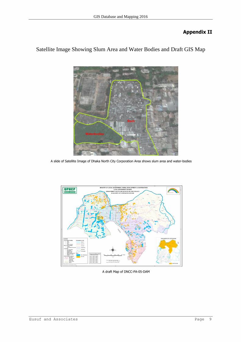
Satellite Image was used for capturing Slum Area, Water-bodies and other updated features
like flyover, bridge and new road: Appendix II.
Data entry, editing, layering and preparing GIS database as spatial and attribute data.
Prepared PA wise Draft Maps
Draft Maps were prepared and shared with concern PA-NGO and jointly checked and verified
Draft Maps and GIS Database were updated considering PA-NGO’s feedback: Appendix II.
Coordination with ICDDR’B about their GIS activities.
Updated Draft Maps was shared with PMU.
Updated Draft Maps was shared with PMU and PIU in Workshop.
Updated Draft Maps was shared with PAs respective PIUs for verification.
Final draft PA Maps were developed incorporating PMU and PIUs suggestions.
GIS Database and Mapping 2016
Eusuf and Associates Page 6
CHAPTER III
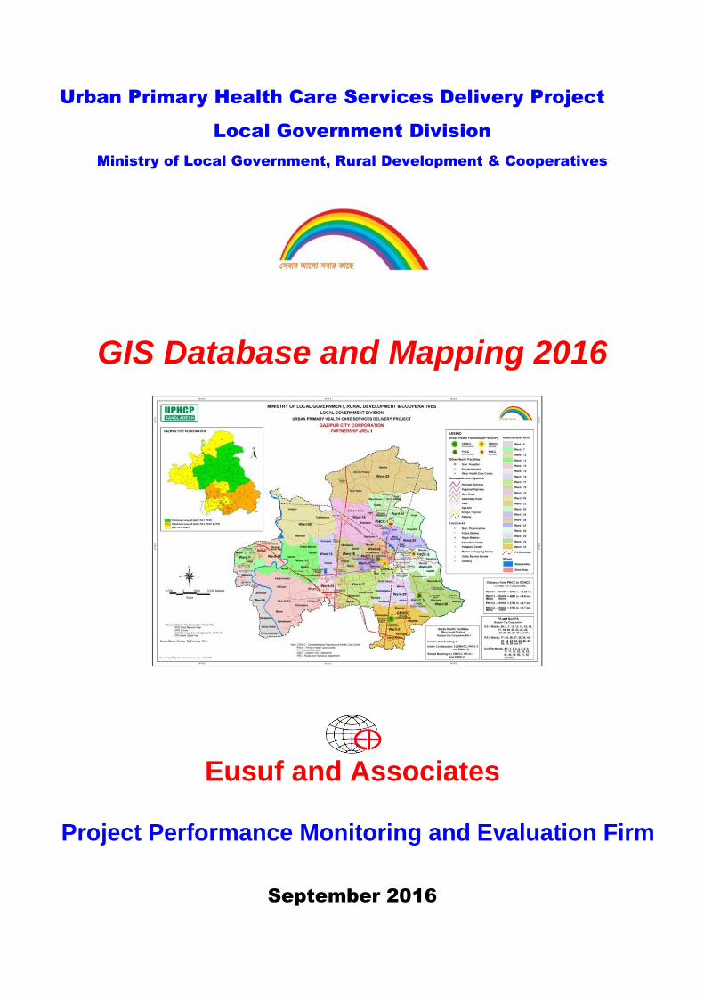
FEATURES OF DRAFT GIS MAPS 18. The GIS map of each of the partnership area is consists of the following features:
a. Partnership Area-PA Final Map showing Administrative Units Ward Boundary
PA Boundary
b. Urban Health facilities (UPHCSDP)
CRHCC- Comprehensive Reproductive Health Care Center
PHCC-Primary Health Care Center
c. Other Health facilities Govt. Hospitals (Sadar Hospital, Govt. Medical College Hospital, MCWC and Others)
Private Hospital (Major Hospital and Private Medical College and Hospital)
Other Major Health Care Center (Major Private and NGO Health Care)
d. Landmarks City Corporation , Municipality, Police Station and Govt. office
Utility Service Center – Fire Service, Water Pump/Tank and Electric Power House.
Education Center – School, College, University and Madrasa
Social Center– Hat, Bazar, Market, Park, Theme Park, Community Center, Club, Eidga,
Graveyard, Play Field, Open Space, Ghat, Railway Station, Bus & Launch Terminal and Airport.
Religious – Mosque, Mazar (Shrine), Temple, Church and Tomb.
Industrial – Garments, Jute, Textile, BSCIC Area and others.
e. Communication systems Road – National Highway, Regional Highway, Main Road, Secondary Road,
Bridge
Flyover
Railway
River
Lake
Khal
f. Other features Slum Area – Dwelling place for poor and ultra poor.
Water-bodies – Pond, Ditch, Very Low land and Water logged Area
g. Distance: by Road (in meter/km.) (Approximate)
From PHCC to CRHCC
h. PA and Non PA within City and Municipality
Catchment Area / Services Delivery Area – PA
Non Services Delivery Area – Non PA
i. Structural Status of Urban Health Facilities of PAs Under Construction Building
Rented Building
GIS Database and Mapping 2016
Eusuf and Associates Page 7
CHAPTER IV
DELIVERABLE GIS MAPS AND CONCLUSIONS A. Deliverables
19. The final draft GIS Maps have been prepared incorporating all suggestions from the PA NGOs,
PMUs and PIUs. The maps are available in both hard and soft copy. The requirements are given
below:
Deliverables
1) Hard copy maps of 25 Partnership Areas (size 3’x 2’’), and
2) Soft copy of 25 Partnership Areas (Digital Web- enabled)
Future plan as per PMU’s requirement
GIS database and Mapping will be linked to the HMIS, ISIs and poverty data
PA wise GIS Spatial and attribute data may be used on Google Earth as kmz file
The GIS analytical maps will be updated and developed by end of the project.
B. Conclusion
20. GIS database produces not only Static Map also has power to generate Dynamic, Web-
enabled and Inter-operability, analyzing and modeling, planning, manipulating and managerial decision. GIS based Spatial and Non Spatial data will be linked to HMIS and used on Google Earth.
Health facilitators and decision makers can oversee the Partnership Area and location of urban health
facilities using GIS database and PA’s coverage map for taking necessary steps to review their catchment area.
GIS Database and Mapping 2016
Eusuf and Associates Page 8
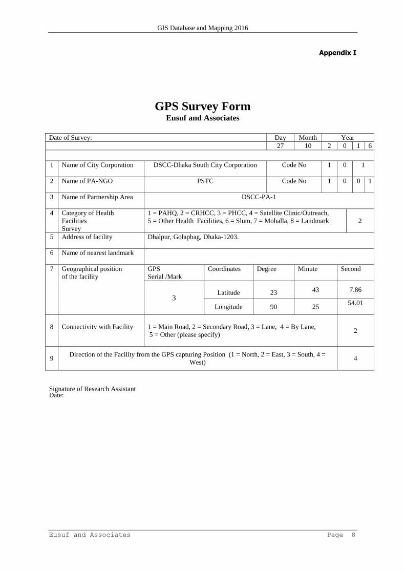
Appendix I
GPS Survey Form Eusuf and Associates
Date of Survey: Day Month Year
27 10 2 0 1 6
1 Name of City Corporation DSCC-Dhaka South City Corporation Code No 1 0 1
2 Name of PA-NGO PSTC Code No 1 0 0 1
3 Name of Partnership Area DSCC-PA-1
4 Category of Health
Facilities
Survey
1 = PAHQ, 2 = CRHCC, 3 = PHCC, 4 = Satellite Clinic/Outreach,
5 = Other Health Facilities, 6 = Slum, 7 = Mohalla, 8 = Landmark
2
5 Address of facility Dhalpur, Golapbag, Dhaka-1203.
6 Name of nearest landmark
7 Geographical position
of the facility
GPS
Serial /Mark
Coordinates Degree Minute Second
3
Latitude
23 43 7.86
Longitude 90 25 54.01
8
Connectivity with Facility
1 = Main Road, 2 = Secondary Road, 3 = Lane, 4 = By Lane,
5 = Other (please specify)
2
9 Direction of the Facility from the GPS capturing Position (1 = North, 2 = East, 3 = South, 4 =
West)
4
Signature of Research Assistant Date:
GIS Database and Mapping 2016
Eusuf and Associates Page 9
Appendix II
Satellite Image Showing Slum Area and Water Bodies and Draft GIS Map
A slide of Satellite Image of Dhaka North City Corporation Area shows slum area and water-bodies
A draft Map of DNCC-PA-05-DAM