gis and gps for trail route identification - department of … · 2015-09-19 · gps - a better...
TRANSCRIPT

Summary Slide
The following presentation was put together for the Virginia Parks and Recreation Society’s 54th Annual conference on Greenways and Blueways in Virginia.
On behalf of Bland County and the US Forest Service we are very excited and grateful to have the opportunity to prepare this presentation of our means andgrateful to have the opportunity to prepare this presentation of our means and methods for routing a “Trail Corridor”. Using GIS and GPS software and technology we efficiently located viable route options for use in field work and trail design process.
This study is being used by the US Forest Service in preparing their environmental impact studies. We provided the USFS with a digital route file usable in common handheld GPS units for final trail corridor location (in lieu of trail ribbons and staking).g)
Overall this project connects Wolf Creek Indian Village a significant cultural heritage resource in Bland County with the Jefferson National Forest. Connecting the Indian Village to both Rich and Round Mountains.
I h f h il b i l d h k h i fIn the future other connector trails are being planned that make their way from this project to the community of Bland and the Appalachian Trail to the south. This project is an ecologically sensitive design that brings to the community a taste of eco-tourism.

GIS and GPS for Recreational Trail Planning and Design in Wild-land Settings
Mike Futrell – GIS AdministratorMichael LaRoche – Landscape ArchitectMichael LaRoche Landscape Architect

What you will learn from this presentation:What you will learn from this presentation:
1. Data gathering for GIS sources for basic trail planningg g p g
2. Explain the “merge and collaborate process” between G S d d ld d dGIS Data-Based Design and Field Adjusted Design
3 Walk through of a “Real World” design in USFS located in3. Walk through of a Real World design in USFS located in Bland County, Virginia.
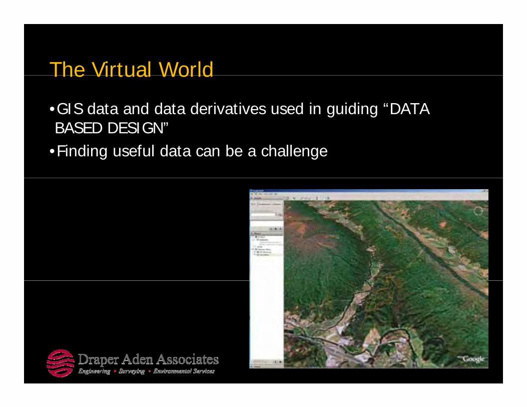
The Virtual WorldThe Virtual World
•GIS data and data derivatives used in guiding “DATA BASED DESIGN”BASED DESIGN
•Finding useful data can be a challenge
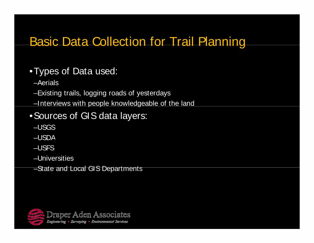
Basic Data Collection for Trail PlanningBasic Data Collection for Trail Planning
•Types of Data used: yp–Aerials–Existing trails, logging roads of yesterdays–Interviews with people knowledgeable of the landp p g
•Sources of GIS data layers:–USGSUSDA–USDA
–USFS–Universities State and Local GIS Departments–State and Local GIS Departments
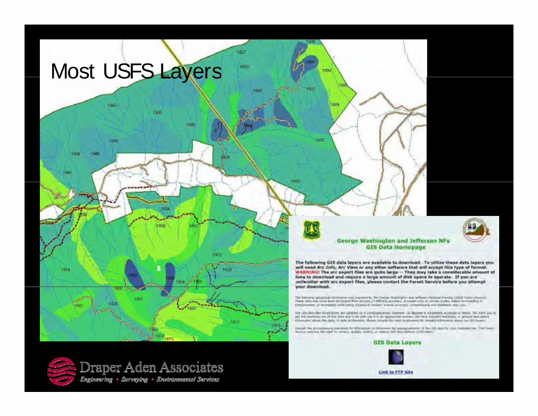
Most USFS LayersMost USFS Layers

Aerials, Soils, (many)Aerials, Soils, (many)

‘the blue lines on a topo’the blue lines on a topo

VGIN 2002 Aerials, Topos,( )(many)
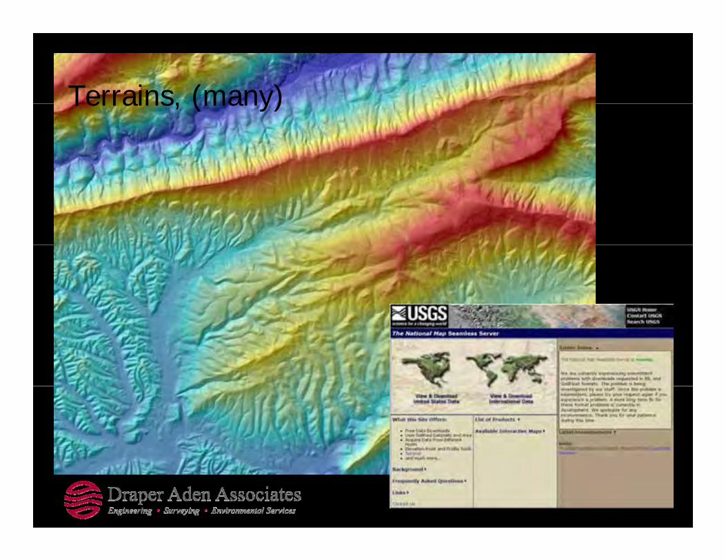
Terrains, (many)Terrains, (many)

Design Tools - GIS Data DerivativesDesign Tools GIS Data Derivatives
•Hillshade and Elevation Visualizations•Terrain Models and Contours•Slope and Aspect•Digitize New Features

Hillshade and Elevation Visualization

Terrain Models and ContoursTerrain Models and Contours

Slope MapSlope Map
A t MAspect Map

Digitize New FeaturesStreamStream
2002
20052005

Software and Equipment UsedSoftware and Equipment Used
•Ricoh GPS Camera•Garmin Handheld GPS (60CSx)•AutoCAD (Map and LDD)•ArcGIS•Minnesota DNR Garmin GPS Utility

Ricoh GPS CameraRicoh GPS Camera

GPS Camera = Georeferenced Photos

GPS - A Better CompassGPS A Better Compass
•Creating a new route using a GPS unit to guide the way…g g g y•Tracklogs have replaced flagging tape and a compass.•“Points of Interest” collection allows for virtual field data
ll d bcollection and observation notation.•After using GIS data derivatives and design factors in trail planning upload the trail route and you have a GPS unitplanning, upload the trail route and you have a GPS unit guiding the way along a preliminary design path.

Handheld GPS Unit

GPS Interface Software

Data Based Design(T l D t D i ti )(Tools ~ Data Derivatives)
•Slope Analysisp y•Aspect Analysis•Vegetation Types in relation to Aspect Map (overlays)•Identify viable routes based on a review of GIS data•Identify routes and “pinch” points that require field investigationinvestigation


Slope Analysis MappingSlope Analysis Mapping
•Legend, Slopes, existing logging trails, trail route design g , p , g gg g , goptions

Slope Analysis MappingSlope Analysis Mapping
•Weaving a trail gthrough steep side slopes, avoiding the orange and red areasorange and red areas (steep)

Slope Analysis MappingSlope Analysis Mapping
•Connecting Wolf Creek Recreation Area to the top of Round g pMountain
•The challenge of ascending the north face of Round Mountain was a combination of avoiding steep rocky sideMountain was a combination of avoiding steep rocky side slopes and dense thickets of Rhododendrons.
•Data-based trail design used the “follow the contour” gmethod, while avoiding steep slope ranges used in the data based trail design.

Vegetation Types in relation to Aspect
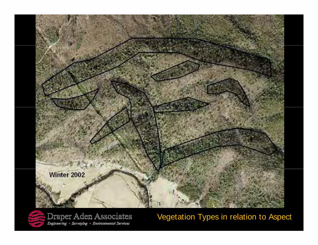
Vegetation Types in relation to Aspect

Vegetation Types in relation to Aspect

Vegetation Types in relation to Aspect

Vegetation Types in relation to Aspect

Design Considerations:O t iti d C t i tOpportunities and Constraints
•Streams•Steep erodible slopes•Boulder fields•Proximity to boundary and other properties•VegetationP i t f i t t d l k•Points of interest and overlooks

Overlooks
Boulder FieldsBoulder Fields

VegetationCh llChallenges

Trail ClassificationTrail Classification
•Type of Usersyp•Trail Widths•Slopes & Gradients
Image Courtesy of IMBA www.imba.com

Route Decisions for Trail User GroupsRoute Decisions for Trail User Groups
•User groups, Hiking, Back Country Horseback Trailsg p , g, y•Shared use with Mountain Biking
Image Courtesy of FHWA www.fhwa.dot.gov
Image Courtesy of www.extension.umn.edu

Trail Design FeaturesTrail Design Features
Above images Courtesy of “Trail Design for Small Properties” http://www.extension.umn.edu/distribution/naturalresources/DD8425.html

Stretch Pause BreakStretch – Pause – Break
Questions thus far?

Wolf Creek Indian Village to Round Mountain USFS E l f C t I l t dUSFS: Example of Concepts Implemented
Bland Co.

Design Process IllustratedDesign Process Illustrated
•USFS and Bland County collaborate on tourism and yeconomic development with recreational trails connecting cultural and natural resources.

Connecting USFSConnecting USFS property to Wolf Creek Indian VillageCreek Indian Village


Data Derivative ToolsData Derivative Tools
•Next series of slides is a review of the design process.g p1. Data Based Design Route2. Field Recon and Route Adjustment3. Finalize of Corridor study area

Data Based Design

Prepare for Field WorkPrepare for Field Work
•Field Data Based Designg–Upload GIS “DATA BASED DESIGN” to GPS unit–Gather slope maps GIS overlay maps to use in taking field notes–Define area of study and key study points “pinch points” or challenge areasy y y p p p g–Head to the Wilderness!

GPS Tracklogs, and Data Based Design

Follow GIS Data-based Design RouteFollow GIS Data based Design Route
•Follow GIS data-based designg–Retrieve “Actual/Field” adjusted trail route –Note reasons for trail relocation, remember this route is a corridor “study area “ and requires further environmental impact analysis.
–Note points of interest, views, significant landmarks, –Note factors that may affect trail construction level of difficulty and cost–Make notes on GPS and hard copies for use back in the office–Note routes not found in “data based design” to evaluate with GIS overlays

Field Recon

Deviations & features found along the wayDeviations & features found along the way
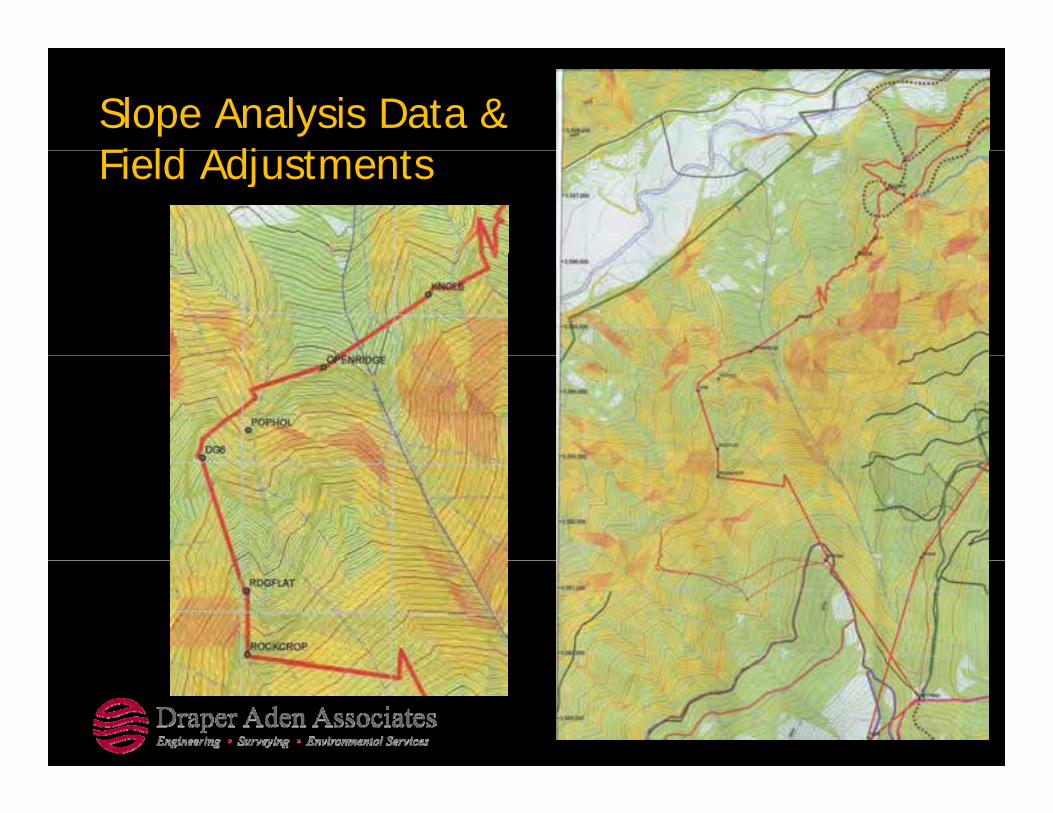
Slope Analysis Data & Fi ld Adj t tField Adjustments

Trail Constructability & Labor EffortTrail Constructability & Labor Effort

Field Adjustments and Map Notes used in the fi ldfield

Locating Switchbacks and OverlooksLocating Switchbacks and Overlooks

Decipher and compare Data based d i ith Fi ld dj t tdesign with Field adjustments
•Take the points of interest and tracklogs from GPS into GIS p gutility program, to overlay design route with field route and other opportunities and constraints observed in the field.–Download data from GPS to GIS and CAD program–Download data from GPS to GIS and CAD program–Plot field based design onto data derivatives (slope and aspect maps) –Determine routes abandoned OR approved for “final corridor study”

Final Trail Corridor


Process - Final Corridor Study AreaProcess Final Corridor Study Area
•Final Corridor Study Areay–Adjust final corridor study routes based on GIS data derivative tools–Run sectional profiles of routes–Identify each route with a level of trail classification based on trail gradients y gand widths
–Identify trail constructability and costs based on trail classification and site constraints.
–Identify areas that require specific study (stream crossings, sensitive lands)

Communicating the Final DesignCommunicating the Final Design
•Sharing the final design in various formats.g g
–Digital•Shape Files (SHP) •Google Earth data files (KML)
–Visual: •Images (PDF)

Sharing with Google Earth

Selected Routes and Priorities


Questions - DiscussionQuestions - Discussion
Michael LaRoche – Landscape ArchitectMike Futrell – GIS AdministratorMike Futrell GIS Administrator