gim international august 2015
DESCRIPTION
http://www.gim-international.com/magazines/gim-international-august-2015.pdfTRANSCRIPT

I N T E R N A T I O N A L
THE GLOBAL MAGAZINE FOR GEOMATICSWWW.GIM-INTERNATIONAL.COM
ISSUE 8 • VOLUME 29 • AUGUST 2015
Bringing Geography into EverythingEd Parsons, Geospatial Technologist of Google
SERIOUS GAMING Improving Stakeholder Communication in Urban Development Projectsj
BUILDING A GLOBAL 3D ROUTING MAP Collecting Trillions of Points around the World.
PERMANENT COMMITTEE ON CADASTRE A Solid Value in Europe.

No
2850
2850.indd 1 04-08-15 12:14

CONTENTS
ADVERTISERS INDEX
3 AUGUST 2015 | INTERNATIONAL |
Get your back-issuesin the storewww.geomares.nl/store
REPORT PAGE 27Permanent Committee on Cadastre has Become a Solid Value in EuropePCC Conference in Riga
COMPANY’S VIEW PAGE 30Mobile Laser Mapping Systems for all PocketbooksSiteco
News & Opinion pageEditorial 5Insider’s View 6News 7Endpoint 13
International organisations page FIG 33GSDI 35IAG 37ICA 39ISPRS 41
Other page Advertisers Index 3Agenda 42
INTERVIEW PAGE 14
Bringing Geography into EverythingGIM International Interviews Ed Parsons
FEATURE PAGE 19
Serious GamingImproving Stakeholder Communication in Urban Development Projects
FEATURE PAGE 23
Building a Global 3D Routing MapUsing Mobile Mapping to Collect Trillions of Points around the World
CHC, www.chcnav.com 4ComNav Technology, www.comnavtech.com 22Effi gis, www.effi gis.com 29FOIF, www.foif.com 40Hi-Target Surveying, www.zhdgps.com 26KCS TraceMe, www.trace.me 36Kolida Instrument, www.kolidainstrument.com 42 Pacifi c Crest, www.pacifi ccrest.com 7Ruide, www.ruideinstrument.com 25Sanding, www.sandinginstrument.com 34Settop, www.settopsurvey.com 10
Siteco, www.sitecoinf.it 38South Surveying, www.southinstrument.com 12SPAR Point Group, www.sparpointgroup.com 2SRM Consulting, www.srmconsulting.es 9Supergeo, www.supergeotek.com 38TI Asahi, www.pentaxsurveying.com/en 43TI Linertec, www.tilinertec.com 34Trimble Geospatial, www.trimble.com 44Trimble Integrated Technologies, intech.trimble.com 11UniStrong, www.unistrong.com 17
On the front cover of this month’s issue: A Google Trekker heads south from the Hillsboro Inlet in Broward County, Florida, USA. On page 14 you will find an interview with Ed Parsons, geospatial technologist at Google. Parsons is responsible for evangelising Google’s mission to organise the world’s information using geography. (Photo by Peter W. Cross)

No
2838
Naamloos-11 1 29-06-2015 11:10:26

5 AUGUST 2015 | INTERNATIONAL |
EDITORIAL DURK HAARSMA, PUBLISHING DIRECTOR
Durk Haarsma, publishing director
Phot
ogra
phy:
Arie
Brui
nsm
a
There’s a little bit of geography in everything.
That’s one of the main statements that ‘man
with the mission’ Ed Parsons is trying to spread
around the world. Ed Parsons is responsible
for evangelising Google’s mission to organise
the world’s information using geography
and he was interviewed in this issue of GIM International by our editorial manager Wim van
Wegen (see page 14). Parsons is a geospatial
technologist and has seen many changes in
the fi eld of geo-information since he started
at Google in 2007. The most striking message
that Parsons has for the fi eld of geomatics is
that there’s ‘geography DNA’ in almost every
product or service that one uses on the web or
the smartphone. Geo-information is ubiquitous
and that holds a big promise for the future.
There’s already enough reason to celebrate.
Maps are used every day by hundreds of
millions of people: close to a billion are using
Google Maps in one way or another and
Geo in everything
PUBLISHING DIRECTOR Durk HaarsmaFINANCIAL DIRECTOR Meine van der BijlSENIOR EDITOR Dr Ir. Mathias LemmensCONTRIBUTING EDITORS Dr Ir. Christiaan Lemmen, Dr Rohan Bennett, Mark Pronk BSc, Martin Kodde MSc, Ir. Danbi J. Lee, Dr Ir. Marlies Stoter-de Gunst, Frédérique CoumansEDITORIAL MANAGER Wim van WegenCOPY-EDITOR Lynn Radford, Englishproof.nlEDITORIAL BOARD Dr Ir. Paul van Asperen, Dr Bharat LohaniACCOUNT MANAGER Sybout WijmaMARKETING ASSISTANT Trea FledderusCIRCULATION MANAGER Adrian HollandDESIGN Media Supporters BV, Alphen aan den Rijnwww.vrhl.nl
REGIONAL CORRESPONDENTSUlrich Boes (Bulgaria), Prof. Dr Alper Çabuk (Turkey), Papa Oumar Dieye (Niger), Dr Olajide Kufoniyi (Nigeria), Dr Dmitry Kurtener (Russia), Dr Jonathan Li (Canada), Dr Carlos Lopez (Uruguay), Dr B. Babu Madhavan (Japan), Dr Wilber Ottichilo (Kenya), Dr Carl Reed (USA), Dr Aniruddha Roy (India), Prof. Dr Heinz Rüther (South Africa), Dr Tania Maria Sausen (Brazil)
GIM INTERNATIONALGIM Inter na tion al, the global mag a zine for geo mat ics, is pub lished each month by Geomares Publishing. The mag azine and related e-newsletter pro vide top i cal over views and ac cu rate ly presents the lat est news in geo mat ics, all around the world. GIM Inter na tion al is or ien tat ed towards a pro fes sion al and man a ge ri al read er ship, those lead ing de ci sion mak ing, and has a world wide cir cu la tion.
PAID SUBSCRIPTIONS GIM International is available monthly on a subscription basis. The annual subscription rate for GIM International is €140 within the European Union, and €200 for non-European countries. Subscription can commence at any time, by arrangement via our website or by contacting Abonnementenland, a Dutch subscription administration company. Subscriptions are automatically renewed upon expiry, unless Abonnementenland receives written notification of cancellation at least 60 days before expiry date. Prices and conditions may be subject to change. For multi-year subscription rates or information on current paid subscriptions, contact Abonnementenland, Postbus 20, 1910 AA Uitgeest, Netherlands+31 (0)251-257926 (09.00-17.00 hrs, UTC +1)[email protected].
AD VER TISE MENTSIn for ma tion about ad ver tising and dead lines are avail able in the Me dia Plan ner. For more in for ma tion please con tact our account man ag er: [email protected].
ED I TO RI AL CON TRI BU TIONS All ma te ri al sub mit ted to Geomares Publishing and re lat ing toGIM Inter na tion al will be treat ed as un con di tion al ly as signed for pub li ca tion under copy right sub ject to the editor’s un re strict ed right to ed it and of fer ed i to ri al com ment. Geomares Publishing as sumes no re spon sibil ity for un so lic it ed ma te ri al or for the ac cu ra cy of in for ma tion thus re ceived. Geomares Publishing as sumes, in ad di tion, no ob li ga tion to return ma te ri al if not ex pli cit ly re quest ed. Con tri bu tions must be sent for the at ten tion of the editorial manager: [email protected].
Geomares PublishingP.O. Box 112, 8530 AC Lem mer, The Neth er lands T: +31 (0) 514-56 18 54 F: +31 (0) 514-56 38 [email protected]. gim-international.com
No ma te ri al may be re pro duced in whole or in part with out writ ten per mis sion of Geomares Publishing.Copy right © 2015, Geomares Publishing, The Neth er lands All rights re served. ISSN 1566-9076
maps are improving the lives of those users
in several ways. For example, a lot of time
can be saved by not having to study routes
while travelling and it is now very easy to
fi nd the quickest way to a restaurant or shop
when in the city. On top of that, it also gives
people the right to call a piece of land their
own, thus acquiring a registered economic
life with increasing welfare for themselves
and their families. All in all, consequences
that have come with that widespread use of
geo-information fall in the spectrum of ‘nice-
to-have’.
In the upcoming years it’s important to
spread the use and therefore the benefi ciary
outcomes of embracing geo-information as
part of daily life. A pleasing message in the
interview with Parsons is that it is not Google
alone that will help the poorer and developing
parts of the world to benefi t from the digital
geo-revolution. It will require teamwork
between hard- and software companies to
bring fast internet to as many people as
possible and new and other business models
will have to be thought up for these companies
to be able to make it happen.
The geospatial industry is more infl uential,
says Ed Parsons in this issue of GIM International, than ever before. Maybe not
as obvious to everybody in the outside world,
but, again, ‘geo’ is part of a lot of the activities
of citizens, businesses, organisations and
governments – day after day. The fact that
geography is in everything and is everywhere
makes the opportunities for the geospatial
industry to grow their number of products
and services immense, says the evangelist of
Google. Here at GIM International we couldn’t
agree more.

NEWS INSIDER’S VIEW
66 | INTERNATIONAL | AUGUST 2015
EABThe Editorial Advisory Board (EAB) of GIM International consists of profes sionals who, each in their discipline and with an independent view, assist the editorial board by making recommen dations on potential authors and specific topics. The EAB is served on a non- committal basis for two years.
PROF ORHAN ALTANIstanbul Technical University, Turkey
PROF DEREN LIWuhan University, China
MR SANTIAGO BORREROSecretary-general of Pan American Institute of Geography and History (PAIGH), Mexico
PROF STIG ENEMARKHonorary President, FIG, Denmark
DR ANDREW U FRANK Head, Institute for Geoinformation, Vienna University of Technology, Austria
DR AYMAN HABIB, PENGProfessor and Head, Department of Geomatics Engineering, University of Calgary, Canada
DR GABOR REMETEY-FÜLÖPPPast Secretary General, Hungarian Association for Geo-information (HUNAGI), Hungary
PROF PAUL VAN DER MOLENTwente University, The Netherlands
PROF DR IR MARTIEN MOLENAARTwente University, The Netherlands
MR JOSEPH BETITSenior Land Surveyor, Dewberry, USA
PROF SHUNJI MURAIInstitute Industrial Science, University of Tokyo, Japan
PROF DAVID RHINDret. Vice-Chancellor, The City University, UK
PROF DR HEINZ RÜTHER Chairman Financial Commission ISPRS, University of Cape Town, Department of Geomatics, South Africa
MR FRANÇOIS SALGÉSecretary-general, CNIG (National Council for Geographic Information), France
PROF DR TONI SCHENKProfessor, The Ohio State University, Department of Civil and Environmental Engineering, USA
PROF JOHN C TRINDERFirst Vice-President ISPRS, School of Surveying and SIS, The University of New South Wales, Australia
MR ROBIN MCLARENDirector, Know Edge Ltd, United Kingdom
The ‘Art of Recording’
Creating a viable state requires money.
Governments that don’t have money cannot
spend. Not, for example, on infrastructure,
health care or education. Economic growth
much depends on education, as Thomas
Piketty in his book Capital in the Twenty-First Century convincingly explains. In rich
countries public spending on important things
for society amounts to 50-60% of the GDP, in
other countries much less. As a consequence
the tax burden in rich countries is high, say
up to 45% of the GDP, while in other
countries the government doesn’t collect
more than 10-20%. In some cases those
governments mainly receive tax income from
mineral exports and not from income, profit
and land taxation, which makes the state
budget extremely volatile (e.g. Nigeria, Angola
and the Middle East). But how can poor
countries collect taxes when the necessary
tax administration does not exist or is not
maintained? How can income tax be levied
when there are no reliable census and
income records? The same goes for taxing
business profit without business records, car
tax without car records, land and transfer tax
when there is no cadastre. I would like to
bring to the fore that one of the important
drivers of state building is the capacity of the
government to levy taxes and to claim an
equitable share of the national income.
Morten Jerven in Poor Numbers unveils how
often governments fail to invest in correct
and reliable datasets on persons, businesses,
vehicles, finance, land and real estate, which
are actually fundamental to their ability to
govern the country. I sometimes wonder why
surveyors do not defy their governments to
develop such fundamental datasets, and
ostensibly accept the current situation tacitly.
I feel that this attitude impairs the further
building of the state and that the lack of
fundamental datasets warrants intervention.
After all, surveyors are professional in
collecting data, safeguarding accuracy and
reliability through process design and process
management, and are amongst the few
professionals that can handle big and
complex IT systems. Surveyors are tradi-
tionally focussed on land and real estate, but
my question is whether the overall skill of
surveyors shouldn’t actually be the ‘art of
recording’? Does it really matter whether
registers concern land, persons, cars, and
such like? I challenge the propensity of
surveyors to do their daily cadastral work in a
modest way, while they are so versed in ‘the
art of recording’. By upgrading their profes-
sional image to ‘recording expert’, they could
deliver an urgently needed contribution to the
building of states. Better taxation has yet
another benefit, namely becoming less
dependent on external aid. As Dambisa Moyo
in Dead Aid explains, governments which are
forced to be accountable to donors cannot be
accountable to their own population at the
same time, while the latter appears to be
fundamental to state building. Why should
citizens otherwise comply with fiscal rules?
Surveyors could be more important than they
think they are.
BY PROF EMER PAUL VAN DER MOLEN, UNIVERSITY OF TWENTE, THE NETHERLANDS

NEWS
Most shared during the last month from www.gim-international.com
7 AUGUST 2015 | INTERNATIONAL | 7
EXTENDED BATTERY LIFE MEANS EXTENDED
PERFORMANCE.
®
No
2848
1. Rwanda Launches First-ever Land-use Portal in Africa - http://bit.ly/1MJWjHI
2. Hans Rosling to Share His Insights into Global Change at GIM Summit - http://bit.ly/1MJVfnj
3. Wearable Reality Capture with Leica Pegasus:Backpack - http://bit.ly/1Rf9rDx
4. Integrated Land Management – A Dream? - http://bit.ly/1MJVI8Q
5. What a UAS Actually Is and Does - http://bit.ly/1MJVUFk
what3words Wins Innovation Grand Prix at Cannes Lions The young British company what3words has won
the prestigious Innovation Grand Prix at the
Cannes Lions awards in France – the world’s
biggest annual awards show and festival for
professionals in the creative communications
industry – for its revolutionary service that gives
every location in the world an easy-to-remember
three-word address. The solution tackles a
problem that affects about 75% of the world’s
population, who have either no address or an
inadequate one. Without an address, people
struggle to secure microfi nance, run a business or
join the global economy.
http://bit.ly/1LTUFTB
what3words on various devices.
Geo-matching.com Adds Handheld Scanners CategoryGeo-matching.com has recently added
Handheld Scanners to its broad spectrum
of product categories. FARO Europe,
DotProduct and Artec 3D Scanners are the
fi rst suppliers in this category. In addition
to general specifi cations, detailed infor-
mation is given about scanning character-
istics, connectivity and sensors and
functionality. To see the Handheld
Scanners category, visit
www.geo-matching.com.
http://bit.ly/1C8aaoP

NEWS
88 | INTERNATIONAL | AUGUST 2015
4DMapper Launches Complete Geospatial Data Solution FIG Working
Week 2016 Programme Unveiled FIG is inviting geomatics professionals to the
FIG Working Week 2016 which will be held
in Christchurch, New Zealand, from 2-6
May 2016. The Working Week is hosted by
FIG and the New Zealand Institute of
Surveyors (NZIS) as the local host. The FIG
Working Week 2016 has wide support
throughout New Zealand with a commitment
already pledged by Christchurch City
Council and Land Information New Zealand,
which is New Zealand’s government
department responsible for land titles,
geodetic and cadastral survey systems and
topographic information.
http://bit.ly/1eIX4TI
Second Edition of Commercial UAV Show in Bigger VenueOn 20 and 21 October 2015 the UAV community will gather in London, UK, where the Commercial UAV
Show premium conference brings end users from a range of industries together in one room to evaluate how
UAVs can deliver cost and operational effi ciencies. The event is the right occasion to meet organisations
currently using UAVs successfully alongside the companies supplying the latest technology so that visitors
can decide where and how their organisations can benefi t most.
http://bit.ly/1eJ3TVt
4DMapper.
4DMapper, a browser-based 3D geospatial data gateway,
has been launched recently to change the way geospatial
data is stored, delivered, visualised and shared. Powerful
cloud processing enables the fusion of multi-source
content and seamless streaming of massive data fi les,
immediately, to unlimited users on their browsers.
According to 4DMapper, this turns the geospatial world
inside out, enabling access to big data without local
storage, hardware and software.
http://bit.ly/1eJ0lCv
The Hague to Host Second TUSExpo for UASs
Intergeo Launches UAS Side Event
Carlson Software Releases Surveyor2 Data CollectorFrom 2-4 February 2016, the Dutch city of The Hague will host the second
edition of The Unmanned Systems Expo (TUSExpo) at the city’s World
Forum. TUSExpo is a European trade fair aimed at the growing market for
unmanned systems such as drones and will feature both commercial and
civil applications in areas including security, agriculture, industry, science,
entertainment and
environmental
protection. The event is
expected to attract
2,500 international
visitors.
http://bit.ly/1gsLZb5
In line with the growing role of UASs in geomatics Intergeo is increasingly
looking skywards, as demonstrated by interaerial SOLUTIONS, an integrated
platform for all aspects of UASs. Visitors can witness the incredible pace of
developments in applications and the very latest solutions – whether multi-
copter, helicopter or fi xed wing – at the
upcoming Intergeo in Stuttgart, Germany,
from 15-17 September. International
UAS manufacturers will be on hand
alongside hardware and software
suppliers and service providers.
http://bit.ly/1gszyfo
Carlson Software recently released its new Carlson
Surveyor2, the newest model in the Carlson Surveyor
line of data collectors. The Surveyor2 is paired with
Carlson’s software to provide a complete solution for
surveying, stake out, construction layout and GIS
mapping.
http://bit.ly/1gsL0Yi
Planet Labs to Acquire BlackBridgeBlackBridge has entered into a defi nitive agreement for Planet Labs to
acquire the RapidEye suite of core offerings. Planet Labs is a provider of
a dataset of satellite imagery based in San Francisco, USA, that designs,
builds and operates a fl eet of Earth-imaging satellites. The transaction is
subject to the customary closing conditions and is expected to close
during the third quarter of 2015.
http://bit.ly/1gsLduE
senseFly eBee UAS.
TUSExpo 2015.
Carlson Surveyor2.

GIM INTERNATIONAL SUMMIT NEWS
Sign up hereDo you want to be part of the geomatics innovation? Sign up to attend the GIM International Summit at www.gimsummit.com.
9AUGUST 2015 | INTERNATIONAL |
For further information visit www.ortosky.com
now in the cloud
No 2831
Hans Rosling studied
statistics and medicine
in Sweden and then
worked as medical
doctor in Mozambique,
where he identified
a new epidemic
paralytic disease that
was named konzo. His research across
rural Africa linked it to hunger and organic
dietary toxins. He initiated Médecins sans
Frontières in Sweden, is a member of
Scientific Academies and an author of a
textbook on global health.
With his son and daughter-in-law he
co-founded Gapminder and developed
animation software that Google acquired.
By using it to animate statistics, Hans
Rosling raises understanding of global
economic, social and environmental trends.
His award-winning lectures are described
as ‘humorous, yet deadly serious’. His key
message is that the old division between
developed and developing countries has
been replaced by countries on a continuum
of social and economic development.
Hans Rosling Confirmed as Keynote SpeakerThe Conference Committee is excited to announce that Hans Rosling will be appearing at the GIM International Summit as a keynote speaker. The professor of international health in Stockholm, Sweden, is a high-profile public speaker on global change, and Time Magazine listed him among the 100 most influential people in the world. Thanks to his inimitable style of presenting data and information, delegates at the GIM International Summit in February 2016 are in for a real treat!
WHAT IS THE GIM INTERNATIONAL SUMMIT?The GIM International Summit is focused on discussing the future of the field. The discussion will be fuelled by speakers from outside the traditional geomatics world, all of whom are experts in their own field. They will explain the needs and desires of the wider world and how they would like to see the geomatics sector develop.The summit will be very much based on the concept of ‘inside looking out’ rather than merely insiders’ perspectives. The main topics of the Summit – Water, Food Security and Social Justice – will be brought together under the overarching theme of ‘Seeking Space for Future Development’.

NEWS
1010 | INTERNATIONAL | AUGUST 2015
SETTOPRADIOLINK,THE GNSS RADIO.
[email protected] (+34) 93 700 44 66
TRANSMITTER. TX REPEATER ACCESSORYREPEATER. RX/TX ROVER
APPLICATIONS
No 2839
Symposium Programme Released for UAS Mapping 2015 RenoThe programme has been announced for
the second annual technical UAS Mapping
2015 Reno symposium, sponsored by the
American Society for Photogrammetry and
Remote Sensing (ASPRS). The conference
will take place on 29 and 30 September
2015 at the Reno Ballroom in Reno,
Nevada, USA. In addition to the technical
symposium, ASPRS is also sponsoring a
workshop on UAS Data Processing on
Monday 28 September.
http://bit.ly/1eIZB0n
Satel Launches Extremely Small Radio Data Transceiver ModuleSatel, a Finnish manufacturer of radio data
transmission systems, aims to set a new
milestone with the launch of the new
Satelline TR4. This compact UHF transceiver
with transmitting power of 1,000mW is
compatible with the protocols of Pacific
Crest, Trimble and Satel. The type certifica-
tions in all important regions of the world
make the Satelline TR4 very suitable for
integration in end devices that are intended
for international use.
http://bit.ly/1eIXeKP
Satelline TR4. MTi 1-series.
100 Resilient Cities Launches London Office and Announces Esri Partnership
Xsens Launches New Family of Motion TrackersXsens, a Dutch innovator in 3D motion tracking technology,
has expanded its successful 4th-generation MTi product
portfolio by releasing a new series of complete, self-
contained 3D IMU/VRU/AHRS motion tracking modules for
high-volume industrial and prosumer applications. The new
MTi 1-series of motion trackers incorporates the latest in
advanced sensor fusion and miniature MEMS technologies.
Individually calibrated and tested to enable
minimal implementation effort, the MTi
1-series delivers a dynamic
accuracy of 1° RMS for roll and
pitch, making them the most
accurate 3D motion trackers in
their class.
http://bit.ly/1LTUJT4
Cutting the new office’s ribbon.
100 Resilient Cities – pioneered by The Rockefeller Foundation
(100RC) has announced the opening of its regional
headquarters in London to serve member cities in Europe and
the Middle East. 100RC has also announced new partnerships
with AIR Worldwide and Esri. 100RC is dedicated to helping
cities around the world become more resilient to the physical,
social and economic challenges that are a growing part of the
21st century, including UK member cities London, Bristol and
Glasgow. The move comes less than six months after London
was named part of the presently 67-city global network.
http://bit.ly/1eJ08zl

NEWS
11 AUGUST 2015 | INTERNATIONAL |
MORE NEWS GIM-INTERNATIONAL.COM
The BD935-INS module features a high
accuracy GNSS receiver for precise
position and an integrated MEMS
inertial sensor package for 3-D orientation
to serve applications requiring position
and attitude. The GNSS + Inertial
combination delivers more stability
and robustness than GNSS alone.
GNSS + InertialPrecise Positioning and Orientation
THE TRIMBLE BD935-INS — A PRECISION GNSS + INERTIAL MODULE DELIVERING RTK AND ORIENTATION IN REAL TIMEThe BD935-INS is a compact module that integrates
triple frequency GNSS and MEMS Inertial sensors to
provide precise real-time position and attitude.
FOR HIGH-PERFORMANCE, PRECISE POSITIONING IN A COMPACT, MOBILE-READY DESIGN• 336 Channels
• GPS, GLONASS, Galileo and BeiDou
• Integrated 3-D MEMS Sensors
• 100Hz RTK Position and Orientation
• Also available in IP67 enclosure
© Copyright 2015, Trimble. All rights reserved. All other trademarks are the property of their respective owners. TPC103 (08/15)
Trimble GNSS OEMInTech.trimble.com
60mm x 67mm
Visit us at Hall 8, Booth C8.047
No
2847
2847.indd 1 07-07-15 14:35
Swiss Use TatukGIS SDK for Road Infrastructure Management Switzerland-based geologix AG has used the
TatukGIS Developer Kernel to develop GIS
functionality in its ‘Logo’ information system
for planning, managing and maintaining road
infrastructure. Logo is targeted at all people
and organisations entrusted with road admin-
istration, including road engineering and
construction planning. Logo customers in
Switzerland and Germany range from small
villages with up to 30km of roads and streets
to cities with up to 500km of road and streets
and counties/states with more than 3,000km
of roads and streets to manage.
http://bit.ly/1eIWTYH
Dutch Prime Minister Embraces Tygron’s Digital Urban Planning SystemThe Dutch Prime Minister Mark Rutte,
Minister of Infrastructure and the Environment
Melanie Schultz van Haegen and alderman
Boudewijn Revis of BSKB The Hague experi-
mented in a real-life digital urban planning
system by Tygron last month in the Binckhorst
area of The Hague. This interaction marked
the start of Tygron’s collaboration with the
Dutch government. It was clear that the
Tygron Engine led to all parties reaching a
consensus, thus underlining its role as the
urban planning tool of the future.
http://bit.ly/1eIZ7qQ
Supergeo Announces SuperGIS Server 10 Series
Dutch PM Rutte and Minister Schultz van Haegen during the workshop.
SuperGIS Server 10 series.
Supergeo is upgrading all its products to a new level,
the 10 series, including SuperGIS Server. The most
notable change in SuperGIS Server 10 is its integration
of 2D and 3D capabilities. In the SuperGIS 3 series,
SuperGIS Server and SuperGIS 3D Earth Server
provide 2D and 3D map visualisation respectively. With
the integration of 2D and 3D, users can view the same
map layers in two different modes and gain a better
understanding of their data.
http://bit.ly/1eIZP7u

No
2841
Naamloos-2 1 02-07-2015 09:19:14

13AUGUST 2015 | INTERNATIONAL |
No
2841
Naamloos-2 1 02-07-2015 09:19:14
ENDPOINT
Nowadays, we are living in an interconnected
world with road and sewerage networks, oil
and gas pipeline networks, power lines and
drainage canals. Not all these networks are
visible and geodetic reference systems belong
to these invisible networks. Billions of people
use these systems every day, quite unknow-
ingly, for positioning and navigation purposes.
In the era of industrialisation it took decades
to establish nationwide reference systems. For
example, the creation of the famous Great Arc
forming the geometric backbone of the Indian
subcontinent took 50 years. This undertaking
was led by George Everest as surveyor-general
of India during the period 1830 to 1843.
Indeed, Mount Everest, the highest mountain
on Earth, was named after the surveyor to
honour his efforts in determining the height of
the peak. Today, the creation of a reference
frame with centimetre accuracy takes a
matter of months rather than decades, thanks
to GNSS. For many centuries the surveyor
was limited to attaching his measurements to
a local or – at best – a national frame. Even
to this day no unified and accurate geodetic
frames are available in some developing
countries. For example, Burkina Faso now
has nine continuously operating reference
stations (CORS) covering the whole nation,
but up until recently the country had to make
do with multiple frames: one established in
1950 by IGN France covering French-
speaking West Africa, one made in 1958 in
and around the capital Ouagadougo, one set
up in 1960 by the US army and one based on
Doppler measurements created in 1979.
Since 1997, a first-order network of 55 GNSS
points has covered the entire nation. When
so many systems are used at the same time
ITRFthe value of modern GIS and surveying
technologies becomes scant. Launching
CORS is a first step towards unified frames.
Since the turn of the millennium the amount
of geodata has grown at a compound rate of
20% annually. Nowadays, 15 times more
geodata is available than 15 years back and
its use by diverse managers and planners is
supported by Global or National Spatial Data
Infrastructures and open geodata. Nearly all
modern geodata acquisition tools, including
mobile GIS, Lidar, mobile mappers, aerial
photogrammetry and unmanned airborne
systems, use INS and GNSS linked to a CORS
for positioning the sensors. GNSS positions
are given in the worldwide standard WGS84.
Civil engineers, dike builders and water
boards do not need heights above a mathe-
matical surface, which is an artificial
construct, but ‘physical’ heights above sea
level, or better geoid, to prevent water from
running the wrong way in a network of
drainage canals. Added to this, the increasing
cross-border use of geodata requires inter-
regional reference frames.
The International Terrestrial Reference System
(ITRS) is the most accurate global frame and
today nearly all countries have adopted ITRF.
Plate tectonics cause movement of land
masses, meaning that Africa and South
America, for example, are drifting away from
each other and Europe is colliding with Africa
and Asia. The mutual position of reference
points therefore deforms in the course of time
– the coordinates are time dependent and
need revision once in a while. It is not enough
to know that a frame is connected to ITRF. Its
epoch also has to be known as well as the
seven parameters (scale, 3 translations and 3
rotations) of the 3D similarity transformation
to link the various frames. ITRF ensures
compatibility of a variety of cross-border
geodata. GNSS users benefit a great deal
when the transfer from the WGS84 outputs to
ITRF is carried out by the device itself. Once
the 7 parameters are known, a little piece of
software embedded in the system suffices to
conduct the transformation automatically. The
scripting of such software can be done by the
users themselves or by the vendors of GNSS
receivers and GIS software. Many users will
prefer the latter.
BY MATHIAS LEMMENS, SENIOR EDITOR, GIM INTERNATIONAL
How a Well-functioning Cadastre Can Help Greece to Emerge from the Crisis
Last year GIM International took the opportunity to interview
the general director of the Greek Cadastre, Akis Markatos.
Earlier in 2014, work had started on the completion of the
cadastral registration in Greece. More than 60 percent of the
territory still had to be surveyed, and the project was destined
to be completed by 2020. The IT infrastructure had been set
up, new laws passed, 28 survey projects tendered, and a new
board and management were in place at the National Cadastre
and Mapping Agency. Now, one year later, not much seems to
have changed and there are still many challenges to overcome.
The interview from June 2014, which is still relevant today,
illustrates just how important a well-functioning cadastre is in
helping the Greek government to find a way out of the debt
crisis.
http://bit.ly/1gsLEoC
Acropolis, Athens.
Boston, February 2015.
Grand Prize for Boston’s Snow StoryEsri revealed the winners of its Storytelling with Maps Contest
on 20 June 2015 at the Esri User Conference in San Diego,
USA, highlighting grand prize winner Joyce John’s Snow
Journal story map for the city of Boston. John’s story map
incorporated data-rich
maps, videos, photos
and text to craft an
engaging story of how
the city dealt with
historic amounts of snow
in Boston earlier this
year.
http://bit.ly/1gsMoKFff

14 | INTERNATIONAL | A U G U S T 2 015
You’re the geospatial technologist at Google, responsible for evangelising Google’s mission to organise the world’s information using geography. Can you describe that mission?In many ways it’s quite a unique role since
the number of people within Google that are
really focused on outside the organisation
is quite limited. A key aspect of the role is
communicating what Google is trying to do in
very broad terms to different communities.
For me those communities specifically
include the academic research community
and also potential partners: people that might
want to use our technology for applications
they are building, or people that might want
to contribute content to Google Maps. The
broadest community is our users. Here,
I’ve already spoken this week to people
from travel magazines and from cookery
magazines, all making use of Google
technologies.
When you were hired by Google back in 2007 your task was to improve the interface between the new geoweb company and the GIS industry, to bring those two worlds together. How long did it take to succeed?I’m not sure how far we have succeeded.
Maybe the challenge has moved a little bit.
I think the traditional GIS world and the
mass-market, consumer use of geography
have become closer. You see that with the
greater use of APIs from companies like
Esri. Meanwhile, traditional data providers
are opening up and having open data
programmes like Kadaster in The Netherlands
and Ordnance Survey in the UK. So those
As Google’s geospatial technologist, Ed Parsons is responsible for evangelising Google’s mission to organise the world’s information using geography. GIM International caught up with this ‘man with a mission’ in Barcelona during one of his countless foreign trips.
have come together a little bit. The challenge
that has emerged over the past 10 to 15 years
is to try and get the GIS community to adapt
more standard web technologies. You could
argue that the GIS community has developed
a particular way of doing things, almost in
parallel to the rest of the internet. We’ve
developed our own web services for producing
maps and so on, and for communicating the
content of geographical databases. But we’ve
never really made them truly web-compatible.
I think that’s the next challenge: to make the
GIS community more web-savvy. To become
citizens of the web, take a less GIS-specific
approach to publishing data. We need to
recognise that 95% of the consumers of
whatever we create will not be GIS specialists.
We can’t expect them to understand GIS
metadata catalogues and particular ways of
encoding geographic content that they have
never come across before.
You come across as a geospatial technologist preaching to his own community of the like-minded, marching a little way ahead of the troops but never forgetting where he’s come from. Is this a fair reflection of you?Yes, I think so. I’m a geographer at heart
and I think geography is a very important
science, a very important way of looking at
the world. The fundamentals of geography,
spatial autocorrelation and intercorrelation,
the fact that things close to each other are
more related than things further apart, is
actually really important in many realms of
human activity. So yes, I’m always going
to be a geographer. Perhaps what I’m
trying to do is bring a bit of geography into
everything. I’m less precious than I once was,
thinking we need to teach everyone about
GIS so that they understand geographic
principles. In reality we do need to make
small elements of geospatial technology
accessible and available to everybody but
they don’t necessarily need to understand
it. Take a company like Uber – it can only
exist because of the underlying geospatial
technology. But it’s not a GIS company, just
like social networks are not GIS applications,
even though they all have an element with
geographic intelligence. That’s our future. I
often draw the analogy that each organism
has DNA and certain sequences are
responsible for particular characteristics of that
organism. I think there’s probably ‘geography
DNA’ in almost every product or service that
you use on your mobile phone or on the web
nowadays. That’s the big difference; it’s now
possible for that to happen.
Over the past decade, maps have become much more present in everyday life due to internet, mobile devices and social media. The globe is in our pocket now – almost a revolution. Is this a big win for mankind?[Laughs] Well…maybe a ‘big win for
mankind’ is overselling it a bit. It’s certainly
transformative. You’re absolutely right;
mapping is much more accessible and
available than it has ever been, largely
through the internet and mobile devices.
At a very practical level it means that, as
individuals, we probably now take for granted
the fact that we’re always able to know where
we are, anywhere in the world, and we’re
Bringing Geography into Everything
GIM INTERNATIONAL INTERVIEWS ED PARSONS

INTERVIEW
15AUGUST 2015 | INTERNATIONAL |
bike that you have in stock, that can add
value as well and help to keep the business
moving forward. It works on both sides, for
the supplier and for the consumer of that
information. Both people benefit from the
underlying capabilities that are touching
everyone.
Not everyone on the planet is benefiting from the digital revolution that has changed cartography dramatically. How is Google going to solve this?I don’t think that’s something that Google
alone can solve. Fundamentally we need
to get internet access to as many people
as possible around the world – not only
in countries where the infrastructure isn’t
yet well established, but also in Europe
since there are still many Europeans who
don’t have access to broadband at home
or don’t have smartphones. So we need to
reduce the costs of the technology as well.
At Google we’re trying this. For instance,
we’re looking at developing Android One – a
cheaper smartphone. We’re looking around
the world at different technologies to make
internet access both more affordable and
more practical. Think of Project Loon, for
example (see box on page 16). But there’s
no silver bullet to solve it yet, and it will
take developments in terms of hardware
and software but also in terms of different
business models.
On your blog you wrote that the development of OpenStreetMap as told by its founding father, Steve Coast, is going to be a great read (the book is scheduled for publication in the second half of 2015, Ed.). You called it a truly game-changing event in the mapping industry. Why?It’s hard to deny the impact that
OpenStreetMap has had. It’s a demonstration
that mapping can be carried out by a
community of enthusiasts. Given the tools
and the internet, you can crowdsource
and develop a map of the world which is
at least as detailed as those produced by
international mapping agencies, and in many
ways perhaps more detailed. I remember in
my time at Ordnance Survey, that was a big
question: would this be possible? If you look
at what has happened over the last decade,
the answer is obvious. How influential is
that going to be on the way that mapping
agencies will have geospatial content to
create with from now on? We probably don’t
know yet, but certainly ourselves at Google
and Nokia and TomTom have all bought
into the concept of our users helping us to
keep our maps up to date. Ultimately I think
the future role for many mapping agencies
will become one of validating and qualifying
content that has been created elsewhere. We
as individuals change the world around us by
our day-to-day activities, so we’re the experts
in our neighbourhood; we’re the people that
can tell when the landscape has changed.
In 2014 Google launched a new mapping tool called Cartographer. How does it work? Cartographer is an experiment. It’s a way of
potentially solving what we see as one of the
big challenges of mapping moving forward:
mapping indoors. In the West, we spend the
vast majority of our time inside buildings,
but most of the geospatial technologies that
we’ve come to rely on – things like GPS and
crowdsourced maps, for example – don’t
always able to know – to a reasonable level
of accuracy – what’s happening around
us. Where are the bus stops, where are
the restaurants, where’s the police station,
how do I get from where I am to my hotel?
That’s crept up on us, that capability. Now
we travel with much less planning than we
used to. It wasn’t that long ago that you’d
see people on trains with printouts of maps
and their itineraries. Now, we get off the train
somewhere and we fire up our smartphone,
or smartwatch even, and off we go and find
wherever we need to be. Maybe, as result
of doing less planning, we’re saving a few
minutes every day which in we can do other
things, and potentially that makes a big
difference for us.
On the other side of the equation, if
you’re a small business looking to attract
customers, such as a bicycle shop in The
Hague, and you know that there are people
in your neighbourhood who are looking for
a particular accessory right now for that
BY WIM VAN WEGEN, GIM INTERNATIONAL

| INTERNATIONAL | A U G U S T 2 01516 AUGUST 2015 | INTERNATIONAL |
work when you go inside. Indoor spaces are
usually private, you need permission from
whoever owns the buildings to map them. And
there’s no easy or consistent way of gathering
floor plans or architectural designs – BIM
is still in its infancy in terms of adoption.
Cartographer is an attempt to take some of
the lessons we’ve learned from Streetview
and from developing self-driving cars. Can we
use that technology to map indoor spaces?
Cartographer consists of a backpack with
a specialised computer and some laser
rangefinders and an inertial measurement
unit. It creates a 3D model of an environment
as someone simply walks through it. From that
3D model we can create a floor plan available
in Google Maps. It’s interesting technology
and quite quick to develop. It’s a different take
on solving the problem. It might work, but it
might not work – it’s an experiment.
Indoor mapping seems to be the new frontier, and indoor mappers are the new explorers. What can we expect in the years ahead?As with mapping outdoors, we’re
fundamentally trying to answer the question
of ‘Where am I?’ But indoors, where you no
longer have access to reliable GNSS signals,
there has to be an alternative to locate
where you are. There are many candidates
out there – including Wi-Fi, ultra-wideband
technology, beacon technology – that might
solve that problem. Another challenge is,
how do you know what’s inside? How do
you create maps of the world around you?
One method could be BIM and CAD models
for 3D mapping. Potentially we could do
this photogrammetrically – such as in
Project Tango, which is another experiment
where we’re trying to use photogrammetric
techniques to capture 3D data. We always
face the challenge of scale. This can be –
and already has been – done for the big
buildings, e.g. stations, airports, hotels – but
how do you scale it to all the buildings you
might want to visit? No one has really solved
this yet.
At the International Cartographic Conference, the International Map Year will be officially launched – a worldwide celebration of maps and geographic information. What should be celebrated in particular?
The main thing we should celebrate is our
success. The fact that maps are now in the
hands of hundreds of millions of people and
are used by a billion people a month in the
case of Google Maps. The fact that maps
are impacting on and improving people’s
everyday lives is a huge change. Maps and
geographic information have always had
the potential to have that impact, but today
we’re getting to the point where we can
actually deliver on that. Partly because it’s
no longer just in the hands of the specialists
or government agencies – everyone can take
part in this now. And obviously that comes
with some challenges; after all, you get
some pretty poor maps these days because
anyone can create a map. But clearly, when
technology like this becomes accessible for
everyone the world benefits.
A year full of festivities is well-deserved to honour the contribution of maps to our lives, but are there also challenges for the cartography and mapping industry?Where there are people, there are always
challenges. We talked already about indoor
mapping, but there are also some residual
challenges in mapping the world around us.
They are perhaps societal challenges rather
than technological ones. The European and
North American view of access to information
– that information is of benefit to citizens –
isn’t necessarily shared by everyone. That
leads to difficulties when you’re trying to
create a global map; something that is OK
to map in one part of the world is not OK to
map in another. How do you deal with those
complexities? I’m not making any sort of
value judgement about whether a country
is right or wrong in their approach; you just
have to be able to deal with that. Perhaps,
as a result, you need more educated users
who recognise that a map is not reality.
Instead it is a reflection of the world for a
specific purpose. Every map is designed to
communicate a particular message. We need
to make sure that people are aware that every
map will have had some compromises made
in its design.
Do you still like paper maps and printed atlases?I do still like paper maps! I still have a
collection of Ordnance Survey 1:25,000
maps. I occasionally pick up maps if I’m
travelling, because they are something of
interest. I think I probably always will – as
long as they are still produced, I will make
use of them. Paper maps are not going to
Project LoonTwo-thirds of the world’s population do not yet have internet access. Project Loon is being developed by Google with the mission of providing internet access to rural and remote areas. The project uses high-altitude balloons placed in the stratosphere at an altitude of approx. 32km to create an aerial wireless network with up to 3G-like speeds. More information: www.google.com/loon

INTERVIEW
AUGUST 2015 | INTERNATIONAL | 17
completely disappear, but they will become
a more specialised, luxury product that is of
more niche interest than it once was. I have
memories of picking up an atlas as a child
and just looking at it and imagining travelling
to the places shown, imagining what the
world represented by those maps looked like.
Maybe that’s something only us geographers
experience, maybe that’s not generally
widespread. Actually I think my true love
was computers early on, and it was nice to
be able to connect the two. In the very early
days it was difficult to represent geography in
computers and lots of compromises had to be
made. I’ve always had an interest in the world
around me. Most of the people in the industry
have that sense of wanting to know why the
world is the way it is – its cities, mountains
and rivers. That’s a fundamental question
that we all have and geographers are good at
answering it.
Is there anything else you would like to say to the readers of GIM International?Celebrate our success! Our industry is more
influential than it has ever been, although
that’s perhaps less obvious than it once
was. We’re increasingly a small part of lots of
other activities that are happening. It might
be that geospatial technology/GI is not at the
forefront of these, but nevertheless it’s a very
important component of them. And that’s a
good place to be. Google’s business model is
to make a relatively small amount of money
from lots and lots of transactions – it’s the
scale that brings the benefit. I think there’s
still potential for the geospatial industry
to massively increase its scale in terms of
the number of products and services, the
number of people that are using geographic
and geospatial technology. But to get to that
scale we have to simplify what we do. We’re
making good progress…
Ed Parsons Ed Parsons is the geospatial technologist of Google, with responsibility for evangelising Google’s mission to organise the world’s information using geography. In this role he maintains links with universities, research and standards organisations which are involved in the development of geospatial technology. Parsons was the first chief technology officer in the 200-year-old history of Ordnance Survey, the UK government agency responsible for the official, definitive topographic survey and mapping of Great Britain. He played a vital role in moving the focus of the organisation from mapping to geographical information. He joined Ordnance Survey from Autodesk, where he was EMEA applications manager for the GIS division. Ed Parsons earned a masters degree in applied remote sensing from Cranfield Institute of Technology, holds an honorary doctorate in science from Kingston University, London, UK, and is a fellow of the Royal Geographical Society.
More information https://www.google.com/atap/project-tango/
http://techcrunch.com/2014/09/04/google-unveils-the-cartographer-its-indoor-mapping-backpack/
No
2849
www.intergeo.de
15 – 17 September 2015 Stuttgart, Exhibition Grounds
along with
63rd German Cartographic Conference
Host: DVW e.V.Conference organiser: DVW GmbH and DGfK e.V.Trade fair organiser: HINTE GmbH
Sponsors:
No
2815
2815.indd 1 09-06-15 11:59
FEATURE
1919 19AUGUST 2015 | INTERNATIONAL |
The Tygron Engine offers a visual and
interactive 3D platform which enables
stakeholders to examine, plan and negotiate
solutions for city designs and development
projects. The software helps to streamline
planning, to build stakeholder consensus
and to reduce time and costs. The platform
supports decision-makers, urban planners,
architects and engineers as well as
citizens and others with little experience of
geoinformation in viewing and manipulating
complex geodata easily and intuitively. It is
possible to expand its functionalities and
automated interaction using an application
programming interface (API).
DESIGN CONCEPTThe virtual 3D environment is based on
gaming in which several players are able
to interact simultaneously. In this case, the
Today’s advanced computer technology enables several players to play the same game at the same time. Can the visualisation technology used in 3D multiplayer games designed for leisure and entertainment purposes also be used to improve communication between the various stakeholders in spatial development projects? The authors have developed a platform, called the Tygron Engine, which supports decision-making by visual-ising geodata, modelling it and facilitating interaction in a virtual 3D environment.
the spot as changes are presented in near
real time.
JOINT SESSIONSThe project starts with the upload of geodata
from online sources, such as cadastral
data, heights and images. 3D virtual
representations of buildings, water bodies,
height maps and more are created from
that data. Building costs, parking demands,
water storage capacity, carbon emissions,
ownership details, other rights holders and
many other parameters can be attached to
each of those objects. Whenever stakeholders
modify or move objects, the platform
automatically calculates the effects on the
parameters. In such a parametric model,
road capacity can be increased by widening
the roads for example. This will use more
asphalt and reduce green space. Together,
the two have a negative impact on heat stress
and liveability. The widening of the road also
requires involvement of the owner.
Serious GamingIMPROVING STAKEHOLDER COMMUNICATION IN URBAN DEVELOPMENT PROJECTS
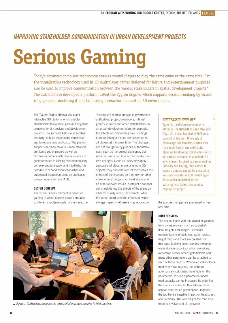
Figure 1, Stakeholders examine the effects of alternative scenarios in joint sessions.
SUCCESSFUL SPIN-OFF Tygron is a software company with offices in The Netherlands and New York City, USA. It was founded in 2005 as a spin-off of the Delft University of Technology. The founders started with the simple idea of supporting city planning by allowing stakeholders to try out various scenarios in a realistic 3D environment. Inspired by games such as Sim-City and LinCity, they wanted to create a gaming engine for processing accurate geodata and 3D modelling of cities which supported citizen participation. Today, the company employs 20 people.
BY FLORIAN WITSENBURG AND RUDOLF KOSTER, TYGRON, THE NETHERLANDS
‘players’ are representatives of government
authorities, project developers, interest
groups, citizens and other stakeholders. In
an urban development plan, for example,
the effects of constructing new buildings
or demolishing old ones are presented to
all players at the same time. The changes
are not brought in by just one authoritative
user, such as the project developer, but
rather all users can interact and make their
own changes. Since all users may apply
geodata and place, move or remove 3D
objects, they can discover for themselves the
effects of the changes on their own or other
stakeholders’ budgets, on heat stress and
on other relevant issues. A project developer
gains insight into the effects of the plans on
citizens’ quality of life, for example, while
the water board sees the effects on water
storage capacity. All users may respond on

2020 | INTERNATIONAL | A U G U S T 2 015 AUGUST 2015 | INTERNATIONAL |20
Figure 3, A spatial development project in Tarrytown, where citizen participation greatly contributed to reaching a consensus.
The Tygron Engine is linked to Esri’s ArcGIS
for data visualisation and datasheet creation.
The 3D representations are vector-based
and thus allow realistic visualisations.
Stakeholders add specific data, such as
scenarios and options – parameters like the
ones discussed above – and relationships
to other stakeholders. During joint sessions,
stakeholders implement alternatives to
which the other stakeholders may respond
(Figure 1). As the alternatives are explored,
the plans can be adjusted in line with new
insights or new developments. Throughout
the sessions, the stakeholders gain a better
understanding of their own and the other
stakeholders’ roles. They negotiate and
implement their plans and receive feedback
on the effects. The platform speeds up the
spatial development process, thus benefiting
all parties. The results are saved and
Figure 2, Visualisation of Lower Manhattan, created in response to Hurricane Sandy.
CHANGES AND THEIR EFFECTS ARE TRANSPARENT FOR ALL STAKEHOLDERS AND THIS INTRODUCES A BEHAVIOURAL CHANGE
presented to residents, interest groups or
other parties. As the project progresses, the
stakeholders might collect new information
which may impact financing and projected
results or shift interests. The adjusted project
also acts as a template for similar projects in
the future. Such an adaptive approach has
already allowed the development of a Climate
Game template, for example, which provides
new projects with a full set of climate-related
stakeholders, data models and options such
as green roofs, levees and dikes.
REVITALISING A STAGNANT PROJECTThe power of the platform was first
demonstrated in a deadlocked urban
development. The local government of Delft,
The Netherlands, had sold a land parcel
to a project developer, but refused to grant
a permit for development as long as the
buyer would not allocate part of the land as
an overflow reservoir to prevent inundation.
Costly lawsuits dragged on for five years and
the delay caused a loss of EUR12 million.
Residents feared an increase of traffic in their
neighbourhood, thus decreasing liveability.
After years of stagnation, local infrastructure
was degrading, a primary school suffered a
drop in the number of pupils and the quality
of life declined – a textbook example of a
stagnant project in which stakeholders hire
consultants to defend individual interests. The
serious game introduced by Tygron enabled
stakeholders to implement their ideas in a
virtual 3D environment, resulting in consensus
and understanding. This put an end to
lawsuits and streamlined communication and
progress. Today, the potential of this serious
game has been recognised by municipalities,
project developers and water boards, not only

FEATURE
21AUGUST 2015 | INTERNATIONAL |
Figure 4, The editor allows stakeholders to tune the project.
Figure 5, Maps of air quality in an area of Delft before (left) and after taking measures.
FLORIAN WITSENBURGFlorian Witsenburg, owner and CEO of Tygron, is a member of the Dutch government’s Smart Cities group and guest lecturer in software use
for community engagement at the Massachusetts Institute of Technology, Cornell University and Oxford University.
RUDOLF KOSTERRudolf Koster is software developer and specialises in API and SDK for interaction with the Tygron Engine.
in The Netherlands but also in the USA (see
Figures 2 and 3), South Africa and other parts
of the world.
EDITORThe functionality of the Tygron Engine is
sufficient to present an initial overview but, as
demands increase, users want to implement
case-specific data. The built-in editor allows
customisation of projects in a graphical ‘what
you see is what you get’ environment (Figure
4). The parametric design discussed above
shows the effects of, for example, building
a new neighbourhood from the perspective
of water-storage capacity and other related
components. Hence any changes and their
effects are transparent for all stakeholders,
and this introduces a behavioural change;
communication is more open since the
data can be explored by all stakeholders
and implementing incorrect or inaccurate
data would harm one’s own interests. In
one project, some stakeholders complained
that the data was wrong and provided their
own data. That stimulated the sharing
of information, active engagement and
transparent communication. In the traditional
approach, each stakeholder would hire
consultants, architects and lawyers to raise
and defend their own interests. The Tygron
platform helps stakeholders to collaborate,
negotiate and develop scenarios.
EXTERNAL MODELSUsers can expand the functionality by
connecting the platform to their own models
using the API. One example is the calculation
of the effect of a new road on the emission
of particulate matter. The platform sends a
request to the stakeholder’s external model,
retrieves buildings, roads, key performance
indicator targets, measures and other data,
and calculates concentrations. The results
are sent back to the platform which displays
maps and data sheets (Figure 5). External
models can also be called up by the platform
through web services. To facilitate working
with the API, a free open-source software
development kit (SDK) is available.
More informationwww.tygron.comwww.github.com/Tygron/SDK

No 2844
2844.indd 1 03-07-15 08:19

FEATURE
23 AUGUST 2015 | INTERNATIONAL |
Digital street maps are essential to car
navigation and visualisation of online mapping
products. Traditionally, such maps are made
of annotated vectors in a spatial database
that can be queried to retrieve optimal routing
information. Increasingly, the maps are
enriched with 3D contextual information. This
3D data is used for smart city management
or as the foundation for driverless cars. At
Nokia’s mapping division, known as HERE, the
3D data is collected by mobile laser scanning
on a large fl eet of cars around the world.
Nokia’s mapping division, HERE, uses a fl eet of more than 200 cars to collect dense point cloud data about roads around the world. The data from these mobile mapping vehicles is processed to secure privacy and produce detailed routing maps. This data is the input for various applications, ranging from traditional car navigation to analysis of the steepness of ramps. The most compelling application, however, is the application of this data to enable self-driving cars.
MOBILE MAPPINGOver 200 cars, known as TRUE cars, are
driving around the world to collect the
data (Figure 1). Each vehicle is outfi tted
with a 1.5m-high rig that holds a laser
scanner, cameras and a GNSS/IMU system.
The scanner, a Velodyne HDL-32E, is a
small rotating scanner that contains 32
independent lasers which emit pulses in
a swath of 40 degrees. In total, the
scanner collects up to 700,000 points
per second. The ranging accuracy of
the scanner is 2cm and points can be
scanned at a distance of up to 100m.
Thanks to the inclined position of the
Building a Global 3D Routing Map
USING MOBILE MAPPING TO COLLECT TRILLIONS OF POINTS AROUND THE WORLD
Figure 1, A TRUE car maps the streets of Berlin.
BY JOHN RISTEVSKI, VICE PRESIDENT REALITY CAPTURE AND PROCESSING, HERE
In early August 2015, Nokia announced an agreement to sell its HERE digital mapping and location services business to a consortium of three leading German automotive companies comprising Audi, BMW and Daimler.

2424 | INTERNATIONAL | A U G U S T 2 015 AUGUST 2015 | INTERNATIONAL |24
Figure 2, Collected 3D point cloud with derived road centre lines.
Figure 3, Digitised lane centre lines at an intersection.
A point cloud as collected for the HD maps
scanner on the roof of the car, shadow effects are mitigated
as much as possible.
The rig contains a GNSS receiver and an inertial
measurement unit (IMU) which collects position, heading
and attitude data. For street imagery, the TRUE cars also
include four wide-angle 24MP cameras. The images from
these cameras can be stitched into panoramic photos.
It is advantageous to use a small number of cameras for
panoramic photography, as this reduces the number of seam
lines in the stitched photo.
OPERATIONSFor effi cient data collection, each TRUE car has a routing
system installed that guides the driver to collect data from
unmapped areas or zones which require refreshed data.
The drivers focus primarily on major urban areas but data
is collected in some less populated regions too, such as
highways outside of urban centres or rural roads. The
combined sensors generate approximately 140GB of data per
day. Globally, the fl eet of TRUE cars collects 100 terabytes
of data, capture 9.5 million images and drive more than
50,000km in a single week. Between 2010 and 2015, 5
million kilometres of roads were mapped in 30 different
countries. Once the encrypted hard drives are full, the drivers
send the contents to one of three processing centres in Fargo
(North Dakota, USA), Leon (Mexico) or Mumbai (India). These
centres process the data and the hard drives are returned to
the fi eld for reuse after reformatting.
PROCESSINGAfter the new data is received by one of the processing
centres, it undergoes a number of processing steps. These
steps are partly automated, but a human operator is needed
to complete many of the checks. All images are visually
checked for quality. Photos with bad weather or sun glare
are deleted. To eliminate privacy concerns, blurring fi lters
are automatically applied to people’s faces and licence
plates. After the privacy check, each map is tagged with
road attributes such as stop signs and speed limit signs.
Those street signs are automatically detected from the
images using algorithms that are capable of recognising
signs in 22 countries. A team of analysts cross-checks the
automated results with the images to confi rm the output of
the tags and eliminate ambiguities. The resulting map is also
cross-referenced against other sources, such as government
databases and city maps, and run through a program that
uses a set of rules to detect illegal situations or database
inconsistencies. Internally developed algorithms are run on
these different data sources looking for discrepancies as the
data is processed.
The point cloud data is then analysed to retrieve lane
markings and curb edges (Figure 2). Lane markings can be
recognised from the point cloud because each point contains
a value for refl ected intensity. As lane markings are bright in
comparison to the pavement, they also stand out very clearly
in the point cloud. Curb edges can be detected by searching
for clear break lines at the roadside.

FEATURE
25AUGUST 2015 | INTERNATIONAL |
JOHN RISTEVSKIJohn Ristevski is vice president of reality capture and processing at Nokia’s mapping company, HERE. John joined HERE in 2012 through the
acquisition of his company, Earthmine, which developed mobile mapping systems. He was director of R&D at non-profit CyArk, and has lectured at Stanford’s Civil and Environmental Engineering Department. He has a master of science degree from the University of California at Berkeley and has degrees from the University of Melbourne, Australia, in both geomatic engineering and law.
END RESULTSThe end result of all processing is a database
containing the detailed geometry of the road
and its attributes including lane boundaries,
curb edges, lane restrictions, speed limits,
etc. This data can form the basis for car
navigation databases, for example. The point
cloud data is stored as a separate product
in a cloud environment. The collected point
clouds have an absolute accuracy of 5m and
a relative accuracy of 20cm over a distance
of 100m (Figure 3).
SELF-DRIVING CARSThe development of self-driving cars is
giving significant impetus to the collection
of point clouds around the world. Compared
to 2D maps, the HD 3D maps provide more
information at a higher fidelity and accuracy,
including features such as lane markings
and roadside barriers. Autonomous cars
are equipped with an array of sensors to
recognise the roads. The HD map is able
to provide additional context for the real-
time sensors, thus allowing the vehicle to
distinguish anomalous situations from regular
driving conditions – e.g. is a lane divider
knocked down? Has a tree fallen into the
street?
Additionally, while sensors on autonomous
cars can detect a distance of around 30
metres, a car travelling at high speed such as
on a motorway has a sensing horizon of just
one or two seconds. A detailed 3D map helps
cars to ‘peek’ around the corner. In addition,
self-driving cars will be able to improve their
positioning by referencing re the information
contained in the map against what they
sense in real time. This is an additional level
of reliability compared with regular GNSS/
IMU positioning. In 2013, Mercedes used
the HD map to recreate the world’s first long-
distance journey driven by Bertha Benz – an
equally historic 100km drive, but this time
completed by an autonomous vehicle.
In other applications of the technology,
inspecting the road condition can lead
to safer roads while also reducing costs.
The Americans with Disabilities Act (ADA)
stipulates a certain size and maximum
slope for ramps, and the City of Oakland
in California used the 3D scan data to
reduce the costly and labour-intensive field
work required to identify and catalogue
ADA-compliant ramps across the city. High-
resolution panoramic imagery in conjunction
with the overlapping 3D point cloud data
allowed accurate measurements to be taken
quickly and the necessary geometry to be
extracted for cataloguing purposes.
No
2843
No 2862
2862.indd 1 04-08-15 09:53

REPORTYOUR GIM-INTERNATIONAL.COM REPORT BY FRÉDÉRIQUE COUMANS, CONTRIBUTING EDITOR, GIM INTERNATIONAL
27AUGUST 2015 | INTERNATIONAL |
By invitation only, all of the cadastral
organisations in the European Union come
together once per six months at a conference
of the Permanent Committee on Cadastre
(PCC). It is an efficient way of evaluating the
trends and learning about best practices in
a small group of peers. Through coordinated
efforts, the cadastral organisations ensure
that cadastral data can be used widely,
even across European borders. 28 different
The 28 organisations responsible for the national cadastres in the countries of the European Union cooperate on a structural basis in the Permanent Committee on Cadastre (PCC). Their aim is to have a strong, top-level personal and institutional network that facilitates exchange of knowledge. It is impossible to point out clear results on a pan-European level, but the PCC definitely helps each cadastral agency to make individual progress faster, with a clear vision of shared strategies
institutions in as many EU countries provide
information about more than 560 million land
parcels. They feel strongly that cadastral and
land registry information and services should
be an integral part of national e-government
infrastructures.
PROPERLY CONNECTED“The value of cadastral information is still
underestimated and decision-makers too
often do not recognise that our information is
fundamental, not only for taxation purposes
but also for secure land tenure, environment
protection and sustainable land development
at both national and European level. Cadastral
and land registration data – in particularly
when managed by different institutions –
should be properly connected. We strive
to achieve full coverage and high-quality
data: secure, up-to-date, well-described,
transparent and accessible. In that way fiscal,
legal and administrative information becomes
available for stronger economic, social and
environmental development,” stipulates Ms
Elita Baklane-Ansberga, president of the
PCC during the first half of 2015 and director
general of the Latvian State Land Service.
She made an inventory of the current crucial
projects among the PCC members. Most
of the issues mentioned by the country
representatives are connected to necessary
supportive legal changes and attempts to
make the cadastral information part of the
national e-government infrastructures. When
talking about future business challenges,
most of the countries mentioned integration
of information systems with partly overlapping
workflows: land registry, survey, cadastre,
valuation of real estate and other public
registers. New sources to update cadastral
data are being invested by several countries,
varying from interconnection with other public
Permanent Committee on Cadastre has Become a Solid Value in Europe
PCC CONFERENCE IN RIGA
Elita Baklane-Ansberga (Latvia) hands over the flag to the next president, Raymond Dhur (Luxembourg).

AUGUST 2015 | INTERNATIONAL |2828 | INTERNATIONAL | A U G U S T 2 01528
Table: Survey on PCC Member States’ Opinions about Open Data, Table 2.5, Riga, May 2015 (Belgium, Bulgaria, Croatia and Malta did not respond).
international organisations (EuroGeographics,
CLGE and WPLA) and four national cadastral
organisations from non-EU countries (Iceland,
Switzerland, Norway and Turkey) currently
have the status of PCC observer.
This way of finding solutions to common
challenges is still appealing today, confirms
Mrs Baklane. Latvia became an EU member
in 2004. “In the PCC I share knowledge,
make contacts for exchanging experiences
and find partners for different projects. To
name one example, last year our experts
worked with the National Land Survey of
Finland and the Swedish Mapping, Cadastral
and Land Registration Authority. It concerned
a project to implement sustainable ICT
solutions for electronic data archiving and
for mass digitisation of paper documents.
The shared experiences from Sweden and
Finland helped to make state administration
processes in Latvia more effective.”
REVOLVING PRESIDENCYIn the EU the presidency of the European
Council (that comprises the 28 heads of state
to define the EU political direction) changes to
another Member State every six months, and
so too does the presidency of the PCC. The
active president organises a conference. The
most recent two-day conference was held in
Riga (Latvia) in May and the next one will take
place in Luxembourg in November. To ensure
the continuity of the PCC there is a Steering
Committee where the active president, the
outgoing and the incoming president work
together. The PCC works without any regular
budget and there are no membership fees;
all activities are financed by the presiding
organisation. This organisational structure
does not help the implementation of long-
lasting projects. Elita Baklane-Ansberga
admits: “In Latvia we have a saying: ‘The
one who pays can order the music’. The
presiding institution of the PCC actually
defines the agenda and has the possibility to
speed up certain cooperation projects and to
encourage certain discussions. That doesn’t
mean that I’m sceptical about the PCC at all.
It’s true that there are no specific continuous
projects because of our differences in
character and traditions; we all choose to
accentuate other things. But that’s also the
most important strength: our competences
diverge. And we don’t have to prove anything
to anybody; we can be honest about
solutions in detail. No empty words here, but
rather in-depth discussions with a focus on
cadastral relevancy.”
During the Latvian presidency of the
EU Council the leading theme was the
development and strengthening of the
information society in Europe, so it should
come as no surprise that the then-active
president of the PCC chose the same
theme. “More and more data which is the
administrations to crowd sourcing, very-high-
resolution photogrammetry and the use of
drones.
EXCHANGECadastral issues are not directly regulated in
Europe and they are an internal matter for
each country, except for some requirements
imposed by the INSPIRE Directive (a law
at EU level). To ensure that the spatial
data infrastructures of the Member States
are compatible and usable in a trans-
boundary context, the Directive requires
that Implementing Rules are adopted in a
number of specific areas. PCC members
are responsible for many INSPIRE data
themes; most common are cadastral parcels,
addresses, buildings and administrative units.
Secure ownership rights are important to
support basic principles of the EU: freedom
of market, movement of goods, capital
and people. In view of the influence of real
property cadastres on the legal system and
the economies of the EU, and because of
forthcoming technological challenges and
the INSPIRE regulations, the cadastral
agencies thought it necessary to facilitate the
exchange of information, expertise and best
practices. Therefore the PCC was constituted
in 2002, also to promote awareness of the
activities and importance of cadastres and
to achieve greater coordination among the
different cadastral systems in the EU. Three

REPORT
AUGUST 2015 | INTERNATIONAL | 29
responsibility of the cadastral organisations
is used both in the public and private sector.
It’s necessary to ensure that the information
is as up-to-date as possible and that the
data structure supports decision-making
processes for future planning requirements.”
Therefore the main issues on the conference
agenda in May were related to the digital
infrastructure for land administration, new
solutions/sources to improve data quality and
access to and reuse of cadastral data.
OPEN CADASTRAL DATA Based on a questionnaire developed by the
Latvians (which was completed by all but
four PCC members), it became clear that
the discussion about implementing ‘open
data’ on the national political level is ongoing
in most countries, but the definition varies.
However, ‘open data’ is mostly identified by
the PCC members as open access, machine-
readable and reusable without restrictions.
In Denmark, Greece, Lithuania, Slovenia and
Spain all relevant data – e.g. on cadastre,
buildings, taxation, address and land register
– is already open. Austria, Germany and
Hungary have decided to be completely
restrictive to cadastral datasets, either free or
paid for, even the INSPIRE-related ones. The
other countries are somewhere in between
(see figure).
The obstacles to making cadastral data
open are diverse. Some countries have the
opinion that cadastral data are private data,
also when connected to other data layers,
and therefore confidential (67%). 30% of
the participants also mentioned the need
for technological developments, business
process reengineering or changes in the
internal business culture. Last but not least,
there is the financial barrier (63%). Elita
Baklane-Ansberga comments:
“There is strong pressure from EU initiatives
and domestic data users to provide free-of-
charge services for reuse of cadastral data.
In most of the countries cadastral institutions
are financed partly from self-revenues and
data distribution fees are applied. Of course,
we see that fees are an obstacle for the wider
use of our data. But making the data free of
charge for non-governmental users would
require a financial contribution from the state
to keep our public registers in good shape
and in line with modern needs. In this day
and age, that’s not realistic.”
More informationwww.eurocadastre.org
Compatible with
POWER AND PRECISIONAT YOUR FINGERTIPS
EZSURV ® POST-PROCESSING SOFTWAREPROVIDES YOU WITH:
Access to more than 8,000 CORS stations data all around the world
Support multiple receiver native data format
State-of-the-art processing engine
Easy-to-use application
Flexible licensing mechanism
White Label version available for manufacturers
ASK FOR YOUR FREE TRIAL
effi gis.com/ezsurv
No
2807

3030 | INTERNATIONAL | A U G U S T 2 0153030
Siteco is a private company founded in 2000
by Augusto Burchi. In December 2014 it
joined the Gavio Group, an Italian leader in
infrastructure construction and motorway
management. Siteco currently employs 15
people in 3 main areas: system production,
software development and training/support.
The company generated a turnover of EUR2
million in 2014 and has enjoyed steady
growth of 10% p.a. in the last 3 years.
The original company activity was the
development of road information systems for
asset management and engineering design
but since 2005 the core business has been
progressively extended to include surveys
of large road networks and roadside asset
databases. To achieve this, proprietary
technology for photogrammetric survey was
developed, based on the Applanix INSs.
The sub-metre accuracy achieved with
the imagery technology was quickly
revolutionised with the adoption of the first
FARO LS 880 laser-scanner, generating
massive georeferenced point clouds. The
density of the first model in 2007 allowed
generation of cross-sections every 15-30cm
(depending on the driving speed), thus
increasing the accuracy of all roadside
asset measurements (clearance, guardrails,
pavements, lanes, etc.). In 2010, the new
FARO Focus model became more lightweight
and offered faster scanning. This allowed
for the development of the Road-Scanner3
model, equipped with up to 3 lasers, which
achieved complete environmental coverage of
120m per side and accuracy of 2-3cm.
“The point clouds obtained can be merged
with the imagery to obtain high-grade
deliverables of traditional static surveys with
GPS/total station, but with an increased
productivity some 2-5 times greater. Since
2009, we’ve been able to compete with the
top mobile LMSs,” says Augusto Burchi. “We
offer similar performance at lower prices
thanks to the more cost-effective FARO
sensors.”
LASER MAPPING SYSTEMS TAKE OFFThe company’s mission and primary business
is to improve the cost-effectiveness of laser
mapping systems (LMSs) and to open the
market to thousands of mid-size surveying
and engineering companies. The LMS
market is almost ten years old yet has barely
reached 10% of potential applications due
to high costs and complexity of operation.
Current LMS software requires a high level
of skill and, depending on the application,
different software licences to execute lengthy
conversions of big datasets.
Siteco is focused on producing the best
price/performance mobile mapping systems
Siteco S.r.l., based in Bologna, Italy, is among the first companies to develop mobile mapping systems. Initially based on FARO sensors, the Road-Scanner system now supports most commercially available scanners and inertial navigation systems (INSs). This strategy is based on the development of flexibly configured, easy-to-use systems and software, allowing for large-scale adoption.
SITECO
Mobile Laser Mapping Systems for all Pocketbooks
Every month GIM International invites a company to introduce itself in these pages. The resulting article, entitled Company’s View, is subject to the usual copy editing procedures, but the publisher takes no responsibility for the content and the views expressed are not necessarily those of the magazine.
Top: Road-Scanner4 with 2 Z+F 9012 laser-scanners, bottom: Road-Scanner4 with 2 RIEGL VQ450 laser-scanners.

COMPANY’S VIEW
31AUGUST 2015 | INTERNATIONAL |
and supplying them with a complete project
planning, execution and data-delivery
software package. The Road-Scanner can be
flexibly configured with almost any brand of
sensors (Lidar, spherical cameras, thermal
cameras, pavement inspection equipment,
etc.) and INSs. Whereas hardware producers
typically try to capture market segments
by offering dedicated closed-architecture
designs with expensive task-specific sensors,
this flexible strategy allows everyone to
benefit from the technological advancements.
TRANSLATING CUSTOMER NEEDSThe company serves the international market
with 15 years’ experience in software and
hardware development. The technical team
has proven its competence and global
mindset by supporting customers on almost
every continent. There are also SitecoBG
operations in Sofia, Bulgaria, a team of 10-15
experts who are fully trained and experienced
in processing GIS or CAD deliverables. The
team is available to assist Road-Scanner
customers in need of excess processing
capacity at short notice.
Augusto Burchi describes the company
challenge as: “Always understanding the
client’s needs and quickly showing them
that the hardware and software products
can fit those needs”. Hence Siteco works
side by side with its customers, quickly
understanding their needs to adapt the
system and software for their specific
application, as demonstrated recently
with ASCO, for example. This 200-strong
engineering company based in Osaka,
Japan, had been operating an expensive
mobile mapper for several years but was
not fully satisfied with its complexity and
low-resolution imagery. After seeing the
Road-Scanner system at Intergeo 2014,
ASCO requested a pilot test in a 140km road
survey on Okinawa. This was completed in
March 2015 and data was delivered to the
final customer. In April, ASCO subsequently
ordered a new system configured with
Applanix POSLV 510 INS and which can be
used with either Z+F or FARO Focus laser
scanners. It is now fully operational and the
customer is completely satisfied.
Siteco achieved similar success in France
where the feature extraction software had
to fulfil ERDF’s demanding specifications
for high-grade maps (1:200 scale) of large
urban communities (Bordeaux, Nantes,
Paris). Thanks to that cooperation, Road-
Scanner users can now deliver the high-
grade maps without the delays experienced
with traditional GPS and total-station survey
methods.
Another rewarding experience was Amberg
Technologies’ decision to adopt the Road-
Scanner mobile mapping system. Following
three years of collaboration in road and
railways surveys in Switzerland, Siteco was
able to demonstrate that the Road-Scanner
system could achieve the extreme accuracies
required by the railway sector using Amberg’s
own Z+F-based scanners.
FUTURE OUTLOOKThe mobile mapping industry has evolved
into several clear vertical markets: mass
image-based collection (e.g. Google,
Microsoft and other map tools), limited-
accuracy roadway inventory management
systems, and engineering/survey-grade
projects with high performance demands.
Siteco has always strived to offer customers
the highest possible accuracy balanced with
the cost-effectiveness of the best choice of
scanner, camera and INS components. This
allows optimum flexibility for any customer,
especially if they already use a laser scanner
and Lidar sensors for other purposes.
Integrating them into a mobile system
platform provides cost savings by reducing
component duplication. Survey companies
are demanding more effective usage of their
capital assets and no longer leave expensive
systems sitting idle between jobs. Siteco’s
ongoing R&D focus is on offering the most
flexible and compact platforms, with a
comprehensive set of software for project
planning, execution and data deliverables
while staying highly compatible with clients’
existing software platforms. While system
performance is never a compromise, cost
competitiveness and system flexibility are the
main drivers of Siteco’s innovation initiatives.
The demand is growing for new applications
in factory environments and interior data
collection, and also for more compact and
diverse vehicles. There are new technology
sensors appearing on the market and even
flash Lidar cameras are beginning to see
mainstream markets. These have all been
part of Siteco’s most recent technology
roadmap. The challenge lies in ensuring that
there is flexible, scalable hardware coupled
with software which makes the operator’s
tasks simple and efficient. The company’s
history of innovation combined with close
consideration of client demands has been the
mainstay of Siteco’s success so far.
BY AUGUSTO BURCHI, CEO, SITECO, ITALY
More informationwww.sitecoinf.it
Road-Scanner3 with 3 FARO Focus laser scanners.
The Siteco team.

5 good reasons not to miss it!
Save the date: 10 - 12 February 2016
The GIM International Summit is a brand-new event for the geospatial industry. Building on 30 years of leadershipas a global geospatial publication, GIM International is now leveraging its print and online prowess to facilitate alcutting-edge forum for thought-leaders and decision-makers. The event will go beyond industry borders, challengeconventions and look ahead to the future. Infl uential speakers from both within and beyond the sector will providean inspiring practical perspective on the spatial dimension of global development.
Seek spacefor future
development
Enjoy the city of Amsterdamto the fullest!
Meet your peers within the
geomatics world
Only 15 minutes from the airport and in the heart of Amsterdam
Celebrate 30 years of geospatial knowledge
by innovating the future!
Visit www.gimsummit.com for the programme!Partners
SEEKING SPACE FOR FUTURE DEVELOPMENT. JOIN THE GIM INTERNATIONAL SUMMIT
MG
008
Naamloos-1 1 19-05-2015 09:51:14

FIG
33AUGUST 2015 | INTERNATIONAL |
FÉDERATION INTERNATIONALE GÉOMÈTRES
INTERNATIONAL FEDERATION OF SURVEYORS
INTERNATIONALE VEREINIGUNG DER VERMESSUNGSINGENIEURE
PRESIDENTChryssy Potsiou, Greece
VICE PRESIDENTSBruno Razza, ItalyDiane Dumashie, United KingdomPengfei Cheng, China Rudolf Staiger, Germany
REPRESENTATIVE OF THE ADVISORY COMMITTEE OF COMMISSION OFFICERSBrian Coutts, New Zealand
COMMISSION 1Brian Coutts, New Zealand
COMMISSION 2E.M.C. (Liza) Groenendijk, The Netherlands
COMMISSION 3Enrico Rispoli, Italy
COMMISSION 4Angela Etuonovbe, Nigeria
COMMISSION 5Volker Schwieger, Germany
COMMISSION 6Ivo Milev, Bulgaria
COMMISSION 7Gerda Schennach, Austria
COMMISSION 8Kwame Tenadu, Ghana
COMMISSION 9Liao Junping (Patrick), China
COMMISSION 10See Lian ONG, Malaysia
FIG OFFICELouise Friis-Hansen, manager
INTERNATIONAL FEDERATION OF SURVEYORS, FIG, KALVEBOD Brygge 31-33DK-1780 Copenhagen V DenmarkTel + 45 3886 1081 Fax + 45 3886 0252Email: [email protected] Website: www.fig.net
INTERNATIONAL FEDERATION OF SURVEYORS
Participants of the 3rd Young Surveyors European Meeting send their regards to the world.
More information www.fig.net
The future of young surveyors, as
professionals as well as individuals, entails
endless possibilities and unique opportunities,
interspersed with various challenges and new
agendas. What is our role in this future and
how can we best meet those challenges and
seize those opportunities?
Those are just a few of the questions which
were discussed during the 3rd Young Surveyors
(YS) European Meeting held at the University
of Architecture, Civil Engineering and
Geodesy in Sofia, Bulgaria on 16 May 2015.
About fifty young professionals from twenty
countries gathered to share and explore new
ideas, address pressing issues and focus
on the future development of the European
YS Network. By organising the meeting as
a pre-event of the FIG Working Week 2015,
young surveyors from Malaysia, China, Japan,
Nigeria and Ghana were able to join.
PAST EXPERIENCESDuring the opening ceremony FIG president
Chryssy Potsiou shared her conception of
the involvement of the YS Network in FIG
as a joint effort to ensure a prosperous
and sustainable future of the profession.
Eva-Maria Unger, chair of the Network and
Paula Dijkstra, the vice chair presented the
agenda and gave an overview of the work
plan for the next term of office. The Council
of European Geodetic Surveyors presented its
recent project activities, followed by speeches
from the Chamber of Engineers in Surveying
in Bulgaria and from the hosting University.
Speakers encouraged the participants to get
involved in various international organisations.
During this event a variety of topics was
covered, the first being astronomy and how
it is related to surveying. A journey through
our surveying history was then presented,
covering the most outstanding discoveries
and groundbreaking inventions. It started
with Aristoteles, highlighted surveying
achievements during the time of Napoleon
and ended in the modern world of surveying
with an extraordinary tale from Japan.
THINK GLOBALLY, ACT LOCALLYThis was followed by an interactive working
session, themed “Wisdom through Trial
and Error”. Group discussions focussed
on the need for broader integration in
different organisations; on the role on an
international scale and on unfolding tasks
and responsibilities. Some of the objectives
presented at the end of this session included
the establishment of a global professional
forum as a platform for data, the sharing
of experience and resources and far more
extensive promotion of young surveyors’
activities to students’ associations worldwide.
The afternoon session was dedicated to
‘Challenges of the Modern World, Innovations
and Land Management’. The goals and
missions of the UN-Habitat Global Land Tool
Network were presented, followed by the ‘Fit
for Purpose’ concept for land administration,
fundamentals of modern photogrammetry,
achievements in 3D laser scanning and
unlimited data management. During the
concluding session diverse topics were
discussed such as digital mapping of urban
change, the perspective of different roles as a
young surveyor in a professional career, and
an innovative project for raising awareness
and advertising the many aspects of our
profession among the young generation. One
of the participants summarised the outcome of
this amazing event as follows: ‘Alone We Can
Do so Little, Together We Can Do so Much’.
Anna Shnaidman, Israel, Eva-Maria Unger,
Austria and Paula Dijkstra, The Netherlands.
3rd Young Surveyors European Meeting, Sofia, Bulgaria

No
2842
No
2565

GSDIGLOBAL SPATIAL DATA INFRASTRUCTURE ASSOCIATION
GSDIGlobal Spatial Data
Infrastructure Association
35AUGUST 2015 | INTERNATIONAL |
GSDI members contribute to the development
of spatial data infrastructures throughout the
world. While tackling institutional and technical
issues domestically, many also work to identify
innovative approaches and appropriate
technologies in other countries. Innovative
and appropriate are operative words, since
every country has unique sociopolitical
dynamics and public administration structures.
The establishment of SDI cannot be easily
standardised. Other guiding principles are
simple, low cost, and user-friendly.
GSDI member, the Dutch Cadastre, Land
Registry and Mapping Agency (Kadaster)
was named ‘National Geospatial Agency of
the Year’ at the INSPIRE-Geospatial World
Forum in Lisbon in May 2015, owing in part
to Kadaster International’s efforts to empower
land and mapping agencies in developing
countries worldwide.
Kadaster shares its knowledge of modernising
its own organisation, changing it from a
governmental to an independent body, moving
from an analogue to a digital environment,
moving from a task-oriented organisation to a
customer-oriented organisation. The Kadaster
therefore has a variety of methods, procedures
and IT-systems at its disposal for realising land
administration and SDI objectives. Some of
these methods are illustrated in the following
highlights from recent Kadaster assignments in
Croatia, Jordan, Rwanda and Colombia. For 15
years, Turkey and The Netherlands have also
cooperated in the field of land use and rural
development.
CROATIAThe Ministry of Justice in Croatia is
com puterising part of its archives, including
source documents for the land book. Apart
from safeguarding and preserving those
archives, the Ministry recognises options for
potential future use of these documents and
that management of sustainable archives is
a knowledge domain in itself. The archives
need to be accessible over decades or even
centuries. An international team from Austria,
Slovenia, Greece and The Netherlands shared
experiences during a workshop with experts
from the Croatian Ministry in May 2015. Apart
from relevant legislation, they debated the
organisational and IT impact involved and
presented recommendations in support of the
GSDI Members’ Global SDI Work: Dutch Kadaster
harmonisation process between the land book
and the cadastral map. This ongoing operation
may lead to the use of web services for
citizen participation. Efficiency improvement,
compliancy and trust in the government are all
relevant to the process.
JORDANThe Swedish cadastre agency, Swedesurvey,
and Dutch Kadaster are cooperating on
an EU-funded project in Jordan with the
Department of Lands and Survey. The aim is
to reduce discrepancies between the physical
reality and documented graphical cadastral
information. Swedesurvey and Kadaster are
sharing their experience both domestically and
internationally in this field. Other joint activities
are underway in Saudi Arabia and Malawi.
RWANDAIn March 2015 the Land Administration
Information System (LAIS) went live in
Rwanda. District Land Bureaus under
the Rwanda Natural Resources Authority
(RNRA) now have access to this system.
LAIS supports the registration of rights on
immovable objects, such as houses and
land, and creation of land certificates and
efficient maintenance processes. The first
LAIS module was introduced in 2012 in the
Kigali City District Land Bureaus. Supported
by a Kadaster GIS-expert, RNRA launched
the second version of LAIS. As a web-based
land registration tool, LAIS allows working with
many users without creating inconsistencies
and conflicts in maintaining the data. This
ensures all land owners in Rwanda receive
land title documents that are legally valid.
COLOMBIAThe Colombian government is mapping land
properties, with a land administration system
at the forefront of peace negotiations with
the FARC. Land rights are being formalised
and incorporated into national laws. People
driven from their homes during the civil war
will receive restitution. Many small farmers
in Colombia are not able to prove that they
own specific land. With the international land
administration school, ITC, the Kadaster will
assist Colombia to formally register those land
rights. On 13 March 2015, an agreement was
signed with the Dutch Embassy in Colombia
and Colombian stakeholders.
More informationwww.gsdi.org
Mapping land rights in Colombia in support of the peace process.
PRESIDENT & EXECUTIVE DIRECTORDavid Coleman, Canada
PAST PRESIDENTAbbas Rajabifard, Australia
PRESIDENT ELECTDavid Lovell, Belgium & UK
SECRETARY GENERALRoger Longhorn, Belgium
SECRETARYAl Stevens, USA
TREASUREREddie Pickle, USA
BUSINESS MANAGERMarilyn Gallant, USA
NEWS EDITORSKate Lance, USAKaren Leveloger, The Netherlands
GSDI OFFICEGSDI AssociationAttention: Marilyn Gallant, Business Manager946 Great Plain Avenue, PMB-194 Needham, MA 02492-3030, USA
www.gsdi.org

No
2798
2798.indd 1 15-04-15 09:26

IAG
The mission of the Association is the advancement of geodesy.
IAG implements its mission by:
- advancing geodetic theory through research and teaching,
- collecting, analysing and
modelling observational data, - stimulating technological
development, and - providing a consistent
representation of the figure, rotation and gravity field of the Earth and planets, and their temporal variations.
IAG EXECUTIVE COMMITTEE 2011 - 2015
President:Harald Schuh, [email protected]
Vice-President:Zuheir Altamimi, [email protected]
Secretary General:Hermann Drewes, [email protected]
Immediate Past President:Chris Rizos, [email protected]
President of Commission 1 Reference Frames:Geoff Blewitt, [email protected]
President of Commission 2 Gravity Field:Roland Pail, [email protected]
President of Commission 3 Earth Rotation & Geodynamics:Manabu Hashimoto, [email protected]
President of Commission 4 Positioning & Applications:Marcelo Santos, [email protected]
Chair of Global Geodetic Observing System (GGOS):Hansjörg Kutterer, [email protected]
President of Communication & Outreach Branch (COB):Jozsef Adam, [email protected]
Representatives of the Services:Ruth Neilan, [email protected] Barzaghi, [email protected]
Axel Nothnagel, [email protected]
Members at Large:Maria Cristina Pacino, [email protected] Combrinck, [email protected]
INTERNATIONAL ASSOCIATION OF GEODESY
37 AUGUST 2015 | INTERNATIONAL |
Achievements and Highlights of the IAG 2011-2015
More informationwww.iag-aig.org
Participants at the 2013 Scientifi c Assembly in Potsdam.
This is my last contribution as president of the
IAG. The new IAG president is Harald Schuh,
and the new vice-president is Zuheir Altamimi.
Hermann Drewes remains secretary-general.
I’m pleased to take this opportunity to
summarise some of the achievements and
highlights of the IAG during the past four
years.
Milestones. Over 500 scientists attended
the IAG Scientifi c Assembly in Potsdam,
Germany, from 2-6 September 2013 to
celebrate the 150th anniversary of the
founding of the IAG’s forerunner organisation,
which was established in 1862 to oversee
the Central European Arc Measurement
(‘Mitteleuropäische Gradmessung’) Project.
The International GNSS Service (IGS)
celebrated 20 years of service at its biennial
workshop, 23-27 June 2014, in Pasadena,
California. The 19th International Workshop
on Laser Ranging from 27-31 October 2014
in Annapolis, Maryland, marked the 50th
anniversary of the fi rst successful satellite
laser ranging measurement.
Noteworthy Progress. Never before has the
investment in geodetic infrastructure been so
high, its outputs so accurate and its utility so
widely recognised. On 26 February 2015 the
United Nations General Assembly adopted
the Global Geodetic Reference Frame for
Sustainable Development recognising the
growing role of geodesy in people’s lives and
its contributions to the geospatial discipline
and the geosciences. For example, more
new radio telescopes have been inaugurated
than ever before. The latest version of the
International Terrestrial Reference System,
the ITRF2014, has been released. Progress
has also been made in gravimetry networks
and standards, gravity fi eld mapping from
space (including monitoring of time-varying
features), in developing guidelines for an
International Height Reference System,
refi ning the structures of the Global Geodetic
Observing System (GGOS), launching new
GNSS-based services to support real-time
geohazard-related applications and system
integrity monitoring, and continued regional
campaigns and collaborations.
Engagement and Collaboration. The IAG
engages with many national and international
science agencies, professional associations
and non-government organisations, including
the International Union of Geodesy &
Geophysics (IUGG), International Council for
Science (ICSU), Group of Earth Observations
(GEO), UN Offi ce for Outer Space Affairs
(UN-OOSA), UN Global Geospatial
Information Management (UN-GGIM), and
its sister associations in the Joint Board of
Geospatial Information Societies (JBGIS).
Such engagement manifests itself among
other things as joint conferences, workshops,
publications and collaborative projects,
thanks to the fact that many offi cers of the
IAG (its Commissions and Services) also
hold positions in a range of scientifi c and
professional organisations and hence are able
to promote geodesy more broadly.
Outreach and Education. During the past
four-year period the IAG sponsored 65
conferences or workshops, ran more than
10 schools (GNSS, space geodesy, reference
frames, geoid, heights), published (or
prepared) 11 conference proceedings in the
IAG Symposia Series, and published over
300 peer-reviewed articles in its Journal of
Geodesy. Particularly noteworthy is the fact
that the IAG granted 94 scientists, 49 of
whom in developing countries, a travel award
for attendance of conferences or workshops.
Organisational Matters. The IAG continues to
pursue goals aimed at improving its operations,
its governance structures and its visibility.
Amongst the initiatives in this regard are the
restructure of GGOS (and its components),
the commencement of the IAG Service
Assessment Exercise, increased engagement
with the UN (through the UN-OOSA and
UN-GGIM), and of course the election of a
new IAG leadership team at the IUGG General
Assembly, held in Prague, Czech Republic,
from 22 June to 2 July this year.
I have enjoyed a stimulating and highly
satisfying four years at the ‘helm’ of the IAG
and I wish to thank all the people (both within
and external to the IAG) who have assisted me
in so many ways. I look forward to continuing
to serve the interests of the IAG. I wish my
successor well and am confi dent that under
his leadership the IAG will continue to provide
essential geodetic services to our modern
world.
Chris Rizos

No
2803
Siteco Informatica srl [email protected] www.sitecoinf.it
tel +390516414470
Configure your own selection of sensors, INS system or use your existing Faro, Z+F and other scanners.
Complete calibration, project planning, execution and data delivery software package included.
INTERGEO 2015 Hall 4 - Booth E4.088
No
2852
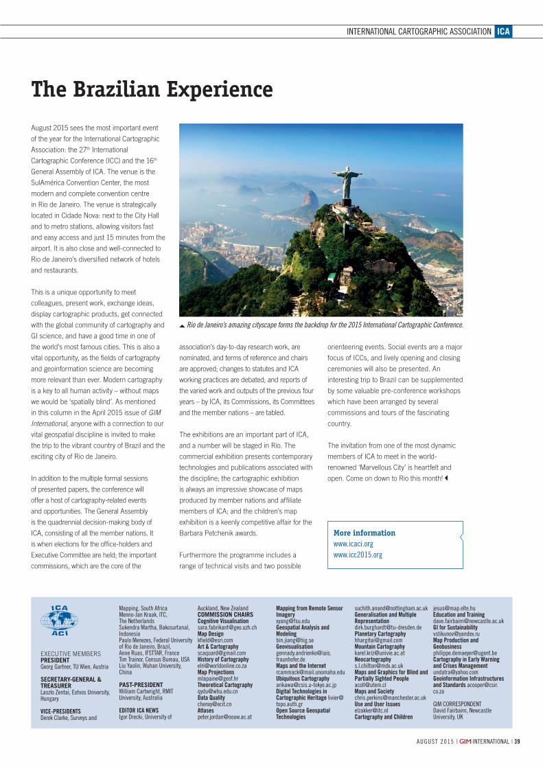
ICA
39AUGUST 2015 | INTERNATIONAL |
EXECUTIVE MEMBERSPRESIDENTGeorg Gartner, TU Wien, Austria
SECRETARY-GENERAL & TREASURERLaszlo Zentai, Eotvos University, Hungary
VICE-PRESIDENTSDerek Clarke, Surveys and
Mapping, South AfricaMenno-Jan Kraak, ITC, The NetherlandsSukendra Martha, Bakosurtanal, IndonesiaPaulo Menezes, Federal University of Rio de Janeiro, Brazil, Anne Ruas, IFSTTAR, FranceTim Trainor, Census Bureau, USALiu Yaolin, Wuhan University, China
PAST-PRESIDENTWilliam Cartwright, RMIT University, Australia
EDITOR ICA NEWSIgor Drecki, University of
Auckland, New ZealandCOMMISSION CHAIRSCognitive [email protected] [email protected] & [email protected] of [email protected] [email protected] [email protected] [email protected]@oeaw.ac.at
Mapping from Remote Sensor Imagery [email protected] Geospatial Analysis and Modeling [email protected] [email protected] and the [email protected] [email protected] Technologies in Cartographic Heritage [email protected] Open Source Geospatial Technologies
[email protected] and Multiple Representation [email protected] [email protected] [email protected]@mdx.ac.ukMaps and Graphics for Blind and Partially Sighted [email protected] and [email protected] and User [email protected] and Children
[email protected] Education and [email protected] for [email protected] Production and [email protected] in Early Warning and Crises [email protected] Geoinformation Infrastructures and Standards [email protected]
GIM CORRESPONDENTDavid Fairbairn, Newcastle University, UK
INTERNATIONAL CARTOGRAPHIC ASSOCIATION
August 2015 sees the most important event
of the year for the International Cartographic
Association: the 27th International
Cartographic Conference (ICC) and the 16th
General Assembly of ICA. The venue is the
SulAmérica Convention Center, the most
modern and complete convention centre
in Rio de Janeiro. The venue is strategically
located in Cidade Nova: next to the City Hall
and to metro stations, allowing visitors fast
and easy access and just 15 minutes from the
airport. It is also close and well-connected to
Rio de Janeiro’s diversified network of hotels
and restaurants.
This is a unique opportunity to meet
colleagues, present work, exchange ideas,
display cartographic products, get connected
with the global community of cartography and
GI science, and have a good time in one of
the world’s most famous cities. This is also a
vital opportunity, as the fields of cartography
and geoinformation science are becoming
more relevant than ever. Modern cartography
is a key to all human activity – without maps
we would be ‘spatially blind’. As mentioned
in this column in the April 2015 issue of GIM International, anyone with a connection to our
vital geospatial discipline is invited to make
the trip to the vibrant country of Brazil and the
exciting city of Rio de Janeiro.
In addition to the multiple formal sessions
of presented papers, the conference will
offer a host of cartography-related events
and opportunities. The General Assembly
is the quadrennial decision-making body of
ICA, consisting of all the member nations. It
is when elections for the office-holders and
Executive Committee are held; the important
commissions, which are the core of the
The Brazilian Experience
association’s day-to-day research work, are
nominated, and terms of reference and chairs
are approved; changes to statutes and ICA
working practices are debated; and reports of
the varied work and outputs of the previous four
years – by ICA, its Commissions, its Committees
and the member nations – are tabled.
The exhibitions are an important part of ICA,
and a number will be staged in Rio. The
commercial exhibition presents contemporary
technologies and publications associated with
the discipline; the cartographic exhibition
is always an impressive showcase of maps
produced by member nations and affiliate
members of ICA; and the children’s map
exhibition is a keenly competitive affair for the
Barbara Petchenik awards.
Furthermore the programme includes a
range of technical visits and two possible
orienteering events. Social events are a major
focus of ICCs, and lively opening and closing
ceremonies will also be presented. An
interesting trip to Brazil can be supplemented
by some valuable pre-conference workshops
which have been arranged by several
commissions and tours of the fascinating
country.
The invitation from one of the most dynamic
members of ICA to meet in the world-
renowned ‘Marvellous City’ is heartfelt and
open. Come on down to Rio this month!
More informationwww.icaci.orgwww.icc2015.org
Rio de Janeiro’s amazing cityscape forms the backdrop for the 2015 International Cartographic Conference.

No
2845
2845.indd 1 03-07-15 11:06

ISPRS
ISPRS COUNCIL 2012 – 2016
CHEN JUNPRESIDENTNational Geomatics Centre of China
28 Lianhuachixi Road Haidian District,Beijing 100830, PR CHINA Email: [email protected]
CHRISTIAN HEIPKESECRETARY GENERALLeibniz Universität HannoverInsitut für Photogrammetrie und GeoInformation (IPI)Nienburger Str. 1,30167 Hannover, GERMANY
Email: [email protected]
ORHAN ALTAN1ST VICE PRESIDENTIstanbul Technical University Faculty of Civil EngineeringDepartment of Geomatic Engineering34469 Ayazaga-Istanbul, TURKEYEmail: [email protected]
MARGUERITE MADDEN2ND VICE PRESIDENT Center for Geospatial Research (CGR)Department of GeographyThe University of GeorgiaAthens, Georgia 30602-2305, USAEmail: [email protected]
LENA HALOUNOVACONGRESS DIRECTOR
Czech Technical UniversityFaculty of Civil EngineeringRS LaboratoryThakurova 7 166 29 Prague, CZECH REPUBLICEmail: [email protected]
JON MILLSTREASURERSchool of Civil Engineering and Geosciences
University of Newcastle Newcastle upon Tyne, NE1 7RU UNITED KINGDOMEmail: [email protected]
ISPRS HEADQUARTERSsee address of secretary general
INTERNATIONAL SOCIETY FOR PHOTOGRAMMETRY AND REMOTE SENSING
41 AUGUST 2015 | INTERNATIONAL |
ISPRS Awards
Franz Leberl receives the Brock Gold Award.
More information1. www.isprs.org/society/awards/Awards_Brochure_2014.pdf
ISPRS recognises individual accomplishments
through the sponsorship of awards and
honours which are granted at each
quadrennial ISPRS Congress. Nominations
for deserving candidates for awards are
welcome and may be made by individuals
or organisations at any time, but before the
relevant deadlines [1].
An ISPRS Honorary Member (1926) is elected
by the Society in recognition of distinguished
services to ISPRS and its aims and there
may not be more than ten living Honorary
Members of the Society at any given time.
An ISPRS Fellow (2010) is elected by the
Society in recognition of sustained, excellent
service to the ISPRS and its aims.
The Brock Gold Medal Award (1956) is
presented for an outstanding landmark in
evolution of the photogrammetry, remote
sensing and spatial information sciences.
The Otto von Gruber Award (1964) is
presented to a young (less than 40 years
of age) sole or fi rst author of a paper of
outstanding merit in the photogrammetry,
remote sensing and spatial information
sciences (Phot&RemSens&SIS) written in the
four-year period preceding the Congress.
The Samuel Gamble Award (1988) is
presented to up to three individuals who have
contributed signifi cantly to the development,
organisation or professional activities of
Phot&RemSens&SIS at the national or
international level.
The Willem Schermerhorn Award (1988) is
granted to a person who has most signifi cantly
contributed to the activities of a Working
Group of the ISPRS during the four-year
Congress period.
The Schwidefsky Medal (1988) is presented
to persons who have made signifi cant
contributions to Phot&RemSens&SIS either
through the medium of publication as author
or editor, or in another form.
The President’s Honorary Citation (1988)
is a certifi cate of recognition presented by
the president of ISPRS to a chairperson,
co-chairperson or member of a Working
Group of each ISPRS Technical Commission.
The ISPRS Prizes for Best Papers by Young
Authors (1988) are given to authors who are
less than 35 years old and are the fi rst author
of a high-quality paper presented to the
Congress.
At the Congress, the CATCON Prizes (1996),
a software Computer Assisted Teaching
Contest, will be organised by ISPRS Technical
Commission VI and funded by The ISPRS
Foundation.
The Eduard Doležal Award (1996) consists
of a complimentary registration and a grant
for limited travel and expenses of at least
one individual, from developing or reform
countries, to participate in the ISPRS
Congress.
The U. V. Helava Award (2000) consists of
a grand prize of SFR10,000 and a silver
plaque presented to the author(s) of the most
outstanding paper published exclusively in the
ISPRS Journal during the four years preceding
the Congress.
The Wang Zhizhuo Award (2008) will be
granted at each quadrennial ISPRS Congress
to a person who has made signifi cant
achievement or innovation in the spatial
information sciences.
The Karl Kraus Medal (2010) is awarded to
authors of excellent textbooks in the fi elds
of Phot&RemSens&SIS written in one of
the offi cial languages of the ISPRS, and
published no more than eight years prior
to the commencement of the quadrennial
ISPRS Congress at which the medal is to be
presented.
The Frederick J. Doyle Award (2012) will
be awarded to an individual who has made
signifi cant accomplishments in advancing the
photogrammetry, remote sensing and spatial
information sciences and technologies. The
recipient of the award should typically be less
than 50 years of age.
The Giuseppe Inghilleri Award (2012)
is presented to a person who has
signifi cantly enhanced the applications
of Phot&RemSens&SIS in the four years
preceding the Congress.

AGENDAFUTURE EVENTS
| INTERNATIONAL | A U G U S T 2 0154242
CALENDAR NOTICESPlease send notices at least 3 months before the event date to: Trea Fledderus, marketing assistant, email: [email protected]
For extended information on the shows mentioned on this page, see our website: www.gim-international.com.
AUGUST27TH INTERNATIONAL CARTOGRAPHIC CONFERENCERio de Janeiro, Brazil
from 23-28 August
For more information:
W: www.icc2015.org
ISPRS GEOSPATIAL WEEKLa Grande Motte, FR
from 28 August-02 September
For more information:
W: www.isprs-geospatialweek2015.org
UAV-G CONFERENCE 2015Toronto, Canada
from 30 August-02 September
For more information:
W: www.uav-g-2015.ca
SEPTEMBERPHOTOGRAMMETIC WEEK 2015Stuttgart, Germany
from 7-11 September
For more information:
W: www.ifp.uni-stuttgart.de/phowo
INTERDRONE 2015Las Vegas, NV, USA
from 09-11 September
For more information:
W: www.interdrone.com
INTERGEO 2015Stuttgart, Germany
from 15 -17 September
For more information:
W: www.intergeo.de
SUMMIT ON EARTH OBSERVATION BUSINESS (PART OF THE WORLD SATELLITE BUSINESS WEEK)Paris, France
from 17-18 September
For more information:
W: www.satellite-business.com
CONVENTION OF SURVEYING “AGRIMENSURA 2015”Havana, Cuba
from 23-26 September
For more information:
W: www.agrimensuracuba.com
OCTOBERREGIONAL CONFERENCE SURVEYING AND DEVELOPMENTSharm El-Sheikh, Egypt
from 03-06 October
For more information:
W: www.sd2015-eg.org
COMMERCIAL UAV EXPOLas Vegas, NV, USA
from 05-07 October
For more information:
W: www.expouav.com
INTERNATIONAL SYMPOSIUM OF DIGITAL EARTH 2015Halifax, Nova Scotia, Canada
from 06-10 October
For more information:
W: www.digitalearth2015.ca
GEODESIGN SUMMIT EUROPESalzburg, Austria
from 11-13 October
For more information:
W: http://geodesignsummit.com/
europe/
ACRS 2015: THE 36TH ASIAN CONFERENCE ON REMOTE SENSINGQuezon City, Philippines
from 19-23 October
For more information:
W: www.acrs2015.org/
No
2840

+ Integrated HDR camera allows combination of brilliant colours with high-resolution scan data
+ The fastest laser-scanner over 1 million points/second
+ Eyesafe laser class 1
+ IP53 dust & water resistance
Scanning System S-3180V3D laser measurement system
www.pentaxsurveying.com/en/
TI Asahi Co., Ltd.International Sales Department 4-3-4 Ueno Iwatsuki-Ku, Saitama-ShiSaitama, 339-0073 JapanTel.: +81-48-793-0118Fax: +81-48-793-0128E-mail: [email protected]
No
2837
2837.indd 1 26-06-15 12:04

© 2015, Trimble Navigation Limited. All rights reserved. Trimble and the Globe & Triangle logo are trademarks of Trimble Navigation Limited, registered in the United States and in other countries. TerraFlex is a trademark of Trimble Navigation Limited. The Bluetooth word mark and logos are owned by the Bluetooth SIG, Inc. and any use of such marks by Trimble Navigation Limited is under license. All other trademarks are the property of their respective owners. GEO-063 (03/15)
Trimble R1GNSS ReceiverTRANSFORM YOUR SMART DEVICE INTO A
HIGH-ACCURACY DATA COLLECTOR.Achieve high-accuracy data collection using your smart phone or tablet
when paired with the Trimble® R1 GNSS receiver. The ideal solution
for mapping and GIS professionals who use smart devices to carry out
GIS field work for their business or organization, the lightweight and
rugged Trimble R1 delivers the accuracy you need without slowing you
down. Providing multiple satellite constellation support and a range of
correction services including SBAS, VRS and RTX, the Trimble R1 offers
a truly global solution. Plus, combining the Trimble R1 with mapping
and GIS field software such as the customizable workflows of Trimble
TerraFlex™ will give you an integrated hardware and software solution
that flows seamlessly from field to office. Make accuracy personal with
the Trimble R1—delivering professional-level positions to everyone.
Discover how to collect accurate location data on consumer-grade
smart devices at Trimble.com/R1
Capture professional-grade location accuracy on consumer smart devices, such as iOS and Android
Small, lightweight, and rugged for easy use and durability in the field
Streamlined cable-free operation with Bluetooth® connectivity
Integrate with Trimble TerraFlex for a seamless field to office workflow
Achieve submeter accuracy with RTX ViewPoint corrections over IP or satellite
No
2846
2846.indd 1 07-07-15 16:05