gewex wv assessment responding to the gewex needs the water vapour assessment contributes to the...
TRANSCRIPT

GEWEX WV Assessment• Responding to the GEWEX needs the Water Vapour Assessment contributes to the evaluation of GCOS water vapour ECV CDRs;• This includes a comprehensive documentation of the data records, of the analysis approaches used and of the assessment results;• The assessment is performed in close collaboration with the data record producers assuring a fair process for each participating datarecord;• The assessment made significant progress by:
− Consolidating the assessment plan;− Collecting data sets and compiling information on them;− Developing a comparison metric and basic comparison processing tools;− Performing first analysis of long-term data records.
• Caveat: The large number of available data records, the diversity in parameter definitions and formats is a challenge and requires decisions on priorities related to the analysis performed with the data records.
⇒ GCOS AOPC is invited to take note.
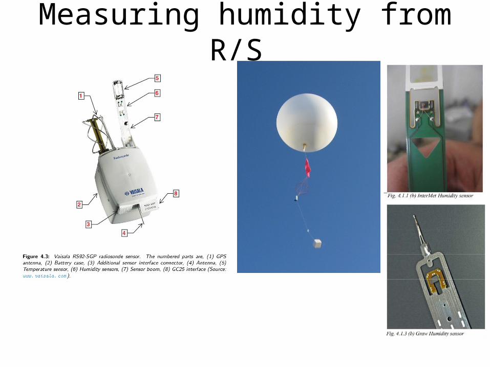
Measuring humidity from R/S
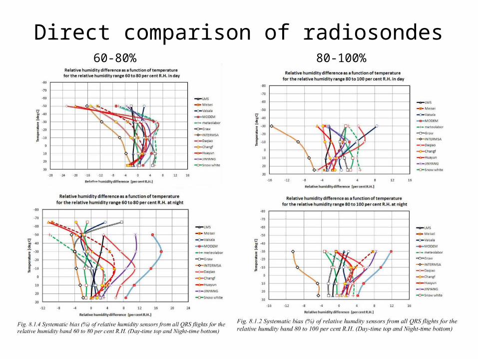
Direct comparison of radiosondes60-80% 80-100%

Monitoring Radisonde Humidity Biases
Use of satellite radiances to monitor radiosonde
humidity biases
UT
MT
LT
Anchorage(WMO no. 70273)
Br. Temperature difference (degK)
Sond
e –S
atel
lite
(deg
K)

ECMWFFD/RD meeting 13 March 2015, ECMWF
BUFR radiosonde coverage and quality
~70% report some BUFR (similar for Synop stations)
Many are reformatted TEMP X (problems), some are HiRes ☺
ECMWF wiki page about BUFR data – international exchange
Newsletter items
Feedback including:
Position errors
Td > T …
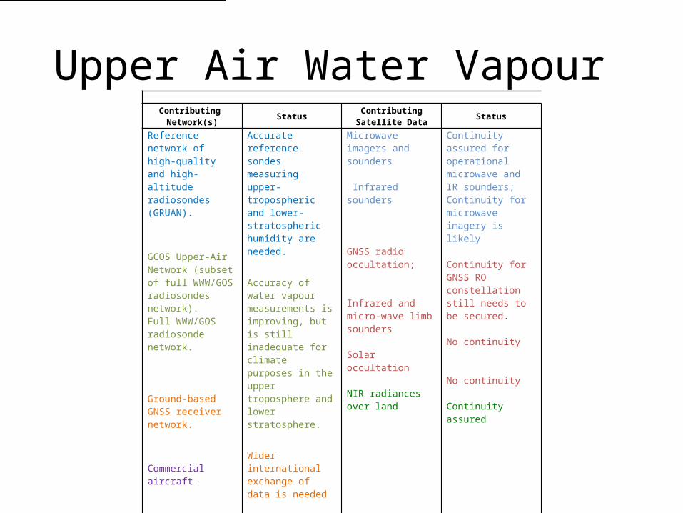
Upper Air Water Vapour Contributing
Network(s)Status
ContributingSatellite Data
Status
Reference network of high-quality and high- altitude radiosondes (GRUAN).
GCOS Upper-Air Network (subset of full WWW/GOS radiosondes network).Full WWW/GOS radiosonde network.
Ground-based GNSS receiver network.
Commercial aircraft.
Raman LidarUplooking MW radiometer
Accurate reference sondes measuring upper-tropospheric and lower-stratospheric humidity are needed.
Accuracy of water vapour measurements is improving, but is still inadequate for climate purposes in the upper troposphere and lower stratosphere.
Wider international exchange of data is needed
Aircraft data are potentially useful. E-TAMDAR
Only very limited research instrumentsEU project to develop network
Microwave imagers and sounders
Infrared sounders
GNSS radio occultation;
Infrared and micro-wave limb sounders
Solar occultation
NIR radiances over land
Continuity assured for operational microwave and IR sounders; Continuity for microwave imagery is likely
Continuity for GNSS RO constellation still needs to be secured.
No continuity
No continuity
Continuity assured

© Crown copyright Met Office 7
Long-term variability: Tropical mean anomalies in large-scale descending regions
• Model reproduces observed variability very well• Indicates no significant trend in UTH
Deseasonalised anomaly time series of tropical (30S-30N) descent region UTH observed by HIRS and AMSU-B, and modelled by HadGEM2. For clarity, each time series has been smoothed using a 3-month running mean.

Improvement in ground-based GPS October 2012 May 2013

Recommendations
• Better characterisation of R/S humidity sensors.• Make available ground-based GPS TZD outside US and
Europe• Determine characteristics of aircraft humidity.• Determine value of emerging ground-based remote
sensing networks (MW, FTIR, Lidar)• Encourage space agencies to provide limb sounder for
stratospheric measurements• Explore GNSS-RO for low level water vapour
concentrations

Radiation Budget Variables
• TOA upwelling SW flux (all-sky)• TOA upwelling LW flux (all-sky)• TOA solar irradiance • TOA incoming solar spectral irradiance

© Crown copyright Met Office 11
SW CRF
LW CRF
Biases compared to CERES – Annual Mean
New Cloud Scheme Old Cloud Scheme

© Crown copyright Met Office 12
Development of a set of metrics to assess model performance is important. How can satellite datasets contribute?

© Crown copyright Met Office 13
ERB Observations

Radiation Budget
• Future continuity of TOA ERB needs to be assured for at least 1 polar orbit CERES -> RBI and new Chinese Sensors ERM-1, SIM-2.
• New requirement for spectrally resolved irradiances not being met