getting there walks in and - doc.govt.nz · the mana whenua would like to restore the partnership...
TRANSCRIPT

Check before you light a fire – a ban may be in place
R126
857
Published by: Department of ConservationTongariro National Park Visitor CentrePO Box 71029Whakapapa Village, Mount Ruapehu 3951New ZealandNovember 2018
Editing and design: Creative Services, DOC National Office
Front cover: Tongariro Northern Circuit Photo: DOC/90 Seconds
This publication is produced using paper sourced from well-managed, renewable and legally logged forests.
Further information:Tongariro National Park Visitor CentreState Highway 48 Whakapapa VillagePO Box 71029 Mt Ruapehu 3951
PHONE: 07 892 3729EMAIL: [email protected]
www.doc.govt.nz
Getting thereThis 78,618 ha park, located in the central North Island, is bordered by State Highway 1, 49, 4 and 47. The nearest towns are Turangi, National Park and Ohakune. The small village of Whakapapa is located within the park.
The main trunk railway runs through National Park and Ohakune townships. Regular bus services operate to Ohakune, National Park and Turangi.
1
49
46474
Raetihi Ohakune
Waiouru
Turangi
Tongariro National Park Visitor Centre
25km
CENTRAL NORTH ISLAND
Walks in and around Tongariro National Park

Map Key10 Whakapapaiti Valley Track
11 Tama Lakes Track
15 16 Lake Rotokura Track
16 17 Ohakune Old Coach Road and Historic Viaducts
17 18 Lake Surprise Track
18 19 Old Blyth Track
19 20 Soda Springs Track
21 Historic Waihohonu Hut
21 22 Tongariro Alpine Crossing
22 23 Taurewa Loop Track
23 24 Okupata Caves
24 25 Te Porere Redoubt Walk
25 26 Rotopounamu Track
26 27 Ohinetonga Track
27 28 Tupapakurua Falls Track
28 29 Round the Mountain
29 30 Tongariro Northern Circuit
Scenic campsite
Serviced hut
Great Walk hut
Picnic area
Information
Caving
10
Mangahuia Campsite
National Park
Mangaturuturu Hut
Blyth Hut
Mangaehuehu Hut
Mangawhero Campsite
Rangipo Hut
Waihohonu Hut
Oturere HutMangatepopo
Hut
Whakapapaiti Hut
Whakapapa Visitor Centre
22
20
2111
16
17
18
19
29
29
29
29 30
30
3030
30
252423
26
27
28
to W
hang
anui
Tongariro National Park
ContentsTongariro National Park World Heritage AreaThe Sacred 1887 Tuku . . . . . . . . . . . . . . . . . . . . . . . . . . . . . . . . . . . . . 1
Introduction . . . . . . . . . . . . . . . . . . . . . . . . . . . . . . 3Tongariro National Park Visitor Centre . . . . . . . . . . . . . . . . . . . . 3
Know before you go . . . . . . . . . . . . . . . . . . . . . . . 4Camping . . . . . . . . . . . . . . . . . . . . . . . . . . . . . . . . . . . . . . . . . . . . . . . . . . 8 Huts . . . . . . . . . . . . . . . . . . . . . . . . . . . . . . . . . . . . . . . . . . . . . . . . . . . . . . 8
Plan and prepare . . . . . . . . . . . . . . . . . . . . . . . . . .10Tracks and walks . . . . . . . . . . . . . . . . . . . . . . . . .12Whakapapa . . . . . . . . . . . . . . . . . . . . . . . . . . . . . .13Walks (less than 3 hours) . . . . . . . . . . . . . . . . . . . . . . . . . . . . . . . . . 15 Day tramps (3–8 hours) . . . . . . . . . . . . . . . . . . . . . . . . . . . . . . . . . . . 20
Ohakune . . . . . . . . . . . . . . . . . . . . . . . . . . . . . . . . 22Walks (less than 3 hours) . . . . . . . . . . . . . . . . . . . . . . . . . . . . . . . . . 22 National Cycle Trail: Ruapehu–Whanganui Trails . . . . . . . . 25 Day tramps (3–8 hours) . . . . . . . . . . . . . . . . . . . . . . . . . . . . . . . . . . . 29
On and near Mt Tongariro . . . . . . . . . . . . . . . . 30Walks (less than 3 hours) . . . . . . . . . . . . . . . . . . . . . . . . . . . . . . . . . 30 Day tramps (3–8 hours) . . . . . . . . . . . . . . . . . . . . . . . . . . . . . . . . . . . 31
Further afield . . . . . . . . . . . . . . . . . . . . . . . . . . . . 34Walks (less than 3 hours) . . . . . . . . . . . . . . . . . . . . . . . . . . . . . . . . . 34 Day tramps (3–8 hours) . . . . . . . . . . . . . . . . . . . . . . . . . . . . . . . . . . . 35
Multi-day tramping tracks . . . . . . . . . . . . . . . . 36Round the Mountain . . . . . . . . . . . . . . . . . . . . . . . . . . . . . . . . . . . . . 37 Tongariro Northern Circuit – Great Walk . . . . . . . . . . . . . . . . . 44 Backcountry travel in Tongariro National Park . . . . . . . . . . . 48 Tongariro’s unique flora and fauna . . . . . . . . . . . . . . . . . . . . . . . 50 Protecting our natural heritage . . . . . . . . . . . . . . . . . . . . . . . . . . . 54
MapsWhakapapa enlargement . . . . . . . . . . . . . . . . . . . . . . . . . . . . . . . . . 14 Ohakune enlargement . . . . . . . . . . . . . . . . . . . . . . . . . . . . . . . . . . . 23 Ruapehu-Whanganui Trails . . . . . . . . . . . . . . . . . . . . . . . . . . . . . . 26Tongariro National Park . . . . . . . . . . . . . . . . . . . . . . . . . . . . .fold-out
back cover
New
Zea
land
fa
lcon
/kār
eare
a.
Phot
o: C
onra
d Sm
ith

Tongariro National Park World Heritage AreaThe Sacred 1887 TukuHoronuku Te Heuheu Tukino IV, (Paramount Chief) of Ngāti Tūwharetoa, one of the tribes who have mana whenua (occupational authority) over the land in this region, extended the kaitiakitanga (custodianship) of the peaks of Tongariro, Ngāuruhoe and part of the peak of Ruapehu to the people of New Zealand 23 September 1887. Described as a ‘Tuku’, or offer to extend custodianship, this ensured that the Central North Island mountains would stay pristine and protected with joint ownership between the mana whenua and the Crown.
Iwi (Māori tribes) had always held land on a communal basis. Horonuku did not want to see the sacred mountains of his people divided into blocks and sold to land-seeking settlers. Loss of this land would mean loss of the sacred volcanoes and a loss of mana (status, prestige, integrity) for the Ngāti Tūwharetoa, Ngāti Rangi and Whanganui Iwi who all have mana whenua of the mountains.
For your safetyCarry the following topographical maps with you. The maps in this brochure are a guide only and should not be used for navigation.
The appropriate NZTopo50 series maps for these trips are:• BJ34 Mt Ruapehu• BH34 Raurimu• BH35 Turangi
• BJ35 Waiouru.
See also: • Tongariro Alpine
Crossing brochure• Tongariro Northern Circuit
Great Walk brochure
Remember, if you are not experienced and equipped for alpine hiking, we recommend that you choose a track below the bushline where alpine experience is not required, or go with a guide.
To book a guide contact your nearest i-SITE, or go to www.visitruapehu.com or www.greatlaketaupo.com.
www.doc.govt.nz/tongariro www.doc.govt.nz/tongariroalpinecrossing www.doc.govt.nz/tongarironortherncircuit
Tell someone before you goSafety is your responsibility so remember to leave details of your trip (return date and time, planned route, party member names and vehicle licence plates) with a trusted contact, and don’t forget to let them know when you return. Information on the Outdoor Intentions System can be found at www.adventuresmart.org.nz.
Remember to fill in hut books during your trip, even if you do not stay in the hut. They can assist in search and rescue operations, and may help save your life.
Tong
arir
o Al
pine
Cro
ssin
g.
Phot
o: G
raem
e M
urra
y
21

National Parks represent glimpses of our environment as it once was, and also form cultural icons connecting people to the land. The varying landscape of Tongariro National Park features herbfields, forests, lakes, streams and desert-like areas, as well as dramatic terrain formed by volcanic activity. The landforms, volcanoes and ecosystems of Tongariro National Park are now recognised as having outstanding international significance and have been awarded UNESCO dual World Heritage status for natural and cultural values.
Tongariro National Park Visitor Centre Call in to the Tongariro National Park Visitor Centre, situated in Whakapapa Village, and meet DOC rangers who have first-hand, in-depth local knowledge about conservation places and activities. The centre is open every day (except for Christmas day) from 8 am to 5.30 pm during the summer season, and 8 am to 4.30 pm during the winter. Hut tickets, hut passes and topographical maps are available for sale as well as books, souvenirs, clothing and a selection of outdoor safety items. A foyer is open 24 hours for access to a public telephone, weather and avalanche reports, and track information.
Tel: (07) 892 3729 Email: [email protected]
Information on the park is also available from the i-SITES in: Ohakune (06) 385 8427 Taumarunui (07) 895 7494 Turangi (07) 386 8999.
An Act of Parliament formally established Tongariro National Park in 1894 and it was gazetted as such in 1907. The original tuku area of 2360 hectares has been increased over the years by government procurement of surrounding land to create a national park of 78,618 hectares.
Due to the insight of Horonuku and his people, Tongariro National Park was the first national park in New Zealand and the fifth in the world.
While the mountains have been protected, and are recognised as a World Heritage site, the mana whenua feel the Tongariro National Park Act 1894 has not adequately recognised the intent of Horonuku’s tuku as an expression to share the ownership and management of the mountains. The mana whenua would like to restore the partnership intended by the 1887 tuku by making a new partnership arrangement for the National Park.
Introduction
If our mountains of Tongariro are included in the blocks passed through the court in the ordinary way, what will become of them? They will be cut up and sold, a piece going to one Pakeha and a piece to another. They will become of no account, for the tapu will be gone.
Tongariro is my ancestor, my tupuna, it is my head; my mana centres around Tongariro.
You know how my name and history are associated with Tongariro, I cannot consent to the court passing these mountains through in the ordinary way.
After I am dead, what will be their fate?
Te Heuheu Tūkino IV, 1885
43

Lahar hazards on Mount RuapehuMount Ruapehu is an active volcano. An eruption may generate lahars (volcanic floods and mudflows) in major valleys and in the Whakapapa Ski Area. Hikers and skiers should familiarise themselves with known lahar paths and be prepared to move out of valleys should an eruption occur.
1975 Ngauruhoe eruptionIncandescent lava blocks, some the size of small cars, leave vapour trails in the sky. Some of the heavier material begins to drop, causing fluid pyroclastic flows (glowing avalanches of fragmented rock) travelling 2 km from the crater down the Mangatepopo valley.
Weather The climate of Tongariro National Park is highly unpredictable and changes quickly.
High levels of rain and very cold temperatures are common, and snow is possible at any time of the year. Check the latest weather forecast and track conditions before starting out on any hikes – always be prepared for bad weather.
For the latest weather forecast, check at the Tongariro National Park Visitor Centre or visit www.metservice.com/mountain/tongariro-national-park.
River crossingsHeavy rain will cause increased water flow in all streams and rivers in the park. At
these times, unbridged rivers may become difficult or impossible to cross, particularly those on the longer walks such as the Round the Mountain and Whakapapaiti Valley tracks. If you come across a swollen river, do not cross it. Turn back or stop and wait for the river to subside.
Volcanic hazardsOne of the main reasons Tongariro National Park is considered a special area is because
of its volcanic features. Although volcanic events are often spectacular to view at a safe distance, there can be considerable risk for those who venture close to the active volcanoes.
Visitors should be aware that volcanic activity is possible in the area at any time with little or no warning. Anyone intending to hike or climb on the upper slopes of the volcanoes should first check the current volcanic status and safety information for the area. During times of volcanic activity, hikers and skiers should move away from the crater and onto high ground to avoid flying rocks, lahars and blasts.
Check Geonet for volcanic status: www.geonet.org.nz/volcano.
Know before you go
65
Mou
nt N
gaur
uhoe
eru
ptio
n. P
hoto
: DO
C

DronesNo unauthorised drones are allowed within the Tongariro National Park.
Drones can: • interfere with helicopters for search and rescue, fire and
operational needs • disturb our native birds and our visitors. For further information, visit www.doc.govt.nz/drones.
Rubbish and recyclingThere is a ‘pack-it-in, pack-it-out’ policy within the park. Please carry out all your rubbish.
There is a recycling and rubbish transfer station at Whakapapa Village.
VehiclesDo not leave valuables in parked cars and if possible arrange alternative transport
to and from tracks. Carry important documents like passports and credit cards with you. Leaving vehicles parked overnight in more isolated car parks is not recommended.
Mountain bikingMountain biking is permitted in Tongariro National Park on formed roads, ie Bruce Road,
Ohakune Mountain Road, Tukino Road, Mangatepopo Road, the Ohakune Old Coach Road and Ruapehu–Whanganui Trails.
Mountain biking is permitted in adjacent Rangataua Conservation Area on the southern boundary of Tongariro National Park east of Ohakune. Erua and Tongariro Forest Conservation Areas are also good locations for mountain biking, hunting and tramping. Disused logging tracks provide trails through varied and scenic forest.
Snow and avalanchesThroughout the year tracks in the park may be affected by snow and ice. In these conditions
hikes may take longer than the posted track times. Be aware of avalanche danger after heavy snowfalls. Before you set out, check information on the current snow stability at the Tongariro National Park Visitor Centre or visit www.avalanche.net.nz/region/1. Treat snow slopes in the lee (downwind) aspect of recent winds and ice slopes as high hazard areas.
Throughout winter, ice axes and crampons (and the experience to use them) are required for tracks in the alpine areas of the park. Visitors must be able to make their own on-site assessments of weather, route and avalanche conditions, and should carry an avalanche transceiver, probe and shovel if venturing into snow-covered areas.
It is recommended that visitors who are not equipped for or experienced in alpine conditions go with a guide.
WaterGiardia may be present in some streams in the park. We recommend you boil all
drinking water (for at least 3 min). Water from the upper Mangatepopo Stream, Emerald Lakes and Ketetahi Springs is not suitable for drinking due to its high mineral content. In times of volcanic activity, water tanks at huts may be disconnected to avoid ash contamination. Streams and rivers could also become contaminated. Visitors should carry their own water supply.
For cultural and health reasons, swimming is not advised in many of the lakes, streams and rivers of the park. Check with DOC staff for further information.
Dogs and other petsIt is an offence under the National Parks Act 1990 to bring dogs or any other introduced
animals into Tongariro National Park. This includes bringing pets to Whakapapa or Turoa ski fields, or into Whakapapa Village. To give greater protection to native wildlife please leave your pets at home.
7 8

During the Great Walks season (the start of the third weekend in October to 30 April), huts in the Tongariro Northern Circuit (Mangatepopo, Oturere and Waihohonu) are also supplied with gas cookers. Hut wardens are in residence at these huts over this period and can provide park and weather information.
Considerate hut use During your visit to Tongariro National Park, please respect the rights of other visitors. Clean the benches, sweep the floor and ensure no food scraps (which encourage vermin) remain. Maximum group size at huts or campsites is 16. Use is limited to two consecutive nights.
Hut bookings and feesThe Tongariro Northern Circuit Great Walk During the Great Walks Season bookings must be made for Mangatepopo, Oturere and Waihohonu Huts. Bookings for these huts can be made online at bookings.doc.govt.nz. You can create your own account, view, modify and cancel your booking.
Other huts Other huts in Tongariro National Park do not require booking at any time. They are on a first-come basis only. Backcountry tickets may be purchased for these huts from DOC visitor centres.
Hut fees These are listed on the DOC website for the Great Walks Season under Tongariro National Park. See www.doc.govt.nz/huts for hut fees. For backcountry hut fees please contact your closest DOC office or visitor centre. Backcountry Hut Passes and Backcountry Hut Tickets are not accepted on the Tongariro Northern Circuit during the Great Walks Season.
CampingMangawhero Campsite is located 2 kilometres up Ohakune Mountain Road. Mangahuia Campsite is located off SH47. There is a charge and self–registration is required. Toilets are provided. Campsites are located near each of the huts on the Tongariro Northern Circuit. There is a charge for campsites at huts, check the DOC website or at a DOC visitor centre for current rates. Reservations are required during the Great Walks season. If you camp at a campsite with a hut you may use any of the hut facilities except a bunk and mattress.
Hut and camping fees (see following section) contribute to service and maintenance and help to ensure that these special backcountry facilities remain available. Contact a DOC visitor centre and/or an i-SITE centre for more information and hut/campsite pass sales.
Camping is not permitted at picnic sites, in the Active Volcanic Hazard Zone of Mt Tongariro or within 200 metres of any State Highway or other road. Camping is not permitted within 500 metres of the Northern Circuit Track or within 200 metres of any other track except designated campsites.
HutsThere are eight public huts in Tongariro National Park available for overnight use. Historic Waihohonu Hut, preserved as an historic building, is not available for overnight use. Facilities at huts include toilets and a water supply. Firewood and an axe or saw are provided at huts with wood burners.
Otu
rere
Hut
. Pho
to: J
anet
te A
sche
9 10
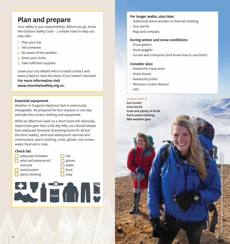
In your pack Sun screenFirst aid kitFood and plenty of drinkExtra warm clothingWet weather gear
For longer walks, also take:• Additional warm woollen or thermal clothing• First aid kit• Map and compass.
During winter and snow conditions:• Snow gaiters• Snow goggles• Ice axe and crampons (and know how to use them).
Consider also:• Avalanche transceiver• Snow shovel• Avalanche probe• Personal Locator Beacon• GPS.
The
corr
ect g
ear
in th
e m
ount
ains
. Pho
to: D
OC/
90 s
econ
ds
Essential equipmentWeather in Tongariro National Park is notoriously changeable. Be prepared for four seasons in one day and take the correct clothing and equipment.
While an afternoon walk on a short track will obviously require less gear than a full day hike, you should always have adequate footwear (tramping boots for all but the short walks), wind and waterproof raincoat and overtrousers, warm clothing, a hat, gloves, sun screen, water, food and a map.
Plan and prepareYour safety is your responsibility. Before you go, know the Outdoor Safety Code – 5 simple rules to help you stay safe:
1. Plan your trip2. Tell someone 3. Be aware of the weather4. Know your limits5. Take sufficient supplies
Leave your trip details with a trusted contact and leave a date to raise the alarm if you haven't returned.For more information visit www.mountainsafety.org.nz.
Check list adequate footwear wind and waterproof
raincoat overtrousers warm clothing
hat gloves water food map
1211
Wha
kapa
p Vi
llage
vie
w o
f Mou
nt R
uape
hau.
Pho
to: A
rjan
Vee
n
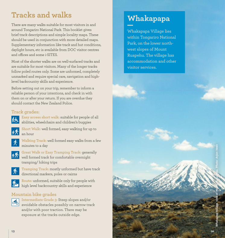
WhakapapaWhakapapa Village lies within Tongariro National Park, on the lower north-west slopes of Mount Ruapehu. The village has accommodation and other visitor services.
Tracks and walksThere are many walks suitable for most visitors in and around Tongariro National Park. This booklet gives brief track descriptions and simple locality maps. These should be used in conjunction with more detailed maps. Supplementary information like track and hut conditions, daylight hours, etc is available from DOC visitor centres and offices and some i-SITES.
Most of the shorter walks are on well-surfaced tracks and are suitable for most visitors. Many of the longer tracks follow poled routes only. Some are unformed, completely unmarked and require special care, navigation and high-level backcountry skills and experience.
Before setting out on your trip, remember to inform a reliable person of your intentions, and check in with them on or after your return. If you are overdue they should contact the New Zealand Police.
Track grades:Easy access short walk: suitable for people of all abilities, wheelchairs and children’s buggies
Short Walk: well formed, easy walking for up to an hour
Walking Track: well formed easy walks from a few minutes to a day
Great Walk or Easy Tramping Track: generally well formed track for comfortable overnight tramping/ hiking trips
Tramping Track: mostly unformed but have track directional markers, poles or cairns
Route: unformed, suitable only for people with high level backcountry skills and experience
Mountain bike grades Intermediate Grade 3: Steep slopes and/or avoidable obstacles possibly on narrow track and/or with poor traction. There may be exposure at the tracks outside edge.
1413

4
47
45
11
7
10
8
9
6
3
2
29
30
30
29
28
Mangahuia Campsite
The Mounds
Tawhai Falls
Ridge Track
Taranaki Falls
Whakapapanui Track
Nature Walk
Silica Rapids
Meads Wall
Skyline Route
Round the Mountain Track
Whakapapaiti Valley
Whakapapa Village
Tama Lakes
11
National Park
Hauhungatahi
Tongariro Northern Curcuit
Whakapapaiti Hut
1
Tongariro National ParkVisitor Centre
Holiday Park
To Whakapapa Ski Area
Whakapapaiti Track
Tavern
Car park
Toilet
Visitor shelter
Shop
Skotel
Ngauruhoe Place
0 300 m
Bruce Road
Nature Walk1
7Silica Rapids
4 Ridge Track
6Whakapapanui
Track
32To The Mounds and Tawhai Falls
5To Taranaki Falls
11To Taranaki Falls and Tama Lakes
5
Chateau Tongariro
Walks (less than 3 hours)These walk are accessible on foot from Whakapapa Village or require a short drive to the starting point.
1 Whakapapa Nature Walk
15 min loop trackBegins 250 m above Tongariro National Park Visitor Centre on SH48.This sealed loop track gives a glimpse of the unique flora of Tongariro National Park. A series of on-site information panels explain the various vegetation zones in the park.
Whakapapa map Village enlargement
15 16

2 Mounds Walk20 min return
Begins 5 km below Tongariro National Park Visitor Centre on SH48.Debris avalanches during Ruapehu’s periods of volcanic activity are believed to have formed these mounds thousands of years ago. The top of the track offers good views of the volcanoes and surrounding area.
3 Tawhai Falls Walk20 min return
Begins 4 km below Tongariro National Park Visitor Centre on SH48.The falls, which tumble over the edge of an ancient lava flow, are reached after a short stroll through mountain toatoa and beech forest.
4 Ridge Walking Track30–40 min, 1.2 km return
Begins 150 m above Tongariro National Park Visitor Centre.After a short climb through low beech forest, the track emerges into alpine shrublands with panoramic views of Mt Ngauruhoe and the surrounding landscape.
5 Taranaki Falls Walking Track2 hr, 6 km loop track
Begins 100 m below the visitor centre on Ngauruhoe Place.The track to Taranaki Falls has excellent mountain views and crosses a range of land forms. All streams are bridged. The upper and lower tracks form a loop with the falls situated around the halfway point. The lower track is generally the more sheltered on windy days.
The lower track passes through tussock and alpine shrublands before entering beech forest. On a clear day Ngauruhoe’s symmetrical cone and the older, eroded mountains of Tongariro and Pukekaikiore are visible. Once in the forest, the track descends to Wairere Stream then climbs alongside it, passing Cascade Falls. The forest consists mainly of large mountain beech trees, shiny broadleaf, mountain five-finger, umbrella ferns and mountain toatoa. Small native birds such as whiteheads, grey warbler and rifleman are commonly seen.
From the forest edge the track passes over the Wairere Stream with impressive views of a small narrow gorge. Continuing on up the track, Taranaki Falls comes into view tumbling 20 metres over the edge of a large andesite lava flow which erupted from Ruapehu 15,000 years ago.
The trail from the falls climbs up a flight of 100 steps to a forest of mountain toatoa before joining the Tama Lakes Track. Turn right to return to Whakapapa, cross Wairere Stream and climb the shoulder of the lava flow, now covered with red tussock. Native birds likely to be heard in this area include pipits, fernbirds and occasionally skylarks.
The return track crosses a series of eroded gullies formed by wind, rain and frost action on volcanic soils. As the trail begins to sidle around the slopes of Mount Ruapehu, it merges with the wider old Waihohonu horse trail. Here, layers of pumice and ash from previous eruptions are exposed. After passing through the last patch of bush, the track emerges again into red tussock and manuka, leading easily back to the village.Ta
wha
i Fal
ls. P
hoto
: Con
rad
Smit
h
Tara
naki
Fal
ls. P
hoto
: Dan
iel D
eans
1817

6 Whakapapanui Walking Track2 hr, 6 km return via same track or via SH48
Begins 250 metres above Tongariro National Park Visitor Centre. After a 10–15 minute walk, the Whakapapanui Walking Track branches to the right (don’t follow the Whakapapaiti Track sign in error!) and heads downstream. Water-logged clearings are passed as the track follows Whakapapanui Stream. Here, storm-damaged beech forest is slowly regenerating. The tracks comes out at the bridge of SH48 3km below Whakapapa Village. On fine days, enjoy the views walking back along the highway; on wet/windy days, enjoy the shelter of the forest and return back along the trail. Keep a look out along the river for the endangered whio/blue duck. They are the same colour as the rocks so can be very difficult to spot, but you may hear the male’s whistling call.
7 Silica Rapids Walking Track2 hr 30 min, 7 km return via Bruce Road
Begins 250 metres above Tongariro National Park Visitor Centre.This track takes in a range of vegetation types as well as the creamy-white Silica Rapid terraces. After crossing Whakapapanui Stream at the top end of the Holiday Park, the track meanders through beech forest. Pass the Whakapapanui Track turn-off and continue towards Silica Rapids. The track soon crosses a bubbling stream with a gold-toned bed. The coloured deposits are iron-oxide clays from upstream swamps. Coprosma, five finger and broadleaf surround the track.
Emerging from the bush, the track climbs to a swampy area of wire rush, tangle fern and red tussock. Seepage ponds beside the boardwalk are home to freshwater crayfish (kōura). The boardwalk makes walking over swampy ground more comfortable and reduces the impact of foot traffic on delicate vegetation. This is a great place to enjoy mountain views.
After passing the Whakapapaiti Track turn-off, the Silica Rapids Track follows the stream up through dense bush to Punaruku Falls. Here, after heavy rain, Tawhainui Stream tumbles over the edge of an ancient lava flow. Close to the track, metal bands on tree trunks protect mistletoe from possums. At the forest edge gold-coloured snow tōtara and olive-green bog pine give way to sun-loving alpine herbs and alpine flowers like mountain daisies, harebells and ourisia.
A little further up the hill the stream bed widens and forms a series of shallow terraces coated in creamy white deposits – the famous Silica Rapids. When the stream emerges from lava cliffs at the head of the valley the water is rich in aluminium and silicate minerals. As the stream gathers speed and the water is aerated, the alumino-silicates are deposited on the stream bed.
Moving on from the rapids, the track climbs onto a tussock-covered lava flow. A small clump of mountain beech and toatoa, seen a short distance up the mountain, forms the upper limit of beech trees in the area. The track then winds through tussock and sub-alpine shrubs to the Bruce Road, which can be followed downhill 2.5 kilometres to Whakapapa Village.
8 Meads Wall Route10 min return
From Iwikau Village, at the top of the Bruce Road. Follow the route to Meads Wall — a spectacular rocky outcrop which was one of the filming locations for Lord of the Rings. Meads Wall drops off steeply and care is required whilst standing at the edge to enjoy spectacular views of the valley below and Ngauruhoe to the northeast.
Note: This route is administered by Ruapehu Alpine Lifts Ltd.
Silic
a Ra
pids
. Pho
to: D
OC
2019

Day tramps (3–8 hours)
10 Whakapapaiti Valley Tramping Track4–5 hr, 16 km loop (including the Bruce Road
section) or 11 km one-way (transport required)Begins 250 m above Tongariro National Park Visitor Centre. See map (page 14). The track can be walked in either direction but is described anticlockwise. Follow Silica Rapids Track for about 45 minutes to the junction with Whakapapaiti Track. The track goes through forest then an open tussock-covered area. There is a bridged crossing of Whakapapaiti River, then the track continues up the valley, passing the junction with Mangahuia Track (2–3 hours to campsite). Further up the valley there is an
9 Skyline Route 1 hr 30 min – 2 hr return
From the top of Waterfall Express chairlift, Whakapapa Ski Area. This walk follows a poled route, marked only in summer, over steep rocky terrain and loose scree. There is no formed track. This walk is not recommended in winter, in poor weather, and/or snow or ice cover.
Follow the marker poles beside the Valley T-bar line, at the top of the T-bar, climb up the side of the ridge to your left for fantastic views. Return the same way.
Note: This route is administered by Ruapehu Alpine Lifts Ltd.
unbridged river crossing - it may not be possible to cross safely when the river is high following or during rainfall. Whakapapaiti Hut is 10–15 minutes further up the track.
Leaving the hut, the track winds its way through stunted beech forest, then up the valley to the Round the Mountain Track junction. Turn left here towards Bruce Road. The track zig-zags up and over a moraine ridge with great views of Whakapapaiti Valley and the surrounding landscape. Continue to the Scoria Flat area on the Bruce Road. From here it is approximately 5 km down the road to Whakapapa Village.
11 Tama Lakes Tramping Track5–6 hr, 17 km return on same trackBegins 100 metres below the visitor centre at the end of Ngauruhoe Place.
This track is an extension of the Taranaki Falls Track and part of the Tongariro Northern Circuit and Round the Mountain tracks.
At the top of Taranaki Falls, the track branches off the Taranaki Falls Walk, to cross rolling tussock country and alpine herbfields. Further on, the track branches left to Tama Lakes, while the main track continues on to Waihohonu Hut. There is a view of the lower lake (1240 metres), and then the track climbs steeply to a viewpoint (1440 metres) of the upper lake. Tama Lakes occupy several old explosion craters on Tama Saddle between Ruapehu and Ngauruhoe. The saddle acts as a funnel for prevailing westerly winds and windproof clothing is recommended.
Upp
er T
ama
Lake
. Pho
to: D
OC
21 22

OHAKUNE
Ohakune Junction
Mangawhero Campsite and picnic area
Ohakune Base
Blyth Hut
Turoa Ski Area
Mangaturuturu Hut
Hor
opito
Tra
ck
Man
gatur
utur
u Rive
r
Oha
kune
Mou
ntai
n R
oad
Man
gaw
hero
Riv
er
Lake Surprise
17
12
13
15
29
29
14
19
18
Walks (less than 3 hours)See Ohakune map (page 23)
12 Rimu Walk15 min returnThis walk begins opposite the DOC Ohakune Base at the bottom of Ohakune Mountain Road.
This track loops off the Mangawhero Forest Walk. It meanders gently through an understorey of ground ferns and kāmahi and criss-crosses a quiet mountain stream. It is suitable for wheelchairs and pushchairs.
12 13 Mangawhero Forest Walk1 hr, 3 km loop track
This track begins opposite the DOC Ohakune Base at the bottom of Ohakune Mountain Road.After crossing the Mangawhero River, the track leads into a forest of kāmahi, broadleaf and five finger, with giant rimu, mataī and kahikatea reaching 30 metres or more above the forest floor. Immediately after passing through a cut log the track crosses a large volcanic crater. At its highest point, the track crosses Ohakune Mountain Road and returns to the Field Base.
12 Rimu Walk
12 13 Mangawhero Forest Walk
13 14 Mangawhero Falls Walk
14 15 Waitonga Falls Walk
15 16 Lake Rotokura Walk
16 17 Ohakune Old Coach Road and Historic Viaducts
17 18 Lake Surprise Track
18 19 Old Blyth Track
28 29 Round the Mountain Track
Parking
Scenic campsite
Picnic area
Information
Serviced hut
OhakuneOhakune is the southern entrance to the Tongariro National Park and to the Turoa Ski Area.
Ohakune map
To L
ake
Surp
rise
. Pho
to: E
duar
do V
illou
ta S
teng
l DO
C
23 24

13 14 Mangawhero Falls Walk5–10 min return
Starts from a car park on Ohakune Mountain Road, 13 km past the DOC Ohakune Base.This short walk provides excellent views of a beautiful waterfall close to the road. Here, not far below the bushline, the beech forest is stunted because of the harsh climate. Spectacular icicles form around the falls in winter.
14 15 Waitonga Falls Walking Track1 hr 20 min, 4 km return
The track begins on Ohakune Mountain Road, 11 km past the DOC Ohakune Base.The park’s highest waterfall, Waitonga Falls (39 metres), is reached via a well-formed track through mountain beech and kaikawaka (mountain cedar) forest. The track passes Rotokawa, an alpine bog where on a calm day the reflection of Mt Ruapehu’s southern face can be seen in the pools. Past the falls, the track continues as part of the Round the Mountain Track, a 4- to 6-day tramp around Mt Ruapehu (see page 37).
15 16 Lake Rotokura Walking Track30 min return
Signposted off SH49, 12 km from Ohakune en route to Waiouru. Drive 1 km from the turn-off along Karioi Station Road, cross the railway line, continue to Rotokura car park. See main map (fold-out back cover).Lakes, beech forest and plentiful bird life feature on this short walk in Rotokura Ecological Area. The first lake you will pass on the track is Dry Lake. Flat, grassed areas above the lake are perfect for family picnics. The track continues past Dry Lake to Lake Rotokura. This lake is surrounded by ancient beech forest and on clear days Mount Ruapehu is reflected in the lake’s calm waters. Native birds such as tūī, kākā, bellbird, fantail and North Island robin are commonly seen or heard along the track to the lake. Rotokura is tapu (sacred healing waters) to Ngāti Rangi, the local Māori people or tangata whenua. Please respect this by not eating at or near Rotokura. Fishing is also prohibited.
National Cycle Trail: Ruapehu–Whanganui TrailsNgā Ara Tūhono From the mountains to the sea
16 17 Ohakune Old Coach Road and Historic Viaducts
Walk and Cycle Track: Ohakune to Horopito (or reverse) 15 km.
Ohakune Railway Station to Horopito 2 hr 20 min cycle, 4 hr 30 min walk
Ohakune Railway Station to Marshalls Road car parkFrom the station follow the footpath to the Mangawhero River Bridge and cross over onto Old Station Road. Continue about 1.5 kilometres and turn right onto Marshalls Road. Rongokaupo Wetland and picnic area, a community project under development, is situated about 350 metres before Marshalls Road car park. Total distance, 3 km. The track continues from the car park.
Old Coach Road. Photo: Camilla Stoddart
2625

4
Old
Sta
tion
Roa
d
Tongariro National Park
Railway Station
HOROPITO
Haeremaere Stream
Taonui Stream
Taonui Viaduct
Hapua whenua
Str
ea
m
Marshalls R
oad
OHAKUNE
Hapuawhenua Viaducts
Ohakune Old Coach Rd
Marshalls Road car park to Hapuawhenua ViaductFrom the car park the track follows the Ohakune Old Coach Road, weaving its way through rolling farmland with views over the spectacular Ohakune Basin. It then heads into native bush toward the Hapuawhenua Viaducts. Cobblestones (setts) are still evident along the track. Explore the Hapuawhenua Tunnel and marvel at the workmanship of yesteryear. The track climbs up to a ridge before dropping into the Hapuawhenua Valley. There are good stands of kahikatea, rimu, mataī and ponga along the way. From this point the two viaducts come into view. Walk the historic Hapuawhenua Viaduct (cyclists dismount on the viaduct) and enjoy both old and new viaducts and native forest surrounds. The limestone cliff that is visible high up on top of Raetihi Hill is a reminder that this area was once under the sea. From here you can return to Ohakune or carry on to Horopito.
Hapuawhenua Viaduct to HoropitoFrom the western end of Hapuawhenua Viaduct access the cycle trail to Horopito. The trail passes through a beautiful section of native bush before coming out on the original Old Coach Road again. This is known as the Skyline section; some kilometres of it can be very muddy and difficult for less experienced riders. On the way to the highest point the trail passes the old quarry which supplied much of the rock for the cobbles as the old dray road was upgraded to a coaching road in 1905.
At the top of the ridge you again pass by some magnificent rimu and rātā trees and there are beautiful views over
Hap
uaw
henu
a ra
il tu
nnel
por
tal.
Ph
oto:
Ros
ie B
row
nH
apua
whe
nua
viad
uct.
Ph
oto:
Tou
rism
New
Zea
land
27

Day tramps (3–8 hours)See Ohakune map (page 23)
17 18 Lake Surprise Tramping Track5 hr, 9 km return
This track is part of the Round the Mountain Track and begins on the Ohakune Mountain Road.After sidling around open country from Mountain Road, the track descends into Mangaturuturu Valley beside a beautiful cascade. This section can be very slippery. The creamy coating on the cascade is due to silica and mineral rich water from an alpine spring. Waterfalls and bluffs complement the backdrop of Mount Ruapehu. The Mangaturuturu River is forded shortly after passing Mangaturuturu Hut, (1 hour 30 minutes from the road). Evidence of the 1975 lahar (volcanic mudflow) can be seen here in the scoured treeless riverbanks. Lake Surprise, a broad, shallow lake set amongst beech forest and tussock, is reached after a steady climb from the river valley.
Return the same way or follow Horopito Track to Horopito (3 hours). Please note that local landowner permission is required to bring vehicles on to the Horopito Trail.
18 19 Old Blyth Tramping Track4–5 hr, 11 km round trip
This track begins on the Ohakune Mountain Road.Following part of the historic route up Mount Ruapehu, the track climbs gradually through one of the few red beech stands in the park and then passes through kaikawaka and mountain beech until it meets the Waitonga Falls Track. When Blyth Track was constructed in the early 1900s, much of the route was through alpine bog. Logs placed horizontally across the track (‘corduroy’) helped improve the muddy surface. The remains of this type of track can still be seen.
For the return it is necessary to retrace your steps or walk out to the Mountain Road via the Waitonga Falls / Round the Mountain Tramping Track, and then walk back down the road.
farmland and hills. Throughout this part of the trail there are old campsites established when the dray road was upgraded. While not much can be seen of them, they are a reminder of the hardships the road workers and their families faced while living in canvas-covered houses in the midst of a cold, wet rainforest.
Shortly after crossing the bridge over a beautiful spring-fed stream, there is a grassed picnic area surrounded by rimu and tawa trees. This is an ideal place to stop for a rest before continuing through the forest, down the hill to Taonui Stream and under the new Taonui Rail Bridge. The trail follows the stream down to the historic Taonui Viaduct. From the top of the viaduct you follow part of the old railway alignment through to the present day railway line. The railway line must be crossed at the designated crossing point. Use caution when looking for trains which regularly use the line.
From the railway line the next points of interest are the old viaduct abutments across Haeremaere Stream. From here the trail crosses the stream and follows the Old Coach Road through to Horopito. Signs at each end of the trail give distances and time estimates for riding and walking. There are also directional signs en route. Please respect the environment and ensure all rubbish and human waste is removed from the park.
Marshalls Road, Ohakune to Hapuawhenua Viaduct return6.8 km return, 1 hr 30 min cycle 2 hr 30 min walkSee description on page 25 to the viaduct. Return via same route. Access along the railway line or rail access road is not permitted.
Old
Coa
ch R
oad.
Pho
to: A
vara
M
oody
and
Reb
ecca
O’B
rien
3029

Walks (less than 3 hours)See map (fold-out back cover)
19 20 Soda Springs Walking Track2 hr, 6 km return
Begins at the Mangatepopo roadend, 13.4 km from Whakapapa Village, 7 km up Mangatepopo Road, off SH47.The track to Soda Springs is part of the Tongariro Alpine Crossing Track and follows Mangatepopo Stream. Ngauruhoe’s most recent lava flows appear dark in contrast to the older flows which are slowly revegetating. Under the headwall of the Mangatepopo
valley, these cold water springs create a small oasis of
lush yellow mountain buttercups and white foxgloves in summer.
Day tramps (3 – 8 hours)21 Historic Waihohonu Hut 3 hr, 6.3 km return
From the Desert Road, SH1 35 km south of Turangi.See images (page 42) Built in 1903/04 by the government, this hut used to be a stopover for stage coaches. The walls are constructed of a double layer of corrugated iron with a layer of pumice sandwiched between for insulation. No longer used for accommodation, the hut is preserved as an historical building and is classified by the Heritage New Zealand.
The track meanders through beech forest and open tussockland, crossing the Ohinepango Stream. At the junction where the track branches right to the new Waihohonu Hut or left to Rangipo Hut, continue straight ahead towards Whakapapa for about 5 minutes to the next junction. Turn left to reach the historic Waihohonu Hut. Return the same way.
Nea
r Ta
ngar
iro.
Pho
to: J
ohn
Stro
ther
On and near Mt TongariroAbout a million people visit Tongariro National Park each year. Despite the popular ski fields on Mount Ruapehu, there are more visitors in summer than winter due to the excellent hiking opportunities.
Mou
ntai
n fo
xglove. Photo: C Rudge
31 32

21 22 Tongariro Alpine Crossing7–8 hr, 19.4 km one way
Recommended direction is from Mangatepopo to Ketetahi. This track is part of the Tongariro Northern Circuit and begins at the Mangatepopo roadend, 13.4 km from Whakapapa.This challenging trip begins at 1120 m, winding up the Mangatepopo Valley to the saddle between Mount Tongariro and Mount Ngauruhoe, through South Crater before climbing again to Red Crater, the highest point on the crossing at 1886 m.The descent is on a volcanic rock scree track to the vivid Emerald Lakes, known as Nga Rotopounamu (greenstone-hued lakes). After passing Blue Lake, also known as Te Wai-whakaata-o-te-Rangihiroa (Rangihiroa’s mirror), the track sidles around the northern slope of Tongariro, then descends in a zigzag track past Ketetahi Shelter and down to the roadend. Be prepared for a long and challenging day out.
See the summer Tongariro Alpine Crossing Day Hikes factsheet at www.doc.govt.nz/tac-brochure
Seasonal restrictionsCar parkingA 4-hour parking restriction is enforced each year from Labour weekend in October until 30 April at both
roadends, Mangatepopo and Ketetahi. Traffic management staff are in place and a DOC ranger will carry out compliance work.
Plan ahead and book a shuttle with the i-SITE located in Whakapapa Village or at our nearby towns Turangi, Ohakune, Taumarunui and Taupo. Visit www.visitruapehu.com and www.greatlaketaupo.com. Shuttles can also be arranged with accommodation providers.
Winter conditionsYou need special skills and preparation to complete the Tongariro Alpine Crossing during the winter
months (May to October). There are increased risks from snow, ice, avalanche and sub-zero temperatures. An ice axe and crampons are essential, as is competency using them. Be prepared to turn back if conditions are no longer safe or if your progress is too slow.
Dress for cold, windy and icy conditions: On a calm day, Red Crater is at least 10°C colder than Taupo and 5°C colder than the start of the track – subtract another 2°C for every 10 km/h of wind. Conditions can change quickly. Layer your clothes to trap warm air in and keep cold wind out. Start with a base layer of polypropylene/merino, add an insulation layer of fleece/wool and finish with a waterproof shell layer.
Expect ice on the track between April and October. A helmet, crampons and ice axe are essential, as is competency using them, as 38% of tramping injuries are from slipping.
Be avalanche alert: Take an avalanche transceiver, avalanche probe and snow shovel, and be competent using them.
Make a plan: Talk with someone at the Tongariro National Park Visitor Centre who knows the current crossing conditions. See also: www.doc.govt.nz/tongariroalpinecrossing.
Take these essentials:• Drinking water (water not safe), food and toilet paper• Waterproof jacket and pants, sunhat, sunscreen, warm
hat, gloves and layered clothing• Sturdy tramping or mountaineering boots• Mobile phone, personal locator beacon (PLB)• Map, compass and/or GPS
See the winter Tongariro Alpine Crossing factsheet: Are you prepared? At www.doc.govt.nz/tac-winter-brochure
The Mountain Safety Council at www.mountainsafety.org.nz has great information and short videos to help you plan and prepare for your trip.
Tong
arir
o Al
pine
Cro
ssin
g.
Phot
o: G
raem
e M
urra
y
3433
Walks (less than 3 hours)See map (fold-out back cover)
22 23 Taurewa Loop Walking Track2 – 3 hr, 4.5 km loop track.
17 km from Whakapapa Village. Take SH47 north, turn left at John McDonald Rd (rough gravel road). Turn right onto Pukehinau Rd. Look for the Taurewa Track sign.The track starts on the edge of Tongariro Forest and follows old milling trails through bush.
23 24 Okupata Caves25 km from Whakapapa Village. Turn off SH47,
travel 11 km down John McDonald Rd (rough gravel road). Veer left at the Pukehinau Rd intersection, continue to caves.A natural, unmarked network of limestone passages in Tongariro Forest. Recommended for experienced cavers only. Heavy rainfall may result in rising water levels or flooding in the caves.
24 25 Te Porere Redoubt Walk45 min, 2.5 km return
25 km from Turangi on SH47 ( just south of junction with SH46), 22.3 km from Whakapapa.These 1869 earthworks fortifications (outpost and main redoubt) were built by the Māori warrior Te Kooti and his followers. It was here that the last of the New Zealand land wars were fought. This area is preserved as an historic place.
25 26 Rotopounamu Walking Track20 min to lake one way; 2 hr, 5 km loop track
11 km from Turangi, 35 km from Whakapapa on SH47. Car park signposted south of Te Ponanga Saddle.
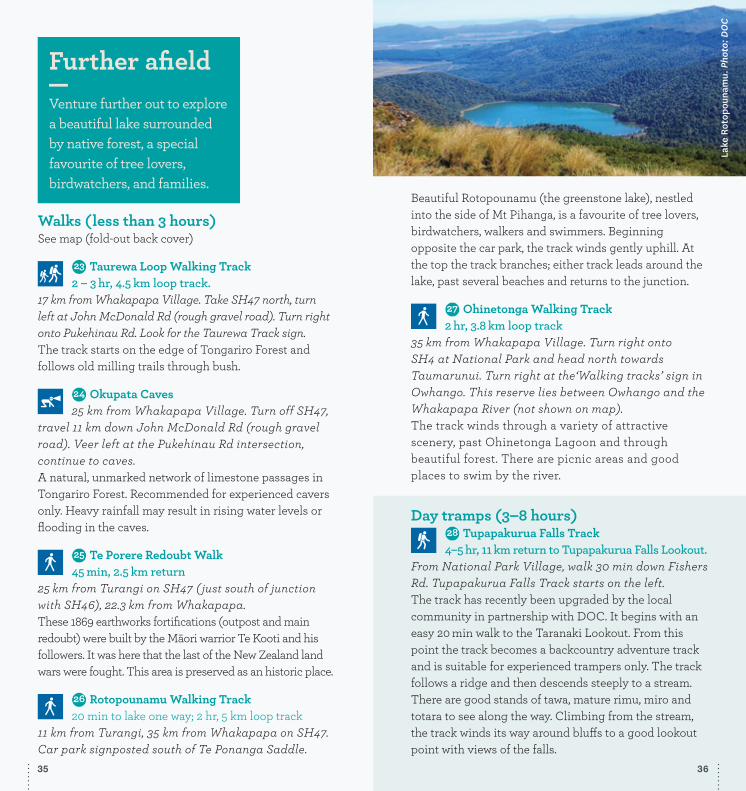
Beautiful Rotopounamu (the greenstone lake), nestled into the side of Mt Pihanga, is a favourite of tree lovers, birdwatchers, walkers and swimmers. Beginning opposite the car park, the track winds gently uphill. At the top the track branches; either track leads around the lake, past several beaches and returns to the junction.
26 27 Ohinetonga Walking Track2 hr, 3.8 km loop track
35 km from Whakapapa Village. Turn right onto SH4 at National Park and head north towards Taumarunui. Turn right at the‘Walking tracks’ sign in Owhango. This reserve lies between Owhango and the Whakapapa River (not shown on map). The track winds through a variety of attractive scenery, past Ohinetonga Lagoon and through beautiful forest. There are picnic areas and good places to swim by the river.
Day tramps (3–8 hours)27 28 Tupapakurua Falls Track
4–5 hr, 11 km return to Tupapakurua Falls Lookout.From National Park Village, walk 30 min down Fishers Rd. Tupapakurua Falls Track starts on the left.The track has recently been upgraded by the local community in partnership with DOC. It begins with an easy 20 min walk to the Taranaki Lookout. From this point the track becomes a backcountry adventure track and is suitable for experienced trampers only. The track follows a ridge and then descends steeply to a stream. There are good stands of tawa, mature rimu, miro and totara to see along the way. Climbing from the stream, the track winds its way around bluffs to a good lookout point with views of the falls.
Lake
Rot
opou
nam
u. P
hoto
: DO
C
Further afieldVenture further out to explore a beautiful lake surrounded by native forest, a special favourite of tree lovers, birdwatchers, and families.
35 36

28 29 Round the MountainThis is a 4–6 day tramp around
Mount Ruapehu. It is ideal for those seeking solitude, magnificent mountain views and a backcountry experience and is a more remote alternative to the popular Tongariro Northern Circuit. Enjoyable in either direction.
The track can be walked at any time of year, but the safest and most popular time is from December to March. During this period the tracks are normally clear of snow and the weather is less severe.
The Round the Mountain Track traverses a myriad of landscapes, ranging from mountain beech forest, tussock country and alpine herbfields; to desert lands and glacial river valleys. Although a greater part of the track is in an alpine environment, there are no major alpine passes.
There are six huts are on the track. Five are backcountry huts on a first-come basis only; Waihohonu is a Great Walk hut requiring reservations in the Great Walk season.
More detailed information and maps are available at the Tongariro National Park Visitor Centre:• NZTopo50 series: BJ34 Mt Ruapehu and BJ35 Waiouru
AccessIt is possible to walk sections of the track in 1–2 days, or the full trip in up to 6 days. Access points are:• Whakapapa
Whakapapa Village — Silica Rapids Track/Whakapapaiti Track entrance. There are overnight car parks in the village opposite the Tongariro National Park Visitor Centre.
• Scoria Flat 5 km from Whakapapa Village on the Bruce Road.
• Desert Road (SH1) There is a car park just off the Desert Road, 35 km from Turangi or 21 km from the Rangipo Junction. It is approximately 1 hr 30 min to the Round the Mountain/Tongariro Northern Circuit junction, then a further 5 hr to Rangipo Hut.
Otu
rere
Hut
, Ton
gari
ro N
orth
ern
Circ
uit.
Pho
to: D
OC/
90 S
econ
ds
Multi-day tramping tracksTongariro National Park has a range of day- and multi-day tracks for serious trampers.
3837

Waihohonu Hut to Rangipo Hut5 hr, 12.5 km one wayThe track from Waihohonu Hut to Rangipo Hut is in one of the most unique areas in the park. It is the only true desert landscape in the North Island, and features vast plains of wind sculptured sands and volcanic rock. The Rangipo Desert is dryer than most areas in Tongariro National Park as it is sited in the rain shadow to the east of Mount Ruapehu.
The track passes Ohinepango Springs then traverses the eastern side of Ruapehu, past Tukino Mountain Road and the Whangaehu River, eventually arriving at Rangipo Hut. The hut is perched on the southern edge of the desert with views east to the Kaimanawa mountains.
Rangipo Hut to Mangaehuehu Hut5 hr 30 min, 8.5 km one wayThe trip from Rangipo to Mangaehuehu is an undulating traverse. It leaves the desertlands of Rangipo, re-entering the mountain beech forest on the southern flanks of Mt Ruapehu. A feature of this section is crossing the awesome Wahianoa Gorge which cuts a path down the mountain into Karioi Forest.
Rang
ipo
Hut
. Pho
to: E
duar
do V
illou
ta S
teng
l
• Ohakune Mountain Road There are two access points: Waitonga Falls car park (at 11 km) and Wanganui Corner (at 15 km) on opposite sides of the road.
• Tongariro Northern Circuit There are two connection points with the Northern Circuit: Whakapapa Village and Waihohonu Track junction.
• Tukino Road (4 wheel drive) This is not a regular track access point. The road leads to the Tukino club ski field. Road conditions vary. It can be rough at any time of the year and in the winter it is often impassable due to snow. In summer there is a locked gate beyond the point where the Round the Mountain Track crosses the road.
Whakapapa Village to Waihohonu Hut5 hr 30 min, 14.3 km one wayThe track begins at the end of Ngauruhoe Place 100 m below Tongariro National Park Visitor Centre.There are two options. The Lower Taranaki Falls Track crosses tussock and shrubland before following Wairere Stream through mountain beech forest to the base of Taranaki Falls. On leaving the falls, the track climbs a set of steps and brings you to the junction with the Upper Taranaki Falls Track (1 hr 15 min to this point). Alternatively, the Upper Taranaki Falls Track takes you over tussock and shrubland to the same point in 1 hr.
After leaving the Taranaki Falls Track, it is a further 2 hr to Tama Saddle and Tama Lakes junction. From here a side trip can be made to the Tama Lakes. Tama Saddle is exposed and can be windy in bad weather (see page 21).
From Tama Saddle the track gradually descends for 2 hr down Waihohonu Stream to Waihohonu Hut (note that reservations are required from late October to April). A side trip can be made from the Round the Mountain Track to the historic Waihohonu Hut (see page 31) about 10 min before you reach the new hut.
39 40

Mangaturuturu Hut to Whakapapaiti Hut5 hr 30 min, 10.3 km one wayOn leaving the hut, the track crosses the Mangaturuturu River. It may not be possible to cross safely when the river is high during or following rain. The river bed was scoured out in 1975 by a lahar (volcanic mud flow), thus the sides of the river are devoid of established vegetation. Take care crossing the river, particularly after heavy rain. A climb out of the valley brings you to Lake Surprise, a shallow alpine tarn. The staircase that climbs up from Lake Surprise onto the ridge above was constructed to protect the fragile alpine environment previously destroyed by trampers clambering up the difficult rock face.
The traverse to Whakapapaiti features two magnificent river valleys, the Manganuioteao and the Makatote. These rivers merge in the Ruatiti valley then flow into the Whanganui River. This part of the track features views of Hauhungatahi, a conical peak to the northwest of Ruapehu, as well as spectacular waterfalls tumbling off lava bluffs in the Whakapapaiti valley. The track junction just before Whakapapaiti Hut gives you the option of continuing on to Scoria Flat on the Bruce Road (1 hr 30 min), or turning off to Whakapapaiti Hut (15 min) and on to Whakapapa Village (2 hr 30 min).
Whakapapaiti Hut to Whakapapa Village1 hr 30 min to Scoria Flat one way 2 hr 30 min to the village, 8.7 km one wayFrom Whakapapaiti Hut the track continues down the valley. Fifteen minutes below the hut it crosses Whakapapaiti River. In low flow it is possible to boulder hop across the river but after heavy rain crossings can be unsafe. If necessary take the alternative return route via the Round the Mountain top track to Scoria Flat, 5 km above Whakapapa Village on Bruce Rd. In winter, this route may be covered in snow and ice. Crampons, ice axes and alpine experience may be required.
Mangaehuehu Hut to Ohakune Mountain Road3 hr, 8.9 km one wayThe gradual downhill traverse from Mangaehuehu weaves through open alpine tussock country and mountain beech stands. After 1 hr 30 min, a track junction gives walkers the option of a side trip to Blyth Hut (1 hr return) or continuing out to Ohakune Mountain Road. About 20 min past the track junction are Waitonga Falls (39 metres), reputedly the highest falls in Tongariro National Park. The track out to the road passes Rotokawa, a tarn featuring several alpine wetland species and spectacular views of Ruapehu on a clear day.
A second junction indicates the Old Blyth Track (1 hr 15 min to the 7-km point on Ohakune Mountain Road) on the left, or 15 min straight ahead to Waitonga Falls car park (see page 24), the 11-km point on the road. There is a 3-km walk up the road to link up with the Round the Mountain Track again.
Ohakune Mountain Road to Mangaturuturu Hut1 hr 30 min, 3 km one wayThe track begins at Wanganui Corner, the 15-km point on the Ohakune Mountain Road, and descends into the Makotuku valley. It crosses over a lava ridge covered in alpine herbs and then descends into the expansive Mangaturuturu valley via the Cascades, where a mountain stream tumbles over a spectacular rockfall.
The rocks are coated with a creamy-coloured silica deposit left behind by the fast-flowing stream. Take care here, as the rocks can be slippery during wet or icy conditions. Mangaturuturu
Hut, situated on the valley floor, is maintained jointly by DOC and the Wanganui Tramping Club.
Mis
tlet
oe m
ay be seen on beech trees along the track. Photo: Trevor Johnston
41 42

Side tripsHistoric Waihohonu HutSee walk 21 (page 31) for more information.
Blyth Hut1 hr return from track junctionBlyth Hut can be reached by leaving the Round the Mountain Track at a junction just east of Waitonga Falls. A gentle climb through mountain beech forest brings you out into the open, from where the hut is a short climb above the headwaters of the Mangateitei Stream. The hut site features expansive views of the mountain and the countryside to the south.
Tama LakesThe junction to the Tama Lakes is approximately an hour’s walk from Taranaki Falls on the way to Waihohonu Hut. Lower Tama: 20 min return from the junction Upper Tama 1 hr 30 min return from the junction
Tama Lakes, two infilled explosion craters, are named after Tamatea, the high chief of the Tākitimu canoe, who explored the area six centuries ago. The lower lake (1200 metres above sea level), is a 10 minute side trip from the junction. Volcanic debris is slowly washing in and filling the crater. The upper lake (at 1314 metres), is a further 35 minutes up a steep ridge. This beautiful lake is reputed to be very deep.
Ohinepango Springs5 min return from Round the Mountain Track 1 hr return from new Waihohonu HutThe springs are signposted on the Round the Mountain Track heading south towards Rangipo Hut. Crystal-clear cold water bubbles up from beneath an old lava flow and discharges at an enormous rate into the Ohinepango Stream.
About 45 min below the hut Mangahuia Track branches off to the left (to Mangahuia Campsite and SH47). The track to the village continues straight on then veers east. Interesting features of this area are the groves of kaikawaka and cabbage trees amongst the beech forest. From here the track undulates for a number of easy climbs and descents before joining the well formed Silica Rapids Track, for the last 45 min to Whakapapa Village.
Inside Historic Waihohonu Hut
This is the oldest existing mountain hut in New Zealand. It was first built in Tongariro National Park in 1904, and was the base for the first recreational sking. It was in active use for over 60 years.
His
tori
c W
aiho
honu
Hut
. Ph
otos
: Jan
ette
Asc
he
Beware of strong crosswinds on the ridgelines up to the
Upper Tama lake lookout.
Tam
a La
kes.
Pho
tos:
Jim
my
John
son
DO
C
4443

Red
Crat
er lo
okin
g to
war
d Ce
ntra
l Cra
ter
an
d Bl
ue L
ake.
Pho
to: G
raem
e M
urra
y
Emer
ald
Lake
s. P
hoto
: Cam
illa
Ruth
erfo
rd29 30 The Tongariro Northern Circuit
Reservations required in the Great Walks Season (see page 8). A range of trips can be planned around the Tongariro Northern Circuit. Day trips, overnight trips, or a 3- to 4-day walk around the complete circuit. The most popular time of year to walk the Tongariro Northern Circuit is during the summer months (December to March) when the tracks are normally clear of snow and the weather is less severe.
The Tongariro Northern Circuit connects with the Round the Mountain Track at two points – Whakapapa Village and Waihohonu.
More detailed information and maps are available at Tongariro National Park Visitor Centre:• NZTopo50 series: BJ34 Mt Ruapehu, BH34 Raurimu,
and BH35 Turangi• Tongariro Northern Circuit brochure
Track description Whakapapa to Mangatepopo Hut3 hr (up to 5 hr in bad weather), 8.5 km one wayBegins 100 metres below the Tongariro National Park Visitor Centre at Ngauruhoe Place and along the lower Taranaki Falls Track. About 20 min from the village the Mangatepopo Track branches off the Falls Track. For the last hour the track skirts around Pukekaikiore until it reaches the Mangatepopo valley. Mangatepopo Hut is 5 minutes from the Mangatepopo Roadend.
Mangatepopo Hut to Emerald Lakes3 hr 30 min, 8 kmThe track follows Mangatepopo Stream up the glacially carved valley, climbing over a succession of lava flows from Ngauruhoe. A 5-minute detour at the head of the valley leads to Soda Springs, cold springs which emerge beneath an old lava flow.
The steep climb to Mangatepopo Saddle is known as the Devil’s Staircase. It rewards climbers with views of the valley and if clear, Mt Taranaki to the west. From the saddle the track crosses South Crater, not a true crater but a drainage basin between the surrounding volcanic landforms.
The climb to Red Crater offers splendid views of Oturere valley and the Kaimanawa Mountains to the east. Local iwi ask that you respect their tikanga and do not climb to the summit. Follow the main track along the crater rim. The large flat-topped crater seen ahead is North Crater.
A scoria covered ridge leads down to Emerald Lakes. These three lakes fill old explosion craters. Their brilliant colour is caused by minerals washed down from the thermal area of Red Crater. The lakes are tapu or sacred and also have a high mineral content so swimming in them is not permitted. Just beyond Emerald Lakes, the track branches right to Oturere Hut or continues straight ahead to Ketetahi Roadend.
45 46

Tara
naki
Fal
ls. P
hoto
: DO
C/90
Sec
onds
Emerald Lakes to Oturere Hut1 hr 30 min, 4.8 kmFrom Emerald Lakes the track descends steeply into the Oturere valley with views of the valley and the Kaimanawa Mountains. The track weaves through an endless variety of unusual jagged lava forms created by early eruptions from Red Crater. A magical place to visit especially on a misty day. Oturere Hut is nestled on the eastern edge of these flows.
Oturere Hut to Waihohonu Hut3 hr, 7.5 kmAfter leaving Oturere Hut the track undulates over a number of stream valleys and open gravel fields. The track gradually sidles around the foothills of Ngauruhoe descending into a valley and crossing one of the branches of the Waihohonu Stream. Continue through a beech-clad valley before climbing towards the ridge top. Waihohonu Hut is in the next valley.
Waihohonu Hut to Whakapapa Village5 hr 30 min, 14.3 kmFrom the historic hut the track follows the Waihohonu Stream gradually climbing to Tama Saddle. Tama Saddle is exposed and can be windy in bad weather.
On reaching the saddle a track branches right to Tama Lakes, two partially infilled explosion craters. The lower lake is a 10-minute side trip from the junction while the upper lake is up a steep ridge, a 1 hr 30 min side trip.
Whakapapa Village is approximately 2 hours from the Tama Lakes junction. After the first hour the track meets the Taranaki Falls Loop Walk. To view the falls, follow the lower track down a flight of stairs to a boulder-ringed pool at the base of the falls. The track then continues beside Wairere Stream through mountain beech forest.
Alternatively, take the upper track through tussock and shrubland. Both options take about one hour to return to the village.
Bott
om -
Wai
hoho
nu H
ut. P
hoto
: Jan
ette
Asc
heTo
p - V
iew
from
insi
de th
e hu
t.
Phot
o: D
anie
l Dea
ns
47 48

Backcountry travel in Tongariro National Park
Travelling beyond the track network in Tongariro National Park is not recommended without
backcountry skills and experience. Experience and skills in navigation, route selection, hazard identification, weather interpretation and survival are needed to safely visit the wilderness. Natural hazards are not managed in Tongariro National Park beyond the ski areas. Visiting backcountry alpine areas exposes you to volcanic hazards, avalanche terrain, ice and potentially dangerous weather conditions. If deciding to venture off-track, ask yourself: Do I have the skills, equipment and experience to make it home?
Alpi
ne la
ke. P
hoto
: DO
C/90
Sec
onds
Don’t lose your wayWhen travelling in the backcountry,
especially on unmarked routes, it is essential to have excellent navigational skills and equipment as well as favourable weather conditions. Otherwise you may find yourself lost.
If you lose your way – do not panic!• Try to retrace your steps to the last point where
you recognise the route.
• Mark your current position, eg with a hat on a rock and only move within sighting distance of this object so that you do not stray further from your known route.
• Do not split up the party.
• Do not travel in ‘white out’ conditions or in the dark.
• If you cannot find the route, and visibility allows, head for the best shelter that you can find (eg any building, the leeward side of a ridge, a large rock). Then stay in one place.
• Make your position as conspicuous as possible.
There is reasonable cellular coverage around the park. If you are lost and/or injured call 111 and ask for Police. In New Zealand, Police handle all land search and rescue operations.
A personal locator beacon (PLB) is a reliable method of alerting authorities to lost or injured trampers. PLBs are available for hire at the i-SITEs at the Tongariro National Park Visitor Centre, Turangi and Ohakune.
49 50

Silv
erey
e. Photo: Sabine Bernert
Kākā
on
a branch. Photo: Sabine Bernert
Tongariro’s unique flora and faunaWildlifeNew Zealand’s plants and animals have developed during 80 million years of isolation from the ancient super-continent of Gondwana. As a result many of them are unique and found only in this country.
Birds found in Tongariro National Park include whio/blue duck, North Island brown kiwi, the North Island robin, whitehead, kererū, fantail, silvereye, chaffinch, tūī, tomtit, blackbird, kākāriki/yellow-crowned parakeet, ruru/morepork, kārearea/New Zealand falcon and kākā. While the birds are mostly active during the day, many of the park’s other unique creatures, such as bats and kiwi, only come out at night. Tongariro is home to New Zealand’s only native land mammals, the short- and long-tailed bats. Skinks and geckos are also found in the park, but are more likely to be visible during the warmer summer months.
Insects found in the park include many varieties of cicada, New Zealand’s largest beetle (the huhu), the rare forest ringlet butterfly, wētā and several species of moth.
Most notable among introduced animals are deer, goats, possums and hares, all of which cause severe damage to alpine and forest vegetation. Wasps also pose a threat to native bird species with whom they compete for food. Red deer provide sport for hunters, but unfortunately also severely affect the health of our native forests. Stoats and rats are also major predators of native birds.
Wēt
ā live
throughout the park. Photo: Sabine Bernert
The
huhu beetle perched on a plant. Photo: Rob Scotcher
Ruru
/mor
epor
k. P
hoto
: Sab
ine
Bern
ert
Whio/blue duck. Photo: Sabine Bernert
51 52

View
to M
ount
Nga
uruh
oe.
Phot
o: B
rend
an B
omba
ciM
ount
ain toatoa. Photo: C.S Robertson
VegetationThe park’s plant life has to cope with a wide spectrum of climatic conditions and temperatures that range from warm to freezing cold.
In barren, dry, and cold environments like the Rangipo Desert or high slopes on the mountains, many plants like the vegetable sheep adopt a low creeping form, or shelter in cracks and crevices.
In moist alpine environments, mountain shrubs survive, many of them herbaceous. Common plants in this category include mountain inaka and white daisy.
Sedges, rushes and flaxes are common in the park’s wetlands, such as those on the southern slopes of Ruapehu, and around Hauhangatahi.
The greatest variety of plants probably exists in the tussock grasslands so characteristic of the park’s mid-mountain slopes. While red tussock may seem to dominate these landscapes, these native grasses
shelter a large number of other plants including mosses,
daisies, hebes and mountain toatoa.
Mountain beech forest is the most widespread forest type in the park, occurring as an almost continuous belt around the western and southern slopes of Ruapehu. Distinctive in these mountain beech forests is kaikawaka or mountain cedar, which is recognised by its dark green, conical appearance.
Silver and red beech occur in isolated patches on the eastern slopes of Tongariro and extensively on the south slopes of Ruapehu, in a zone below the mountain beech. In other scattered areas of the park, usually between 600 m and 900 m, various hardwood species and podocarps such as rimu, kāmahi, kahikatea, and rātā can be found.
Native plants in the park have been displaced by introduced plants (referred to as weeds) including heather and broom. Although these weeds have attractive flowers they are aggressively invading many tussock grasslands in the park.
Mou
ntain daisy. Photo: Jimmy Johnson, DO
C
Whi
te ge
ntian. Photo: Jimmy Johnson, DOC
53 54

Project TongariroProject Tongariro (known for many years as the Tongariro Natural History Society) is made up of people from throughout New Zealand with a love for Tongariro National Park and the surrounding areas, and a commitment to conservation.
The vision is to promote a wider knowledge and appreciation of the unique natural heritage, historic, educational and recreational values of Project Tongariro. Since establishment in 1984, as a living memorial to five people who died in a helicopter accident on Mt Ruapehu, Project Tongariro has contributed to promoting and supporting conservation efforts in and around Tongariro National Park such as the forest restoration of Rotopounamu, the restoration of the Hapuawhenua viaduct as a walkway and providing opportunities for students to study in the park.
Protecting our natural heritageRangataua ForestRangataua Forest is a 10,000-ha forest located on the southern slopes of Mount Ruapehu. It contains a high number of nationally ranked, high priority threatened species and ecosystems, including the North Island’s largest mistletoe population and the largest known population of short-tailed bats in New Zealand. There are also populations of North Island brown kiwi and kākā, as well as endangered wetland orchids.
DOC’s work in Rangataua Forest involves controlling pests like rats and stoats that prey on the endangered birds and bats, as well as controlling possums that destroy native plants. DOC also monitors the bat, kiwi and endangered plant populations, as well as carrying out weed control in the wetlands and alpine areas.
Rangataua Forest is a significant area for the local iwi (tribe) Ngāti Rangi because of their cultural and historic association with the southern side of Mount Ruapehu.
Access to the area is through the Rotokura Ecological Reserve, situated just off State Highway 49, 14 km southeast of Ohakune, where there is a 30-minute walk to tranquil Lake Rotokura.
Mt Pihanga and Rotopounamu restorationMt Pihanga is situated at the northernmost point of the Tongariro National Park. Rotopounamu (see page 34) is nestled into the flank of Mt Pihanga, an easy 20 min walk from SH47. This project began in 2003 with the aim of protecting and restoring the native biodiversity of the area.
To date, Tongariro Natural History Society volunteers and DOC have achieved these steps toward restoration:• Monitoring and investigation towards introduced
pest control within the area• Nesting success study of New Zealand robin• Set up bat detection boxes• Completion of a freshwater study of the lake.
Project Tongariro welcomes new members. If you enjoy visiting the park and wish to give practical support or are interested in learning more, contact them at:
Email: [email protected]: 07 386 6499www.tongariro.org.nz
Div
erse
rang
e of
alp
ine
plan
ts.
Phot
o: s
toke
dfor
satu
rday
.com
5655