geoworx sync for maximo - software for gis and enterprise ...geoworx™ sync for maximo® is an...
TRANSCRIPT

GeoNexus Technologies, LLC. 3135 South State Street, Suite 350
Ann Arbor, MI 48108 (866) 839-4993
[email protected] www.geo-nexus.com
GeoWorx Sync for Maximo
Enabling the Loosely Coupled Data Model for IBM’s Maximo Spatial
White Paper
April 22, 2013

www.geo-nexus.com
Copyright GeoNexus Technologies, LLC. 2013 Page: 2
Contents
Contents ....................................................................................................................................................... 2
Introduction .................................................................................................................................................. 3
What is GeoWorx Sync? ......................................................................................................................... 3
Purpose of this Paper ............................................................................................................................. 3
About GeoNexus Technologies .............................................................................................................. 4
Summary ....................................................................................................................................................... 4
Part I: Tightly Coupled Versus Loosely Coupled Integration .................................................................. 4
Part II: Build Versus Buy ......................................................................................................................... 4
Part III: Why Not Use Standard Database Synchronization Tools? ........................................................ 4
Part I: Tightly Coupled Versus Loosely Coupled Integration ........................................................................ 5
The Tightly Coupled Model .................................................................................................................... 5
The Loosely Coupled Model ................................................................................................................... 7
Part II: Build Versus Buy ............................................................................................................................. 12
Part III: Why Not Use Standard Database Synchronization Tools? ............................................................ 16
Conclusion .................................................................................................................................................. 18

www.geo-nexus.com
Copyright GeoNexus Technologies, LLC. 2013 Page: 3
Introduction
What is GeoWorx Sync?
GeoWorx™ Sync for Maximo® is an autonomous enterprise software program that synchronizes data between
an IBM® Maximo database and an Esri® ArcGIS® geodatabase. GeoWorx Sync communicates with Maximo and
ArcGIS systems via vendor-supported Application Programming Interfaces (APIs), including Maximo Business
Objects and ArcObjects.
GeoWorx Sync does not run “in process” with either the IBM Maximo or the Esri ArcGIS system. The
independent installation of GeoWorx Sync means that:
1. GeoWorx Sync is very easy to install and configure.
2. GeoWorx Sync can support software upgrades and version changes to the Maximo and ArcGIS software
platforms.
The loosely coupled nature of GeoWorx Sync ensures the highest degree of stability and flexibility, so that
organizations can rely on GeoWorx Sync for safe, consistent, dependable synchronization of data between
Maximo and the ArcGIS geodatabase.
GeoWorx Sync is a fully supported software product, complete with robust documentation and installation
programs and procedures. As a software product company, GeoNexus Technologies is 100% committed to the
support and continual improvement of GeoWorx Sync. GeoNexus will release regular updates to ensure
compatibility with current versions of Maximo and ArcGIS.
IBM’s Maximo Spatial delivers the full power of EAM and GIS combined in a single, streamlined solution.
GeoWorx Sync for Maximo helps enterprises maximize their Maximo Spatial investment by ensuring that GIS
and Maximo data are properly and reliably synchronized.
More detail about the specific features of GeoWorx Sync can be found in Part II of this paper.
Purpose of this Paper
Organizations commonly recognize two approaches for integrating Maximo and ArcGIS from a database
perspective. These are: (1) the tightly coupled approach, which combines GIS and Maximo data through the use
of database links and views; and (2) the loosely coupled approach, which maintains separate GIS and Maximo
databases, leveraging software to synchronize data between the two databases. The purpose of this paper is to
compare these two integration approaches, showing that many organizations can benefit from the advantages
of the loosely coupled approach.
This position paper consists of the following three main parts:
Part I compares the advantages of the loosely coupled and tightly coupled models. It will demonstrate that the
loosely coupled approach is often the best path for organizations because it offers (1) the highest degree of
flexibility; (2) reduced impact on existing workflows and data models; and (3) a lower total cost of ownership.
Part II examines the benefits of implementing GeoWorx Sync for Maximo as a “commercial-off-the-shelf” (COTS)
product rather than relying on in-house resources to build a custom GIS–Maximo data synchronization system.

www.geo-nexus.com
Copyright GeoNexus Technologies, LLC. 2013 Page: 4
Part III discusses the reasons that standard enterprise database synchronization tools do not provide a
comprehensive solution for synchronizing data between Maximo and ArcGIS software platforms.
About GeoNexus Technologies
GeoNexus Technologies™ Inc. is a software product and solutions company focused specifically on the
integration of GIS and Enterprise Asset Management (EAM) systems. GeoNexus provides front-end (“client-
side”) and back-end (“server-side”) technologies designed to enhance productivity and the end-user experience
in addition to improving the reliability, manageability, and performance of integrated GIS–EAM databases.
GeoNexus has more than 25 years of combined experience with Maximo–ArcGIS integration with several public
and private utilities in the United States and Canada.
Summary
Part I: Tightly Coupled Versus Loosely Coupled Integration
Part I of this paper will point out the benefits and limitations of the tightly coupled approach versus the loosely
coupled approach for Maximo–GIS integration. This section will also demonstrate that, while the tightly coupled
approach initially seems simpler, it may in fact be more complex and challenging to maintain in the long term.
Experience has shown that the best way to maximize the inherent capabilities of the Maximo and ArcGIS
platforms is to keep the Maximo and ArcGIS systems aligned with their native data models. This approach
reduces the level of custom configuration, and ensures that the full range of Maximo and ArcGIS functionality
remains available. The Maximo Spatial architecture allows the back-end data models to be maintained
separately (using their intended native data structures), while offering end-users the fully integrated
functionality of the Maximo Spatial map viewer.
Part II: Build Versus Buy
Part II will compare the benefits of using COTS software such as GeoWorx Sync for Maximo rather than relying
upon in-house resources to build software for synchronizing Maximo and GIS data. In some cases, the costs
associated with developing and maintaining complex enterprise-class, mission-critical software are not
immediately apparent. This paper will highlight the advanced features of GeoWorx Sync, showing that it is a
comprehensive, carefully architected system for synchronizing Maximo and GIS data. With GeoWorx Sync for
Maximo, an organization can be up and running very quickly and have peace of mind knowing that the software
will be supported, upgraded, and maintained over the long term.
Part III: Why Not Use Standard Database Synchronization Tools?
Part III will discuss the many reasons why standard database synchronization tools may not provide the
comprehensive set of functions needed to ensure proper synchronization between the Maximo and ArcGIS
platforms. These two platforms are both built upon complex data models designed specifically to support a wide
range of Maximo and ArcGIS functionality. In addition, the ArcGIS versioned editing model (which conceptually
equates to long transactions from a database perspective) adds another layer of complexity. End-users must
address these complexities when synchronizing ArcGIS and Maximo data. Failure to do so may result in the
corruption of data structures and the failure of ArcGIS and Maximo systems to operate correctly. To protect

www.geo-nexus.com
Copyright GeoNexus Technologies, LLC. 2013 Page: 5
against data corruption, GeoWorx Sync for Maximo performs updates/adds/deletes to Maximo and ArcGIS data
using only vendor-supported APIs.
Part I: Tightly Coupled Versus Loosely Coupled Integration
The Tightly Coupled Model
The tightly coupled integration approach is the standard IBM approach and is described in the Maximo Spatial
installation and configuration documentation. The primary goal of this approach is to reduce or eliminate data
duplication. From a practical standpoint, this means that the attributes for spatially enabled Maximo entities
(e.g., Assets and Locations) exist only in one system. Through the use of database links and views, the data fields
become shared and may be accessed by both the GIS and Maximo systems.
For example, consider a water main asset that has the UniqueID, Diameter, Length, Condition, Install Year, and
Status attributes. In the tightly coupled model, the Maximo asset database might contain only the UniqueID and
Status attributes, while the UniqueID, Diameter, Length, Condition, and Install Year would reside in the GIS
database (along with the geometric data). The UniqueID attribute needs to exist in both systems in order to
allow a combined view of the data to be created and presented to Maximo or GIS as a single view.
Theoretically, this approach also results in the most current data being displayed in both systems. For example,
if a GIS editor changes the Diameter value in the example above, then the new Diameter would be seen
immediately from the Maximo interface. In practice, however, the real-world GIS editing workflow means that it
is unlikely that GIS edits are available immediately to Maximo. This is because enterprise GIS edits typically are
performed using the ArcGIS versioned editing model. GIS editors perform edits in their own “versions” of the
geodatabase. These edited versions typically would not be seen by the database views used to integrate
Maximo and GIS data. In reality, GIS editors may wait hours, days, or even weeks before posting edits that would
be viewable by Maximo users.
An Example of a Tightly Coupled Asset Data Model
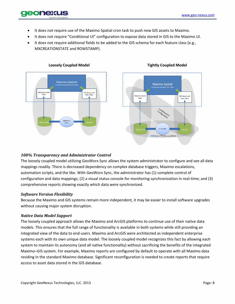
The diagram below shows conceptually how database views are used to combine data from the GIS and Maximo
databases so that the Maximo and ArcGIS systems can access the asset attributes required to support the
functionality of each platform.

www.geo-nexus.com
Copyright GeoNexus Technologies, LLC. 2013 Page: 6
An Example of a Loosely Coupled Asset Data Model
The diagram below shows that in the loosely coupled model, each system utilizes its own native data model,
while the synchronizer software ensures that data in both systems is up to date.
Another consideration to note is that even with the tightly coupled model, some degree of synchronization must
occur. IBM has added a component called the cron task to Maximo Spatial that will create new Asset and
Location records in Maximo when new corresponding features are created in GIS. For example, if a GIS editor
creates a new water main in GIS using standard ArcGIS editing tools, the cron task will recognize this new water
main and create a corresponding Maximo water main asset record. Most organizations that choose to
implement the tightly coupled model will want to activate and configure the cron task, which synchronizes
newly created assets in GIS with Maximo.
Advantages of the Tightly Coupled Model
The tightly coupled model does provide some notable advantages. Depending on an organization’s current
software/database architecture and system requirements, this model may be the preferred path.

www.geo-nexus.com
Copyright GeoNexus Technologies, LLC. 2013 Page: 7
IBM-Supported, Out-of-the-Box Solution
This model is supported with Maximo Spatial right out-of-the-box, with no need for additional software. With
the proper configuration and planning, some organizations can be successful using this approach.
Decreased Data Duplication
Very little data duplication occurs with this approach. Assuming that an organization successfully establishes a
system of record (that is, Maximo or GIS) for each data field and that clear lines of responsibility for maintaining
data are in place, then having only one copy of each data attribute can be advantageous.
No Additional Synchronization Software
An organization using the tightly coupled approach has no need to purchase and implement additional software.
All required components are delivered as part of the Maximo Spatial and Esri systems.
The Loosely Coupled Model
In the loosely coupled integration approach, the GIS and Maximo databases remain mostly independent, with
each database containing the data needed to support its respective software system. This approach depends
much less on cross-database views and links. Maximo uses its native data model and is not dependent on data
residing in the GIS database, and the GIS will not have cross-database dependencies on data residing in Maximo.
This approach allows the Maximo and ArcGIS platforms to continue to leverage their respective native data
models, while providing a completely integrated view of GIS and Maximo data to the end-users. The primary
advantages of the loosely coupled approach are: (1) it ensures that the widest range of native Maximo and GIS
functionality remains intact; and (2) it minimizes the need for institutional and workflow changes. Existing
departmental and organizational data stewardship procedures can continue to operate because the Maximo
and GIS data models remain largely intact and independent.
It is likely that some degree of data duplication will occur in the loosely coupled model. However, the experience
of GeoNexus clients has been that some level of data duplication is manageable and actually can be beneficial
because it allows the Maximo and GIS systems to operate freely and independently, utilizing their native data
models.
While this loosely coupled model is not an “out-of-the-box” approach, it is important to note that the Maximo
Spatial software is not modified in any way. Maximo operates just as it would with the tightly coupled model.
The Maximo and GIS databases are simply allowed to remain more autonomous while still providing an
integrated view to front-end Maximo Spatial users.
Advantages of the Loosely Coupled Model
Although data duplication and the reliance on data synchronization software may seem causes for concern,
years of real-world experience show that many organizations will find numerous advantages of the loosely
coupled model.
Decreased Overall Complexity
Although this approach requires the use of synchronizer software, it actually can be less complex and easier to
maintain overall. The loosely coupled approach may be simpler because:
It has less dependence on database views and cross-database links.
www.geo-nexus.com
Copyright GeoNexus Technologies, LLC. 2013 Page: 8
It does not require use of the Maximo Spatial cron task to push new GIS assets to Maximo.
It does not require “Conditional UI” configuration to expose data stored in GIS to the Maximo UI.
It does not require additional fields to be added to the GIS schema for each feature class (e.g.,
MXCREATIONSTATE and ROWSTAMP).
Loosely Coupled Model Tightly Coupled Model
100% Transparency and Administrator Control
The loosely coupled model utilizing GeoWorx Sync allows the system administrator to configure and see all data
mappings readily. There is decreased dependency on complex database triggers, Maximo escalations,
automation scripts, and the like. With GeoWorx Sync, the administrator has (1) complete control of
configuration and data mappings; (2) a visual status console for monitoring synchronization in real-time; and (3)
comprehensive reports showing exactly which data were synchronized.
Software Version Flexibility
Because the Maximo and GIS systems remain more independent, it may be easier to install software upgrades
without causing major system disruption.
Native Data Model Support
The loosely coupled approach allows the Maximo and ArcGIS platforms to continue use of their native data
models. This ensures that the full range of functionality is available in both systems while still providing an
integrated view of the data to end-users. Maximo and ArcGIS were architected as independent enterprise
systems each with its own unique data model. The loosely coupled model recognizes this fact by allowing each
system to maintain its autonomy (and all native functionality) without sacrificing the benefits of the integrated
Maximo–GIS system. For example, Maximo reports are configured by default to operate with all Maximo data
residing in the standard Maximo database. Significant reconfiguration is needed to create reports that require
access to asset data stored in the GIS database.

www.geo-nexus.com
Copyright GeoNexus Technologies, LLC. 2013 Page: 9
Support for Mismatched Data Types
End-users may have justifiable technical, aesthetic, historical, or organizational reasons for storing certain data
attributes as different data types in Maximo and GIS. GeoWorx Sync for Maximo accommodates those
differences by optionally translating data types as data are synchronized between the two systems.
Mobile Maximo Solutions Compatibility
Many third-party mobile Maximo solutions operate by uploading and downloading data to and from Maximo.
The research has shown that these systems assume that Maximo data are stored using the standard Maximo
data model. This won’t cause problems with the loosely coupled approach, because the Maximo data model is
maintained. However, this is not the case with the tightly coupled approach, where much of the data actually
will be stored in the GIS database.
Maximo Specifications and Classifications Compatibility
The use of Maximo Specifications is the standard Maximo data modeling and storage approach, which allows for
differentiation between multiple asset/location types (i.e., Classifications) in a single Maximo Asset or Location
table. A loosely coupled, synchronizer-enabled system allows data stored as Maximo Specifications to be
synchronized with the GIS database. With the tightly coupled model, Maximo Specifications are only available to
the GIS through complex multi-join views. This means that a primary Maximo data modeling technique may not
be usable with the tightly coupled model, without increased data model complexity and additional system
maintenance.
Maximo Reports Compatibility
Standard Maximo reports are configured with the expectation that Asset and Location data are stored in the
native Maximo database. This is the case with the loosely coupled approach and therefore no additional report
configuration or customization is necessary (beyond what would be done normally). However, with the tightly
coupled model, significant customization may be required because the reports will need to access data from
various tables within the GIS database.
Reduced Workflow Modifications and Institutional Changes
The Maximo and GIS systems can continue to operate independently using their native data models and
maintenance procedures without sacrificing any of the benefits of the integrated Maximo–GIS system. This
means that existing data stewardship practices can continue to operate as they did before the implementation
of Maximo Spatial. Also, other enterprise integrations involving Maximo and GIS may be affected less, because
the existing data models are not significantly modified.
Reduced GUI Customization
The loosely coupled model does not impact standard Maximo GUI configuration in any significant way. Again,
this is because the standard Maximo data model for Assets and Locations is not modified. However, with the
tightly coupled model, end-users must implement an approach called “Conditional UI Configuration” extensively
in order to expose different screen configurations for each asset/location type. This is largely because the use of
Maximo Specifications and Classifications is severely hampered with the tightly coupled model.

www.geo-nexus.com
Copyright GeoNexus Technologies, LLC. 2013 Page: 10
Alignment with GIS Editing Workflows
In practice, most end-users conduct GIS data edits using the ArcGIS versioned editing model. The result is that
data edits are only posted to the enterprise geodatabase after several hours or even days. Therefore, a system
that emphasizes access to data edits in “real time” may not offer significant value. The loosely coupled data
synchronization system typically updates both Maximo and GIS databases on a nightly basis (or on-demand at
any time). This means that the update frequency is well aligned with typical GIS editing workflows.
Reduced Data Model Alignment Effort
While the integration of Maximo and GIS always will require significant effort, organizations may experience less
strain with the loosely coupled model. This is because neither the Maximo nor the GIS data models are forced to
adhere to the needs of the other system. Even data types do not need to match. Instead, this approach
emphasizes “data mapping,” whereby fields in Maximo are mapped to their counterparts in GIS so that their
values can be synchronized.
No Need for Specialized/Custom GIS Editing Tools
A robust data synchronizer, such as GeoWorx Sync, is capable of detecting complex GIS data-editing operations
that can result in corruption of the UniqueID used to link the Maximo and GIS datasets. For example, consider a
single water main that is split to add a new connection. A new UniqueID must be generated for one (or both) of
the new main segments. In order to ensure that this is done correctly, organizations often must build (or buy)
custom data-editing tools. However, the GeoWorx Sync for Maximo software can be configured to recognize and
rectify these issues automatically while subsequently synchronizing the updates with Maximo with no need for
user involvement.
Synchronization of Service Address Data
Many organizations are realizing the benefits of using the Maximo Service Address module. A well-maintained
Service Address dataset can serve as a master address database and can help improve the accuracy of address
data across the enterprise. It also protects against service address record redundancy in Maximo and with other
integrated systems such as GIS.
The Maximo Service Address module is very flexible and can accommodate a variety of use cases. In order to
support Service Address functionality, the data model for Service Addresses is somewhat more complex than the
data model for other Maximo entity types. Address data is stored and managed across multiple tables within
the Maximo database.
The loosely coupled synchronization approach is well suited to handle the complexity of the Service Address
data model. The Maximo data structures can be navigated programmatically and the address data can be pulled
from the appropriate tables in Maximo and sent to receiving fields in GIS feature classes. Using the tightly
coupled approach would involve the linking of multiple data tables across disparate databases.
Employing the loosely coupled approach means that the enterprise can develop procedures to maintain an
enterprise-wide Service Address dataset in Maximo, and then synchronize the address data with GIS feature
classes.
GeoWorx Sync is designed to navigate the Maximo Service Address Data Model (Maximo Version 7.5.0.3 shown below).

www.geo-nexus.com
Copyright GeoNexus Technologies, LLC. 2013 Page: 11
Potential for Improved System Stability
Since Maximo remains largely independent from the GIS database, Maximo is much less likely to become
disabled if the GIS geodatabase becomes inaccessible for some reason. All asset/location data is housed in the
Maximo database and can still be accessed.
Reduced Total Cost of Ownership
Real-world experience indicates that the cost for data synchronization software is often less than the costs
associated with managing the configuration, workflows, and database integration when using a tightly coupled
model, because of the reduced overall complexity associated with the configuration and maintenance of the
loosely coupled approach. This becomes more apparent as the number of different GIS feature classes (and
corresponding Maximo asset types) increases.

www.geo-nexus.com
Copyright GeoNexus Technologies, LLC. 2013 Page: 12
Part II: Build Versus Buy
Organizations that decide that they are likely to benefit from the loosely coupled integration approach will need
to determine whether to build their own custom Maximo-GIS data synchronizer or to purchase a commercial off
the shelf (COTS) package such as GeoWorx Sync for Maximo by GeoNexus Technologies.
This section describes several advantages to implementing GeoWorx rather than relying on in-house resources
to build a custom solution.
Reliable Technical Support
GeoNexus provides responsive technical support via email, phone, and web-conferencing. Clients need not
worry about key personnel being out of the office when they need technical support for their synchronization
software.
Complete, Continually Updated Documentation
With a licensed version of GeoWorx Sync, clients have access to our comprehensive documentation, help, and
FAQ system (24/7/365). GeoWorx Sync documentation is updated continuously based on product updates and
on feedback from customers. This means that an organization does not need to use internal resources to keep
documentation up-to-date.
Support for Future ArcGIS and Maximo Versions
As a product company, GeoNexus Technologies is committed to continually updating GeoWorx Sync for Maximo
to be compatible with new releases of ArcGIS and Maximo versions. Our licensed customers have access to
product updates as soon as they are available. Clients do not need to divert internal resources to upgrade
custom synchronization software.
Community
The list of GeoWorx Sync customers is growing. GeoNexus Technologies will provide on-line forums to facilitate
discussion among our customers. GeoNexus also will facilitate customer meetings at relevant conferences
throughout the year. Open lines of communication will help customers get the most from GeoWorx Sync by
learning from the experience of other organizations. These forums will also help GeoNexus get the feedback we
need to continue to improve the product.
Easy-to-Use Installation and Configuration
GeoWorx Sync for Maximo is a fully supported software product. As expected, an industry-standard software
installation program is used to install GeoWorx Sync on clients’ servers. As soon as the installation is finished,
users can open the GeoWorx Sync GUI immediately and start configuring the software for their enterprise.
Best-of-Breed Software Based on Years of Experience and Multiple Implementations
The GeoNexus team responsible for engineering and building GeoWorx Sync has over 25 years of combined
experience with the integration of EAM and GIS systems. They have worked on a wide variety of Maximo–Esri
integration projects for over a decade. Many of these projects involved the development of Maximo–GIS
synchronization systems. The GeoWorx Sync development team leveraged the experience gained in all of these
projects to design a “best-of-breed” enterprise-class synchronization platform. Our goal is to provide a fully
supported software package that is flexible enough to meet the specific needs of our customers.

www.geo-nexus.com
Copyright GeoNexus Technologies, LLC. 2013 Page: 13
1,000+ Hours of Development Time
Organizations responsible for managing several complex enterprise systems may have the internal technical
resources required to build a synchronization system. However, before they choose that path, GeoNexus
recommends that they consider the time it could take to build many of the features that come right out-of-the-
box with GeoWorx Sync for Maximo.
Advanced User-friendly GUI
All configurations, reporting, alerting, and other operations are handled from the intuitive GeoWorx
Sync desktop GUI. There is no need to edit complex configuration files and database tables.
Comprehensive Reporting Module
GeoWorx Sync produces comprehensive reports each time it runs. Reports are produced in PDF and XML
formats. These reports may include data regarding synchronization performance, updates, adds,
deletes, orphans, processing errors, and more.

www.geo-nexus.com
Copyright GeoNexus Technologies, LLC. 2013 Page: 14
Detection of Updated, New, Deleted, and Decommissioned Assets/Locations
GeoWorx Sync detects and resolves (or reports) the following database changes or conditions:
o Updated GIS attributes
o Updated Maximo attributes
o Pending Decommissioned Maximo Assets/Locations
o New Assets/Locations created in GIS
o Deleted Assets/Locations in GIS
o Orphaned Maximo Assets/Locations
o Orphaned GIS Features
Automatic GIS Feature Split and Copy/Paste Reconciliation
GeoWorx Sync can be configured to detect GIS features that result from split or copy/paste operations
in GIS. New unique identifiers are generated automatically and the new or updated features are
automatically synchronized with Maximo without any need for user involvement. No custom GIS editing
tools are required.
Bidirectional Data Synchronization
GeoWorx Sync can be configured to handle “bidirectional” synchronization. This is useful when no
absolute “system of record” exists for a given attribute. That is, the attribute may be edited in either the
Maximo or the GIS system. In these cases, GeoWorx Sync data updates need to flow in both directions
between GIS and Maximo.
Mismatched Data Type Translation
With GeoWorx Sync, the Maximo and GIS systems are free to utilize their optimal data formats for each
asset/location attribute. For example, an attribute such as InstallYear may be stored as a String in
Maximo (e.g., ‘1968’ ) and as a Numeric type in GIS (e.g., 1968.0) and the synchronization software will

www.geo-nexus.com
Copyright GeoNexus Technologies, LLC. 2013 Page: 15
handle the data type translations as necessary. This is often done for aesthetic reasons, because a
numeric value of 1968 for a Maximo attribute would be displayed as 1,968.
Real-time Synchronization Process Status Console
The GeoWorx Sync status console connects to the synchronization process that is currently running. It
allows visual monitoring of the synchronization process in real time, and even permits users to stop the
process if necessary.
Comprehensive Synchronization Configuration Validation Console
As the number of feature classes and asset types being synchronized grows, the configuration can
become very complex, and therefore the chance for configuration anomalies can grow. GeoWorx Sync
allows users to run a complete validation of their configuration before processing begins.

www.geo-nexus.com
Copyright GeoNexus Technologies, LLC. 2013 Page: 16
Error Detection and Alerts
GeoWorx Sync has built-in mechanisms for alerting administrators via email and text messages if errors
are encountered during the synchronization process.
GIS Edit and Publish Database Support
GeoWorx Sync for Maximo can be configured to create and manage a Publish geodatabase specifically
for use with Maximo Spatial. Experience has taught us that Maximo Spatial performs best with a
geodatabase that is unversioned and that has only the fields required for Maximo. That is, the Maximo
Publish geodatabase is tuned specifically for optimal performance with Maximo Spatial. Another benefit
is that the GIS edit geodatabase will not be affected directly by Maximo operations.
GeoWorx Sync for Maximo Is Ready Today
An organization that chooses to build the synchronization software in-house will need time to architect, design,
build, test, and debug the system. Depending on how complex the system becomes, this could take many weeks
or months to complete. GeoWorxs Sync for Maximo from GeoNexus Technologies is ready to install and
configure immediately.
Part III: Why Not Use Standard Database Synchronization Tools?
Why does synchronizing data between Maximo and the ArcGIS geodatabase require specialized software such as
GeoWorx Sync? On the surface it would seem that typical enterprise database synchronization tools, available
from a variety of vendors, would work fine.
Listed below are several reasons, gleaned from our real-world experience, that explain why standard data
synchronization tools , especially those that do not use vendor-supported APIs for data updates, will not provide
a comprehensive solution and ultimately may not be successful.
www.geo-nexus.com
Copyright GeoNexus Technologies, LLC. 2013 Page: 17
Software Warrantee Protection
Software warrantees for both Maximo and Esri products assume that users/developers do not edit data tables
directly. Custom applications and tools should always use vendor-supported APIs when modifying Maximo and
Esri data. Examples for Maximo include the Maximo Integration Framework and Maximo Business Objects.
Examples for Esri are the ArcObjects and Esri SOAP and REST web services.
Data Corruption
Editing tables directly could cause Maximo or ArcGIS data to become corrupted. The Maximo and ArcGIS data
models are both relatively complex and the developer should not assume that he or she is certain about which
tables and records need to be updated in all cases. Vendor-supported APIs should always be used.
Data Validation
Bypassing the vendor-supported APIs and editing tables directly means that end-users will not be leveraging the
built-in data validation layer provided by both the ArcGIS and Maximo APIs, which increases the chance for data
corruption and software failure.
Complex Data Structures
The Maximo and ArcGIS data models are more complex than they may seem at first glance. Reverse-engineering
the table structures in an effort to determine exactly which tables and columns need to be updated requires a
significant investment in time.
Future-Proof
The GeoWorx Sync for Maximo software is protected from changes that Esri and IBM may make to underlying
table structures by using the vendor-supported APIs. This will not be the case if the system interacts directly
with the data tables.
Proper Handling of New, Deleted, Decommissioned, and Orphaned Assets
Making updates to attributes in Maximo may be relatively straightforward. However, synchronization
complexity rapidly increases when the synchronization software must also detect, reconcile, and report newly
created assets, deleted assets, decommissioned assets, and orphaned assets in either the GIS or Maximo
databases. For example, the creation of a new asset in Maximo is not a simple matter of adding a record to a
data table. Multiple tables and columns and indices need to be updated in a specific order. The bottom line is
that these types of operations should never be handled by editing the tables directly. Vendor-supported APIs
should always be used.
Geodatabase Versions and GIS Editing Workflows
The ArcGIS geodatabase utilizes a powerful and highly versatile architecture called “versioning.” This allows
multiple GIS editors to edit the geodatabase simultaneously using long transactions that can last hours, days, or
even weeks. One side effect of this versioning model is that no “base” table typically exists that standard data
synchronization software can access and rely upon for the most current GIS data. GeoWorx Sync accounts for
this versioned model and always uses Esri’s ArcObjects API to ensure that GIS data are interpreted correctly.

www.geo-nexus.com
Copyright GeoNexus Technologies, LLC. 2013 Page: 18
GIS Feature Split and Copy/Paste Detection and Resolution
It is highly unlikely that generic enterprise data synchronization tools will handle situations where GIS feature
editing results in duplicate or nonexistent UniqueID (that is, the ids that link the GIS and Maximo asset data). For
example, consider a single water main line that is split to add a new connection. A new UniqueID must be
generated for one (or both) of the new main segments. GeoWorx Sync software can recognize and rectify these
issues automatically, and also can synchronize the updates with Maximo with no need for user involvement.
Standard data synchronization tools will not be capable of doing this.
Support for a Publish Database
GeoWorx Sync for Maximo is a specialized synchronization system designed specifically for the support of
Maximo Spatial. Support for a Maximo Spatial Publish geodatabase is a great example of this. GeoWorx Sync can
be configured to populate, manage, and maintain a geodatabase that is tuned specifically for use with Maximo
Spatial. The Maximo Spatial Publish geodatabase only contains the data necessary for Maximo Spatial, so it
typically results in improved performance for end-users.
Streamlined Address/Intersection Management and Searching
Maximo users expect a simple, efficient mechanism for locating addresses, whether searching for street
addresses (e.g., “100 Main Street”) or for intersections (e.g., “Oak & Main”). In practice, this requires a single
search box in which the user can enter any type of address.
However, this “single search box” approach is typically not achievable in Maximo because of the way in which
organizations manage their address and intersection data. Most organizations store street addresses and
intersections as separate data sources, and a single Maximo search field cannot point to multiple data sources.
Street addresses and intersections often are stored as separate feature classes in the geodatabase, or they may
even be stored in completely separate databases. For example, intersections may be managed in the GIS, while
street addresses are managed by the customer care or asset management system.
GeoWorx Sync solves this problem by combining multiple address sources automatically into one address data
source. Then, a single, intuitive address search field can be configured in the Maximo GUI, making address
searching simple and intuitive for Maximo users.
Handling Service Address Data
The Maximo Service Address database structure is relatively complex, with address data stored and managed
across multiple tables and linked using a unique code (ADDRESSCODE). Using Service Address functionality with
Service Requests and Work Orders introduces two new tables (WOSERVICEADDRESS and TKSERVICEADDRESS)
adding to the complexity. Using standard database tools to synchronize Address data with external sources will
undoubtedly require the creation and maintenance of custom scripts. GeoWorx Sync supports synchronization
of Maximo Service Address out of the box, eliminating the need for custom interfaces.
Conclusion
A core mission of GeoNexus Technologies is to provide software solutions that help organizations manage and
maximize their investment from the integration of Maximo and ArcGIS platforms. We want our customers to be
successful! Based on our experience in designing, building, and implementing EAM–GIS integrations, GeoNexus

www.geo-nexus.com
Copyright GeoNexus Technologies, LLC. 2013 Page: 19
believes that GeoWorx Sync for Maximo can be a valuable tool for managing and maintaining the data
integration tier for Maximo Spatial implementation.
This conclusion is based on three main points:
1. The Maximo and ArcGIS platforms were architected and built as separate enterprise-class systems with
different core purposes in mind. By using GeoWorx Sync as part of a “loosely coupled” integration
model, an organization can allow the Maximo and ArcGIS platforms to operate independently using
their purpose-built native data models. This approach ensures that the full range of functionality
remains intact in both systems, while still enabling the integrated view of GIS and Maximo data that is
provided through Maximo Spatial.
2. GeoWorx Sync for Maximo is a fully supported software system with an architecture based on years of
experience with a variety of Maximo–Esri integration projects. Building a similar system with in-house
resources would be a significant undertaking and may prove more costly to build and maintain over the
long term.
3. GeoWorx Sync for Maximo was designed and built specifically for synchronizing data between Maximo
and the ArcGIS geodatabase and for supporting Maximo Spatial implementations. Generic enterprise
data synchronization software cannot handle the complex synchronization scenarios associated with
updating, deleting, creating, and decommissioning assets and locations in Maximo and ArcGIS.
Additionally, GeoWorx Sync always uses Maximo and Esri APIs for updating asset data, ensuring the
integrity of the data and the reliability of the Maximo and ArcGIS software.