geovariances training catalog - geostatistics for the environment 2015
TRANSCRIPT

1

2
3
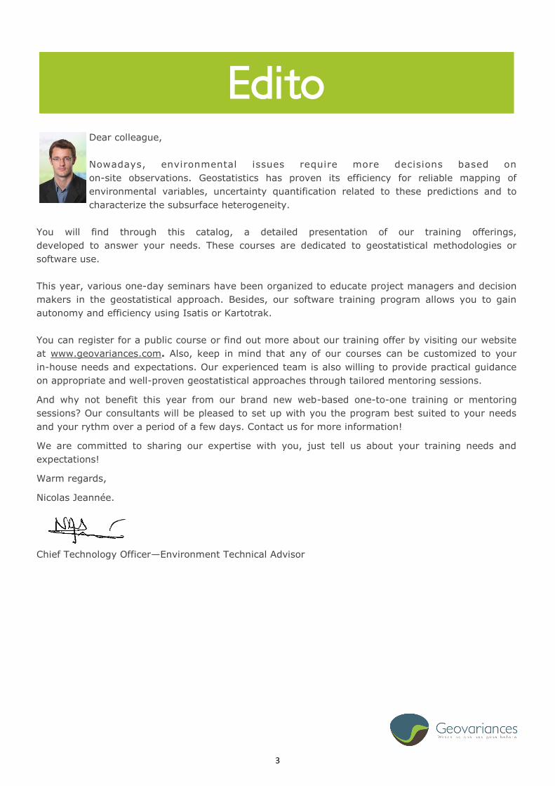
Dear colleague,
Nowadays, environmental issues require more decisions based on
on-site observations. Geostatistics has proven its efficiency for reliable mapping of
environmental variables, uncertainty quantification related to these predictions and to
characterize the subsurface heterogeneity.
You will find through this catalog, a detailed presentation of our training offerings,
developed to answer your needs. These courses are dedicated to geostatistical methodologies or
software use.
This year, various one-day seminars have been organized to educate project managers and decision
makers in the geostatistical approach. Besides, our software training program allows you to gain
autonomy and efficiency using Isatis or Kartotrak.
You can register for a public course or find out more about our training offer by visiting our website
at www.geovariances.com. Also, keep in mind that any of our courses can be customized to your
in-house needs and expectations. Our experienced team is also willing to provide practical guidance
on appropriate and well-proven geostatistical approaches through tailored mentoring sessions.
And why not benefit this year from our brand new web-based one-to-one training or mentoring
sessions? Our consultants will be pleased to set up with you the program best suited to your needs
and your rythm over a period of a few days. Contact us for more information!
We are committed to sharing our expertise with you, just tell us about your training needs and
expectations!
Warm regards,
Nicolas Jeannée.
Chief Technology Officer—Environment Technical Advisor
Edito

4
Geovariances offers a complete set of high quality
training programs for beginners and experienced users.
Courses cover basic and advanced Geostatistics and provide
participants with plenty of hands-on practice with real data
sets. They are led by Geovariances highly experienced
consultants.
Public courses are organized worldwide and throughout the
year in English and French.
Our consultants also provide in-house training and mentoring focused on companies’ specific needs.
Some of our courses can also be tailored to your particular needs and preferred rhythm through
one-to-one web-based training or mentoring sessions. These online sessions are scheduled jointly
with one of our consultants over a period of a few days. Several pricing options are available
depending on the mentoring duration. Contact your sales representative for more information.
Geovariances Headquaters at Avon, France
Discover Geovariances clicking through the picture
Summary of our offer
5
Summary
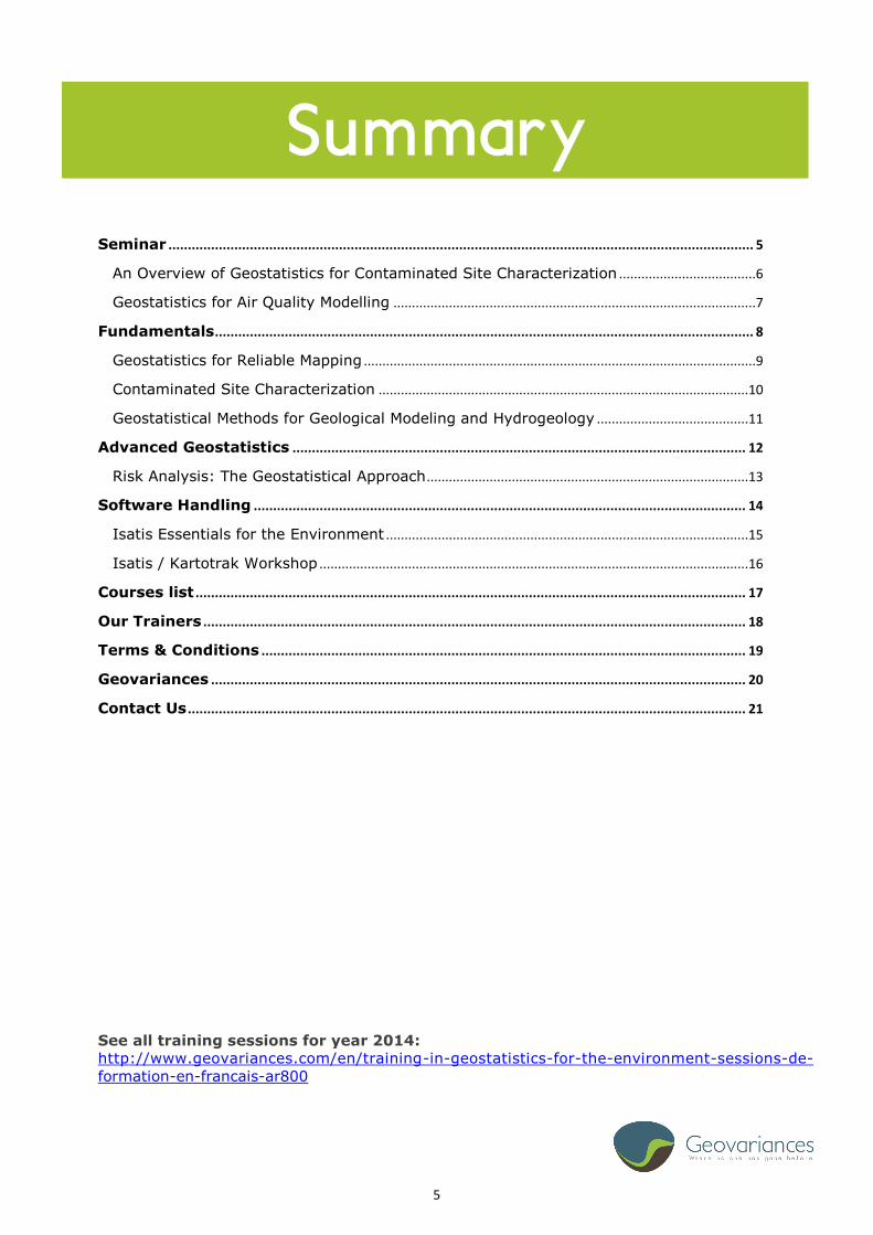
Seminar ....................................................................................................................................................... 5
An Overview of Geostatistics for Contaminated Site Characterization .....................................6
Geostatistics for Air Quality Modelling ..................................................................................................7
Fundamentals ........................................................................................................................................... 8
Geostatistics for Reliable Mapping ..........................................................................................................9
Contaminated Site Characterization ....................................................................................................10
Geostatistical Methods for Geological Modeling and Hydrogeology .........................................11
Advanced Geostatistics ..................................................................................................................... 12
Risk Analysis: The Geostatistical Approach .......................................................................................13
Software Handling ............................................................................................................................... 14
Isatis Essentials for the Environment ..................................................................................................15
Isatis / Kartotrak Workshop ....................................................................................................................16
Courses list .............................................................................................................................................. 17
Our Trainers ............................................................................................................................................ 18
Terms & Conditions ............................................................................................................................. 19
Geovariances .......................................................................................................................................... 20
Contact Us ................................................................................................................................................ 21
See all training sessions for year 2014:
http://www.geovariances.com/en/training-in-geostatistics-for-the-environment-sessions-de-
formation-en-francais-ar800

6
Seminar
7
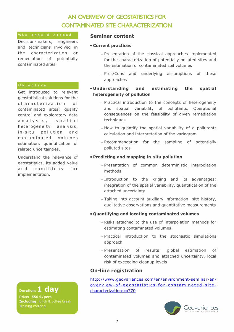
Decision-makers, engineers
and technicians involved in
the characterization or
remediation of potentially
contaminated sites.
Get introduced to relevant
geostatistical solutions for the
c h a r a c t e r i z a t i o n o f
contaminated sites: quality
control and exploratory data
a n a l y s i s , s p a t i a l
heterogeneity analysis,
i n - s i tu po l l u t i on and
con taminated vo lumes
estimation, quantification of
related uncertainties.
Understand the relevance of
geostatistics, its added value
a n d c o n d i t i o n s f o r
implementation.
Who should attend
Objective
AN OVERVIEW OF GEOSTATISTICS FOR
CONTAMINATED SITE CHARACTERIZATION
Seminar content
Current practices
- Presentation of the classical approaches implemented
for the characterization of potentially polluted sites and
the estimation of contaminated soil volumes
- Pros/Cons and underlying assumptions of these
approaches
Understanding and estimating the spatial
heterogeneity of pollution
- Practical introduction to the concepts of heterogeneity
and spatial variability of pollutants. Operational
consequences on the feasibility of given remediation
techniques
- How to quantify the spatial variability of a pollutant:
calculation and interpretation of the variogram
- Recommendation for the sampling of potentially
polluted sites
Predicting and mapping in-situ pollution
- Presentation of common deterministic interpolation
methods.
- Introduction to the kriging and its advantages:
integration of the spatial variability, quantification of the
attached uncertainty
- Taking into account auxiliary information: site history,
qualitative observations and quantitative measurements
Quantifying and locating contaminated volumes
- Risks attached to the use of interpolation methods for
estimating contaminated volumes
- Practical introduction to the stochastic simulations
approach
- Presentation of results: global estimation of
contaminated volumes and attached uncertainty, local
risk of exceeding cleanup levels
On-line registration
http://www.geovariances.com/en/environment-seminar-an-
ove rv i ew-o f - g eos t a t i s t i c s - f o r - c on t am ina t ed - s i t e -
characterization-co770 Duration: 1 day
Price: 550 €/pers
Including: lunch & coffee break
Training material
8
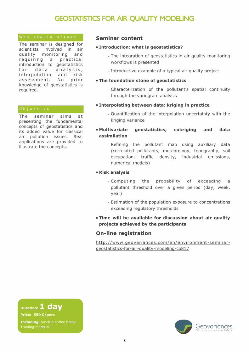
The seminar is designed for
scientists involved in air
quality monitoring and
requ i r i ng a p rac t i ca l
introduction to geostatistics
f o r d a t a a n a l y s i s ,
interpolation and risk
assessment . No prior
knowledge of geostatistics is
required.
The seminar aims at
presenting the fundamental
concepts of geostatistics and
its added value for classical
air pollution issues. Real
applications are provided to
illustrate the concepts.
Who should attend
Objective
GEOSTATISTICS FOR AIR QUALITY MODELING
Seminar content
Introduction: what is geostatistics?
- The integration of geostatistics in air quality monitoring
workflows is presented
- Introductive example of a typical air quality project
The foundation stone of geostatistics
- Characterization of the pollutant’s spatial continuity
through the variogram analysis
Interpolating between data: kriging in practice
- Quantification of the interpolation uncertainty with the
kriging variance
Multivariate geostatistics, cokriging and data
assimilation
- Refining the pollutant map using auxiliary data
(correlated pollutants, meteorology, topography, soil
occupation, traffic density, industrial emissions,
numerical models)
Risk analysis
- Computing the probability of exceeding a
pollutant threshold over a given period (day, week,
year)
- Estimation of the population exposure to concentrations
exceeding regulatory thresholds
Time will be available for discussion about air quality
projects achieved by the participants
On-line registration
http://www.geovariances.com/en/environment-seminar-
geostatistics-for-air-quality-modeling-co817
Duration: 1 day
Price: 550 €/pers
Including: lunch & coffee break
Training material
9
Fundamentals

10
GEOSTATISTICS FOR RELIABLE MAPPING
The course is designed for
geologists, engineers and
other geoscientists requiring
a practical introduction to
geostat i s t i ca l methods
applied to data analysis,
interpolation and simulation.
No prior knowledge of
geostatistics is required.
H o w e v e r a b a s i c
understanding of statistics is
recommended.
The course objective is to
present the basic concepts
and methods of geostatistics
for interpolating between
data in environmental
applications. The subject
m a t t e r r a n g e s f r om
variograms to kriging and
multivariate geostatistics. The
potential pitfalls and hints in
the geostatistical analysis of
data are highlighted for each
of these concepts. Particular
attention is paid to the
specific problems associated
with air pollution.
Who should attend
Objective
Course content
Introduction:
- What is geostatistics?
- The advantages of using geostatistics over existing
methods
The foundation stone of geostatistics:
- Quantifying the spatial behaviour via the variogram
- Calculating, modelling and interpreting the directional
variograms
Interpolating between the data:
- The theory and practice of kriging
- The estimated values reflect the spatial continuity
observed in the data
Multivariate geostatistics and cokriging:
- Integrating multidisciplinary correlated data (remote
sensing data, DTM’s or other co-factors) to improve the
final estimate
Using non-stationary geostatistics to respect the trend
present in the data.
On-line registration
http://www.geovariances.com/en/environment-geostatistics-for
-reliable-cartography-co104
Duration : 3 days
Price : 1495 €/pers
Including: lunch & coffee break
Training material

11
CONTAMINATED SITE CHARACTERIZATION
The course is designed for
practitioners involved in the
c h a r a c t e r i z a t i o n o f
contaminated sites and who
wish a practical introduction
to geostatistical methods
using the software Kartotrak.
No prior knowledge of
geostatistics is required.
H o w e v e r a b a s i c
understanding of statistics is
recommended.
The course presents a
comprehensive methodology
for the characterization of
potentially contaminated
sites: accounting for the
historical data, sampling
optimization, in-situ pollution
mapping and contaminated
volumes estimation.
Following this session, you
will be acquainted with
geostatistics basic concepts
and usual methodologies for
pollution mapping and risk
ana l ys i s: var i ography,
kriging, simulations.
Who should attend
Objective
Course content
Introduction
- Presentation of the current practices for the characterization
of contaminated sites and the estimation of contaminated
soil volumes
- Advantages of using geostatistics over existing methods
- Getting started with Kartotrak
Understanding and estimating the spatial heterogeneity of
pollution
- Practical introduction to the concept of spatial variability.
Operational implications for the feasibility of given
remediation modes
- How to quantify the spatial variability of a pollutant:
calculation, interpretation and variogram modeling
- Recommendations for the sampling of potentially
contaminated sites
Predicting and mapping in-situ pollution
- Presentation of usual methods of mapping the analytical
data
- Principle and properties of kriging in 2D/3D
Quantifying and localizing the contaminated volumes
- Overall estimate of the volumes of non-compatible land and
its associated uncertainty, risk of non-compatibility of local
mesh cleanup
- Final control after remediation
On-line registration
http://www.geovariances.com/en/environment-contaminated-site-
characterization-with-kartotrak-co103
Duration: 3 days
Price: 1495 €/pers
Including: lunch & coffee break
Training material

12
GEOSTATISTICAL METHODS FOR GEOLOGICAL MODELLING AND HYDROGEOLOGY
This course is aimed at
engineers, geologists and
hydrogeologists confronted
with the modeling of the
subsoil heterogeneity and
with the estimation of
hydrogeological variables. No
p r i o r k n o w l e d g e o f
geostatistics is required.
H o w e v e r a b a s i c
understanding of statistics is
recommended.
The course presents the
appropriate geostatistical
m e t h o d s f o r t h e
characterization of natural
r e s ou r c e s a n d t h e i r
heterogeneities. They include
the implementation of
sampling strategies to the
quant i f i ca t i on o f the
uncertainties attached to the
modeling of continuous
variables (top/bottom of
geological horizons, hydraulic
head , mechan i ca l o r
hydrogeological properties) or
facies data.
Who should attend
Objective
Course content
Introduction
- Current practices in geological modeling and hydrogeology
- Heterogeneity and uncertainty characterization
Understanding and estimation of the spatial
heterogeneity of the followed phenomenon
- Practical introduction to the concepts of heterogeneity and
spatial variability
- Quantification of the spatial variability: calculation and
interpretation of the variogram
Mapping a continuous variable (horizon top, hydraulic
head)
- Deterministic interpolation methods
- Estimation by kriging (2D / 3D) and quantification of the
attached uncertainty
- Consideration of auxiliary information: Digital Elevation
Model, geophysical and/or geological information
- Introduction to the conditional simulations for the
quantification of uncertainties
Modelling of the geological heterogeneity
- Presentation of simulation methods for discrete variables,
in particular the plurigaussian and multipoint (MPS)
simulations
- Post-processing of the results
On-line registration
http://www.geovariances.com/en/environment-geostatistical-
methods-for-geological-modeling-and-hydrogeology-new-co760
Duration: 5 days
Price: 2495 €/pers
Including: lunch & coffee break
Training material

13
Advanced Geostatistics

14
RISK ANALYSIS: THE GEOSTATISTICAL APPROACH
The course is designed for
geologists, engineers and
other geoscientists concerned
with the analysis and
quantification of risk, or for a
better management of the
available resources.
Participants should have a
good working knowledge of
b a s i c g e o s t a t i s t i c a l
techniques : variograms and
kriging.
The course objective is to
provide an in-depth review of
the different simulation
methods applicable to the
environment. The course
specifically addresses issues
of uncertainty assessment in
different application fields
such as soil and water
pollutants, soil science,
hydrogeology, oceanography,
f i s h e r i e s a n d c i v i l
engineering.
Who should attend
Objective
Course content
Introduction: a review of the fundamentals required in
order to perfom geostatistical simulations
- Variography
- Kriging or cokriging
Why we need simulations
- Sensitivity of the observed statistics to the sampling
- Limitations of the use of the kriging
- Risk quantification
General overview of simulation methods for both
continuous and categorical variables
Interpreting the results
- Histograms
- Quantile plots
- Isoprobability maps
On-line registration
http://www.geovariances.com/en/environment-risk-analysis-
the-geostatistical-approach-co111
Duration: 3 days
Price: 1495 €/pers
Including: lunch & coffee break
Training material
15
Software Handling
Click through the pictures to know more about the geostatistical software

16
ISATIS ESSENTIALS FOR THE ENVIRONMENT
This course is aimed at
geoscientists, engineers and
researchers working with
spatial data and seeking a
comprehensive overview of
the essential geostatistics
tools available in Isatis.
B a s i c k n o w l e d g e o f
variography and kriging is
recommended. However, the
course does not make use of
mathematics and therefore
can be followed by beginners
in geostatistics as well as
confirmed geostatisticians.
The following main topics will
be addressed: data loading,
exploratory data analysis,
kriging and simulations. At
the end of the course, you
will be able to quickly handle
the software and to apply
geostatistics with Isatis.
Who should attend
Objective
Course content
Presentation of Isatis concepts and most used
applications
- User interface
- Handled data
- Isatis database organization
- On-line html documentation
Data exchange with third-party software:
- Importing data and exporting results
Data management
Classical statistics and exploratory spatial data analysis
Calculation of experimental variograms and variogram
fitting
Use of classical kriging algorithms
Introduction to simulations
Graphics setup and edition
Batch processing and use of journal files
On-line registration
http://www.geovariances.com/en/environment-environment-
isatis-essentials-co761
Duration: 3 days
Price: 1495 €/pers
Including: lunch & coffee break
Training material

17
ISATIS / KARTOTRAK WORKSHOP
This workshop is intended for
engineers and technicians,
who are familiar with the
application of geostatistics
with Isatis and / or Kartotrak
for the characterization of
contaminated sites and who
wish to improve their use of
the software and go further.
It is required to have followed
one of the Fundamental
trainings prior to the
workshop.
Workshop content and
duration will be set according
to the requested objectives;
the leading idea being that
each participant is there to
deepen his own knowledge.
From practical work based on
each participant’s data,
geostatistics key concepts will
be discussed. The following
points will be addressed:
variography and anisotropy
m o d e l i n g , G a u s s i a n
transformations, change of
support and application of
results for decision aid, etc.
Who should attend
Objectives
Course content
Introduction
- Presentation of participants’ case studies
- Specification of the exact content of the workshop and
the time for each topic
Suggested topics
- Variography, particularly with 3D anisotropies;
- Gaussian transformations (anamorphosis): how to control
its quality
- Change of support and geostatistical simulations;
- 3D visualization and results display: superimposition of
contextual information (topography, base maps) and
advanced visualization.
- Post-processing and decision support: which results to
provide, how to communicate based on the results of the
study;
- Surveying contaminated sites: how to refine the sampling
strategy.
- How to choose and combine several auxiliary variables to
refine mapping
Discussion
Throughout the workshop, time is allocated to discuss
about studies made by participants, results and issues
On-line registration
http://www.geovariances.com/en/environment-isatis-kartotrak-
workshop-co925
Duration: 2 days
Price : 995 €/pers
Including: lunch & coffee break
Training material

18
These courses may be scheduled for another date and/or location. Tailored courses may also be
organized in your offices on demand, focused on specific applications or algorithms, for
example: multivariate geostatistics, simulations and risk analysis, local geostatistics, specific
workflows, etc.
Check online the updated dates of the training sessions :
English:
http://www.geovariances.com/en/training-in-geostatistics-for-the-environment-training-
sessions-in-english-ar799
French:
http://www.geovariances.com/en/training-in-geostatistics-for-the-environment-sessions-de-
formation-en-francais-ar800
Courses Calendar
Date Place Intitulé du cours
January 28—30 Paris Contaminated Site Characterization
June 22—24 Paris Geostatistics for Reliable Mapping

19
Dr Yvon Desnoyers, Consultant & Trainer, Nuclear Technical Advisor
Yvon joined Geovariances in 2008 as a member of the consulting and training team.
In 2010, he obtained his PhD dedicated to the geostatistical characterization of
radiological contamination in nuclear facilities in partnership with the French Atomic
Energy Commission, CEA. Yvon is mainly involved in nuclear consulting projects,
trainings and working groups on radiological characterization and sampling
optimization.
Ophélie Lemarchand, Consultant & Trainer
Ophélie joined Geovariances in 2007 after graduating from university with a master in
mathematical engineering and a speciality in statistics. She spent 8 months in a
French association for Air Quality Monitoring where she worked on ozone pollution
automatic mapping. Ophélie is mainly involved in environmental consulting projects
and trainings. She also takes part in the Isatis Technical Support and documentation.
Our Trainers Dr Nicolas Jeannée, Chief Technology Officer, Environment Technical Advisor
Nicolas coordinates all projects involving Geovariances’ technology: software
products, technical support, research & development, scientific partnerships. Nicolas
has 15 years experience in quantitative data analysis and geostatistical modeling in
various fields and is technical advisor for the Environment sector. He has published in
various journals and presented talks in numerous conferences. He taught more than
70 courses dedicated to (geo)statistics, mainly for industry and research
organizations. Nicolas holds a Master Degree in Applied Mathematics & Statistics from
the University of Namur, Belgium and a Special Degree in Hydrogeology from the
UPMC in Paris. He received his Ph.D. in geostatistics from Paris School of Mines in
Claire Faucheux, Consultant & Trainer
Claire joined Geovariances in 2010. Graduated from the École Nationale Supérieure
d’Agronomie de Rennes – France with a diploma of agronomic engineering and a
speciality in applied statistics, she spent two years and a half within the Geostatistical
team of Mines ParisTech as a research assistant. At Geovariances, Claire is mainly
involved in Environmental consulting projects and trainings and also takes part in the
Isatis technical support and documentation.

20
Terms and Conditions Registration Fees
Class fees include one set of course material and lunches.
Attendees are invited to use their own laptop for computer exercises. A temporary demo version of
ISATIS will be freely supplied by GEOVARIANCES for this purpose.
For courses to be held in GEOVARIANCES only, if you are unable to bring your own laptop during
the training session, be sure to inform your sales contact and GEOVARIANCES will provide you with
a computer as far as possible.
Please note that admission will be only confirmed on receipt of your formal purchase order and af-
ter full payment.
Payment
Geovariances will invoice your company for the approved course cost amount in full unless
cancellation notice has been given 5 working days before the course date.
Payment is required prior to the course to confirm the registration.
Payment options: credit card (American Express is not accepted - please provide with your card
details) or wire transfer to BRED Fontainebleau HDV - IBAN number: FR76 1010 7003 2700 0302
7055 623.
Venue
Courses can be organized in or outside GEOVARIANCES premises (hotel, client premises). Please
refer to the course description for more details.
Training hours are from 9:00 am to 5:00 pm unless otherwise specified.
Accomodation
Fee does not cover hotel accommodation. Attendees should make their own reservations directly
(for courses to be held in GEOVARIANCES, see the included hotel list).
Cancellation
No refund will be made for cancellation notified by a registered participant to GEOVARIANCES wi-
thin 2 weeks (10 working days) prior to the course or for ’no shows’.
Attendee can be substituted.
Geovariances reserves the right to cancel a session if the minimum number of registrations is not
reached and to schedule an additional session if the number of registrations is in excess of the
maximum number of attendees.
Queries
Should you have any question or need further information, do not hesitate to contact us.

21
Geovariances Geovariances is a French independent software vendor, world leader in Geostatistics. It was founded
in 1986 by three engineers from the Geosciences Research Department/Geostatistics Group at Mines
ParisTech.
Geovariances has developed a real know-how and a professional expertise confirmed by more than
25 years of experience in applying geostatistics to address mine exploration, oil exploration or
environmental issues.
The company develops and sells two software packages: ISATIS, the industry benchmark software
for geostatistics and KARTOTRAK, integrated software solution for contaminated site
characterization.
Geovariances primary strength is its human resources. Our consultants are versatile highly qualified
and experienced engineers offering the industrial solutions our customers need. They also provide
training programs in geostatistics for beginners and skilled geostatisticians.
Geovariances is tailored to its customers' needs constantly improving its software products and
technology. The company invests in research and development through research consortia or
partnerships with research leaders in their respective industries. In addition to the collaboration
agreement with Mines ParisTech for the development of ISATIS, it has partnered with CEA to
develop KARTOTRAK.
Geovariances is responsible of the implementation of many significant technical advances over the
past 25 years and provides regular contributions to international industry and academic conferences
and journals.
Geovariances current CEO is Yves Touffait. Geovariances headquarter is based in Fontainebleau. The
company has also an office in Brisbane (Australia) and a representative in Brazil.
Key figures:
Number of employees : 40
Headquater in France
1 subsidiary office in Australia
Turnover : +5 M€
+500 company customers over the world
+3500 software users over the world

22
Contact Us Geovariances France
49bis avenue Franklin Roosevelt
77215 AVON Cedex
Tel.: +33 (0)1 6074 9090
Fax: +33 (0)1 6422 8728
Email: [email protected]
Your contacts
Sales manager environment
Jean-Jacques Peraudin
Customer services representative
Marie-Hélène Pires

23

24