geothermal resource exploration and development in ethiopia 2008/42teklemariam.pdf · exploration...
TRANSCRIPT

THE FEDERAL DEMOCRATIC REPUBLIC OF ETHIOPIATHE FEDERAL DEMOCRATIC REPUBLIC OF ETHIOPIAMINISTRY OF MINES AND ENERGYMINISTRY OF MINES AND ENERGY
Geological Survey Of EthiopiaGeological Survey Of Ethiopia
GEOTHERMAL RESOURCE
EXPLORATION AND DEVELOPMENT IN ETHIOPIA
Short course III
Exploration of Geothermal Resource
Naivasha, Kenya
November 2008

ETHIOPIA
•LAND AREA = 1.1 M SQ.KM
• POPULATION ~ 75 MILLION
• Has Largest portion of the GREAS (1000 Km)
( E.G.P: > 5000 MWe)

ENERGY RESOURCES IN THE COUNTRY
•HYDROHYDRO
•GEOTHERMAL
•NATURAL GASU G S
•BIOMASS
•COAL
•WIND
•SOLAR

Energy supply
TIC= 783 MWe
Hydro= 671 MWe
Thermal= 112 Mwe
G th l 7 33Geothermal= 7.33 MWe
22% f h• 22% of the Population have access
to Eto E
••PLANNED TO REACH TOPLANNED TO REACH TO••PLANNED TO REACH TOPLANNED TO REACH TO50 % BY 201550 % BY 2015
Others- traditional Biomass
ETHIOPIAN ELCTRIC POWER SUPPLY
STATUS OF GEOTHERMAL ENERGY
RESOURCE EXPLORATION AND DEVELOPMENT IN ETHIOPIA

The First Geothermal License in Ethiopia
April 22, 1903

•Exploration began in 1969 (UNDP & EG)
•About 18 Geothermal Prospect areas were identifiedProspect areas were identified in the whole ERV (covers 13%
of the country)
•Much larger are for direct uses (agriculture, agro-
industry etc)
LARGEST GEOTHERMAL RESOURCE IN AFRICA
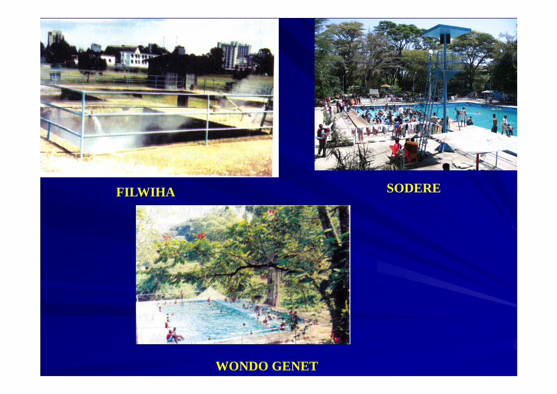
FILWIHA SODERE
WONDO GENET

GEOTHERMAL PROSPECTS OF ETHIOPIA
Geothermal Area Detail Survey Drilling Max. Temp oC1 Abaya Yes No2 Corbetti Yes 942 Corbetti Yes 943 Aluto Langano Yes Yes 3504 Tulu Moye Yes No 60-805 Gedemsa No No 60-806 Kone No No7 Fantale Yes No8 Dofan Yes No9 Meteka No No9 Meteka No No
10 Danab No No11 Teo No No12 Abe No No13 Tendaho Yes Yes 27014
Note: + Geothermometer value16 it k16 sites known

•ONLY TWO AREAS ARE SUBJECTED TO DRILLNG
TENDAHOTENDAHO
SUBJECTED TO DRILLNG
•ALUTO-LANGANO (LD-AREA) - 200 KM S OF A AAREA) - 200 KM S. OF A.A
•TENDAHO (N.AFAR)- 650 KM NE OF A.A
ALUTO-LANGAO
ALUTO-LANGANO

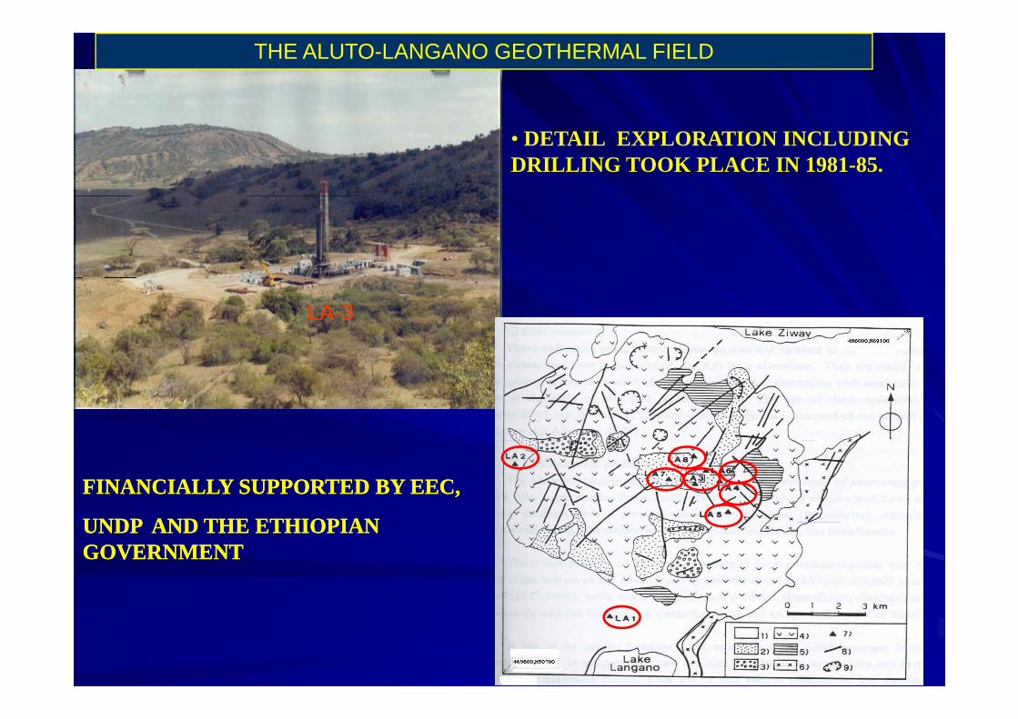
THE ALUTO-LANGANO GEOTHERMAL FIELD

Geological Mapping 1:50 000 scale
33
4
3
4
4
3
3
4
4
4
4
(
L a k e Z i w a y
L A 8
RHYOLITE
1:50,000 scale
• LITHOLOGICAL AND
3
4 4
3
L A - 7L A - 6
L A - 4
L A - 8
L A - 3
L A - 5
L A - 2
LITHOLOGICAL AND STRUCTURAL STUDIES
3
3
⊥ ⊥ ⊥ ⊥
0 1 2 3 K mL A - 1
L a k e L a n g a n o
•HEAT SOURCE
Abundant silicic volcanoes, recent volcanic products
Simplified Geological Map
recent volcanic products (2000Yrs.)RHYOLITE
•PERMEABILITY
WFB and other transverse BASALTfaults (production of
secondary Permeability)SiO2
Total Alkali-Silica diagram for classification of
Aluto outcropping rocks.

Bobesa
SURACE ALTERATION MINERAL STUDIES
Bole
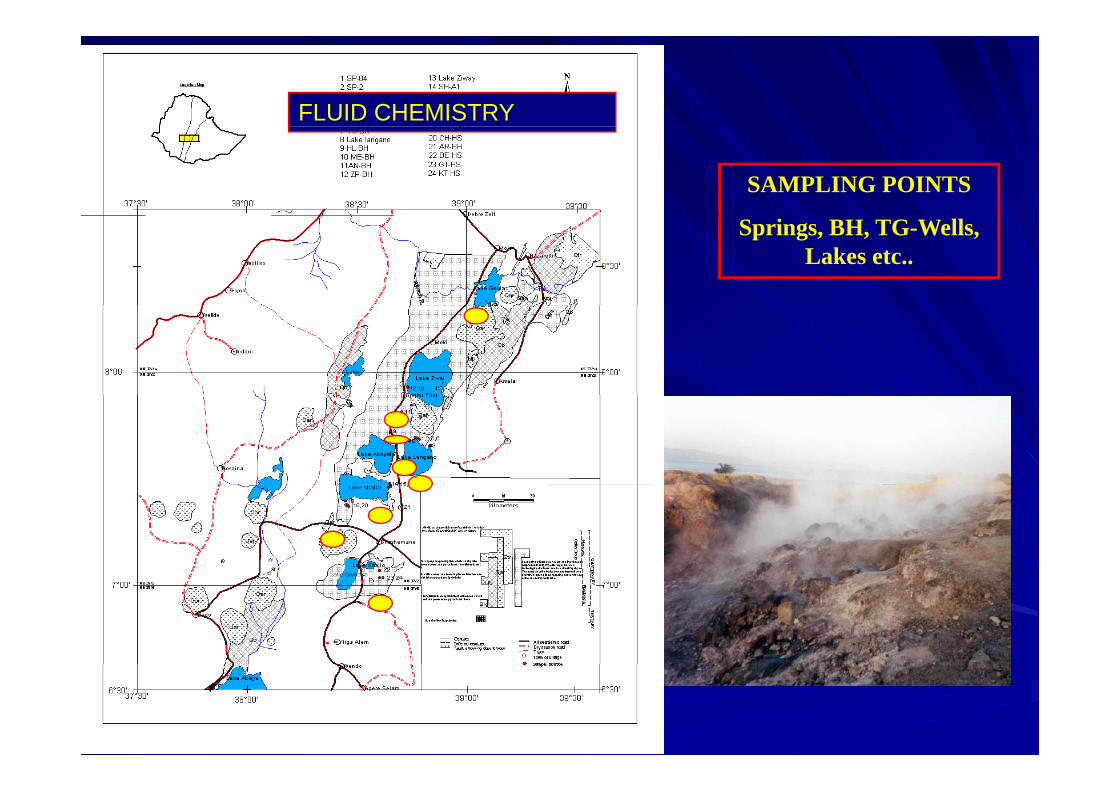
FLUID CHEMISTRY
SAMPLING POINTS
Springs, BH, TG-Wells, Lakes etc..

Water Classification
ClBole SP Shalla NE
0100
7
SP-84
SP-2
TG-31
Shalla SW
Chitu Sp
Wondo (Belle)
25
5050
75
TG-32 Wondo (Giorgis)
50
75 2
50
SO4 HCO3
7
100 0
25
A BICARBONATE
SO4 HCO3
0 25 50 75 100Figure 12A. Cl - HCO3 -SO4 PLOT (2003)

Evaluation of Na-K-Mg temperatures
Na/1000Bole Sp Shalla (SW)
Q
5
0
100
7
SP-84
SP-2
TG-32
TG-31
( )
Chitu HS
Wondo (Giorgis)
Wondo (Belle)
25
50
50
75
100120140160180
200220
TG 31
75
25
80220
240260
280300
320340Na-K geothermometer=
K/100 Sqrt Mg0 25 50 75 100
100 0
immature watersg180- 200°C
Figure 13A. Evaluation of Na-K-Mg temperatures (1973-2003). After Giggenbach (1988)

GEOPHYSICS
• ELECTRICAL RESISTIVITY
•MAGNETICS
•GRAVITY
• TG WELLS WERE DRILLED

USE of ER as a tool for siting drilling locations was constrained by the rock succession :
Due to its inability to attain sufficientdepth pentration below a conductive layerf AVP & LSof AVP & LS
A combination of topographic and
ALUTO-VOLCANIC PRODUCTS
Lake sedimentsA combination of topographic andgeological structure complexity thevolcanic edifice itself didn’t allow theemergence of a clear electrical resistivity
Basalt
Tertiary ignimbriteemergence of a clear electrical resistivitystructure
Tertiary ignimbrite
It is recommended to complement thissurvey with an MT survey to provide adelineation of the target area and to havega better resolution in the verticaldimension
THE ALUTO-LANGANO GEOTHERMAL FIELD
• DETAIL EXPLORATION INCLUDING DRILLING TOOK PLACE IN 1981-85.
LA-3
FINANCIALLY SUPPORTED BY EEC,FINANCIALLY SUPPORTED BY EEC,
UNDP AND THE ETHIOPIANUNDP AND THE ETHIOPIANUNDP AND THE ETHIOPIAN UNDP AND THE ETHIOPIAN GOVERNMENT GOVERNMENT
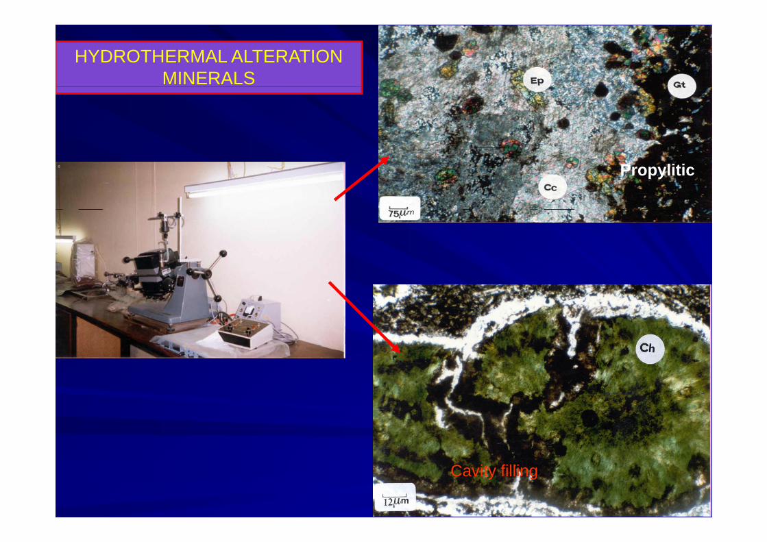
HYDROTHERMAL ALTERATION MINERALS
Propylitic
Cavity filling

CLAY MINERAL STUDIES
Mixed Layer Illite smectite
Illite-chlorite
Chlorite intergrade
illite
Chlorite intergradeChlorite intergrade
chlorite
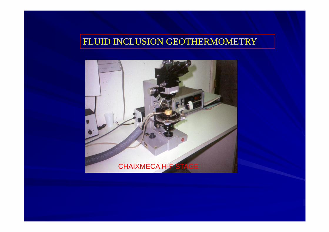
FLUID INCLUSION GEOTHERMOMETRY
CHAIXMECA H-F STAGECHAIXMECA H F STAGE

TYPES OF INCLUSIONS
P-INCLUSIONEQz
S INCLUSIONEV-RICH INC
S-INCLUSIONE
Cc Qz
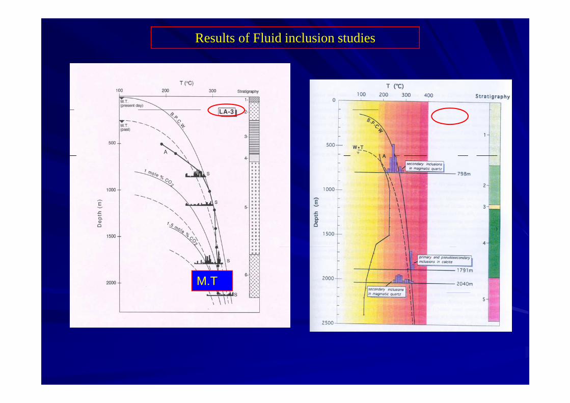
Results of Fluid inclusion studies
M.T

NONE OF THE FLUID FROM THE WELLS REPRESENT THE PARENT FLUID

GEOCHEMISTRY
• Water and gas sampling from thermal manifestations
•Analyse for major cations and anionsAnalyse for major cations and anions
•Data processing using various geochemical softwares (e.g. WATCH, SOLMINEQ 88 t )
AASGC
SOLMINEQ 88 etc..)
•Determine the reservoir temperature•Determine the reservoir temperature using various chemical geothermomters (e.g. Si-geothermometer, Na-k, Na-K-Ca geothermometers)geothermometers)
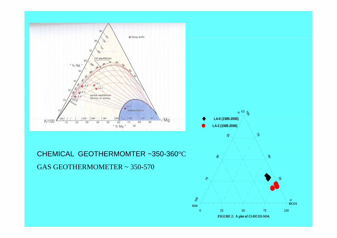
Cl
LA-6 (1985-2000)LA-6 (1985-2000)
LA-3 (1985-2000)
CHEMICAL GEOTHERMOMTER ~350-360°C
GAS GEOTHERMOMETER ~ 350-570
SO4 HCO3
0 25 50 75 100
FIGURE 2: A plot of Cl-HCO3-SO4.

SATURATION INDICES
1.20 1.20
0.40
0.80
nI n d e x ( S I ) Quartz
0.40
0.80
on In
dex
(SI)
Quartz
Calcite
-0.40
0.00
S a t u r a t i o n
Amorphous silica
-0.40
0.00
S
atur
atio
Amorphous silica
120 160 200 240 280 320Temperature ( C)
-0.80
Calcite
80 120 160 200 240Temperature ( C)
-0.80
FIGURE 6: A plot of SI vs temperature (well LA-3)Temperature ( C)
FIGURE 8: A plot of SI vs temperature (well LA-4)

2000
Figure 1: Downhole Temperature Profiles (Aluto wells)
3
Lake Ziway
DOWNHOLE TEMPERATURE PROFILES
1500
3
4
4
3
3
4
4
4
(
1000
(m.a
.s.l)
1
3
3
3
4
4
LA-7LA-6
LA 4
LA-8
LA-3
LA-2
500
Ele
vatio
n(
4 4
3
LA-4
LA-5
0
3
⊥ ⊥ ⊥ ⊥
0 1 2 3 KmLA-1
0 50 100 150 200 250 300 350Temperature (°C)
-500
LegendLA1-T16LA2 T13
3
Lake Langano
LA2-T13LA3-T55LA4-T33LA5-T18LA6-T15LA7-T27LA8-T10
File:Tempelveation

One of the Discharging Wells At Aluto, LA-6 • FIVE WELLS ARE
POTENTIALLY PRODUCTIVEPOTENTIALLY PRODUCTIVE WITH A MAX. TEMPERATURE OF 350 °C.
•• FEASIBILITY STUDY WAS FEASIBILITY STUDY WAS COMPLETED IN 1986 BY GSE COMPLETED IN 1986 BY GSE AND ELC, ITALY THAT AND ELC, ITALY THAT INDICATED 30MWe OF INDICATED 30MWe OF GEOTHERMAL POTENTIAL GEOTHERMAL POTENTIAL TO LAST FOR 30 YEARS.TO LAST FOR 30 YEARS.
IN 1995, THE FIELD HANDED OVER TO EEPCO
FOR DEVELOPMENT

TERTIARY
IGNIMBRITETERTIARYIGNIMBRITE
CONCEPTUAL MODEL OF THE A-L GEOTHERMAL SYSTEM

THE ALUTO-LANGANO GEOTHERMAL
PILOT POWER PLANT
3MWe

CURRENT ACTIVITYCURRENT ACTIVITY
PROBLEM IDENTIFICATION
REHABILITATION OF THE PLANT

THE WAY FORWARD FOR ALUTO
•Further MT + TEM studies for location of wells for further appraisal drillingfurther appraisal drilling
•Drilling of Appraisal and production wells
•Resource Development in various phases

TENDAHO GEOTHERMAL FIELD
TENDAHO GEOTHERMAL FIELD
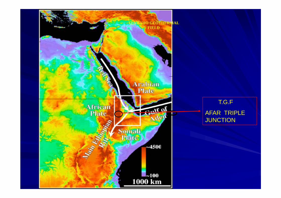
T.G.F
AFAR TRIPLE JUNCTIONJUNCTION

TENDAHO GEOTHERMAL FIELDTENDAHO GEOTHERMAL FIELD
Ayroberay
DoubtiDoubti
Allalobeda
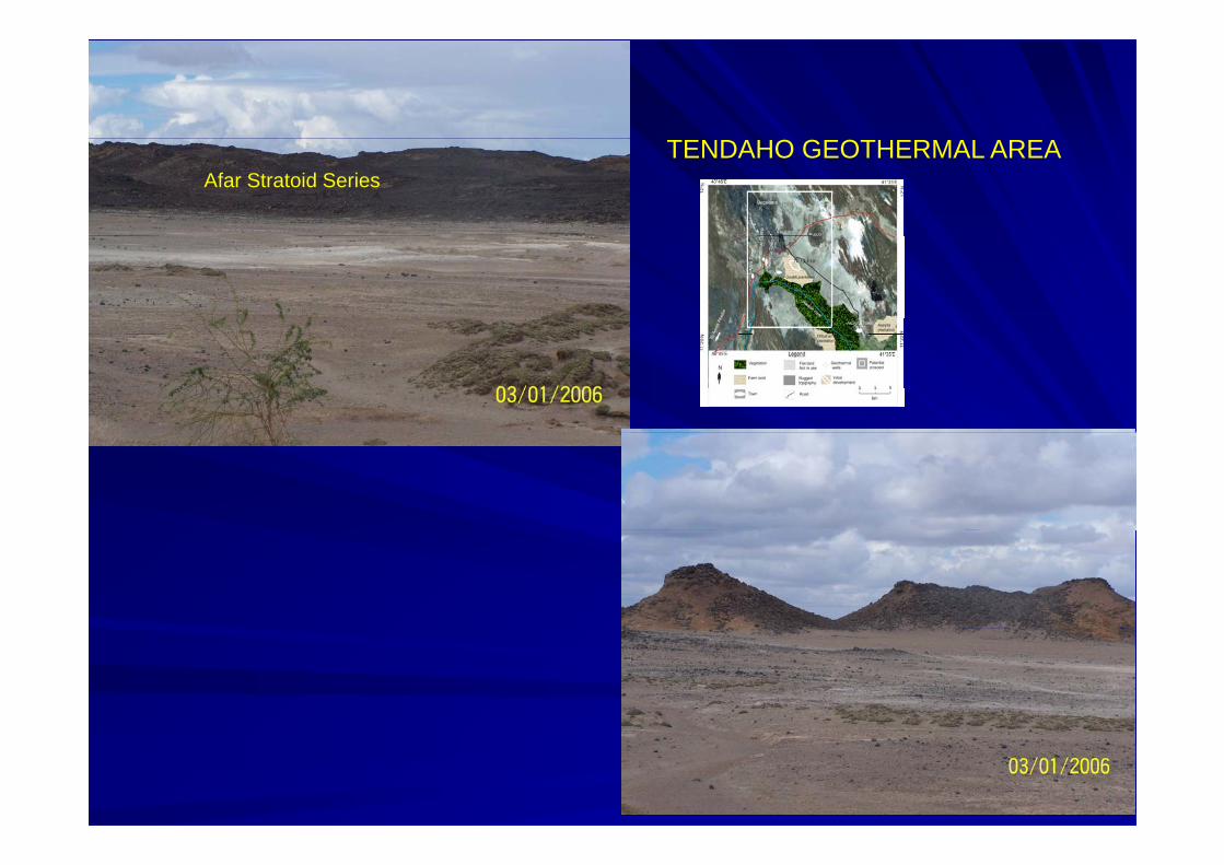
TENDAHO GEOTHERMAL AREAAfar Stratoid Series

TENDAHO GEOTHERMAL FIELD TENDAHO GEOTHERMAL FIELD EXPLORATION HISTORYEXPLORATION HISTORY
RECONAAISSANCE SURVEY (1969/70)RECONAAISSANCE SURVEY (1969/70)PREPRE--FEASIBILITY STUDY (1979/1980)FEASIBILITY STUDY (1979/1980)TECHNO ECONOMIC STUDY (1982)TECHNO ECONOMIC STUDY (1982)DRILLING OF 3 DEEP & A SHALLOW WELLS (1993DRILLING OF 3 DEEP & A SHALLOW WELLS (1993--1995)1995)1995)1995)2 SHALLOW WELLS DRILLING (19972 SHALLOW WELLS DRILLING (1997--1998)1998)WE TESTING & GEOSCIENTIFIC STUDIES (1998WE TESTING & GEOSCIENTIFIC STUDIES (1998WELL TESTING & GEOSCIENTIFIC STUDIES (1998WELL TESTING & GEOSCIENTIFIC STUDIES (1998--TO DATE)TO DATE)FINANCED BY ITALIAN AND ETHIOPIAN GOVTFINANCED BY ITALIAN AND ETHIOPIAN GOVTFINANCED BY ITALIAN AND ETHIOPIAN GOVT.FINANCED BY ITALIAN AND ETHIOPIAN GOVT.

15-3 My
1.4 Ma
GEOLOGICAL MAP OF THE TENDAHO GEOTHERMAL AREA (Aquater, 1996)

Surface alteration along manifestations
Surface alteration along manifestations

TENDAHO
• 3 DEEP (2100 m) & 3 SHALLOW
TD-1TD-3
• 3 DEEP (2100 m) & 3 SHALLOW WELLS (500m) WERE DRILLED
TD 1
TD-2TD-4
• MAXIMUM TEMP = 260ºC AT A DEPTH OF 500M
TD-5 TD-6
LOCATION OF WELLS IN THELOCATION OF WELLS IN THE TENDAHO GEOTHERMAL FIELD
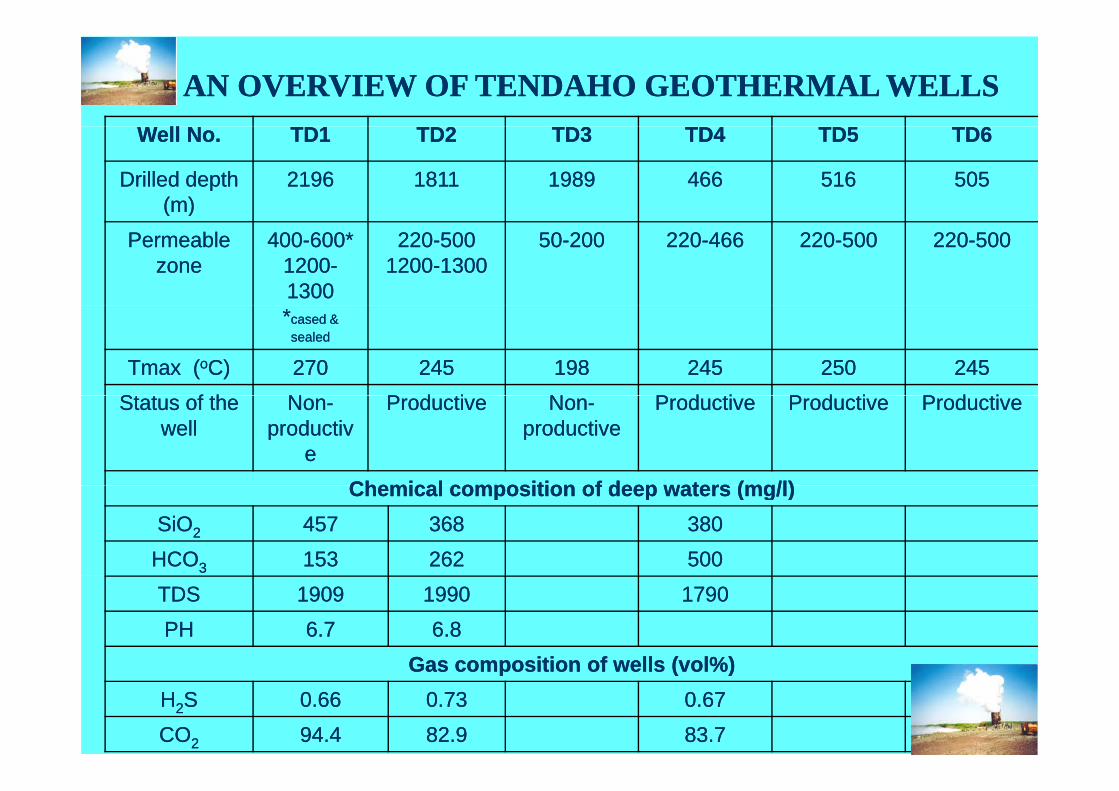
AN OVERVIEW OF TENDAHO GEOTHERMAL WELLSAN OVERVIEW OF TENDAHO GEOTHERMAL WELLSWell No.Well No. TD1TD1 TD2TD2 TD3TD3 TD4TD4 TD5TD5 TD6TD6
Drilled depth Drilled depth (m)(m)
21962196 18111811 19891989 466466 516516 505505( )( )
Permeable Permeable zonezone
400400--600* 600* 12001200--1300 1300
220220--50050012001200--13001300
5050--200200 220220--466466 220220--500500 220220--500500
**cased & cased & sealedsealed
Tmax (Tmax (ooC)C) 270270 245245 198198 245245 250250 245245St t f thSt t f th NN P d tiP d ti NN P d tiP d ti P d tiP d ti P d tiP d tiStatus of the Status of the
wellwellNonNon--
productivproductivee
ProductiveProductive NonNon--productiveproductive
ProductiveProductive ProductiveProductive ProductiveProductive
Chemical composition of deep waters (mg/l)Chemical composition of deep waters (mg/l)Chemical composition of deep waters (mg/l)Chemical composition of deep waters (mg/l)SiOSiO22 457457 368368 380380HCOHCO33 153153 262262 500500TDSTDS 19091909 19901990 17901790PHPH 6.76.7 6.86.8
Gas composition of wells (vol%)Gas composition of wells (vol%)Gas composition of wells (vol%)Gas composition of wells (vol%)HH22SS 0.660.66 0.730.73 0.670.67COCO22 94.494.4 82.982.9 83.783.7

SUMMARY OF EXPLORATION RESULTSRESULTS
• EXISTNANCE OF SHALLOW °RESERVOIR (220-250°C)
PROVEN
• POTENTIAL OF SHALLOW RESERVOIR ESTIMATED AT 3-5MWe
• DEEP RESERVOIR INDICATED (>270°C)
•LOCATION OF DEEP DRILL WELL SITES TO BE IDENTIFIED

MT INVESTIGATION AT TENDAHO (DUBTI &AYROBERA)
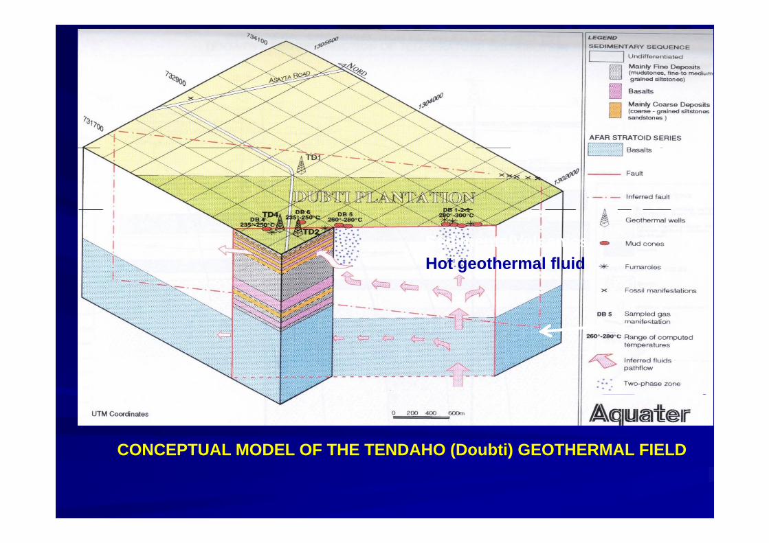
Sediments/VolcanicsHot geothermal fluidg
AFSSAFSS
CONCEPTUAL MODEL OF THE TENDAHO (Doubti) GEOTHERMAL FIELD( )

The way forward for the Tendaho Geothermal Field
•Location and delineation of the deep reservoir
•Identification of Shallow reservoir volume
•Characterize the shallow reservoir by installing a small scale pilot power plant
•Further drilling to reach to the deep reservoir & develop the fieldreservoir & develop the field
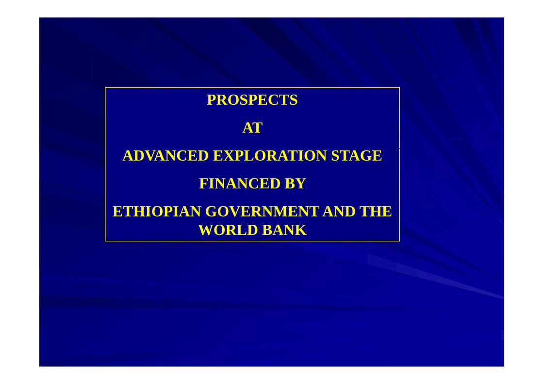
PROSPECTS OS C S
AT
ADVANCED EXPLORATION STAGE
FINANCED BY
ETHIOPIAN GOVERNMENT AND THE WORLD BANK

DOFAN-FANTALE
TULU MOYETULU MOYE
CORBETTI
ABAYA

GEOTHERMAL PROSPECT AREAS FROM SOUTH TO NORTH OF THE LDFROM SOUTH TO NORTH OF THE LD
PROSPECT 1 ABAYAPROSPECT 1: ABAYA
PROSPECT 2 : CORBETTI
PROJECT 3: TULU MOYEPROJECT 3: TULU MOYE
PROSPECT 4: DOFAN FANTALE

ABAYA GEOTHERMAL PROSPECT AREA
•400 KM SOUTH OF A.A
•DETAILED GEOSCIENTIFIC STUDIES INCLUDING MT SURVEY
HAVE IDENTIFIED A TEMPERATURE IN EXCESS OF 260 °C.
•FURTHER GEOPHYSICAL SURVEY (MT+TEM) ARE RECOMMENDED.
•132 KV TL WITHIN 45 KM OF THE
PROSPECT AREA
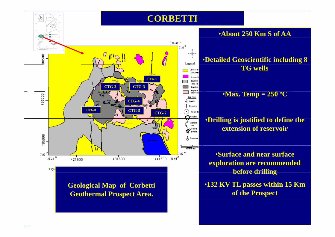
•About 250 Km S of AA
CORBETTI
•Detailed Geoscientific including 8 TG wells
M T 250 ºC
CTG-1
CTG-2 CTG-3
•Max. Temp = 250 ºC
D illi i j tifi d t d fi thC
CTG-4
CTG-8CTG-7CTG-5
•Drilling is justified to define the extension of reservoir
C
•Surface and near surface exploration are recommended
before drilling
Geological Map of Corbetti Geothermal Prospect Area.
before drilling
•132 KV TL passes within 15 Km of the Prospect

TULU MOYE GEOTHERMAL PROSPECT AREA
•DETAILED GEOSCIENTIFIC STUDIES INCLUDING 5 TG WELLSWELLS
•HIGH TEMP > 200 ºC & GOOD PERMEABILITYPERMEABILITY
•TARGET AREAS FOR DEEP WELLS ARE SELECTEDWELLS ARE SELECTED
•Lateral extent/depth of geothermal reservoir unknowng
•LOCATED CLOSE TOAWASH I AND II POWER STATIONS
TG-1

THE DOFAN & FANTALE GEOTHERMAL PROSPECT AREA
• LOCATED ABOUT 250 KM NE OF AA
• DETAIL GEOSCIENTIFIC STUDIES ARE COMPLETED INSTUDIES ARE COMPLETED IN 2004-06
•SEVERAL HYDROTHERMALSEVERAL HYDROTHERMAL MANIFESTATIONS WITHIN THE VICINITY
•LATERAL EXTENT/DEPTH OF GEOTHERMAL RESERVOIRGEOTHERMAL RESERVOIR UNKNOWN

Geological and Structural Maps of the Dofan Fantale Geothermal
Prospect Area
BI
R

Surface Alteration Studies

FLUID CHEMISTRY
Cl
0
100
Legend Filoa-2 H.Sp
Filoa-3 H.Sp
25
75
Habilo H.Sp
Hubicha-1 H.Sp
Hubicha-2 H.Sp
Melka T H Sp
50
50
Melka T. H.Sp
Merti Bh
Metehara Bh
Debhiti Bh
75
25
Awash Rv
Bulga Rv
Kebena Rv
A di D
SO4 HCO3
100 0
Arowadi Dw
Beseka Lk
SO4 HCO30 25 50 75 100

0
10
Na/1000Legend
25
0 00
75
Filoa-2 H.Sp
Filoa-3 H.Sp
Habilo H.Sp
50
50
80
100120140160180
200220
240
p
Hubicha-1 H.Sp
Hubicha-2 H.Sp
Melka T. H.Sp
75
25
immature waters
Habilo(Sp-4)
240260
280300
320340
K/100 Sqrt Mg0 25 50 75 100
100 0
immature waters
60
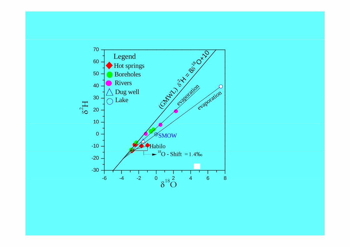
70
δ18 O+1
0LegendHot springs
40
50
WL)
tionoratio
nδ2 H =
8δ
Hot springsBoreholesRiversDug well
10
20
30
δ2H (G
MW
evaporatio
evapo
rLake
-10
0 SMOW
Habilo18
-6 -4 -2 0 2 4 6 8-30
-20
18
18O - Shift = 1.4‰
6 4 2 0 2 4 6 8δ18O

GEOPHYSICAL INVESTIGATION
APPARENT RESISTIVITY MAPRESIDUAL GRAVITY MAP APPARENT RESISTIVITY MAPRESIDUAL GRAVITY MAP

Schematic Conceptual Model of the D-F G.P.A

CURRENT ACTIVITY
•• RESERVOIR ENGINEERING &RESERVOIR ENGINEERING &RESERVOIR ENGINEERING & RESERVOIR ENGINEERING &
GEOSCIENTIFIC STUDIES OF THEGEOSCIENTIFIC STUDIES OF THE
TENDAHO GEOTHERMAL FIELDTENDAHO GEOTHERMAL FIELD
•• INTERPRETATION OF MT &TEM DATAINTERPRETATION OF MT &TEM DATA
DETAILED GEOSCIENTIFIC STUDIES
(Geology &Geochemistry) OF THE ABAYA
GEOTHERMAL PROSPECT AREA
PROBLEM IDENTIFICATION AND
REHABILITATION OF THE ALUTO-
LANGANOGEOTHERMAL PILOT
POWER PLANT

DURING THE THREE DECADES THAT GEOTHERMAL RESOURCE
EXPLORATION WAS CARRIED OUT
• GOOD INFORMATION BASE
• GOOD DEGREE OF EXPLORATION AND HUMAN CAPACITYAND HUMAN CAPACITY
• BASIC INSTITUTIONAL AND INFRASTRUCTURE HAVE DEVELOPED.
•HOSTED 1ST ARGEO CONFERENCE IN ADDIS ABABA ETHIOPIA NOVEMBER 2006ABABA, ETHIOPIA NOVEMBER 2006

THE WAY FORWARD IN PROSPECTIVE AREAS
Ad i ibl• Advancing as many prospect areas as possible to Exploration drilling
• Selection of two geothermal potential areas for explorationSelection of two geothermal potential areas for exploration drilling
• Selection for Det.Exp. ‘ll be based on the geothermal p gPotential and proximity to existing national electrical grid
• Execute power Development activities such as:
(i)Resource Development( )(ii) Drilling for steam field development
(iii)Power plant installation(iii)Power plant installation

POSSIBLE STRATEGIES FOR FURTHER
EXPLORATION AND DEVELOPMENT IN ETHIOPIAEXPLORATION AND DEVELOPMENT IN ETHIOPIA

Currently the desire to Increase the geothermal Currently the desire to Increase the geothermal development and utilisation in Ethiopia inspired by:development and utilisation in Ethiopia inspired by:
Critical role of energy in socioCritical role of energy in socio--economic devt of economic devt of the countrythe countrythe countrythe countryEnergy demand growthEnergy demand growthRural Electrification focusRural Electrification focusRural Electrification focusRural Electrification focusIncreasing world oil priceIncreasing world oil priceFrequent drought and shift to Generation MixFrequent drought and shift to Generation Mixq gq gClean Development Mechanism availabilityClean Development Mechanism availabilityGrowth of interest of private investment (Japan, Growth of interest of private investment (Japan, Iceland)Iceland)Availability of required inputs (Human Resource, Availability of required inputs (Human Resource, Rigs etc ) for GEDRigs etc ) for GEDRigs etc..) for GEDRigs etc..) for GEDExistence of identified potential geothermal Existence of identified potential geothermal prospect areasprospect areasp pp p

POSSIBLE STRATEGY FOR GEOTHERMAL EXPLORATION AND
DEVELOPMENT IN ETHIOPIA
22. TENDAHO
5
6
6. D-FANTALE
3
4
1CorbettAbay 1. ALUTO
5.T.MOYE
3. CORBETTI
4. ABAYA

THE WAY FORWARD
GOVT OF ETHIOPIA IS COMMITTEDGOVT. OF ETHIOPIA IS COMMITTED TO DIVERSIFY AER. (ROAD MAP)
Hold an Investment/Donor Conference Dec. 2008
PROSPECT 1: ALUTO LANGANO
PROSPECT 2: TENDAHOPROSPECT 2: TENDAHO
PROSPECT 3 : CORBETTI
PROSPECT 4: ABAYA
PROJECT 5: TULU MOYE
PROSPECT 6: DOFAN FANTALE
GEOTHERMAL STRATEGY TOGEOTHERMAL STRATEGY TO FURTHER EXPLORE AND
DEVELOP ABOUT 500 MWE FOR THE COMING 14 15 YEARSTHE COMING 14-15 YEARS.

CONSTRAINTS AND OPTIONS FOR DEVELOPMENTCONSTRAINTS AND OPTIONS FOR DEVELOPMENT OF GEOTHERMAL RESOURCE IN ETHIOPIA

N C t i t O ti
CONSTRAINTS AND OPTIONS FOR DEVELOPMENT OF GEOTHERMAL ENERGY
No. Constraints Options1. Geothermal not in National
Energy Development PlansIntegrate Geothermal in National Energy Development Plansgy p gy p
2. Large upfront cost of Exploration and Development
Promote PPP, IPPParticipation of Finance, bilateral
donors and development agencies (e gdonors and development agencies (e.g. UNDP, WB)
Use the Opportunity of RMF/TAF (A G )(ARGeo)
3. Limited budget for full fledged exploration Establish Policy to provide enoughexploration Establish Policy to provide enough
budget4. Lack of continous and
i d k i l i E bli h / fintegrated work in exploration and development of the resource
Establish a process/system for un-interrupted Geothermal exploration and development activity
SUMMARYSUMMARYGeothermal is known to be a reliable, indigenous, environmentalGeothermal is known to be a reliable, indigenous, environmentalGeothermal is known to be a reliable, indigenous, environmental Geothermal is known to be a reliable, indigenous, environmental friendly & cost effective alternative energy resource.friendly & cost effective alternative energy resource.
A substantial Potential of G E Resource exist within the EthiopianA substantial Potential of G E Resource exist within the EthiopianA substantial Potential of G. E. Resource exist within the Ethiopian A substantial Potential of G. E. Resource exist within the Ethiopian Rift System that can be used for power generation and direct uses.Rift System that can be used for power generation and direct uses.
Government is Committed to Investigate and Further Develop Government is Committed to Investigate and Further Develop Geothermal Resource to Supplement and Diversify Energy Geothermal Resource to Supplement and Diversify Energy Consumption Dueto: Consumption Dueto:
-- Strong Growth in Electrcity DemandStrong Growth in Electrcity Demand-- Recurrent Drought Recurrent Drought -- Increase of Petroleum PricesIncrease of Petroleum PricesIncrease of Petroleum PricesIncrease of Petroleum Prices
LongLong termterm conduciveconducive policiespolicies andand incentivesincentives thatthat attractattract privateprivateinvestmentinvestment isis alreadyalready establishedestablished inin thethe countrycountryEnco rageEnco rage foreignforeign technicaltechnical andand financialfinancial participationparticipationEncourageEncourage foreignforeign technicaltechnical andand financialfinancial participationparticipationEstablishEstablish aa soundsound CBCB MechanismMechanism forfor sustainablesustainable GEDGEDEstablishEstablish aa process/systemprocess/system forfor anan integratedintegrated geothermalgeothermal explorationexplorationandand developmentdevelopment ofof thethe resourceresource withwith aa viewview toto quickquick developmentdevelopment andandimplementationimplementation possiblepossible..

THANK YOU