geothermal education and research at uo a2
TRANSCRIPT

Overview of Geothermal, Education and ResearchEducation and Research
The University of AucklandThe University of Auckland
Gary PuttExecutive Director
Geothermal Institute
April 2011

Outline
1. New Zealand and Auckland
2. The University of Auckland
3. Geothermal in New Zealand
4. Geothermal training at the UoA
5. Geothermal Research at the UoA

Where in the world is New Zealand?

New Zealand
AucklandThe size of NZ:
~267 000 km2Auckland ~267,000 km2
–North Island: 115,777 km2 +
Wellington–South Island: 151,215 km2
ChristchurchSimilar size to Japan and UK
Dunedin

Stunning Natural Beauty ...


…With Plenty Of Adventure Close At Handy
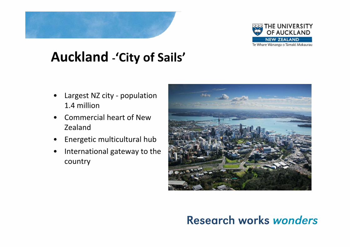
Auckland ‐‘City of Sails’
• Largest NZ city population• Largest NZ city ‐ population 1.4 million
• Commercial heart of New Zealand
• Energetic multicultural hub• International gateway to the• International gateway to the
country


The University of Auckland• Founded in 1883
Largest and top ranked research institution • Largest and top ranked research institution in New Zealand
• Comprehensive University with full range of Comprehensive University with full range of professional schools to PhD level
• Nearly 40,000 students and 7,000 staff i l diincluding– 4,300 international students from over
100 countries
• Annual turnover >$800M– >NZ$5 billion pa contribution to
Auckland / NZ economy

Research at the University – Key figures
2 500 d i ff• 2,500 academic staff
• About 10,500 postgraduate students including nearly 2,000 at doctoral level
• More than 60 research units, centres and institutes
• More than 6,500 research articles, books and conference papers published annually
• 180 patent families and 115 patents granted since 1987
• Research revenue NZ$206 million pa in 2009.

Research at the University - Structure
• Eight Faculties:– Arts
Business and Economics– Business and Economics– National Institute of Creative Arts and Industries– Education– Engineeringg g– Law– Medical and Health Sciences– Science
– More than 60 research units, centres and institutes, including the Institute of Earth Science and Engineering.
T L S l R h I tit t (LSRI)• Two Large Scale Research Institutes (LSRI):– Auckland Bioengineering Institute - computational
physiology and biomedical engineering– Liggins Institute - research on fetal and child health – Liggins Institute - research on fetal and child health
and development.

Geothermal in New ZealandWorld Leader in World Leader in Geothermal• 720 MWe installed
capacity• 12% of electricity
generatedgenerated• 50+ years history of
excellence in excellence in development, research, and training
• significant near-term growth due to mega-scale projects 500MW’sscale projects 500MW s

New Zealand SubductionSubduction
http://www.teara.govt.nz/en/volcanoes/2/2
http://www.teara.govt.nz/en/volcanoes/2/2
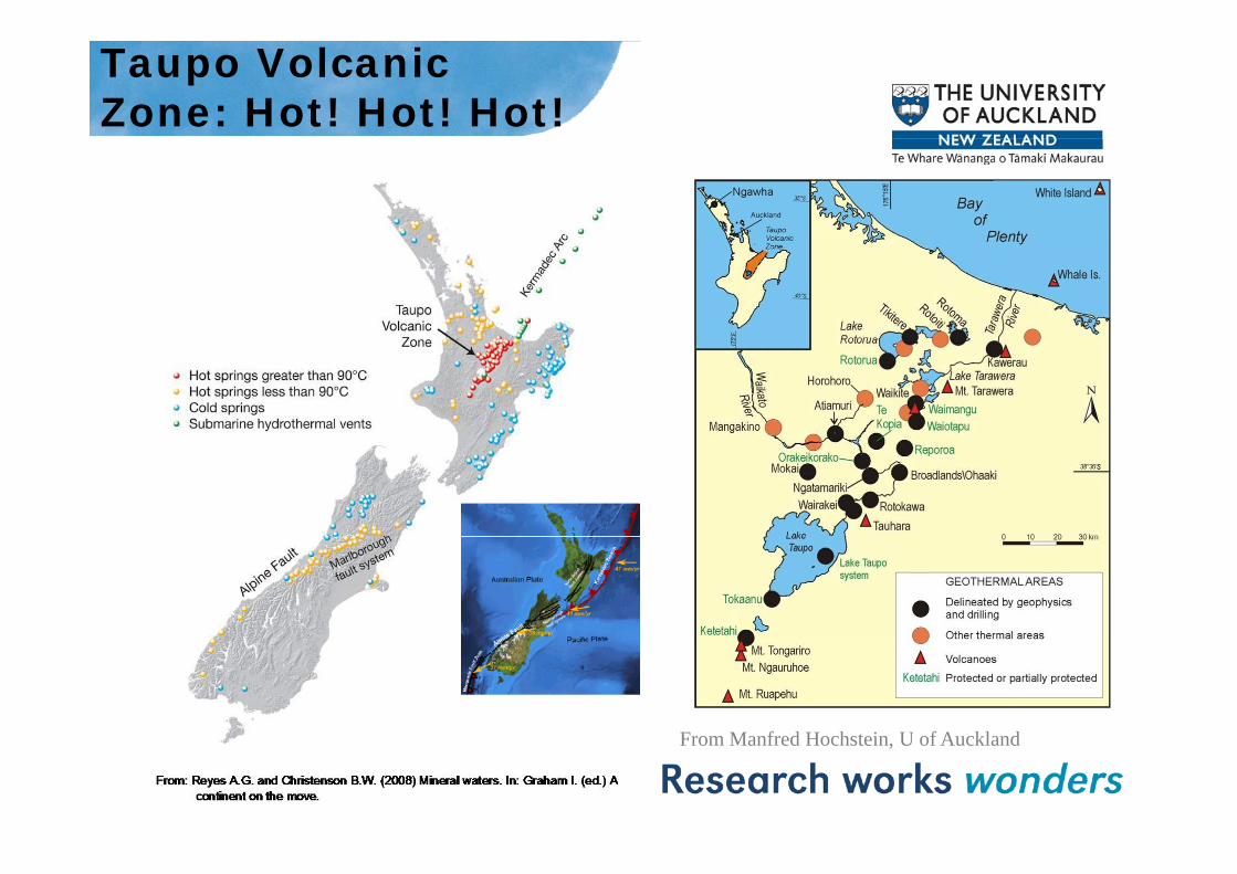
Taupo Volcanic Zone: Hot! Hot! Hot!
F M f d H h t i U f A kl dFrom Manfred Hochstein, U of Auckland
Geothermal Use in New Zealand
• Electricity – established with considerable growth potentialpotential– 720 MW’s installed capacity– Further 500 MW’s currently under development– 1100 MW’s available using existing technology– $4 billion development program to realise
• Direct Use – established with lesser growth potential• Direct Use established with lesser growth potential• Heat pumps - infancy
– Relatively new– Developing recognition in the commercial sector– Luxury housing market in colder parts of Southland, and
Auckland

Direct UseDirect Use
• Most common use is bathing• Space and water heating• Frost protection and irrigation• Greenhouse and glasshouse heating - growth• Timber kiln drying - growth• Special tourism developments• Kawerau industrial development 56% of
industrial use – timber mill

Direct Use of Geothermal Heatgy
.org
Mokai Glasshouses
othe
rmal
-ene
rgge
o
Wairakei Prawn FarmWairakei Prawn FarmWhite, 2006

Drivers of Growth in New Zealand• Premium geothermal resources• Vibrant geothermal industry• Cost effective and base load• Depletion of local gas reserves• Cost and supply of imported fossil fuels• Few available hydro alternatives – limited y
storage capacity• Commitments to reducing greenhouse
emissions• Cost of carbon ETS• Export opportunities

Challenges in New ZealandChallenges in New Zealand
• Competing uses• Resource consents• Investment limited• Environmental• Subsidence• Induced seismicity• New research and technology
– Deeper resources– Blind resources
L t t– Lower temperature

New Zealand: Pioneers e ea a d o ee sin Geothermal Energy
Wairakei 1950: Exploration Phase1958: World’s first production of a liquid Wairakei, 2010: 176 Mwe1958: World s first production of a liquid dominated geothermal system
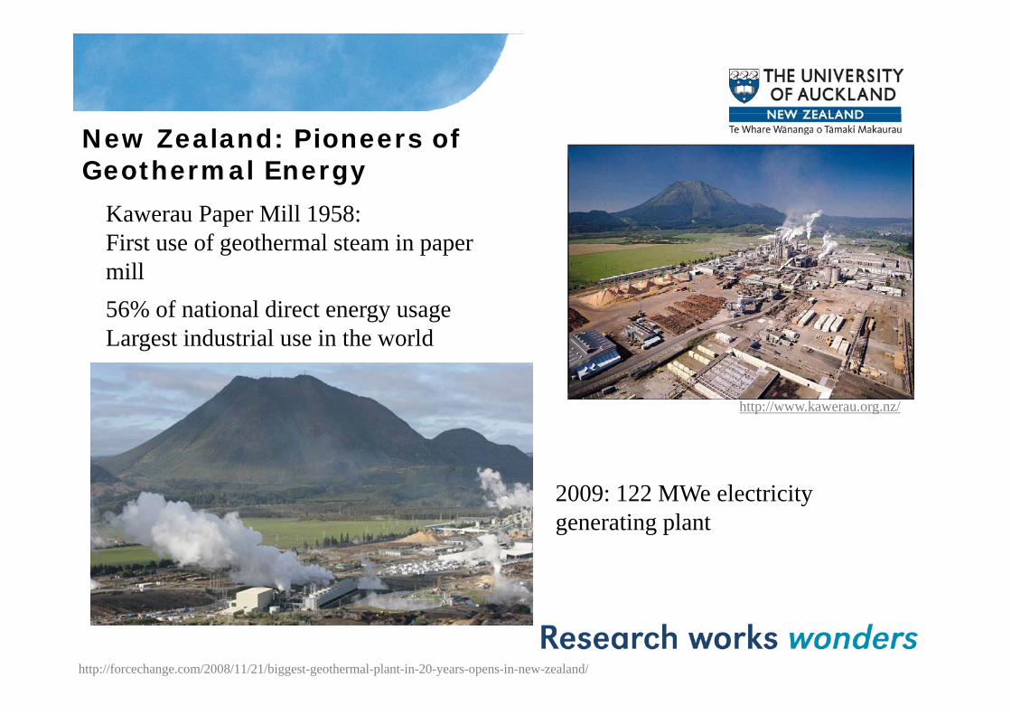
New Zealand: Pioneers of Geothermal Energy
Kawerau Paper Mill 1958:First use of geothermal steam in paper millmill56% of national direct energy usageLargest industrial use in the world
http://www.kawerau.org.nz/
2009: 122 MWe electricity generating plantgenerating plant
http://forcechange.com/2008/11/21/biggest-geothermal-plant-in-20-years-opens-in-new-zealand/

New Zealand Energy Mix 90% Renewables by 2025

Geothermal Institute 1978 -The University of Auckland
Professional Training & Education
The University of Auckland
• Professional Training & Education
Post-graduate (Certificate, Masters, PhD, Interns, Mentoring & Coaching, Commercial Short Courses)
• Research
Basic, Applied, Student
• Technology• Technology
Borehole seismic, Geophysical Observatory, Joint Geophysical Imaging
• Commercial Services & Consulting
Exploration, Monitoring, Modeling, Equipment

Geothermal Training at the U i itUniversity• Short Courses & Coaching
• Postgraduate Certificate in Geothermal Energy Technology
• Masters of Science
• Masters of Engineering
• Masters of Energy
• Doctoral degrees in Geothermal topics

Short Courses and CoachingShort Courses and Coaching• Public short courses in New Zealand
– GeosciencesGeosciences– Reservoir Engineering– Exploration– GeophysicsGeophysics– Reservoir modelling
• Contracted off shore courses• Contracted off shore courses– Australia, Indonesia, Philippines, Chile, Kenya
• Mentoring Coaching Internships• Mentoring, Coaching, Internships– Philippines reservoir modelling
Post Graduate Certificate in G th l E T h lGeothermal Energy Technology• 1 Semester Course
• Programme covers:- Geothermal science & technology- Geothermal engineeringGeothermal engineering- Geothermal geoscience- Geothermal field studies- Research projectResearch project
• Two Field Trips- Taupo Volcanic Zone- Geothermal power plants at Wairakei and Mokai- Direct use projects at Taupo and Rotorua- Several undeveloped geothermal fieldsp g

Masters of EnergyMasters of Energy• Targeted at Science, Engineering, Business and Economics Students• One yearOne year• Research or Taught• Two core courses that will give an overview of energy resources and
energy technology.e e gy ec o ogy• Taught Master Electives in geothermal
– GEOTHERM601 (Geothermal resources & their use) – GEOTHERM602 (Geothermal energy technology) GEOTHERM602 (Geothermal energy technology) – One other from a range of elective papers in engineering, science,
economics, management, energy, sustainability and environment papers
– Research Project
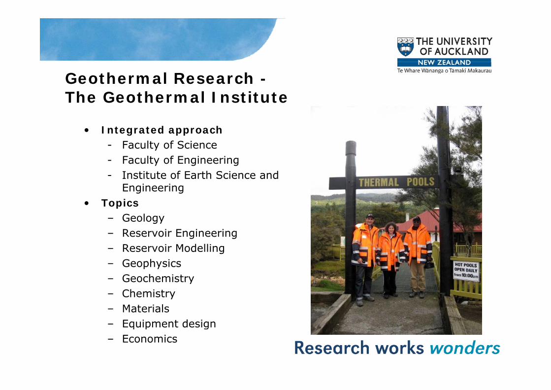
Geothermal Research -The Geothermal Institute
• Integrated approach- Faculty of Science- Faculty of Engineering- Institute of Earth Science and
Engineering• Topics
– Geology– Reservoir Engineering– Reservoir Modelling– Geophysics– Geochemistryy– Chemistry– Materials– Equipment designq p g– Economics
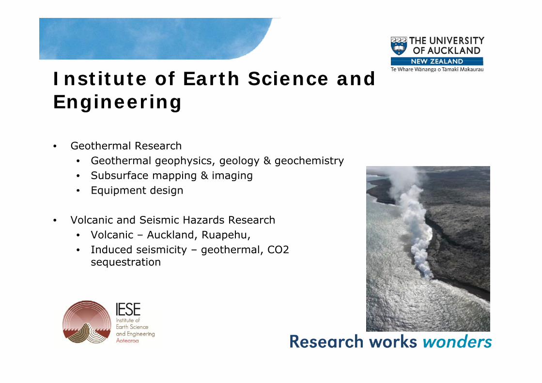
Institute of Earth Science and Engineering
• Geothermal Research
Engineering
Geothermal Research• Geothermal geophysics, geology & geochemistry• Subsurface mapping & imaging• Equipment designEquipment design
• Volcanic and Seismic Hazards Research• Volcanic – Auckland Ruapehu• Volcanic – Auckland, Ruapehu,• Induced seismicity – geothermal, CO2
sequestration

What does IESE do?“FROM WELL-WATER TO MAGMA”
Research, Development, and Service work on rocks and
fluid in the accessible crustfluid in the accessible crust.
Crustal GeophysicsGeothermal GeologygyVolcanologyTechnologies
• Active, passive, and borehole seismology• Electromagnetics• Electromagnetics• Geothermal chemistry and mineralogy• Ground penetrating radar
Staff: 13 PhD-level staff
13 Technical, field, and office staff
5 Graduate students5 Graduate students

Some Current Basic Research1. FRST Geothermal (Two contracts; one at ~$650,000 pa
for 6 years, second for $400,000 pa for 4 years -collaboration with GNS – Deeper and Hotter identifying collaboration with GNS Deeper and Hotter identifying and understanding fracture systems 3-7km’s deep
2. RSNZ Strategic Relocation Fund ($8.4M over 5 years). –The Underground Eye Imaging the sub surface of the The Underground Eye - Imaging the sub surface of the earth - instrumentation, installation, interpretation and illustration
Krafla Iceland• Krafla Iceland• Olkaria Kenya• Mammoth California• Puna, Hawaii ,• Basel ,Switzerland

Some Current Applied Research - New Zealand- New Zealand
1. Micro seismic monitoring at Wairakei Geothermal Field.
2. Reservoir modelling at Ohaaki and Wairakei.
3. Li, B, and Sr isotope geochemistry of geothermal water., , p g y g
4. Near- and sub-solidus magma/fluid reaction and implications for deep reservoir conditions in geothermal systems.
5. Prevention of Scaling - Silica chemistry of Geothermal brines.
6. NZ, US and Chile – Sinter mapping using Ground penetrating radarradar.
7. Improving steam washing to prevent corrosion and scaling.

Some Current Applied Research -InternationalInternational1. Utah Geothermal exploration and drilling
2. Nevada Geothermal exploration
3. Alaska Seismic monitoring of a geothermal field
4. Indonesia
• Seismic monitoring of a geothermal field in Sumatra
• Reservoir Modelling of Wayang Windu
5. Monitoring EGS Fracing in South Australia
6. Geothermal exploration on Nevis
7. Geothermal exploration - Rwanda

Geothermal International Linkages
• Agent in the United States for IESE
Li k ith h • Links with research groups overseas– University of Chile– University of Santiago de ChileU y o a ago d– Bochum University - Germany– Geothermal Research Initiative – Aust Unis, CSIRO &
Geosciences AustGeosciences Aust– Indonesian University’s – Gadjah Mada, Bandung Institute of
Technology

IESE Technical Expertise• Specialised borehole tools
• Micro seismic networks:c o se s c e o s
design, installation, operation, analysis and maintenance
• Integration of MT , TEM and micro seismic

New Geothermal Technologies• Subsurface mapping techniques
– Joint geophysical imaging : Technique for Geothermal explorationGeothermal exploration
• Geophysical instrumentsDown borehole seismic instruments– Down borehole seismic instruments
– Geophysical observatory
Joint Geophysical Imaging (JGI)
A New technique for geothermal exploration
• Goal -Target productive, permeable wells
• Method - MT / TEM polarization & Seismic polarization• Method MT / TEM polarization & Seismic polarization
• Outcomes - Reduced Risk & Increased Productivity
➥ Cost savings

What can be done practically to deal with this?- Mapping with hi-res seismic & EM
Microearthquake (MEQ) S-splitting
Mapping with hi res seismic & EM
- Time lapse data (Repeated surveys)
Magnetotelluric (MT) q ( Q) p gmapping
Seismic
“split” paths
These “image” the fractures
g ( )Polarization mapping
MT Sounding
These “image” the fracturesSeismic
recorder These . do not
Sounding fractures
NormalThese
Normalpath Normal
pathHigh High
do not
Microearthquake
Explosion source Low Low ResistanceResistance
ResistanceResistance

Correlation of MT & S-wave polarizations
Stations K21 and KMT115 Stations K35 and KMT44
0 3
0.35
0.4
Frequencies MT Strike Direction
Fast Shear Wave Polarization Direction
0 3
0.35
0.4
ets/ M
T
MT Strike DirectionFast S‐wave Splitting Direction
0.2
0.25
0.3
Shear W
aves/MT
0.2
0.250.3
littin
g ev
uenc
ies
0.1
0.15
lized num
ber of S
0.1
0.15
aliz
ed S
pfreq
u0
0.05
5 15 25 35 45 55 65 75 85 95 105 115 125 135 145 155 165 175
Median Polarization Direction
Normal
0
0.05
5 15 25 35 45 55 65 75 85 95 105 115 125 135 145 155 165 175
Nor
ma
Median Polarization Direction 5 15 25 35 45 55 65 75 85 95 105 115 125 135 145 155 165 175
Polarization Direction

Why JGI?Why JGI?• Reduced risk in exploration phase
– Targeting permeable fracture zonesTargeting permeable fracture zones– Krafla, Iceland: Go/No go decision making
• Increased productivity• Increased productivity– Fewer wells necessary or more production from wells drilled– Olkaria, Kenya:
• 70MW �140 MW• 70MW �140 MW• US$75 Million savings
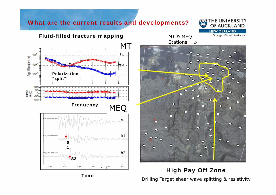
What are the current results and developments?
Fluid-filled fracture mapping
MTTE
MT & MEQ Stations
Polarization
TE
TM
“split”
003905231043000.sgd.1
MEQFrequency
V
003905231043000.sgd.2
S
V
h1
003905231043000.sgd.3
S2
S1
h2
1424 1425 1426 1427 1428 1429Time [s] High Pay Off Zone
Drilling Target shear wave splitting & resistivityTime
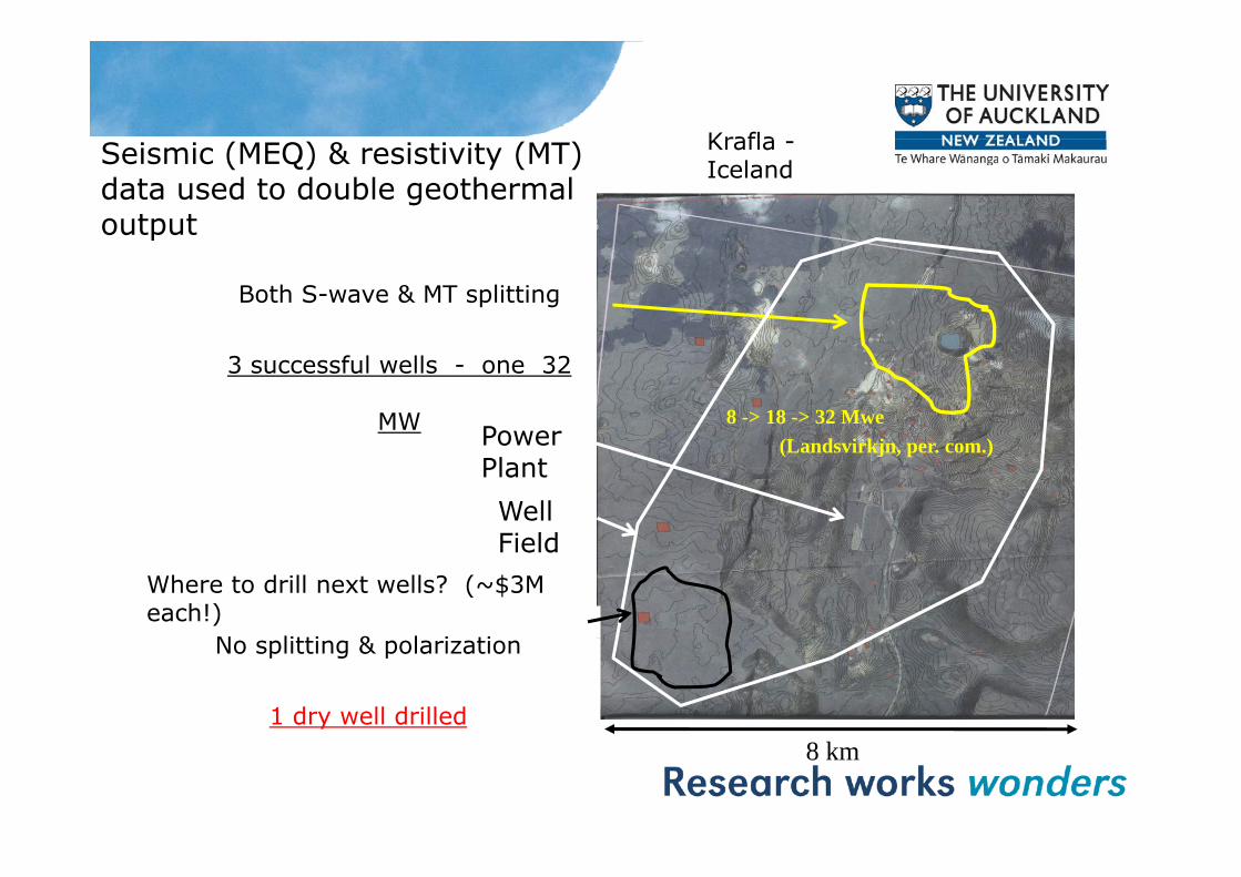
KraflaSeismic (MEQ) & resistivity (MT) data used to double geothermal output
Krafla -Iceland
Both S-wave & MT splitting
p
3 successful wells - one 32
MW 8 -> 18 -> 32 MwePower (Landsvirkjn, per. com.)Power PlantWell Field
N litti & l i ti
FieldWhere to drill next wells? (~$3M each!)
No splitting & polarization
1 dry well drilled8 km

Example: successful geothermal wells - Kenya
MT Polarization
Drilling direction
MT site & low resistance direction
MT Polarization
S-Wave splitting
Earthquake station & fast direction
Drill site
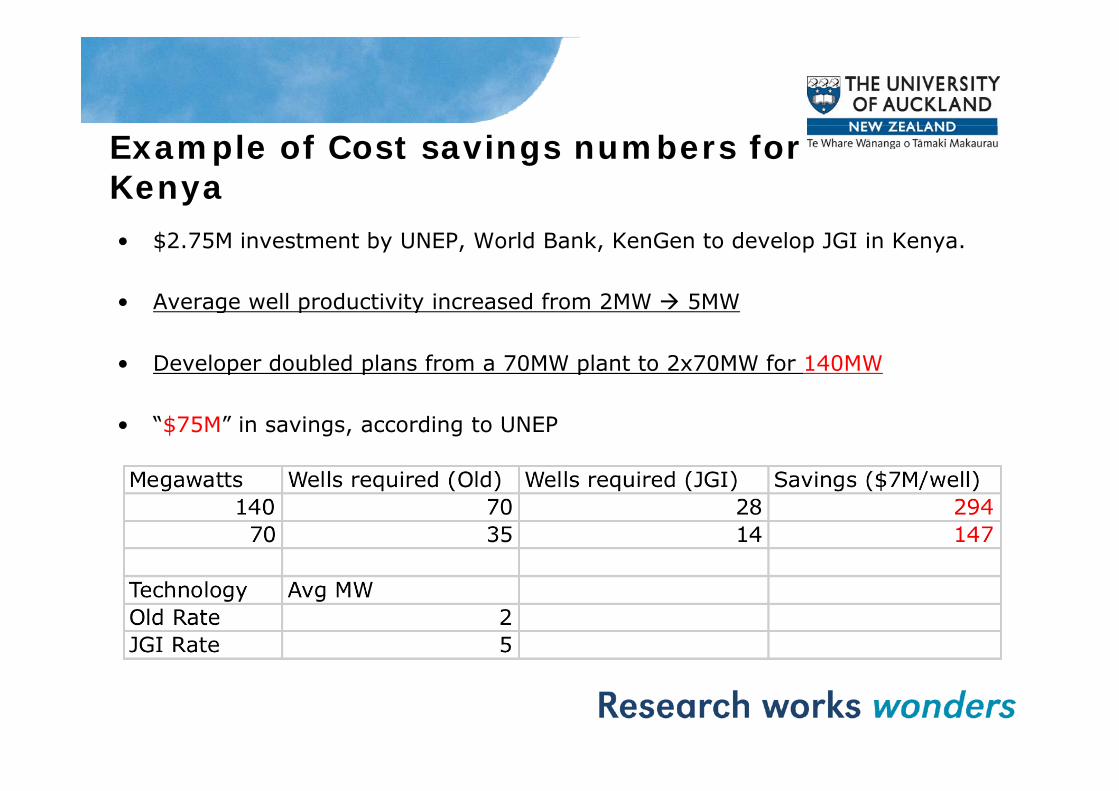
Example of Cost savings numbers for Kenya• $2.75M investment by UNEP, World Bank, KenGen to develop JGI in Kenya.
• Average well productivity increased from 2MW 5MW• Average well productivity increased from 2MW 5MW
• Developer doubled plans from a 70MW plant to 2x70MW for 140MW
• “$75M” in savings, according to UNEP

JGI Research – An emerging t h ltechnology• 1989 – Seismic methods pioneered in Coso by Prof. Malinp y• 1998 – Advanced seismic methods applied in Mammoth, CA• 2002 – $2.75M investment UNEP & partners for work in Olkaria• 2005 – JGI study in Krafla, Iceland - 18MW well locatedy ,• 2007 – JGI applied in Olkaria - Average productivity increased from
2MW 5MW• 2009 – JGI applied in Box Elder, Utah – Identified specific target zone
for client to drill productive wells• 2011 – Indonesia Sumatra

DOWN BOREHOLE SEISMICS REASON 1.
Noise Reduction!Results of test station installed at Riverhead, NZ, depth of 245m
Noise Reduction!
Same small event M~11 minute1 min
BoreholeSurface

REASON 2. Scattering Reduction!M ~ 0.5 MEQ Data from 3.3 km deep LVEW
1 second
Surface seismograph
1 second
1 secondBorehole seismograph
1 second

Borehole seismometergimbaledgimbaled
S20G 2Hz and 4 5 Hz 3C geophones• S20G , 2Hz and 4.5 Hz 3C geophones
•Gimbaled, 18 deg maximum tilt
•4 5 Hz sonde withstands up to 150 deg C4.5 Hz sonde withstands up to 150 deg C
•Outer diameter 8.9 cm
•Operational pressure 69 MPa (~7 Km)p p ( )
•Designed for permanent long term installations, original sensors deployed 21 years ago are still workingy g g
•Integrated cable – various lengths (armored , Tefzel, or Polyurethane)

Borehole seismometerfixedfixed
•Fixed 3D
•High output geophones (76 Vm/s)
•Shallow borehole installation•Shallow borehole installation
•S30F-4.5-130 integrated with accelerometer
•Various cable lengths

Borehole seismometer (new design)(new design)
•Borehole seismometer with integrated recording system, b dbattery powered
•Designed to be part of the drill stringdrill string
•Coupling of sensor achieved by releasing drill pipe weight by releasing drill pipe weight which applies pressure to casing side wall

Borehole seismometer (new design)(new design)

Fabrication and testing at IESECNC Lathe for specialized threads Large format Lathes for long tubesCNC Lathe for specialized threads Large format Lathes for long tubes
Hydrostatic testing of high pressure sealsFunctional testing of electronic components

Installation of borehole instruments
Installation of 6 sondes Work over rig needed for installation

Borehole Micro-Seismic Network, ,Wairakei
•10 stations telemetered via radios to 10 stations telemetered via radios to Central recording site – real-time
•9 stations at depths ~> 90 m
•1 station at 1.2 Km depth
•High gain 24 bit digital recording
O 1000 i i i t •Over 1000 microseismic events detected in 1 year
•Data used to manage geothermal field (injection and extraction of fluids)
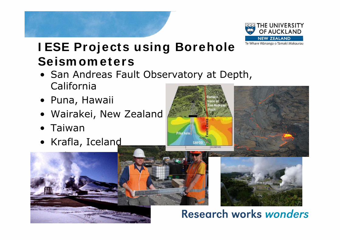
IESE Projects using Borehole SeismometersSeismometers• San Andreas Fault Observatory at Depth,
California• Puna, Hawaii• Wairakei, New Zealand• Taiwan• Krafla, Iceland• Indonesia• Alpine Fault, New Zealandp ,

Basel, SwitzerlandS i i A f M j Seismic Array for a Major European City

Basel SwitzerlandBasel, SwitzerlandDrill Rig in the middle of the Citymiddle of the City
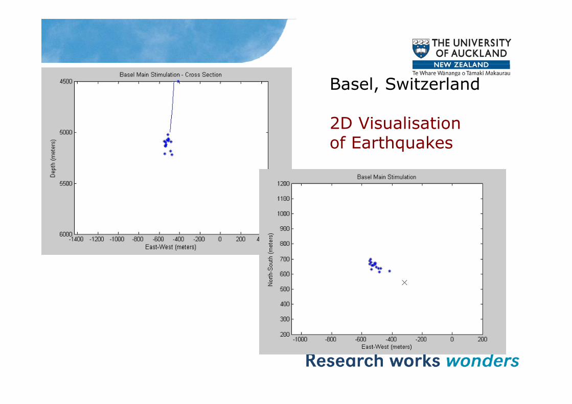
Basel, Switzerland
2D Visualisation of Earthquakes

IESE Custom Borehole Seismometers for Chinese Academy of Geological SciencesCCSD 5.2KM BOREHOLE EARTHQUAKE OBSERVATORY -DEEPEST IN WORLD
earthquake sensor

i l b h l iTypical borehole microearthquake station
Radio telemetry to central site
BoreholeRecording system
Paralana SW Australia EGS experiment

Recording system

Characteristic Data •Very good signal to noise•Several types of events observedHi h 95% i i•High >95% station uptime
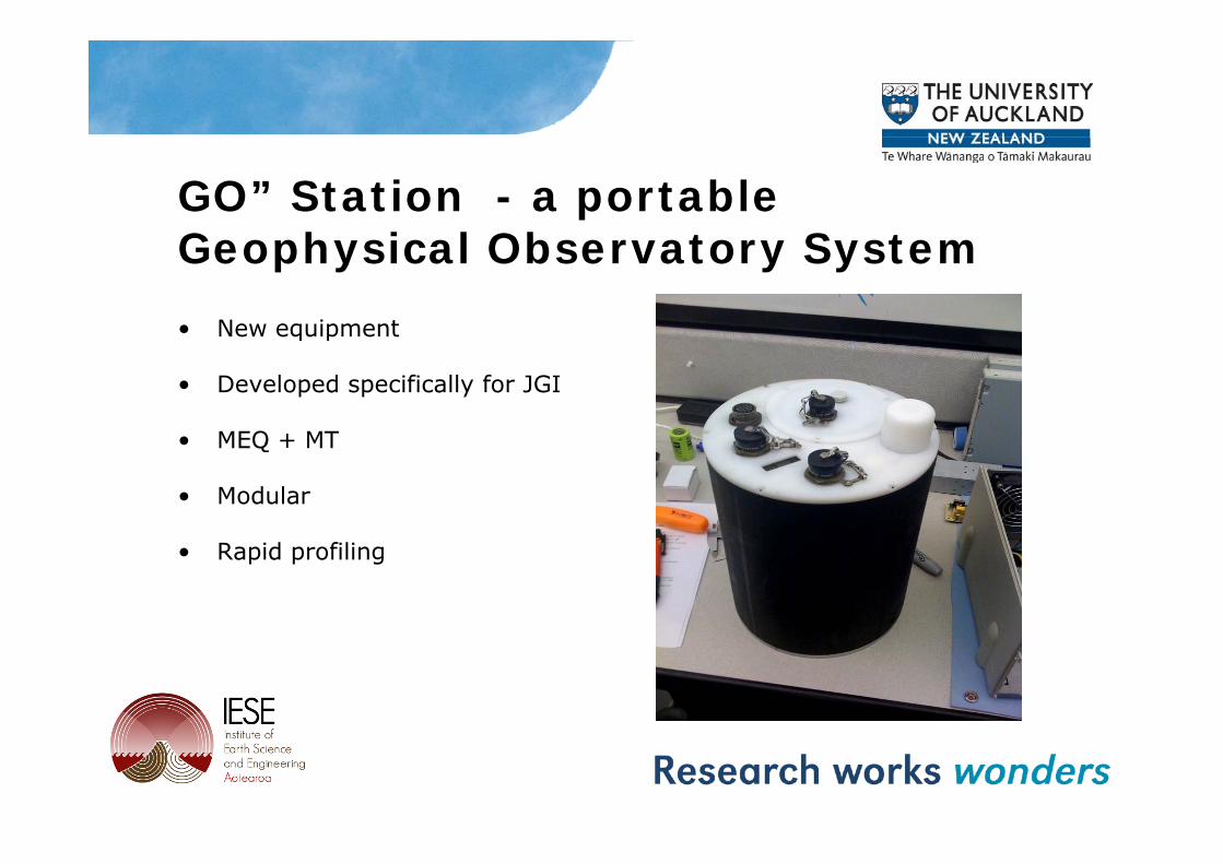
GO” Station - a portable G h i l Ob t S tGeophysical Observatory System• New equipmentNew equipment
• Developed specifically for JGI
MEQ MT• MEQ + MT
• Modular
• Rapid profiling

GOES systemCombined MT, TEM and micro seismic system

Preliminary Results indicate that GPR is a promising tool for:p g
• Locating and mapping sinter depositssinter deposits.
• Detecting alteration/ overprinting by acidic steam condensate.

METHODS
GPR (GSSI‐SIR 2000 and SIR 3000)200 and 270MHz Antennas
Control Unit
200 and 270MHz AntennasRange 50‐300ns
Control Unit
Antenna
Jol and Smith, 1992
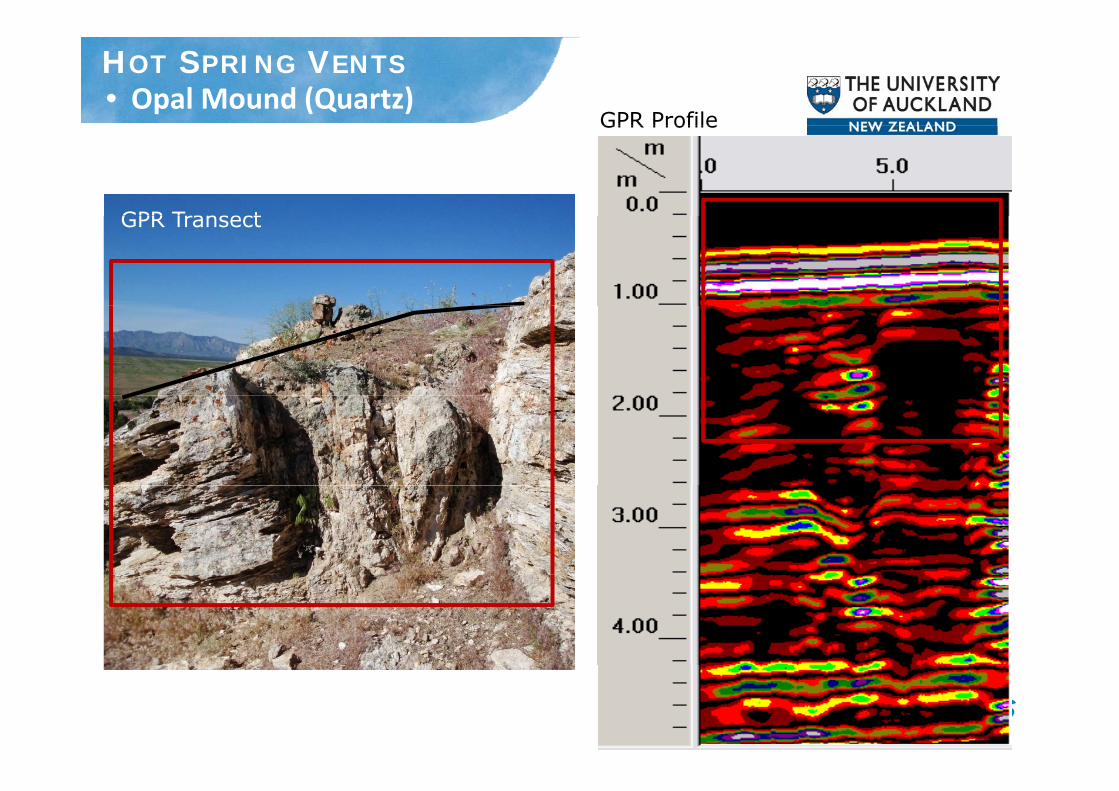
• Opal Mound (Quartz)GPR Profile
HOT SPRING VENTS
GPR Profile
GPR TransectGPR Transect

St b t S i L Si t T (O l A)FRACTURES• Steamboat Springs Lower Sinter Terrace (Opal‐A)
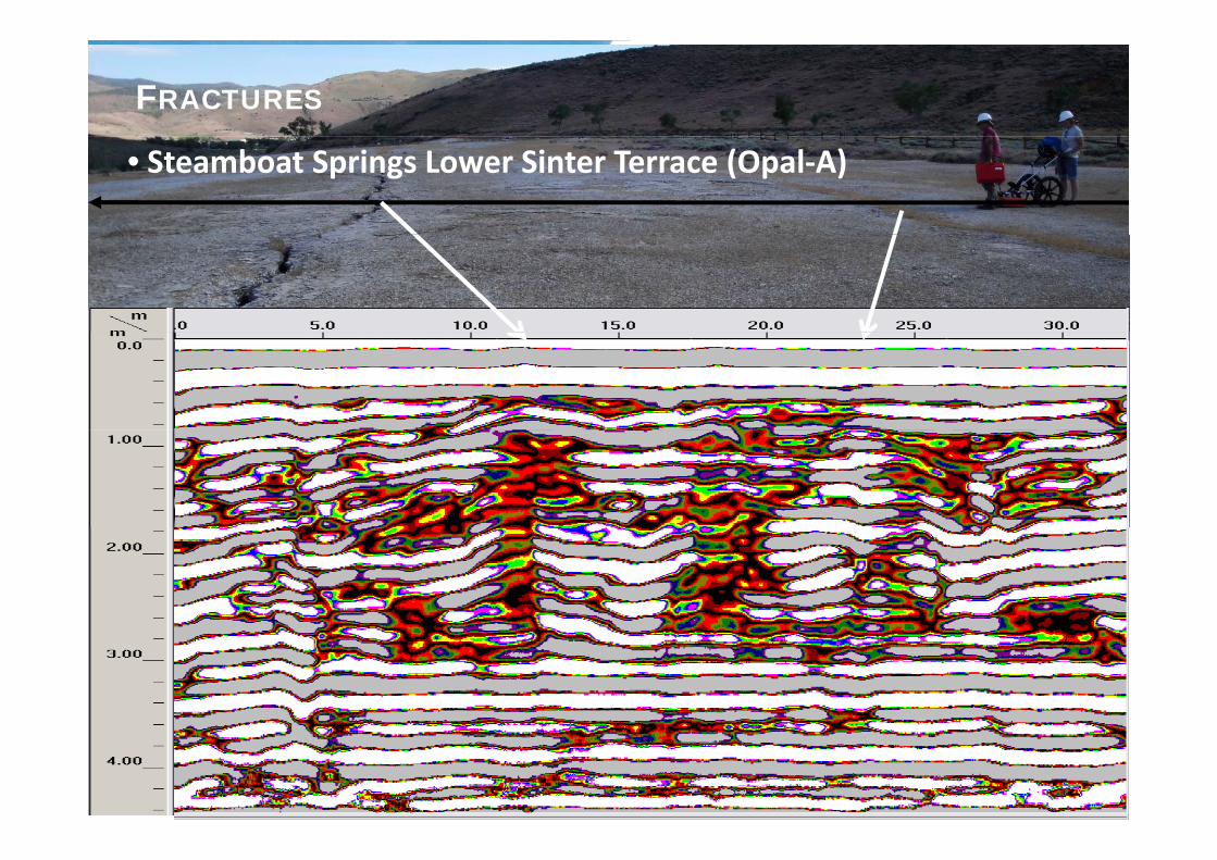
FRACTURES
• Steamboat Springs Lower Sinter Terrace (Opal‐A)
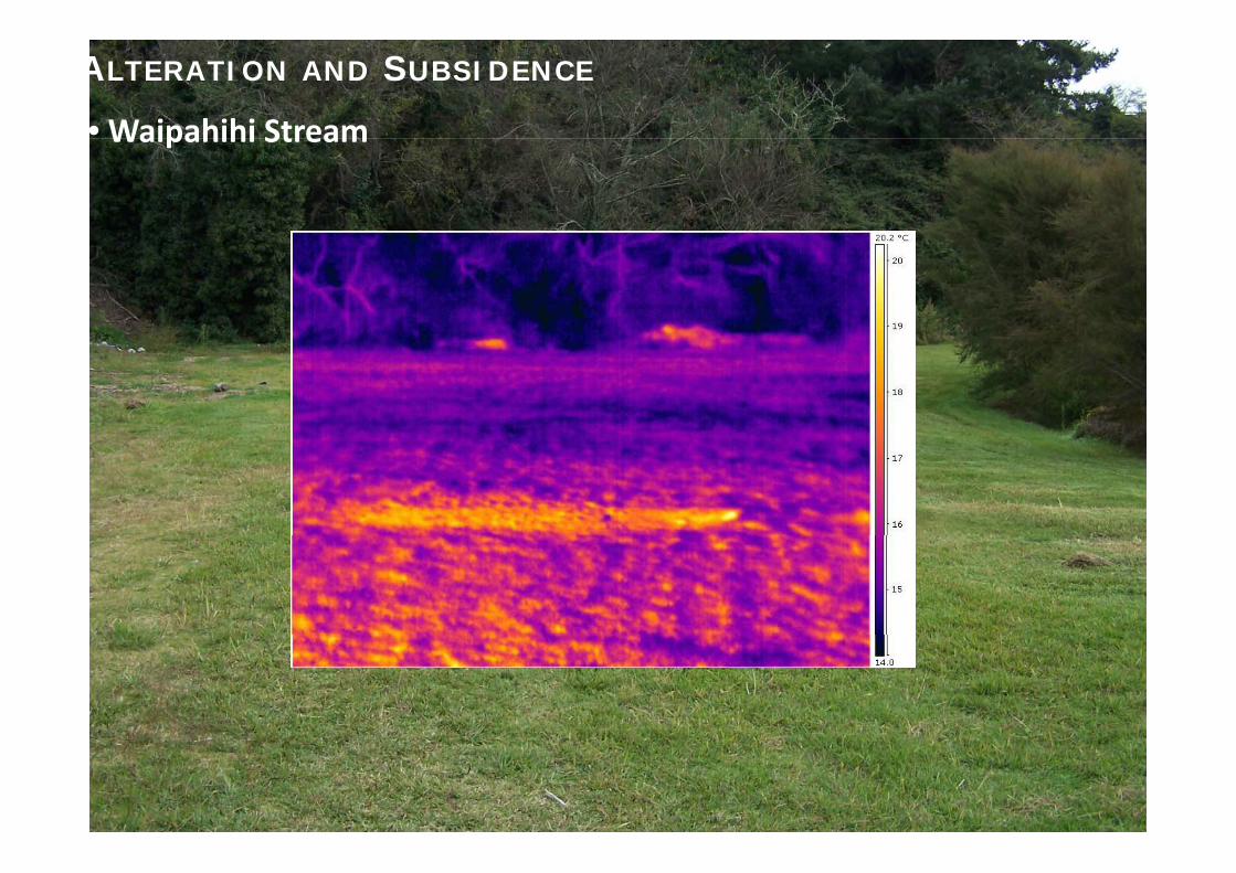
• Waipahihi Stream
ALTERATION AND SUBSIDENCE
Waipahihi Stream
Geothermal Geochemistry Research
• Current funded research is both fundamental and applied in nature.
• Scope of research includes production brine fluids, surficial fluids, and reservoir mineralogy.
• Lead researcher: Paul Hoskin, Ph.D. (Australian National University), Habilitation (Albert-Ludwigs-UniversitätFreiburg)

Example 1: New isotope systematics• Aim: determine the proportion of magmatic fluid
influx into the Taupo Volcanic Zone, delineate crustal reservoirs for Li and assess local reservoir scale reservoirs for Li, and assess local reservoir-scale hydrology
• Data: very large sample set (N = 70) with isotopic • Data: very large sample set (N = 70) with isotopic analyses for Li and B (collaborators: University of Maryland, USA; University of Calgary, Canada) and Cl isotopes (collaborator: University of Alberta, Canada)
• Current data collection campaign eclipses similar work recently done for the Yellowstone (USA), Central M if (F ) d F h W t I di th l Massif (France), and French West Indies geothermal systems
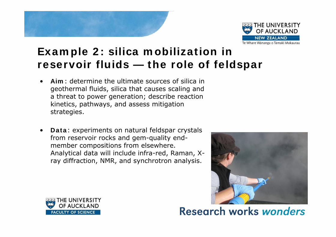
Example 2: silica mobilization in reservoir fluids — the role of feldsparreservoir fluids — the role of feldspar• Aim: determine the ultimate sources of silica in
geothermal fluids, silica that causes scaling and g , ga threat to power generation; describe reaction kinetics, pathways, and assess mitigation strategies.
• Data: experiments on natural feldspar crystals from reservoir rocks and gem-quality end-member compositions from elsewhere member compositions from elsewhere. Analytical data will include infra-red, Raman, X-ray diffraction, NMR, and synchrotron analysis.

Structural controls on geothermal fluid flowfluid flow• Current funded research is both fundamental and
li d i tapplied in nature.• Scope of research includes regional-scale controls on
upflow zones and local-scale controls on fluid flow within the reservoirthe reservoir.
• Lead researcher: Julie Rowland, Ph.D. (OtagoUniversity, NZ).
Example 1: Tracking upflow through time in a migrating arctime in a migrating arc• Aim: decipher the tectonic and magmatic controls on 15
million years of hydrothermal fluid flow in the central North million years of hydrothermal fluid flow in the central North Island, New Zealand
• Data: synthesis of various geological and geophysical data y g g g p ysets(collaborator: Victoria University, NZ).
• This work will identify vectors for prospectivity (epithermal and geothermal) and geothermal).

Example 2: Generation of high-flux pathways within the reservoirpathways within the reservoir
• Aim: determine the fundamental controls on the d l t f hi h fl th ithi th development of high-flux pathways within the geothermal reservoir.
• Data: 3 D geological and hydrological models for • Data: 3-D geological and hydrological models for selected geothermal systems within the Taupo Volcanic Zone.
• This work will improve targeting of wells for geothermal production.

Trenching campaign to determine fault slip rates, Taupo Volcanic Zone 2010Trenching campaign to determine fault slip rates, Taupo Volcanic Zone 2010
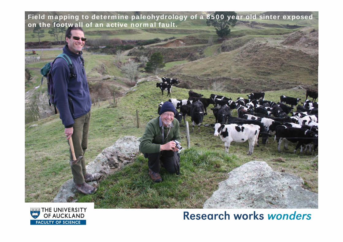
Field mapping to determine paleohydrology of a 8500 year old sinter exposed on the footwall of an active normal fault.

Conceptual model of controls on fluid flow in a generalised on fluid flow in a generalised geothermal reservoir, TaupoVolcanic Zone.

Geothermal reservoir modellingGeothermal reservoir modelling
Wairakei model

The R&D modelling team• Team leader: Professor Mike O’Sullivan• Two other academics: Associate Professor Rosalind
Archer Dr Sadiq ZarroukArcher, Dr Sadiq Zarrouk• Three post-doctoral research fellows• Three R&D engineers• Six graduate students
• Calibration of geothermal models
Main research topicsg
• Improved modelling methods• Fluid/rock interaction
L l ti• Large-scale convection
Calibration of geothermal modelsCalibration of geothermal models• The problem: How to assign permeabilities, porosities
and other parameters in a geothermal reservoir modelp g• The solution: Many hours of manual calibration by a
modelling expert or use automatic calibrationOne of our main research topics is automatic calibration One of our main research topics is automatic calibration of geothermal models

Automatic calibration of th l d lgeothermal models
• Inverse modelling using iTOUGH2 and PESTInverse modelling using iTOUGH2 and PEST• Statistical sampling approach using Markov chain Monte Carlo
methods (MCMC)• Expert system approach using a guided application of inverse • Expert system approach using a guided application of inverse
modelling. For example use an expert system: (i) to choose which model parameters are used for the inverse model and (ii) to decide how to systematically introduce new parameters

Improved modelling methodsImproved modelling methodsThe aim is to be able to run bigger and better models.
Current projects include:
• Introduction of a supercritical equation of state• Introduction of a supercritical equation of state• Investigation of parallel solvers• Euler-Lagrange differencing• Modelling of surface features• Modelling of surface features

Fluid/rock interactionSeveral of our current research topics involve fluid rock interaction. We are combining TOUGH2 for modelling heat and mass transfer with ABAQUS for the rock mechanics. We are also using FEHM for the coupled problem.
T i i l dTopics include:
• Subsidence in geothermal fields• Fracturing and permeability changes caused by • Fracturing and permeability changes caused by
injection of cold water• Tectonic activity and permeability structure
Large-scale convectionLarge scale convectionOur interest in this topic arises from our work on particular fields
such as Wairakei and also from trying to understand large i f h T l i sections of the Taupo volcanic zone.
• For example: why do the three upflow zones at Te Mihi, Tauhara and Rotokawa occur close together? What large-Tauhara and Rotokawa occur close together? What largescale structures determine their positions?
• Similarly, what determines the locations of Wairakei, Mokai, Ohaaki etc? Is it the deep permeability structure or the deep heat inflow?

The ‘Development’ part of ‘R&D’The Development part of R&DWe are currently working on computer models of severalgeothermal fields:geothermal fields:
• Wairakei and Ohaaki (Contact Energy)• Lihir (Newcrest Gold)• Lihir (Newcrest Gold)• Wayang Windu (with SKM for Star Energy, Indonesia)• Palinpinon and Mindanao (in collaboration with EDC, Philippines)

Related modelling researchRelated modelling research• Coal-bed methane extraction• Gas-hydrate reservoirsGas hydrate reservoirs• In-situ gasification• Carbon sequestration• Oil and gas reservoirs• Oil and gas reservoirs
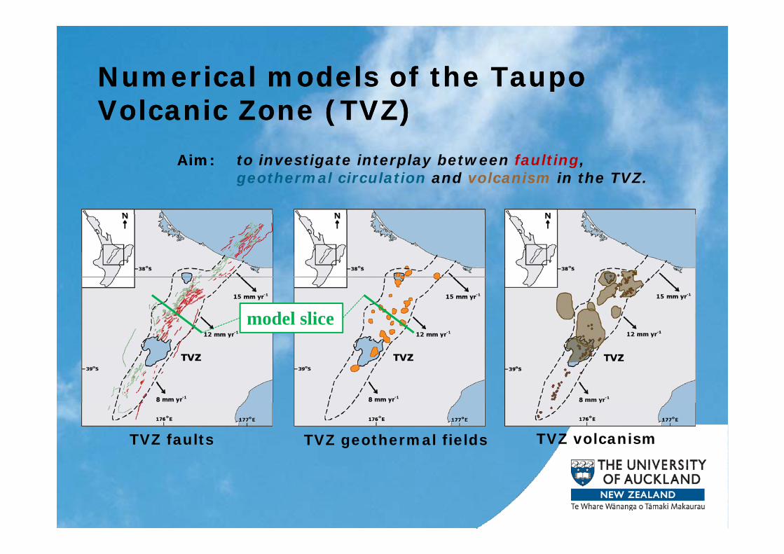
Numerical models of the Taupo Numerical models of the Taupo pVolcanic Zone (TVZ)
pVolcanic Zone (TVZ)
to investigate interplay between faulting, geothermal circulation and volcanism in the TVZ.
Aim:Aim:
model slice
TVZ faults TVZ geothermal fields TVZ volcanism

Tectonic model of faultingTectonic model of faulting
1 m slip
0.5 m upliftCoseismic
displacements
stress increaseCoseismic
Earthquake! stress dropCoseismic
stress changes
Fluid model of geothermal circulationFluid model of geothermal circulation
conceptual model numerical model
Geothermal plumeGeothermal plume Geothermal plumeGeothermal plume
depth

Gas Hydrates
• New Zealand (and other countries) may have huge • New Zealand (and other countries) may have huge resources of natural gas stored in hydrate deposits in shallow sediments.
• Hydrates are ice-like solids that release methane from their structure as they are depressurised.
• TOUGH+HYDRATE code (derived from the TOUGH2 geothermal code) being used to model resource development in NZ in collaboration with Lawrence
k l bBerkeley Laboratories.

Integrating Indigenous Values into Geothermal Developmentinto Geothermal Development
Dan Hikuroa1
Te Kipa Kepa Brian Morgan2, Manuka Henare3, Darren Gravley 4
1 – Institute of Earth Science & Engineering, Uni..of Auckland (UoA)2 – Senior Lecturer, Dept. of Civil & Environmental Engineering (UoA)3 – Director, Mira Szaszy Research Centre, (UoA)4 – Geological Sciences, University of Canterbury

P t k d R i iPapatuanuku and Ranginui
http://ww
w.teeara.govt.nz/file
Nga Roimata O Ranginui
es/p14121enz.jppg
Nga Puna Tapu O Nga Atua

OutlineOutline
Geothermal Energy
• Renewable• Sustainable• Desirable to Maori
Kaitiakitanga (Guardianship) Approach to Geothermal Development
Photo: GNS Science
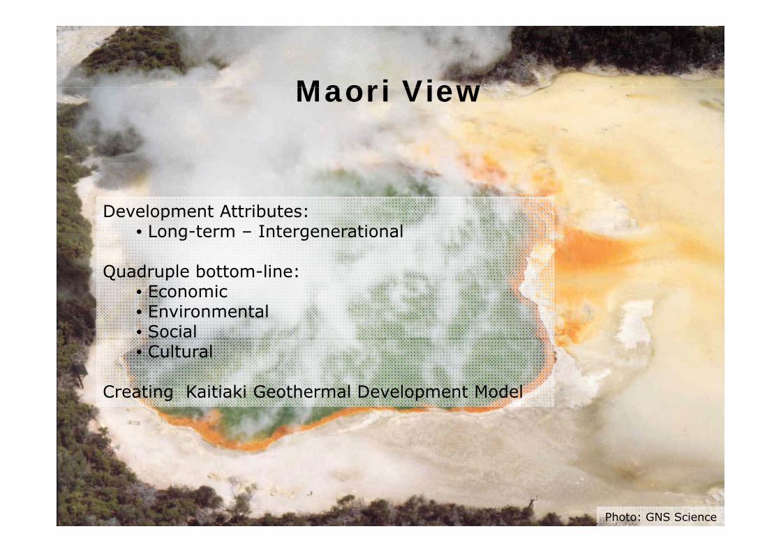
Maori ViewMaori View
Development Attributes:Development Attributes:• Long-term – Intergenerational
Quadruple bottom-line:Quadruple bottom line:• Economic• Environmental• Social• Cultural
Creating Kaitiaki Geothermal Development Model
Photo: GNS Science
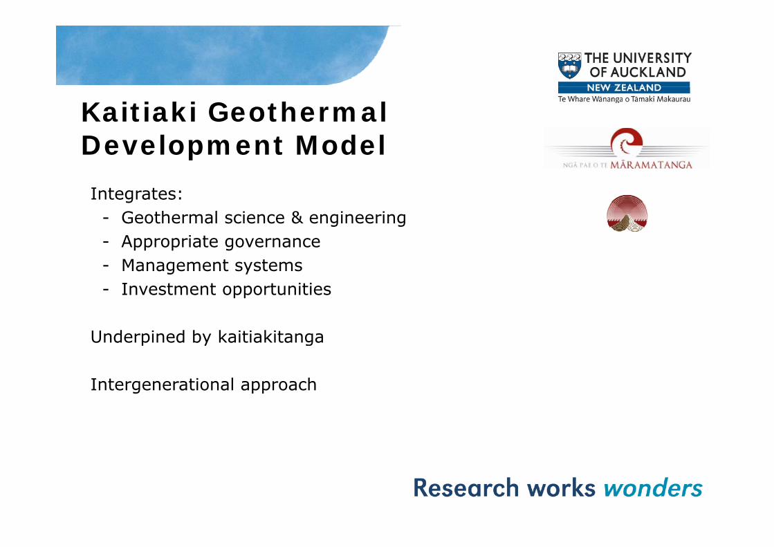
Kaitiaki Geothermal Development ModelDevelopment ModelIntegrates:
G h l i & i i- Geothermal science & engineering- Appropriate governance- Management systemsg y- Investment opportunities
Underpined by kaitiakitangaUnderpined by kaitiakitanga
Intergenerational approach

Kaitiaki Development ApproachApproachStrategy incorporates quadruple bottom-line of well-beings:beings:
Environmental, Social, Economic & CulturalCultural
These are also the four well-beings in the RMAg
Geothermal Overview, Education and Seismic ResearchEducation and Seismic Research
Th U i it f A kl dThe University of Auckland
Thank you