geotechrep firgrove substation site 060711 - · pdf fileproposed new substation firgrove...
TRANSCRIPT
PROPOSED NEW SUBSTATION
FIRGROVE SUBSTATION IN THE
WESTERN CAPE
GEOTECHNICAL REPORT
REPORT ON THE GEOTECHNICAL DESK TOP STUDY
FOR THE PROPOSED NEW SUBSTATION NEAR THE
EXISTING FIRGROVE SUBSTATION
GEOTECHNICAL INVESTIGATIONS
TRANSMISSION TECHNOLOGY
June 2011June 2011June 2011June 2011 Report no GR5Report no GR5Report no GR5Report no GR5----11111111

CONTENTS
1.0 INTRODUCTION
2.0 THE NATURE OF THE PROJECT
3.0 OBJECTIVES OF INVESTIGATION
4.0 DESK STUDY
4.1 Maps Consulted
4.2 Aerial Photographic Interpretation
4.3 Review of Desk Study and Selection of Sites
4.4 Seismic Zoning
5.0 THE SITE
6.0 REGIONAL ENVIRONMENT
6.1 Geography
6.2 Geology
6.3 Water Table
7.0 GEOTECHNICAL EVALUATION
7.1 Geometric Design
7.2 Geological Influences on Construction
7.3 Water Table
7.4 Topography –Substation Platform Construction
` 8.0 CONCLUSIONS AND RECOMMENDATIONS
TITLE : GEOTECHNICAL REPORT
REPORT ON GEOTECHNICAL DESK TOP STUDY
FOR THE PROPOSED EXTENSION OF THE EXISTING FIRGROVE SUBSTATION
PREPARED BY : Specialist Consultant Geotechnical Engineering Transmission Technology
CLIENT : Land and Rights Transmission PROJECT TEAM:: F A Grové REPORT NO : GR05-11 DATE : June 2011
Approved : F A Grové Senior Specialist Consultant Geotechnical Investigations

1.0 INTRODUCTION
Eskom plans to construct a new 400/132 kV Substation near the existing Firgrove Substation
in the Western Cape.
It was requested by Transmission Lands and Rights to carry out a Geotechnical desk top study
for the proposed site.
PROPOSED SITE - EXTENSION OF THE EXISTING FIRGROVE SUBSTATION Figure-I
A site for the proposed development was identified during the EIA phase of the Cape
Peninsula Strengthening Project, which is located to the west of the existing Firgrove
Substation (Figure-I). For the selection of the site, factors such as the availability of land,
ESKOM installations and power line servitude routes were considered.
Information collected during this desk top study is considered suitable for site assessment
purposes, and once the final design is required, a Detailed Geotechnical Investigation will
be required to provide design parameters and confirm findings of this investigation..
2.0 THE NATURE OF THE PROJECT
The project comprises the construction of a new Substation in the Firgrove area, in the
Western Cape.
The development would include the installation of typical equipment such as:
• Electrical transformers
• Circuit breakers or line termination structures
• �High-voltage switchgear
• Low voltage switchgear
• Surge & lightning protection equipment
• �Control and metering equipment
• Access roads and buildings
3.0 OBJECTIVES OF THE INVESTIGATION
The objectives of this investigation were defined as:
Proposed Site

- Obtain Geotechnical information during a Desk Top Study, suitable to confirm the
suitability of the site for the development.
4.0 DESK STUDY
41 Maps Consulted
An attempt was made to collect as much information as possible of the area, for the
assessment of the Geotechnical suitability of the proposed site.
For this purpose the following maps were consulted:
i)`Topographical Maps – 3418 BA
ii) Geological Map – Geological Map 3318 Cape Town (1:250 000)
4.2 Aerial Photographic Interpretation
In principle the following features are being studied, information being obtained and
interpreted when studying aerial photographs for geotechnical purposes:
- Reflection of the action of nature in creating the existing conditions
- Grouping of materials according to certain patterns
- Definition of various boundaries and linear features of
significance
- Field checking by visual inspection
Stereo-interpretation has a great advantage over interpretation of a single photograph,
because it is better able to identify topographical and erosion features, grey tones, and
textures have greater requisite clarity contrasts. Basically, two aspects of the air photo
image are revealed in the stereo-model of a given area, and these are surface form and
grey tone, which could be subdivided as:
a) Elements of Surface Form
- Topographic form
- Drainage form
- Erosion form
b) Elements of Grey tone and Texture of :
- vegetation
- due to land use
- soil and rock material
Geotechnical information obtained in this way was correlated with Geological Map
data.
4.3 Review of the Site
The size of the substation platform was not confirmed at the time of this report. It is
however confirmed through this study that the site is limited in size with its
trapezoidal shape and side dimensions of the order of:
• North western side 430m
• North eastern side 497m
• South eastern side 240m
• South western side 416m
For the purpose of flexibility the site area is limited and careful design would
require fitting the conventional open plan substation on this site.
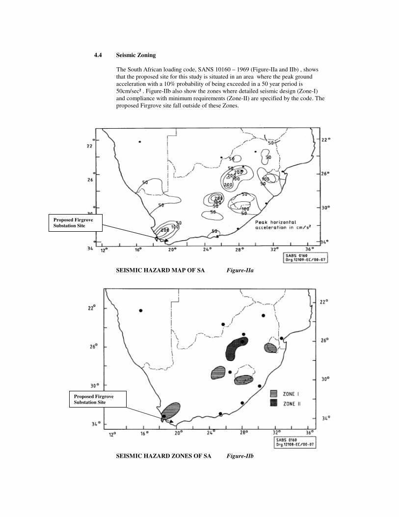
4.4 Seismic Zoning
The South African loading code, SANS 10160 – 1969 (Figure-IIa and IIb) , shows
that the proposed site for this study is situated in an area where the peak ground
acceleration with a 10% probability of being exceeded in a 50 year period is
50cm/sec² . Figure-IIb also show the zones where detailed seismic design (Zone-I)
and compliance with minimum requirements (Zone-II) are specified by the code. The
proposed Firgrove site fall outside of these Zones.
SEISMIC HAZARD MAP OF SA Figure-IIa
SEISMIC HAZARD ZONES OF SA Figure-IIb
Proposed Firgrove
Substation Site
Proposed Firgrove
Substation Site
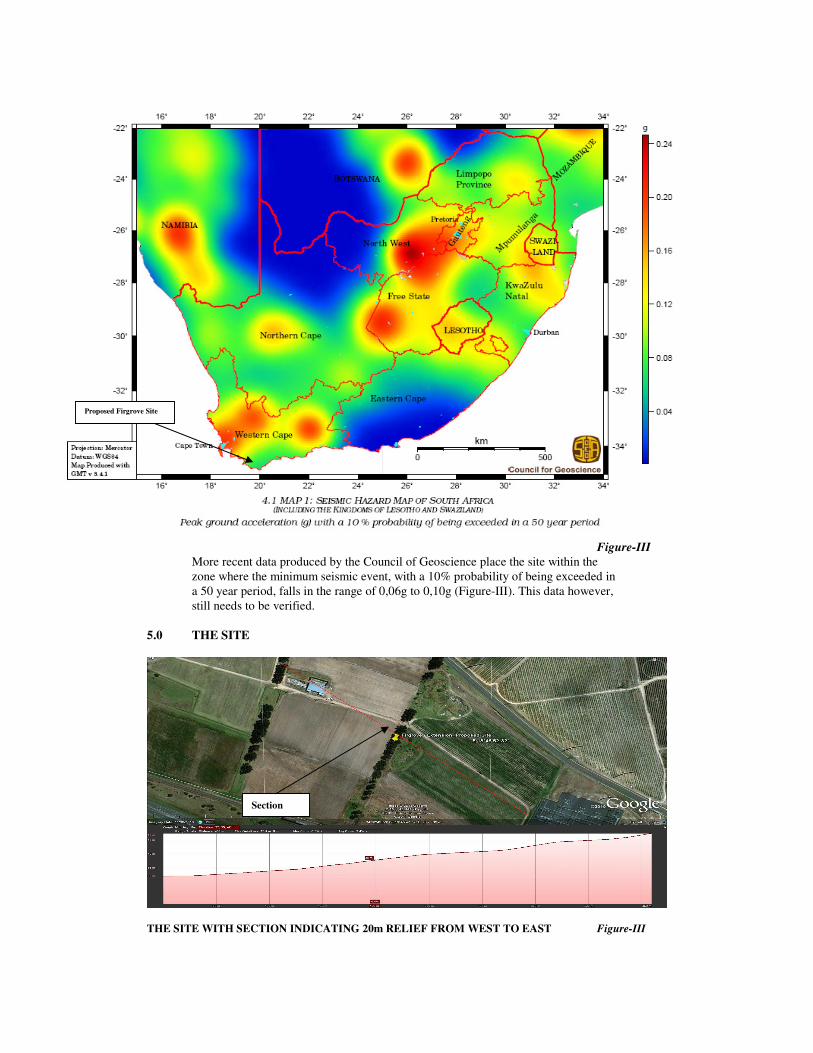
Figure-III
More recent data produced by the Council of Geoscience place the site within the
zone where the minimum seismic event, with a 10% probability of being exceeded in
a 50 year period, falls in the range of 0,06g to 0,10g (Figure-III). This data however,
still needs to be verified.
5.0 THE SITE
THE SITE WITH SECTION INDICATING 20m RELIEF FROM WEST TO EAST Figure-III
Proposed Firgrove Site
Section

It should be noted that options for suitable sites are limited in the Study Area due to extreme
development of the urban area.
6.0 REGIONAL ENVIRONMENT
6.1 Geography
6.1.1 Topography and Drainage
General flat to occasionally waving topography with the presence of hillocks, hills
and water ways forms features of the region. The elevation of the site and its
located on a relatively high is well drained and has no risk of flooding.
6.1.2 Flood –line
The elevation of the site with a limited storm water catchment area has no risk of
flooding within a 1:50 year flood.
6.1.3 Climate
N-Value
The "Weinert N-Value", that describes the climatic environment, is approximately 2
for the area. Where "N" is more than "5", disintegration is the prominent form of
weathering, and where "N" is less than "5", decomposition affects those rocks
whose minerals are liable to change chemically under atmospheric conditions.i
The Cape Peninsula has a Subtropical Mediterranean climate (Koppen Csa), with
mild, wet winters, and dry and very warm summers. In winter time, which lasts from
the beginning of June to end of August, large cold fronts come across from the
Atlantic Ocean with heavy precipitation and strong north-westerly winds. The winter
months are cool, with an average minimum of 7.0 °C (45 °F) and maximum of 17.5
°C (63 °F).
Rainfall
Most of the city's annual rainfall occurs in wintertime, but due to the mountainous
topography of the city, rainfall amounts for specific areas can vary dramatically.
Newlands, to the south of the city, is the wettest suburb in South Africa. The valleys
and coastal plains average 515 millimeters (20.3 in) of rain per annum, while iimountain areas can average as much as 1,500 millimeters (59 in) per annum.
Temperatures
Summer, which lasts from November to March, is warm and dry. The Peninsula gets
frequent strong winds from the south-east, known locally as the Cape Doctor, because
it blows away pollution and cleans the air. The south-easterly wind is caused by a
high-pressure system which sits in the South Atlantic to the west of Cape Town,
known as the South-Atlantic High. Summer temperatures are mild, with an average
maximum of 26.5 °C (80 °F)iii. Cape Town can be uncomfortably hot when the Berg
Wind, meaning "mountain wind" blows from the Karoo interior for a couple of weeks
in February or early March.
. Vegetation
The site is partly cultivated and covered with typical indigenous grass and bush.
6.2 Geology
The area is underlain by loam and sandy loam, with greywacke, phyllite and quartz
sandstone, interbedded lava and tuff of the Beaufort Group.
6.3 Water Table
A perched water table is likely to be present during the rainy season.
7.0 GEOTECHNICAL EVALUATION
7.1 Geometric Design
Careful design will be required for the construction of a substation on this site. The
conventional open yard substation will probably not fit on this site.
7.2 Geology Influences on Construction
The sandy loam, probably masking the greywacke with limited thickness, might have
a collapse potential due to not being consolidated, which will require special
measures for founding of structures. The greywacke is probably underlying the
Transported soils shallowly, forming a low permeability membrane. The loam mixed
with weathered greywacke is likely suitable for substation platform construction.
This material could be suitable for construction, pending the Plasticity Index and
Grading Modulus. iv
The greywacke will increase in consistency with depth, changing to a soft to medium
hard rock with depth.
7.3 Water Table
The presence of a perched water table is not expected to have a severe influence
during construction.
7.4 Topography - Geometry (Earthworks)
The construction of a substation platform will result in relatively deep cut and high
fill, with a relief of 20m (Figure-II).
8.0 CONCLUSIONS AND RECOMMENDATIONS
Considering the results of the desk studies carried out it is clear that the site is suitable for
the construction of a substation platform and founding of substation structures conventionally.
However, the site is limited in size for the construction of an conventional open substation,
iJennings Brink & Williams (1973). Revised Guide to Soil Profiling for Civil
Engineering purposes in South Africa. The civil Engineer in S.A. Jan. 1973.
ii The Natural Road Construction Materials of Southern Africa – HH Weinert
iii http://www.1stweather.com/regional/climate/index_climate.shtml
iv Engineering Geology of South Africa Volume 2 A.B.A. Brink