geoss 10-year implementation plan reference document plan reference docu… · global earth...
TRANSCRIPT
Global Earth ObservationSystem of Systems
GEOSS
Global Earth ObservationSystem of Systems
GEOSS
10-Year Implementation Plan Reference Document
Group on Earth Observations
GEO 1000RFebruary 2005
GE
O 1000R
, Feb
ruary 2005
10-Year Implementation Plan Reference Document
Group on Earth Observations
Global Earth ObservationSystem of Systems
GEOSS
10-Year Implementation PlanReference Document
Group on Earth Observations
1
GEOSS 10-Year Implementation Plan: Reference Document
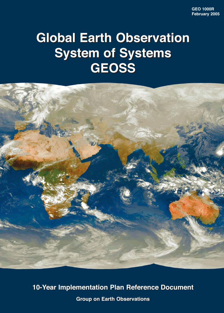
Cover: World cloud map for 15:00 hours UCT on 1 February 2005. The mosaic is acomposite of Meteosat-5, Meteosat-7, GEOS-9, GOES-10 and GOES-12 imagery(Copyright EUMETSAT 2005)
2
GEO 1000R / ESA SP-1284, February 2005
Published by: ESA Publications Division
ESTEC, PO Box 299
2200 AG Noordwijk
The Netherlands
Editor: Bruce Battrick
Design and Layout: Jules Perel
Copyright: This document is in the public domain and may be
reproduced without permission
ISSN No.: 0379-6566
ISBN No.: 92-9092-986-3
Printed in the Netherlands
Acknowledgement
The Group on Earth Observations would like to thank the members of the ad hocGEO Implementation Plan Task Team, the ad hoc GEO subgroups, and the manyscientists and technical experts who contributed to the development of thisdocument.
Implementation Plan IPTT Support IPTT Topic
Task Team (IPTT) Team Coordinators
Ivan DeLoatch Eliot Christian Mary Altalo
Toshio Koike Peter Colohan Congbin Fu
Robert Scholes Guy Duchossois Rosalind Helz
David Williams Roy Gibson Rick Lawford
Chu Ishida Nancy Maynard
Misako Kachi Stefan Rösner
Linda Moodie Martin Sharman
Imraan Saloojee Jeff Tschirley
Wenjian Zhang
FOREWORD
The Global Earth Observation System of Systems (GEOSS) 10-Year ImplementationPlan, endorsed by nearly 60 governments and the European Commission on 16 February 2005, is designed to qualitatively improve our understanding of the Earthsystem, markedly enhancing global policy- and decision-making abilities to promotethe environment, human health, safety, and welfare.
It is important to recall that, during the period in which our countries andorganizations collaborated so intensively to prepare this Plan, an important firstsuccess had already been achieved. Like few other partnerships before, the GEOsucceeded in bringing together a diverse and rich tapestry of peoples and views,united in a concerted effort with a common vision, to rapidly advance the globalagenda for sustainable development and sound environmental management. Ours isnow the responsibility to ensure the deliverables and targets we had committed to inthe GEOSS 10-Year Implementation Plan are met. Our full and enthusiastic supportwill be imperative to sustain the implementation and monitoring processes.
On matters pertaining to sustainable development, the voices of our citizens in recentyears have been loud and clear. They expect clear and unambiguous responses fromtheir leaders to the pressing challenges facing planet Earth. The successfulimplementation of GEOSS will be a practical and meaningful response to this call.Indeed, we are presented with a unique opportunity to implement a practical andvisible global development initiative, which supports poverty eradication and humanadvancement within the context of the protection of the ecology of our planet.
Dr. Achilleas Mitsos, European CommissionMr Tetsuhisa Shirakawa, JapanDr. Rob Adam, South AfricaVADM Conrad C. Lautenbacher (USN-Ret.), United StatesThe GEO Co-Chairs
3
GEOSS 10-Year Implementation Plan: Reference Document
CONTENTS
1 Origin and Purpose of this Plan 7
2 Scope of the GEOSS Implementation Plan 11
3 The Case for a Global Earth Observation System of Systems 173.1 Arrangements to Make Systems Interoperable and to Share Data3.2 Collective Optimization of the Observation Strategy3.3 Cooperative Gap Filling3.4 Observational Adequacy and Continuity3.5 Data Transfer and Dissemination3.6 Collaboration on Capacity Building3.7 Harmonization of Methods and Application of Observation
Standards
4 Societal Benefits, Requirements, and Earth Observation Systems 274.1 Reducing Loss of Life and Property from Natural and Human
Induced Disasters4.2 Understanding Environmental Factors Affecting Human Health and
Well-Being4.3 Improving Management of Energy Resources4.4 Understanding, Assessing, Predicting, Mitigating and Adapting to
Climate Variability and Change4.5 Improving Water Resource Management through Better Understanding
of the Water Cycle4.6 Improving Weather Information, Forecasting and Warning4.7 Improving the Management and Protection of Terrestrial, Coastal
and Marine Ecosystems4.8 Supporting Sustainable Agriculture and Combating Desertification4.9 Understanding, Monitoring and Conserving Biodiversity4.10 Common Observations and Data Utilization
5 Architecture of a System of Systems 1255.1 Functional Components5.2 Observations5.3 Data Processing5.4 Data Transfer and Dissemination5.5 Interoperability Arrangements5.6 Collaboration Mechanisms5.7 Initially Identified GEOSS Systems5.8 Targets to Enable the Architecture for GEOSS
6 Data in the Service of Users 1376.1 Key Principles6.2 Data Management6.3 User Involvement and User Support6.4 Research Facilitation6.5 Radio Frequency Protection6.6 Targets
4
7 Capacity Building 1457.1 Introduction7.2 What is Capacity Building?7.3 Goals7.4 Strategy and Principles7.5 Targets
8 Outreach 1518.1 Introduction8.2 Objectives of GEOSS Outreach8.3 Outreach Audiences8.4 Time Frame
9 Performance Indicators 1579.1 Input Indicators9.2 Output Indicators9.3 Outcome Indicators9.4 Impacts
10 Phased Implementation and GEOSS Evolution 16110.1 Phased Implementation10.2 GEOSS Evolution
11 Glossary and Acronyms 16711.1 Glossary of Terms11.2 Acronyms
Annex 1 Table of Initially Identified Systems 173Annex 2 Declaration 177Annex 3 Communiqué of the Second Earth Observation Summit 181Annex 4 Framework Document 185Annex 5 Resolution of the Third Earth Observation Summit 193
10-Year Implementation Plan 197
5
GEOSS 10-Year Implementation Plan: Reference Document
6
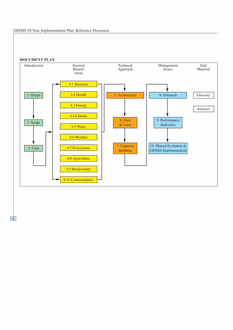
DOCUMENT PLAN
7
ORIGIN AND PURPOSE
1
GEOSS 10-Year Implementation Plan: Reference Document
8
Origin and Purpose
The World Summit on Sustainable Development, Johannesburg 2002 (WSSD),highlighted the urgent need for coordinated observations relating to the state of theEarth. This Plan is a step toward addressing the challenges articulated by the WSSDand fulfilling the Millennium Development Goals. It will also further theimplementation of international environmental treaty obligations.1
A meeting of the Heads of State of the Group of 8 Industrialized Countries Summitin June 2003 in Evian, France, affirmed the importance of Earth Observation as apriority activity. The first Earth Observation Summit convened in Washington, DC inJuly 2003, was attended by high-level officials from 33 countries and the EuropeanCommission and 21 international organizations involved in Earth observations.2
Governments adopted a Declaration signifying a political commitment to movetowards development of a comprehensive, coordinated, and sustained Earthobservation system of systems. The Summit established the ad hocintergovernmental Group on Earth Observations (ad hoc GEO), co-chaired by theEuropean Commission, Japan, South Africa, and the United States, and tasked it withthe development of an initial 10-Year Implementation Plan by February 2005. The adhoc GEO established five technical subgroups and a small secretariat. A series ofsubgroup meetings and a plenary meeting led to a Framework Document,3 negotiatedat GEO-3 in Cape Town and adopted at the second Earth Observation Summit inTokyo in April 2004 by 43 countries and the European Commission, joined by 25international organizations. The Framework defines the scope and intent of a GlobalEarth Observation System of Systems (GEOSS). A small task team was charged bythe ad hoc GEO with the drafting of an Implementation Plan, building on inputs fromthe subgroups and other sources.
The GEOSS 10-Year Implementation Plan establishes the intent, operating principles,and institutions relating to GEOSS. It is supported by a longer Reference Document(this document), which is consistent with the Plan, and provides substantive detailnecessary for implementation. The Plan was negotiated by the ad hoc GEO in Ottawain November 2004, and adopted at the third Earth Observation Summit in Brussels,in February 2005. The Reference Document was extensively reviewed by technicalexperts, countries and international organizations.
The third Earth Observation Summit established the intergovernmental Group onEarth Observations (GEO). Membership in GEO is open to all member States of theUnited Nations and to the European Commission. GEO welcomes as ParticipatingOrganizations intergovernmental, international, and regional organizations with amandate in Earth Observation or related activities, subject to approval by Members.GEO may invite other relevant entities to participate in its activities as observers.
9
1Origin and Purposeof this Plan
1 The Johannesburg Declaration on Sustainable Development and Plan of Implementation, World Summiton Sustainable Development, September 2002. See http://www.johannesburgsummit.org/. See alsoMillennium Declaration, September 2000, and Road Map towards the Implementation of the UnitedNations Millennium Declaration, September 2001. See http:/www.developmentgoals.org 2 Declaration of the First Earth Observation Summit, July 2003. See Annex 2. See also:http://www.earthobservationsummit.gov/declaration.html or http://earthobservations.org/declaration.asp3 Framework Document, April 2004. See Annex 4. See also:http://www.mext.go.jp/english/kaihatu/earth/resume/framworkdocument_e.htm

GEOSS 10-Year Implementation Plan: Reference Document
10
11
SCOPE
2

GEOSS 10-Year Implementation Plan: Reference Document
12
Scope
The Washington Summit Declaration establishes the objective “to monitorcontinuously the state of the Earth, to increase understanding of dynamic Earthprocesses, to enhance prediction of the Earth system, and to further implement ourinternational environmental treaty obligations”, and thus the need for “timely,quality, long-term, global information as a basis for sound decision making”. TheFramework Document adds that to move from principles to action, a “10-YearImplementation Plan for establishing the Global Earth Observation System ofSystems (GEOSS)”, which should be “comprehensive”, “coordinated”, and“sustained” is needed.
The vision for GEOSS is to realize a future wherein decisions and actions for thebenefit of humankind are informed by coordinated, comprehensive, and sustainedEarth observations and information.
The GEOSS 10-Year Implementation Plan defines a sequence of actions andresponsibilities, commencing from the third Earth Observation Summit in February2005. GEOSS has an indefinite lifetime, subject to periodic review of its continuedeffectiveness.
A global…
GEOSS aspires to involve all countries of the World, and to cover in situobservations as well as airborne and space-based observations. The focus of GEOSSis on observations relevant to large parts of the World and issues that requirecomprehensive information to be addressed optimally.
In the GEOSS context, the word ‘global’ thus has two meanings. In the first sense,GEOSS aspires to be as inclusive as possible, embracing all countries and parts of theWorld and all organizations with Earth Observation mandates. In the second sense,the priority focus of GEOSS is Earth system processes that operate at scales greaterthan the individual country, for instance the global climate system or regionallyshared river basins. Phenomena for which the causes and consequences are mostlyexpressed at lesser scales are the primary responsibility of local and nationalobserving systems, but may be included in GEOSS if any of the following threeconditions are met:
• They have global consequences in aggregate (e.g. desertification).
• They have significant global-scale causes (e.g. biodiversity loss).
• Their observation is enhanced by global systems (e.g. natural hazards).
…system of systems…
GEOSS will be a “system of systems” with components consisting of existing andfuture Earth observation systems across the processing cycle from primaryobservation to information production. The Earth observing systems that participatein GEOSS retain their existing mandates and governance arrangements,supplemented by their involvement in GEOSS. Through GEOSS, they will shareobservations and products with the system as a whole and take such steps as arenecessary to ensure that the shared observations and products are accessible,comparable, and understandable, by supporting common standards and adaptation touser needs.
GEOSS thus makes it possible to combine information from currently unconnectedsources, in order to obtain a view that is sufficiently comprehensive to meet userneeds.
13
2Scope of the GEOSSImplementation Plan
GEOSS 10-Year Implementation Plan: Reference Document
The change in comparison with the current situation will be:
a) GEOSS will, in cooperation with participating systems and with the various usercommunities, attempt to identify gaps and unnecessary duplications, redirect orinitiate activities to optimize the system, and ensure the necessary continuity inobservations. By cooperating on new missions, it will encourage a more effectiveoverall fulfilment of user observational needs.
b) GEOSS systems will abide by interface specifications with respect to the portionof their data systems that they agree to share, which will provide meaningful linksbetween systems, and will help to make their products more compatible with thoseof other systems and thus of use to a wide community.
GEOSS will provide the overall conceptual and organizational framework to buildtowards integrated global Earth observations to meet user needs. GEOSS does notmean an attempt to incorporate all Earth observing systems into a single, monolithic,centrally controlled system. It is intended to improve the data supply to users and notas a justification for annexing existing observation and data distribution systems intoa new international organization. GEOSS systems are themselves often ‘systems ofsystems’. It is desirable to organize in this way in order to remain closely in touchwith dynamic observational requirements within particular societal benefit areas andgeographical domains. GEOSS is an attempt to address some of the disadvantages ofsuch an arrangement when it occurs without coordination. The principle ofsubsidiarity applies: decisions need to be taken at the lowest level in the systemhierarchy that is competent to take them.
…for Earth Observation
GEOSS will facilitate access to direct observations as well as products based on thecollation, interpolation, and processing of observations. It will also conduct theactivities necessary for such a coordinated system, such as the maintenance of datarequirements, data description, and exchange standards. The observations providedthrough GEOSS will originate entirely from contributing national, intergovernmentaland non-governmental systems. They will include observations made outside theterritory of any nation, for example of open oceans or Antarctica, and from space.GEOSS will give priority to the continuity and adequacy of, and access to,observation-based products critical to identified user needs within the nine societalbenefit areas, and to the development of those that are not currently available.
The content of GEOSS will be defined, from time to time, through its governancestructures. Initially it covers the nine societal benefit areas identified by the secondEarth Observation Summit to be beneficial to many countries, and included in theFramework Document. GEOSS should be built step-by-step through cooperationamong existing observing and processing systems, while encouraging andaccommodating new components as needs and capabilities develop. The planincludes the actions needed to build capacity, particularly in developing countries,that will allow all to contribute, and permit the system to be useful to all.
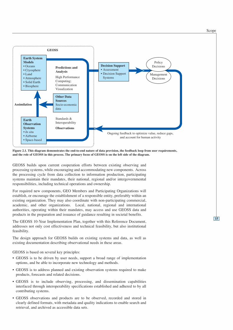
The scope and focus of GEOSS, as implemented by its component systems, isillustrated in Figure 2.1.
GEOSS, collectively, has several functional components:
• to address identified common user requirements
• to acquire observational data
• to process data into useful products
• to exchange, disseminate, and archive shared data, metadata and products; and
• to monitor performance against the defined requirements and intended benefits.
14
Scope
GEOSS builds upon current cooperation efforts between existing observing andprocessing systems, while encouraging and accommodating new components. Acrossthe processing cycle from data collection to information production, participatingsystems maintain their mandates, their national, regional and/or intergovernmentalresponsibilities, including technical operations and ownership.
For required new components, GEO Members and Participating Organizations willestablish, or encourage the establishment of a responsible entity, preferably within anexisting organization. They may also coordinate with non-participating commercial,academic, and other organizations. Local, national, regional and internationalauthorities, operating within their mandates, may access and use GEOSS data andproducts in the preparation and issuance of guidance resulting in societal benefits.
The GEOSS 10-Year Implementation Plan, together with this Reference Document,addresses not only cost effectiveness and technical feasibility, but also institutionalfeasibility.
The design approach for GEOSS builds on existing systems and data, as well asexisting documentation describing observational needs in these areas.
GEOSS is based on several key principles:
• GEOSS is to be driven by user needs, support a broad range of implementationoptions, and be able to incorporate new technology and methods.
• GEOSS is to address planned and existing observation systems required to makeproducts, forecasts and related decisions.
• GEOSS is to include observing, processing, and dissemination capabilitiesinterfaced through interoperability specifications established and adhered to by allcontributing systems.
• GEOSS observations and products are to be observed, recorded and stored inclearly defined formats, with metadata and quality indications to enable search andretrieval, and archived as accessible data sets.
15
Figure 2.1. This diagram demonstrates the end-to-end nature of data provision, the feedback loop from user requirements,and the role of GEOSS in this process. The primary focus of GEOSS is on the left side of the diagram.
GEOSS 10-Year Implementation Plan: Reference Document
• GEOSS is to provide a framework for securing the future continuity of observationsand initiating of new observations.
• GEO Members and Participating Organizations and the components they supportare to be documented in a catalogue that is publicly accessible, network distributed,and interoperable with major Earth Observation catalogues.
• GEOSS will work closely with research initiatives that may use GEOSS data andproducts, as well as improve the effectiveness of future observing systems.
• GEO Members and Participating Organizations will provide training, education,and capacity building to facilitate GEOSS adoption and long-term use.
16
17
THE CASE FOR GEOSS
3

GEOSS 10-Year Implementation Plan: Reference Document
18
The Case for GEOSS
Rational management of the Earth system, in both its natural and human aspects,requires information that is both relevant and timely. Ensuring that such informationis available to those who need it is a function of governments and institutions at alllevels. Despite laudable efforts in some domains, the current situation with respect tothe availability of Earth observations is far from satisfactory, particularly in terms ofcoordination and data sharing between countries, organizations and disciplines, tomeet the needs of sustainable development. There is therefore a need, as agreed at theWorld Summit on Sustainable Development (WSSD), in the Framework Document,and in many other fora, for targeted, collective action to bring observing systems inline with the requirements for addressing a range of issues of concern to society.
The following shortcomings are neither universal nor exhaustive, but apply to varyingdegrees across the range of existing systems:
• For many users, appropriate data are hard or costly to access, or are in a form thatis difficult to interpret, or are of uncertain quality.
• There is insufficient exchange of data among agencies and countries, partly due toincompatible data policies.
• There is inadequate involvement of data users in specifying the informationrequirements.
• Delays in data access sometimes prevent the timely use of information that couldsave lives or minimize loss of property.
• The generation and dissemination of products using large volumes of data often lagfar behind the collection of observations.
• Spatial and temporal coverage is not optimized, leaving large parts of the globeunder-sampled, diminishing the effectiveness of sampling systems in regions withadequate observations.
• Observations of the same variable in different places or by different agencies maynot be able to be combined, because the methods used to measure it are different,do not follow agreed standards or are not adequately intercalibrated, or because thetime and space resolution or the data structures in which the observations are storedhave significant incompatibilities.
• There is unnecessary redundancy in observation effort resulting from lack ofcoordination and an inability to use one observation to serve a number of differentusers. Observation systems and networks are planned separately by differentdomains, and the economic and scientific benefits of co-location are rarely realized.
• Many observations derive from research projects lacking the long-term stablefunding and staffing needed to collect and manage consistent observations overlong periods of time.
• Entire topics of vital interest to society are missing crucial observations taken on asustained, systematic, and operational basis.
• Some existing systems are not operating at their designed capacity.
The established Earth observation systems, through which many countries cooperateas members of the United Nations Specialised Agencies and Programmes and ascontributors to international scientific programmes, provide essential building blocksfor GEOSS. GEO will seek to ensure effective consultation and coordination with theUN system and other international agencies sponsoring or co-sponsoring the majorcomponent global observing systems on which GEOSS will be built. For example, amajor lesson learned from the tsunami of 26 December 2004 is that an internationalobservation and prediction system closely coordinated with national emergencyservices is needed in order for the public to receive timely warning.
19
3The Case for a GlobalEarth Observation Systemof Systems
GEOSS 10-Year Implementation Plan: Reference Document
20
Cou
rtes
y of
Dig
italG
lobe
C
ourt
esy
of D
igita
lGlo
be
23 June 2004
28 December 2004
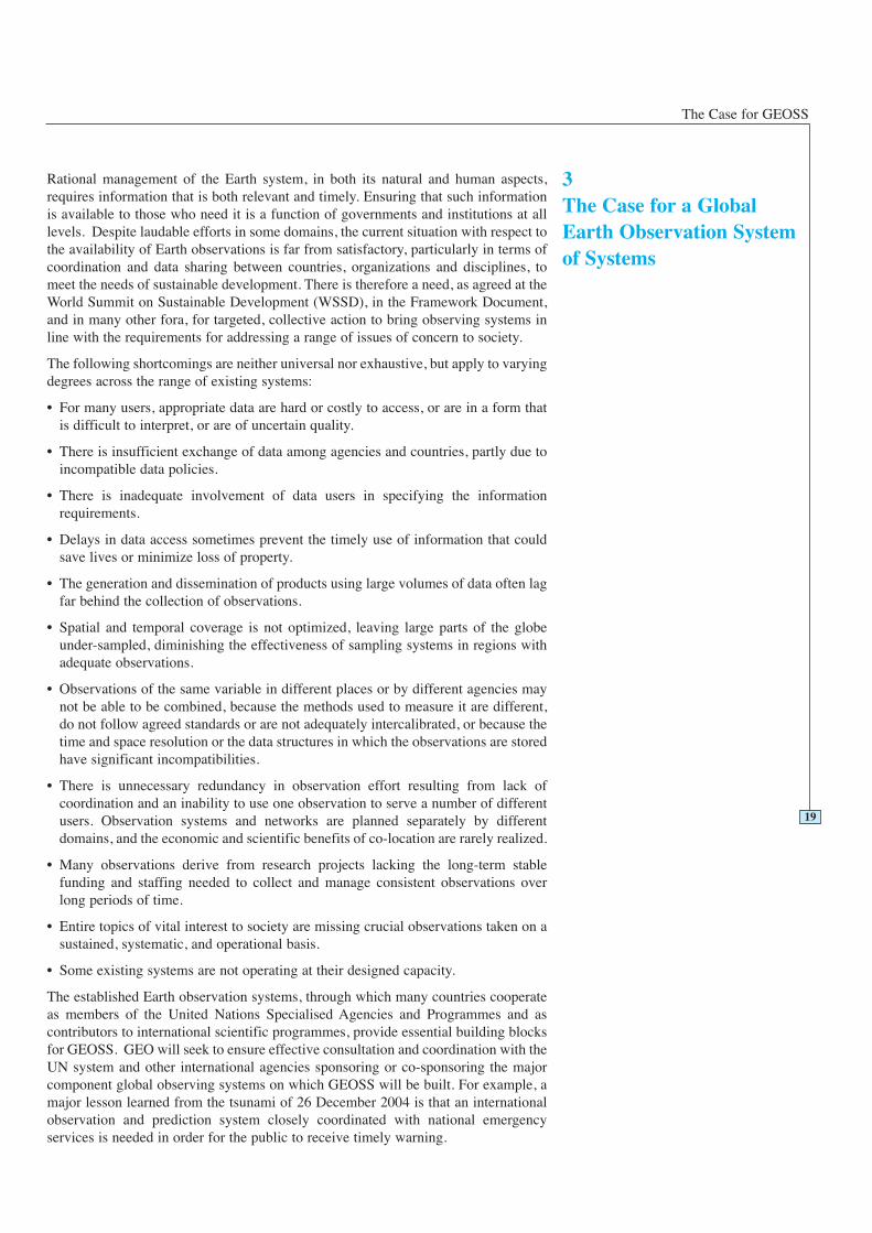
QuickBird satellite images of the Banda Aceh shoreline in Indonesia before and after the tsunami
The Case for GEOSS
21
GEOSS Could Help Nations Save Lives in the Event of a Tsunami
On 26 December 2004, an extreme undersea earthquake was recorded by the GlobalSeismographic Network, one of the systems participating in GEOSS. When such anevent occurs, a worldwide system of regional tsunami warning centres should beready to send an early warning to pre-designated authorities in nations that mightbe affected by the earthquake or by an estimated potential tsunami. To confirm ifthe quake had generated a tsunami, seismic data would be further refined andcombined with data from coastal tide gauges and buoys giving deep-ocean sealevel. Based on numerical models, a tsunami forecast could be prepared for areasnot yet affected. That information, along with probable tsunami arrival times, wouldbe sent to the same authorities.
Wherever a general tsunami threat exists, tsunami hazard zonation maps showingareas vulnerable to tsunami run-up, areas of safety and evacuation routes shouldhave been prepared. These maps are based on numerical models of variousscenarios and require high-resolution shoreline topography and near-shorebathymetry, as called for in GEOSS. In each of the potentially affected nations,national emergency managers would have close cooperation with regional centresto facilitate rapid data exchange and coordination of warning information.
National emergency managers would interpret the alert in their local context, anddecide upon a course of action. They might decide to trigger an integrated warningsystem that can activate multiple communications media with a single alertmessage. Alerts would then be converted automatically into forms suitable foravailable communication technologies: voice on radio and telephones, text captionson television, messages on highway signs, or signals for sirens. A common publicwarning system with simple instructions for action would minimize the publicconfusion that occurs during emergencies, especially if the system is in routine usenot only for tsunamis, but also for severe weather, fire, and other threats. This all-hazard public warning technology could be implemented using the GEOSSarchitecture that encourages system interfaces using international standards such asthe Common Alerting Protocol (CAP).
Rapid response of the alerted public is necessary to save lives when a dangeroustsunami arrives. People would move to safety and await an all-clear signal, givensigns along the seashore and emergency sirens, plus prior public awareness,preparedness, and education on the tsunami threat, as well as hazard zonation andevacuation maps. After the event, relief efforts could be focused by rapidlygenerated estimates of populations affected. Also, certain observation satellitescould be re-tasked to image the likely affected coastal areas. Overviews of affectedareas would be useful to national authorities in organizing efficient disasterresponse actions.
Disaster reduction demands greater sharing of Earth Observation data andinformation that are timely, of known quality, long-term, and global in nature.GEOSS will facilitate such sharing. GEOSS will also facilitate the internationalcollaboration among countries and organizations essential to minimize losses fromdisasters.
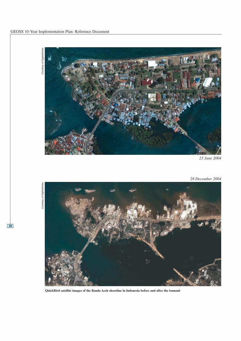
Deployment of a tsunami measuring buoy inthe Pacific Ocean
Cou
rtes
y of
NO
AA
GEOSS 10-Year Implementation Plan: Reference Document
There are clear improvements that can be made to existing Earth observations throughadopting a coherent global approach that will guide the expansion of observingsystems to meet society’s needs. The incremental cost of bringing the systems up tospecification and linking them together is small relative to the existing expenditure,and very small relative to the potential benefits that can accrue. In most cases, globalinformation arises from the voluntary contribution of data collected by nationalsystems, for national purposes.
The global, comprehensive, integrated and sustained effort outlined in the GEOSS 10-Year Implementation Plan would address these shortcomings in the following ways:
• arrangements to make systems interoperable and to share data
• collective optimization of the observation strategy
• cooperative gap filling
• commitments to observational adequacy and continuity
• data transfer and dissemination
• collaboration on capacity building
• harmonization of methods and application of observation standards.
These are expanded on below and in subsequent sections of this document. Consistentwith its structure as a ‘system of systems’, the goals and targets of GEOSS are mostlyachieved through and with the component systems. This Plan distinguishes, as far aspossible, between actions that are the primary responsibility of GEOSS (by usingverbs such as ‘GEOSS will produce…’), those undertaken jointly (‘GEOSS willfacilitate…’) and items where the GEOSS role is more indirect (‘GEOSS willadvocate…’).
The capacity to combine data from different sources substantially increases thenumber and type of observations available for analysis, as well as their spatial andtemporal coverage, in a cost-effective way. GEOSS provides a mechanism throughwhich partial or full data sharing can be negotiated and a technical process by whichit can be achieved. The Global Biodiversity Information Facility (GBIF) is anexample of the power of this approach. The vast collections in museums and herbariaaround the World were mutually inaccessible before an agreement was reached toshare information, and a set of database protocols designed to make it possible. Thistopic is covered in detail in Section 5.
For any topic of societal concern, there is a minimum sampling design required tomeet the accuracy specifications appropriate to that application. In the absence ofcollaboration, each observing system needs to do this calculation individually, anddeploy its own network and associated space-based systems to satisfy therequirement. By cooperating, such redundancies are avoided. Rapid technicalprogress is making hybrid observation systems the norm (combining, for instance, thespatial coverage advantages of satellites with the precision of in situ measurements).The optimal configuration of the sampling system is therefore continuously changing.An integrated observation strategy (i.e. one that is coordinated, co-designed andshares data) is both more effective and more efficient than stand-alone strategies.This principle is exemplified by the work of the Integrated Global Observing StrategyPartnership (IGOS-P).
Optimization of sampling is only possible with a degree of knowledge of thedistribution and dynamics of the system being observed. This is one reason why it isessential to maintain close and interactive relationships among observation systems,research programmes, and user communities.
22
3.1Arrangements to make
systems interoperable andto share data
3.2Collective optimization of
the observation strategy
The Case for GEOSS
A second aspect of this point is the opportunity to gain synergies and cost savings byusing one observational infrastructure for more than one purpose. For example,validation of land cover products requires a distributed network of ground locations.These can be co-located with existing stations currently set up for weather and climateobservations, ecosystem measurements or geodetic monitoring, for example, savingadditional overheads and providing a better data set to both parties (a conceptsometimes referred to as ‘super-sites’).
GEO will create a collaborative forum for technical analysis and observation strategydevelopment.
An example is provided by the atmospheric carbon-dioxide observation systemdesigned by the many collaborating organizations in the Global Carbon Project of theEarth System Science Partnership. By combining space-based observations of theland and sea surface conditions, air movement data from weather observation systemdata assimilation models, and a limited number of strategically placed, highlyaccurate, inter-calibrated surface stations, a specified accuracy can be obtainedglobally at minimum cost. This topic is addressed in Section 6.
Because many Earth-system processes operate at large scales, deficiencies inobservation in one area have an impact in other areas. It is recognized that the primaryresponsibility for observations within the territory of individual countries belongswith those countries, but reliance on independent efforts alone has deficiencies. Largeparts of the globe (specifically the open oceans, Antarctica and space) are outside theterritory of individual countries. It is to the benefit of all that these areas areadequately observed and that the burden of doing so is equitably shared to the best ofeach contributor’s capacity. Similar arguments apply to new observation needs, forinstance around emerging diseases. GEOSS provides a mechanism for identifying thegaps and mobilizing the resources needed to fill them. An example is the globalsystem of Argo floats, already partly implemented, that provides information onocean temperature, salinity, and ocean currents – all of which are essential for long-term meteorological forecasting and oceanographic studies and climate assessment,monitoring and prediction. The logistics of deploying the system throughout theglobal oceans and the costs of doing so are daunting for a single nation, but muchmore feasible if undertaken as a cooperative action by many countries for thecommon good.
There is further information on this topic in Section 6.
None of the above actions will be effective in the long term unless there is afundamental commitment to continuation of observations at an acceptable level ofaccuracy and coverage for all targeted users. Participation in GEOSS implies anacceptance of this need for adequacy and continuity. In some cases, the achievementof adequacy within the participating systems will require additional resources. Theincremental costs of achieving linkage and coordination within the ‘system ofsystems’ will also require resources over and above the current budgets of existingsystems.
An example is the network of hydrological gauging stations worldwide, which hasbeen in decline since the 1960s, due largely to inadequate provision for maintenance.For many basins, the network is now below the minimum required for adequateengineering design of flood protection structures, bridges, dams, and water supplyschemes. Ongoing investment is needed to keep the network functional and up to datewith technical advances.
A further example is the need for continuity of moderate- to high-resolution, space-based observations of the land and sea surface in the visible and near-infraredwavebands, such as is provided by the Landsat and SPOT platforms. This requires a
23
3.3Cooperative gap filling
3.4Observational adequacyand continuity
GEOSS 10-Year Implementation Plan: Reference Document
planned migration of some sensor platforms, demonstrated to be of benefit to users,out of the research domain and into operational agencies, with a schedule for regularreplacement, an operational budget separate from the research budget, andcommitment to backward compatibility of observations and inter-calibration whennew systems are implemented. Similar transfers of research instruments andmeasurements to operational agencies are critical in many other domains, includingamong others atmospheric composition, ocean temperature and salinity andbiodiversity observations.
Much has been achieved by current systems, but failure to take the opportunityafforded by GEOSS to rectify identified observation system deficiencies will meanthat the opportunity to obtain substantial added value from the global observationalnetwork will be lost for the foreseeable future. In certain important aspects (e.g. insurface climate, upper atmosphere, and hydrological observations) the observationalcapacity is likely to continue the decline that has been evident for several decadesunless a decisive intervention is made. With respect to new observation areas justemerging (e.g. around issues of health), future coordination will be hampered by thefailure to establish and adhere to interoperability standards at this stage. In others,such as aspects of climate change, land degradation and desertification andbiodiversity loss, failure to establish a comprehensive observation baseline at thistime, and a commitment to continuity of observation systems, will hamper the abilityto detect and quantify changes and the achievement of treaty targets.
Enabling all users globally to receive the relevant data in a timely fashion isimperative for maximizing the successful exploitation of the data observations andproducts. This involves the collection of global data, particularly from in situnetworks, the transfer of data and products between agencies responsible forobservations and products, and the dissemination of data and products to users. Insome domains, such as the World Weather Watch programme, much effort has alreadybeen invested in the achievement of this objective.
The technology to support these activities is evolving rapidly and includes theInternet, commercial telecommunication satellites and broadband land connections.The solution is not simply one of adopting the Internet. This can have timelinessproblems, particularly if data is required with tight time-scales that cannot bebreached, e.g. in weather forecasting, disasters. There are also significant accessissues to be resolved in many developing countries, particularly in the rural areas.Commercial telecommunication satellites can resolve some of these problems, butintroduce cost issues that need to be resolved.
The most efficient means to improve the geographic coverage of the Earth observingsystem is to encourage wider participation from all countries, both as providers andusers of information. Some types of observations are hard to justify, particularly indeveloping countries, in terms of immediate local benefit, and are therefore of lowpriority for national support by those countries alone. The benefits of making andsharing these observations are collective. There are significant advantages to taking acoordinated, focused, co-financed and partnership-based approach to capacitybuilding.
The GEO definition of capacity building includes three observation system elements:human resources, infrastructure, and institutional capacity.
It is recognized that a variety of organizations have, over a long period of time, madeexcellent efforts in capacity building, and the degree to which we currently haveglobal coverage is an inspiration to what can be achieved, but in most cases it remainsinsufficient.
24
3.5Data transfer and
dissemination
3.6Collaboration on capacity
building
The Case for GEOSS
Capacity building needs and targets are addressed within each societal benefit area inSection 4, and in Sections 5 and 6. The overarching considerations are contained inSection 7.
The combination of data from different sources is essential to advance our knowledgeof the Earth system, but is in many cases constrained due to incompatibleobservations, missing standards and insufficient operational data assimilationcapacity. GEOSS can provide a mechanism for achieving the convergence orharmonization of observation methods, the use of standards and references, and thepromotion of intercalibration and operational data assimilation.
This topic is elaborated in Sections 4.10 and 6.
25
3.7Harmonization of methodsand application ofobservation standards

GEOSS 10-Year Implementation Plan: Reference Document
26
27
SOCIETAL BENEFITSAND REQUIREMENTS
4

GEOSS 10-Year Implementation Plan: Reference Document
28
Societal Benefit Areas
The Framework Document set out nine societal benefit areas on which there wasrecognition that clear societal benefits could be derived from a coordinated globalobservation system.
Some of these societal benefit areas are themselves complex clusters of issues, withmany and varied stakeholders. In each area there are observational needs for manyvariables, with requirements for their accuracy, spatial and temporal resolution andspeed of delivery to the user. It is also clear that there is considerable commonality ofobservation needs among societal benefit areas. This is the powerful argument forimplementing GEOSS.
The societal benefit areas are at widely varying levels of maturity with respect toestablishing user needs, defining the observation requirements, and implementingcoordinated systems. For example, the Weather area is very mature while the Healtharea is relatively immature in the context of Earth Observation. In the former case, theactivities to be undertaken through GEOSS are largely in the areas of data sharing,advanced products and the coordination of future technologies. In the latter case,GEOSS activities commence with assisting the users to define their requirements,which in turn will lead to better use of existing data in the mid-term and newoperational coordinated observation systems and synthesis products only towards theend of the initial ten-year GEOSS implementation period.
It is anticipated that each of the nine societal benefit areas will evolve over time, andit is also probable that entirely new societal benefit areas may be added, in time.Mechanisms are established in later sections of this Plan to allow for orderly growth,review and revision.
In each of the societal benefit areas, GEOSS will work with the appropriate societalbenefit area community to facilitate execution of the target actions delineated below.Achievement of these actions is necessary to realize the outcomes by societal benefitarea as adopted in the Implementation Plan. The targets introduced in the ninesocietal benefit areas should not be understood as representing the activities of GEOMembers and Participating Organizations alone. Entities currently pursuing many ofthese targets will continue to do so, and they become GEOSS targets by virtue of thefact that the primary responsibility falls within observing systems that are participantsin the ‘system of systems’. The additional role of GEOSS will be, in consultation withsystem providers and users, to identify measures still needed to achieve the targets,and feasible ways of implementing them through cooperation among participants.Direct and active contribution by GEO to some targets is not excluded, whereappropriate and as approved by GEO.
The sequence in which the societal benefit areas are presented in the followingsections corresponds to the sequence presented in the Framework Document, anddoes not have any connotation of importance or priority.
29
4Societal Benefits,Requirements, and EarthObservation Systems
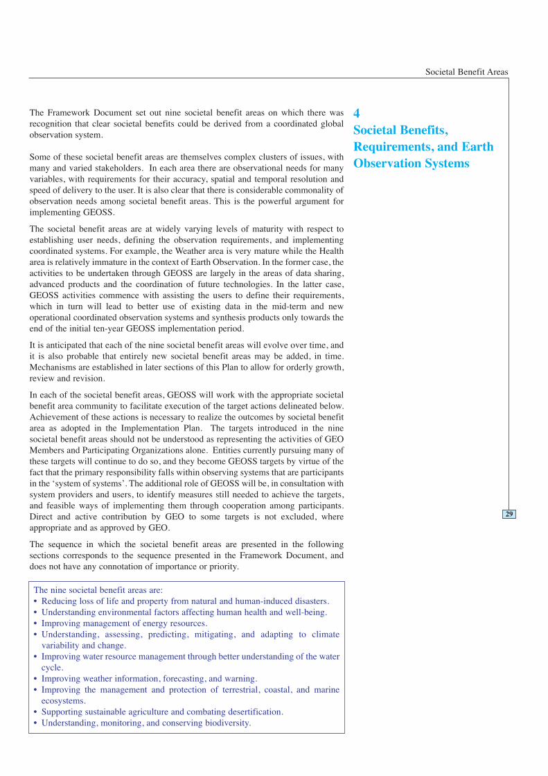
The nine societal benefit areas are:• Reducing loss of life and property from natural and human-induced disasters.• Understanding environmental factors affecting human health and well-being.• Improving management of energy resources.• Understanding, assessing, predicting, mitigating, and adapting to climate
variability and change.• Improving water resource management through better understanding of the water
cycle.• Improving weather information, forecasting, and warning.• Improving the management and protection of terrestrial, coastal, and marine
ecosystems.• Supporting sustainable agriculture and combating desertification.• Understanding, monitoring, and conserving biodiversity.
GEOSS 10-Year Implementation Plan: Reference Document
30
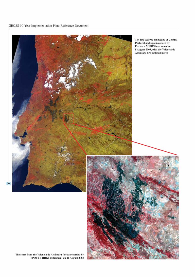
The fire-scarred landscape of CentralPortugal and Spain, as seen byEnvisat’s MERIS instrument on 8 August 2003, with the Valencia deAlcántara fire outlined in red
The scars from the Valencia de Alcántara fire as recorded bySPOT-5’s HRG1 instrument on 21 August 2003
Disasters
4.1.1 Statement of Need
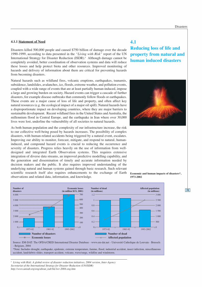
Disasters killed 500,000 people and caused $750 billion of damage over the decade1990-1999, according to data presented in the “Living with Risk” report of the UNInternational Strategy for Disaster Reduction (ISDR).4 Although damage cannot becompletely avoided, better coordination of observation systems and data will reducethese losses and help protect biota and other resources. Improved monitoring ofhazards and delivery of information about them are critical for preventing hazardsfrom becoming disasters.
Natural hazards such as wildland fires, volcanic eruptions, earthquakes, tsunamis,subsidence, landslides, avalanches, ice, floods, extreme weather, and pollution events,coupled with a wide range of events that are at least partially human-induced, imposea large and growing burden on society. Hazard events can trigger a cascade of furtherdisasters, for example disease outbreaks that commonly follow floods or earthquakes.These events are a major cause of loss of life and property, and often affect keynatural resources (e.g. the ecological impact of a major oil spill). Natural hazards havea disproportionate impact on developing countries, where they are major barriers tosustainable development. Recent wildland fires in the United States and Australia, themillennium flood in Central Europe, and the earthquake in Iran where over 30,000lives were lost, underline the vulnerability of all societies to natural hazards.
As both human population and the complexity of our infrastructure increase, the riskto our collective well-being posed by hazards increases. The possibility of complexdisasters, with human-related accidents being triggered by a natural event, escalates.Improving our ability to monitor, forecast, mitigate, and respond to natural, human-induced, and compound hazard events is crucial to reducing the occurrence andseverity of disasters. Progress relies heavily on the use of information from well-designed and integrated Earth Observation systems. This requires extensiveintegration of diverse data streams, an improved predictive modelling capability, andthe generation and dissemination of timely and accurate information needed bydecision makers and the public. It also requires improved understanding of theunderlying natural and human systems gained through basic research. Such relevantscientific research itself also requires enhancements to the exchange of Earthobservations and related data, information, and knowledge.
31
4.1Reducing loss of life andproperty from natural andhuman induced disasters
4 Living with Risk: A global review of disaster reduction initiatives, 2004 version, Inter-AgencySecretariat of the International Strategy for Disaster Reduction (UN/ISDR)http://www.unisdr.org/eng/about_isdr/bd-lwr-2004-eng.htm
Source: EM-DAT: The OFDA/CRED International Disaster Database - www.em-dat.net - Université Catholique de Louvain - Brussels- Belgium, 2004*Note: Includes drought, earthquake, epidemic, extreme temperature, famine, flood, industrial accident, insect infection, miscellaneousaccident, land/debris-slides, transport accident, volcano, wave/surge, wildfire and windstorm.
Economic and human impacts of disasters*,1973-2002
GEOSS 10-Year Implementation Plan: Reference Document
4.1.2 Vision and How GEOSS Will Help
The overarching 10-year vision in the societal benefit area of Disasters is to furtherenhance coordination among operational observing systems with global coverage.These need to be capable of supporting effective disaster warnings, responses, andrecovery, and of generating information products that enable planning and mitigation,in support of sustainable development. Disparate, multidisciplinary, basic, andapplied research must be integrated into operational systems. Gaps must be filled inobservations, in knowledge, in technology and in capacity, but above all inorganization. Providing this collaborative framework to permit free exchange of andefficient use of data, together with support for continuity of operations for all essentialsystems, is precisely the purpose of GEOSS.
For fire detection and monitoring, GEOSS can facilitate rapid tasking of the availablemoderate-resolution to high-resolution infrared imaging satellites to revisit areas ofconcern as frequently as possible. Geostationary weather satellites can view a givenarea on hourly repeat cycles or better, but lack the spatial resolution needed fordetecting wildland fires while they are small. For the next 10 years, fire monitoring
will depend on polar-orbiting satellites withappropriate bands and spatial resolutionsupporting the geostationary data. The bestintermediate solution will be robustinternational coordination of satellitetasking, along the lines of the presentInternational Charter on Space and MajorDisasters, but allowing for pre-event taskingwhere appropriate (as is the case forwildland fires and volcanic eruptions).
Another area of benefit of GEOSS will be tofacilitate cross-checking and evaluation ofreal-time and other data streams. This willaid in earthquake disaster mitigation basedon real-time strong ground motionestimation, identification of possibleprecursor signals for earthquakes,determination of the circumstances underwhich a significant tsunami may be
32
Example: A Wildland Fire Hazard System for Early Detection of Fire Outbreaks
Some years from now, enhanced in situ, airborne, and space-based observations ofdry fuel load (biomass with low water content) in East Kalimantan, Indonesia,indicate a high potential for severe fires. Weather data indicate that lightning strikescould ignite uncontrollable fires in the next few days. Increased satellitesurveillance detects a possible wildland fire, which is quickly confirmed by airborneobservers. Maps showing areas at risk are generated and local authorities issuespecific alerts to the affected population, government officials, and media. Tacticalmaps and evacuation routes are generated as response crews deploy and people areremoved from immediate danger. Equipment requests and optimal deploymentplans are generated, based on specific local weather and smoke prediction models,including effects of the fire itself. Wind profiles at higher levels and weather atlarger scales are factored into predictions of potential for spread and the relativeeffectiveness of fire management options. When the fires are brought under controlwithin two days, the event is reviewed, with all players involved, to improve futurepreparedness and response for such events.
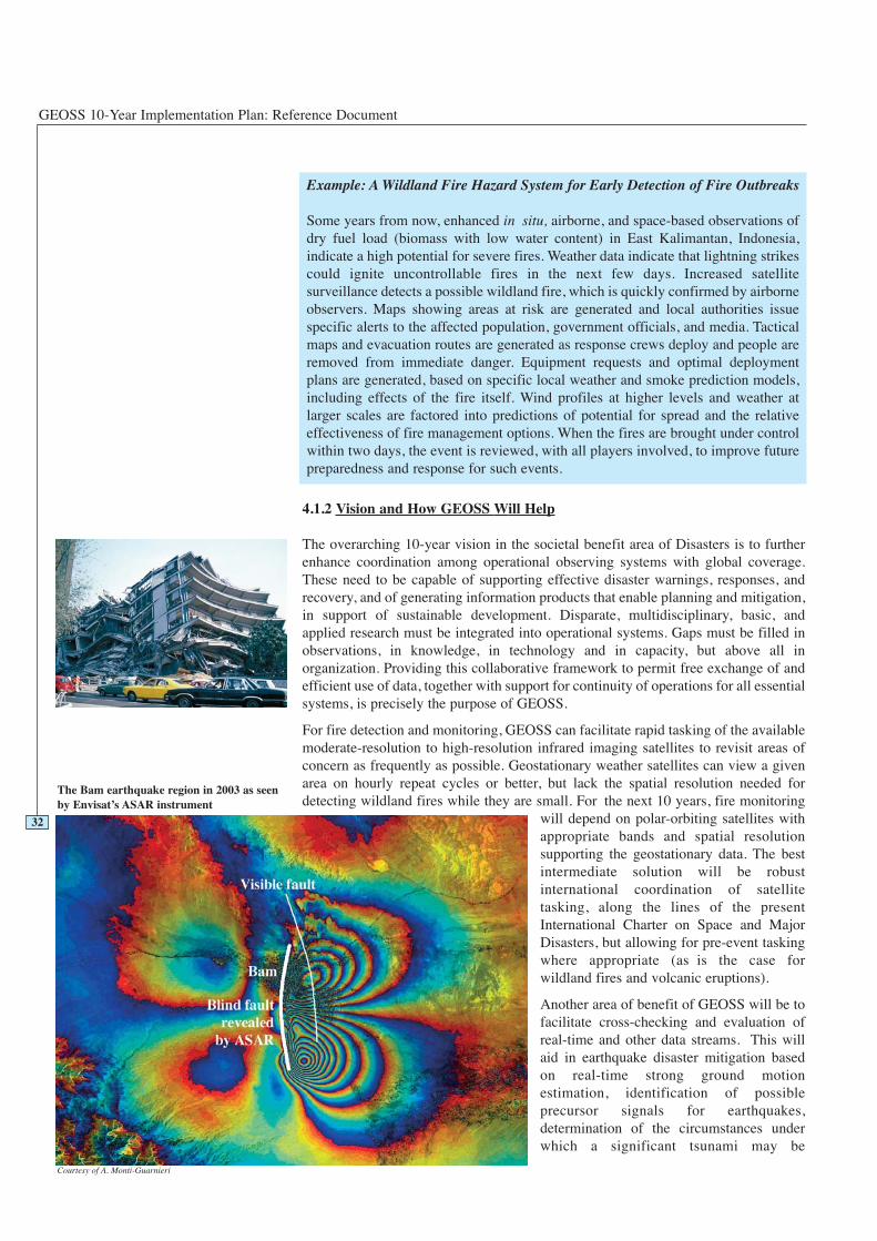
The Bam earthquake region in 2003 as seenby Envisat’s ASAR instrument
Courtesy of A. Monti-Guarnieri
Disasters
generated, and better recognition of the difference between geothermal and magmaticunrest at volcanoes.
Most aspects of weather related hazards are covered in Section 4.6 (Weather), withsome also addressed in Sections 4.4 (Climate), 4.5 (Water), and 4.8 (Agriculture).Beyond improvements in our current tracking of large weather systems such astropical cyclones, aspects important for disaster management include improvement ofshort-range and medium-range forecasts. Such forecasts are especially critical forlocal, severe weather such as heavy rain (triggering flash floods or debris flows) andtornadoes. These weather events still cause loss of life and local but severe damagebecause of insufficiently detailed forecasts and warnings. Biological hazards(disease, toxic algae, etc.) are covered in Sections 4.2 (Health) and 4.7 (Ecosystems).
4.1.3 Existing Situation and Gaps
Alarge number of agencies and organizations deal with disaster issues at national, regional, andglobal levels. The key issue for GEOSS is to ensure that relevant data and products areproduced and that the data and information are received in a timely fashion. The WorldMeteorological Organization (WMO) has mechanisms that enable the provision of weatherdata and forecast and warning services to areas suffering from disasters, and the InternationalCharter on Space and Major Disasters focuses the efforts of participating satellite data providerson responding to specific requests in cases of floods, oil spills, earthquakes and other hazards.
Our capability to monitor hazards needs to be improved in order to provide early warnings,which can prevent hazards from becoming disasters. An approach that includes data frommany different sources from both the natural environment and human infrastructure isessential. To provide timely and accurate information, it is necessary to integrate in situmeasurements, airborne and satellite remote sensing, and predictive models. It is also essentialto have basic Geographic Information Systems (GIS) to facilitate the analysis of these data, andmany varieties of socio-economic and other relevant data.
GEOSS must address a number of issues to realize solutions, including filling technical andorganizational gaps, as well as continuity issues. Major technical gaps are summarized inTable 4.1.5, which shows that few of the observational requirements for the ten hazards
33
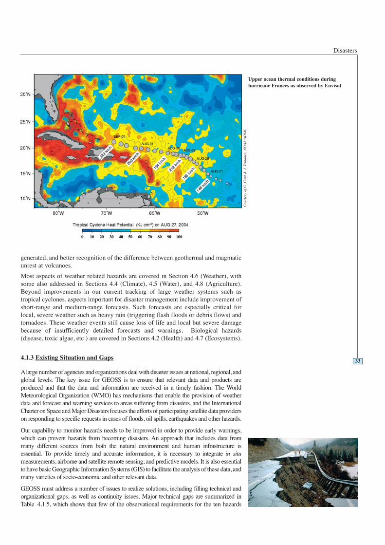
Upper ocean thermal conditions duringhurricane Frances as observed by Envisat
Cou
rtes
y of
G. G
oni
& J
. Tri
nane
s, N
OA
A/A
OM
L
GEOSS 10-Year Implementation Plan: Reference Document
listed are adequately met on a worldwide basis. For instance, there is a lack of worldwide,high-spatial-resolution terrain models. There are efforts to develop a global terrain model,e.g. using the Shuttle Radar Topography Mission (SRTM) results, but even when fullyavailable these results have horizontal spatial resolutions no better than 30 metres. Effectivemonitoring of crustal deformation using InSAR (Interferometric Synthetic Aperture Radar)requires 10 metre horizontal spatial resolution, and this is currently not available routinely.Floods, storm surges and tsunamis in areas of low relief raise the requirement for DEMs(Digital Elevation Models) with vertical resolutions of less than 1 metre. This resolution isachievable with airborne SAR (Synthetic Aperture Radar) and LiDAR (Light Detectionand Ranging).
Existing regional-scale geologic maps of volcanic areas, seismically active zones,landslide-prone areas, flood plains, and low-lying coastal areas, together with current dataon land cover, land use and population distribution, are inadequate to support disasterreduction strategies. This background information, plus knowledge of the frequency ofhazard events and maintenance of appropriate databases of historical hazard events, isrequired in order to generate meaningful hazards zonation maps (e.g. fuel distributionmaps, seismic hazard maps). Hazards zonation maps and supporting GIS databases are keytools for disaster preparedness and mitigation. These maps depend on interoperabledatabases and services provided by existing national and international Spatial DataInfrastructures (SDI).
There are monitoring gaps relative to specific hazards. For instance, the study ofgeohazards requires integrated, multi-disciplinary research focused on particular groups ofvolcanoes or high-priority tectonic zones for earthquakes. Deployment of in situinstruments, such as broadband seismometers and accelerometers, is incomplete. Remotesensing support, especially SAR imagery critical for deformation monitoring, has noguarantee of continuity, and the data supply is inadequate for real-time monitoring.Limitations on access to SAR data also impact the monitoring of ice hazards, oil spills, andinundation from flooding. Wildland fire detection depends in most areas on direct humanobservation on the ground or incidental observation from aircraft, in the absence of satellitesensors with appropriate temporal and spatial resolutions.
Coordination and data exchange between observation organizations and researchcommunities remains weak. Earth Observation information, whether from in-situ, airborneor space-based systems, is not used consistently or optimally for disaster managementdecision-making. GEOSS has a role in building the bridge between the communities.Demonstrations showing the usefulness of such information in an operational, integratedmanner would be helpful and achievable within a two-year horizon.34
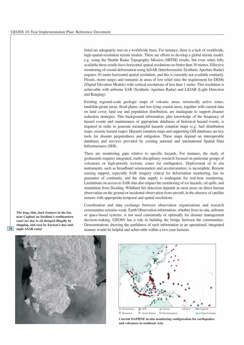
The long, thin, dark features in the baynear Cagliari on Sardinia’s southeasterncoast are due to oil dumped illegally byshipping, and seen by Envisat’s day-and-night ASAR radar
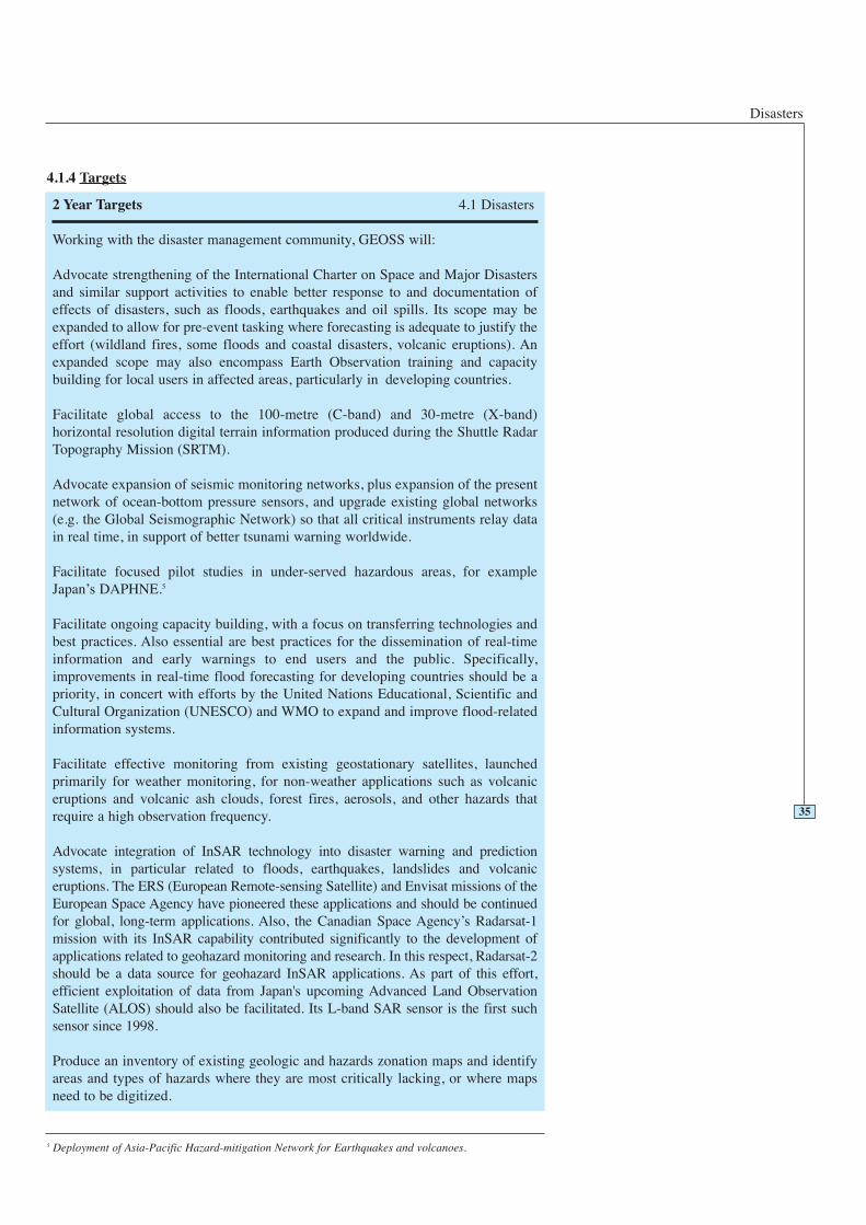
Current DAPHNE in-situ monitoring configuration for earthquakesand volcanoes in southeast Asia
Disasters
4.1.4 Targets
35
2 Year Targets 4.1 Disasters
Working with the disaster management community, GEOSS will:
Advocate strengthening of the International Charter on Space and Major Disastersand similar support activities to enable better response to and documentation ofeffects of disasters, such as floods, earthquakes and oil spills. Its scope may beexpanded to allow for pre-event tasking where forecasting is adequate to justify theeffort (wildland fires, some floods and coastal disasters, volcanic eruptions). Anexpanded scope may also encompass Earth Observation training and capacitybuilding for local users in affected areas, particularly in developing countries.
Facilitate global access to the 100-metre (C-band) and 30-metre (X-band)horizontal resolution digital terrain information produced during the Shuttle RadarTopography Mission (SRTM).
Advocate expansion of seismic monitoring networks, plus expansion of the presentnetwork of ocean-bottom pressure sensors, and upgrade existing global networks(e.g. the Global Seismographic Network) so that all critical instruments relay datain real time, in support of better tsunami warning worldwide.
Facilitate focused pilot studies in under-served hazardous areas, for exampleJapan’s DAPHNE.5
Facilitate ongoing capacity building, with a focus on transferring technologies andbest practices. Also essential are best practices for the dissemination of real-timeinformation and early warnings to end users and the public. Specifically,improvements in real-time flood forecasting for developing countries should be apriority, in concert with efforts by the United Nations Educational, Scientific andCultural Organization (UNESCO) and WMO to expand and improve flood-relatedinformation systems.
Facilitate effective monitoring from existing geostationary satellites, launchedprimarily for weather monitoring, for non-weather applications such as volcaniceruptions and volcanic ash clouds, forest fires, aerosols, and other hazards thatrequire a high observation frequency.
Advocate integration of InSAR technology into disaster warning and predictionsystems, in particular related to floods, earthquakes, landslides and volcaniceruptions. The ERS (European Remote-sensing Satellite) and Envisat missions of theEuropean Space Agency have pioneered these applications and should be continuedfor global, long-term applications. Also, the Canadian Space Agency’s Radarsat-1mission with its InSAR capability contributed significantly to the development ofapplications related to geohazard monitoring and research. In this respect, Radarsat-2should be a data source for geohazard InSAR applications. As part of this effort,efficient exploitation of data from Japan's upcoming Advanced Land ObservationSatellite (ALOS) should also be facilitated. Its L-band SAR sensor is the first suchsensor since 1998.
Produce an inventory of existing geologic and hazards zonation maps and identifyareas and types of hazards where they are most critically lacking, or where mapsneed to be digitized.
5 Deployment of Asia-Pacific Hazard-mitigation Network for Earthquakes and volcanoes.

GEOSS 10-Year Implementation Plan: Reference Document
36
6 Year Targets 4.1 Disasters
Working with the disaster management community, GEOSS will:
Facilitate widespread use of LiDAR and InSAR technologies for topography inareas of low relief. For floods and coastal hazards, the most crucial need is for highvertical resolution (less than 1 metre) topographic data, plus good shallow-waterbathymetry.
Advocate continuity and interoperability of all satellite systems providing globalpositioning, such as the United States Global Positioning System (GPS), EuropeanGALILEO, Russian Global Orbiting Navigation Satellite System (GLONASS) andJapanese Quasi-Zenith Satellite System (QZSS). This includes support of the globalgeodetic network services such as Very Long Baseline Interferometry (VLBI) andSatellite Laser Ranging (SLR), that define the orbits of the GPS satellites andthereby enable the use of GPS for precise geo-location. Applications of GPSessential to disaster response include precision topography, mapping support, anddeformation monitoring, as well as geo-location for search and rescue operations.
Advocate that the international satellite community, coordinated through theCommittee on Earth Observation Satellites (CEOS), plan for assured continuity ofcritical sensing capabilities. For example, certain research systems should becomeoperational systems and the projected lifetimes of some systems should not resultin service gaps in key satellite sensor data. Longer-term actions for monitoring ofgeohazards include realization of an integrated observation system of SARinterferometry and GPS.
Advocate enhancements of the automatic processing and evaluation of satelliteimagery, to facilitate production of digital topography, and to support rapiddetection of fires, oil spills, or other hazards.
Advocate more rapid SAR processing for interferometry to enable strain mappingover large seismically active zones and to monitor landslides and subsidence inpopulated areas and along transportation corridors.
Advocate systematic expansion of the inventory of geologic and hazards zonationmaps and expansion of Geographic Information Systems (GIS) as a critical tool formanaging spatial information for disaster management. In this context, digitalmaps based on distributed systems and data sources and conforming to recognizedinternational GIS standards (e.g. International Organization for Standardizationstandards and Open Geospatial Consortium specifications).
Facilitate the development and sharing of critical airborne sensors and capabilities,such as hyper-spectral sensors, high-resolution infrared sensors and LiDAR.
Advocate further development of the Global Spatial Data Infrastructure (GSDI) anddraw on GSDI components as institutional and technical precedents.
Produce a comprehensive gaps analysis to assess the status and regional distributionof existing disaster management capacity-building programmes and initiatives.
Disasters
37
Advocate the development of models to better support disaster response. One areaof particular interest is the dispersion of pollution plumes in the atmosphere or inwater (including the spread of oil spills in the marine environment).
Establish a process for monitoring of capacity-building efforts in disastermanagement to enable building upon strong existing programmes in the continuingefforts to integrate and share resources.
Advocate access to data from seismic and infrasound networks operated by thePreparatory Commission for the Comprehensive Nuclear Test-Ban TreatyOrganization (CTBTO) that are useful and relevant for monitoring earthquakes andvolcanic activity.
Facilitate access to real-time data analyzing technology and real-time access tocritical data for all hazards.
Advocate real-time monitoring of submarine seismic and volcanic activities andtsunami propagation.
10 Year Targets 4.1 Disasters
Working with the disaster management community, GEOSS will:
Facilitate further expansion of real-time monitoring of submarine seismic andvolcanic activity and of tsunami propagation by use of surface and subsurfacesensors, including re-use of submarine telephone cables.
Facilitate further expansion and integration of regional projects like DAPHNE 6 andGlobal Monitoring for Environment and Security (GMES),7 and the development ofefficient interfaces between these and other such programmes.
Advocate meeting various unmet needs for classes of satellite sensors. Of particularimportance for the area of hazards and disasters is the global need for a significantincrease in SAR satellites (C-band, L-band, and X-band). The disaster managementcommunity needs an L-band system optimized for interferometry, and an expandedL-band capacity for better forest and fuel characterization. Monitoring the range ofsmoke and pollution plumes in the atmosphere around the globe requires expandedhyper-spectral capability, which is currently limited to airborne sensors. A passivemicrowave capability would help in determining soil moisture repeatedly overbroad areas.
Advocate development of systematic methods for rapid determination of shallowbathymetry, especially in turbid water. Such research is vital to characterizing near-shore bathymetry, whether for improved modelling of tsunamis and storm surges orfor documenting changes produced during such events.
Produce an evaluation of the effectiveness of its capacity-building activities for thedisaster management sector, including an assessment of the effectiveness ofbuilding the needed inventory of geologic and hazards zonation maps.
6 http://www.daphne.bosai.go.jp7 http://www.gmes.info/
GEOSS 10-Year Implementation Plan: Reference Document
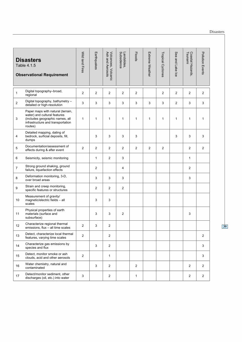
4.1.5 Table of Observation Requirements
In the table on the following page, several types of hazard or disaster are charted asexamples. Certain hazard types are absent here as they are treated elsewhere withinthis report. For instance, droughts are addressed within the Agriculture area.
38
Legend for Table 4.1.5
0 - Monitored with acceptable accuracy, spatial and temporal resolution; timeliness and in all countries worldwide.
1 - Monitored with marginally acceptable accuracy, spatial and temporal resolution; timeliness or not in all countriesworldwide
2 - Not yet widely available or not yet monitored globally,but could be within two years.
3 - Only locally available or experimental; could be availablein six years.
4 - Still in research phase; could be available in ten years.
Disasters
39
DisastersTable 4.1.5
Observational Requirement
Wild
lan
d F
ires
Ea
rthq
ua
ke
s
Vo
lca
no
es, V
olc
an
ic
Ash
an
d A
ero
so
ls
La
nd
slid
es,
Su
bsid
en
ce
Flo
od
s
Extre
me
We
ath
er
Tro
pic
al C
yclo
ne
s
Se
a a
nd
La
ke
Ice
Co
asta
l Ha
za
rds,
Tsu
na
mi
Po
llutio
n E
ve
nts
1Digital topography–broad,regional
2 2 2 2 2 2 2 2 2
2Digital topography, bathymetry –detailed or high-resolution
3 3 3 3 3 3 3 2 3 3
3
Paper maps with natural (terrain,water) and cultural features(includes geographic names, all
infrastructure and transportationroutes)
1 1 1 1 1 1 1 1 1 1
4Detailed mapping, dating ofbedrock, surficial deposits, fill,dumps
3 3 3 3 3 3 3
5Documentation/assessment ofeffects during & after event
2 2 2 2 2 2 2 2 2
6 Seismicity, seismic monitoring 1 2 3 1
7Strong ground shaking, groundfailure, liquefaction effects
2 4 2
8Deformation monitoring, 3-D,over broad areas
3 3 3 3
9Strain and creep monitoring,specific features or structures
2 2 2
10Measurement of gravity/magnetic/electric fields – allscales
3 3
11Physical properties of earthmaterials (surface and
subsurface)
3 3 2 3
12Characterize regional thermal
emissions, flux – all time scales2 3 2
13Detect, characterize local thermalfeatures, varying time scales
2 2 2
14Characterize gas emissions byspecies and flux
3 2 3
15Detect, monitor smoke or ashclouds, acid and other aerosols
2 1 3
16Water chemistry, natural andcontaminated
3 2 2 2 2
17Detect/monitor sediment, otherdischarges (oil, etc.) into water
3 2 1 2 2
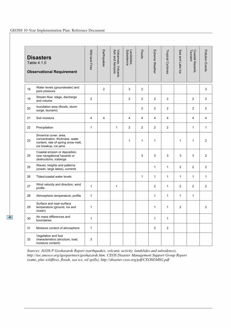
GEOSS 10-Year Implementation Plan: Reference Document
DisastersTable 4.1.5
Observational Requirement
Wild
land F
ires
Earth
quakes
Volc
anoes, V
olc
anic
Ash a
nd A
ero
sols
Landslid
es,
Subsid
ence
Flo
ods
Extre
me W
eath
er
Tro
pic
al C
yclo
nes
Sea a
nd L
ake Ic
e
Coasta
l Hazard
s,
Tsunam
i
Pollu
tion E
vents
18Water levels (groundwater) and
pore pressure2 3 2 3
19Stream flow: stage, discharge
and volume2 2 2 2 2 2 2
20Inundation area (floods, storm
surge, tsunami)2 2 2 2 2
21 Soil moisture 4 4 4 4 4 4 4 4
22 Precipitation 1 1 2 2 2 2 1 1
23
Snow/ice cover: area,concentration, thickness, watercontent, rate of spring snow melt,
ice breakup, ice jams
1 1 1 1 1 2
24Coastal erosion or deposition,
new navigational hazards orobstructions, icebergs
3 3 3 3 3 2
25Waves, heights and patterns
(ocean, large lakes), currents1 1 2 2 2
26 Tides/coastal water levels 1 1 1 1 1 1
27Wind velocity and direction, windprofile
1 1 2 1 2 2 2
28 Atmospheric temperature, profile 1 1 1 1 1
29Surface and near-surfacetemperature (ground, ice andocean)
1 1 1 2 2
30Air mass differences andboundaries
1 1 1
31 Moisture content of atmosphere 1 2 2
32Vegetation and fuelcharacteristics (structure, load,
moisture content)
3
Sources: IGOS-P Geohazards Report (earthquakes, volcanic activity, landslides and subsidence),
(same, plus wildfires, floods, sea ice, oil spills), http://disaster.ceos.org/pdf/CEOSDMSG.pdf
http://ioc.unesco.org/igospartners/geohazards.htm; CEOS Disaster Management Support Group Report
40
Health
4.2.1 Statement of Need
People born in the 21st Century in most regions of the World can expect to livesignificantly longer and healthier lives than those born just over a century ago. Asignificant factor in this increase have been gains in environmental management,including improved sanitation, purified water, more effective control of diseasevectors and reservoirs, cleaner air, and safer use of chemicals in our homes, gardens,farms, factories, and offices. Continued improvement in quality of life and longevitydepends on understanding a complex array of factors that determine human healthconditions.
Significant differences in the health and well-being of people in various regions of theWorld still exist. One person in five does not have access to good quality drinkingwater. The rapidly-growing global population is creating numerous stresses withserious health impacts, such as increased release of chemical emissions into theenvironment, and special attention needs to be paid to an observing system which cantrack indicators for these chemicals, especially persistent organic pollutants (POPs),heavy metals, polychlorinated biphenyls (PCBs), and pesticides.The demands of this ever-increasing global population call forthe development, communication, and fulfilment of userrequirements for data and data products to aid in satisfying ourfundamental needs for clean air and water, food, and shelter andin enhancing our present quality of life and the sustainabledevelopment necessary for our future.
GEOSS will contribute significantly to human health forprevention, early warning, and rapid problem-solving byfacilitating better data on environmental factors such as exposurefactors like air and water contaminants, pathogens, andultraviolet radiation; nutritional factors such as price andavailability of food; extreme weather events and noise; andindicators of the stresses of overpopulation. Health serviceproviders, researchers, policy makers, and the public indeveloped and developing countries as well as indigenouscommunities need such data products for providing the services,science, and decisions that affect human health and well-being.For example, data on population distributions, production andtransport of chemicals, as well as hurricanes and floods arefactored into emergency management decisions that save livesand property. Data on conditions that increase mosquitopopulations are factored into prevention measures in areas wheremalaria is endemic. Data on the transport of air pollution arefactored into early warnings for cardiovascular and respiratoryresponses as well as remediation efforts. Data on weather andstream flow are factored into the management of drinking water.
Key health and environment indicators include factors such asforecasts of famine/food security, quality and quantity of waterand soil for human use, occurrence of vector-borne and water-borne diseases, harmful algal blooms and seafoodcontamination, wildland fires, and severe weather. Another set ofindicators includes air quality, recreational water quality andultraviolet radiation indices. Health and well-being policydevelopment requires a broader set of change indicators, such asland use, urban environment, transportation infrastructure,transportation patterns, energy use, agricultural-chemical use,long-range trans-boundary pollution, and waste management.
4.2Understandingenvironmental factorsaffecting human healthand well-being
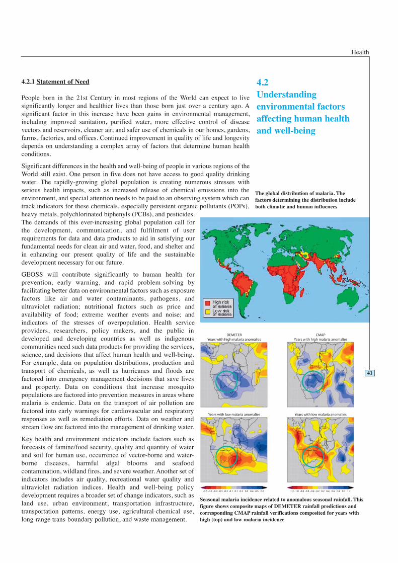
The global distribution of malaria. Thefactors determining the distribution includeboth climatic and human influences
Seasonal malaria incidence related to anomalous seasonal rainfall. Thisfigure shows composite maps of DEMETER rainfall predictions andcorresponding CMAP rainfall verifications composited for years withhigh (top) and low malaria incidence
41
GEOSS 10-Year Implementation Plan: Reference Document
4.2.2 Vision and How GEOSS Will Help
The vision is for Earth Observation to make a significant contribution to the continuedimprovements in human health by enabling improved understanding of the linkagesbetween the environment and human health, as well as prevention, early warning, andmore rapid problem-solving. It will be achieved through the development of a systemof in situ, airborne, and space-based systems integrated through assimilation andmodelling tools with census data on health, and building upon developing systemssuch as the international Earth System Science Partnership (ESSP) and the Centers forDisease Control (United States) Public Health Information Network (PHIN). Theoutputs will be to identify environmental conditions, health hazards, and at-riskpopulations, and to establish epidemiological associations between measurableenvironmental parameters, chronic and infectious diseases, and health conditions. Toaccomplish this, the available data will be identified, processed into a useable form,and disseminated to all users, including the health community represented by relevantinternational bodies such as the World Health Organization (WHO), ESSP, and PHIN.Models relating environmental hazards to health condition/disease will be developedand tested in appropriate areas. Data delivery mechanisms to get the information topublic health officials, connecting to well developed decision support systems for healthcare planning and delivery, are an essential component and an especially pressing needin developing countries and indigenous communities.
GEOSS will be a vital means of bringing useful environmental data to the healthcommunity in a user friendly form. Comprehensive data sets are powerful tools thatsupport prevention, early warning, research, epidemiology, health care planning anddelivery, and provide a variety of timely public alerts. For example, by linkingweather, air quality data and the urban heat island effects, air quality forecasts canhelp protect asthmatics, the elderly and the young from cardiovascular and respiratory
42
Example: A Future when the Ocean Warns of a Cholera Epidemic
Some years from now, in situ and remote sensing of the Bay of Bengal identifiesincreasing sea surface temperatures. Experience and models suggest thedevelopment of conditions conducive to increased ocean productivity. In thefollowing days, ocean colour measurements indicate strongly increasingconcentrations of chlorophyll-a, and the proliferation of phytoplankton.Epidemiological information from international researchers in Dhaka, Bangladesh,reports novel serogroups of cholera pathogens that can evade vaccine-derivedimmunity. Time remains, however, to prepare in case the cholera-bearing copepodsapproach the Ganges Delta, home to over one hundred and fifty million people.
A major public health effort, coordinated by the Ministry of Health with significantinternational support, provides hospitals, clinics and healthcare providers in thethreatened areas with immense stocks of pre-packaged oral rehydration salts withinstructions for use. Meanwhile, sea-surface height increases, and high-resolutionimaging tracks large populations of plankton being carried into the delta.Geographic Information Systems with global positioning coordinates from thelong-standing vaccine field trial sites are used to identify the communities at riskand health care centres in the track of the pathogen that need additional medicalsupplies.
Shortly thereafter, an explosive epidemic occurs, and cholera cases pour into thehospitals and clinics. Patient numbers rapidly increase, and cholera cots are set inthe corridors and parking lots of clinics. Microbiologists identify a new antibiotic-resistant cholera strain. In previous years this would have been a recipe for disaster;however, early warning and pre-placement of adequate medical supplies minimizecholera casualties to near zero.
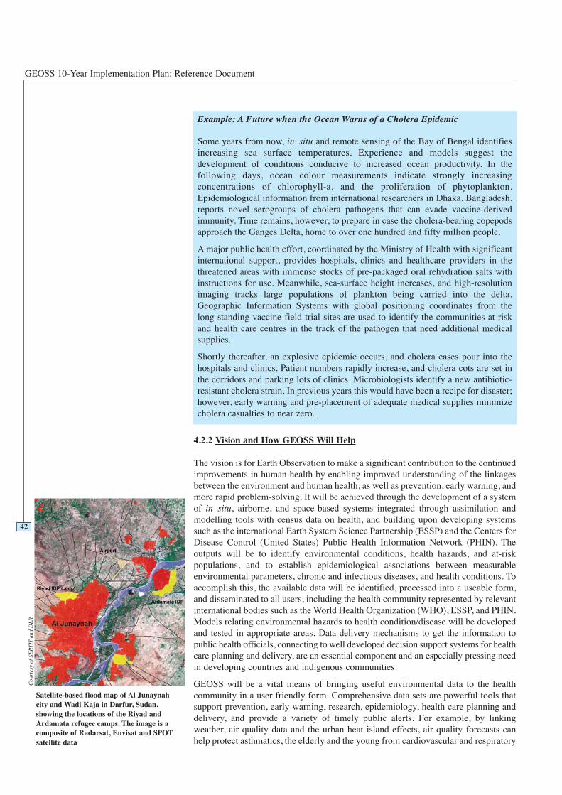
Satellite-based flood map of Al Junaynahcity and Wadi Kaja in Darfur, Sudan,showing the locations of the Riyad andArdamata refugee camps. The image is acomposite of Radarsat, Envisat and SPOTsatellite data
Cou
rtes
y of
SE
RT
ITan
d D
LR
Health
problems resulting from air pollution episodes. These data can also provide linkagesto longer-term air quality impacts such as cancers, respiratory diseases, asthma andbirth defects. Also, by connecting the environmental requirements of pathogens withremote sensing observations of land parameters, weather and other data, it can bepossible to predict outbreaks of infectious diseases such as malaria, and reduce theimpact and severity of the outbreak. By using remotely sensed land use data, it ispossible to predict areas of probable water quality impairment, which allows localcommunities to better target in situ water quality/drinking water monitoring andremedial efforts. Better UV-B measurements and warning systems will reduce theincidence of skin cancer and cataracts around the World.
GEOSS will bring a focus to predictive and preventative aspects of health,particularly with respect to environmental conditions such as pollutants andcontaminants. Thus, at the global level, the availability of remotely sensed and in situenvironmental data creates the opportunity for applying powerful new tools todiscovering early indicators of adverse conditions, thereby alerting the communityand providing time for hazard avoidance or disease mitigation. This contrasts with thefocus of most of the health care today, which is primarily a treatment-based systemcoupled with research on the processes underlying chronic and infectious diseases.
Currently, the work being conducted with remote sensing technologies and disease isthrough interdisciplinary research groups involving scientists with variedbackgrounds such as remote sensing, epidemiologists, and atmospheric scientists (e.g.the international ESSP). The science of epidemiology involves observing factors thatmight be associated with disease, and then calculating the degree of significance inthe association. The true value of Earth Observation data will become more fullyrealized when simple, user-friendly data products are prepared that are easily overlaidonto disease/dysfunction maps. For example, if an epidemiologist wishes toinvestigate factors associated with childhood asthma, it will be useful to model thephysical location of patients with real-time and cumulative local airborne particulatesover the study period. GEOSS can make a significant contribution to this class ofactivity by ensuring data are available and developing the modelling capability.
It is essential to be able to relate the results of disease studies conducted in differenttimes and locations. Historical data from satellites on the effects of land use and landcover changes are needed to track, model and predict changes in ozone, particulatematter, chemical emissions, disease vectors, cancers, and birth defects to evaluateimprovements in health conditions related to public well-being. GEOSS will beinvaluable in allowing exposure and disease data to be related among populations. Forexample, the aerial particle pollution and health consequences among the World’smajor cities could be compared and contrasted, and degenerating environmentalconditions that could lead to the emergence of infectious diseases could be identifiedand reversed before a new epidemic occurs.
43
UV index forecast for 21 March 2002 derivedfrom ERS’s GOME instrument
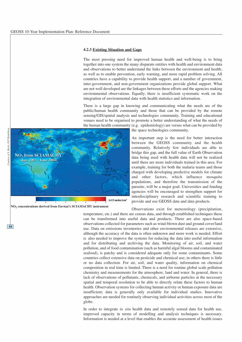
GEOSS 10-Year Implementation Plan: Reference Document
4.2.3 Existing Situation and Gaps
The most pressing need for improved human health and well-being is to bringtogether into one system the many disparate entities with health and environment dataand observations to better understand the links between the environment and health,as well as to enable prevention, early warning, and more rapid problem solving. Allcountries have a capability to provide health support, and a number of government,inter-government, and non-government organizations provide global support. Whatare not well developed are the linkages between these efforts and the agencies makingenvironmental observations. Equally, there is insufficient systematic work on theintegration of environmental data with health statistics and information.
There is a large gap in knowing and communicating what the needs are of thepublic/human health community and those that can be provided by the remotesensing/GIS/spatial analysis and technologies community. Training and educationalvenues need to be organised to promote a better understanding of what the needs ofthe human health community (e.g. epidemiology) are versus what can be provided by
the space technologies community.
An important step is the need for better interactionbetween the GEOSS community and the healthcommunity. Relatively few individuals are able tobridge this gap, and the full value of Earth Observationdata being used with health data will not be realizeduntil there are more individuals trained in this area. Forexample, training for both the malaria teams and thosecharged with developing predictive models for climateand other factors, which influence mosquitopopulations, and therefore the transmission of theparasite, will be a major goal. Universities and fundingagencies will be encouraged to strengthen support forinterdisciplinary research and scientific training toprovide and use GEOSS data and data products.
Observations exist for meteorology (precipitation,temperature, etc.) and there are census data, and through established techniques thesecan be transformed into useful data and products. There are also space-basedobservations collected for parameters such as wind-blown dust and ground cover/landuse. Data on emissions inventories and other environmental releases are extensive,although the accuracy of the data is often unknown and more work is needed. Effortis also needed to improve the systems for reducing the data into useful informationand for distributing and archiving the data. Monitoring of air, soil, and waterpollution, and of food contamination (such as harmful algal blooms and contaminatedseafood), is patchy and is considered adequate only for some contaminants. Somecountries collect extensive data on pesticide and chemical use; in others there is littleor no data collection. For air, soil, and water quality, information on chemicalcomposition in real time is limited. There is a need for routine global scale pollutionchemistry and measurements for the atmosphere, land and water. In general, there islack of observations of pollutants, chemicals, and airborne particles at the necessaryspatial and temporal resolution to be able to directly relate these factors to humanhealth. Observation systems for collecting human activity or human exposure data areinsufficient; data is generally only available for individual studies. Innovativeapproaches are needed for routinely observing individual activities across most of theglobe.
In order to integrate in situ health data and remotely sensed data for health use,improved capacity in terms of modelling and analysis techniques is necessary.Information is needed at a level that enables the accurate assessment of health issues
NO2 concentrations derived from Envisat’s SCIAMACHY instrument
Cou
rtes
y of
S. B
ierl
e, I
UP
Hei
delb
erg
44
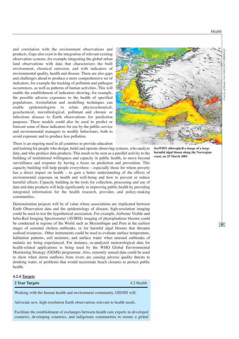
Health
and correlation with the environment observations andproducts. Gaps also exist in the integration of relevant existingobservation systems, for example integrating the global urbanland observations with data that characterizes the builtenvironment, chemical emission, and with indicators ofenvironmental quality, health and disease. There are also gapsand challenges ahead to produce a more comprehensive set ofindicators, for example the tracking of pollutant and pathogenoccurrences, as well as patterns of human activities. This willenable the establishment of indicators showing, for example,the possible adverse exposures to the health of specifiedpopulations. Assimilation and modelling techniques canenable epidemiologists to relate physicochemical,geochemical, microbiological, pollutant and chronic orinfectious disease to Earth observations for predictionpurposes. These models could also be used to predict orforecast some of these indicators for use by the public-serviceand environmental managers to modify behaviours, both toavoid exposure and to produce less pollution.
There is an ongoing need in all countries to provide educationand training for people who design, build and operate observing systems, who analyzedata, and who produce data products. This needs to be seen as a parallel activity to thebuilding of institutional willingness and capacity in public health, to move beyondsurveillance and response by having a focus on prediction and prevention. Thiscapacity building will help people everywhere – especially those for whom povertyhas a direct impact on health – to gain a better understanding of the effects ofenvironmental exposure on health and well-being and how to prevent or reduceharmful effects. Capacity building in the tools for collection, processing and use ofdata and data products will help significantly in improving public health by providingintegrated information for the health research, provider, and policy-makingcommunities.
Demonstration projects will be of value where associations are implicated betweenEarth Observation data and the epidemiology of disease; high-resolution imagingcould be used to test the hypothetical association. For example, Airborne Visible andInfra-Red Imaging Spectrometer (AVIRIS) imaging of phytoplankton blooms couldbe conducted in regions of the World such as Mozambique and Peru at the earlieststages of seasonal cholera outbreaks, or for harmful algal blooms that threatenseafood resources. Other instruments could be used to evaluate surface temperature,habitation patterns, soil moisture, and surface water when unusual outbreaks ofmalaria are being experienced. For instance, re-analyzed meteorological data forhealth-related applications is being used by the WHO Global EnvironmentalMonitoring Strategy (GEMS) programme. Also, remotely sensed data could be usedto show when storm outflows from rivers are causing adverse quality threats todrinking water, or problems that would necessitate beach closures to protect publichealth.
4.2.4 Targets
2 Year Targets 4.2 Health
Working with the human health and environment community, GEOSS will:
Advocate new, high-resolution Earth observations relevant to health needs.
Facilitate the establishment of exchanges between health care experts in developedcountries, developing countries, and indigenous communities to ensure a global
45
SeaWIFS chlorophyll-a image of a largeharmful algal bloom along the Norwegiancoast, on 25 March 2001
Cou
rtes
y of
Dun
dee
Uni
v./N
ASA
-GSF
C/O
RB
IMA
GE

GEOSS 10-Year Implementation Plan: Reference Document
46
perspective of the challenges and some coordinated development of a network toaddress problems and to leverage Earth Observation systems where appropriate.
Facilitate mechanisms that help to translate the needs of health data users intorequirements that Earth Observation data providers can address.
Promote the development of an integrated public health information networkdatabase that includes information relevant to human health officials and agencies,and includes multi-scaled, multi-temporal spatial data collected from remotesensing data sources, to provide better predictive models of the effects ofenvironmental factors affecting human health and well-being.
Facilitate development of data products and systems that integrate Earth sciencedatabases with health and epidemiological information. This includes social andinfrastructure data needed in decision support systems for health care planning anddelivery. For example, in places having no water quality data but large populationswith a reduced life span, the best way to improve health may be to monitor waterquality/drinking water, implement water purification, and inform the public aboutthe need to use purified water.
Advocate enhancements to international networks and systems needed to supportEarth Observation data sharing in areas of human health.
Produce a comprehensive gaps analysis of existing capacity building programmesand aggressively promote initiatives for improved coordination.
Advocate, within its field of competence, an increase in collaborative researchprogrammes between developed and developing country scientists and indigenouscommunities, to their mutual benefit.
Facilitate the ability to overlay on epidemiology maps the variety of relevantinventoried and processed data, including meteorological, aerosol, ocean and landfeatures, demographic, and infrastructure. This kind of overlay map will be createdthrough interoperable databases and services provided by existing national andinternational Spatial Data Infrastructures (SDIs).
Facilitate reductions in the lag time in the temporal collection and assimilation ofhuman health data (in some cases, this can mean years) and the “real-time” synopticdata that is collected by remote sensing systems.
Facilitate provision of historical remote sensing data that can be used for trackingor monitoring environmental changes as precursors for what exists today and formodelling future human health scenarios.
Facilitate identification of technical needs in terms of instrumentation and dataproducts that will yield useful epidemiological data at the community level.
Facilitate identification of “paradigm environments”, such as vaccine field sites thathave strong epidemiological and demographic data, and demonstrate the utility ofoverlaying high resolution remotely sensed data as a way to correlate environmentalfactors and specific infectious diseases (e.g. cholera and malaria).
Facilitate development of models relating remotely sensed and in situ data to theepidemiology of environmentally related infectious and chronic diseases.

Health
47
6 Year Targets 4.2 Health
Working with the human health and environment community, GEOSS will:
Produce an inventory of available Earth remote sensing and ground-based databasesthat can be associated with known health problems such as asthma, pollutantexposure, birth defects, seafood contamination and certain infectious and vector-bornediseases. This includes remote sensing and ground-based databases, historic data setsencompassing well characterized epidemics, and gaps in human health relatedenvironmental data (e.g. places where water, soil, or air quality are not measured.) Toaccomplish this, GEOSS will develop the tools, architecture and infrastructure for apublic health information network database that can be accessed and used by thepublic health community at large to obtain historical and current health data for betterpredictability of environmental effects on human health.
Facilitate further development of remotely sensed maps describing the global systemfor sources, transport and sinks/deposition of gasses and aerosols, and systemscharacterizing atmospheric, soil, river and coastal pollution.
Facilitate human health community input to the technical specification of new majorenvironmental observation capabilities, including in situ and remotely sensedobservations.
Facilitate the development of sets of environment and infrastructural determinants ofhealth, e.g. sanitation, transport, energy, communications, traffic managementsystems, and housing.
Facilitate the development of the tools and processes needed to address healthconcerns and develop a useful regional network of experts and information databases,working primarily through the GEOSS coordination group for health described above.
Facilitate the establishment of a coordinating group focused on health organizations asusers of Earth Observation data and information. This outreach and information-sharing group must engage developed and developing country health communities toensure a global perspective of the challenges and to catalyze a global network toaddress problems.
Advocate the development of indicators of human health based on environmentalmeasurements.
Facilitate the development of monitoring methods and systems to detect earlyevidence of health-related changes and to further inform epidemiological modellingstudies.
Facilitate coordinated approaches to the integration of environmental monitoringparameters with vectors, animal reservoirs of disease, and clinical admissions.
Facilitate the development of mechanisms for alerting public health professionals tohazardous conditions identified by environmental monitoring.
Facilitate the availability of wide-area health parameters derived from satellite data,e.g. sanitation, transport, energy, communications, traffic management systems, andhousing.
Facilitate the development of geochemical baseline data and maps, such as trace-element toxicity and deficiencies.
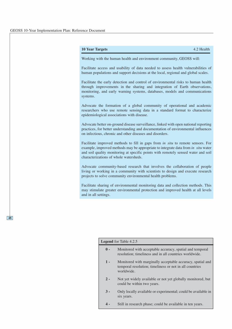
GEOSS 10-Year Implementation Plan: Reference Document
48
10 Year Targets 4.2 Health
Working with the human health and environment community, GEOSS will:
Facilitate access and usability of data needed to assess health vulnerabilities ofhuman populations and support decisions at the local, regional and global scales.
Facilitate the early detection and control of environmental risks to human healththrough improvements in the sharing and integration of Earth observations,monitoring, and early warning systems, databases, models and communicationssystems.
Advocate the formation of a global community of operational and academicresearchers who use remote sensing data in a standard format to characterizeepidemiological associations with disease.
Advocate better on-ground disease surveillance, linked with open national reportingpractices, for better understanding and documentation of environmental influenceson infectious, chronic and other diseases and disorders.
Facilitate improved methods to fill in gaps from in situ to remote sensors. Forexample, improved methods may be appropriate to integrate data from in situ waterand soil quality monitoring at specific points with remotely sensed water and soilcharacterizations of whole watersheds.
Advocate community-based research that involves the collaboration of peopleliving or working in a community with scientists to design and execute researchprojects to solve community environmental health problems.
Facilitate sharing of environmental monitoring data and collection methods. Thismay stimulate greater environmental protection and improved health at all levelsand in all settings.
Legend for Table 4.2.5
0 - Monitored with acceptable accuracy, spatial and temporalresolution; timeliness and in all countries worldwide.
1 - Monitored with marginally acceptable accuracy, spatial andtemporal resolution; timeliness or not in all countriesworldwide.
2 - Not yet widely available or not yet globally monitored, butcould be within two years.
3 - Only locally available or experimental; could be available insix years.
4 - Still in research phase; could be available in ten years.
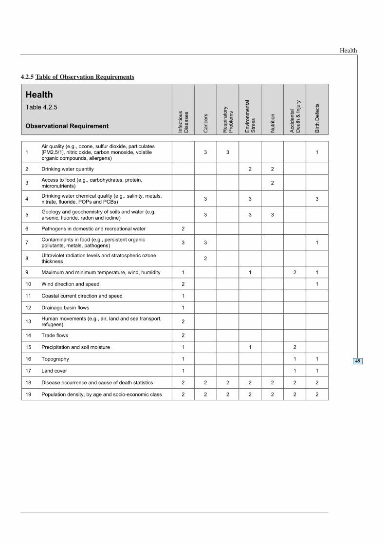
Health
4.2.5 Table of Observation Requirements
49
Health
Table 4.2.5
Observational Requirement
Infe
ctio
us
Dis
ea
se
s
Ca
nce
rs
Respirato
ryP
rob
lem
s
En
viro
nm
en
tal
Str
ess
Nutr
itio
n
Accid
en
tal
De
ath
& I
nju
ry
Birth
De
fects
1Air quality (e.g., ozone, sulfur dioxide, particulates[PM2.5/1], nitric oxide, carbon monoxide, volatileorganic compounds, allergens)
3 3 1
2 Drinking water quantity 2 2
3Access to food (e.g., carbohydrates, protein,
micronutrients)2
4Drinking water chemical quality (e.g., salinity, metals,nitrate, fluoride, POPs and PCBs)
3 3 3
5Geology and geochemistry of soils and water (e.g.
arsenic, fluoride, radon and iodine)3 3 3
6 Pathogens in domestic and recreational water 2
7Contaminants in food (e.g., persistent organicpollutants, metals, pathogens)
3 3 1
8Ultraviolet radiation levels and stratospheric ozonethickness
2
9 Maximum and minimum temperature, wind, humidity 1 1 2 1
10 Wind direction and speed 2 1
11 Coastal current direction and speed 1
12 Drainage basin flows 1
13Human movements (e.g., air, land and sea transport,refugees)
2
14 Trade flows 2
15 Precipitation and soil moisture 1 1 2
16 Topography 1 1 1
17 Land cover 1 1 1
18 Disease occurrence and cause of death statistics 2 2 2 2 2 2 2
19 Population density, by age and socio-economic class 2 2 2 2 2 2 2
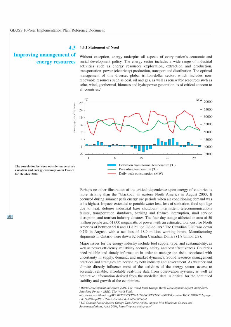
GEOSS 10-Year Implementation Plan: Reference Document
4.3.1 Statement of Need
Without exception, energy underpins all aspects of every nation’s economic andsocial development policy. The energy sector includes a wide range of industrialactivities such as energy resources exploration, extraction and production,transportation, power (electricity) production, transport and distribution. The optimalmanagement of this diverse, global trillion-dollar sector, which includes non-renewable resources such as coal, oil and gas, as well as renewable resources such assolar, wind, geothermal, biomass and hydropower generation, is of critical concern toall countries.8
Perhaps no other illustration of the critical dependence upon energy of countries ismore striking than the “blackout” in eastern North America in August 2003. Itoccurred during summer peak energy use periods when air conditioning demand wasat its highest. Impacts extended to potable water loss, loss of sanitation, food spoilagedue to heat, defense industrial base shutdown, intermittent telecommunicationsfailure, transportation shutdown, banking and finance interruption, mail servicedisruption, and tourism industry closures. The four-day outage affected an area of 50million people and 61,000 megawatts of power, with an estimated total cost for NorthAmerica of between $5.8 and 11.8 billion US dollars.9 The Canadian GDP was down0.7% in August, with a net loss of 18.9 million working hours. Manufacturingshipments in Ontario were down $2 billion Canadian Dollars (1.8 billion US).
Major issues for the energy industry include fuel supply, type, and sustainability, aswell as power efficiency, reliability, security, safety, and cost effectiveness. Countriesneed reliable and timely information in order to manage the risks associated withuncertainty in supply, demand, and market dynamics. Sound resource managementpractices and strategies are needed by both industry and government. As weather andclimate directly influence most of the activities of the energy sector, access toaccurate, reliable, affordable real-time data from observation systems, as well aspredictive information derived from the modelled data, is critical for the continuedstability and growth of the economies.
50
4.3Improving management of
energy resources
8 World Development indicators 2001, The World Bank Group; World Development Report 2000/2001,Attacking Poverty, IBRD, The World Bank.http://web.worldbank.org/WBSITE/EXTERNAL/TOPICS/EXTPOVERTY/0,,contentMDK:20194762~pagePK:148956~piPK:216618~theSitePK:336992,00.html9 US-Canada Power System Outage Task Force report: August 14th Blackout: Causes andRecommendations, April 2004, https://reports.energy.gov/
The correlation between outside temperaturevariation and energy consumption in Francefor October 2004
Cou
rtes
y of
C. F
il, E
DF,
Fra
nce
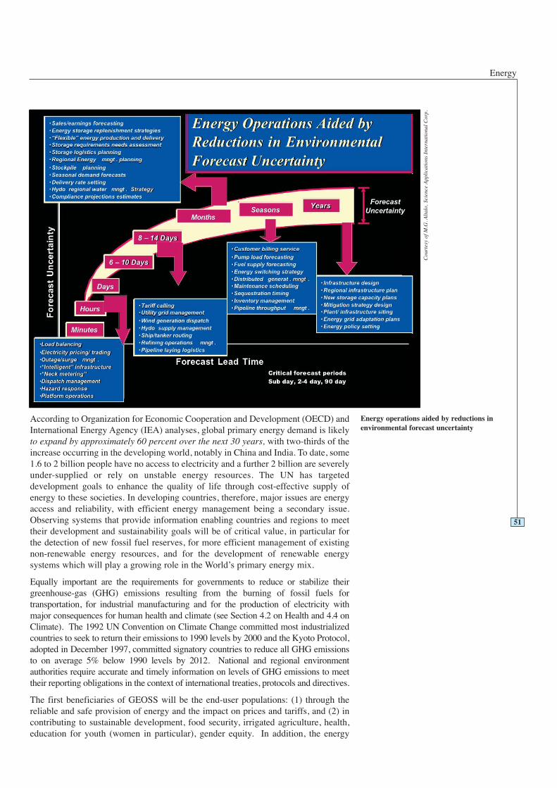
Energy
According to Organization for Economic Cooperation and Development (OECD) andInternational Energy Agency (IEA) analyses, global primary energy demand is likelyto expand by approximately 60 percent over the next 30 years, with two-thirds of theincrease occurring in the developing world, notably in China and India. To date, some1.6 to 2 billion people have no access to electricity and a further 2 billion are severelyunder-supplied or rely on unstable energy resources. The UN has targeteddevelopment goals to enhance the quality of life through cost-effective supply ofenergy to these societies. In developing countries, therefore, major issues are energyaccess and reliability, with efficient energy management being a secondary issue.Observing systems that provide information enabling countries and regions to meettheir development and sustainability goals will be of critical value, in particular forthe detection of new fossil fuel reserves, for more efficient management of existingnon-renewable energy resources, and for the development of renewable energysystems which will play a growing role in the World’s primary energy mix.
Equally important are the requirements for governments to reduce or stabilize theirgreenhouse-gas (GHG) emissions resulting from the burning of fossil fuels fortransportation, for industrial manufacturing and for the production of electricity withmajor consequences for human health and climate (see Section 4.2 on Health and 4.4 onClimate). The 1992 UN Convention on Climate Change committed most industrializedcountries to seek to return their emissions to 1990 levels by 2000 and the Kyoto Protocol,adopted in December 1997, committed signatory countries to reduce all GHG emissionsto on average 5% below 1990 levels by 2012. National and regional environmentauthorities require accurate and timely information on levels of GHG emissions to meettheir reporting obligations in the context of international treaties, protocols and directives.
The first beneficiaries of GEOSS will be the end-user populations: (1) through thereliable and safe provision of energy and the impact on prices and tariffs, and (2) incontributing to sustainable development, food security, irrigated agriculture, health,education for youth (women in particular), gender equity. In addition, the energy
51
Cou
rtes
y of
M.G
. Alt
alo,
Sci
ence
App
lica
tion
s In
tern
atio
nal
Cor
p.Energy operations aided by reductions inenvironmental forecast uncertainty
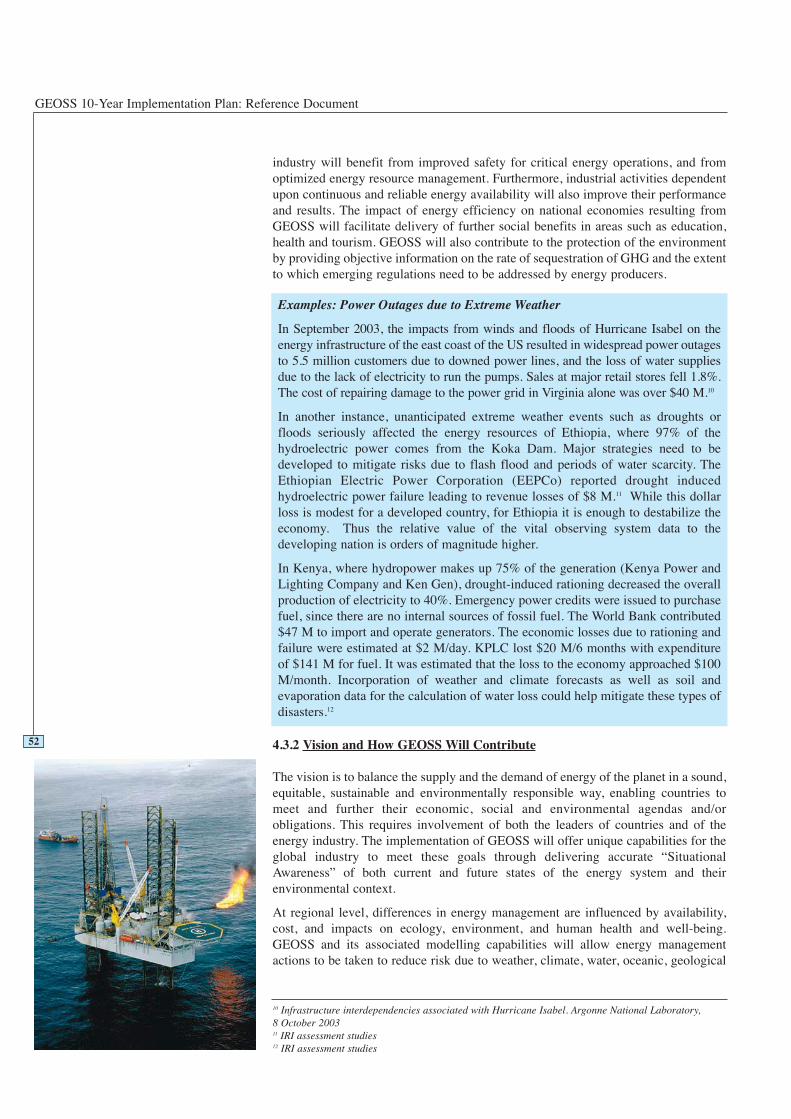
GEOSS 10-Year Implementation Plan: Reference Document
industry will benefit from improved safety for critical energy operations, and fromoptimized energy resource management. Furthermore, industrial activities dependentupon continuous and reliable energy availability will also improve their performanceand results. The impact of energy efficiency on national economies resulting fromGEOSS will facilitate delivery of further social benefits in areas such as education,health and tourism. GEOSS will also contribute to the protection of the environmentby providing objective information on the rate of sequestration of GHG and the extentto which emerging regulations need to be addressed by energy producers.
4.3.2 Vision and How GEOSS Will Contribute
The vision is to balance the supply and the demand of energy of the planet in a sound,equitable, sustainable and environmentally responsible way, enabling countries tomeet and further their economic, social and environmental agendas and/orobligations. This requires involvement of both the leaders of countries and of theenergy industry. The implementation of GEOSS will offer unique capabilities for theglobal industry to meet these goals through delivering accurate “SituationalAwareness” of both current and future states of the energy system and theirenvironmental context.
At regional level, differences in energy management are influenced by availability,cost, and impacts on ecology, environment, and human health and well-being.GEOSS and its associated modelling capabilities will allow energy managementactions to be taken to reduce risk due to weather, climate, water, oceanic, geological
Examples: Power Outages due to Extreme Weather
In September 2003, the impacts from winds and floods of Hurricane Isabel on theenergy infrastructure of the east coast of the US resulted in widespread power outagesto 5.5 million customers due to downed power lines, and the loss of water suppliesdue to the lack of electricity to run the pumps. Sales at major retail stores fell 1.8%.The cost of repairing damage to the power grid in Virginia alone was over $40 M.10
In another instance, unanticipated extreme weather events such as droughts orfloods seriously affected the energy resources of Ethiopia, where 97% of thehydroelectric power comes from the Koka Dam. Major strategies need to bedeveloped to mitigate risks due to flash flood and periods of water scarcity. TheEthiopian Electric Power Corporation (EEPCo) reported drought inducedhydroelectric power failure leading to revenue losses of $8 M.11 While this dollarloss is modest for a developed country, for Ethiopia it is enough to destabilize theeconomy. Thus the relative value of the vital observing system data to thedeveloping nation is orders of magnitude higher.
In Kenya, where hydropower makes up 75% of the generation (Kenya Power andLighting Company and Ken Gen), drought-induced rationing decreased the overallproduction of electricity to 40%. Emergency power credits were issued to purchasefuel, since there are no internal sources of fossil fuel. The World Bank contributed$47 M to import and operate generators. The economic losses due to rationing andfailure were estimated at $2 M/day. KPLC lost $20 M/6 months with expenditureof $141 M for fuel. It was estimated that the loss to the economy approached $100M/month. Incorporation of weather and climate forecasts as well as soil andevaporation data for the calculation of water loss could help mitigate these types ofdisasters.12
10 Infrastructure interdependencies associated with Hurricane Isabel. Argonne National Laboratory,8 October 200311 IRI assessment studies12 IRI assessment studies
52
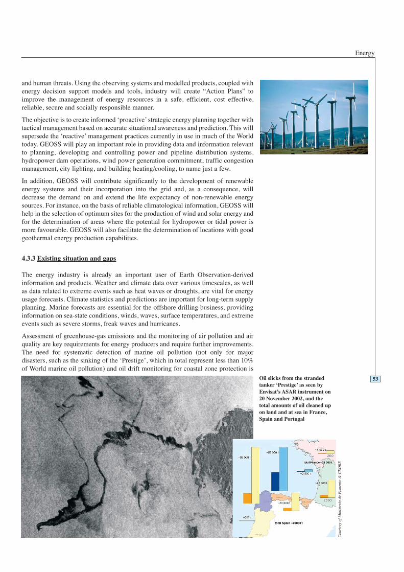
Energy
and human threats. Using the observing systems and modelled products, coupled withenergy decision support models and tools, industry will create “Action Plans” toimprove the management of energy resources in a safe, efficient, cost effective,reliable, secure and socially responsible manner.
The objective is to create informed ‘proactive’ strategic energy planning together withtactical management based on accurate situational awareness and prediction. This willsupersede the ‘reactive’ management practices currently in use in much of the Worldtoday. GEOSS will play an important role in providing data and information relevantto planning, developing and controlling power and pipeline distribution systems,hydropower dam operations, wind power generation commitment, traffic congestionmanagement, city lighting, and building heating/cooling, to name just a few.
In addition, GEOSS will contribute significantly to the development of renewableenergy systems and their incorporation into the grid and, as a consequence, willdecrease the demand on and extend the life expectancy of non-renewable energysources. For instance, on the basis of reliable climatological information, GEOSS willhelp in the selection of optimum sites for the production of wind and solar energy andfor the determination of areas where the potential for hydropower or tidal power ismore favourable. GEOSS will also facilitate the determination of locations with goodgeothermal energy production capabilities.
4.3.3 Existing situation and gaps
The energy industry is already an important user of Earth Observation-derivedinformation and products. Weather and climate data over various timescales, as wellas data related to extreme events such as heat waves or droughts, are vital for energyusage forecasts. Climate statistics and predictions are important for long-term supplyplanning. Marine forecasts are essential for the offshore drilling business, providinginformation on sea-state conditions, winds, waves, surface temperatures, and extremeevents such as severe storms, freak waves and hurricanes.
Assessment of greenhouse-gas emissions and the monitoring of air pollution and airquality are key requirements for energy producers and require further improvements.The need for systematic detection of marine oil pollution (not only for majordisasters, such as the sinking of the ‘Prestige’, which in total represent less than 10%of World marine oil pollution) and oil drift monitoring for coastal zone protection is
Oil slicks from the strandedtanker ‘Prestige’ as seen byEnvisat’s ASAR instrument on20 November 2002, and thetotal amounts of oil cleaned upon land and at sea in France,Spain and Portugal
Cou
rtes
y of
Min
iste
rio
de F
omen
to &
CE
DR
E
53
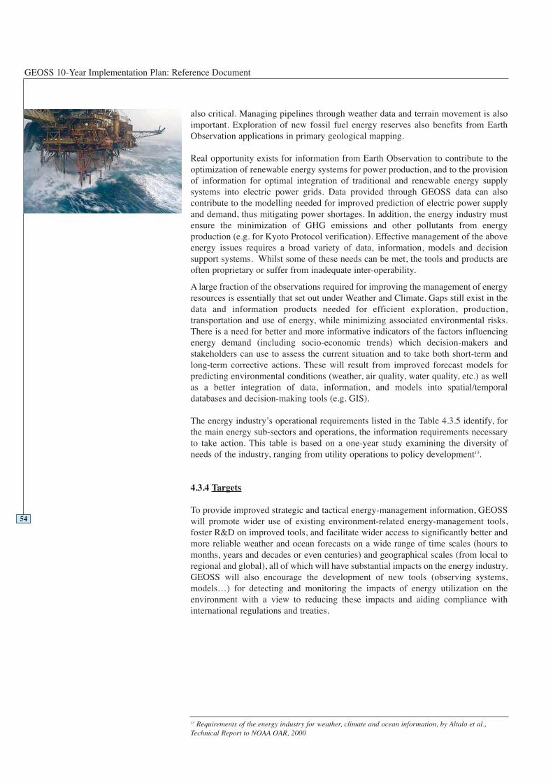
GEOSS 10-Year Implementation Plan: Reference Document
also critical. Managing pipelines through weather data and terrain movement is alsoimportant. Exploration of new fossil fuel energy reserves also benefits from EarthObservation applications in primary geological mapping.
Real opportunity exists for information from Earth Observation to contribute to theoptimization of renewable energy systems for power production, and to the provisionof information for optimal integration of traditional and renewable energy supplysystems into electric power grids. Data provided through GEOSS data can alsocontribute to the modelling needed for improved prediction of electric power supplyand demand, thus mitigating power shortages. In addition, the energy industry mustensure the minimization of GHG emissions and other pollutants from energyproduction (e.g. for Kyoto Protocol verification). Effective management of the aboveenergy issues requires a broad variety of data, information, models and decisionsupport systems. Whilst some of these needs can be met, the tools and products areoften proprietary or suffer from inadequate inter-operability.
A large fraction of the observations required for improving the management of energyresources is essentially that set out under Weather and Climate. Gaps still exist in thedata and information products needed for efficient exploration, production,transportation and use of energy, while minimizing associated environmental risks.There is a need for better and more informative indicators of the factors influencingenergy demand (including socio-economic trends) which decision-makers andstakeholders can use to assess the current situation and to take both short-term andlong-term corrective actions. These will result from improved forecast models forpredicting environmental conditions (weather, air quality, water quality, etc.) as wellas a better integration of data, information, and models into spatial/temporaldatabases and decision-making tools (e.g. GIS).
The energy industry’s operational requirements listed in the Table 4.3.5 identify, forthe main energy sub-sectors and operations, the information requirements necessaryto take action. This table is based on a one-year study examining the diversity ofneeds of the industry, ranging from utility operations to policy development13.
4.3.4 Targets
To provide improved strategic and tactical energy-management information, GEOSSwill promote wider use of existing environment-related energy-management tools,foster R&D on improved tools, and facilitate wider access to significantly better andmore reliable weather and ocean forecasts on a wide range of time scales (hours tomonths, years and decades or even centuries) and geographical scales (from local toregional and global), all of which will have substantial impacts on the energy industry.GEOSS will also encourage the development of new tools (observing systems,models…) for detecting and monitoring the impacts of energy utilization on theenvironment with a view to reducing these impacts and aiding compliance withinternational regulations and treaties.
54
13 Requirements of the energy industry for weather, climate and ocean information, by Altalo et al.,Technical Report to NOAA OAR, 2000
Energy
Short term (2 years)
The short-term goal in the energy industry must be to promote the use of existing dataand forecast information. Preparing the industry to receive and use the new GEOSSproducts when available is critical to the early success of GEOSS. To this end, it isessential that countries foster investments at local, national, and regional level inimproved energy management through use of Earth Observation data and informationproducts. Actions are needed as follows:
Medium term (6 years)
In the medium term, progress and improvement of energy resources managementactivities, ranging from exploration to exploitation, transport and distribution, will belargely related to the improvement of short- to medium-term (up to 8-10 days)weather predictions, as well as progress in seasonal to inter-annual climate forecastsresulting in particular from the utilization of a new generation of satellites coming on-line and improved models allowing better matching between demand and supply aswell as improved safety operations.
The continuous monitoring of atmospheric pollution and the improvement of airquality will result from the availability of operational daily global analyses ofgreenhouse gases, monthly estimates of the sources and sinks of CO2 (implyingsustained observations of ocean carbon at regional and global scales) plus dailyglobal/regional analyses complemented by available chemistry-transport modellingfor the forecasting of reactive gases and aerosols.
The development of new renewable energy systems will also benefit from existingand new Earth Observation techniques and satellite data to define optimum operatingconditions/locations for sites and minimize environmental impacts.
55
2 Year Targets 4.3 Energy
Working with the energy community, GEOSS will:
Facilitate the exchange and use of existing data/products and forecast informationthrough specific initiatives and actions in coordination with the energy community:(i) to raise awareness about the importance and potential of environmentalinformation; (ii) to facilitate access to the existing information and products; and(iii) to develop training and encourage the development of decision-support toolsfor optimal energy use.
Produce, in coordination with the energy community, a strategic 5-10 year plan forexploitation of the benefits of the new generation of operational observing systems- both space-based and in situ - which comes on-stream in this decade. The planshould include efforts on: (i) operationalizing existing research capabilities to meetthe needs of the energy industry; (ii) research and development in advanced end-to-end modelling and forecasting techniques (such as ensemble-based methods)covering both environmental and energy processes, and with an emphasis on issuesof risk assessment; (iii) the improvement of information networks by linkingexisting systems and making them inter-operable; (iv) continue efforts to raiseawareness of, facilitate access to, and operationalize improved methodologies forexploitation of GEOSS data and information products for the industry.

GEOSS 10-Year Implementation Plan: Reference Document
Long term (10 years)
Energy management needs and opportunities for improvement vary globally.However, in view of the increasing demand for energy and the simultaneous need toreduce environmental impacts, the energy sector will rely increasingly in the longterm on improved, tailored products and services derived from operational EarthObservation systems and modelling. The energy sector will also further support thedevelopment of renewable energy systems relying on products available throughGEOSS.
4.3.5 Table of Observation Requirements
56
Legend for Table 4.3.5
0 - Monitored with acceptable accuracy, spatial and temporalresolution; timeliness and in all countries worldwide.
1 - Monitored with marginally acceptable accuracy, spatial andtemporal resolution; timeliness or not in all countriesworldwide.
2 - Not yet widely available or not yet globally monitored, butcould be within two years.
3 - Only locally available or experimental; could be availablein six years.
4 - Still in research phase; could be available in ten years.
6 Year Targets 4.3 Energy
Working with the energy community, GEOSS will:
Produce an evaluation of the Plan’s progress with regard to energy and revisestrategy as needed. The revised Plan will also include an assessment of the needs ofthe energy sector for new and/or enhanced GEOSS observations and products.
Facilitate the exchange of data and products for efficient energy management.
Facilitate the use of improved weather and climate products for the development ofnew energy tailored products and services.
10 Year Targets 4.3 Energy
Working with the energy community, GEOSS will:
Facilitate the implementation of appropriate operational observing systems –space-based and in situ - for the continuous and sustainable provision of reliableand timely data in support of energy operations.
Advocate the development of new generation (higher resolution, additionalvariables…) weather and climate forecasting models.
Facilitate capacity building in order to bring energy management at the local levelto equivalent high (national and regional) levels of efficiency.
Facilitate the development of renewable energy systems taking advantage ofproducts available through GEOSS.

Energy
57
EnergyTable 4.3.5
Observational Requirement
Oil & Gas
Exploration,Development& Production
Operations(onshore &offshore)
Refining &
TransportOperations(at sea and
over land),EnvironmentalImpact of
Emissions &Transport
Renewable
EnergyOperations,Environmental
Impact of PlantSiting &Operations,
Biomass CropsOptimization
Electricity
Generation,Transmission& Distribution
Energy LoadDemand, &Supply
Forecasting
Global Energy
Management,EmissionsTrading,
Impact ofClimateChange,
Treaties &Regulations
Land Requirements
1Digital terrain model / digitaltopography maps*
2 2 2 2
2 Land use / Land cover maps* 2 2 2 2 2
3 Geological maps* 3 3 3
4 Soil maps & variables 3 3 3 3
5 Subsidence maps 3 3 3
6 Urban extent 2 2 2 2 2
7 Hydrological variables**3
(see Water)
3(see Water)
8 Crop variables**2
(see Agriculture)
*Depends on geographical scale and accuracy required.**Depends on types of variables required.
Atmosphere Requirements
9Weather and short-term climate
forecasts*1 (for 1 to 3-day forecast), 1 (for 3 to 10-day forecast), 3 (for climate forecast)
10Extreme weather & climate eventforecasts*
3 (for 1 to 5-day forecast)
11Measurements and forecasts of airpollutants
4 4 4 4 4
12Climate statistics for atmosphere
variables**3 3 3 3 3
*See Weather and Climate societal benefit areas for detailed information.
**Depends on types of variables required.
Ocean Requirements
13 Sea surface temperature* 1 1 (see Climate)
14 Sea ice* 2 2 (see Climate)
15 Sea-level* 1 1 1 (see Climate)
16 Tides* 1 1 1 (see Climate)
17 Surface currents* 2 2 2 (see Climate)
18 Sub-surface currents* 3 3 (see Climate)
19 Eddies* 3 3 (see Climate)
20 Salinity* 3 3 (see Climate)
21 Ocean color* 2 2 (see Climate)
22 Sea state* 1 1 1 (see Climate)
23 Surface wind speed and direction* 1 1 1 (see Climate)
24 Extreme event: Hurricanes* 2 2 2 2
25 Extreme event: Tsunami* 4 4 4 4
26 Extreme event: ENSO* 3 3 3 3 3
27 Bathymetry* 4
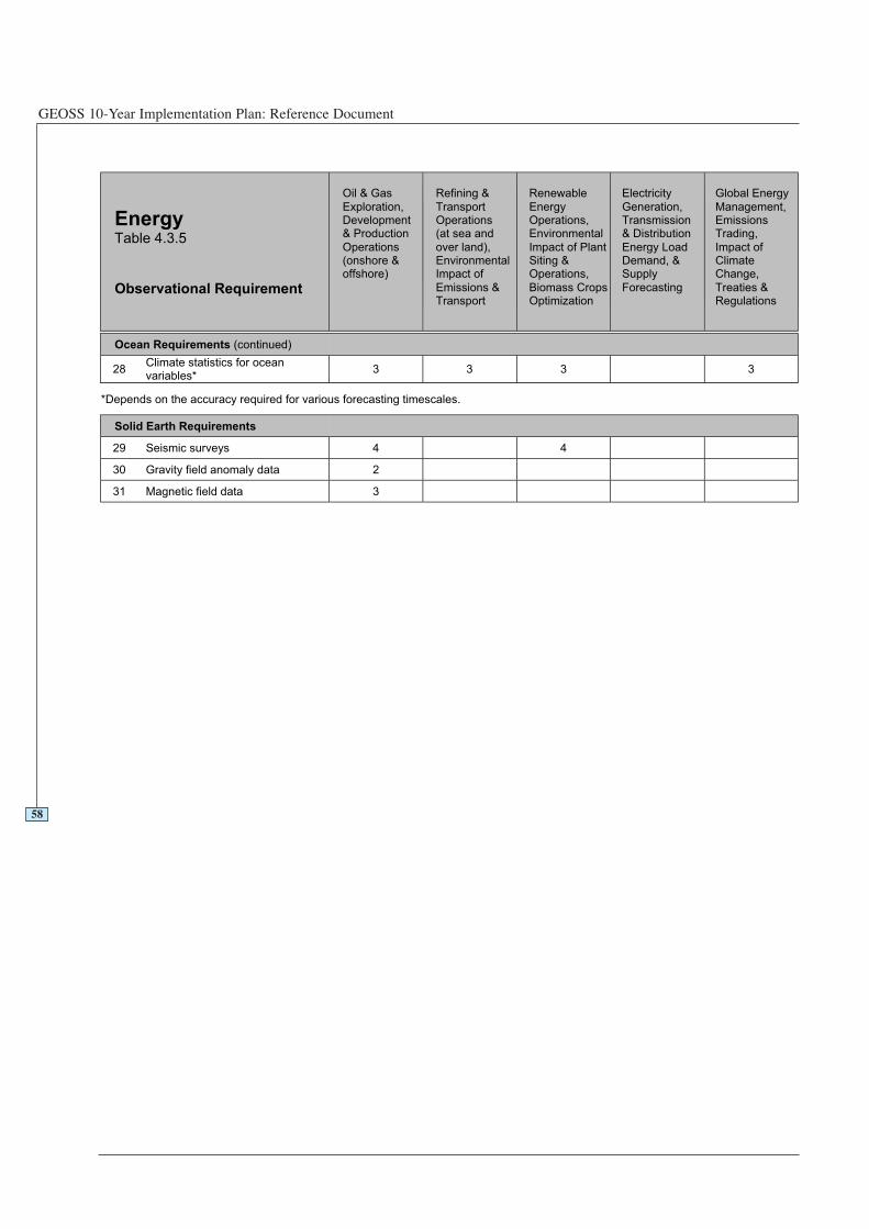
GEOSS 10-Year Implementation Plan: Reference Document
58
EnergyTable 4.3.5
Observational Requirement
Oil & Gas
Exploration,Development& Production
Operations(onshore &offshore)
Refining &
TransportOperations(at sea and
over land),EnvironmentalImpact of
Emissions &Transport
Renewable
EnergyOperations,Environmental
Impact of PlantSiting &Operations,
Biomass CropsOptimization
Electricity
Generation,Transmission& Distribution
Energy LoadDemand, &Supply
Forecasting
Global Energy
Management,EmissionsTrading,
Impact ofClimateChange,
Treaties &Regulations
Ocean Requirements (continued)
28Climate statistics for oceanvariables*
3 3 3 3
*Depends on the accuracy required for various forecasting timescales.
Solid Earth Requirements
29 Seismic surveys 4 4
30 Gravity field anomaly data 2
31 Magnetic field data 3
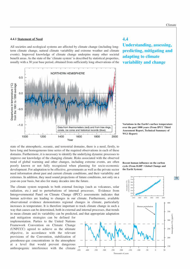
Climate
4.4.1 Statement of Need
All societies and ecological systems are affected by climate change (including long-term climate change, natural climate variability and extreme weather and climateevents). Improved knowledge of climate change underpins many other societalbenefit areas. As the state of the ‘climate system’ is described by statistical properties,usually with a 30 year base period, obtained from sufficiently long observations of the
state of the atmospheric, oceanic, and terrestrial domains, there is a need, firstly, tohave long and homogeneous time series of the required observations in each of thesedomains. Furthermore, it is necessary to identify the underlying dynamic processes toimprove our knowledge of the changing climate. Risks associated with the observedtrend of global warming and other changes, including extreme events, are oftenpoorly known or not fully recognized when planning for socio-economicdevelopment. For adaptation to be effective, governments as well as the private sectorneed information about past and current climate conditions, and their variability andextremes. In addition, they need sound projections of future conditions, not only on ayear-on-year basis, but also for many decades into the future.
The climate system responds to both external forcings (such as volcanoes, solarradiation, etc.) and to perturbations of internal processes. Evidence fromIntergovernmental Panel on Climate Change (IPCC) assessments indicates thathuman activities are leading to changes in our climate. Furthermore, availableobservational evidence demonstrates regional changes in climate, particularlyincreases in temperature. It is therefore important to track climate change in such away that causes can be determined, both in external and internal processes, that trendsin mean climate and its variability can be predicted, and that appropriate adaptationand mitigation strategies can be defined forimplementation. Parties to the United NationsFramework Convention on Climate Change(UNFCCC) agreed to achieve as the ultimateobjective, in accordance with the relevantprovisions of the Convention, stabilization ofgreenhouse-gas concentrations in the atmosphereat a level that would prevent dangerousanthropogenic interference with the climate
59
4.4Understanding, assessing,predicting, mitigating andadapting to climatevariability and change
Variations in the Earth’s surface temperatureover the past 1000 years (From IPCC ThirdAssessment Report, Technical Summary ofWG1 Report)
Recent human influence on the carboncycle (From IGBP / Global Change andthe Earth System)

GEOSS 10-Year Implementation Plan: Reference Document
system. Such a level should be achieved within a time frame to allow ecosystems toadapt naturally, to ensure that food production is not threatened, and to enableeconomic development to proceed in a sustainable manner.
Human and technological capacity is needed for the end-to-end collection,management (including data quality control), exchange, archiving and utilization ofcurrent and future observations from the atmosphere, ocean, and terrestrial domains.Increased attention is needed to recover and access past records (both instrumentaland palaeoclimate reconstructions) in order to better establish the variability andlong-term trends in climate. Procedures for the storage and exchange of high qualitymetadata will need to be implemented. This stewardship is a significant challengesince developed countries are currently barely able to keep up with the growing influxof new data from satellites and in situ observations, while developing countries lackthe resources to meet the high costs of accessing such data. Furthermore, observingstandards and guidelines for required climate variables must be adopted andsupported by countries making observations. The Global Climate Observing System(GCOS) can provide the framework for this. In many cases, this may require thatoutside assistance be available so that countries can contribute to and make use of aglobal climate network.
60
Example: Climate Extremes Warning System for Seasonal Forecasts
Five years from now, in June, seasonal climate forecasts predict an exceptionallystrong El Niño event for the following December to February season in the Pacific,with heavy impact on regional weather patterns in parts of Latin America. A timelyand tailored forecast is broadly disseminated and provides the opportunity to planadequate mitigation measures in all affected regions and with respect to varioussocietal areas for the coming months: in the agriculture sector, farmers inNorthwestern Peru, Southern Ecuador and Uruguay are advised to expect anincreased likelihood of heavy rainfalls and prepare for reducing possible flooddamage, thereby improving national food security; Northeast Brazilian farmers are
Cou
rtes
y of
R. S
char
roo,
NO
AA
Satellite altimetry measurements of sea-level rise
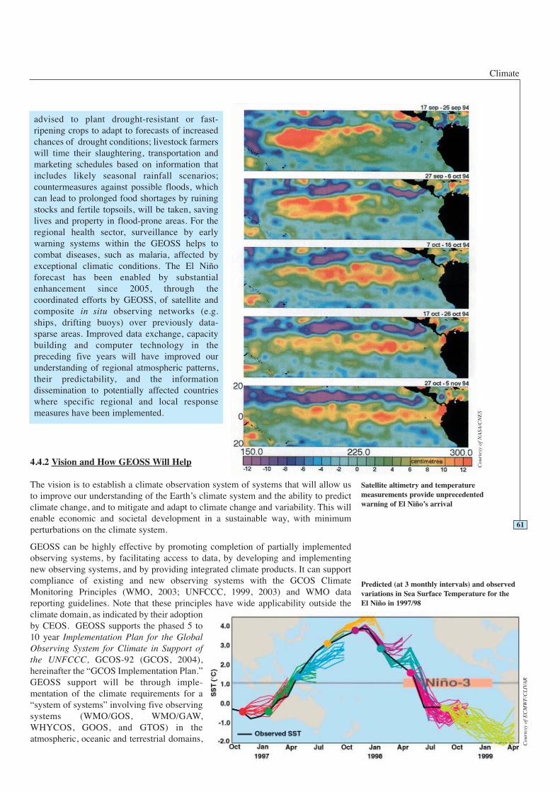
Climate
4.4.2 Vision and How GEOSS Will Help
The vision is to establish a climate observation system of systems that will allow usto improve our understanding of the Earth’s climate system and the ability to predictclimate change, and to mitigate and adapt to climate change and variability. This willenable economic and societal development in a sustainable way, with minimumperturbations on the climate system.
GEOSS can be highly effective by promoting completion of partially implementedobserving systems, by facilitating access to data, by developing and implementingnew observing systems, and by providing integrated climate products. It can supportcompliance of existing and new observing systems with the GCOS ClimateMonitoring Principles (WMO, 2003; UNFCCC, 1999, 2003) and WMO datareporting guidelines. Note that these principles have wide applicability outside theclimate domain, as indicated by their adoptionby CEOS. GEOSS supports the phased 5 to10 year Implementation Plan for the GlobalObserving System for Climate in Support ofthe UNFCCC, GCOS-92 (GCOS, 2004),hereinafter the “GCOS Implementation Plan.”GEOSS support will be through imple-mentation of the climate requirements for a“system of systems” involving five observingsystems (WMO/GOS, WMO/GAW,WHYCOS, GOOS, and GTOS) in theatmospheric, oceanic and terrestrial domains,
61
advised to plant drought-resistant or fast-ripening crops to adapt to forecasts of increasedchances of drought conditions; livestock farmerswill time their slaughtering, transportation andmarketing schedules based on information thatincludes likely seasonal rainfall scenarios;countermeasures against possible floods, whichcan lead to prolonged food shortages by ruiningstocks and fertile topsoils, will be taken, savinglives and property in flood-prone areas. For theregional health sector, surveillance by earlywarning systems within the GEOSS helps tocombat diseases, such as malaria, affected byexceptional climatic conditions. The El Niñoforecast has been enabled by substantialenhancement since 2005, through thecoordinated efforts by GEOSS, of satellite andcomposite in situ observing networks (e.g.ships, drifting buoys) over previously data-sparse areas. Improved data exchange, capacitybuilding and computer technology in thepreceding five years will have improved ourunderstanding of regional atmospheric patterns,their predictability, and the informationdissemination to potentially affected countrieswhere specific regional and local responsemeasures have been implemented.
Predicted (at 3 monthly intervals) and observedvariations in Sea Surface Temperature for theEl Niño in 1997/98
Satellite altimetry and temperaturemeasurements provide unprecedentedwarning of El Niño’s arrival
Cou
rtes
y of
NA
SA/C
NE
S
Cou
rtes
y of
EC
MW
F/C
LIV
AR
GEOSS 10-Year Implementation Plan: Reference Document
including data access facilities for supporting interoperable use of large volumes ofdata from inhomogeneous information sources. At the same time, GEOSS can makeuse of the technical commissions of WMO, the achievements of the World ClimateProgramme (WCP) and the scientific guidance provided by the World ClimateResearch Programme (WCRP). This will be especially through the WCRP’s ten-yearstrategy, “Coordinated Observation and Prediction of the Earth System (COPES),”and through the IGOS-P Theme Reports on atmospheric chemistry, carbon-cycle,water cycle, and ocean, geohazards, and others under development.
Adapting to climate change, mitigating its impact, and assessing climate variability,will benefit from GEOSS through improvements in the provision of services to othersocio-economic areas, as many of them are linked to climate variability and change.GEOSS can improve the observational basis by working to ensure the sustainedoperation of essential networks and systems, including the continuity of satellitesystems, and by developing its activities in close contact with the scientificcommunity, in order to take advantage of new observation techniques. GEOSS willpromote data assimilation and modelling for the integration of in situ and satellitedata, for algorithm development, validation, and the creation of integrated productsthat improve understanding of the climate system. GEOSS can also facilitate bettertelecommunications networks to exchange the data sets in an operational mode. It isimportant to include metadata to ensure reliable data interpretation, to activate dataexchange, and to archive the increasing volume of data from very heterogeneoussources. GEOSS will support such data centre functions that systematically meet userrequirements.
Because all countries contribute to factors affecting climate variability and human-induced change and are affected by them in different ways, an understanding of thesephenomena and mitigation and adaptation to changes should be tailored to the specificpriorities of those countries by considering their national circumstances andgeographic locality, as well as to broader regional and global considerations. Forexample, small island countries and coastal communities may focus on the socio-economic impacts of sea-level rise, whereas inland countries and communities, suchas in the African Sahel, may consider the impacts of desertification a higher priority.Once the priorities and impacts are recognized, the necessary capabilities to assess,predict, mitigate and adapt to these priority issues at both the local and national levelshould be established. In turn, the contribution of their knowledge to the internationalcommunity will provide a more comprehensive global understanding of the Earth’sclimate. A capacity building commitment will require that national institutions ororganizations augment operational responsibility for making the observations and fortheir distribution, analysis, and archiving. To do this, sustained sources of funding areneeded. Countries with underdeveloped infrastructure or capacity could focus first onthe collection of essential in situ observations, both historical and future data sets,which provide valuable data for local applications and also contribute to the cross-calibration of satellite sensors. Higher priority observations, infrastructure, and evensustained operational activities, where national capacity is insufficient, could in somecases be supported by relevant funding mechanisms with appropriate internationalcoordination (such as the GCOS Cooperation Mechanism).
4.4.3 Existing Situation and Gaps
The IPCC Third Assessment Report (IPCC, 2001) highlighted scientific uncertaintiesthat need additional research as well as new observational data. The Essential ClimateVariables (ECVs) required for climate monitoring are identified in the GCOS SecondReport on the Adequacy of the Global Observing Systems for Climate in Support ofthe UNFCCC, GCOS-82 (GCOS, 2003), hereinafter “GCOS Second AdequacyReport,” and in the IGOS-P Theme Reports. Research activities aimed at improvingour capability to predict climate variability and change are coordinated by the WCRP
62
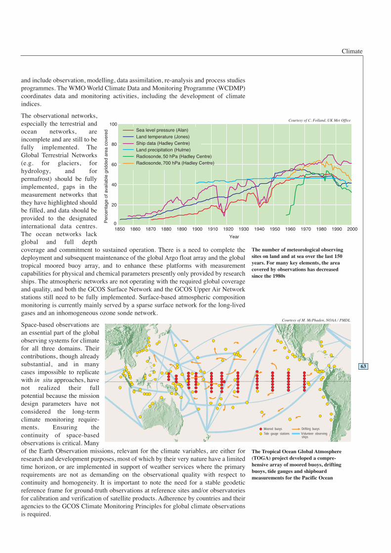
Climate
and include observation, modelling, data assimilation, re-analysis and process studiesprogrammes. The WMO World Climate Data and Monitoring Programme (WCDMP)coordinates data and monitoring activities, including the development of climateindices.
The observational networks,especially the terrestrial andocean networks, areincomplete and are still to befully implemented. TheGlobal Terrestrial Networks(e.g. for glaciers, forhydrology, and forpermafrost) should be fullyimplemented, gaps in themeasurement networks thatthey have highlighted shouldbe filled, and data should beprovided to the designatedinternational data centres.The ocean networks lackglobal and full depthcoverage and commitment to sustained operation. There is a need to complete thedeployment and subsequent maintenance of the global Argo float array and the globaltropical moored buoy array, and to enhance these platforms with measurementcapabilities for physical and chemical parameters presently only provided by researchships. The atmospheric networks are not operating with the required global coverageand quality, and both the GCOS Surface Network and the GCOS Upper Air Networkstations still need to be fully implemented. Surface-based atmospheric compositionmonitoring is currently mainly served by a sparse surface network for the long-livedgases and an inhomogeneous ozone sonde network.
Space-based observations arean essential part of the globalobserving systems for climatefor all three domains. Theircontributions, though alreadysubstantial, and in manycases impossible to replicatewith in situ approaches, havenot realized their fullpotential because the missiondesign parameters have notconsidered the long-termclimate monitoring require-ments. Ensuring thecontinuity of space-basedobservations is critical. Manyof the Earth Observation missions, relevant for the climate variables, are either forresearch and development purposes, most of which by their very nature have a limitedtime horizon, or are implemented in support of weather services where the primaryrequirements are not as demanding on the observational quality with respect tocontinuity and homogeneity. It is important to note the need for a stable geodeticreference frame for ground-truth observations at reference sites and/or observatoriesfor calibration and verification of satellite products. Adherence by countries and theiragencies to the GCOS Climate Monitoring Principles for global climate observationsis required.
63
The number of meteorological observingsites on land and at sea over the last 150years. For many key elements, the areacovered by observations has decreasedsince the 1980s
Courtesy of C. Folland, UK Met Office
The Tropical Ocean Global Atmosphere(TOGA) project developed a compre-hensive array of moored buoys, driftingbuoys, tide gauges and shipboardmeasurements for the Pacific Ocean
Courtesy of M. McPhaden, NOAA / PMDL
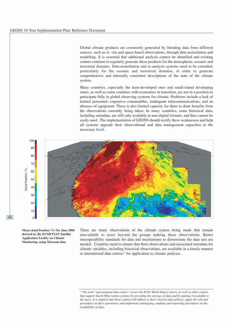
GEOSS 10-Year Implementation Plan: Reference Document
Global climate products are commonly generated by blending data from differentsources, such as in situ and space-based observations, through data assimilation andmodelling. It is essential that additional analysis centres be identified and existingcentres continue to regularly generate these products for the atmospheric, oceanic andterrestrial domains. Data-assimilation and re-analysis systems need to be extended,particularly for the oceanic and terrestrial domains, in order to generatecomprehensive and internally consistent descriptions of the state of the climatesystem.
Many countries, especially the least-developed ones and small-island developingstates, as well as some countries with economies in transition, are not in a position toparticipate fully in global observing systems for climate. Problems include a lack oftrained personnel, expensive consumables, inadequate telecommunications, and anabsence of equipment. There is also limited capacity for them to draw benefits fromthe observations currently being taken. In many countries, some historical data,including metadata, are still only available in non-digital formats, and thus cannot beeasily used. The implementation of GEOSS should rectify these weaknesses and helpall systems upgrade their observational and data management capacities to thenecessary level.
There are many observations of the climate system being made that remainunavailable to users beyond the groups making those observations. Betterinteroperability standards for data and mechanisms to disseminate the data sets areneeded. Countries need to ensure that their observations and associated metadata forclimate variables, including historical observations, are available in a timely mannerat international data centres14 for application to climate analyses.
64
14 The term “international data centre” covers the ICSU World Data Centers, as well as other centresthat support Earth Observation systems by providing the storage of data and by making it available tothe users. It is implicit that these centres will adhere to their relevant data policies, apply the relevantprocedures in their operations, and implement cataloguing, auditing and reporting procedures on theavailability of data.
Mean cloud fraction (%) for June 2004derived by the EUMETSAT SatelliteApplication Facility on ClimateMonitoring, using Meteosat data
Climate
4.4.4 Targets
2 Year Targets 4.4 Climate
Working with the climate community, GEOSS will:
Support GCOS Surface and GCOS Upper Air Networks, Global Atmosphere Watch(GAW) observatories, initial Global Ocean Observing System (GOOS), riverdischarge, lake level, soil moisture, permafrost, snow cover and glacier observingnetworks, which are recommended in the GCOS Implementation Plan.
Support implementation of actions called for in GCOS Implementation Plan and therelevant IGOS-P Theme Reports.
Improve the reporting of observations to international data and analysis centres interms of data volumes, quality and timeliness.
Improve the capability of international data centres for data archiving and distributionof data and products.
Establish a strong collaboration mechanism between observational organizations andresearch communities, and users of climate information, to further refine theobservations, analyses and products required.
Identify the needs and solutions necessary to implement the global observing systemsfor climate in all regions and countries based on the recommendation of GCOSImplementation Plan and specific regional action plans.
Initiate an intergovernmental mechanism in the terrestrial domain to prepare and issueregulatory and guidance information on observational procedures and datamanagement as, for example, also asked for in decision 9/CP.9 (UNFCCC, 2003).
Support JCOMM to coordinate the implementation of and prepare regulatory andguidance information for an operational in situ ocean observing system.
Emphasize to satellite agencies the importance of satellites for long-term climatemonitoring, and advocate that all Earth observing satellite systems adhere to theGCOS Climate Monitoring Principles (WMO, 2003) and commit to the suite ofinstrumentation called for in the GCOS Implementation Plan and in the relevantIGOS-P Theme Reports.
Focus on research programmes to support the development of observationalcapabilities for ECVs such as tropospheric ozone, cloud and aerosol properties andtheir vertical profiles, CO2 and other greenhouse gases, soil moisture andgroundwater, above-ground biomass, permafrost, snow cover and glaciers, and oceansalinity, carbon and nutrients and their vertical profiles.
Coordinate climate sectors and broad user groups to clarify and specify requirementsfor socio-economic benefit areas (disaster prevention, health, energy, water resources,ecosystem, agriculture, and biodiversity) for climate products and information.
Enforce palaeoclimate research to improve knowledge about historical and currentclimate change, by combining natural science data and socio-economic information.
Promote the improvement of emission databases for aerosols, greenhouse gases andtheir precursors.
65
GEOSS 10-Year Implementation Plan: Reference Document
66
6 Year Targets 4.4 Climate
Working with the climate community, GEOSS will:
Enhance the collaboration mechanism between observation organizations andresearch communities with users of climate information to make maximum use ofthe observations, analyses and products.
Support implementation of actions called for in the GCOS Implementation Plan andthe relevant IGOS-P Theme Reports.
Promote the establishment of data archive centres for all ECVs.
Promote institutional commitments to provide integrated global analyses of allECVs.
Develop data integration facilities for exchanging data, products and informationbetween climate sectors and socio-economic benefit areas.
Emphasize detection of current and historical climate changes and their impactslinked with other societal benefit areas such as disaster, health, water, ecosystemand agriculture by combining the natural scientific data and socio-economicinformation and enforcing palaeoclimate research approaches.
Develop and operate new in situ and/or space-based observation instruments forthe observation of ECV such as cloud and aerosol properties and their verticalprofiles, ocean salinity, ocean carbon and nutrients, soil moisture and ground water,CO2 and other greenhouse gases.
10 Year Targets 4.4 Climate
Working with the climate community, GEOSS will:
Provide support to the development of a long-term strategy that encompassesprogress in observation, data assimilation and modelling.
Support implementation of actions called for in the GCOS Implementation Plan andthe relevant IGOS-P Theme Reports.
Promote new and extended re-analysis programmes for the oceanic, terrestrial andatmospheric domains.
Contribute to major advances in the monitoring and predictability of climate onseasonal, interannual and decadal time scales, including the occurrence of extremeevents.
Establish an evaluation mechanism for climate product applicability to socio-economic benefits.
Support climate sectors to implement tailored approaches to respond to socio-economic requirements.
Promote implementation of an integrated observing system for atmosphericcomposition monitoring in support of climate policy through an optimalcombination of ground-based networks, low Earth orbit and geostationary satellitesand models.
Climate
4.4.5 Table of Observation Requirements
Table 4.4.5 includes the ECVs identified in the GCOS Second Adequacy Report.Each box shows the observational situation for that application. An empty boxindicates that a variable is assumed not to be relevant for this application.
Please see Table 4.4.5 on the following page.
67
Legend for Table 4.4.5
0 - Monitored with acceptable accuracy, spatial and temporalresolution; timeliness and in all countries worldwide.
1 - Monitored with marginally acceptable accuracy, spatial andtemporal resolution; timeliness or not in all countriesworldwide.
2 - Not yet widely available or not yet globally monitored, butcould be within two years.
3 - Only locally available or experimental; could be available insix years.
4 - Still in research phase; could be available in ten years.
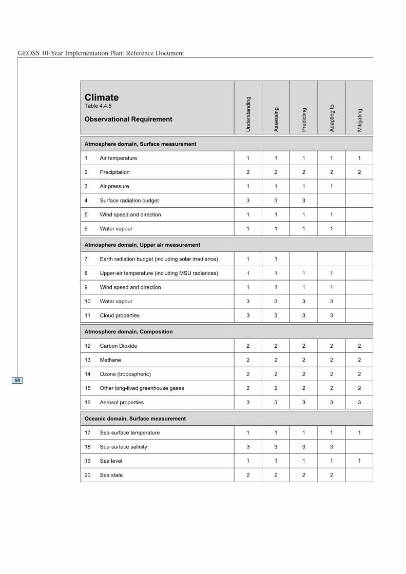
GEOSS 10-Year Implementation Plan: Reference Document
68
ClimateTable 4.4.5
Observational Requirement
Un
de
rsta
nd
ing
Asse
ssin
g
Pre
dic
tin
g
Ad
ap
tin
g t
o
Mitig
ating
Atmosphere domain, Surface measurement
1 Air temperature 1 1 1 1 1
2 Precipitation 2 2 2 2 2
3 Air pressure 1 1 1 1
4 Surface radiation budget 3 3 3
5 Wind speed and direction 1 1 1 1
6 Water vapour 1 1 1 1
Atmosphere domain, Upper air measurement
7 Earth radiation budget (including solar irradiance) 1 1
8 Upper-air temperature (including MSU radiances) 1 1 1 1
9 Wind speed and direction 1 1 1 1
10 Water vapour 3 3 3 3
11 Cloud properties 3 3 3 3
Atmosphere domain, Composition
12 Carbon Dioxide 2 2 2 2 2
13 Methane 2 2 2 2 2
14 Ozone (tropospheric) 2 2 2 2 2
15 Other long-lived greenhouse gases 2 2 2 2 2
16 Aerosol properties 3 3 3 3 3
Oceanic domain, Surface measurement
17 Sea-surface temperature 1 1 1 1 1
18 Sea-surface salinity 3 3 3 3
19 Sea level 1 1 1 1 1
20 Sea state 2 2 2 2
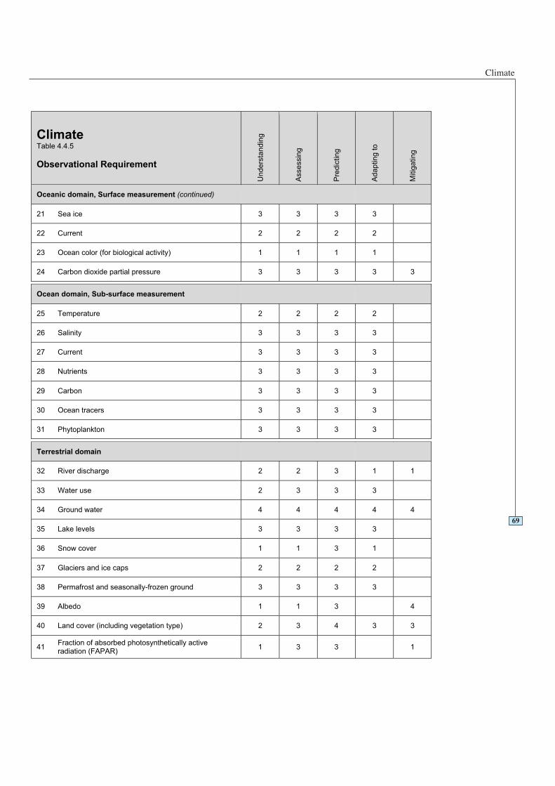
Climate
69
ClimateTable 4.4.5
Observational Requirement
Un
de
rsta
nd
ing
Asse
ssin
g
Pre
dic
tin
g
Ad
ap
tin
g t
o
Mitig
ating
Oceanic domain, Surface measurement (continued)
21 Sea ice 3 3 3 3
22 Current 2 2 2 2
23 Ocean color (for biological activity) 1 1 1 1
24 Carbon dioxide partial pressure 3 3 3 3 3
Ocean domain, Sub-surface measurement
25 Temperature 2 2 2 2
26 Salinity 3 3 3 3
27 Current 3 3 3 3
28 Nutrients 3 3 3 3
29 Carbon 3 3 3 3
30 Ocean tracers 3 3 3 3
31 Phytoplankton 3 3 3 3
Terrestrial domain
32 River discharge 2 2 3 1 1
33 Water use 2 3 3 3
34 Ground water 4 4 4 4 4
35 Lake levels 3 3 3 3
36 Snow cover 1 1 3 1
37 Glaciers and ice caps 2 2 2 2
38 Permafrost and seasonally-frozen ground 3 3 3 3
39 Albedo 1 1 3 4
40 Land cover (including vegetation type) 2 3 4 3 3
41Fraction of absorbed photosynthetically activeradiation (FAPAR)
1 3 3 1
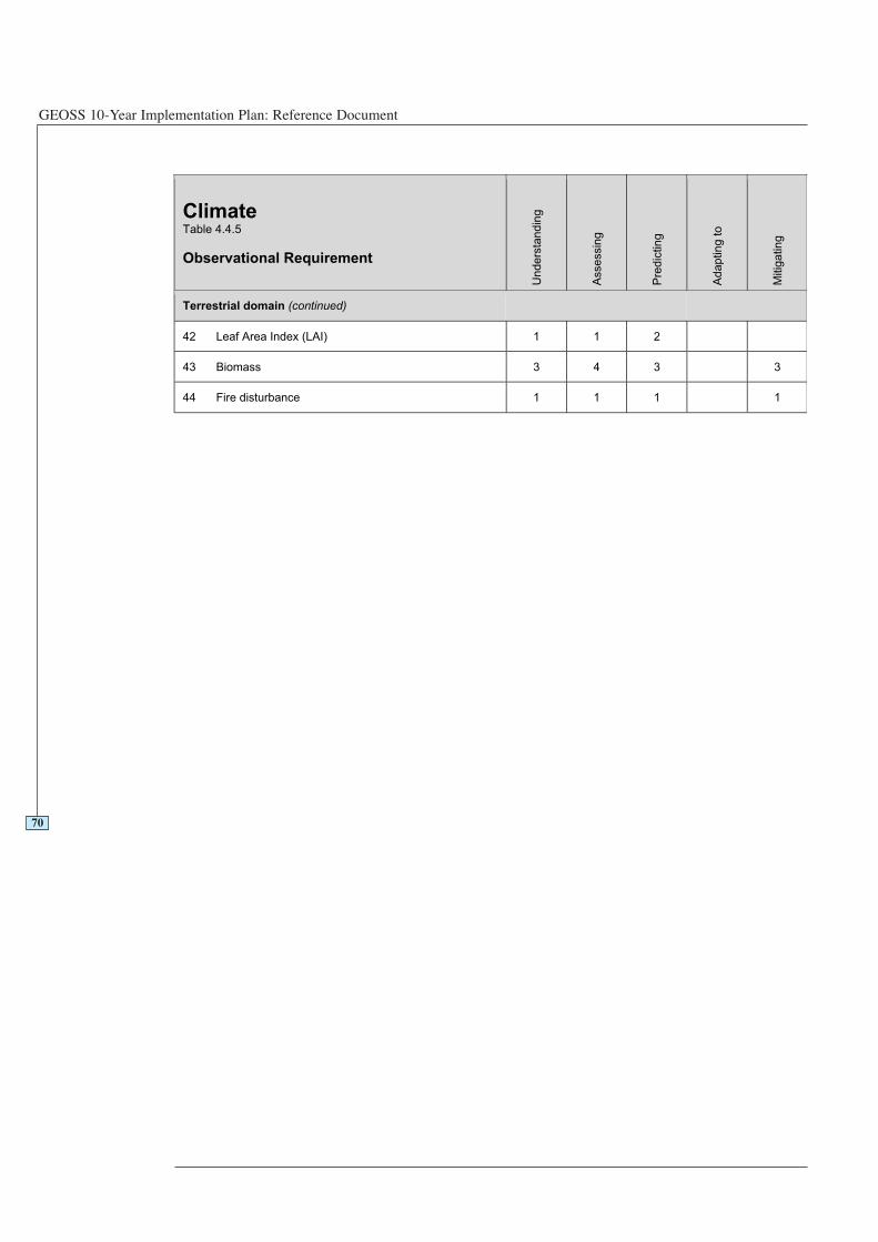
GEOSS 10-Year Implementation Plan: Reference Document
70
ClimateTable 4.4.5
Observational Requirement
Un
de
rsta
nd
ing
Asse
ssin
g
Pre
dic
ting
Ad
ap
tin
g t
o
Mitig
ating
Terrestrial domain (continued)
42 Leaf Area Index (LAI) 1 1 2
43 Biomass 3 4 3 3
44 Fire disturbance 1 1 1 1
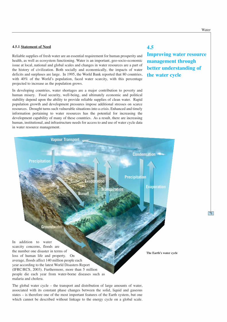
Water
4.5.1 Statement of Need
Reliable supplies of fresh water are an essential requirement for human prosperity andhealth, as well as ecosystem functioning. Water is an important, geo-socio-economicissue at local, national and global scales and changes in water resources are a part ofthe history of civilization. Both socially and economically, the impacts of waterdeficits and surpluses are large. In 1995, the World Bank reported that 80 countries,with 40% of the World’s population, faced water scarcity, with this percentageprojected to increase as the population grows.
In developing countries, water shortages are a major contribution to poverty andhuman misery. Food security, well-being, and ultimately economic and politicalstability depend upon the ability to provide reliable supplies of clean water. Rapidpopulation growth and development pressures impose additional stresses on scarceresources. Drought turns such vulnerable situations into a crisis. Enhanced and timelyinformation pertaining to water resources has the potential for increasing thedevelopment capability of many of these countries. As a result, there are increasinghuman, institutional, and infrastructure needs for access to and use of water cycle datain water resource management.
In addition to waterscarcity concerns, floods arethe number one disaster in terms ofloss of human life and property. Onaverage, floods affect 140 million people eachyear according to the latest World Disasters Report(IFRC/RCS, 2003). Furthermore, more than 5 millionpeople die each year from water-borne diseases such asmalaria and cholera.
The global water cycle – the transport and distribution of large amounts of water,associated with its constant phase changes between the solid, liquid and gaseousstates – is therefore one of the most important features of the Earth system, but onewhich cannot be described without linkage to the energy cycle on a global scale.
71
4.5Improving water resourcemanagement throughbetter understanding ofthe water cycle
The Earth’s water cycle
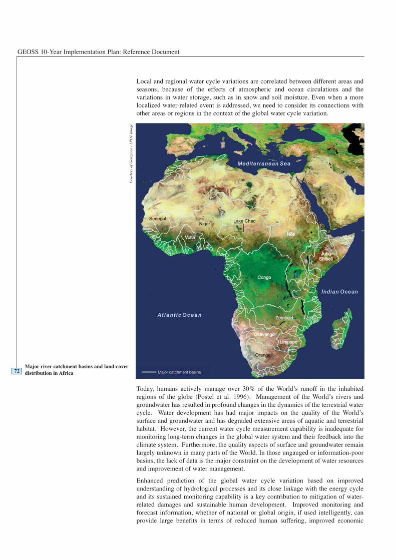
GEOSS 10-Year Implementation Plan: Reference Document
Local and regional water cycle variations are correlated between different areas andseasons, because of the effects of atmospheric and ocean circulations and thevariations in water storage, such as in snow and soil moisture. Even when a morelocalized water-related event is addressed, we need to consider its connections withother areas or regions in the context of the global water cycle variation.
Today, humans actively manage over 30% of the World’s runoff in the inhabitedregions of the globe (Postel et al. 1996). Management of the World’s rivers andgroundwater has resulted in profound changes in the dynamics of the terrestrial watercycle. Water development has had major impacts on the quality of the World’ssurface and groundwater and has degraded extensive areas of aquatic and terrestrialhabitat. However, the current water cycle measurement capability is inadequate formonitoring long-term changes in the global water system and their feedback into theclimate system. Furthermore, the quality aspects of surface and groundwater remainlargely unknown in many parts of the World. In those ungauged or information-poorbasins, the lack of data is the major constraint on the development of water resourcesand improvement of water management.
Enhanced prediction of the global water cycle variation based on improvedunderstanding of hydrological processes and its close linkage with the energy cycleand its sustained monitoring capability is a key contribution to mitigation of water-related damages and sustainable human development. Improved monitoring andforecast information, whether of national or global origin, if used intelligently, canprovide large benefits in terms of reduced human suffering, improved economic
72Major river catchment basins and land-coverdistribution in Africa
Cou
rtes
y of
Geo
spac
e /
SPO
TIm
age
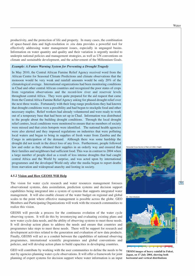
Water
productivity, and the protection of life and property. In many cases, the combinationof space-based data and high-resolution in situ data provides a powerful tool foreffectively addressing water management issues, especially in ungauged basins.Information on water quantity and quality and their variation is urgently needed tounderpin national policies and management strategies, as well as UN conventions onclimate and sustainable development, and the achievement of the Millennium Goals.
4.5.2 Vision and How GEOSS Will Help
The vision for water cycle research and water resources management foreseesobservational systems, data assimilation, prediction systems and decision supportcapabilities being integrated into a system of systems that supports integrated watermanagement. It will also enable closure of the water budget on regional and globalscales to the point where effective management is possible across the globe. GEOMembers and Participating Organizations will work with the research communities torealize this vision.
GEOSS will provide a process for the continuous evolution of the water cycleobserving system. It will do this by inventorying and evaluating existing plans andnew water cycle data needs, and the ability of observing systems to meet those needs.It will develop action plans to address the needs and ensure that countries andprogrammes take steps to meet those needs. There will be support for research anddevelopment activities related to the generation and evaluation of new data products.Finally, GEOSS will act as a conduit between the capabilities of national observingprogrammes, international scientific programmes and global conventions andpolicies, and will develop action plans to build capacities in developing countries.
GEO will contribute by working with the user communities to define the needs to bemet by agencies planning water cycle observations. It will offer a framework for jointplanning of expert systems for decision support where water information is an input
73
Example: A Future Warning System for Preventing a Drought Tragedy
In May 2010, the Central African Famine Relief Agency received word from theAfrican Centre for Seasonal Climate Predictions and climate observations that themonsoon would be very weak and rainfall amounts would be only 20% of theclimatological average. International organizations had been monitoring conditionsin Chad and other central African countries and recognized the poor states of cropsfrom vegetation observations and the record-low river and reservoir levelsthroughout central Africa. They were quite prepared for the aid request that camefrom the Central Africa Famine Relief Agency asking for phased drought relief overthe next three weeks. Fortunately with their long-range predictions they had knownthat drought conditions were a possibility and had begun to stockpile food and othernecessary staples. Relief workers had already volunteered and were ready to workout of a temporary base that had been set up in Chad. Information was distributedto the people about the building drought conditions. Through the local droughtrelief centres, local conditions were monitored to ensure that no members of societywere missed and that crisis hotspots were identified. The national health agencieswere also alerted and they imposed regulations on industries that were pollutinglocal waters and began to bring in supplies of fresh water from Zambia and theCongo in anticipation of the demand. Although there was some hardship thedrought did not result in the direct loss of any lives. Furthermore, people followedlaw and order as they obtained their supplies in an orderly way and ensured thattheir families and neighbours had sufficient food. This was in contrast to 2004 whena large number of people died as a result of less intense droughts that had caughtcentral Africa and the World by surprise, and was acted upon by internationalprogrammes and the developed World only after the media began to report deathsfrom starvation and widespread anarchy and looting in society.
TRMM images of heavy rainfall in Fukui,Japan, on 17 July 2004, showing bothhorizontal and vertical distributions
Cou
rtes
y of
EO
RC
/JA
XA
/TR
MM

GEOSS 10-Year Implementation Plan: Reference Document
(e.g. hydrologic prediction services) or is dependent on inputs from all other societalbenefit areas. It will also coordinate the development of a capacity building plan forthe use of Earth Observation data (satellite, surface and subsurface data) for watermanagement in developing countries.
On the operational side GEOSS will facilitate the development of new applications ofEarth Observation data in water quality and groundwater monitoring, oversee thedevelopment of plans to increase the accuracy and space and time resolution ofsatellite data relevant to water budgets, and facilitate the maintenance andenhancement of in situ hydrometeorological observations and internationalcoordination of planning and operating national in situ monitoring networks,including common standards.
GEOSS will also be active in promoting the integration and use of in situ data withremotely sensed data to produce new products, in order to provide the data needed todevelop indicators that will be useful in advising the international conventions, andmanagers concerned with integrated water management at a local level. This willinvolve facilitating access to water resource databases needed to develop expertsystems in support of integrated water management decisions.
4.5.3 Existing Situation and Gaps
Critical observations for closing water and energy budgets, detecting extreme events,and monitoring water environment are missing, including soil moisture, evaporation,surface wind speed, precipitable water over land, short-term heavy rainfall, and waterquality, although missions that will be launched over the next decade will start toaddress these needs. However, the sensor capability for these missions is not adequateto fully meet the requirements of many user communities. GCOS is taking stepstowards addressing the needs for soil moisture through the development of a referencenetwork (IGWCO, 2004, GCOS Implementation Plan, 2004).
Space agencies should fully implement planned space missions and are encouraged tocontinue new sensor development based on user needs. To the degree possible, spaceagencies should give priority to the development of effective sensors and missions forprecipitation, surface and subsurface water stores - including snow water equivalence,water stored in natural and man-made reservoirs, and groundwater. One of the most
74
Rain gauges deliver the most reliable data on precipitation amounts reaching the Earth’s surface, but only represent the nearbyenvironment of the station. This map shows the distribution of stations for precipitation data acquired by the GPCC from the nationalnetworks of WMO member countries (about 40,000 stations)
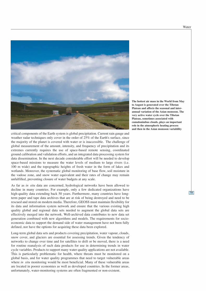
Water
critical components of the Earth system is global precipitation. Current rain gauge andweather radar techniques only cover in the order of 25% of the Earth's surface, sincethe majority of the planet is covered with water or is inaccessible. The challenge ofglobal measurement of the amount, intensity, and frequency of precipitation and itsextremes currently requires the use of space-based remote sensing, coordinatedground calibration and validation efforts, and an integrated data processing system fordata dissemination. In the next decade considerable effort will be needed to developspace-based missions to measure the water levels of medium to large rivers (i.e. 100 m wide) and the topographic heights of fresh water in the form of lakes andwetlands. Moreover, the systematic global monitoring of base flow, soil moisture inthe vadose zone, and snow water equivalent and their rates of change may remainunfulfilled, preventing closure of water budgets at any scale.
As far as in situ data are concerned, hydrological networks have been allowed todecline in many countries. For example, only a few dedicated organizations havehigh-quality data extending back 50 years. Furthermore, many countries have long-term paper and tape data archives that are at risk of being destroyed and need to berescued and stored on modern media. Therefore, GEOSS must maintain flexibility forits data and information system network and ensure that the various existing highquality global and regional data sets needed to augment the global data sets areeffectively merged into the network. Well-archived data contributes to new data setgeneration combined with new algorithms and models. The requirements for socio-economic data to support the demand side of water management have not been fullydefined, nor have the options for acquiring these data been explored.
Long-term global data sets and products covering precipitation, water vapour, clouds,snow cover, and glaciers are essential for assessing trends. Given the tendency ofnetworks to change over time and for satellites to drift or be moved, there is a needfor routine reanalysis of such data products for use in determining trends in watercycle variables. Products to support many water quality applications are not available.This is particularly problematic for health, where threats must be monitored on aglobal basis, and for water quality programmes that need to target vulnerable areaswhere in situ monitoring would be most beneficial. Many of these vulnerable areasare located in poorer economies as well as developed countries. In the former areas,unfortunately, water-monitoring systems are often fragmented or non-existent.
75
The hottest air mass in the World from Mayto August is generated over the TibetanPlateau and affects the seasonal and inter-annual variation of the Asian monsoon. Thevery active water cycle over the TibetanPlateau, sometimes associated withcumulonimbus clouds, plays an importantrole in the atmospheric heating processand then in the Asian monsoon variability

GEOSS 10-Year Implementation Plan: Reference Document
A comprehensive, coupled, land-atmosphere-ocean data assimilation capability isneeded to optimize the use of advanced data systems. The process and budgeting forthe transfer of systems from a research environment to operations needs to bestrengthened. Currently, although data archives exist for special collections, there isinsufficient integration capacity for global observing systems. This situation isaggravated by incompatible data management plans among the individualcomponents. A special challenge is the development of assimilation methodologiesto integrate satellite and in situ observations, and the development of high-performance distributed data management and archiving systems with harmonizedaccess nodes to use data from largely different sources for studies of the global watercycle. A prototype data integration system is being demonstrated by the CEOP(Coordinated Enhanced Observing Period). An overall plan for in situ and satellitewater cycle observational systems is needed so that data can be readily exchanged,standards can be set, and data quality can be monitored. Elements of such planningdo occur at present within the IGOS-P Water Cycle Theme. Also, a strong applicationplan is necessary for GEOSS to demonstrate its practical use. For this it is importantto provide the methodology to translate the GEOSS data into the information needed,e.g. translating remote-sensing data into local discharges for ungauged basins.Demonstration programmes are especially important in countries that suffer from lackof data or have little expertise in data assembly and interpretation.
National policies regarding copyright laws and the sale of data have led to problemswith the free and open distribution of hydrological data. Although WMO andUNESCO have established international policies and practices for free andunrestricted exchange of hydrological data, there are some practical problems inimplementing these policies and there is room for improvement in the flow ofhydrological data.
Many developing countries lack the basic capabilities needed to access, interpret, andapply water cycle information available from satellite systems. While hardware and
76
The Amazon River Basin observedwith the Radar Altimeter on ERS-1
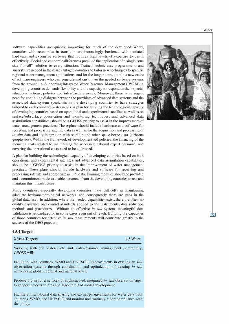
Water
software capabilities are quickly improving for much of the developed World,countries with economies in transition are increasingly burdened with outdatedhardware and expensive software that requires high levels of expertise to use iteffectively. Social and economic differences preclude the application of a single “onesize fits all” solution to every situation. Trained technicians, programmers, andanalysts are needed in the disadvantaged countries to tailor new techniques to specificregional water management applications, and for the longer term, to train a new cadreof software engineers who can generate and customize the needed software systemsfrom the ground up. Supporting Integrated Water Resource Management (IWRM) indeveloping countries demands flexibility and the capacity to respond to their specialsituations, actions, policies and infrastructure needs. Moreover, there is an urgentneed for continuing dialogue between the providers of advanced data systems and theassociated data system specialists in the developing countries to have strategiestailored to each country’s water needs. A plan for building the technological capacityof developing countries based on operational and experimental satellites as well as onsurface/subsurface observation and monitoring techniques, and advanced dataassimilation capabilities, should be a GEOSS priority to assist in the improvement ofwater management practices. These plans should include hardware and software forreceiving and processing satellite data as well as for the acquisition and processing ofin situ data and its integration with satellite and other space-borne data (airbornegeophysics). Within the framework of development aid policies, the financing of therecurring costs related to maintaining the necessary national expert personnel andcovering the operational costs need to be addressed.
A plan for building the technological capacity of developing countries based on bothoperational and experimental satellites and advanced data assimilation capabilities,should be a GEOSS priority to assist in the improvement of water managementpractices. These plans should include hardware and software for receiving andprocessing satellite and appropriate in situ data. Training modules should be providedand a commitment made to enable personnel from the developing countries to use andmaintain this infrastructure.
Many countries, especially developing countries, have difficulty in maintainingadequate hydrometeorological networks, and consequently there are gaps in theglobal database. In addition, where the needed capabilities exist, there are often noquality assurance and control standards applied to the instruments, data reductionmethods and procedures. Without an effective in situ system, meaningful datavalidation is jeopardized or in some cases even out of reach. Building the capacitiesof those countries for effective in situ measurements will contribute greatly to thesuccess of the GEO process.
4.5.4 Targets
77
2 Year Targets 4.5 Water
Working with the water-cycle and water-resource management community,GEOSS will:
Facilitate, with countries, WMO and UNESCO, improvements in existing in situobservation systems through coordination and optimization of existing in situnetworks at global, regional and national level.
Produce a plan for a network of sophisticated, integrated in situ observation sites,to support process studies and algorithm and model development.
Facilitate international data sharing and exchange agreements for water data withcountries, WMO, and UNESCO, and monitor and routinely report compliance withthe policy.
GEOSS 10-Year Implementation Plan: Reference Document
78
Produce an implementation plan for a broad global water cycle data integrationsystem that combines in situ and satellite and numerical model outputs anddisseminates usable information for decision-making.
Facilitate, with space agencies and research communities, more accurate, frequent(3-hourly), global, high spatial resolution, and microphysically detailedmeasurements of precipitation through a global constellation of satellites carryingpassive microwave radiometers in complementary orbits.
Advocate that IGOS-P should take the lead in development of integratedprecipitation and soil moisture products and new products including indicators.
Facilitate, with space agencies and research communities, studies to evaluate thecontribution of space-based observations to the determination of surface waterquality and mapping of critical aquatic habitats.
Produce an evaluation of the resolution and accuracy requirements for applyingsatellite altimetry to the measurement of streamflow and surface water storage.
Facilitate establishment of an international coordination function for in situ watercycle observation and data integration and dissemination.
Produce a framework for developing ensemble-based hydrological predictions andimprove the ability of users to exploit the information.
Advocate and globalize ongoing activities that promote the use of Earth observationfor both monitoring the state of, and improving implementation of, water resourcesmanagement in developing countries, particularly in concert with the activitiespursued by the CEOS WSSD Follow-up Programme.
Organise workshops and special studies for documenting the cultural barriers totechnology transfer and procedures in order to identify and avoid these obstacles.
Advocate eliminating barriers to the free and open exchange of data and softwareto enable full access by water managers in developing countries.
6 Year Targets 4.5 Water
Working with the water-cycle and water-resource management community,GEOSS will:
Produce a number of new products for precipitation, soil moisture, evaporation,evapotranspiration and other water cycle variables, by in situ observations and theplanned space missions.
Provide validation of the accuracy of new water cycle data products, involving“virtual water” with respect to food production and its transportation.
Advocate continuous sensor development with improvement of accuracy andhigher spatial-temporal resolutions, and with special attention to snow waterequivalent and streamflow.
Facilitate international and fully networked operational data exchange capabilities.
Water
79
Facilitate testing of a fully integrated prototype data system, with data assimilation,analysis and visualization capabilities for the water cycle.
Advocate a study of the water resource variables required to support an expertsystem in water management and provide prototyping on an operational system forassimilating routine water cycle observations for improved monitoring andmanagement of water resources.
Advocate a system for the routine collection of water level data for use in validatingsatellite data and for monitoring surface water storage.
Advocate precision gravity field missions for global water storage monitoring.
Produce a plan for institutionalizing surface water and energy flux measurements.
Facilitate the establishment of coordinated in situ observation networks with high(and low) elevation sites along mountain transects.
Produce an experiment using the global network of sophisticated and temporallyintegrated in situ observation sites for water cycle observations.
Produce integrated water cycle data sets (including predictions) on a continentalscale, such as the Asian monsoon region or any large river watershed.
Produce an evaluation of the data and product requirements for use in applicationsto water-related health issues with a view to developing a specialized observingsystem in support of health.
Produce a plan for monitoring drinking water quality, along with efforts to extendwater and sanitation services, especially in developing countries.
Facilitate, with space agencies and research communities, the development ofeffective sensors and missions for Global Precipitation Measurement (GPM),surface and subsurface water stores – including snow water equivalence, waterstored in natural and man-made reservoirs, and groundwater.
Facilitate, with numerical weather prediction agencies, space agencies andinternational research programmes, the reanalysis of products for use indetermining trends in water cycle variables.
Produce a plan for capacity building to support water management, includinghardware and software for receiving and processing satellite and appropriate in situdata, and training modules for the developing countries.
10 Year Targets 4.5 Water
Working with the water-cycle and water-resource management community,GEOSS will:
Produce a characterization of the long-term water cycle budget based on a hierarchyof spatial and temporal scales.
Facilitate, with countries and research communities, operationalization of the global

GEOSS 10-Year Implementation Plan: Reference Document
4.5.5 Table of Observation Requirements
80
Legend for Table 4.5.5
0 - Monitored with acceptable accuracy, spatial and temporalresolution; timeliness and in all countries worldwide.
1 - Monitored with marginally acceptable accuracy, spatial andtemporal resolution; timeliness or not in all countriesworldwide.
2 - Not yet widely available or not yet globally monitored, butcould be within two years.
3 - Only locally available or experimental; could be available insix years.
4 - Still in research phase; could be available in ten years.
network of sophisticated and temporally integrated in situ observation sites.
Produce operational, fully integrated data systems by evaluating and improvingprototype systems.
Facilitate provision of data and information, including quantity and quality for bothsurface and groundwater, to a prototype water cycle expert decision support system.
Facilitate improved simulation and prediction capabilities for precipitation, watercycling and water cycle acceleration in weather and climate models.
Produce a system for monitoring changes in the water cycle, including clouds andprecipitation, by using the integrated data system.
Produce integrated information for documentation and understanding of therelationship between known climate indices, particularly ENSO, AO, PDO andMJO, and flood and drought frequency and precipitation type and intensity.
Produce appropriate indicators of “watershed health” routinely from satellite data,surface and subsurface data, and data assimilation capabilities.
Facilitate development of plans for more effective transfer into operations oftechnologies that have been proven in the research environment.
Facilitate the development of a plan for building the technological capacity ofdeveloping countries based on both operational and experimental satellites, andadvanced data assimilation capabilities.
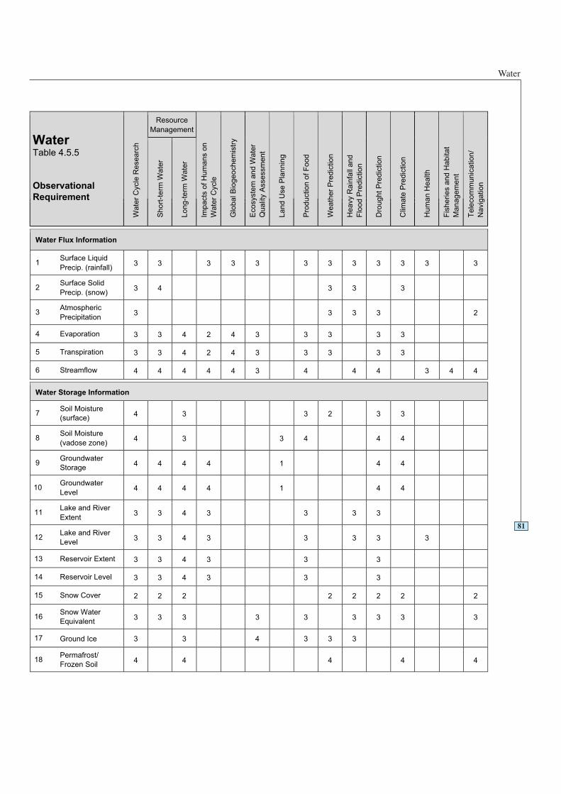
Water
81
Resource
Management
WaterTable 4.5.5
Observational
Requirement
Wa
ter
Cycle
Re
se
arc
h
Sh
ort
-te
rm W
ate
r
Lo
ng
-te
rm W
ate
r
Imp
acts
of
Hu
ma
ns o
n
Wa
ter
Cycle
Glo
ba
l B
iog
eo
ch
em
istr
y
Eco
syste
m a
nd
Wa
ter
Qu
alit
y A
sse
ssm
en
t
La
nd
Use
Pla
nn
ing
Pro
du
ctio
n o
f F
oo
d
We
ath
er
Pre
dic
tio
n
He
avy R
ain
fall
an
d
Flo
od
Pre
dic
tio
n
Dro
ug
ht
Pre
dic
tio
n
Clim
ate
Pre
dic
tio
n
Hu
ma
n H
ea
lth
Fis
he
rie
s a
nd
Ha
bita
t
Ma
na
ge
me
nt
Te
leco
mm
un
ica
tio
n/
Navig
ation
Water Flux Information
1Surface Liquid
Precip. (rainfall)3 3 3 3 3 3 3 3 3 3 3 3
2Surface Solid
Precip. (snow)3 4 3 3 3
3Atmospheric
Precipitation3 3 3 3 2
4 Evaporation 3 3 4 2 4 3 3 3 3 3
5 Transpiration 3 3 4 2 4 3 3 3 3 3
6 Streamflow 4 4 4 4 4 3 4 4 4 3 4 4
Water Storage Information
7Soil Moisture
(surface)4 3 3 2 3 3
8Soil Moisture
(vadose zone)4 3 3 4 4 4
9Groundwater
Storage4 4 4 4 1 4 4
10Groundwater
Level4 4 4 4 1 4 4
11Lake and River
Extent3 3 4 3 3 3 3
12Lake and River
Level3 3 4 3 3 3 3 3
13 Reservoir Extent 3 3 4 3 3 3
14 Reservoir Level 3 3 4 3 3 3
15 Snow Cover 2 2 2 2 2 2 2 2
16Snow Water
Equivalent3 3 3 3 3 3 3 3 3
17 Ground Ice 3 3 4 3 3 3
18Permafrost/
Frozen Soil4 4 4 4 4
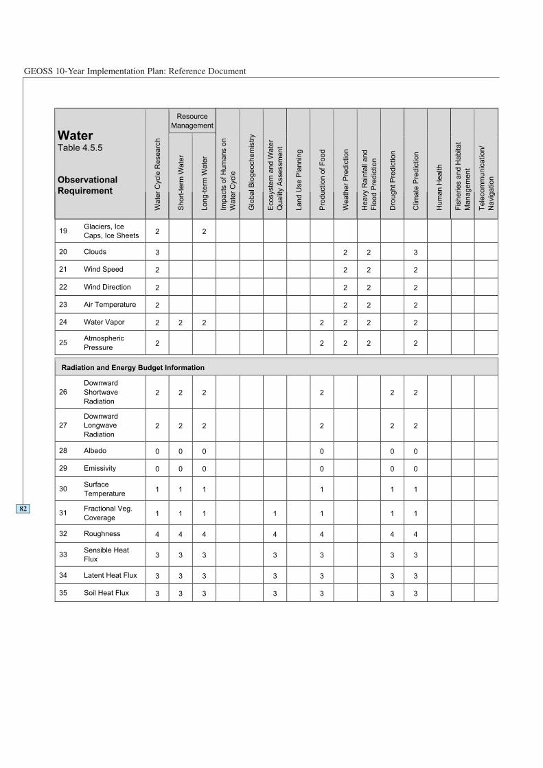
GEOSS 10-Year Implementation Plan: Reference Document
82
Resource
Management
WaterTable 4.5.5
Observational
Requirement
Wa
ter
Cycle
Re
se
arc
h
Sh
ort
-te
rm W
ate
r
Lo
ng
-te
rm W
ate
r
Imp
acts
of
Hu
ma
ns o
n
Wate
r C
ycle
Glo
ba
l B
iog
eo
ch
em
istr
y
Eco
syste
m a
nd
Wa
ter
Qu
alit
y A
sse
ssm
en
t
La
nd
Use
Pla
nn
ing
Pro
du
ctio
n o
f F
oo
d
We
ath
er
Pre
dic
tio
n
He
avy R
ain
fall
an
d
Flo
od
Pre
dic
tio
n
Dro
ug
ht
Pre
dic
tio
n
Clim
ate
Pre
dic
tio
n
Hu
ma
n H
ea
lth
Fis
he
rie
s a
nd
Ha
bita
t
Ma
na
ge
me
nt
Te
leco
mm
un
ica
tio
n/
Na
vig
atio
n
19Glaciers, Ice
Caps, Ice Sheets2 2
20 Clouds 3 2 2 3
21 Wind Speed 2 2 2 2
22 Wind Direction 2 2 2 2
23 Air Temperature 2 2 2 2
24 Water Vapor 2 2 2 2 2 2 2
25Atmospheric
Pressure2 2 2 2 2
Radiation and Energy Budget Information
26
Downward
Shortwave
Radiation
2 2 2 2 2 2
27
Downward
Longwave
Radiation
2 2 2 2 2 2
28 Albedo 0 0 0 0 0 0
29 Emissivity 0 0 0 0 0 0
30Surface
Temperature1 1 1 1 1 1
31Fractional Veg.
Coverage1 1 1 1 1 1 1
32 Roughness 4 4 4 4 4 4 4
33Sensible Heat
Flux3 3 3 3 3 3 3
34 Latent Heat Flux 3 3 3 3 3 3 3
35 Soil Heat Flux 3 3 3 3 3 3 3
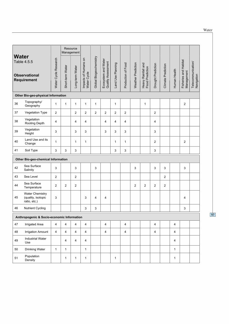
Water
83
Resource
Management
WaterTable 4.5.5
Observational
Requirement
Wa
ter
Cycle
Re
se
arc
h
Sh
ort
-te
rm W
ate
r
Lo
ng
-te
rm W
ate
r
Imp
acts
of
Hu
ma
ns o
n
Wa
ter
Cycle
Glo
ba
l B
iog
eo
ch
em
istr
y
Eco
syste
m a
nd
Wa
ter
Qu
alit
y A
sse
ssm
en
t
La
nd
Use
Pla
nn
ing
Pro
du
ctio
n o
f F
oo
d
We
ath
er
Pre
dic
tio
n
He
avy R
ain
fall
an
d
Flo
od P
redic
tion
Dro
ug
ht
Pre
dic
tio
n
Clim
ate
Pre
dic
tio
n
Hu
ma
n H
ea
lth
Fis
he
rie
s a
nd
Ha
bita
t
Ma
na
ge
me
nt
Te
leco
mm
un
ica
tio
n/
Na
vig
atio
n
Other Bio-geo-physical Information
36Topography/
Geography1 1 1 1 1 1 1 2
37 Vegetation Type 2 2 2 2 2 2 2 2
38Vegetation
Rooting Depth4 4 4 4 4 4 4
39Vegetation
Height3 3 3 3 3 3 3
40Land Use and its
Change1 1 1 1 1 2 2
41 Soil Type 3 3 3 3 3 3
Other Bio-geo-chemical Information
42Sea Surface
Salinity3 3 3 3 3 3 3
43 Sea Level 2 2 2
44Sea Surface
Temperature2 2 2 2 2 2 2
45
Water Chemistry
(quality, isotopic
ratio, etc.)
3 3 4 4 4
46 Nutrient Cycling 3 3 3
Anthropogenic & Socio-economic Information
47 Irrigated Area 4 4 4 4 4 4 4 4
48 Irrigation Amount 4 4 4 4 4 4 4 4
49Industrial Water
Use4 4 4 4
50 Drinking Water 1 1 1 1
51Population
Density1 1 1 1 1
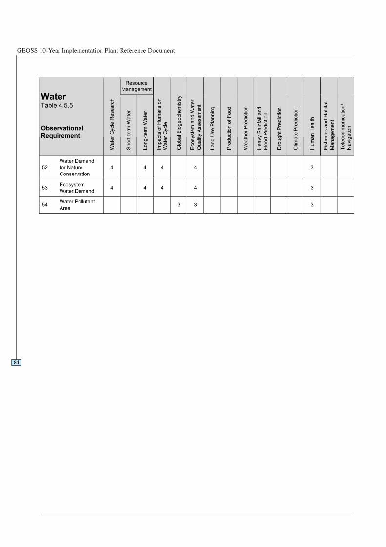
GEOSS 10-Year Implementation Plan: Reference Document
84
Resource
Management
WaterTable 4.5.5
Observational
Requirement
Wa
ter
Cycle
Re
se
arc
h
Sh
ort
-te
rm W
ate
r
Lo
ng
-te
rm W
ate
r
Imp
acts
of
Hu
ma
ns o
n
Wate
r C
ycle
Glo
ba
l B
iog
eo
ch
em
istr
y
Eco
syste
m a
nd
Wa
ter
Qu
alit
y A
sse
ssm
en
t
La
nd
Use
Pla
nn
ing
Pro
du
ctio
n o
f F
oo
d
We
ath
er
Pre
dic
tio
n
He
avy R
ain
fall
an
d
Flo
od
Pre
dic
tio
n
Dro
ug
ht
Pre
dic
tio
n
Clim
ate
Pre
dic
tio
n
Hu
ma
n H
ea
lth
Fis
he
rie
s a
nd
Ha
bita
t
Ma
na
ge
me
nt
Te
leco
mm
un
ica
tio
n/
Na
vig
atio
n
52
Water Demand
for Nature
Conservation
4 4 4 4 3
53Ecosystem
Water Demand4 4 4 4 3
54Water Pollutant
Area3 3 3
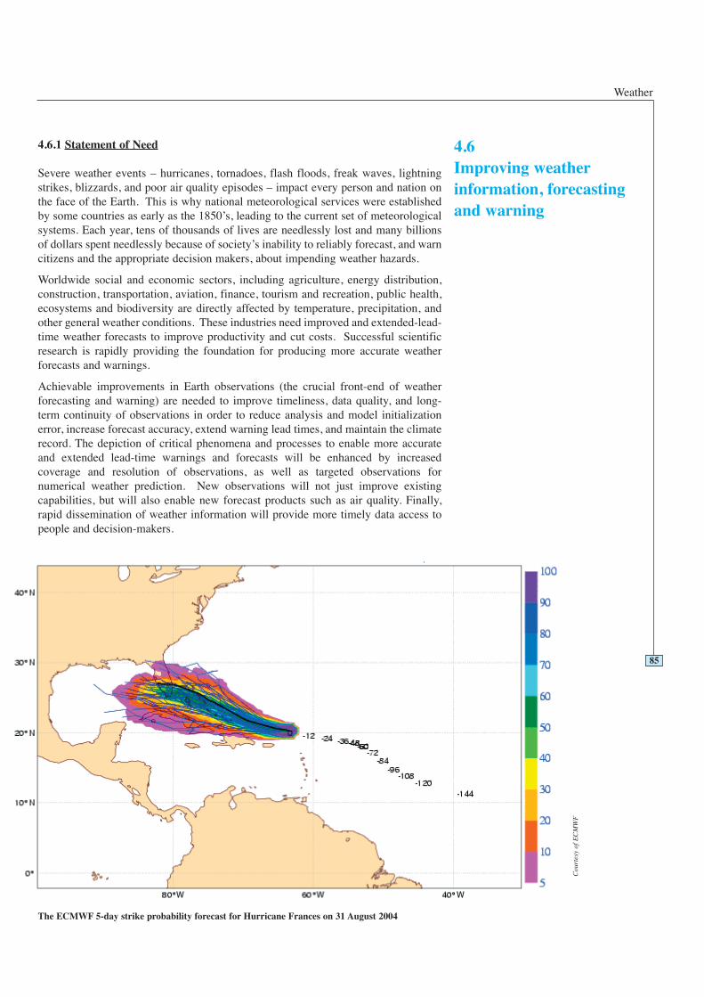
Weather
4.6.1 Statement of Need
Severe weather events – hurricanes, tornadoes, flash floods, freak waves, lightningstrikes, blizzards, and poor air quality episodes – impact every person and nation onthe face of the Earth. This is why national meteorological services were establishedby some countries as early as the 1850’s, leading to the current set of meteorologicalsystems. Each year, tens of thousands of lives are needlessly lost and many billionsof dollars spent needlessly because of society’s inability to reliably forecast, and warncitizens and the appropriate decision makers, about impending weather hazards.
Worldwide social and economic sectors, including agriculture, energy distribution,construction, transportation, aviation, finance, tourism and recreation, public health,ecosystems and biodiversity are directly affected by temperature, precipitation, andother general weather conditions. These industries need improved and extended-lead-time weather forecasts to improve productivity and cut costs. Successful scientificresearch is rapidly providing the foundation for producing more accurate weatherforecasts and warnings.
Achievable improvements in Earth observations (the crucial front-end of weatherforecasting and warning) are needed to improve timeliness, data quality, and long-term continuity of observations in order to reduce analysis and model initializationerror, increase forecast accuracy, extend warning lead times, and maintain the climaterecord. The depiction of critical phenomena and processes to enable more accurateand extended lead-time warnings and forecasts will be enhanced by increasedcoverage and resolution of observations, as well as targeted observations fornumerical weather prediction. New observations will not just improve existingcapabilities, but will also enable new forecast products such as air quality. Finally,rapid dissemination of weather information will provide more timely data access topeople and decision-makers.
85
4.6Improving weatherinformation, forecastingand warning
The ECMWF 5-day strike probability forecast for Hurricane Frances on 31 August 2004
Cou
rtes
y of
EC
MW
F
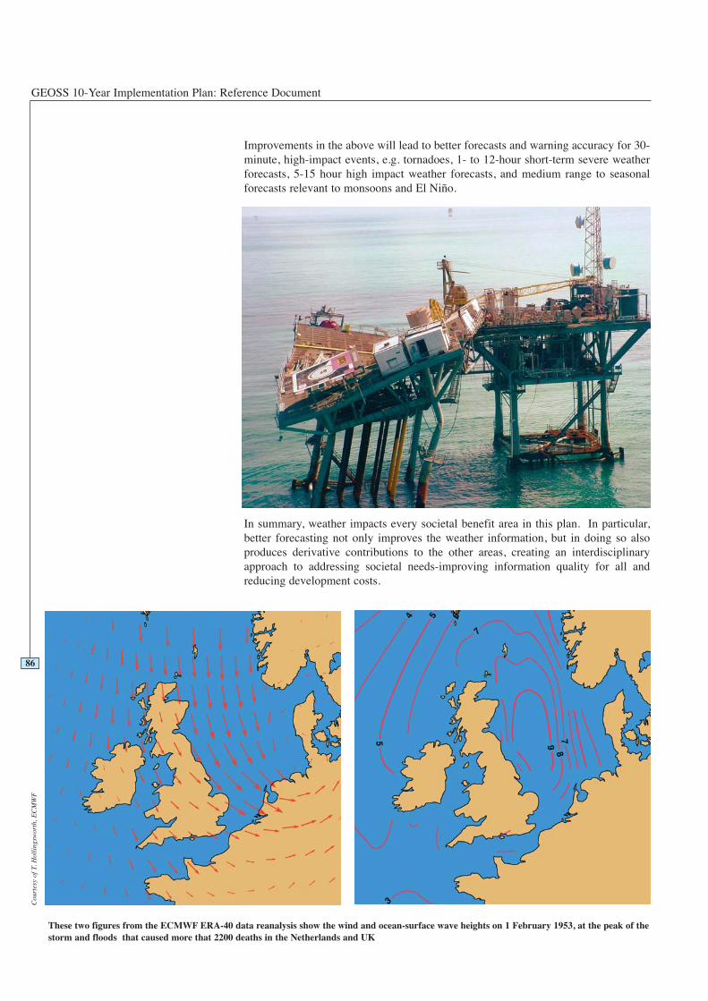
GEOSS 10-Year Implementation Plan: Reference Document
Improvements in the above will lead to better forecasts and warning accuracy for 30-minute, high-impact events, e.g. tornadoes, 1- to 12-hour short-term severe weatherforecasts, 5-15 hour high impact weather forecasts, and medium range to seasonalforecasts relevant to monsoons and El Niño.
In summary, weather impacts every societal benefit area in this plan. In particular,better forecasting not only improves the weather information, but in doing so alsoproduces derivative contributions to the other areas, creating an interdisciplinaryapproach to addressing societal needs-improving information quality for all andreducing development costs.
86
These two figures from the ECMWF ERA-40 data reanalysis show the wind and ocean-surface wave heights on 1 February 1953, at the peak of thestorm and floods that caused more that 2200 deaths in the Netherlands and UK
Cou
rtes
y of
T. H
olli
ngsw
orth
, EC
MW
F
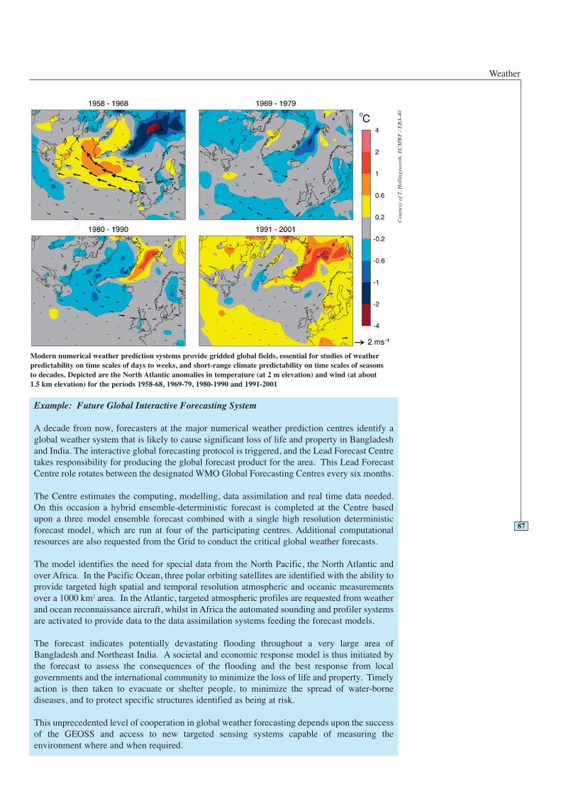
Weather
87
Modern numerical weather prediction systems provide gridded global fields, essential for studies of weatherpredictability on time scales of days to weeks, and short-range climate predictability on time scales of seasonsto decades. Depicted are the North Atlantic anomalies in temperature (at 2 m elevation) and wind (at about 1.5 km elevation) for the periods 1958-68, 1969-79, 1980-1990 and 1991-2001
Example: Future Global Interactive Forecasting System
A decade from now, forecasters at the major numerical weather prediction centres identify aglobal weather system that is likely to cause significant loss of life and property in Bangladeshand India. The interactive global forecasting protocol is triggered, and the Lead Forecast Centretakes responsibility for producing the global forecast product for the area. This Lead ForecastCentre role rotates between the designated WMO Global Forecasting Centres every six months.
The Centre estimates the computing, modelling, data assimilation and real time data needed.On this occasion a hybrid ensemble-deterministic forecast is completed at the Centre basedupon a three model ensemble forecast combined with a single high resolution deterministicforecast model, which are run at four of the participating centres. Additional computationalresources are also requested from the Grid to conduct the critical global weather forecasts.
The model identifies the need for special data from the North Pacific, the North Atlantic andover Africa. In the Pacific Ocean, three polar orbiting satellites are identified with the ability toprovide targeted high spatial and temporal resolution atmospheric and oceanic measurementsover a 1000 km2 area. In the Atlantic, targeted atmospheric profiles are requested from weatherand ocean reconnaissance aircraft, whilst in Africa the automated sounding and profiler systemsare activated to provide data to the data assimilation systems feeding the forecast models.
The forecast indicates potentially devastating flooding throughout a very large area ofBangladesh and Northeast India. A societal and economic response model is thus initiated bythe forecast to assess the consequences of the flooding and the best response from localgovernments and the international community to minimize the loss of life and property. Timelyaction is then taken to evacuate or shelter people, to minimize the spread of water-bornediseases, and to protect specific structures identified as being at risk.
This unprecedented level of cooperation in global weather forecasting depends upon the successof the GEOSS and access to new targeted sensing systems capable of measuring theenvironment where and when required.
Cou
rtes
y of
T. H
olli
ngsw
orth
, EC
MW
F /
ER
A-4
0
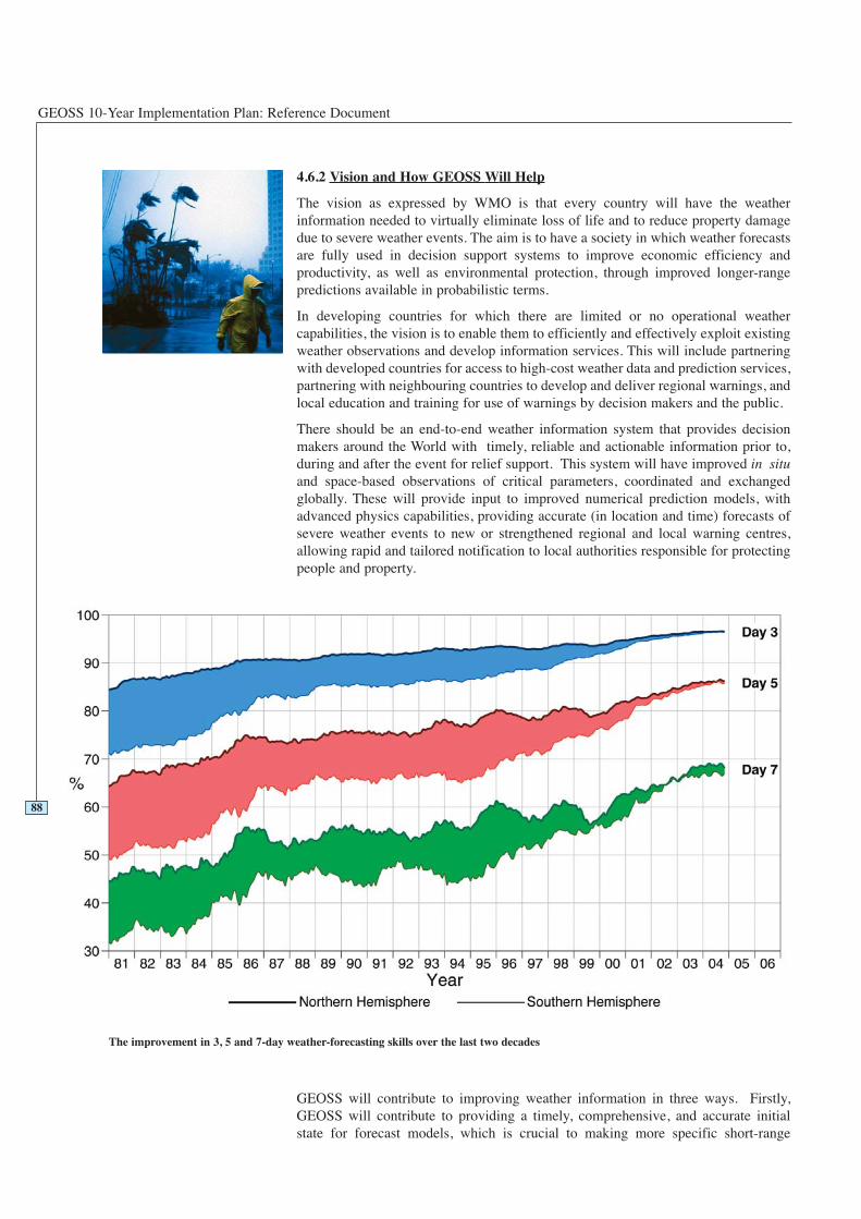
GEOSS 10-Year Implementation Plan: Reference Document
4.6.2 Vision and How GEOSS Will Help
The vision as expressed by WMO is that every country will have the weatherinformation needed to virtually eliminate loss of life and to reduce property damagedue to severe weather events. The aim is to have a society in which weather forecastsare fully used in decision support systems to improve economic efficiency andproductivity, as well as environmental protection, through improved longer-rangepredictions available in probabilistic terms.
In developing countries for which there are limited or no operational weathercapabilities, the vision is to enable them to efficiently and effectively exploit existingweather observations and develop information services. This will include partneringwith developed countries for access to high-cost weather data and prediction services,partnering with neighbouring countries to develop and deliver regional warnings, andlocal education and training for use of warnings by decision makers and the public.
There should be an end-to-end weather information system that provides decisionmakers around the World with timely, reliable and actionable information prior to,during and after the event for relief support. This system will have improved in situand space-based observations of critical parameters, coordinated and exchangedglobally. These will provide input to improved numerical prediction models, withadvanced physics capabilities, providing accurate (in location and time) forecasts ofsevere weather events to new or strengthened regional and local warning centres,allowing rapid and tailored notification to local authorities responsible for protectingpeople and property.
GEOSS will contribute to improving weather information in three ways. Firstly,GEOSS will contribute to providing a timely, comprehensive, and accurate initialstate for forecast models, which is crucial to making more specific short-range
88
The improvement in 3, 5 and 7-day weather-forecasting skills over the last two decades
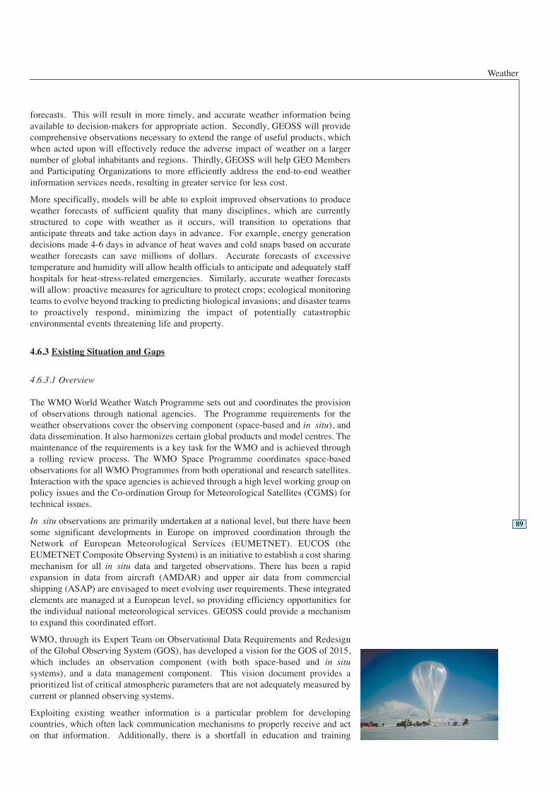
Weather
forecasts. This will result in more timely, and accurate weather information beingavailable to decision-makers for appropriate action. Secondly, GEOSS will providecomprehensive observations necessary to extend the range of useful products, whichwhen acted upon will effectively reduce the adverse impact of weather on a largernumber of global inhabitants and regions. Thirdly, GEOSS will help GEO Membersand Participating Organizations to more efficiently address the end-to-end weatherinformation services needs, resulting in greater service for less cost.
More specifically, models will be able to exploit improved observations to produceweather forecasts of sufficient quality that many disciplines, which are currentlystructured to cope with weather as it occurs, will transition to operations thatanticipate threats and take action days in advance. For example, energy generationdecisions made 4-6 days in advance of heat waves and cold snaps based on accurateweather forecasts can save millions of dollars. Accurate forecasts of excessivetemperature and humidity will allow health officials to anticipate and adequately staffhospitals for heat-stress-related emergencies. Similarly, accurate weather forecastswill allow: proactive measures for agriculture to protect crops; ecological monitoringteams to evolve beyond tracking to predicting biological invasions; and disaster teamsto proactively respond, minimizing the impact of potentially catastrophicenvironmental events threatening life and property.
4.6.3 Existing Situation and Gaps
4.6.3.1 Overview
The WMO World Weather Watch Programme sets out and coordinates the provisionof observations through national agencies. The Programme requirements for theweather observations cover the observing component (space-based and in situ), anddata dissemination. It also harmonizes certain global products and model centres. Themaintenance of the requirements is a key task for the WMO and is achieved througha rolling review process. The WMO Space Programme coordinates space-basedobservations for all WMO Programmes from both operational and research satellites.Interaction with the space agencies is achieved through a high level working group onpolicy issues and the Co-ordination Group for Meteorological Satellites (CGMS) fortechnical issues.
In situ observations are primarily undertaken at a national level, but there have beensome significant developments in Europe on improved coordination through theNetwork of European Meteorological Services (EUMETNET). EUCOS (theEUMETNET Composite Observing System) is an initiative to establish a cost sharingmechanism for all in situ data and targeted observations. There has been a rapidexpansion in data from aircraft (AMDAR) and upper air data from commercialshipping (ASAP) are envisaged to meet evolving user requirements. These integratedelements are managed at a European level, so providing efficiency opportunities forthe individual national meteorological services. GEOSS could provide a mechanismto expand this coordinated effort.
WMO, through its Expert Team on Observational Data Requirements and Redesignof the Global Observing System (GOS), has developed a vision for the GOS of 2015,which includes an observation component (with both space-based and in situsystems), and a data management component. This vision document provides aprioritized list of critical atmospheric parameters that are not adequately measured bycurrent or planned observing systems.
Exploiting existing weather information is a particular problem for developingcountries, which often lack communication mechanisms to properly receive and acton that information. Additionally, there is a shortfall in education and training
89
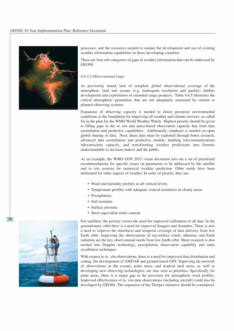
GEOSS 10-Year Implementation Plan: Reference Document
processes, and the resources needed to sustain the development and use of existingweather information capabilities in those developing countries.
There are four sub-categories of gaps in weather information that can be addressed byGEOSS:
4.6.3.2 Observational Gaps
As previously stated, lack of complete global observational coverage of theatmosphere, land and oceans (e.g. inadequate resolution and quality) inhibitsdevelopment and exploitation of extended range products. Table 4.6.5 illustrates thecritical atmospheric parameters that are not adequately measured by current orplanned observing systems.
Expansion of observing capacity is needed to detect precursor environmentalconditions as the foundation for improving all weather and climate services, as calledfor in the plan for the WMO World Weather Watch. Highest priority should be givento filling gaps in the in situ and space-based observation capacity that limit dataassimilation and predictive capabilities. Additionally, emphasis is needed on openglobal sharing of data. Next, these data must be exploited through better research,advanced data assimilation and predictive models, building telecommunicationsinfrastructure capacity, and transforming weather predictions into formatsunderstandable to decision makers and the public.
As an example, the WMO GOS 2015 vision document sets out a set of prioritizedrecommendations for specific issues on parameters to be addressed by the satelliteand in situ systems for numerical weather prediction. Other needs have beendelineated for other aspects of weather. In order of priority, they are:
• Wind and humidity profiles at all vertical levels.
• Temperature profiles with adequate vertical resolution in cloudy areas.
• Precipitation.
• Soil moisture.
• Surface pressure.
• Snow equivalent water content.
For satellites, the priority covers the need for improved calibration of all data. In thegeostationary orbit there is a need for improved Imagers and Sounders. There is alsoa need to improve the timeliness and temporal coverage of data delivery from lowEarth orbit. Improving the observations of sea-surface winds, altimetry and Earthradiation are the key observational needs from low Earth orbit. More research is alsoneeded into Doppler technology, precipitation observation capability and radiooccultation techniques.
With respect to in situ observations, there is a need for improved data distribution andcoding, the development of AMDAR and ground-based GPS. Improving the networkof observations in the oceans, polar areas, and tropical land areas, as well asdeveloping new observing technologies, are also seen as priorities. Specifically forpolar areas, there is a major gap in the provision for atmospheric wind profiles.Improved effectiveness of in situ data observations (including aircraft) could also bedeveloped by GEOSS. The expansion of the Thorpex initiative should be considered.
90

Weather
4.6.3.3 Gaps in Modelling
Despite the progress made, scientific modelling techniques (data assimilation,Numerical Weather Prediction (NWP), and statistical post processing) still limit theaccuracy and reliability of weather forecasts and warnings, and data are needed tovalidate the models. NWP models still have gaps in the following categories of datathat increase uncertainty and reduce model accuracy: vertical profiles of moistureflux; coverage of tropical land areas and ocean areas; measurements of clouds,precipitation, and ozone; rigorous calibration of remotely sensed radiances; andenhanced data initialization and assimilation capabilities to facilitate full use of theexpanded remotely sensed and in situ observations.
4.6.3.4 Gaps in Information Technologies
Telecommunication and computer processing gaps limit observation exchange,scientific collaboration, and dissemination of critical information to decision-makersand the general public. Also, full implementation of new observing systemtechnologies is challenging due in part to a lack of structure to facilitate transition ofresearch technologies to operational use in all components of the end-to-end weatherinformation services system.
4.6.3.5 Gaps in Research, Education and Training
With improvements in all facets of producing and delivering weather information,parallel improvements in education and training processes are necessary to ensure fulluser exploitation of that information worldwide. Research and Development activitiesare necessary, related to new archive, access and data processing (including numericalmodelling) capabilities, to ensure sustained weather information for the long-term.
4.6.4 Targets
91
2 Year Targets 4.6 Weather
Working with the weather community, GEOSS will:
Facilitate investment in the critical data gaps (atmospheric wind and humidityprofiles, ocean evaporation and precipitation, soil moisture, precipitation) andimprove predictive models to augment the quality of forecasts of severe events andgeneral weather conditions.
Advocate support for plans to assist developing countries to utilize the forecasts inorder to reduce impacts on life and property.
Facilitate, with WMO, education and training of developing country personnel inthe effective use of currently available weather information.
Advocate support for existing weather capacity building programmes andinitiatives, understanding their status and regional distribution.
Advocate support for the WMO plans to establish the feasibility of expandingEUCOS to other regions.
GEOSS 10-Year Implementation Plan: Reference Document
4.6.5 Table of Observation Requirements
92Legend for Table 4.6.5
0 - Monitored with acceptable accuracy, spatial and temporalresolution; timeliness and in all countries worldwide.
1 - Monitored with marginally acceptable accuracy, spatial andtemporal resolution; timeliness or not in all countriesworldwide.
2 - Not yet widely available or not yet globally monitored, butcould be within two years.
3 - Only locally available or experimental; could be available insix years.
4 - Still in research phase; could be available in ten years.
6 Year Targets 4.6 Weather
Working with the weather community, GEOSS will:
Advocate support for WMO coordinated activities to improve data observations andmodels to produce reliable forecasts of severe weather. These are forecasts thatinclude reliability/probability estimates, as well as a range of possible outcomes,and interact with local authorities to improve usage and provide tailored servicesthrough newly established regional and local warning centres.
Advocate support for WMO plans in developing countries to support theestablishment of new regional centres, to allow reliable warnings of impendingsevere events.
Advocate support for WMO plans to establish better coordinated regional in situobservation networks on the basis of the EUCOS model.
10 Year Targets 4.6 Weather
Working with the weather community, GEOSS will:
Facilitate continuous education, evaluation and improvements in developingcountries, especially to allow sustained operations of the newly established regionalcentres.
Advocate and facilitate the establishment of new observing systems to coverspecific observation requirements set out in this Reference Document.
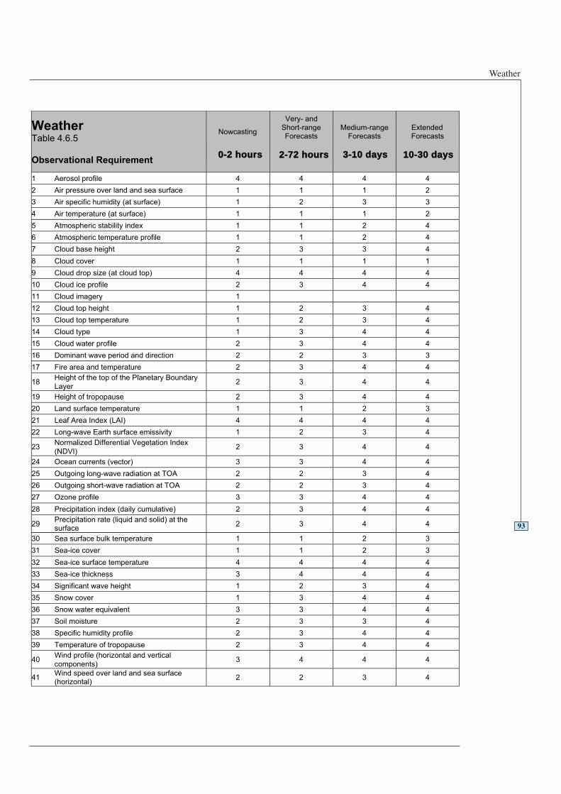
Weather
93
WeatherTable 4.6.5
Observational Requirement
Nowcasting
0-2 hours
Short-rangeForecasts
Medium-rangeForecasts
3-10 days
ExtendedForecasts
1 Aerosol profile 4 4 4 4
2 Air pressure over land and sea surface 1 1 1 2
3 Air specific humidity (at surface) 1 2 3 3
4 Air temperature (at surface) 1 1 1 2
5 Atmospheric stability index 1 1 2 4
6 Atmospheric temperature profile 1 1 2 4
7 Cloud base height 2 3 3 4
8 Cloud cover 1 1 1 1
9 Cloud drop size (at cloud top) 4 4 4 4
10 Cloud ice profile 2 3 4 4
11 Cloud imagery 1
12 Cloud top height 1 2 3 4
13 Cloud top temperature 1 2 3 4
14 Cloud type 1 3 4 4
15 Cloud water profile 2 3 4 4
16 Dominant wave period and direction 2 2 3 3
17 Fire area and temperature 2 3 4 4
18Height of the top of the Planetary Boundary
Layer2 3 4 4
19 Height of tropopause 2 3 4 4
20 Land surface temperature 1 1 2 3
21 Leaf Area Index (LAI) 4 4 4 4
22 Long-wave Earth surface emissivity 1 2 3 4
23Normalized Differential Vegetation Index
(NDVI)2 3 4 4
24 Ocean currents (vector) 3 3 4 4
25 Outgoing long-wave radiation at TOA 2 2 3 4
26 Outgoing short-wave radiation at TOA 2 2 3 4
27 Ozone profile 3 3 4 4
28 Precipitation index (daily cumulative) 2 3 4 4
29Precipitation rate (liquid and solid) at thesurface
2 3 4 4
30 Sea surface bulk temperature 1 1 2 3
31 Sea-ice cover 1 1 2 3
32 Sea-ice surface temperature 4 4 4 4
33 Sea-ice thickness 3 4 4 4
34 Significant wave height 1 2 3 4
35 Snow cover 1 3 4 4
36 Snow water equivalent 3 3 4 4
37 Soil moisture 2 3 3 4
38 Specific humidity profile 2 3 4 4
39 Temperature of tropopause 2 3 4 4
40Wind profile (horizontal and vertical
components)3 4 4 4
41Wind speed over land and sea surface(horizontal)
2 2 3 4
2-72 hours 10-30 days
Very- and
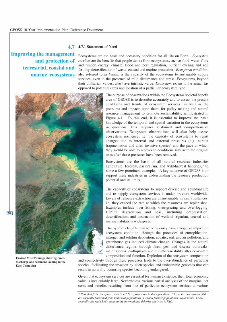
4.7Improving the management
and protection ofterrestrial, coastal and
marine ecosystems
GEOSS 10-Year Implementation Plan: Reference Document
4.7.1 Statement of Need
Ecosystems are the basis and necessary condition for all life on Earth. Ecosystemservices are the benefits that people derive from ecosystems, such as food, water, fibreand timber, energy, climate, flood and pest regulation, nutrient cycling and soilfertility, detoxification of waste, coastal and marine protection. Ecosystem condition,also referred to as health, is the capacity of the ecosystems to sustainably supplyservices, even in the presence of mild disturbance and stress. Ecosystems, beyondtheir utilitarian values, also have intrinsic value. Ecosystem extent is the actual (asopposed to potential) area and location of a particular ecosystem type.
The purpose of observations within the Ecosystems societal benefitarea of GEOSS is to describe accurately and to assess the presentconditions and trends of ecosystem services, as well as thepressures and impacts upon them, for policy making and naturalresource management to promote sustainability, as illustrated inFigure 4.1. To this end, it is essential to improve the basicknowledge of the temporal and spatial variation in the ecosystemsin question. This requires sustained and comprehensiveobservations. Ecosystem observations will also help assessecosystem resilience, i.e. the capacity of ecosystems to resistchanges due to internal and external pressures (e.g. habitatfragmentation and alien invasive species) and the pace at whichthey would be able to recover to conditions similar to the originalones after those pressures have been removed.
Ecosystems are the basis of all natural resource industriesagriculture, forestry, pastoralism, and wild-harvest fisheries,15 toname a few prominent examples. A key outcome of GEOSS is tosupport these industries in understanding the resource productionpotential and its limits.
The capacity of ecosystems to support diverse and abundant lifeand to supply ecosystem services is under pressure worldwide.Levels of resource extraction are unsustainable in many instances;i.e. they exceed the rate at which the resources are replenished.Examples include over-fishing, over-grazing and over-logging.Habitat degradation and loss, including deforestation,desertification, and destruction of wetland, riparian, coastal andmarine habitats is widespread.
The byproducts of human activities may have a negative impact onecosystem condition, through the processes of eutrophication,nitrogen and sulphur deposition, aquatic, soil, and air pollution, andgreenhouse gas induced climate change. Changes in the naturaldisturbance regime, through fires, pest and disease outbreaks,major storms, earthquakes and climate variability alter ecosystemcomposition and function. Depletion of the ecosystem composition
and connectivity through these processes leads to the over-abundance of particularspecies, facilitating the invasion by alien species and undesirable genomes that canresult in naturally-occurring species becoming endangered.
Given that ecosystem services are essential for human existence, their total economicvalue is incalculably large. Nevertheless, various partial analyses of the marginal net costs and benefits resulting from loss of particular ecosystem services at various
94
15 Note that fisheries appear both in 4.7 Ecosystems and in 4.8 Agriculture. This is for two reasons: fishare currently harvested from both wild populations (4.7) and farmed populations (aquaculture) (4.8);secondly, the main body maintaining international fisheries statistics is FAO.
Envisat MERIS image showing river-discharge and sediment loading in theEast China Sea
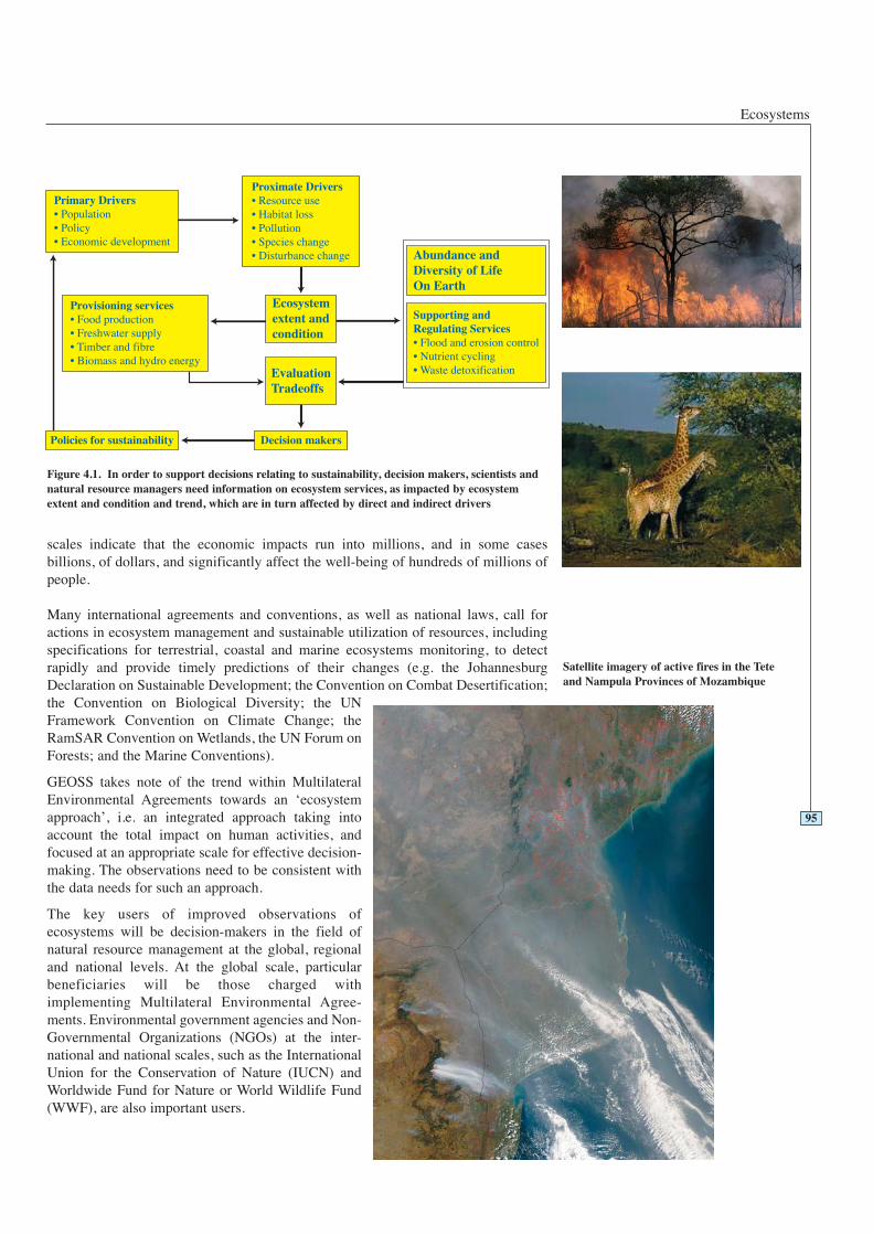
Ecosystems
scales indicate that the economic impacts run into millions, and in some casesbillions, of dollars, and significantly affect the well-being of hundreds of millions ofpeople.
Many international agreements and conventions, as well as national laws, call foractions in ecosystem management and sustainable utilization of resources, includingspecifications for terrestrial, coastal and marine ecosystems monitoring, to detectrapidly and provide timely predictions of their changes (e.g. the JohannesburgDeclaration on Sustainable Development; the Convention on Combat Desertification;the Convention on Biological Diversity; the UNFramework Convention on Climate Change; theRamSAR Convention on Wetlands, the UN Forum onForests; and the Marine Conventions).
GEOSS takes note of the trend within MultilateralEnvironmental Agreements towards an ‘ecosystemapproach’, i.e. an integrated approach taking intoaccount the total impact on human activities, andfocused at an appropriate scale for effective decision-making. The observations need to be consistent withthe data needs for such an approach.
The key users of improved observations ofecosystems will be decision-makers in the field ofnatural resource management at the global, regionaland national levels. At the global scale, particularbeneficiaries will be those charged withimplementing Multilateral Environmental Agree-ments. Environmental government agencies and Non-Governmental Organizations (NGOs) at the inter-national and national scales, such as the InternationalUnion for the Conservation of Nature (IUCN) andWorldwide Fund for Nature or World Wildlife Fund(WWF), are also important users.
95
Figure 4.1. In order to support decisions relating to sustainability, decision makers, scientists andnatural resource managers need information on ecosystem services, as impacted by ecosystemextent and condition and trend, which are in turn affected by direct and indirect drivers
Satellite imagery of active fires in the Teteand Nampula Provinces of Mozambique
GEOSS 10-Year Implementation Plan: Reference Document
4.7.2 Vision and How GEOSS Will Help
The vision is to develop, on a global basis, standardized and integratedmethodologies, observations and products that allow the repeated mapping ofecosystem extent and the quantification of ecosystem condition, for the purposes ofdetecting and predicting changes in ecosystem function, identifying locations underthreat of degradation, and identifying uses that are unsustainable.
Ecosystem properties are currently widely observed, but not consistently,systematically or in an integrated way, and the data are not widely shared. Many
96
Example: Early Warning of Toxic Algal Blooms
In recent years, the economic losses caused by harmful algal blooms in the ChinaSea, which is bordered by several countries, have exceeded US$ 1.2 billion. Tomitigate the damage to coastal and marine ecosystems and to reduce the economiclosses, approaches to monitor and to predict the occurrence of the blooms are beingdeveloped. The observational products from GEOSS such as Sea SurfaceTemperature (SST), sea surface chlorophyll, suspended sediment and ocean colourcould be used in monitoring the state of the coastal ocean, and in conjunction withan ocean ecosystem model, to predict the time of occurrence and spatial coverageand intensity of algal blooms. Complementary in situ data would provideadditional detail on the nature of the blooms, and on their level of toxicity. Awarning system would inform the fishing industry, transportation industry andrecreation agencies of the risks.
Satellite measurements can be used to quantify the concentrations of green-leaf vegetation around the World, allowing scientists to monitor majorfluctuations and understand how they affect, and are affected by, regional climate trends
Cou
rtes
y of
MO
DIS
Lan
d G
roup
Ecosystems
ecosystem processes are transnational andrequire an integrated, global approach toavoid, contain and mitigate problems relatedto ecosystem management. GEOSS can bethe mechanism to help the integration,harmonization, and coordination of theefforts and outcomes of current research andmonitoring programmes related to marine,coastal, inland aquatic and terrestrialecosystems at the international level.
GEOSS can also serve as an instrument forscaling up local and regional observations tothe global scale, in order to address issueswith global implications, or those that areubiquitous in nature. To this purpose,GEOSS must be built from regionalnetworks or national institutions working onecosystem monitoring.
Increasing worldwide concerns regardingecosystems argue for improved monitoring.As yet, no system for sustained, long-termmonitoring of ecosystem processes is inplace at the global scale. The productsderived from integration of remotely sensedand in situ observations through GEOSSwill contribute to closing this gap. GEOSSwill improve the capacity to monitor thestatus and variability of ecosystems and thepressures on them and thus contribute tosustainable management of living resources.It will also contribute to monitoring thepressure on terrestrial, coastal, marine andfreshwater ecosystems and the assessment oftheir ability to support sustainabledevelopment. Thirdly, it will be of value inacquiring and integrating information on thebiological causes and feedback mechanismsimplicated in global change and climatevariability.
4.7.3 Existing Situation and Gaps
There are elements of existing global observing systems that can contribute to theneeds identified above, and much detailed planning for needed observation systemshas been done. Specifically, the IGOS-P Oceans, Carbon, Land and Coastal ThemeReports describe most of the observational requirements relating to ecosystems. TheIGOS-P specifications are themselves based on observations made by space agenciesrepresented in the CEOS and in situ observations made by governmental agencies inindividual countries (including environmental agencies, forestry, fisheries, and oceandepartments; and research organizations), coordinated by the GOOS, the GlobalTerrestrial Observing System (GTOS) and the Global Geodetic Observing System(GGOS). Key organizations, initiatives, projects and programmes include the Land-Ocean Interactions in the Coastal Zone Project (LOICZ of the IGBP), Global OceanEcosystem Dynamics Project (GLOBEC of the IGBP), Surface Ocean–LowerAtmosphere Study (SOLAS), Integrated Marine Biogeochemistry and Ecosystem
97
Boom-mounted microwave sounders mounted on a truck can quicklymeasure soil moisture
GEOSS 10-Year Implementation Plan: Reference Document
Research (IMBER), Marine Geological and Biological Habitat Mapping (GeoHab),International Ocean Carbon Coordination Project (IOCCP), International Associationof Geodesy (IAG), United Nations Environment Programme (UNEP) BiodiversityProgram, UNESCO, and the UN Food and Agriculture Organization (FAO) ForestResource Assessment. This societal benefit area has close links to those of Climate,Water, and Biodiversity, so organizations and observations involved in those areas areoften also relevant here.
Global maps of land cover (from which ecosystem extent can be inferred) have beenprepared by a number of organizations. The conceptual equivalent for oceans (largemarine ecosystems, or alternately the biogeochemical provinces) has been mapped.High-resolution global products of leaf area, ocean colour, and net primaryproduction exist in the research domain. Observation-based maps of nitrogendeposition exist for limited regions, some making use of hyperspectral informationfrom airborne or space-based remote sensing. At the global scale, nitrogen depositionmaps are model-based and incompletely validated. The GOFC/GOLD panel of GTOShas an operational fire observation system. Metadata on several thousand existingterrestrial, freshwater, coastal, and cryosphere observation sites around the World aremaintained in the GTOS Terrestrial Ecosystem Monitoring Sites (TEMS) database.
Detailed observation plans exist in the following subtopics:
• Coastal ecosystems (IGOS-P Coastal Theme, GTOS and GOOS coastalobservation panels, OOI/IOOS networks).
• Land cover, including global fire mapping products, cultivated area, and forest area(IGOS-P Land Theme, GTOS Global Observation of Forest and Land CoverDynamics (GOFC/GOLD), FAO Global Land Cover Network (GLCN)).
• Carbon cycle observations (IGOS-P Integrated Global Carbon Observation(IGCO) Theme, incorporating the GTOS Terrestrial Carbon Observations on land,GCOS components for the atmosphere and the GOOS IOCCP for the oceans).
• Freshwater ecosystems are partly covered by the IGOS-P Global Water CycleObservation Theme (IGWCO).
Nonetheless there are significant gaps. As yet there is no universally agreedclassification scheme for ecosystems, although there are strong efforts in thisdirection by, among others, the FAO Land Cover Classification System (LCCS).Neither are there reliable maps of the geology, soil, and sediment properties thatcontrol many ecosystem processes, such as soil depth, geochemistry, carbon content,
98

Ecosystems
particle size distribution and pollution status, at a resolution appropriateto ecosystem processes, and with global coverage, although there areefforts underway by FAO and the International Soil Science SocietySoTER project to address this need.
The observation and estimation of the lateral flow of material (carbon,nitrogen and other elements) in traded products, river discharge, oceancurrents and air masses are poor. In addition there is no assured continuityof moderate to high-resolution satellite data for ecosystem mapping andkey variable observations, specifically of land cover, ocean colour andtemperature. The time scale of ecosystem dynamics makes long-termmonitoring of ecosystem processes highly desirable.
There is not a sufficient and representative in situ observational networkfor complementing and validating satellite data. Nor do adequateobservation systems exist for: soil moisture; land-ocean-atmosphereexchanges of water, energy and carbon and nitrogen; biomass andstanding stocks of carbon, nitrogen and other elements; canopy propertiesand their temporal dynamics; and routine in situ chemical and biologicalmeasurements of the aquatic environment, including primary andsecondary production and biomass in lakes and oceans. There is a need todevelop and improve data assimilation, data fusion, historical datamining, models and remote sensing algorithms in the ecosystems field,and to generate operational products relating to ecosystem disturbanceregimes, such as harvesting, fire, drought, pest and disease outbreaks,major storms, and large-scale climate anomalies (e.g. El Niño-La Niñaevents, see Section 4.4).
4.7.4 Targets
99
2 Year Targets 4.7 Ecosystems
Working with the ecosystem management community, GEOSS will:
Facilitate the harmonization of methods for observing the GEOSS set of ecosystemvariables.
Facilitate the full implementation of a global carbon observing system, inaccordance with the specifications detailed in the IGOS-P IGCO Theme Report,which incorporates the Terrestrial Carbon Observation plan of GTOS, and carbon-related components of GOOS and GCOS.
Facilitate a globally agreed, robust and implementable (operational) classificationscheme for ecosystems.
Advocate the operational continuity of moderate to high-resolution Earth-observingsatellites for land cover and ocean colour.
Facilitate efforts to eliminate regional disparity in observing capacity. For example,two thirds of the World’s oceans are in the Southern Hemisphere, whereas most ofthe advanced oceanographic centres are in the Northern Hemisphere. Stations forobserving ecological variables on land are much more closely spaced in temperatecountries than in the tropical belt.
Facilitate the networking of institutions making observations relating to ecosystems.
Flux tower for in-situ carbon-dioxide measurements
GEOSS 10-Year Implementation Plan: Reference Document
100
Advocate the development of tools to scale up from a limited number of in situecosystem observations made at local scales, to arrive at a large-scale,comprehensive picture of ecosystems.
Advocate the continued rescue, acquisition, digitisation and making accessible ofhistorical information relating to ecosystems.
Facilitate the validation of existing tools such as synthetic aperture radar andhyperspectral imagers for the measurement of ecosystem properties.
Advocate the development of new sensors and platforms, and facilitate their use forroutine observations in the field on an operational basis. For example, airbornesensor technologies such as LiDAR are ready to move out of the research domain.Molecular tools are now being developed to study the microbial ecology of marinesystems. In situ, self-contained, flow cytometers for classification of phyto-plankton and bacteria (the “cytobuoys”) and underwater laser imaging and scanningtechniques that can be used for recording marine life underwater and for detectingterrestrial ecosystem structures, are in advanced stages of development. Newsensors are also on the horizon for measurement of the chemical properties of theocean and terrestrial ecosystems.
6 Year Targets 4.7 Ecosystems
Working with the ecosystem management community, GEOSS will:
Facilitate the execution of a global (terrestrial, inland water, coastal, and oceanic)ecosystem mapping initiative at a resolution of 500 m, using a standardizedclassification and the tools validated above, and integrated with the Global SpatialData Initiative.
Facilitate the implementation of a global nitrogen observing system.
Facilitate the coordination and expansion of a network of land, ocean and coastalreference stations for monitoring ecosystem properties such as carbon, nitrogen,phosphorus, and iron fluxes, including change detection.
Facilitate the establishment of a global, sufficient and representative in situ andairborne network for validating and enhancing space-based observations ofecosystem properties in both terrestrial and aquatic ecosystems, based on existingnational and regional integrated environmental monitoring networks, andcoordinated with and linked to the network described above.
Produce or facilitate the production of baseline maps for the globe, with adequateresolution and known uncertainty, of selected ecosystem properties such as: leafarea phenology, phytoplankton bloom dynamics; primary production, and netcarbon exchange; energy and water exchange; productivity at higher trophic levels(e.g. grazing, fisheries production), and ancillary data such as topography, land use,geology and soils.
Ecosystems
4.7.5 Observation Requirements Table
Please see Table 4.7.5 on the following page.
101
10 Year Targets 4.7 Ecosystems
Working with the ecosystem management community, GEOSS will:
Facilitate the production of spatially-resolved information on ecosystem change,condition and trend, in relation to their capacity to deliver sustainable ecosystemservices in sufficient quantities to meet societal needs; i.e. maps of ecosystemhealth, risk and vulnerability with sufficient resolution to support national andglobal decision-making.
Facilitate monitoring of urban ecosystems.
Legend for Table 4.7.5
0 - Monitored with acceptable accuracy, spatial and temporalresolution; timeliness and in all countries worldwide.
1 - Monitored with marginally acceptable accuracy, spatial andtemporal resolution; timeliness or not in all countriesworldwide.
2 - Not yet widely available or not yet globally monitored, butcould be within two years.
3 - Only locally available or experimental; could be available in sixyears.
4 - Still in research phase; could be available in ten years.
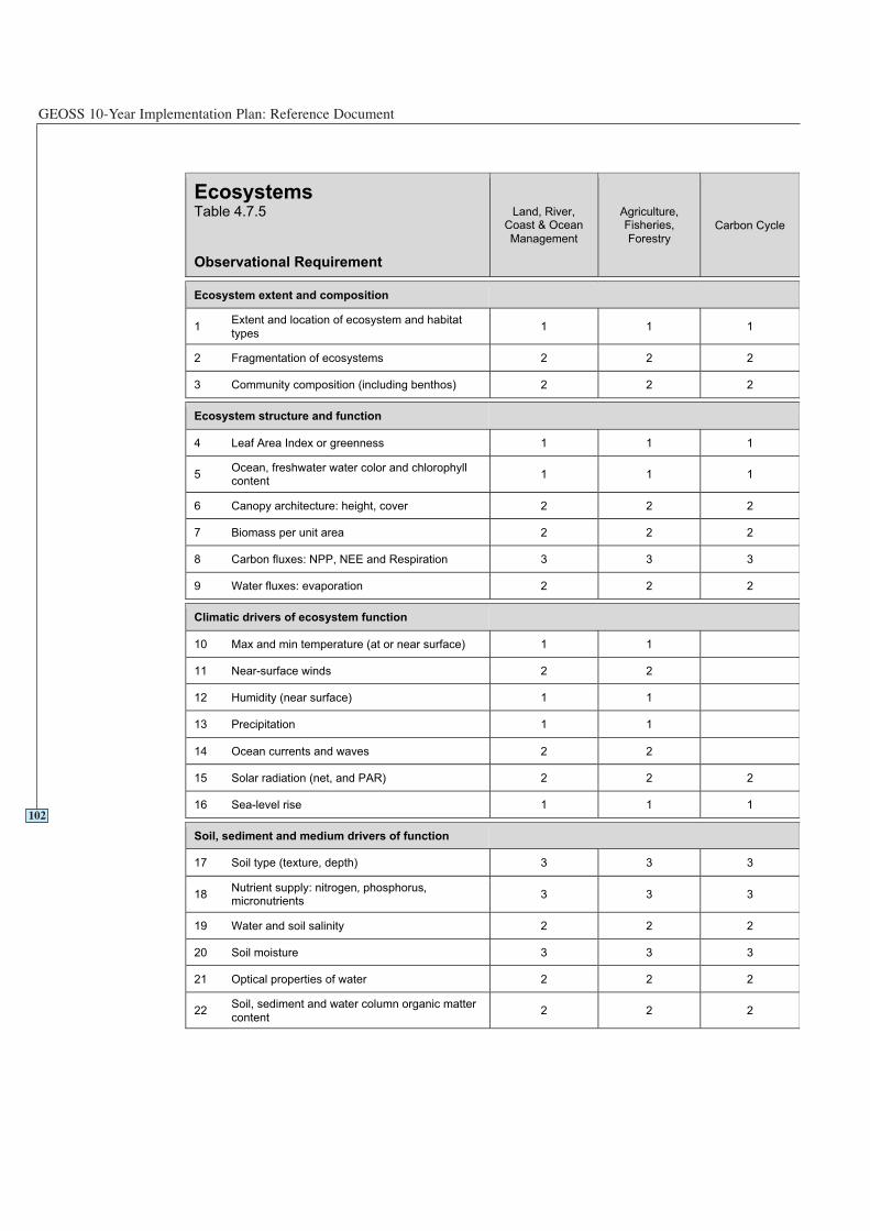
GEOSS 10-Year Implementation Plan: Reference Document
102
EcosystemsTable 4.7.5
Observational Requirement
Land, River,Coast & Ocean
Management
Agriculture,Fisheries,
ForestryCarbon Cycle
Ecosystem extent and composition
1Extent and location of ecosystem and habitat
types1 1 1
2 Fragmentation of ecosystems 2 2 2
3 Community composition (including benthos) 2 2 2
Ecosystem structure and function
4 Leaf Area Index or greenness 1 1 1
5Ocean, freshwater water color and chlorophyllcontent
1 1 1
6 Canopy architecture: height, cover 2 2 2
7 Biomass per unit area 2 2 2
8 Carbon fluxes: NPP, NEE and Respiration 3 3 3
9 Water fluxes: evaporation 2 2 2
Climatic drivers of ecosystem function
10 Max and min temperature (at or near surface) 1 1
11 Near-surface winds 2 2
12 Humidity (near surface) 1 1
13 Precipitation 1 1
14 Ocean currents and waves 2 2
15 Solar radiation (net, and PAR) 2 2 2
16 Sea-level rise 1 1 1
Soil, sediment and medium drivers of function
17 Soil type (texture, depth) 3 3 3
18Nutrient supply: nitrogen, phosphorus,micronutrients
3 3 3
19 Water and soil salinity 2 2 2
20 Soil moisture 3 3 3
21 Optical properties of water 2 2 2
22Soil, sediment and water column organic matter
content2 2 2

Ecosystems
103
EcosystemsTable 4.7.5
Observational Requirement
Land, River,Coast & Ocean
Management
Agriculture,Fisheries,
ForestryCarbon Cycle
Human drivers of ecosystem function
23Human population density and growth rate,urban and rural
1 1
24 Harvest intensity (on land and oceans) 1 1
25 Nitrogen deposition 3 3
26 Extent of coastal and lake eutrophic zones 2
Disturbance regime
27 Burned area 1 1 1
28 Pest and disease outbreaks 3
29 River discharge pattern 2
Note: many ecosystem services are listed under other benefit areas, and would be part of the ecosystem benefit
area as well. These include water yield, food and forest production, climate regulation, flood amelioration, andextent of desertification.
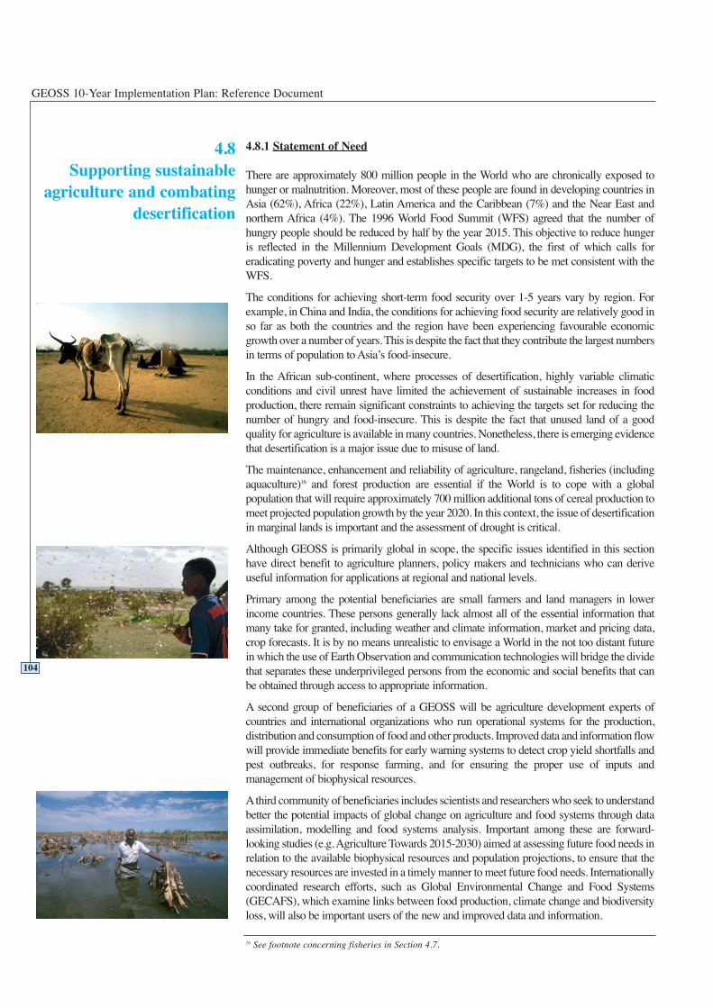
GEOSS 10-Year Implementation Plan: Reference Document
4.8.1 Statement of Need
There are approximately 800 million people in the World who are chronically exposed tohunger or malnutrition. Moreover, most of these people are found in developing countries inAsia (62%), Africa (22%), Latin America and the Caribbean (7%) and the Near East andnorthern Africa (4%). The 1996 World Food Summit (WFS) agreed that the number ofhungry people should be reduced by half by the year 2015. This objective to reduce hungeris reflected in the Millennium Development Goals (MDG), the first of which calls foreradicating poverty and hunger and establishes specific targets to be met consistent with theWFS.
The conditions for achieving short-term food security over 1-5 years vary by region. Forexample, in China and India, the conditions for achieving food security are relatively good inso far as both the countries and the region have been experiencing favourable economicgrowth over a number of years. This is despite the fact that they contribute the largest numbersin terms of population to Asia’s food-insecure.
In the African sub-continent, where processes of desertification, highly variable climaticconditions and civil unrest have limited the achievement of sustainable increases in foodproduction, there remain significant constraints to achieving the targets set for reducing thenumber of hungry and food-insecure. This is despite the fact that unused land of a goodquality for agriculture is available in many countries. Nonetheless, there is emerging evidencethat desertification is a major issue due to misuse of land.
The maintenance, enhancement and reliability of agriculture, rangeland, fisheries (includingaquaculture)16 and forest production are essential if the World is to cope with a globalpopulation that will require approximately 700 million additional tons of cereal production tomeet projected population growth by the year 2020. In this context, the issue of desertificationin marginal lands is important and the assessment of drought is critical.
Although GEOSS is primarily global in scope, the specific issues identified in this sectionhave direct benefit to agriculture planners, policy makers and technicians who can deriveuseful information for applications at regional and national levels.
Primary among the potential beneficiaries are small farmers and land managers in lowerincome countries. These persons generally lack almost all of the essential information thatmany take for granted, including weather and climate information, market and pricing data,crop forecasts. It is by no means unrealistic to envisage a World in the not too distant futurein which the use of Earth Observation and communication technologies will bridge the dividethat separates these underprivileged persons from the economic and social benefits that canbe obtained through access to appropriate information.
A second group of beneficiaries of a GEOSS will be agriculture development experts ofcountries and international organizations who run operational systems for the production,distribution and consumption of food and other products. Improved data and information flowwill provide immediate benefits for early warning systems to detect crop yield shortfalls andpest outbreaks, for response farming, and for ensuring the proper use of inputs andmanagement of biophysical resources.
Athird community of beneficiaries includes scientists and researchers who seek to understandbetter the potential impacts of global change on agriculture and food systems through dataassimilation, modelling and food systems analysis. Important among these are forward-looking studies (e.g. Agriculture Towards 2015-2030) aimed at assessing future food needs inrelation to the available biophysical resources and population projections, to ensure that thenecessary resources are invested in a timely manner to meet future food needs. Internationallycoordinated research efforts, such as Global Environmental Change and Food Systems(GECAFS), which examine links between food production, climate change and biodiversityloss, will also be important users of the new and improved data and information.
4.8Supporting sustainable
agriculture and combatingdesertification
16 See footnote concerning fisheries in Section 4.7.
104
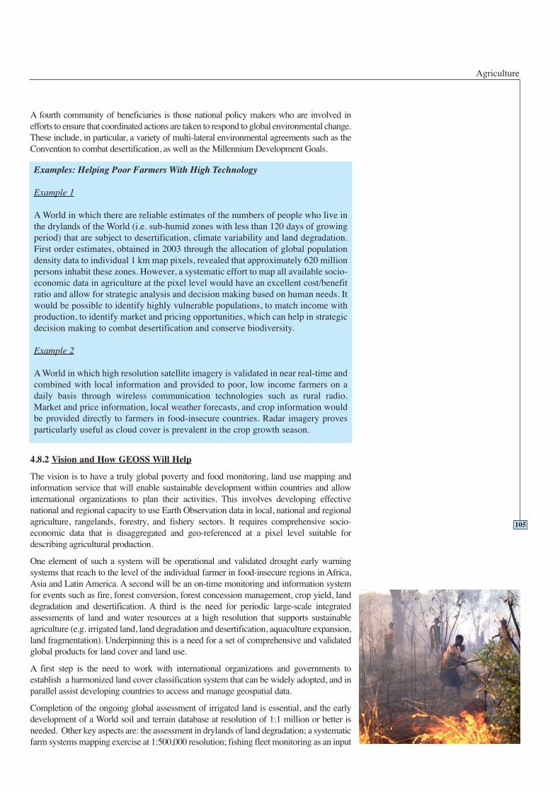
Agriculture
A fourth community of beneficiaries is those national policy makers who are involved inefforts to ensure that coordinated actions are taken to respond to global environmental change.These include, in particular, a variety of multi-lateral environmental agreements such as theConvention to combat desertification, as well as the Millennium Development Goals.
4.8.2 Vision and How GEOSS Will Help
The vision is to have a truly global poverty and food monitoring, land use mapping andinformation service that will enable sustainable development within countries and allowinternational organizations to plan their activities. This involves developing effectivenational and regional capacity to use Earth Observation data in local, national and regionalagriculture, rangelands, forestry, and fishery sectors. It requires comprehensive socio-economic data that is disaggregated and geo-referenced at a pixel level suitable fordescribing agricultural production.
One element of such a system will be operational and validated drought early warningsystems that reach to the level of the individual farmer in food-insecure regions in Africa,Asia and Latin America. A second will be an on-time monitoring and information systemfor events such as fire, forest conversion, forest concession management, crop yield, landdegradation and desertification. A third is the need for periodic large-scale integratedassessments of land and water resources at a high resolution that supports sustainableagriculture (e.g. irrigated land, land degradation and desertification, aquaculture expansion,land fragmentation). Underpinning this is a need for a set of comprehensive and validatedglobal products for land cover and land use.
A first step is the need to work with international organizations and governments toestablish a harmonized land cover classification system that can be widely adopted, and inparallel assist developing countries to access and manage geospatial data.
Completion of the ongoing global assessment of irrigated land is essential, and the earlydevelopment of a World soil and terrain database at resolution of 1:1 million or better isneeded. Other key aspects are: the assessment in drylands of land degradation; a systematicfarm systems mapping exercise at 1:500,000 resolution; fishing fleet monitoring as an input
Examples: Helping Poor Farmers With High Technology
Example 1
A World in which there are reliable estimates of the numbers of people who live inthe drylands of the World (i.e. sub-humid zones with less than 120 days of growingperiod) that are subject to desertification, climate variability and land degradation.First order estimates, obtained in 2003 through the allocation of global populationdensity data to individual 1 km map pixels, revealed that approximately 620 millionpersons inhabit these zones. However, a systematic effort to map all available socio-economic data in agriculture at the pixel level would have an excellent cost/benefitratio and allow for strategic analysis and decision making based on human needs. Itwould be possible to identify highly vulnerable populations, to match income withproduction, to identify market and pricing opportunities, which can help in strategicdecision making to combat desertification and conserve biodiversity.
Example 2
A World in which high resolution satellite imagery is validated in near real-time andcombined with local information and provided to poor, low income farmers on adaily basis through wireless communication technologies such as rural radio.Market and price information, local weather forecasts, and crop information wouldbe provided directly to farmers in food-insecure countries. Radar imagery provesparticularly useful as cloud cover is prevalent in the crop growth season.
105
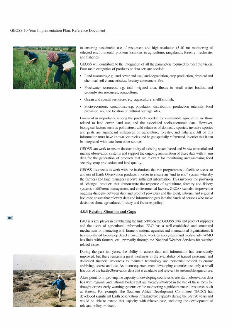
GEOSS 10-Year Implementation Plan: Reference Document
to ensuring sustainable use of resources; and high-resolution (5-40 m) monitoring ofselected environmental problem locations in agriculture, rangelands, forestry, freshwaterand fisheries.
GEOSS will contribute to the integration of all the parameters required to meet the vision.Four main categories of products or data sets are needed:
• Land resources, e.g. land cover and use, land degradation, crop production, physical andchemical soil characteristics, forestry assessment, fire.
• Freshwater resources, e.g. total irrigated area, fluxes in small water bodies, andgroundwater resources, aquaculture.
• Ocean and coastal resources, e.g. aquaculture, shellfish, fish.
• Socio-economic conditions, e.g. population distribution, production intensity, foodprovision, and the location of cultural heritage sites.
Foremost in importance among the products needed for sustainable agriculture are thoserelated to land cover, land use, and the associated socio-economic data. However,biological factors such as pollinators, wild relatives of domestic species, invasive speciesand pests are significant influences on agriculture, forestry, and fisheries. All of thisinformation must have known accuracies and be geospatially referenced, in order that it canbe integrated with data from other sources.
GEOSS can work to ensure the continuity of existing space-based and in-situ terrestrial andmarine observation systems and support the ongoing assimilation of these data with in-situdata for the generation of products that are relevant for monitoring and assessing foodsecurity, crop production and land quality.
GEOSS also needs to work with the institutions that run programmes to facilitate access toand use of Earth Observation products in order to ensure an “end-to-end” system wherebythe farmers and land managers receive sufficient information. This involves the provisionof “change” products that demonstrate the response of agriculture, forestry and fisherysystems to different management and environmental factors. GEOSS can also improve theongoing dialogue between data and product providers and the local, national and regionalbodies to ensure that relevant data and information gets into the hands of persons who makedecisions about agriculture, forestry and fisheries policy.
4.8.3 Existing Situation and Gaps
FAO is a key player in establishing the link between the GEOSS data and product suppliersand the users of agricultural information. FAO has a well-established and structuredmechanism for interacting with farmers, national agencies and international organizations. Ithas also started to develop direct cross-links to work on ecosystems and biodiversity. WMOhas links with farmers, etc., primarily through the National Weather Services for weatherrelated issues.
During the past ten years, the ability to access data and information has consistentlyimproved, but there remains a great weakness in the availability of trained personnel anddedicated financial resources to maintain technology and personnel needed to ensurearchiving, access and use. As a consequence, most developing countries use only a smallfraction of the Earth Observation data that is available and relevant to sustainable agriculture.
Akey point for improving the capacity of developing countries to use Earth observation datalies with regional and national bodies that are already involved in the use of these tools fordrought or pest early warning systems or for monitoring significant natural resources suchas forests. For example, the Southern Africa Development Committee (SADC) hasdeveloped significant Earth observation infrastructure capacity during the past 20 years andwould be able to extend that capacity with relative ease, including the development ofrelevant policy products.
106
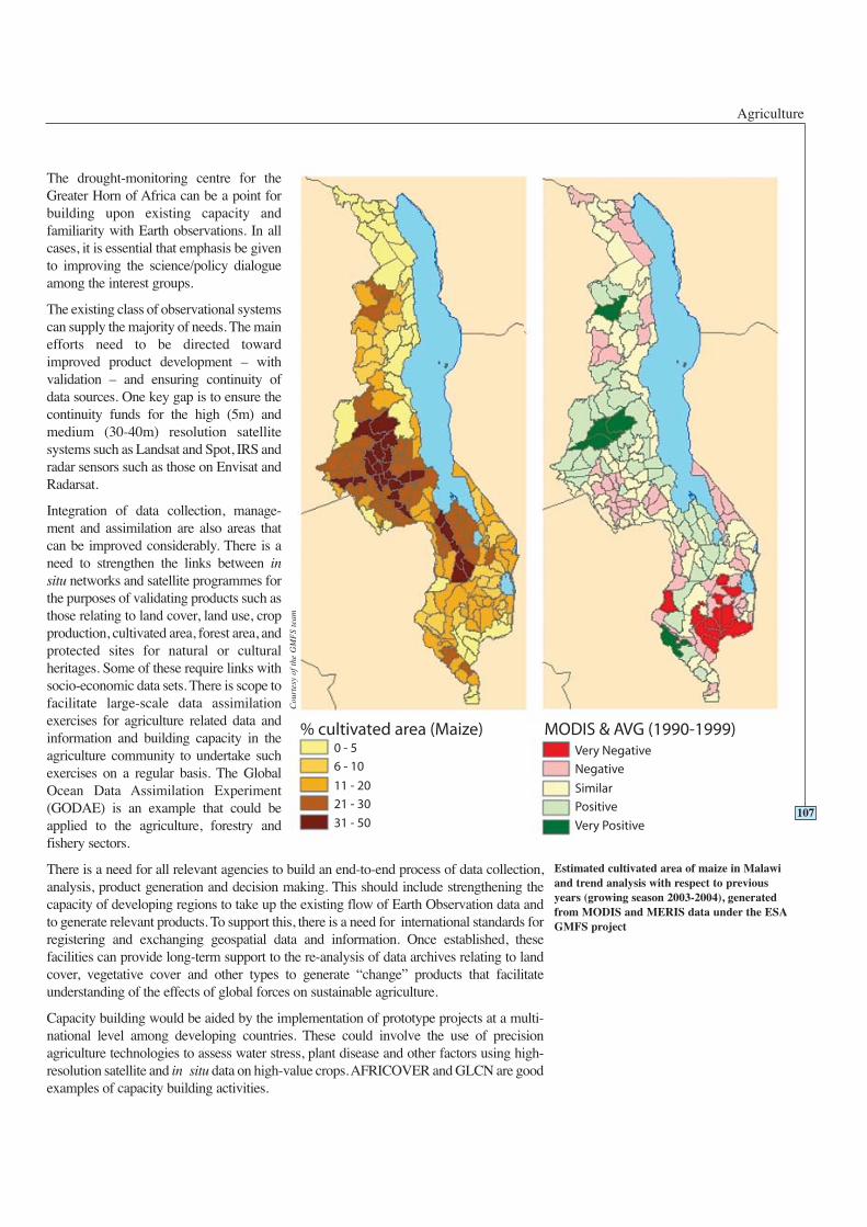
The drought-monitoring centre for theGreater Horn of Africa can be a point forbuilding upon existing capacity andfamiliarity with Earth observations. In allcases, it is essential that emphasis be givento improving the science/policy dialogueamong the interest groups.
The existing class of observational systemscan supply the majority of needs. The mainefforts need to be directed towardimproved product development – withvalidation – and ensuring continuity ofdata sources. One key gap is to ensure thecontinuity funds for the high (5m) andmedium (30-40m) resolution satellitesystems such as Landsat and Spot, IRS andradar sensors such as those on Envisat andRadarsat.
Integration of data collection, manage-ment and assimilation are also areas thatcan be improved considerably. There is aneed to strengthen the links between insitu networks and satellite programmes forthe purposes of validating products such asthose relating to land cover, land use, cropproduction, cultivated area, forest area, andprotected sites for natural or culturalheritages. Some of these require links withsocio-economic data sets. There is scope tofacilitate large-scale data assimilationexercises for agriculture related data andinformation and building capacity in theagriculture community to undertake suchexercises on a regular basis. The GlobalOcean Data Assimilation Experiment(GODAE) is an example that could beapplied to the agriculture, forestry andfishery sectors.
There is a need for all relevant agencies to build an end-to-end process of data collection,analysis, product generation and decision making. This should include strengthening thecapacity of developing regions to take up the existing flow of Earth Observation data andto generate relevant products. To support this, there is a need for international standards forregistering and exchanging geospatial data and information. Once established, thesefacilities can provide long-term support to the re-analysis of data archives relating to landcover, vegetative cover and other types to generate “change” products that facilitateunderstanding of the effects of global forces on sustainable agriculture.
Capacity building would be aided by the implementation of prototype projects at a multi-national level among developing countries. These could involve the use of precisionagriculture technologies to assess water stress, plant disease and other factors using high-resolution satellite and in situ data on high-value crops. AFRICOVER and GLCN are goodexamples of capacity building activities.
Agriculture
107
Estimated cultivated area of maize in Malawiand trend analysis with respect to previousyears (growing season 2003-2004), generatedfrom MODIS and MERIS data under the ESAGMFS project
Cou
rtes
y of
the
GM
FS
team
GEOSS 10-Year Implementation Plan: Reference Document
4.8.4 Targets
108
6 Year Targets 4.8 Agriculture
Working with the agriculture community, GEOSS will:
Advocate the development and improvement of the analytical tools and methods foragriculture risk assessment, and establish common standards and formats.
Advocate support for the completion of the World soil and terrain database (SoTer)at a resolution of 1:1 million.
Advocate support for the completion of land degradation and desertificationassessment in drylands (LADA).
Facilitate provision of regularly validated global land cover product at 1:500,000.
Facilitate the role of satellite data in monitoring and maintaining a global farmingsystems database.
2 Year Targets 4.8 Agriculture
Working with the agriculture community, GEOSS will:
Facilitate - with relevant users at regional, national and local level - definition ofuser needs for agriculture, rangelands, forestry and fisheries in terms of EarthObservation data and information, as well as mechanisms to keep users informed.
Advocate and facilitate existing initiatives that regularly provide updates of landcover data at 1:1,000,000 scale; use agreed International Organization forStandardization (ISO) standard to initiate land cover mapping activities at 1:500,000.
Facilitate regional training in land cover classification and the assimilation ofexisting data sets in Africa, Asia and Latin America.
Facilitate the use of agriculture, forestry, and fishery production statistics to beexploited at pixel level.
Advocate the adoption and use of geostationary satellite data (e.g. Meteosat SecondGeneration) in food-insecure regions.
Facilitate establishment of a basis for the continuity of high resolution optical andradar satellite observing networks (5-30 m).
Facilitate production of a map of the World’s irrigated agriculture areas, and theestablishment of a monitoring programme among users.
Advocate the development of on-time monitoring and information systems forsignificant and extreme events such as fire, forest conversion, and forest concessionmanagement.
Facilitate the development of courses to demonstrate the usage of Earth observationdata and products in developing countries.
Agriculture
4.8.5 Table of Observation Requirements
Please see Table 4.8.5 on the following page.
109
Facilitate the establishment of operational linkage of Earth Observation data togeospatially referenced production and use statistics. This should cover cropagriculture, livestock, forestry and freshwater fisheries.
Facilitate the continuity of high-resolution imagery for monitoring loggingconcessions in areas with high biodiversity concentrations.
Advocate operational on-time monitoring and information systems introduced forsignificant and extreme events such as crop yield and crop water stress.
10 Year Targets 4.8 Agriculture
Working with the agriculture community, GEOSS will:
Facilitate, with identified partners, the development of a fully integrated in situ andspaced-based observation service for on-time drought early warning systems infood-insecure regions.
Facilitate, with identified partners, the production of a comprehensive and validatedglobal products suite production capability for land cover in higher resolution (e.g.1:250,000) and land use in moderate resolution (e.g. 1:500,000).
Facilitate the creation of global databases and assessments of irrigated land, wateravailability for agriculture, land degradation, forest conversion, and aquacultureexpansion. Define process for data supply for updates.
Facilitate conversion of all statistics and associated sub-national socio-economicdata and environmental information to pixel format with known accuracies for crosslinkage with satellite data.
Facilitate on-time monitoring and information systems for significant and extremeevents such as areas of land degradation and desertification.
Produce an assessment of the effectiveness of delivery of GEOSS capacity buildingactivities in the agriculture, forestry, and fishery sectors.
Legend for Table 4.8.5
0 - Monitored with acceptable accuracy, spatial and temporalresolution; timeliness and in all countries worldwide.
1 - Monitored with marginally acceptable accuracy, spatial andtemporal resolution; timeliness or not in all countriesworldwide.
2 - Not yet widely available or not yet globally monitored, butcould be within two years.
3 - Only locally available or experimental; could be available insix years.
4 - Still in research phase; could be available in ten years.
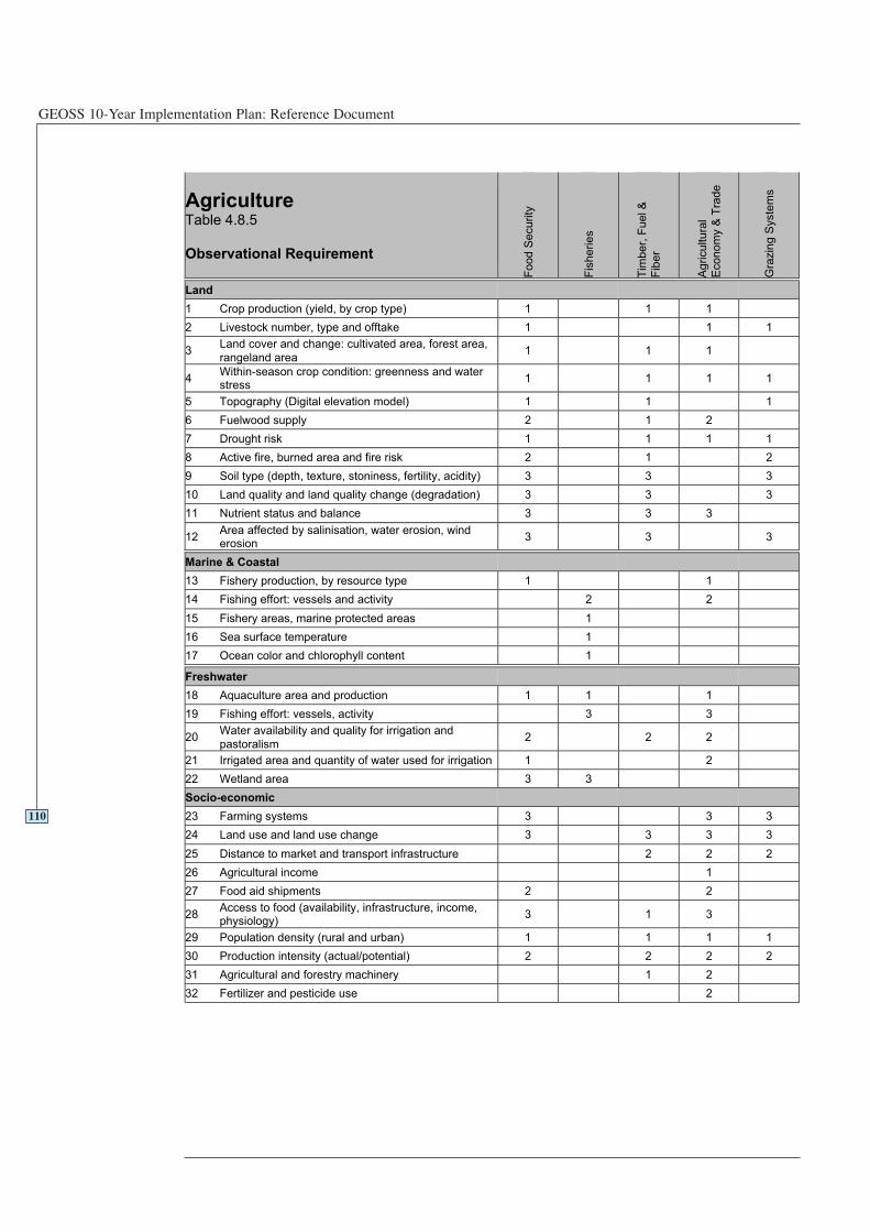
GEOSS 10-Year Implementation Plan: Reference Document
110
AgricultureTable 4.8.5
Observational Requirement
Fo
od
Se
cu
rity
Fis
he
rie
s
Tim
ber,
Fuel &
Fib
er
Agricultura
l
Eco
no
my &
Tra
de
Gra
zin
g S
yste
ms
Land
1 Crop production (yield, by crop type) 1 1 1
2 Livestock number, type and offtake 1 1 1
3Land cover and change: cultivated area, forest area,
rangeland area1 1 1
4Within-season crop condition: greenness and waterstress
1 1 1 1
5 Topography (Digital elevation model) 1 1 1
6 Fuelwood supply 2 1 2
7 Drought risk 1 1 1 1
8 Active fire, burned area and fire risk 2 1 2
9 Soil type (depth, texture, stoniness, fertility, acidity) 3 3 3
10 Land quality and land quality change (degradation) 3 3 3
11 Nutrient status and balance 3 3 3
12Area affected by salinisation, water erosion, winderosion
3 3 3
Marine & Coastal
13 Fishery production, by resource type 1 1
14 Fishing effort: vessels and activity 2 2
15 Fishery areas, marine protected areas 1
16 Sea surface temperature 1
17 Ocean color and chlorophyll content 1
Freshwater
18 Aquaculture area and production 1 1 1
19 Fishing effort: vessels, activity 3 3
20Water availability and quality for irrigation and
pastoralism2 2 2
21 Irrigated area and quantity of water used for irrigation 1 2
22 Wetland area 3 3
Socio-economic
23 Farming systems 3 3 3
24 Land use and land use change 3 3 3 3
25 Distance to market and transport infrastructure 2 2 2
26 Agricultural income 1
27 Food aid shipments 2 2
28Access to food (availability, infrastructure, income,physiology)
3 1 3
29 Population density (rural and urban) 1 1 1 1
30 Production intensity (actual/potential) 2 2 2 2
31 Agricultural and forestry machinery 1 2
32 Fertilizer and pesticide use 2
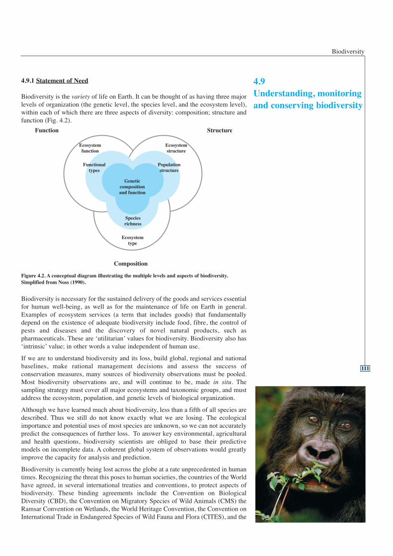
4.9Understanding, monitoringand conserving biodiversity
Biodiversity
4.9.1 Statement of Need
Biodiversity is the variety of life on Earth. It can be thought of as having three majorlevels of organization (the genetic level, the species level, and the ecosystem level),within each of which there are three aspects of diversity: composition; structure andfunction (Fig. 4.2).
Biodiversity is necessary for the sustained delivery of the goods and services essentialfor human well-being, as well as for the maintenance of life on Earth in general.Examples of ecosystem services (a term that includes goods) that fundamentallydepend on the existence of adequate biodiversity include food, fibre, the control ofpests and diseases and the discovery of novel natural products, such aspharmaceuticals. These are ‘utilitarian’ values for biodiversity. Biodiversity also has‘intrinsic’ value; in other words a value independent of human use.
If we are to understand biodiversity and its loss, build global, regional and nationalbaselines, make rational management decisions and assess the success ofconservation measures, many sources of biodiversity observations must be pooled.Most biodiversity observations are, and will continue to be, made in situ. Thesampling strategy must cover all major ecosystems and taxonomic groups, and mustaddress the ecosystem, population, and genetic levels of biological organization.
Although we have learned much about biodiversity, less than a fifth of all species aredescribed. Thus we still do not know exactly what we are losing. The ecologicalimportance and potential uses of most species are unknown, so we can not accuratelypredict the consequences of further loss. To answer key environmental, agriculturaland health questions, biodiversity scientists are obliged to base their predictivemodels on incomplete data. A coherent global system of observations would greatlyimprove the capacity for analysis and prediction.
Biodiversity is currently being lost across the globe at a rate unprecedented in humantimes. Recognizing the threat this poses to human societies, the countries of the Worldhave agreed, in several international treaties and conventions, to protect aspects ofbiodiversity. These binding agreements include the Convention on BiologicalDiversity (CBD), the Convention on Migratory Species of Wild Animals (CMS) theRamsar Convention on Wetlands, the World Heritage Convention, the Convention onInternational Trade in Endangered Species of Wild Fauna and Flora (CITES), and the
111
Figure 4.2. A conceptual diagram illustrating the multiple levels and aspects of biodiversity.Simplified from Noss (1990).
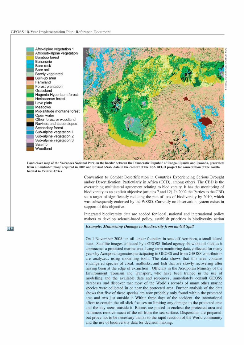
GEOSS 10-Year Implementation Plan: Reference Document
Convention to Combat Desertification in Countries Experiencing Serious Droughtand/or Desertification, Particularly in Africa (CCD), among others. The CBD is theoverarching multilateral agreement relating to biodiversity. It has the monitoring ofbiodiversity as an explicit objective (articles 7 and 12). In 2002 the Parties to the CBDset a target of significantly reducing the rate of loss of biodiversity by 2010, whichwas subsequently endorsed by the WSSD. Currently no observation system exists insupport of this objective.
Integrated biodiversity data are needed for local, national and international policymakers to develop science-based policy, establish priorities in biodiversity action
112Example: Minimizing Damage to Biodiversity from an Oil Spill
On 1 November 2008, an oil tanker founders in seas off Acropora, a small islandstate. Satellite images collected by a GEOSS-linked agency show the oil slick as itapproaches a protected marine area. Long-term monitoring data, collected for manyyears by Acroporan agencies participating in GEOSS and from GEOSS contributorsare analyzed, using modelling tools. The data shows that this area containsendangered species of coral, mollusks, and fish that are slowly recovering afterhaving been at the edge of extinction. Officials in the Acroporan Ministry of theEnvironment, Tourism and Transport, who have been trained in the use ofmodelling and the available data and resources, immediately consult GEOSSdatabases and discover that most of the World’s records of many other marinespecies were collected in or near the protected area. Further analysis of the datashows that five of these species are now probably only found within the protectedarea and two just outside it. Within three days of the accident, the internationaleffort to contain the oil slick focuses on limiting any damage to the protected areaand the key areas outside it. Booms are placed to enclose the protected area andskimmers remove much of the oil from the sea surface. Dispersants are prepared,but prove not to be necessary thanks to the rapid reaction of the World communityand the use of biodiversity data for decision making.
Land cover map of the Volcanoes National Park on the border between the Democratic Republic of Congo, Uganda and Rwanda, generatedfrom a Landsat-7 image acquired in 2003 and Envisat ASAR data in the context of the ESA BEGO project for conservation of the gorillahabitat in Central Africa
Cou
rtes
y of
Syn
opti
c an
d th
e B
EG
O T
eam
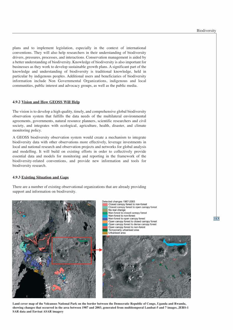
Biodiversity
plans and to implement legislation, especially in the context of internationalconventions. They will also help researchers in their understanding of biodiversitydrivers, pressures, processes, and interactions. Conservation management is aided bya better understanding of biodiversity. Knowledge of biodiversity is also important forbusinesses as they work to develop sustainable growth plans. A significant part of theknowledge and understanding of biodiversity is traditional knowledge, held inparticular by indigenous peoples. Additional users and beneficiaries of biodiversityinformation include Non Governmental Organizations, indigenous and localcommunities, public interest and advocacy groups, as well as the public media.
4.9.2 Vision and How GEOSS Will Help
The vision is to develop a high quality, timely, and comprehensive global biodiversityobservation system that fulfills the data needs of the multilateral environmentalagreements, governments, natural resource planners, scientific researchers and civilsociety, and integrates with ecological, agriculture, health, disaster, and climatemonitoring policy.
A GEOSS biodiversity observation system would create a mechanism to integratebiodiversity data with other observations more effectively, leverage investments inlocal and national research and observation projects and networks for global analysisand modelling. It will build on existing efforts in order to collectively provideessential data and models for monitoring and reporting in the framework of thebiodiversity-related conventions, and provide new information and tools forbiodiversity research.
4.9.3 Existing Situation and Gaps
There are a number of existing observational organizations that are already providingsupport and information on biodiversity.
113
Land cover map of the Volcanoes National Park on the border between the Democratic Republic of Congo, Uganda and Rwanda,showing changes that occurred in the area between 1987 and 2003, generated from multitemporal Landsat-5 and 7 images, JERS-1SAR data and Envisat ASAR imagery

GEOSS 10-Year Implementation Plan: Reference Document
The Global Biodiversity Information Facility (GBIF) offers a coordinated list ofknown species and collections, linking many taxon- or region-specific databases. TheWorldwide Fund for Nature (WWF) has a global map of ecosystems (‘ecoregions’) ata coarse scale. Distribution maps for birds, mammals, and reptiles are available froma variety of research and conservation agencies. The WWF Living Planet Index (LPI)is an indicator of the state of the Earth's natural ecosystems, based on the area of theWorld's natural forest cover, and global populations of freshwater and marine species.The UNEP World Conservation Monitoring Centre (WCMC) maintains databases ofprotected areas, endangered species, conservation processes and maps of ecosystemsand habitats of particular importance, such as mangrove forests. The United NationsEducational, Scientific and Cultural Organization (UNESCO) Man and the Biosphere(MAB) programme coordinates the International Biodiversity Monitoring Network(IBMN), which monitors forest biodiversity. The UNESCO Biosphere ReserveIntegrated Monitoring (BRIM) initiative promotes the monitoring of abiotic,biodiversity, and social changes in the World Network of Biosphere Reserves. TheIUCN Species Survival Commission operates a network of over 7000 volunteerexperts in over 120 specialist groups worldwide. Notably, it produces the IUCN RedList of Threatened Species, and is developing the Species Information System insupport of this effort. Wetlands International operates the International WaterbirdCensus (IWC), a site-based scheme for monitoring waterbird numbers. GCRMN, theGlobal Coral Reef Monitoring Network, promotes coral reef monitoring. The Censusof Marine Life (CoML) is a biodiversity research network that makes its global geo-referenced information on marine species available through the web-based OceanBiogeographic Information System (OBIS). The state of global diversity has beenassessed by Global Biodiversity Assessment (GBA), the Pilot Analysis of GlobalEcosystems (PAGE) and the Millennium Ecosystem Assessment.
GBIF is a global effort to provide interoperability between biodiversity databases. Ithas developed protocols and mechanisms for data standards and data sharing. It hasstarted its work with specimen-level data, and intends to integrate species, geospatial,genetic, and ecological data also. GBIF and GEOSS must develop commoninteroperability protocols and tools, and extend them to other biodiversity-relatedobservation systems.
GOOS and GTOS (in coordination with DIVERSITAS, a programme on diversity co-sponsored by the International Council for Science (ICSU), UNESCO, InternationalUnion of Biological Sciences (IUBS), International Union of MicrobiologicalSciences (IUMS), and the Scientific Committee on Problems of the Environment(SCOPE)) integrate existing marine and terrestrial observing systems to observe,model, analyze and predict marine and ocean variables, including living resources.The International Biodiversity Observation Year (IBOY) has established anobservation baseline in some areas, and taxonomic groups.
The Global Marine Assessment (GMA) works with the IntergovernmentalOceanographic Commission (IOC) and GOOS to test ocean sampling methods, whilstthe Smithsonian Tropical Research Institute Center for Tropical Forest Sciencefacilitates a network of long-term standardized Forest Dynamics Plots in tropicalsites. The Global Invasive Species Programme (GISP) focuses on informationexchange on invasive species. It does not collect field data.
FAO’s State of the World’s Plant Genetic Resources for Food and Agriculture is basedon 158 Country Reports. UNEP’s Global Environment Outlook is based oninformation from a network of multidisciplinary Collaborating Centers and morespecialized Associated Centers.
Monitoring projects are under development or ongoing in several countries to providestatistically reliable estimates of species status and trends. For instance,DIVERSITAS Western Pacific and Asia (DIWPA) has promoted studies in its region.
114
Biodiversity
Together, the above agencies and their activities provide a non-homogenous set ofrequirements and information on biodiversity and GEOSS would need to develop theappropriate links. The following significant gaps need to be addressed:
Some taxa have not received the attention merited by their numerical contribution tobiodiversity. There are few global assessments of less charismatic groups (such aslichens or marine worms, whereas studies of microbial diversity are still in theirinfancy). Many observations of biodiversity are from easily accessible areas andhence are not regionally or globally representative. Observations are mostly recentand lacking a long time-series. Most of the vitally important historical and baselinedata are not yet digitized and in some cases need to be rescued. Observations ofdifferent components of biodiversity are uncoordinated. Genetic data are largelyabsent.
Comprehensive descriptions and listings of the fauna and flora exist for manycountries, but are often not updated effectively. The global distributions andconservation status of most organisms are not known. Gazetteers and geographicinformation systems for the mapping and spatial analysis of species distributionsfrequently lack necessary observational data. Terrestrial and marine research facilitiesthat can collect comparable and long-term biodiversity data are not well distributedacross the ecosystems of the World, nor adequately coordinated, equipped or funded.Collections in museums, botanical gardens, seed banks, zoos, aquaria, and culturecollections universally need increased funding to prevent loss of specimens andhuman expertise and to leverage the investment in these invaluable, irreplaceableresources.
4.9.4 Targets
115
2 Year Targets 4.9 Biodiversity
Working with the biodiversity community, GEOSS will:
Facilitate the interoperability of the multi-institutional biodiversity observationnetwork through GBIF and ensure that it links to data sets of ecological and otherrelated observation systems.
Develop a biodiversity observation strategy that is spatially and topicallyprioritized, based on analysis of existing information, identifying unique or highlydiverse ecosystems and those supporting migratory, endemic or globally threatenedspecies, those whose biodiversity is of socio-economic importance, and which cansupport the 2010 CBD target.
Facilitate the capture of ten million new biodiversity observations per year, theagreement to data collection protocols by networks of permanent sites, and thelaunch of initiatives on three key issues.
Advocate additional support to permit data system integration sharing by dataproviders, particularly the research and collections institutions.
Produce an analysis of the gaps and needs in capacity building initiatives within thebiodiversity observation system, including for microbial biodiversity.
Produce a strategy for capturing the outputs of citizen-based biodiversitymonitoring systems.
GEOSS 10-Year Implementation Plan: Reference Document
116
6 Year Targets 4.9 Biodiversity
Working with the biodiversity community, GEOSS will:
Produce timely data and information for local, national, regional and internationalpolicy makers, scientists and natural resource managers through the distributedobservation network.
Facilitate the establishment of monitoring systems for policy-interest andendangered species, allowing frequently-repeated globally-coordinated assessmentof trends and distributions of species of special conservation merit, includingdomesticated animals, cultivated plants, and fish species and their wild relatives andspecies of medicinal or economic value.
Facilitate the operational deployment of a system to provide near-real-time data ondetection, establishment and spread of problematic invasive organisms.
Facilitate the systematic monitoring of biodiversity in all ecosystems usingstatistically valid methods.
Facilitate the full operationality and integration of citizen-based biodiversityobservation systems.
Facilitate the addition of twelve million new spatially and temporally explicitobservation records yearly.
Facilitate the delivery of capacity building programmes on data use andinterpretation.
10 Year Targets 4.9 Biodiversity
Working with the biodiversity community, GEOSS will:
Ensure the integration of the distributed biodiversity observation network withsectoral, crisis, health and policy systems. Ensure that it is routinely used to solveproblems, guide policy and management and generate opportunities for sustainabledevelopment.
Facilitate the addition of fifteen million new spatially and temporally explicitobservation records yearly, and the wide accessibility of systems to analyze andmodel trends in abundance and distribution.
Ensure the optimization of the observational network, including where necessaryfacilitating the development of new sites, facilities, technologies and networks,based on an analysis of the observations collected in the first decade.
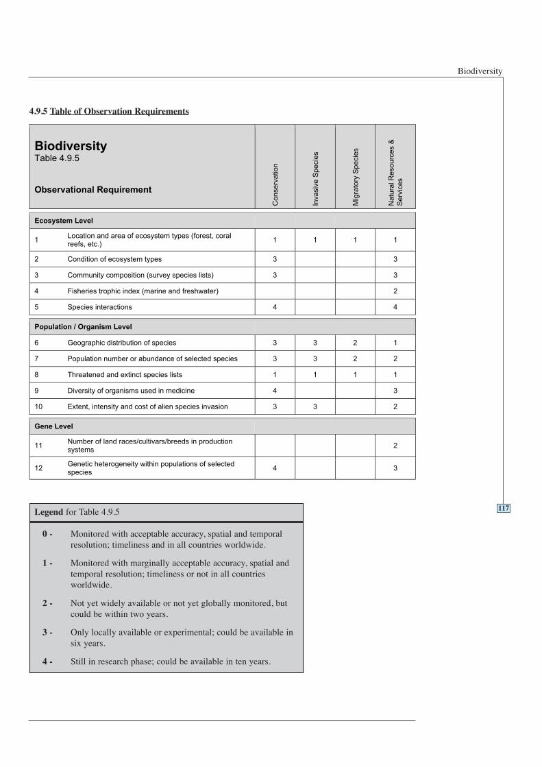
Biodiversity
4.9.5 Table of Observation Requirements
117Legend for Table 4.9.5
0 - Monitored with acceptable accuracy, spatial and temporalresolution; timeliness and in all countries worldwide.
1 - Monitored with marginally acceptable accuracy, spatial andtemporal resolution; timeliness or not in all countriesworldwide.
2 - Not yet widely available or not yet globally monitored, butcould be within two years.
3 - Only locally available or experimental; could be available insix years.
4 - Still in research phase; could be available in ten years.
BiodiversityTable 4.9.5
Observational Requirement
Co
nse
rva
tio
n
Inva
siv
e S
pe
cie
s
Mig
rato
ry S
pe
cie
s
Na
tura
l R
eso
urc
es &
Se
rvic
es
Ecosystem Level
1Location and area of ecosystem types (forest, coralreefs, etc.)
1 1 1 1
2 Condition of ecosystem types 3 3
3 Community composition (survey species lists) 3 3
4 Fisheries trophic index (marine and freshwater) 2
5 Species interactions 4 4
Population / Organism Level
6 Geographic distribution of species 3 3 2 1
7 Population number or abundance of selected species 3 3 2 2
8 Threatened and extinct species lists 1 1 1 1
9 Diversity of organisms used in medicine 4 3
10 Extent, intensity and cost of alien species invasion 3 3 2
Gene Level
11Number of land races/cultivars/breeds in productionsystems
2
12Genetic heterogeneity within populations of selectedspecies
4 3
GEOSS 10-Year Implementation Plan: Reference Document
Analysis of user requirements in the nine societal benefit areas indicates that there aresignificant synergies between them in terms of underlying needs for Earthobservations and data utilization. Addressing these common requirements can providefor prioritized and efficient implementation of GEOSS.
4.10.1 Observation Commonalities
4.10.1.1 Space-based Observation
Considerable effort has been expended on studying user requirements and reflectingthem in the planning and coordination of satellite missions, but the current situationdoes not satisfy all requirements for each benefit area. All-weather observation dataand climate-related observations, as well as high temporal/spatial resolution data, arebasic observation data and can be used across virtually all societal benefit areas. SARsensors, passive microwave observations, high-resolution optical observation systemsand geostationary observation systems should be considered key observing systems.
The following highlights requirements for space-based observation from specificsocietal benefit areas:
• Addressing disaster requirements includes the need for high spatial resolution andall-weather capability through technology such as optical and SAR satellites, aswell as high temporal resolution observation from geostationary orbit for disastermonitoring of floods, volcanic eruptions, forest fires, and other hazards.
• Facilitating the availability of wide-area health parameters derived from satellitedata, e.g. sanitation, transport, energy, communications, traffic managementsystems, and housing.
• For improved climate observations, it is strongly recommended that satelliteoperators in GEOSS adhere to the GCOS Implementation Plan.
• Improving agriculture ecosystem monitoring through observations requires high tomedium resolution observation from space for land cover classification, and thewidespread adoption and use of geostationary observations in food-insecure areas.
4.10.1.2 In situ Observation
The baseline in situ observation networks are declining and authority over data andinformation, especially in the terrestrial domain, is often scattered regionally andsectorally, resulting in highly fragmented management approaches, and these trendsneed to be reversed. The first step is to track the performance of observationalnetworks and identify and fix problems. The second step is to improve existingobservation networks, including where necessary the availability of the qualifiedhuman resources needed, the development of new sites, facilities, technology, andnetworks. Adherence by countries and agencies to the recommendations in the GCOSImplementation Plan is important. There is a need to complete and strengthen theocean in situ observing system, particularly Argo floats. Elimination of regionaldisparity in observing capacity, such as the imbalance in advanced oceanographicobservation sites between the Northern and Southern Hemispheres, needs to betackled. More coordinated investment of resources is necessary to achieve themaximum effect.
4.10.1.3 Convergence of Observation
It is essential for GEOSS to encourage the establishment of global, efficient andrepresentative networks of integrated in situ observation sites, relying on existingnational and regional environmental monitoring networks. These in situ networks
118
4.10Common observations and
data utilization
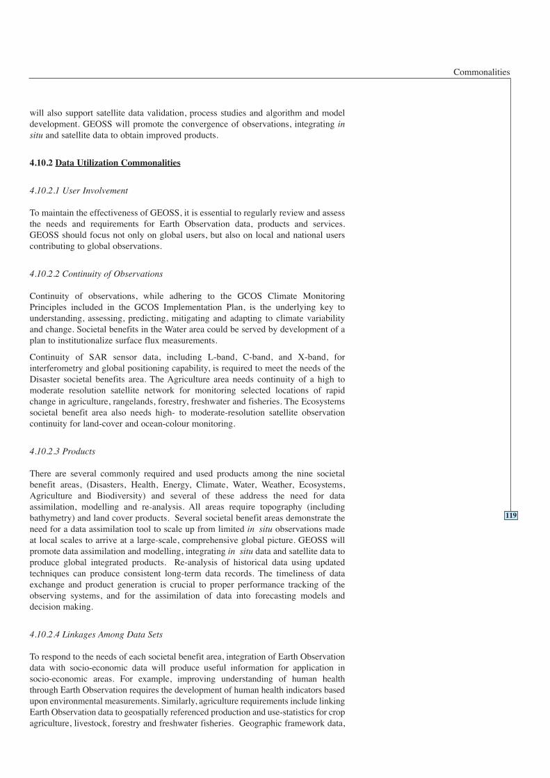
Commonalities
will also support satellite data validation, process studies and algorithm and modeldevelopment. GEOSS will promote the convergence of observations, integrating insitu and satellite data to obtain improved products.
4.10.2 Data Utilization Commonalities
4.10.2.1 User Involvement
To maintain the effectiveness of GEOSS, it is essential to regularly review and assessthe needs and requirements for Earth Observation data, products and services.GEOSS should focus not only on global users, but also on local and national userscontributing to global observations.
4.10.2.2 Continuity of Observations
Continuity of observations, while adhering to the GCOS Climate MonitoringPrinciples included in the GCOS Implementation Plan, is the underlying key tounderstanding, assessing, predicting, mitigating and adapting to climate variabilityand change. Societal benefits in the Water area could be served by development of aplan to institutionalize surface flux measurements.
Continuity of SAR sensor data, including L-band, C-band, and X-band, forinterferometry and global positioning capability, is required to meet the needs of theDisaster societal benefits area. The Agriculture area needs continuity of a high tomoderate resolution satellite network for monitoring selected locations of rapidchange in agriculture, rangelands, forestry, freshwater and fisheries. The Ecosystemssocietal benefit area also needs high- to moderate-resolution satellite observationcontinuity for land-cover and ocean-colour monitoring.
4.10.2.3 Products
There are several commonly required and used products among the nine societalbenefit areas, (Disasters, Health, Energy, Climate, Water, Weather, Ecosystems,Agriculture and Biodiversity) and several of these address the need for dataassimilation, modelling and re-analysis. All areas require topography (includingbathymetry) and land cover products. Several societal benefit areas demonstrate theneed for a data assimilation tool to scale up from limited in situ observations madeat local scales to arrive at a large-scale, comprehensive global picture. GEOSS willpromote data assimilation and modelling, integrating in situ data and satellite data toproduce global integrated products. Re-analysis of historical data using updatedtechniques can produce consistent long-term data records. The timeliness of dataexchange and product generation is crucial to proper performance tracking of theobserving systems, and for the assimilation of data into forecasting models anddecision making.
4.10.2.4 Linkages Among Data Sets
To respond to the needs of each societal benefit area, integration of Earth Observationdata with socio-economic data will produce useful information for application insocio-economic areas. For example, improving understanding of human healththrough Earth Observation requires the development of human health indicators basedupon environmental measurements. Similarly, agriculture requirements include linkingEarth Observation data to geospatially referenced production and use-statistics for cropagriculture, livestock, forestry and freshwater fisheries. Geographic framework data,
119
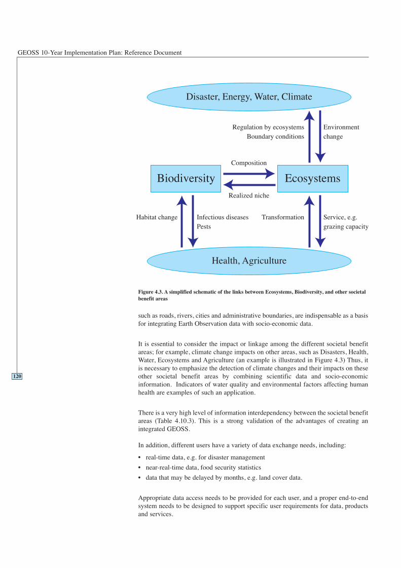
GEOSS 10-Year Implementation Plan: Reference Document
such as roads, rivers, cities and administrative boundaries, are indispensable as a basisfor integrating Earth Observation data with socio-economic data.
It is essential to consider the impact or linkage among the different societal benefitareas; for example, climate change impacts on other areas, such as Disasters, Health,Water, Ecosystems and Agriculture (an example is illustrated in Figure 4.3) Thus, itis necessary to emphasize the detection of climate changes and their impacts on theseother societal benefit areas by combining scientific data and socio-economicinformation. Indicators of water quality and environmental factors affecting humanhealth are examples of such an application.
There is a very high level of information interdependency between the societal benefitareas (Table 4.10.3). This is a strong validation of the advantages of creating anintegrated GEOSS.
In addition, different users have a variety of data exchange needs, including:
• real-time data, e.g. for disaster management
• near-real-time data, food security statistics
• data that may be delayed by months, e.g. land cover data.
Appropriate data access needs to be provided for each user, and a proper end-to-endsystem needs to be designed to support specific user requirements for data, productsand services.
120
Figure 4.3. A simplified schematic of the links between Ecosystems, Biodiversity, and other societalbenefit areas
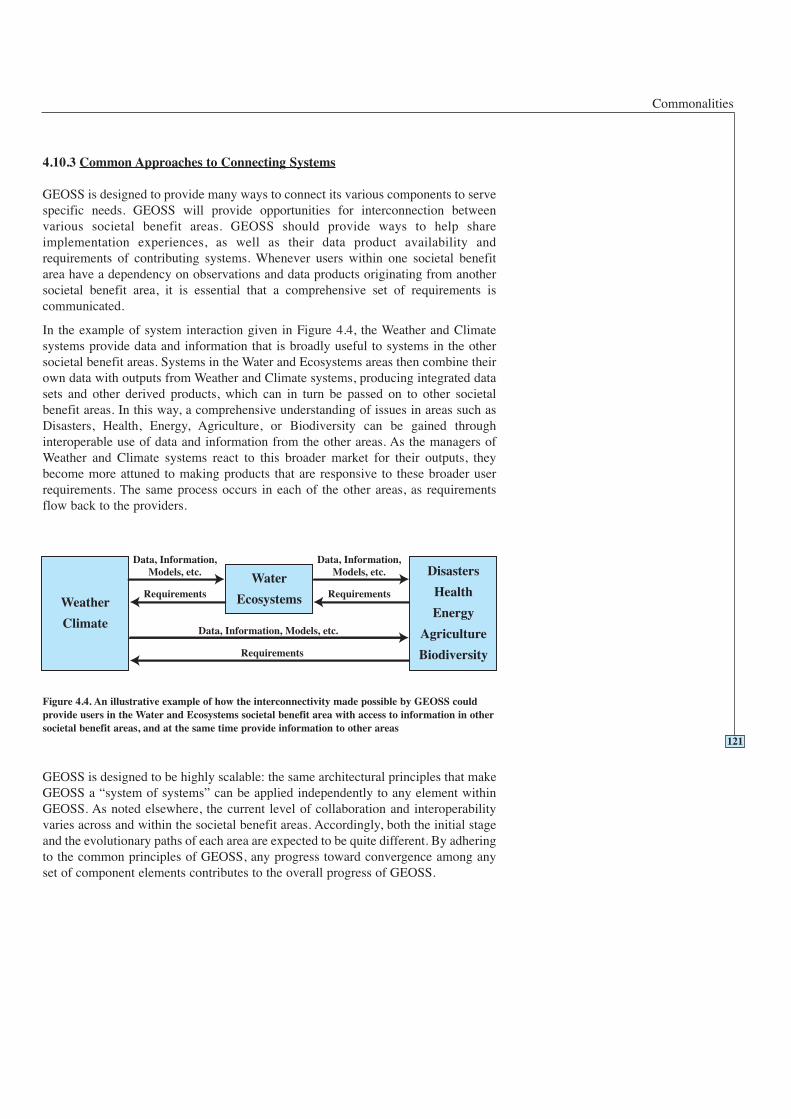
Commonalities
4.10.3 Common Approaches to Connecting Systems
GEOSS is designed to provide many ways to connect its various components to servespecific needs. GEOSS will provide opportunities for interconnection betweenvarious societal benefit areas. GEOSS should provide ways to help shareimplementation experiences, as well as their data product availability andrequirements of contributing systems. Whenever users within one societal benefitarea have a dependency on observations and data products originating from anothersocietal benefit area, it is essential that a comprehensive set of requirements iscommunicated.
In the example of system interaction given in Figure 4.4, the Weather and Climatesystems provide data and information that is broadly useful to systems in the othersocietal benefit areas. Systems in the Water and Ecosystems areas then combine theirown data with outputs from Weather and Climate systems, producing integrated datasets and other derived products, which can in turn be passed on to other societalbenefit areas. In this way, a comprehensive understanding of issues in areas such asDisasters, Health, Energy, Agriculture, or Biodiversity can be gained throughinteroperable use of data and information from the other areas. As the managers ofWeather and Climate systems react to this broader market for their outputs, theybecome more attuned to making products that are responsive to these broader userrequirements. The same process occurs in each of the other areas, as requirementsflow back to the providers.
GEOSS is designed to be highly scalable: the same architectural principles that makeGEOSS a “system of systems” can be applied independently to any element withinGEOSS. As noted elsewhere, the current level of collaboration and interoperabilityvaries across and within the societal benefit areas. Accordingly, both the initial stageand the evolutionary paths of each area are expected to be quite different. By adheringto the common principles of GEOSS, any progress toward convergence among anyset of component elements contributes to the overall progress of GEOSS.
121
Figure 4.4. An illustrative example of how the interconnectivity made possible by GEOSS couldprovide users in the Water and Ecosystems societal benefit area with access to information in othersocietal benefit areas, and at the same time provide information to other areas
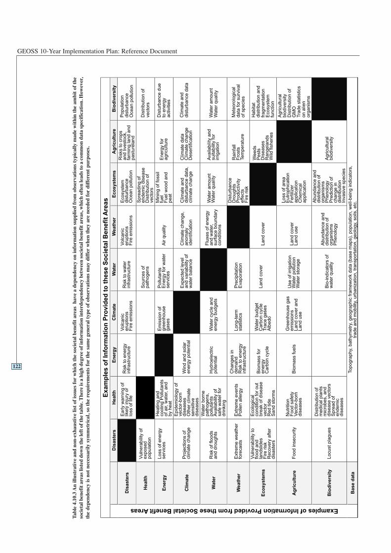
GEOSS 10-Year Implementation Plan: Reference Document
122
Exam
ple
s o
f In
form
ati
on
Pro
vid
ed
to
th
ese S
ocie
tal B
en
efi
t A
reas
Dis
as
ters
He
alt
hE
ne
rgy
Cli
ma
teW
ate
rW
ea
the
rE
co
sy
ste
ms
Ag
ric
ult
ure
Bio
div
ers
ity
Dis
as
ters
Ea
rly w
arn
ing
of
like
ly in
jury
or
loss o
f lif
e
Ris
k t
o e
ne
rgy
infr
astr
uctu
re
Vo
lca
nic
eru
ptio
ns
Fire
em
issio
ns
Ris
k t
o w
ate
rin
fra
str
uctu
re
Vo
lca
nic
eru
ptio
ns
Fire
em
issio
ns
Eco
syste
md
istu
rba
nce
Oce
an
po
llutio
n
Ris
ks t
o c
rop
sa
nd
liv
esto
ck,
farm
ing
la
nd
an
dp
astu
rela
nd
Po
pu
latio
nd
istu
rba
nce
Oce
an
po
llutio
n
He
alt
hV
uln
era
bili
ty o
fe
xp
ose
dp
op
ula
tio
n
So
urc
es o
fp
ath
og
en
s
Sp
rea
din
g o
fe
nd
em
ic d
ise
ase
Dis
trib
utio
n o
fve
cto
rs
Dis
trib
utio
n o
fve
cto
rs
En
erg
yL
oss o
f e
ne
rgy
se
rvic
es
He
atin
g a
nd
co
olin
g P
ollu
tan
tso
f a
ir,
wa
ter, a
nd
by h
ea
t
Em
issio
n o
fg
ree
nh
ou
se
ga
se
s
Po
lluta
nts
En
erg
y f
or
wa
ter
se
rvic
es
Air q
ua
lity
Min
ing
of
fossil
fue
lF
ue
l w
oo
d a
nd
pe
at
En
erg
y f
or
ag
ricu
ltu
re
Dis
turb
an
ce
du
eto
en
erg
ya
ctivitie
s
Cli
ma
teP
roje
ctio
ns o
fclim
ate
ch
an
ge
Ep
ide
mio
log
y o
fve
cto
r-b
orn
dis
ea
se
sO
the
r clim
ate
se
nsitiv
ed
ise
ase
s
Win
d a
nd
so
lar
en
erg
y p
ote
ntia
l
Exp
ecte
d le
ve
la
nd
va
ria
bili
ty o
fw
ate
r b
ala
nce
Clim
ate
ch
an
ge
,a
no
ma
lyid
en
tifica
tio
n
Clim
ate
an
dd
istu
rba
nce
da
ta,
clim
ate
ch
an
ge
Clim
ate
da
taC
lima
te c
ha
ng
eD
ese
rtific
atio
n
Clim
ate
an
dd
istu
rba
nce
da
ta
Wa
ter
Ris
k o
f flo
od
sa
nd
dro
ug
hts
Wa
ter
bo
rne
pa
tho
ge
ns,
po
lluta
nts
Ava
ilab
ility
of
sa
fe w
ate
r fo
rd
rin
kin
g
Hyd
roe
lectr
icp
ote
ntia
lW
ate
r cycle
an
de
ne
rgy b
ud
ge
ts
Flu
xe
s o
f e
ne
rgy
an
d w
ate
r,su
rfa
ce
bo
un
da
ryco
nd
itio
ns
Wa
ter
am
ou
nt
Wa
ter
qu
alit
yA
va
ilab
ility
an
dsu
ita
bili
ty f
or
irrig
atio
n
Wa
ter
am
ou
nt
Wa
ter
qu
alit
y
We
ath
er
Extr
em
e w
ea
the
rfo
reca
sts
Extr
em
e e
ve
nts
Po
llen
alle
rgy
Ch
an
ge
s in
de
ma
nd
Ris
k t
o e
ne
rgy
infr
astr
uctu
re
Lo
ng
-te
rmsta
tistics
Pre
cip
ita
tio
nE
va
po
ratio
n
Dis
turb
an
ce
Dro
ug
hts
Pro
du
ctivity
effe
cts
Fire
ris
k
Ra
infa
llF
rosts
Te
mp
era
ture
Me
teo
rolo
gic
al
da
ta f
or
su
rviv
al
of
sp
ecie
s
Ec
os
ys
tem
s
Vu
lne
rab
ility
to
flo
od
an
dla
nd
slid
es
Fire
ris
kR
eco
ve
ry a
fte
rd
isa
ste
rs
Eco
log
ica
lco
nd
itio
n f
or
ou
tb
rea
k o
f d
ise
ase
ve
cto
rR
ed
tid
eS
an
d s
torm
s
Bio
ma
ss f
or
en
erg
yC
arb
on
cycle
Wa
ter
bu
dg
et
Ca
rbo
n c
ycle
Tra
ce
ga
se
sA
lbe
do
La
nd
co
ve
rL
an
d c
ove
r
We
ed
sP
ests
Dis
ea
se
sR
an
ge
lan
ds
Wild
fis
he
rie
s
Ha
bita
td
istr
ibu
tio
n a
nd
fra
gm
en
tatio
nE
co
syste
mfu
nctio
n
Ag
ric
ult
ure
Fo
od
in
se
cu
rity
Nu
tritio
nF
oo
d s
afe
tyV
ecto
r-b
orn
dis
ea
se
s
Bio
ma
ss f
ue
ls
Gre
en
ho
use
ga
se
mis
sio
ns
La
nd
co
ve
r a
nd
La
nd
use
Use
of
irrig
atio
nW
ate
r p
ollu
tio
nW
ate
r sto
rag
e
La
nd
co
ve
rL
an
d u
se
Lo
ss o
f a
rea
Eu
tro
ph
ica
tio
nF
ert
ilize
ra
pp
lica
tio
nC
he
mic
al
ap
plic
atio
n
Ag
ricu
ltu
ral
bio
div
ers
ity
Dis
trib
utio
n o
fG
MO
Tra
de
sta
tistics
on
alie
no
rga
nis
ms
Bio
div
ers
ity
Lo
cu
st
pla
gu
es
Dis
trib
utio
n o
fm
ed
ica
l p
lan
tsm
icro
be
s,
an
dd
ise
ase
ve
cto
rsS
pre
ad
of
en
de
mic
dis
ea
se
s
Bio
-in
dic
ato
rs o
fw
ate
r q
ua
lity
Ab
un
da
nce
an
dd
istr
ibu
tio
n o
fo
rga
nis
ms
Ph
en
olo
gy
Ab
un
da
nce
an
dd
istr
ibu
tio
n o
fo
rga
nis
ms
Ph
en
olo
gy
Pre
dic
tio
n o
fch
an
ge
in
dis
trib
utio
nIn
va
siv
e s
pe
cie
s
Ag
ricu
ltu
ral
bio
div
ers
ity
Examples of Information Provided from these Societal Benefit Areas
Ba
se
da
taTo
po
gra
ph
y, b
ath
ym
etr
y, g
eo
gra
ph
ic f
ram
ew
ork
da
ta (
ba
se
ma
ps),
po
pu
latio
n,
we
ll-b
ein
g in
dic
ato
rs,
tra
de
an
d m
ob
ility
, u
rba
niz
atio
n,
tra
nsp
ort
atio
n,
ge
olo
gy,
so
ils,
etc
.
Tabl
e 4.
10.3
An
illus
trat
ive
and
non-
exha
usti
ve li
st o
f is
sues
for
whi
ch t
he s
ocie
tal b
enef
it a
reas
hav
e a
depe
nden
cy o
n in
form
atio
n su
pplie
d fr
om o
bser
vati
ons
typi
cally
mad
e w
ithi
n th
e am
bit
of t
heso
ciet
al b
enef
it a
reas
list
ed d
own
the
left
of t
he ta
ble.
The
re is
a h
igh
degr
ee o
f inf
orm
atio
n in
terd
epen
denc
y be
twee
n so
ciet
al b
enef
it a
reas
, whi
ch o
ften
lead
s to
a c
omm
on d
ata
spec
ific
atio
n. H
owev
er,
the
depe
nden
cy is
not
nec
essa
rily
sym
met
rica
l, so
the
req
uire
men
ts f
orth
e sa
me
gene
ral t
ype
of o
bser
vati
ons
may
dif
fer
whe
n th
ey a
re n
eede
d fo
rdi
ffer
ent
purp
oses
.
Commonalities
123
2 Year Targets 4.10 Common Observations and Data Utilization
Working with all GEOSS communities across societal benefit areas, GEOSSwill:
Facilitate sharing of best practices for the development of products customizedfor particular socio-economic benefits.
Produce practical strategic and tactical guidance on how to converge disparatesystems to a higher degree of collaboration and interoperability using GEOSSprinciples.
Facilitate interoperability among data sets acquired by different countries andagencies, as these are not likely to be in compatible formats or easily usableform.
Facilitate the development of basic geographic framework data.
10 Year Targets 4.10 Common Observations and Data Utilization
Working with all GEOSS communities across societal benefit areas, GEOSSwill:
Advocate optimum use of data and information available from GEOSS.
Develop a plan to sustain and evolve a system of systems beyond 10 years.
6 Year Targets 4.10 Common Observations and Data Utilization
Working with all GEOSS communities across societal benefit areas, GEOSSwill:
Facilitate the joint evaluation of prototypes that connect multiple systems, andsupport making operational any research demonstrations of such collaborationand interoperability.
Facilitate periodic demonstrations of the overall progress toward the highestlevel of collaboration and interoperability achieved, as a measure of realizing thefull vision of a global system of systems for Earth observations.
4.10.4 Targets

GEOSS 10-Year Implementation Plan: Reference Document
124
125
ARCHITECTURE OF A SYSTEM OFSYSTEMS
5
GEOSS 10-Year Implementation Plan: Reference Document
126
Architecture
This section describes how GEOSS component strategies and systems fit together toproduce a comprehensive, coordinated, and sustained system of systems that bettersatisfies overall requirements in the identified societal benefit areas.
GEO will employ a range of methods to advance the implementation of the Plan,tailoring them as required to address each of the various implementation issues. Themethods will include: establishment of standing and specific task-oriented GEOSSstructures; referring specific tasks to participating international organizations oragencies; coordinating and cooperating with national agencies; collaboration betweeninternational organizations; providing a forum for dialogue and resolution of issues atvarying levels, and advocacy within and across existing systems and othermechanisms.
Five functional components are identified in the GEOSS 10-Year ImplementationPlan. User requirements are addressed in Sections 4 and 6, and performancemonitoring is addressed in Section 9. The remaining three are addressed here:
• components to acquire observations based on existing local, national, regional andglobal systems to be augmented as required by new observing systems;
• components to process data into useful information, i.e. geo-products that are partof GEOSS, recognizing the value of modelling, integration and assimilationtechniques (including re-analysis) for example, global sea-surface temperaturefields – such geo-products will be prepared in those modelling centres participatingin GEOSS and serve as input to the decision support systems required in responseto societal needs; and
• components required to exchange and disseminate observational data andinformation including those for archiving. Components are understood to includedata management that encompasses functions such as QA/QC (QualityAssessment/Quality Control), access to data, and archiving of data and otherresources.
In common with Spatial Data Infrastructures and services-oriented informationarchitectures, GEOSS system components are to be interfaced with each otherthrough interoperability specifications based on open, international standards. Accessto data and information resources of GEOSS will be accomplished through variousservice interfaces to be contained within the data exchange and disseminationcomponent. The actual mechanisms will include many varieties of communicationsmodes, with a primary emphasis on the Internet wherever appropriate, but rangingfrom very low technology approaches to highly specialized technologies.
A key consideration is that GEOSS catalogues data and services with sufficientmetadata information so that users can find what they need and gain access asappropriate. The Internet is a primary medium for the mechanism to allow users toaccess the catalogue of available data and products, with hardcopy media to also beavailable as appropriate. Users searching GEOSS catalogues will find descriptions ofGEO Members and Participating Organizations and the components they support,leading directly to whatever information is needed to access the specific data orservice in a harmonized way, independent of the specific provider. In this sense, theinteroperable GEOSS catalogues form the foundation of a more general‘clearinghouse’. GEOSS data resources can be fully described in context, and dataaccess can be facilitated through descriptions of other useful analysis tools, userguides, data policies, and services. Many examples of such clearinghouse facilities
127
5Architecture of a Systemof Systems
5.1Functional components
GEOSS 10-Year Implementation Plan: Reference Document
128
Spatial Data Infrastructures
GEOSS will advocate further development of the Global Spatial Data Infrastructure (GSDI) and use ofexisting Spatial Data Infrastructure (SDI) components as institutional and technical precedents. SDI's areconcerned with data and information that is ‘geospatial’, i.e. referenced to locations on the Earth, at allscales. In common with GEOSS, SDI's support a components-based, services oriented architecture thatprovides interoperability based on open, international standards. To the extent that GEOSS adoptsidentical or compatible standards, GEOSS and SDI components become interoperable with each other aswell. This provides a powerful synergy as GEOSS addresses types of data and information that are notalways geospatial, while SDI's address types of data and information that are not always Earthobservation. Examples of SDI data and information types include transportation, population, politicalboundaries, land ownership, socio-economic data, cultural heritage, and minerals, among many others.
GSDI “encompasses the policies, organizational remits, data, technologies, standards, deliverymechanisms, and financial and human resources necessary to ensure that those working at the global andregional scale are not impeded in meeting their objectives.”17 A key operational feature of the GSDI is itsClearinghouse network, which now includes over 400 catalogues in which comprehensive metadata aboutavailable geospatial data is maintained.
Many countries and international organizations are members of GSDI or ongoing participants in the GSDIClearinghouse. Among these are: Argentina, Australia, Barbados, Bolivia, Brazil, Canada, Chile, China,Colombia, Costa Rica, Czech Republic, Dominican Republic, Ecuador, El Salvador, Ethiopia, EuropeanUnion, Finland, France, Germany, Guatemala, Honduras, Hungary, India, Indonesia, Ireland, Italy, Japan,Malaysia, Mexico, Namibia, Netherlands, Nicaragua, Norway, Poland, Senegal, South Africa, Spain,Trinidad and Tobago, United Kingdom, United States, and Uruguay.
Among the regional and topic-specific organizations participating in GSDI are: Antarctic Geographic DataIntegration Project, Association for Biodiversity Information, Committee for Earth Observation Satellites(CEOS), Consultative Group on International Agriculture (CIGAR), Environmental Information SystemsAfrica, European Umbrella Organisation for Geographic Information, Geographic Information forSustainable Development (Africa), Global Disaster Information Network (GDIN), International SteeringCommittee for Global Mapping (ISCGM), Global Resource Information Database (GRID), Global WaterInformation Network, Infrastructure for Spatial Information in Europe (INSPIRE), IntergovernmentalPanel on Climate Change (IPCC), International Geosphere-Biosphere Program (IGBP), Open GeospatialConsortium (OGC), Permanent Committee on GIS Infrastructure for Asia and the Pacific (PCGIAP),Permanent Committee on SDI for the Americas, and World Bank Development Gateway.
Although national SDI's share a common architecture and commitment to standards-basedinteroperability, specific policies and operational components can vary widely. As one example, UnitedStates law (44 USC Ch 36) and policy (OMB Circular A-16) establishes the U.S. National Spatial DataInfrastructure (NSDI). The policy states that the NSDI “assures that spatial data from multiple sources(federal, state, local, and tribal governments, academia, and the private sector) are available and easilyintegrated to enhance the understanding of our physical and cultural world”. This policy puts specificrequirements on all agencies that collect, use, or disseminate geographic information to assure that theresulting data, information, or products can be readily shared and integrated among federal agencies andnon-federal users. In their activities, they must require adherence to the SDI standards for data andmetadata, and must make metadata available online through the GSDI Clearinghouse. The U.S. NSDIincludes various interoperability standards, including Framework Data Standards, Web Mapping Service,Web Feature Service, and Geographic Markup Language, among other ISO and national standards.
17 Global Spatial Data Infrastructure, http://www.gsdi.org
Architecture
already exist in the realm of Earth Observation and networked information systemsgenerally, and many of these already employ interoperable interfaces.
GEOSS will develop a set of guidelines for archiving Earth observations, which willemphasize that archive centres must have adequate funding to address data growthand be in a position not only to ensure the perpetuity of incoming data, but also tosafeguard data on ageing or obsolete media.
Historical data, and in some cases contemporary data (particularly in developingcountries), are frequently kept as paper records. They are often stored locally, andtheir existence is not well known. The rescue, digital capture, and secure storage ofsuch data are important to strengthen and broaden the historical records for assessingtrends.
GEOSS will promote the use of common mechanisms for the cataloguing of archives,including how to access them. All providers need to ensure that archived data andproducts provide a statement of the access conditions in terms of the mechanics andpolicies. There should also be a well-documented statement of the ancillary dataneeded to understand and use basic data sets and products.
5.2.1 Convergence of Observations
One of the goals of GEOSS is to establish a system of systems that can provide timelydata and information for local, national, regional and international policy makers. Forexample, near-real-time observations are required to address specific disaster needs(e.g. submarine seismic and volcanic activity and tsunami propagation) andsignificant extreme events in Agriculture (e.g. fire). Consequently, someparticipating systems will need to provide real- or near-real-time monitoring, earlydetection, and globally integrated observations.
Topic-specific integration of global observations is required by almost all of theidentified societal benefit areas, but each area has a different balance between in situand satellite observations.
5.2.2 Observation Continuity
GEOSS will address Earth Observation continuity, emphasized as a fundamentalrequirement across the range of societal benefit areas. Continuity is needed for bothbasic observation networks and intensive observation focused on selected areas. Onlywith assured continuity can users invest confidently in applications that rely onparticular data sets.
In situ observations provide the long-term historical record for most variables andserve a vital role in applications for various societal benefit areas. There is a decliningtrend of observations from in situ atmospheric networks and hydrological networks.This trend needs to be reversed and these baseline in situ observations must besustained. Many in situ observations are provided by research programmes, which donot have guarantees for long-term funding. Argo is one such programme, which isnow critical to understanding the ocean dynamics and applications in meteorologyand climate. GEOSS should encourage continuity of in situ observations inoperational services and research programmes.
The continuity of high-temporal-frequency geostationary imagery, high- to moderate-resolution optical and SAR observations over land, and other critical observations
129
5.2Observations
GEOSS 10-Year Implementation Plan: Reference Document
over oceans needs to be assured. Accordingly, contingency plans of observationsystem operators should be sensitive to how their user communities are affected byinterruptions of data and services.
5.2.3 Data Sampling
Sampling problems emerge wherever Earth system processes operate at scalesrequiring observations beyond the boundaries of the operating agency, e.g. climate,weather, river basins, and migratory species. For instance, an atmospheric carbondioxide observation system is required to satisfy the objectives and protocols of theUN Framework Convention on Climate Change. Improving the most sparselysampled regions would lead to improvements in estimation of net carbon dioxidefluxes both locally, as well as in distant regions. Consequently, it is in the globalinterest to ensure an adequate sampling network everywhere. Clearly, coordination insuch situations can minimize the duplication of effort, while also bolstering thecredibility and transparency of the sampling programme. GEOSS can enhanceinternational coordination of investments in observation systems and observationprocedures as well as data exchange, processing, and archiving.
5.3.1 Common Products
GEOSS will place a high priority on data and information products commonlyrequired across diverse societal benefit areas. GEOSS products include current statusassessments and descriptions, as well as predictive products in each of the domainsof socio-economic benefit discussed in Section 4. Examples of GEOSS statusassessments or descriptions include topography, land cover, vegetation status, soilmoisture, extent of floods, snow cover, wind profile, precipitation, water quality, andocean dynamics. Examples of GEOSS predictive products include outlooks,forecasts, and predictions generated by global and regional Earth system models andtheir associated data assimilation systems. These may be direct products in the formof weather and air-quality forecasts, as well as seasonal and climate predictions, orindirect products in the form of outputs from specialized models (hydrologicalmodels, ocean models, crop models, health models, biosphere models, etc.) driven bythe predictions of the Earth system models.
To understand the interaction of societies with Earth systems, it is critically importantto blend socio-economic data with Earth Observation data. Consequently, GEOSSwill emphasize promoting the accessibility of socio-economic data products,including census data, economic activity, and political boundaries.
5.3.2 Modelling and Data Assimilation
GEOSS will advocate harmonized methods in the modelling and analysis techniquesneeded to transform data into useful information. Best practices and up-to-datescientific understanding should be shared broadly. This should include techniques forestimating and recording quality indicators and representation of uncertainties inmodels as well as observation data.
In applications such as climate and weather modelling, methods known as dataassimilation are commonly used. These procedures transform a wide variety of insitu, airborne, and space-based Earth observation data into parameters that feed intonumerical models of physical, chemical, and biological processes calculated overtime and space. There may be benefit in a targeted effort to enhance sharing acrossEarth Observation areas of operational experience in data assimilation.
130
5.3Data processing
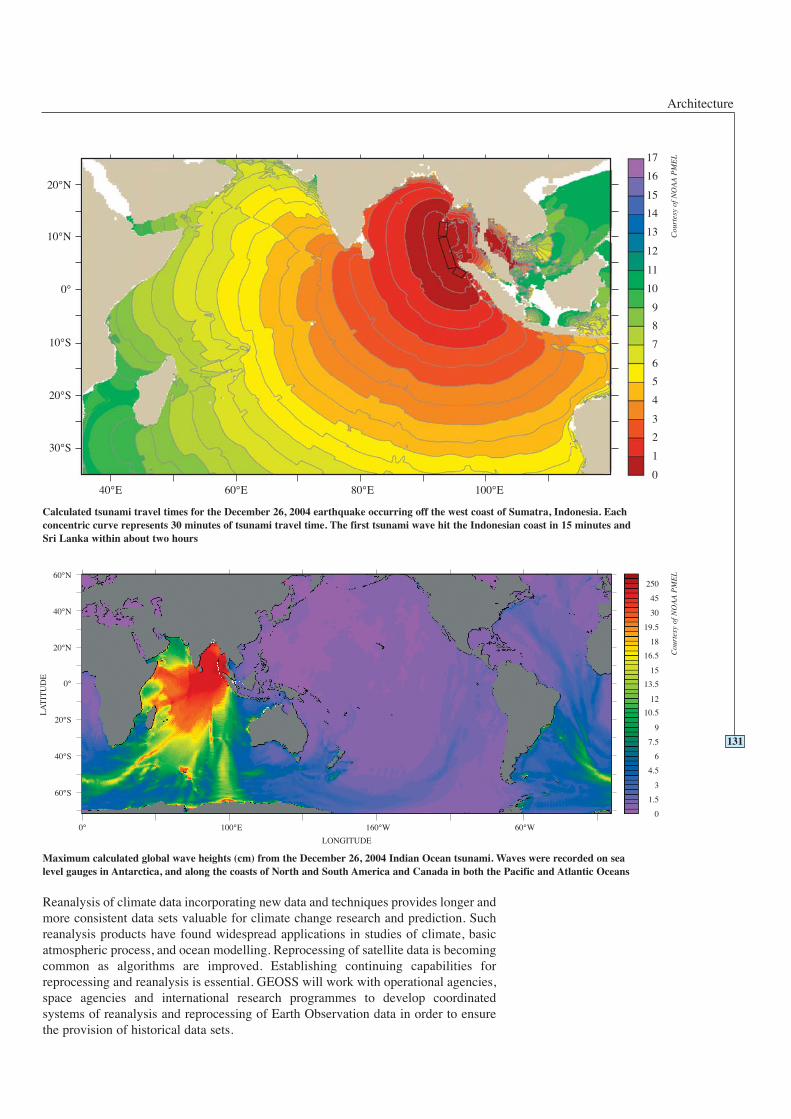
Architecture
Reanalysis of climate data incorporating new data and techniques provides longer andmore consistent data sets valuable for climate change research and prediction. Suchreanalysis products have found widespread applications in studies of climate, basicatmospheric process, and ocean modelling. Reprocessing of satellite data is becomingcommon as algorithms are improved. Establishing continuing capabilities forreprocessing and reanalysis is essential. GEOSS will work with operational agencies,space agencies and international research programmes to develop coordinatedsystems of reanalysis and reprocessing of Earth Observation data in order to ensurethe provision of historical data sets.
131
Maximum calculated global wave heights (cm) from the December 26, 2004 Indian Ocean tsunami. Waves were recorded on sealevel gauges in Antarctica, and along the coasts of North and South America and Canada in both the Pacific and Atlantic Oceans
Calculated tsunami travel times for the December 26, 2004 earthquake occurring off the west coast of Sumatra, Indonesia. Eachconcentric curve represents 30 minutes of tsunami travel time. The first tsunami wave hit the Indonesian coast in 15 minutes andSri Lanka within about two hours
Cou
rtes
y of
NO
AA
PM
EL
Cou
rtes
y of
NO
AA
PM
EL
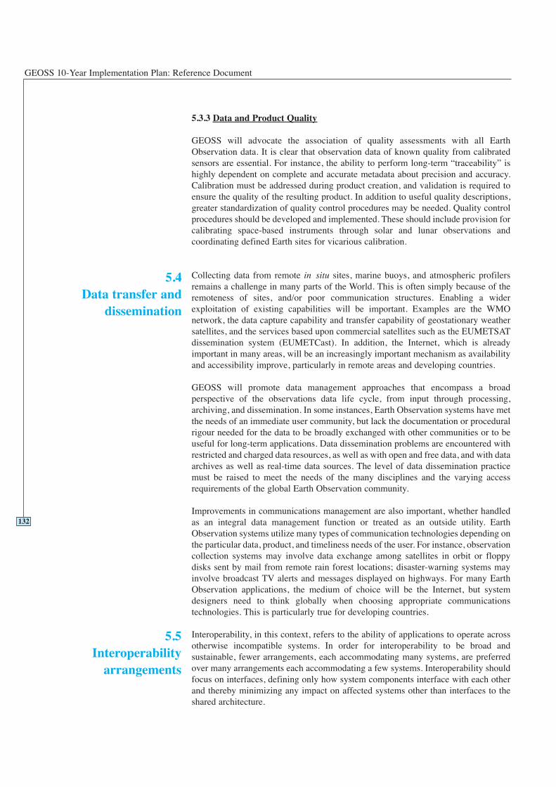
GEOSS 10-Year Implementation Plan: Reference Document
5.3.3 Data and Product Quality
GEOSS will advocate the association of quality assessments with all EarthObservation data. It is clear that observation data of known quality from calibratedsensors are essential. For instance, the ability to perform long-term “traceability” ishighly dependent on complete and accurate metadata about precision and accuracy.Calibration must be addressed during product creation, and validation is required toensure the quality of the resulting product. In addition to useful quality descriptions,greater standardization of quality control procedures may be needed. Quality controlprocedures should be developed and implemented. These should include provision forcalibrating space-based instruments through solar and lunar observations andcoordinating defined Earth sites for vicarious calibration.
Collecting data from remote in situ sites, marine buoys, and atmospheric profilersremains a challenge in many parts of the World. This is often simply because of theremoteness of sites, and/or poor communication structures. Enabling a widerexploitation of existing capabilities will be important. Examples are the WMOnetwork, the data capture capability and transfer capability of geostationary weathersatellites, and the services based upon commercial satellites such as the EUMETSATdissemination system (EUMETCast). In addition, the Internet, which is alreadyimportant in many areas, will be an increasingly important mechanism as availabilityand accessibility improve, particularly in remote areas and developing countries.
GEOSS will promote data management approaches that encompass a broadperspective of the observations data life cycle, from input through processing,archiving, and dissemination. In some instances, Earth Observation systems have metthe needs of an immediate user community, but lack the documentation or proceduralrigour needed for the data to be broadly exchanged with other communities or to beuseful for long-term applications. Data dissemination problems are encountered withrestricted and charged data resources, as well as with open and free data, and with dataarchives as well as real-time data sources. The level of data dissemination practicemust be raised to meet the needs of the many disciplines and the varying accessrequirements of the global Earth Observation community.
Improvements in communications management are also important, whether handledas an integral data management function or treated as an outside utility. EarthObservation systems utilize many types of communication technologies depending onthe particular data, product, and timeliness needs of the user. For instance, observationcollection systems may involve data exchange among satellites in orbit or floppydisks sent by mail from remote rain forest locations; disaster-warning systems mayinvolve broadcast TV alerts and messages displayed on highways. For many EarthObservation applications, the medium of choice will be the Internet, but systemdesigners need to think globally when choosing appropriate communicationstechnologies. This is particularly true for developing countries.
Interoperability, in this context, refers to the ability of applications to operate acrossotherwise incompatible systems. In order for interoperability to be broad andsustainable, fewer arrangements, each accommodating many systems, are preferredover many arrangements each accommodating a few systems. Interoperability shouldfocus on interfaces, defining only how system components interface with each otherand thereby minimizing any impact on affected systems other than interfaces to theshared architecture.
132
5.5Interoperability
arrangements
5.4Data transfer and
dissemination
Architecture
Interoperability arrangements must be based on non-proprietary, open standards, andprofiles must be specified when standards are not sufficiently specific. Rather thandefining new specifications, GEOSS should adopt standard specifications agreedupon voluntarily and by consensus, with preference given to formal internationalstandards such as ISO. All interface implementations should be specified in aplatform-independent manner, and verified through interoperability testing and publicdemonstrations. In the instances cited below, the service standards are widelydeployed in commercial products and are also available free as open source softwareimplementations. GEOSS will transition to more advanced standards as they evolvein these and other relevant areas.
GEOSS interoperability arrangements are to be based on the view of complex systemsas assemblies of components that interoperate primarily by passing structuredmessages over network communication services. By expressing interfaceinteroperability specifications as standard service definitions, GEOSS systeminterfaces assure verifiable and scaleable interoperability, whether amongcomponents within a complex system or among discrete systems.
It should be understood that the GEOSS approach to interoperability does not require,for example, that all participating systems use the same data format. Rather, it is onlynecessary that all participating systems provide a precise definition of their dataformats and how the data is accessed. This access mechanism is called a ‘service’ anda precise service definition lets other systems designers know how to get the dataappropriately. This is because the interoperability specification states exactly how theservice and the data must be described. (These descriptions are ‘metadata’.)
GEOSS service definitions are to specify precisely the syntax and semantics of alldata elements exchanged at the service interface, and fully describe how systems
133
Open Standards and Intellectual Property Rights
GEOSS will not require any commercial or otherwise proprietary standards, following the policy thatsoftware components must have open-standards-based interfaces. An ‘open standard’ is a standardspecification that is not restricted in its use. This is a matter separate from whether the document thatexpresses the specifications may be subject to Intellectual Property Rights (IPR) restrictions. (Forinstance, standards bodies such as ISO rely on sales revenue from standards documents to support theiroperations.)
A goal of GEOSS is that multiple software implementations compliant with the open standards shouldexist for the most commonly used components. Such software may be subject to IPR restrictions, typicallyexpressed as a licensing agreement.
In light of its capacity building commitments, a further goal of GEOSS is that at least one of theimplementations for the most commonly used components should be available to all implementers‘royalty-free’ (i.e. having no requirement for recurring payment).
GEOSS also encourages the development and verification of software that has no restrictions on beingcopied, modified or redistributed. Such software is typically distributed in the form used by programmers(‘source code’), and is therefore commonly known as ‘open source’. Given the lack of restrictions on itsuse, open source software typically requires payments at roughly the cost of distribution.
It should be noted that distributors may disclaim responsibility to repair defects or otherwise updateroyalty-free or open source software, relying instead on a network of developers who contribute updatedversions on a best-effort basis.
GEOSS 10-Year Implementation Plan: Reference Document
interact at the interface. At present, the systems interoperating in GEOSS should useany one of four open standard ways to describe service interfaces: CORBA, CommonObject Request Broker Architecture; WSDL, Web Services Definition Language;ebXML, electronic business Extensible Markup Language, or UML, UnifiedModelling Language.
Systems interoperating in GEOSS agree to avoid non-standard data syntaxes infavour of well-known and precisely defined syntaxes for data traversing systeminterfaces. The international standard ASN.1 (Abstract Syntax Notation) and theindustry standard XML (Extensible Markup Language) are examples of robust andgeneralized data syntaxes, and these are themselves interconvertible.
It is also important to register the semantics of shared data elements so that anysystem designer can determine in a precise way the exact meaning of data occurringat service interfaces between components. The standard ISO/IEC 11179, InformationTechnology-Metadata Registries, provides guidance on representing data semantics ina common registry.
A major concern in GEOSS is the set of standards for archiving data and otherresources that are acceptable to both providers and users. Communities withparticular expertise in archiving, such as those data managers associated with theWorld Data Center programme managed by ICSU (International Council forScience), will provide advice on archival standards. Archived data should be welldocumented, be stored using known and published standards, and be readilytransferable to a standard format for data exchange.
Many Earth Observation catalogues that require interoperability at the search servicehave adopted the international standard used for catalogue search (ISO 23950Protocol for Information Search and Retrieval). This search service is interoperablewith the broadest range of information resources and services, including libraries andinformation services worldwide as well as the Clearinghouse catalogues supportedacross the Global Spatial Data Infrastructure now implemented in more than 50countries. This standard search service also has demonstrated interoperability withservices registries using either an ebXML metadata model or UDDI (UniversalDescription, Discovery, and Integration).
Data and information resources and services in GEOSS typically include referencesto specific places on the Earth. Interfaces to discover and use these geospatial data andservices are agreed upon through the various Spatial Data Infrastructure initiatives.These include the ISO 23950 search service interface standard, as well as a range ofISO standards covering documentation and representation, and place codes.
The standard for geospatial metadata is ISO 19115: Geographic Information –Metadata. This standard facilitates the exchange and integration of data andinformation by giving a standard description of the identification, extent, quality,spatial and temporal scheme, spatial reference and distribution specifics of geospatialdata.
Services providing access to Earth Observation data and products often includesignificant requirements for assuring various aspects of security and authentication.These range from authentication of user identity for data with restricted access, tonotification of copyright restrictions for data not in the public domain, and tomechanisms for assurance that data is uncorrupted. In addition to security,accommodations will be made for necessary data and information charges and fees,when appropriate.
134
Architecture
Other standards typically are needed for the appropriate interchange of particularkinds of data. These include standards on calibration and methodology, among manyothers. GEOSS will promote convergence to common standards for each of thesevarious aspects.
GEOSS will provide coordination and cost-and-benefit-sharing mechanisms thataddress several challenges plaguing typical international efforts requiringcollaboration.
Shared Infrastructure - GEOSS will promote shared infrastructures for EarthObservation, leading to cost reductions for GEO Members and ParticipatingOrganizations, and provide scientific benefits as well. For example, an oceanographiccruise to sample plankton diversity can simultaneously collect weather data, and aterrestrial network for weather observations can also measure pollution. Similarly, theincremental cost of adding another sensor to a satellite platform with spare capacityis much smaller than building, launching and operating another satellite. In general,sample co-location often yields savings. This is because the costs of singleobservations are often quite high (especially in remote places), but the incrementalcosts of additional observations at the same place are relatively small.
Multi-Use Systems - Efficiency can also be realized by designing Earth Observationsystems from a multi-use perspective as envisioned in GEOSS. For instance, weatherdata are necessary inputs to all the societal benefit areas specified in the FrameworkDocument. An optimal observation system for, say, weather forecasting, would notlikely be optimal or even sufficient for climate, ecosystems, agriculture or health.However, a mechanism promoting coordination of user requirements can exposeopportunities for synergy among users with similar observation needs.
Shared Costs and Benefits - A mechanism for cost and benefit sharing such asGEOSS can often lead to a substantial improvement in an observation network. Forinstance, the accuracy of weather forecasting models is limited by upper airobservations in the Southern Hemisphere, and particularly over Africa and SouthAmerica. In the context of many of the developing countries located there, thenational benefits of making such observations do not justify the cost, given all theother demands on national resources. Cost sharing can be crucial whenever theprincipal benefits of a given observation accrue at a scale or location that differs fromthe jurisdiction of those best placed to make it.
GEOSS will be based on existing observing, data processing, data exchange anddissemination systems, while fostering and accommodating new systems operated byGEO Members and Participating Organizations, as needs and capabilities develop.The technical commitments of a GEO Member or Participating Organization willapply only to those contributions that they have identified.
One of the initial tasks for GEOSS will be to establish and maintain an inventory ofcontributing systems. Annex 1 shows GEO Members and Participating Organizationsthat have so far provided an informal indication to contribute to the initial GEOSSwith the noted systems.
135
5.6Collaboration mechanisms
5.7Initially identifiedGEOSS systems
GEOSS 10-Year Implementation Plan: Reference Document
To enable implementation of the GEOSS architecture, certain actions need to beundertaken as a first priority, as follows:
136
2 Year Targets 5 Architecture
GEOSS will:
Advocate formal commitments of contributions by GEO Members andParticipating Organizations, including commitment to adhere to GEOSSinteroperability specifications.
Produce a publicly accessible, network-distributed catalogue maintainedcollectively under the auspices of GEOSS. The catalogue will include informationon GEO Members and Participating Organizations and the components theysupport. The catalogue system will itself be subject to GEOSS interoperabilityspecifications, including the standard search service and geospatial services.
Establish and maintain a process for reaching interoperability arrangements,informed by ongoing dialogue with major international programmes and consortia.That process is to be sensitive to technology and accessibility disparities amongGEO Members and Participating Organizations, and must include mechanisms forupgrading arrangements.
Advocate use of existing Spatial Data Infrastructure (SDI) components asinstitutional and technical precedents in areas such as geodetic reference frames,common geographic data, standard protocols, and interoperable system interfaces,among other components.
Establish and maintain baseline sites for global in situ networks.
Develop a cost-and-benefit-sharing mechanism(s) for observations by which anoptimum observation system can be realized.
Provide a framework for securing the future continuity of necessary observationsand initiating new observations.
Facilitate the analysis of the current and planned systems for data transfer anddissemination by GEOSS members.
Facilitate a common understanding of future capabilities at a global level for datadissemination.
5.8Targets to enable the
architecture for GEOSS
137
DATA IN THE SERVICE OF USERS
6

GEOSS 10-Year Implementation Plan: Reference Document
138
Data and Users
The societal benefits of Earth Observation cannot be achieved without data sharing.The following are GEOSS data sharing principles:
• There will be full and open exchange of data, metadata, and products shared withinGEOSS, while recognizing relevant international instruments and national policiesand legislation.
• All shared data, metadata, and products will be made available with minimum timedelay and at minimum cost.
• All shared data, metadata, and products for use in education and research will beencouraged to be made available free of charge or at no more than the cost ofreproduction.
Use of data or products does not necessarily imply agreement with or endorsement ofthe purpose behind the gathering of such data.
Opportunities include synergies among the systems operating in the different userdomains and serving the different communities of users. It is expected that there willbe a large increase in the volume of Earth Observation data. In addition to distributeddata archives and integration systems, data management facilities will be used fordiverse and large-volume Earth Observation data from inhomogeneous informationsources in cooperation with existing data centres that will keep their institutionalidentity and mandates. Thus, GEOSS will facilitate:
• life-cycle data management for large volume data from leading-edge storagetechnology
• utilization of advanced database technology that enables multi-layeredvisualization of various types of data
• integration of natural science data and human societal data by standard co-registration techniques for data and geographic information
• new value-added products resulting from data and information fusion of diverseand large volume Earth Observation and socio-economic data
• implementation of international information sharing capabilities through an openand accessible system using appropriate international standards
• free availability of standardized metadata through a standard Internet-basedcatalogue search service, supporting multidisciplinary data and information search.
139
6.1Key principles
6.2Data management
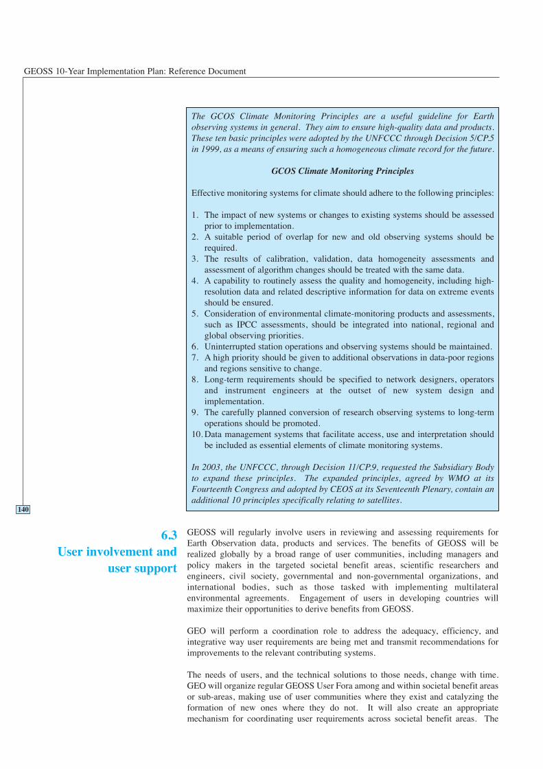
GEOSS 10-Year Implementation Plan: Reference Document
GEOSS will regularly involve users in reviewing and assessing requirements forEarth Observation data, products and services. The benefits of GEOSS will berealized globally by a broad range of user communities, including managers andpolicy makers in the targeted societal benefit areas, scientific researchers andengineers, civil society, governmental and non-governmental organizations, andinternational bodies, such as those tasked with implementing multilateralenvironmental agreements. Engagement of users in developing countries willmaximize their opportunities to derive benefits from GEOSS.
GEO will perform a coordination role to address the adequacy, efficiency, andintegrative way user requirements are being met and transmit recommendations forimprovements to the relevant contributing systems.
The needs of users, and the technical solutions to those needs, change with time.GEO will organize regular GEOSS User Fora among and within societal benefit areasor sub-areas, making use of user communities where they exist and catalyzing theformation of new ones where they do not. It will also create an appropriatemechanism for coordinating user requirements across societal benefit areas. The
140
The GCOS Climate Monitoring Principles are a useful guideline for Earthobserving systems in general. They aim to ensure high-quality data and products.These ten basic principles were adopted by the UNFCCC through Decision 5/CP.5in 1999, as a means of ensuring such a homogeneous climate record for the future.
GCOS Climate Monitoring Principles
Effective monitoring systems for climate should adhere to the following principles:
1. The impact of new systems or changes to existing systems should be assessedprior to implementation.
2. A suitable period of overlap for new and old observing systems should berequired.
3. The results of calibration, validation, data homogeneity assessments andassessment of algorithm changes should be treated with the same data.
4. A capability to routinely assess the quality and homogeneity, including high-resolution data and related descriptive information for data on extreme eventsshould be ensured.
5. Consideration of environmental climate-monitoring products and assessments,such as IPCC assessments, should be integrated into national, regional andglobal observing priorities.
6. Uninterrupted station operations and observing systems should be maintained.7. A high priority should be given to additional observations in data-poor regions
and regions sensitive to change.8. Long-term requirements should be specified to network designers, operators
and instrument engineers at the outset of new system design andimplementation.
9. The carefully planned conversion of research observing systems to long-termoperations should be promoted.
10. Data management systems that facilitate access, use and interpretation shouldbe included as essential elements of climate monitoring systems.
In 2003, the UNFCCC, through Decision 11/CP.9, requested the Subsidiary Bodyto expand these principles. The expanded principles, agreed by WMO at itsFourteenth Congress and adopted by CEOS at its Seventeenth Plenary, contain anadditional 10 principles specifically relating to satellites.
6.3User involvement and
user support
Data and Users
function of the User Fora will be to document and review user requirements, assessthe extent to which they are being met, and make recommendations to GEO with theobjective of improving the delivery of information appropriate to user needs.
GEO Participating Organizations will continue to play a key role in connecting usersand Earth Observation systems. Although GEOSS focuses on global issues, involve-ment of local and national users is also essential, in order to address issues that haveglobal implications.
In many cases, tools and/or manuals are needed to handle the data and products.GEOSS will encourage the development of the appropriate tools and manuals forusers, and the provision of help desks in order to make GEOSS “user-friendly.”
GEOSS will promote more effective transition of Earth Observation technologies,proven in the research environment, into operational use. Research strategic plansshould not only address continued investment in research, but should also considerhow to turn a successful research system into an operational system. Research space-based observation missions, once proven successful and useful, need to be transferredinto operational services through collaboration among space agencies and operationalagencies. It will be necessary to evolve experimental or research-based in situobservations into operational services in order to provide long-term monitoringcapabilities.
Because of the rapid pace of technological change, continuous and evolutionarysystem development is necessary to keep Earth Observation systems effective andefficient. Clearly, the science and practice of Earth Observation has a continuing needfor improved sensors, sampling strategies, and networks, among many othercomponents. New technologies often provide better coverage or precision at lowercost, and occasional breakthroughs lead to societal benefits hardly consideredpossible before. However, for changes to be effective in observation networks andsystems, there need to be assurances that long-term consistency and homogeneity willbe preserved.
GEOSS will promote coordination between observation and research, which includesWCRP, IGBP, and other international research programmes. Strong collaborationwith the research community, represented by ICSU and other organizations, willfurther refine required analyses and products. GEOSS will provide access to theobservations and data necessary for research communities, while research outcomeswill have an impact on observation system planning and system design.
GEO will advocate research and development in key areas to facilitate, on an ongoingbasis, improvements to Earth Observation systems, including:
• improved and new instrumentation and system design for in situ, airborne, andspace-based observation on a long-term basis
• life-cycle data management, data integration and information fusion, data mining,network enhancement, and design optimization studies, and
• development of models, data assimilation modules, and other algorithms that areable to produce global and regional products more effectively.
GEOSS implementation will promote research efforts that are necessary for thedevelopment of tools required in all societal benefit areas. It will also encourage andfacilitate the transition from research to operations of appropriate systems and
141
6.4Research facilitation
GEOSS 10-Year Implementation Plan: Reference Document
techniques. This includes facilitating partnerships between operational groups andresearch groups.
In order to enable the various functions of GEOSS, it is necessary that appropriatefrequency allocations exist and are protected. The frequency allocations will benecessary both for telecommunications and for observing systems. In some observingsystems, the required radio frequency will be determined by physics. The full set ofGEOSS required radio frequency allocations must take into account nationalfrequency plans as well as those of the International Telecommunication Union (ITU).To this end, GEOSS will:
• review allocations of radio-frequency bands and assignments of radio-frequenciesto GEOSS related activities for requirements (telecommunications, instruments,sensors, etc.) and research purposes
• coordinate with GEO Members and Participating Organizations to ensure theproper notification and assignment of frequencies, and to determine their future useof the radio spectrum
• keep abreast of the activities of the Radio Communication Sector of theInternational Telecommunication Union (ITU-R), and in particular of the RadioCommunication Study Groups
• prepare and coordinate proposals and advice to GEO Members and ParticipatingOrganizations on radio-regulation matters pertaining to GEOSS activities with aview to ITU Radio Communication Study Groups, Radio CommunicationAssembly, World Radio Communication Conferences and related regional andglobal preparatory meetings
• facilitate the coordination among GEO Members and Participating Organizationsfor the use of frequency bands allocated to GEOSS activities with respect to: (i) coordination of frequency use/assignments between countries, and (ii) coordination of frequency use/assignments between various radio communi-cation services sharing the same band
• facilitate the coordination among GEO Members and Participating Organizationsand other international organizations that address radio-spectrum planning,including specialized organizations (e.g. CGMS, SFCG, IUCAF) and regionaltelecommunication organizations (e.g. CEPT, CITEL, APT), and
• assist GEO Members and Participating Organizations, upon request, in the ITUcoordination procedure of frequency assignment for radio communication systemssharing a frequency band.
142
6.5Radio frequency protection
Data and Users
The targets given below are in addition to specific targets given for each of the ninesocietal benefit areas in Section 4 of this document. The targets given here also relateto overarching data management issues that need to be addressed.
143
6.6Targets
2-Year Targets 6 Data in the Service of Users
GEOSS will:
Establish a mechanism for coordinating user needs within the various societalbenefit areas.
Facilitate, with relevant countries and international organizations, the developmentand availability of data, metadata, and products commonly required across diversesocietal benefit areas, including base maps and common socio-economic data.
Advocate, through appropriate representations to the International Tele-communication Union, the protection of radio frequencies critical to Earthobservation.
6-Year Targets 6 Data in the Service of Users
GEOSS will:
Facilitate data management approaches that encompass a broad perspective of theobservation data life cycle, from input through data acquisition, processing,archiving, and dissemination, including analysis and visualization of large volumesand diverse types of data.
Advocate and facilitate international information sharing capabilities throughappropriate technologies, including, but not limited to, Internet-based services.
10-Year Targets 6 Data in the Service of Users
GEOSS will:
Facilitate sharing of data and products among the societal benefit areas and their usefor decision-making support.
Advocate new and increased efforts to enhance data availability and usabilitybeyond the 10-year implementation period.

GEOSS 10-Year Implementation Plan: Reference Document
144
145
CAPACITY BUILDING
7

GEOSS 10-Year Implementation Plan: Reference Document
146
Capacity Building
Capacity building is an integral part of the implementation strategy of GEO and is across-cutting component for the societal benefit areas identified and discussed inSection 4. Specific capacity building activities, however, need to be tailored to suitregional or local requirements on the basis of existing capacity.
The most efficient means to improve the geographic coverage of the Earth observingsystem is to encourage wider participation from all countries. The capacity buildingenvisaged within this context must extend beyond training of qualified technicalpersonnel to operate the observing instruments, to include building of a broadercommunity that will be trained in the development, interpretation and utilization ofvalue-added products from the observations. Capacity building initiatives musttherefore target a spectrum of citizens – from the general public, to scientists, tomanagers, to decision-makers. This is essential to ensure that all countries benefitfrom GEOSS.
Many potential GEOSS components have made significant progress in developingcapacity, but linkages and partnerships between these activities are critical to ensuresustainability and the most effective use of resources.
The 1992 United Nations Conference on Environment and Development (UNCED)definition of capacity building encompasses a country’s human, scientific,technological, organizational, and institutional resources and capabilities. Afundamental goal of capacity building is to enhance the abilities of stakeholders toevaluate and address crucial questions related to policy choices and modes ofimplementation among different options for development. These choices would bebased on an understanding of environmental potential and limits and of the needsperceived by the people of the country concerned.
The goals of capacity building in GEO will be to strengthen the capability of allcountries, in particular developing countries, to:
1. Use Earth Observation data and products (i.e. process, integrate, model, etc.) in asustainable, repeatable manner (both space-based and in situ sensors), with resultsor outputs that are consistent with accepted Earth observing standards.
2. Contribute in situ observations to global networks, and access and retrieverelevant data from global data systems useful for in situ applications.
3. Analyze and interpret data (both in situ and space-based) to derive nationally,regionally and globally relevant information and provide decision-support systemsand tools useful to decision-makers.
4. Integrate Earth Observation data and information with data and information fromother sources for a comprehensive and holistic view and understanding ofproblems in order to identify sustainable solutions.
The GEO capacity building strategy takes its lead from the emerging understandingof Best Practices derived from a study of successful and less successful approachesfrom the past. The GEO capacity building strategy follows the WSSD concept of aglobal partnership between those whose capacity needs development and those whoare able to assist in the process, recognizing that activities have intertwined social,environmental, and economic impacts.
147
7.1Introduction
7.2What is capacitybuilding?
7.3Goals
7.4Strategy and principles
GEOSS 10-Year Implementation Plan: Reference Document
GEO capacity building activities will build on existing local, national, regional, andglobal initiatives to achieve the goals of the GEOSS. Capacity building across theentire continuum of GEOSS activities is crucial for sustained results, whereby eachcountry must determine the set activities in which it is able to engage. The capacitybuilding recommendations that are reflected in the 10-Year Implementation Plan arebased on the following considerations:
1. GEO capacity building efforts are funded and sustained, to ensure the continuityand enhancement of initiatives. These initiatives must be approached as a multi-level activity – enhancing research capacities, expanding tertiary educationalfacilities and training, and creating highly skilled and dedicated technicians.
2. Capacity building activities must respect the needs and recommendations of, andlessons learned from, previous and existing efforts.
3. Efforts must be based on the recognition that Earth Observation and relatedcapacity building activities have intertwined social, environmental, and economicimpacts.
4. Sustainable capacity building will only be successful if local and nationalstakeholders are partners in the process from the onset, and if there is an ongoingand long-term political and institutional commitment. Advantage should be takenof existing experience and capability within regions.
5. Capacity building envisaged here should lead to sustained improvements in Earthobservations and related activities.
6. Capacity building efforts should be directed at maintaining and strengtheningexisting structures and developing new infrastructure where necessary.
7. Infrastructure development in regions of poor observational coverage is to beencouraged on a priority basis to realize maximum societal benefits.
8. Capacity building efforts should aim to move individual countries from a positionof awareness to a position where they take all necessary actions to continuouslyimprove their own capacity.
9. Capacity building should address not only issues related to data collection, butalso those related to data archiving, data distribution, data analyses, productcreation and interpretation.
10. A variety of outputs, ranging from raw data to processed outputs will be necessaryto meet the needs of various applications. These outputs will have to be tailoredto meet the requirements of the applications envisaged, and adapted to the regionalsituations and technological capabilities and continuously improved as thedemand for products increases.
The recommendations given below are in addition to specific capacity buildingrecommendations and targets identified under Sections 4, 5, and 6. Therecommendations given here relate to overarching capacity building issues that needto be addressed. They are written being cognizant of the vast array of capacitybuilding interventions that do exist within various national, regional, and internationalorganizations. These will need to be considered in the implementation of GEOSS.
148
7.5Targets
Capacity Building
149
2 Year Targets 7 Capacity Building
GEO will:
Produce a comprehensive review and gaps analysis based on existing regional andinternational capacity building efforts as a first step in the implementation ofGEOSS. GEO will facilitate coordination of those efforts with the objective ofachieving the maximum return for the effort expended.
Produce methodologies to monitor and evaluate capacity building initiativesrelating to Earth Observation systems.
Facilitate, with existing international, regional and national efforts, the maintenanceand strengthening of education, training, research, and communication so that eachcountry reaches and sustains a level of capability that enables them to participate inGEOSS, receiving maximum benefits from it according to their needs.
Facilitate, with developing countries and across all societal benefit areas, theestablishment and maintenance of baseline sites for global in situ and remote-sensing networks that cannot always be justified on national grounds alone, incooperation with relevant global research programs and activities to ensure thatsynergies in observations and understanding are achieved. Examples include theinadequacy of GCOS, GTOS, GOOS, and Global Geodetic Observing System(GGOS) sites in developing countries and the need to establish a minimum set ofoceanic, terrestrial and atmospheric reference stations for long-term observations ofkey variables.
Develop a network of experts involved in existing local, national and globalcapacity building initiatives related to Earth Observation to facilitate the task offurthering capacity building, and inform the GEO Members and ParticipatingOrganizations of existing efforts in capacity building. GEO will encourage users toaccess this knowledge base.
Encourage, in each societal benefit area, the development of capacity buildingcomponents as a requirement to any network, project, activity, or user forum thatwill be a component of GEOSS.
Facilitate access to data and models, particularly for developing countries.
Develop recommended priorities for new or augmented efforts in capacity building,to meet the objectives of the overall GEOSS 10-Year Implementation Plan.
6 Year Targets 7 Capacity Building
GEO will:
Advocate funding of multinational projects to leverage the end-to-end value ofobservations including the establishment of necessary infrastructure.
Produce monitoring and evaluation mechanisms aimed at determining the efficacyof GEO capacity building efforts.
GEOSS 10-Year Implementation Plan: Reference Document
150
Facilitate education and training to provide a global base of technical expertise forGEOSS.
Develop recommended priorities for new or augmented efforts in capacity building,to meet the objectives of the GEOSS 10-Year Implementation Plan.
10 Year Targets 7 Capacity Building
Within 10 years, GEO will seek to have in place a sustained capacity buildingstrategy that will have significantly strengthened the capability of all countries, andparticularly of developing countries, to:
• Use Earth Observation data and products (e.g. process, integrate, model)following accepted standards.
• Contribute to, access, and retrieve data from global data systems and networks.
• Analyze and interpret data to enable development of decision-support tools.
• Integrate Earth Observation data and products with other data and products, fora more complete view and understanding of problems and derived solutions.
• Improve infrastructure development in areas of poor observational coverage.
Develop recommended priorities for new or augmented efforts in capacity building.
151
OUTREACH
8

GEOSS 10-Year Implementation Plan: Reference Document
152
Outreach
GEOSS outreach activities and the resulting dialogue will provide many benefits.They will: inform individuals or stakeholders to enable better decision making;inform GEOSS principals, providing for continuous improvement of the “system ofsystems”; and increase understanding among policy makers and the general public toensure appropriate support for Earth Observation systems.
The overall objective of the GEOSS outreach component is, therefore, to promote andincrease the general awareness of the benefits of Earth Observation, in the broadestsense possible. The key target audiences will be the present and future users,beneficiaries and sponsors of relevant systems. The Outreach Plan should beconsidered a flexible component. It can be adapted in response to major strategic andoperational developments that might occur during the 10-year implementation period.It will also include ways to measure its success.
Decision-makers and the general public will be two target groups for EarthObservation promotion activities. In the past, material generated for these groups hasbeen insufficient and not always “tailored” to their needs (frequently focusing onengineering/technology/science). Several examples exist where properly driven EarthObservation promotion has successfully attracted further governmental and publicattention.
The main objectives of outreach activities are to:
• convince key audiences that past, present, and future investments in EarthObservation are delivering tangible socio-economic benefits, and therebyencourage more countries and organizations to participate actively in GEOSS
• show the practical applications of Earth Observation and their relevance togovernment policy, socio-economic growth, and the interests of citizens
• increase public awareness of GEOSS scientific achievements, technologyadvances, applications and capabilities, as well as benefits and support toenvironmental management.
The outreach component has to address a wide range of audiences, including diverselanguage groups, differing national interests, all age groups, varying levels oftechnical sophistication, and high to low political influence.
While all materials will be Internet-based, it is essential to recognize that hard copies(paper, CDs) will be necessary to reach all communities.
8.3.1 Decision and Policy Makers
This audience includes, primarily, political-level entities and representatives of GEOMembers and Participating Organizations, as well as those responsible or interestedin the exploitation of Earth Observation data and information. Typically included inthis category are ministers, parliamentarians and specialized government committees,high-level civil servants, relevant national and international organizations, and usergroups. All need to be shown, beyond the specific technicalities, the usefulness ofEarth Observation information and data to solve their sector issues (e.g. ecosystemmanagement, disaster management, agriculture, energy, health, etc.).
8.3.2 General Public
The general public includes the “man-in-the-street” as well as opinion makers fromthe media (press, TV, radio), who need to be familiarized, through qualityinformation, with Earth Observation achievements. The goal is to increase confidencein public investment in this sector and raise awareness of the potential contribution
153
8.1Introduction
8.2Objectives of GEOSSoutreach
8.3Outreach audiences

GEOSS 10-Year Implementation Plan: Reference Document
that Earth Observation tools and information can provide in everyday life. In today’s“information society,” the “image” of Earth Observation can be channeled to thegeneral public in an extremely effective way. The requirement is for effective andappealing sets of information.
8.3.3 Industry, Value Adding Companies (VAC) and Service Communities
Existing initiatives already link the industrial, non-governmental, academic andgovernment sectors to promote the understanding and use of Earth Observation forsocietal and economic benefit. GEOSS could liaise with these types of initiatives tocreate a better dialogue with the industrial world. Service industries are also to beconsidered for possible outreach activities, since they are probably not fully aware ofthe potential economic benefits and markets that can be derived from EarthObservation. Public/private partnership should also be encouraged in this sector. Afirst set of actions could be directed towards existing, sector-specific industrialassociations.
8.3.4 Scientific and Technical Communities
This audience includes R&D institutions, universities, government laboratories, non-governmental bodies, and industry. The interest of these communities must be drawnto the potential support Earth Observation can provide to their research andinvestigations, also in order to complement and improve their scientific and technicalachievements, exploiting the multidisciplinary nature of Earth Observation data, andfacilitating the transfer of technology and know-how.
8.3.5 Education Community
This audience includes primary and secondary schools as well as universities.Outreach promotion of Earth Observation to schools is meant to trigger and generateawareness of teachers and students of Earth Observation techniques as part of basiceducation and of Earth Observation products and services as useful and modern toolsfor teaching and learning. Today’s students will, in the medium term, becomedecision-makers or potential data users and therefore need to be trained early to fullyappreciate the usefulness of, and benefit from, Earth Observation programmes. Thiswill involve the development of ad hoc educational curricula.
8.3.6 NGOs and Public Interest Advocacy Groups
NGOs include non-governmental organizations devoted to specific or cross-sectoralissues such as environment, sustainable development, health, agriculture, energy use,cooperation with developing countries, etc. Public Interest/Advocacy Groups includecitizen groups capable of influencing public opinion and of lobbying with decision-makers for their specific causes. Outreach promotion activities towards thesecategories could support and complement actions towards the general public inOECD and developing countries.
8.3.7 International Financial Institutions and Official Development AssistanceAgencies
This audience includes international and national investment institutions andtechnical/development assistance organizations devoted to cooperation with
154
Outreach
developing countries. Outreach promotion activities directed at these institutions andorganizations will increase their knowledge of Earth Observation benefits, thusencouraging the inclusion of Earth Observation programmes in developing countryinvestments, and promoting appropriate partnerships to ensure the related capacitybuilding activities.
8.4.1 Short Term (Two-year)
GEO will produce and begin to implement an outreach plan directed toward keytarget audiences, including decision-makers and policy makers; educators andtrainers; the general public; industry and service communities; scientific and technicalcommunities; non-governmental organizations; public interest advocacy groups; andinternational financial institutions and official development assistance agencies.
8.4.2 Medium and Long-term (6 to 10 Year)
All target audiences should be reached, although with different priority levels andresources. Decision-makers, educators and trainers, and the general public willremain of highest priority. In the longer term, priority will be given to private sectorneeds for triple bottom line reporting.
155
8.4Time frame

GEOSS 10-Year Implementation Plan: Reference Document
156
157
PERFORMANCE INDICATORS
9

GEOSS 10-Year Implementation Plan: Reference Document
158
Performance Indicators
GEO Members and Participating Organizations will require evidence that theimplementation of GEOSS is measurably beneficial in order to assure continuingsupport. This Reference Document has identified a number of specific actions forimplementation in the short term (2 years), medium term (6 years), and long term (10 years). This section sets out the proposed mechanism for assessing theperformance of the 10-Year Implementation Plan against these goals.
It is proposed to use a broadly recognized four-part system of indicators for assessingthe performance of GEOSS as described below. An early task of GEO will be to workout the details of these indicators.
These quantify the effort and resources committed to the GEOSS implementation.They include:
• Number of staff in the GEO Secretariat, including both those resourced by GEOand seconded to GEO, and classified into professionals and support staff.
• Total budget of the GEO Secretariat, broken down by:
- fraction spent on human resources
- fraction spent on operations (meetings, travel, etc.)
- fraction spent on overheads (office, etc.).
• Number of participating countries and organizations.
• Percentage of due contributions received.
These indicators will be provided annually and will form part of an Annual Report.
The total cost for implementing GEOSS will be significant, but only limited resourceswill need to be provided through GEO. Most of the resources will be providedthrough existing national and international mechanisms, and by voluntarycontributions to special projects. There are a number of input indicators that could beapplied to measuring the global level of resource commitment to Earth Observationsystems, particularly those participating in GEOSS.
These indicators quantify the auditable products delivered in the reporting period.They include:
• implementation plan targets achieved
• reports issued (including standards and protocols and scientific papers published)
• meetings held and documented, including duration, location, outputs, number andorigin of participants
• number of users of GEOSS Internet-based resources, data and products.
These indicators will be provided annually and will form part of an Annual Report.
Outcomes are a measure of the effectiveness of the GEOSS process in terms of theimprovements to the Earth observing system. In effect, they relate to the specificactions set out in each section and summarized in Section 10, and in relation to thetargeted areas of current deficiency and promised improvement described inSection 3. The timeline for this reporting will be consistent with the relevant time-scale of implementation across the ten-year period. Examples of outcomes include:
• new observational products traceable to GEOSS
• percentage interoperability achieved between collaborating systems
159
9Performance Indicators
9.1Input indicators
9.2Output indicators
9.3Outcome indicators
GEOSS 10-Year Implementation Plan: Reference Document
• use of GEOSS-sourced products in major assessments
• improvements in the quantity, quality, timeliness and scope of data deliveredthrough GEOSS
• degree to which user requirements for observations are met by systemsparticipating in GEOSS.
This is the assessment of whether the activities of GEOSS have led to significantimprovements in human well-being within the societal benefit areas. Almost bydefinition, many of these are measurable only on the decadal timescale, and aremostly qualitative. The mechanism for assessment is a detailed, external review asdirected by GEO.
160
9.4Impacts
161
PHASED IMPLEMENTATIONAND GEOSS EVOLUTION
10

GEOSS 10-Year Implementation Plan: Reference Document
162
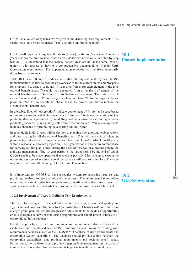
Phased Implementation and GEOSS Evolution
GEOSS is a system of systems evolving from and driven by user requirements. Thissection sets out a broad sequence for its evolution and implementation.
GEOSS will implement targets in the short- (2-year), medium- (6-year) and long- (10-year) term for the nine societal benefit areas identified in Section 4, in a step-by-stepfashion. It is understood that the societal benefit areas are not at the same level ofmaturity with respect to having a comprehensive understanding of their EarthObservation requirements. The implementation schedule will therefore necessarilydiffer from area to area.
Table 10.1 is an attempt to indicate an initial phasing and maturity for GEOSSimplementation. It aims to provide an overview as to the current status and prospectsfor progress in 2-year, 6-year, and 10-year time frames for each element in the ninesocietal benefit areas. The table was generated from an analysis of targets of thesocietal benefit areas in Section 4 of this Reference Document. The status of eachelement is indicated by “P” for being in a planning phase, “I” for an implementationphase and “O” for an operational phase. It has not proved possible to include theHealth societal benefit area.
In the table, lines of “observation” indicate deployment of in situ and space-basedobservation systems and their convergence. “Products” indicates generation of keyproducts, data sets produced by modelling and data assimilation, and synergisticproducts generated by integrating data from different sources. “Data management”includes elements for promoting data sharing and utilization.
In general, the initial 2 years will be devoted to planning how to promote observationsand data sharing for all the societal benefit areas. This will be a critical planningphase to lay out a detailed implementation plan, do-able and verifiable in 10 years,within a reasonable resource projection. The 6-year period is another important phasefor carrying out the plan, consolidating the basis of observations, product generationand data management. The 10-year period is the target period by the end of whichGEOSS needs to be made operational as much as possible. Mechanisms to sustain theobservation system of systems beyond the 10 years will need to be in place. The tablemay assist such overall planning of GEOSS implementation.
It is important for GEOSS to have a regular system for assessing progress andproviding feedback for the evolution of the systems. The assessment has to define,inter alia, the extent to which a comprehensive, coordinated, and sustained system ofsystems can be achieved and what actions are needed to ensure relevant feedback.
10.2.1 Involvement of Users in Defining New Requirements
The need for changes in data and information provision, access, and quality aresignificant and concern different actors and institutions. Changes will not result froma single grand plan, but require progressive adjustments to be made as opportunitiesarise (e.g. regular reviews of monitoring programmes and establishment or renewal ofobservational infrastructures).
For this approach, a distinct and common user requirements database should beestablished and maintained for GEOSS, building on and linking to existing userrequirements databases, such as the CEOS/WMO database of user requirements andobservation system capabilities. The database should provide a link between theobservation capabilities, data products requirements and societal benefit areas.Furthermore, the database should provide a gap analysis mechanism on the basis ofcomparison of available observations and data products with the required ones.
163
10.1Phased implementation
10.2GEOSS evolution
GEOSS 10-Year Implementation Plan: Reference Document
164
Ta
ble
10
.1 G
EO
SS
Ten
-Yea
r Im
ple
men
tati
on
Pla
n:
Rel
ati
ve
Ph
asi
ng
an
d M
atu
rity
of
Ea
rth
Ob
serv
ati
on
Ap
pli
cati
on
An
initi
al s
ynop
tic d
escr
iptio
n of
the
pha
sing
of
GE
OSS
im
plem
enta
tion.
To
pic
sD
isa
ster
Hea
lth
En
erg
yC
lim
ate
Wa
ter
Wea
ther
Eco
-
syst
ems
Ag
ri-
cult
ure
Bio
-
div
ersi
ty
Per
iod
s (y
ears
)2
61
02
61
02
61
02
61
02
61
02
61
02
61
02
61
02
61
0
Ob
serv
ati
on
:
1 I
n s
itu
an
d a
irb
orn
eI
II
IO
OI
OO
II
OO
OO
II
OI
IO
II
O
2 S
pa
ce-b
ase
dI
II
IO
OI
OO
II
OO
OO
II
OP
IO
PI
O
3 C
on
ver
gen
ce o
f O
bs.
PI
IP
IO
IO
OP
IO
OO
OP
IO
PO
OP
IO
4 C
on
tin
uit
yP
PI
II
OI
IO
II
OO
OO
PI
OP
PI
PI
O
Pro
du
ct:
5 K
ey P
rod
uct
sP
IO
II
OP
IO
PI
OO
OO
II
OI
IO
II
O
6 M
od
elin
g/A
ssim
ila
tio
nP
II
II
OP
IO
II
OO
OO
PI
OP
IO
PI
O
7 S
yn
erg
y o
f P
rod
uct
sP
II
PI
OP
IO
PI
OP
IO
PI
OP
IO
PI
O
8 Q
ua
lity
Co
ntr
ol
PP
II
IO
PI
OP
IO
OO
OP
IO
PI
OP
IO
Da
ta M
an
ag
emen
t:
9 A
cces
sib
ilit
yI
IO
II
OP
IO
II
OO
OO
PI
OI
IO
PI
O
10
Da
ta E
xch
an
ge
II
OI
IO
PI
OP
IO
OO
OP
IO
PI
OP
IO
11
In
tero
per
ab
ilit
yP
II
PI
OP
IO
PI
OP
IO
PI
OP
IO
PI
O
12
Use
r In
vo
lvem
ent
II
IP
IO
IO
OP
OO
OO
OP
IO
IO
OP
IO
13
R &
D f
or
Ob
serv
ati
on
II
II
II
II
II
II
II
IP
II
PI
OP
II
Ca
pa
city
Bu
ild
ing
:
14
Ca
pa
city
Bu
ild
ing
PI
I
Rep
rese
n-ta
tion
of th
eph
asin
g ha
sno
t yet
bee
nde
term
ined
II
OI
IO
PI
OI
IO
PI
OI
OO
PI
O
Leg
end
PP
lan
nin
g P
ha
seI
Imp
lem
enta
tio
n P
ha
seO
Op
era
tio
na
l P
ha
se
Phased Implementation and GEOSS Evolution
For updating user requirements, the WMO experience in setting, reviewing, andupdating observational data following their process called the Rolling Review ofRequirements (RRR) could be used as a model. All WMO-supported programmes usethe RRR process, which has become an effective tool for assessing currentcapabilities of a global observing system and defining enhancements.
GEOSS will launch a programme to ensure the involvement of users, and toeffectively monitor their needs. User requirements, and the extent to which they arebeing met, will be assessed through coordination meetings with those responsible forthe various domain- and agency-based observing systems. GEOSS User Fora shouldbe held regularly to review the overall progress of GEOSS with respect to meeting theuser needs within and among societal benefit areas. The outcome of the fora will beimportant inputs into the updating of the 10-Year Implementation Plan. Furtherdetails are provided in Section 6.6.
10.2.2 Involvement of the Science and Industrial Communities
GEOSS needs to involve the science and industrial communities to ensureincorporation of technical developments that could enable existing (and new)requirements to be met, as well as new exploitation techniques that will improve theutility of GEOSS. This activity should be part of the GEOSS User Fora.
Improvements in the observing system require support from research anddevelopment in several areas. The most important of these are listed below:
• Improved and new instrumentation for in situ and space-based observation.
• Data management, data integration and information fusion, data mining, networkenhancement, and design optimization studies. This must include an evaluation oftrade-offs in performance based on various hypothetical improvements in theobservations.
• Development of models and algorithms that are able to more effectively invert orassimilate raw observations to produce global products.
• Transition from scientific/technical programmes to operational services.
The involvement of standards organizations and certification bodies in the processwill facilitate the development of user standards.
The GEOSS evolution is driven by user requirements and available capability. Theseuser requirements and capabilities will grow as time goes by. There will always be anevolution in terms of future requirements and capabilities. There needs to be aconsistency check between the user requirements and available capabilities. This is anecessary step to assess how well user requirements are being met by capabilities, andhow well future user requirements can be met by future capabilities, thereby makingit possible to provide user requirements to capabilities feedback, and vice versa.
The relationship between users, Earth systems, science, technologies, and GEOSS isshown in Figure 10.1. It is important to ensure close links between the user, scienceand technology communities and GEOSS in order to decide future user needs andtechnological capabilities, and the societal benefits including scientific outcomes.
165
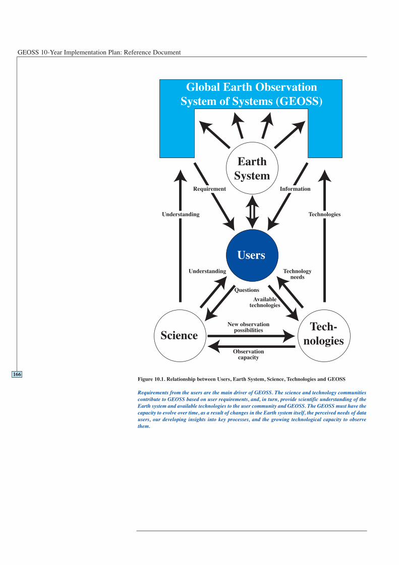
GEOSS 10-Year Implementation Plan: Reference Document
166Figure 10.1. Relationship between Users, Earth System, Science, Technologies and GEOSS
Requirements from the users are the main driver of GEOSS. The science and technology communitiescontribute to GEOSS based on user requirements, and, in turn, provide scientific understanding of theEarth system and available technologies to the user community and GEOSS. The GEOSS must have thecapacity to evolve over time, as a result of changes in the Earth system itself, the perceived needs of datausers, our developing insights into key processes, and the growing technological capacity to observethem.
167
GLOSSARY AND ACRONYMS
11

GEOSS 10-Year Implementation Plan: Reference Document
168
Glossary and Acronyms
C-band - a category of satellite transmission in the 6 GHz range.
GCOS Implementation Plan - Implementation Plan for the Global ObservingSystems for Climate in Support of the UNFCCC, GCOS-92 (GCOS, 2004).
GCOS Second Adequacy Report - Second Report on the Adequacy of the GlobalObserving Systems for Climate in Support of the UNFCCC, GCOS-82 (GCOS, 2003).
global positioning - a category of satellite constellations (e.g. United States GlobalPositioning System, European GALILEO, Russian GLONASS, Japanese QZSS) thatprovide services for determining position on the Earth.
in situ observations - observations captured locally, i.e. within a few kilometres ofthe object or phenomenon being observed. These include measurements taken atground stations, by aircraft and sondes, ships and buoys.
integrated (dataset) - data sourced from multiple systems that are combined in aconsistent and scientifically rigorous way.
L-band - the portion of the electromagnetic spectrum allotted for satellitetransmission in the 1 to 2 GHz frequency range.
observation(s) - quantitative or qualitative measurements of environmental andsocial variables obtained by instruments or human observers, either in situ or throughremote sensing. Such observations frequently include numerical transformations tocalibrate or interpolate them.
products (observational) - information that is derived from observations, typicallythrough the processes of collation, synthesis, integration, summarization andinterpretation.
realised niche - that fraction of the potential distribution of a species that is actuallyoccupied by it.
remote sensing - in general, observations made at a distance. In the GEOSS contextspecifically, observations made from satellites in space, in the visible, infrared andmicrowave parts of the electromagnetic spectrum, at high, medium and lowresolutions. Airborne, sonde and other forms of near-surface remote sensing areconsidered part of in situ observations for GEOSS purposes.
services (observational) - activities that are necessary in support of an observationsystem, but are not themselves observations–for example, the development ofstandards and the provision of calibrations.
AFRICOVER A regional land cover mapping programme in AfricaALOS Advanced Land Observing Satellite (Japan)AMDAR Aircraft Meteorological Data RelayAPT Asia-Pacific TelecommunityArgo Global array of temperature/salinity profiling floats for
ocean climate observationsAVIRIS Airborne Visible and Infra-Red Imaging SpectrometerCAP Common Alerting ProtocolCBD Convention on BiodiversityCCD Convention to Combat Desertification in countries
experiencing serious drought and/or desertification,particularly in africa
CDC Centres for Disease Control (United States)CEOS Committee on Earth Observation SatellitesCEPT European Conference of Postal and Telecommunications
Administrations
169
11.1Glossary of terms
11.2Acronyms
GEOSS 10-Year Implementation Plan: Reference Document
CGMS Co-ordination Group for Meteorological SatellitesCITEL Inter-American Telecommunication CommissionCITES Convention on International Trade in Endangered SpeciesCMS Convention on Migratory SpeciesCORBA Common Object Request Broker ArchitectureCoML Census of Marine LifeCOSMO-SkyMed Observing system (Italy)CTBTO Preparatory Commission for the Comprehensive Nuclear
Test-Ban Treaty OrganizationDAPHNE Deployment of Asia-Pacific Hazard-mitigation Network for
Earthquakes and volcanoes (Japan)DEMs Digital Elevation ModelsDIVERSITAS A biodiversity research programme of ICSU, UNESCO,
IUBS, and SCOPEDIWPA DIVERSITAS Western Pacific and AsiaebXML Electronic business Extensible Markup LanguageECMWF European Centre for Medium-Range Weather ForecastsECVs Essential Climate VariablesEEPCo Ethiopian Electric Power CorporationEUMETNET Network of European Meteorological ServicesEUMETSAT European Organization for the Exploitation of
Meteorological SatellitesENSO El Niño/Southern OscillationEnvisat Environmental satellite mission of the European Space
AgencyERS European Remote-sensing SatelliteESA European Space AgencyESSP Earth System Science PartnershipEUCOS EUMETNET Composite Observing SystemFAO Food and Agriculture Organization (of the United Nations)F-NET Full Range Seismograph Network (Japan)GALILEO ESA/EU Global Navigation Satellite SystemGAW Global Atmospheric Watch (WMO)GBA Global Biodiversity AssessmentGBIF Global Biodiversity Information FacilityGCOS Global Climate Observing System (co-sponsored by ICSU,
IOC of UNESCO, UNEP and WMO)GCRMN Global Coral Reef Monitoring NetworkGECAFS Global Environmental Change and Food SystemsGEMS Global Environmental Monitoring Strategy (WHO)GEO Group on Earth ObservationsGeoHab Marine Geological and Biological Habitat MappingGEONET GPS Earth Observation Network System (Japan)GEOSS Global Earth Observation System of SystemsGGOS Global Geodetic Observing SystemGHG Greenhouse GasGIS Geographic Information SystemsGISP Global Invasive Species ProgrammeGLCN Global Land Cover Network of the FAOGLOBEC Global Ocean Ecosystem Dynamics Project (of the IGBP)GLONASS Global Orbiting Navigation Satellite System (Russia)GMA Global Marine AssessmentGMES Global Monitoring for Environment and Security GODAE Global Ocean Data Assimilation ExperimentGOFC-GOLD Global Observations of Forest and Land Cover DynamicsGOOS Global Ocean Observing System (hosted by IOC)
170

Glossary and Acronyms
GOS Global Observing System (co-sponsored by ICSU, IOC ofUNESCO, UNEP and WMO)
GPCC Global Precipitation Climatology Centre (hosted byGermany)
GPM Global Precipitation Measurement GRDC Global Runoff Data Centre (hosted by Germany)GSDI Global Spatial Data InfrastructureGSN Global Seismographic NetworkGTN-H Global Terrestrial Network for HydrologyGTOS Global Terrestrial Observing System. (co-sponsored by
FAO, ICSU, UNESCO, UNEP and WMO, hosted by FAO)GUAN GCOS Upper Air NetworkHi-NET Hi-sensitivity Seismograph Network (Japan)IAG International Association of GeodesyIBMN International Biodiversity Monitoring NetworkIBOY International Biodiversity Observation Year ICSU International Council for ScienceIEA International Energy AgencyIEC International Electrotechnical CommissionIFRC/RCS International Federation of the Red Cross/Red Crescent
SocietiesIGBP International Geosphere-Biosphere Program (of the ICSU)IGOS-P Integrated Global Observation Strategy Partnership.
(includes CEOS, FAO, GCOS, GOOS, GOS/GAW, GTOS,ICSU, IGBP, IGFA, IOC, UNESCO, UNEP, WCRP, WMO)
IMBER Integrated Marine Biogeochemistry and EcosystemResearch
InSAR Interferometric Synthetic Aperture RadarIOC Intergovernmental Oceanographic Commission of
UNESCOIOCCP International Ocean Carbon Coordination ProjectIPCC Intergovernmental Panel on Climate ChangeIPR Intellectual Property RightsIRI International Research Institute for Climate PredictionISCGM International Steering Committee for Global MappingISDR International Strategy for Disaster ReductionISO International Organization for StandardizationITU International Telecommunication UnionITU-R Radio Communication Sector International
Telecommunication UnionIUBS International Union of Biological SciencesIUCN International Union for the Conservation of NatureIWC International Waterbird CensusIWRM Integrated Water Resource ManagementK-NET/KiK-NET Kyoshin Network/Kiban Kyoshin Network (Japan)Landsat Satellite observing system (United States)LCCS Land Cover Classification SystemLiDAR Light Detection and RangingLOICZ Land-Ocean Interactions in the Coastal Zone Project (of the
IGBP)MAB Man and the Biosphere Programme of UNESCOMDG Millennium Development GoalsMeteosat Satellite observing system (EUMETSAT)MJO Madden-Julian OscillationNASA National Aeronautics and Space Administration (United
States)
171
GEOSS 10-Year Implementation Plan: Reference Document
NGOs Non-Governmental OrganizationsNOAA National Oceanic and Atmospheric Administration (United
States)NWP Numerical Weather PredictionOBIS Ocean Biogeographic Information SystemOECD Organization for Economic Cooperation and DevelopmentOGC Open Geospatial ConsortiumPAGE Pilot Analysis of Global EcosystemsPCBs Polychlorinated BiphenylsPDO Pacific Decadal OscillationPHIN Public Health Information Network (United States)POPs Persistent Organic PollutantsQA/QC Quality Assessment/Quality ControlQZSS Quasi-Zenith Satellite SystemRADARSAT Satellite observing system (Canada)RRR Rolling Review of RequirementsSADC Southern Africa Development CommitteeSAR Synthetic Aperture RadarSCOPE Scientific Committee on Problems of the EnvironmentSDI Spatial Data InfrastructureSFCG Space Frequency Coordination GroupSLR Satellite Laser RangingSOLAS Surface Ocean - Lower Atmosphere StudySPOT Satellite Pour l’Observation de la Terre (France, Sweden,
Belgium)SRTM Shuttle Radar Topography Mission of NASASST Sea-Surface TemperatureTEMS Terrestrial Ecosystem Monitoring SitesUDDI Universal Description, Discovery, and IntegrationUML Unified Modelling LanguageUNCED United Nations Conference on Environment and
DevelopmentUNEP United Nations Environment ProgrammeUNESCO United Nations Educational, Scientific and Cultural
OrganizationUNFCCC United Nations Framework Convention on Climate ChangeUV-B Ultraviolet radiation at wavelengths of 290-320 nanometersVLBI Very Long Baseline Interferometry WCRP World Climate Research ProgrammeWFS 1996 World Food SummitWHO World Health OrganizationWHYCOS World Hydrological Cycle Observing SystemWMO World Meteorological OrganizationWSDL Web Services Definition LanguageWSSD World Summit on Sustainable Development 2002WWF Worldwide Fund for Nature or World Wildlife FundXML Extensible Markup Language
172
173
ANNEX 1TABLE OF INITIALLY IDENTIFIED SYSTEMS

GEOSS 10-Year Implementation Plan: Reference Document
174
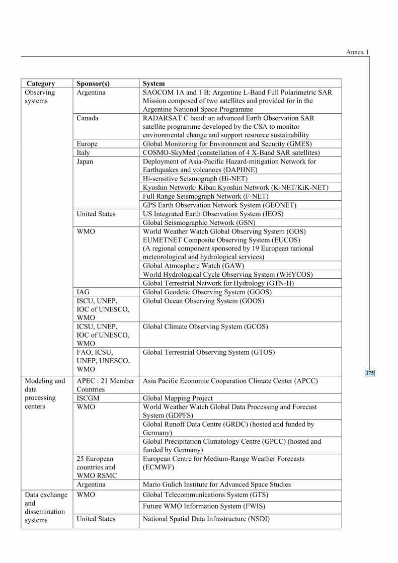
Annex 1
175
Category Sponsor(s) System
Argentina SAOCOM 1A and 1 B: Argentine L-Band Full Polarimetric SAR
Mission composed of two satellites and provided for in the
Argentine National Space Programme
Canada RADARSAT C band: an advanced Earth Observation SAR
satellite programme developed by the CSA to monitor
environmental change and support resource sustainability
Europe Global Monitoring for Environment and Security (GMES)
Italy COSMO-SkyMed (constellation of 4 X-Band SAR satellites)
Deployment of Asia-Pacific Hazard-mitigation Network for
Earthquakes and volcanoes (DAPHNE)
Hi-sensitive Seismograph (Hi-NET)
Kyoshin Network/ Kiban Kyoshin Network (K-NET/KiK-NET)
Full Range Seismograph Network (F-NET)
Japan
GPS Earth Observation Network System (GEONET)
US Integrated Earth Observation System (IEOS)United States
Global Seismographic Network (GSN)
World Weather Watch Global Observing System (GOS)
EUMETNET Composite Observing System (EUCOS)
(A regional component sponsored by 19 European national
meteorological and hydrological services)
Global Atmosphere Watch (GAW)
World Hydrological Cycle Observing System (WHYCOS)
WMO
Global Terrestrial Network for Hydrology (GTN-H)
IAG Global Geodetic Observing System (GGOS)
ISCU, UNEP,
IOC of UNESCO,
WMO
Global Ocean Observing System (GOOS)
ICSU, UNEP,
IOC of UNESCO,
WMO
Global Climate Observing System (GCOS)
Observing
systems
FAO, ICSU,
UNEP, UNESCO,
WMO
Global Terrestrial Observing System (GTOS)
APEC : 21 Member
Countries
Asia Pacific Economic Cooperation Climate Center (APCC)
ISCGM Global Mapping Project
World Weather Watch Global Data Processing and Forecast
System (GDPFS)
Global Runoff Data Centre (GRDC) (hosted and funded by
Germany)
WMO
Global Precipitation Climatology Centre (GPCC) (hosted and
funded by Germany)
25 European
countries and
WMO RSMC
European Centre for Medium-Range Weather Forecasts
(ECMWF)
Modeling and
data
processing
centers
Argentina Mario Gulich Institute for Advanced Space Studies
Global Telecommunications System (GTS)WMO
Future WMO Information System (FWIS)
Data exchange
and
dissemination
systems United States National Spatial Data Infrastructure (NSDI)

GEOSS 10-Year Implementation Plan: Reference Document
176
ANNEX 2DECLARATION
177

GEOSS 10-Year Implementation Plan: Reference Document
178
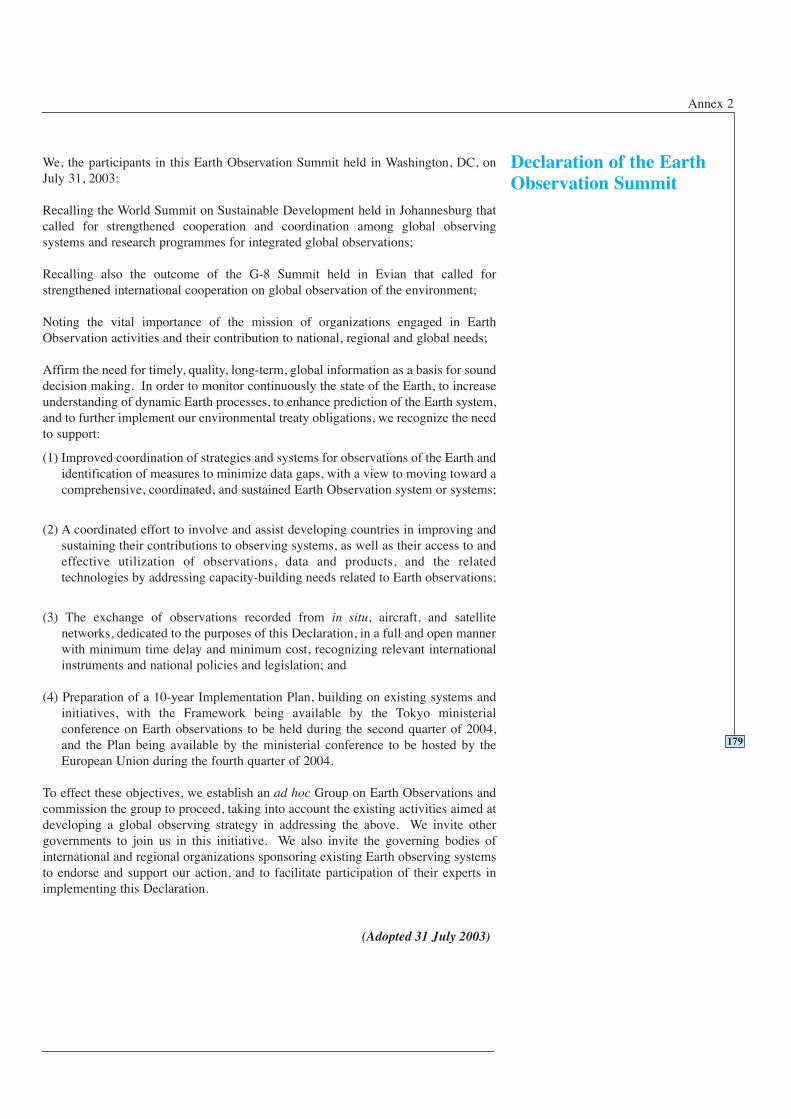
Annex 2
We, the participants in this Earth Observation Summit held in Washington, DC, onJuly 31, 2003:
Recalling the World Summit on Sustainable Development held in Johannesburg thatcalled for strengthened cooperation and coordination among global observingsystems and research programmes for integrated global observations;
Recalling also the outcome of the G-8 Summit held in Evian that called forstrengthened international cooperation on global observation of the environment;
Noting the vital importance of the mission of organizations engaged in EarthObservation activities and their contribution to national, regional and global needs;
Affirm the need for timely, quality, long-term, global information as a basis for sounddecision making. In order to monitor continuously the state of the Earth, to increaseunderstanding of dynamic Earth processes, to enhance prediction of the Earth system,and to further implement our environmental treaty obligations, we recognize the needto support:
(1) Improved coordination of strategies and systems for observations of the Earth andidentification of measures to minimize data gaps, with a view to moving toward acomprehensive, coordinated, and sustained Earth Observation system or systems;
(2) A coordinated effort to involve and assist developing countries in improving andsustaining their contributions to observing systems, as well as their access to andeffective utilization of observations, data and products, and the relatedtechnologies by addressing capacity-building needs related to Earth observations;
(3) The exchange of observations recorded from in situ, aircraft, and satellitenetworks, dedicated to the purposes of this Declaration, in a full and open mannerwith minimum time delay and minimum cost, recognizing relevant internationalinstruments and national policies and legislation; and
(4) Preparation of a 10-year Implementation Plan, building on existing systems andinitiatives, with the Framework being available by the Tokyo ministerialconference on Earth observations to be held during the second quarter of 2004,and the Plan being available by the ministerial conference to be hosted by theEuropean Union during the fourth quarter of 2004.
To effect these objectives, we establish an ad hoc Group on Earth Observations andcommission the group to proceed, taking into account the existing activities aimed atdeveloping a global observing strategy in addressing the above. We invite othergovernments to join us in this initiative. We also invite the governing bodies ofinternational and regional organizations sponsoring existing Earth observing systemsto endorse and support our action, and to facilitate participation of their experts inimplementing this Declaration.
(Adopted 31 July 2003)
179
Declaration of the EarthObservation Summit

GEOSS 10-Year Implementation Plan: Reference Document
180
181
ANNEX 3COMMUNIQUE OF THE SECONDEARTH OBSERVATION SUMMIT

GEOSS 10-Year Implementation Plan: Reference Document
182
Annex 3
We, the participants in the Second Earth Observation Summit held in Tokyo, Japan,on 25 April 2004:
Recalling the Declaration of the first Earth Observation Summit, held in Washington,D.C., on July 31, 2003,
Building on the commitment made at that Summit to move toward a comprehensive,coordinated, and sustained Earth observation system or systems, and;
Remaining cognizant of the fact that what we are designing will change and improvehow we perceive and understand the Earth system – its weather, climate, oceans, land,geology, natural resources, ecosystems, and natural and human-induced hazards – andthat such understanding is crucial to enhancing human health, safety and welfare,alleviating human suffering including poverty, protecting the global environment, andachieving sustainable development;
We affirm our support to the process underway, recognizing the increased attention toour initiative with more countries and organizations participating since the firstSummit;
We acknowledge with appreciation the work of the ad hoc Group on EarthObservations thus far to begin to develop a 10-Year Implementation Plan, based onuser requirements and building on existing systems, for a comprehensive,coordinated, and sustained Earth observation system of systems.
We adopt with satisfaction the Framework Document, describing principal benefits ofEarth observations to a broad range of user communities and the fundamentalelements to be included in the 10-Year Implementation Plan for what will henceforthbe called a Global Earth Observation System of Systems (GEOSS);
We approve the way forward for the development of the 10-Year Implementation Planas described in the Framework Document;
We note with appreciation the “GEO Subgroup Reports to the Second EarthObservation Summit,” and
We commission the ad hoc Group on Earth Observations to take those steps necessaryto have in place for our review a draft Implementation Plan before the third EarthObservation Summit to be hosted by the European Union in early 2005.
We renew our invitation to other governments to join us in this initiative. We alsoinvite the governing bodies of international and regional organizations sponsoringexisting Earth observing systems to support our action.
(As adopted 25 April 2004)
183
Communiqué ofthe Second EarthObservation Summit

GEOSS 10-Year Implementation Plan: Reference Document
184

185
ANNEX 4FRAMEWORK DOCUMENT

GEOSS 10-Year Implementation Plan: Reference Document
186
Annex 4
From Observation to Action
Achieving Comprehensive, Coordinated, and Sustained Earth Observations forthe Benefit of Humankind
Framework for a 10-Year Implementation Plan
As adopted by Earth Observation Summit II25 April 2004
Understanding the Earth system – its weather, climate, oceans, land, geology, naturalresources, ecosystems, and natural and human-induced hazards – is crucial toenhancing human health, safety and welfare, alleviating human suffering includingpoverty, protecting the global environment, and achieving sustainable development.Data collected and information created from Earth observations constitute criticalinput for advancing this understanding. In 2003, a consensus emerged amonggovernments and international organizations that, while supporting and developingexisting Earth Observation systems, more can and must be done to strengthen globalcooperation and Earth observations. This Framework Document, while not legallybinding, marks a crucial step in developing the 10-Year Implementation Plan for thecreation of a comprehensive, coordinated, and sustained Earth Observation system orsystems as envisioned by the Washington Declaration adopted at the EarthObservation Summit of 2003.
2.1 Observing and understanding the Earth system more completely andcomprehensively will expand worldwide capacity and means to achieve sustainabledevelopment and will yield advances in many specific areas of socio-economicbenefit, including:
• Reducing loss of life and property from natural and human-induceddisasters.
• Understanding environmental factors affecting human health andwell-being.
• Improving management of energy resources.
• Understanding, assessing, predicting, mitigating, and adapting toclimate variability and change.
• Improving water resource management through better understandingof the water cycle.
• Improving weather information, forecasting, and warning.
• Improving the management and protection of terrestrial, coastal, andmarine ecosystems.
• Supporting sustainable agriculture and combating desertification.
• Understanding, monitoring, and conserving biodiversity.
2.2 Globally, these benefits will be realized by a broad range of user communities,including (1) national, regional, and local decision-makers, (2) relevant internationalorganizations responsible for the implementation of international conventions, (3) business, industry, and service sectors, (4) scientists and educators, and (5) thegeneral public. Realizing the benefits of coordinated, comprehensive, and sustainedEarth observations (i.e. the improvement of decision-making and prediction abilities)
187
1Introduction
2Benefits ofComprehensive,Coordinated andSustained EarthObservations
GEOSS 10-Year Implementation Plan: Reference Document
represents a fundamental step toward addressing the challenges articulated in thedeclarations of the 2002 World Summit on Sustainable Development and fulfilling theMillennium Development Goals agreed at the Millennium Summit in 2000.
2.3 Full participation of developing country members will maximize theiropportunities to derive real benefits in the above socio-economic areas. Suchparticipation is supported as it enhances the capacity of the entire Earth Observationcommunity to address global sustainable development challenges.
3.1 Coordinated and sustained global cooperation on Earth observations is wellestablished in the crucial area of weather. The World Meteorological Organization’sWorld Weather Watch demonstrates the value of international collaboration in thisarena. Improvements in observation networks are still needed and will yield furthersuccess through improved accuracy in weather information and long-term prediction.
3.2 Cooperation is less advanced in the areas of land, water, climate, ice, andocean observation. Nevertheless, some important work and guidance for futureaction has been developed in a number of areas, for example:
(a) Natural hazard understanding through a range of international observing andearly warning systems consistent with the International Strategy for DisasterReduction (ISDR);
(b) Climate understanding and research through the World Climate ResearchProgram (WCRP), and climate monitoring consistent with the Global ClimateObserving System (GCOS) in support of the Conference of Parties (COP) of theUnited Nations Framework Convention on Climate Change (UNFCCC);
(c) Ocean monitoring, modelling and forecasting through the Global OceanObserving System (GOOS);
(d) A range of observation themes addressed by the Integrated Global ObservingStrategy Partnership (IGOS-P) including oceans; carbon; water cycle; solid earthprocesses, coastal zone (including coral reef); atmospheric chemistry; andland/biosphere.
3.3 In each of these areas, observation efforts to understand dynamic Earthprocesses have been identified and should be expanded to support action-orientedsolutions in the areas of key socio-economic benefit.
4.1 Human knowledge of the Earth system, although advanced in certain areas, isfar from complete. Current efforts to observe and understand the Earth system mustprogress from the separate observation systems and programs of today to coordinated,timely, quality, sustained, global information - developed in accordance withcompatible standards - as a basis for future sound decisions and actions.
4.2 Many international organizations and programmes are working to sustain andimprove the coordination of Earth observations. However, current efforts to captureEarth observation data are limited by (1) a lack of access to data and associatedbenefits especially in the developing World, (2) eroding technical infrastructure, (3)large spatial and temporal gaps in specific data sets, (4) inadequate data integrationand interoperability, (5) uncertainty over continuity of observations, (6) inadequate
188
3Key Earth Observation
Areas
4Shortcomings of Current
Observation Systems
Annex 4
user involvement, (7) a lack of relevant processing systems to transform data intouseful information, and (8) insufficient long-term data archiving.
5.1 To achieve the many benefits of coordinated Earth observations and to movefrom principles to action, governments adopting this Framework Document set forththe primary components of a 10-Year Implementation Plan for establishing the GlobalEarth Observation System of Systems (GEOSS). GEOSS will be:
• comprehensive, by including observations and products gathered from allcomponents required to serve the needs of participating members;
• coordinated, in terms of leveraging resources of individual contributing membersto accomplish this system, whose total capacity is greater than the sum of itsparts;
• sustained, by the collective and individual will and capacity of participatingmembers.
5.2 GEOSS will be a distributed system of systems, building step-by-step oncurrent cooperation efforts among existing observing and processing systems withintheir mandates, while encouraging and accommodating new components.Participating members will determine ways and means of their participation inGEOSS. The 10-Year Implementation Plan for GEOSS will be based on thefollowing considerations:
(a) With the socio-economic benefits identified in Section 2 as the roadmap, the10-Year Implementation Plan will identify, document, and prioritize actions toaddress user requirements for current and future Earth observations. This processwill be based on appropriate dialogue and procedures, taking advantage of andbuilding upon the experience of existing initiatives and infrastructures.
(b) The architecture model will build incrementally on existing systems to create adistributed system of systems, incorporating an observation component, a dataprocessing and archiving component, and a data exchange and disseminationcomponent.
(c) The 10-Year Implementation Plan will elucidate practical methods for fillingcritical gaps in, inter alia, observation parameters, geographical areas,observation specifications, and accessibility.
5.3 The GEOSS will address key challenges of data utilization, including the need for:
• Full and open exchange of observations with minimum time delay and minimumcosts, recognizing relevant international instruments and national policies andlegislation;
• Assured data utility and usability (including thresholds for validation, calibration,and spatial and temporal resolution);
• Assured continuity and availability of the many observations and products inplace or planned;
• A robust regulatory framework for Earth observations (e.g. through protection ofradio frequency bands that are uniquely essential for Earth observations).
5.4 The plan will facilitate both current and new capacity building efforts,particularly in developing countries, across the entire continuum of GEOSS activities,
189
5What is Needed:The 10-YearImplementation Plan forEarth Observations(2005-2014)
GEOSS 10-Year Implementation Plan: Reference Document
which will include education, training, institutional networks, communication, andoutreach as fundamental to those efforts. Building on existing local, national,regional, and global capacity building initiatives, GEOSS will:
(a) Focus on training and education for the development and/or utilization of existinghuman, institutional, and technical capacities for data utilization;
(b) Develop the infrastructure resources necessary to meet research and operationalrequirements;
(c) Build on globally accepted sustainable development principles – most notablythose outlined in the World Summit on Sustainable Development Plan ofImplementation.
5.5 The development of GEOSS should take maximum advantage ofdevelopments in research and technologies. Conversely it will enable the globalscientific community to address key scientific questions concerning the functioningof the Earth system.
6.1 The success of the 10-Year Implementation Plan will be measured by theoperational achievement of GEOSS. Specific outcomes for GEOSS, both short andlong-term, will be elaborated in the 10-Year Implementation Plan, including but notlimited to the following:
(a) Enabling global, multi-system information capabilities for each of the following:
• disaster reduction, including response and recovery;
• integrated water resource management;
• ocean monitoring and marine resources management;
• air quality monitoring and forecasting;
• biodiversity conservation;
• sustainable land use and management.
(b) Global tracking of invasive species.
(c) Comprehensive monitoring of global and regional climate on annual, decadal,and longer time scales, and enabling information products related to climatevariability and change.
(d) Improving the coverage, quality, and availability of essential information fromthe in situ networks and improving the integration of in situ and satellite data.
(e) Involvement of users from developed and developing countries, monitoring theirneeds and fulfillment over time.
(f) An outreach mechanism to actively demonstrate the usefulness of Earthobservation to decision makers in key user communities.
7.1 The adoption of this Framework Document indicates a decision to proceedwith the elaboration of the GEOSS 10-Year Implementation Plan along the lines setforth in this Document and a willingness to cooperate on, and participate in, theimplementation of the plan. At present, the ad hoc Group on Earth Observations(GEO) is a “best efforts” activity with voluntary input from States and advice andsupport from international organizations.
190
6Outcomes
7The Way Forward
Annex 4
7.2 For 2005 and beyond, the implementation of the “10-Year ImplementationPlan” will require a ministerial-guided successor mechanism with maximumflexibility - a single intergovernmental group for Earth observations drawing on theexperience of the ad hoc GEO, with membership open to all interested governmentsand the European Commission, and with representatives of relevant internationalorganizations taking part.
7.3 The GEOSS 10-Year Implementation Plan will elaborate details for thisGroup, which will provide generally for:
(a) Coordination and planning of GEOSS implementation (in situ and remotelysensed).
(b) Opportunities for engagement of all members and relevant international andregional organizations.
(c) Involvement of user communities.
(d) Measuring, monitoring, and facilitating openness of GEOSS to improve cross-flow of observations and products.
(e) Co-ordination and facilitation of the development and exchange of observationsand products between members and relevant international and regionalorganizations.
191

GEOSS 10-Year Implementation Plan: Reference Document
192
193
ANNEX 5RESOLUTION OF THE
THIRD EARTH OBSERVATION SUMMIT

GEOSS 10-Year Implementation Plan: Reference Document
194
Annex 5
We, the participants in the Third Earth Observation Summit held in Brussels,Belgium, on February 16, 2005:
Recalling the Declaration of the first Earth Observation Summit, held in Washington,D.C., on July 31, 2003, and the Framework Document adopted at the Second EarthObservation Summit, held in Tokyo, on April 25, 2004;
Building on the commitment made at those Summits to move toward acomprehensive, coordinated, and sustained Earth observation system of systems,taking into account the particular needs of developing countries;
Remaining cognizant of the fact that observing and understanding the Earth systemmore completely and comprehensively will expand worldwide capacity and means toachieve sustainable development as envisioned in our commitments in theJohannesburg Plan of Implementation adopted at the 2002 World Summit onSustainable Development, and will yield advances in many specific societal benefitareas, including disaster reduction, health, energy, weather, climate, water,ecosystems, biodiversity, agriculture and combating desertification;
Acknowledging the achievements of the established national, regional, andinternational observing systems, including those sponsored and cosponsored by anumber of UN Specialised Agencies and Programmes; and
Determined to build upon, strengthen and expand, where appropriate, the establishedobserving systems by working with and through existing planning and coordinationmechanisms;
Affirm our support to the process, recognizing the increased attention to our initiativewith more countries and organizations participating since the first Summit;
Acknowledge with appreciation the work of the ad hoc Group on Earth Observations(GEO) to develop a 10-Year Implementation Plan, based on user requirements andbuilding on existing systems, and seeking to undertake concerted capacity-buildingefforts, especially within developing countries;
Endorse the 10-Year Implementation Plan as the basis for its further development andfor establishing a Global Earth Observation System of Systems (GEOSS) to fulfilluser requirements among various socio-economic benefit areas;
Note with appreciation the extensive supporting information compiled in the GEOSS10-Year Implementation Plan Reference Document prepared by the ad hoc GEO;
Establish the intergovernmental Group on Earth Observations (GEO), to take thosesteps necessary to implement GEOSS in accordance with its implementation plan;
Encourage the governments of all UN member states to participate in GEO and invitethe governing bodies of the UN Specialised Agencies and Programmes and otherrelevant international and regional organizations, which sponsor and cosponsorestablished global, regional, and national observing systems, to endorse theimplementation of GEOSS and to encourage and assist GEO in its work;
Request GEO to consult the intergovernmental and other sponsors of the componentsystems of GEOSS on progress and on issues involved in implementation of the Plan;
195
Resolution ofthe Third EarthObservation Summit
GEOSS 10-Year Implementation Plan: Reference Document
Affirm our intention to provide the support necessary to execute the GEOSS 10-YearImplementation Plan;
Resolve to meet again, before the end of 2007, to take stock of progress and providefurther guidance towards the successful implementation of GEOSS; and
Resolve to conduct a mid-term assessment of GEO by 2010.
(As adopted 16 February 2005)
196
197
10-YEAR IMPLEMENTATION PLAN(As adopted 16 February 2005)

GEOSS 10-Year Implementation Plan: Reference Document
198
Implementation Plan
Understanding the Earth system – its weather, climate, oceans, atmosphere, water,land, geodynamics, natural resources, ecosystems, and natural and human-inducedhazards – is crucial to enhancing human health, safety and welfare, alleviating humansuffering including poverty, protecting the global environment, reducing disasterlosses, and achieving sustainable development. Observations of the Earth systemconstitute critical input for advancing this understanding.
Interested countries and organizations have collaborated to develop this Plan toensure comprehensive and sustained Earth observations. It builds on and adds valueto existing Earth-observation systems by coordinating their efforts, addressing criticalgaps, supporting their interoperability, sharing information, reaching a commonunderstanding of user requirements, and improving delivery of information to users.
The purpose of this Plan is to summarize the essential steps to be undertaken, over thenext decade, by a global community of nations and intergovernmental, international,and regional organizations, to put in place a Global Earth Observation System ofSystems (GEOSS).
The vision for GEOSS is to realize a future wherein decisions and actions for thebenefit of humankind are informed via coordinated, comprehensive and sustainedEarth observations and information.
3.1 Purpose of GEOSS
The purpose of GEOSS is to achieve comprehensive, coordinated and sustainedobservations of the Earth system, in order to improve monitoring of the state of theEarth, increase understanding of Earth processes, and enhance prediction of thebehaviour of the Earth system. GEOSS will meet the need for timely, quality long-term global information as a basis for sound decision making, and will enhancedelivery of benefits to society in the following initial areas:
• Reducing loss of life and property from natural and human-induced disasters.
• Understanding environmental factors affecting human health and well-being.
• Improving management of energy resources.
• Understanding, assessing, predicting, mitigating, and adapting to climatevariability and change.
• Improving water-resource management through better understanding of thewater cycle.
• Improving weather information, forecasting, and warning.
• Improving the management and protection of terrestrial, coastal, and marineecosystems.
• Supporting sustainable agriculture and combating desertification.
• Understanding, monitoring, and conserving biodiversity.
GEOSS is a step towards addressing the challenges articulated by the United NationsMillennium Declaration and the 2002 World Summit on Sustainable Development,including the achievement of the Millennium Development Goals. GEOSS will alsofurther the implementation of international environmental treaty obligations.
199
Preamble
1Purpose of this Plan
2Vision for GEOSS
3Purpose and Scope ofGEOSS, and the Groupon Earth Observations
GEOSS 10-Year Implementation Plan: Reference Document
3.2 Scope of GEOSS
GEOSS will provide the overall conceptual and organizational framework to buildtowards integrated global Earth observations to meet user needs. GEOSS will be a“system of systems” consisting of existing and future Earth-observation systems,supplementing but not supplanting their own mandates and governance arrangements.It will provide the institutional mechanisms for ensuring the necessary level ofcoordination, strengthening and supplementation of existing global Earth-observationsystems, and for reinforcing and supporting them in carrying out their mandates.
GEOSS will capture the success of Earth-observation research programmes, andfacilitate their transition to sustained operational use.
The established Earth-observation systems, through which many countries cooperateas members of the United Nations Specialised Agencies and Programmes and ascontributors to international scientific programmes, provide essential building blocksfor GEOSS. The implementation of GEOSS will seek to ensure effective consultationand cooperation with the UN system and other international and national agenciessponsoring or co-sponsoring the major component global observing systems on whichGEOSS will be built.
The contributing systems will range across the processing cycle, from primaryobservation to information production. Through GEOSS, they will shareobservations and products with the system as a whole, and will take the necessarysteps to ensure that the shared observations and products are accessible, comparable,and understandable, by supporting common standards and adaptation to users’ needs.
GEOSS aspires to encompass all areas of the World, and to cover in situ, airborne,and space-based observations. GEOSS will be primarily focused on issues ofregional and global scale and cross-sectorial applications, while also facilitating, if soinvited, the operation and enhancement of Earth-observing systems that are focusedon national, local and sector-specific needs. GEOSS will promote capacity buildingin Earth observation, building on existing local, national, regional, and internationalinitiatives.
3.3 Group on Earth Observations (GEO)
Membership in GEO is open to all member States of the United Nations and to theEuropean Commission. GEO welcomes, as Participating Organizations, inter-governmental, international, and regional organizations with a mandate in Earthobservation or related activities, subject to approval by GEO Members. GEO mayinvite other relevant entities to participate in its activities as observers.
Sound management of the Earth system, in both its natural and human aspects,requires information that is timely, of known quality, long-term, and global. Ensuringthat such information is available to those who need it is a function of governmentsand institutions at all levels. Despite laudable efforts, the current situation withrespect to the availability of Earth observations is not optimal. This is particularlytrue with respect to coordination and data sharing among countries, organizations anddisciplines, and meeting the needs of sustainable development. There are large spatialand temporal gaps in data coverage. Moreover, there is an eroding observationalinfrastructure, inadequate long-term data archiving, and no assured continuity formany essential observing systems. Consequently, targeted collective action is neededto bring observing systems in line with the requirements for addressing a range ofissues of concern to society.
200
4Benefits of GEOSS
Implementation Plan
4.1 Societal Benefit Areas
GEOSS will yield advances in the societal benefit areas defined by its purpose andscope. Each area has compelling reasons for the Earth-observation advancesenvisioned in GEOSS.
For information needs common to many societal benefit areas, GEOSS will facilitatethe development and provision of common products such as maps of topography,bathymetry, river systems, infrastructure, and land cover and land use, and a geodeticreference frame for Earth observation. Interpretation and use of Earth observationsrequires information on the drivers and consequences of change, including geo-referenced socio-economic data and indicators.
The following are brief summary statements of topics covered and key outcomes ineach area.
4.1.1 Disasters: Reducing loss of life and property from natural and human-induceddisasters
Disaster-induced losses can be reduced through observations relating to hazards suchas: wildland fires, volcanic eruptions, earthquakes, tsunamis, subsidence, landslides,avalanches, ice, floods, extreme weather, and pollution events. GEOSSimplementation will bring a more timely dissemination of information through bettercoordinated systems for monitoring, predicting, risk assessment, early warning,mitigating, and responding to hazards at local, national, regional, and global levels.
4.1.2 Health: Understanding environmental factors affecting human health and well-being
Health issues with Earth-observation needs include: airborne, marine, and waterpollution; stratospheric ozone depletion; persistent organic pollutants; nutrition; andmonitoring weather-related disease vectors. GEOSS will improve the flow ofappropriate environmental data and health statistics to the health community,promoting a focus on prevention and contributing to continued improvements inhuman health worldwide.
4.1.3 Energy: Improving management of energy resources
GEOSS outcomes in the energy area will support: environmentally responsible andequitable energy management; better matching of energy supply and demand;reduction of risks to energy infrastructure; more accurate inventories of greenhousegases and pollutants; and a better understanding of renewable energy potential.
4.1.4 Climate: Understanding, assessing, predicting, mitigating, and adapting toclimate variability and change
The climate has impacts in each of the other eight societal benefit areas. Coping withclimate change and variability demands good scientific understanding based onsufficient and reliable observations. GEOSS outcomes will enhance the capacity tomodel, mitigate, and adapt to climate change and variability. Better understanding ofthe climate and its impacts on the Earth system, including its human and economicaspects, will contribute to improved climate prediction and facilitate sustainabledevelopment while avoiding dangerous perturbations to the climate system.
201
GEOSS 10-Year Implementation Plan: Reference Document
4.1.5 Water: Improving water-resource management through better understanding ofthe water cycle
Water-related issues addressed by GEOSS will include: precipitation; soil moisture;streamflow; lake and reservoir levels; snow cover; glaciers and ice; evaporation andtranspiration; groundwater; and water quality and water use. GEOSS implementationwill improve integrated water-resource management by bringing togetherobservations, prediction, and decision-support systems and by creating better linkagesto climate and other data. In situ networks and the automation of data collection willbe consolidated, and the capacity to collect and use hydrological observations will bebuilt where it is lacking.
4.1.6 Weather: Improving weather information, forecasting and warning
The weather observations encompassed by GEOSS are based on the requirements fortimely short- and medium-term forecasts. GEOSS can help fill critical gaps in theobservation of, for example, wind and humidity profiles, precipitation, and datacollection over ocean areas; extend the use of dynamic sampling methods globally;improve the initialization of forecasts; and increase the capacity in developingcountries to deliver essential observations and use forecast products. Every countrywill have the severe-weather-event information needed to mitigate loss of life andreduce property damage. Access to weather data for the other societal benefit areaswill be facilitated.
4.1.7 Ecosystems: Improving the management and protection of terrestrial, coastaland marine resources
Observations are needed on the area, condition, and natural-resource stock levels ofecosystems such as forests, rangelands, and oceans. GEOSS implementation willseek to ensure that methodologies and observations are available on a global basis todetect and predict changes in ecosystem condition and to define resource potentialsand limits. Ecosystem observations will be better harmonized and shared, spatial andtopical gaps will be filled, and in situ data will be better integrated with space-basedobservations. Continuity of observations for monitoring wild fisheries, the carbon andnitrogen cycles, canopy properties, ocean colour, and temperature will be set in place.
4.1.8 Agriculture: Supporting sustainable agriculture and combating desertification
Issues addressed by GEOSS will include: crop production; livestock, aquaculture andfishery statistics; food security and drought projections; nutrient balances; farmingsystems; land use and land-cover change; and changes in the extent and severity of landdegradation and desertification. GEOSS implementation will address the continuity ofcritical data, such as high-resolution observation data from satellites. A truly globalmapping and information service, integrating spatially explicit socio-economic datawith agricultural, forest, and aquaculture data will be feasible, with applications inpoverty and food monitoring, international planning, and sustainable development.
4.1.9 Biodiversity: Understanding, monitoring and conserving biodiversity
Issues in this area include the condition and extent of ecosystems, distribution andstatus of species, and genetic diversity in key populations. Implementing GEOSS willunify many disparate biodiversity-observing systems and create a platform tointegrate biodiversity data with other types of information. Taxonomic and spatialgaps will be filled, and the pace of information collection and dissemination will beincreased.
202
Implementation Plan
4.2 User Involvement
The benefits of GEOSS will be realized globally by a broad range of usercommunities, including managers and policy makers in the targeted societal benefitareas, scientific researchers and engineers, civil society, governmental and non-governmental organizations and international bodies, such as those assisting with theimplementation of multilateral environmental agreements. Engagement of users indeveloping countries will maximize their opportunities to derive benefits fromGEOSS.
GEO will perform a coordination role to address the adequacy, efficiency, andintegrative way user requirements are being met, and transmit recommendations forimprovements to the relevant contributing systems.
The needs of users, and the technical solutions to those needs, change with time.GEO will organize regular GEOSS User Fora among and within societal benefit areasor sub-areas, making use of user communities where they exist and catalyzing theformation of new ones where they do not. It will also create an appropriatemechanism for coordinating user requirements across societal benefit areas. Thefunction of the User Fora will be to document and review user requirements, assessthe extent to which they are being met, and make recommendations to GEO with theobjective of improving the delivery of information appropriate to user needs.
GEOSS, collectively, has several functional components:
• to address identified common user requirements
• to acquire observational data
• to process data into useful products
• to exchange, disseminate, and archive shared data, metadata and products, and
• to monitor performance against the defined requirements and intended benefits.
GEO will employ a range of methods to advance the implementation of the Plan,tailoring them as required to address each of the various implementation issues. Themethods will include: establishment of standing and specific task-oriented GEOSSstructures; referring specific tasks to participating international organizations oragencies; coordinating and cooperating with national agencies; collaboration betweeninternational organizations; providing a forum for dialogue and resolution of issues atvarying levels from ministerial and senior-official levels to scientific and technicallevels; and advocacy within and across existing systems and other mechanisms.
GEOSS will be based on existing observing, data-processing, data-exchange anddissemination systems, while fostering and accommodating new systems operated byGEO Members and Participating Organizations, as needs and capabilities develop.The technical commitments of a GEO Member or Participating Organization willapply only to those contributions that they have identified.
Long-term continuity of existing observations is required. In addition, activities tofacilitate research, capacity building, and outreach will be carried out andcoordination focal points will be provided.
The utilization of new technologies and know-how will be carried out in accordancewith international and national legislations.
203
5Technical Approach,Capacity Building,and Outreach
GEOSS 10-Year Implementation Plan: Reference Document
5.1 Observations and Modelling
In the implementation of GEOSS, increased sharing of methods for modelling andanalysis needed to transform data into useful products will be advocated.
Within 2 years, a mechanism will be established for coordinating user needs acrossthe various societal benefit areas. GEO will facilitate the development andmaintenance of a distinct and common user-requirements database for GEOSS,building on and linking to existing user-requirements databases. These requirementswill include specifics such as location, frequency and accuracy. On the same timescale, a collaboration mechanism for sharing costs and benefits will be developed forobservations and infrastructures for which the defined requirements may not be metby single-party activities alone. GEO will also provide a framework for securing thefuture continuity of necessary observations and initiating new observations. GEOcould act as a forum for discussion on common implementation issues at regional andtrans-national levels, such as transportation of in situ observation devices acrossborders.
The implementation of GEOSS will facilitate, within 2 years, the establishment andmaintenance of baseline sites for global in situ networks.
GEO will establish, within 10 years, its system of systems to provide timely data andproducts for local, national, regional, and international policy makers. In theimplementation of GEOSS, harmonization of observations, real- or near-real-timemonitoring, integration of information from in situ, airborne and space-basedobservations through data assimilation and models, and early detection of significantand extreme events will be advocated. Integration of in situ, airborne and space-based observations within the various societal benefit areas will be encouraged, aswill the establishment of global, efficient, and representative networks of in situobservation to support process studies, satellite-data validation, and algorithm andmodel development, as well as the detection, documentation and attribution ofchange.
5.2 Products, Data Management, and Radio-Frequency Protection
Current status assessments and descriptions, as well as predictive products in each ofthe domains of socio-economic benefit are required. The implementation of GEOSSwill facilitate, within 2 years, the development and availability of shared data,metadata, and products commonly required across diverse societal benefit areas.
GEOSS will encourage the adoption of existing and new standards to support broaderdata and information usability.
GEO will advocate, within 2 years, through appropriate representations to theInternational Telecommunications Union (ITU), the protection of radio frequenciescritical to Earth observation.
The implementation of GEOSS will facilitate, within 6 years, data-managementapproaches that encompass a broad perspective of the observation-data life cycle,from input through processing, archiving, and dissemination, including reprocessing,analysis and visualization of large volumes and diverse types of data.
The implementation of GEOSS will establish, within 6 years, internationalinformation sharing and dissemination drawing on existing capabilities throughappropriate technologies, including, but not limited to, Internet-based services.
204
Implementation Plan
5.3 Architecture and Interoperability
The success of GEOSS will depend on data and information providers accepting andimplementing a set of interoperability arrangements, including technicalspecifications for collecting, processing, storing, and disseminating shared data,metadata and products. GEOSS interoperability will be based on non-proprietarystandards, with preference given to formal international standards. Interoperabilitywill be focused on interfaces, defining only how system components interface witheach other and thereby minimizing any impact on affected systems other than wheresuch systems have interfaces to the shared architecture.
For those observations and products contributed and shared, GEOSS implementationwill facilitate their recording and storage in clearly defined formats, with metadataand quality indications to enable search, retrieval, and archiving as accessible datasets.
GEO will establish, within 2 years, a process for reaching, maintaining, andupgrading GEOSS interoperability arrangements, informed by ongoing dialogue withmajor international programmes and consortia. That process is to be sensitive totechnology disparities among GEO Members and Participating Organizations.
Attention is drawn to the importance of using existing international standardsorganizations and institutes as a focal point for the GEOSS interoperability objectivesas they relate to and use standards.
For the most commonly used open-standard interfaces, the GEOSS process willadvocate some implementations having no restrictions on being modified freely,commonly known as “open-source” software.
To enable implementation of the GEOSS architecture, GEOSS will draw on existingSpatial Data Infrastructure (SDI) components as institutional and technical precedentsin areas such as geodetic reference frames, common geographic data, and standardprotocols. GEO Members and Participating Organizations and their contributionswill be catalogued in a publicly accessible, network-distributed clearinghousemaintained collectively under GEOSS. The catalogue will itself be subject to GEOSSinteroperability specifications, including the standard search service and geospatialservices.
5.4 Data Sharing
The societal benefits of Earth observations cannot be achieved without data sharing.The following are GEOSS data-sharing principles:
• There will be full and open exchange of data, metadata and products sharedwithin GEOSS, recognizing relevant international instruments and national policies and legislation.
• All shared data, metadata and products will be made available with minimumtime delay and at minimum cost.
• All shared data, metadata and products being free of charge or no more thancost of reproduction will be encouraged for research and education.
Use of data or products does not necessarily imply agreement with, or endorsementof the purpose behind the gathering of such data.
205
GEOSS 10-Year Implementation Plan: Reference Document
5.5 Research Facilitation
GEO will advocate research and development in key areas to facilitate, on an ongoingbasis, improvements to Earth-observation systems, including:
• Improved and new instrumentation and system design for in situ, airborne, andspace-based observations on a long-term basis.
• Life-cycle data management, data integration and information fusion, datamining, network enhancement, and design optimization studies.
• Development of models, data-assimilation modules, and other algorithms thatare able to produce global and regional products more effectively.
GEOSS implementation will promote research efforts that are necessary for thedevelopment of tools required in all societal benefit areas. It will also encourage andfacilitate the transition from research to operations of appropriate systems and techniques.This includes facilitating partnerships between operational groups and research groups.
5.6 Capacity Building
The GEO capacity-building strategy follows the World Summit on SustainableDevelopment concept of a global partnership between those whose capacity needsdevelopment and those who are able to assist in the process, recognizing thatactivities have intertwined social, environmental, and economic impacts.
The GEO capacity-building strategy will be based on best practices derived fromstudying successful and less-successful approaches.
Within 2 years, GEO will:
• Produce a comprehensive review and analysis of gaps and methodologies,based on existing and planned capacity-building efforts.
• Facilitate, together with existing efforts, the maintenance and strengthening ofeducation, training, research and communication.
• Facilitate, with developing countries and across all societal benefit areas, theestablishment and maintenance of baseline sites for global in situ and remote-sensing networks that cannot always be justified on national grounds alone, in cooperation with relevant global research programmes and activities to ensure that synergies in observations and understanding are achieved.
• Develop a network of experts involved in existing capacity-building initiativesrelated to Earth observation, and encourage users to access this knowledge base.
• Encourage, in each societal benefit area, the development of capacity-buildingcomponents as a requirement for any network, project, activity, or User Fora that will be a component of GEOSS.
• Facilitate access to data and models, particularly for developing countries.
Within 6 years, GEO will:
• Advocate funding of multinational projects to leverage the end-to-end value ofobservations, including the establishment of necessary infrastructure.
• Produce monitoring and evaluation mechanisms for GEO capacity-building efforts.
• Facilitate education and training to provide a global base of technical expertisefor GEOSS.
206

Implementation Plan
Within 10 years, GEO will seek to have in place a sustained capacity-buildingstrategy that will have significantly strengthened the capability of all countries, andparticularly developing countries, to:
• Use Earth-observation data and products (e.g. process, integrate, model)following accepted standards.
• Contribute to, access, and retrieve data from global data systems and networks.
• Analyze and interpret data to enable development of decision-support tools andto advance understanding in the nine societal benefit areas.
• Integrate Earth-observation data and products with other data and products, fora more complete view and understanding of problems and derived solutions.
• Improve infrastructure development in areas of poor observational coverage.
• Develop recommended priorities for new or augmented efforts in capacitybuilding.
5.7 Outreach Plan
Outreach is essential to many aspects of GEO activities. The outreach objective is topromote and increase the general awareness of the benefits of Earth observation,especially among present and future users, beneficiaries and sponsors of relevantsystems.
Within 2 years, GEO will produce and begin to implement an outreach plan directedtowards key target audiences, including decision makers and policy makers; thegeneral public; industry and service communities; scientific and technicalcommunities; education entities; non-governmental organizations; public-interestadvocacy groups; and international financial institutions and official developmentassistance agencies.
In subsequent years, GEO will continue to implement and periodically revise theoutreach plan.
GEO will develop its international outreach activities in partnership with itsparticipating UN and other intergovernmental and international organizations. Forinstance, UNESCO is the lead agency for the 2005-2014 “Decade of Education forSustainable Development”, which has several key actions in common with GEOSS.
6.1 Functions
The functions of GEO include:
• Overseeing implementation of the Plan, including monitoring and evaluatingprogress.
• Further developing and periodically updating the Plan, taking into accountexisting activities and evolving needs and capabilities.
• Identifying opportunities and measures to minimize gaps in data, metadata, andproducts.
• Setting and addressing priorities for filling gaps.
• Coordinating efforts to involve and assist developing countries in improvingand sustaining their contributions to observing systems, their access to and
207
6Governance
GEOSS 10-Year Implementation Plan: Reference Document
effective utilization of shared data, metadata, and products, and the related technologies.
• Facilitating exchange of shared data, metadata, and products.
• Measuring, monitoring, and facilitating interoperability.
• Drawing on the expertise of the international scientific and technologicalcommunities.
• Facilitating user involvement and conducting outreach at global and regionallevels.
• Adopting an Annual Work Plan and associated budget.
• Selecting the Director of the Secretariat.
• Establishing and adopting its operating rules and procedures.
• Consulting, coordinating, and liaising with relevant UN Specialized Agenciesand Programmes, and international scientific organizations.
6.2 Organizational Structure
GEO, comprising the Members and Participating Organizations, is established on avoluntary and legally non-binding basis, with voluntary contributions to supportactivities.
GEO will meet in Plenary at least annually at the senior-official level, andperiodically at the ministerial level.
GEO will take decisions by consensus of its Members. Decisions on implementationof the Plan will be based upon sound scientific and technical advice obtained throughappropriate consultation with the research and observation communities.
To support its work, the GEO Plenary will establish:
• An elected Executive Committee.
• Subsidiary bodies as appropriate, including science and technical advisorymechanisms.
• A Secretariat.
6.3 Secretariat
The Secretariat, led by the Director, will facilitate and support GEO activities. TheSecretariat will consist of co-located, well-qualified, professional and administrativestaff.
7.1 Funding of GEOSS
The total cost for implementing GEOSS will be significant, but only limited resourceswill need to be provided through GEO. Most of the resources will be providedthrough existing national and international mechanisms, and by voluntarycontributions to special projects.
208
7Funding, and
Measuring Progress
Implementation Plan
Unless otherwise agreed, any costs arising from GEO activities will be borne by theMember or Participating Organization that incurs them and will be subject to theavailability of funds, personnel, or other resources.
Members and Participating Organizations may make voluntary financial or othercontributions to GEO activities, including the baseline activities of the Secretariat,through a trust fund to be administered by the Secretariat. Other entities may makecontributions to finance specific activities approved by GEO.
7.2 Performance Indicators
GEO will develop performance indicators for GEOSS.
It is expected that time will be needed to make arrangements for the successormechanism, following adoption of this Plan at the Third Earth Observation Summitin February 2005. To maintain current momentum, the Terms of Reference for the adhoc GEO will be extended until such Terms of Reference are superseded, recognizingthat, in order for the necessary transitional arrangements to be completed, the ad hocGEO Terms of Reference will need to continue until the first meeting of the successorGEO.
209
8The Transition Period