geospatial web image mining - uol. dethe massive amount of georeferenced images in these collections...
TRANSCRIPT
Internet Multimedia Search and Mining, 1-32 1
Chapter 1
Geospatial Web Image Mining
Dirk AhlersOFFIS Institute for Information Technology
Susanne BollUniversity of Oldenburg
Philipp SandhausOFFIS Institute for Information Technology
Abstract: One commonly asked question when confronted with a photograph is“Where is this place?” When talking about a place mentioned on the Web, thequestion arises “What does this place look like?” Today, these questions can notreliably be answered for Web images as they typically do not explicitly reveal theirrelationship to an actual geographic position. Analysis of the keywords surroundingthe images or the content of the images alone has not yet achieved results thatwould allow deriving a precise location information to select representative images.Photos that are reliably tagged with labels of place names or areas only cover asmall fraction of available images and also remain at a keyword level.
Results can be improved for arbitrary Web images by combining features fromthe Web page as image context and the images themselves as content. We proposea location-based search for Web images that allows finding images that are onlyimplicitly related to a geographic position without having to rely on explicit tag-ging or metadata. Our spatial Web image search engine first crawls and identifieslocation-related information on Web pages to determine a geographic relation of theWeb page, and then extends this geospatial reference further to assess an image’slocation. Combining context and content analysis, we are able to determine if theimage actually is a realistic representative photograph of a place and related to ageographic position.
Xian-Sheng Hua, Marcel Worring, and Tat-Seng Chua (Ed)
All rights reserved - c�2009 Bentham Science Publishers Ltd.
2 CHAPTER 1. GEOSPATIAL WEB IMAGE MINING
1.1 Introduction
The role of geographic location for images and the relation of Web information to aphysical place has gained much attention in recent years. Web search is increasinglybecoming “local”, search engines not only index content by keywords but also bygeographical locations. Users can have information mapped to a certain place orregion of interest and search accordingly. Web image search, on the other hand,is mostly keyword-based or explores basic image features such as color or texture.A geospatial Web image search that works on unstructured Web pages with arbi-trary images is not yet available. Searching for images related to a certain locationquickly shows that Web images typically do not easily reveal their explicit relationto an actual geographic position. The geographic semantics of Web images are ei-ther not available at all or hidden somewhere within the Web pages’ content. Thislack of explicit location information also applies to the images contained in Webpages. Even though GPS has arrived at the consumer, the photos that actuallyhave a location stamp or are geo-tagged cover only a tiny fraction of all Web im-ages. Furthermore, such images are mostly only available in social communities,but seldom find their way into the interesting asset of local Web pages. This posesan interesting challenge to the field of Web image retrieval, namely, the derivationof reliable location information for Web images from unstructured Web pages.
Currently, a Web search for photos of a certain well-known place name remains akeyword-based search of known geographic place names. This can work for knownplaces, landmarks, or regions such as “New York” or “Singapore” but does notdeliver a precise geo-reference for Web image content. We therefore need a spatialWeb image search to enable users to search for images from a certain geographicalcoordinate or its spatial vicinity to complement geospatial Web search engines.
In this work, we develop a system for geospatial Web image search [1]. Weaim at a general approach for common Web images that works beyond keyword-search and does not need prepared tags or annotations. We derive possible locationinformation for those images that are contained in Web pages with an establishedspatial context. The mutual relation of a Web pages’ text, location, its containedimages, and accociated metadata is a main driving force behind this approach. Weemploy our spatial search engine for a location-based geo-referenced search downto the address level [2]. It exploits the location information of a Web page that isnot explicitly contained as metadata or other structured annotation but is ratheran implicit part of the textual content.
Based on this previously identified location of the Web page, we can identify rep-resentative photographic representations of the mentioned location. The potentialpropagation of this location to the images embedded in the page and its reliability isdetermined by content-based and context-based analysis. In a first step, an analysisof the Web pages identifies photographs, i.e., the image content relevant for a spatialimage search for realistic depictions of places. Following the photograph identifica-
1.2. RELATED WORK 3
tion, a location-relevance classification process evaluates image context and contentto determine if the photograph is actually related to the location already identifiedfor the Web page.
We evaluated and combined several heuristic approaches for analyzing and scor-ing relevant features. These are categorized into context and content information forboth Web pages and embedded images. Feature classifiers are combined to achievean overall assessment of an image’s connection to a location. As a means to reducethe computational cost, classifiers’ individual analyzers are ordered by their dis-criminatory ability and their computational cost to filter out non-promising imagesearly, preferably even without the need to download them. Our test and evaluationshow that, even though only a small fraction of the Web pages reveal photos thathave a relation to the location, these can be well related to their geospatial context.
With a Web search that reliably finds georeferenced images from unstructuredWeb pages located at a certain geographic location or region, a large number ofpotentially geographically-related images onWeb pages becomes available for spatialWeb image search. This can be applied for a variety of interesting applicationssuch as searching for images along a route when preparing a vacation, extendingpersonal photo collections, gathering visual information about an area, or providingrepresentative images for spatial search results.
1.2 Related Work
This work researches the connection of Web images and location from an unusualangle. While the usual direction is to start from an image and examine its contentand metadata to estimate a location, our approach takes a different route in thatit starts with a document as the image’s context which already contains a knownlocation and tries to extend and propagate it to matching images. Using Web pagesas a special case of context and drawing the connection to the image content, ourhybrid approach thus attacks the problem from both sides simultaneously. A largebody of literature exists on techniques for image retrieval, geographic retrieval, Websearch and various combinations thereof. The following examines the different fieldsof related work and compares and applies their findings to the goal of our approach.
Data sources for geospatial image search
Location is a fast growing topic in the Web today, generating huge interest for usersand a growing number of location-aware data sources. GPS has arrived at the end-consumer; services such as Plazes, Dopplr, Yahoo! Fire Eagle, or Google Latitudeallow users to share their own physical location. Users can use their location tostart a local search or link their current location to their photos. Modern cameraswith an integrated GPS-receiver can directly embed coordinates in a photo’s EXIFmetadata. However, such geo-located images are rare in the first place even in
4 CHAPTER 1. GEOSPATIAL WEB IMAGE MINING
large photo collections and are even more rare in a general Web context. Thislack of metadata is only partly due to loss of information in editing processes.Especially in the Web, images are often edited before publication and their EXIFinformation inadvertently destroyed. Regarding loss of metadata, [41] presents asystem that captures metadata at media capture time and preserves it over theproduction process in a professional environment, which is therefore not yet suitablefor common use and cannot address the current state of Web images. However, itis a complementary approach to metadata extraction and derivation on documentswithout systematically defined metadata.
A richer source for location-based images are Web 2.0 services that allow fororganizing and sharing personal photo collections. They provide for an assign-ment of location-related information by manual tagging and annotation [37]. Forexample, Flickr (flickr.com) or other tag-oriented services allow adding names oflocations to entities such as photos and to find photos tagged with the same pla-cename. More intuitive to the user and more precise in the assignable locationare services that provide means to drag digital content onto a map and by thismanually geo-code the content: With Placeopedia (placeopedia.com) entries fromWikipedia can be associated with a geographic location and queried on a map;photos on Flickr or locr (locr.com) can also be positioned on a map to geocodethem. Panoramio (www.panoramio.com) is a service entirely dedicated to collect-ing high-quality location-based images. These applications use collaborative effortsto manually geo-code image content and by this contribute to a localized search.
The massive amount of georeferenced images in these collections allows for in-teresting data mining approaches, for example, to identify places and sights ofimportant landmarks [58], [49]. However, exploiting the long tail of photos of“less-interesting” locations is not as easy. Additionally, tagged media collectionsor prepared geocoded images cover only a very small fraction of images on the Web;many others still reside unrecognized on arbitrary Web pages.
A complementing approach to the long-tail of locations and their images cancome from a different perspective. Several services are based on existing directoriessuch as yellow pages. For their entries, the geographic location is known, enabling lo-cal search and visualization of results, e.g., on a 2D map. Such content is mapped byservices such as Yahoo! Maps (maps.yahoo.com), Google Maps (maps.google.com),or MSN Live (maps.live.com), enabling map-based spatial search and visualizationof results. By enhancing these entries with user-generated or specifically crawledcontent, images for these lcoations can become available. For example, Google Mapshas created the ability for business owners to enhance their yellow pages entry withimages of their business. Such images have the added value of being manually se-lected as representative images for a place, so they match the type of images ourapproach aims at. Their PlacePages further aggregates information about a specificlocation. This trend clearly emphasizes the demand for accompanying images tolocation information.
1.2. RELATED WORK 5
Geographic Web information retrieval
The field of Geographic Information Retrieval concerns itself with research towardsextracting geographic meaning from unstructured documents and spatially index-ing it. In many cases, the documents are the Web’s textual resources. Centralchallenges in the field are the identification, extraction, and disambiguation of ge-ographical entities as described in [36], [5], [39], and [38]. Since textual clues forlocations are often highly ambiguous, additional disambiguating terms are usedto verify found locations. Such other features can be telephone numbers, statenames, or similar. These features are verified against domain knowledge taken fromgazetteers, geographic taxonomies detailing geographic coverage and location; pla-cenames; physical, political, or demographic features etc. [18]. Further heuristicsare used to aid in disambiguation and in improvement of retrieval performance inextracting geospatial entities. For example, when sufficient disambiguation termsare missing, larger locations may be preferred over smaller ones and locations neareach other are often more probable than those with higher distance between them.Of specific interest to our work are those systems that aim to identify location ref-erences at a high granularity to pinpoint content to individual coordinates and notjust a broad region. Exemplary geospatial Web search engines are presented in [43]and [36], addressing issues of extraction, indexing, and query processing.
The basis for the proposed geospatial Web image search is a location-based Websearch engine we developed [1, 3] that employs geographically focused Web crawlingand database-backed geoparsing at address-level granularity to spatially index Webpages and make them accessible to geospatial search.
Web image retrieval
Web image retrieval and classification aims to open up images on the Web formultimedia retrieval, often by textual queries that rather work on the surroundingcontent of the Web page than image content. Since the HTML code of a pageprovides rich context information for embedded images, most related approachesuse text-based image retrieval as a basis by examining textual content such as sur-rounding text, image metadata, or take hints from the HTML code and especiallyits structure. Only secondarily, if at all, the actual Web image content is used.Similarly, current keyword-based Web image search engines such as Google ImageSearch (images.google.com) or Yahoo! Search (images.search.yahoo.com) employmostly surrounding text features and the image name and path which allows forkeyword-based queries. As an addition several approaches exist to combine tradi-tional text-based queries with content analysis of images.
Looking at the field of image retrieval in general, [12] gives a good overviewover current trends and approaches for image retrieval in general. An earlier workprovides a good survey over the field on content-based image retrieval at the end of
6 CHAPTER 1. GEOSPATIAL WEB IMAGE MINING
the early years [51] while [34] describes combinations of content- and context-basedimage retrieval specifically for photographs.
A survey and comprehensive discussion of existing technologies in Web imageretrieval and how they address key issues in the field can be found in [28] alongwith application scenarios and a comparison of different existing systems. An earlyexample for a system also considering the image content is ImageRover [50], combin-ing text-based queries to provide initial example images following a content-basedquery-by-example approach to refine the result set. Other approaches combiningtext-based queries and content-based image similarity are [30, 42, 33]. Besides theseworks for general web image search more specialized approaches exist concentratingon specific domains (e.g. celebrity search by face recognition [6]).
Purely text-based Web image retrieval approaches are solely taking the HTMLcode into account to derive annotations for the images contained in the page. Asone example, [54] uses an approach for image retrieval examining the attributes ofthe image tag itself, surrounding paragraph and title of the page. However, furtherexamination of the the effectiveness of features [40] leads to the conclusion that theHTML source contains the most valuable initial clues, but that results improve ifimages themselves also are examined. Aiming to understand the role of an imageon a Web page, [35] uses a range of features to assign roles to Web images. Thefeatures are taken from structural document data and image metadata but notfrom actual image content. Based on these features, various roles of Web imagesare derived and used to preprocess images for display on a mobile device. By meansof structural analysis of HTML documents, [16] segments Web pages into semanticblocks. The authors propose that embedded images inherit the semantics from theirsurrounding semantic block. Other approaches consider both content and HTMLcontext of an image for semantic annotation and clustering. An early work [13] usesthe HTML content and a few selected image content features for Web image search.Building upon this work, [7] developed a classifier to distinguish images into twoclasses of either photographs or graphics using decision trees. The iFind system[17] considers context and content of images and examines their layout on a pagefor semantic annotation.
Aiming at a more intuitive presentation of Web multiple ambiguous image searchresults, approaches such as Igroup [25] as well as iFind [14] additionally consider thesurroundings and the content of an image to organize Web image search results intosemantically coherent clusters. The latter additionally examines the spatial layoutof images on Web pages to identify nearness for groups of images. Closely arrangedimages are then considered to also be semantically related.
Content-based location detection
The use of only content-based image analysis to derive a location has produced someinteresting results. Often, such systems are developed to work on known locations
1.2. RELATED WORK 7
and are independent from Web pages. IDeixis [53] is a system to compare picturestaken by a mobile device to previously taken photos to initiate a search by findingsimilar photos. By combining image analysis and comparison methods, the mostlikely location of the given image can be determined. Image comparison is donerather naively by emplyong euclidian distance according to color histograms. Photo-to-Search [24] approaches a similar use case, but with an indexing and search systembased on SIFT features provides a more sophisticated approach enabling for moreaccurate and faster search results. The PhotoTourism system [52] demonstrateshow, with an extensive set of overlapping photographs of a place, a 3-dimensionalreconstruction of that place is possible by estimating viewpoints of photographs andstitching them together for a 3D-scene working on image-based rendering.
These approaches are relevant for our work as they show that location-recognitionbased on image content is possible in case the possible location is known and theretrieval scope is thus narrowed down. However, these systems require an alreadypreviously established collection of georeferenced images as the basis for comparison.
Landmark Recognition
Taking a complementary approach, annotated Web images can also be used to findplaces of interest and thus create a rich database of high-ranking places. Severalgroups have employed web images to extract popular world landmarks: The goalof Tour the World [58] is to build up a global landmark database by mining GPS-Tagged images from the net and online tour guides. Landmarks are extractedby unsupervised visual clustering of candidate images resulting in a database ofcurrently 5312 landmarks from 1259 cities in 144 countries. [45] follows a similar goalby mining images from community photo collections and clustering these images inan unsupervised fashion regarding visual, textual and spatial proximity. Extractedlandmarks are verified and semantically enriched by combining them with matchingWikipedia articles. [23] mines famous city landmarks from blogs with the help ofa graph modeling framework, fusing context, content, and community information.[10] employs only tag and location information from community images to identifypopular places of a specific area. [27] tries to find representative photos of places byanalyzing large collections of community-contributed photos. The work leveragescontext information like location and tags as well as content-based features. Anearlier work [21] solely works on the location information of the photos and theirtags to find popular places and corresponding photos of a specific area or to alsocouple events and locations by more powerful algorithms [46]. This allows thevisualization of photo’s concepts by grouping them by their location and time.

8 CHAPTER 1. GEOSPATIAL WEB IMAGE MINING
Semantic Image Annotation
Many attempts have been made in the past to narrow the so-called semantic gap inimage retrieval by trying to derive high-level semantic annotations from low-levelimage features. These attempts either try to identify specific kinds of objects in animage or try to categorize images according to semantic concepts. Most works relyon a combination of content-based features and supervised learning.
In the first group, one on the most heavily studied applications is face detec-tion where [57] provides a comprehensive overview. Accordingly, other works focuson other object types such as on text characters [32], vehicles [29] or persons [9].Considering the second group one can find many works trying to build classifiersfor a limited number of categories. For example, [56] describes one of the first ex-amples of simple concept detection by categorizing images as showing parts of acity or landscapes based on low-level image features. In a follow-up, [55] describesa hierarchical classification to detect high level concepts such as indoor or outdoor,city or landscape, sunset or forest etc. with high accuracy by performing super-vised classification on the basis of low level features. A more recent contributionis [11] which tries to automatically tag or retag images according to general con-cepts and thus making them available to text based searches. A real time imageannotation engine is presented in [31] and is available as a real-world system on theweb (www.alipr.com). Work about inferring semantics by multimodal analysis ofpersonal photo collections and their spatial and temporal properties was done by,e.g., our group in [48].
Regarding the relation of keywords and location, [20] analyzes the dependence ofimages and text on a page. [49] uses a combination of metadata and content-basedretrieval methods in an approach for landmark clustering. With a strong geographicinformation retrieval background, [44] uses a combination of content-based imageretrieval and text-based geographic retrieval to integrate a geographical facet intoimage search.
Following this line of work, we aim at an approach that can reliably derive aconnection between images and their location, working on arbitrary images on theWeb, useable on a Web-scale. The remaining open issue therefore is that explicitlocation information for Web pages and their images is given only for a small frac-tion of the Web, which leaves a large number of potentially geographically-relatedimages on Web pages as yet unrecognised for spatial search. However, they couldbe uncovered by better use of implicit location information. This opens up a po-tential for other methods of location assessment and additional sources of data forgeo-referencing Web images.
1.3. GEOSPATIAL WEB SEARCH 9
1.3 Geospatial Web search
Geospatial search allows querying for Web pages related to a certain given location.Most current search engines are already very efficient for keyword-based queries,but lack geospatial capabilities since the search for geospatial information posessome special requirements that they cannot completely fulfil. For example, certainlocation-based queries cannot be answered with a purely textual index, such asvicinity queries within a certain radius, results in a specific district of a city, orother geospatial constraints. Furthermore, the result presentation should considerand cater for the geospatial dimension.
Nowadays, location-based Web search and also services operating on preparedgeo-referenced data receive widespread attention. This is consistent with the highrelevance of location to the user. A study in 2004 [47] finds that as much as 20%of user’s Web queries have a geographic relation while [26] estimates this at 5-15% for search on mobile devices. On the other hand, the Web contains a massiveamount of resources that exhibit geospatial references. Web pages with the requiredlocation-related information include home pages of businesses, restaurants, agencies,museums etc. These are excellent sources to answer user’s queries for relevant spatialinformation.
Even though these pages only represent an estimate of 10-20% of all Web pages[19, 38, 22], their relation to a physical location is a yet widely unused asset for aninteresting set of location-based applications. The main goal of a spatial search en-gine is to properly discover and identify those Web pages that bear a relationship toa geographic location and process this information for a spatial search. For our ownspatial Web search engine as presented in [1], we use common Web crawler and in-dexing technology and extended it with our own location specific components. Ourspatial crawler and indexer identify Web pages that exhibit a relation to a physicallocation, extract the desired information, and assign a geo-reference to the pages.They are designed to exploit the location information of a Web page that is notexplicitly contained as metadata or structured annotation but is rather an implicitpart of the textual content [2]. Based on our research in mobile pedestrian applica-tions [8], we tailor our search to a mobile user who needs precise geo-references atthe level of individual buildings.
The architecture detailed in Figure 1.1 comprises the main components of ourspatial Web search engine prototype, separated into function groups of crawling,indexing, and search. These groups are modeled after the general architecture forWeb search engines, but are extended with spatial capabilities to support the spatialsearch approach. The indexer can integrate several parsers, for this work we addedan image analysis component. The architecture supports an efficient geographicallyfocused crawling, meaning that the crawler aims at retrieving mostly only relevantpages [3]. For this, a seed generator feeds the focused crawler a number of seedURLs. These seeds are selected to be location-oriented and enable the crawler to

10 CHAPTER 1. GEOSPATIAL WEB IMAGE MINING
Figure 1.1: Architecture of the spatial search engine
start with pages that have a high relevance. The seeds alone, however, only form thestarting point for focused crawling. A key aspect of focused crawling as opposed togeneral crawling is a feedback loop on downloaded documents to steer the crawlertowards pages with the desired topic. Besides the analysis of the textual Webcontent as known from search engines, a geo-parser analyzes the page and tries toextract geographic information from it, if available. This extraction process is alsosupported by an address database used as a gazetteer [18]. Whenever a relevantlocation-related information is found it is notified to the indexer for a later geo-coding and insertion into a spatial index. At the same time the information abouta location-information on a crawled Web page is fed back to the crawler to supportthe focused crawling. If the geo-parser determines one or multiple addresses on apage, each single address is geo-coded, i.e., the hierarchical textual description ismapped to a coordinate of latitude and longitude. The coordinate is then storedalong with the textual address, the page and its URL in our spatial index. Forthis process, we use a commercially available address reference database to enablethe geo-coding of found address to a geo-referenced position [4]. The index of thespatial search engine can then be used for the known keyword-based search nowextended with spatial search capability.
Location references can be very diverse, ranging from mentions of countries,broad regions, city names down to exact addresses. As our approach naturallyrestricts the amount of pages we can identify to those with precise geographical
1.4. WEB IMAGE LOCATION-ASSESSMENT 11
references, we might miss location-related photographs that are on pages withoutsuch references. On the other hand, as our location-based indexing delivers highlyrelevant and precise spatial information, this places the location-based Web imagesearch on good grounds to deliver images at very high location granularity. The ar-chitecture and design of the location-derivation from Web pages has been presentedin [1]. As one of several additional and supportive features for the geospatial Websearch, this paper proceeds to examine its image-oriented aspects to anhance thesearch results by the extraction of representative images for the found results.
1.4 Web image location-assessment
While today an interesting set of semantic annotations can be derived from an im-age’s content, a geographic location is usually not part of it. Apart from well-knowngeographic landmarks, existing annotations, or a prepared environment where im-ages of all objects are already catalogued, a randomly chosen Web image showingsome part of a town or some building cannot be processed by current techniquesto pinpoint an actual location. This is of course different for images that comedirectly from a modern camera with GPS-information directly embedded in theEXIF metadata. However, such geo-located images are rare in the first place evenin large photo collections and are even more rare in a general Web context. Wetherefore need other methods of location assessment and additional sources of datafor geo-referencing Web images.
The goal of our spatial Web image search is to be able to automatically illustratelocations with relevant, representative images of themselves or their surroundingsand for a given place to answer questions like “What does this place look like?” or“What is a representative image of this place?” by retrieving them from the Web.We aim to derive location-information for those images that are contained in Webpages that reveal some spatial context. As discussed in the literature [40, 20, 17],the proposed system will use a combination of content and context features fromboth Web page and images. The extension of spatial annotations from a page to itsembedded images is made by the use of images in the content of a page. A page’sspatial semantics are transitively extended to the embedded images which thenwill, to a certain degree and depending on detected features, inherit the locationof the page, thus implementing a location relevance propagation. For this, theimplicit location contained in some images has to be made explicit, which is bothan extraction and a verification problem. It will have to examine different featuresfrom multiple aspects of an image such as its content, its context, available semanticannotations, and possibly other sources of information.
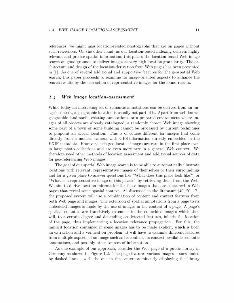
As one example of our approach, consider the Web page of a public library inGermany as shown in Figure 1.2. The page features various images – surroundedby dashed lines – with the one in the center prominently displaying the library
12 CHAPTER 1. GEOSPATIAL WEB IMAGE MINING
Figure 1.2: Images and location on a sample Web page
building. Its address – Pferdemarkt 15, 26121 Oldenburg – is present just to theright of the image and its name and city in some of the metadata such as keywordand title. A location-based image search focused on representative images of placesshould yield the photograph in the center. In the example, only this photographshould be retrieved since it is the only one descriptive of the location. The imageanalysis should be able to filter out all other, rather decorating images on the page.An analysis of the images’ context and content should determine that only this onein fact has a location relevance and a strong connection to the specific location.
Method for location assessment
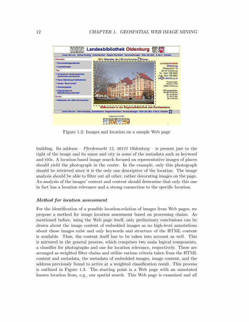
For the identification of a possible location-relation of images from Web pages, wepropose a method for image location assessment based on processing chains. Asmentioned before, using the Web page itself, only preliminary conclusions can bedrawn about the image content of embedded images as no high-level annotationsabout these images exist and only keywords and structure of the HTML contentis available. Thus, the content itself has to be taken into account as well. Thisis mirrored in the general process, which comprises two main logical components,a classifier for photographs and one for location relevance, respectively. These arearranged as weighted filter chains and utilize various criteria taken from the HTMLcontent and metadata, the metadata of embedded images, image content, and theaddress previously found to arrive at a weighted classification result. This processis outlined in Figure 1.3. The starting point is a Web page with an annotatedknown location from, e.g., our spatial search. This Web page is examined and all
1.4. WEB IMAGE LOCATION-ASSESSMENT 13
its image references are extracted. Each image is then analyzed and processed bya filter chain in the photo classification component. This analyzes each image tovalidate whether it satisfies the conditions to be considered a photograph. If thecondition is met, the surrounding page as well as image features are input to thelocation classification. It examines image and Web page for hints towards a locationreference, which are weighted and summarized. Some filters have can cast a veto onimages where a direct negative classification is possible, effectively truncating thechain. Such cases can be 1x1 sized images, single-colored images etc. If a locationcould be reliably assigned, the process results in a geo-coded image. For bothphotograph classification and location classification, we utilize different informationsources: the Web page itself, the HTML content surrounding the image, metadata ofembedded images and their content, and the address previously found. With thesecriteria, we can have spatial information inherited and automatically annotate it tothe images, based on a previously derived or known location of the Web page.
Figure 1.3: Logical process of the location assessment
Photograph classification
Images on Web pages are used for different reasons. Distinguishing their differentroles supports filtering certain images by their roles. A first large group of images arethose that serve an illustrative purpose: photographs, diagrams, graphics, sketches,titlebars, logos. A second group serves as formatting objects : bullets, borders, menuitems, buttons, headings. Also, Web images can represent advertisements by meansof banners, animated images or are used as ”invisible” images used for user tracking.Other embedded media such as videos, flash or Java applets are outside the scopeof this work since they have quite different semantics than images. We obviouslymiss some finer distinctions as needed by other approaches, but these classes sufficefor the exclusion of non-location-bearing images according to our goal. Of the rolesidentified, we are only interested in photographs being the main bearers of visuallocation information. Such photographs serve illustrative purposes. Page authors

14 CHAPTER 1. GEOSPATIAL WEB IMAGE MINING
use them with this in mind, and they clearly depict objects or scenery that is inmost cases related to the text they accompany. This corresponds to the results ofour initial surveys and probings.
Therefore, we developed methods to identify images with a high probability tobe a realistic photograph of a place. To this end, we use different information sourcesand combine them into an overall classification by drawing on image metadata aswell as image features. The different features and their relevance for photographclassification are discussed in the following. Each of these features are inconclusive,except in the direct negative case of a veto. Yet, in combination they yield satisfyingresults.
• Image size and image ratio is used to remove small images such as bullets,menu items and other formatting images as well as illustrative images that lacksufficient size or that have an unusual ratio that deviates too much from usualphotos, in this case images with one side being less that 1/3 of the other. Wefound 100 pixels to be a good minimum size. This removes most advertisementbanners, borders, rulers, headings etc. These filters are employed twice, oncepre-download, if size information is available from the img-tag, and then post-download when size information is always available from the image itself.
• size comparison is an analysis over all images within a page to sort imagesaccording to their size. The assumption is that larger images often are morerelated to the content of a page. This can be observed in the case of newsarticles [15] which are illustrated with a teaser image, but can also – whilewith less weight – be used to search for photographs depicting locations. Theanalysis runs once in the pre-download phase, but since many images do notcarry size information in the HTML source, is run again when all images of apage are downloaded. Since many images can already be removed by vetoes,its results may suffer from missing values and are thus weighted less.
• filename comparison is another page-scale analysis running only in the pre-download stage on the page content. Since image size information often isunavailable, it employs a different method to mainly detect formatting objects.First, it counts identical image filenames within the page to identify imagesthat have multiple occurrences in a page. Second, all filenames are comparedto each other. By using editing distances, similar filenames can be groupedand images contained in a group weighted less since they are more likely toconstitute formatting objects.
• Color count and histogram analysis is used to distinguish photographs withtheir high number of colors from illustrations or drawings. We calculate theratio of used colors in an image to the maximum possible colors depending onfile format. Black & white images are detected to be treated with different
1.4. WEB IMAGE LOCATION-ASSESSMENT 15
thresholds. For GIFs with the restricted palette of only 256 colors we cannotgive a reliable threshold but rate them generally lower; JPGs and PNGs with16777216 possible colors were found to need a minimum of 0.18% of possiblecolors to qualify as a photograph; black and white images were invariant forgifs, the other formats needed 0.0014% of possible colors. In the case of verfew colors, images are most probably simple logos or similar and can receivea veto. Similarly, a histogram analysis aims at the same goal, but by using agreyscale histogram with its limited number of bins, it basically allows to workon a reduced palette, which can pool similar colors which often are present injpeg-artifacts and might misguide a pure color count. The histogram thereforesmoothes over such outliers and can provide a more aggregated view. Fordiscrimination, bins are ordered by their value and the necessary number ofbins to contain half the image’s pixels are evaluated. Furthermore, if less thanthree bins are used, a veto discards the image.
• Animation or transparency in images usually indicates non-photographs. Wealso found many part-transparent click maps.
• EXIF-data in JPG files is a strong evidence for a photograph. Digital camerastoday generate a multitude of camera-specific metadata such as camera type,focal length, flash usage, exposure etc. We use the fields of Flash (whether theflash fired), Model (the camera model) and ExposureTime as sufficient evi-dence that the image was taken by a digital camera and is thus a photograph.The reverse is not true; converting or manipulating images may destroy orremove the EXIF information.
• Vertical edges in above-average quantity can indicate photographs of a placeshowing buildings, pieces of architecture or trees. For our purposes, a modifiedSobel filter operating on greyscaled images for edge detection worked best forurban buildings but is inconclusive for rural scenery.
• Face detection is used to distinguish mere snapshots of people at a locationfrom images truly depicting the location itself. We found the number of suchsnapshots quite high and use this feature to focus on location-depicting photos.
Location-relevance classification
With the bearers of visual location information found to be in and around pho-tographs, we have to make the connection to the actual location of the Web page.An image related to a location will exhibit certain characteristics which we exploitto create a set of measurements of how well the location of a Web page can beinherited by the images embedded in it.
Already knowing the location referenced on a Web page, we need to verifywhether an image—or more precisely its content—is related to this location as well.

16 CHAPTER 1. GEOSPATIAL WEB IMAGE MINING
We assume a certain intention of a Web page’s author about images embedded inthe pages. Images identified as illustrative do usually indeed often serve to visuallydescribe the content present in the page—in our case, the location of the addresspresent on the page or the referenced building or place. This relation is not alwaysvery clear and it is also not always present. Though, an image related to a locationwill exhibit certain characteristics which we exploit to create a set of measurementsof how well a given location of a Web page can be inherited by the images embeddedin it. To establish a relation of an image and an address on the Web page, we rely oncontent and structure of the page in question. From the photograph classificationstep, we know all photographs on the page; from our search engine, we also knowthe geographic location of a Web page as a full address including street, number,zip code, city name and also geo-coordinate. We assume this location referencedoes not necessarily stand for the entire page but rather may determine a locationfor at least part of the page decreasing in relevance by increasing distance fromthe location reference. Then, an image in the vicinity of an address has a higherprobability for location relevance than one further away. Also, if we can identifya page as generally dealing with the location, it’s probability to contain relevantimages increases.
For the implementation of the location-relevance classification, we consider thedistance of the image to each address on the page and the matching of image de-scriptors and key elements on the page to parts of the address. We use an in-pagelocation keyword search. We interpret the given address as a small subsection ofa geographic thesaurus. This allows for generalization of an address by traversingits hierarchy for keywords. We can broaden the search from full street address toonly city or region. An address such as “Escherweg 2, 26121 Oldenburg” could bematched in decreasing levels of relevance as “Escherweg, Oldenburg” or “Olden-burg” alone. This truncation matching is already useful for searching the page, butabsolutely necessary for searching features such as metatags, page title, or imageattributes. They are very unlikely to contain full addresses, but will often contain atleast the city name. This method also allows for more general approaches to describelocation than just addresses. In theory, arbitrary topics could be searched this way.Matches of this search are rated by the amount of matched keywords and—whereapplicable—the distance from the image based on the DOM-representation of thedocument. The process would repeat for each location associated to a Web page.
The examined image tag attributes are alt, title, and name. These descriptivefields for an image may contain descriptions of the image contents and are thereforehighly relevant as well as the src attribute for meaningful image or path names.The page’s metatag fields description, keywords and page title as well as DublinCore DC.Subject, DC.Description can hint that the page as a whole is concernedwith the location and therefore contained elements receive a higher rating. Otherwell-known tags such as dc.coverage, geo.location or icbm coordinates were notencountered during our crawls and were therefore not included at this time. The
1.4. WEB IMAGE LOCATION-ASSESSMENT 17
set of evaluation features is presented in the following.
• image-attributes Checks whether a keyword appears within a textual, descrip-tive attribute of the image tag such as alt, title or name. These fields of animage may contain descriptions of the image contents and are therefore highlyrelevant.
• DOM-Distance Checks whether identified address keywords appear near theimage on the page by using a DOM-representation of the HTML source. Thisdecreases by distance to give text near the image a higher rating. Withinmany of the other systems discussed in Section 1.2, this is their only or majorsource for a similarity measure of keywords and image.
• Source-Path Checks the src attribute of an image for meaningful image filenames or, to a lesser degree, path names.
• Page title and metadata Checks the page’s metatag fields description, keywordsand Dublin Core DC.Subject, DC.Description. This would mean that the pageas a whole is concerned with the location and therefore the parts on it geta higher rating. These fields were selected for their possible general locationrelevance. Other well-known tags such as dc.coverage, geo.location or icbmcoordinates were not encountered during our crawls and were therefore notincluded at this time.
Combining features for location assessment
The process shown before in Figure 1.3 depicts two logical blocks for location as-sessment, photograph classification and location classification, each realised by ananalysis chain. Inside each chain, several filters serially evaluate the aforementionedfeatures, calculate a relevance score, and add an annotation for the assessed image.
With this partition into two processing chains it quickly becomes clear thatthis might not be the most efficient arrangement for use within a search engine,especially when the wanted images are rather rare. For an applicability within aresource-constrained search engine, it is desireable to reduce the processing time,which is induced mainly by the need for analysis of features from the image file itself.Since we currently have no further need for images beyond those with a derivedlocation, the solution is to reduce expensive image operations. The most expensiveof these is the I/O overhead induced by the necessary download of images and to alesser degree some image analysis steps such as face detection. However, for mostanalysis steps, the download and decoding of images is the major part of processingtime. Therefore, the ability of the system to filter out unwanted and unpromisingimages has to be improved. This is achieved by adding a further result state toindividual filters. While for the overall system, only the combination of multiple

18 CHAPTER 1. GEOSPATIAL WEB IMAGE MINING
Table 1.1: Combination of evaluation features
stage, source scope classificationfeature pre-dl post-dl image page location photo veto
(html) (image)image size/ratio • • • • •size comparison • • • ( • ) •filename occurrence • • • •filename similarity • • •img-attributes • • •DOM-distance • • •source-path • • •metadata • • •animation/transparency • • • •color count/histogram • • • •EXIF-data • • •edge detection • • ( • ) •face detection • • ( • ) •
feature classifiers can provide reliable estimates on the positive classification forphotograph or location, some features have the ability to directly judge an image asnegatively classified for the overall chain. That is, a filter can have its own thresholdbelow which the image is considered a non-match for the whole chain, making furtherprocessing unnecessary. Such filters are thus equipped with a veto ability for theremainder of the filter chains. This allows for a fast veto on unpromising images,freeing up performance for further processing.
Using the veto mechanism, the filter chains are rearranged from their logicalarrangement of photograph and location classification into pre- and post-downloadoperations on the images. Within each group, filters are ordered by their vetoability, discriminative ability, and computational expense. The resulting propertiesof the feature filters and their order is shown in Table 1.1. The stage column denoteswhether a filter works before or after the download of images, i.e., on the html pageor the image file; the scope denotes whether the filter works on image or Web pageproperties; and the classification indicates whether this goes into the location orphotograph classification. The veto field indicates whether a specific filter can casta veto on the processing. Note that the image size filter can be run twice, as oftenembedded images do not carry size attributes in the img-tag and size can only beevaluated when images are available after their download.
With the reordered chains, the location assessment is still mostly decoupled fromthe photo classification and run in the pre-download stage. Thus, if the evidence forlocation lies below a threshold, it is possible to abort the processing chain before the
1.4. WEB IMAGE LOCATION-ASSESSMENT 19
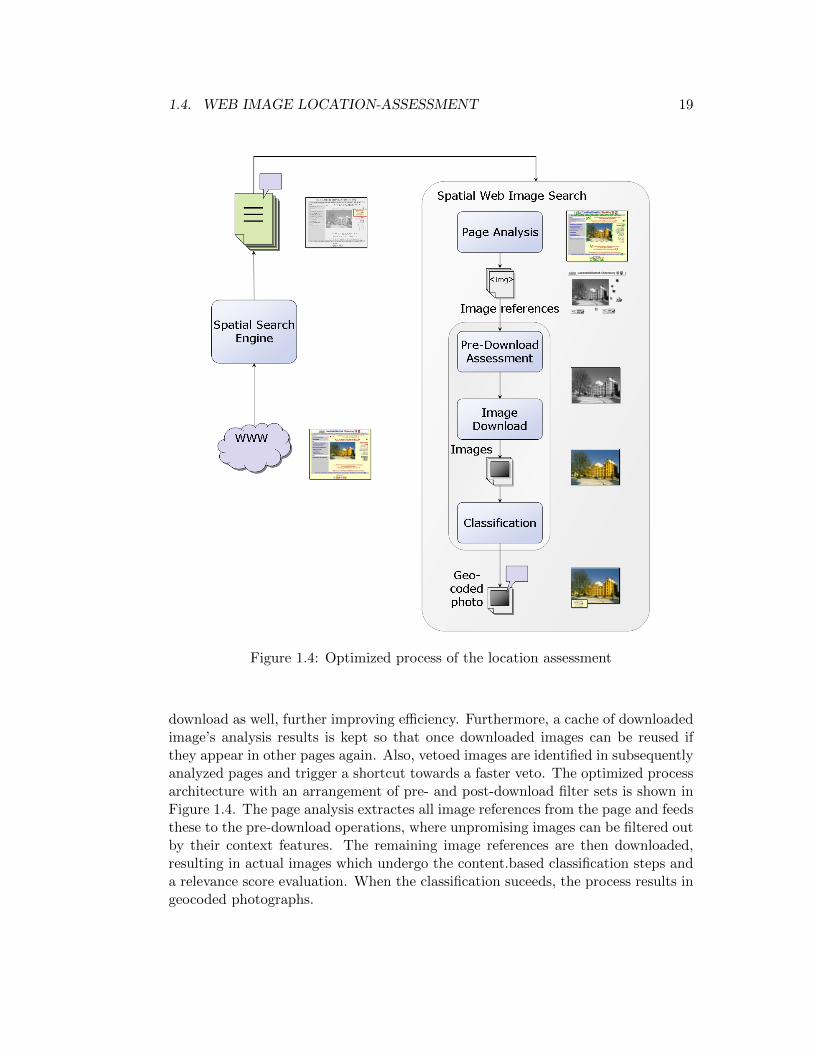
Figure 1.4: Optimized process of the location assessment
download as well, further improving efficiency. Furthermore, a cache of downloadedimage’s analysis results is kept so that once downloaded images can be reused ifthey appear in other pages again. Also, vetoed images are identified in subsequentlyanalyzed pages and trigger a shortcut towards a faster veto. The optimized processarchitecture with an arrangement of pre- and post-download filter sets is shown inFigure 1.4. The page analysis extractes all image references from the page and feedsthese to the pre-download operations, where unpromising images can be filtered outby their context features. The remaining image references are then downloaded,resulting in actual images which undergo the content.based classification steps anda relevance score evaluation. When the classification suceeds, the process results ingeocoded photographs.
20 CHAPTER 1. GEOSPATIAL WEB IMAGE MINING
Formally, the assessment is defined as follows. Two actual chains location andphoto are installed for location assessment and photograph detection respectively.These span the whole process, independent of the stage, as defined in Table 1.1.Let n be the number of feature filter modules in the chain. Each filter moduleevaluationi is assigned a weight wi to express its relevance relative to other modulesand allow for easy parameterization and tuning. The relevance score for an imageimg per chain is calculated by summing up the evaluation scores for each featureand noting potential vetoes:
relevance(img)chain =n�
i=1
wi evaluationi(img) (1.1)
veto(img) = ∃i ∈ 0..n : evaluationi(img) = veto (1.2)
For each chain, the final relevance score of an image is compared to an empiricallydetermined threshold thresholdchain to decide whether it is in or out of scope afterchecking for a veto:
pass(img)chain =
0 veto(img) = true
1 thresholdchain ≤ relevance(img)chain0 otherwise
(1.3)
An image is classified as location-relevant if it passes both chains; its overalllocation score is given as relevance(img)location and the relation between imageand location is established with the given relevance score value.
locRelevant(img) = pass(img)location ∧ pass(img)photo (1.4)
Separating the classification into location classification and photograph classi-fication allows setting different thresholds to pass the chain for the location clas-sification and the subsequent photograph classification. This can be seamlesslyintegrated with the aforementioned separation into a pre- and post-download stageby simply collecting evaluation scores along the process and doing the calculationof the overall relevance at the end.
In the evaluation section, we will present the experimentation with differentthresholds and discuss the quality of the results for different threshold values. Theinitial thresholds were determined experimentally with a known testset of imagesusing the abovementioned features. During the experiments, we allowed each imageto pass through each evaluation module to gather complete data. For later use, theveto mechanism and thresholds introduce efficient truncation for images which arerated well below passing thresholds in the assessment chains. With the locationrelation thus established, the image is associated with the location on the Web pageand is accessible to spatial Web image search.
1.5. EVALUATION 21
1.5 Evaluation
To evaluate our approach and assess its validity, we ran a series of test crawlson our system. These served to answer the questions of first, how reliable thephotograph-classification is, and second, whether the overall location reference iscorrectly assigned. As a testset we chose a crawl of Rugen, Germany’s largest islandand a famous tourist area, and of the city of Oldenburg, Germany. The resultingtestset comprises Web pages along with the addresses that were identified on them.Both regions deliver similar results, but the rural region of of Rugen has a slightlydifferent composition of image types. We show the performance of photographclassification on a smaller testset and then present the location classification in asecond step.
Evaluation of photograph classification
To create a small testset for the photograph classification we used a random sam-pling from our spatial index of 100 Web pages with an identified location relevance.Out of these, 78 pages could be used as 22 pages remained unreachable or had pars-ing problems. Within the remaining pages, we found 1580 images. Our photographclassification resulted in 86 images classified as photographs. Visual inspection ofthese images revealed that 69 were classified correctly. The remaining 17 imageswere misclassified graphics which still showed some of the relevant photographicfeatures. 1538 images were classified as non-photographs and mainly compriseddecorative items of Web pages. We also went through a visual inspection of theseimages and identified 1511 as classified correctly. The 27 falsely classified pho-tographs contained only few colors or had untypical sizes or ratios such that theirscore fell beyond the threshold. The fact that we only found very few photographs isnot surprising, as on the Web nowadays quite a lot of images are used for decorativepurposes. This still means that ≈ 70% of pages contained a photograph. Withinthis small testset, the achieved values for precision ≈ 0, 80 and recall ≈ 0, 72 arepromising.
Evaluation of location classification
To draw meaningful conclusions for the location assessment, two larger crawls wereperformed. For the Crawl of Rugen, the testset was enlarged to 1000 pages. Ofthese, 857 pages could be examined. The result set of photographs confirmed asimilar performance as before, but was not manually assessed. A resulting 618combinations of photos with locations were analysed. Of the 74 images classifiedas having a location relevance we found 55 classified correctly and 19 with dubiousor false results. Of the 544 images classified without location relevance, we have noexact values for the ratio of wrong classification. However, scanning these imagesseems to confirm that most of them are correctly classified; we estimate recall at

22 CHAPTER 1. GEOSPATIAL WEB IMAGE MINING
above 0.7 and can calculate precision ≈ 0, 7 at a similar value. Examples of theimages retrieved by our system are shown in Fig. 1.5. We find some well-relatedimages a-d, some even from the interior of buildings, especially for holiday homes.However, some false positives and mismatches are also returned. Images e and gdepict a location, but the connection to the found location is uncertain. For g wecan assume that it is just a general landscape of the island. Some uncertainties couldonly be solved by in-depth linguistic analysis of the pages, some are unsolvable evenby a human user. Clearly mis-classified is the illustrative graphic f. The sketch of achapel h shows good location relevance but is not a photo. This shows an interestingcapability of our system: The major part of images falsely classified as photographswere rated lower for location relevance than true photographs. Apparently thelocation classification compensates for some errors in the photograph detection.
Figure 1.5: Retrieved images Rugen, sample true positives (a–d) and false positives(e–h)
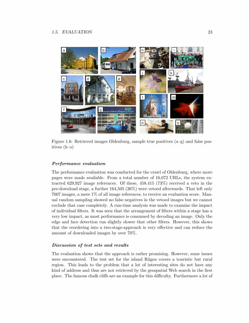
The results from the crawl of Oldenburg show similar results. A noteable differ-ence is first the higher variance of images that were retrieved, manifesting in muchmore urban buildings instead of landscapes. Second, the images, especially the falsepositives, have a much higher variance in their types, ranging from actual buildingsand interiors to products, people, or logos. Figure 1.6 shows some characteristicresults. Images a–d and f show broad exterior shots of buildings, two of of themmuseums a or banks f, other smaller houses of pharmacies or workshops. the latteris also shown in a more close-up shot in g. Finally, g is the interior of a church. Thefalse positives are rather varied, with h a collage from a museum, m a lasershowfrom a respective craftsman. j, n and o are general illustrative photographs. Inter-estingly, i shows a sports club in front of a landmark building and l shows anotherlandmark, albeit on a CD cover. Finally, k shows a harbour location in a differentcity.
1.5. EVALUATION 23
Figure 1.6: Retrieved images Oldenburg, sample true positives (a–g) and false pos-itives (h–o)
Performance evaluation
The performance evaluation was conducted for the crawl of Oldenburg, where morepages were made available. From a total number of 16,072 URLs, the system ex-tracted 629,927 image references. Of these, 458,415 (73%) received a veto in thepre-download stage, a further 164,505 (26%) were vetoed afterwards. That left only7007 images, a mere 1% of all image references, to receive an evaluation score. Man-ual random sampling showed no false negatives in the vetoed images but we cannotexclude that case completely. A run-time analysis was made to examine the impactof individual filters. It was seen that the arrangement of filters within a stage has avery low impact, as most performance is consumed by decoding an image. Only theedge and face detection run slightly slower that other filters. However, this showsthat the reordering into a two-stage-approach is very effective and can reduce theamount of downloaded images by over 70%.
Discussion of test sets and results
The evaluation shows that the approach is rather promising. However, some issueswere encountered. The test set for the island Rugen covers a touristic but ruralregion. This leads to the problem that a lot of interesting sites do not have anykind of address and thus are not retrieved by the geospatial Web search in the firstplace. The famous chalk cliffs are an example for this difficulty. Furthermore a lot of
24 CHAPTER 1. GEOSPATIAL WEB IMAGE MINING
images depicting Rugen are pure landscape-photos, which makes location validationdifficult. The testset for the urban region of Oldenburg exhibits different imageswhere a lot of places actually have an address and are present in the result set. In thismore urban environment most addresses lie within the city, while in a rural area,addresses can be in the countryside, leading to two different sets of photographsto be expected; one showing more buildings, the other more landscape-orientedphotos. Our results show a slight decrease in reliability of our photo-detection forurban regions. By examining the filtered images, we recognized that the imagesfrom a more urban area contain much more graphics which are produced in a waythat makes them more similar to photos. Another issue is the composition of thetest set. It contained a lot of classifieds directory sites which mostly have no photosembedded, but often sport entensive graphics.
The system also discovers a substantial amount of maps on Web pages detaillinglocation and directions for the referenced place. Other images that we aim to filterout, but which sometimes still appear in the results, comprise logos, products,people, etc. This can be further improved by respective filters. More difficult aresome cases where the image does show a location, but it remains unclear whetherit really shows the location present on the page. In a few cases, the location of thepage and the one shown in the image are a definite mismatch, as evidenced, e.g., bymountains on the seaside. However, we were also able to recognize an interestingcapability of our system: The majority of image falsely classified as photographswere rated with a lower score for location relevance than the real photographs.Apparently our location classification can compensate for some of the photographclassification errors and vice versa. This furthermore confirms our initial assumptionthat location and corresponding photos already relate to each other on the Web.This seems at least in part be due to the fact that page creators tend to use them ina certain way. In conclusion, the results and our chosen features show that contextanalysis for Web images in combination with content analysis can deliver usefulresults for detecting location-bearing photographs.
1.6 Future developments
As the results of the evaluation revealed, it remains challenging to determine if aphoto actually carries a location-relation. Still, the results and our chosen featuresshow that while context analysis for images alone is not sufficient, in combinationwith basic image content analysis it shows promising results in detecting location-bearing photographs. From this achieved state onward, several options are availableto advance the system into different directions.
1.6. FUTURE DEVELOPMENTS 25
Improvements
A first advancement is of course the improvement of the existing system alongs itspreviously defined goals, to reliably propagate a Web page’s location to embeddedimages for place illustration. This will include refining the parameters of the heuris-tics, analyzing in more detail to what extent the filters each influence the resultsand whether this could be exploited by using machine learning approaches. Sincethe current approach is rather exploratory, the results could be made more soundlyfounded by comparing different classification results by, e.g., decision trees, neuralnetworks, SVMs etc. This could be supported by the use of more page and imagefeatures for the classification. Since the location of a page is already known, othersources could be used to indicate the type of area this location is in. Such informa-tion could be used to validate found images against an expectation for, e.g., ruralareas, landscapes, or urban buildings. Such attempts to improve the location as-sessment would however require the use of content-based retrieval techniques. Theaim then would be to better understand the content of images and their use androle on Web pages, which leads to further improvements as discussed in the nextsection.
Classification of illustrative images
A second development would be to turn some of the current misclassifications intonew challenges. Instead of trying to remove them, they might actually be goodresults if only the question were framed a little different. This requires a redefinitionof the notion of a ”representative” image. A substantial amount of found imagescould be said to have a location relevance, but often rather because they have avery high relevance to the entity described on a Web page instead of depicting thelocation itself. So if the goal might not be to actually find a picture of a locationbut one that is characteristic for the described entity, a lot more opportunities openup. This is especially true since the actual amount of location-depicting images ourapproach finds is quite low.
A complimentary approach can be to extend the concept of image roles to beable to identify the type of photograph for more content-based image understand-ing. Some of the found images that are currently being discarded include drivingdirections (which still have a stong location aspect), logos, representative products,graphics design, characteristic tools, or pictures of individuals or groups These couldbe a valuable asset in some scenarios. For example, logos and similar images canserve as as mnemonic identifiers for entities. Similar to a favicon in a bookmark list,such images could be used to identify geospatial results on a map. These differentsemantics of images could be identified by image type classification using a content-and context-based hierarchical classification system.
The Web page context can be a further opportunity to feed specialized meth-
26 CHAPTER 1. GEOSPATIAL WEB IMAGE MINING
odswith additional data. These could work on basic characteristics of the underlyingWeb pages, such as the type of page or the type of entity described on them suchas cultural entities, landmarks, restaurants, activities, shops, etc. Since differenttypes of pages often carry different types of representative images, such knowledgecould be gainfully used in a classification. A Web page about a person could thenbe illustrated with that very person, a shop with its logo or defining product. De-pending on the type of entity, further preferences and expectations for image typescould be defined. Complementing this development, the next section examines howthe original goal of finding location-depicting images can be improved.
Geospatial images
Susan Sontag once famously wrote that ”everything exists to end up in a photo-graph”. Today, one might add, everything exists to ends up on the Web. Butstill, the exact extraction of what the ”everything” in a given photo might be and,following, where it is located, still poses strong research challenges. Some of thesechallenges are currently being solved, as discussed in Section 1.2. Simultaneously,a gworing number of sources for geospatial images exist. While in some cases thesedo not hold images georeferenced at a building level, they can still be used for againful advantage. First, the large amount of geospatially-enabled photo sharingsites such as flickr, locr, panoramio etc. can be used to find images from the positionof interest and to try to match them to the current location and to a larger dataset,possibly identifying established logos or names of entities within some pictures. An-other interesting source are large-scale high-resolution mappings of cities to retrieveimages for pages without photographs. For example, Google Street View offershigh-resolution street-level imagery in areas where coverage is available. Other nav-igation vendors have similar data, but usually do not release it. It can also be usedto indentify individual buildings and could be a suitable source to depict a building,museum, or landmark. For that, the individual boundaries of buildings and theirspatial extent must be known and these then annotated in the image. At lowerresolution, building or facade reconstruction from the oblique view of bird’s eye im-agery has been undertaken in several projects and can also provide low-resolutionbuilding and environment images. A use in car navigation systems could even ben-efit more from an abstract view of buildings for better visual integration. However,indoor images could not be retrieved this way and we remain dependent on thebusiness owners to provide them on their pages. We were able to find an interestingset of such images, from recording studios over hotels or workshops to libraries orchurches.
These are just some examples to demonstrate how rich datasources could beemployed to retrieve spatially-enriched images. The main argument for the approachfollowed in this chapter is that the geospatial images on Web pages often betterselected by the page’s authors and therefore are better suited to be representative
1.7. CONCLUSION 27
images for the page in question. However, to offset their rare occurrence, methodsas described here can be employed for a more complete picture over aggregatedsources.
1.7 Conclusion
In this chapter, we presented an approach to automatically geo-reference imagesembedded in Web pages on the address level. Based on our work on location-basedWeb search, we presented our method and heuristics to propagate the locationof a Web page and assign it to embedded photographs. We could show that acombined multi-source analysis of content and context is feasible for this task. Au-tomatic location detection of images on unstructured Web pages now allows imagesto become part of the results of a geospatial Web search without previous manualtagging. The results of our evaluation are promising regarding classification andperformance. However, for borad applicability, the approach lacks sufficient datain the form of geospatial Web images. To counter this effect, we also proposed sev-eral improvements. Depending on the application scenario, other types of imagesor other sources of data might be considered to gather representative images for aplace. For such cases, the system described here could be adapted to arrive at adeeper understanding of representative Web images and their associated location.
Acknowledgements
We thank our students Sebastian Stockfleth for the initial implementation of theimage search system and Timo Scheffler for substantial improvements and sugges-tions. Part of this research has been carried out as subproject of the Niccimonproject and was supported by the State of Lower Saxony, Germany.
References
[1] D. Ahlers and S. Boll. Location-based Web search. In A. Scharl and K. Tochter-man, editors, The Geospatial Web. How Geo-Browsers, Social Software and theWeb 2.0 are Shaping the Network Society. Springer, London, 2007.
[2] D. Ahlers and S. Boll. Retrieving Address-based Locations from the Web. InGIR ’08: 5th Workshop on Geographic Information Retrieval, pages 27–34,New York, NY, USA, 2008. ACM.
[3] D. Ahlers and S. Boll. Adaptive Geospatially Focused Crawling. In CIKM’09: Proceeding of the 18th ACM Conference on Information and KnowledgeManagement, pages 445–454, New York, NY, USA, 2009. ACM.

28 REFERENCES
[4] D. Ahlers and S. Boll. On the Accuracy of Online Geocoders. In W. Reinhardt,A. Kruger, and M. Ehlers, editors, Geoinformatik 2009, Osnabruck, volume 35of ifgiprints, pages 85–91, Munster, 2009.
[5] E. Amitay, N. Har’El, R. Sivan, and A. Soffer. Web-a-Where: Geotagging WebContent. In SIGIR ’04, pages 273–280, New York, NY, USA, 2004. ACM Press.
[6] Y. Aslandogan and C. Yu. Diogenes: A Web search agent for content basedindexing of personal images. In Proceedings of ACM SIGIR, pages 481–482,2000.
[7] V. Athitsos, M. J. Swain, and C. Frankel. Distinguishing Photographs AndGraphics on the World Wide Web. In CAIVL ’97: Proceedings of the 1997Workshop on Content-Based Access of Image and Video Libraries, page 10,Washington, DC, USA, 1997. IEEE Computer Society.
[8] J. Baldzer, S. Boll, P. Klante, J. Krosche, J. Meyer, N. Rump, A. Scherp,and H.-J. Appelrath. Location-Aware Mobile Multimedia Applications on theNiccimon Platform. In IMA’04, 2004.
[9] H. Bischof. Robust person detection for surveillance using online learning. InWIAMIS ’08: Proceedings of the 2008 Ninth International Workshop on ImageAnalysis for Multimedia Interactive Services, page 1, Washington, DC, USA,2008. IEEE Computer Society.
[10] W.-C. Chen, A. Battestini, N. Gelfand, and V. Setlur. Visual summaries ofpopular landmarks from community photo collections. In MM ’09: Proceedingsof the seventeenth ACM international conference on Multimedia, pages 789–792, New York, NY, USA, 2009. ACM.
[11] R. Datta, W. Ge, J. Li, and J. Z. Wang. Toward bridging the annotation-retrieval gap in image search by a generative modeling approach. In IEEEMultimedia: Special Issue on Advances in Multimedia Computing, volume 14,pages 24–35, New York, NY, USA, 2007. ACM Press.
[12] R. Datta, D. Joshi, J. Li, and J. Z. Wang. Image Retrieval: Ideas, Influences,and Trends of the new age. ACM Computing Surveys, 2007.
[13] C. Frankel, M. J. Swain, and V. Athitsos. WebSeer: An Image Search Enginefor the World Wide Web. Technical report, Chicago, IL, USA, 1996.
[14] B. Gao, T.-Y. Liu, T. Qin, X. Zheng, Q.-S. Cheng, and W.-Y. Ma. Web imageclustering by consistent utilization of visual features and surrounding texts. InMULTIMEDIA ’05: Proceedings of the 13th annual ACM international confer-ence on Multimedia, pages 112–121, New York, NY, USA, 2005. ACM Press.
REFERENCES 29
[15] W. Gong, H. Luo, and J. Fan. Extracting informative images from web newspages via imbalanced classification. In MM ’09: Proceedings of the seventeenACM international conference on Multimedia, pages 1123–1124, New York,NY, USA, 2009. ACM.
[16] Z. Gong, L. H. U, and C. W. Cheang. Web image semantic clustering. InProceedings of the 4th International Conference on Ontologies, Database andApplications of Semantics (ODBASE 2005), Lecture Notes in Computer Sci-ence, Agia, Napa, Cyprus, 2005. Springer.
[17] X. He, D. Caia, J.-R. Wen, W.-Y. Ma, and H.-J. Zhang. Clustering and Search-ing WWW Images Using Link and Page Layout Analysis. In ACM Trans. onMultimedia Comput. Commun. Appl., volume 3, 2007.
[18] L. L. Hill. Core elements of digital gazetteers: Placenames, categories, andfootprints. In ECDL ’00: Proceedings of the 4th European Conference on Re-search and Advanced Technology for Digital Libraries, pages 280–290, London,UK, 2000. Springer.
[19] M. Himmelstein. Local Search: The Internet Is the Yellow Pages. IEEE Com-puter, 38(2):26–34, 2005.
[20] M. Hughes, A. Salway, G. Jones, and N. O’Connor. Analyzing image-textrelations for semantic media adaptation and personalization. In SMAP ’07:Proceedings of the Second International Workshop on Semantic Media Adapta-tion and Personalization, pages 181–186, Washington, DC, USA, 2007. IEEEComputer Society.
[21] A. Jaffe, M. Naaman, T. Tassa, and M. Davis. Generating Summaries and Vi-sualization for Large Collections of Geo-Referenced Photographs. In MIR ’06:Proceedings of the 8th ACM international workshop on Multimedia informationretrieval, pages 89–98, New York, NY, USA, 2006. ACM.
[22] M. Jakob, M. Großmann, D. Nicklas, and B. Mitschang. DCbot: FindingSpatial Information on the Web. In L. Zhou, B. C. Ooi, and X. Meng, edi-tors, Proceedings of the 10th International Conference on Database Systems forAdvanced Applications DASFAA 2005, volume 3453 of LNCS, pages 779–790.Springer, 2005.
[23] R. Ji, X. Xie, H. Yao, and W.-Y. Ma. Mining city landmarks from blogs bygraph modeling. In MM ’09: Proceedings of the seventeenth ACM internationalconference on Multimedia, pages 105–114, New York, NY, USA, 2009. ACM.
[24] M. Jia, X. Fan, X. Xie, M. Li, and W.-Y. Ma. Photo-to-Search: Using CameraPhones to Inquire of the Surrounding World. In 7th International Conferenceon Mobile Data Management, MDM 2006, pages 46–48, 2006.
30 REFERENCES
[25] F. Jing, C. Wang, Y. Yao, K. Deng, L. Zhang, and W.-Y. Ma. IGroup: WebImage Search Results Clustering. In ACM Multimedia 2006, 2006.
[26] M. Kamvar and S. Baluja. A large scale study of wireless search behavior:Google mobile search. In CHI ’06: Proc. of the SIGCHI conf. on HumanFactors in computing systems, pages 701–709, New York, NY, USA, 2006.ACM.
[27] L. S. Kennedy and M. Naaman. Generating diverse and representative imagesearch results for landmarks. In WWW ’08: Proceedings of the 17th interna-tional conference on World Wide Web, pages 297–306, New York, NY, USA,2008. ACM.
[28] M. L. Kherfi, D. Ziou, and A. Bernardi. Image retrieval from the world wideweb: Issues, techniques, and systems. ACM Comput. Surv., 36(1):35–67, 2004.
[29] Z. Kim and J. Malik. Fast vehicle detection with probabilistic feature group-ing and its application to vehicle tracking. In Proc. 9th IEEE InternationalConference on Computer Vision, Nice, France, volume 1, pages 524–531, 2003.
[30] M. S. Lew. Next-GenerationWeb Searches for Visual Content. IEEE Computer,33(11):46–53, 2000.
[31] J. Li and J. Z. Wang. Real-time computerized annotation of pictures. In MUL-TIMEDIA ’06: Proceedings of the 14th annual ACM international conferenceon Multimedia, pages 911–920, New York, NY, USA, 2006. ACM.
[32] R. Lienhart. Video OCR: a survey and practitioners guide. Video Mining,pages 155–184, 2003.
[33] G. Lu and B. Williams. An Integrated WWW image retrieval system. InProceedings of the AusWeb99, Lismore, Australia, 1999.
[34] J. Luo, M. Boutell, and C. Brown. Pictures are not taken in a vacuum. IEEESignal Processing Magazine, 23(2):101– 114, 2006.
[35] T. Maekawa, T. Hara, and S. Nishio. Image classification for mobile webbrowsing. In WWW ’06: Proc.of the 15th Intl. Conf. on World Wide Web,pages 43–52, New York, NY, USA, 2006. ACM Press.
[36] A. Markowetz, Y.-Y. Chen, T. Suel, X. Long, and B. Seeger. Design and imple-mentation of a geographic search engine. In A. Doan, F. Neven, R. McCann,and G. J. Bex, editors, WebDB 2005, pages 19–24, Baltimore, Maryland, USA,2005.
REFERENCES 31
[37] C. Marlow, M. Naaman, D. Boyd, and M. Davis. HT06, Tagging Paper, Tax-onomy, Flickr, Academic Article, To Read. In HYPERTEXT ’06. ACM, 2006.
[38] K. S. McCurley. Geospatial Mapping and Navigation of the Web. In WWW’01: Proc. of the 10th Intl. Conf. on World Wide Web, pages 221–229, NewYork, NY, USA, 2001. ACM Press.
[39] Y. Morimoto, M. Aono, M. E. Houle, and K. S. McCurley. Extracting SpatialKnowledge from the Web. In SAINT ’03. IEEE, 2003.
[40] E. V. Munson and Y. Tsymbalenko. To search for images on the web, lookat the text, then look at the images. In Proceedings of the First InternationalWorkshop on Web Document Analysis (WDA2001), 2001.
[41] F. Nack and W. Putz. Designing annotation before it’s needed. In MULTI-MEDIA ’01: Proceedings of the ninth ACM international conference on Mul-timedia, pages 251–260, New York, NY, USA, 2001. ACM Press.
[42] M. Ortega-Binderberger, S. Mehrotra, K. Chakrabarti, and K. Porkaew. Web-MARS: A Multimedia Search Engine, 2000.
[43] R. S. Purves, P. Clough, C. B. Jones, A. Arampatzis, B. Bucher, D. Finch,G. Fu, H. Joho, A. K. Syed, S. Vaid, and B. Yang. The Design and Implemen-tation of SPIRIT: a Spatially Aware Search Engine for Information Retrievalon the Internet. International Journal of Geographical Information Science,21(7):717–745, 2007.
[44] R. S. Purves, A. Edwardes, and M. Sanderson. Describing the where – im-proving image annotation and search through geography. In G. Csurka, editor,Proceedings of the workshop on Metadata Mining for Image Understanding(MMIU 2008), pages 105–113, Setbal, 2008.
[45] T. Quack, B. Leibe, and L. Van Gool. World-scale mining of objects and eventsfrom community photo collections. In CIVR ’08: Proceedings of the 2008international conference on Content-based image and video retrieval, pages 47–56, New York, NY, USA, 2008. ACM.
[46] T. Rattenbury, N. Good, and M. Naaman. Towards automatic extractionof event and place semantics from flickr tags. In SIGIR ’07: Proceedings ofthe 30th annual international ACM SIGIR conference on Research and devel-opment in information retrieval, pages 103–110, New York, NY, USA, 2007.ACM.
[47] M. Sanderson and J. Kohler. Analyzing Geographic Queries. In ACM SIGIRWorkshop on Geographic Information Retrieval, Sheffield, UK, 2004.
32 REFERENCES
[48] P. Sandhaus, A. Scherp, S. Thieme, and S. Boll. Metaxa – Context- andcontent-driven metadata enhancement for personal photo albums. In Multime-dia Modeling 2007, Singapore, 2007.
[49] C. Schlieder and C. Matyas. Photographing a city: An analysis of place con-cepts based on spatial choices. Computational Models of Place, Special Issueof Spatial Cognition and Computation: An Interdisciplinary Journal, 9(3):212–228, July 2009.
[50] S. Sclaroff, M. La Cascia, and S. Sethi. Unifying textual and visual cues forcontent-based image retrieval on the World Wide Web. Comput. Vis. ImageUnderst., 75(1-2):86–98, 1999.
[51] A. W. M. Smeulders, M. Worring, S. Santini, A. Gupta, and R. Jain. Content-based image retrieval at the end of the early years. IEEE Trans. Pattern Anal.Mach. Intell., 22(12):1349–1380, 2000.
[52] N. Snavely, S. M. Seitz, and R. Szeliski. Photo Tourism: Exploring PhotoCollections in 3D. ACM Transactions on Graphics (TOG), 25(3):835–846,2006.
[53] K. Tollmar, T. Yeh, and T. Darrell. IDeixis - Image-based Deixis for FindingLocation-Based Information. In MobileHCI, 2004.
[54] Y. Tsymbalenko and E. V. Munson. Using HTML Metadata to Find RelevantImages on the World Wide Web. In Proceedings of Internet Computing 2001,volume 2, pages 842–848, Las Vegas, 2001. CSREA Press.
[55] A. Vailaya, M. Figueiredo, A. Jain, and H. Zhang. Image classification forcontent-based indexing. IEEE Transactions on Image Processing, 10(1):117–130, 2001.
[56] A. Vailaya, A. Jain, and H. J. Zhang. On Image Classification: City Imagesvs. Landscapes. In Proc. of the IEEE Workshop on Content-Based Access ofImage and Video Libraries, 1998.
[57] M.-H. Yang, D. J. Kriegman, and N. Ahuja. Detecting Faces in Images: ASurvey. IEEE Trans. Pattern Anal. Mach. Intell., 24(1):34–58, 2002.
[58] Y.-T. Zheng, M. Zhao, Y. Song, H. Adam, U. Buddemeier, A. Bissacco,F. Brucher, T.-S. Chua, and H. Neven. Tour the world: Building a web-scalelandmark recognition engine. IEEE International Conference on ComputerVision and Pattern Recognition (CVPR), 0:1085–1092, 2009.