geospatial technologies integrated with building information
TRANSCRIPT
Lisbon, 28th May 2015
Geo-IT: The Enabler Ingredient in the Infrastructure Construction Project Life Cycle Mix
Geospatial Technologies integrated with Building Information Modelling on Large Construction Site for Health and Safety
ManagementA. Ciribini, A. Vanossi, S. Mastrolembo Ventura, M. Paneroni, M. Bolpagni, G. Caratozzolo
Geo BIM 2015
Lisbon Congress Centre
28th May 2015

Geospatial Technologies integrated with Building Information Modelling on Large Construction Site for Health and Safety ManagementSilvia Mastrolembo Ventura
Lisbon, 28th May 2015
University of Brescia – BIM Research GroupDepartment of Civil Engineering and Architecture - DICATAM

Geospatial Technologies integrated with Building Information Modelling on Large Construction Site for Health and Safety ManagementSilvia Mastrolembo Ventura
Lisbon, 28th May 2015
Case Study – the «Piastra»Lenght: 2 kmWidth: from 350 m to 750 mDivided in sub-construction areas
Surface: 7900 mq
• Hydraulic works
• Circulation routes
• Technological systems
• Renovation of an existing building

Geospatial Technologies integrated with Building Information Modelling on Large Construction Site for Health and Safety ManagementSilvia Mastrolembo Ventura
Lisbon, 28th May 2015
General Characteristics of an Infrastructure Construction Site
• large construction site
• organisation in sub-construction areas
• horizontal construction site with main directions - ie linear development for roads, energy and fluids transport, etc (vertical BIM vs and horizontal BIM)
• construction operations involving large volumes of earth movement
• interferences with over-ground and underground utilities
• large number of workers concurrently on site
• reduced number of construction site accesses in relation to site’s extension and number of workers and vehicles

Geospatial Technologies integrated with Building Information Modelling on Large Construction Site for Health and Safety ManagementSilvia Mastrolembo Ventura
Lisbon, 28th May 2015
General Issues
• comprehensive understanding of the construction site to quickly update and manage information
• complex traffic management because of continues changes due to works on underground utilities
• construction roads modified from too many subjects and not constantly updated
• subcontractors working without a comprehensive knowledge of other sub-areas but operating on same construction roads and interferences
• spatial constraints due to interferences (ie space restrictions because of earthworks for both excavated and accumulated soil)
• risks such as collapse of excavations and falling into excavations: one of the main danger to workers in or near excavations
Geospatial Technologies integrated with Building Information Modelling on Large Construction Site for Health and Safety ManagementSilvia Mastrolembo Ventura
Lisbon, 28th May 2015
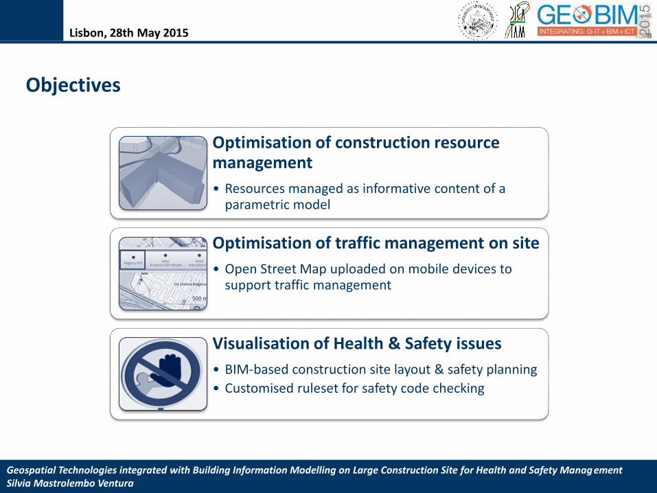
Objectives
Optimisation of construction resourcemanagement
• Resources managed as informative content of a parametric model
Optimisation of traffic management on site
• Open Street Map uploaded on mobile devices to support traffic management
Visualisation of Health & Safety issues
• BIM-based construction site layout & safety planning
• Customised ruleset for safety code checking

Geospatial Technologies integrated with Building Information Modelling on Large Construction Site for Health and Safety ManagementSilvia Mastrolembo Ventura
Lisbon, 28th May 2015
Construction Resource Managementworkers and vehicles on construction site
Effective management of the construction phase
TraditionallyPaper based documents
Verbal communication
ProblemsMultitude of documents
Not shared knowledgeWeakness of the information delivery process
Subjectivity in data interpretation
Interferences between activitiesOvercrowding of resourcesRisk assessment
workersvehicles and machineriestemporary equipmenttheir space-time interrelation
Clear visualisation of resources
Site supervisorSubcontractors
Contractors
Safetycoordinator
Not a clear undestanding of the number of workers and their location on site

Geospatial Technologies integrated with Building Information Modelling on Large Construction Site for Health and Safety ManagementSilvia Mastrolembo Ventura
Lisbon, 28th May 2015
Construction Resource Management
chromatic representation to visualiseevery sub-area with different coloursaccording to the information about thenumber of resources and toimmediately know which sub-area iscritical for resources overcrowding
Information Management:
Objective: clear and effective visualisationof data contained in traditional documents
Visualisation
Information takeoff
• H&S information updated for a monitoringperiod of four weeks
• Data become input for BIM-based analyses
• sub-construction sites modelled as Spaces, information container
analysis of critical days – overcrowding of resources

Geospatial Technologies integrated with Building Information Modelling on Large Construction Site for Health and Safety ManagementSilvia Mastrolembo Ventura
Lisbon, 28th May 2015
Construction Resource Management
Weekly analysis of areas subjected to excavations
• Knowledge of which areas are potentially dangerous andshould be checked
• Application of safety measures and presence of safetydevices
• Areas can be effectively subjected to strict preventionstrategies
Objective: clear and effective visualisationof data contained in traditional documents
analysis of critical days – hazardous activities
Geospatial Technologies integrated with Building Information Modelling on Large Construction Site for Health and Safety ManagementSilvia Mastrolembo Ventura
Lisbon, 28th May 2015
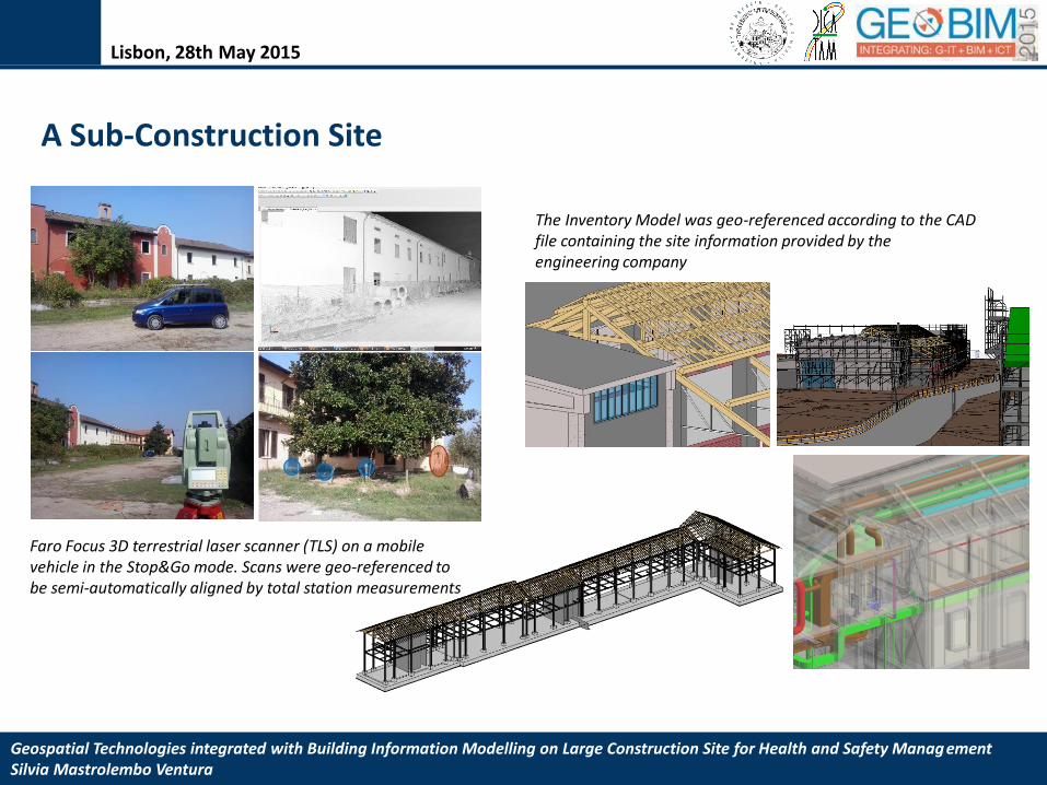
A Sub-Construction Site
Faro Focus 3D terrestrial laser scanner (TLS) on a mobile vehicle in the Stop&Go mode. Scans were geo-referenced to be semi-automatically aligned by total station measurements
The Inventory Model was geo-referenced according to the CAD file containing the site information provided by the engineering company

Geospatial Technologies integrated with Building Information Modelling on Large Construction Site for Health and Safety ManagementSilvia Mastrolembo Ventura
Lisbon, 28th May 2015
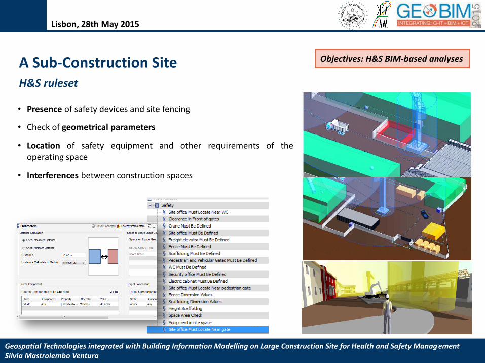
A Sub-Construction Site Objective: a health and safety database
Geospatial Technologies integrated with Building Information Modelling on Large Construction Site for Health and Safety ManagementSilvia Mastrolembo Ventura
Lisbon, 28th May 2015
• Presence of safety devices and site fencing
• Check of geometrical parameters
• Location of safety equipment and other requirements of theoperating space
• Interferences between construction spaces
A Sub-Construction Site Objectives: H&S BIM-based analyses
H&S ruleset
Geospatial Technologies integrated with Building Information Modelling on Large Construction Site for Health and Safety ManagementSilvia Mastrolembo Ventura
Lisbon, 28th May 2015
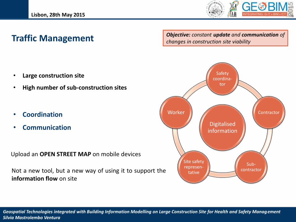
Upload an OPEN STREET MAP on mobile devices
Not a new tool, but a new way of using it to support theinformation flow on site
• Large construction site
• High number of sub-construction sites
Digitalisedinformation
Safetycoordina-
tor
Contractor
Sub-contractor
Site safetyrepresen-
tative
Worker• Coordination
• Communication
Traffic Management Objective: constant update and communication of changes in construction site viability

Geospatial Technologies integrated with Building Information Modelling on Large Construction Site for Health and Safety ManagementSilvia Mastrolembo Ventura
Lisbon, 28th May 2015
Traffic Managementtraditional process
Objective: constant update and communication of changes in construction site viability

Geospatial Technologies integrated with Building Information Modelling on Large Construction Site for Health and Safety ManagementSilvia Mastrolembo Ventura
Lisbon, 28th May 2015
Objective: constant update and communication of changes in construction site viabilityTraffic Management
Infomation Modelling

Geospatial Technologies integrated with Building Information Modelling on Large Construction Site for Health and Safety ManagementSilvia Mastrolembo Ventura
Lisbon, 28th May 2015
Traffic Management

Geospatial Technologies integrated with Building Information Modelling on Large Construction Site for Health and Safety ManagementSilvia Mastrolembo Ventura
Lisbon, 28th May 2015
Traffic Management Implementation of parameters

Geospatial Technologies integrated with Building Information Modelling on Large Construction Site for Health and Safety ManagementSilvia Mastrolembo Ventura
Lisbon, 28th May 2015
Traffic Management
The OSM resulted to be integrated with the road network of the urban context

Geospatial Technologies integrated with Building Information Modelling on Large Construction Site for Health and Safety ManagementSilvia Mastrolembo Ventura
Lisbon, 28th May 2015
Conclusions
Resource management
• The H&S coordinator remarked some failures in the information coming from the main contractorand asked for an improved data flow within the construction site
• BIM-based analysis of safety plans
Traffic management
• Update and share information about viability on site
Geospatial Technologies integrated with Building Information Modelling on Large Construction Site for Health and Safety ManagementSilvia Mastrolembo Ventura
Lisbon, 28th May 2015
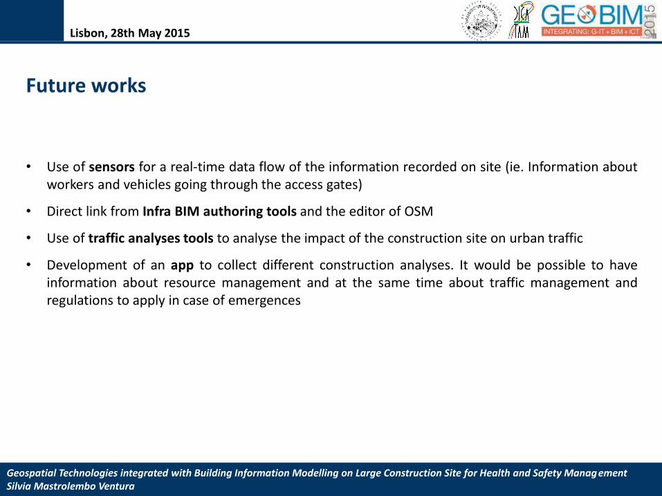
Future works
• Use of sensors for a real-time data flow of the information recorded on site (ie. Information aboutworkers and vehicles going through the access gates)
• Direct link from Infra BIM authoring tools and the editor of OSM
• Use of traffic analyses tools to analyse the impact of the construction site on urban traffic
• Development of an app to collect different construction analyses. It would be possible to haveinformation about resource management and at the same time about traffic management andregulations to apply in case of emergences

Silvia Mastrolembo Ventura
Building Engineer - Collaborator to Research Activities
University of Brescia – Department of Civil Engineering and Architecture (DICATAM), www.ing.unibs.it
@s_mastrolembo
Lisbon, 28th May 2015
@
Thank you