geospatial data sharing, online spatial … · this is indigenous geospatial data processing engine...
TRANSCRIPT

GEOSPATIAL DATA SHARING, ONLINE SPATIAL ANALYSIS AND PROCESSING OF
INDIAN BIODIVERSITY DATA IN INTERNET GIS DOMAIN- A CASE STUDY FOR
RASTER BASED ONLINE GEO-PROCESSING
Harish Karnatak*, Kamal Pandey, Kapil Oberai, Arijit Roy, Deepti Joshi, Hariom Singh, PLN Raju and YVN Krishna Murthy Indian Institute of Remote Sensing, Indian Space Research Organization, Department of Space, Govt. of India, Dehradun, [email protected]
Commission VIII, WG VI/4
KEYWORDS: Biodiversity, Services Oriented Architecture, OGC web services, GDAL/OGR, and Geo-processing
ABSTRACT:
National Biodiversity Characterization at Landscape Level, a project jointly sponsored by Department of Biotechnology and
Department of Space, was implemented to identify and map the potential biodiversity rich areas in India. This project has generated
spatial information at three levels viz. Satellite based primary information (Vegetation Type map, spatial locations of road & village,
Fire occurrence); geospatially derived or modelled information (Disturbance Index, Fragmentation, Biological Richness) and
geospatially referenced field samples plots. The study provides information of high disturbance and high biological richness areas
suggesting future management strategies and formulating action plans. The study has generated for the first time baseline database in
India which will be a valuable input towards climate change study in the Indian Subcontinent.
The spatial data generated during the study is organized as central data repository in Geo-RDBMS environment using PostgreSQL
and POSTGIS. The raster and vector data is published as OGC WMS and WFS standard for development of web base geo-
information system using Service Oriented Architecture (SOA). The WMS and WFS based system allows geo-visualization, online
query and map outputs generation based on user request and response. This is a typical mashup architecture based geo-information
system which allows access to remote web services like ISRO Bhuvan, Openstreet map, Google map etc., with overlay on
Biodiversity data for effective study on Bio-resources.
The spatial queries and analysis with vector data is achieved through SQL queries on POSTGIS and WFS-T operations. But the most
important challenge is to develop a system for online raster based geo-spatial analysis and processing based on user defined Area of
Interest (AOI) for large raster data sets. The map data of this study contains approximately 20 GB of size for each data layer which
are five in number. An attempt has been to develop system using python, PostGIS and PHP for raster data analysis over the web for
Biodiversity conservation and prioritization. The developed system takes inputs from users as WKT, Openlayer based Polygon
geometry and Shape file upload as AOI to perform raster based operation using Python and GDAL/OGR. The intermediate products
are stored in temporary files and tables which generate XML outputs for web representation. The raster operations like clip-zip-ship,
class wise area statistics, single to multi-layer operations, diagrammatic representation and other geo-statistical analysis are
performed. This is indigenous geospatial data processing engine developed using Open system architecture for spatial analysis of
Biodiversity data sets in Internet GIS environment. The performance of this applications in multi-user environment like Internet
domain is another challenging task which is addressed by fine tuning the source code, server hardening, spatial indexing and running
the process in load balance mode. The developed system is hosted in Internet domain (http://bis.iirs.gov.in) for user access.
1. INTRODUCTION
1.1 Biodiversity Characterization at landscape level
National Biodiversity Characterization at Landscape Level, a
project jointly sponsored by Department of Biotechnology and
Department of Space, was implemented to identify and map the
potential biodiversity rich areas in India (Roy et al, 2012). The
project has contributed to the scientific understanding,
characterizing and deciphering spatial patterns of Indian natural
vegetated ecosystems, their disturbance regimes and biological
richness. It provides spatial information on 120 vegetation types
consisting of natural, semi-natural and managed formations.
The database preparation was supported with phyto-sociological
data collected from geospatially located ~16,000 field sample
plots for ~7500 plant species (Roy et al, 2012). The geospatial
analysis of the data was done for different landscape metrics in
conjunction with disturbance, ecological uniqueness, species
diversity and economic value of different forest types assessed
using field plot data. The analysis resulted in geospatial
products providing spatial patterns on disturbance and
biological richness facilitating conservation prioritization.
According to Roy et al, 2012, the project has resulted in the
generation of information with the following end-use:
• Digital database on vegetation type distribution, the first of
its kind of systematically organized databases developed in
India, a basic input for identifying the species habitats and
would serve as benchmark for further biodiversity related
ecological studies.
• Disturbance Regimes assessed across the landscape flag as
the ‘stressed’ eco-systems and may highlight the causative
factors.
• Biological Richness maps (BR) lay emphasis on the areas,
which should be treated on priority while formulating the
strategies for conservation of biodiversity.
• National inventory of 7500 unique plant species recorded
during field sampling.
The International Archives of the Photogrammetry, Remote Sensing and Spatial Information Sciences, Volume XL-8, 2014ISPRS Technical Commission VIII Symposium, 09 – 12 December 2014, Hyderabad, India
This contribution has been peer-reviewed. doi:10.5194/isprsarchives-XL-8-1133-2014
1133
1.2 Biodiversity Information System
The spatial data generated in national project on Biodiversity
Characterization at landscape level is organized as central data
repository and published as Web GIS based Biodiversity
Information System (BIS) (http://bis.iirs.gov.in). The BIS is
developed based on Service Oriented Architecture (SOA) where
OGC web services are published for Geo-visualization and
spatial queries in Web GIS environment. The WMS and WFS
based system allows geo-visualization, online query and map
outputs generation based on user request and response. This is a
typical mashup architecture based geo-information system
which allows access to remote web services like ISRO Bhuvan,
Openstreet map, Google map etc., with overlay on Biodiversity
data for effective study on Bio-resources.
The BIS Geo-portal provides various GIS based services for
Biodiversity data sets. It has major two components for spatial
data sets and information services i.e. Biodiversity spatial
viewer and Data download facility. These GIS viewers are
developed using OpenLayer API and PHP. The rich GUI is
developed using GeoEXT. The major features of BIS include:
• Adoption of open system architecture for development and
deployment of the web services and database management.
• The national data spatial and non-spatial is organized as a
central repository for biodiversity of India.
• The data download utility using online clip-ship-zip facility.
The user can define AOI and can download original GIS layer
of vegetation type, Disturbance Index, Fragmentation and
Biological Richness map.
• Biodiversity Spatial Viewer for advance online GIS utilities
like: effective geo-visualization using map cache technique,
overlay of Bhuvan satellite imagery (56mt to 5.8 mt),
connection to remote GIS servers, adding user defined
servers, basic GIS navigation tools, area and distance
measurement, spatial filter, overlay of sample plot grid data
(with advanced filtering utility), layer swapping for effective
visualization, layer transparency, search places and search
species etc.
2. LITRATURE REVIEW
2.1 Online Geo-processing and Web service standards
Geoprocessing is a GIS operation used to manipulate spatial
data. A typical geoprocessing operation takes an input dataset,
performs an operation on that dataset, and returns the result of
the operation as an output. For online geospatial data
processing, Web Processing Service specification was released
in 2005 by Open Geospatial Consortium, that incorporate
complex spatial process through a standardized service interface
based on the Hypertext Transfer Protocol (HTTP) (Foerster and
Stoter, 2006). Karnatak et al., 2007 has developed Web GIS
based multicriteria decision analysis system for biodiversity
conservation and prioritization. The most popular multicriteria
technique AHP is used to select optimal alternative. The
developed SDSS is a typical example of web based GIS data
processing for decision analysis.
Some notable and updated OGC WPS specification
implementations are PyWPS, a project with GRASS-based
processing and R (Geostatistical computing) available to web
client (Cepicky and Becchi, 2007), 52 North WPS, ZOO open
WPS platform (Fenoy et al., 2013), the Deegree project is a Java
based framework for processing services and other striking
commercial solutions have been implemented such as ESRI
ArcGIS Server, ERDAS APOLLO 2010 etc (Evangelidis et al.,
2014). All the above said frameworks are based on SOA
implementation in which the developed services can be
accessed over a network and can be combined and reused in
web application. These services used for communication with
each other by exchanging data in a shared and well defined
format or managing activities between two or more services
(Bruin et al., 2014).
The WPS specification defines a mechanism by which a client
may submit a processing task to a server to be completed. The
service defines a server instance, or server, as an entity which
may provide one or more processes, or individual processing
tasks (e.g., adding two raster datasets together could be one
process) (Christopher et al., 2009). WPS basic properties are: 1)
Inputs can be web-accessible URLs or embedded in the request.
2) Outputs can be stored as web-accessible URLs or embedded
in the response. It supports multiple inputs and output formats
(Wikipedia WPS, 2013). It is a service on the web following a
SOA architecture where pre-programmed geospatial
computation models are available over a network. The SOA
model permits processes to be available in a transparent way,
independent of programming language and operating system.
The services describes a mechanism by which a client computer
may submit a job to be processed on a server computer, using
data provided as a WFS (Vector) or WCS (Raster). It is
client/server architecture, meaning that both a client component
and a server component are mandatory (Anthony et al., 2013 ;
Dubois et al., 2013 ) For implementation and testing purposes it
is useful to build the client-side application on a GIS to take
advantage of existing services or develop their own services
(Christopher et al., 2009).
Some important works have been done by using online
geoprocessing such as the shortest path between two points
(PML: Shortest path), systematic planning and cultivation of
agricultural fields (Bruin et al., 2014), ecological modeling and
forecasting, forecast the impact of climate change on protected
areas (Dubois et al., 2013) ,process geospatial data such as
NDVI calculation on different computing backend (Giuliani et
al., 2012 ), Geostatistical computing and INTAMAP: The
design and implementation of an interoperable automated
interpolation web service (Pebesma et al., 2011 ), thematic map
generation (Rautenbach et al., 2013 ) and Forecasting biomes of
protected areas (Skoien et al.,2011 ) etc.
3. APPROACH
The Geospatial data sharing, online spatial analysis and
processing of Indian Biodiversity data in web GIS environment
is achieved based on SOA architecture. The web service
specifications from OGC are implemented for centralized data
repository. The spatial queries and analysis with vector data is
achieved through Structured Query Language (SQL) using
POSTGIS and WFS-T operations. The vector data stored in
PostgreSQL is accessed through POSTGIS and presented as
WMS and WFS using Geoserver. But the development of geo-
processing engine for raster data analysis in Web GIS
environment is a major objective of this study. The
methodology adopted in the study is shown in Figure 1.
The International Archives of the Photogrammetry, Remote Sensing and Spatial Information Sciences, Volume XL-8, 2014ISPRS Technical Commission VIII Symposium, 09 – 12 December 2014, Hyderabad, India
This contribution has been peer-reviewed. doi:10.5194/isprsarchives-XL-8-1133-2014
1134

Figure1. Methodology of the study
The complete information flow from user input to presenting
output is shown in Figure 2.
Figure2. Information Flow
The study is based on three basic principles i.e. users input as
WKT and Shape File, GIS raster operations using GDAL/OGR
and presenting outputs as XML. The major steps involves:
3.1 Web Application:
The web application is developed using PHP, OpenLayer API
and GeoEXT. The web application has two components for GIS
related activities i.e. Biodiversity spatial viewer and Data
download facility. The biodiversity spatial viewer provides
WMS and WFS based web services, GIS data visualizations,
basic and advance queries with spatial filter
(http://bis.iirs.gov.in/maps.php).
3.2 User’s inputs:
This module is developed under data download category. The
user provides its inputs either as simple drawing over available
map viewer for Area of Interest (AOI) or uploading the
boundary of study area as simple Shape file. The system creates
a user session for each request which will be live till end of the
process.
3.3 Convert to POSTGIS Geometry:
The user’s inputs are converted as PostGIS geometry and stored
as a table in PostgreSQL. This will be the inputs to geo-
processing engine of the study.
3.4 Python module for raster based Geo-processing:
During this study a Python based software product for raster
data analysis is developed which is core of the geo-processing
engine. The GDAL/OGR library for python is used for reading
and writing of raster and vector data.
3.5 Generate Geo-statistical outputs as XML:
The geo-processing engine developed for this study provides the
facility to do geo-statistical analysis in multi-user environment.
The intermediate products are stored in temporary files and
tables which generate XML outputs for web representation. The
raster operations like clip-zip-ship, class wise area statistics,
single to multi-layer operations, diagrammatic representation
and other geo-statistical analysis are performed. This is
indigenous geospatial data processing engine developed using
Open system architecture for spatial analysis of Biodiversity
data sets in Internet GIS environment.
3.6 Present outputs as report, tables, chart and GIS data
format to the user:
The module generates the outputs in the form of HTML reports,
tables, charts and subset of raster data as .tiff and .img files.
4. RESULTS AND DISCUSSION
The geo-spatial data generated under national level project on
Biodiversity Characterization at landscape level using RS&GIS
is disseminated through web GIS based Biodiversity
Information System (http://bis.iirs.gov.in). The system provides
various facilities to access and analysed the biodiversity data for
effective conservation planning. The system provides data
visualization and query system under Biodiversity spatial
viewer (Figure 3)
Figure 3- Biodiversity Spatial viewer.
The Biodiversity spatial viewer provides access to GIS layers
from central and distributed servers. For example the satellite
data from ISRO Bhuvan portal as WMS service is accessible.
The basic layers are available in layer tree and additional layers
can be added by the user. WFS based query builder is developed
for sample plot data set which allows to perform various queries
on vector data sets in web browser environment (Figure 4). The
Layer swiping tool for WMS is also developed as part of geo-
Geo-RDBMS Biodiversity File Server
Database Server
GIS Server
OGC Web ServicesWMS
WFS
WFS-T
Apache Server
BIS Application Server (PHP, Java,
OpenLayer and GeoEXT based app.
Raster Geo-Processing Engine
Statistical Outputs (XML) +
Extracted raster Data (TIFF/IMG)
Tomcat Server
Web Server
Geo-Visualization and Queries Raster Data Operations
Web
Application
Draw AOI using OpenLayer API or upload Shape File
Convert to POSGT GIS Geometry
Read PG data using GDAL/OGR and Python
Python module for raster based Geo-
processing
Generate Geo-statistical outputs
Publish Output as XML
Present outputs as report, tables, chart and GIS data
format to the user
User S
essio
n
The International Archives of the Photogrammetry, Remote Sensing and Spatial Information Sciences, Volume XL-8, 2014ISPRS Technical Commission VIII Symposium, 09 – 12 December 2014, Hyderabad, India
This contribution has been peer-reviewed. doi:10.5194/isprsarchives-XL-8-1133-2014
1135
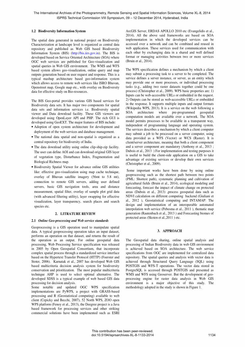
visualization. The implementation for mashup based
architecture for geo-information services provides unique
capability to accessing multiple data and information services
from remote servers. This also allows an interoperable solution
for information overlay in GIS environment.
Figure 4- Species queries and geo-tagging
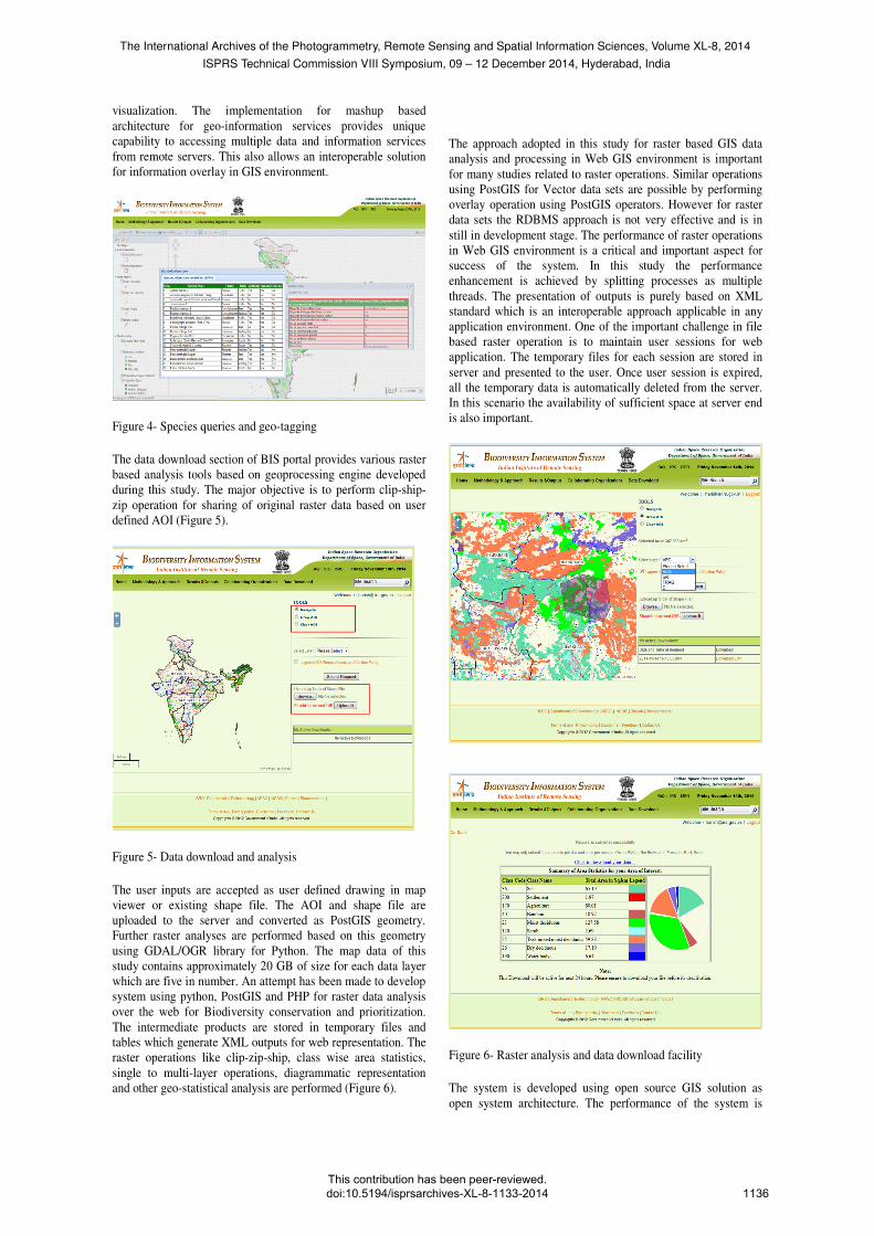
The data download section of BIS portal provides various raster
based analysis tools based on geoprocessing engine developed
during this study. The major objective is to perform clip-ship-
zip operation for sharing of original raster data based on user
defined AOI (Figure 5).
Figure 5- Data download and analysis
The user inputs are accepted as user defined drawing in map
viewer or existing shape file. The AOI and shape file are
uploaded to the server and converted as PostGIS geometry.
Further raster analyses are performed based on this geometry
using GDAL/OGR library for Python. The map data of this
study contains approximately 20 GB of size for each data layer
which are five in number. An attempt has been made to develop
system using python, PostGIS and PHP for raster data analysis
over the web for Biodiversity conservation and prioritization.
The intermediate products are stored in temporary files and
tables which generate XML outputs for web representation. The
raster operations like clip-zip-ship, class wise area statistics,
single to multi-layer operations, diagrammatic representation
and other geo-statistical analysis are performed (Figure 6).
The approach adopted in this study for raster based GIS data
analysis and processing in Web GIS environment is important
for many studies related to raster operations. Similar operations
using PostGIS for Vector data sets are possible by performing
overlay operation using PostGIS operators. However for raster
data sets the RDBMS approach is not very effective and is in
still in development stage. The performance of raster operations
in Web GIS environment is a critical and important aspect for
success of the system. In this study the performance
enhancement is achieved by splitting processes as multiple
threads. The presentation of outputs is purely based on XML
standard which is an interoperable approach applicable in any
application environment. One of the important challenge in file
based raster operation is to maintain user sessions for web
application. The temporary files for each session are stored in
server and presented to the user. Once user session is expired,
all the temporary data is automatically deleted from the server.
In this scenario the availability of sufficient space at server end
is also important.
Figure 6- Raster analysis and data download facility
The system is developed using open source GIS solution as
open system architecture. The performance of the system is
The International Archives of the Photogrammetry, Remote Sensing and Spatial Information Sciences, Volume XL-8, 2014ISPRS Technical Commission VIII Symposium, 09 – 12 December 2014, Hyderabad, India
This contribution has been peer-reviewed. doi:10.5194/isprsarchives-XL-8-1133-2014
1136

tested for 100 concurrent virtual users performing raster
operations for ~10,000 square km for different geographical
locations. In LAN environment (100 Mbps) the output was
generated within 12 second and in internet environment (10
Mbps) the output was generated within 20 second.
5. CONCLUSION
The geo-spatial data generated under national level project on
Biodiversity Characterization at landscape level using RS&GIS
for Indian is disseminated through Web GIS based Biodiversity
Information System (http://bis.iirs.gov.in). The BIS portal
provides geo-visualization with various basics and advanced
tools, data download and analysis for raster data using clip-ship-
zip operation as open system architecture. The study
demonstrates use of Python, GDAL/OGR and PostGIS for
online raster based geo-processing in multi-user environment.
The same approach can be used for development of online
spatial analysis and modelling system for any theme. Further,
the performance of the system can be improved by including
cluster computing environment like HPC for larger areas.
ACKNOWLEDGEMENT
Authors express their gratitude to Chairman, Indian Space
Research Organisations (ISRO) for motivation and
encouragements. Thanks to Dr. P.S. Roy Former Director IIRS,
Dr. SPS Kushwaha Head FED and GD PPEG, Dr. Sarnam
Singh PC CSSTEAP for their guidance and support. Authors
also express their thanks to Dr. S.K. Srivastav Head
Geoinformatics Department IIRS for his critical observations
and suggestions.
REFERENCES
Anthony, M., Castronova, Jonathan, L., Goodall, Mostafa, M.
and Elag. (2013). Model as web services using the Open
Geospatial Consortium (OGC) Web Processing Service (WPS)
standard. Environmental Modelling & Software, Vol. 41, pp.72-
83.
Bruin, S.D., Lerink, P., La Riviere, I.J. and Vanmeulebrouk, B.
(2014). Systematic planning and cultivation of agricultural
fields using a geo-spatial arable field optimization services:
Opportunities and obstacles. Biosystems engineering, I 20,
pp.15-24.
Cepicky, J. and Becchi, L. (2007). Geospatial processing via
Internet on remote servers– PyWPS. OSGeo Journal, Vol. 1, pp.
39-42. http://osgeo.org/journal. (Accessed 17.01.14).
Christopher D. Michaelis and Daniel P. A. (2009). Evaluation
and Implementation of the OGC Web Processing Service for
Use in Client-Side GIS. Geoinformatica, Vol. 13, pp.109–120.
Dubois, G., Schulz, M., Skoien, J., Bastin, L. and Peedell, S.
(2013). eHabitat, a multi-purpose Web Processing Services for
ecological modeling. Environmental Modelling & Software,
Vol. 41, pp.123-133.
Evangelidis, K., Ntouros, K. and Makridis, S. (2014).
Geospatial services in the cloud. Computers & Geosciences,
Vol. 63, pp.116-122.
Fenoy, G., Bozon, R. and Raghavan, V. (2013). ZOO-project:
The open WPS platform. Applied Geomatics, Vol. 5, pp.19-24.
Foerster, T. and Stoter, J. (2006). Establishing an OGC Web
Processing Service for generalization processes. In: Workshop
of the ICA Commission on Map Generalisation and Multiple
Representation.
Giuliani, G., Nativi, S., Lehmann, A. and Ray, N. (2012). WPS
mediation: An approach to process geospatial data on different
computing backends. Computers & Geosciences, Vol. 47,
pp.20-33
Karnatak Harish Chandra, Sameer Saran, Karamjit Bhatia and
P.S. Roy, (2007) “Multicriteria Decision Analysis in web GIS
environment”, Geoinformatica (2007) 11: pp 407-429: DOI
10.1007/s10707-006-0014-8.
Pebesma, E., et al. (2011). INTAMAP: The design and
implementation of an interoperable automated interpolation web
service. Computer & Geosciences, Vol. 3, pp. 343-352.
Roy PS, Karnatak Harish, Kushwaha SPS, Roy A, Saran S
(2012), " India's plant diversity database at landscape level on
geospatial platform: prospects and utility in today's changing
climate", Current Science, Vol 102, Issue 8, pp 1136-1142.
Rautenbach, V., Coetzee, S. and Iwaniak, A. (2013).
Orchestrating OGC web services to produce thematic maps in a
spatial information infrastructure. Computers, Environment and
Urban Systems, Vol. 37, pp.107-120.
Skoien, J.O., Dubois, G. and Jesus, J.D. (2011). Forecasting
biomes of protected areas, Procedia Environmental Sciences,
Vol. 4, pp. 44-49.
Wikipedia, WPS,
http://en.wikipedia.org/wiki/Web_Processing_Service
(Accessed, 12.04.14)
The International Archives of the Photogrammetry, Remote Sensing and Spatial Information Sciences, Volume XL-8, 2014ISPRS Technical Commission VIII Symposium, 09 – 12 December 2014, Hyderabad, India
This contribution has been peer-reviewed. doi:10.5194/isprsarchives-XL-8-1133-2014
1137