geospatial data coordination implementation guide · 2 introduction ... 4.1 gdc business process...
TRANSCRIPT

Geospatial Data Coordination Implementation Guide
Geospatial Data Coordination Implementation Guide
Version 3, January 2011

Geospatial Data Coordination & Standardization Team
ii Version 2.2, March 2008
Document Management History
Document Location Location: Geospatial Coordination page, Risk Map Portal
File Path: http://pm.riskmapcds.com/riskmap_usergroups/GeoCoord/Shared%20Documents/GeoDataImplem.docx
Revision History Version Number Version Date Summary of Changes Team/Author
1.0 October 2010 Original document Sue Hoegberg, Scott Anderson, Josh Price, Jeff Burm
2.0 November 2010 Update to reflect Risk Map Jeff Burm
3.0 December 2010 Further updates to reflect Risk Map Scott Eller, Paul Rooney, Andrew Freese
4.0 January 2011 Further updates to reflect Risk Map Scott Eller, Paul Rooney, Andrew Freese
Client Distribution Name Title/Organization Location
Paul Rooney Mapping Technology Specialist/FEMA
Boston, MA

Geospatial Data Coordination Implementation Guide
Table of Contents Document Management History ..................................................................................ii
Document Location......................................................................................................ii
Revision History ..........................................................................................................ii
Client Distribution .......................................................................................................ii
1 Acronyms and Terms Defined ............................................................................................... iii
2 Introduction ..............................................................................................................................1
2.1 Geospatial Data Coordination Goals and Policy..........................................................1
2.2 Geospatial Data Coordination Process Overview........................................................2
2.3 Roles and Responsibilities ...........................................................................................4
2.4 Geospatial Data Coordination Implementation Guide.................................................6
Implementation Guide Audience .................................................................................7
Implementation Guide Versioning...............................................................................8
Implementation Guide Maintenance............................................................................8
3 Flood Risk Project Coordination Activities .............................................................................9
3.1 Identify Existing and Needed Data ............................................................................11
Step 1 – Follow the State Geospatial Data Coordination Procedure .........................12
Step 2 – Find Available Data .....................................................................................13
Step 3 – Select Data to be Evaluated and Share this Information..............................18
3.2 Obtain and Evaluate Data ..........................................................................................19
Step 1 – Order and Receive the Data .........................................................................19
Step 2 – Check and Document the Data ....................................................................20
3.3 Finalize Existing Data and New Data for Project ......................................................21
Step 1 – Document Project Decisions........................................................................21
Step 2 – Load the Data and Metadata and Enter Leverage Information ....................22
3.4 Procure New Data ......................................................................................................22
Step 1 – Follow FEMA’s Policies on Procuring New Data.......................................24
Version 3, January 2011 i

Geospatial Data Coordination National Team
Step 2 – Build Partnerships to Share Costs of New Data ..........................................24
3.5 Acquire, Integrate and Load Finished Data ...............................................................25
4 Enterprise Coordination Activities.........................................................................................27
4.1 GDC Business Process Implementation Goals ..........................................................27
4.2 Change Management Plan .........................................................................................27
Annual Meeting .........................................................................................................27
Additional Training....................................................................................................27
Communications ........................................................................................................28
4.3 Maintain Resources for Flood Risk Projects..............................................................28
Receive Changes, and Update and Post State Geospatial Data Coordination Procedures..................................................................................................................29
Receive Changes, and Update and Post National Resources.....................................30
4.4 Monitor Posted Metadata Related to Flood Risk Projects .........................................30
4.5 Monitor and Control Compliance of Projects ............................................................31
4.6 Report Benefits of Coordination Activities ...............................................................32
Semiannual Geospatial Data Coordination Report Compilation ...............................33
5 References ..............................................................................................................................35
Appendix A. Summary of Base Map and Elevation Data and Related Metadata .........................38
Base Map Data .......................................................................................................................38
Starting Point for a Base Map: Vector and Raster Options ......................................39
Completing the Base Map..........................................................................................40
Elevation Data ........................................................................................................................41
Metadata .................................................................................................................................42
Appendix B. FEMA Policies on Procuring New Data ..................................................................44
Policy for New Base Map Data..............................................................................................44
Policy for New Elevation Data...............................................................................................45
ii Version 3, January 2011

Geospatial Data Coordination Implementation Guide
1 Acronyms and Terms Defined AAL – Average Annualized Loss
“base map” – a spatially accurate map that shows the georeferenced location of geographic features. These features include roads and railroads, streams and lakes, boundaries, other geographic features, and related names and labels. Most base maps are created today using orthoimagery, which are aerial photographs processed to have the spatial accuracy of a map.
CIS – Community Information System
CLICK – Center for LIDAR Information Coordination and Knowledge
CNMS – Coordinated Needs Management Strategy
CTP – Coordinating Technical Partner
FIRM – Flood Insurance Rate Map
“elevation data” – In this context, the term refers to datasets that identify the height of the ground at specific locations. These datasets are a component of the models that determine where water flows and what the water surface elevation will be for specific floods. The density of points in the collection may vary based on the needs of the data collector. LIDAR is the most common technique for FEMA’s elevation data acquisition. Also referred to as “topographic data” and “topo”
FEMA – Federal Emergency Management Agency
FGDC – Federal Geographic Data Committee
GDC National Team – Geospatial Data Center (GDC) National Team is responsible for coordinating effort at the national level, including GDC compliance enforcement, GDC Web site development and maintenance, regular GDC maintenance reports, and semi-annual reporting, as of this publication, the team consists of PM and three PTS representatives, with the FEMA team lead.
GOS – Geospatial One Stop
LIDAR – Light Detection and Ranging
MIP – Mapping Information Platform
MAS – Mapping Activity Statement
NDEP – National Digital Elevation Program
NDOP – National Digital Orthophoto Program
NED – National Elevation Dataset
Version 3, January 2011 iii

Geospatial Data Coordination National Team
iv Version 3, January 2011
NFIP – National Flood Insurance Program
NOAA – National Oceanic and Atmospheric Administration
OFA – Other Federal Agencies
Orthoimagery, orthophotography – see “base map”
RSC – Regional Support Center
SOP – Standard Operating Procedure
SOW – Statements of Work
“topographic data” – see “elevation data”
TSDN – Technical Support Data Notebook

Geospatial Data Coordination Implementation Guide
2 Introduction
2.1 Geospatial Data Coordination Goals and Policy The Department of Homeland Security’s Federal Emergency Management Agency (FEMA) Geospatial Data Coordination Policy (Maurstad, 2005) establishes the principles for coordinating, communicating, documenting, and reporting existing and proposed geospatial data collected, produced, or manipulated under the FEMA Risk Map Program.
The goals of the Policy are to help ensure that the Risk Map Program will:
Protect its investments in geospatial data by requiring data to be documented, comply to standards, and be easily accessible to the general public;
Maximize the use of partnerships, including Federal, State, and local partners, for the acquisition and production of geospatial data;
Minimize duplicative requests from Federal agencies to State and local data stewards and use existing data when possible;
Recognize the value of existing coordination efforts at the State and local levels; and
Comply with all Federal requirements for coordination and reporting of geospatial activities.
These goals are derived from FEMA’s desire:
To be thrifty with geospatial data. The majority of the resources of the program are dedicated to flood mapping and not to the development of underlying base map, elevation, and other geospatial data. Reuse existing data, minimize duplication, and create new data only when necessary, and when doing so partner with others to reduce costs and increase the area of acquisition. The avoidance of duplication of existing data and the use of the best available data are critical to managing FEMA’s production budget and demonstrating proper stewardship of the funds expended. This enables FEMA to expend resources on areas with significant risk that do not have existing elevation data.
For partnerships to achieve the short- and long-term goals of the program. FEMA seeks to develop relationships that support the immediate Risk Map program and continual, longer-term maintenance of the data. Respect existing coordination efforts at the State and local government levels, minimize requests for State and local information that duplicate those of other Federal agencies, and maximize partnerships when creating new data.
To manage geospatial data as an investment by and asset of the American people. The last four Presidents and the Department of Homeland Security have specified minimum requirements for good management of federally sponsored geospatial activities, and most states and many communities have similar policies and coordination activities. Document data, make sure that the
Version 3, January 2011 1

Geospatial Data Coordination National Team
data comply with standards, and make them readily accessible to the public; and comply with Federal requirements for coordination and reporting.
2.2 Geospatial Data Coordination Process Overview At the high level, the coordination process begins with prioritization and sequencing. As the FEMA Regions identify potential projects, this information is shared through the NDEP & NDOP partnership and through the Geospatial One-Stop (GOS.) These are activities at the National level that work to coordinate mapping activities across Federal, State, and local government. The primary tool for coordinating projects through NDEP and GOS is the NDEP project tracking tool. An initial entry will be created in the NDEP tracker by the GDC National team based on the sequencing data. As projects move through Discovery, it is the responsibility of the mapping partners involved to keep the NDEP tracker information up-to-date with project plans. Leverage, in the form of geospatial data provided by Federal, State, and local partners, is recorded in the Acquire Base Map and Develop Topographic Data MIP workflow steps and the input geospatial data sets and final versions used on the project are submitted to the MIP for management and archive at the completion of these tasks.
Geospatial data coordination activities usually occur during Discovery and Data Development phases of a Flood Risk Project. In addition to using the NDEP Web-based project system for coordinating, there is significant person-to-person coordination as well. Nationally, the NDEP holds a project coordination meeting at the beginning of the federal fiscal year for the national agency leads to review projects across agencies and discuss the best mechanisms to coordinate across agencies. Most of the real decision-making takes place at the state, regional or district level where individual agency operating units (e.g. FEMA Regions, NRCS State offices, USACE Districts) identify partnerships that meet specific mission requirements.
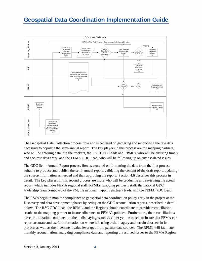
The following diagram illustrates the GDC Data Collection workflow, giving a visual rendering of GDC data collection process step-by-step, identifying the players involved.
2 Version 3, January 2011
Geospatial Data Coordination Implementation Guide
GDC Data Collection
RS
CR
PM
LF
EM
AM
app
ing
Par
tner
Enter Data into NDOP/NDEP
Tracker6
Decide ortho and elevation data sources
for project4
Compare NDOP/NDEP, MIP Tasks, and Exception Data to provide feedback
(monthly)8
Data Entered?
9
Follow up with Mapping Partner
10b
No
Yes End
Search for or Acquire New
Data per Implementation
Guide3
MIP Work Flow Task Updates – Enter leverage for Ortho and Elevation
(Follow Up with Mapping Partner)
10a
TrackerData Entry/
Update Necessary?
5
Exception Data Entry Solution
7a
No
YesCTP or
PTS/IDIQ?
PTS/IDIQ
Exception Data Entry Solution
7b
CTP
GD
C N
atio
nal
Te
am
Coming out of sequencing,
document initial geodata plans in
the NDEP&NDOP Trackers
2
Sequence elevation projects
1
The Geospatial Data Collection process flow and is centered on gathering and reconciling the raw data necessary to populate the semi-annual report. The key players in this process are the mapping partners, who will be entering data into the trackers, the RSC GDC Leads and RPMLs, who will be ensuring timely and accurate data entry, and the FEMA GDC Lead, who will be following up on any escalated issues.
The GDC Semi-Annual Report process flow is centered on formatting the data from the first process suitable to produce and publish the semi-annual report, validating the content of the draft report, updating the source information as needed and then approving the report. Section 4.6 describes this process in detail. The key players in this second process are those who will be producing and reviewing the actual report, which includes FEMA regional staff, RPMLs, mapping partner’s staff, the national GDC leadership team composed of the PM, the national mapping partners leads, and the FEMA GDC Lead.
The RSCs begin to monitor compliance to geospatial data coordination policy early in the project at the Discovery and data development phases by acting on the GDC reconciliation reports, described in detail below. The RSC GDC Lead, the RPML, and the Regions should coordinate to provide reconciliation results to the mapping partner to insure adherence to FEMA's policies. Furthermore, the reconciliations have prioritization component to them, displaying issues as either yellow or red, to insure that FEMA can report accurate and useful information on where it is using orthoimagery and terrain data sets in its projects as well as the investment value leveraged from partner data sources. The RPML will facilitate monthly reconciliation, analyzing compliance data and reporting unresolved issues to the FEMA Region
Version 3, January 2011 3

Geospatial Data Coordination National Team
and RSC GDC Lead. National issues will be elevated to the PM National Team for review and recommended solutions to the FEMA GDC Lead.
The GDC National Team will provide regular updates and notifications about geospatial coordination resources and activities to the RSC GDC Leads, RPMLs, and other interested parties. Internally, the quarterly GDC National Team conference call can be used as a forum to review reconciliation summaries, draft geospatial coordination reports, and gather feedback and guidance from the FEMA GDC lead. Summaries of the reconciliation result may also be shared at the National level through the main Risk Map Conference call and/or other mechanisms to emphasize the importance and allow the Regional Management staff to see how their performance compares with others.
2.3 Roles and Responsibilities This section identifies the Geospatial Data Coordination process actors and their roles and responsibilities, as diagramed in the Geospatial Workflow Diagram located on the portal. (http://pm.riskmapcds.com/riskmap_usergroups/GeoCoord/Shared%20Documents/GDC%20Workflow%20Diagram%20v4.pdfx)
Mapping Partner Responsibilities (see Flood Risk Project Coordination Activities)
Have procedures to insure coordination with Federal, State and local partners that minimizes duplication of other coordination efforts. Mapping partner’s procedures should be integrated with FEMA Regional staff coordination activities
Coordinate acquisition of new data with potential partners as early as possible
Report any new ortho or elevation data produced plus and State or local ortho or elevation used on mapping projects through the NDEP and NDOP tracking systems.
Report information as soon as decision is made regarding the data to be used for the project regardless of when decision is made.
Report the value of ortho and elevation data obtained from other sources – i.e., “Leverage” - in the MIP workflow.
Notify RSC GDC Lead of changes to state coordination
RSC GDC Lead Responsibilities
Oversee that MIP projects have GDC-related leverage entries, or are otherwise identified as exception projects
Oversee that MIP projects have corresponding NDEP & NDOP Tracker entries, or are otherwise identified as exception projects
4 Version 3, January 2011

Geospatial Data Coordination Implementation Guide
Monitor geospatial data coordination efforts, utilizing the reconciliation reports on a periodic basis (at least monthly.)
Ensure mapping partner’s best efforts to meeting GDC goals.
Review the draft semi-annual report for accuracy.
Address issues highlighted by the FEMA Region or designee.
Maintain state specific coordination documentation, provided by Mapping Partner and other sources.
Escalate national issues to the appropriate PTS National Lead, copying the GDC National Team.
RPML Responsibilities
In coordination with the FEMA Region, responsible for ensuring that MIP projects contain the full set of GDC-related tasks, or are otherwise identified as exception projects. Actual MIP data entry is the responsibility of the MIP Champions, or their delegates.
Enforce the implementation of geospatial coordination processes in their respective regions
o Review the three reconciliation reports - task, Tracker, and leverage - on a periodic basis (at least monthly)
o Respond to issues in the reconciliation reports on a priority basis – red, then yellow
o Follow issue to resolution with the party responsible for the particular report topic (could be the RPML him/herself.)
o When resolution is not forthcoming, escalate to the FEMA Region, copying the GDC National Team
PTS National Leads
Ensure all PTS staff involved in discovery, base map, develop topo tasks and other related activities are aware of their responsibilities, are trained, and comply.
Elevate unresolved issues to the PM National Team.
Insure that GDC related effort is billed appropriately to production and standard operations task orders. Coordination, leverage data entry, project tracker entries, documentation, and upload of data to the MIP are scope assigned to production task orders. Coordination with the PM on monthly reconciliation and semi-annual reports, follow-up with those responsible for missing data entries, escalation of issues and maintenance of State SOPs are standard operations scope.
PM National Team Responsibilities
Version 3, January 2011 5

Geospatial Data Coordination National Team
Provide leadership for implementation of geospatial coordination processes across the program.
Compile semi-annual coordination report and circulate for review.
Finalize and publish semi-annual report.
Maintain national coordination documentation and tools and integrate geospatial coordination requirements into standard program practices
GDC National Team
Meet quarterly to discuss the current status of the GDC effort. Recommend and implement national GDC policy changes.
Review the Draft Semi-Annual Report.
Discuss national level issues and propose resolutions.
FEMA Regional Responsibilities
Lead / support geospatial coordination with federal, State, and local partners in the Region.
Insure that mapping partners’ task orders contain geospatial coordination requirements
Ensure that MIP projects contain the full set of GDC-related tasks
Coordinate follow-up on monthly reconciliation reports.
Review and approve regional content for semi-annual reports.
Coordinate with RPML and mapping partners on regional roles for geospatial coordination monitoring.
FEMA GDC Lead
FEMA Headquarters sponsor and expert on all Geospatial Data Coordination efforts.
DHS COTR on all Geospatial Data Coordination efforts.
Lead/support geospatial coordination with Federal, State, and local partners throughout the nation.
Approves solutions to national level issues.
2.4 Geospatial Data Coordination Implementation Guide To achieve the goals of the Policy, the Geospatial Data Coordination Implementation Guide (hereafter referred to as the Implementation Guide) defines a process and provides guidance on how to coordinate
6 Version 3, January 2011

Geospatial Data Coordination Implementation Guide
with Federal, State, and local governments for base map, elevation, and other geospatial data, and to document and report these geospatial data collections, to support Flood Risk Projects.
The Implementation Guide describes the processes needed to support the reliable maintenance of the Web based coordination systems, capture the important geospatial data and metadata for FEMA operations and reporting and guide the coordination with partners to maximize opportunities for data sharing and collaboration and minimize the burden on state and local geospatial staff.
Each process in the Implementation Guide is described using the following outline:
Task(s): The activity to be conducted.
Resources: Information to be used in the task.
Anticipated outcome(s): The new information to be known or processes to be completed at the end of the task.
Responsible organization(s): The organization that should perform the task.
Problems (optional): Sources of additional information about the task.
Reminder(s) (optional): Additional notes about the task
This document is available at https://hazards.fema.gov/femaportal/docs/GeoDataImplem.pdf.
Implementation Guide Audience Section 3 of the Implementation Guide, FLOOD RISK PROJECT COORDINATION ACTIVITIES, provides guidance to organizations responsible for identifying, developing or acquiring, and inspecting base map, elevation, and other geospatial data used in Flood Risk Projects. Because the assignment of responsibilities can vary among FEMA regions, organizations that might have these responsibilities include the FEMA regions, Regional Support Centers (RSC), Cooperating Technical Partners (CTP), and mapping contractors. Flood risk project leads must ensure that project participants clearly understand their responsibilities to achieve the outcomes described in the Implementation Guide.
In addition, FEMA Regional personnel will find the Implementation Guide helpful in their efforts to oversee FEMA’s partner's and contractor's compliance with the Policy.
Section 4,
Version 3, January 2011 7

Geospatial Data Coordination National Team
8 Version 3, January 2011
ENTER
Data C
The Im
ial Data Coordination Policy (Maurstad, 2005). The Policy is available
PRISE COORDINATION ACTIVITIES, describes enterprise responsibilities of RSCs and the Geospatial oordination National Team.
plementation Guide:
Supports FEMA’s Geospatat https://hazards.fema.gov/femaportal/docs/GeoDataCoord.pdf.
References FEMA’s Guidelines and Specifications for Flood Hazard Mapping Partners and procedure memoranda (e.g. Procedure Memorandum No. 61—Standards for LIDAR and Other High Quality Digital Topo
related
graphy (2010)) (hereafter referred to as G&S). The G&S is available at http://www.fema.gov/plan/prevent/fhm/dl_cgs.shtm. Although some sections of the Implementation Guide summarize procedures and specifications contained in the G&S, this document is not meant to be used as a substitute. The G&S is the comprehensive reference for
References FEMA’s National Flood Insurance Program (NFIP) metadata profiles (U.S. Department
https://hazards.fema.gov
flood map specifications.
of Homeland Security, 2006a). The profiles are available though the Mapping Information Platform (MIP) Web site. Start at and follow the links Tools & Links, and
ple, contact information and fact sheets) on the MIP
Implementation Guide Versioning This document is Version 3 of the Implementation Guide. This document has been updated to reflect the processes being used under FEMA’s Risk MAP program.
Subsequent versions will be released in conjunction with changes to the MIP, related procedures, or new resources available to coordination tasks.
Implementation Guide Maintenance The GDC National Team wrote and maintains this document.
then Metadata Profiles.
References positional accuracy and metadata standards developed by the Federal Geographic Data Committee (FGDC) (1998a and 1998b).
References related activities of the National Digital Elevation Program (NDEP) and the National Digital Orthophoto Program (NDOP).
References national FEMA resources (for examthat support Flood Risk Projects.

Geospatial Data Coordination Implementation Guide
3 Flood Risk Project Coordination Activities
In Flood Risk Projects, geospatial data coordination results in the identification and acquisition of geospatial data, especially base map and elevation data, essential to the projects. It takes advantage of existing data, and, when new data are needed, forms partnerships between stakeholders to share the costs of collecting new data. Coordination reduces costs, speeds production, and garners good will. In addition to helping the projects, these procedures ensure that FEMA complies with government-wide instructions that agencies search for existing data before procuring or developing new data.
Figure 1. Procurement Guidance Coordination Activities and Relationships
These tasks are not additional work for the project, but integral parts of a project that help it be successful. These activities should be integrated with the normal Project Planning, Discovery, Data Development, and project Monitoring & Controlling processes during which participants develop the overall plan for the project and a consensus on the project approach, and perform data development tasks, especially the development of topographic (elevation) data and acquisition of base map data. They are reflected in Mapping Activity Statements (MAS) for CTPs and Statements of Work (SOW) for Contractors and Other Federal Agencies (OFA), and the new G&S Appendix I: Discovery. In general, any costs of complying with the requirements in section 3 of this guide must be included in regional production task orders and are not appropriate for charging to standard operations task orders.
Flood risk project leads must ensure that participants clearly understand their responsibilities to achieve the outcomes described in the Implementation Guide. Often, the Implementation Guide identifies responsibilities for Mapping Partners performing Discovery. In cases where the normal Discovery process is not followed or where geospatial data coordination, identification, acquisition or gathering from existing sources take place outside of Discovery, whatever partner searches for and identifies the base
Version 3, January 2011 9

Geospatial Data Coordination Implementation Guide
map and topographic data for the project is responsible for completing these tasks. In addition, the partner responsible for base map acquisition and topographic data acquisition tasks is responsible for the achieving the implementation guide outcomes if they have not been accomplished prior to those tasks.
This section assumes that the reader is familiar with the minimum criteria for content, currentness, accuracy, and other criteria for base map and elevation data used in the Flood Risk Project. APPENDIX A of this document provides an overview of these criteria, and identifies sources of more detailed information. This section also assumes that the reader is familiar with FEMA’s policies on sharing and collecting new data. Please see APPENDIX B of this document for more information.
Although base map (especially orthophotos) and elevation data receive special attention in the Implementation Guide, the coordination process in this section should be followed for other themes of geospatial data required by the project.
The general process for geospatial data coordination is shown in below.
10 Version 3, January 2011

Geospatial Data Coordination Implementation Guide
Figure 2. Overview of the geospatial data coordination process during a Flood Risk Project.
3.1 Identify Existing and Needed Data The availability of pertinent data, including high-quality elevation data, factors into the prioritization process by virtue of enabling projects to be initiated more quickly and without having to wait for further data acquisition. Once project areas have been prioritized, further identification and evaluation of
Version 3, January 2011 11

Geospatial Data Coordination Implementation Guide
available elevation data should be conducted before any elevation data acquisition is initiated. This identification and evaluation should normally be performed as part of the Discovery phase. This section provides guidance on identifying existing elevation data sources.
This activity identifies the best geospatial data available for use by FEMA Mapping Partners in accomplishing project tasks, gains consensus among project participants on the choice of data to be used, and documents plans to use the selected data and to procure new data. Such efforts should be as exhaustive as possible to help inform decisions about the scope of the project. This need is especially true for elevation data; elevation data are critical for Flood Risk Projects and all sources should be explored. Where Discovery will be performed for multiple projects in the same state during the same fiscal year, these activities should be consolidated across projects to the maximum extent possible to minimize the burden on partners.
The steps outlined in this section are normally completed during Discovery. If for some reason they are not, they must be performed during other project planning, initiation activities, or during the base map acquisition and topographic data development phases of a Flood Risk Project.
For many projects, acquisition of new elevation data may be needed. Many of the Federal, state and local organizations that mapping partners will interact with while identifying existing data may also be interested in partnering on the acquisition of new elevation data. While coordinating with these organizations, it is always a good idea to cultivate potential partnerships for new data acquisition.
Step 1 – Follow the State Geospatial Data Coordination Procedure FEMA has documented a Geospatial Data Coordination Procedure, sometimes called the “State SOP” (standard operating procedure), for each state. Prepared in cooperation with each state’s geospatial data coordinator, the procedures outline sources of the best available geospatial data and contact information, preferences for base map data and state geospatial participation in projects, and other useful information. They also provide reminders about unique needs for states, such as the need to coordinate with special district governments (such as regional planning commissions and councils of governments as well as flood control, levee, and water districts), for data about the Public Land Survey System, or to consider extra-territorial jurisdictions for projects. (Mapping partners performing projects must provide feedback to their geospatial coordination lead on the procedure as a means to continually improve this resource. CTPs should provide this information to the RSC. Updates to the State SOPs are periodic deliverables for the PTS contractors.)
Task: Early in the Discovery process or prior to beginning the search for base map and topographic data, read the state procedure and learn about the geospatial data assets and preferences of the geospatial data community in the state. Follow the procedures listed.
Resources: State Geospatial Data Coordination Procedure: The procedure is available from the from the MIP Web site. Start at https://hazards.fema.gov and follow the links Tools & Links and then State Geospatial Data Coordination Procedures.
12 Version 3, January 2011

Geospatial Data Coordination Implementation Guide
Anticipated outcome: Responsible organization has a general awareness of geospatial activities and preferences in the state, and knows state-specific starting points for finding more information about available data and contacts. Responsible organization is able to leverage existing state coordination activities and avoid actions that the State thinks are contrary to their preferred practices.
Responsible organization: Organization responsible for Discovery or the organization that searches for and obtains the base map and topographic data.
Problems: Send questions about the procedure, or updates or corrections to the procedure found during the conduct of a project, to the geospatial coordination lead of the RSC.
Step 2 – Find Available Data Data sources that will meet the needs of projects may exist at the Federal, State, and local levels. Data sources that exist, or that are in work or planned, must be identified and investigated. Only if they are ruled insufficient may a project consider the purchase of new data.
In some cases, the state SOP directs project participants to interact with the state geospatial data coordinator. Project participants also will discuss Federal data holdings with the federal agencies’ representatives in the states. To avoid repetitive project-by- project contacts with these personnel, Mapping Partners that are responsible for Discovery for multiple projects should approach the coordinator and the Federal agency representatives once to discuss all of their projects.
This step has two parts: researching data inventories to develop a preliminary list of data available for the project, and validating and revising the list by interacting with knowledgeable members of the geospatial community and project participants. The main outcome is the list of geospatial data anticipated to be used for the project, and the identification of data gaps that will be filled by procuring new data. This activity should be pursued in the order presented.
Research Data Inventories
This deskwork allows a project lead to gain a sense of available data that might be useful, identify gaps in data that will have to be filled before a project can proceed, and have background knowledge that will speed discussions with state, Tribal agency, and community contacts in later phases of the project. This task also helps reduce the burden on state and local project partners by developing a consolidated list of potential data sources in advance. By developing a complete list of data sources, the project lead can identify data that serve as “fall back” options in case the primary data identified for a project are not available. The Geospatial Topo Inventory developed by FEMA in the spring of 2010 should be used as a base for identifying existing elevation data sources.
Task: Work with project stakeholders to identify the themes of geospatial data (including, but not limited to, base map and elevation data) that might be needed. Review geospatial data inventories (see the Resources section below) on the Web and other media, select the existing, in-work, and planned data that meet the minimum criteria for projects (see APPENDIX A) and are otherwise available and useful to the project, and build a preliminary list of these data. Record the data discovered and their characteristics in
Version 3, January 2011 13

Geospatial Data Coordination Implementation Guide
the reports described in the G&S Appendix I: Discovery. Note that specific information for orthoimagery and elevation data is required for populating the NDEP and NDOP tracking systems.
Resources:
State Geospatial Data Coordination Procedure: The procedures identify preferred data sources. The Procedures are available from the from the MIP Web site. Start at https://hazards.fema.gov and follow the links Tools & Links and then State Geospatial Data Coordination Procedures.
Data inventories: Information about data that exist, are in work, or are planned are recorded in these inventories:
o State geospatial data clearinghouses: The state Geospatial Data Coordination Procedure identifies geospatial data clearinghouses maintained by the states.
o National program fact sheets: Information about national data programs of Federal agencies is identified in fact sheets available from the MIP Web site. Start at https://hazards.fema.gov and follow the links Tools & Links and then Federal Mapping Program Fact sheets.
o NDOP tracking system: The system allows the search of orthophoto project information and the entry of information about new projects and existing data. The system provides project entries to Geospatial One–Stop (GOS). To access the system, go to the MIP Web site at https://hazards.fema.gov and select the link “NDOP Project Tracker Web site.” You can also go to the NDOP Web site at http://www.ndop.gov/ and select the link “Project Tracking.”
o NDEP tracking system: The system allows the search of elevation project information and the entry of information about new projects and existing data. The system provides project entries to GOS. To access the system, go to the MIP Web site at https://hazards.fema.gov and select the link “NDEP Project Tracker Web site.” You can also to the NDEP Web site at http://www.ndep.gov/ and select the link “Project Tracking.”
o FEMA’s National High Quality Topography Inventory (National Inventory): In early 2010, FEMA began an initiative to identify the majority of existing elevation data available nationwide. Each elevation data set is represented in the National Inventory by its spatial extents (polygons); information about when the data were collected, their accuracy, and from whom the data can be obtained, is also included. This inventory includes the following data sources:
1. Elevation data that were acquired and used for mapping projects under FEMA’s Map Modernization program.
2. Other known existing high-quality elevation data developed by Federal or state agencies (e.g., USGS, NOAA).
3. Known elevation data acquisition projects underway or planned for the near future by Federal or state agencies.
14 Version 3, January 2011

Geospatial Data Coordination Implementation Guide
Since it is possible that some local elevation data holdings were not identified in the National Inventory or that newer data have been acquired since the inventory was last updated, it is still crucial to confirm local data availability.
o National Elevation Dataset (NED) http://seamless.usgs.gov/: USGS maintains the NED, which provides nationwide seamless elevation data. Check the NED for existing DEMs with 1/9th arc-second spacing or better. The NED was consulted during the collection of information for the National Inventory, but new data may have been posted since the National Inventory was last updated.
o Center for LIDAR Information Coordination and Knowledge (CLICK) http://lidar.cr.usgs.gov/: USGS maintains the CLICK site. The goal of CLICK is to facilitate data access, user coordination, and education of LIDAR remote sensing for scientific needs. Users can find bare earth and discrete –return LIDAR data through the CLICK. The CLICK was consulted during the collection of information for the National Inventory, but new data may have been posted since the National Inventory was last updated.
o Digital Coast http://www.csc.noaa.gov/digitalcoast/index.html: NOAA provides access to coastal data, including topographic and bathymetric data, and provides a viewer and data download options via the Digital Coast.
o Geospatial One–Stop (GOS) http://www.geodata.gov: GOS provides a single point of access to geospatial data. Two parts of this Federal electronic government initiative that should be investigated are the “data categories” for existing data and the “marketplace” to find data that are planned or in-work and potential partners for new data collection activities. Two sources of data for GOS are the NDOP and NDEP tracking systems (see above).
o FEMA Engineering Library: Information gathered during previous Flood Risk Projects from the FEMA Engineering Library, including Community Assistant Contacts from the Community Information System (CIS), the Technical Support Data Notebook (TSDN), and other information, is available on request through the FEMA library.
o Web searches: Information about data held by local governments (for example, county or parish, Tribal agency, or community), special district governments (for example, councils of government, regional planning commissions), and other organizations (for example, local universities) is available by searching Web sites for geospatial data maintained by these organizations. The state SOPs might provide contact information for such organizations. Another starting point is the government links portal at http://www.statelocalgov.net/.
o Specification of the minimum criteria for geospatial data acceptable for use in Flood Risk Projects from the G&S and the National Flood Insurance Program metadata profiles. A summary of both items is in APPENDIX A of this document.
Version 3, January 2011 15

Geospatial Data Coordination Implementation Guide
Anticipated outcome: Preliminary list of available data and their characteristics and procedures to obtain the data. Corrections to and feedback on the resources provided to the RSC.
Responsible organization: Organization responsible for Discovery or the organization that searches for and obtains the base map and topographic data.
Problems?: Send questions about the task, and questions, updates, or corrections found related to the list of resources, to the geospatial coordination lead of the RSC.
Validate and Revise the Preliminary List
To validate and revise the preliminary list of potentially useful geospatial data, invite comments on the list from members of the geospatial data community interested in the geographic area in which the project is located. Unless specified otherwise in the state’s Geospatial Data Coordination Procedure, initiate direct contacts at the Federal level, then go to the state contacts, and then to contacts at the local level.
Some discussions with members of the geospatial community might reveal the existence of data that would be useful to the project, but that the contact is reluctant to “give” the data to the project. In such cases, make sure that the contact knows that FEMA counts data made available to a project as a cost sharing arrangement, and so the data are not a “gift” but are an “in-kind contribution” to the project. Such contributions are a major way that communities share the costs of a project without expending their funds. FEMA’s “Estimating the Value of Partner Contributions: A Blue Book” provides more information on this subject. Also, be sure that the contact knows that by providing high-quality data to the project, the contact is helping to protect the community by improving the quality of the flood maps used to mitigate hazards and protect lives and property.
Task: Unless otherwise instructed in the state SOP, contact relevant local Federal, then state, and then local government and Tribal agency members of the geospatial data community. Verify that data identified in the list are the most recent and the most complete data available, and determine project stakeholder preferences about data to be used in the project. For needs of the project for which no data have been identified, ask the contacts for leads to finding suitable data that exist, are in work or are planned, or their interest in partnering to collect new data. Provide corrections to the resources and feedback on their usefulness to the RSC.
In particular:
Federal Contacts: Contact the Federal agency’s state representative to obtain the most up-to-date information on the status of Federal data holdings and future projects. Share with them information about the most promising data identified so far and data gaps, and ask whether they are aware of other existing or planned data that might be more suitable.
Contact information for many of the agencies’ state or regional geospatial personnel is available from the Mapping Information Platform (MIP) Web site. Start at https://hazards.fema.gov and follow the link Tools & Links and then Geospatial Data Coordination Contacts by State, or use the following link https://hazards.fema.gov/contacts/statecontacts/contacts.asp?page=xx where “xx” is
16 Version 3, January 2011

Geospatial Data Coordination Implementation Guide
the two-letter postal abbreviation for the state. (For example, the Web address for contacts for Alabama (abbreviation “AL”) is https://hazards.fema.gov/contacts/statecontacts/contacts.asp?page=AL.)
Note changes in Federal contact information or status of national data holdings and report them to the RSC.
The USGS liaison for the state in question may also be able to identify: (1) if there are any pending elevation projects for the area of interest, (2) if there are other agencies known to have interest in acquiring elevation data for the area of interest, and (3) if there have been digital orthophotos produced of the area of interest for which imagery and aerial triangulation data could be used to photogrammetrically compile elevation data of required accuracy.
State Contacts: Follow the preferences of the state geospatial data coordinator listed in the SOP to contact the coordinator to obtain the most up-to-date information on the current status of state data holdings and future projects. Share with the coordinator information about the most promising data identified so far and data gaps, and ask if they are aware of other existing or planned data that might be more suitable. Discuss plans for coordination with other state agencies. Obtain contact information for county, Tribal agency, and community geospatial personnel if such a list is identified in the state Geospatial Data Coordination Procedure. Discuss plans for coordination with local contacts. Note changes in state contact information and report them to the RSC.
Local Contacts: Compile a list of local geospatial data contacts using contacts identified in lists provided by the state, in the FEMA archive and CIS system, or in other sources for inclusion in the Discovery Report. Note changes in contact information to be reported to the state geospatial data coordinator if such updates are requested in the state SOP.
Use the list to coordinate with local contacts:
o Special government district contacts: Contact the geospatial contact at special government districts (for example, councils of government or regional planning commissions) to discuss their data holdings. Share with them information about the most promising data identified so far and data gaps, and ask if they are aware of other existing or planned data that might be more suitable or for which they have a preference.
o County and parish contacts: Contact the geospatial contact at the county, parish, or other equivalent unit of government and discuss their data holdings. Share with them information about the most promising data identified so far and data gaps, and ask if they are aware of other existing or planned data that might be more suitable or for which they have a preference.
o Community and Tribal agency contacts: Contact the geospatial contact for incorporated communities and Tribal agencies in the county or parish and discuss local data holdings. Share with them information about the most promising data identified so far and data gaps, and ask if
Version 3, January 2011 17

Geospatial Data Coordination Implementation Guide
they are aware of other existing or planned data that might be more suitable or for which they have a preference.
Resources:
Federal and state contact information: Lists of Federal agencies’ state representatives and the main state contacts are available on the MIP Web site at https://hazards.fema.gov/contacts/statecontacts/contacts.asp?page=xx where “xx” is the two-letter postal abbreviation for the state. (For example, the Web address for contacts for Alabama (abbreviation “AL”) is https://hazards.fema.gov/contacts/statecontacts/contacts.asp?page=AL.)
Lists of contacts available from the state if identified in the state SOP. The procedure is available from the from the MIP Web site. Start at https://hazards.fema.gov and follow the links Tools & Links and then Geospatial Data Coordination Procedure by State.
Preliminary list of geospatial data and related characteristics developed in the previous step.
Anticipated outcomes:
Revised list of geospatial data and their characteristics and procedures to obtain the data, and updated contact information.
Updated contact information for Federal agencies’ state representatives and the main state contacts found on the MIP Web site is reported to the RSC.
Updated local contact information for local organizations contacts is reported to the state geospatial data coordinator if requested in the state Geospatial Data Coordination Procedure.
Responsible organization: Organization responsible for Discovery or the organization that searches for and obtains the base map and topographic data.
Problems?: Send questions about the task to the geospatial coordination lead of the RSC.
Step 3 – Select Data to be Evaluated and Share this Information Select and document available geospatial data and their characteristics to be evaluated for the project, and identify new data to be procured. Be sure to document decisions and reasons for data not used that was recommended by project stakeholders in the previous step. This information is important to communicate at the Discovery meeting.
Tasks:
Compare the needs of the project to the list of available geospatial data, and identify the candidate available data that comply with minimum criteria to be used in the project and data needed to be procured to fill gaps.
18 Version 3, January 2011
Geospatial Data Coordination Implementation Guide
Confirm whether the base map data will be vector or raster (orthophoto) data. Consider the format
used in adjacent county/community flood maps. Obtain commitments from the communities/county to the method of delivery and delivery schedule for the base map and elevation data. Confirm that the data being delivered satisfies FEMA’s criteria for geospatial data in the G&S.
Anticipated Outcomes: List of data to evaluate for use on project
Resources: Geospatial data needs identified by project participants and revised list of available geospatial data and their characteristics.
3.2 Obtain and Evaluate Data In this activity, geospatial data that were selected for evaluation are ordered, received, checked, and documented. These activities will validate which existing data are suitable for the project.
Step 1 – Order and Receive the Data Tasks: Formally request from the appropriate organization geospatial data and related metadata that were selected for evaluation. Follow the standard data ordering procedures of the organization; request data from an organization’s geospatial point-of-contact only if the organization does not have a standard procedure. Report any newly established and/or updated ordering procedures for Federal or state data to the RSC.
Monitor the receipt of data to ensure that orders are received on a timely basis. Typically FEMA requires that existing data be delivered within 30 days of a request. Follow-up on overdue orders to determine the status of geospatial data that have not been received. Alert the project lead if data selected for the project are not available.
Resources: Ordering procedures identified during the IDENTIFY EXISTING AND NEEDED DATA or PROCURE NEW DATA activities, including the procedures for Federal data found in national program fact sheets, and for state data found in the state Geospatial Data Coordination Procedure. The procedure is available from the from the MIP Web site. Start at https://hazards.fema.gov and follow the links Tools & Links and then State Geospatial Data Coordination Procedures.
Anticipated outcomes:
Required geospatial data and related metadata are received for use in project.
Anticipated data that are not available for the project due to delays in delivery or non-delivery are identified.
Feedback on Ordering Procedures: Updated ordering procedures for Federal and state data are reported to the RSC for use in updating the federally sponsored national data program fact sheets and the state Geospatial Data Coordination Procedure.
Version 3, January 2011 19

Geospatial Data Coordination Implementation Guide
Responsible organization: Mapping Partner responsible for collecting existing data during Discovery or for Develop Topographic Data (for elevation data) or Acquire Base Map.
Step 2 – Check and Document the Data Tasks: Check the data and metadata to ensure that they comply with the criteria in the G&S, and so are suitable for use in the project. For example, check the data and metadata to determine if they have the characteristics identified during the “Identify Existing Data” activity. Inspect the data for errors, such as blunders (for example, look at the attribute table for vector base map data and sort the elevation data to find obvious outliers that are not consistent with the data), edge matching errors (for example, look at the edges of adjoining tiles to see if base map and elevation data are consistent from one tile to the next), data voids (missing data), and artifacts (areas of anomalous data).
For elevation data in particular, it is the mapping partner’s responsibility to certify that the elevation data used for the project complies with the G&S and industry best practices. Depending on the documentation available for the data, including documentation of prior QA, the mapping partner must determine the steps needed to validate the suitability of the data.
If the problems are minor and corrections can be made cost effectively and without reducing the integrity of the data, make corrections to the data without going back to the source of the data. Update related metadata to reflect the changes. If problems are widespread or cannot be corrected, contact the source of the data to troubleshoot problems and receive replacement data and metadata. If the problems cannot be resolved, alert the project lead that data selected for the project are not available.
Check that sufficient documentation is available to produce metadata that comply with the NFIP metadata profiles and correct any deficiencies found.
Resources: Geospatial data and metadata received in the previous step, and the G&S and the NFIP metadata profiles. A summary of both items is in APPENDIX A of this document.
Anticipated outcomes:
Required geospatial data and related metadata are found or are corrected to be of sufficient quality for use in project.
Anticipated data that are not available for the project due to insufficient quality are identified.
Responsible organization: Mapping Partner responsible for Develop Topographic Data (for elevation data) or Acquire Base Map tasks.
Reminders: Be sure that each data set is (1) accompanied by sufficient documentation to determine its suitability for the project and (2) available with rights for FEMA to use and redistribute the data as needed. (APPENDIX A of this document has more information on these topics.)
20 Version 3, January 2011

Geospatial Data Coordination Implementation Guide
3.3 Finalize Existing Data and New Data for Project Once all the suitable existing data for a project have been obtained and evaluated the findings may be presented at the Discovery meeting. In some cases, additional existing data sources may be identified at the Discovery meeting, which will require a repeat of the previous steps to obtain and evaluate those data.
When all the existing data has been evaluated, the project lead, in coordination with project team and other partners as appropriate will select the existing data sets to be used on the project and new data to be collected.
Step 1 – Document Project Decisions Tasks: Record information about geospatial data to be used and procured and update contact information in the Discovery Report (see the G&S Appendix I: Discovery. For orthoimagery and elevation data, the responsible party must also populate the NDEP and NDOP tracking systems. Provide any updates to the state SOPs or contact information to the RSC.
Anticipated outcomes:
Decision recorded in the Discovery Report: Information about available and needed geospatial data to be used in the project and updated contact information are recorded in the Discovery Report
Decisions shared in NDEP and NDOP tracking systems: Required information is entered or updated in the NDEP and NDOP tracking systems. This requirement includes entries for:
o Information about elevation and orthophoto data to be obtained from non-Federal sources.
o Information about plans to procure new orthophoto and elevation data.
Updated state SOP information and contacts is provided to RSC.
Responsible organization: Mapping Partner responsible for Discovery or the organization that searches for and obtains the base map and topographic data.
Reminders: To be credited for making entries in the tracking systems, be sure to enter the project’s MIP case number in the comments field at the end of the NDEP or NDOP project tracking forms.
In cases where entry into the trackers is not needed, usually because a project is using existing federal data, an entry is required in the exception tracking system, located at http://pm.riskmapcds.com/riskmap_usergroups/GeoCoord/Lists/TrackerDataEntryExceptions/.
Entries in the NDOP and NDEP tracking systems are the means by which FEMA shares information about geospatial data with other organizations. Entries made in the tracking systems are forwarded to GOS. These systems are available to other organizations (and the public). Through these entries, project participants advertise the need for data to others, and might receive inquiries from other organizations about opportunities to share the cost of new data collection or to receive copies of data to be used in the project.
Version 3, January 2011 21

Geospatial Data Coordination Implementation Guide
Note that contacts for projects entered in the NDEP and NDOP tracking systems incur obligations to maintain the records for projects that are proposed, planned, or in work. The systems will send the contact an e-mail message notifying them when the metadata for the project are entered, and a message prompting them to update the status of “proposed” and “planned” projects after the start date entered into the systems has passed and the status of “in work” projects after the end date entered into the systems has passed. When the data about the project are entered, they also will receive a copy of the metadata record in Extensible Markup Language (XML) format. The contact can use this record as a starting point from which they can build more detailed metadata. Other organizations will use the point of contact to gain access to the data if no Web site for data distribution is entered into the systems. When working with other organizations, be sure to explain these responsibilities to them before entering them as the contact. If an organization prefers not to maintain project status information in the system, substitute the contact information for the geospatial coordination lead from the RSC.
Step 2 – Load the Data and Metadata and Enter Leverage Information Task: Load the data and related metadata in the MIP. Enter leverage information in the MIP to record the geographic area covered by the data. This task must be accomplished by the date provided in the schedule baseline.
Resources: Checked geospatial data and metadata from the previous step. Detailed instructions for entering leverage information in the MIP are on the GDC site at http://pm.riskmapcds.com/riskmap_usergroups/GeoCoord/GDC_User_Care/Entering_Leverage_Information_in_the_MIP.aspx.
Responsible organization: To load the data, the Mapping Partner responsible for Develop Topographic Data (for elevation data) or Acquire Base Map task. For entering leverage information, the Topography Task Lead for elevation data and the Base Map Task Lead for base map data.
3.4 Procure New Data This activity focuses on procuring new geospatial data and related metadata needed to fill data gaps (see Section 3.1, IDENTIFY EXISTING AND NEEDED DATA). New data may be procured only if needed data are not already available from other sources. Areas that require new acquisition of elevation data should be based on the level of flood risk, the need for updates to the existing flood hazard data. For FEMA Risk MAP products new data acquisition is almost exclusively elevation data acquisition, generally using LIDAR technology. It is extremely rare for FEMA to acquire new orthophotography for a Risk MAP project.
22 Version 3, January 2011

Geospatial Data Coordination Implementation Guide
Figure 1. Process to procure new data.
The procurement of geospatial data is a large and sometimes complex topic. The Risk MAP strategy is to perform Discovery and fund elevation in the fiscal year prior to funding the engineering project for a
Version 3, January 2011 23

Geospatial Data Coordination Implementation Guide
specific area. This will align the elevation scope with the engineering scope and minimize wasted effort and data gaps.
The lead times needed to develop partnerships as well as produce and deliver new data are long. Start coordinating efforts to develop and deliver new data as soon as possible to maximize the potential for partnerships for acquiring new data.
Step 1 – Follow FEMA’s Policies on Procuring New Data Task: Review and follow FEMA’s policies on procuring new geospatial data.
Resources:
Procedure Memorandum No 61.
Elevation procurement guidance – in Appendix C
Anticipated outcome: Responsible organization is aware of FEMA’s policy and has defined the minimum data needed to support FEMA’s goals for the project. This information is important background for discussion with potential partners for cost sharing.
Responsible organization: FEMA lead, project team and Mapping Partner responsible to Develop Topographic Data (for elevation data) or Acquire Base Map.
Step 2 – Build Partnerships to Share Costs of New Data FEMA seeks partners to defray the costs of new data collection and provide opportunities to expand the areas of data acquisition and areas processed. These partners might be organizations that are participating in the project, or organizations that have other business reasons for needing data in addition to the area identified for the project.
The main point of this step is to make potential partners aware of where FEMA plans to use resources for collecting high quality elevation data and to identify potential partners that want to work with FEMA to collect new data.
Identify the Partners
Task: Contact other organizations to identify those able to share costs of new data. Work with the USGS state geospatial liaisons to identify potential partners. In most cases contact should be made with local staff at the NRCS, USACE, [and NOAA in watersheds adjacent to the Atlantic, Pacific, Gulf, or Great Lakes coasts]. Contact should also be made with State NFIP / Flood Mapping officials and state GIS coordinators. One strategy to accomplish this would be to hold an annual meeting timed to coincide with the Discovery phase when all agencies can share plans for the upcoming year and potential data needs.
Resources: List of potential partner organizations (1) identified or contacted while researching data inventories and validating and revising the list of available data or (2) that contacted project participants to volunteer their interest in partnering to collect new data.
24 Version 3, January 2011

Geospatial Data Coordination Implementation Guide
Anticipated outcome: List of organizations interested in partnering to develop new data.
Responsible organization: Mapping Partner responsible to Develop Topographic Data (for elevation data) or Acquire Base Map.
Pool Resources and Procure New Data
Task: Represent project to work with partners to pool resources to procure new data and related metadata. Be sure to reach written agreement on the area of coverage, delivery schedule, technical specifications for the data and metadata, rights to the data collected, data acceptance responsibilities and procedures, financial arrangements, and plan to deliver a copy of the final data to the project. While some negotiation among the participants is likely, ensure that the minimum requirements for data content and quality are met, ensure that rights to the data are retained by FEMA, and do not violate FEMA’s policies on procuring new data. Treat new data created during a project as a separate deliverable.
Resources: List of partner organizations, the policy summary in APPENDIX B of this document, and the G&S and National Flood Insurance Program metadata profiles (U.S. Department of Homeland Security, 2006a), a summary of which is APPENDIX A of this document.
Anticipated outcome: New data needed for the project.
Responsible organization: Mapping Partner responsible to Develop Topographic Data (for elevation data) or Acquire Base Map.
3.5 Acquire, Integrate and Load Finished Data Task: Once the task orders or mapping activity statements are issued for acquisition of new data, the responsible mapping partners should verify that the information for the project in the NDOP or NDEP tracking systems is complete and accurate and update it as needed.
Once all the data is obtained, integrated and validated for the project it must be delivered to the FEMA Engineering Library either by upload to the MIP or by sending the data on media to the MIP data depot. The requirements for data submittal are described in Appendix M – Data Captures Standards of the G&S. These data must be accompanied by metadata that complies with the NFIP Metadata Profiles. These metadata records are the permanent documentation for these data and eventually replace the temporary metadata records published through the NDEP and NDEP tracking systems.
Resources:
G&S Appendix M – Data Capture Standards
NFIP Metadata Profiles
NDEP and NDOP project tracking systems.
Anticipated outcomes:
Version 3, January 2011 25

Geospatial Data Coordination Implementation Guide
Decisions shared in NDEP and NDOP tracking systems: Required information is entered in the NDEP and NDOP tracking systems (if they are not entered already).
New elevation data acquired in its native format and derived elevation products that integrate new LIDAR, survey or other elevation data with existing elevation data to produce an elevation dataset used for the flood hazard analysis is stored on the MIP and documented base on the NFIP Metadata Profile.
Responsible organization: Mapping Partner responsible for Develop Topographic Data.
26 Version 3, January 2011

Geospatial Data Coordination Implementation Guide
4 Enterprise Coordination Activities
These activities monitor & control the activities of the Flood Risk Project, in the FLOOD RISK PROJECT COORDINATION ACTIVITIES section above. By their nature, the activities of this section typically occur on a periodic basis, such as monthly or annually. In some cases, such as certain change management scenarios, they may occur as needed.
4.1 GDC Business Process Implementation Goals FEMA Regional staff recognizes the importance of GDC; understand how they can monitor the
status for their Region, and how to get more information when needed.
RPMLs view monitoring of GDC status, coordination, and escalation of issues as a routine, cyclical component of their role.
PTS establish internal training, policy and business processes to insure that they are compliant with the GDC requirements across their production and RSC operations.
4.2 Change Management Plan An effective change management plan enables GDC processes to evolve with strategy, methodology, and staffing changes to the broader Risk MAP program. The approach outlined below includes both training and communication strategies. Appropriate training must be provided to stakeholders, at the time of on-boarding and on a periodic ongoing basis. Consistent communications on multiple channels – meetings, emails – support institutionalization and maintenance of the process.
Annual Meeting The PM National Team will host an annual meeting in October, or thereabouts, inviting the RSC GDC Leads, RPMLs, and GDC National Team. This meeting will coincide with releasing a draft version of the November semi-annual report. The purpose of this meeting will be:
To refresh stakeholders on existing processes
To train new stakeholders
To develop or communicate any new processes
To provide an opportunity for working sessions to discuss challenges in the GDC arena
Additional Training The GDC Annual Meeting will focus on the RPMLs and Mapping Partner audiences. Additional training needs may include:
Supporting the mapping partners who are responsible for internal training based on the defined roles and responsibilities of mapping partners.
Version 3, January 2011 27

Geospatial Data Coordination Implementation Guide
Supporting the mapping partners who are responsible for external training to CTPs.
GDC SharePoint site training as needed.
Communications Communications will be distributed on multiple channels throughout the year. As previously stated, there will be an annual stakeholder meeting to give an overview of the GDC processes, distribute work instructions, communicate the annual and monthly schedule, and demonstrate the use of additional resources included in the GDC SharePoint site. This will be followed by routine monthly communications, and quarterly meetings by the GDC National Team.
Routine communications will include:
A monthly reminder from the PM National Team distributed to RPMLs to remind them of their reconciliation responsibilities and communicate any potential updates.
RPMLS will be required to send monthly reminders to regional mapping partner GDC points of contact.
FEMA Regional POCs or their designated RPML will communicate any follow up on monthly reconciliation issues to the RSC GDC Lead.
GDC status as a special topic in one or more Regional JPR Meetings
GDC as a periodic topic (approximately monthly) on RPML/PAML calls
Feedback will be solicited monthly from the RPMLs on recommended changes.
Feedback will be solicited monthly from mapping partners on recommended changes.
The GDC National Team will meet quarterly to review feedback and discuss any issues or recommend changes.
4.3 Maintain Resources for Flood Risk Projects FEMA’s Flood Risk Projects coordinate with other organizations’ projects to take advantage of existing geospatial data and to form partnerships to defray the costs of collecting new data. It is useful to have as much background information about data that exist, are in work, or are planned and related information about contacts for these data available at the beginning of risk projects. Reasons for this include the typically brief timeframe for Discovery phases of risk projects (and so there is not much time to discover and become familiar with what is available); and the usefulness of some data resources, particularly those of Federal and state agencies, that cover large areas and could be used by many projects (and so are inefficient to discover and rediscover project-by-project). This activity avoids the need for each project to repetitively learn about agency contacts, data available from the agencies, and the agencies’ interests in new data collection opportunities. The activity is illustrated in FIGURE 3.
28 Version 3, January 2011

Geospatial Data Coordination Implementation Guide
Figure 3. Process to maintain resources for Flood Risk Projects.
Receive Changes, and Update and Post State Geospatial Data Coordination Procedures Task: Receive information about potentially useful existing data, data that are in work, data that are planned, and questions and comments about the procedures from regional offices of Federal agencies, state geospatial data coordinators and agencies, regional and local data sources and others organizations that the mapping partner works with during the course of a flood risk project. Solicit feedback from state geospatial data coordinators on the state Geospatial Data Coordination Procedures at least annually. Use the information received to update the procedures as changes warrant (at least annually). Solicit comments on the changes from state coordinators before issuing revisions. Post the revised procedures on the MIP Web site through the GDC National Team.
Resources: Feedback and updates on the state Geospatial Data Coordination Procedure from routine interactions during Flood Risk Projects with federal, state and others local organizations. Knowledge of new activities of other organizations gained through participation in state, regional, and other coordination activities. The current versions of the Procedures available from the MIP Web site (start at https://hazards.fema.gov and follow the links Tools & Links and then State Geospatial Data Coordination Procedures).
Anticipated outcome: State Geospatial Data Coordination Procedures are kept current on at least an annual basis and made available for Flood Risk Projects through the MIP Web site.
Responsible organizations: RSCs for receiving the changes mapping partners working on production task orders, updating the procedures, reviewing them with the state geospatial data coordinator, and forwarding
Version 3, January 2011 29

Geospatial Data Coordination Implementation Guide
the revised procedures to the GDC National Team. The Team for posting the revised procedures on the MIP Web site.
Receive Changes, and Update and Post National Resources Task: Receive feedback on national resources from Flood Risk Project participants and Federal agencies provided through FEMA federal liaisons. Update the resources as follows:
National program fact sheets: Receive feedback from flood insurance participants provided through the RSCs and Federal agencies provided through FEMA’s federal liaisons, update the fact sheets as changes warrant (at least annually), and post the results to the MIP Web site.
Federal agencies’ state representatives and main state contacts: Receive feedback from flood insurance participants and state agencies provided through the RSCs and Federal agencies provided through FEMA’s federal liaisons, update the contacts as changes warrant (at least annually), and post the results to the MIP Web site.
Resources: Feedback and updates on fact sheets and contacts from Flood Risk Projects received through the RSCs and from federal agencies received through FEMA’s federal liaisons. The current version of the fact sheets and contact information.
Anticipated outcome: The resources identified in the Task section kept current on at least an annual basis and made available for Flood Risk Projects through the MIP Web site or other appropriate channel.
Responsible organizations: RSCs to forward feedback received from projects and FEMA liaison to forward feedback from federal agencies to the GDC National Team. The Team to receive this information, update the resources, and post them to the MIP Web site.
4.4 Monitor Posted Metadata Related to Flood Risk Projects Sometimes long lead times are needed to coordinate with other organizations to share existing data and to develop partnerships to procure new data. To alert other organizations about the opportunity to cooperate with new projects and to share geospatial data collected and used for projects, metadata for planned Flood Risk Projects, and for geospatial data collected and used for projects are posted to Geospatial One–Stop and the NDEP and NDOP tracking systems.
Through these activities, FEMA complies with the government-wide directives to post planned geospatial data investments to the Geospatial One–Stop marketplace (U.S. Executive Office of the President, 2006a, page 4 and 2006b) and to make metadata available in the National Spatial Data Infrastructure (U.S. Executive Office of the President, 1994, section 3(b), and 2002, section 8(a)(4)).
Metadata are posted at three different phases of a project. The first is a general metadata record that identifies plans for a project. The second is metadata about geospatial data that a project plans to use. The third is final metadata for geospatial data used in projects. The GDC National Team is responsible for monitoring these activities, following up on any problems.
30 Version 3, January 2011

Geospatial Data Coordination Implementation Guide
The initial metadata records are created in the NDEP tracking system by the PM National Team once projects are sequenced by the FEMA Regions. When mapping partners begin Discovery they are responsible for creating new NDEP or NDOP tracker records, or updating the existing records as appropriate. The NDOP and NDEP tracking systems automatically post these metadata records to Geospatial One-Stop (GOS). The GDC National team needs to monitor this exchange periodically to insure that new records entered in the tracking systems are reflected in GOS.
When mapping partners complete basemap or topographic data tasks in the MIP, they are required to submit the geospatial data along with a complete metadata record. The MIP must also post these metadata records to GOS. The GDC National team needs to monitor this exchange periodically to insure that new records entered in the tracking systems are reflected in GOS. [This MIP functionality is not yet implemented, so this task is not active.]
4.5 Monitor and Control Compliance of Projects This activity seeks compliance of Risk MAP projects with the Geospatial Data Coordination Policy and Implementation Guide. The activity occurs monthly in close coordination with other project management activities, and the essential tools for this activity are the GDC reconciliation reports. Information about reconciliation is available at http://pm.riskmapcds.com/riskmap_usergroups/GeoCoord/GDC_User_Care/Reconciliation_Processes.aspx.
Task: On a monthly basis, Regional Program Management Leads (RPMLs) will perform reconciliation to ensure:
GDC-compliant MIP project/task setup
Appropriate usage of NDEP and NDOP project tracking systems
MIP Leverage entries for all instances of GDC leverage
With respect to each of the three categories above, active MIP projects will have a Green, Yellow, or Red status. Green indicates compliance; yellow and red indicate non-compliance. Yellow status indicates non-compliance at an early stage, while red is a later, or more urgent stage. By each, we mean that a project might have different status across the three areas above, e.g. Green project/task setup, Yellow NDEP/NDOP tracking, and Red Leverage compliance.
Resources: The GDC National team will provide monthly reconciliation reports to the RSC GDC Leads and RPMLs. Reconciliation reports are linked under Data Reconciliations on the GDC homepage, http://pm.riskmapcds.com/riskmap_usergroups/GeoCoord/default.aspx. Additionally, the NDEP and NDOP project tracking systems available at http://hazards.fema.gov/metadata/NDEP and http://hazards.fema.gov/metadata/NDOP.
Version 3, January 2011 31

Geospatial Data Coordination Implementation Guide
Anticipated outcome: Action taken in the MIP, NDEP & NDOP trackers, and GDC Web site Exception list which lead to all projects having only green statuses – this is the ideal case. The priority of yellow and red statuses is ranked against competing program priorities by Risk MAP leadership. Attention to yellow and red statuses is heightened at the time of semi-annual report creation (see SEMIANNUAL GEOSPATIAL
DATA COORDINATION REPORT COMPILATION.)
Responsible organizations:
GDC National Team – to issue monthly reconciliation reports based upon completed project milestones as reported in the MIP; compile regional reconciliation results and provide summary data to FEMA HQ, FEMA Regions, and RSC s. Monitor regional compliance and follow-up with regions where there appear to be performance problems.
RPMLs – for providing assistance to the Region and Mapping Partners on GDC-compliant MIP project/task setup (item 1 above.). Following up with RSC and Region where there are issues and escalating unresolved issues to the GDC National Team.
Regional Support Centers – to complete reconciliations of each project listed in the monthly reconciliation report; to review Discovery Reports (when applicable) and compare base map and topographic data selections to metadata in the project tracking systems per established reconciliation guidelines; assist Region in providing feedback and assistance to Mapping Partners in use of the project tracking systems (items 2 and 3 above.)
FEMA Regions – when issues remain unresolved after escalation to RSC Geospatial Leads and RPMLs, FEMA Regions provide enforcement of GDC policy.
FEMA Headquarters – Assess program-wide compliance with Geospatial Data Coordination Policy. Review monthly reconciliation results and provide guidance to Regions on improving adherence to policy.
4.6 Report Benefits of Coordination Activities This activity highlights successful / beneficial geospatial data coordination activities on the Risk Map Program. This activity primarily occurs twice-annually, in the Semi-Annual Geospatial Data Coordination Report, which is described below in detail. The activity could also occur on an ad-hoc basis, triggered by Congressional, OMB, or other federal oversight. Here is a generalized description of reporting benefits:
Task: Analyze the MIP and the NDEP & NDOP tracking systems for examples of successful / beneficial geospatial data coordination activities. Measure of benefits may include costs avoided by taking advantage of available data and partnering in the collection of new data, and benefits provided to other organizations that take advantage of data used in projects.
Resources: Leverage data and metadata stored in the MIP, the NDEP & NDOP project tracking systems, and the Exception tracking systems on the Geospatial Coordination page of the Risk Map portal.
32 Version 3, January 2011

Geospatial Data Coordination Implementation Guide
Anticipated outcome: Semiannual Geospatial Data Coordination Report and similar reports that respond to ad hoc queries.
Responsible organization: GDC National Team
Semiannual Geospatial Data Coordination Report Compilation Inputs to the semi-annual Geospatial Data Coordination Report are the same as the monthly reconciliation process. The report is organized into an introductory section that provides an overview of the value of base map (imagery) and topographic data sets leveraged from partners, and later includes data that provide details on regional leverage values, and base map and topographic data that is planned to be used in active projects.
The Report is documented on the GDC Web site (http://pm.riskmapcds.com/riskmap_usergroups/GeoCoord/GDC_User_Care/Semi-Annual_Report.aspx) .
Version 3, January 2011 33

Geospatial Data Coordination Implementation Guide
GDC Semi-Annual Report Workflow
1. Run Script for Data Extraction (Monthly) – The GDC National Team has developed a process that will join data from NDOP, NDEP, and the MIP, into a report and the results will be posted to the GDC site on the Risk Map Portal.
2. Compile Data Extraction – The data extracts will be compiled by the PM National Team and formatted for inclusion in the Semi-Annual Report.
3. Draft the Semi-Annual Report – The PM National Team will develop and format the draft of the Semi-Annual Report and send it out to the Mapping Partner Leads and FEMA for review.
4. Review the Draft Report – FEMA regional staff, RPMLs, mapping partner staff, the national GDC leadership team composed of the PM, the national mapping partner leads, and the FEMA GDC Lead will review the draft for data integrity and content. Presentation should be finalized, although minor modifications may be necessary. All comments will be submitted to the PM national team to be incorporated into the report.
5. Approve Report? – All reviewers will need to provide an approval of the draft. Once approval is secured by all parties, the report will be published and distributed by the PM national team.
6. Make Corrections to the Report – Corrections found during the review process will be incorporated into the draft and sent back out for review by the PM national team.
7. Publish Report – Upon final approval by all parties, the report will be published by the PM national team.
34 Version 3, January 2011

Geospatial Data Coordination Implementation Guide
5 References
Federal Geographic Data Committee, 1998a, Geospatial positioning accuracy standards, Part 3, National standard for spatial data accuracy (FGDC-STD-007.3-1998): Reston, Va., Federal Geographic Data Committee, 28 pp. (Available through <http://www.fgdc.gov/standards/projects/FGDC-standards-projects/accuracy/part3/chapter3>) (Accessed December 28, 2010)
Federal Geographic Data Committee, 1998b, Content standard for digital geospatial metadata (FGDC-STD-001-1998): Reston, VA, Federal Geographic Data Committee, 90 pp. (Available through <http://www.fgdc.gov/standards/projects/FGDC-standards-projects/metadata/base-metadata/v2_0698.pdf>) (Accessed December 28, 2010)
Federal Geographic Data Committee, 2006 (August 29), Geospatial metadata standards <http://www.fgdc.gov/metadata/geospatial-metadata-standards>. (Accessed December 28, 2010)
Maurstad, David, to Regional Flood Insurance and Mitigation Division Directors and Risk Identification Branch Staff, 2005 (August 23), Memorandum regarding geospatial data coordination policy: Washington, U.S. Department of Homeland Security, Federal Emergency Management Agency, 5 pp. (Available through <https://hazards.fema.gov/femaportal/docs/GeoDataCoord.pdf>) (Accessed August 30, 2006)
National Digital Elevation Program (NDEP), 2006a (July 31), NDEP project tracking system. (Available through the NDEP Web site at <http://www.ndep.gov/>; follow the link Project Tracking). (Accessed December 28, 2010).
National Digital Elevation Program (NDEP), 2006b (July), NDEP project tracking system quick reference guide: Washington, Federal Emergency Management Agency, 18 pp. (Available through <http://hazards.fema.gov/metadata/NDEP/doc/ndepquickref.pdf>. (Accessed December 28, 2010)
National Digital Orthophoto Program (NDOP), 2006a (July 31), NDOP project tracking system. (Available through the NDOP Web site at <http://www.ndop.gov/>; follow the link Project Tracking). (Accessed December 28, 2010)
National Digital Orthophoto Program (NDOP), 2006b (July), NDOP project tracking system quick reference guide: Washington, Federal Emergency Management Agency, 19 pp. (Available through <http://hazards.fema.gov/metadata/NDOP/doc/ndopquickref.pdf>. (Accessed December 28, 2010)
National States Geographic Information Council, 2006 (March 6), Ramona GIS inventory system (version 2): Bel Air, Md., National States Geographic Information Council, 2 pp. (Available through <http://www.nsgic.org/hottopics/ramona_announcement.pdf>. (Accessed December 28, 2010)
Roche, Sean, 2006 (June 8), FW: NDEP&NDOP updates for FY06 projects, E-mail and attachments to Barbara Hayes and others.
U.S. Department of Agriculture, Forest Service, 2005 (March 2), Regional areas of the Forest Service <http://www.fs.fed.us/contactus/regions.shtml>. (Accessed December 28, 2010)
U.S. Department of Commerce, Census Bureau, 2005 (December 27), U.S. Census Bureau regional offices <http://www.census.gov/regions//>. (Accessed December 28, 2010)
Version 3, January 2011 35

Geospatial Data Coordination Implementation Guide
U.S. Department of Commerce, National Oceanic and Atmospheric Administration, National Geodetic Survey (NGS), 2006 (June 5), NGS geodetic advisors <http://www.ngs.noaa.gov/ADVISORS/AdvisorsIndex.shtml>. (Accessed December 28, 2010)
U.S. Department of Defense, U.S. Army Corps of Engineers, 2002 (January 17), Where we are <http://www.usace.army.mil/about/Pages/Locations.aspx>. (Accessed December 28, 2010)
U.S. Department of Defense, U.S. Army Corps of Engineers, 2006 (May 19), Joint airborne LIDAR bathymetry technical center of expertise (JALBTCX) <http://shoals.sam.usace.army.mil/>. (Accessed December 28, 2010)
U.S. Department of Homeland Security, Federal Emergency Management Agency, 2003 (April) (individual sections have various dates), Guidelines and specifications for flood hazard Mapping Partners: Washington, Federal Emergency Management Agency. (Available through <http://www.fema.gov/plan/prevent/fhm/dl_cgs.shtm>) (Accessed August 30, 2006)
U.S. Department of Homeland Security, Federal Emergency Management Agency, 2006a (September 12), NFIP metadata profiles. (Available through the MIP Web site at <https://hazards.fema.gov>; follow the links Tools & Links and then Metadata Profiles.) (Accessed December 28, 2010)
U.S. Department of Homeland Security, Federal Emergency Management Agency, 2006b, Template for cooperating technical partners mapping activity statement and statement of work for IDIQs [indefinite delivery indefinite quantity contractors] and OFAs [other federal agencies] (version 4): Washington, Federal Emergency Management Agency, 56 pp.
U.S. Department of Homeland Security, Federal Emergency Management Agency, 2006c, Scoping Guidelines: Pre-Scoping and the Scoping Meeting (version 1.0, September 28 draft): Washington, Federal Emergency Management Agency, 65 pp.
U.S. Department of Homeland Security, Federal Emergency Management Agency, 2009 (March 6), Risk Map Multi-year Plan. (Available through (<http://www.fema.gov/library/viewRecord.do?id=3587 >). (Accessed December 28, 2010)
U.S. Department of Homeland Security, Federal Emergency Management Agency, 2006f (March 21), Regional contacts <http://www.fema.gov/about/contact/regions.shtm>. (Accessed December 28, 2010)
U.S. Department of the Interior, Bureau of Land Management, 2005a (November 15), Geographic coordinate data base < http://www.blm.gov/wo/st/en/prog/more/gcdb.html>. (Accessed December 28, 2010)
U.S. Department of the Interior, U.S. Geological Survey, 2005b (September), Geodata.gov: U.S. maps and data: Reston, VA: U.S. Geological Survey, 2 pp. (Available from <http://www.usgs.gov/ngpo/documents/Geodata-2s.pdf>.) (Accessed December 28, 2010)
U.S. Department of the Interior, U.S. Geological Survey, USGS geospatial liaisons <http://liaisons.usgs.gov/geospatial/>. (Accessed December 28, 2010)
36 Version 3, January 2011

Geospatial Data Coordination Implementation Guide
U.S. Department of the Interior, U.S. Geological Survey, 2006 (March 13), The Public Land Survey
System (PLSS) in The National Atlas of the United States of America <http://nationalatlas.gov/articles/boundaries/a_plss.html>. (Accessed December 28, 2010)
U.S. Environmental Protection Agency, 2006 (September 6), Regions <http://www.epa.gov/aboutepa/index.html>. (Accessed December 28, 2010)
U.S. Executive Office of the President, Office of Management and Budget, undated, Geospatial One–Stop <http://www.whitehouse.gov/omb/legislative_sap_106-1_hr1906-h>. (Accessed December 28, 2010)
U.S. Executive Office of the President, The President, 1994 (April 11), Coordinating geographic data acquisition and access: the National Spatial Data Infrastructure (Executive Order 12906): Washington, U.S. Executive Office of the President. (Available through the National Archives and Records Administration Web site at <http://www.archives.gov/federal-register/executive-orders/pdf/12906.pdf>). (Accessed December 28, 2010)
U.S. Executive Office of the President, Office of Management and Budget, 2010 (November 10), Coordination of geographic information and related spatial data activities (revised Circular A-16): Washington, Office of Management and Budget. (Available from <http://www.whitehouse.gov/omb/circulars/a016/a016_rev.html#2b2>) (Accessed September 26, 2006)
Version 3, January 2011 37

Geospatial Data Coordination Implementation Guide
Appendix A. Summary of Base Map and Elevation Data and Related Metadata Geospatial data coordination focuses on requirements for base map and elevation data. The following section provides a summary of specifications for these data. More detailed specifications can be found in the G&S, especially Volume 1 and appendices A, B, I, K, L, and N through the Web site at http://www.fema.gov/plan/prevent/fhm/gs_main.shtm (U.S. Department of Homeland Security, 2003). Additional information about metadata specifications can be found through the MIP Web site; start at https://hazards.fema.gov and follow the links Tools & Links and then Metadata Profiles (U.S. Department of Homeland Security, 2006a).
Base Map Data A base map is a planimetric map that shows the georeferenced location of geographic features. These features include roads and railroads, streams and lakes, boundaries, other geographic features, and related names and labels.
Every Flood Risk Project must have a base map. The base map helps flood map users understand the location of flood risks in relation to geographic features they encounter everyday in their communities.
The characteristics of data used for base maps may vary among projects as long as the data fulfill the role of a base map. At a minimum, the final base map data must:
Provide a reasonably useful representation of important features on the ground (for example, roads, railroads, and hydrography), especially for areas of significance for flooding. Data created, updated, or checked within the last seven years is preferred, although older data can be used if the area has not changed substantially since the data were created and the data provide reasonable locational reference information and do not confuse potential map users.
Have a horizontal radial accuracy (Accuracyr) better than or equal to 38 feet (11.58 meters) as measured using the National Standard for Spatial Data Accuracy (Federal Geographic Data Committee, 1998a). (Under the old National Map Accuracy Standard, this measure equates to maps of scales larger than or equal to 1:12,000.) FEMA adopted this accuracy requirement in 1988.
Be sent by the data source within 30 days of FEMA’s request for the data.
Be provided with permission from the source to allow FEMA’s use and distribution of hardcopy and digital map products free of charge.
Cover the entire project area.
The preferred horizontal datum is the North American Datum of 1983 (NAD 83). New data funded in whole or in part by FEMA must be provided on this datum. Data provided by partners can be in the North American Datum of 1927 (NAD 27) if the data can be cost-effectively transformed to NAD 83 for final flood map products.
38 Version 3, January 2011

Geospatial Data Coordination Implementation Guide
It is important to remember that there must be no restrictions on FEMA’s use or redistribution of base map data. The base map data must accompany the flood risk data when distributed to the public, and so FEMA needs to be able to distribute the base map freely. Distribution methods include, but are not limited to, incorporating an image of the base map data as part of printed flood maps, distributing digital base map data with other digital flood data online and on media, and displaying digital base map data on the Web with other flood data. FEMA also participates in interagency exchanges of base map data.
Starting Point for a Base Map: Vector and Raster Options The starting point for a base map is the portrayal of transportation (for example, roads, railroads, and airports) and hydrographic (for example, streams and lakes) features. Two types of geospatial data can be used as the starting point for transportation and hydrographic features: vector data or raster data.
Vector data use lines to depict geographic features such as roads, railroads, streams, and boundaries. Vector base map data must contain the alignments of all transportation features (for example, roads (travel ways intended for use by motorized vehicles), railroads, and airports). These data also must include hydrography.
Raster data use a picture to depict geographic features. The typical raster base map is a digital orthophoto. Orthophotos depict the location of features using aerial photographs. These photographs are specially processed, or orthorectified, so that positions on the image are accurately georeferenced. For flood hazard maps, orthophotos are used to provide the location of transportation and hydrographic features (only).
The orthophoto data must provide a useful image of the ground:
Have a ground-sample distance (resolution) of one meter or finer.
Have a minimum image radiometry of 256 gray levels.
Provide a clear view of important features on the ground for areas of significance for flooding. Leaf-off, cloud-free imagery is preferred, although the canopy of deciduous vegetation and a small amount of cloud cover is tolerated if features in areas of significance for flooding are not obscured. Different spectral bands (such as near infrared) can be used if the resulting image is usable as a base map for flood data.
One-meter resolution Digital Orthophoto Quarter quadrangles (DOQQs) from the U.S. Geological Survey meet (and often exceed) the minimum criteria for a base map. Several States, especially in the northeast and midwest, have statewide orthophoto programs that yield data that exceed the minimum criteria.
A second (and rare) type of raster base map is a picture of a map. Such data look like a scanned image of a paper map, although they are created directly from vector data. Such a base map is an option if a source of vector transportation data refuses to permit FEMA to redistribute the vector data, but accepts a compromise in which FEMA receives vector transportation data and converts them to a raster map image that will serve as the base map in place of the vector data.
Version 3, January 2011 39
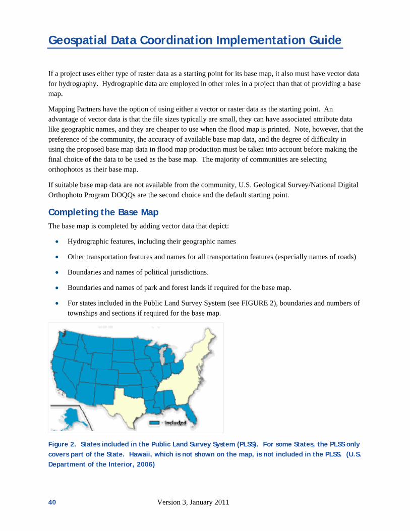
Geospatial Data Coordination Implementation Guide
If a project uses either type of raster data as a starting point for its base map, it also must have vector data for hydrography. Hydrographic data are employed in other roles in a project than that of providing a base map.
Mapping Partners have the option of using either a vector or raster data as the starting point. An advantage of vector data is that the file sizes typically are small, they can have associated attribute data like geographic names, and they are cheaper to use when the flood map is printed. Note, however, that the preference of the community, the accuracy of available base map data, and the degree of difficulty in using the proposed base map data in flood map production must be taken into account before making the final choice of the data to be used as the base map. The majority of communities are selecting orthophotos as their base map.
If suitable base map data are not available from the community, U.S. Geological Survey/National Digital Orthophoto Program DOQQs are the second choice and the default starting point.
Completing the Base Map The base map is completed by adding vector data that depict:
Hydrographic features, including their geographic names
Other transportation features and names for all transportation features (especially names of roads)
Boundaries and names of political jurisdictions.
Boundaries and names of park and forest lands if required for the base map.
For states included in the Public Land Survey System (see FIGURE 2), boundaries and numbers of townships and sections if required for the base map.
Figure 2. States included in the Public Land Survey System (PLSS). For some States, the PLSS only
covers part of the State. Hawaii, which is not shown on the map, is not included in the PLSS. (U.S.
Department of the Interior, 2006)
40 Version 3, January 2011

Geospatial Data Coordination Implementation Guide
Note that these data may or may not be required for a flood map for a particular area; check with
the project lead for requirements for a particular project. These data can be less accurate than the data that serve as the starting point for the base map, and often are “fit” to the starting point data.
Additional optional content to be obtained if available include:
Bridges
Unimproved roads or trails (i.e., those travel ways not intended for motorized vehicles or not usually used by motorized vehicles due to width or seasonal conditions)
Flood-control structures (i.e., levees, dams, weirs, floodwalls, jetties)
Building footprints
Parcel outlines or parcel centroids
Elevation Data Elevation (topographic) data encode the bare-earth elevation of the topography for an area, devoid of vegetation and structures. The data may be organized in a number of forms, including contours, mass points, breaklines, triangulated irregular networks, and digital elevation models (regularly spaced grids).
Typical hydrologic analyses do not require high-accuracy elevation data. USGS digital elevation data may suffice for analyzing and modeling entire watershed. Hydraulic analyses do require high-accuracy data. The project lead must determine the required accuracy based on the risk for each stream reach. The minimum requirements are specified in Procedure Memo 61. Elevation data can be used to create cross sections and reduce the need for new surveys. For areas of high flood risk, such data should have a consolidated vertical accuracy (Accuracyz) of 2.4 feet (0.73 meters) measured using the National Standard for Spatial Data Accuracy, equivalent to the accuracy for four-foot contours assessed using the old National Map Accuracy Standard. In unusually flat areas, elevation data with a higher vertical accuracy of 1.2 feet (0.36 meters) (Accuracyz), equivalent to the accuracy assessed for two-foot contours using the old National Map Accuracy Standard, may be needed. Procedure Memo 61 also includes additional specifications for moderate and low risk areas.
Costs of new data should be evaluated carefully. In some cases, existing five-foot contours would provide sufficient accuracy or hard copy topographic maps with four-foot (or better) contours could be digitized and used at much lower cost than new data collection. When elevation data of reasonable quality exist, the project lead should assess if they can be used to produce a result nearly the same as that could be provided by newly collected data.
Current methods for developing elevation data include traditional photogrammetry; digital camera photogrammetry (such as multi-angle scanning with a high resolution stereo camera); laser sensors (such as Light Detection and Ranging (LIDAR)); and radar sensors (such as Interferometric Synthetic Aperture Radar (IFSAR)). Missions or systems that use these technologies have different names; some of the more well known are the Shuttle Radar Topography Mission (SRTM), Geographic Synthetic Aperture Radar
Version 3, January 2011 41

Geospatial Data Coordination Implementation Guide
(GeoSAR), and ISTAR.1 Different technologies yield data of different accuracies. Any particular technology or system can have different performance characteristics that vary with different types of terrain, and vegetation and other land cover. Section A.8 of the G&S (U.S. Department of Homeland Security, 2003, Appendix A, pages A-39 though A-56) provides extensive coverage of considerations for LIDAR surveys.
The preferred vertical datum is the North American Vertical Datum of 1988 (NAVD 88). New data funded in whole or in part by FEMA must be provided using this datum.
New elevation data funded in whole or in part by FEMA must allow for unlimited free distribution by FEMA and its partners. FEMA prefers to have these rights for all elevation data used in projects so that it can participate in interagency exchanges of elevation data. Depending on the vendor and their business model, some existing elevation data may have use or distribution restrictions. In cases when existing elevation data are suitable and cost effective for use in a project but are available only with licensing restrictions, they may be used if the restrictions are not too limiting and the use of the data is advantageous to the project.
The data must be sent by the data source within 30 days of FEMA’s request for the data.
Metadata Metadata, or “data about data,” provide information about the content, quality, condition, and other characteristics of data. Metadata help an organization manage its data, advertise its data to others through data portals, catalogs, and clearinghouses, and inform recipients of data about correct ways to use the data.
For Flood Risk Projects, the information content of metadata for geospatial data follow the National Flood Insurance Program (NFIP) metadata profiles. The profiles can be found through the MIP Web site; start at https://hazards.fema.gov and follow the links Tools & Links and then Metadata Profiles (U.S. Department of Homeland Security, 2006a). FEMA created these profiles (agreed-upon subsets and interpretations of the standard) based on the Federal Geographic Data Committee’s Content Standard for Digital Geospatial Metadata (1998b and 2006).
In the early phases of a Flood Risk Project, participants use metadata provided by data sources to understand the characteristics of available data and evaluate and rank their usefulness to the project. Once base map and elevation data are selected for use in a project, participants enter a very basic set of metadata into the NDOP (if orthophotos are used as a base map) and NDEP tracking systems for orthophoto or elevation data obtained from non-Federal sources or to be procured through new collection.
1 Names of specific systems are provided for descriptive purposes only, and do not represent an endorsement by the United States Government.
42 Version 3, January 2011

Geospatial Data Coordination Implementation Guide
As geospatial data to be used in a project are received, checked, and accepted, more complete metadata that comply with the appropriate NFIP metadata profile must be completed and provided with the package of data submitted to the MIP. These metadata include information about points of contact, the type of data, the sources of data, the quality, lineage, and processes applied to the data, the coordinate system, the information content, and the transfer media for the data. The Mapping Partner responsible for selecting the data to be used in a project must have a reasonable idea of all of these characteristics in order to determine the suitability of a candidate set of data for a project.
There must be no restrictions on FEMA’s use or redistribution of metadata. The metadata must accompany the flood risk data when distributed to the public, and so FEMA needs to be able to distribute the metadata freely. Distribution methods include, but are not limited to, incorporating information from the metadata in collar information and annotations on printed flood maps, distributing metadata with other digital flood data online and on media, and providing metadata on the Web with flood maps. FEMA also participates in interagency exchanges of metadata, and participants can expect the metadata to appear on publicly available data portals and clearinghouses such as Geospatial One–Stop and the NDOP and NDEP tracking systems. The metadata also may appear in other applications that acquire data from such portals and clearinghouses, even if FEMA does not participate in these other applications directly.
The best time to collect metadata is when the data are being developed, and it can be very difficult to recover information about the development of a set of data after the fact. Because of this fact and the requirement that compliant metadata be submitted with other data for the project, participants will benefit greatly from asking data sources to provide compliant metadata with geospatial data supplied for the project, from working with data sources to recover information that has not been recorded, and for requiring vendors to provide compliant metadata for any newly collected data.
Version 3, January 2011 43

Geospatial Data Coordination Implementation Guide
Appendix B. FEMA Policies on Procuring New Data This appendix outlines FEMA’s policies for funding new base map and elevation data. These policies reflect the approach FEMA uses to estimate the value of mapping activities contributed by community, Tribal, regional, and state agencies described in “Estimating the Value of Partner Contributions: A Blue Book” (U.S. Department of Homeland Security, 2006d).
Policy for New Base Map Data Generally, the base map used for a flood map is not part of the flood risk assessment process. The base map helps map readers understand the location of the results of the Flood Risk Project by ensuring that the hazard information is referenced accurately to its real world location. The most important characteristic of the base map is that it is spatially accurate so that features are shown in their correct real world locations.
The policy for FEMA providing funding for new base map data collection as part of a Flood Risk Project is as follows:
FEMA will only provide funding when existing base map data are inadequate. If base map data are inadequate, FEMA will provide funding only if the base map data to be procured meet or exceed minimum requirements for content, currentness, accuracy, and NFIP-compliant metadata. If FEMA provides funds for new base map data collection, it must have the rights to distribute the resulting base map data without restriction or cost. (Note that FEMA must have such rights to base map data regardless of the source of funds.)
The maximum amount that FEMA will provide to a community project for the procurement of new base map data is 50 percent of the cost to produce a black-and-white panchromatic orthophoto with a one-meter ground sample distance over a “small” area based on cost estimates from participants in the National Digital Orthophoto Program2.
New base map data for which FEMA provides funding must be referenced to the North American Datum of 1983.
Regarding leverage credits to communities, if adequate base map data exist but a community supplies better data, FEMA will provide leverage credit to the community.
2 In late 2006, the cost was estimated to be $25 per square mile; 50 percent of this amount is $12.50 per square mile.
44 Version 3, January 2011

Geospatial Data Coordination Implementation Guide
Version 3, January 2011 45
Policy for New Elevation Data While many Flood Risk Projects require new elevation data, the development of these data is only part of the overall project process. FEMA must focus its investment in new elevation data in areas where flood hazard analyses need to be updated, and is not able to support general-purpose data production. Therefore, FEMA usually procures elevation data only for the floodplain areas.
The policy for FEMA providing funding for new elevation data collection as part of a Flood Risk Project is as follows:
FEMA will only provide funding when existing elevation data are inadequate. In cases where adequate elevation data exist but are not in digital form, FEMA will fund new data collection only if the project participants clearly demonstrate that new data collection is more cost effective than the conversion of the existing data to digital form.
FEMA will only fund the development of new-finished bare earth elevation data in the floodplain. If cost effective, FEMA will consider funding the collection of raw data over a larger area that contains the floodplains (for example, where it is inefficient to fly LIDAR data collection only over the floodplain). The area in such cases must be the smallest rectangle that encloses the floodplains.
FEMA will only fund data to meet the minimum accuracy required for the project to be performed as outlined in FEMA’s flood hazard mapping standards. This accuracy needed is determined on a reach-by-reach basis during Discovery.
If FEMA funds new elevation data collection in whole or in part, it must have the rights to distribute the resulting elevation data without restriction or cost.
The cost to FEMA for new ground elevation data collection for a project must be proportionate to the risk to the area to be mapped by the project.
New elevation data funded by FEMA must be referenced to the North American Vertical Datum of 1988 and have NFIP-compliant metadata.
Regarding leverage credits to communities, the credit is based on the area for which the project requires elevation data. Typically, this area is the floodplain and not the entire area for which the community has elevation data
Note that this emphasis on funding elevation data only in floodplains does not preclude FEMA’s participation in more ambitious (and more expensive) efforts to collect data for larger areas that include the floodplains. For example, FEMA can partner with a community that seeks elevation data for its entire jurisdiction. Funding from the project defrays the cost to the community’s expenses. The community gains many benefits from the new data beyond those of updated flood maps, and the project gets the data needed for the project. Such an arrangement allocates the costs of projects in proportion to the benefits received by the participant.