geopacificresources%limited% cambodia ...2015/10/22 · page!!2!...
TRANSCRIPT

28m@ 3.43% Cu eq. – TARGETING RESOURCE The Board of Geopacific Resources Limited (“Geopacific”) is pleased to provide an exploration update of the Kou Sa copper-‐gold Project in Cambodia.
HIGHLIGHTS
• Drilling returns thick, high-‐grade down-‐dip extensions • Potential feeder zone identified • Resource-‐definition drilling continues
EXPLORATION UPDATE Prospect 160 extensional drilling
Prospect 160 is one of the most advanced areas at Kou Sa and is expected to form part of a future resource. Ongoing extensional drilling at Prospect 160 has identified an extremely thick zone of copper-‐sulphide mineralisation that forms the central core of the overall mineralised structure. The first, deep hole (KRC184) into the zone intercepted copper sulphide mineralisation at least 28 metres thick from a shallow depth. The hole ended in mineralisation when drilling conditions caused the hole to collapse.
Recent drilling has returned results of: • KRC184: 28m at 3.37% Cu and 5.43g/t Ag for 3.43% Cu eq.
incl 16m at 5.08% Cu and 7.5g/t Ag for 5.17 Cu eq. • KRC159: 20m at 2.08% Cu and 7.5g/t Ag for 2.16% Cu eq.
Figure 1: Cross-‐section of Prospect 160
22 October 2015 GEOPACIFIC RESOURCES LIMITED ACN 003 208 393 ASX Code: GPR [email protected] www.geopacific.com.au AUSTRALIAN OFFICE Level 1, 278 Stirling Highway Claremont, WA 6010. PO Box 439, Claremont, WA 6910. T +61 8 6143 1823 FIJI OFFICE PO Box 9975 Nadi Airport Nadi T +679 6 72 7150 F +679 6 72 7152 DIRECTORS Chairman: Milan Jerkovic Managing Director: Ron Heeks Non-‐Exec Director: Mark Bojanjac Company Secretary: John Lewis PROJECTS CAMBODIA: Kou Sa Copper FIJI: Sabeto/Vuda Gold-‐Copper Rakiraki Gold Nabila Copper-‐Gold F
or p
erso
nal u
se o
nly

Page 2
Figure 1, above, shows a cross-‐section of Prospect 160 highlighting that the zone of copper mineralisation thickens at depth and is open to the north-‐west. A further hole, KRC199, drilled up plunge from hole KRC184 has intercepted over 40m of copper sulphide mineralisation. This hole ended in mineralisation after collapsing due to unfavourable drilling conditions. Assay results for the hole are expected shortly.
Managing Director, Ron Heeks said
“Recent drilling at prospect 160 confirmed our understanding of the style of mineralisation in the area. Allowing us to target drilling into what is a considerably thicker zone of mineralisation that plunges to the north-‐west. This thicker zone that appears to be over 50m wide, has been intercepted to a true thickness of over 40m. It is open to the north-‐west and has the potential to extend considerably further. The top of the 40m thick zone is only 40m from surface and dips at a shallow angle of 30° to the north-‐west. Drilling of the zone will continue as a matter of priority with a diamond drill-‐rig being used to test the mineralisation at depth. The zone will add considerably to the metal inventory of the project”
Figure 2: Prospect 160 -‐ drill hole location plan showing the most recent holes, overlain with an isopach map of the thickness of the copper mineralisation. The plan highlights the zone of greater than 20m thick copper mineralisation and highlights that it is open to the north-‐west. The current strike length of the Prospect 160 mineralisation is 300 metres.
Ongoing exploration
RC drilling will continue to test near surface mineralisation at Prospect 160, before moving to Prospects 120 and 190 in the coming months. A diamond drill-‐rig currently drilling the potential feeder zone at Prospect 150 will be moved to Prospect 160 to continue testing the wider zone of copper sulphide mineralisation at depth. The second diamond drill rig on-‐site is currently testing the Prospect 117 area where a new
For
per
sona
l use
onl
y

Page 3
interpretation of the mineralisation in that area appears to have been validated. Results from Prospect 117 drilling should be known shortly.
In the Prospect 190 area, a dipole-‐dipole IP geophysics program is assessing the potential of deep-‐seated mineralising sources. Recent drilling and a reinterpretation of the airborne magnetics indicate these sources may be present. The results of this survey should be available within the next few weeks. These results will be used to target further drilling in the Prospect 190 area.
A new track-‐mounted diamond rig is currently being mobilised from Thailand to enable the drilling of deeper diamond holes and improve mobility between drill-‐holes. This rig is expected to be on-‐site shortly.
SUMMARY OF PROSPECTS ACCORDING TO STAGE OF DEVELOPMENT
Prospect location plan over IP Geophysics
The local village of Chep and exploration camp, which are located on a bitumen highway, are situated in the north-‐east corner. All known prospects at Kou Sa are marked and overlain on the IP chargeability geophysics (IP). The IP has been invaluable in accurate drill-‐targeting, with over 80% of drill-‐holes resulting in mineralisation. Areas of high chargeability are shown in red and white. An overview of the project with this in mind indicates the prospectivity of Kou Sa.
For
per
sona
l use
onl
y

Page 4
Development status of prospects
The pyramid below shows the status of development and process of advancement towards becoming a reserve for all identified Prospects at Kou Sa. This is followed by a technical summary of each of the prospects, grouped according to stage of development.
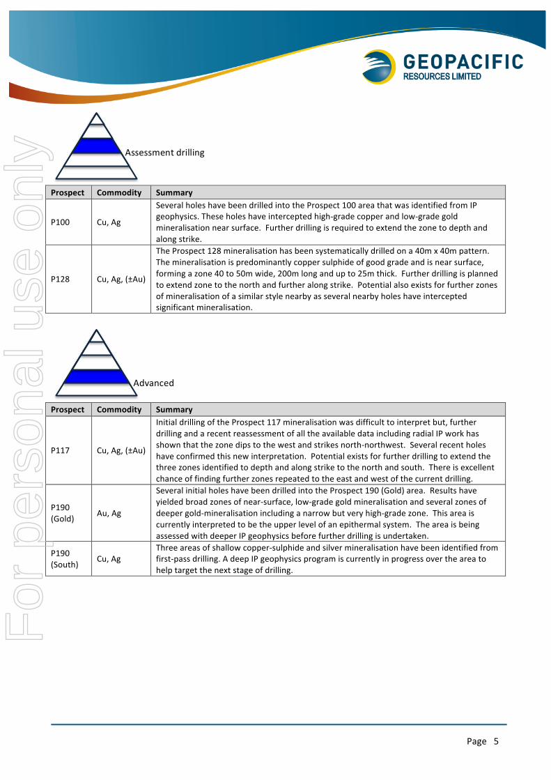
Prospect Commodity Summary
P150 Cu, Au, Ag
The majority of the prospect area is now drilled on a 40m x 40m pattern with some infill on a 20m x 20m pattern. Understanding of the structure and orientation of the zone is now high. A deep feeder zone to the near surface mineralisation is currently being assessed. Most of mineralisation contains copper, gold and silver with some extremely high grades. Depth of the mineralisation is currently less than 70m from the surface. Some infill and extensional drilling remains to be completed.
P160 Cu, Ag, (±Au)
The geometry of the deposit is now fairly well understood. The zone has an extremely, thick core of copper sulphide mineralisation that tapers towards the sides of the zone. The zone has a strike length of 300m. Drilling continues to extend the mineralisation down plunge. There is potential for gold mineralisation combined with the copper sulphide at depth, as mineralisation approaches what is thought to be the feeder zone.
P120%%%%%P170%%%%%P180%
P117%%%%%%%%%%%P190%
P100%%%P128%
P150%P160% Resource%drilling%
Assessment%drilling%
Advanced%explora>on%
Greenfields%explora>on%
Reserve%
Resource drilling
For
per
sona
l use
onl
y
Page 5
Prospect Commodity Summary
P100 Cu, Ag
Several holes have been drilled into the Prospect 100 area that was identified from IP geophysics. These holes have intercepted high-‐grade copper and low-‐grade gold mineralisation near surface. Further drilling is required to extend the zone to depth and along strike.
P128 Cu, Ag, (±Au)
The Prospect 128 mineralisation has been systematically drilled on a 40m x 40m pattern. The mineralisation is predominantly copper sulphide of good grade and is near surface, forming a zone 40 to 50m wide, 200m long and up to 25m thick. Further drilling is planned to extend zone to the north and further along strike. Potential also exists for further zones of mineralisation of a similar style nearby as several nearby holes have intercepted significant mineralisation.
Prospect Commodity Summary
P117 Cu, Ag, (±Au)
Initial drilling of the Prospect 117 mineralisation was difficult to interpret but, further drilling and a recent reassessment of all the available data including radial IP work has shown that the zone dips to the west and strikes north-‐northwest. Several recent holes have confirmed this new interpretation. Potential exists for further drilling to extend the three zones identified to depth and along strike to the north and south. There is excellent chance of finding further zones repeated to the east and west of the current drilling.
P190 (Gold) Au, Ag
Several initial holes have been drilled into the Prospect 190 (Gold) area. Results have yielded broad zones of near-‐surface, low-‐grade gold mineralisation and several zones of deeper gold-‐mineralisation including a narrow but very high-‐grade zone. This area is currently interpreted to be the upper level of an epithermal system. The area is being assessed with deeper IP geophysics before further drilling is undertaken.
P190 (South)
Cu, Ag Three areas of shallow copper-‐sulphide and silver mineralisation have been identified from first-‐pass drilling. A deep IP geophysics program is currently in progress over the area to help target the next stage of drilling.
Assessment drilling
Advanced
For
per
sona
l use
onl
y

Page 6
Prospect Commodity Summary
P120 Cu, Au A significant but discrete zone of gold and copper soil geochemistry was identified and follow-‐up gradient array geophysics has confirmed the presence of an IP anomaly. Several lines of RC drilling over the geophysics are planned to be undertaken in the near future.
P170 Au, Ag
Prospect 170 has a large base-‐metal and gold geochemical anomaly associated with other geochemical signatures that would suggest the mineralisation came from a deep source. An assessment of airborne magnetics also suggests that a deep mineralising source is nearby. A few holes drilled over the anomaly produced scattered copper and gold results with extremely wide zones of anomalous silver. This would also suggest we are at the top of the system and that deeper holes need to be drilled. A deep IP geophysics program will be undertaken to further define the deeper zone before drilling commences.
P180 Cu, Au, Ag
Prospect 180 was identified from broad copper and gold geochemistry and IP geophysicis. First-‐pass drilling intercepted wide low-‐grade copper mineralisation in oxide and sulphide zones. This indicates the presence of mineralising system, potentially located at depth. Further drilling is required to allow a better assessment of the Prospect 180 area.
WHY DO THE COMMODITIES DIFFER BETWEEN PROSPECTS?
The mineralisation at Kou Sa is thought to be derived from a deep intrusive source. Geochemistry, geophysics and petrology all point to a deep source as the origin of the near-‐surface mineralisation.
As the intrusive cooled, mineralising fluids under pressure have taken the path of least resistance to the surface. In places the solutions have hit an impermeable layer and as pressure has built up under the layer, the fluids have moved sideways into the rock units that fracture most easily. The first fluids emplaced are predominantly copper-‐sulphides. If the pressure buildup is significant enough to crack the impermeable horizon there is
a rapid decrease in fluid pressure that causes the gold and silver solutions to deposit in the area of the pressure decrease. Therefore, as you move away from the area of the cracking the mineralisation transitions from being gold and silver rich, to gold, silver and copper rich and then to predominantly copper sulphide. In areas where the seal does not crack, mineralisation is
Greenfields exploration
For
per
sona
l use
onl
y

Page 7
predominantly just copper rich. There can be multiple episodes of cracking and emplacement of solution, which can considerably improve the grade of the mineralisation.
CONTACT
For further information on this update or the Company generally, please visit our website at www.geopacific.com.au or contact:
Mr Ron Heeks
Managing Director
Competent Person’s Statement
The information in this announcement that relates to exploration results is based on information compiled by or under the supervision of Ron Heeks, a Competent Person who is a Member of The Australasian Institute of Mining and Metallurgy and Managing Director of Geopacific. Mr Heeks has sufficient experience which is relevant to the style of mineralisation and type of deposit under consideration and the activity he is undertaking to qualify as a Competent Person as defined in the 2012 Edition of the “Australasian Code for Reporting of Exploration Results, Mineral Resources and Ore Reserves”. Mr Heeks consents to the inclusion in the announcement of the matters based on his information in the form and context in which it appears.
For
per
sona
l use
onl
y

Page 8
ABOUT GEOPACIFIC AND KOU-‐SA, CAMBODIA Kou Sa Project
Geopacific is actively exploring for copper and gold in Cambodia and Fiji. In Cambodia, its rapidly advancing Kou-‐Sa copper-‐gold project is a well-‐funded exploration vehicle in a highly prospective district. Project highlights include high grade, near surface deposits, excellent logistics, low cost environment, compelling geology and exceptional initial metallurgy results. With a proven management team and focused strategy to target a maiden resource and scoping study, exploration success is expected to continue and add to the potential of the project.
Ownership
In 2013, Geopacific (85%) and their JV Partner The Royal Group (15%) signed a purchase agreement to acquire 100% of the Kou Sa Project from the vendor. The Kou Sa Project covers 158km2.
The Royal Group is the largest, commercial conglomerate in Cambodia. They have entered into corporate ventures in Cambodia with the likes of ANZ and Siemens.
Location
Kou-‐Sa is in Cambodia’s Chep district in the province of Phreah Vihear. The Project is a 3-‐hour drive from Siem Reap international Airport or alternatively a 5-‐hour drive from the capital city of Phnom Penh, both routes follow high-‐quality bitumen highways.
Discovery
Kou-‐Sa was identified by French geologists in the 1960’s, pre-‐dating the Vietnamese and regional civil wars. In 2009, the Vendors began shallow drilling along parts of visibly outcropping mineralisation. In 2013, after agreeing to purchase the Project, Geopacific commenced detailed exploration with airborne magnetics (3,800 line kms), regional soil geochemistry (approx. 8,000 samples) and detailed IP and EM geophysics. The work undertaken allowed Geopacific to identify a number of high priority prospects in an East – West arc across the project area. Geopacific has continued exploration with encouraging results.
For
per
sona
l use
onl
y

Page 9
APPENDIX A – DRILLING DETAILS
Key for results tables
Colour % or g/t Orange 0.2 -‐ 0.5 Red 0.5 – 1.0 Pink >1.0
Significant Drill Results for Prospect 160
Hole ID From Interval Au (g/t) Ag (g/t) Cu (%) CuEq (%) Zn (%)1 KRC159* 40.00 20.00 0.03 7.50 2.08 2.16 0.06 KRC162* 56.00 8.00 0.23 11.80 0.75 0.99 0.02 KRC167* 28.00 24.00 0.04 3.88 1.00 1.06 0.07 incl.* 32.00 4.00 0.03 9.80 2.46 2.57 0.06 KRC170 24.00 4.00 0.04 3.20 0.86 0.91 0.12 KRC172 16.00 16.00 0.07 5.50 1.18 1.27 0.14 KRC174 20.00 8.00 0.03 1.88 0.94 0.97 0.33 KRC176 68.00 8.00 0.01 2.10 0.55 0.57 0.55 KRC176 84.00 4.00 0.05 6.40 1.24 1.33 0.13 KRC184* 68.00 28.00 0.02 5.43 3.37 3.43 0.17 KRC186 28.00 8.00 0.25 22.20 1.15 1.50 4.74
NOTES:
All RC results are highlighted in green and are 4m composites. Any interval marked with an asterisk (*) are wet samples.
Intervals are selected on a 0.5% Cu eq. or 0.5g/t Au cutoff.
Equivalent grades are based on a US dollar gold price of $1,300/oz, copper price of $7,000/tonne, and silver price of $20/oz. Equivalent grades were calculated as follows:
Cu % (Eq) = Cu % + [((Au g/t x Au price per gram) ÷ Cu price per tonne) x 100] + [((Ag g/t x Ag price per gram) ÷ Cu price per tonne) x 100]
Initial metallurgical testwork suggests that metal recoveries for the 150 Prospect will be in the range of: copper >95%, gold >92% silver >90% (ASX release 26 March 2015). Metallurgical testwork has not been undertaken on other prospects at this time.
Drillhole collar information in this table is presented in the ‘WGS84 zone 48N’ coordinate system. This data was collected using a handheld GPS unit as well as tape and compass from known survey points.
1 Zinc not included in copper equivalent calculation
For
per
sona
l use
onl
y

Page 10
Drilling summary for Prospect 160
Hole ID Prospect Type Easting Northing RL Depth Dip/Azi Analysis Status KRC159 160 RC 544667 1518116 133 93 -‐80 / 180 Released KRC160 160 RC 544610 1518107 128 103 -‐70 / 180 No Significant Results KRC161 160 RC 544571 1518097 127 96 -‐80 / 180 No Significant Results KRC162 160 RC 544571 1518017 127 78 -‐60 / 180 Released KRC163 160 RC 544529 1518109 116 80 -‐60 / 180 No Significant Results KRC164 160 RC 544529 1518070 121 66 -‐60 / 180 No Significant Results KRC165 160 RC 544529 1518030 122 54 -‐60 / 180 No Significant Results KRC166 160 RC 544571 1517980 125 54 -‐60 / 180 No Significant Results KRC167 160 RC 544610 1518037 131 70 -‐60 / 180 Released KRC168 160 RC 544571 1518097 128 75 -‐55 / 180 No Significant Results KRC169 160 RC 544667 1518159 132 84 -‐70 / 180 No Significant Results KRC170 160 RC 544670 1518049 134 60 -‐55 / 180 Released KRC171 160 RC 544710 1518049 137 50 -‐60 / 180 No Significant Results KRC172 160 RC 544710 1518074 135 54 -‐60 / 180 Released KRC173 160 RC 544749 1518039 141 50 -‐60 / 180 No Significant Results KRC174 160 RC 544749 1518079 137 54 -‐60 / 180 Released KRC175 160 RC 544749 1518129 138 72 -‐60 / 180 No Significant Results KRC176 160 RC 544749 1518169 137 102 -‐60 / 180 No Significant Results KRC177 160 RC 544645 1518142 132 54 -‐60 / 180 No Significant Results KRC178 160 RC 544567 1517950 123 30 -‐60 / 180 Hole Collapsed KRC179 160 RC 544567 1517953 123 50 -‐60 / 180 No Significant Results KRC180 160 RC 544529 1518000 122 60 -‐60 / 180 No Significant Results KRC181 160 RC 544490 1518085 121 109 -‐60 / 180 No Significant Results KRC182 160 RC 544530 1518145 128 80 -‐60 / 180 No Significant Results KRC183 160 RC 544570 1518120 131 90 -‐80 / 180 No Significant Results KRC184 160 RC 544610 1518150 132 96 -‐80 / 180 Released KRC185 160 RC 544790 1518080 138 60 -‐60 / 180 No Significant Results KRC186 160 RC 544789 1518120 139 80 -‐50 / 180 Released KRC187 160 RC 544789 1518184 138 80 -‐60 / 180 Awaiting Results KRC188 160 RC 544830 1518170 134 70 -‐60 / 180 Awaiting Results KRC189 160 RC 544830 1518100 140 66 -‐60 / 180 Awaiting Results KRC190 160 RC 544851 1518112 140 66 -‐60 / 180 Awaiting Results KRC191 160 RC 544851 1518151 138 78 -‐60 / 180 Awaiting Results KRC192 160 RC 544870 1518160 134 72 -‐60 / 180 Awaiting Results KRC193 160 RC 544870 1518170 139 42 -‐60 / 180 Awaiting Results KRC194 160 RC 544870 1518080 141 42 -‐60 / 180 Awaiting Results KRC195 160 RC 544900 1518080 141 40 -‐60 / 180 Awaiting Results KRC196 160 RC 544900 1518040 143 33 -‐60 / 180 Awaiting Results KRC197 160 RC 544939 1518143 139 72 -‐60 / 180 Awaiting Results KRC198 160 RC 544939 1518103 139 60 -‐60 / 180 Awaiting Results KRC199 160 RC 544645 1518142 132 96 -‐80 / 180 Awaiting Results
For
per
sona
l use
onl
y

Page 11
Appendix B – JORC Code, 2012 Edition – Table 1
Section 1 Sampling Techniques and Data
(Criteria in this section apply to all succeeding sections.)
CRITERIA JORC CODE EXPLANATION COMMENTARY
Sampling techniques
Nature and quality of sampling (e.g. cut channels, random chips, or specific specialised industry standard measurement tools appropriate to the minerals under investigation, such as down hole gamma sondes, or handheld XRF instruments, etc.). These examples should not be taken as limiting the broad meaning of sampling.
Include reference to measures taken to ensure sample representivity and the appropriate calibration of any measurement tools or systems used.
Sampling was conducted using percussion drilling (RC).
Sampling of RC drilling comprised four metre composites taken using a PVC tube/spear with one metre samples collected using rifle splitter within zones of interest.
Samples were sent for fire assay gold and four-‐acid multi-‐element analysis. Blank, duplicate, and standard samples were inserted in at various intervals based on Geopacific’s QAQC procedure to ensure sample representivity and repeatability of the sampling results.
Aspects of the determination of mineralisation that are Material to the Public Report.
In cases where ‘industry standard’ work has been done this would be relatively simple (e.g. ‘reverse circulation drilling was used to obtain 1 m samples from which 3 kg was pulverised to produce a 30 g charge for fire assay’). In other cases more explanation may be required, such as where there is coarse gold that has inherent sampling problems. Unusual commodities or mineralisation types (e.g. submarine nodules) may warrant disclosure of detailed information.
RC samples comprised four metre composites collected using a PVC spear, and one metre splits collected using a rifle splitter.
The RC samples were then sent for sample preparation where they were crushed, pulverised, and split to a nominal 200g sample size for analysis.
Samples were sent for fire assay gold analysis using a 30g charge, as well as multi-‐element analysis using multi-‐acid digest with ICP finish.
Drilling Techniques
Drill type (e.g. core, reverse circulation, open-‐hole hammer, rotary air blast, auger, Bangka, sonic, etc.) and details (e.g. core diameter, triple or standard tube, depth of diamond tails, face-‐sampling bit or other type, whether core is oriented and if so, by what method, etc.).
RC drilling was completed using standard face sampling RC drill hammers.
Drill Sample Recovery
Method of recording and assessing core and chip sample recoveries and results assessed.
Bulk RC drill samples were visually inspected by the supervising geologist to ensure adequate sample recoveries were achieved. Any wet/moist samples were flagged and recorded in the database to ensure no sampling bias was introduced.
Measures taken to maximise sample recovery and ensure representative nature of the samples.
RC drilling was undertaken using industry best practice with geological supervision at all times to ensure good sample recovery.
Whether a relationship exists between sample recovery and grade and whether sample bias may have occurred due to preferential loss/gain of fine/coarse material.
Sample recovery was good to moderate throughout the drill holes. Possible preferential loss of ore material could have resulted in some zones, but the majority of the samples had good recovery.
Logging Whether core and chip samples have been geologically and geotechnically logged to a level of detail to support appropriate Mineral Resource estimation, mining studies and metallurgical studies.
All drill chips were geologically logged by Geopacific geologists using the Geopacific’s logging procedure.
For
per
sona
l use
onl
y

Page 12
CRITERIA JORC CODE EXPLANATION COMMENTARY
Whether logging is qualitative or quantitative in nature. Core (or costean, channel, etc.) photography.
Drill chips were logged both qualitatively (e.g. lithology, alteration, structure, etc.) and quantitatively (e.g. mineralisation percentage). Samples of the drill chips are stored in plastic chip trays in our exploration core yard.
The total length and percentage of the relevant intersections logged.
All holes are logged their entire length.
Sub-‐sampling techniques and sample preparation
If core, whether cut or sawn and whether quarter, half or all core taken.
No diamond drilling results are reported in this announcement.
If non-‐core, whether riffled, tube sampled, rotary split, etc. and whether sampled wet or dry.
Initial four metre composites are sampled using a PVC tube/spear; with one metre samples collected using a rifle splitter.
For all sample types, the nature, quality and appropriateness of the sample preparation technique.
Samples are crushed to a nominal 2mm by a jaw crusher, with the whole sample pulverised and then split to two final 200g samples. One sample is stored on site with the other sent for analysis.
Quality control procedures adopted for all sub-‐sampling stages to maximise representivity of samples.
Field blank, duplicate, and standard samples are introduced to maximise the representivity of the samples.
Measures taken to ensure that the sampling is representative of the in situ material collected, including for instance results for field duplicate/second-‐half sampling.
Field duplicates are inserted in accordance with Geopacific’s QAQC procedure.
Whether sample sizes are appropriate to the grain size of the material being sampled.
Sample sizes are appropriate to the grain size of the material being sampled.
Quality of assay data and laboratory tests
The nature, quality and appropriateness of the assaying and laboratory procedures used and whether the technique is considered partial or total.
Fire assay Au and four-‐acid digest ICP analysis are thought to be appropriate for determination of gold and base metals in fresh rock, and are considered to represent a total analysis.
For geophysical tools, spectrometers, handheld XRF instruments, etc., the parameters used in determining the analysis including instrument make and model, reading times, calibrations factors applied and their derivation, etc.
No results from geophysical tools, spectrometers, or handheld XRF instruments are reported in this release.
Nature of quality control procedures adopted (e.g. standards, blanks, duplicates, external laboratory checks) and whether acceptable levels of accuracy (i.e. lack of bias) and precision have been established.
Field and lab blank, duplicate, and standard samples were used in the drilling. Results from these QAQC samples were within the acceptable ranges.
Verification of sampling and assaying
The verification of significant intersections by either independent or alternative company personnel.
Significant intersections were inspected by senior geological staff.
The use of twinned holes. No holes reported in this announcement are twins of previous drilling.
For
per
sona
l use
onl
y

Page 13
CRITERIA JORC CODE EXPLANATION COMMENTARY
Documentation of primary data, data entry procedures, data verification, data storage (physical and electronic) protocols.
Primary assay data is sent from the lab to our database administrator and then entered into Geopacific’s database and validated by the database administrator and senior staff.
Discuss any adjustment to assay data. No adjustments were made or required to be made to the assay data.
Location of data points
Accuracy and quality of surveys used to locate drill holes (collar and down-‐hole surveys), trenches, mine workings and other locations used in Mineral Resource estimation.
Drillhole collars were located using a Garmin handheld GPS and measured from nearby surveyed locations. These collars will be accurately located in the next round of surveying. Downhole survey tools are used and calibrated on a regular basis.
Specification of the grid system used. Coordinates are recorded in WGS84 zone 48 south.
Quality and adequacy of topographic control. A digital terrain model of the various prospects was created from detailed LiDAR data and is used to set the RL of the drill collars.
Data spacing and distribution
Data spacing for reporting of Exploration Results. These holes represent the drill-‐out and extension phase of the mineralisation at Prospect 160. The drill spacing is set to a nominal 40m x 40m grid pattern.
Whether the data spacing and distribution is sufficient to establish the degree of geological and grade continuity appropriate for the Mineral Resource and Ore Reserve estimation procedure(s) and classifications applied.
No Mineral Resource and Ore Reserve estimations have been made based on these results.
Whether sample compositing has been applied. Results that refer to RC drilling are all 4m composites. One metre splits will be sent in from significant zones.
Orientation of data in relation to geological structure
Whether the orientation of sampling achieves unbiased sampling of possible structures and the extent to which this is known, considering the deposit type.
Interpretations of the mineralised zone at Prospect 160 suggest that the drill orientation does not introduce a significant bias to the sampling.
If the relationship between the drilling orientation and the orientation of key mineralised structures is considered to have introduced a sampling bias, this should be assessed and reported if material.
An interpretation of the mineralisation has indicated that no significant bias has been introduced by the orientation of the drill holes reported herein.
Sample security The measures taken to ensure sample security. All samples are collected by GPR staff and put into numbered calico bags, which are immediately tied and placed in larger polyweave bags with other samples. These polyweave bags are tied and secured, and are then sent with a consignment notice direct to ALS in Phnom Penh using Geopacific staff.
Audits or reviews
The results of any audits or reviews of sampling techniques and data.
QAQC data is monitored on a batch-‐by-‐batch basis. An audit of the database by a geochemical consultant has shown that the current procedures are adequate. F
or p
erso
nal u
se o
nly

Page 14
Section 2 Reporting of Exploration Results
(Criteria listed in the preceding section also apply to this section.)
CRITERIA JORC CODE EXPLANATION COMMENTARY
Mineral tenement and land tenure status
Type, reference name/number, location and ownership including agreements or material issues with third parties such as joint ventures, partnerships, overriding royalties, native title interests, historical sites, wilderness or national park and environmental settings.
The security of the tenure held at the time of reporting along with any known impediments to obtaining a licence to operate in the area.
Geopacific has entered into a sale agreement with Golden Resources Development Co. Ltd (“GRD”), a South Korean controlled Cambodian company, for an option to acquire an 85% interest in the highly prospective Kou Sa Copper Project in Northern Cambodia. The remaining 15% has been acquired by a subsidiary of WWM’s Cambodian partner, The Royal Group.
Exploration done by other parties
Acknowledgment and appraisal of exploration by other parties.
This announcement is based on work done solely by Geopacific Resources Limited and makes no reference to work done by other companies.
Geology Deposit type, geological setting and style of mineralisation.
The geology of the tenement is dominated by andesitic, dacitic and rhyolitic volcanic and volcaniclastic rocks with minor lenses of limestone and sediments. Quartz-‐feldspar porphyry intrusions are noted in the drilling with outcropping dacitic porphyry observed in the west of the tenement. Known mineralisation on the tenement comprises structurally-‐hosted semi-‐massive copper sulphide veins.
Drill hole Information
A summary of all information material to the understanding of the exploration results including a tabulation of the following information for all Material drill holes:
o easting and northing of the drill hole collar o elevation or RL (Reduced Level – elevation above
sea level in metres) of the drill hole collar o dip and azimuth of the hole o down hole length and interception depth o hole length
If the exclusion of this information is justified on the basis that the information is not Material and this exclusion does not detract from the understanding of the report, the Competent Person should clearly explain why this is the case.
Refer to tables in Appendix A.
Data aggregation methods
In reporting Exploration Results, weighting averaging techniques, maximum and/or minimum grade truncations (e.g. cutting of high grades) and cut-‐off grades are usually Material and should be stated.
No top-‐cuts were used in the reporting of these significant intercept. The interval selected using a cut off value 0.5% CuEq, and were calculated using weighted averaging.
Where aggregate intercepts incorporate short lengths of high grade results and longer lengths of low grade results, the procedure used for such aggregation should be stated and some typical examples of such aggregations should be shown in detail.
Shorter intercepts of higher grade within larger reported intercepts are subsequently highlighted within the summary drilling table.
For
per
sona
l use
onl
y

Page 15
CRITERIA JORC CODE EXPLANATION COMMENTARY
The assumptions used for any reporting of metal equivalent values should be clearly stated.
Due to the polymetallic nature of the Project, copper equivalent values were calculated on the significant intervals with the calculation and assumptions reported below the relevant tables.
Relationship between mineralisation widths and intercept lengths
These relationships are particularly important in the reporting of Exploration Results.
If the geometry of the mineralisation with respect to the drill hole angle is known, its nature should be reported.
If it is not known and only the down hole lengths are reported, there should be a clear statement to this effect (e.g. ‘down hole length, true width not known’).
Information from other drilling in the area as well as geological mapping indicate that the downhole intervals may be fairly close to the true width, but more structural information is needed to determine the exact orientation of the mineralised zones.
Diagrams Appropriate maps and sections (with scales) and tabulations of intercepts should be included for any significant discovery being reported These should include, but not be limited to a plan view of drill hole collar locations and appropriate sectional views.
Diagrams relevant to the report content are included in the body of the report.
Balanced reporting
Where comprehensive reporting of all Exploration Results is not practicable, representative reporting of both low and high grades and/or widths should be practiced to avoid misleading reporting of Exploration Results.
Refer to tables in Appendix A.
Other substantive exploration data
Other exploration data, if meaningful and material, should be reported including (but not limited to): geological observations; geophysical survey results; geochemical survey results; bulk samples – size and method of treatment; metallurgical test results; bulk density, groundwater, geotechnical and rock characteristics; potential deleterious or contaminating substances.
The references to IP geophysics refers specifically to chargeability results from various methods of induced polarisation geophysics unless otherwise specified.
Further work The nature and scale of planned further work (e.g. tests for lateral extensions or depth extensions or large-‐scale step-‐out drilling).
Diagrams clearly highlighting the areas of possible extensions, including the main geological interpretations and future drilling areas, provided this information is not commercially sensitive.
Refer to text.
For
per
sona
l use
onl
y