geonetcast for and by developing countries · notably ilwis and its geonetcast toolbox, and direct...
TRANSCRIPT
GEONETCast for and by Developing Countries
FINAL PUBLISHABLE SUMMARY REPORT
Authors: Tim Jacobs, Carolien Tote, Lieven Bydekerke (VITO, Belgium) Date: 2012-02-01 Issue: 1.2 Dissemination level: Public Project website: http://www.devcocast.eu
Acknowledgement The work of the DevCoCast project, described in this report, has been partially funded by the European Union under the Seventh Framework Programme (FP7), under Grant Agreement n° 211307

DevCoCast
FP7 Support Action 211307
Final publishable summary report
2012-02-01 Issue: 1.2 Page 2 of 37
Change Record
Issue Date Page(s) /
Section(s) Description of Change
1.0 2012-01-17 All First issue
1.1 2012-01-26 All Reviewed chapter 2 & 3
Completed Executive Summary
1.2 2012-02-01 All Review by PML and CREAN
Final report
Executive Summary
DevCoCast received funding from the European Community’s 7th Framework Programme for Research and Technological Development (FP7, under grant agreement 211307)
2012-02-01 Issue 1.2
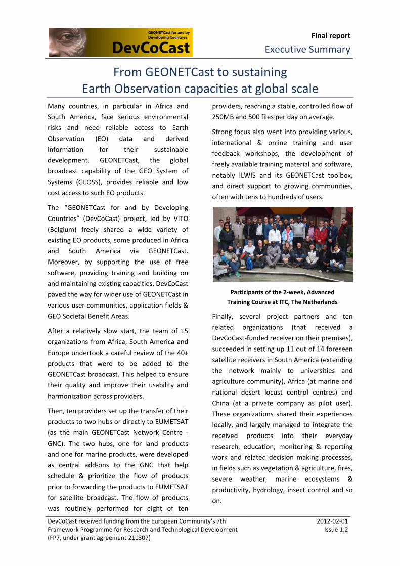
From GEONETCast to sustaining Earth Observation capacities at global scale
Many countries, in particular in Africa and
South America, face serious environmental
risks and need reliable access to Earth
Observation (EO) data and derived
information for their sustainable
development. GEONETCast, the global
broadcast capability of the GEO System of
Systems (GEOSS), provides reliable and low
cost access to such EO products.
The “GEONETCast for and by Developing
Countries” (DevCoCast) project, led by VITO
(Belgium) freely shared a wide variety of
existing EO products, some produced in Africa
and South America via GEONETCast.
Moreover, by supporting the use of free
software, providing training and building on
and maintaining existing capacities, DevCoCast
paved the way for wider use of GEONETCast in
various user communities, application fields &
GEO Societal Benefit Areas.
After a relatively slow start, the team of 15
organizations from Africa, South America and
Europe undertook a careful review of the 40+
products that were to be added to the
GEONETCast broadcast. This helped to ensure
their quality and improve their usability and
harmonization across providers.
Then, ten providers set up the transfer of their
products to two hubs or directly to EUMETSAT
(as the main GEONETCast Network Centre -
GNC). The two hubs, one for land products
and one for marine products, were developed
as central add-ons to the GNC that help
schedule & prioritize the flow of products
prior to forwarding the products to EUMETSAT
for satellite broadcast. The flow of products
was routinely performed for eight of ten
providers, reaching a stable, controlled flow of
250MB and 500 files per day on average.
Strong focus also went into providing various,
international & online training and user
feedback workshops, the development of
freely available training material and software,
notably ILWIS and its GEONETCast toolbox,
and direct support to growing communities,
often with tens to hundreds of users.
Participants of the 2-week, Advanced
Training Course at ITC, The Netherlands
Finally, several project partners and ten
related organizations (that received a
DevCoCast-funded receiver on their premises),
succeeded in setting up 11 out of 14 foreseen
satellite receivers in South America (extending
the network mainly to universities and
agriculture community), Africa (at marine and
national desert locust control centres) and
China (at a private company as pilot user).
These organizations shared their experiences
locally, and largely managed to integrate the
received products into their everyday
research, education, monitoring & reporting
work and related decision making processes,
in fields such as vegetation & agriculture, fires,
severe weather, marine ecosystems &
productivity, hydrology, insect control and so
on.

DevCoCast
FP7 Support Action 211307
Final publishable summary report
2012-02-01 Issue: 1.2 Page 4 of 37
Table of Contents
EXECUTIVE SUMMARY ..................................................................................................................................... 3
1 DEVCOCAST CONTEXT AND OBJECTIVES .................................................................................................. 8
1.1 Introduction .............................................................................................................................................. 8 1.2 Flow of DevCoCast products and the project work plan .......................................................................... 9 1.3 A growing global partnership .................................................................................................................. 10
2 MAIN RESULTS OF DEVCOCAST ............................................................................................................. 12
2.1 Product harmonization and sharing ....................................................................................................... 12 2.1.1 Product review and adaptation ..................................................................................................... 12 2.1.2 Sharing EO products globally via GEONETCast ............................................................................. 13
2.2 Setup of receiver and hub infrastructure ............................................................................................... 18 2.2.1 Central product gathering hubs .................................................................................................... 18 2.2.2 GEONETCast receivers ................................................................................................................... 20
2.3 Capacity building, training and user support .......................................................................................... 22 2.4 Supporting everyday use of GEONETCast ............................................................................................... 24
3 IMPACT, MAIN DISSEMINATION ACTIVITIES AND FURTHER EXPLOITATION OF PROJECT RESULTS ........ 26
3.1 Potential and achieved impact ............................................................................................................... 26 3.2 Main dissemination and outreach activities ........................................................................................... 29
3.2.1 Attendance at workshops, conferences and meetings .................................................................. 29 3.2.2 Publications and outreach material .............................................................................................. 33
3.3 Exploitation of results ............................................................................................................................. 35
4 WEBSITE AND CONTACT ........................................................................................................................ 37

DevCoCast
FP7 Support Action 211307
Final publishable summary report
2012-02-01 Issue: 1.2 Page 5 of 37
List of Figures
Figure 1 The four core activities of DevCoCast ....................................................................................... 8
Figure 2 Diagram of DevCoCast product flow ......................................................................................... 9
Figure 3 African user community at start of DevCoCast project, March 2008 ..................................... 10
Figure 4 Sharing EO products across the continents within DevCoCast ............................................... 14
Figure 5 Number of DevCoCast files and total volume per day for May 2010 –Sept 2011 .................. 17
Figure 6 Daily EUMETCast dissemination performance for May 2010 – Sept 2011 ............................. 17
Figure 7 Land and ocean hubs in the DevCoCast product flow systems ............................................... 18
Figure 8 DevCoCast product flow from EUMETSAT point-of-view ........................................................ 19
Figure 9 Set-up of EUMETCast receivers in South America (left) and Africa (right) ............................. 21
Figure 10 Participants to some of the training workshops organized within DevCoCast ..................... 23
List of Tables
Table 1 List of DevCoCast beneficiaries ................................................................................................. 11
Table 2 International training workshops & online courses organized within DevCoCast ................... 22
Table 3 Outreach activities within the DevCoCast project .................................................................... 32
DevCoCast
FP7 Support Action 211307
Final publishable summary report
2012-02-01 Issue: 1.2 Page 6 of 37
List of Acronyms
AARSE African Association of Remote Sensing of the Environment ACMAD African Centre of Meteorological Application for Development AFIS Advanced Fire Information Service
AGRHYMET Centre Régional de Formation et d‟Application en Agrométéorologie et Hydrologie Opérationnelle (Regional centre for training and operational applications in agrometeorology and hydrology)
AMESD African Monitoring of Environment for Sustainable Development CAI Congreso Argentino de Agroinformática CBMET Congressos Brasileiros de Meteorologia CMA Chinese Meteorological Administration CONAB Companhia Nacional de Abastecimento (Food Supply Agency of the Ministry of Agriculture) CREAN Centro de Relevamiento y Evaluación de Recursos Agrícolas y Naturales (Centre for Surveying
and Assessment of Agriculture and Natural Resources) CSIR Council for Scientific and Industrial Research CS-W Catalog Service for the Web DG-RTD Directorate General for Research & Innovation DMI Danish Meteorological Institute EAMNet Europe-Africa Marine EO Network EARSC European Association of Remote Sensing Companies EARSeL European Association of Remote Sensing Laboratories EMBRAPA Empresa Brasileira de Pesquisa Agropecuária (Brazilian Agricultural Research Corporation) EO Earth observation EUMETSAT European Organisation for the Exploitation of Meteorological Satellites FP Framework Programme GEO Group on Earth Observation GEOSS Global Earth Observation System of Systems GMES Global Monitoring for Environment and Security GNC GEONETCast Network Centre GOOS Global Ocean Observing System IGAD Intergovernmental Authority on Development IGARSS International Geoscience and remote Sensing Symposium INPE Instituto Nacional de Pesquisas Espaciais (National Institute for Space Research) INTA Instituto Nacional de Tecnología Agropecuaria (National Institute of Agriculture Technology) ISRSE International Symposium on Remote Sensing of Environment JRC Joint Research Centre MA-RE University of Cape Town - Marine Research Institute MSG Meteosat Second Generation NDVI Normalized Difference Vegetation Index NERC-NOCS Natural Environment Research Council - National Oceanography Centre Southampton PML Plymouth Marine Laboratory PUMA Preparation for Use of MSG in Africa RANET Response and Assistance Network SAGEO South American Group of EUMETCast Operators SBSR Simpósio Brasileiro de Sensoriamento Remoto (Brazilian Remote Sensing Symposium) SDI Spatial Data Infrastructure SERVIR Regional Visualization and Monitoring System UT-ITC University of Twente - Faculty of Geo-Information Science and Earth Observation VITO Vlaamse Instelling voor Technologisch Onderzoek (Flemish Institute for Technological
Research) VGT Family of VEGETATION instruments on board the SPOT4, SPOT5 and future PROBA-V satellites WP Work Package WWW WorldWideWatch project YEOS Yellow Sea Observation, forecasting and information System

DevCoCast
FP7 Support Action 211307
Final publishable summary report
2012-02-01 Issue: 1.2 Page 7 of 37
Reference documents
RD 1. Work Package (WP) 1 report on product review
RD 2. Report on First data review of FP7-EAMNet project, available on:
http://www.eamnet.eu/cms/sites/eamnet.eu/files/d210_1_first_data_review_v3.pdf
RD 3. VGT4Africa project’s Final Publishable Activity Report, available on
http://www.vgt4africa.org/PublicDocuments/VGT4AFRICA_Final_Activity_Report_v4.pdf
RD 4. Work Package 10 report on local capacity acquisition
RD 5. Work Package 11 report on integration of GEONETCast products in decision making
processes
Links
Website of Hyperlink(s)
SPOT-VEGETATION Programme http://www.spot-vegetation.com
FP7 Geoland 2 project
EU GMES Land service
http://www.geoland2.eu,
http://www.gmes-geoland.info/
JRC Monitoring Agriculture through Remote
Sensing
http://mars.jrc.ec.europa.eu,
http://www.marsop.info
IOC-UNESCO
Global Ocean Observing System
http://www.ioc-goos.org
Chlorophyll Globally Integrated Network http://www.chlorogin.org/
FP6-Yellow Sea Observation, forecasting and
information System project
http://ocean.dmi.dk/yeos/
EDF - African Monitoring of Environment for
Sustainable Development
http://www.amesd.org
FP7-Europe Africa Marine EO Network project http://www.eamnet.eu

DevCoCast
FP7 Support Action 211307
Final publishable summary report
2012-02-01 Issue: 1.2 Page 8 of 37
1 DevCoCast context and objectives
1.1 Introduction
As part of the core infrastructure of the Global Earth Observation System of Systems (GEOSS),
GEONETCast reliably shares Earth Observation (EO) and other environmental data, derived products
and information worldwide using telecommunication satellites, by exchanging data between three
broadcast systems: EUMETCast operated by EUMETSAT, GEONETCast-Americas operated by NOAA
and CMACast operated by Chinese Meteorological Agency (CMA). At the same time many countries,
in particular developing ones, face serious environmental risks and need reliable, fast and low cost
access to such EO products.
The major focus of the “GEONETCast for and by Developing Countries” (DevCoCast) project, started
in May 2008, was thus to build up and maintain the capacities on three continents (Africa, South
America and Asia) in making effective use of GEONETCast for their sustained development. To
achieve this, the project was composed of four core activities: (i) sharing Earth observation products,
some originating from Africa or South America, via GEONETCast; (ii) extending the GEONETCast
infrastructure by setting up receiver and hub infrastructure; (iii) capacity building and support to
various user communities; and (iv) supporting EO specialists in the targeted continents in making
everyday use of GEONETCast (Figure 1). While building on existing experiences (data production and
GEONETCast systems, training and user networks) and bridging a number of international activities,
the main goal of the project was to get the shared products and GEONETCast technology embedded
into everyday research, education and planning and decision making processes. This was done
through an open and cross-thematic (multi-disciplinary) cooperation between continents (e.g. Africa
and South America), with particular attention to provide direct support to users (e.g. removing small
bottlenecks can have a big impact) and the promotion of low cost solutions, such as free and open
source software (e.g. ILWIS, GEONETCast toolbox) and low cost satellite receivers.
Figure 1 The four core activities of DevCoCast
Sharing cross-cutting Earth Observation products
Setting up receiver and hub infrastructure
Capacity building: supporting & training user communities
Building on capacity: Making everyday use of GEONETCast

DevCoCast
FP7 Support Action 211307
Final publishable summary report
2012-02-01 Issue: 1.2 Page 9 of 37
1.2 Flow of DevCoCast products and the project work plan
The project’s work plan was broken down into 13 work packages (WP) that followed the logical flow
of DevCoCast products (see Figure 2). Beyond general impact assessment and outreach (WP12) and
project management (WP13) activities, the project partners first ensured that the provided products
were all reviewed and harmonized (WP1 and WP2), both IT-technically and scientifically, to ensure
their quality and improve usability, while respecting existing users’ needs and production limitations.
A number of product providing partners, some in Africa and South America, were then asked to set
up (WP3) and routinely run (WP4) the provision of the products to the hubs (set up in WP6, run
operationally in WP7), that acted (and still act) as “add-on” nodes to collect and help schedule and
prioritize the flow of products before they are sent onwards to EUMETSAT as main GEONETCast
Networking Centre and operator of EUMETCast service (WP8). EUMETSAT then ensured delivery via
EUMETCast broadcast to Europe, Africa and the Americas, and via the GEONETCast data-exchange to
CMA (for broadcast on CMACast over Asia). These broadcasts are picked up by large numbers of
satellite receivers, including some set up specifically using project funds (WP9) for marine (4) and
desert locust control centres (3) in Africa, for various applications in Brazil (4) and Argentina (2) and
one pilot receiver in China. The organizations benefiting from these funded receivers, were,
furthermore asked to a) share their GEONETCast experience in their usual, often local, networks
(WP10) and b) to work on the use of the provided products into decision making processes, such as
regular reporting to policy makers, or efforts to manage wild fires, desert locusts, monitoring of
vegetation and agriculture, marine and coastal productivity and ecosystems or the impact of (severe)
weather (WP11).
Figure 2 Diagram of DevCoCast product flow
DevCoCast
FP7 Support Action 211307
Final publishable summary report
2012-02-01 Issue: 1.2 Page 10 of 37
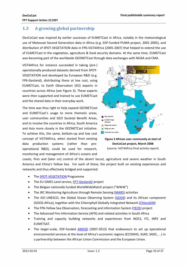
1.3 A growing global partnership
DevCoCast was inspired by earlier successes of EUMETCast in Africa, notably in the meteorological
use of Meteosat Second Generation data in Africa (e.g. EDF-funded PUMA project, 2001-2005), and
distribution of SPOT-VEGETATION data in FP6-VGT4Africa (2005-2007) that helped to extend the use
of EUMETCast In the vegetation, agriculture & food security domains. At the same time, EUMETCast
was becoming part of the worldwide GEONETCast through data-exchanges with NOAA and CMA.
VGT4Africa for instance succeeded in taking (pre-)
operationally-produced datasets derived from SPOT-
VEGETATION and developed by European R&D (e.g.
FP6-Geoland), distributing these at low cost, using
EUMETCast, to Earth Observation (EO) experts in
countries across Africa (see Figure 3). These experts
were then supported and trained to use EUMETCast
and the shared data in their everyday work.
The time was thus right to help expand GEONETCast
and EUMETCast’s usage to more thematic areas,
user communities and GEO Societal Benefit Areas,
and to involve the countries in Africa, South America
and Asia more closely in the GEONETCast initiative.
To achieve this, the same, bottom-up and low cost
concept of VGT4Africa, when started from existing
data production systems (rather than pre-
operational R&D), could be used for research,
monitoring and management of Africa’s oceans and
coasts, fires and (later on) control of the desert locust, agriculture and severe weather in South
America and China’s Yellow Sea. For each of these, the project built on existing experiences and
networks and thus effectively bridged and supported:
The SPOT-VEGETATION Programme
The EU GMES Land service, FP7-Geoland2 project
The Belgian nationally funded WorldWideWatch project (“WWW”)
The JRC Monitoring Agriculture through Remote Sensing (MARS) activities
The IOC-UNESCO, the Global Ocean Observing System (GOOS) and its African component
(GOOS-Africa), together with the Chlorophyll Globally Integrated Network (ChloroGIN)
The FP6-Yellow Sea Observation, forecasting and information System (YEOS) project
The Advanced Fire Information Service (AFIS) and related activities in South Africa
Training and capacity building networks and experiences from NOCS, ITC, INPE and
EUMETSAT.
The larger-scale, EDF-funded AMESD (2007-2013) that endeavours to set up operational
environmental services at the level of Africa’s economic regions (ECOWAS, IGAD, SADC, ...) in
a partnership between the African Union Commission and the European Union.
Figure 3 African user community at start of
DevCoCast project, March 2008
(source: VGT4Africa final activity report)

DevCoCast
FP7 Support Action 211307
Final publishable summary report
2012-02-01 Issue: 1.2 Page 11 of 37
Beneficiary’s full name Acronym Country
Vlaams Instelling voor Technologisch Onderzoek NV /
Flemish Institute for Technological Research
VITO Belgium
African Centre of Meteorological Application for Development ACMAD Niger
Centre Régional de Formation et d’Application en Agrométéorologie et
Hydrologie Opérationnelle
Regional centre for training and operational applications in agrometeorology
and hydrology
AGRHYMET Niger
Companhia Nacional de Abastecimento /
Food Supply Agency of the Ministry of Agriculture
CONAB Brazil
Centre for Surveying and Assessment of Agriculture and Natural Resources CREAN Argentina
Council for Scientific and Industrial Research CSIR South Africa
Danish Meteorological Institute DMI Denmark
European Organisation for the Exploitation of Meteorological Satellites EUMETSAT Germany
National Institute for Space Research INPE Brazil
Instituto Nacional de Tecnología Agropecuaria /
National Institute of Agriculture Technology
INTA Argentina
University of Twente /
Faculty of Geo-Information Science and Earth Observation
ITC/UT The
Netherlands
European Commission – DG Joint Research Centre /
Institute for Environment and Sustainability
JRC Italy
Natural Environment Research Council /
National Oceanography Center Southampton
NERC-NOCS United
Kingdom
Marine Research Institute / University of Cape Town MA-RE/UCT South Africa
Plymouth Marine Laboratory PML United
Kingdom
Table 1 List of DevCoCast beneficiaries
In addition to the above 15 full partners, 10 Associated Organizations received a DevCoCast-funded
satellite receiver and were in turn expected to integrate GEONETCast into their work and share this
experience in their usual network. These included:
Brazilian Agricultural Research Corporation’s (EMBRAPA) Centre for Satellite Monitoring (CNPM), Brazil
State University of Campinas, Faculty of Agricultural Engineering (FEAGRI), Brazil
Four marine research institutes
o University Cheikh Anta Diop, Laboratory for Training and Research in Geo-matics (LERG), Senegal
o University of Dar es Salaam, Institute of Marine Sciences (IMS), Tanzania
o Ministry of Fisheries and Marine Resources, National Marine Information and Research Centre (NatMIRC), Namibia
o University of Ghana
National locust control centres and offices of Mali (CNLCP), Sudan and Eritrea
A private company and Chinese pilot user, Jiangyin Marine Technology Co. Ltd. (JYMT)
DevCoCast
FP7 Support Action 211307
Final publishable summary report
2012-02-01 Issue: 1.2 Page 12 of 37
2 Main results of DevCoCast
The overview of the main results of the DevCoCast project are organized into the four core activities
of the project: (i) harmonization and sharing of EO data, derived products and information; (ii) setting
up GEONETCast receiver and hub infrastructure; (iii) capacity building and support to user
communities; and (iv) making everyday use of GEONETCast (see also Figure 1, p.8).
2.1 Product harmonization and sharing
2.1.1 Product review and adaptation
There is a wealth (100+) of products available on GEONETCast/EUMETCast, and lots more (40+) were
added during the DevCoCast project. As this could lead to confusion of the users and, hence, impede
proper use of the products, it is important that the data and information products were not just
“dumped” onto the users’ desks. Rather, it needed to be ensured that -even basic- users were able to
work with the products and understand them sufficiently for their applications. To help address this
important challenge, the project partners first reviewed each product scientifically and IT-technically,
using, respectively, a survey with 8 main questions and an assessment of 11 main criteria (each time
with clear rationale), in order to:
Ensure products are of sufficient quality;
Avoid unnecessary, duplicate data or information;
Make sure overlapping or complementary products are accompanied by clear instructions on
which product to use in which situation;
Provide users with a clear overview of product characteristics; and
Harmonize the products across providers.
After creating a detailed report with general and provider-specific recommendations for product (&
service) adaptations (see [RD1]), all providers assessed impact of the proposed changes on their
production systems. This was done not only in consideration of project constraints such as time,
effort and cost needed to make the changes, but more importantly in view of the impact on existing
users.
Despite several delays and challenges related to input products from external sources or other
projects, staff shortages and changes and the wide variety of DevCoCast products (different thematic
areas, processing levels, etc), a strong harmonization effort was carried out by all providers.
Implementing a standardized Catalog Service for the Web (CS-W), or upgrading existing web portals
to conform to the CS-W standard, proved to be the most difficult or even unfeasible
recommendation to implement. The main exceptions were VITO and PML who could benefit from
the Spatial Data Infrastructure developments of the larger scale GMES efforts, such as Geoland2 and
MyOcean (FP7) projects.

DevCoCast
FP7 Support Action 211307
Final publishable summary report
2012-02-01 Issue: 1.2 Page 13 of 37
In particular, the considerable efforts made by the Africa-focussed marine product providers (UCT,
PML, JRC) to not only individually implement their own recommendations, but to largely harmonize
the formats and naming of their products a) between the three of them and b) in line with existing CF
convention for NetCDF file format, can be seen as a success. The geographic mapping method is left
as the main difference between PML and UCT products, as indicated and discussed at the marine
user feedback workshop in October 2010.
When FP7-EAMNet started to review all marine products that were relevant and available to the
project in 2010 (not limited to those provided via GEONETCast), the same review approach and
criteria were applied (see [RD 2]).
2.1.2 Sharing EO products globally via GEONETCast
From the start, DevCoCast was seen as a bridge that linked, built upon, supported and helped
maintain, existing efforts. This is true for the GEONETCast technology and infrastructure itself, the
capacity building and training (e.g. links to ITC, EUMETSAT and Ocean Colour training networks) and
the usage of the provided products (e.g. various user communities), but also for the creation of the
disseminated products.
DevCoCast was inspired by earlier successes in Africa, notably the FP6-VGT4Africa project that shared
SPOT-VEGETATION derived data, both the basic NDVI (a commercial product of the SPOT-
VEGETATION Programme, given free access for use in developing countries) and a set of added value
products, developed by EU R&D, and added these to the EUMETCast distribution to make them
available to EO experts in Africa. These experts were in turn trained to use EUMETCast and the data
it shares in their day-to-day work. This process helped to extend EUMETCast to environmental and
vegetation/agriculture communities, beyond the meteorological community that still remains at its
heart today.
DevCoCast attempted to apply this concept to other products, application domains and user
communities – for example, oceans, fires and desert locusts in Africa, the Yellow Sea in China, or
severe weather and agriculture in South America. To achieve this, and contrary to VGT4Africa,
DevCoCast was fortunately able to rely on existing production systems and experiences. Although the
following list is without doubt not fully exhaustive, DevCoCast would like to acknowledge the
contributions from and cooperation with:
The SPOT-VEGETATION Programme;
The EU GMES Land service, FP7-Geoland2 project, that among others improves the derived
products of VGT4Africa in terms of algorithm, geographic scale and validation;;
The Belgian nationally funded WorldWideWatch project (“WWW”);
The EC Joint Research Centre’s Monitoring Agriculture through Remote Sensing (MARS)
activities;
The IOC-UNESCO, the Global Ocean Observing System (GOOS) and its African component
(GOOS-Africa), together with the Chlorophyll Globally Integrated Network (ChloroGIN);
The FP6-Yellow Sea Observation, forecasting and information System (YEOS) project;
The Advanced Fire Information Service (AFIS) and related activities in South Africa.

DevCoCast
FP7 Support Action 211307
Final publishable summary report
2012-02-01 Issue: 1.2 Page 14 of 37
Combined, these resulted in a wide range of 40+ products, from satellite data and derived products
to model and forecast outputs and information products (bulletins with local expert analysis),
covering a variety of thematic fields. In fact, the distribution of a new CBERS high resolution product,
a fusion between the colour CCD and pan-chromatic HRC sensors, and maps of green vegetation
dynamics (produced in the “WorldWideWatch” project), used in the control of Desert Locusts, were
not originally foreseen and added in a contract change towards the end of 2009 (roughly halfway
through the project).
This wide range of DevCoCast products flowed from ten different providers in Africa, South America
and Europe, over two central hubs (see also §2.2.1) at PML (ocean products) and VITO (land) to
EUMETSAT as the regional GEONETCast Network Centre and then over GEONETCast broadcast
towards the users. Providers DMI (Denmark) and INPE (Brazil) transferred their products directly to
EUMETSAT, and the DMI products used the GEONETCast data-exchange between EUMETSAT and
CMA before being broadcast on CMACast (the Asian component of GEONETCast), whereas all other
products were put on the EUMETSAT-operated EUMETCast broadcast (covering EU, Africa and the
Americas). Finally, the products were (and largely still are) received using low cost receiving stations,
completing the South-North-South and North-South flows, that are illustrated in Figure 4.
Figure 4 Sharing EO products across the continents within DevCoCast
Where the flow started, on the product providers’ side, DevCoCast contributed to the technical
development of the systems (hardware, software, network, internet connectivity upgrade) needed to
automatically transfer the created products. This included Quality Assurance (QA) methods, put in
place to ensure that providers could routinely monitor the performance of their product uploads
(e.g. through operators, automated alerts, performance logging, etc) and report any interruptions.

DevCoCast
FP7 Support Action 211307
Final publishable summary report
2012-02-01 Issue: 1.2 Page 15 of 37
This effort thus completed the providers’ side of the operational interfaces between
eight providers (ACMAD, AGRHYMET, CSIR, INTA, JRC, PML, UCT and VITO) and the hubs at
PML and VITO (see also §2.2.1), including also the use of the back-up hub in case of hub
service interruptions;
INPE and DMI on one hand and EUMETSAT on the other, via direct links.
These provider to hub and provider to EUMETSAT interfaces were all established and documented in
terms of technical details (FTP servers, logins, etc), mutual responsibilities (e.g. reporting) and points-
of-contact in the Operations and Interface Control Documents (OICD) in accordance with the usual
template, seamlessly integrating into EUMETCast.
To further set up the flow, a concerted effort between the providers, hubs and EUMETSAT further
arranged:
The setup of the DEVCOCAST-1 channel on EUMETCast, receivable in the entire EUMETCast
broadcast footprint (Europe, Africa, Americas):
The access conditions and registration requirements, with most products freely and openly
available, except for (re-)selling, thus largely in line with the GEO Data Sharing Principles;
The creation of metadata needed to feed the Product Navigator
(http://navigator.eumetsat.int), the searchable online catalog of products available on
EUMETCast or GEONETCast. The Navigator’s Extended Search option for instance allows to
easily find products from the DevCoCast providers, dealing with specific topics, etc.:
The procedure to add products to EUMETCast and the related announcements to users:
The entry points into the EUMETCast systems of EUMETSAT and related priorities when
bandwidth competition occurs.
The established procedure to add products to the EUMETCast broadcast (and to less extent the
GEONETCast data-exchange to CMA), encompassed the following steps:
1. Test the product uploads to EUMETSAT, mostly via the hubs
2. Announce start of trial broadcast to a limited set of satellite receivers
3. Actual start of trial broadcast
4. At least 2 weeks of trial broadcast, which ends when the product flow is regular and stable,
monitoring is configured and ready on EUMETSAT side, and the Product Navigator metadata
has been created;
5. Announce of operational, full-scale broadcast
6. Start of operational broadcast
The requirements for GEONETCast-Americas and/or CMACast were sometimes different, and there
were exceptions to this procedure, e.g. for closed user groups. Nevertheless, the three stages
(upload tests, limited-scale trial broadcast until stable flow, and full-scale broadcast) accompanied
with user announcements, ensured a smooth transition for users and helps to maintain control over
the system.

DevCoCast
FP7 Support Action 211307
Final publishable summary report
2012-02-01 Issue: 1.2 Page 16 of 37
In this coordinated effort and following product changes (following the review recommendations or
user feedback), the partners succeeded in moving the majority of the foreseen products to full-scale
broadcast. This proved that EUMETCast and GEONETCast are open and flexible in terms of the type
of products that can be shared while keeping an emphasis on near-real time deliveries (i.e. no large
archives of years of data). Furthermore, attention was paid to avoid duplication (conserving valuable
bandwidth) and delivering quality products, in particular supporting the delivery of those products
that have proven usage.
As mentioned, product providers continuously monitored the performance of their uploads to the
hubs and EUMETSAT. This was done until the end of the project (and has continued in follow-on
projects), clearly in close conjunction with the hubs’ own monitoring (see next section), EUMETSAT’s
rigorous, central monitoring and reporting, as well as input from JYMT (the Chinese pilot user that
evaluated the data availability and tried to compare the performance of standard FTP against
GEONETCast). The monitoring was stepped up as products moved from test uploads over trial
broadcast (limited number of users) to full-scale broadcast. It involved products from providers in
Africa (CSIR, UCT), South America (INTA, INPE) and Europe (DMI, VITO, PML), with JRC’s products
waiting to be added.
For instance:
INPE’s monitoring of the last three months revealed a performance with 11% outages,
whereas their target was less than 5%.
CSIR’s monitoring showed lapses in SAWS input data, which triggered them to start
developing their own model to replace the input. This effort was stopped when SAWS inputs
stabilized and an improved fire risk model was identified that will replace their current
products completely.
After some initial issues when moving to operational broadcast, INTA’s verification of the
integrity (size) of uploaded files proved quite effective.
JYMT’s monitoring showed high availability of DMI products (<1% lapses) via FTP, though
with very varying transfer speeds.
By the end of the project, nearly 80 interruptions were reported, 55 affecting the closely monitored
operational broadcast, however:
Nearly half were not caused by providers themselves, but rather from external causes or
downstream in the flow (hubs, EUMETSAT), the latter often being short in duration;
Many interruptions were actually caused by problems in data production rather than the
newly established, automated product transfer systems;
Out of 24 interruptions contributed to provider-side, most were linked to one-time events
such as product (flow) changes and largely of short duration: only three reported issues took
more than a couple of days to resolve.
The monitoring was clearly challenging and used diverse methods, but the efforts did stabilize the
flow, notably in the last six months of the project, at a constant level of 250MB or 500 files per day.
This is for instance shown in EUMETSAT’s monitoring: see Figure 5 (source: EUMETSAT performance
report).

DevCoCast
FP7 Support Action 211307
Final publishable summary report
2012-02-01 Issue: 1.2 Page 17 of 37
Figure 5 Number of DevCoCast files and total volume per day for May 2010 –Sept 2011
The EUMETSAT monitoring furthermore showed that EUMETCast and GEONETCast-exchange to CMA
themselves performed within typical performance ranges, e.g. >99.5% for EUMETCast broadcasts
(see Figure 6), thus confirming once more their high reliability. Delivery times were less than 20min
on average and up to two hours maximum, varying according to product file size.
Figure 6 Daily EUMETCast dissemination performance for May 2010 – Sept 2011

DevCoCast
FP7 Support Action 211307
Final publishable summary report
2012-02-01 Issue: 1.2 Page 18 of 37
2.2 Setup of receiver and hub infrastructure
2.2.1 Central product gathering hubs
In order to schedule and prioritize the various DevCoCast products, some originating in Africa or
South America, before passing them to EUMETSAT as one of the three main GNC, the products were
first gathered by two intermediate nodes, called “hubs”, at PML (UK) for “ocean” thematic products
and VITO (Belgium) for “land” products. The position of the land and ocean hubs in the DevCoCast
product flow systems is visualized in Figure 7. The hub systems were, thus, central product gathering
nodes, servers running bespoke software for the controlled dissemination of satellite imagery and
derived information. At the same time, they effectively extended (and continue to extend)
EUMETCast and thus GEONETCast with additional providers and products, covering additional
application themes (beyond meteorology and ocean altimetry) and GEO Societal Benefit Areas.
Figure 7 Land and ocean hubs in the DevCoCast product flow systems
While the hubs were designed and set up through a joint development by PML and VITO within the
frame of DevCoCast, they integrated well with the rest of the GEONETCast infrastructure (in
particular EUMETCast) and acted as (optional) add-ons to EUMETSAT’s GNC. Figure 8 shows how
EUMETSAT’s systems in turn added the products passed by the two hubs, DMI and INPE onto the
EUMETCast broadcast and the GEONETCast data-exchange between EUMETSAT and CMA (China).
Just as for the provider side (see section 2.1.2), the hubs needed to be part of a routine, controlled
flow of products. This was achieved by:
Regularly monitoring their performance and the bandwidth consumption (via logs, graphs
and the open source Nagios software);
Both hubs acting as each other’s backup (see dashed lines in Figure 7) in case of interruption;
Maintaining the software and configuration;
Day-to-day reporting of interruptions, between both hubs (VITO and PML), EUMETSAT and
the various product providers connected to each hub.

DevCoCast
FP7 Support Action 211307
Final publishable summary report
2012-02-01 Issue: 1.2 Page 19 of 37
Figure 8 DevCoCast product flow from EUMETSAT point-of-view
After the hubs were put into operation, a few issues were discovered and resolved by fixing or
improving the software, adding additional software tests along the way (to ensure the issues did not
re-appear in future) and by updating the configurations of the hubs (e.g. to add products or change
from trial to operational broadcast). This led to very stable and reliable hub software, which has run
at VITO and PML for several months without major interruptions, except for the occasional planned
system maintenance. Even the rarely occurring take-over scenario, whereby product providers
temporarily transfer their products via the alternate hub when their nominal hub is unavailable, was
shown to work out fine. In fact, the hubs automatically keep track of each other’s file uploads via
synchronized logs, to ensure as far as possible that they do not upload the same files twice. The
efforts of VITO and PML to merge their hub configurations made this scenario easier to manage as
well.
The fact that, by the end of the project, PML was operating more than one hub software instance
concurrently, can be considered proof of the scalability and extensibility of the hub concept.
Finally, the continued operation of both hubs has been assured in the related FP7-EAMNet (for PML
hub) and FP7-AGRICAB projects (VITO hub), making the hub software a valuable project output in
itself.

DevCoCast
FP7 Support Action 211307
Final publishable summary report
2012-02-01 Issue: 1.2 Page 20 of 37
2.2.2 GEONETCast receivers
Before the start of the project, Africa already benefited from a EUMETCast satellite receiver network,
mainly at the various National Meteorological Services (NMS), inherited from the PUMA project.
DevCoCast’s predecessor, the FP6-VGT4Africa project and ITC’s capacity building efforts, already
extended this network with a small number of stations for environmental or agricultural institutes
and universities (see [RD 3]). Several NMS stations were also re-configured to receive the SPOT-
VEGETATION data. The African Monitoring of Environment for Sustainable Development initiative
(AMESD) that started in parallel to DevCoCast, soon indicated their plans to upgrade the NMS
stations and to install “environmental” stations (called AMESD stations) in every country, often in the
Ministries of Agriculture, Environment or both. In other words, Africa was set to go from
approximately 50 to over 100 stations. DevCoCast efforts well complemented this by extending the
receiver network to other user communities, starting with four marine centres in Ghana, Senegal,
Namibia & Tanzania, respectively in four of the African Large Marine Ecosystems (LMEs). Halfway
through the project, three pilot national locust centres in Mali, Sudan, Eritrea were also foreseen to
get a funded receiver. As these seven organizations were not full project partners, the supply of
equipment and its installation were undertaken by the University of Cape Town, with support from
other partners (notably VITO, EUMETSAT and ITC). While the marine receivers proved to be
successful (see right side of Figure 9) and continue to be used, for instance in the follow-up FP7-
EAMNet project, only one of the three desert locust receivers (Mali) is up and running.
On the other side of the Atlantic, the South-American data receiver community also consisted,
initially, of stations provided to the National Meteo Services of the various countries. This meant an
even smaller network (20-30 receivers, only two in Brazil) than the African one, with more limited
usage of MSG data (since MSG doesn’t cover the full South American continent). Nevertheless, as in
Africa, DevCoCast used the meteorological network as a starting point and aimed to extend the
network with environmental and agricultural (research and monitoring) organizations and
Universities. In particular, DevCoCast set up three receiving stations in Brazil (and re-configured a
fourth one) and installed two in Argentina (see left side of Figure 9).
On the Asian side, the GEONETCast data-exchange between EUMETSAT and CMA had just been put
in place. DevCoCast thus set out to try using this exchange to send DMI products over to China for
inclusion in the FengYunCast broadcast, installing one receiver for a pilot user that would compare
the performance of this exchange with a regular, internet download and demonstrate its use to raise
awareness. Unfortunately, this was significantly hampered by CMA’s migration to the larger
CMACast, that included a large extension of the receiver network and a move from DVB-S to DVB-S2
for higher bandwidth capacity. Though CMA has opened up CMACast to other Asian countries and
supported a public demonstration of the use of DMI products, received via the data-exchange and
CMACast, in marine information services at the GEO VII Ministerial Summit in Beijing, they are
currently not willing to support the installation of a CMACast receiver for routine use by a private
company, like JYMT, DevCoCast’s pilot user.
In each case, the receiving station setup was kept low cost, to further prove that cost should not be a
barrier to using GEONETCast. It involved the installation of a 2-2.5m antenna, a dedicated reception
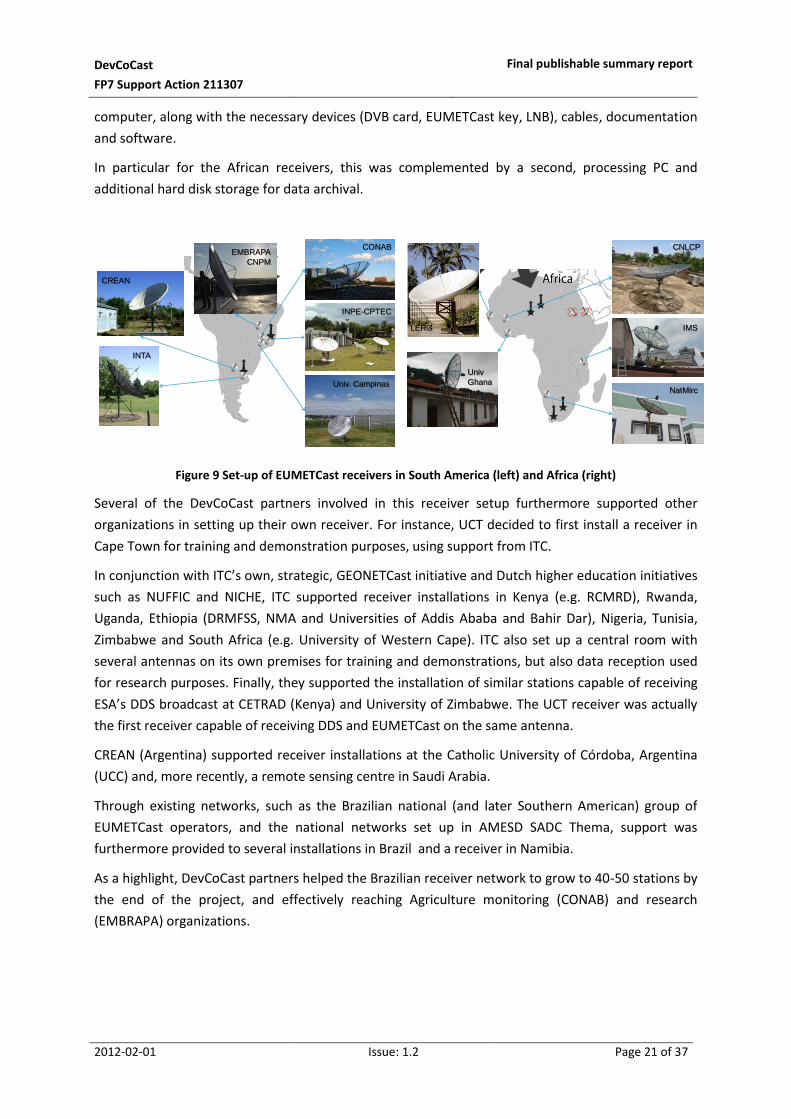
DevCoCast
FP7 Support Action 211307
Final publishable summary report
2012-02-01 Issue: 1.2 Page 21 of 37
computer, along with the necessary devices (DVB card, EUMETCast key, LNB), cables, documentation
and software.
In particular for the African receivers, this was complemented by a second, processing PC and
additional hard disk storage for data archival.
Figure 9 Set-up of EUMETCast receivers in South America (left) and Africa (right)
Several of the DevCoCast partners involved in this receiver setup furthermore supported other
organizations in setting up their own receiver. For instance, UCT decided to first install a receiver in
Cape Town for training and demonstration purposes, using support from ITC.
In conjunction with ITC’s own, strategic, GEONETCast initiative and Dutch higher education initiatives
such as NUFFIC and NICHE, ITC supported receiver installations in Kenya (e.g. RCMRD), Rwanda,
Uganda, Ethiopia (DRMFSS, NMA and Universities of Addis Ababa and Bahir Dar), Nigeria, Tunisia,
Zimbabwe and South Africa (e.g. University of Western Cape). ITC also set up a central room with
several antennas on its own premises for training and demonstrations, but also data reception used
for research purposes. Finally, they supported the installation of similar stations capable of receiving
ESA’s DDS broadcast at CETRAD (Kenya) and University of Zimbabwe. The UCT receiver was actually
the first receiver capable of receiving DDS and EUMETCast on the same antenna.
CREAN (Argentina) supported receiver installations at the Catholic University of Córdoba, Argentina
(UCC) and, more recently, a remote sensing centre in Saudi Arabia.
Through existing networks, such as the Brazilian national (and later Southern American) group of
EUMETCast operators, and the national networks set up in AMESD SADC Thema, support was
furthermore provided to several installations in Brazil and a receiver in Namibia.
As a highlight, DevCoCast partners helped the Brazilian receiver network to grow to 40-50 stations by
the end of the project, and effectively reaching Agriculture monitoring (CONAB) and research
(EMBRAPA) organizations.
CREAN
INTA
Univ. Campinas
INPE-CPTEC
EMBRAPA
CNPM
CONAB
Univ
Ghana
LERG
CNLCP
NatMirc
IMS

DevCoCast
FP7 Support Action 211307
Final publishable summary report
2012-02-01 Issue: 1.2 Page 22 of 37
2.3 Capacity building, training and user support
A major part of the DevCoCast project effort was dedicated to capacity building, training and direct,
ad hoc user support. The partners, with important roles for ITC (land, GEONETCast) and NERC
(marine) in particular, aimed to:
Provide users with free, stand-alone training material in multiple languages, including French,
English, Spanish and Portuguese;
Provide more harmonized product documentation;
Organize several workshops in order to train users in using GEONETCast and use of the
provided products;
Provide direct user support via help desk services responding to ad hoc, e-mail questions,
where possible providing a central access (e.g. web form) to contact the product providers
and their support services;
Set up a project website, hosted by VITO, which contains contributions from all partners,
especially from the data producers.
In total, over 300 people were trained in 10 different international workshops across Africa (6), South
America (3) and at ITC, and in two online courses (Table 2, Figure 10). This added to the courses
organised in related training networks (e.g. ITC, EUMETSAT, INPE) and national/local workshops
organized by DevCoCast partners, such as the INTA user feedback workshop in Pergamino, Argentina,
in December 2010. The regional African land workshops in Kinshasa (CICOS region), Niamey
(ECOWAS), Nairobi (IGAD) and Botswana (SADC) were successfully co-organized with AMESD,
whereby DevCoCast provided one or two trainers and development of training material.
Date Place
June 2009 Virtual course (INPE) July 2009 Cape Town, South Africa (at IGARSS2009) December 2009 Kinshasa, D.R. Congo February 2010 Nairobi, Kenya May 2010 Niamey, Niger May 2010 Virtual course (INPE) June 2010 Córdoba, Argentina June 2010 Cachoeira Paulista, Brazil October 2010 Addis Ababa, Ethiopia (at AARSE2010) February 2011 In depth training at ITC, The Netherlands June 2011 Gaborone, Botswana June 2011 Cachoeira Paulista, Brazil
Table 2 International training workshops & online courses organized within DevCoCast
Figure 10 shows a collection of group photographs taken at the workshops, from top to bottom and
left to right, in Kenya, Argentina, Brazil, Ethiopia, Botswana, The Netherlands and Niger. Reports of
each of the workshops are provided on the project website, at
http://www.devcocast.eu/ViewContent.do?pageId=102

DevCoCast
FP7 Support Action 211307
Final publishable summary report
2012-02-01 Issue: 1.2 Page 23 of 37
Figure 10 Participants to some of the training workshops organized within DevCoCast
In the training package development, the initial goal was to provide two, self-learning training
packages: one on land applications (with focus on the use of SPOT-VEGETATION derived products,
relying on pre-existing material from JRC) and one on marine and coastal applications (with focus on
ChloroGIN-Africa products). In addition, pre-existing ITC material, as “common denominator”
between land and ocean packages, the GEONETCast technology itself, e.g. the setup and operation of
low cost receiving stations and related software, would be updated and provided. The training
material was to be tried at the workshops and then further developed in line with user feedback.
This, for instance, led to a first ocean package, with theory slides, practicals and a document with an
overview of online available materials, made publicly available in January 2010.
At the highlight of the training plan, the 2-week advanced training course at ITC, 30 participants,
many selected from attendance at earlier workshops, worked on over 20 practical applications of
GEONETCast and the shared products. These applications covered a wide variety of topics, such as
agricultural & biomass monitoring, land degradation, fire risk modelling, water management and
evapotranspiration, monitoring of insect populations, sea surface temperature, marine ecosystem
productivity and coral bleaching, in various study areas in Africa and South America. Thus underlining
once more the versatility of GEONETCast.
This led to the development of an “Application Manual”, consisting of presentations, exercise
descriptions and data, over 70 GB in total. This material was further enhanced and translated to
Spanish and Portuguese, and will be further used and developed in e.g. the FP7-AGRICAB project.

DevCoCast
FP7 Support Action 211307
Final publishable summary report
2012-02-01 Issue: 1.2 Page 24 of 37
Part of it will also be provided via the EUMETCast Training Channel in the future. The workshops in
Botswana and Brazil, in June 2011, further built on the results on the 2-week advanced course as
well.
For the accompanying software tools, the idea was to leave the choice of software to the users, in
view of their past experiences. Via the help desks, users were thus supported regardless of the
software they were using. At the same time, the project pushed the use and development of free
and/or open source solutions, which proved particularly successful in the training efforts. This led to
the further development of a complement of tools that a) integrated the received data into
commonly used GIS and Remote Sensing tools, notably VITO’s VGTExtract1, and b) offered generic
GIS/Remote Sensing processing and visualisation capabilities, in particular UNESCO’s BILKO and
ILWIS2 and the GEONETCast Toolbox3 (including Data Manager) developed jointly by ITC and
52North.
2.4 Supporting everyday use of GEONETCast
With GEONETCast data reception operational and sufficient capacity built to ensure proper usage of
the data, the last DevCoCast last task was to work on the integration of the received data into
applications and decision making processes. In fact, it was the project’s ultimate goal to embed
GEONETCast and the provided products systematically in everyday research & education, monitoring
and finally planning and decision making, as key to wider and more sustained use of GEONETCast.
This effectively made this the most important, and most ambitious, task.
It was clear that, there was a need to support this major effort locally on the receiver side. Rather
than funding the day-to-day operation of the installed receiving stations, the involved organizations
were instead given the opportunity to set up the necessary technical capacities (e.g. computer
systems, network), to train their staff (e.g. replicating the experience from attended project
workshops) and to share the acquired products, software tools and experiences within their own,
usual network.
These efforts, often taken for granted, helped to
Build a “critical mass” of technical and human capacities in using GEONETCast and its
products within the organization (which helps to ensure sustainability);
Leverage and replicate the efforts from the project’s many, mainly international workshops
on other scales (organization, state, province, country);
Raise awareness and share working experiences on GEONETCast by building on each
organization’s usual network, both internally and with local project partners and (end) users;
Prepare the integration of GEONETCast into (mainly existing) applications and decision
making processes and disseminate their outcome.
1 http://www.devcocast.eu/VGTExtract.do
2 http://52north.org/communities/ilwis
3 http://www.itc.nl/Pub/Organization/Geonetcast-Toolbox.html and
http://52north.org/communities/earth-observation/

DevCoCast
FP7 Support Action 211307
Final publishable summary report
2012-02-01 Issue: 1.2 Page 25 of 37
It is important to see that these efforts were tailored to the local circumstances. For instance, in the
African organizations, acquiring additional computer and network capacities, reference data sets
(archives, time series) was the first focus. As awareness of GEONETCast was still limited in Latin
America at the start of DevCoCast (as evidenced by the limited receiver network, despite clear
potential), the need for local networking and raising awareness was more pressing there. This was
done both externally with local project partners and end users, as well as internally within the
involved organizations, for instance through EMBRAPA’s network of 40+ research centres, CONAB’s
departments in several Brazilian states and INPE’s divisions/centres.
This work was also closely related to the training efforts organized by the DevCoCast product-
providing partners, with limited support for project workshop attendance on the receiver side, and
the received training materials and experiences being shared locally. This work shows the motivation
of several product-receiving organizations to really work with GEONETCast, by leveraging the
experiences and networks they carefully built up in the past years.
In fact, the DevCoCast consortium, in cooperation with the leading GEONETCast implementation
group (EUMETSAT, NOAA, CMA, WMO), were constantly looking towards the continuity and
expansion of the services to users and the continued/sustained use of GEONETCast.
It is well beyond the scope of this report to discuss the many examples of integration of GEONETCast,
as these have often been improved and are the results of years of experience. For more details on
the networking and strengthening of local capacities, please see [RD 4]. For the integration work, it is
recommended to read the report from a survey carried out in first half of 2011 (see [RD 5]) or the
presentations of the project’s final meeting at
http://www.devcocast.eu/ViewContent.do?pageId=121.
While very challenging, it can be concluded that this important work did manage to result in
successful applications of DevCoCast data in a variety of topics, such as fire fighting in Southern
Africa, desert locust control in affected countries around the Sahara, monitoring severe weather in
Brazil, agriculture and vegetation conditions (e.g. re-forestation) in Brazil and Argentina, marine and
coastal ecosystems (e.g. coral bleaching) and productivity (fisheries) around Africa’s coastline and
helped to provide feed information services on marine conditions and transport over the Yellow Sea.
DevCoCast efforts helped the networks of EUMETCast and GEONETCast users grow, in particular in
Brazil, Senegal and several southern African (SADC) countries. These impacts are further described in
the next section.

DevCoCast
FP7 Support Action 211307
Final publishable summary report
2012-02-01 Issue: 1.2 Page 26 of 37
3 Impact, main dissemination activities and further
exploitation of project results
3.1 Potential and achieved impact
Global in its geographical perspective, and highly visible from its inception, the DevCoCast project set
out to and succeeded in bridging providers of Earth Observation products (data, derived products,
information) and growing networks of receivers and (end-)users in Africa, South-America and Asia,
via GEONETCast as central, global and reliable satellite broadcast technology. Those users, local EO
experts in various thematic areas, in turn were supported and trained and finally made everyday use
of GEONETCast and the shared products in research, education, monitoring, planning and
(ultimately) decision making processes. By leveraging, supporting and maintaining existing capacities,
DevCoCast aimed at having a big impact with a limited budget (approx. 2M€) and within less than 3.5
years. Being the “glue” between the best of many worlds proved to be very challenging, but overall
advantageous.
To reliably share 40+ products, from ten sources, helped to involve African and South American
organizations more closely in GEONETCast (e.g. as product providers), and built upon existing
experiences such as SPOT-VEGETATION, GMES Land service, CBERS, FP6-YEOS and ChloroGIN-Africa.
The wide range of products, varying in type (from satellite imagery, derived data, model outputs and
forecasts to information products), thematic focus (agriculture, fire, ocean and coast, weather,...)
and geographically covered area, underlined the versatility and potential of GEONETCast as one-stop
delivery system for many kinds of environmental data and information. Furthermore, a modest effort
was made to review and harmonize the products, thus ensuring quality and improving usability. An
effort that is already picked up in the follow-on FP7-EAMNet project.
Additional infrastructure was built and reliably operated to help organize this product flow: the land
and ocean hubs as add-ons to the EUMETSAT-operated EUMETCast service, one of the three main
GEONETCast Network Centres. The hubs thus seamlessly integrated the products into the regular
EUMETCast infrastructure and full-scale broadcast to Europe, Africa and the Americas, while DMI
products covering the Yellow Sea were using the GEONETCast data-exchange between EUMETSAT
and CMA for broadcast over Asia (as a pilot and demonstration). The hub concept can easily be
extended to cover additional thematic areas. Why not even envisage a hub being operated by an
organization in Africa or South America?
While this product sharing and extension of GEONETCast were valuable on their own, the main
challenges were more on the user side: the data reception, local networking and, supported by
training and capacity building, day-to-day use of GEONETCast. With the aim of opening up
GEONETCast to additional user communities, thematic areas and achieving real impact and societal
benefits, and thus paving the way for more sustained use of GEONETCast.
In Africa, DevCoCast succeeded in building up satellite receivers for marine centres in four of the
African Large Marine Ecosystems (LMEs) and one out of the three foreseen receivers for national
desert locust control centres that were added halfway through the project.

DevCoCast
FP7 Support Action 211307
Final publishable summary report
2012-02-01 Issue: 1.2 Page 27 of 37
This brought GEONETCast capabilities and advantages to previously under-reached user
communities. It nicely complemented other international initiatives, notably AMESD, that undertook
to maintain the receiver network at National Meteorological Services (NMS), inherited from the
PUMA project, and extend it to other environmental and agriculture domains (building on the
success of DevCoCast’s pre-decessor, the FP6-VGT4Africa project). In fact, these four centres were
taken up in national EUMETCast networks, in cooperation with for instance AMESD’s SADC regional
Thema. The FP7-EAMNet project extends the network of receivers at African marine institutes.
In South America, the foreseen receivers were all set up and put to use, extending the network to
institutes dealing with for instance routine food supply monitoring, agriculture and environmental
research, modelling and education. This, combined with support to local networks, such as the Brazil
(and later South American) group of EUMETCast operators, extended GEONETCast in South America
beyond the meteorological usage that remains at its heart. With the upcoming use by an
international drought network, a newly established disaster centre and possible link to the fire
community (in cooperation with South Africa) should assure future expansion.
In China, the data-exchange was successfully demonstrated in the exhibit at the GEO-VII Ministerial
summit in Beijing, where DMI products, flowing through the GEONETCast data-exchange and
CMACast broadcast were received in the exhibit and used in two marine information systems.
Unfortunately, the installation of CMACast for routine use by the private company JYMT was not
(yet) supported by CMA. A clear need for more validation (e.g. typhoon forecasts), was put forward
by the Chinese user market (incl. fishing and other off-shore companies) and started to be addressed.
Direct user support, opened to all users in these growing networks and in the form of enhanced
product documentation, practical advice to setting up low cost receivers and use of the projects, and
the promotion and further development of free software (e.g. ILWIS, GEONETCast Toolbox, Bilko,
VGTExtract, AFIS field terminal), proved effective. It led to receiver installations for organizations in
several African countries, Argentina and Brazil.
The same software was used in a large training effort, with 10 international workshops, 3 online
courses and several local workshops, that linked to existing training networks (e.g. regular ITC,
EUMETSAT, INPE and OceanColour/ChloroGIN trainings) and AMESD. These training efforts
furthermore contributed to the development of extendable, freely available training material, in
particular an “Application Manual”, showing exercises built by local African and South American EO
experts in a variety of thematic fields and study areas. Once more a clear proof of the versatility and
applicability of GEONETCast for various user communities.

DevCoCast
FP7 Support Action 211307
Final publishable summary report
2012-02-01 Issue: 1.2 Page 28 of 37
The reliable data provision, free software, support and training, across thematic areas and
continents, was seen as the right mix for the final and most important work – the actual embedding
of GEONETCast and the provided products into:
Bulletins or reports for policy makers, other decision makers or even the general public;
Dedicated, downstream information services;
Decision support (software) tools;
Everyday environmental monitoring (and/or Early Warning) systems;
Research, to refine the input data used, enhance the methodology and validate the outcome.
These covered a variety of application themes: monitoring and forecasting (severe) weather, major
crops, (re-)forestation, management and modelling of watersheds, managing and fighting fires,
controlling insect populations and pest, etc. Each time, the integration of GEONETCast and
DevCoCast was shown to offer benefits such as:
Improved quality (e.g. from better or additional data sources);
Better performance and efficiency (e.g. saving time in the field by helping to timely locate
areas for closer survey);
Improved timeliness or frequency, by e.g. increasing reporting frequencies or delivery times
via a faster, more reliable access to input data;
A one-stop point to access products from several sources (thus saving time to search
products, contact providers and leaving valuable internet capacity for other downloads).
As a final, non-exhaustive list of highlights and achieved impact, the following can be mentioned:
The strengthened cooperation and networks, across thematic fields and continents, leading
to follow-on PhD research (e.g. Argentina, Brazil) and further collaboration;
The strong growth of national networks, in particular in Brazil (in cooperation with the Brazil
(later South American) group of EUMETCast Operators and UFAL), Senegal and several SADC
countries (in cooperation with AMESD SADC Thema). With DevCoCast help, the Brazil
network grew from two to more than 40 receivers in 3.5 years time;
The uptake of the disseminated Desert Locust products by 14/23 (60%) of the national
centres in the affected countries and UN-FAO in one half year’s time, who continue to
regularly use the products, though focusing on website access in first place;
The large variety of thematic areas covered in the applications and training material;
The three-fold increase (to over 300 users) of the African network of SPOT-VEGETATION
users and the start up of a similar network in South America with already 60 registered users.
The large number of EUMETCast receivers (200+) registered to receive and use the
DevCoCast products;
The pioneer distribution of CBERS high resolution data scenes over Africa.
The market survey of public, private and research users in China, clearly identifying their
needs;

DevCoCast
FP7 Support Action 211307
Final publishable summary report
2012-02-01 Issue: 1.2 Page 29 of 37
3.2 Main dissemination and outreach activities
Since its start, it was clear that the DevCoCast project concept differed from other activities in the
way it spanned thematic areas and the European, African, Latin American and Asian continents. At
the same time, it built on and linked to several important projects and initiatives, such as the
European GMES Land Service (FP7-Geoland24), the ChloroGIN network5 and GOOS-Africa6, the FP6-
YEOS project7, and the EDF-funded AMESD8 to mention a few. During the project, even more
initiatives, like UN-FAO’s Desert Locust Information Service, the CBERS distribution over Africa and
the Brazil network of EUMETCast operators (later called SAGEO – South American Group of
EUMETCast Operators) were linked to as well.
This “central” position gave DevCoCast a lot of visibility, right from its inception. In addition, and
although not initially foreseen in the work plan, DevCoCast was soon put forward to take up a
flagship role among the family of EU (research) projects contributing to GEO and GEOSS. This family
of projects meets regularly in workshops organized by the European Commission’s DG Research and
Innovation9.
On top of being highly visible, it was also recognized that the uptake of GEONETCast as broadcasting
technology still required a lot of awareness raising. Too many organizations in developing countries,
who stand to benefit significantly from this low cost, reliable EO data sharing technology, are simply
unaware of its existence or the many benefits it can offer them. These two combined made the
DevCoCast team put a lot of effort into outreach and promotion efforts, such as attendance of, and
presentation at, international meetings and conferences, development of outreach materials
(posters, promotional publications, etc) and the collection of user feedback at various public events.
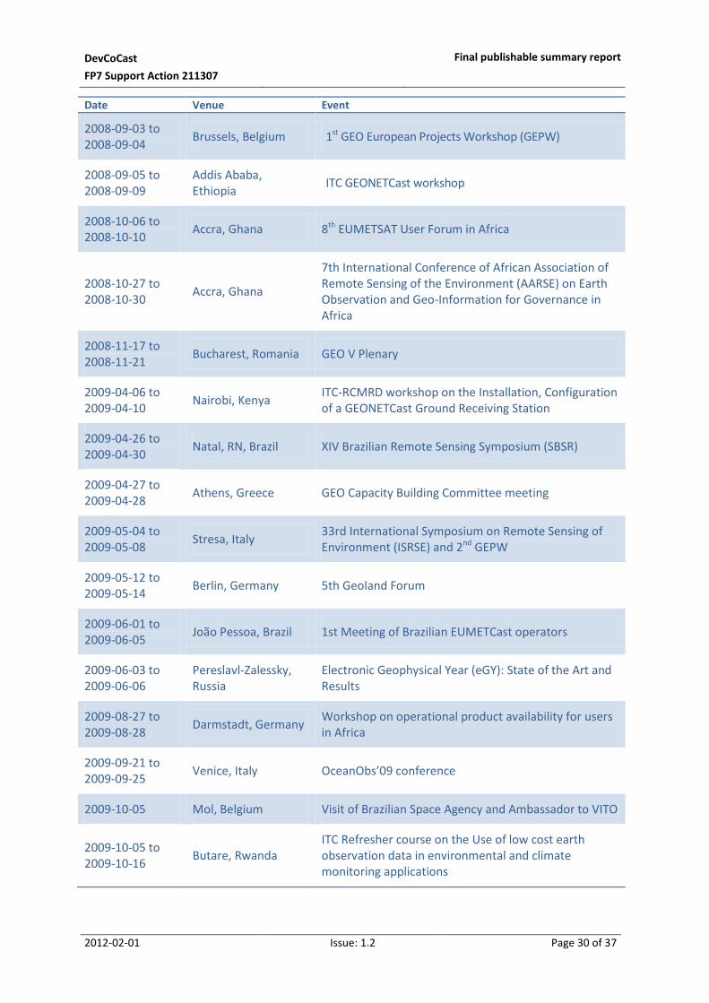
3.2.1 Attendance at workshops, conferences and meetings
To promote the project to users and other stakeholders, as well as to coordinate efforts with related
projects, the DevCoCast partners attended a large number of international workshops and
conferences (Table 3). Their participation had many forms: from presenting posters and fliers,
providing papers for conference proceedings and presentations to live demonstrations of
GEONETCast and the reception of DevCoCast (and similar) products.
4 http://www.geoland2.eu
5 http://www.chlorogin.org
6 http://www.ioc-goos.org
7 http://ocean.dmi.dk/yeos
8 http://www.amesd.org
9 http://ec.europa.eu/research/environment/index_en.cfm?section=geo&pg=meetings
DevCoCast
FP7 Support Action 211307
Final publishable summary report
2012-02-01 Issue: 1.2 Page 30 of 37
Date Venue Event
2008-09-03 to 2008-09-04
Brussels, Belgium 1st GEO European Projects Workshop (GEPW)
2008-09-05 to 2008-09-09
Addis Ababa, Ethiopia
ITC GEONETCast workshop
2008-10-06 to 2008-10-10
Accra, Ghana 8th EUMETSAT User Forum in Africa
2008-10-27 to 2008-10-30
Accra, Ghana
7th International Conference of African Association of Remote Sensing of the Environment (AARSE) on Earth Observation and Geo-Information for Governance in Africa
2008-11-17 to 2008-11-21
Bucharest, Romania GEO V Plenary
2009-04-06 to 2009-04-10
Nairobi, Kenya ITC-RCMRD workshop on the Installation, Configuration of a GEONETCast Ground Receiving Station
2009-04-26 to 2009-04-30
Natal, RN, Brazil XIV Brazilian Remote Sensing Symposium (SBSR)
2009-04-27 to 2009-04-28
Athens, Greece GEO Capacity Building Committee meeting
2009-05-04 to 2009-05-08
Stresa, Italy 33rd International Symposium on Remote Sensing of Environment (ISRSE) and 2nd GEPW
2009-05-12 to 2009-05-14
Berlin, Germany 5th Geoland Forum
2009-06-01 to 2009-06-05
João Pessoa, Brazil 1st Meeting of Brazilian EUMETCast operators
2009-06-03 to 2009-06-06
Pereslavl-Zalessky, Russia
Electronic Geophysical Year (eGY): State of the Art and Results
2009-08-27 to 2009-08-28
Darmstadt, Germany Workshop on operational product availability for users in Africa
2009-09-21 to 2009-09-25
Venice, Italy OceanObs’09 conference
2009-10-05 Mol, Belgium Visit of Brazilian Space Agency and Ambassador to VITO
2009-10-05 to 2009-10-16
Butare, Rwanda ITC Refresher course on the Use of low cost earth observation data in environmental and climate monitoring applications

DevCoCast
FP7 Support Action 211307
Final publishable summary report
2012-02-01 Issue: 1.2 Page 31 of 37
Date Venue Event
2009-10-08 to 2009-10-09
Istanbul, Turkey 3rd GEO European Projects Workshop
2009-10-19 to 2009-10-23
Zanzibar, Tanzania Ocean Colour 2009 training workshop
2009-10-26 to 2009-10-30
Kampala, Uganda AfricaGIS 2009 International Conference on Geo-Spatial Information and Sustainable Development in Africa and related ITC course
2009-11-17 to 2009-11-18
Washington DC, United States
GEO VI Plenary
2009-11-30 to 2009-12-04
Lima, Peru GEO Water Cycle Capacity Building Workshop
2009-12-01 to 2009-12-04
Kinshasa, Dem. Rep. Congo
First AMESD Forum
2010-02-15 to 2010-02-18
Cotonou, Benin Coastal Zone Community of Practice meeting
2010-02-15 to 2010-02-17
Kochi, India SAFARI Remote Sensing and Fisheries International Symposium
2010-04-29 to 2010-04-30
Athens, Greece 4th GEO European Projects Workshop
2010-04-27 to 2010-04-30
St. Petersburg, Russia
International Conference IOC50: “50 Years of Education and Awareness Raising for Shaping the Future of the Oceans and Coasts”
2010-05-17 to 2010-05-19
Pretoria, South Africa
GEO Work Plan Symposium
2010-09-13 to 2010-09-17
Belém, Brazil 16th Brazilian Meteorology Conference (CBMET) and Second training workshop of EUMETCast operators of South American Network of EUMETCast Operators
2010-09-27 to 2010-10-01
Ouagadougou, Burkina Faso
EUMETSAT’s 9th User Forum in Africa
2010-10-11 Brussels, Belgium WorldWideWatch project Steering Committee meeting
2010-10-25 to 2010-10-29
Addis Ababa, Ethiopia
AARSE
2010-11-03 to 2010-11-05
Beijing, China GEO VII Plenary and Ministerial Summit

DevCoCast
FP7 Support Action 211307
Final publishable summary report
2012-02-01 Issue: 1.2 Page 32 of 37
Date Venue Event
2010-12-07 Buenos Aires, Argentina
INTA-CREAN joint user workshop
2010-12-14 to 2010-12-17
Niamey, Niger RANET workshop
2011-01 Jena, Germany Seminar at University of Jena
2011-02-08 to 2011-02-09
London, United Kingdom
5th GEO European Projects Workshop
2011-04-01 Enschede, The Netherlands
Presentation to students and staff from University of Utrecht, The Netherlands
2011-04-06 to 2011-04-07
Santiago, Chile First EUrocLIMA meeting on Drought & Desertification
2011-04-16 Buenos Aires, Argentina
Mass event on INTA achievements
2011-04-30 to 2011-05-05
Curitiba, Brazil 15th Brazilian Remote Sensing Symposium (SBSR XV)
2011-05-04 to 2011-05-06
Bariloche, Argentina
3rd Argentinean Landscape Ecology Meeting
2011-05-18 Cairo, Egypt Locust training workshop
2011-05-30 to 2011-06-02
Prague, Czech Republic
31st Annual EARSel Symposium
2011-07-22 Mauritius Second AMESD Forum
2011-08-29 to 2011-09-02
Córdoba, Argentina
2nd Agro-Informatics Congress (CAI), part of the 40th Argentine conference on Informatics (JAIIO)
2011-08-30 to 2011-09-02
Maceió, Brazil Third Training Meeting of the South American Group of
EUMETCast Operators (SAGEO)
2011-09 Enschede, The Netherlands
Demonstration of a (mobile) GEONETCast ground reception facility during “Open Days” at the University of Twente, with visits from secondary schools:
2011-09-25 to 2011-09-29
Porto de Galinhas, Brazil
14th World Water Congress
Table 3 Outreach activities within the DevCoCast project
The outreach continued after the end of the project as well, with at least two demonstrations, two
seminars and three presentations by ITC and CREAN in October, November and December 2011.

DevCoCast
FP7 Support Action 211307
Final publishable summary report
2012-02-01 Issue: 1.2 Page 33 of 37
As DevCoCast was put forward, from its first year, as an flagship project within the family of EU
projects contributing to the worldwide GEO and GEOSS, and for added global visibility and impact
(e.g. through GEO progress reports and work plans), particular attention was spent on outreach to
GEO. Throughout most of the project’s lifetime, for instance, VITO participated as an advisor and
GEO Task contributor in the bi-weekly teleconferences of the high level GEONETCast Implementation
Group, together with NOAA, EUMETSAT and CMA. INPE likewise participated in the implementation
group of GEONETCast-Americas.
The highlight outreach event was the GEO VII Plenary and Ministerial Summit in Beijing, China in
early November 2010, where DevCoCast represented in and contributed to:
Three different exhibit stands (GEO Capacity Building Committee, EU and GEONETCast) with
slideshows and posters;
The live demonstration in the GEONETCast exhibit organized by CMA, with DMI products
sent from Denmark, through EUMETSAT, the GNC data exchange to CMA and then the
CMACast broadcast to the exhibit hall, where they were used in live displays of marine
information and marine transport information services;
The GEO Capacity Building Showcase video, showing GEONETCast, DevCoCast partner INPE
and a strong DevCoCast and GEONETCast user in Kenya, RCMRD.
3.2.2 Publications and outreach material
Initially, three posters were prepared, on project activities in Africa, South America and to highlight the
contributions to GEO. This was complemented with a fourth poster on marine activities, in time for GEO
Plenary in November 2009. All four posters were regularly updated for exhibit at conferences (along
with convenient handouts) and made available on the project website. Copies of the first three
posters were sent to the GEO Secretariat, to be hung in the halls of GEO in Geneva. Furthermore,
project fact sheets were created by/for the European Commission and EUMETSAT, and a contribution
was made to the EU “Capacity Building within GEO” brochure handed out at GEO VII. CREAN published a
flier to hand out at the CAI conference in late August 2011.
Abstracts and full papers with related presentations and posters, all available on request, were prepared
for international conferences and events including:
ISRSE 33 in 2009
AARSE 2008 and 2010
EUMETSAT User Forums in Africa in 2008 and 2010
CBMET (2010) and SBSR (2009 & 2011) in Brazil
IOC50 conference in 2010
31st EARSel symposium in 2011
EGU Assembly 2011 (abstract only, available at 10)
AGU fall meeting, 2011
2nd AMESD Forum in 2011 (abstract only, available at 11)
10
http://meetingorganizer.copernicus.org/EGU2011/EGU2011-7242.pdf 11
http://sites.agu.org/fallmeeting/

DevCoCast
FP7 Support Action 211307
Final publishable summary report
2012-02-01 Issue: 1.2 Page 34 of 37
Announcements and reports of the training workshops, as well as related workshops (e.g. of the South
American Group of EUMETCast Operators, see 12) are available on the DevCoCast web site. For the
OceanObs’09 conference (previous period), DevCoCast was mentioned in the ChloroGIN Community
White Paper, available on the conference website13.
Whereas the focus of the project was not on research and journal publications, the usage of
GEONETCast and the data it shares was openly supported, including research and education (at
universities). This resulted in a number of users publishing papers (for example, see 14) that
acknowledged or mentioned DevCoCast. In addition, the project inspired cross-thematic and cross-
continental scientific cooperation, for instance by supporting a short term visit from Argentina
researchers (C. L. Garcia and I. Teich) to VITO, to work on PhD research and joint papers. In fact, two
papers15,16 related to this joint research won Research Awards for Young Scholars at the World Water
Congress at the end of September 2011. As part of the final outcome, topics for further PhD or MSc
work were identified from the training and application development work, so more publications can
be expected.
Moreover, the DevCoCast project was mentioned and/or acknowledged in the following newsletters,
bulletins, magazines and press release:
GSDI newsletter 17, Africa edition of May 2008;
Two continental environmental bulletins and regional newsletters from the AMESD 18 initiative,
e.g. IGAD region newsletter from Nov-Dec 2010;
GMES Land (Geoland2 19) flash reports;
ITC News, DevCoCast Regional Land Training Workshops in Cordoba, Argentina and Brazil, Aug
2010;
Public Service Review magazine 20 : European Union Issue 20, Capturing change - VITO's global
earth observation activities, Sept 2010;
Innovation International magazine, Bridging the continents – Sustaining Earth Observation
capacities at global scale, August 2011, available through the project website21;
EOMag! newsletter from the European Association of Remote Sensing Companies (EARSC 22);
DevCoCast was cited in a press release by South African minister Naledi Pandor at the end of
2010.
12
http://www.lapismet.com 13
http://www.oceanobs09.net 14
T. Gebrehiwot et al, Spatial and temporal assessment of drought in the Northern highlands of Ethiopia, International Journal of Applied Earth Observation and Geoinformation, vol 13, 2011 15
I. Teich et al, Hydrological modelling to assess the link between water availability and vegetation growth, Proceedings of 14th IWRA World Water Congress, 2011 16
C. L. Garcia et al, Water availability for a growing population in the face of Climate and Land Use Change, Proceedings of 14th IWRA World Water Congress, 2011 17
http://www.gsdi.org/ 18
http://www.amesd.org 19
http://www.geoland2.eu 20
http://www.publicservice.co.uk 21
http://www.devcocast.eu/PublicDocuments/InnovIntl_article.pdf and http://www.research-europe.com/ 22
http://earsc.org/

DevCoCast
FP7 Support Action 211307
Final publishable summary report
2012-02-01 Issue: 1.2 Page 35 of 37
Beyond the project’s own web site, http://www.devcocast.eu, the project was referenced and promoted
online through:
The EUMETSAT web site, on several News entries, User announcements, Product Navigator, and
articles on international cooperation (for example, see 23);
The European Commission (DG-RTD) web sites on the family of FP6 and FP7 projects that
contribute to GEO24 ;
The ITC web site on GEONETCast capacity building 25;
The 52North online “Earth Observation” community26;
The VITO company website27;
Web pages and bulletin of several project partners, for instance CREAN28 and INPE.
EU surveys on Collaborative Research (Nov 2010) and administrative burden (Feb 2011);
CNRS survey on EU-Argentina Science & Technology cooperation;
The PRO-IDEAL29 project’s survey on “Success Factors for participation in International
Cooperation projects between Europe and third countries”;
News entries of GMES30 and EARSC31;
SDI Africa and SERVIR-Africa news entries;
DevCoCast was selected to feature in an Innovation Case Study of the European Association of
Research and Technology Organizations. The project is also referred to in the GEO Work Plans, as
contributor to GEONETCast infrastructure and capacity building related Tasks.
3.3 Exploitation of results
For the African marine users, continuity is ensured through the FP7-funded EAMNet project.
EAMNet32 (Europe-Africa Marine EO Network) aims to construct a network linking EO information
providers, user networks and centres of excellence in Europe and Africa in the area of coastal and
marine observations towards sustainable development in Africa. The network will undertake capacity
building and maintenance and build upon existing infrastructure and expertise in Africa. The overall
aim is to improve the exploitation of EO data for coastal and oceanic monitoring towards an Africa-
wide observation system (GOOS-Africa). EAMNet will provide an interface between European GMES-
related core and downstream services and R&D projects (notably MyOcean) and African initiatives
(e.g. AMESD) with the emerging GMES-Africa initiative. It will also provide further links with GEO and
provide access to a Data Portal.
23
http://www.eumetsat.int/Home/Main/AboutEUMETSAT/InternationalRelations/Africa/SP_1235664773918 24
http://ec.europa.eu/research/environment/index_en.cfm?section=geo&pg=fp6-fp7-projects 25
http://www.itc.nl/Pub/WRS/WRS-GEONETCast 26
http://52north.org 27
http://www.vito.be/ 28
http://www.crean.unc.edu.ar/ 29
http://www.pro-ideal.eu/ 30
http://www.gmes.info 31
http://www.earsc.eu 32
http://www.eamnet.eu/

DevCoCast
FP7 Support Action 211307
Final publishable summary report
2012-02-01 Issue: 1.2 Page 36 of 37
As the project started in 2010, there was strong cooperation with DevCoCast, providing an extended
data coverage over all of Africa’s coastline, to review more products using the same approach as in
DevCoCast, to organize a annual EAMNet meeting alongside DevCoCast’s final meeting, and so on.
The AGRICAB project33, which started on October 1 2011, immediately after DevCoCast finished, and
again led by VITO, offers continuity for the Africa-land user community. The main focus of the
AGRICAB project ‘A Framework for enhancing earth observation capacity for agriculture and forest
management in Africa as a contribution to GEOSS’, funded by EC-FP7, is to integrate European and
African research capacity and advance the use of earth observation technology for agriculture and
forestry. Apart from the sustained provision of data through GEONETCast, the project aims at a
continued and better exploitation of, and access to, satellite data. Twinning partnerships between
African and European institutes are being set up in order to integrate Earth Observation and
predictive modeling in agriculture and forest management in different themes: (i) yield forecasting
for food crops; (ii) early warning and agricultural mapping of food crops; (iii) agricultural statistics; (iv)
livestock and rangeland monitoring; and (v) forest and forest fire monitoring.
Finally, FP7-Geoland2 will help to sustain the provision of SPOT-VEGETATION products towards South
America, until end of 2012. This gives more time to start up joint projects.
33
www.agricab.info and [email protected]

DevCoCast
FP7 Support Action 211307
Final publishable summary report
2012-02-01 Issue: 1.2 Page 37 of 37
4 Website and contact
The website of the DevCoCast project, hosted by VITO, can be reached at http://www.devcocast.eu
For more information on the project and its activities, please address VITO as overall coordinator via:
Remote Sensing Unit
Flemish Institute for Technological Research (VITO NV)
Boeretang 200
2400 Mol
Belgium
Tel: +32 (0) 14 336807
Fax: +32 (0) 14 322795
http://www.vito.be/remotesensing