geomorphic assessments of major city of austin … · eric stewart, p.e., cfm, env sp (hdr) cris...
TRANSCRIPT

9/12/2014
1
Morgan Byars, P.E., (City of Austin)
Eric Stewart, P.E., CFM, ENV SP (HDR)
Cris Parker, P.E., CFM (HDR)
September 4, 2014
G E O M O R P H I C
AS S E S S M E N T S O F M AJ O R
C I T Y O F AU S T I N
WAT E R S H E D S
M I SS I O N – C I T Y O F AU ST I N
WAT E R S H E D PR O T EC T I O N D EPAR T M EN T
» Reduce the impact of flooding, erosion and storm water pollution on our
community in order to protect lives, property and the environment.
» Mission Integration Program (MIP)
» Water Quality
» Creek Erosion - Stream Restoration Program
» Flood Control
» Purpose - Maximize the opportunities and
minimize negative impacts

9/12/2014
2
ST R E AM R ESTO R AT I O N PR O G R AM
» Problem Assessment
• Site Specific, Reach-based, Watershed Scale
» Project Delivery
• Planning and Prioritization
• In-house and Capital Improvements
» Regulatory Criteria
• Erosion Hazard Zone
• Open Channel Design Criteria
• Standards
» Field Engineering
• Maintenance Crews
» SRP Design ~4,000 linear feet of stream/year
• Scour protection
• Stream Stabilization
• Stream Rehabilitation
• Stream Restoration
WAT E R S H E D PL AN N I N G -
ER O SI O N
» Asset Management (Creeks)
• Inventory
• Condition Assessment
• Erosion Hazards
» 1997 – City-wide Watershed Erosion
Assessments
• 17 watersheds (urban)
» 2002 Onion Creek, 2006 Carson Creek
» 2012 – Erosion and Geomorphic
Assessments
• 6 watersheds (suburban)
• Outside city limits, but within
desired development zone

9/12/2014
3
PL AN N I N G AN D PR I O R I T I Z AT I O N
» Erosion Mission Problem
Score Approach
• Erosion Site Score
• Reach Score
» City-Wide Erosion Database
• Erosion Sites
» Site Severity
» Threatened Resource
» Physical Characteristics
• Geomorphic Reaches
» Stability Rating
» Visual and Quantitative
ER O SI O N PR O B L EM PR I O R I T I Z AT I O N
» Erosion Problem Score
• ECscore = ESseverity * Resource Value
• ES = f(Geotechnical + Planform + Surface Cover)
» Geotechnical = f(bank height, bank angle, resource distance, soils)
H existing
Resource
Critical
Slope
Toe of Bank
Top of Bank
Threatened
Resource
b
Offset

9/12/2014
4
G EO M O R PH I C AS S E S SM E N T S - O B J EC T I V E S
» Map and Characterize
• Stream Reaches
• Erosion sites
• Threatened resources
» Delineate erosion hazard zones
» Prioritize sites and reaches
G EO M O R PH I C AS S E S SM E N T S – STAT U S
» Recently completed six watersheds
• Gilleland
• Harris Branch
• Decker
• Elm
• Slaughter
• South Boggy
» 112 square miles
» 210 miles of stream

9/12/2014
5
SC O PE
» Phase 1
• Desktop planning
• GIS
• Delineate geomorphic like reaches
(GLRs)
• Refine scope
• Accessibility determination
» Phase 2
• Stream reconnaissance and survey
• Analysis
• Mapping
• Report
SC O PE
» Phase 1
• Desktop planning
• GIS
• Delineate geomorphic like reaches
(GLRs)
• Refine scope
• Accessibility determination
» Phase 2
• Stream reconnaissance and survey
• Analysis
• Mapping
• Report

9/12/2014
6
EASTERN WATERSHEDS
ST R E AM T Y PES
EASTERN WATERSHEDS

9/12/2014
7
» GPS (handheld)
» Field photos
» Reach Morphology
» Bed Morphology
» Bank Morphology
» Manmade Structures
» Survey Cross Sections
ST R E AM R EC O N N A I S S A N C E
R E AC H M O R PH O L O G Y
» Planform
» Stability
» Meander Belt
» Floodplain

9/12/2014
8
» Bed material type
» Morphology
» Bed forms
» Armoring
» Knickzones and
headcuts
B ED M O R PH O L O G Y
» Left and right
» Protection
» Bank Material
» Bank Stability
» Bank Vegetation
B AN K M O R PH O L O G Y

9/12/2014
9
» Grade control
» Channel spanning
» Outfalls
» Bank Revetments
M AN M AD E ST R U C T U R E S
» Rapid stability assessment
» Survey and monument
» Historical utility crossings
STAB I L I T Y

9/12/2014
10
» Erosion Site Inspection
» Localized Reach Based
Erosion Prioritization
STAB I L I T Y
» Erosion Site Inspection
» Localized Reach Based
Erosion Prioritization
STAB I L I T Y

9/12/2014
11
Q U I C K R EF ER E N C E
SU M M ARY
9/12/2014
12
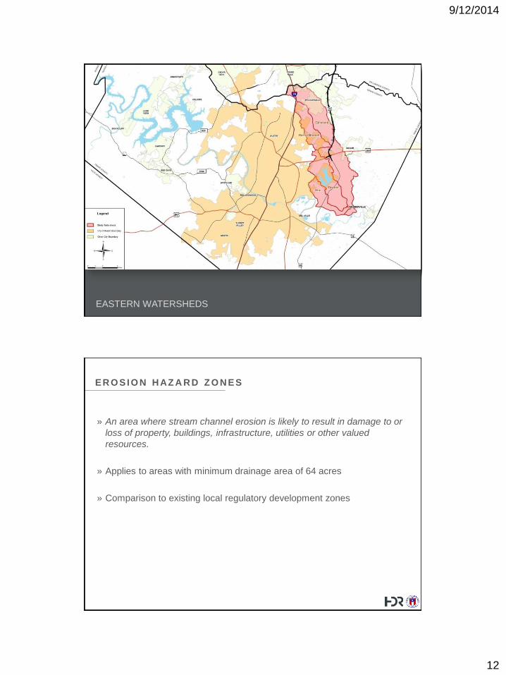
EASTERN WATERSHEDS
ER O SI O N H AZ A R D Z O N ES
» An area where stream channel erosion is likely to result in damage to or
loss of property, buildings, infrastructure, utilities or other valued
resources.
» Applies to areas with minimum drainage area of 64 acres
» Comparison to existing local regulatory development zones

9/12/2014
13
C I T Y O F AU ST I N O B SERV E D I N C I S I O N D EPT H S
ER O SI O N H AZ A R D Z O N ES
Category 1
Category 2

9/12/2014
14
ER O SI O N H AZ A R D Z O N ES
» Mostly within existing regulatory
areas like floodplain or Critical
Water Quality Zone
» Not a buffer, but area that needs
special attention
» Guidance in the Drainage
Criteria Manual
» Provisions in the Watershed
Protection Ordinance
SOUTHWESTERN WATERSHEDS

9/12/2014
15
SLAUGHTER AND SOUTH BOGGY CREEK
31 Sq. Mi.
62 Stream Miles
SLA5 Sq. Mi.
10 Stream Miles
SBG
31 Sq. Mi.
62 Stream Miles
SLA5 Sq. Mi.
10 Stream Miles
SBG
ST R E AM T Y PES
SOUTHWESTERN WATERSHEDS

9/12/2014
16
H I STO R I C A L L AN D U SE & L AN D C O VER - 1 9 8 4
H I STO R I C A L L AN D U SE & L AN D C O VER - 1 9 9 7

9/12/2014
17
H I STO R I C A L L AN D U SE & L AN D C O VER - 2 0 1 0
ER O SI O N S I T ES
SOUTHWESTERN WATERSHEDS

9/12/2014
18
F I N D I N G S
» Eastern Watersheds
» Largely undeveloped compared to
SW watersheds
» Instabilities associated with
grazing, agriculture, and loss of
riparian buffer
F I N D I N G S
» South Boggy Creek
» Developed prior to watershed
protection rules
» Less stormwater controls
» More problem areas
compared to Slaughter Creek
» Channel enlargement
» Meander migration

9/12/2014
19
F I N D I N G S
» Slaughter Creek
» Mostly developed within last
25 years post-watershed
protection
» WQ setbacks
» 100-yr detention
» Structural WQ controls
» Less problem areas observed
W H Y AL L T H E EF F O R T ?
» Drainage Utility Asset Management
» Informed decision making
• Identification and prioritization of WPD projects
• Advise management strategies - preservation, restoration, rehabilitation,
stabilization
• Erosion hazard information for creek side development
» Easily accessed data for public inquiries
» Institutional knowledge from getting “feet wet”
» Effort is scalable. Little effort goes a long way.
» Future studies
• e.g. Monitor monumented cross sections, study of enlargement ratios

9/12/2014
20
Q U EST I O N S AN D AN SW E R S
Morgan Byars
City of Austin
512-974-9790
Eric Stewart
HDR
512-912-5115