geomatica glenella, qld, 4740 tel....geomatica land development consulting 38 gingham street...
TRANSCRIPT
GeomaticaLand Development Consulting
38 Gingham StreetGlenella, QLD, 4740
Tel.: (07) 4942 2505
Town Planning Reportfor
3 Lot Boundary Realignment at 76 Frank Miles Road, Sarina
Project Ref. No.: 00504.01 Revision No. 1 2 March 2015 Page 1 of 23
File: D:\Geomatica\Projects\504\504.01 Planning and quote\Planning\1 Application stage\Bdy realignmnet application\504.01 Planning report_Boundary realignment.odt
Table of Contents 1 Summary....................................................................................................................................3
1.1 Site Details..........................................................................................................................3 1.2 Application Details...............................................................................................................3 1.3 Local Planning Scheme Designations................................................................................3 1.4 Regional Plan Designations................................................................................................3 1.5 State Assessment Referral Triggers....................................................................................4 1.6 State Planning Policies........................................................................................................4
2 Subject Site and Surrounding Locality.......................................................................................4 2.1 Subject Site.........................................................................................................................4 2.2 Surrounding Locality............................................................................................................6
3 The Proposal..............................................................................................................................6 4 Planning Assessment.................................................................................................................7
4.1 State Development Assessment Provisions.......................................................................7 4.2 State-controlled road and Area within 25m of a State-controlled road.............................10 4.2.1 Railway and Area within 25m of existing railway...........................................................10 4.2.2 Water resources planning area boundaries...................................................................11 4.2.3 Qld waterways for waterway barrier works....................................................................11 4.3 State Planning Policies......................................................................................................11 4.4 Regional Plan....................................................................................................................11 4.5 Local Town Planning Scheme...........................................................................................11 4.5.1 Rural Zone Code............................................................................................................12 4.5.2 Reconfiguration of a Lot Code.......................................................................................13 4.5.3 Overlay Controls.............................................................................................................14 4.5.3.1 Bushfire Management.................................................................................................14 4.5.3.2 Major Transport and Energy Corridors........................................................................16
5 Conclusion................................................................................................................................18 6 Title documents.........................................................................................................................19
Page 2 of 23
1 Summary
1.1 Site Details
Street Address 76 Frank Miles Road, L 6 Sarina Homebush Road & L 2 Plath Road, Sarina
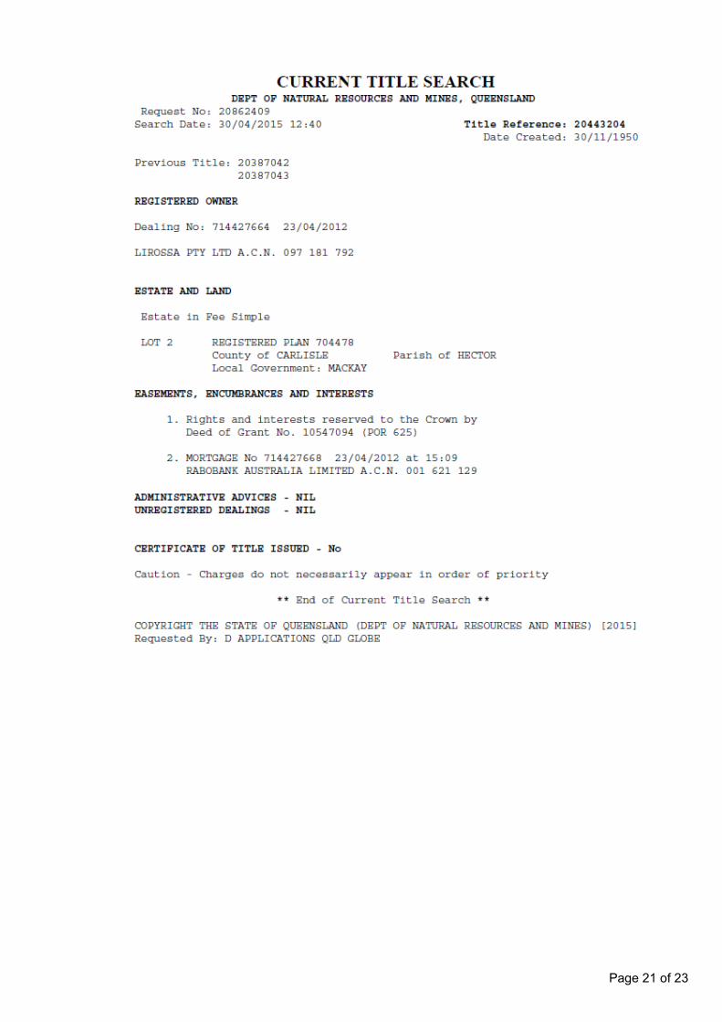
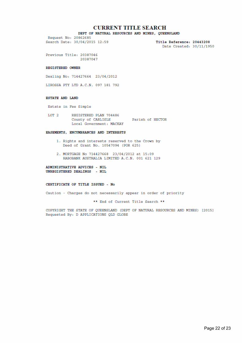
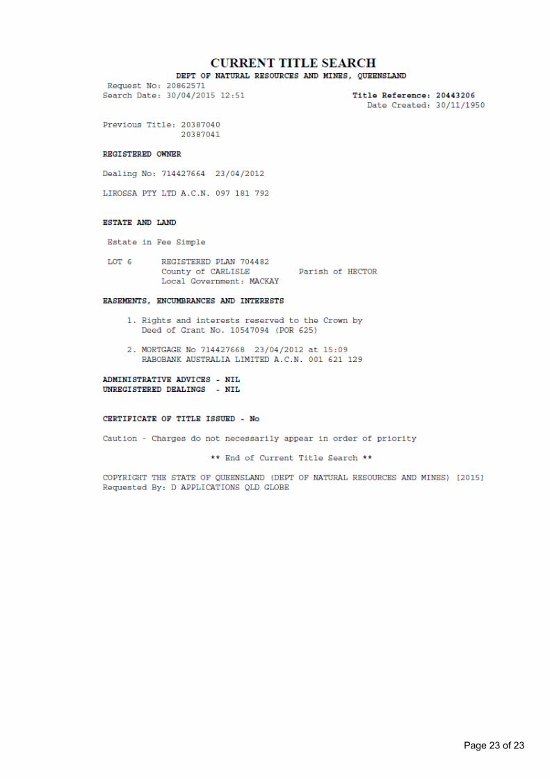
Real Property Description Lot 2 on RP704478, Lot 6 on RP704482 and Lot 2 on RP704486.
Site Area Lot 2 on RP704478 = 28.143 haLot 6 on RP704482 = 55.004 haLot 2 on RP704486 = 10.537 haTotal area = 93.684 ha
Existing Land Use Agriculture – Sugar cane farm
1.2 Application Details
Prepared for Lirossa Pty Ltd
Applicant Geomatica
Applicant Address 38 Gingham Street, Glenella, QLD, 4740
Contact Person Charles Gosling
Telephone 0459 358 809
Email [email protected]
Development Proposal Realign the boundaries of Lot 2 on RP704478, Lot 6 on RP704482 and Lot 2on RP704486 into 3 new lots so that each lot has legal access from Frank Miles Road.
Category of Development Assessable Development
Level of Assessment Code
1.3 Local Planning Scheme Designations
Town Planning Scheme Sarina Shire Planning Scheme
Locality
Precinct
Zone Rural (Sarina)
Applicable Codes Rural zone code
Reconfiguration of a lot code
Applicable Overlays Major Transport and Energy Corridors
Bushfire Management
1.4 Regional Plan Designations
Regional Plan Mackay, Isaac and Whitsunday Regional Plan
Regional Land Use Category Regional Landscape and Rural Production Area
Page 3 of 23
1.5 State Assessment Referral Triggers
Agency State interest Assessment
Transport State-controlled Road Not applicable
Area within 25m of State controlled road Not applicable
Railway Not applicable
Area within 25m of existing railway Not applicable
Economic Growth Water resource planning area boundaries Not applicable
Environment & Heritage Qld waterways for waterway barrier works Not applicable
1.6 State Planning PoliciesThere are no State Planning Policies that apply to this application that are not appropriately reflected in the Sarina Shire Planning Scheme.
2 Subject Site and Surrounding Locality
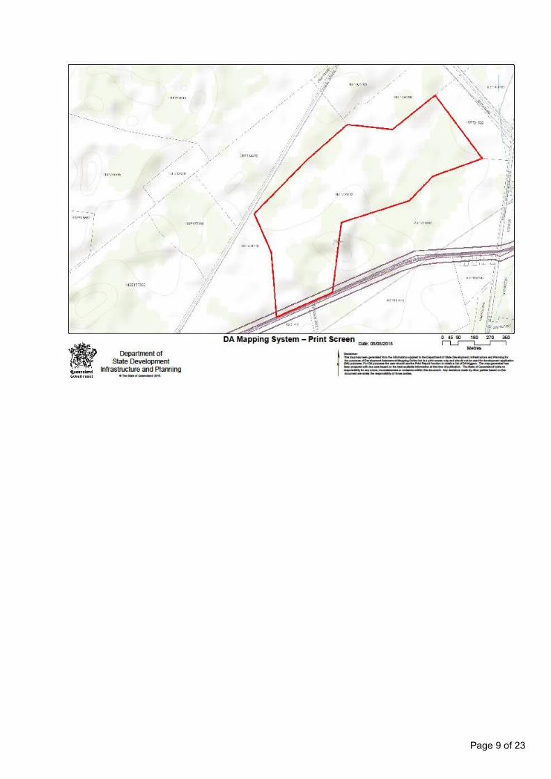
2.1 Subject SiteThe three subject lots are irregular in shape, with a combined area of 93.7 ha, and lie in the triangle formed by the intersection of Frank Miles Road and Sarina Homebush Road, and the North Coast Railway line running adjacent to Mt. Convenient Road.
The lots are under one ownership, and are used collectively to cultivate sugar cane. The individual cane fields do not follow the existing boundaries.
The lots and the adjoining lots are generally flat with gentle slopes, and are cultivated with sugar cane.
• Lot 2 on RP704478, being 28.143 ha in extent, is cultivated with sugar cane. It also has a homestead with ancillary agricultural buildings and sheds.
There is an existing constructed access to Frank Miles Road. It also has 684m frontage to Sarina Homebush Road although there are no constructed access points to this road.
Sewerage is disposed of via a septic tank system.
Water is via a borehole.
• Lot 6 on RP704482, being 55.004 ha in extent is cultivated with sugar cane, and has frontage to Sarina Homebush Road although there are no constructed access points to this road.
There is a water borehole located on Lot 6 on RP704482, with the power supply to the bore coming from anoverhead power line from Lot 2 on RP704478.
• Lot 2 on RP704486, being 10.537 ha in extent, is cultivated with sugar cane, and has no access to a formed road. It is bounded to the north-east by the North Coast Railway line.
Page 4 of 23
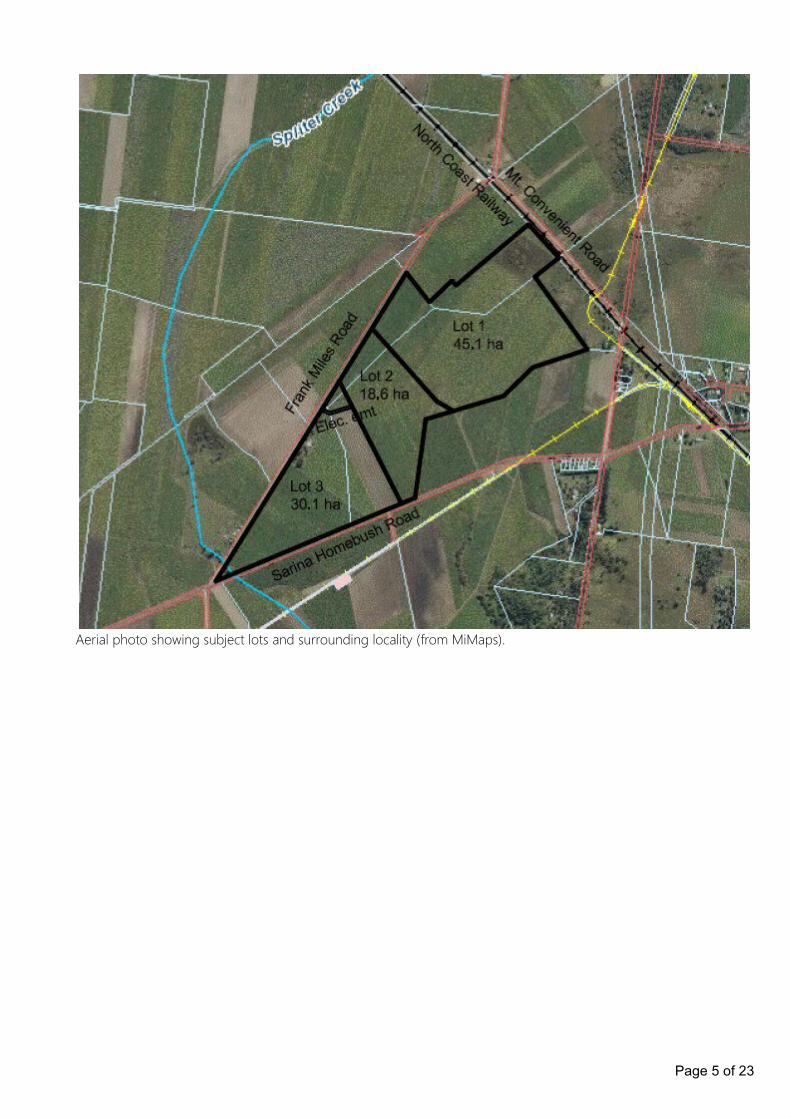
Aerial photo showing subject lots and surrounding locality (from MiMaps).
Page 5 of 23
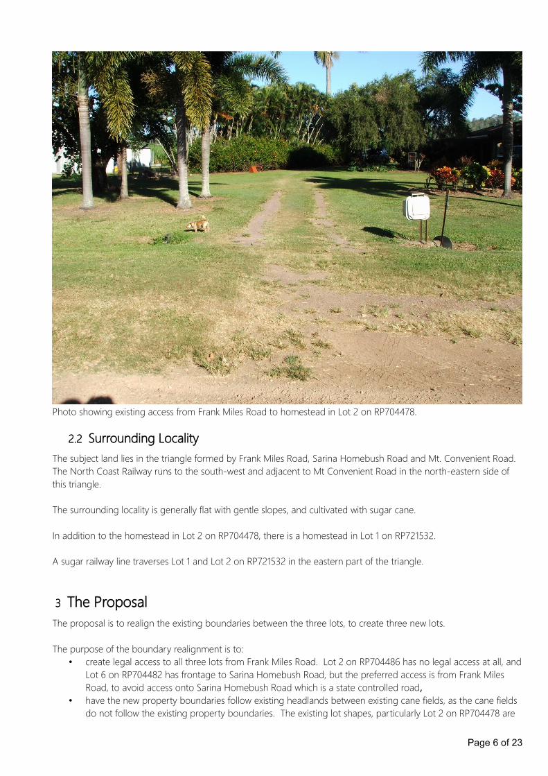
Photo showing existing access from Frank Miles Road to homestead in Lot 2 on RP704478.
2.2 Surrounding LocalityThe subject land lies in the triangle formed by Frank Miles Road, Sarina Homebush Road and Mt. Convenient Road. The North Coast Railway runs to the south-west and adjacent to Mt Convenient Road in the north-eastern side of this triangle.
The surrounding locality is generally flat with gentle slopes, and cultivated with sugar cane.
In addition to the homestead in Lot 2 on RP704478, there is a homestead in Lot 1 on RP721532.
A sugar railway line traverses Lot 1 and Lot 2 on RP721532 in the eastern part of the triangle.
3 The ProposalThe proposal is to realign the existing boundaries between the three lots, to create three new lots.
The purpose of the boundary realignment is to:• create legal access to all three lots from Frank Miles Road. Lot 2 on RP704486 has no legal access at all, and
Lot 6 on RP704482 has frontage to Sarina Homebush Road, but the preferred access is from Frank Miles Road, to avoid access onto Sarina Homebush Road which is a state controlled road,
• have the new property boundaries follow existing headlands between existing cane fields, as the cane fields do not follow the existing property boundaries. The existing lot shapes, particularly Lot 2 on RP704478 are
Page 6 of 23
irregular in shape and are not practical or optimised for agricultural production.
The proposed lot configuration improves an already fragmented lot configuration and optimises the lots for agricultural production in sympathy with the layout of the existing, productive cane fields
Proposed Lot 1 is approximately 45.0 ha in extent, and has access to Frank Miles Road, and will continue to be cultivated with sugar cane.
Proposed Lot 2 is approximately 18.5 ha in extent, and has access to Frank Miles Road, and will continue to be cultivated with sugar cane.
Proposed Lot 3 is approximately 30.2 ha in extent, and has access to Frank Miles Road, and will continue to be cultivated with sugar cane, and will accommodate the existing homestead and ancillary structures.
The existing water borehole in Lot 2 and its associated power supply will remain in use in its current position, and thepower supply will be protected by an easement over Lot 3 in favour of Lot 2.
The effluent field from the septic tanks at the homestead are well clear of any new boundaries, so will have no impact on the neighbouring lots.
It is proposed that all three new lots will be accessed from Frank Miles Road, so there will be no impact on Sarina Homebush Road, which is a state-controlled road.
There will be no impact on the North Coast Railway, as there is no increase in the number of lots, and there will be no interference with the existing railway line in any way.
4 Planning Assessment
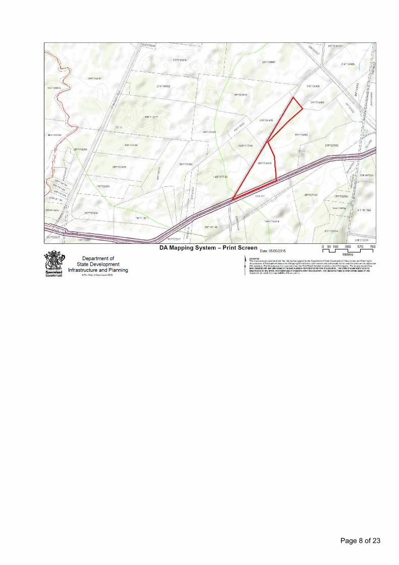
4.1 State Development Assessment ProvisionsThe following matters have been identified as being of interest to the state for development assessment, which the chief executive administering the Sustainable Planning Act 2009 may have regard to when assessing the development application. None of the matters apply to this application, however, as is explained under the following headings.
Page 7 of 23
Page 8 of 23
Page 9 of 23

4.2 State-controlled road and Area within 25m of a State-controlled roadItem 2 of Table 2 of Schedule 7 of the Sustainable Planning Regulation 2009 specifies the following requirements to be met for the code to apply to a Reconfiguration of a lot development application:
Reconfiguration of a lot if-(a) any part of the land-
(I) is within 25m of a State-controlled road; or(II) is future State-controlled road; or(III) abuts a road that intersects with a State-controlled road that is within 100m of the land; and
(b) 1 or more of the following apply-(I) the total number of lots is increased;(II) the total number of lots abutting the State-controlled road is increased(III) there is a new or changed access between the land and the State-controlled road.
Item (a)(I) applies, but none of the items of part (b) apply, so the code is not applicable to this application.
4.2.1 Railway and Area within 25m of existing railwayItem 34 of Table 2 of Schedule 7 of the Sustainable Planning Regulation 2009 specifies the following requirements to be met for the code to apply to a Reconfiguration of a lot development application:
Reconfiguration of a lot if any part of the land is-
Page 10 of 23

(a) within 25m of a railway or future railway land and 1 or both of the following apply-(I) the total number of lots is increased;(II) an easement abutting the railway or future railway land is created; or
(b) future railway land.
The land is within 25m of a railway, but neither items (a)(I) or (a)(ii) of apply, nor does part (b) apply, so the code is not applicable to this application.
4.2.2 Water resources planning area boundariesThe following State interests are identified:
• The State interest of “Taking or interfering with water” need only be assessed for Operational Works applications, so does not apply to this application.
• The State interest of “Interfering with water in drainage and embankment areas” need only be assessed for Operational Works applications, so does not apply to this application.
• The State interest of “Removal of quarry material from a watercourse or lake” does not apply to this application, as no quarry activity is proposed.
4.2.3 Qld waterways for waterway barrier worksThe State interest of “Constructing or raising waterway barrier works” need only be assessed for Operational Works applications, so does not apply to this application.
4.3 State Planning Policies
The Minister for Local Government and Planning has identified the following State Planning Policies as having been appropriately reflected in the Planning Scheme for the Shire of Sarina:
• Development and Conservation of Good Quality Agricultural Land – SPP 1/92
• Development in the Vicinity of Certain Airport and Aviation Facilities – SPP 1/02
• Planning and Managing Development Involving Acid Sulphate Soils – SPP 2/02
• Mitigating the Adverse Impacts of Flood, Bushfire & Landslide – SPP 1/03
There are no other State Planning Policies that have been identified as being applicable to this development application, which are not appropriately integrated in the planning scheme.
4.4 Regional Plan
The land use and intensity of use will remain unchanged, so there are no provisions of the Mackay Isaac Whitsunday Regional Plan applicable to this application.
4.5 Local Town Planning Scheme
The assessment category is 'Reconfiguration of a lot' and relevant assessment criteria are:
• Rural Zone Code
Page 11 of 23
• Reconfiguration of a Lot Code.
The level of assessment is code assessment.
4.5.1 Rural Zone Code
Overall Outcomes for the Rural Zone Code
(1) The overall outcomes are the purpose of the Rural Zone Code.
(2) The overall outcomes sought for the Rural Zone are the following: (a) Good quality agricultural land is protected from fragmentation; unless otherwise demonstrated by
overwhelming community need; and (b) Existing rural activities are protected from intrusion of incompatible uses, except for urban
residential expansion adjoining the northern part of Sarina Township between the Bruce Highway and Sarina Beach Road; and
(c) A wide range of agricultural and animal husbandry uses, and other compatible primary production uses occur in the Rural Zone; and
(d) The rural character of the Shire is retained; and(e) The productive capacity of land is maintained; and (f) Residential uses are primarily ancillary to other uses in the Rural Zone; and(g) Non-agricultural uses, such as recreation, roadside stall, home based business, host
home accommodation, educational or tourism related uses are of a low intensity and scale; and (h) Other uses are located in the Rural Zone if they cannot practically be located in urban
areas due to their: (i) nature; or (ii) scale; or (iii) effects; or (iv) necessary relationship to a particular cultural heritage feature, natural resource or feature, infrastructure or activity; and
(i) Uses and works are located, designed and managed where they: − Are compatible with other uses and works; and − Maintain the safety of people and works; and − Maintain the health and safety of residents and visitors in the rural area and the
amenity they enjoy; and − Maintain the scenic values of the natural environment enjoyed by residents and
visitors in the rural area; and − Avoid significant adverse effects on the natural and cultural heritage values of the
environment; and − Maximise the efficient use and extension and safe operation of infrastructure; and − Cause no adverse impact (due to site specific or cumulative effects) on water quality
(surface and ground); − Do not compromise the operation or expansion of the major port and related facilities
at Hay Point; − Do not compromise the efficiency and safety of any road and are connected to the
Shire road network and urban centres by roads capable of accommodating the type and volume of traffic likely to be generated;
− Are provided with a water supply, liquid and solid waste disposal system and electricity supply adequate for all on-site purposes; and
− Do not intrude into buffer areas around activities requiring separation from incompatible uses (such as Extractive Industry, Intensive Animal Industry, Stables, Kennels and Catteries).
The Overall Outcomes for the Rural Zone Code have been met by achieving the overall outcomes of the code as there is nothing in the proposed lot configuration that would be inconsistent with those outcomes.
In addition,
• each lot would have access to a formed road, not being a state-controlled road,
Page 12 of 23
• the lot boundaries would follow existing headlands between existing cane fields,
• the lot boundaries would be better shaped than the existing lots insofar as agricultural production is concerned.
4.5.2 Reconfiguration of a Lot Code
Overall Outcome for the Reconfiguring a Lot Code (1) The overall outcome is the purpose of the Reconfiguring a Lot Code. (2) The overall outcome of the Reconfiguring a Lot Code is to ensure:
• allotment design and size is suited to its intended use; and • areas of environmental significance are protected; and• a range of allotment sizes are available to meet the needs of the community; and• infrastructure and services are supplied in an efficient manner; and• sustainable on-site sewage disposal and on-site water supply in areas where reticulated services are
not available; and• public access to the coast or coastal waters is maintained and enhanced; and• maintenance of the productive capacity of Good Quality Agricultural Land and other rural land; and• urban design outcomes promote energy efficiency; and• urban design promotes walking, cycling and public transport as alternative forms of transport to the
private car.
Provisions Applicable to Reconfiguration of Lots in the Rural ZoneSpecific outcomes Probable Solutions Response Comment
Lot Size and Configuration
SO1 Lots must be of an appropriate size and configuration to sustain the utility and productive capacity of the land for rural purposes, and to reduce potential for impacts on the natural environment by facilitating opportunities for the implementation of improved land management practices and through provision of safe and adequate water supply and sewage disposal.
PS1.1 Lot boundaries relate to naturalfeatures such as ridges or other catchment boundaries, drainage linesor flood flows, or remnant stands of vegetation; and PS1.2 The minimum lot size is equal to or greater than 80ha in the Rural Zone identified on Map ZM 1; OR A proposed lot is smaller than 80ha, and the reconfiguration is a boundary rearrangement that would not create any additional lots, would improve the relationship of the lots to natural features, and: (i) any new lot to be primarily used for a dwelling unit and ancillary buildings are buffered from Good Quality Agricultural Land in accordance with Table 2: Summary ofbuffer area design Criteria of Planning Guideline: Separating Agricultural and Residential Land Uses (DNRM & DLGP); and (ii) any new lot to be primarily used for a dwelling unit and ancillary buildings contain buffers described in
Achieved The lots are less than 80ha, and the proposed reconfiguration does not create any additional lots.
The proposed lot boundaries follow existing headlands between the existing cane fields, whereas the existing lot boundaries do not relate in any way to the existing cane fields.
The proposed lot configuration improves the existing fragmented lot configuration and also provides frontage to Frank Miles Road for each lot.
No Good Quality Agricultural Land is compromised, as all new lots are to continue to be used for agriculture.
AND:
(i) - (iii) No new lots are to be used primarily for a dwelling.
(iv) The existing areas are:• 55.004 ha
Page 13 of 23
Specific outcomes Probable Solutions Response Comment
(i) above and do not contain areas ofGood Quality Agricultural Land; and (iii) access to any new lot to be primarily used for a dwelling unit andancillary buildings does not compromise the utility of Good Quality Agricultural Land; and (iv) any lot comprising the balance area of the boundary rearrangementhas a minimum area of 40ha and a regular boundary configuration.
• 28.143 ha• 10.537 ha,
and the proposed areas are approximately:
• 30.2 ha,• 18.5 ha• 45.0 ha,
showing a slight rationalisation of the existing, non-uniform areas.
SO2 The reconfiguration of lots provides for protection of life and property from risk of flooding.
PS2.1 Existing patterns and levels of upstream and downstream drainage are maintained.
Achieved The proposed lot boundaries follow existing headlands between the existing cane fields, so there will be no change to the existing drainage patterns.
Drainage
SO3 Stormwater runoff is contained and managed so that it does not adversely affect either the, upstream ordownstream built environment, natural stream systems or surface or underground water quality.
PS3.1 Road and drainage works are designed and constructed to standards stated in planning scheme policies 4 and 11.
N/A There are no proposed road and drainage works, and the proposed lot boundaries follow existing headlands between the existing cane fields, so there will be no change to the existing drainage patterns.
The overall outcomes have been met by achieving the specific outcomes of the code, by satisfying the probable solutions of the relevant code.
4.5.3 Overlay Controls
4.5.3.1 Bushfire Management
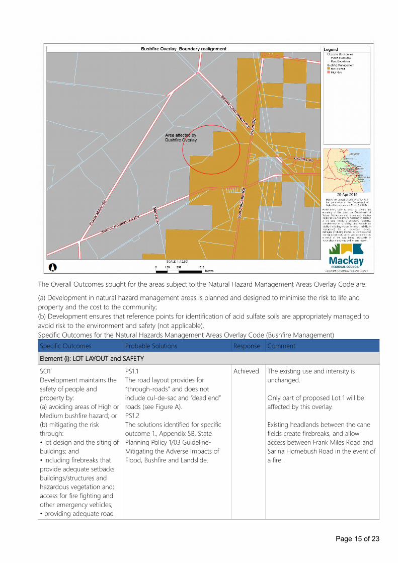
Lot 6 on RP704482 is partially affected by the Bushfire Management Overlay Code and is identified as having a medium risk of bushfire, as shown on the following overlay map from MiMaps.
Page 14 of 23
The Overall Outcomes sought for the areas subject to the Natural Hazard Management Areas Overlay Code are:
(a) Development in natural hazard management areas is planned and designed to minimise the risk to life and property and the cost to the community; (b) Development ensures that reference points for identification of acid sulfate soils are appropriately managed to avoid risk to the environment and safety (not applicable).Specific Outcomes for the Natural Hazards Management Areas Overlay Code (Bushfire Management)Specific Outcomes Probable Solutions Response Comment
Element (i): LOT LAYOUT and SAFETY
SO1 Development maintains the safety of people and property by: (a) avoiding areas of High or Medium bushfire hazard; or (b) mitigating the risk through: • lot design and the siting of buildings; and • including firebreaks that provide adequate setbacks buildings/structures and hazardous vegetation and; access for fire fighting and other emergency vehicles; • providing adequate road
PS1.1 The road layout provides for “through-roads” and does not include cul-de-sac and “dead end” roads (see Figure A). PS1.2 The solutions identified for specific outcome 1., Appendix 5B, State Planning Policy 1/03 Guideline-Mitigating the Adverse Impacts of Flood, Bushfire and Landslide.
Achieved The existing use and intensity is unchanged.
Only part of proposed Lot 1 will be affected by this overlay.
Existing headlands between the cane fields create firebreaks, and allow access between Frank Miles Road and Sarina Homebush Road in the event of a fire.
Page 15 of 23
Specific Outcomes Probable Solutions Response Comment
access for fire fighting and other emergency vehicles and safe evacuation; and • providing an adequate andaccessible water supply for fire fighting purposes.
Element (ii): FIREBREAKS
SO2 Where development involves reconfiguring a lot, firebreaks must be around and through the development (where appropriate), and must: - have sufficient width to both serve as an effective fire break and allow continuous access for fire fighting vehicles; and- be in secure tenure and maintained.
PS2.1 Firebreaks are provided by: - a minimum 20m wide cleared road reserve located between the development site and surrounding vegetated lands; or - roadways situated around the outside of the development site; or - the development being separated from medium/high bushfire hazard areas by a cleared buffer of 1.5 times the height of the canopy; and
PS2.2 Fire breaking trails are provided between the development site and surrounding vegetated landsand such trails: - have a minimum cleared width of 6metres; - have a minimum formed width of 4metres; - have a maximum gradient of 1 in 6 (16%); - are constructed and maintained to prevent erosion and provide continuous access for fire fighting vehicles; - allow for vehicle access at least every 200 metres; and - provide passing or turning areas at least every 400 metres.
Achieved The existing use and intensity is unchanged.
Only part of proposed Lot 1 will be affected by this overlay.
Existing headlands between the cane fields create firebreaks, and allow access between Frank Miles Road and Sarina Homebush Road in the event of a fire.
The overall outcomes have been met by achieving the specific outcomes of the code, by satisfying the probable solutions of the relevant code.
4.5.3.2 Major Transport and Energy Corridors
Lot 2 on RP704478 and Lot 6 on RP704482 are identified as being affected by the Major Transport and Energy Corridors Overlay, as they are located within 20 metres of a Major Transport Corridor identified on Overlay Map MTEC1, namely Sarina Homebush Road.
The Overall Outcomes sought for the areas subject to the Major Transport and Energy Corridors Overlay Code are:
(a) Development adjacent to major transport and high voltage transmission lines does not compromise the efficiency of facilities and infrastructure contained within these corridors;
Page 16 of 23
(b) The amenity and safety of development is not adversely affected by proximity to a major transport or energy corridor;
(c) Development that may constitute a fire risk (such as the storage of flammable liquids) is not located adjacent to an energy pipeline; and
(d) Aircraft safety in operational airspace is maintained.
Specific Outcomes for the Major Transport and Energy Corridors Overlay Code
Specific Outcomes Probable Solutions Response Comment
SO1 (high voltage transmission lines) Electricity transmission line easements are managed to promote: - the continuation of the transmission of bulk power; - safety and amenity for residents, occupiers and landuses in close proximity; and - environmental and natural resources values; and - Shire visual and landscape qualities.
Only vegetation with a maximum height of 4 metres is planted within the Electricity Transmission Line Easement and only vegetation with amaximum height of 4 metres is planted along an electricity substation boundary with foliage a minimum of 3 metres from the electricity substation boundary; and PS1.2 Development for residential purposes and child activity areas20 maintain a separation distance of 20m from the most proximate boundary of an electricity transmission line easement shown as a feeder line on Overlay Map MTEC1.
N/A No high voltage transmission lines are affected by this proposal.
SO2 (major transport corridors) Residential amenity is not compromised by excessive noise from major transport corridors and the siting of development does not prejudice the intended role of the corridors.
PS2.1 Where a site area is situated in the Rural Zone or the Rural Residential Zone, buildings used for residential purposes are located a minimum distance of 20 metres from State-controlled roads and sub-arterial roads and 100m from rail lines as identified on Overlay Map MTEC1.
Achieved Any new building can be located a minimum distance of 20 metres from State-controlled roads and sub-arterial roads and 100m from rail lines as identified on Overlay Map MTEC1.
SO3 (major transport corridors) The form and density of development along a major road corridor does not prejudice safety, speed or the intended role of the corridor.
PS3.152 Achieved As the use and intensity of the lots will remain unchanged, and there are no access points proposed onto Sarina Homebush Road, there will be no impact on the state-controlled road.
SO4 (major transport corridors) Predominant views and vistas from State-controlled Roads are preserved.
PS4.1 57 Achieved As the use and intensity of the lots will remain unchanged, there will be no impact on the predominant views and vistas from state-controlled road.
SO5 (major transport PS5.1 Achieved As the use and intensity of the lots will
Page 17 of 23
Specific Outcomes Probable Solutions Response Comment
corridors) Development located adjacent to a major road transport corridor does not have an adverse impact on safety, traffic efficiency or planning impacts through roadside parking.
Development adjacent to a major road transport corridor has adequateon-site parking such that removal of any roadside parking in the future will not significantly affect the development’s viability.
remain unchanged, and there are no access points proposed onto Sarina Homebush Road, there will be no impact on the state-controlled road.
SO6 (major transport corridors) Wildlife, particularly flying vertebrates, such as birds and bats, are not attracted into operational airspace in significant numbers.
PS6.1 Uses involving the disposal of putrescible waste are not located within 13km of the airport as indicated on Overlay Map MTEC1.
N/A The use and intensity of the lots will remain unchanged.
The overall outcomes have been met by achieving the specific outcomes of the code, by satisfying the probable solutions of the relevant code.
5 Conclusion
This report has been submitted in support of a development application for a Reconfiguration of a Lot – Boundary Realignment (3 lots into 3 lots), to provide legal access to a formed road.
The proposal has been assessed against the relevant codes of the Sarina Shire Planning Scheme and has been foundto be generally consistent with the planning scheme.
As a result, it is considered that the proposed development application be approved subject to reasonable and relevant conditions.
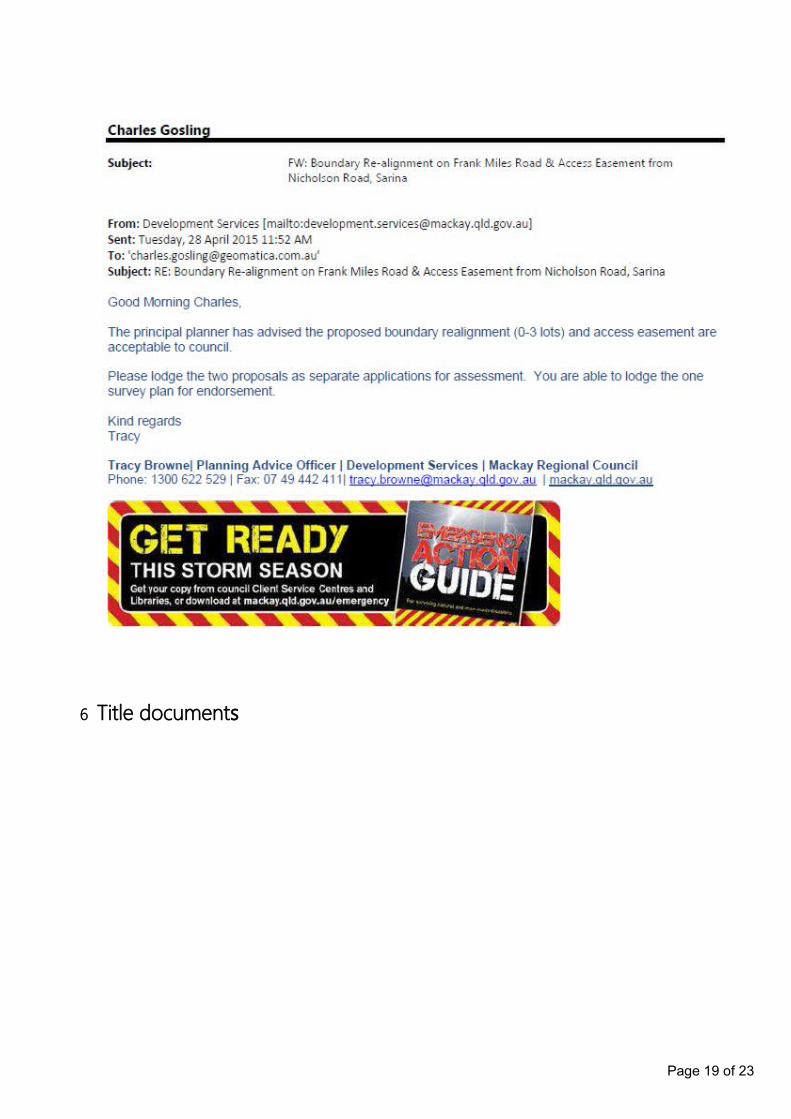
Council's comments were requested in regard to this application by way of an email to the Duty Planner. This application was discussed at a D.A.R.T. meeting and was found to be acceptable to Council. The following is a copy of the email received from Development Services on 28/04/2015:
Page 18 of 23
6 Title documents
Page 19 of 23

Page 20 of 23
Page 21 of 23
Page 22 of 23
Page 23 of 23