geology of the wayland quadrangle, stephens and eastland … · the wayland quadrangle is in...
TRANSCRIPT

Geology of the Wayland Quadrangle, Stephens and Eastland Counties, Texas
GEOLOGICAL SURVEY BULLETIN 1201-G
Prepared in cooperation with the Bureau of Economic Geology of the University of Texas

Geology of the Wayland Quadrangle, Stephens and Eastland Counties, TexasBy DONALD A. MYERS
CONTRIBUTIONS TO GENERAL GEOLOGY
GEOLOGICAL SURVEY BULLETIN 1201-C
Pennsylvanian and Lower Permian rocks of an area in central Texas
Prepared in cooperation with the Bureau of Economic Geology of the University of Texas
UNITED STATES GOVERNMENT PRINTING OFFICE, WASHINGTON : 1965

UNITED STATES DEPARTMENT OF THE INTERIOR
STEWART L. UDALL, Secretary
GEOLOGICAL SURVEY
Thomas B. Nolan, Director
For sale by tbe Superintendent of Documents, U.S. Government Printing Office Washington, D.C. 204*2
CONTENTS
Page Abstract-._ _____________________________________________________ ClIntroduction._____________________________________________________ 2
Purpose of the study_________________________________________ 2Location and geographic features._______________________________ 2Fieldwork and acknowledgments._______________________________ 4Lithologic terminology.__._________-_______-__-___-_-___-_-_-__ 5Geologic setting and structure_________________________________ 9
Stratigraphy. _______________________________________________ 9Pennsylvanian System_______________________________________ 11
Canyon Group________-______________-______-___--_-__--_- 11Caddo Creek Formation______________________________ 11
Colony Creek Shale Member______________________ 11Home Creek Limestone Member______-__-_-____---_ 11
Cisco Group_______________________________ ____ 12Graham Formation____________________________________ 13
Unnamed shale member overlying the Home Creek Limestone Member.____________-_____-_____--_-- 14
Gonzales Limestone Member______________________ 14Unnamed shale member overlying the Gonzales Lime
stone Member__ _ ______________________________ 15Bunger Limestone Member_______-___-___-__-----__ 15Unnamed shale member overlying the Bunger Limestone
Member_ _______________________.___--__----_- 16Gunsight Limestone Member_____-________--------- 18Wayland Shale Member___________________ 20Avis Sandstone Member__________________________ 21Unnamed shale member overlying the Avis Sandstone
Member_ _ ____________________________________ 24Ivan Limestone Member____-_-_-_____-_--_-------- 24Unnamed shale member overlying the Ivan Limestone
Member___-____-__________----________ 26Thrifty Formation________________________ 27
Speck Mountain Limestone Member_________________ 29Unnamed shale member overlying the Speck Mountain
Limestone Member._____-____________-_-_----- 29Breckenridge Limestone Member.__________________ 31Unnamed shale member overlying the Breckenridge
Limestone Member._______________ _________ 32Chaffin Limestone Member__-_-___________-----__-- 33
m

IV CONTENTS
Stratigraphy Continued PagePermian System_____________________________________________ C36
Wiehita Group____________-______-__--_________-__________ 36Pueblo Formation.._________________________________ 37
Waldrip Shale Member___________________________ 37Saddle Creek Limestone Member..__________________ 40Channel-fill sandstone that overlies the Saddle Creek
Limestone Member________-____-________________ 40Distribution and possible source of channel-fill deposits._-______._ 41Cretaceous System; rocks of Trinity age________________________ 42Quaternary deposits____________-__---_____-__-_______--_-__-_- 44
Economic geology_________________________-_____-____-_______-____ 44Clay deposits____-_-_-________-_-___----------_-_---_--------- 44Oil and gas____-________-________-____--_-_-_-__-_-______-_- 44
Fossil localities________________________________________ 45Measured stratigraphic sections..-...---------------------------.--- 47References cited ____________________--_-____-_---______-_-___---- 61
ILLUSTRATIONS
PLATE 1. Geologic map of the Way land quadrangle, Texas. ____ In pocket2. Classification of Upper Pennsylvania!! and Lower Permian
rocks in the Brazos River drainage basin and in the Colorado River drainage basin compared with the classi fication used in the Wayland quadrangle, Texas.___. In pocket
3. Composite stratigraphic sections of Pennsylvanian andPermian rocks in the Wayland quadrangle, Texas. __ In pocket
Page FIGUBB 1. Index map of north-central Texas showing major rock
units in relation to areas mentioned in the text _-__.-. C3 2. Photographs of rocks between the Gonzales Limestone and
Wayland Shale Members of the Graham Formation__ _ 17 3-6. Photomicrographs of rocks in the Graham Formation:
3. Gunsight Limestone Member_____________________ 204. Wayland Shale Member. _________________ 225. Avis Sandstone Member_________________________- 236. Ivan Limestone Member_____________________ 25
7. Map showing outcrop areas of the Breckenridge, Speck Mountain, and Blach Ranch Limestone Members of the Thrifty Formation and the Ivan Limestone Member of the Graham Formation___________________ 27
8. Correlation diagram of the Speck Mountain and BlachRanch Limestone Members of the Thrifty Formation. __ 30
9. Photograph of a post-Breckenridge channel-fill deposit- _ _ _ 3410. Correlation diagram of limestone beds in the Thrifty
Formation and in the lower part of the Pueblo Formation between the Colorado River drainage basin and the Brazos River drainage basin__ ___________________ 35

ILLUSTRATIONS V
Page FIGURE 11. Photomicrograph of chert conglomerate from the rocks of
Trinity age_ ___ ___.._.. ______________ C43
TABLES
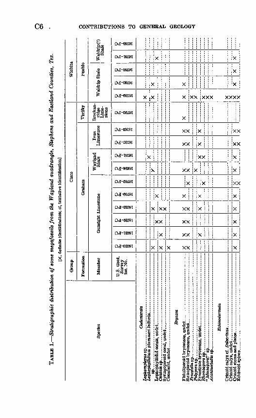
PageTABLE 1. Stratigraphic distribution of some megafossils from the
Wayland quadrangle, Stephens and Eastland Counties, Tex._.._........._._._..___...___._._._...__.__._. C6
2. Calcium, magnesium, total carbonate, and insoluble residue in selected limestone samples from the Wayland quad- rangle____ ______________________________- 9
3. Major upper Paleozoic stratigraphic subdivisions mentionedin this report____________________________________ 10


CONTRIBUTIONS TO GENERAL GEOLOGY
GEOLOGY OF THE WAYLAND QUADRANGLE, STEPHENS AND EASTLAND COUNTIES, TEXAS
By DONALD A. MYERS
ABSTRACT
The Wayland quadrangle is in north-central Texas about 90 miles west of Fort Worth. Pennsylvanian and Lower Permian sedimentary rocks crop out at the surface and dip gently to the west-northwest; older Paleozoic rocks lie in the sub surface. Rocks belonging to the lower part of the Cretaceous System overlap the Pennsylvanian and Permian rocks in the southeastern part of the quadrangle and occur as isolated patches along the south edge of the area. Quaternary alluvium covers older rocks along stream valleys.
Pennsylvanian rocks comprise the upper part of the Canyon Group and the Cisco Group. Permian rocks are represented by the lower part of the Wichita Group. The extremely thin Chaffin Limestone Member of the Thrifty Formation (Pennsylvanian) was mapped with the overlying Pueblo Formation (Permian). The Pennsylvanian-Permian boundary may be in the lower member of the Pueblo.
The Canyon Group is represented by the Home Creek Limestone Member and the Colony Creek Shale Member of the Caddo Creek Formation.
The Cisco Group is represented by the Graham and Thrifty Formations. The Graham Formation, where measured, contains 53-71 percent shale, 22-35 percent sandstone and conglomerate, and 7-12 percent limestone. The Thrifty Formation contains 39-45 percent shale, 25-33 percent sandstone and conglom erate, and 28-30 percent limestone. The sandstone and conglomerate in both the Graham and Thrifty Formations occur mostly as channel-fill deposits. Some shale and siltstone probably was deposited also in channels.
The Wichita Group is represented by the lower part of the Pueblo Formation. The Pueblo Formation comprises the Waldrip Shale Member, the Saddle Creek Limestone Member, and an overlying chaotic sequence of channel-fill deposits of sandstone and conglomerate.
Cretaceous rocks of early Trinity age are .composed of sandstone and conglom erate, some of which have opaline cement.
In the Wayland quadrangle large amounts of oil and gas have been produced from rocks ranging in age from late Middle Pennsylvanian (Strawn Group) to Ordovician (EUenburger, Group).
Cl

C2 CONTRIBUTIONS TO GENERAL GEOLOGY
INTRODUCTION
PURPOSE OF THE STUDY
In 1949 the U.S. Geological Survey, in cooperation with the Bureau of Economic Geology, University of Texas, undertook a study of the Pennsylvanian and Lower Permian sedimentary rocks of central and western Texas to obtain a better understanding of their lithology, distribution, stratigraphic relations, and conditions of deposition. Some of the results of this study have been presented by Burnside (1959), Heck, Yenne, and Henbest (1952), Eargle (1960), Myers (1958; 1960a, b), My?rs, Stafford, and Burnside (1956), Stafford (1959; 1960a, b), and Terriere (1960, 1963). This report on the geology of the Wayland quadrangle is another in the series. The geologic map (pi. 1) shows the areal distribution of Upper Pennsyl vanian and Lower Permian rocks in then* outcrop areas in the Way- land quadrangle, and the text describes the stratigraphic relations of these rocks.
LOCATION AND GEOGRAPHIC FEATURES
The Wayland quadrangle is in north-central Texas about 90 miles west of Fort Worth. It lies almost wholly within Stephens County, but in the southern part of the area (fig. 1) it includes an east-west strip of Eastland County that is about 15 miles long and 1 mile wide. Breckenridge, the county seat of Stephens County, lies just to the north of the quadrangle. The communities of Necessity, Gunsight, and Wayland lie within the quadrangle. Eastland, the county seat of Eastland County, is a few miles to the south.
The area lies north of the Callahan Divide (fig. 1), a broad ridge that separates the Colorado River and Brazos River drainage basins. Upper Pennsylvanian and Lower Permian rocks are exposed on the north and south sides of the divide but are covered at its crest by Cretaceous rocks. Because of this cover and the lack of subsurface information from wells on the divide, many uncertainties have existed in the correlation of the Pennsylvanian and Permian rocks of the two drainage basins. The present study was designed to remove some of these uncertainties.
The quadrangle lies in two distinct physiographic provinces. The southeastern part (pi. 1) is underlain by Lower Cretaceous rocks and is characterized by a gently rolling plain having shallow stream valleys. The remainder of the quadrangle, underlain by Upper Pennsylvanian and Lower Permian rocks, is characterized by more rugged terrain having valleys eroded in shale and intervening cuestas capped by limestone or by sandstone and conglomerate.
The relief in the Wayland quadrangle is about 350 feet; few promi nences, however, stand more than about 150 feet above the surrounding

GEOLOGY, WAYLAND QUADRANGLE, TEXAS C3
-~r~^:-: --~~1 EXPLANATION
FIGUBE 1.! Outcrop areas of major rock units of north-central Texas in relation to the counties and quadrangles mentioned in text.
terrain. The relatively broad, flat major stream valleys drain to the north; meandering stream channels are incised 10 feet or more into the valley floors.
Terrane underlain by shale generally supports sparse vegetation that consists mostly of mesquite and cactus. Most of the terrane underlain by limestone also is sparsely vegetated, but oak trees gener ally grow along the base of the outcrop and along well-defined bedding planes and joint systems. Most of the terrane underlain by sandstone is densely covered by oak trees. Water holes or tanks for livestock,
758-446<

C4 CONTRIBUTIONS TO GENERAL GEOLOGY
formed by placing earthen dams in ravines or other topographically low areas, are generally found in areas underlain by shale. Those emplaced in sandstone terrane usually will not hold water.
Access within the quadrangle is good. U.S. Highway 183, extending south from Breckenridge, bisects the area. At Breckenridge it inter sects U.S. Highway 180, which crosses the northeastern part of the quadrangle. Many county roads and privately owned ranch roads provide access to the rest of the area.
FIELDWORK AND ACKNOWLEDGMENTS
The Wayland quadrangle was mapped intermittently between 1955 and 1958 on aerial photographs at a scale of approximately 1:20,000. The planimetric base map (pi. 1) was compiled by photogrammetric methods from Army Map Service photography at a scale of approxi mately 1:67,000. Geologic data were transferred from the photo graphs to the planimetric base at the time of compilation.
The author thanks Robert T. Terriere of the Geological Survey for field assistance during November 1957 and thanks Dr. L. F. Brown, Jr., of the University of Texas Bureau of Economic Geology, for bene ficial discussions of the stratigraphy of the upper part of the Thrifty Formation and the lower part of the Permian System and for help in identifying the Gonzales Limestone Member of the Graham Formation.
Throughout the text, reference is made to field locality numbers and to U.S. Geological Survey fossil-collection locality numbers shown on plate 1. Field locality numbers have an "M" prefix followed by four digits and refer to a measured stratigraphic section or to a specific outcrop. U.S. Geological Survey fossil-collection locality numbers have five digits and indicate collections of fossils; those with an "f" prefix indicate collections of Foraminifera.
Stratigraphic sections were measured and described in detail in critical areas or wherever control was deemed necessary. Fusulinid Foraminifera are generally common in the limestone beds, and sufficient collections were made to establish the variety of fusulinids typical of various units through most of the stratigraphic sequence. Once this fauna was established, the fusulinids proved very useful in establishing correlation among the various limestone units. Megafossils were identified by Helen Duncan (corals and bryozoans), Mackenzie Gor don, Jr. (brachiopods and cephalopods), Ellis L. Yochelson (pele- cypods and gastropods), and D. H. Dunkle, U.S. National Museum (vertebrate remains) (written commun., 1956, 1957). These fossils are listed in conventional biological arrangement in table 1. A few megafossils were identified in the field by the author, and these are mentioned in the text but are not listed in table 1. Algae were identi-
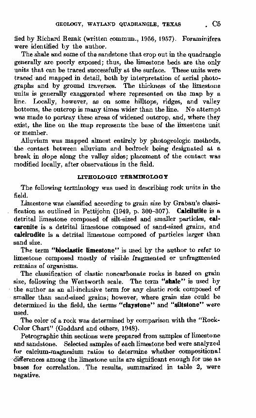
GEOLOGY, WAYLAND QUADRANGLE, TEXAS . C5
fied by Richard Rezak (written commun., 1956, 1957). Foraminifera were identified by the author.
The shale and some of the sandstone that crop out in the quadrangle generally are poorly exposed; thus, the limestone beds are the only units that can be traced successfully at the surface. These units were traced and mapped in detail, both by interpretation of aerial photo graphs and by ground traverses. The thickness of the limestone units is generally exaggerated where represented on the map by a line. Locally, however, as on some hilltops, ridges, and valley bottoms, the outcrop is many times wider than the line. No attempt was made to portray these areas of widened outcrop, and, where they exist, the line on the map represents the base of the limestone unit or member.
Alluvium was mapped almost entirely by photogeologic methods, the contact between alluvium and bedrock being designated at a break hi slope along the valley sides; placement of the contact was modified locally, after observations in the field.
LITHOLOGIC TERMINOLOGY
The following terminology was used hi describing rock units hi the field.
Limestone was classified according to grain size by Grabau's classi fication as outlined in Pettijohn (1949, p. 300-307). Calcilutite is a detrital limestone composed of silt-sized and smaller particles, cal- carenite is a detrital limestone composed of sand-sized grains, and calcirudite is a detrital limestone composed of particles larger than sand size.
The term "bioclastic limestone" is used by the author to refer to limestone composed mostly of visible fragmented or unfragmented remains of organisms.
The classification of clastic noncarbonate rocks is based on grain size, following the Wentworth scale. The term "shale" is used by the author as an all-inclusive term for any clastic rock composed of smaller than sand-sized grains; however, where grain size could be determined in the field, the terms "claystone" and "siltstone" were used.
The color of a rock was determined by comparison with the "Rock- Color Chart" (Goddard and others, 1948).
Petrographic thin sections were prepared from samples of limestone and sandstone. Selected samples of each limestone bed were analyzed for calcium-magnesium ratios to determine whether compositional differences among the limestone units are significant enough for use as bases for correlation. The results, summarized in table 2, were negative.
C6 . CONTRIBUTIONS TO GENERAL GEOLOGY
1
I I
o g
.S §
I III
8
H
OJ-06i9T
OJ-68i9I
OJ-89Z9I
OJ-T9i9T
OJ-88091
OJ-S8091
OJ-1809T
OJ-0809T
m ph
XX
XX
XX
XX
XX
XX
XX
XX
XX
xx
I!
«S.B SS&a'
XXX
XX
& §!'llfl IHfill I tt®^OMO feSfei^So;; ^ OOCXf

GEOLOGY, WAYLAND QUADRANGLE, TEXAS C7
5 XX
X X
X X )
XX
X
X X
8
X X
X
X X
Brachiopoda Enteletes cf. E. hemiplicatua (Hall).. Derbyia crassa (Meek and Hayden)
sp. indet
Meeketta sp. indet -
Chonetes granuhfer Owen
verneuUianus platsmouthensis Dunbar and Condra
SP _____
Lissochonetes geinitzianua geronticus Dunbar and Condra
Juresania nebrascensis (Owen)
X
< XXX X
XX X
X X
X
xxx i
X X
x x i x
3 xx
X XX j
^£ 1
xxxx
X
s x
X
X
X
SP
Juresaniat sp. indet
Echinaria moorei Dunbar and Condra ....... ... ... ....
Echinoconchus? sp. .
Reticulatia huecoensis (R. E. King) - . ... . cf. R. newetti K. H. King.. - - -
Reticulatia't sp. ..... . . +-
SP _____ Hystriculina wabashensis (Norwood and Pratten).
Retaria lasattensia (Worthen) .. .... .......
Linoproductua cf. L. mognispinus Dunbar and Condra.
prattenianus (Norwood, in Norwood and Pratten) ............
sp. indet...
Cancrinellasv- .- - --------- -
X
8
"3
X
X
*
\>
3
X
X
XX
sxxx
XX -3
X X
Rhynchopora Ulinoisensis (Worthen)- ___ Spirifersp ................................... .. .
Neospirifer dunbari R. H. King
X-8
SP _____
Crurithyria planoconvexa (Shumard)
X
X
X
X )
'
X
3X
X
X )
sp . -
Conarathyris perplexa (McChesney) ......... ... ...... ... Punctospwifer kentuckensis (Shumard) ............................
Sp. ...
X
«
X
X
X
< X
X
<
< X
Ousteaia mormoni (Marcou) __
Composita subtilita (Hall)...
X
X>
X >
Mollusca
Edmondia sp. indet Nuculopsis girtyi Schenck __.
ventricosa (Hall) __._
I
X
X
XX )
X
(
( X
X
X
Nuculana cf. N. attenu&ta (Meek) .............. ....... . .. . .
Myalina (Orthomyalina) sp. indet .............. .
Aviculopinna sp. indet . Pseudomonotis't sp. indet _...._ Aviculopecteri! sp...... . .
<X
X
X
3
WUkingia cf. W. terminate Hall sp. indet- _ . __ -
Attartella concentrica (Conrad)..

C8 CONTRIBUTIONS TO GENERAL GEOLOGY
&3
i s8
gll
0
agO
3n3,
|
!OS
5
aSB
§
1°°
£
3
a
Ift i
!! o
IM
S§ sa>
ao
0
1*Q
S
2
0*«0l
OJ 16491
J I
0*«»l
MHWI
o
OJ-89i9T
0^91
OJ-T9i9T
OJHW09T
OJ-2949T
OJ-69491
OJ-88091
OJ-2809T
OJ-I809T
OJ-OB09I
1&«
6 g«5
1S.
X
&
3X
X
i
X
X
1Is
XXX
o«
&lpS&L
XX
X
X
1 o
* a>
!? OM
x ><
XX >
>
S1-SS 8 S'^ ts «""
>
X
?
C X
/
XX
X X
X
X X
I osg,
it c? is £ * 5, I §i
f" Tt *3If y
X
X
XX X)
xxxx
X
X
'a
11 ^*i niii
i ^li| 5 s S s-3!
natopleura brazoem iasp .-.- . ...
o«ptra cf. Af. perat ikern of subulitace dorthoceras knoxens dorthoceroid cephi
XX X
i1
cocerassp .........tcwxrast sp .
lonoid indet ......dentition.. _
1

C9
TABLE 2. Calcium, magnesium, total carbonate, and insoluble residue, in percent, in selected limestone samples from the Wayland quadrangle
[Analyst: R. F. Gantnier]
Formation
Pueblo
Thrifty
Graham
Caddo Creek
Member
Saddle Creek Limestone. __ . ..do. _ - .-._-.... Waldrip Shale. ...... ...
fihaflfin T-imePt-onfi ..do
..do _____________Speck Mountain Limestone _
do..... ..do Wayland Shale (bioherm) __ Gunsight Limestone _____
. .do. ..do .. ....Rtingnr T,imp<;t.rmA__ do. _ _________ ..
Locality (Pl.l)
'M57201 M5720B
M5742M5740
M5739M5572M5701M5560M5768 M5656
M5800M5771BM5723BM5581 M5771
1M5718M5575M5553M5709M5580A
1M5778
Calcium
37.538.328.532.0
36.234.138.133.333.3 36.6
36.638.238.232.5 36.930.134.334.631.735.2
36.4
Magnesium
Trace
0.8
TraceTrace
0.6TraceTrace
1.0
0.8
2.8Trace
1.4
Total carbonate
(calcu lated)
93.7+95.7+73.980.0+
90.5+85.2+95.2+83.2+83.2+ 91.5+
91.5+97.695.5+81.2+ 95.775.2+88.486.5+88.988.0+
95.8
Insoluble residue
6.3-4.3-
26.120.0-
9.5-14.8-4.8-
16.8-16.8- 8.5-
8.5-2.44.5-
18.8- 4.3
24.8-11.813.5-11.212.0-
4.2
1 Lies outside mapped area.
GEOLOGIC SETTING AND STRUCTURE
The Wayland quadrangle lies in the eastern part of an outcrop belt of Pennsylvanian and Permian rocks that begins at the Llano uplift, about a hundred miles to the south, and trends discontinuously northeastward into Oklahoma. It lies on the western flank of the subsurface Bend Arch, near the axis of that feature as described by Cheney (1940, p. 98-113). The rocks in the quadrangle dip less than 1° WNW. Folds of low amplitude may be present locally in the quadrangle, but, as no topographic base was available and no precise determinations of altitudes were made on the outcrops, no such folds were detected.
STRATIGRAPHY
About 790 feet of strata is exposed in the Wayland quadrangle (pi. 1). These rocks comprise those assigned to the upper part of the Canyon Group and to the Cisco Group, both of Late Pennsylvanian age, and those of the lower part of the Wichita Group of Early Permian age (table 3), also included are rocks equivalent to the lower part of the Trinity Group of Early Cretaceous age and alluvial deposits of Quaternary age.
The nomenclature used for the Pennsylvanian rocks is that of Eargle (1960) unless otherwise noted. The nomenclature used for the Permian and Cretaceous rocks is that of Stafford (1960a), who followed, in part, Moore (1949). Some classifications of Pennsylvan-

CIO CONTRIBUTIONS TO GENERAL GEOLOGY
ian and Permian rocks in and near the Wayland quadrangle are shown on plate 2.
TABLE 3. Major upper Paleozoic stratigraphic subdivisions mentioned in this report
System
Permian
Pennsylvania!!
Series
Leonard
Leonard (?)
Wolfcamp
Upper Pennsylvanian
Middle Pennsylvanian
Group
Clear Fork
Wichita
Cisco
Canyon
Strawn
Formation
Arroyo
Lueders Clyde Belle Plains
Admiral Putnam Moran Pueblo
Thrifty Graham
Caddo Creek Brad Winchell Limestone Graford
Undifferentiated
Examination of sample logs from wells drilled in Stephens and Eastland Counties indicates that between 3,000 and 3,500 feet of pre-Cisco Pennsylvanian rocks is unexposed in the quadrangle. The rocks assigned to the Canyon Group consist of gray shale, a few relatively thick beds of limestone, and minor amounts of sandstone. The pre-Canyon rocks are dominantly gray shale and sandstone but contain minor amounts of limestone. The so-called "Caddo Lime" of drillers, which is near the base of the Pennsylvanian section, is a sequence of limestone and interbedded black shale several hundred feet thick which produces oil.
Rocks of the Canyon Group crop out in the southeast corner of the quadrangle as part of a northeast-southwest-trending belt about 18 miles wide that overlies stratigraphically the outcropping rocks of the Strawn Group. (See Plummer and Hornberger, 1935; Hendricks, 1957; and Ross, 1921, for descriptions of these units.)
As determined from well data, rocks of the Mississippian System in the Wayland quadrangle consist of an upper unit of black shale (Barnett Shale) that is about 150 feet thick and a basal limestone unit of variable thickness that is considered to be of Chester age by many geologists. The oldest Paleozoic rocks penetrated in drill holes belong to the Ellenburger Group of Ordovician age. These rocks consist of dolomite and limestone and are about 1,500 feet thick in

GEOLOGY, WAYLAND QUADRANGLE, TEXAS Oil
northern Eastland County (Cheney, 1940, fig. 2). The group overlies less than 100 feet of Cambrian sandstone that was assigned to the Hickory Sandstone by Cheney (1940), and this sandstone in turn rests upon Precambrian rocks. The Hickory has been considered to be a member of the Riley Formation since 1943 (Cloud, Barnes, and Bridge, 1943).
PENNSYLVANIAN SYSTEM
Rocks belonging to the Pennsylvanian System in the Wayland quadrangle are represented by the upper part of the Canyon Group and by the Cisco Group (pi. 3). The youngest exposed bed of Penn sylvanian age is the Chaffin Limestone Member of the Thrifty Forma tion. The oldest bed exposed in the area is the Home Creek Lime stone Member of the Caddo Creek Formation.
CANYON GROUP
CADDO CREEK FORMATION
The Canyon Group is exposed in the extreme southeastern part of the quadrangle, where it is represented by the Caddo Creek Forma tion. The Caddo Creek, consisting of the Colony Creek Shale Mem ber and the overlying Home Creek Limestone Member, has a reported thickness of 120 feet in southern Stephens County (Plummer and Hornberger, 1935, p. 59). The name Colony Creek Shale Member (Cheney, 1948) has replaced the abandoned name, Hog Creek Shale Member (Eargle, 1960, p. 67).
COLONY CREEK SHALE MEMBER
The Colony Creek Shale Member in the Wayland quadrangle is masked by alluvium and vegetation. Probably no more than the upper 10-15 feet of shale is present. Ross (1921, p. 306) described the equivalent unit east of the Wayland quandrangle as "about 70 feet of shale containing several thin-bedded calcareous sandstones and lenticular limestones."
HOME CREEK LIMESTONE MEMBER
The name Home Creek was applied by Drake (1893, p. 398-399) to a limestone bed 25-50 feet thick that crosses Home Creek about l&-2% miles north of the Colorado River in southeastern Coleman County.
The Home Creek Limestone Member is incompletely represented in the Wayland quadrangle, the upper beds having been removed by pre-Cretaceous erosion. The 15 feet remaining is exposed in roadcuts in the southeast corner of the quadrangle. The lower 1 foot of this limestone is moderate-yellowish-brown calcilutite; it is brittle, has a hackly fracture, and contains scattered fragments of indeterminate fossils. The upper 14 feet is nodular marly limestone and contains in
758-446 O 65 3

C12 CONTRIBUTIONS TO GENERAL GEOLOGY
its lower part the fusulinids Triticites of T. consobrinus White and Triticites ex gr. T. secaLicus (Say), which were identified by the author. This bed is overlain by Lower Cretaceous sandstone correlative with the Trinity Group of the Gulf Coastal Plain.
Reeves (1922, p. 119) said that the Home Creek Limestone Member hi northern Eastland County (just south of the Wayland quadrangle)
consists of two beds of limestone separated by 10 feet of shale. The upper bed of limestone, which is 3 to 5 feet thick, weathers into light-gray massive slabs and usually forms outcrops some distance back from the lower bed. The lower bed is about 15 feet thick and includes at the top 5 feet of thin layers of soft grayish-white limestone which weathers into chalky fragments or smooth white slabs, underlain by 10 feet of massive rock that forms prominent cliffs along the banks of streams.
CISCO GROUP
The Cisco Group crops out in about two-thirds of the Wayland quadrangle. The group is underlain by the Canyon Group and overlain by the Wichita Group of Permian age. It is represented by two formations: the Graham Formation below, and the Thrifty Formation above. In the southern part of the area, it is about 600 feet thick; in the northern part only the upper 250 feet is exposed (pi. 3), and the total thickness is unknown. The contact with the underlying Canyon Group is covered by overlapping rocks of Early Cretaceous age.
The Cisco Group is dominantly shale but contains some limestone, sandstone, and conglomerate. The thicker sandstone units are found mostly as channel-fill deposits. Their thicknesses are variable, and the fragments composing them range hi size from silt to pebbles. The limestone units are generally no more than 5 feet thick and rarely are more than 15 feet thick. Being persistent, resistant to erosion, and generally of uniform thickness and texture, they are fairly easily mapped and are useful for correlation. The shale units generally are poorly exposed, and those overlying the Gunsight Limestone Member of the Graham Formation have been extensively replaced by channel- fill deposits.
The shale units of the group are typically olive-gray to greenish- gray claystone and siltstone and generally are poorly fossiliferous, although some siltstone contains macerated plant fossils. Locally, shale in the Graham Formation is light-gray claystone that commonly contains marine invertebrate fossils. Limestone in nodules or dis continuous beds occurs locally hi the gray shale.
The sandstone members of the Graham and Thrifty Formations are mostly crossbedded ripple-marked channel-fill deposits that range hi thickness from 0 to 74 feet (Avis Sandstone Member of the Graham Formation). The sandstones are mostly reddish brown, fine to coarse grained, and quartzose. Angular grains of chert are commonly

GEOLOGY, WAYLAND QUADRANGLE, TEXAS C13
present, and the sandstones locally contain chert pebbles and clay pellets, especially where near the base of the channels. Macerated fossil plant debris and fragments of fossil wood also have been found in the sandstones.
Crosscut ting relations at the base of individual sandstone units that fill channels cut into the shale usually cannot be seen at any one locality. Such relations are inferred by noting from place to place the differing amount of underlying shale and limestone that has been removed and replaced by sandstone. The sandstone bodies grade laterally, presumably along the edges of the channels, into the encasing shale units. Where the sandstone units grade to a featheredge, shale units above and below cannot be separated. The sandstone members commonly form well-defined topographic escarpments on the tops and sides of hills but, as they are discontinuous and of various thickness, cannot be used with confidence for correlations.
The persistent limestone beds are mostly light-olive-gray calcarenite and algal calcilutite. They generally crop out in well-defined escarp ments that are easily traced in the field and on aerial photographs.
GRAHAM FORMATION
The Graham Formation was described by Plummer and Moore (1921, p. 125, 126) as
The lowest division of the Cisco group * * * named from the county seat of Young County where the formation is typically developed * * *. The formation as here defined includes all the strata from the top of the Home Creek limestone in the Canyon group to the base of the first sandstone above the Wayland and Gunsight fossiliferous beds, known as the Avis sandstone * * *. The formation is distinguished from the strata of the Canyon group below by its thinner lime stone members and from the strata of the formations above by the very prolific and persistent group of fossils which occur in the shales of the upper members.
In the Wayland quadrangle the gross lithologic differences between the Graham Formation and the overlying Thrifty Formation are slight. The Graham contains somewhat more shale and less sand stone and limestone than does the Thrifty.
The Graham Formation is approximately 525 feet thick in the southern part of the area, but only the upper 350 feet is exposed. The exposed part consists of 71 percent shale, 22 percent sandstone and conglomerate, and 7 percent limestone. The lower part of the formation is overlapped by rocks correlative with the Trinity Group of Early Cretaceous age. In the northern part of the area, only the upper 170 feet of the Graham is exposed. It consists of 53 percent shale, 35 percent sandstone and conglomerate, and 12 percent lime stone (pi. 3).

C14 CONTRIBUTIONS TO GENERAL GEOLOGY
The Graham Formation has been subdivided into the following members, listed in descending order:
Unnamed shale memberIvan Limestone MemberAvis Sandstone MemberWayland Shale MemberGunsight Limestone MemberUnnamed shale memberBunger Limestone MemberUnnamed shale memberGonzales Limestone MemberUnnamed shale member
These members express the cyclic sequence (a) shale, (b) channel- fill sandstone, (c) shale, and (d) limestone, which is repeated five times in the Graham Formation. At many places near the top of the formation, there is a thin discontinuous layer of coal and carbonaceous shale.
UNNAMED SHALE MEMBER OVERLYING THE HOME CREEK LIMESTONE MEMBER
The shale unit at the base of the Graham Formation reaches a thickness of 96 feet in the Lacasa area of north-central Texas (Ross, 1921, p. 307), but in the Wayland quadrangle only the upper 1 foot or so of the unit is exposed. As seen in the bed of East Fork Gon zales Creek, it is ferruginous sandstone. South of the quadrangle, near the town of Eastland, the shale unit contains channel-fill sand stone. The shale unit in Jack County was called the Finis Shale by Plummer and Moore (1921, p. 127), but this name is not used in the Wayland quadrangle because too little of the unit is exposed to justify correlation.
GONZALES LIMESTONE MEMBER
The Gonzales Limestone Member was named by Ross (1921, p. 307, 308) for a limestone unit exposed along the headwaters of Gonzales Creek. He described the unit asa coarse-grained dark-gray limestone containing large numbers of Campophyllum, and locally a thin shaly limestone carrying large numbers of Myalina subquadrata lies 8 feet above it. The interval between the top of the Home Creek limestone and the top of the Gonzales limestone cannot be measured directly in this region but is about 100 feet.
The type area of the Gonzales Limestone Member is in the south eastern part of the Wayland quadrangle. The limestone in this member crops out at stream level near the headwaters of East Fork Gonzales Creek, where it consists of about 2 feet of poorly exposed rough-weathering sandy yellowish-gray (5Y 7/2) calcarenite that lo cally weathers grayish red purple (5RP 4/2). It contains many

GEOLOGY, WAYLAND QUADRANGLE, TEXAS C15
crinoid-stem segments and, in places, bellerophontid gastropods, which are found on the bedding surfaces. Locally, colonies of Syringopora were noted. The limestone is overlain by a massive sandstone that has been traced into the area of measured section M5713 (p. 60-61). Because stratigraphic relations are obscured by soil and vegetation, one cannot be certain whether the sandstone replaces the Gonzales Member. Along Gonzales Creek, the basal part of the sandstone locally grades into a sandy limestone facies that seems to be part of the Gonzales Member.
The sandy facies of the Gonzales contains angular to subrounded quartz grains, mostly subangular to subrounded, dispersed in a lime stone matrix. Most quartz grains are isolated, but a few lie in sutured contact. The quartz grains average 0.2 mm in diameter and are accompanied by a few grains of porcelaneous white chert about 0.1 mm in diameter. Fossils observed in thin section are worn fragments of Epimastopora, Bradyina, very rare f usulinids, ostracodes, bryozoans, brachiopods, and crinoid-stem segments.
In some places the Gonzales is a hash of organic debris, being com posed of sand-sized fragments of fossils in a crystalline matrix. Many of the organic fragments are coated with algal-appearing material. Fragments of Epimastopora are common. Other identifiable organic debris noted in thin section consists of smaller Foraminifera, includ ing Tetrataxis and Tubertinat, rare fusulinids, bryozoans, ostracodes, crinoid parts, brachiopod spines, and small high-spired gastropods. With the organic material are scattered angular to subrounded quartz grains that average about 0.2 mm in diameter.
UNNAMED SHALE MEMBER OVERLYING THE GONZALES LIMESTONE MEMBER
Shale and sandstone above the Gonzales Limestone Member were called the Gonzales Creek shale and sandstone by Plummer and Moore (1921, p. 127), but, because this name is easily confused with that of the limestone member, it is not used in this report.
The sequence of rocks consists of shale and local thick-bedded channel-fill crossbedded sandstone (fig. 2A) . A cast of Sigittaria was found in a boulder of sandstone near the base of the sandstone unit that crops out at M5713 (fig. 2B). The presence of this cast and of macerated plant debris found elsewhere in this sandstone unit sug gests that the unit is nonmarine. The measured section on pages 60-61 shows the character of the member.
BUNGER LIMESTONE MEMBER
The Bunger Limestone Member was described by Plummer and Moore (1921, p. 129) as the Bunger Limestone Lentil, although the name was used earlier by Plummer (1919, p. 143, 144) as the Bunger

C16 CONTRIBUTIONS TO GENERAL GEOLOGY
Limestone Member of the Bunger Formation. The unit was named for the town of Bunger in southern Young County. Plummer and Moore (1921) traced the Bunger from southern Young County across the eastern part of Stephens County into Eastland County as far as the area of Cretaceous overlap. They described the lithology of the limestone (p. 129) as* * * in places it is dark yellowish-brown, quite dense and heavy; in other areas it is light gray, impure, and massively bedded. The member is thickest in the South Bend area of Young County and is thinnest in Eastland County. In Stephens County, the limestone has a rusty, dark-gray color and caps a low escarpment. West of the escarpment it has a wide outcrop and forms an excellent key rock for structural mapping * * *.
In the Wayland quadrangle the Bunger Limestone Member is typically light-olive-gray limestone that varies from calcilutite to calcarenite. The thickness of the member is 3-8 feet, averaging about 5% feet. The beds have a maximum thickness of about 1 foot but more commonly are 2-8 inches thick. Bedding is commonly wavy, especially in the more thinly bedded parts of the Bunger. The wavy bedding is generally associated with algae, although algae are also common in the flat-bedded parts of the member.
Small fusulinids belonging to the genus Triticites are generally found in the upper 1 or 2 feet of the bed but are rare in the lower part and in the algal layers. Crinoid-stem segments and a few brachiopods have been noted on broken and on weathered surfaces.
The Bunger crops out almost continuously along the east side of the mapped area, where it commonly caps hills and forms a low ridge
UNNAMED SHALE MEMBER OVERLYING THE BUNGER LIMESTONE MEMBER
The shale sequence that overlies the Bunger Limestone Member was called the South Bend shale and sandstone by Plummer and Moore (1921, p. 127). Sellards (1932, p. 104) pointed out that the name "South Bend" had already been given to another unit and pro posed as a replacement the new name "Necessity Shale," which he credited to Plummer. Sellards did not cite a type area or describe the unit; unfortunately, the references to the Necessity cited by Sellards contain no mention of either Necessity or South Bend. In this report the unit is referred to as an unnamed shale.
FIGURE 2. Lithologic features in rocks between the Goni,ales Limestone and Wayland Shale Members of the Graham Formation. A, Crossbedded channel- fill sandstone about 40 feet below the Bunger Limestone Member at M5774. B, Cast of tree trunk (Sigillaria) in channel-fill sandstone at M5714. Photo graphed part of trunk is about 20 inches long and has a maximum width of about 3 inches. C, Typical weathered surface of algal parts of Gunsight Limestone Member in roadbed at M5711. Algae belong to the genus Archaeolithophyllum.

GEOLOGY, WAYLAND QUADRANGLE, TEXAS C17
B

CIS CONTRIBUTIONS TO GENERAL GEOLOGY
The shale ranges from 15 to 30 feet in thickness and is dominantly siltstone and claystone containing lesser amounts of sandstone in lenticular beds. The siltstone and claystone are gray to light brown. The sandstone is reddish brown to olive gray, consists of fine- to medium-grained quartz, and is in beds as much as 2 feet thick. Some of the sandstone lentils contain impressions of reedlike plants, but many others contain macerated and carbonized plant debris as the only fossils.
Uppermost hi the shale sequence is a %- to 1%-foot-thick bed of light-olive-gray calcareous sandstone composed of poorly sorted fine-grained quartz. The sandstone has trails and problematic markings on the bedding surfaces. It forms an inconspicuous bench and grades upward into the basal bed of the Gunsight Limestone Member.
GUNSIGHT LIMESTONE MEMBER
The Gunsight Limestone Member was named for the town of Gun- sight in southern Stephens County by Plummer and Moore (1921, p. 120). They described the member astwo thin limestone layers separated by 20 to 25 feet of yellow shale * * *. At the type locality at Gunsight the upper limestone layer is a uniformly thin, light yellowish-gray densely crystalline bed weathering to smooth-surfaced blocks. The lower layer is separated from the upper by 22 feet of soft yellow clay shale and consists of a soft white or light-buff limestone in most places filled with Campophyttum torquium, which weather out on exposed slopes so abundantly that in some places they can be scooped up hi cart loads.
Plummer and Moore (1921, p. 134) stated: "The upper limestone member occurs in the road at the town of Gunsight, and the lower bed filled with the Campophyllum corals forms a low escarpment two miles east of the town." The Gunsight, however, is poorly exposed in this area. The upper limestone bed crops out in the road between Gunsight and U.S. Highway 183 and in the road south from Gunsight. About 6 feet of algal limestone is poorly exposed in a pasture between the road intersection at Gunsight and the cemetery. Fossils, other than algae that resemble Archaeolithophyllum, are rare. The lower beds are not exposed at Gunsight but are exposed at other places, including localities M5553 and M5773, northeast of Gunsight.
The lower bed consists of about 2-2 % feet of gray calcareous clay- stone containing many brachiopods, bryozoans, caninoid corals (Campophyllum of earlier workers), and other megaf ossils. Collections made from this bed are listed in table 2. The unit is overlain by gray calcareous shale %-l foot thick which locally becomes light-olive-gray nodular calcarenite. This upper zone contains common to locally abundant large fusulinids, many of which resemble^ Triticites secalicus (Say) 1823. Soil from weathered outcrops of this bed characteris-

GEOLOGY, WAYLAND QUADRANGLE, TEXAS C19
tically contains abundant free fusulinids and pebbles and slabs of coquinoid fusulinid limestone. The bed has not been found north of the area of locality M5771, 4 miles north-northwest of Necessity, where it grades into calcareous sandstone. At this locality the sand stone contains fossils similar to those in the calcareous shale.
About 2% miles southwest of Necessity (loc. M5772, pi. 1), a limestone bed that may be an equivalent of the lower fossiliferous bed crops out in a creek bed about 20 feet below the algal facies of the Gunsight. As seen in thin section, this limestone is bioclastic calcilu- tite. Hematite and pyrite are disseminated throughout the matrix and are often associated with fragmented fossils. The fragments of fossils, mostly broken and abraded, consist of indeterminate shell frag ments, crinoid-stem segments, and a few encrusting Foraminifera(?).
The fossil-bearing beds are overlain by about 25 feet of olive-gray claystone containing minor amounts of siltstone and local bodies of sandstone as much as 7 feet thick that resemble channel-nil deposits. At locality M5575, about 1% miles northwest of Necessity, a 4-inch- thick bed of yellowish-gray calcarenite composed of comminuted shell debris and a few crinoid-stem segments lies about 13 feet below the upper limestone bed.
The thickness of the upper limestone bed of the Gunsight Member is 1-6 feet, averaging about 3 feet. It is a light-olive-gray to dark- gray fine-grained rock that grades from calcarenite to calcilutite and is often dusky yellow on weathered surfaces. The calcilutite is frequently sublithographic in texture. The lower 2%-3 feet of the bed is algal, containing Archaeolithophyllum as identified by Richard Rezak from three localities M5575, 1% miles north-northwest of Necessity; M5578, 2% miles southwest of Necessity; and M5762, three-quarters of a mile north of Eastland-Stephens County line on U.S. Highway 183. At locality M5762 he identified the follow ing algae:
Osagia-Nubecularia (coatings) Girvanella sp. Epimastopora sp. Archaeolithophyllum sp.
The algal part of the bed is the most persistent (fig. 3). It is typically wavy-bedded calcilutite and forms a ledge on which the algae weather in relief, giving the rock a graphic appearance (fig. 2 CO- Fusulinids are not common in the upper bed of the Gunsight Member but, where found, are usually in limestone that overlies the algal part of the bed.
About 4% miles north-northwest of Necessity, a 3-foot-thick bed of algal limestone is exposed in the bed and banks of Big Bear Creek. It is olive-gray to light-olive-gray brittle calcilutite, locally having a subconchoidal fracture. Except for algae that resemble Archaeo-
75&-446 O 65 4

C20 CONTRIBUTIONS TO GENERAL GEOLOGY
FIGURE 3. Alga Epimastopora (circled) in bioclastic calcarenite of the Gunsight Limestone Member of the Graham Formation. Locality M5762, USNM 641937. X 10.
liihophyllum, fossils are rare. Only sparse crinoid stems and brachio- pods were noted on the outcrop. In thin section, the groundmass is very fine grained calcite with agglutinated masses of finer grained calcite. It contains rare subangular to subrounded quartz grains about 0.06 mm in diameter. The algae have been completely recrys- tallized and resemble veinlets of crystalline calcite. Fossils othei than the algae include rare fragments of brachiopod shells, brachiopod spines, and indistinct forms that may be partially recrystallized Foraminifera.
WATLAND SHALE MEMBER
The Wayland Shale Member was named by Plummer and Moore (1921, p. 130) for exposures in the vicinity of Wayland, although no specific type area was mentioned. The Wayland Shale Member overlies the Gunsight Limestone Member and underlies the Avis Sandstone Member.
Exposures of the Wayland are generally poor. The best exposures can be seen about 1% miles southeast of Gunsight (Iocs. M5580, M5581), about 1 mile northwest of Gunsight (loc. M5763), and about 2% miles northeast of Gunsight (loc. M5773), where the Wayland is light-olive-gray claystone and siltstone interbedded with fine-grained quartz sandstone. Carbonized plant fragments are commonly found in the siltstone and sandstone. Locally, the Way- land includes a bed of light-gray claystone that contains marine fossils, and in some places it contains scattered nodules of limestone. East of the cemetery at Wayland, the member is greenish-gray

GEOLOGY, WAYLAND QUADRANGLE, TEXAS C21
siltstone that is sandy near the base of the overlying Avis. The contact between the Avis Member and the Wayland Member, how ever, is not gradational. The basal few feet of the Wayland Member is concealed by alluvium.
The thickness of the Wayland Member is not uniform. The maximum measured thickness is 86 feet, but in a few localities the Avis Sandstone Member has replaced the Wayland and rests directly upon the Gunsight Limestone Member.
Marine fossils are uncommon in the Wayland but have been found about 9 feet above the base and near the top. They are mostly brachiopods and mollusks (table 1). Fusulinids have been found only about \% miles southeast of Gunsight (loc. M5705) in an ant hill near the base of a Wayland outcrop. At this locality, Dun- barinetta sp., Tritidtes aff. T. secalicus (Say) 1823, Triticites cf. T. plummeri Dunbar and Condra 1927, and Triticites cf. T. beedei Dunbar and Condra 1927 were collected.
A bioherm exposed about 1% miles southeast of Gunsight (loc. M5581) is overlain by siltstone and underlain by siltstone and fine grained quartz sandstone. Fossils typical of the Wayland have been found about 10 feet above the bioherm (table 1, USGS loc. 16034). The bioherm has an exposed thickness of about 12 feet, is about 150 feet long in a northwesterly direction, and is about 20 feet wide. The exposed surface is grooved with north-trending troughs as much as 2% feet deep, probably due to solution weathering. The limestone is in part calcarenite composed mostly of comminuted shell debris and in part calcirudite composed of angular fragments of fine calcarenite as much as half an inch in diameter in a matrix of bioclastic calcarenite. In places, especially in the northern and western parts of the bioherm, the deposit is a coquina of brachiopod shells; in other places it is a hash of wave-worked fragments of brachiopod shells, crinoid-stem segments, bryozoan fragments, and indeterminate organic debris (fig. 4).
AVIS SANDSTONE MEMBER
The Avis Sandstone Member was named by Plummer and Moore (1921, p. 154) for exposures near the town of Avis, in Jack County. Plummer and Moore also noted that the unit has a similar expression in Young and Stephens Counties. As exposed in the Wayland quadrangle, the Avis is resistant to weathering and commonly caps hills or forms low escarpments.
The Avis Member was deposited on an eroded surface, probably as channel-fill deposits, and was itself eroded down to an irregular surface upon which younger sediments were deposited. In the Wayland quadrangle the Avis is underlain by the Wayland Member

C22 CONTRIBUTIONS TO GENERAL GEOLOGY
FIGUHE 4. Fragments of limestone from a bioherm in the Wayland Shale Member of the Graham Formation. Note sand-sized rock fragments and fragments of unidentifiable fossils. The irregular contacts of the rock frag ments indicate "fitting" by solution shortly after deposition. Locality M5581, USNM 641935. X 50.
or, less commonly, by the Gunsight Member. It is overlain either by an unnamed shale member or by the Ivan Limestone Member. The Avis is typically dusky-yellow to dark-grayish-orange or red medium-grained quartz sandstone; the grains are subangular to subrounded and are moderately well sorted. Many of the quartz grains are iron stained, and, locally, hematite grains are present. Locally, especially near the base of the bed, the Avis is a conglomerate composed of subangular to angular pebbles of chert as much as 1 inch in diameter in a sandstone matrix. The sandstone is crossbedded, and, at locality M5601 (measured sections, p. 55-56), sets of torrential- type crossbeds have been observed. Bedding planes are commonly ripple marked.
The Avis contains interbeds of siltstone and fine sandstone that locally contain nodular hematite, and it grades laterally, presumably along the edges of the channel, into siltstone. Such siltstone was mapped with the underlying or overlying shale units because, in the

GEOLOGY, WAYLAND QUADRANGLE, TEXAS C23
absence of the sandstone, the underlying and overlying shales are impossible to distinguish from one another.
The Avis Member ranges in thickness from less than 5 feet to more than 79 feet. The most complete exposure is at locality M5601. A section at this locality is shown on pages 55-56. About 9 miles farther south, at locality M5763, the Avis is 5 feet thick.
Sandstone of the Avis Member from locality M5901, on Farm Koad 576 about three-quarters of a mile west of U.S. Highway 183, is composed, as seen in thin section, of angular to subrounded quartz grains having a maximum size of about 0.32 mm and an average size of about 0.20 mm. Minor amounts of biotite and rare fragments of plagioclase showing albite twinning are present. The cementing material is mostly calcite but contains minor amounts of locally clear cellophane in amorphous blobs about 0.05 mm in diameter (fig. 5). Spheroidal or botryoidal masses of clear cellophane with a rind of dark-brown cellophane are also present. A sample analyzed by
FIGURE 5. Avis Sandstone Member. Shows amorphous masses of collophane(?), quartz, and chert grains. Locality M5901, USNM 641936. Crossed nicols, X 50.

C24 CONTRIBUTIONS TO GENERAL GEOLOGY
R. F. Gantnier contained 0.2 percent P205 . Hematite is disseminated throughout the rock.
Sandstone from about 1 mile south-southeast of Gunsight (loc. M5903) is composed of angular to subrounded, mostly subangular, quartz grains, many of which show wavy extinction under polarized light. The maximum grain size is 0.26 mm, and the average is 0.20 mm. The cement is calcite that is finely disseminated and also sparsely distributed in irregular masses as much as 0.25 mm diameter. Minor amounts of cellophane, scattered grains of hematite, and a single abraded brachiopod spine were notod.
Fusulinids have been found at the base of the Avis Member about 2% miles east-northeast of Gunsight (loc. M5571). Here the Avis replaces the upper part of the Gunsight Limestone Member. Its area of outcrop is, however, too small to be shown at map scale. The fusulinids are probably reworked from the limestone. Other fossils from the Avis consist of unidentifiable carbonized plant debris.
UNNAMED SHALE MEMBER OVERLYING THE AVIS SANDSTONE MEMBER
The shale member between the Avis Sandstone Member and the Ivan Limestone Member consists of as much as 8 feet of nonfossilifer- ous olive-gray silty claystone or siltstone. Locally the unit is absent and the Ivan rests directly upon the Avis.
IVAN LIMESTONE MEMBER
The Ivan Limestone Member was named by Plummer and Moore (1921, p. 154) for "a rather persistent lentil of limestone which appears in the vicinity of Ivan, Stephens County."
The continuity of the Ivan from its type area southward to the Wayland quadrangle is not certain. In the Wayland quadrangle, a limestone unit at about the stratigraphic position of the Ivan Lime stone Member has been mapped as the Ivan although it may be slightly above the position of the true Ivan (Brown, 1960b, p. 13). This unit is l%-9% feet thick and generally forms a ledge, especially in the northeastern part of the quadrangle. In the southern part of the quadrangle, the Ivan is generally less than 2 feet thick, and locally the entire bed has been replaced by post-Ivan channel-fill deposits.
The Ivan Limestone Member is divided into two parts. The lower part is a light-olive-gray calcilutite in beds from 1 inch to more than 6 inches thick. The upper, more widespread part is algal limestone in a bed 1-2 feet thick. This bed is well-sorted yellowish-gray bio- clastic calcarenite (fig. 6). The lower and upper parts of the member are gradational. The best exposures are 4-4% miles north-northwest of Necessity (Iocs. M5771, M5723). Thin sections from locality M5723 show that the lower 1 foot of the member is very arenaceous and grades upward into nonarenaceous limestone that has been

GEOLOGY, WAYLAND QUADRANGLE, TEXAS C25
FIGURE 6. Algae Osagia and Nubecvlaria in bioclastic calcarenite of the Ivan Limestone Member of the Graham Formation. The algae coat fragments with in the limestone. Locality M5763, USNM 641938. X 10.
leached by solution weathering. The arenaceous bed is bioclastic calcilutite. It contains angular to subrounded, dominantly sub- angular, etched quartz grains as much as 0.38 mm in diameter and patches of hematite. Some of the quartz grains show wavy extinction in polarized light. The organic debris is mostly smaller Foraminifera, brachiopod spines, crinoid columnals, and brachiopod shell fragments. The upper bed is very fine grained calcilutite. Material that resembles organic remains has been extensively replaced by calcite. The rock contains scattered reticulate masses of hematite. Individual meshes in the hematite network have the shape of calcite rhombs. This bed contains many brachiopods that resemble Composita.
Many of the organic fragments in the limestone are algae. Algae in the persistent upper bed have been identified by Richard Rezak as follows:
M5600 (west side of Lake Daniel) Epimastopora sp. Osagia-Nu^ecularia (coatings) Solenopora sp.
M5601 (2% miles north-northwest of spillway on Lake Daniel) Osagia-Nubecularia (coatings) Epimastopora sp.
M5763B (1 mile northwest of Gunsight)Osagia-Nv^becularia (coatings)
M5765 (U.S. Highway 180, about \% miles east of Farm Road 207)
Solenopora sp.

C26 CONTRIBUTIONS TO GENERAL GEOLOGY
Except for the algae, the Ivan is not notably fossiliferous. Crinoid- stem segments are rather widely distributed; brachiopods, some of which resemble Composita, have been noted; and fusulinids have been found at two localities about 4 miles north-northwest of Necessity (loc. M5771) and about 2% miles southwest of Gunsight (loc. M5802). At locality M5771 the fusulinids lie just below the algal limestone; at locality M5802 they have been found in limestone just above the algal beds and in ant hills below the algal beds. The fusulinids are primitive forms of the group of Triticites ventrwosus (Meek and Hay- den) 1858.
UNNAMED SHALE MEMBER OVERLYING THE IVAN LIMESTONE MEMBER
Rocks above the Ivan Limestone Member consist of a sequence of claystone and siltstone about 70 feet thick containing a channel-fill sandstone near the middle.
The shale beneath the channel-fill sandstone ranges from 0 to 39 feet in thickness. This unit is dominantly light-olive-gray to dusky-red siltstone having lesser amounts of light-olive-gray to light-gray claystone. Just south of the mapped area, light-gray calcareous clay- stone containing nodules of limestone crops out 13 feet above the Ivan Member. This claystone, which has not been found elsewhere, contains very well preserved spiriferoid and productid brachiopods (table 1, USGS Iocs. 16757, 16763). Because the deposition of this bed apparently is genetically related to that of the Ivan, the collections have been listed under that member in the table.
The channel-fill sandstone that overlies the lower siltstone and clay- stone unit at places cuts through the underlying beds and into rocks as old as the Avis Sandstone Member. Where the two sandstones merge, they are indistinguishable; hence, an exact maximum thickness for the post-Ivan cannot be stated but is more than 50 feet. The thickest exposure of this bed is about 4% miles southwest of Gunsight (south of the mapped area), where 14 feet of the sandstone crops out.
The sandstone is calcareous to noncalcareous, grayish orange pink to very pale orange, and generally crossbedded. It consists of subrounded to subangular fine- to medium-grained quartz sand but locally contains lenses of claystone or chert conglomerate. The quartz grains average 0.20 mm in diameter but are as much as 0.40 mm in diameter, and many are in sutured contact. As in most of the sandstone units in the Wayland quadrangle, hematite is disseminated throughout the rock. The cement is in part calcareous and in part siliceous.
Overlying the sandstone is a unit 15-48 feet thick consisting mostly of olive-gray siltstone that is streaked and banded red, yellow, and green. Interbedded with the siltstone are lesser amounts of light-

GEOLOGY, WAYLAND QUADRANGLE, TEXAS C27
gray, green, and red claystone and minor amounts of fine-grained quartz sandstone. The variation in thickness of this unit apparently resulted from its having been deposited on an irregular erosion surface.
Thin beds of coal or coaly shale, usually no more than a few inches thick, have been found in the interval between about 4 and 40 feet below the top of the unit. The number of beds of coal and coaly shale is unknown, but probably several lenticular beds occur in two zones. One zone extends from the top of the unit downward about 15 feet, and the other is between 30 and 40 feet below the top.
THRIFTY FORMATION
As restricted by Eargle (1960, p. 71), the Thrifty Formation consists of the following members hi the Colorado River drainage basin:
Chaffin Limestone MemberParks Mountain Sandstone MemberBreckenridge Limestone MemberSpeck Mountain Limestone Member
This classification is used in this report except that the Parks Mountain Sandstone Member is not recognized in the Wayland quadrangle and two thin shale and sandstone members are recognized. Thus, the following subdivisions of the Thrifty Formation were mapped in the Wayland quadrangle:
Chaffin Limestone MemberUnnamed shale and sandstone memberBreckenridge Limestone MemberUnnamed shale and sandstone memberSpeck Mountain Limestone Member
Note: The Chaffin Limestone Member equals the lower bed of the Crystal Falls Limestone Member of the Harpersville Formation of Lee and others (1938). The Speck Mountain Limestone Member equals the Blach Ranch Limestone Member of the Thrifty Formation of Plummer and Moore (1921), Lee and others (1938), and Brown (1960a).
The Thrifty Formation is approximately 90 feet thick. In the southern half of the Wayland quadrangle, it consists of about 33 percent sandstone and conglomerate, 39 percent shale, and 28 percent limestone; in the northern half it consists of about 25 percent sand stone and conglomerate, 45 percent shale, and 30 percent limestone (pl. 3).
The rocks of the Thrifty Formation were deposited in a cyclic sequence which is a continuation of that noted for the Graham Formation.
Geologic mapping (fig. 7) indicates that the Blach Ranch Lime-
758-446 0 63 5

C28 CONTRIBUTIONS TO GENERAL GEOLOGY
/ ,i\y C" oGuftsight / T_f___ I \\f\ STEPHENS'tCOUNTY >__I _____
f "^ K EASTLAND COUNTY . T ^1| ( /'
FIGURE 7. Outcrop pattern of the Breckenridge (Ptb), Speck Mountain (Pts), and Blach Ranch (PtbI) Lime stone Members of the Thrifty Formation and the Ivan Limestone Member (Pgi) of the Graham Formation. Cretaceous rocks (Trinity Group equivalent) indicated by stipple. A-D, location of columnar sections in figure 8; F-K, location of columnar sections in figure 10.

GEOLOGY, WAYLAND QUADRANGLE, TEXAS C29
stone Member (Plummer and Moore, 1921; Sellards, 1932; Brown, 1960a, b) in the Brazos River drainage basin is continuous with the Speck Mountain Limestone Member hi the Colorado River drainage basin as described by Drake (1893), Eargle (1960), Stafford (1960b), and Terriere (1960). The two members maintain an equivalent stratigraphic position in the rock sequence (fig. 8); they have identical lithologies and outcrop characteristics, similar thicknesses, and the same characteristic fusulinid assemblages (Myers, 1958, pi. 93; 1960b, pis. 22, 24). The units at this position can be traced along almost continuous outcrops for many miles both to the north and to the south of the overlapping Cretaceous rocks on the Callahan Divide. Because the name Speck Mountain has priority, it is used in this report hi preference to the name Blach Ranch.
SPECK MOUNTAIN LIMESTONE MEMBER
The Speck Mountain Limestone Member was named by Drake (1893, p. 408) for outcrops on and west of Speck Mountain in eastern Coleman County hi the Colorado River drainage basin. Speck Mountain is about 60 miles south-southwest of the Wayland quadrangle.
The Speck Mountain Limestone Member hi the Wayland quadrangle and southward to where it is covered by the Cretaceous rocks on the Callahan Divide is composed of two layers of limestone separated by a thin bed of shale. The member is about 40 inches thick. The lower limestone bed is 2 feet thick and is composed of light-olive-gray cal- cilutite and fine-grained calcarenite. It has conchoidal fracture, weathers brown, and forms a rubble of large polygonal blocks. The lower limestone is separated from the upper one by 4 inches to 1 foot of pale-yellowish-orange to moderate-yellowish-brown non- fossiliferous shale. The upper, light-olive to yellowish-gray lime stone is somewhat argillaceous and commonly is poorly exposed, weathering to lenticular slabs and at some places to nodular rubble.
UNNAMED SHALE MEMBER OVERLYING THE SPECK MOUNTAIN LIMESTONE
MEMBER
The interval between the Speck Mountain Limestone Member and the Breckenridge Limestone Member contains 45-70 feet of poorly exposed sandstone and shale. Locally beds of yellowish-gray (5 Y 7/2), grayish-olive (10 F 4/2), or light-gray (N 7) claystone are exposed. About a mile southwest of Lake Daniel (loc. M5566), Myctiina frag ments and rare gastropods and crinoid stems were found in the clay- stone 2 feet above the Speck Mountain Member.
The sandstone in this interval occurs as channel-fill deposits or as lenticular beds hi claystone. The thickest sandstone unit, generally

C30 CONTRIBUTIONS TO GENERAL GEOLOGY
WAYLAND QUADRANGLE NORTHERN HALF
EXPLANATION
Siltstone, shale, and sandstone
FEET I- 0
FIGURE 8. Correlation of Speck Mountain and Blach Ranch Limestone Members of the Thrifty Formation. Datum is the base of the Breckenridge Limestone Member. Location of columnar sections shown in figure 7. Column A generalized from Terriere (1960); B, from Stafford (1960a).

GEOLOGY, WAYLAND QUADRANGLE, TEXAS C31
found a few feet below the top of the interval, ranges from zero to more than 25 feet in thickness. The thickest continuous exposure of the sandstone is 4% miles southwest of Gunsight (loc. M5729, outside mapped area), where there is 12 feet of grayish orange-pink (10.R 8/2), crossbedded, ripple-marked sandstone. The rock is fairly well to poorly sorted and is composed of subrounded to subangular medium- grained quartz sand. It contains numerous flecks of limonite and (or) hematite. In the same area (loc. M5726, outside mapped area), a channel-fill deposit consists of cherty conglomerate and conglomeratic sandstone at the base and grades upward into sandstone. The con glomeratic phase contains angular to subangular chert pebbles, in a matrix of quartz sandstone, and much disseminated hematite. The chert pebbles appear milky in reflected light and tan to brown in transmitted light. Many show a brown rind or rim caused by altera tion. The sandstone phase consists of poorly sorted quartz sand accompanied by abundant angular to rounded chert grams as much as 0.80 mm in diameter. The chert grams are light brown in transmitted light and milky white in reflected light; many have a darker colored alteration rim around a lighter colored center. Hematite and limonite are disseminated in the matrix of the sand.
One and one-half miles northeast of Stephens County Airport (loc. M5759) this sandstone, which is the same as Brown's (1960a) bed "f," lies a few feet above the Speck Mountain Limestone Member. At nearby locality M5760, the channel occupied by the sandstone cuts through the Speck Mountain Member.
BRECKENRIDGE LIMESTONE MEMBER
The Breckenridge Limestone Member was named by Plummer and Moore (1921, p. 155), who stated:It forms a prominent escarpment in and about the town of Breckenridge and may be traced easily to the northwest and south. It has an average thickness of 3 or 4 feet and like the other limestones in the Thrifty which have been described, it is gray, massive and resistant. It is 25 to 45 feet above the Blach Ranch member.
No specific type or reference section was designated by Plummer and Moore. Brown (1960a, p. 18-20) redescribed the Breckenridge Limestone Member and designated a type or reference section "on the Harris Veale property, near the south city limits of Breckenridge, west of U.S. Highway 183." This locality is immediately south of the north boundary of the Wayland quadrangle. The member generally forms an easily traced ledge or small escarpment.
The Breckenridge Limestone Member at the type reference section (Brown, 1960a, p. 20) is about 7.4 feet thick. Elsewhere in the Wayland quadrangle it is about 1%-21% feet thick. Where the member is thickest, it is composed of two beds of limestone separated
C32 CONTRIBUTIONS TO GENERAL GEOLOGY
by shale. The lower bed of limestone, l%-2% feet thick, is yellowish- gray (5F 6/2) fine-grained calcarenite or calcilutite. It weathers to large angular blocks about 1 foot thick. It is not markedly fossilif- erous, although fusulinids are locally common.
The upper bed of limestone, which is about 3 feet thick, is yellowish- gray (5F 7/2) nodular calcarenite or calcilutite that weathers to nodular rubble. The bed is locally very fossiliferous, especially in the upper part, where numerous fusulinids, crinoid-stem segments, and scattered brachiopods are found. This bed, which crops out about 5% miles west-northwest of Gunsight (Iocs. M5555, M5556) and in the southwestern part of the quadrangle (loc. M5701), was probably deposited originally as a continuous sheet, but over much of the area it has been replaced by channel-fill deposits of sandstone and conglomerate.
The shale sequence between the two limestone beds is rarely ex posed. Where seen, it consists of as much as 17 feet of red and gray shale but is predominantly gray shale.
In many places in the Wayland quadrangle, the Breckenridge Limestone Member consists of a single limestone bed, which seems to be the equivalent of the lower of the two limestone beds discussed above. The bed consists typically of 1-5 feet of grayish-yellow (5F 8/4), yellowish-gray (5F 7/2), or light-olive-gray (5F 4/2) lime stone. It may be either calcarenite or calcilutite. Fusulinids, of which Triticites plummeri Dunbar and Condra is a common species, and crinoid-stem segments are scattered throughout Che bed; brach iopods and bryozoans are present in fewer numbers.
UNNAMED SHALE MEMBER OVERLYING THE BRECKENRIDGE LIMESTONE MEMBER
The interval between the Breckenridge Limestone Member and the Chaffin Limestone Member contains three lithologic units: a lower shale bed, an intervening channel-fill deposit of sandstone and conglomerate, and an upper shale bed. The channel-fill deposit is not present everywhere, and where it is absent the upper and lower shale beds are not distinguishable. This interval was assigned to the Quinn Clay by Plummer and others (1949), who ascribed a thickness of 30 feet to the unit in the northern part of the Wayland quadrangle (near loc. M5753, pi. 1). The name is not used in this report because through most of the Wayland quadrangle the rocks of this interval differ from those described by Plummer and others. According to the description, the Quinn Clay is mostly bluish-green clay, having reddish-maroon and brownish-red hues. The lower 10-15 feet of the clay (shale) is locally replaced by a sandstone lentil, and many iron concretions mark the outcrop.

GEOLOGY, WAYLAND QUADRANGLE, TEXAS C33
A complete section of the rocks between the Breckenridge Member and the Chafiin Member is exposed near the southwest corner of the quadrangle at locality M5702 (pi. 1), where the sequence is 31 feet thick. The lower 16 feet is light-gray (N-7) claystone containing thin bands of spherulitic hematite and siderite. Near the middle of the sequence, the claystone is carbonaceous and contains scattered poorly preserved plant impressions and a one-half-foot-thick bed of coaly and carbonaceous shale. The upper half of the unit is poorly exposed, but in its lower part it is probably gray and red claystone. It contains bands of spherulitic hematite that weather out as slabs as much as 2 inches thick.
Where this member contains a medial channel-sandstone deposit, the shale beneath the sandstone contains reddish-brown hematitic shale or fossiliferous gray calcareous shale having limestone nodules. The calcareous facies may represent the upper bed of the Brecken ridge Limestone Member. The maximum measured thickness of calcareous shale is 10 feet about 3% miles west-northwest of Gunsight (loc. M5559, pi. 1).
The channel-fill deposits are probably more than 40 feet thick (pi. 3), but the maximum thickness exposed at any one locality is about 12 feet (loc. M5555). The rock is a massive, locally cross- bedded, quartz sandstone that ranges in color from light brown (5YR 5/4) to red and orange. The quartz grains are usually coated with iron oxide. Discontinuous bands of angular light-colored chert granules occur locally. In ditches along the edge of the road at locality M5555, the sandstone is in contact with the Breckenridge Limestone Member and contains fragments of the limestone (fig. 9). Thin sections show that the sandstone consists principally of mod erately subangular to rounded well-sorted quartz grains that average about 0.30 mm in diameter. Chert grains the same size as the quartz grains compose about 10 percent of the rock. Most quartz grains have a secondary overgrowth of chalcedony which also fills interstices between the grains. Minor amounts of disseminated hematite are also present.
CHAFFIN LIMESTONE MEMBER
The Chafiin Limestone Member (Drake, 1893, p. 410^112) has been mapped continuously from the type area at the Chaffin coal mines in McCulloch County (fig. 1) northward through Coleman and north western Brown Counties to the south edges of the Callahan Divide (Stafford, 1960b; Terriere, I960; Cheney and Eargle, 1951; Hudnall and Pirtle, 1929), except in places where it is cut out by younger channel-fill deposits. North of the Callahan Divide, in Eastland County, the limestone is poorly represented, as it is extensively re-

C34 CONTRIBUTIONS TO GENERAL GEOLOGY
FIGURE 9. Channel-fill sandstone showing basal conglomerate containing cobbles from the Breckenridge Limestone Member. Ditch on west side of road at locality M5555. ;
placed by younger channel-fill deposits, but it was traced northward the length of the Wayland quadrangle to the vicinity of Breckenridge, and it was mapped as Crystal Falls Limestone Member from the type area in northern Stephens County to Breckenridge by Brown (1960a).
The Chaffin Limestone Member is correlated with the Crystal Falls Limestone Member on the basis of the similarity of their stratigraphic positions above the Breckenridge Limestone Member (fig. 10) and the similarity of their fusulinid faunas (Myers, 1958, pi. 93). Because the two members are correlative and because the name Chaffin has priority (Drake, 1893) over the name Crystal Falls (Plununer and Moore, 1921), the name Chaffin is used in this report. Hudnall and Pirtle (1929) called the Chaffin Member the "Upper Crystal Falls."
The Chaffin Limestone Member is poorly exposed along most of its outcrop in the Wayland quadrangle but is well exposed in a quarry about 1% miles northwest of Harpersville Cemetery in the west- central part of quadrangle (loc. M5758). There the member consists of yellowish-gray (5Y 7/2) fine-grained calcarenite about 1.5 feet thick which is blotched very pale purple (5P 7/2) and has a delicate violet cast on fresh surfaces. It is underlain by a nodular shaly lime stone that contains many fusulinids. In the southwestern part of the quadrangle (loc. M5702), the Chaffin consists of 3.8 feet of light-

CO
LO
RA
DO
R
IVE
R
DR
AIN
AG
E
BA
SIN
IC
AL
LA
HA
N
DIV
IDE
BR
AZ
OS
R
IVE
R
DR
AIN
AG
E
BA
SIN
("U
pper
Cry
stal
Fal
ls
limes
tone
mem
ber"
)
(Cry
stal
Fal
ls L
imes
tone
M
embe
r)
(Bre
cken
ridge
Lim
esto
ne
Mem
ber)
(Bla
ch R
anch
Lim
esto
ne
Mem
ber)
FIG
UR
E 10
. Cor
rela
tion
of l
imes
tone
bed
s in
the
Thr
ifty
For
mat
ion
and
in t
he l
ower
par
t of
the
Pue
blo
For
mat
ion
betw
een
the
Col
orad
o R
iver
dra
inag
e ba
sin
and
the
Bra
zos
Riv
er d
rain
age
basi
n.
In s
ectio
n K
, be
ds b
elow
the
Bre
cken
ridg
e L
imes
tone
Mem
ber
have
bee
n pr
ojec
ted
from
the
typ
e lo
cati
on o
f th
e B
lach
Ran
ch
Lim
esto
ne
Mem
ber.
N
ames
in
pare
nthe
ses
to r
ight
of
sect
ion
K r
epre
sent
Bro
wn'
s (1
960a
) te
rmin
olog
y.
Loc
atio
n of
col
umna
r se
ctio
ns o
n fi
gure
7.
O
oo

C36 CONTRIBUTIONS TO GENERAL GEOLOGY
olive-gray (5F 5/2) calcarenite containing smaller Foraminifera, fenestrate bryozoans, brachiopods, crinoid-stem segments, and several indistinct calcareous bodies that resemble fragments of organic re mains. Elsewhere in the quadrangle the Chamn is seen hi fields as bouldery rubble; in creek beds, where only the upper few inches are exposed; or on a few hilltops, where most of the upper part of the bed has been removed by erosion.
PERMIAN SYSTEM
Rocks of the Permian System in the Wayland quadrangle are represented by the lower part of the Wichita Group of the Wolfcamp Series. The oldest unit is the Waldrip Shale Member of the Pueblo Formation, which lies with apparent conformity on the Chaffin Lime stone Member of the Thrifty Formation (pi. 3). The youngest unit is channel-fill sandstone and conglomerate that overlies the Saddle Creek Limestone Member at about the middle of the Pueblo Forma tion.
As the Chaflin is only 1-3 feet thick, it was mapped with the over lying Pueblo Formation. The Permian-Pennsylvanian boundary, however, may lie within the Waldrip Member of the Pueblo.
The thickness of the exposed Permian rocks is about 167 feet in the southern part of the quadrangle and about 130 feet in the northern part. The rocks in the southern part of the quadrangle are about 84 percent shale, 8 percent sandstone, and 8 percent limestone; those in the northern part are about 63 percent shale, 31 percent sandstone, and 6 percent limestone. Most of the sandstone is in channel-fill deposits (pl. 3).
WICHTTA GROUP
The name "Wichita beds" was first applied by Cummins (1890, p. 187-188) to a sequence of "sandstones, sandy shales, clays, and a peculiar conglomerate." After many changes in nomenclature, the Wichita in the Colorado River valley now has group rank and is divided into seven formations (Moore, 1949, sheet 2). These are, in descending order:
Lueders LimestoneClyde FormationBelle Plains FormationAdmiral FormationPutnam FormationMoran FormationPueblo Formation
As classified by Moore, the Wichita Group comprises all the Wolfcamp Series and probably part of the Leonard Series. Eargle (1960, p. 74, 75) defined, for practical purposes, the lower boundary of the Wichita Group as being at the base of the Waldrip Shale Member of

GEOLOGY, WAYLAND QUADRANGLE, TEXAS C37
the Pueblo Formation, thus coincident with the base of the Permian System. This definition is used in this report.
In the Wayland quadrangle only that part of the Wichita Group represented by the lower part of the Pueblo Formation is preserved.
PUEBLO FORMATION
The Pueblo Formation was named by Plummer (1919, p. 144-145), who stated:The Pueblo Formation is bounded by the Pueblo limestone [Camp Colorado lime stone) which is yellow, fossiliferous, and impure. Near the Red Bed line in Stephens County it changes to sand and loses its identity, but just below its horizon is a thin limestone abundant in Myalina fossils, which characterize this bed. The series of members in this formation is so variable that no one section is typical.
Later, Moore and Plummer (1922, p. 40) clarified the definition by stating that the Pueblo Formation . . .is named from a town on the Missouri, Kansas & Texas Railway in northeastern Callahan County, where the rocks of this division are typically exposed. It lies conformably on the Harpersville Formation and includes the strata to the top of the persistent Camp Colorado Limestone which forms a readily traceable escarpment both in the Colorado and Brazos valleys.
The Harpersville Formation (pi. 2) was defined by Plummer and Moore (1921, p. 160) as including all strata from the top of the Breckenridge Limestone Member of the Thrifty to the top of the Saddle Creek Limestone Member and was named for the no longer extant town of Harpersville in Stephens County.
Cheney (1940, p. 91) abandoned the name "Harpersville Formation" and designated the base of the Pueblo Formation (base of the Permian) as at a vague position beneath the Waldrip limestone No. 3 of Drake (1893). Moore (1949, sheet 2) defined the formation as including "Beds lying between the disconformity at the base of the Waldrip shale and the top of the Camp Colorado Limestone * * *."
This report follows the usage of Moore (1949) and Eargle (1960, p. 74, 75).
The Pueblo Formation in the Wayland quadrangle comprises, in ascending order, the Waldrip Shale Member, the Saddle Creek Limestone Member, and some overlying channel-fill deposits that replace the Camp Creek Shale Member. Younger members of the formation are exposed west of the quadrangle.
WALDRIP SHALE MEMBER
The name Waldrip was first used by Tarr (1890, p. 207) as his "Waldrip coal division." The unit first described, however, by Drake (1893, p. 412-416) as the "Waldrip bed" was a sequence of "blue clays" containing local sandstone beds and three limestone

C38 CONTRIBUTIONS TO GENERAL GEOLOGY
units, all cropping out in the vicinity of the town of Waldrip in McCulloch County. As defined by Drake, the Waldrip includes all strata between the Chaffin Limestone Member below and the Saddle Creek Limestone Member above. According to Drake (p. 412), the thickness of the Waldrip ranges from 100 to more than 200 feet. The limestone beds, which Drake numbered 1, 2, and 3 (No. 1 at the base), range from 1 to 2 feet in thickness at the type area.
Eargle (1960, p. 76) indicated that the lower two limestone beds of the Waldrip of Drake are not continuous north of the type area. The upper limestone bed, or No. 3 of Drake, has been recognized along the south edge of the Callahan Divide (Terriere, 1960; Stafford, 1960b).
The sequence of strata is about 160 feet thick in the southern part of the quadrangle and about 115 feet thick in the northern part of the quadrangle. It consists of shale and a little sandstone and limestone.
In general, the Waldrip Shale Member contains a basal shale unit followed successively by a limestone bed, a shale unit, a channel-fill sandstone unit, and a shale unit.
The basal shale unit was called the Curry Clay by Plummer and others (1949). In the southwestern part of the quadrangle (loc. M5702, pi. 1), the unit consists of 32 feet of poorly exposed red and gray claystone. In the northern part of the area (Plummer and others, 1949, p. 18-20), its maximum thickness is more than 27 feet.
The limestone bed, which is unnamed in this report, is the "Upper Crystal Falls Limestone" of Plummer and others (1949) and the "Upper Crystal Falls milestone member" of Brown (1960a). This bed, which is 1-3 feet thick, ranges from calcilutite to calcarenite. It is yellowish gray (5F7/2) to light olive gray. At most localities the limestone is bioclastic and contains fusulinids; productid, spiriferoid. and chonetid brachiopods; bryozoans; and crinoid fragments. The fusulinids resemble those found in the Waldrip No's. 1 and 2 limestones (Drake, 1893) at the type area in McCulloch County.
Thin sections of the limestone (loc. M5752A, southwest of Brecken- ridge, north of mapped area) show many fragments of ostracodes; Bradyina, Schubertetta, Triticites, and smaller Foraminifera that resemble Climacammina; bryozoan fragments; crinoid-stem segments; brachiopod shells and spines; and tetracoral fragments. The matrix, which can be seen only under high magnification, appears to be finely crystalline calcite containing angular quartz grains and shell fragments of silt size and smaller. Much disseminated hematite and limonite is also present.
The shale unit that overlies the unnamed limestone bed consists of about 40 feet of poorly exposed red to gray claystone and siltstone and

GEOLOGY, WAYLAND QUADRANGLE, TEXAS C39
local beds of nodular and lenticular limestone. It seems to be grada- tional with the underlying limestone bed. The unit contains crinoid stems and bryozoan fronds that at some localities are stratigraphically as much as 7 feet above the base of the shale. A limestone bed %-2 feet thick occurs about 24 feet above the base of the shale in the northern part of the area. This bed may be equivalent to the lime stone known as the Belknap Limestone Member in the northern part of Stephens County and in Young County. The limestone is olive- gray (5F4/2) to dusky-yellow-green (5GY 5/2) calcarenite or calcilu- tite containing few fossils, which are mostly crinoid-stem segments and brachiopods. A single specimen of Aviculopinnat was noted. A thin section from an outcrop about 5% miles west-northwest of the junction of Farm Road 576 with U.S. Highway 183 (loc. M5742) indicates that the rock is bioclastic calcilutite containing much dis seminated hematite and limonite and rare angular quartz grains of silt size or smaller. The rock contains sparse Schubertella ; fragments of ostracodes, brachiopods, and crinoid stems; and many smaller Foraminifera that have been extensively replaced by hematite. Most of the elongate shell fragments are oriented parallel to the bedding.
The top of a channel-fill sandstone deposit lies 45-58 feet above the base of the Waldrip Shale Member. Although the sandstone has a maximum exposed thickness of only 18 feet, it fills a channel that cuts into the basal shale unit of the Waldrip Shale Member; the channel, therefore, is approximately 70 feet deep (pi. 3, col. B). The sandstone generally forms a well-defined topographic bench.
About 5% miles west-northwest of the junction of Farm Road 576 with U.S. Highway 183 (loc. M5741, pi. 1), where the channel-fill deposit caps a hill, about 10 feet of thin-bedded sandstone underlain by 8 feet of massive sandstone is exposed. The sandstone is moderate reddish orange (105 6/6) to grayish orange (10 YR 7/4), fine to medium grained, poorly to moderately well sorted, and crossbedded. In dividual quartz sand grains are subangular to subrounded and are coated with hematite. Thin lenses of siltstone and fine-grained quartz sandstone are scattered through the sandstone, and locally the lower part of the unit is calcareous. The sandstone contains a few carbonized plant fragments as much as 2 inches wide and 6 inches long.
The channel-fill sandstone seems to grade laterally into siltstone that is indistinguishable from the typical siltstone and shale of the Waldrip Shale Member.
The unnamed shale sequence that overlies the channel-fill deposits is as much as 105 feet thick and is poorly exposed. In the southern half of the quadrangle, most of the rock is gray claystone containing minor amounts of siltstone and thin beds of sandstone. In the

C40 CONTRIBUTIONS TO GENERAL GEOLOGY
northern part of the quadrangle, the upper part of the unit has been replaced by a channel-fill sandstone, and the unit has a maximum thickness of only about 37 feet. There, the unit is light-olive-gray silty claystone that contains thin beds of hematitic siltstone near the top and, in some places, a thin bed of carbonaceous or coaly shale. At locality M5748 (pi. 1), a thin bed of light-olive-gray fine-grained calcarenite or calcilutite that weathers grayish red purple has been found a few feet above the coaly shale. It is sparsely fossiliferous although, locally, it is almost a coquina of productid and other brachiopod fragments. The milestone is overlain by about 16 feet of olive-brown claystone and probably some siltstone. Whether the limestone and the overlying claystone and siltstone were once more widespread is not known, as elsewhere the rocks in this interval have been mostly replaced by channel-fill deposits.
SADDLE CREEK LIMESTONE MEMBER
The Saddle Creek Limestone Member was originally described by Drake (1893, p. 416) as the "Saddle Creek bed," named for rocks cropping out 1-2 miles south of the mouth of Saddle Creek in McCulloch County. Drake described the unit as a limestone bed usually 6-7 feet thick but ranging from 5 to 12 feet in thickness and as "the first hard bed rock of any thickness that overlies the thick clays of the Waldrip bed." The member has been traced from the type area northward to the Callahan Divide (Moore, 1949; Eargle, 1960; Terriere, 1960; Stafford, 1960b). North of the Callahan Divide the outcrop of the member was traced by Wender (1929) to the southern edge of Stephens County and by Stafford (1960a) to the Clear Fork Brazos River.
In the southwestern part of the Wayland quadrangle, the Saddle Creek Member is found as outliers, its main outcrop being west of the mapped area. In the outliers the bed consists of 3 feet or more of yellowish-gray (5Y 7/2) calcilutite that weathers to large angular blocks. It contains Foraminifera that resemble calcitornellids, rare large ventricose fusulinids belonging to the group of Triticites ventri- cosus, questionable algae, and sparse crinoid-stem segments and bryozoans. Just west of the mapped area, the Saddle Creek is about 5 feet thick and consists of gray calcarenite in wavy beds as much as 6 inches thick. At or near the base is a bioclastic nodular milestone commonly containing large ventricose fusulinids belonging to the group of Triticites ventricosus and many algalike bodies.
CHANNEI^FILL SANDSTONE THAT OVEBLIES THE SADDLE CREEK LIMESTONE MEMBER
Rocks that overlie the Saddle Creek Limestone Member in the Wayland quadrangle consist of massive channel-fill deposits of sand-

GEOLOGY, WAYLAND QUADRANGLE, TEXAS C41
stone that have replaced the Camp Creek Shale Member and, in places, part of the underlying Waldrip Shale Member. This sand stone may be equivalent to the Coon Mountain Sandstone Member of the Pueblo Formation south of the Callahan Divide (Terriere, 1960; Eargle, 1960; Stafford, 1960b), but, because of the discontinuous nature of its outcrops and the various thicknesses of the channel-fill deposits, no correlation is made.
The total thickness of the channel-fill sandstone is not known. In the northern half of the area, the sandstone merges with the underlying channel-fill sandstone of the Waldrip Shale Member and is at least 40 feet thick, having a maximum thickness of possibly more than 100 feet. The sandstone generally caps hills.
The sandstone is typically grayish orange (10 YR 7/4) to moderate brown (5YR 4/4) crossbedded, medium grained, and quartzose. The quartz grains are iron stained and subangular to subrounded. In many places the sandstone contains subangular to subrounded porcelaneous white chert grains of medium-sand size.
In the northwest corner of the quadrangle, a chaotic sequence of superimposed channel-fill sandstone and conglomerate beds overlies the Waldrip Shale Member and occupies the position of the Saddle Creek Limestone Member. Detailed mapping to the north and west is needed before stratigraphic relations of these, channel-fill deposits can be clarified.
DISTRIBUTION AND POSSIBLE SOURCE OF CHANNEL-FILLDEPOSITS
The distribution of the channel-fill deposits is economically impor tant because many of the Upper Pennsylvanian and Lower Permian oil- and gas-bearing sandstones in the subsurface in north-central Texas were probably deposited in channels. Most of the sandstone and conglomerate bodies of Pennsylvanian and Permian age in the Wayland quadrangle are channel-fill deposits.
The channel-fill deposits in the Grosvenor quadrangle to the south (fig. 1) were described by Terriere (1960, p. 27-29). Many of the same features are found in the deposits in the Wayland quadrangle; hence, only a general summary of the channel-fill deposits is noted here.
The channels occupied by the sandstones are broad and shallow, most of them being cut only a few tens of feet into the underlying strata but extending hundreds of feet, or even miles, in width. The trend of most of the channels is not known. The contact between the Speck Mountain Limestone Member of the Thrifty Formation and an overlying channel-fill sandstone, as seen at several localities in the north-central part of the quadrangle (pi. 1), suggests a northeast ward trend for that channel.

C42 CONTRIBUTIONS TO GENERAL GEOLOGY
The fact that the channel-fill deposits increase in both number and size north and northeast of the Wayland quadrangle indicates that the source of the sediment, although not known, was likely from those directions (Lee and others, 1938). The similarity of the chert frag ments in these conglomerates to the chert found in the Ouachita Mountains of Oklahoma suggests that their source may have been from a part of the Ouachita folded belt that extended through Texas east of the present outcrop of Pennsylvanian and Permian rocks (Bay, 1932, p. 184).
CRETACEOUS SYSTEM; BOCKS OF TRINITY AGE
The rocks assigned to the Cretaceous System in the Wayland quad rangle are all of Trinity age. They are found only in the southern part of the area (pi. 1), where they were deposited on a maturely eroded surface cut on Upper Pennsylvanian and Lower Permian rocks. The relief of the eroded surface is probably about 150 feet (Stafford, 1960b, p. 69).
The Cretaceous rocks consist of quartz sandstone in the south eastern part of the quadrangle and a thin chert conglomerate in the southwestern part. The sandstone weathers to loose sand that effec tively masks the contact between it and the underlying rocks; con sequently, the thickness of the sandstone could not be accurately measured. Data published by Ross (1921, fig. 5) are suggestive of a thickness between 50 and 80 feet.
The sandstone is generally medium-grained subangular to sub- rounded quartz and chert grains in a siliceous matrix. The average grain size is about 0.30 mm, the maximum being about 0.6 mm. The contact between many of the quartz grains is sutured. Much disseminated hematite and limonite are present also.
Commonly associated with the quartz sandstone is a pebble con glomerate that consists of angular to subangular pebbles of quartz and brown, gray, and white chert in a coarse sand matrix of poorly sorted angular to subangular quartz and chert grains. The maximum size of the quartz grains is about 1.9 mm, and that of the chert grains, about 2.5 mm. Many of the quartz grains show wavy extinction; some show evidence of etching and have been partially replaced by opaline silica. The cement is siliceous, in places opaline. The sandstone and the pebble conglomerate decompose to reddish-brown sandy soil that contains many chert pebbles.
Siliceous chert conglomerate about 2 feet thick is the basal unit of the rocks of Trinity age in the southern part of the quadrangle. It locally caps the ridge southeast of Gunsight and caps higher hills farther west. It is composed of red, white, black, and dark-gray subangular to subrounded chert and white quartzite pebbles as much as
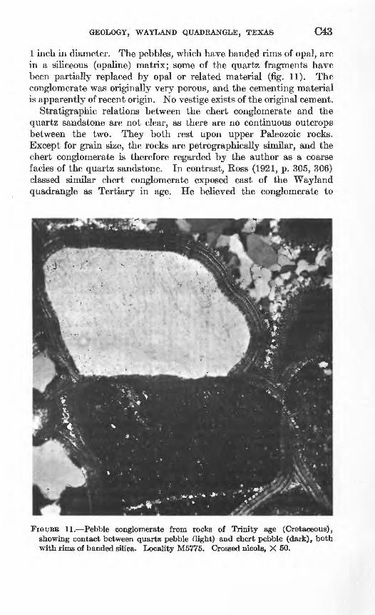
GEOLOGY, WAYLAND QUADRANGLE, TEXAS C43
1 inch in diameter. The pebbles, which have banded rims of opal, are in a siliceous (opaline) matrix; some of the quartz fragments have been partially replaced by opal or related material (fig. 11). The conglomerate was originally very porous, and the cementing material is apparently of recent origin. No vestige exists of the original cement.
Stratigraphic relations between the chert conglomerate and the quartz sandstone are not clear, as there are no continuous outcrops between the two. They both rest upon upper Paleozoic rocks. Except for grain size, the rocks are petrographically similar, and the chert conglomerate is therefore regarded by the author as a coarse facies of the quartz sandstone. In contrast, Ross (1921, p. 305, 306) classed similar chert conglomerate exposed east of the Wayland quadrangle as Tertiary in age. He believed the conglomerate to
FIGURE 11. Pebble conglomerate from rocks of Trinity age (Cretaceous), showing contact between quartz pebble (light) and chert pebble (dark), both with rims of banded silica. Locality M5775. Crossed nicols, X 50.

C44 CONTRIBUTIONS TO 'GENERAL GEOLOGY
have been derived from the rocks of Trinity age and noted that 90 percent of the pebbles more than 1 inch in diameter are dreikanters, which suggests that the beds were deposited in a desert.
QUATERNARY DEPOSITS
Deposits younger than the Trinity Group of Cretaceous age in the Wayland quadrangle include only alluvial valley fill and low terrace deposits along the major streams. These deposits are mostly Recent in age. They have not been studied in detail, and only the larger deposits are shown on the map (pi. 1).
The alluvium and terrace deposits are more than 15 feet thick in some stream valleys where terraces that stand several feet above the stream bottoms remain along the valley sides. These terraces, and abandoned stream channels above present stream level, are evidence of minor rejuvenation of the streams in comparatively recent time.
ECONOMIC GEOLOGY
CLAY DEPOSITS
Clay deposits, some of which contain material suitable for making ceramics, are in the upper part of the Thrifty Formation in the Wayland quadrangle. The clays and their uses were described by Plummer and others (1949).
OIL AND GAS
Oil was first found in commercial amounts in the vicinity of the Wayland quadrangle on October 30, 1916, when the Texas Co. completed a well on the Parks Lease, near Breckenridge (Reeves, 1922, p. 133). According to Reeves, this discovery induced the company to drill a well at Ranger, in Eastland County, and started the greatest exploration, drilling, and leasing activity the country had known. According to Matteson (1919, p. 163), the original Parks wellfoiind good production at the contact of the "Black Lime" and the Smithwick shale of the Bend series * * * but owing to lack of storage and transportation facilities, it was pinched in to 250 barrels daily, which production it is still main-
. taining after 20 months.
Development of the Ranger field induced a flurry of exploration and drilling activity in adjacent areas and led to the discovery of several oil fields in Stephens County, some of them in the area of this report.
The Railroad Commission of Texas (1958) listed 132 oil fields and 56 gas fields in Stephens County. Many of these fields have multiple producing zones, and each producing zone is listed as a separate field. Oil production from Stephens County, through January 1,

GEOLOGY, WAYLAND QUADRANGLE, TEXAS C45
1958, was 170,210,479 barrels. Natural gas production for the year 1957 was 2,688,444,000 cubic feet, and, in addition, 3,869 barrels of liquid hydrocarbons was produced from the gas wells. About 90 percent of the oil production hi the county is listed by the Railroad Commission as being from the Stephens County Regular field, which includes wells that are not hi recognized oil fields. The author estimates that the Wayland quadrangle has yielded about 25 percent of the total output of oil and gas from Stephens County.
The deepest production listed by the Railroad Commission for Stephens County is from slightly below 4,400 feet, and the shallowest is from about 1,500 feet. Production is from rocks as young as late Middle Pennsylvanian (Strawn Group) and from rocks as old as Ordovician (Ellenburger Group).
Oil wells are not shown on plate 1 because they are too densely located to be plotted at map scale.
FOSSIL LOCALITIES
The localities of the fossil collections are shown on plate 1. All collections were made by the author. Localities are listed in ascending stratigraphic order rather than in numerical sequence.
usos Localitycollection
16030-PC Stephens County, Tex. Fossiliferous calcareous shale and nodular limestone that underlie the Gunsight Limestone Member. 3.9 miles S. 65° E. from junction of Farm Road 1032 with U.S. High way 183; in bank on east side of dirt road.
16031-PC Stephens County, Tex. Fossiliferous calcareous shale in or below the Gunsight Limestone Member. On east side of hill 115 ft above base of section, a few feet below Avis Sandstone Member. 4.8 miles S. 50° E. from junction Farm Road 1032 with U.S. Highway 183.
16032-PC Stephens County, Tex. Fossiliferous calcareous shale below the Gunsight Limestone Member in roadcuts where dirt road climbs a hill. 2.5 miles N. 87° E. from junction of road to Gunsight with U.S. Highway 183.
16033-PC Stephens County, Tex. Fossiliferous calcareous shale below the Gunsight Limestone Member, about 200 yds west of Middle Fork Gonzales Creek. 2 miles S. 69° E. from junction of road to Gunsight with U.S. Highway 183.
16759-PC Stephens County, Tex. Fossiliferous calcareous shale below the Gunsight Limestone Member. On north bank of ravine, about 4 ft below a sandstone bed that caps the hill; about 100 yds west of pipeline. About 2.5 miles S. 55° E. from schoolhouse at Way- land.

C46 CONTRIBUTIONS TO GENERAL GEOLOGY
USGS collection
16762-PC
16761-PC
16034-PC
16763-PC
16757-PC
16792-PC
16760-PC
16789-PC
16790-PC
16791-PC
16793-PC
Locality
Stephens County, Tex. Gunsight Limestone Member. Poorly exposed outcrop of limestone about 2 ft thick, on slope about 6 ft below crest of hill and about 4 ft below bed of sandstone. Shale overlying the limestone contains brachiopod fauna. 2.5 miles S. 50° E. from schoolhouse at Wayland.
Stephens County, Tex. Wayland Shale Member. 3.6 miles S. 80° E. from junction of Farm Road 1032 with U.S. Highway 183. In cut on east side of road, on curve convex to the west. On west side of sandstone-capped hill.
Stephens County, Tex. Wayland Shale Member. 1.3 miles S. 40° E. from schoolhouse at Gunsight, about 10 ft above a bioherm.
Eastland County, Tex. Fossiliferous calcareous shale about 35 ft below the Speck Mountain Limestone Member, and about 13 ft above the Ivan Limestone Member. Kleiner Estate Ranch, approximately 1.4 miles southwest of the ranchhouse and 0.2 mile south of the Wayland quadrangle.
Eastland County, Tex. Shale and nodular limestone 13 ft above the Ivan Limestone Member. On west side of unnamed lake (earthen dam) on south side of Kleiner Estate Ranch. About 0.6 mile south of the Wayland quadrangle.
Stephens County, Tex. Breckenridge Limestone Member. In ditch on east side of north-trending county road, 100 yds south of right-angle curve to east. 1 mile N. 25° W. from intersection of Farm Road 2231 with U.S. Highway 183.
Stephens County, Tex. (probably on Eastland-Stephens County line). Waldrip Shale Member. Poorly exposed yellowish-gray calcilutite that weathers to nodular white earthy rubble. On west side of unnamed creek 110 ft stratigraphically above creek bed. 7.5 miles S. 35° W. from junction of Farm Road 1032 with U.S. Highway 183.
Stephens County, Tex. Waldrip Shale Member. Collected from washes and gullies east and west of road, where roadbed lies on marly limestone north of Hog Branch. 5.5 miles N. 80° W. of junction of Farm Road 576 and U.S. Highway 183, and 0.65 mile north of Fred Tomlin's ranchhouse.
Stephens County, Tex. Waldrip Shale Member. About 800 ft southeast of farmhouse on Ted Brown Ranch in northwestern part of quadrangle. Brachiopod fauna from limestone that forms low ridges on valley floor. 4.2 miles S. 73° W. from junction ot Farm Road 2231 with U.S. Highway 183.
Stephens County, Tex. Pueblo Formation. Bioherm about 2^ ft thick in shale that overlies the Waldrip Shale Member, about 3-5 ft above road level. 0.6 mile N. 30° W. of USGS loc. 16790-PC; about 0.35 mile northwest of farmhouse on Ted Brown Ranch.
Stephens County, Tex. Pueblo Formation. Float from 17-20 ft above bioherm at USGS loc. 16791-PC.

GEOLOGY, WAYLAND QUADRANGLE, TEXAS C47
MEASURED STRATIGRAPHIC SECTIONS
Section of Waldrip Shale Member of Pueblo Formation at locality M5748, 5 mileswest of Stephens County Airport
Permian System: Wichita Group:
Pueblo Formation:Waldrip Shale Member (part):
Sandstone, quartz, grayish-orange, medium-grained, subangular to subrounded; contains porcelaneous chert fragments which are the same size as the quartz grains and are subangular to angular; crossbedded; weathers to bouldery *"#< rubble; caps hill________________________________________ 2+
Covered, probably clay stone ___________________________ 10Claystone, medium-olive-brown; poorly exposed-_____________ 6Limestone, fine calcarenite or calcilutite, light-olive-gray,
slightly arenaceous; weathers grayish red purple; sparsely fossiliferous, but locally may be a coquina of productid and other brachiopods-_-_--____-_------_________-__----___- . 5
Sandstone, quartz, moderate-yellowish-brown, fine-grained to very fine grained, moderately well sorted; weathers to nodular friable rubble__________________________________________ 1. 5
Claystone, olive-gray; becomes silty toward top; plastic when damp; contains a few plant fragments___________________ 4. 3
Sandstone, grayish-brown, very fine grained, carbonaceous; contains macerated plant fragments_____________________ . 3
Shale, brownish-gray, fissile; contains bands of a yellow mineral resembling copiapite; disintegrates into-small flaky chips; contains much macerated plant material and impressions of reedlike plants_________________________________________ 1. 5
Claystone, olive-gray, plastic; copiapite(?) bands in upper 4 in.; lower foot poorly exposed_________________-_______----- 2
Sandstone, quartz, moderate-reddish-orange to very pale orange, fine-grained to very fine grained, ferruginous; poorly exposed, weathers to friable rubble; burrows and trails exposed on bedding surfaces___________________________________ 1
Claystone, light-olive-gray; exposed in ravines_____________ 14Limestone, calcarenite, medium-light-gray; weathers brown; in
beds about 1 ft thick, with shaly partings between beds; small elliptical bioherm about 50 ft by 150 ft whose long axis trends northwest; contains crinoid stems and echinoid spines and spicules; shaly partings contain plant fragments; northward it passes laterally into fine calcarenite or calcilutite that is light olive gray and weathers to nodules 6 in.-l ft thick; contains brachiopod fauna, primarily Chonetids, and a few myalinid pelecypods__---_________-____--_---_---------- 2. 5
Covered, probably claystone_____-___-__-__----____-------- 9- 5Sandstone, quartz, pinkish-gray to yellowish-gray, medium-fine
grained, subangular to subrounded, moderately sorted; dis seminated hematite (?) grains; weathered surfaces have orange cast; forms cliff; same bed as scarp-forming sandstone near top of section M5747____________________________ 6
Total Waldrip Shale Member measured.____ 61. 1+

C48 CONTRIBUTIONS TO GENERAL GEOLOGY
Section of Waldrip Shale Member of Pueblo Formation at locality M5747, 5 mileswest of Stephens County Airport Continued
Permian System: Wichita Group:
Pueblo Formation:Waldrip Shale Member (part):
Sandstone, quartz, grayish-orange to moderate-brown, medium- grained, suoangular to subrounded, moderately well sorted, crossbedded; beds 4 in.-l ft thick, the thicker beds being at the feet base; has trails on bedding surfaces_______________________ 3+
Claystone, light-olive-gray; becomes siltstone near top; hema- titic in upper 3-4 in.; weathers to platy chips ______________ 8. 3
Covered, probably claystone--___---_-_-----_-_-___--_-_-_- 8Sandstone, quartz, grayish-yellow, fine- to medium-grained,
moderately well sorted; in beds 6-20 in. thick, the thicker beds being near the base; major beds separated by siltstone part ings as much as 1 in. thick; cross laminated, with laminae as much as J_ in. thick, swirling suggests eddy currents; texture uniform throughout; forms scarp.________________________ 4.5
Covered, probably claystone________---------_---_-__------ 4Claystone, purple and yellowish-brown; poorly exposed; in
ravines. _______________________________________________ 6Covered, probably claystone.-.---------------------------- 10Limestone, calcarenite; weathers to nodular and platy rubble;
contains brachiopod fauna___________--_--___-____-_----_ . 5Limestone, calcarenite, light-olive-gray; single bed; bioclastic
hash; contains large ventricose fusilinids.__________________ 2Limestone, pale-red-purple, arenaceous, platy, poorly exposed;
fusulinids common___________________-_-_-___-____-_-- . 5Claystone, light-olive-gray with purple streaks__________--_-- 1.5Covered, probably claystone------------------------------- 1. 5Siltstone, or very fine grained sandstone, grayish-olive-
green; contains small selenite crystals; weathers to irregular platy fragments as much as % in. thick with a few blocks as much as 3 in. thick. Poorly exposed in shallow excavation. _ . 5
Total Waldrip Shale Member measured_________________ 50. 3 +Base of exposed section.
Section of rocks of Trinity age, Pueblo Formation, and Thrifty Formation at locality M5702, southwestern part of the Wayland quadrangle
Cretaceous System:Rocks of Trinity age (part):
Conglomerate; composed of subangular to subrounded chert pebbles as much as 1 in. diameter; red, white, and black pebbles predominate; siliceous matrix (opaline quartz); forms bouldery Feet rubble; caps hill_________________-___---_--_--_------ 2 +
Covered, probably sandstone; weathers to sandy soil containing blocks of poorly consolidated sandstone._________-__-------- 3
Total rocks of Trinity age____-__________-___._-_----- 5+

GEOLOGY, WAYLAND QUADRANGLE, TEXAS C49
Section of rocks of Trinity age, Pueblo Formation, and Thrifty Formation at locality M5702, southwestern part of the Wayland quadrangle Continued
Permian System: Wichita Group:
Pueblo Formation:Saddle Creek Limestone Member:
Limestone, calcilutite, yellowish-gray; beds in lower 20 in. and upper 10 in. from 1 to 6 in. thick; middle part massive; weathers to large blocks; contains calcitornellidlike Foraminifera, and algae; upper bed contains rare large ventricose fusulinids, rare Feet crinoid stems, and rare bryozoans________________________ 3
Total Saddle Creek Limestone Member________________ 3Waldrip Shale Member:
Covered, probably shale; much limestone float; upper 8 ft hasdense brush cover_________________________________^_____ 19. 5
Claystone, red and gray, poorly exposed,_____________________ 22Covered, probably red and gray claystone; much sandstone,
limestone, and conglomerate float________________________ 58Claystone, light-gray and purple_________________________ 5. 8Sandstone, quartz, light-olive-gray, fine-grained, subrounded to
subangular, poorly to moderately well sorted; hematite grains disseminated throughout matrix; in two 6-in. beds separated by 1 ft of siltstone or very fine grained yellowish-brown sandstone; weathers to angular blocks; forms conspicuous bench.________ 2
Claystone, light-gray, with beds grayish-red-purple as much as 1 ft thick throughout section, and yellowish-orange bands as much as 2 in. thick__________________________________________ 15
Limestone, calcilutite, yellowish-gray; weathers to white earthy nodular rubble; poorly exposed; the limestone and overlying 2-3 ft of shale contain a brachiopod fauna as well as echinoid spines, crinoid stems and calyx plates, and bryozoans-_______ .5
Shale, red and gray, poorly exposed________________________ 9. 3Covered, probably red and gray shale____________--_-------_- 23
Total Waldrip Shale Member....._____________- 155. 1 Total measured Pueblo Formation.__.___________._-_----- 158.1
Pennsylvanian System: Cisco Group (part):
Thrifty Formation (part): Chaffin Limestone Member:
Limestone, calcarenite, light-olive-gray; indistinct bodies in matrix appear organic and are fragmental; lower bed 1.8 ft thick, upper beds 2-4 in thick; weathered surfaces have fer ruginous splotches; joints in limestone have been healed with limonitic material in bands as much as 3 in. wide; smaller Foraminifera resembling Textularia and calcitornellids are common; fenestrate bryozoans, crinoid stems, and brachiopods are rare-____-_-_--_____--___------_-__----------------- 3. 8
Total Chaffin Limestone Member._________-.___-_----- 3. 8

C50 CONTRIBUTIONS, TO GENERAL GEOLOGY
Section of rocks of Trinity age, Pueblo Formation, and Thrifty Formation at locality M5702, southwestern part of the Wayland quadrangle Continued
Pennsylvanian System Continued Cisco Group (part) Continued
Thrifty Formation (part) ContinuedUnnamed shale member: Feet
Shale, lower 6 ft probably red and gray claystone, poorly exposed. 15 Shale, brown, papery; bands of yellow earthy mineral resembling
copiapite; plant impressions which resemble bull rushes.__ __ . 5Claystone, yellowish-orange, nonbedded._____________________ . 4Shale, grayish-brown to black, carbonaceous and coaly; inter
spersed bands copiapite (?); carbonaceous shale beds as much as 2 in. thick______________________________________________ . 5
Claystone, grayish-yellow to yellowish-gray, with streaks of moderate-yellow earthy mineral resembling copiapite; scattered poorly preserved plant impressions_______________________ .5
Claystone, light-gray; jointed in reticulate system; joints healed with hematitic or sideritic material which weathers out and litters the ground with flakes; matchstick-shaped bryozoans, rare crinoid stems and rare ventricose fusulinids noted on slopes and in ant hills.___________________________________ 2. 5
Shale, poorly exposed in creek bank________________________ 1Claystone, light-gray, nonbedded; disseminated silt-sized particles;
contains bands spherulitic hematite, much of which has altered to limonite; weathers to rounded clayey slopes_______.__---. 5. 8
Covered.. _________________________________________________ 6
Total unnamed shale member_______________-_____--._--__ 32. 2Breckenridge Limestone Member (part):
Limestone, weathers to nodular rubble. Same as uppermost bed at locality M5701_____________________________ 2
Total measured Thrifty Formation._____________________ 38. 0Base of exposures.
Section of the Breckenridge Limestone Member and an unnamed shale member at locality M5701, southwestern part of the Wayland quadrangle
Pennsylvanian System: Cisco group (part):
Thrifty Formation (part):Breckenridge Limestone Member: Feet
Limestone, calcilutite, yellowish-gray, nodular weathering, poorlyexposed; contains very few fossils. Basal bed of M5702 _ 3
Covered, probably shale__--__----_---_-_---__-------------- 9Limestone, calcilutite, yellowish-gray; weathers dark-yellowish-
orange; weathers to angular blocks as much as 13 in. thick; common to very common large ventricose fusulinids in pockets, fusulinids rare elsewhere; echinoid spines and crinoid stems common, spiriferoid and other brachiopods noted.___________ 2. 5
Total Breckenridge Limestone Member _______________ 14. 5

GEOLOGY, WAYLAND QUADRANGLE, TEXAS C51
Section of Breckenridge Limestone Member and an unnamed shale member at locality M5701, southwestern part of the Wayland quadrangle Continued
Pennsylvanian System Continued Cisco Group (part) Continued
Thrifty Formation (part) Continued Unnamed shale member (part):
Covered; shale and platy 1- to 3-in.-thick sandstone beds exposed feet in gullies_____-________--__-_-_____--____---__---__----_ 7
Sandstone, quartz, yellowish-gray, fine-grained, calcareous; ex posed surfaces pitted and etched by solution weathering____ 3
Siltstone, yellowish-gray, fine; contains 2- to 3-in.-thick beds of fine-grained sandstone like that of underlying bed; grades upward into sandstone; makes light-colored soil _____________ 3. 3
Sandstone, quartz, yellowish-gray, medium-fine-grained, well- rounded, well-sorted, calcareous; lO-in.-thick lower bed that in some places resembles an arenaceous limestone; 2- to 3-in.-thick upper beds that are less calcareous_______________________ 1. 5
Covered; lower 2-4 ft alluvium; remainder probably shale______ 8
Total unnamed shale member___-_____________-_---------_ 22. 8Total Thrifty Formation measured-.-.._______________ 37. 3
Base of exposures.
Section of the Thrifty and Graham Formations at locality MS566, about 1% milessouthwest of Lake Daniel
Pennsylvanian System: Cisco Group (part):
Thrifty Formation (part):Breckenridge Limestone Member (part):
Limestone, calcarenite, olive-gray, fine; ferruginous stain on weathered surface; lenticular bedding; large ventricose fusuli- nids common in zone 1 ft above base, rare elsewhere; scattered Feet crinoid stems, rare brachiopods_________________________ 2+
Total exposed Breckenridge Limestone Member.______-_- 2+Unnamed shale member:
Claystone, light-olive-gray, with yf to 1-in. beds of orange clay- stone; calcareous; upper 3 ft has limestone nodules as large as % in. diameter. Lower 7 ft poorly exposed________________ 10
Sandstone, quartz, grayish-yellow-green, medium-grained, sub- angular to subrounded; moderately well consolidated, calcare ous cement; moderately well bedded in beds as much as 2 in. thick________________________________ 1
Claystone, yellowish-gray, with small amounts of red claystone in upper 5 ft; zone containing Myalina and rare crinoid stems 2 ft above base_____________________________________ 21
Total unnamed shale member._________________________ 32

C52 CONTRIBUTIONS TO GENERAL GEOLOGY
Section of the Thrifty and Graham Formations at locality M5566, about 1% miles southwest of Lake Daniel -Continued
Pennsylvanian System Continued Cisco Group (part) Continued
Thrifty Formation (part) Continued Speck Mountain Limestone Member:
Limestone, calcarenite, light-olive-gray; weathers to large angular blocks; scattered fusulinids, sparse to rare crinoid stems, rare braehiopods resembling Hustedia, scattered shell (?) fragments Feet showing prismatic structure in cross section._______________ 1
Covered, probably siltstone_______________.______________ 1Limestone, dusky-yellow, silty, earthy; scattered crinoid stems,
a few braehiopods, much comminuted fossil debris._________ .7
Total Speck Mountain Limestone Member.______________ 2. 7Total Thrifty Formation measured.______---_--_---____ 36. 7+
Graham Formation (part):Unnamed shale member (part):
Siltstone, light-olive-gray, poorly exposed__________________ 5Siltstone, medium-light-gray, red and orange siltstone bands and
very fine-grained sandstone beds as much as 6 in. thick but averaging 2 in. in thickness; forms steep bluff in roadcut; con tains flecks carbonized plant material_____________________ 6
Siltstone, light-olive-gray, fine; scattered discontinuous sand stone beds (channel-fill) as much as 3 in. thick; poorly devel oped fissility _ . _________________________________________ 10
Sandstone, quartz, grayish-orange, fine-grained, subrounded to subangular, moderately well sorted, crossbedded______-__-_- 2
Covered, probably shale_________-___-_-_-_-_----------_-_- 5Total unnamed shale member_-_-___-----------_--------- 28
Total Graham Formation measured.____________________ 28Base of exposures.
Section of the Thrifty and Graham Formations at locality M5567, about 2% milessouth of Lake Daniel
Pennsylvanian System: Cisco Group (part):
Thrifty Formation (part): Unnamed shale member (part):
Sandstone, quartz; grayish orange, fine grained, subrounded to subangular, moderately well to well sorted in lower bed; mod erate brown to very dusky red purple, medium grained, sub- angular to subrounded, fairly well sorted in upper bed; con tains bands as much as % in. thick of white angular chert fragments in upper bed; lower bed about 3 ft thick; upper bed, which is less resistant, caps hill and weathers to a ferruginous feet .rubble___________________________________---- -_--- 6+
Covered, probably shale..______________.____--------------- 18
Total unnamed shale member___________-____----_----__-- 24+

GEOLOGY, WAYLAND QUADRANGLE, TEXAS C53
Section of the Thrifty and Graham Formations at locality M6667, about %% miles south of Lake Daniel Continued
Pennsylvanian System Continued Cisco Group (part) Continued
Thrifty Formation (part) Continued Breckenridge Limestone Member:
Limestone, calcarenite to calcilutite, brownish-gray to light- olive-gray, fine; beds 2-3 in. thick; large ventricose fusulinids common near base, rare toward the top; crinoid columnals and Feet brachiopods noted__----__--_------_---__-_---_-----_-__- 3
Total Breckenridge Limestone Member._________________ 3Unnamed shale member:
Covered, probably shale__________________________________ 23Speck Mountain Limestone Member:
Limestone, calcarenite, light-olive-gray, fine, in two beds; 12-in.- thick lower bed weathers to large angular blocks; 12-in.-thick upper bed, separated from the lower by about 12 in. of silt- stone, is exposed as a nodular rubble. Fusulinids locally common, rare elsewhere; contains a few bands of bioclastic hash; crinoid stems locally common, brachiopods scattered to rare__________________________________________________ 3
Total Speck Mountain Limestone Member.______________ 3Total Thrifty Formation measured________---_-_-------- 53+
Graham Formation (part) : Unnamed shale member:
Covered, much limestone float ____ ________________________ 5. 7Siltstone, light-gray ; has yellow bands which are somewhat more
resistant to weathering and which indicate bedding. _________ 6Sandstone, pink, fine-grained. __ __________________________ . 5Siltstone, yellow and gray, poorly exposed. ___________________ 8Siltstone, as below__--_------_---_--__--__-------_--__-_-_- 6Sandstone, quartz, pale-greenish-yellow, fine-grained, sub-
rounded to subangular, well-sorted, calcareous; poorly ex posed except in ravines _ ________________________________ 2
Siltstone; lower 2 ft. is light olive gray; overlying 20 ft is red, green, purple, and gray siltstone; remainder is light gray. Bedding obscure __ _________________________________ _ 39
__-_-_-_----_--_-_-_--_-_-__--_--_--_--__------_ 4
Total unnamed shale member____-_-__--_-___-------_---_- 71. 2Ivan Limestone Member (part) :
Limestone, calcarenite, yellowish-gray; bioclastic hash; lower 1 ft nodular, upper 6 in. a single bed forming a barely discernible escarpment; upper bed jointed into polygonal blocks; com posed almost entirely of comminuted indeterminate fossil debris; paves creek bed. _ _______________________________ 1. 5
Total Graham Formation measured _ _ _-_-__-__-__-__--_ 72. 7

C64 CONTRIBUTIONS TO GENERAL GEOLOGY
Section of the lower part of the Thrifty Formation and upper part of the Graham Formation at locality M6568, about 3 miles south of Lake Daniel
Pennsylvanian System: Cisco Group (part):
Thrifty Formation (part):Unnamed shale member (part):
Sandstone, quartz, very dark red, medium grained subangular to subrounded, moderately well sorted, crossbedded; angular chert grains somewhat larger than quartz grains; one or more 2- to 3-in.-thick chert-conglomerate beds near base; medium- grained quartz sand matrix containing angular to subangular chert pebbles as much as % in, diameter; weathers to irregular feet boulders as much as 1 ft thick________________________ 3+
Claystone, light-olive-gray, with ^_-in.-thick beds medium- yellowish-brown claystone which are somewhat better con solidated and weather out as J_-in.-thick chips___.._...___ 19
Total unnamed shale member measured... -___ ________ 22 +Speck Mountain Limestone Member:
Limestone; two 18-in.-thick beds separated by thin siltstone parting. Lower bed, light-olive-gray fine calcarenite containing many fragments of shells and crinoid stems in lower 4 in.; fossils rare elsewhere. Upper bed, olive-gray brittle fine calcarenite containing rare fusulinids and common brachiopods resembling Marginifera. Lower bed weathers to blocks as much as 6ft across____________-___-_---_-----_______ 3
Total Speck Mountain Limestone Member_ _____________ 3Total Thrifty Formation measured-...------- __ - 25+
Graham Formation (part): Unnamed shale member:
Claystone, light-gray; has yellow and orange claystone bands as much as }i in. thick and flecks of carbonized plant fragments. 10
Shale, dark-yellowish-brown, papery, carbonaceous, coaly; many plant impressions__-___-_-_____-_._--______-______--_-- . 3
Siltstone, light-gray, very fine; contains carbonized plant frag ments near top________________________-_______________ 6
Sandstone, quartz, yellowish-gray, fine-grained, subangular tosubrounded; in beds as much as % in. thick....... ... . 5
Siltstone, light-olive-gray; becomes lighter gray 20 ft above base; has scattered light-olive-gray fine-grained sandstone lenses and red-claystone streaks.-._________--_-__ __- 31
Sandstone, quartz grayish-orange-pink, very fine grained, slightly calcareous; interbeds of claystone as much as 8 in. thick_____________-___--__________________.-__-------- 5
Claystone and siltstone, olive-gray; weathers to light olive gray; very poor bedding-_____________________-___---- -- 13
Siltstone, dusky-red; grades into overlying claystone and silt- stone; no apparent bedding________._____-____-_-- ____- 10
Covered, probably siltstone._______________-----__---------- 14
Total unnamed shale member.__-_______--_-_------------- 89. 8

GEOLOGY, WAYLAND QUADRANGLE, TEXAS C55
Section of the lower part of the Thrifty Formation and upper part of the Graham Formation at locality M6568, about 8 miles south of Lake Daniel Continued
Pennsylvanian System Continued Cisco Group (part) Continued
Graham Formation (part) Continued Ivan Limestone Member:
Limestone, calcarenite, light-olive-gray; upper 6 in. nodular, argillaceous, bioclastic; lower 1 ft argillaceous in basal 2 in.; remainder in two slabby beds; in places paves creek bed; Veet locally a coquina of fragmented shell debris______---------- 1. 5
Total Ivan Limestone Member________________________ 1. 5Unnamed shale member (part):
Siltstone, greenish-gray; contains several 2-in. beds of pale- olive very fine grained quartz sandstone; poorly exposed.____ 4
Total unnamed shale member.__________________________ 4
Total Graham Formation measured____________________ 95. 3
Section of the Graham Formation at locality M5601, 2% miles north-northwest of LakeDaniel
Pennsylvanian System: Cisco Group (part):
Graham Formation (part):Ivan Limestone Member (part):
Limestone, calcarenite, yellowish-grav; bioclastic hash; contains numerous rodlike bodies having opaque rims and clear cores, a few round to oval bodies that may be oolites, a few elongate to rounded limonitic bodies K~M m- in diam.; weathers to polygonal blocks as much as 8 in. thick that have rounded corners; surfaces show effect of solution weathering; a few crinoid stems and shell fragments noted; rare productid Feet brachiopods on weathered surfaces.--.-------------------- 2+
Total Ivan Limestone Member measured.____.___-__---- 2+ Unnamed shale member:
Claystone, light-olive-gray, plastic; clayey soil _________ 2. 5
Total unnamed shale member________- ______________ 2. 5Avis Sandstone Member (part):
Sandstone, quartz, pale-yellowish-orange, medium- to fine grained, poorly sorted, subrounded to subangular, cross- bedded; interbedded siltstone; crossbeds strike east and dip as much as 15° S., flattening in dip at top. 4
Sandstone, quartz, pale-yellowish-orange, medium-grained, poorly sorted, friable, crossbedded; 8- to lO-in.-thick beds; crossbeds strike east and dip as much as 15° N. flattening in dip at top______________________-_- ---- 7
Covered; chert pebbles and cobbles in soil; a few sandstone exposures _________________-_. 8
Covered; sandy soil___________________-_____________ -- 5Sandstone; same as underlying bed but having less apparent
crossbedding; hematite nodules weather free and litter slopes- 5. 7

C56 CONTRIBUTIONS TO GENERAL GEOLOGY
Section of the Graham Formation at locality M6601, 2% miles north-northwest of LakeDaniel Continued
Pennsylvanian System Continued Cisco Group (part) Continued
Graham Formation (part) Continued Avis Sandstone Member (part) Continued
Sandstone, quartz, yellowish-gray, medium-grained, subrounded, well-sorted; scattered hematite grains same size as quartz grains; lower 5 ft calcareous, well cemented; remainder friable; grain size increases somewhat toward top of unit; upper 3-4 ft well bedded in 2- to 3-in-thick beds, changes to pale yellowish orange where bed is no longer calcareous; lower 10-11 ft crossbedded (torrential bedding?); crossbeds dip as much as 25° E., but bedding becomes flat at top of each Feet crossbed.______________________________________________ 14
Sandstone, quartz, dusky-yellow, medium- to fine-grained, sub- rounded, ripple-marked; somewhat better sorted than under lying bed; has streaks of hematitic granules that attain a thickness of }£ in.; ripple marks 3 ft above base strike N. 60° W. (magnetic) and dip most steeply to the southeast; sym metrical ripple marks 8 ft above base of unit strike N. 60° W. (magnetic); poorly developed cross lamination_____________ 13
Sandstone, quartz, dusky-yellow, medium-grained, subangular to subrounded, poorly sorted; in 2- to 6-in.-thick beds; oscilla tion ripples on bedding planes; weathers to rectangular blocks; locally, upper 1-2 in. of each bed disintegrates into plates about % in. thick; three covered intervals, each about 1 ft thick, are probably siltstone.__-_-___-__-.---__---------- 5
Covered, probably siltstone or very fine grained sandstone-____ 12Covered, sandy soil; sandstone boulders common on upper 3 ft
of surface____________________________________________ 5. 8
Total Avis Sandstone Member._________-__--___------- 79. 5Total Graham Formation measured_____________-_--_- 84. 0+
Section of the Graham Formation at locality M5771, 4 miles north-northwest ofNecessity
Pennsylvanian System: Cisco Group (part):
Graham Formation (part): Ivan Limestone Member (part):
Limestone, calcilutite, light-olive-gray; bioclastic in lower 3 ft; grades upward into calcarenite and bioclastic hash; lower 4 ft contains irregular beds about 1-6 in. thick and forms scarp; upper beds weather but cap hill; has fusulinids 4 ft above base, sparse to very common crinoid stems, a few brachio- ***
_________________________________________ 7+
Total Ivan Limestone Member measured-____--------_ 7+Unnamed shale member:
Covered___--_________-______-___-___---_--_---------- 8
Total unnamed shale member.

GEOLOGY, WAYLAND QUADRANGLE, TEXAS C57
Section of the Graham Formation at locality M6771, 4 miles north-northwest ofNecessity Continued
Pennsylvanian System Continued Cisco Group (part) Continued
Graham Formation (part) Continued Avis Sandstone Member:
Sandstone quartz, grayish-yellow, fine- to medium-grained, moderately well to poorly sorted, subrounded to subangular, thin-bedded to massive; massive part seen as boulders at Feet base of hill; ferruginous flecks scattered throughout.------- 6
Total Avis Sandstone Member-_______________________ 6Wayland Shale Member:
Clay stone and siltstone, of which clay stone predominates; poorly exposed; much sandstone and limestone float in upper 45ft__-_---_-__-_--_-___--__---_-_--_--_--------- 77
Covered..______________________________________________ 5. 5
Total Wayland Shale Member_____.___--_________ 82. 5 Gunsight Limestone Member:
Limestone, calcilutite, light-olive-gray, sublithographic, wavy- bedded; weathers to large blocks, ferruginous on weathered surfaces; contains algae which resemble Archaeolithophyllum, occasional to common fusilinids near top of bed, occasional brachiopods. _________________________________________ 3
Total Gunsight Limestone Member____________________ 3Unnamed shale member (part):
Covered._______________________________________________ 14Sandstone, quartz, light-olive-brown, fine- to medium-grained,
subangular to subrounded, moderately well sorted to well- sorted, thin bedded-__-_______--__-_____-___--_----_--- 3
Total unnamed shale member.___________-_-_-_-___--- 17Total Graham Formation measured________-___-__--- 123. 5+
Section of the Graham Formation at locality M6658, 8% miles northeast of Gunsight
Pennsylvanian System: Cisco Group:
Graham Formation:Avis Sandstone Member (part):
Sandstone, platy; 1-ft-thick beds; texture and color same as Feet basal bed__________________________-_______----_-------- 8
Sandstone, platy; 4-in.-thick beds; texture and color same as basal bed--.-..____________-___--_.-___--_-----_----- 20
Sandstone, quartz, grayish-dusky-yellow to moderate brown, medium-grained, subrounded to subangular, well-sorted, mas sive; weathers into large blocks.__________________________ 2. 5
Total Avis Sandstone Member measured___________-_---_ 30. 5

C58 CONTRIBUTIONS TO GENERAL GEOLOGY
Section of the Graham Formation at locality M565S, 8% miles northeast ofGunsight Continued
Pennsylvanian System Continued Cisco Group (part) Continued
Graham Formation ContinuedWayland Shale Member: Feet
Covered, sandstone talus________________-__--_-----_____-__ 83
Total Wayland Shale Member._________________________ 83Gunsight Limestone Member:
Covered; composed of limestone plates, light-olive-gray calcar- enite, and bioclastic hash having hackly fracture.___________ 3
Limestone, calcarenite, light-olive-gray; grades upward into cal- cilutite having subconchoidal fracture; surfaces pitted and etched by solution weathering_-________-__---__-_____-_-_- 1. 5
Total Gunsight Limestone Member._____________________ 4. 5Unnamed shale member (part):
Covered__________________________________________________ 3Sandstone, poorly exposed.-_-__----___-____----__--_---_--- 7. 2Covered_____________________________________--_---__ 8. 6Sandstone, quartz, grayish-yellow, medium-grained, subrounded
to subangular, well-sorted; may be slump._________________ 1. 3Clay stone, olive-gray; weathers light olive gray; poorly exposed;
fusulinids locally in great abundance.______________________ 7.2Limestone, calcarenite, light-olive-gray, nodular, lenticular;
grades laterally into calcareous shale that is almost a coquina of large ventricose fusulinids; zone on hill slopes away from good exposure marked by many loose fusulinids in soil.___________ .5
Shale, gray, calcareous; very fossiliferous in upper part; many well-preserved brachiopods, bryozoans, fusulinids, and a few gastropods..---..-___________________.____----_---__ 2
Sandstone, light-olive-gray, calcareous._______---__--__-----_ .3Shale, light-olive-gray_____--____--___-----_----------_----- 2. 5
Total unnamed shale member._______-_-___-____---_------ 32. 6Total Graham Formation measured______________________ 150. 6
Section of the Graham Formation at locality MS571, about 2% miles east-northeastof Gunsight
Pennsylvanian System: Cisco Group (part):
Graham Formation (part): Avis Sandstone Member (part):
Sandstone, quartz, grayish-orange, fine- to medium-grained, subrounded to subangular, well-sorted; contains grains and scattered patches of hematitic material; calcareous cement; about 3 ft above base is a fossiliferous l-in.-thick bed of calcareous sandstone containing many fusulinids, many crinoid stems, and a few Caninia; rocks below this bed are feet poorly exposed and may be float. ___________ ___ ___ 5+
Total Avis Sandstone Member measured-_ _ __-__ 5+

GEOLOGY, WAYLAND QUADRANGLE, TEXAS C59
Section of the Graham Formation at locality M5571, about 2% miles east-northeastof Gunsight Continued
Pennsylvanian System Continued Cisco Group (part) Continued
Graham Formation (part) Continued Gunsight Limestone Member:
Limestone, calcarenite, yellowish-gray, fine, somewhat argil laceous; basal bed, 2 in. thick and poorly exposed, grades up ward into 18-in.-tMck bed of nodular limestone and shale (?), which is overlaiD by a 6-in.-thick bed of earthy limestone containing many Caninia, some of which are in position of growth; remainder is nodular limestone containing many Caninia, which weather free and locally pave the ground; rare fusulinids, crinoid stems, bryozoans, and brachiopods Feet noted_________________________-._____---_---------- 3
Total Gunsight Limestone Member______,___.____-_ 3Unnamed shale member:
Siltstone, poorly exposed; fusulinids free in soil ___________ 4Sandstone, quartz, light-olive-gray, fine-grained, calcareous;
in beds as much as l>_-in.-thick; contains brachiopods and rare reedlike plant fragments __________________--__------ 2
Covered, probably gray shale___________________________ 32Sandstone, quartz, poorly exposed, moderate-reddish-orange to
* dusky-red, medium-grained, subrounded, well-sorted; found as tabular cobbles as much as 4 in. in diameter and 1% in. thick. _________________________________ 1
Covered, limestone float____________ ____-- -- 8
Total unnamed shale member______-____----__---------- 47Hunger Limestone Member:
Limestone, calcarenite, dusky-yellow, ferruginous, earthy; forms bench; crinoid stems common. _____________________ 1. 2
Limestone, calcarenite, light-olive-gray; 4- to 8-in.-thick beds; weathers to well-rounded boulders; large ventricose fu sulinids common; also contains scattered crinoid stems and a few brachiopods_______________________--_-_-------- 1
Limestone, calcarenite or calcilutite, light-olive-gray; fer ruginous on weathered surface; wavy bedding in lower 1 ft; contains laminated ferruginous bands which may be algal; lower beds average 2 in. thick; scattered brachiopods and crinoid stems, rare fusulinids, rare ostracodes(?)._____-_---- 5. 7
Total Bunger Limestone Member._______________----- 5. 7Unnamed shale member (part):
Covered, probably siltstone with sandstone interbeds; much limestone and sandstone float_____---____-_--_---------- 32
Siltstone, light-olive-gray, poorly exposed_____________-_-- 5Siltstone, light-gray; fragments of orange siltstone weather
out; a few flakes of muscovite as much as 1 mm in diameter; flecks of carbonized plant material__________________ 3

C60 CONTRIBUTIONS TO GENERAL GEOLOGY
Section of the Graham Formation at locality M5671, about 2}i miles east-northeastof Gunsight Continued
Pennsylvanian System Continued Cisco Group (part) Continued
Graham Formation (part) ContinuedUnnamed shale member (part) Continued Feet
Covered______________________________________________ 9Clays tone, gray, plastic, poorly exposed-_________________ 5Covered_____ _____________________________ 2Sandstone, quartz, yellowish-gray, fine-grained; 2- to 3-in.-
thick beds; breaks into polygonal slabs; locally exposed as pavement in bed of stream, but mostly covered by stream gravels ___________ ____ _ . 5+
Total unnamed shale member _________________________ 56. 5+Total Graham Formation measured__________________ 119. 4+
Section of the Graham Formation along the East Fork of Gonzales Creek, locality M571S, southeastern part of the Way land quadrangle
Pennsylvanian System: Cisco Group (part):
Graham Formation (part):Bunger Limestone Member (part):
Limestone, olive-gray, with orange ferruginous streaks and bands of calcarenite; fusulinids common to very common; algae, Feet scattered to rare; caps hill_____-___-------______________ 1
Limestone, calcilutite, light-olive-gray; beds 3-4 in. thick in lower half, 2-3 in. thick in upper half; weathers to nodular slabs and boulders; bedding wavy; algal; algae most numerous in upper 2 ft; crinoid stems and spines common, brachiopods occasional to rare; fossils other than algae are most common in lower half_____________________ _ 4
Limestone, calcilutite, gray, thin-bedded, platy; beds as much as 2 in. thick_______________________________ . 75
Total Bunger Limestone Member measured_ ____________ 5.75Unnamed shale member:
Covered, probably claystone._____________________________ 2Claystone, olive-gray____________________________________ 2. 5Claystope, carbonaceous, and coal; much macerated plant debris;
plastic when wet; claystone laminae as much as Vie, in. thick. _ . 3 Claystone, olive-gray; contains interbeds of dark-yellowish-
orange claystone; beds as much as 1 in. thick._____ ______ 1Claystone, light-olive-gray, poorly exposed; in ravines._________ 9Covered, probably shale______________________________ 11. 5Sandstone, quartz, yellowish-gray, fine-grained, poorly sorted;
calcareous cement; poorly preserved plant fragments resembling rushes; bedding surfaces contain trails; forms bench; poorly exposed____________________________ _____ 2
Covered; lower 3 ft probably sandstone; upper 7 ft probably siltstone_____________________________ 10

GEOLOGY, WAYLAND QUADRANGLE, TEXAS C61
Section of the Graham Formation along the East Fork of Gonzales Creek, locality M6718, southeastern part of the Wayland quadrangle Continued
Pennsylvania System Continued Cisco Group (part) Continued
Graham Formation (part) Continued Unnamed shale member Continued
Sandstone, quartz, dark-yellowish-orange to yellowish-orange, medium-grained, subrounded to subangular, moderately well sorted; contains angular white chert fragments, iron-stained quartz grains; in beds as much as 40 in. thick; crossbedded; forms sequence of benches about 3-5 ft apart; weathers to rounded rubble including boulders as much as 40 in. thick and feet 6-8 ft across______________________________ 24
Covered, probably sandstone_____________________________ 5Covered, probably shale__-_-_______-___------_-_-______ 17
Total unnamed shale member measured-_----__--_____-_-__ 84. 3 Total Graham Formation measured__ __-.________ 90. 05
REFERENCES CITED
Bay, H. X., 1932, A study of certain Pennsylvania!! conglomerates of Texas, in Contributions to geology, 1932: Texas Univ. Bull. 3201, p. 149-188.
Brown, L. F., 1960a, Stratigraphy of the Blach Ranch Crystal Falls section (Upper Pennsylvanian), northern Stephens County, Texas: Texas Univ. Bur. Econ. Geology Kept. Inv. 41, 45 p.
1960b, A traverse of post-Avis Cisco rocks, Brazos Valley, north centralTexas, in A study of the Cisco facies near Breckenridge, Texas: Soc. Econ.Paleontologists and Mineralogists Permian Basin Chap. Guidebook, 1960Ann. Field Trip, p. 1-47.
Burnside, R. J., 1959, Geology of part of the Horseshoe atoll in Borden andHoward Counties, Texas: U.S. Geol. Survey Prof. Paper 315-B, p. 21-35.
Cheney, M. G., 1940, Geology of north-central Texas, in DeFord, R. K., andLloyd, E. R., eds., West Texas-New Mexico symposium: Am. Assoc.Petroleum Geologists Bull., v. 24, no. 1, p. 65-118.
1948, Study of Lower Permian and Upper Pennsylvanian rocks in Brazosand Colorado River valleys of west-central Texas, particularly from ColemanJunction to Home Creek limestones: Abilene [Texas] Geol. Soc. Guidebook,Spring Field Trip, June 11-12, 1948, 20 p.
Cheney, M. G., and Eargle, D. H., 1951, Geologic map of Brown County, Texas:Texas Univ. Bur. Econ. Geology, scale, 1:63, 360.
Cloud, P. E., Jr., Barnes, V. E., and Bridge, Josiah, 1943, Stratigraphy of theEllenburger group in central Texas a progress report, in Texas MineralResources: Texas Univ. Pub. 4301, p. 133-161. [1946]
Cummins, W. F., 1890, The Permian of Texas and its overlying beds, in Dumble,E. T., First annual report of the Geological Survey of Texas, 1889: TexasGeol. Survey, p. 183-197.
Cummins, W. F., 1891, Report on the geology of northwestern Texas, in Dumble,E. T., Second annual report of the Geological Survey of Texas, 1890: TexasGeol. Survey, p. 357-552.

C62 CONTRIBUTIONS TO GENERAL GEOLOGY
Drake, N. F., 1893, Report on the Colorado coal field of Texas, in Dumble, E.T.Fourth annual report of the Geological Survey of Texas, pt. 1: Texas Geol.Survey, p. 355-446.
Dumble, E. T., 1890, Report of the State Geologist, in First annual report of theGeological Survey of Texas, 1889: Texas Geol. Survey, p. xv-lxxv.)
Eargle, D. H., 1960, Stratigraphy of Pennsylvanian and lower Permian rocksin Brown and Coleman Counties, Texas: U.S. Geol. Survey Prof. Paper315-D, p. 55-77.
Goddard, E. N., chm., and others, 1948, Rock-color chart: Washington, D.C.,National Research Council, 6 p.
Heck, W. A., Yenne, K. A., and Henbest, L. G., 1952, Boundary of the Penn sylvanian and Permian (?) in the subsurface Scurry reef, Scurry County,Texas: Texas Univ. Bur. Econ. Geology Rept. Inv. 13, 19 p.
Hendricks, C. L., 1957, Geology of Parker County, Texas: Texas Univ. Pub.5724, 67 p.
Hudnall, J. 8., and Pirtle, G. W., 1929, Geologic map of Coleman County, Texas:Texas Univ. Bur. Econ. Geology (maps by Am. Assoc. Petroleum GeologistsCoop. Mapping Comm.), scale 1:48,000.
Lee, Wallace, Nickel, C. O., Williams, J. S., and Henbest, L. G., 1938, Strati- graphic and paleontologic studies of the Pennsylvanian and Permian rocksin north-central Texas: Texas Univ. Pub. 3801, 252 p.
Matteson, W. G., 1919, A review of the development in the new central Texasoil fields during 1918: Am. Assoc. Petroleum Geologists Bull., v. 3, p. 163-211.
Moore, R. C., 1949, Rocks of Permian (?) age in the Colorado River valley,north-central Texas; U.S. Geol. Survey Oil and Gas Inv. Prelim. Map 80,scale, 1:63,360.
Moore, R. C., and Plummer, F. B., 1922, Pennsylvanian stratigraphy of northcentral Texas: Jour. Geology, v. 30, p. 18-42.
Myers, D. A., 1958, Stratigraphic distribution of some fusulinids from the Thriftyformation, Upper Pennsylvanian, central Texas: Jour. Paleontology, v. 32,no. 4, p. 677-681.
1960a, Stratigraphy of the Cisco group, Wayland quadrangle, Stephensand Eastland Counties, Texas, in A study of the Cisco facies near Brecken-ridge, Texas: Soc. Econ. Paleontologists and Mineralogists Permian BasinChap. Guidebook, 1960 Ann. Field Trip, p. 47-59.
1960b, Stratigraphic distribution of some Pennsylvanian Fusulinidaefrom Brown and Coleman Counties, Texas: U.S. Geol. Survey Prof. Paper315-C, p. 37-53, pis. 15-24.
Myers, D. A., Stafford, P. T., and Burnside, R. J., 1956, Geology of the latePaleozoic Horseshoe atoll in west Texas: Texas Univ. Pub. 5607, 113 p.
Pettijohn, F. J., 1949, Sedimentary rocks: New York, Harper and Bros., 526 p. Plummer, F. B., 1919, Preliminary paper on the stratigraphy of the Pennsylvanian
formations of north-central Texas: Am. Assoc. Petroleum Geologists Bull.,v. 3, p. 132-150.
Plummer, F. B., and Moore, R. C., 1921, Stratigraphy of the Pennsylvanianformations of north-central Texas: Texas Univ. Bull. 2132, 237 p.
Plummer, F. B., and Hornberger, Joseph, Jr., 1935, Geology of Palo Pinto County,Texas: Texas Univ. Bull. 3534, 240 p.
Plummer, F. B., Bradley, H. B., and Pence, F. K., 1949, Clay deposits of theCisco group of north-central Texas: Texas Univ. Pub. 4915, 44 p.
Railroad Commission of Texas, 1958, Annual report of the Oil and Gas Division,1957: Austin, Texas, 437 p.

GEOLOGY, WAYLAND QUADRANGLE, TEXAS C63
Reeves, Frank, 1922, Geology of the Ranger oil field, Texas: U.S. Geol. SurveyBull. 736-E, p. 111-170.
Ross, C. S., 1921, The Lacasa area, Ranger district, north-central Texas: U.S.Geol. Survey Bull. 726-G, p. 303-314.
Sellards, E. H., 1932, The pre-Paleozoic and Paleozoic systems in Texas, pt. 1,in Sellards, E. H., Adkins, W. S., and Plummer, F. B., The geology of Texas,v. 1, Stratigraphy: Texas Univ. Bull. 3232, p. 15-238.
Stafford, P. T., 1959, Geology of part of the Horseshoe atoll in Scurry and KentCounties, Texas: U.S. Geol. Survey Prof. Paper 315-A, p. 1-20.
1960a, Stratigraphy of the Wiehita group in part of the Brazos Rivervalley, north Texas: U.S. Geol. Survey Bull. 1081-G, p. 261-280.
1960b, Geology of the Cross Plains quadrangle, Brown, Callahan, Coleman,and Eastland Counties, Texas: U.S. Geol. Survey Bull. 1096-B, p. 39-72.
Tarr, R. S., 1890, A preliminary report on the coal fields of the Colorado River[Texas], in Dumble, E. T., First annual report of the Geological Survey ofTexas, 1889: Texas Geol. Survey, p. 199-216.
Terriere, R. T., 1960, Geology of the Grosvenor quadrangle, Brown and ColemanCounties, Texas: U.S. Geol. Survey Bull. 1096-A, p. 1-35.
1963, Petrography and environmental analysis of some Pennsylvanianlimestones from central Texas: U.S. Geol. Survey Prof. Paper 315-E,p. 79-126.
Wender, W. G., 1929, Geologic map of Eastland County, Texas: Texas Univ.Bur. Econ. Geology Map [revised 1937], scale 1:48,000.
U.S. GOVERNMENT PRINTING OFFICE: 1965 O 758-446


