geology of the tulare formation and … of the tulare formation and other continental deposits, ......
TRANSCRIPT

GEOLOGY OF THE TULARE FORMATION AND OTHER CONTINENTAL DEPOSITS,
KETTLEMAN CITY AREA, SAN JOAQUIN VALLEY, CALIFORNIA,
WITH A SECTION ON
GROUND-WATER MANAGEMENT CONSIDERATIONS AND USE OF TEXTURE MAPS
By R. W. Page
U.S. GEOLOGICAL SURVEY
Water-Resources Investigations Report 83-4000
LT) CM
Sacramento, California May 1983
UNITED STATES DEPARTMENT OF THE INTERIOR
JAMES G. WATT, Secretary
GEOLOGICAL SURVEY
Dallas L. Peck, Director
For additional information write to:
District Chief U.S. Geological Survey Federal Building, Room W-2235 2800 Cottage Way Sacramento, CA 95825
Copies of this report can be purchased from:
Open-File Services Section Western Distribution Branch U.S. Geological Survey Box 25424, Federal Center Denver, CO 80225 Telephone: (303) 234-5888

CONTENTS
PageAbstract-- - -- - - -- -- - - - - ---- iIntroduction --- - -- --- -- -- ---- -___ 2
Purpose and scope --- -- -____ -- - - - - 2Location and general features-- - -- - -- -- -- - -- 2Previous reports - --- ------- -- _______ - 5Well-numbering system---- - -< - - ----- ------------- &
Geology of the Tulare Formation and other continental deposits - -- 7Depth, thickness, base, and structure------- -- - --- -- 10Fossils -- --- ---- --- - - --- - - --__ - 11Sedimentary material--- --- - - - - - ------- -_____- 12Source and depositional environment ------ --- _____ -- 12
Alluvial-fan deposits- -- - ----------- ------ _ _ 14Deltaic deposits- --- -------- --- -- -- - -.--- 14Flood-plain, lake, and marsh deposits----- ---- - ------ - 15
Texture of the deposits- - 18Ground-water-management considerations and use of texture maps----- 20Summary and conclusions- -- - - - ------ - - ______ _ « _ 21Selected references ------ __ -__ ____________ ___ ______ 22
ILLUSTRATIONS
[Plates are in pocket]
Plate 1. Geologic map and sections, showing depth to base and thickness of the Tulare Formation and other continental deposits, Kettleman City area, San Joaquin Valley, California.
2. Texture maps of the Tulare Formation and other continental deposits, Kettleman City area, San Joaquin Valley, California.
Page Figure 1. Map of California showing study area----- - - ____________ 3
2. Map showing landforms in the Kettleman City area------- -- 43. Diagrammatic geologic section, west to east through
study area--------- -- ________ ___ __ _ ___ g4. Diagram of an idealized alluvial fan----------- - - --- 135. Diagram showing generalized geologic section and view of
part of the Central Valley 136. Geophysical logs for part of well 23S/23E-25E 19
III

TABLE
Table 1. Normal temperature and precipitation, Kettleroan Station-Page
5
CONVERSION FACTORS
For readers who may prefer to use the International System of Units rather than inch-pound units the conversion factors for the terms used in this report are listed below:
Multiply By
acres 0.4047 ft (feet) 0.3048 inches 25.4 mi (miles) 1.609 mi2 (square miles) 2.590 |jmho/cm at 25°C 1.000
(micromhos percentimeter at 25° Celsius)
To obtain
ha (hectares)m (meters)mm (millimeters)km (kilometers)km2 (square kilometers)pS/cm at 25°C
(microsiemens percentimeter at 25° Celsius)
Degrees Fahrenheit are converted to degrees Celsius by using the formula Temp °C = (temp °F - 32)/I.8.
National Geodetic Vertical Datum of 1929): A geodetic datum derived from a general adjustment of the first-order level nets of both the United States and Canada, formerly called mean sea level. The datum is shown as sea level in the geologic sections.
IV

GEOLOGY OF THE TULARE FORMATION AND OTHER CONTINENTAL DEPOSITS,
KETTLEMAN CITY AREA, SAN JOAQUIN VALLEY, CALIFORNIA,
WITH A SECTION ON
GROUND-WATER-MANAGEMENT CONSIDERATIONS AND USE OF TEXTURE MAPS
By R. W. Page
ABSTRACT
The Tulare Formation and other continental deposits of Pliocene to Holocene age crop out over most of the 1,040 square-mile area near Kettleman City in the San Joaquin Valley of California. These deposits range in thick ness from 0 to more than 4,000 feet and overlie the upper Mya zone of the San Joaquin Formation of Pliocene age. Some features of the base, which ranges in depth from 0 to more than 4,000 feet, include a trough in the central part of the area, a steep, northeastward-sloping surface in and near the Kettleman Hills, and a deep, northwestward-trending trough just east of the hills. These features reflect structural deformation during Quaternary time.
Many freshwater fossils are found in the Tulare Formation itself, includ ing the largest fossil assemblage of clams and snails known on the Pacific Coast.
Sediments in the Tulare Formation and other continental deposits consist mainly of unconsolidated deposi'ts of clay, silt, sand, and gravel. In the study area, these sediments have been deposited as alluvial-fan, deltaic, flood-plain, lake, and marsh deposits.
Texture maps of the Tulare Formation and other continental deposits show that most of the sandy and gravelly coarse-grained sediment lies beneath the northern, eastern, and southern parts of the study area to depths greater than 1,800 feet. Most of the silty and clayey fine-grained sediment lies beneath the western and central parts of the area to depths of about 1,400 feet. Below 1,400 feet the fine-grained sediment becomes more widespread, and at depths of 2,400 to 2,800 feet it underlies most of the area.
Texture maps made during this study can be useful in making water- management decisions, such as where to drill wells in order to get large yields. The maps also can be used by ground-water modelers for determining relative values for hydraulic conductivity and storage coefficient.
Other factors involved in making water-management decisions in the area include the gas that occurs in the Tulare Formation and other continental deposits, and saline water that underlies the entire area.
INTRODUCTION
Purpose and Scope
The purpose of this report is to compile the available geologic information on the Kettleman City area of the Central Valley that would aid others in the proper management of the valley's ground-water resources.
The scope of the study included the collection, assembly, and evaluation of data (1) to determine the depth to the base and the thickness of the Tulare Formation of Pliocene and Pleistocene age and other continental deposits of Pliocene to Holocene age; (2) to describe the types of sediment in those deposits; (3) to show the relative proportions of coarse-grained to fine grained sediment in the Tulare Formation and other continental deposits; and (4) to consider the geology as related to the management of ground water and the design of hydrologic models in the area. The investigation did not include any fieldwork.
Location and General Features
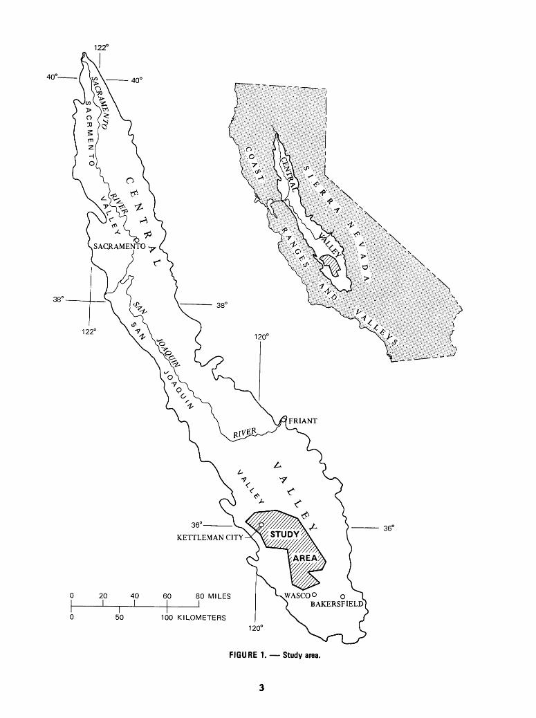
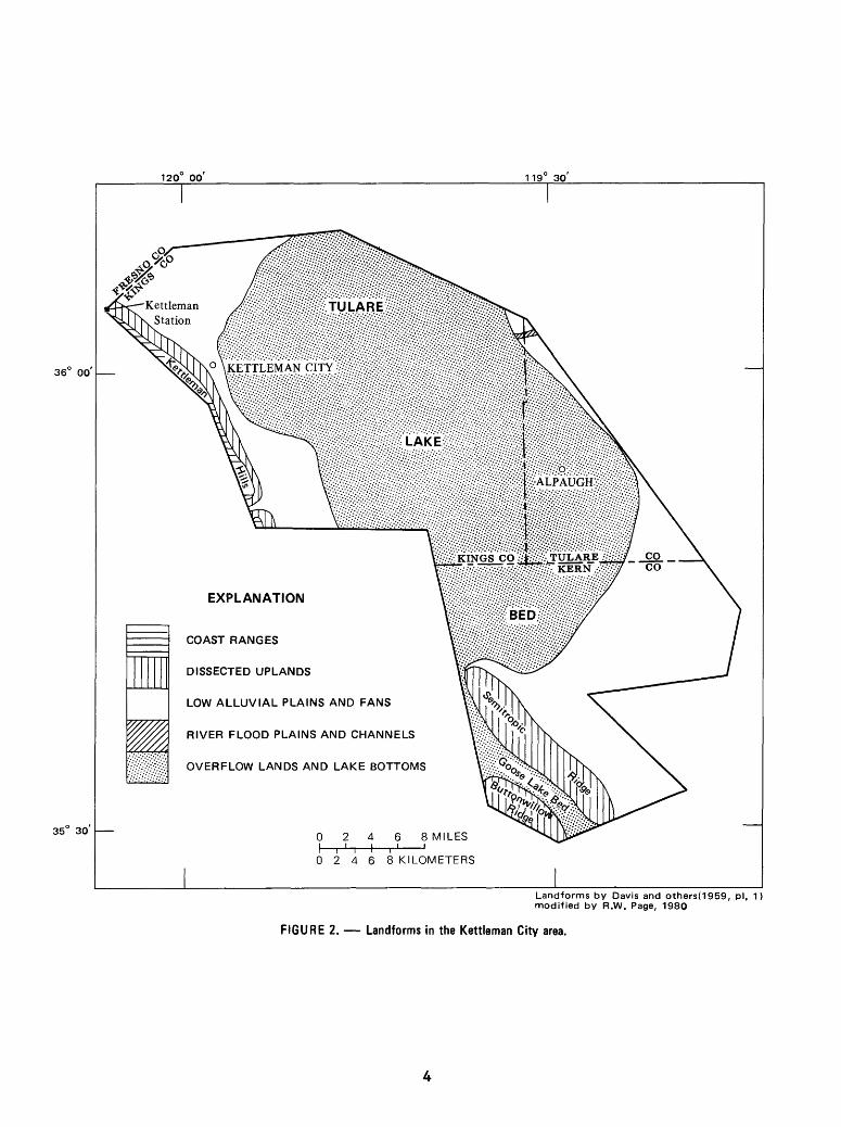
The study area comprises about 1,040 square miles in the Kettleman City area of the San Joaquin Valley (fig. 1). Boundaries of the area were deter mined by the extent of a fossil zone in the underlying San Joaquin Formation of Pliocene age (see p. 7). Lake bottoms, or beds, are the principal land- forms in the area (fig. 2) and are characterized by very gentle slopes of the land surface (Davis and others, 1959, p. 29). At times the lake bottoms are flooded, but throughout most of the year they are farmed. Davis and others (1959, pi. 1) mapped overflow lands and lake bottoms as one unit, but their text (p. 28-29) indicates that Tulare Lake bed is the principal landform in the study area. Other landforms in the area are Goose Lake bed and overflow lands to the south, low alluvial plains and fans that bound the lakebeds on the north, east, and west, and dissected uplands that lie along the western and southern edges of the area (fig. 2). The Kettleman Hills, lying along the northwestern boundary of the area, have been mapped by Davis and others (1959, pi. 1) as part of the Coast Ranges. Summers in the area are hot and dry, and winters are cool and relatively moist (table 1).
122°
40'
50
FIGURE 1. Study area.
120 00 119" 30
36 00
35" 30
EXPLANATION
COAST RANGES
DISSECTED UPLANDS
LOW ALLUVIAL PLAINS AND FANS
RIVER FLOOD PLAINS AND CHANNELS
OVERFLOW LANDS AND LAKE BOTTOMS
0246 SMILES
02468 KILOMETERS
Landforms by Davis and others(1959, pi. 1) modified by R.W. Page, 1980
FIGURE 2. Landforms in the Kettleman City area.
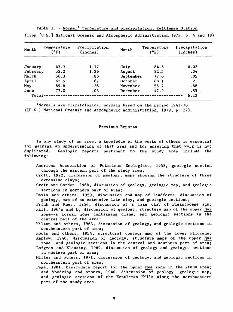
TABLE 1. - Normal 1 temperature and precipitation, Kettleman Station
(from [U.S.] National Oceanic and Atmospheric Administration 1979, p. 4 and 18)
.. ,_, Temperature Precipitation .. . Temperature PrecipitationMonth *. 0_ N ,. * . Month >0_. f . t_ ,
(°F) (inches) (°F) (inches)
JanuaryFebruaryMarchAprilMayJune
Total---
47.352.256.362.569.677.0
1.171.26.88.67.26.03
JulyAugustSeptemberOctoberNovemberDecember
84.582.577.668.156.747.9
0.02.04.05.21.68.85
6 1 o
1Normals are climatological normals based on the period 1941-70 ([U.S.] National Oceanic and Atmospheric Administration, 1979, p. 27).
Previous Reports
In any study of an area, a knowledge of the works of others is essential for gaining an understanding of that area and for ensuring that work is not duplicated. Geologic reports pertinent to the study area include the following:
American Association of Petroleum Geologists, 1958, geologic sectionthrough the eastern part of the study area;
Croft, 1972, discussion of geology, maps showing the structure of threeextensive clays;
Croft and Gordon, 1968, discussion of geology, geologic map, and geologicsections in northern part of area;
Davis and others, 1959, discussion and map of landforms, discussion ofgeology, map of an extensive lake clay, and geologic sections;
Frink and Kues, 1954, discussion of a lake clay of Pleistocene age; Hill, 1964a and b, discussion of geology, structure map of the upper Mya
zone--a fossil zone containing clams, and geologic sections in thecentral part of the area;
Hilton and others, 1963, discussion of geology, and geologic sections insoutheastern part of area;
Hoots and others, 1954, structural contour map of the lower Pliocene; Kaplow, 1940, discussion of geology, structure maps of the upper Mya
zone, and geologic sections in the central and southern part of area; Lofgren and Klausing, 1969, discussion of geology and geologic sections
in eastern part of area; Miller and others, 1971, discussion of geology, and geologic sections in
northeastern part of area; Page, 1981, basic-data report for the upper Mya zone in the study area;
and Woodring and others, 1940, discussion of geology, geologic map,and geologic sections of the Kettleman Hills along the northwesternpart of the study area.
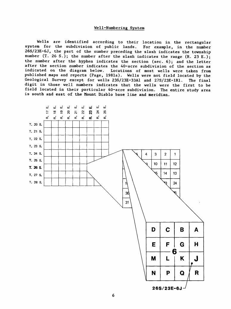
Well-Numbering System
Wells are identified according to their location in the rectangular system for the subdivision of public lands. For example, in the number 26S/23E-6J, the part of the number preceding the slash indicates the township number (T. 26 S.); the number after the slash indicates the range (R. 23 E.); the number after the hyphen indicates the section (sec. 6); and the letter after the section number indicates the 40-acre subdivision of the section as indicated on the diagram below. Locations of most wells were taken from published maps and reports (Page, 1981a). Wells were not field located by the Geological Survey except for wells 23S/23E-33A1 and 27S/23E-1R1. The final digit in those well numbers indicates that the wells were the first to be field located in their particular 40-acre subdivision. The entire study area is south and east of the Mount Diablo base line and meridian.
II* li' II* IM LLJ II* III LLJ LLJ
S3 CM CM
T. 20 S.
T. 21 S.
T. 22 S.
T. 23 S.
T. 24 S.
T. 25 S.
T. 26 S.
T. 27 S.
T. 28 S.
DC DC CC DC DC DC CC
^
\
DC
^
\
DC
[^
D
E
M
N
C
F (
L
P
B
G 5
K
Q
A
H
J
^26S/23E-6J
GEOLOGY OF THE TULARE FORMATION AND OTHER CONTINENTAL DEPOSITS
Woodring and others (1940, p. 13) defined the Tulare Formation as the youngest folded strata exposed in the Kettleman Hills. They defined the base of the Tulare Formation as the layer just above the upper Mya zone of the San Joaquin Formation of Pliocene age (Woodring and others, 1940, p. 13-14). Upper Mya zone refers to the uppermost strata in which the burrowing pelecypod, or clam, Mya occurs in the San Joaquin Formation. This base marks a change from a dominantly marine environment to a continental environment of lakes, swamps, and streams. The upper Mya zone can be traced with a reasonable certainty over a considerable distance in the Kettleman Hills (Woodring and others, 1940, p. 13-14).
Kaplow (1940, pis. 3 and 5) mapped the base of the Tulare Formation as the top of the San Joaquin clay of Barbat and Galloway (1934) of Pliocene age. This clay lies about 500 feet above the Mya zone in the area of Buttonwillow and Semitropic Ridges (fig. 2). Kaplow (1940) did not mention an environ mental change at the top of the upper Mya zone, but he did say that the upper Mya zone was by far the best subsurface marker in the area.
Later, Hill (1964a, p. 14), following the lead of Woodring and others (1940), defined the upper Mya zone in parts of T. 23 S. , Rs. 21 and 22 E. as the top of the San Joaquin Formation, and the base of the Tulare Formation as the layer just above that zone. He indicated that the top of the upper Mya zone marked the greatest environmental change in the area and assumed that the contact between the San Joaquin Formation and the Tulare Formation was con formable (Hill, 1964a, p. 14), suggesting only slight erosional or structural changes over time between the two formations.
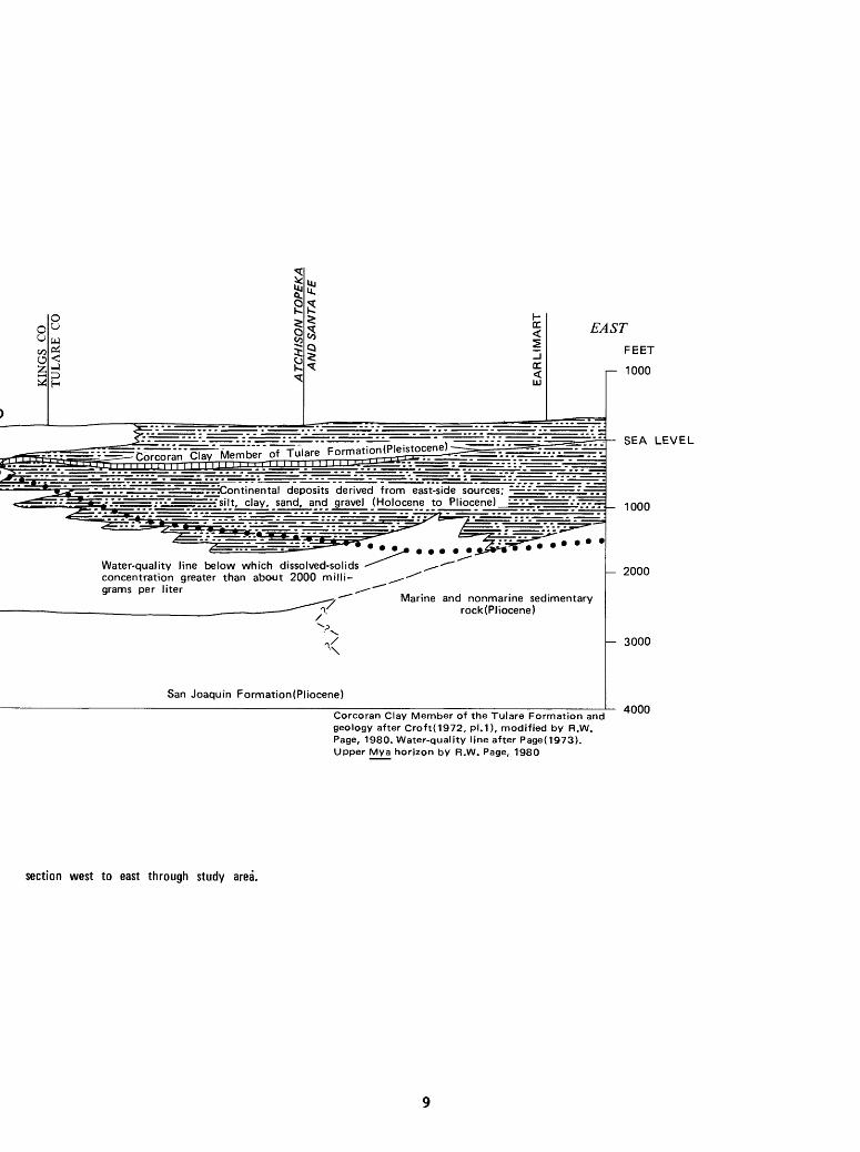
In this report, the base of the Tulare Formation is considered to be just above the upper Mya zone, except in the subsurface along the eastern side of the area where sediments from the Sierra Nevada have been deposited (fig. 3). The Tulare Formation is considered by most workers to include only that sedi ment derived from sources on the west side of the valley (Davis and others, 1959, p. 52); whereas, in the study area, sediments derived from the east side of the valley have, as yet, not been formally defined. The American Association of Petroleum Geologists (1958), however, showed that the eastern part of the study area is underlain by the Tulare Formation or the Kern River Formation, which is probably equivalent to the upper part of the Kern River Series of Diepenbrock (1933).
Nevertheless, without attempting to define the eastern extent of the Tulare Formation, the Tulare and sediments from the east side of the valley are here grouped as the Tulare Formation and other continental deposits. They crop out over most of the area (pi. 1). This grouping also includes the younger alluvium of Holocene age and the older alluvium of Pleistocene age that overlie the deformed Tulare Formation in the Kettleman Hills (Woodring and others, 1940, p. 13). Beneath Tulare Lake bed these two alluvial units cannot be easily distinguished from the Tulare Formation because of similarities in sedimentary material.
WESTFEET
1000 -,
SEA LEVEL '
1000-
2000-H
3000-
4000
LAKE
Tulare Formation and other continental ^ deposits derived from = west-side sources; clay, silt,==
:sand, gravel, sandstone, nd conglomerate
KHolocene to Pliocene
Flood-plain, lake, and marsh deposits derived from both east- and west-side sources; mostly clay, silt, silty clay, and clayey silt; some sand(Holocene to Pliocene)
San Joaquin Formation(PMocene)
D 1 2I I
3 I
4 E I I
I I I I I
5 MILES
012345 KILOMETERS VERTICAL EXAGGERATION X 11
FIGURE 3. Diagrammatic geologic
Ui
EASTFEET
r 1000
^Continental deposits derived from east-side sources; =-:-: --~.--- rrrrfsilt, clay, sand, and gravel (Holocene to Pliocene)
Water-quality line below which dissolved-solids concentration greater than about 2000 milli grams per liter *,
Marine and nonmarine sedimentary rock (Pliocene)
San Joaquin Formation(Pliocene)
SEA LEVEL
--- - - 1000
- 2000
- 3000
Corcoran Clay Member of the Tulare Formation and geology after Croft(1972, pl.1), modified by R.W. Page, 1980. Water-quality line after Page(1973). Upper Mya horizon by R.W. Page, 1980
4000
section west to east through study area.
Depth, Thickness, Base, and Structure
The depth to the base of the Tulare Formation and other continental deposits (pi. 1) was mapped on the basis of 292 identifications of the upper Mya zone in the study area (Page, 1981), structure-contour maps and geologic sections showing the upper Mya zone by Hill (1964a, pi. 2; 1964b, pis. 3 and 4) and Kaplow (1940, pis. 2, 3, 5, and 7), as well as areas where the base of the Tulare Formation is exposed in the Kettleman Hills (Woodring and others, 1940, pi. 3). Because the depth to the base of these deposits is measured from land surface, their present thickness is also defined. Thus, the Tulare Formation and other continental deposits range in thickness, as well as depth to base, from zero where the Tulare Formation lies in contact with the San Joaquin Formation in the Kettleman Hills to more than 4,000 feet just east of the hills (pi. 1). In both of those areas, the Tulare Formation is the principal deposit.
It should be mentioned that, because the Tulare Formation was eroded as the Kettleman Hills were being uplifted, its present thickness in this area is not its original thickness, and that its thickness of 0 foot at its contact with the San Joaquin Formation does not indicate that the Tulare Formation pinched out in the area of the Kettleman Hills. On the contrary, Woodring and others (1940, p. 16-22) described thick sections of the Tulare on both the east and west flanks of the Kettleman Hills, indicating that the Tulare Formation was quite thick prior to uplift and erosion of the hills. For example, on the east flank of the Kettleman Hills the exposed Tulare is as much as 1,700 feet thick, and on the west flank it is as much as 3,500 feet thick (Woodring and others, 1940, p. 14).
Some of the features of the base of the Tulare Formation and other conti nental deposits are (1) a trough near Wilbur Ditch in the north-central part of the area, (2) two rather shallow areas at Buttonwillow and Semitropic Ridges, (3) a fairly shallow area between the Homeland Canal and the Liberty Farms East Canal, (4) a steep, northeastward-sloping surface in and near the Kettleman Hills, and (5) a deep, northwestward-trending trough just east of the Kettleman Hills (fig. 2; pi. 1). In addition, the base slopes south- westward near the southern part of the area and northwestward along the long axis of the area (pi. 1). Although a depth and thickness map cannot be used to properly interpret structure, the features shown on plate 1 reflect some of the structure in the area. Furthermore, it is assumed that the top of the upper Mya zone can be used as a structural datum because in the study area it
10
has been used to successfully define the structure of five gas fields (Hill, 1964a, 1964b, and Kaplow, 1940). Thus, the two shallow areas at Buttonwillow and Semitropic Ridges reflect the structure of two elliptical domes in that area (Kaplow, 1940, pi. 2); the shallow area between the Homeland Canal and the Liberty Farms East Canal partially reflects the structure of a dome and an anticlinal nose (Hill, 1964a, pi. 2); the rather steep, northeastward-sloping surface in and near the Kettleman Hills reflects the uplift that occurred at the close of the deposition of the Tulare Formation in Quaternary time (Hoots and others, 1954, p. 128); and the deep, northwestward-trending trough just east of the Kettleman Hills reflects a syncline, or downwarping, that also occurred as an effect of that uplift (Hoots and others, 1954, p. 129, pi. 5).
Furthermore, Davis and Green (1962, p, 90) postulated that the Tulare Lake area is an area of downwarping. Parts of the area have not only been sinking structurally, they also have been subsiding as fine-grained beds compacted because of ground-water overdraft (Poland and others, 1975, figs. 1, 5, and 12-17).
Fossils
Many freshwater fossils are found in the Tulare Formation itself. Woodring and others (1940, p. 104) said that the lower part of the Tulare Formation contains the largest fossil assemblages of freshwater mollusks, chiefly clams and snails, known on the Pacific Coast. Hill (1964a, table 1) showed that in parts of T. 23 S., Rs. 21 and 22 E. the freshwater clam Anodonta, the freshwater and brackish-water snail Amnicola, and the fresh water snails Fluminicola, Planorbis, and Pyrgulapsis occur in the Tulare Formation. And Croft (1972, p. 22) reported that the freshwater clam Sphaerium kettlemanense (Arnold), and the freshwater snails Valvata utahensis (Call), Lithoglyphus seminalis (Hinds), and Tryonia? occur about 50 feet above the E clay of Pleistocene age at a depth of 600-602 feet in sec. 31, T. 20 S., R. 19 E.
Lohman (1938, p. 88) identified 136 species and varieties of diatoms that were found in the Tulare Formation in the Kettleman Hills. Further, Davis and others (1959, p. 78, pi. 14) said that Lohman identified 113 species of dia toms that were found in their diatomaceous clay, which underlies a large part of the San Joaquin Valley. According to Lohman these species represent a dominantly freshwater to somewhat brackish-water flora (Davis and others, 1959, p. 78-79).
11
Sedimentary Material
Sedimentary material in the Tulare Formation and other continental deposits consists principally of unconsolidated clay, silt, sandy clay and silt, sand, clayey and silty sand, gravel, and clayey, silty, and sandy gravel (fig. 3). Locally, the deposits consist of more consolidated material such as conglomerate and sandstone. Hill (1964a, p. 14) mentioned the occurrence of conglomeratic deposits in parts of T. 23 S., Rs. 21 and 22 E., but most of the deposits in that area consist of clay, sand, and gravel (Hill, 1964a, table 1). In the Kettleman Hills, the Tulare Formation consists principally of sandstone, most of which is cross-bedded, silty, and pebbly, and conglom erate (Woodring and others, 1940, p. 13). There, most of the conglomerate and sandstone is poorly consolidated (Woodring and others, 1940, p. 13); thin- bedded, fine-grained sediments of silt, fine-grained sandstone, tuff, and limestone are also present. Miller and others (1971, p. 21) reported that in the northern part of the Kettleman Hills the Tulare Formation consists prin cipally of sand, much of which is silty, pebbly, and crossbedded; it also contains some gravel, apparently laid down as stream deposits. Beneath Tulare Lake bed, the Tulare Formation and other continental deposits consist prin cipally of silt and clay. Croft (1972, p. 13) considered the boundary between the upper Mya zone and the overlying deposits as probably representing a gradational change from mostly consolidated rocks, such as shale and sandstone, to mostly unconsolidated deposits, such as clay and sand.
Source and Depositional Environment
All the continental sedimentary material in the study area was derived chiefly from either the Sierra Nevada on the east or the Coast Ranges on the west (figs. 1 and 3). Some material probably was derived from those parts of the Sierra Nevada and Coast Ranges that form the southern border of the San Joaquin Valley. The type of material deposited is dependent on controls such as (1) type of rock in the source area, (2) competence of the streams that transported the sediments, and (3) environment of deposition.
The Sierra Nevada are composed of igneous and metamorphic rocks. Sedi ments derived from them have abundant feldspar, mica, and quartz. The Coast Ranges are composed of gypsiferous marine shale, sandstone, and volcanic rocks. Sediments derived from them are gypsiferous, and contain more rock fragments and are darker than those from the Sierra Nevada (Meade, 1967, p. 5). Sediments derived from the Sierra Nevada were transported mostly by major perennial streams; those derived from the Coast Ranges were transported mostly by ephemeral streams of intermediate to small size (Bull, 1964a). As a result of stream competence and source, sediments derived from the Sierra Nevada are, except for rock fragments, generally coarser than those derived from the Coast Ranges. Climatic change and uplift during the Quaternary have also influenced the competence and capacity of the streams (Croft, 1972, p. 15, and Mack, 1969).
In the study area, sediments have been deposited as alluvial-fan, flood- basin, lake, and marsh deposits (figs. 4 and 5), as well as deltaic deposits (not shown).
12

a/,
FIGURE 4. Idealized alluvial fan.
Flood overflow Buena Vistc
Floodand marsh
Block diagram by Dale and others(1964, fig. 7) Modified by R.W. Page, 1980
FIGURE 5. Generalized geologic section and view of part of the Central Valley.
13

Alluvial-Fan Deposits
Alluvial-fan deposits generally grade from coarse-grained material near the head of the fan to finer-grained material near the toe. Depending on source areas, there are boulders, cobbles, gravel, and sand, mixed with some silt and clay, near the fan head. Near the middle of a fan may be found more sand and gravel with clay and silt; near the toe may be found sand, silt, and clay with some gravel. Within any segment of a fan can be found coarse grained deposits, representing a bar or a main channel of a stream, and finer- grained deposits representing natural levees and overbank deposits. Further more, through time the main channel of a stream changes course and cuts and fills across previous deposits. Also, alluvial fans may join together out in the valley. Thus, deposits within alluvial fans comprise a heterogeneous mixture of coarse- and fine-grained material; these deposits tend toward hues of brown, red, and yellow because of oxidizing in subaerial environments.
Alluvial deposits in the study area were formed near the toes of alluvial fans. Miller and others (1971, pis. 3 and 4) showed that alluvial deposits near the northern part of the study area are as much as 1,950 feet deep and 1,650 feet thick. These deposits, as in other parts of the area, are inter- bedded with and overlie deltaic, flood-plain, lake, and marsh deposits. Woodring and others (1940) described beds of dark brown clay and silt, and beds of yellow and yellowish-brown sandstone as occurring in the Kettleman Hills; these beds probably were deposited as alluvial fans. Lofgren and Klausing (1969, fig. 5) showed that alluvial-fan deposits are as much as 1,050 feet deep and 1,000 feet thick in the eastern part of the area, and Croft (1972, pi. 1) showed that alluvial-fan deposits are as much as 1,050 feet deep and 980 feet thick in the southeastern part. Furthermore, alluvial-fan and some deltaic and lake deposits are indicated in the log of test hole 27S/23E-1R1 (depth 1,160 feet) from depths of 0 to about 890 feet (H. B. Goldman, U.S. Bureau of Reclamation, written commun., 1953).
Deltaic Deposits
Deltaic deposits were formed where the streams of alluvial fans dropped most of the remainder of their coarse-grained load as they entered lakes or marshes in the low-lying area, with the lakes and marshes, as well as the flood plains, receiving large quantities of fine-grained material. Miller and others (1971, p. 28) indicated that in the Tulare Formation near the northern part of the study area deltaic deposits consist primarily of bluish-green or greenish-gray, medium to well-sorted sand that is crossbedded and has depositional dips of 10°-40°.
14
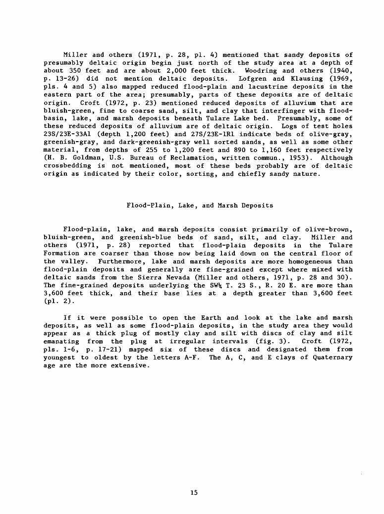
Miller and others (1971, p. 28, pi. 4) mentioned that sandy deposits of presumably deltaic origin begin just north of the study area at a depth of about 350 feet and are about 2,000 feet thick. Woodring and others (1940, p. 13-26) did not mention deltaic deposits. Lofgren and Klausing (1969, pis. 4 and 5) also mapped reduced flood-plain and lacustrine deposits in the eastern part of the area; presumably, parts of these deposits are of deltaic origin. Croft (1972, p. 23) mentioned reduced deposits of alluvium that are bluish-green, fine to coarse sand, silt, and clay that interfinger with flood- basin, lake, and marsh deposits beneath Tulare Lake bed. Presumably, some of these reduced deposits of alluvium are of deltaic origin. Logs of test holes 23S/23E-33A1 (depth 1,200 feet) and 27S/23E-1R1 indicate beds of olive-gray, greenish-gray, and dark-greenish-gray well sorted sands, as well as some other material, from depths of 255 to 1,200 feet and 890 to 1,160 feet respectively (H. B. Goldman, U.S. Bureau of Reclamation, written commun., 1953). Although crossbedding is not mentioned, most of these beds probably are of deltaic origin as indicated by their color, sorting, and chiefly sandy nature.
Flood-Plain, Lake, and Marsh Deposits
Flood-plain, lake, and marsh deposits consist primarily of olive-brown, bluish-green, and greenish-blue beds of sand, silt, and clay. Miller and others (1971, p. 28) reported that flood-plain deposits in the Tulare Formation are coarser than those now being laid down on the central floor of the valley. Furthermore, lake and marsh deposits are more homogeneous than flood-plain deposits and generally are fine-grained except where mixed with deltaic sands from the Sierra Nevada (Miller and others, 1971, p. 28 and 30). The fine-grained deposits underlying the SW% T. 23 S. , R. 20 E. are more than 3,600 feet thick, and their base lies at a depth greater than 3,600 feet (pl. 2).
If it were possible to open the Earth and look at the lake and marsh deposits, as well as some flood-plain deposits, in the study area they would appear as a thick plug of mostly clay and silt with discs of clay and silt emanating from the plug at irregular intervals (fig. 3). Croft (1972, pis. 1-6, p. 17-21) mapped six of these discs and designated them from youngest to oldest by the letters A-F. The A, C, and E clays of Quaternary age are the more extensive.
15
In the study area, the E clay is equivalent to the Corcoran Clay Member (Pleistocene) of the Tulare Formation and the diatomaceous clay of Davis and others (1959, pi. 14, p. 76-81); it lies below most of the area (Croft, 1972, pis. 1, 3, and 4) (pi. 1). In the northeastern part of the San Joaquin Valley, where virtually all deposits were derived from the Sierra Nevada, Marchand and Allwardt (1981, p. 34) considered that the Corcoran Clay Member of the Tulare Formation was also a member of the Turlock Lake Formation of Pleistocene age. The age of the Corcoran Clay Member or E clay (Croft, 1972, p. 18) is approximately bracketed by two dates determined from K-Ar (potas sium-argon) dating techniques. Davis and others (1977, p. 388) reported that an ash found in the basal part of Croft's (1972, p. 18) E clay, in a test hole near Wasco, is about 725,000 years old. They considered this ash to be most probably the Bishop tuff (Davis and others, 1977, p. 388). In addition, they reported that a reversal in polarity occurred about 700,000 to 750,000 years ago represented by strata 12 feet below the ash at the base of the E clay (Davis and others, 1977, p. 388-389); this wide range in age is attributed to "a large margin of uncertainty" in the K-Ar dating of the ash and the sedi mentation rate of the clay between the ash and the reversal (Davis and others, 1977, p. 388-389). Because of new decay constants for K-Ar dating techniques, the ash is now considered to be about 730,000 years old (Marchand and Allwardt, 1981, p. 33). The exact date of the reversal in polarity is still unknown. Janda and Croft (1967, p. 164) reported that a volcanic ash and pumice, the Friant Pumice Member of the Turlock Lake Formation (Marchand and Allwardt, 1981, p. 34), can be traced discontinuously from near Friant, where it is exposed, to beneath the axis of the San Joaquin Valley where it conform ably overlies the Corcoran Clay Member. Using the new decay constants, G. B. Dalrymple (Marchand and Allwardt, 1981, p. 34) dated two separate collections of the Friant Pumice Member as 612,000131,000 years and 618,000131,000 years. Janda and Croft (1967) did not mention the Bishop tuff 1 as being in the area of the Friant Pumice Member, and Davis and others, (1977, p. 385) did not find the Friant Pumice Member in their test holes near Wasco. Therefore, the data concerning the bracketing of the age of the Corcoran Clay Member of the Tulare Formation and the Turlock Lake Formation is not conclusive. Nevertheless, because the Friant Pumice Member was found immediately above the Corcoran Clay Member near the axis of the San Joaquin Valley, and the reversal in polarity was found near the axis of the valley at the base of the Corcoran Clay Member, it can be inferred that the Corcoran Clay Member ranges in age from approximately 615,000 to 750,000 years before present time.
1Marchand and Allwardt (1981, p. 34) noted that "Considerable uncertainty exists as to whether the Friant Pumice Member is correlative with the Reds Meadows tuff of the upper San Joaquin drainage and with the Bishop tuff...," but if the Friant Pumice Member overlies the Corcoran Clay Member (Janda and Croft, 1967, p. 164) and if the probable Bishop tuff lies near the basal part of the Corcoran Member (Davis and others, 1977, p. 388) then the Friant Pumice Member and the probable Bishop tuff of Davis and others (1977, p. 388) are not correlative.
16

Janda and Croft (1967, p. 168) suggested that some of the clays older than the A clay (Croft, 1972, p. 18-20) may have been deposited in large lakes that were coeval with glaciation in the Sierra Nevada (U.S. Geological Survey, 1965, p. A100), but Davis and others (1977, p. 389) suggested that the E clay (Croft, 1972) may represent an interglacial stage.
The C clay of Pleistocene age was mapped beneath the northern, eastern, and southern parts of the area but was not identified beneath Tulare Lake bed because of similarities in sedimentary material (Croft, 1972, pis. 1, 3, and 5) (pi. 1). As one of the older clays of Croft (1972), the C clay may have been deposited in a large lake during a glacial stage in the Sierra Nevada (Janda and Croft, 1967, p. 168, and U.S. Geological Survey, 1965, p. A100).
The A clay of Pleistocene and Holocene (?) age was mapped beneath the northern, northeastern, and southern edges of the study area (Croft, 1972, pis. 1, 3, and 6) (pi. 1). The A clay was not identified beneath Tulare Lake bed because of similarities in sedimentary material. Janda and Croft (1967, p. 168), said that the age of their youngest clay, the A clay of Croft (1972, p. 20-21), was bracketed by radiocarbon dating done by Meyer Rubin of the U.S. Geological Survey. These radiocarbon dates were from wood collected 3 feet beneath the A clay and for wood within the upper part of the clay and are 26,780 ± 600 years and 9,040 ± 300 years respectively (Croft, 1972, p. 21). Janda and Croft (1967, p. 168) considered the A clay to have been deposited in a large lake coeval with the Wisconsin Glaciation.
Croft (1972, p. 18) said that the flood-plain, lake, and marsh deposits range in age from late Pliocene to Holocene; therefore, deposition of these mostly fine-grained deposits has been going on for more than 2 million years. And, except for the expansion of the lake, as represented by the Corcoran Clay Member of the Tulare Formation (Croft, 1972, pi. 4), the ancient lakes and marshes of probable late Pliocene or early Pleistocene age occupied a much larger area for a longer period of time in the eastern and southeastern parts of the study area than later lakes and marshes, as evidenced by the thick deposits of fine-grained material at depths of 2,200 to 2,600 feet and below (pi. 2). Later, alluvial-fan and deltaic deposits from easterly sources encroached on the area formerly occupied by these lake and marsh deposits, as evidenced by the deposition of coarse-grained material above 2,200 feet (fig. 3; pi. 2).
Mack (1969, p. 2535) suggested a minimum rainfall of about 35 to 45 inches per year at the beginning of the deposition of the Tulare Formation in the late Pliocene. Thus, a more abundant rainfall than at present (table 1) and a lower lying area (Hoots and others, 1954, p. 128) probably contributed to the expansion of the ancient lake in the eastern and south eastern parts of the area. In any event, the fine-grained deposits in the central part of the area (pi. 2) were laid down seemingly without interuption throughout the late Pliocene, the entire Pleistocene, and the Holocene. Beneath Tulare Lake bed these deposits would probably yield excellent paleo- climatic data in the form of fossil diatoms, mollusks, and pollens. In turn, paleoclimatic data can help to explain more about the expansions and contractions of this ancient lake.
17

Texture of the Deposits
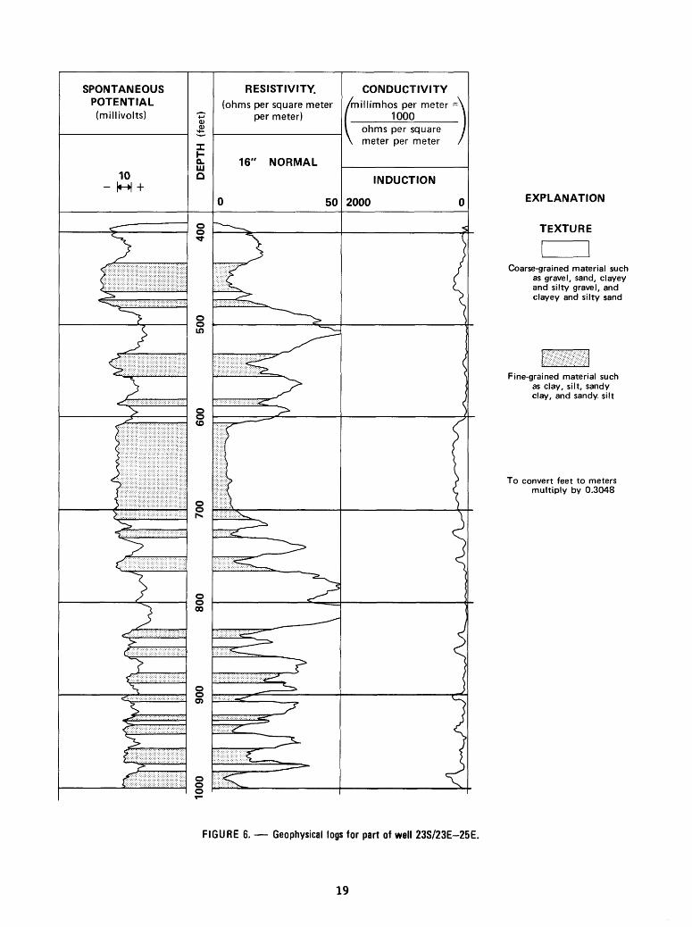
Texture as used in this report means the proportion of coarse-grained to fine-grained sedimentary material in the Tulare Formation and other conti nental deposits. In ordet to determine texture, geophysical logs, mostly from gas or gas-test wells, were used. These logs show properties of sedimentary material such as resistivity and spontaneous potential. Coarse-grained and fine-grained material, as well as their depth and thickness, can be determined from geophysical logs (Schlumberger Ltd., 1972). For example, in the study area high resistivities are interpreted as representing coarse-grained material, and lower resistivities as representing fine-grained material (fig. 6). The spontaneous potential also is a guide in determining coarse grained and fine-grained material. Opposite a coarse-grained bed, the spontaneous-potential line, depending on water salinity in the bed and fluid salinity in the borehole, will move either to the right or left of a base line representing fine-grained material. Although the presence of coarse grained and fine-grained material can be determined from geophysical logs, the logs cannot be used to determine if the coarse-grained material is gravel or sand, nor can they be used to determine if a fine-grained material is silt or clay.
Using geophysical logs and a computer program written by H. T. Mitten of the Geological Survey (written commun., 1980), texture maps of the sedimentary material beneath the study area were generated by computing and plotting the percentage of coarse-grained material in depth intervals of 200 feet (pi. 2). Most of the computations for texture were for depths below 400 feet because the California Division of Oil and Gas requires that before drilling an oil or gas well that a casing be set in the ground from the surface to a depth of 10 percent of the total depth of the well. This casing blocks the recording of resistivity and the spontaneous potential.
18
SPONTANEOUS POTENTIAL(millivolts)
10
T
X
Q. LU O
oO
o o in
§ <o
o o
o o00
o oO)
o o o
RESISTIVITY.(ohms per square meter
per meter)
16" NORMAL
50
CONDUCTIVITY/millimhos per meter
1000ohms per square meter per meter
INDUCTION
2000 EXPLANATION
TEXTURE
Coarse-grained material such as gravel, sand, clayey and silty gravel, and clayey and silty sand
Fine-grained material such as clay, silt, sandy clay, and sandy silt
To convert feet to meters multiply by 0.3048
FIGURE 6. Geophysical logs for part of well 23S/23E-25E.
19
GROUND-WATER-MANAGEMENT CONSIDERATIONS AND USE OF TEXTURE MAPS
Texture maps (pi. 2) can be useful in. making water-management decisions in the study area. For example, coarse-grained material yields water to wells more rapidly and with less drawdown because in a given time it has a greater ability to take water into or release it from storage than fine-grained material and can transmit larger quantities of water. Using this fact, a water manager probably would not elect to drill wells in the central part of the Tulare Lake bed area because of the underlying thick section of fine grained sediment (pi. 2). Instead, he or she would limit well drilling to the northern, southern, or eastern parts of the area, and in those areas probably would limit wells to depths above the fine-grained sediment, as indicated on plate 2. In the southeast corner of T. 21 S., R. 20 E. (pi. 2), he might elect to drill wells through the fine-grained sediment indicated at depths of 400 to 1,000 feet in order to test the coarse-grained sediment indicated at depths of 1,000 to 1,200 feet and below. On the other hand, if he were considering injecting wastes, following all State and local regulations, he might consider that the thick and extensive nature of the fine-grained sediment indicated beneath the lakebed would serve as an effective cap.
The texture maps (pi. 2) also can be used by ground-water modelers. Virtually any model of a ground-water system requires values for hydraulic conductivity, or transmissivity, and the coefficient of storage. These values must be placed in discrete units, or nodes, throughout an entire model. By knowing that coarse-grained sediment has a greater ability than fine-grained sediment to take water into or release it from storage and can transmit water more readily, a modeler can use the texture maps (pi. 2) to assign relative values of hydraulic conductivity and storage coefficient to the model nodes. Values for the storage coefficient, of course, would depend on whether conditions were confined or unconfined.
Through time, fine-grained sediment such as silt and clay can yield large quantities of water when the silt or clay is compacted because of an increase in effective stress (Lofgren, 1975, p. 35, pi. 5). Increased effec tive stress occurs when water levels in an aquifer are drawn down (Lofgren, 1968, p. 222). Compaction of fine-grained beds has resulted in land subsi dence in parts of the Kettleman City area (Bull and Miller, 1975, fig. 4, and Lofgren and Klausing, 1969, fig. 50). Beds of silt and clay also can confine water under greater than atmospheric pressure and impede the vertical movement of water. In the study area, the A-F clays of Croft (1972, p. 17-21, pis. 1-6) function as confining beds. Anyone making decisions about recharge or discharge operations in the area should take these beds into account as well as the thick sections of fine-grained material (pis. 1 and 2). Most of the fine-grained material lies beneath the western and central parts of the study area to depths of over 1,400 feet (pi. 2). Below 1,400 feet the fine grained material becomes more widespread, and at depths of 2,400 to 2,800 feet it underlies most of the area. Below 2,800 feet all the mapped deep areas are filled chiefly with fine-grained material (pis. 1 and 2).
20
Other factors involved in making water-management decisions in the study area include: (1) The gas that occurs in the Tulare Formation and other continental deposits, and (2) saline water that underlies the whole area. Corwin (1960, p. 7) reported the occurrence of gas in the Tulare Formation near the Kettleman Hills, and Hill (1964b, p. 18) reported that farmers in the Tulare Lake area used subcommercial volumes of gas produced from water wells for heating homes and running irrigation pumps. Because of the danger of drilling in gas zones, the California Division of Oil and Gas should be con tacted before drilling wells in the area. Finally, water with a dissolved- solids concentration in excess of 2,000 milligrams per liter underlies the area (Page, 1973) (pi. 1). Wells with screens in or near this zone would yield water with a large dissolved-solids concentration.
SUMMARY AND CONCLUSIONS
In the Kettleman City area the base of the Tulare Formation and other continental deposits marks a change from an underlying dominantly marine environment to a continental environment of lakes, swamps, and streams (Woodring and others, 1940, p. 13-14). The base is mapped as just above the upper Mya zone of the San Joaquin Formation. The eastern extent of the Tulare Formation is not defined. The Tulare has been grouped with continental deposits from the east side of the valley that interfinger with and overlie it; on the west side of the area the Tulare Formation has been grouped with younger deposits of similar material that overlie it.
The Tulare Formation and other continental deposits range in depth and thickness from zero in the Kettleman Hills to more than 4,000 feet just east of the hills. In both these areas, the Tulare Formation is the principal deposit. Prior to the uplift of the Kettleman Hills and erosion of all the exposed formations, the Tulare Formation in that area was quite thick, as indicated by measured sections of the Tulare on both the east and west flanks of the hills.
Some of the features of the base of the Tulare Formation and other conti nental deposits reflect geologic structures in the area. Two of the more prominent features are (1) the rather steep, northeastward-sloping surface in and near the Kettleman Hills that reflects the uplift that occurred at the close of the deposition of the Tulare Formation in Quaternary time, and (2) the deep, northwestward-trending trough that reflects a downwarping that occurred as an effect of that uplift.
Sedimentary material in the Tulare Formation and other continental deposits consists principally of unconsolidated deposits of clay, silt, sand, and gravel. These sediments have been derived chiefly from the Sierra Nevada on the east and the Coast Ranges on the west and have been deposited as alluvial-fan, deltaic, flood-plain, lake, and marsh deposits. Alluvial-fan and deltaic deposits, that contain most of the coarse-grained deposits in the area, underlie the northern, eastern, and southeastern parts. Flood-plain, lake, and marsh deposits of mostly fine-grained material underlie chiefly the central and western parts of the area to depths of 1,400 feet where they become more widespread. At depths of 2,400 to 2,800 feet they underlie most of the area.
21

For most recharge and discharge operations, water managers in the area would choose those areas underlain by coarse-grained material, as indicated by the texture maps. The texture maps also can be used by ground-water modelers for assigning relative values of hydraulic conductivity and storage coeffi cient to model nodes. Fine-grained material, when compacted, can yield large quantities of water, but compaction of fine-grained beds in the area has resulted in land subsidence. Water managers in the study area would also have to consider the subcommerical quantities of gas that occur in the Tulare Formation and other continental deposits and the saline water that underlies the area. Drilling in gas zones, of course, poses a danger, and wells com pleted near the saline water would yield water with a large dissolved-solids concentration.
SELECTED REFERENCES
Addicott, W. 0., 1970, Tertiary paleoclimatic trends in the San Joaquin Basin,California: U.S. Geological Survey Professional Paper 644-D, 19 p.
American Association of Petroleum Geologists, 1958, Correlation sections,Riverdale through Tejon Ranch area (10 South), California: PacificSection, American Association of Petroleum Geologists, Bakersfield,Calif., 1 sheet.
Arnow, Ted, Feth, J. H., and Mower, R. W., 1970, Ground water in deltas of theBonneville Basin, the Great Basin, U.S.A., in Hydrology of deltas:Bucharest Symposium, Bucharest, Romania, 1969, Proceedings,IASH/AIRS-UNESCO, v. 2, p. 396-407.
Barbat, W. F., and Galloway, John, 1934, San Joaquin Clay, California:Bulletin of the American Association of Petroleum Geologists, v. 18,no. 4, p. 476-499.
Bull, W. B., 1964a, Alluvial fans and near-surface subsidence in westernFresno County, California: U.S. Geological Survey ProfessionalPaper 437-A, 71 p.
_____1964b, Geomorphology of segmented alluvial fans in western FresnoCounty, California: U.S. Geological Survey Professional Paper 352-E,p. 89-129.
Bull, W. B. , and Miller, R. E., 1975, Land subsidence due to ground-waterwithdrawal in the Los Banos-Kettleman City area, California, Part 1.Changes in the hydrologic environment conducive to subsidence:U.S. Geological Survey Professional Paper 437-E, 71 p.
Cehrs, David, Soenke, Stephen, and Bianchi, W. C., 1980, A geologic approachto artificial recharge site selection in the Fresno-Clovis area,California: U.S. Department of Agriculture, Technical Bulletin 1604,73 p.
Corwin, C. H., 1960, Dudley Ridge gas field: California Department of NaturalResources, Division of Oil and Gas, Summary of Operations, California OilFields, v. 46, no. 1, p. 4-8.
Croft, M. G., 1968, Geology and radiocarbon ages of late Pleistocenelacustrine clay deposits, southern part of San Joaquin Valley,California, in U.S. Geological Survey Research 1968: U.S. GeologicalSurvey Professional Paper 600-B, p. 151-155.
____1972, Subsurface geology of the late Tertiary and Quaternary water bearing deposits of the San Joaquin Valley, California: U.S. GeologicalSurvey Water-Supply Paper 1999-H, 29 p.
22
Croft, M. G. , and Gordon, G. V., 1968, Geology, hydrology, and quality of water in the Hanford-Visalia area, San Joquin Valley, California: U.S. Geological Survey open-file report, 63 p.
Dale, R. H. , French, J. J., and Wilson, H. D., Jr., 1964, The story of ground water in the San Joaquin Valley, California: U.S. Geological Survey Circular 459, 11 p.
Davis, G. H., and Green, J. H., 1962, Structural control of interior drainage, southern San Joaquin Valley, California, in Geological Survey Research 1962: U.S. Geological Survey Professional Paper 450-D, p. 89-91.
Davis, G. H. , Green, J. H. , Olmsted, F. H. , and Brown, D. W. , 1959, Ground- water conditions and storage capacity in the San Joaquin Valley, California: U.S. Geological Survey Water-Supply Paper 1469, 187 p.
Davis, G. H. , Lofgren, B. E., and Mack, Seymour, 1964, Use of ground-water reservoirs for storage of surface water in the San Joaquin Valley, California: U.S. Geological Survey Water-Supply Paper 1618, 125 p.
Davis, P., Smith, J. , Kukla, G. J. , and Opdyke, N. D. , 1977, Paleomagnetic study at a nuclear power plant site near Bakersfield, California: Quaternary Research, v. 7, p. 380-397.
Diepenbrock, Alex, 1933, Mount Poso oil field: California Department of Natural Resources, Division of Oil and Gas, Summary of Operations, California Oil Fields, v. 19, no. 2, p. 4-35.
Egorov, V. V., 1970, Deltas of the zones characterized by sinking of the earth's crust, in Hydrology of deltas: Bucharest Symposium, Bucharest, Romania, 1969, Proceedings, IASH/AIHS-UNESCO, v. 1, p. 38-43.
Frink, J. W. , and Kues, H. A., 1954, Corcoran Clay, a Pleistocene lacustrine deposit in San Joaquin Valley, California: Bulletin of the American Association of Petroluem Geologists, v. 38, no. 11, p. 2357-2371.
Hackel, Otto, 1966, Summary of the geology of the Great Valley, chapter 5 of Geology of northern California: California Division of Mines Bulletin 190, p. 217-238.
Hill, F. L. , 1964a, Harvester gas field: California Department of Conservation, Division of Oil and Gas, Summary of Operations, California Oil Fields, v. 50, no. 1, p. 11-15.
_____1964b, Northwest Trico gas field: California Department of Conservation, Division of Oil and Gas, Summary of Operations, California Oil Fields, v. 50, no. 1, p. 17-20.
Hilton, G. S., McClelland, E. J. , Klausing, R. L. , and Kunkel, Fred, 1963, Geology, hydrology, and quality of water in the Terra Bella-Lost Hills area, San Joaquin Valley, California: U.S. Geological Survey open-file report, 158 p.
Hoots, H. W. , Bear, T. L. , and Kleinfell, W. D. , 1954, Geological summary of the San Joaquin Valley, California, in Geology of the natural provinces, chapter 2 of Geology of southern California: California Division of Mines Bulletin 170, p. 113-131.
Hoyt, Carrie, ed., 1980, Layperson's guide to ground water: Sacramento, Calif., Western Water Education Foundation, 16 p.
Janda, R. J., and Croft, M. G., 1967, The stratigraphic significance of a sequence of noncalcic brown soils formed on the Quaternary alluvium of the northeastern San Joaquin Valley, California: Quaternary Soils, v. 9, VII Congress, p. 158-190.
Johnson, A. I., Moston, R. P., and Morris, D. A., 1968, Physical and hydro- logic properties of water-bearing deposits in subsiding areas in central California: U.S. Geological Survey Professional Paper 497-A, 71 p.
23

Kaplow, E. J., 1940, Gas fields of southern San Joaquin Valley: CaliforniaDepartment of Natural Resources, Division of Oil and Gas, Summary ofOperations, California Oil Fields, v. 24, no. 1, in Reprint no. 1, 1955,p. 19-39.
Lofgren, B. E. , 1968, Analysis of stresses causing land subsidence, inU.S. Geological Survey Research 1968: U.S. Geological SurveyProfessional Paper 600-B, p. 219-225.
____1975, Land subsidence due to ground-water withdrawal, Arvin-Maricopaarea, California: U.S. Geological Survey Professional Paper 437-D, 55 p.
Lofgren, B. E., and Klausing, R. L., 1969, Land subsidence due to ground-waterwithdrawal, Tulare-Wasco area, California: U.S. Geological SurveyProfessional Paper 437-B, 103 p.
Lohman, K. E. , 1938, Pliocene diatoms from the Kettleman Hills, California:U.S. Geological Survey Professional Paper 189-C, p. 81-102.
Mack, Seymour, 1969, Climatic and tectonic factors affecting water quality inthe San Joaquin Valley near Fresno, California: Bulletin of theGeological Society of America, v. 80, no. 12, p. 2527-2537.
Marchand, D. E., and Allwardt, Alan, 1981, Late Cenozoic stratigraphic units,northeastern San Joaquin Valley, California: U.S. Geological SurveyBulletin 1470, 70 p.
Meade, R. H., 1967, Petrology of sediments underlying areas of land subsidencein central California: U.S. Geological Survey Professional Paper 497-C,83 p.
Miller, R. E., Green, J. H., and Davis, G. H., 1971, Geology of the compactingdeposits in the Los Banos-Kettleman City subsidence area, California:U.S. Geological Survey Professional Paper 497-E, 46 p.
Newman, W. L., 1977, Geologic time: U.S. Geological Survey, 20 p. Page, B. M. , 1966, Geology of the Coast Range of California, chapter 6 in
Geology of Northern California: California Division of MinesBulletin 190, p. 255-276.
Page, R. W., 1973, Base of fresh ground water (approximately 3,000 micromhos)in the San Joaquin Valley, California: U.S. Geological Survey HydrologicInvestigations Atlas HA-489.
____1981, Data on depths to the upper Mya zone of the San Joaquin Formationin the Kettleman City area, San Joaquin Valley, California: U.S.Geological Survey Open-File Report 81-699, 8 p.
Poland, J. F., and Evenson, R. E., 1966, Hydrogeology and land subsidence,Great Central Valley, California, chapter 5 of Geology of northernCalifornia: California Division of Mines Bulletin 190, p. 239-247.
Poland, J. F., Lofgren, B. E. , Ireland, R. L. , and Pugh, R. G. , 1975, Landsubsidence in the San Joaquin Valley, California, as of 1972: U.S.Geological Survey Professional Paper 437-H, 78 p.
Schlumberger, Ltd., 1972, Log interpretation, volume 1 Principles: New York,Schlumberger Limited, 113 p.
U.S. Geological Survey, 1965, Geological Survey Research 1965: U.S.Geological Survey Professional Paper 525-A, 376 p.
[U.S.] National Oceanic and Atmospheric Administration, 1979, Climatologicaldata, annual summary, California, 1979: U.S. Department of Commerce,National Climatic Center, v. 83, no. 13, 29 p.
Woodring, W. P., Steward, Ralph, and Richards, R. W. , 1940, Geology of theKettleman Hills oil field, California: U.S. Geological SurveyProfessional Paper 195, 170 p.
24