geology of the southern bothnian sea. part i
TRANSCRIPT

Geology of the southern Bothnian Sea. Part I. PER T H O R SLU N D a n d S TEF A N A X BER G
Thorslund, P. and Axberg, S. 1 9 7 9 06 1 5 : Geology of the southern Bothnian Sea. Part l. Bulletin of the Geological Institutions of the University of Uppsala, N.S. , Vol. 8, pp. 3 5-62 . Uppsala. ISS N 0302-2749.
Results are given from studies of two cores obtained from drillings in the lighthouses Västra Banken and Finngrundet (=Östra Banken ) , respectively, on the Finngrunden shoals. Results are also given from conrinuous seismic reflection profiling performed in the SW Bothnian Sea. The studies up to now permit a general accounr of the geology of the southwestern part of the Bothnian Sea with regard to the distribution of the sedimentary rocks and the stratigraphy and lithology of the Paleozoic sequence of strata. Cambrian and Tremadocian beds are treared in some detail, and data from the boreholes have been used in the interpretation of the seismic profiling.
Per Thorslund, Paleontologiska institutionen, Uppsala universitet, Box 558, S-75 1 22 Uppasla, Sweden; Ste/an Axberg, Geologiska institutionen, Stockholms universitet, Box 6801 , S-1 1 3 86 Stockholm, Sweden, 21st April, 1 978.
To the memory of Carl lViman
Contents
Thorslund, P.: Preliminary report on the stratigraphy and lithology of Cambrian and Teernadocian beds of the Finngrunden banks. Notes on the pre-Cambrian rocks by P. H. Lundegårdh . . . . . . . . . . . . . . . . . . . 36
Preface . . . . . . . . . . . . . . . . . . . 36 Stratigraphy and lithology of the cores from the Finngrunden banks 37
Introducrion 3 7 Historical review 3 8 General comments on :the core sections 40
Analyses . . . . ·. , . . . . . . 40 The pre-Cambriån. rocks . . . . . . . 4 1
The Quaternary beds a t Västra Banken . 42 The Cambrian sequence 42 The Lower Tremadocian beds 46
Acknowledgements 48 Flate I . . . . . . . . . . . . . . . 64
Axberg, S. : Preliminary resulrs from seismic investigations m the southwestern Bothnian Sea . . . . . . 48
Introduction 48 Acoustic stratigraphy 49 List of acoustic boundaries 5 1 Instrumentation 5 1 Determination of sound velocities 5 2 General geological serring . . . . . 5 3 Sedimentary rocks i n the SW Bothnian Sea
The Gävle Bay area . . . . . . . . . . . . 5 3 The Finngrunden shoal area . . . . . . . 5 6 The area norrh and west o f the Finngrun-den shoals . . . . . . . . . . . . . . . 59
Concluding remarks . . . . . . 60 Thorslund, P. and Axberg, S . : Summary of results 61
References 61

36 P. Thorstund and S. Axberg
Preliminary report on the stratigraphy and lithology of Cambrian and Tremadocian beds of the Finngrunden banks
By Per Thorslund
With notes on the pre-Cambrian rocks
By P. H. Lundegårdh
Preface
Ever since the investigations by C. Wiman on enatics distributed to the south and southwest of the Bothnian Sea, many students have displayed keen interest in the morphology and geology of this area, particularly its sequence of Cambro-Ordovician beds. On various occasions, proj ects were discussed at the Palaeontological Institute of the University of Uppsala for obtaining a core through this sequence. The first attempt at realizing this goal was the drilling of a borehole on the Finngrunden shoals. The winter of 1 966 was very cold, and an attempt was made to bore from the ice on the Västra Banken (W estern Bank). This was made possible by a collaboration with the Geological Survey of Sweden. Men and material were brought to a suitable place on the bank by helicopter, bu t shortly afterwards, a change occurred in the weather, temporary as it turned out, followed by movement in the ice sheet around the shoal . Thus, for the sake of security, the operation was called off.
In 1 969, Sjöfartsverket ( the Swedish Board of Navigation) placed a modern lighthouse on Finngrundet (Eastern Bank; Fig. l) which meant that the borehole proj ect on the Finngrunden shoals could be taken up again. In the interval between June 24 and July 6, 1 970, a core, 1 5 2,88 m deep, was obtained from the bedrock beneath the lighthouse. During the following year, a similar lighthouse was placed on Västra Banken, and in 1 972, a core to a depth of 149 m was taken. Thanks to the courtesy of the Swedish Board of Navigation, the borings could be carried out wirhin the lighthouses and with the full use of their space and facilities. With this and additional help, readily given from the authorities of the Board during the operations, also the core from Västra Banken could be obtained with the amount of money granred from the State Council for Scientific Research and from the Hierta-Retzius' Fond of the Royal Academy of Science.
Bull Geol. Inst. Univ. Uppsala, N. S . 8 ( 1 979)
F i g. l . The lighthouse a t Finngrundet (Eastern Bank) . Photo P. Å. Thorslund.
The lighthouse at Finngrundet stands on Ordovician limestone, while that of Västra Banken is located on loose Quaternary sediments, the thickness of which had to be assessed before the boring. A continuous seismic reflection profile was taken on that bank in collaboration with the Department of Marine Geology at the Geological Institute of the University of Stockholm under the leadership of Dr. Tom Floden. The results of this work were useful not only for the borehole operation, but also for the geological mapping of Västra Banken and the neightbouring area to the south.
The evaluation of the seismic profile has been treared separately by Mr. Stefan Axberg, whose map and description of the bedrock form the seeond part of this paper. The problems concerning the Quaternary deposits were treared earlier by Hoppe ( 1 961 ) , and will be discussed by Axberg elsewhere.
The bulk of the Ordavieian sequence of the Finngrundet core has been worked out in detail

Bull. Geol . Inst. Univ. Uppsala, N. S . 8 ( 1 979)
BÖNAN dLÖFGRUND Holmudd•n <@ EGGEGRUND
Geology of the southern Bothnian Sea 37
LEGEND 10 15 ® lighthoua•
19.
Fig. 2. Map showing the location of the lighthouses on the Finngrunden shoals. (Östra Banken = Finngrundet in this paper.)
by Dr. Torsten Tj ernvik and Mr. Jan Johansson, while the Lower Cambrian and the Tremadocian beds of both cores have been treared by the present writer. The pre-Carobrian part of the Finngrundet core was investigated by Dr. P. H. Lundegårdh.
Stratigraphy and lithology of the cores from the Finngrunden banks
lntroduction
Data obtained from borings on the Finngrunden shoals to the east of Gävle Bay have provided a valuable addition to our knowledge of the stratigraphy and tectonics of the southera part of the Bothnian Sea. The importance of these borings
is attested to by the fact that they penetrated the Cambro-Ordovician sequence of the district; in addition, they have yielded details of importance for the evaluation of seismic profiles.
As already mentioned, the cores were taken wirhin the lighthouses on the shoals, in 1 970 on Finngrundet, in 1 972 on Västra Banken. The location of the lighthouses is shown in Fig. 2.
No cores through the bedrock of the offshore area had been taken previously. In Connection with fieldwork underlying the productian of the geological sheet "Gävle", two borings were made on land in the coastal district, to the east of Gävle. They penetrated the pre-Carobrian rocks, and provided a substantial amount of information, important for the interpretation of the geology of the Bothnian Sea.
A short review of the previous work on the

38 P. Thors/und and S . Axberg
bedrock of this area is now presenred in order to provide a background to the results obtained from the new borings .
flistorical revietu
Thanks to comprehensive collecting and studies of erratics from the so called North Baltic District, Carl Wiman could present the fundamentals to our present knowledge of the pre-Quaternary sequence of the sedimentary rocks in the Bothnian Sea. In his paper of 1 903, Wiman reporred on the results of his investigations on material from the Cambrian and the Tremadocian beds after a historical n�sume of previous observations. The remainder of the Ordavieian sequence was treared in the paper of 1 906, in which his interpretation of the eectonics of Gävle Bay was pur forward and founded on observations published in the former paper. He assumed at that time, that the Ordovician beds exposed on the small peninsula Holmudden, south of Bönan, and on the islands to the south and east, belonged to the country rock, and, in addition, he described, in some detail, the sequence seen on the island of Limön. Regarding the extent of the sequence wirhin the Borhnian Sea, Wiman thought that the Cambro-Ordovician beds occur in a few, comparatively small areas, isolated from each other, not far to the north and east of the coast of Uppland. He implied that the location of such an area could be deduced, with due regard to the direction of the movement of the inland ice, from a rich occurrence of erratics in a limited area. An isolated area of such a kind was supposed to be situated in the Gävle Bay, extending to the east, in the proximity of Eggegrund.
However, Stina Gripenberg ( 1934), who had studied samples of sediments taken from the seabortom, showed that the extent was much larger than that assumed by Wiman, and in summarizing her results, she emphasized the discovery of a wide area of (Ordovician) limestone to the north of, and at the Finngrunden banks. In support of this, she referred to a short paper by Schön ( 19 1 1 ) who reporred the occurrence of erratics of Ordavieian limestones and conglamerates on the island of Brämön close to the town of Sundsvall.
From boreholes in the Gävle Bay district, W estergård ( 1 939) could show that the Ordavieian rocks, outcropping on Limön, in reality are floar and rafts wirhin the till, resting on the gneissgranite bedrock. According to Westergård the same explanation is valid for the adjacent islands with small outcrops of Ordavieian limestone. The core from Holmudden, which was taken near the
Bull Geol . lnst. Univ. Uppsala, N. S . 8 ( 1 9 79)
fault slopes of Bönan, pierced Quaternary deposits, 21,9 m thick, with an accumulation of Ordovician limestone boulders at the top, and Lower Cambrian very hard "blue-green day", 1 1 ,6 m
thick, resting on Jornian sandstone covered by an unfossiliferous, probably post-Jornian, sandstone (cf. Axberg p. 5 3 ) .
Veltheim's ( 1962) and Winterhalter's ( 1 972) papers contain resulrs of investigations which were a continuation, Successively enlarged, of those made by Stina Gripenberg. Veltheim's studies of large samples of material from the sea-bottom confirmed Gripenberg's interpretation of the bedrock of the Finngrunden shoals, and enlarged our knowledge of the extent of the Ordavieian beds in the Bothnian Sea, the bottom morphology of which was outlined with the aid of echo-sounding. As to the extent of various components in the sedimentary bedrock of the sea area, Veltheim summarized his results on a map (op. cit., Fig. 30, p. 1 5 6) in which the Palaeozoic beds are resericred to a few areas, which, according to Veltheim, are isolated from each other owing to erosion. The norrhern-most area with Palaeozoic beds mapped is ESE of Sundsvall in spite of the fact that he had noticed Hörnsten's report (195 9) on the occurrence of Ordavieian limestone boulders on the island of Härnön about 50 km NE of Sundsvall. According to Veltheim, it is very likely that dislocations took place in pre-Carobrian time after the deposition of the Jornian sandstone as well as in post-Caledonian time, and maybe connected with Tertiary uplift of the Scandinavian shield. The latter dislocatians were supposed to have occurred mainly in the western part of the sea area presurnably along faults sub-parallel to the Swedish coast. Consequently, owing to subsequent erosion, downfaulting or downwarping would account for the present remnants of sedimentary bedrock preserved in the sea area. Evidently, Veltheim followed Wiman in assuming that accumulations of boulders on the sea bottom could be deduced from erosional remnants of sedimentary bedrock.
Veltheim did not rake note of Westergård's results from the borings in the Gävle bay district, nor did Winterhalter, whose results and interpretations were founded on investigations performed by improved versions of Veltheim's merhods; in addition, he made use of other methods, of which continuous seismic reflection profiling was vital for the enlargement of our knowledge of the bedrock. With the possibility of using new marine charts and echo-sounding data, Winterhalter drew a detailed bathymetric map. Evaluating the seismic profiling material, he had use of the data obtained from the boring on Finngrundet in the

Bull. Geol. Inst. Univ. Uppsala, N. S. 8 (1979) Geology of the southern Bothnian Sect 39
m o
10
20
30
o;. 40
Ca co3 65,2. 50 63.9.
65.2 • 60
76.6.
51.9 • 70
65.2.
60.9.
54.5. 80
90 65.2 .
36.5.
100 59.2.
34. 7·
55.6 55.6.
25.7 1.3:
o. 7. 0.3.
o 1.0
:
21.0·
<o.3, 1.0'
5.0.
<0.3. 130 1.0.
o
<o.3.
<0.3. 140 26.6·
VÄSTRA BANKEN
H20
6 6 6 6 6
6 6 6 [', 6
6 6 6 6 [',
[', [', [', [', [',
[', [', 6 6 6
6 6 6 [', 6
l l
l
FINNGRUNDET
35,7km ---�-�
l
l l
l
/
/ /
l l
l
/ /
/
o;. H20 CaC03 II1 7 1.6
75. 4
68.7 6 5.2
1Il1 68. 5
51. 9 II1 68.6
11 II 31.8
59 .7
111 63.6
]]l 67.7
:::r:::r::n 1-o-'..,.-L;,.-l-,- • 70.0
.tt�6:t ;.tu l . < 0 . 3
1 u4 1 . 0
1 .7
13.3
• <o. 3
29.4 1 .7
1. 7 tillj .
� ·o � clay and silt with pebbles
t ill
00 l i mestene } Lower
/ �<>�">� 1, o
)( \. x x ,. l<" /x )l ........ )l X K
)f x )( /x
= Obolus sandstone alum sh ale
sandstone, siltstone, el a y
sandstone with phosphorite pebbles
sandstone, redd i sh
arkose, conglamerate
Ordavie i an
Lower Cambr i an
weath ered gneiss L Pre-and gnei ssic granitej Cambrian
Fig. 3. Co:relations between the core seetians of the Finngrunden shoals.
summer of 1970 (o p. cit. p p. 25, 31, 58); ev iden dy these data were useful for mapping the limits between different lithological units. As seen in Fig. 4 (op. cit. p. 12), one of the profile lines went across Finngrundet not far from the lighthouse, the position of which is Lat. 60°59'N,
Long. 18°37'E. Winrerhalter's results are illustrared in a number of maps one of which (op. cit. PI. 2 D) sketches the tectonics of the area, showing that the sedimenrary formations are preserved in a syncline with the sequence gently dipping from the east, and, very likely, with a steep western
40 P. Thorslund and S. Axberg Bull Geol . Inst. Univ. Uppsala, N. S . 8 (1979)
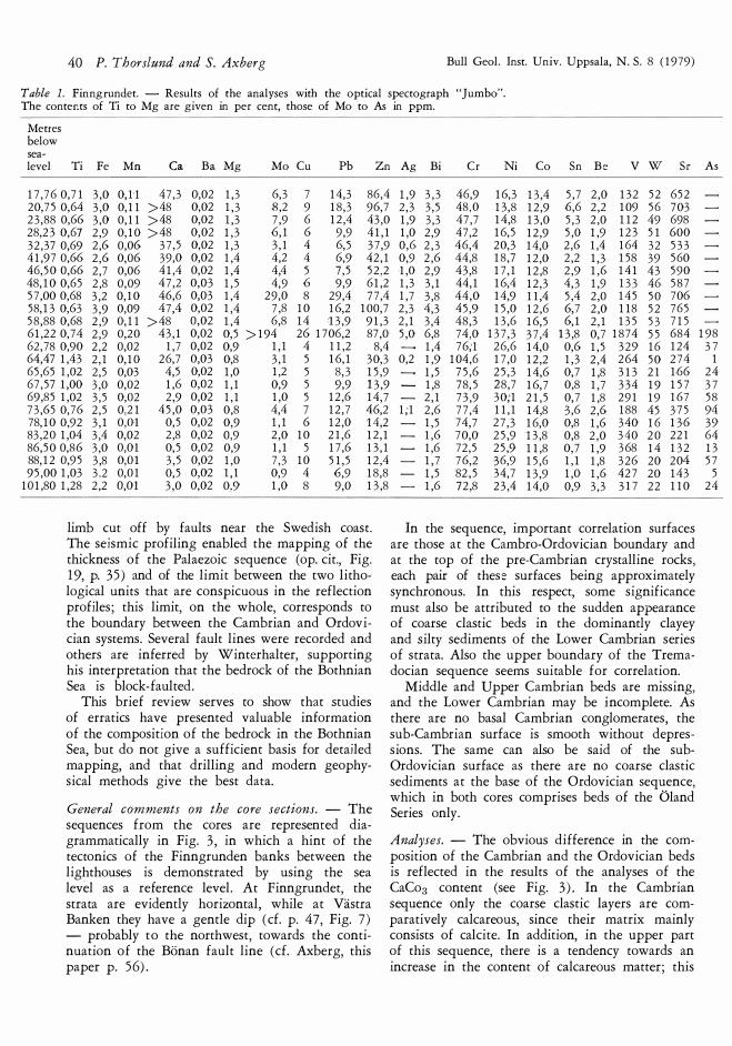
Table l. Finngrundet. - Results of the analyses with the optical spectograph "Jumbo". The conter.ts of Ti to Mg are given in per cent, those of Mo to As in ppm.
M et res bel o w sea-leve! T i Fe M n Ca B a Mg Mo C u P b Z n Ag Bi C r Ni C o Sn Be v w Sr
17,76 0,71 3,0 0,1'1 47,3 0,02 1,3 6,3 7 14,3 86,4 1,9 3,3 46,9 16,3 13,4 5,7 2,0 132 52 652 20,75 0,64 3,0 0,11 >48 0,02 1,3 8,2 9 18,3 96,7 2,3 3,5 48,0 13,8 12,9 6,6 2,2 109 56 703 23,88 0,66 3,0 0,11 >48 0,02 1,3 7,9 6 12,4 43,0 1,9 3,3 47,7 14,8 13,0 5,3 2,0 112 49 698 28,23 0,67 2,9 0,10 >48 0,02 1,3 6,1 6 9,9 41,1 32,37 0,69 2,6 0,06 37,5 0,02 1,3 3,1 4 6,5 37,9 41,97 0,66 2,6 0,06 39,0 0,02 1,4 4,2 4 6,9 42,1 46,50 0,66 2,7 0,06 41,4 0,02 1,4 4,4 5 7,5 52,2 48,10 0,65 2,8 0,09 47,2 0,03 1,5 4,9 6 9,9 61,2 57,00 0,68 3,2 0,10 46,6 0,03 1,4 29,0 8 29,4 77,4 58,13 0,63 3,9 0,09 47,4 0,02 1,4 7,8 10 16,2 100,7 58,88 0,68 2,9 0,11 >48 0,02 1,4 6,8 14 B,9 91,3 61,22 0,74 2,9 0,20 43,1 0,02 0,5 >194 26 1706,2 87,0 62,78 0,90 2,2 0,02 1,7 0,02 0,9 1,1 4 11,2 8,4 64,47 1,43 2,1 0,10 26,7 O,o3 0,8 3,1 5 16,1 30,3 65,65 1,02 2,5 0,03 4,5 0,02 1,0 1,2 5 8,3 15,9 67,57 1,00 3,0 0,02 1,6 0,02 1,1 0,9 5 9,9 13,9 69,85 1,02 3,5 0,02 2,9 0,02 1,1 1,0 5 12,6 14,7 73,65 0,76 2,5 0,21 45,0 0,03 0,8 4,4 7 12,7 46,2 78,10 0,92 3,1 O ,Dl 0,5 0,02 0,9 1,1 6 12,0 •14,2 83,20 1,04 3,4 0,02 2,8 0,02 0,9 2,0 10 21,6 12,1 86,50 0,86 3,0 O,ol 0,5 0,02 0,9 1,1 5 17,6 13,1 88,12 0,95 3,8 O ,Dl 3,5 0,02 1,0 7,3 10 51,5 12,4 95,00 1,03 3.2 0,01 0,5 0,02 l, l 0,9 4 6,9 18,8
101,80 1,28 2,2 om 3,0 0,02 0,9 1,0 8 9,0 13,8
limb cut off by faults near the Swedish coast. The seismic profiling enabled the mapping of the thickness of the Palaezoic sequence (op. cit., Fig. 1 9, p. 3 5 ) and of the limit between the two lithological units that are conspicuous in the reflection profiles ; this limit, on the whole, earresponds to the boundary between the Cambrian and Ordovician systems. Several fault lines were recorded and others are inferred by Winterhalter, supporting his interpretation that the bedrock of the Bothnian Sea is block-faulted .
This brief review serves to show that studies of erratics have presenred valuable information of the composition of the bedrock in the Bothnian Sea, but do not give a sufficient basis for detailed mapping, and that drilling and modern geophysical methods give the best data.
General comments on the care sections. - The sequences from the cores are represemed diagrammatically in Fig. 3, in which a hint of the tectonics of the Finngrunden banks between the lighthouses is demonstrated by using the sea level as a reference level . At Finngrundet, the strata are evidently horizontal, while at Västra Banken they have a gentle dip ( cf. p. 47, Fig. 7 ) - probably to the northwest, towards the continuation of the Bönan fault line ( cf. Ax berg, this paper p. 5 6) .
1,0 2,9 47,2 16,5 12,9 5,0 1,9 123 51 600 0,6 2,3 46,4 20,3 14,0 2,6 1,4 164 32 533 0,9 2,6 44,8 18,7 12,0 2,2 1,3 158 39 560 1,0 2,9 43,8 17,1 12,8 2,9 1,6 141 43 590 1,3 3,1 44,1 16,4 12,3 4,3 1,9 133 46 587 1,7 3,8 44,0 14,9 11,4 5,4 2,0 145 50 706 2,3 4,3 45,9 15,0 12,6 6,7 2,0 118 52 765 2,1 3,4 48,3 13,6 16,5 6,1 2,1 135 53 715 5,0 6,8 74,0 137,3 37,4 13,8 0,7 1874 55 684
1,4 76;1 26,6 14,0 0,6 1,5 329 16 124 0,2 1,9 104,6 17,0 12,2 1,3 2,4 264 50 274
1,5 75,6 25,3 14,6 0,7 1,8 313 21 166 1,8 78,5 28,7 16,7 0,8 1,7 334 19 157 2,1 73,9 30;1 21,5 0,7 1,8 291 19 167
1;1 2,6 77,4 11,1 14,8 3,6 2,6 188 45 375 1,5 74,7 27,3 16,0 0,8 1,6 340 16 136 1,6 70,0 25,9 13,8 0,8 2,0 340 20 221 1,6 72,5 25,9 11,8 0,7 1,9 368 14 132 1,7 76,2 36,9 15,6 1,1 1,8 326 20 204 1,5 82,5 34,7 13,9 1,0 1,6 427 20 143 1,6 72,8 23,4 14,0 0,9 3,3 317 22 110
In the sequence, importallt earrelation surfaces are those at the Cambro-Ordovician boundary and at the top of the pre-Cambrian crystalline rocks, each pair of these surfaces being approximately synchronous. In this respect, some significance must also be attributed to the sudden appearance of coarse clastic beds in the dominandy clayey and silty sediments of the Lower Cambrian series of strata. Also the upper boundary of the Tremadocian sequence seems suitable for correlation.
Middle and U p per Cambrian beds are miss in g, and the Lower Cambrian may be incomplete. As there are no basal Cambrian conglomerates , the sub-Cambrian surface is smooth without depressions. The same can also be said of the subOrdovician surface as there are no coarse clastic sediments at the base of the Ordavieian sequence, which in both cores comprises beds of the Öland Series only.
Analyses. - The obvious difference in the earnposition of the Cambrian and the Ordavieian beds is reflected in the results of the analyses of the CaCo3 content (see Fig. 3 ) . In the Cambrian sequence only the coarse clastic layers are comparatively calcareous, since their matrix mainly consists of calcite. In addition, in the upper part of this sequence, there is a tendency towards an increase in the content of calcareous matter ; this
As
198 37
l 24 37 58 94 39 64 13 57
5 24

Bull. Geol. Inst. Univ. Uppsala, N. S. 8 (1979) Geology of the southern Bothnian Sea 4 1
Table 2 . Västra Banken. - Results of the analyses with the optical spectrograph "Jumbo". The conter:ts of Ti to Mg are given in per cent, those of Mo to Ge in ppm.
Merres bel o w sea-leve! T i Fe M n Ca B a Mg Mo C u P b Z n Ag Bi Ni C o Sn Be v w Sr As Ge
54,55 0,68 2,7 0,10 51,5 0,04 1,5 5,3 3 9,3 75,1 1,5 2,7 17,7 13,6 5,1 1,9 126 46 660 o o 60,50 0,71 3,2 0,15 >52 0,19 1,5 7,7 9 15,1 112,4 2,4 3,5 16,8 15,3 6,9 2,3 105 61 779 o 0,264 66,50 72,50 78,50 81,95 87,35 93,23 99,15
104,25 107,52 108,25 108,85 109,45 110,06 Il 0,29 110,38 110,49 110,59 110,61 110,78 111,30 115,30 119,45 122,87 126,35 126,60 129,30 135,30 13 7,90 139,31 141,10 143,95
0,71 3,3 0,18 >52 0,02 1,3 10,2 11 21,5 0,70 3,0 0,09 44,7 0,03 1,6 4,0 4 7,0 0,78 3,0 0,11 43,2 0,03 1,3 5,4 6 1 1,0 0,74 3,2 0,12 49,8 0,12 1,4 6,6 7 13,7 0,74 2,9 0,12 47,3 0,03 1,5 5,3 7 -10,0 0,75 3,3 0,12 52 0,04 1,3 8,0 9 17,2 0,72 3,1 0,07 33,2 0,03 1,2 2,2 2 4,6 0,8"1 3,7 0,08 43,8 0,03 1,4 4,6 4 8,7 0,73 3,5 0,06 34,4 0,03 1,3 2,6 2 4,.8 0,78 2,2 0,02 4,8 0,15 l, l 0,7 4 12,9 0,68 3,5 0,13 > 0,11 1,4 8,8 27 18,4 0,70 4,3 0,11 46,4 0,03 1,4 5,1 12 11,0 0,89 2,5 0,04 35,3 0,06 1,4 5,1 3 4,9 0,91 2,6 0,03 15,4 0,05 l, 7 1,5 5 4,3 0,78 2,6 0,03 6,6 0,35 1,0 0,7 3 4;1 0,59 3,1 0,05 23,6 0,36 1,0 1,4 6 5,6 0,84 2;6 0,09 34,4 0,27 0,7 14,1 27 94,5 O,Sl 2,4 0,10 36,4 0,22 0,8 8,8 19 440,2 0,83 2,9 0,13 41,3 0,07 0,8 >187 42 150,4 1,24 2,4 0,03 5,0 0,03 0,9 0,7 5 20,3 0,88 2,3 0,02 1,1 0,02 1,0 2,0 4 8,4 0,94 2,6 0,03 1,6 0,03 1,0 0,9 4 10,4 0,79 2,0 0,21 39,6 0,03 0,8 5,7 7 9,3 1,01 3,0 0,01 1,7 0,02 1,0 6,9 5 21,2 1,09 3,0 0,03 4,5 0,03 l, l 0,6 6 25,5 l ,12 2,9 0,04 12,6 0,02 0,9 0,7 lO 64,8 1,45 2,5 0,04 13,6 O,G3 0,9 1,0 41 16,6 1,03 3,1 0,02 0,8 0,02 1,4 0,4 l 9,6 1,04 2,7 0,03 1,6 0,02 1,3 1,0 2 5,4 0,99 2,9 0,02 0,5 0,03 1,2 0,5 3 4,4 0,65 3,2 0,50 52 0,04 0,6 9,6 23 19,9
is pronounced in the Finngrundet core sequence in which a comparatively thick bed of argillaceous limestone occurs near the top.
Some samples, most of them taken from the core above the Cambro-Ordovician boundary to l 1/2 m from this boundary, were analysed for their phosphorus content, with the following result:
Finngrundet M et res
59,86 60,24 60,47 + 60,64 + 61,22 + 61,41 61,88
0,84 4,70 6,98 4,02 1,84 1,38 0,19
0,19' 1,48 2,22 3,60 6,64 7,86 5,88
Västra Banken M et res
109,82 110,06 11 0,29' 110,46 110,5 7 + 110,69'+ 110,71 +
146,0 3,4 3,8 13,2 14,0 9,9 2,6 93 77 844 o 0.500 57,9 1,1 2,7 16,4 14,3 4,0 1,9 146 41 629 o o 81,1 1,6 3,1 16,8 14,7 4,3 2,0 146 53 709 o 0,181 98,6 2,2 3,2 16,7 14,9 5,9 2,3 122 58 753 o 0,261 80,7 1,6 3,1 18,9 19,1 4,3 2,0 158 49 728 o 0,153
113,8 2,5 3,5 18,0 16,1 7,3 2,2 149 65 787 o 0,415 36,6 0,4 2,2 24,6 14,5 2,2 1,5 179 29 529 o o 67,0 1,2 3,1 20,4 13,8 4,3 1,8 175 46 640 o 0,073 36,3 0,5 2,2 20,3 11,4 2,1 1,4 181 32 560 o o 16,1 o 1,4 33,6 60,0 0,7 1,0 365 15 220 19 0,002
125,1 2,9 3,8 12,6 13,0 8,2 2,5 114 64 864 o 0,515 79,6 1,5 3,3 15,2 10,7 5,0 1,6 134 48 721 o 0,200 32,1 0,3 1,8 19,4 10,6 2,0 1,6 205 34 400 o o 15,5 o 1,4 21,5 8,7 0,8 1,3 232 25 326 12 o 16,6 o 1,5 26,6 12,1 0,6 1,3 384 14 517 o 0,029 20,9 0,1 1,9 13,4 7,9 1,6 2,2 722 20 772 o 0,165 49,4 4,1 3,0 132,9 210,0 3,8 o 2613 63 997 700 0,064 49,8 3,4 2,8 141,6 206,3 3,6 o 2509 63 980 628 0,321 87,5 4,3 4,2 59,2 97,6 7,7 1,8 911 80 1150 222 0,972
149,5 o 1,4 22,5 16,6 0,7 1,5 270 27 186 41 0,027 12,4 o 1,2 26,0 15,0 0,5 1,4 321 12 118 o 0,050 14,7 o 1,2 29,0 17,4 1,0 1,2 418 18 166 6 0,064 34,0 0,5 2,2 11,8 10,1 2,7 1,2 341 35 327 o o 16,5 o l, l 27,3 14,6 0,9 1,5 343 24 197 59 0,089 15,4 o 1,0 22,6 12,9 0,8 1,7 339 25 223 24 0,044 24,8 o 1,8 20,4 15,9 1,6 2,4 586 27 189 35,1 0,1 1,3 26,5 22,2 7,3 3,0 269 35 179 14,6 o 1,4 38,4 23,5 0,8 2,0 444 18 140 15,5 o 1,4 32,6 15,0 0,8 2,3 423 23 161 16,6 o 1,2 34,6 16,8 0,7 "1,8 435 20 125 92,0 2,4 3,0 16,9 20,8 6,5 5,4 400 9'6 > 1364
The above analyses were performed, using photospectrometry, by Dr. Ulf Sturesson at the PaleontologicaJ Institute in Uppsala.
The analyses of selected elements were carried out with the optical spectograph "Jumbo" at the Geologica·l Survey of Sweden, and the results are seen in Tables l (Finngrundet) and 2 (Västra Banken) . Comments on the analyses are given on p. 48.
Dr. Astrid Andersson at the Ransradverket Laboratory of the Atomic Energy Authority, kindly carried out analyses on two samples of Dictyonema shale from the Finngrundet core with the following result:
Finngrundet 60,78 m
Finngrundet 61,15 m
V%
0,172 0,209•
l U%
l 0,0241 0,0191
14 o 16 o 28 0,087 13 0,062 15 0,085
o 0,061
+ Samples taken from the Tremadocian Dictyonema-Obolus beds. The pre-Cambrian rocks. - Gneissic rocks form

42 P. Thors/und and S. Axberg
T ab le 3. The pre-Cambrian part of the Finngrundet core.
Merres below sea-leve!
Bull Geol . Inst. Univ. Uppsala, N. S . 8 (1979)
102,01-117,55 Reddish grey, originally coarse augen-granite which is strongly schistase (augen-gneiss-granite) and shows considetable weathering (kaolinization?) . The schistosity planes have an angle of about 45 o with the axis of the core. There are a few dikes or dikelers of red pegmatite; between l 09,9 and 111,2 some inrerealarians of weathered fine-grained amphibolire.
117,55-118,0 Breccia of augen-gneiss-granite, weathered.
118,0 -118,60 Augen-gneiss-granite as between 102,01 and 117,55. 118,60--119,10 Brecciated, and in part disintegrated, augen-gneiss-granite; weathered.
119,10-119,40 Augen-gneiss-granite as between 102,11 and 117,55. 119,40--121,26 Red, acid, coarse to medium-grained gneiss-granite; weathered.
121,26-126,28 Augen-gneiss-granite as between 102,01 and n 7,55. 126,28-126,90 Amphibolite, fine-ro finely medium-grained; weathered.
126,90-132,35 .Augen-gneiss-granite as berween 102,01 and 117,55. 132,35-133,42 Augen-gneiss-granite interstratified with amphibolite; both weathered.
133,42-134,35 Brecciated and partly disintegrated augen-gneiss-granite; weathered, and cut by a vertical crack filled with calcite.
134,35-167,60 Augen-gneiss-granite as between 102,01 and 117,55, although not so strongly weathered. The rock conmins scatrered zones of brecciatian and thin zones of mylonite. Pegmatite is lacking, but the gneiss-granite has been locally transformed (regenerated) to coarse, secondary granite without any visible signs of schistosity. Wearhering is weaker in the secontlary granite than in the gneiss-granite.
the substratum of the Cambro-Ordovician sequence in both cores .
At Västra Banken, the borehole penetrated 4, 1 3 m o f reddish grey augen-gneiss -granite with strong schistosity. Two pegmatite dikes occur, one of which is beneath the Cambrian beds ( cf. Pl. l, Fig. A) being 3 1 cm thick and resting on a comparatively fine-grained gneiss with a dip of about 50° in relation to the axis of the core. The weathering is strong and the feldspars of the pegmatites have been partly altered to kaolin( ? ) .
The pre-Cambrian part o f the Finngrundet core was investigated by Dr. P. H. Lundegårdh of the Geological Survey of Sweden (Table 3 p. 42) . From his investigation Lundegårdh concludes: "lt is evident that the pre-Cambrian crystalline basement has been cut by a tectonic zone in the vicinity of the borehole. The large vertical extent of the weathering indicates a down-fault of the pre-Cambrian crystalline basement."
T h e Quaternary beds at Västra Banken
According to the borehole log, the sediments immediately beneath the l ighthouse are clayey and silty with boulders and pebbles, of which only fragments of grey Ordavieian limestone and predominant pre-Cambrian rocks were recovered from the boring.
Between 25,30 m and 34,20 m below sea-level core portions were taken from the sediments
( together 6,20 m) comprising sandy, grey and brownish till with fragments of pre-Cambrian crystalline rocks and of red and grey Ordavieian l imestones. Below a depth of 34,20 m, and above the bedrock surface, there are a few remaining fragments of pre-Cambrian rocks and abundant pieces of grey limestone, some of which represent the Upper Ordavieian "Östersjökalksten" (Baltic l imestone) .
T h e Cambrian sequence
Only the Early Cambrian beds are present in the Cambrian sediments of the cores . These are almost 7,5 m thicker at Finngrundet than at Västra Banken, being 40,95 m and 33 ,29 m, respectively. So far, the Cambrian sequence of the cores has mainly been studied macroscopically. The results of this investigation are given in Tables 4 and 5 (pp. 44 and 45, resp.) , and diagrammatically illustrared in Fig. 4. Parts of the Cambrian section of the core from Västra Banken are showa in Flate l, Figs. B-E. However, a doser sedimentological study is necessary and will be done later. For a general view of the development of the Early Cambrian sedimentation in the Bothnian Gulf area, more material is required, which means taking cores from the central and northern part of the area. The investigation so far has resulted in many problems, the interpretation of which will be made possible and easier only by the acquisition of new material.
From the results of Wiman's research, it may be thought that the Cambrian sequence in the area

Bull. Geol. Inst. Univ. Uppsala, N. S. 8 (1979)
z w :::,c z <! CD
<! 0:: lU) :<t >
l
w o z � 0:: (!) z z
I.J....
III c o iii Cll E
rtl Cll 1...
o .... u
<{
Cll c o Vl >, rtl u
Cll c o iii Vl
2 o o
Geology of the southern 8othnian Sea 43
Cll c o iii Vl >,
"O c rtl Vl
Cll c o iii "O c rtl Vl
:;:;. Vl
� Cll ::J Ol c
.>e: u o 1...
3: o 1... u
Cll c o iii "O c rtl Vl
Vl Cll ::J c o o Cll .... '- Vl lll-o �c rtl rt) u Vl
Cll n; 1... Cll E o Cll -V) Olo C .:c: 0'-u "'
c "' ·.::: .o
E "'
u di 1... a. m •.. . . i l� ••• •••••• ••
o "'
N "'
c:: ·C ..0 8 u
<U -5 o c: .g
u
�

44 P. Thorslund and S. Axberg
T ab le 4. The Lo we r Cambrian sequence at Finngrur.det.
Merres below sea-leve!
Bull Geol . lnst. Univ. Uppsala, N. S . 8 (1979)
102,01-117,55 Basement: Reddish grey, coarse augen-granite, strongly schistoce (augen-geniss-granite) and rather strongly weathered (kaolinized?) .
101,94-102,01 Greenish grey day with thin seams of dayey arkose. A layer of dayey grave! at the indistinct boundary toward the sub-stratum, the uppermost part of which has thin fissures filled with day.
101,77-101,94 Greenish grey day and siltstone wi,rh a few thin intercalations of whitish grey fine-grained sandstone. At 101,91 m crystals and aggregates of pyrite.
98,39-101,77 Grey siltstone alternating with comparatively thin layers of day, and with !enses, lumps, seams, layers, and tubes of various form of light grey fine-grained sandstone, the content of day decreasing upwards in the sequence. Beds of hard calcareous sandstone, 5 cm and l O cm chick, at 100,12 m and 99,13 m respecrively.
98,27- 98,34 Greenish to yellowish grey, mottled (white-spotted) sandstone with sparse glauconite. Scattered small pellets rich in Ti (cf. Fig. 5).
98,05- 98,27 Crushed into pieces during the drilling: greenish grey siltstone with glauconite, concretions of pyrite, grey argillaceous sandstone, a bed of calcareous sandstone intersected with branching fissures filled with calcite.
96,92- 98,05 Grey, partly silty sandstone, almost without stratification throughout. "Crow rock" (Hessland 1953).
95,92- 96,92 Greenish grey and light grey argillaceous sandstone, some parts mottled brown-reddish, with irregular stratification, occasional cross-bedding, and with a few almost vertical tubes. Glauconite very rare.
9'2,13- 95,92 Argillaceous, fine-grained sandstone, grey with scatrered small parts reddish brown, and with irregular stratification. Content of glauconite scarse. A hard bed, 4 cm chick, at 93,82 m. Mickwitzia sp. at 94,97 m. "Crow rock".
89,12- 92,13 Grey to dark grey siltstone with irregular intercalations and lumps of light grey sandstone up to 90,62 m; subsequently siltstone and silty day with thin layers of fine-grained sandstone with glauconite. Dark brown "spors", branches, and filaments of "algae". A 4 cm chick bed of calcareous sandstone at 91,94 m, intersected with branching fissures filled with calcite.
87,27- 89,12 Dark, upwards darkish grey shaly siltstone with !enses, lumps, and thin, in some parts, very thin, seams of l ight grey sandstone with glauconite.
84,13- 87,27 Darkish grey and grey daystone with thin layers or lenses of light grey sandstone, upwards grading into silty daystone with scatrered lenses and layers of sandstone to which the content of glauconite is concentrated . - A ctrotreta sp. at 89,50 m.
83,52- 84,13 Sequence with graded bedding, each unit consisting of grey argillaceous sandstone with glauconite, irregularly stratified, upwards grading into dark siltstone.
79,97- 83,52 Greenish grey argillaceous sandstone with glauconite bur without stratification. Below 81,22 m a bed, 10 m chick, of light grey calcareous sandstone intersected with branching fissures filled with calcite. ? Kutargina s p. at 82,02 m, Volbarthella s p. at 82,22 m.
76,62- 79,97 Claysrone and silty daystone with a few intercalations of light grey sandstone with glauconite. "Algae" common. The uppermost 0,7 m consist of grey, soft, montmorillonitic day. Oboltts ( Westonica) wimani Walcott and A crotreta s p. at 78,22 m.
76,56- 76,62 Grey silty day with lenses and lumps of coarse arkosic sandstone.
74,46- 76,56 Dark siltstone with irregular intercalations of light grey sandstone with glauconite.
75,87- 76,46 Light grey, fine-grained sandstone, comparatively hard, with glauconite and grains of feldspar, and with a few thin silty layers.
72,50- 75,87 Arkosic sandsrone and arkose, partly coarse, with a few intercalarions of siltstone, of which the thickest, 11 cm, occurs above 72,97 m. The arkosic beds with calcire matrix. Accumulations ot pyrite in the uppermost part.
72,20- 72,50 Brown to greenish oolite with nodules of phosphorite. The ooids are mixed with arkosic sand.
71,96- 72,20 Dark grey, medium-grained sandstone with pyrite.
67,0 - 71,96 Grey and dark-grey siltsrone with some intercalations of daystone, and with thin layers, seems, ]enses, and lumps of light grey sandstone with glauconite. A crotreta sp. at 69,27 m.
61,94- 67 ,O Dark grey siltstone and daystone with Iaminately stratified layers and flat lenses of light grey, fine-grained sandsrone, the content of sandy intercalarions decreasing upwards in the sequence. Above 64,5 5 a bed, 21 cm chick, of grey hard sandstone. A bed of argillaceous limestone, 30 cm chick, above 64,00 m has cone-in-cone structures in the basal part and branching fissures filled with calcite in the middle part. Aggregates of pyrite occur as concretions and thin layers (?) , the chickest one, 8 mm, at 62,98 m.
61,27- 61,94 Grey daysrone and day with a Jayer (or a !ens ) , l cm chick, of pyrite about 5 cm below the Cambro-Ordovician boundary. The topmost part, 1,5 cm chick, of the day sequence is whitish grey and has small aggregates of pyrite.

Bull. Geol. Inst. Univ. Uppsala, N. S. 8 ( 1 979) Geology of the southern Bothnian Sea 45
Table 5 . The Lower Cambrian sequence at Västra Banken (PI. I, Figs. A-F) .
Merres below sea-leve!
1 44,38-148,20 Basement: Red and reddish grey gneiss with pegmatite veins, weathered. - 1 44,07- 1 44,38 Pegmatite, strongly wearhered (kaolinized?) .
143 ,9·6-1 44,07 Hard conglomeracic sandstone or arkose with calcareous matrix, and with weil rounded fragments, those of quartz up to 6 mm,. some feJdspar grains slightly larger.
1 4 1 ,68- 1 4 3 ,96 Argillaceous sandstone varying in coarseness and colour, below 1 4 3 ,2 0 m with intercalations of dark grey siltstone, between 1 42,40 m and 1 4 3 ,0 m, and 1 4 1 ,90 m and 1 42,0 m mostly brownish red with some yellowish brown parts, and with lumps of light grey sandstone. Arkosic beds with sharp boundaries toward their fine-grained substratum (tida! graded bedding; PI. l, Fig. B ) . Some small grains o f glauconite in the uppermost silty part above 1 4 1 ,90 m .
1 40,90- 1 4 1 ,68 Dark grey sandy siltstone with "spors" and filaments o f "algae". Glauconite infrequent. Lingulella sp. at 1 4 1 , 3 8 m.
1 3 8,44- 1 40,90 Mottled grey and darkish grey, silty sandstone with glauconite ( "crow rock") .
1 3 3 , 35-1 3 8,44 Beds, !enses, and lumps of light grey fine-grained sandstone with glauconite sparsely, interealared with layers of dark grey siltstone and a few layers of day, or daystone. "Crow rock" structure in some parts. The sandstone beds between 1 3 3,40 m and 1 3 5 ,26 m are impregnated with bituminous matter (PI. l, Fig. C) .
1 2 3 , 5 2-1 3 3 , 3 5 Dark grey sandstone with "crow rock" structure alternating with beds of siltstone and sandy siltstone. 1 32 ,98- 1 3 3 , 3 5 m "crow rock" with stmall aggregates of pyrite, and with phosphoitic nodules in the lower part; 1 29 ,34 m-1 2 9 , 5 0 m hard, sernewhat calcareous sandstone, comparatively coarse, with glauconite and scatrered coarse grains of quartz and feJdspar (PI. l, Fig. D) .
1 2 3 ,09- 1 2 3 , 5 2 Coarse arkosic sandstone with phosphoritic nodules. Matrix with glauconite, calcareous and sernewhat argillaceous. A fragment of feJdspar at 1 2 3 , 5 0 m is 22 mm Iong (PI. l, Fig. E) .
1 1 6,95-1 2 3 ,09 Dark grey siltstone and silty sandstone with glauconite; below 1 1 7 , 1 0 m with irregular stratification, containing seams, !enses, and sporadic lumps of sandstone, partly with calcareous matrix; coarse arkosic beds, 5 cm and 3 cm thick, below 1 22,84 m and 1 22 ,70 m respectively.
1 1 4,25- 1 1 6,95 Mainly dark grey silty daystone and daystone.
1 1 0,78- 1 1 4,25 Mainly dark grey siltstone with mostly thin inrercalations of fine-grained sandstone with glauconite. 1 1 4, 1 2 m-1 1 4,2 5 m slightly calcareous sandstone with aggregates of galena. Some layers of light grey day in the uppermost part. Crystals and aggregates (thin layers, !enses) of pyrite occur with intetvals throughout this part of the sequence.
is mainly built up of comparatively bard beds, Sandstones and clastics. lt is easy to imagine, however, that due to glacial erosion, only fragments of such beds could become erratics . The loose silty and clayey components of the sequence, eroded and carried by the ice, were disintegrated and redeposited wirhin a southerly fan from the area, forming an important constimtent of the Quaternary clayey beds there.
As shown in Fig. 4, the content of sandstone and sandy sediments in the cores is relatively small, decreasing in an easterly direction wirhin the Finngrunden banks. As the thickness of the sequence increases in that direction, so does the content of clayey matter. lt is also evident, that the bulk of the erraticcs collected and described by Wiman were brought from a large area north of the Finngrunden banks.
A first glance at the core seetians brings to light three notable observations . One of them cancerns the absence of conglomerates, or coarser beds of any thickness, at the base of the sequence. This means that the sub-Cambrian surface under the lighthouse of the Finngrunden banks is smooth.
This surface was formed by denudation over a long period, which seems evident from the fact that the basernem rocks of pre-Cambrian gneisses are weathered, and in some places, deeply weathered.
A seeond observation of particular interest refers to the sudden appearance of fairly coarse arkosic beds situated in the sequence surprisingly high above its base. A definite interpretation of the environment of deposition of these beds will be
a b Fig. 5. a. Pellet from the core portion 98,2 7-98,34 m from Finngrundet (Table 4 p. 00) . X 1 000 in SEM. b. X-ray image of the same pellet showing the high concentration of Ti. Photo Henning Ivert.

46 P. Thorslund and S . Axberg
6 1 , 27
F l N N G R U N D E T
li;i.l;i;l g l a u c o n i t i c l i m e ste n e
� �i�;rs e} st i nkstone
• a l um s h a l e
L.,:.:.,>j �i��� }����us�one
t===j Camb r i an c l ay
Bull GeoL Inse. Univ. Uppsala, N. S . 8 ( 1 979)
possible in the future with more material available from other parts of the marine area. Evidently, the arkosic sediments emanated from pre-Cambrian rocks exposed between the Caledonian geosyncline and the Bothnian Gulf in an area (peninsula ? ) from where they were dispersed by streams, probably turbidity currents . It should be noted that the arkosic beds are thicker at Finngrundet than at Västra Banken which may indicate the direction of the streams. From Winterhalter's paper ( 1 9'72 , p. 3 5 , Fig. 1 9 ) , it is possible to conclude that the thickness of the Cambrian sequence increases considerably to the northeast and the north from the Finngrunden banks. It can also be postulared that an increase in thickness took place from these banks in a southerly direction towards Gotland, the thickness of the Lower Cambrian sequence of strata with fossils be in g 5 7,5 m at Gotska Sandön and approximately 80 m at File Haidar on Gotland.
Calcareous beds in the sequence, particularly at Finngrundet, are notable and also the rich occurrence of pyrite in the uppermost clayey part.
"Crow rock", mentioned in Tables 4 and 5, is a translation (Hessland 1 95 3 p. 5 3 ) of the local Swedish word kråksten, by Westergård ( 1 938 p. 1 6) described as "a peculiar greenish grey spotred rock, made up of rapidly alternating, very thin layers or small lenses of argillaceous or pure sandstone and shale in which the originally pronounced stratification has been veiled or destroyed by burrowing animals" .
The Lower Tremadocian beds
The Ordavieian Series begins in both cores with Dictyonema-Obolus beds. Their thickness at Finngrundet, 0,99 m, is nearly five times that at Västra Banken. They consist of three main lithological components : sandstone, alum shales, and l imestone (stinkstone) . The distribution of these components can be seen from Figs. 6 and 7 .
The basal sandstone layer, about 1 ,5 cm thick in both cores, is slightly coarser than the other beds below the l imestone. Like those, it consists of an impure quartz sandstone, spotred by flakes of mica (biotite and muscovite, the latter less common) , with scatrered grains of glauconite, small aggregates or single crystals of pyrite, and a calcareous matrix.
A !ense- or crescent-shaped pyrite concretion of at !east 3 cm thickness was pierced at Finn-
Fig. 6. Diagrammarie seecion of the lowermosc Ordavieian beds at FinngruP.dec.

Bull. Geol. Inst. Univ. Uppsala, N. S. 8 ( 1 979)
grundet, and is located in the core portion below the limesrone. Similar concretions of various size have been reporred from deposits of moraine in East Sweden; they are supposed to derive from Tremadocian Ceratopyge shales in the Gulf area (Hessland 1 949) .
The sandstone is unsorted, with rounded or subrounded grains . As seen in the basal layer at Finngrundet, the largest grains of quarrz are 0,4 X 0,34 mm; grains of feldspar are rare, the largest of rhose observed being 0,4 X 0,3 mm. Small fragments of inarriculate brachiopods are not uncommon, bur are more frequent towards the rop of the sequence, and this is reHecred in the content of phosphate (cf. p. 4 1 ) . Determinable fragments of Obolus occur in the upper l ight sandsrone which is spotred green by glauconite. The darker sandsrone has a varying content of bituminous matter.
Occasionally, the alum shales contain flakes of mica, small shell fragments, mostly weathered white or blue from vivianite, and pyrite or marcasite. These minute components, rogerher with conodonts, are concentrared on some "bedding surfaces" ; they also occur profusely in transmon zones between sandsrone beds and pure shales, or as interealatians in the shales.
Fragments of graptolires are found in the shaly parts. They are small and indeterminable in the Västra Banken core. A few bigger fragments of Dictyonema in the lower and upper shales of the Finngrundet core do not permit a specific determination due to the imperfect preservation. They may, however, belong to specimens of Dictyonema sociale (Salter) or Dictyonema flabelliforme (Eichwald) , with those in the shales beneath the limestone possibly belonging to the former species, and those above it, to the latter. Apparently, shales with D. sociale are present in the sequence norrh of the Finngrunden banks. According to Tjernvik (personal communication) , this species was found by him in an erratic piece of Obolus conglomerare with a shaly surface on the coast outside the rown of Söderhamn. It has also been collected in a rhin lense of alum shale interealared in the basal Ordavieian conglamerate at skattungbyn in the Siljan district. The original description of D. flabelliforme was based on specimens occurring in Tremadocian shales of the Baltischporr ( = Paldiski) district of Esronia ( cf. Bulman 1966) .
In some respects , the sequence at Finngrunder is similar to that in Estonia where the thickness, however, is much greater. The repetition of sandsrone beds with layers of Dictyonema shale is a disrincrive feature common to both (Fig. 8 ) .
Geology of the southern Bothnian Sea 47
VÄ S T R A B A N K E N
Fig. 7 . O bolus-Dictyonema beds of the Västra Banken care with a diagramrnatic seetian (legend, see Fig. 6 ) .

48 P. T horslund a11d S. Ax berg
Fig. 8. Core portion wirh alum shale (black) and Obolus Sandstone indicating shifrs in direction or strength of water currents during deposition. Finngrundet.
In Estonia, this repetition occurs in the upper part of the sequence and beneath a topmosr, comparatively thick bed of Dictyonema shales . The Estonian sandstone, with or without shell beds and conglomerates, forms the lower part of the sequence (cf. Öpik 1 929) . Beds korresponding to these deposirs, and also to the widespread thick beds of detrims and marcasite in W estern Esto nia, are not found in the Finngrunden core secrions in which the Dictyonema shales are covered by Obolus Sandstone. The upper boundary of this sandstone is represenred by a disconrinuity surface (PI. I, Fig. F) . The richly glauconitiferous limestone above it conrains scatrered grains of quartz and a number of redeposited fragments of Obolus.
As in Estonia, the Ordavieian Period in the Bothnian Gulf area commenced with a transgression after a considerable hiatus, and this is reflected by the sudden appearance of high contents of several trace elements in the Tremadocian beds. Such elements are, for insrance, V, Mo, Ag, Pb, Cu, Sr, Sn, Ni, Bi, W, and Ge (Tables l and 2, p. 40 and 4 1 , resp. ; cf. Loog 1 962 p. 290).
A cknowledgements. - The borehole projecr on the Finngrunden shoals was made possible through the support and assistence of the following aurhoriries and gentlemen to whom I am greatly indebted : the authoriries of the Swedish Board of Navigation, particularly Gunnar Kjellgren and Björn Tännström, respectively former Direcror and Assistent Director of the Building Section of this Board ; Ansgar Falkenborn, former Director of the Pilot Service of Gävle ; Mr. Gunnar Brundell, Gävle; K. A. Linclbergson, former Direecor-General
Bull Geol. Inse. Univ. Uppsala, N. S . 8 ( 1 9 79)
of the Swedish GeologicaJ Survey; my colleagues, Professors I. Hessland, University of Srockholm, G. Regnell, University of Lund, and R. A. Reyment, University of Uppsala; to the men who did the drilling, and to the boat crews for transporting equipment to and from the l ighrhouses.
My sincere rhanks are also due to the rechnical staff of the PaleontologicaJ Institute in Uppsala for rheir valuable assistance during the preparation of this report, particularly to Mrs. Dagmar Engström for preparing the text figures, Mrs. Eva Eklind for typing the manuscript, Mr. Gustav Andersson for photographs, and Dr. Niall Mareer for the linguistic correction of my manuscript. Professor Reyment has kindly criticized ancl reviewed the entire manuscript. Thanks are due to Professor B. Collini for generous help with the manuscript.
Last, bur not !east, I want to thank my co-authors for their contribution to the results obtained up to now to the borehole project, and particularly I want to address myself to Torsten Tjernvik, whose eminent knowledge of the Lower Ordovician stratigraphy and paleontology of the Swedish rnainland has been of urmost value for the investigation and interpretation of the comparatively scanty material obrained from the boreholes. He has fulfilled his painstaking task in spite of long periods of illness, thus manifesting his great interest in the work.
Generous grants from the Sweclish Natural Science Research Council and from the Royal Swedish Academy of Sciences enabled the borehole project and the analyses of the cores to be realized.
Preliminary results from seismic investigations in the southwestern Bothnian Sea
By Stefan Axberg
lntroduction
The present investigarion is part of a proj ect dealing with the distribution, stratigraphy, and tectonics of the sedimentary rocks in the western part of the Bothnian Sea. This report is restrined to the southern part of that area (Fig. 9) .
The interpretation of the seismic profiles is based on results derived from drillings on the Finngrunden banks. The field work was carried out during the years 1 973-1976 from the R/V Strombus, Department of Geology, Stockholm University . The Decca Navigator system, South Bothnian chain, was used to obtain position fixes. Approximately 2600 km of continuous seismic reflection profiles and 10 seismic refraction stations were

Bull. Geol. Inst. Univ. Uppsala, N. S. 8 ( 1 979)
4' a · 1 2 '
70'
ca·
se·
64'
Geology of the southern Bothnian Sett 49
16 ' 2 0'
'
, _ _ ' , h\ r ' ' -,
' '
' ' '
'
• '
28'
F I N L A N D
C E N T R A L E S T O N I A
B A L T l C cG;iu\_oo rpema O l o nd/1 � Idet l a n d L A T V I A U S S R
L l T H U A N l A
Fig. 9. Index map showing the location of the area investigated.
shot. The investigated area and the location of the seismic profiles is given in Fig. 10.
Penetration of the sedimenrary rocks in the order of 200 m was occasionally obtained. However, the normal depth of penetration rarely exceeds 1 00'-1 50 m in this area.
Acoustic stratigraphy
The term acousric stratigraphy 1s inrroduced in
this paper as it is believed that boundaries derived from acoustic investigations ofren are regarded falsely as chronostratigraphical boundaries (Fig. 1 1 ) .
A s the term acousric stratigraphy srresses , an acousric boundary is only an expression of a cerrain change of acoustic parameters in the sediments . These changes are mainly of a lithological character and generally denare either a disconrinuance in the sequence or a change in the composirion of the sediments .

SÖDE
RH
AM
N
GÄVL
E
F i g
. l O
. Are
a o
f in
vest
igat
ion
. T
he
soli
d l
ines
sh
ow
th
e lo
cati
on
of
the
con
tin
uo
us
seis
mic
ref
lect
ion
p
rofi
les
mad
e in
19
73-
197
6 f
or
this
in
ves
tig
atio
n.
Th
e th
ick
li
nes
d
eno
te
po
rtio
ns
of
pro
file
s re
pro
du
ced
in
th
is p
aper
. T
he
adja
cen
t n
um
eral
s sh
ow
th
e re
leva
nt
fig
ure
n
um
ber
. T
he
loca
tio
ns
of
the
refr
acti
on
se
ism
ic
stat
ion
s 1-
1 O a
re m
ark
ed
wit
h
aste
risk
s.
/ Vl
o
�
>-j
<:s- a � �
;;s
.,...
"'
;;s
.,...
�
�
�
"'""'
�
� tl:l §: c.J � � c: "
�·
c: � "' F
:z: Y' 00
......
'D
'-J
::9

Bull. Geol. Inst. Univ. Uppsala, N. S. 8 ( 1 979) Geology of the southern Bothnian Seet 51
g e n e r a t
s l r o l i g r o p h y
z ::: � > o D 0:: o
z ... ;r m :E ... u
r e f l e c t i o n
o u c o e f f i c i e n t
g e n e r a l
l i l h o l o g y
o p 2V 2 -p1 v , a c o u s t i c u s t r o t i g r a p h y � p 2V 2' P 1 V 1
�
l i m e -
s t o n e
s a n d -
s t o n e
s h a l e
c i a y -
s t o n e
c l a y
1-----+-------+------+- 0 . 13 c , ,
a r k o s e
Fig. I l . Acoustic stratigraphy. The figure illustrates principally the relation between the general stratigraphy and the acoustic stratigraphy established in the area investigated. The reflection coefficients, calculated from assumed values of density and velocity, are not absolute figures ; the numbers indicate only the relative magnitode of the reflection coefficient at selected surfaces.
List of acoustic boundaries
Q boundary between Quaternary and preQuaternary sediments
01 2 hard surface in "Raniceps" Limestone
01 1 uppermost surface of Limbettet Limestone
01 transition zone between mainly shaly and mainly calcareous Ordavieian strata ( cf. B-surface in Winterhalter 1 972)
cl l - thick arkosic bed with calcitic matrix m
Lower Cambrian
C1 sub-Cambrian peneplain
The letters with indices denote acoustic boundaries found in the SW Bothnian Sea; they are not intended to earrespond to markings of other areas .
Instrumentation
The continuous seismic reflection profiling (Hersey 1 963) was performed with the following equipment.
A Bolt series 600 air gun fitted with a 30 cu ins chamber was used as transmitter. lt was fired at 2000 PSI and at a rate of 40 shots per minute. The reflected signals were received by a 7 m hydrophone array consisting of 50 elements . The received signals were amplified and frequence filtered, band pass 100-200 Hz, and displayed on a Raytheon series 1 96A graphic recorder. The sweep time of the recorder was 0,5 seconds.
For the benefit of further signal processing, the received signals were recorded also before filtering on a magnetic tape recorder (Tandberg series 100 ) . In order to improve the signal-to-noise ratio o f the seismic signals, the unfiltered signals were

5 2 P. Thorslund and S . Axberg
processed by using simple summing methods on an Alpha LSI-2 mini-computer.
The processed profiles were transformed from the original time domain inta the distance domain using the sound velocities derived from the seismic refraction profiles (Table 6) . This process took place in a digital tracer and plotter system.
The instrumentation and field operation used for the continuous seismic refraction profiling (Hill 1 963) was the same as described by Floden ( 1 975 pp. 1 0--1 2 ) .
Determination of sound velocities
For a correct evaluation of continuous seismic reflection profiles , i t is essential to determine the sound velacity of the investigated sediments. Without this information it is not possible to calculate
T ab le 6 . Results from seismic refraction profiling. For location of stations, see Fig. 1 0.
l assumed corresponding station velacity stratum
2 , 1 2 km/see Quaternary deposit (till) 3 , 3 8 Ordavieian limestone 5 ,82 crystalline basement
2 3 ,44 Ordavieian limestone 5 ,84 crystalline basement
3 3 ,7 7 Ordavieian limesrone 5 ,94 crystalline basement
4 3 , 34 Ordavieian limesrone 4,80 Jornian sandsrone 5 ,98 crystalline basement
5 3 ,64 Ordavieian limestone 4 , 7 7 J otnian sandsron e 6,2 3 crystalline basemenr
6 3 , 5 6 Ordavieian limestone 4 ,76 J otnian sandstone 5 ,96 crystalline basemenr
7 3 ,29 Ordavieian limestone 4,08 Ordavieian limestone 5 ,49 crysralline basemenr
8 2 , 5 1 Cambrian day l sandsrone 5 ,64 crystalline hasemenr
9 4,68 J otnian sandstone 5 ,92 crystalline basement
1 0 3 ,4 1 Ordavieian limestone 4, 1 4 Ordavieian limestone 4 ,79 Jornian sandstone 5 ,63 crystalline basemenr
Bull Geol. Inse. Univ. Uppsala, N. S . 8 ( 1 979)
. . . . . . . . . . . . . . . . . . . . . . . . . . . . . . . . . . . . . . . . . . . . . . . . . . . . . . . . . . . . . . . . . . . . . . . . . . . . . . . . . . . . . . . . . . . . . . . . . . . . . . . . . . . . . . . . . . . . . . . . . . . . . . . . . . . . . . . . . . . . . . . . . . . . . . . . . . . . . . . . . . . . . . . . . . . . . . . . . . . . . . . . . . . . . . . . . . . . . . . . . . . . . . . . . . . . . . . . . . . . . . . . . . . . . . . . . . . . . . . . . . . . . . . . . . . . . . . . . . . . . . . . . . . . . . . . . . . . . . . . . . . . . . . . . . . . . . . . . . . . . . . . . . . . . . . . . . . . . . . . . . . . . . . . . . . . . . . . . . . . . . . . . . . . . . . . . . . . . . . . . . . . . . . . . . . . . . . . . . . . . . . . . . . . . . . . . . . . . . . . . . . . . . . . . . . . . : . : . : . : . : - : . : - : . : . : . : . : . . . . . : . . . . . : . : · = . : · : . : . : . : . : . : . : . : .
recorded ass u med ass u med calculated depth ro
TWT time
layer velacity thickness reflector 01 al 39 ms w ater 1 ,43 km/s 2 7 ,9 m a2 1 3 ms cia y 1 ,60 km/s 1 0,4 m a:3 2 3 ms limestone 3 , 5 O km/ s 40,3 m 78,6 m
bl 26 ms warer 1 ,43 km/s 1 8 ,6 m b2 2 1 ms till 2 , 1 0 km/s 2 2 , 1 m b a 22 ms limeston e 3 , 5 0 km/s 38 , 5 m 79,2 m
C1 42 ms water 1 ,43 km/s 3 0, 0 m (2 1 7 ms day 1 ,60 km/s 1 3 ,6 m (:3 2 1 ms limestone 3 , 5 0 km/s 3 6,8 m 80,4 m
Fig. 1 2. Contra! of adopted sound velocities. In order to check the adopred velocities (Table 6 ) , a portion of a continuous seismic reflecrion profile was srudied in derail. The interval times were measured at three points (a, b and c) from an hypothetical datum Iine. The depth to the acoustic boundary 01 was calculated at each point. The surface 01 was found to be almost horizontal, a result that was expected, and that the rise of 01 below b2 is only a velociry high. If the interval b2 is interprered as being a reefstructure, with an assumed velacity of 4,0 km/see (Floden 1 97 5 ) , a depression of approximate 20 m would, in char case, be present below the strucrure, a result that is unlikely.
a correct thickness between the acoustic boundaries.
Seismic refraction profiling was carried out for this purpose. The method of processing the refraction profiles was the same as that described by Floden ( 1 97 5 pp. 1 2-14) . Wirhin the investigated area, the sound propagation velacity in water was estimated to be 1 ,43 km/see (d. Winterhalter 1 972 p. 10) .
Calculation of the thickness of the Quaternary deposits, consisting mainly of day and till, was carried out by adopting a velacity of 1 ,9 km/see.

Bull . Geol. Inst. Univ. Uppsala, N. S. 8 ( 1 979)
However, this assumption implies that the day has a velacity of approximately 1 ,6 km/see and the till a velacity of approximately 2 , 1 km/see. The latter velacity was recorded at station l (Table 6) in a s ediment interpreted as till.
Recorded velocities between approximately 3 and 4 km/see have been divided inta two groups . The first group has only two recorded values, 4,08 and 4,1 4 km/see, and is believed to be associated with bard layers in the Ordavieian limesrone of only limited extension. The seeond velacity group with values between 3,29 and 3,77 km/see is tentatively accepted as the general velacity in Ordavieian calcareous layers . This is in good accordance with values found in the Baltic Sea (Floden 1 97 5 ) . The mean value, adj usted to 3 ,5 km/see, has been used for all calculations of Ordavieian strata above the acoustic boundary 01 (d. Fig. 1 2 ) .
I t should b e noted that i t i s only possible ro measure the velacity of the Cambrian strata at locations where the uppermost part of the bedrock consists of Cambrian sediments . This depends on the presence in most parts of the investigated area of high-velacity layers overlaying the Cambrian strata. Refraction station number 8 was locared under this assumption. A velacity of 2 ,5 1 km/see was recorded and, adj usted to 2 ,5 km/ see, was used for the calculation of the thickness of the Cambrian strata.
Velocities in the Jornian sandstone were expected ro be in the order of 5 km/ see (Floden 1 97 5 ) . Results o f that magnirude were obrained a t five stations. At stations 4, 5 , 6 and 1 0, the recorded velocities were 4,80, 4,77, 4,76 and 4,79 km/see, respectively. At station 9, a samewhat lower velacity was recorded, 4,68 km/see. For calculations of Jornian strata, a value of 4,8 km/see has been u sed.
Velocities assumed to be associated with the crystalline basernem have been recorded in the range of 5 ,49 and 6,2 3 km/see.
General geological setting
The Bothnian Sea forms a depression in the preCarobrian Baltic Shield. It is to a !arge extent filled with late pre-Carobrian (Middle and possibly also Late Riphean) and Early Paleozoic (CambroOrdovician) sedimenrary rocks ( Fig. 1 3 ) .
The adjoining land area consists o f pre-Carobrian igneous and metamorphic rocks bur with a few exceptions. Jornian sandsrone (Middle Riphean) , tecronically preserved, forms fairly !arge areas near Gävle in Sweden (Gorbatschev 1 967) and near
Geology of the sottthern Bothnian Sea 5 3
Björneborg i n Finland (Laitakari 1 92 5 ) . Jornian bedrock is also present in the region of Nordingrå, 40 km N of Härnösand (Sobra! 1 9 1 3 ) . Westergård ( 1 939) reporred the occurrence of Lower Cambrian day at Holmudden, 10 km NE of Gävle. The day rests on a light reddish sandsrone different from the underlying reddish Jatnian sandsrone (d. below) . Cambrian sandstone in minor fissure fillings is found in SW Finland (Tanner 191 1 , Asklund 1 926 and Martinsson 1 95 6) . Early Paleozoic sediments are also present in Lake Lumparen on Aland (Sauramo 1 943 ) .
Sedimentary rocks m the S W Bothnian Sea
T h e Gävle Bay area
From studies of erratics Wiman ( 1 893) painred out that two different types of red sandsrone are present in the Gävle area. The most common type is a reddish quartzitic sandsrone with yellowish white spors and srripes developed along its bedding planes . This sandsrone, considered to be of Jatnian age, is commonly referred to as Gävle Sandsrone. On the rnainland the Gävle Sandstone, accompanied by conglamerates and dolerites, extends in a lang and narrow area from Gävle and southwestwards. The sandstone is downfaulted and constitutes remnants of a formation that once covered a much larger area.
The seeond type of red sandstone that Wiman (op. cit.) identified in the Gävle area is described as l ight reddish to white and containing kaolin. This sandsrone has been found in situ only in the drilling at Holmudden (Westergård 1 93 9) , 10 km NE of Gävle.
The reddish, quartzitic Jornian sandstone was here found to be covered by more than 7 meters of a l ight reddish to grey-white sandsrone containing kaolin. At the base of the sandsrone, and also on rop of it, a thin polymict conglamerate was found. The age of this l ight reddish sandsrone has not been determined definitively. W estergård ( 1 93 9) and Lundegårdh ( 1 9'67) consicler it to be Late Riphean or Early Cambrian.
On land, in the Gävle Bay area, Paleozoic rocks have only been found in situ in the Holmudden boring. More than 1 1 m of blue-green, very hard, day of Lower Cambrian age was here found ro overlie the possibly Late Riphean sandstone (W estergård 1 939) . On the island of Limön, in the inner part of the Gävle Bay, a !arge ice-transported thin wedge of Ordavieian limesrone constimtes the NE part of the island. The limesrone was believed to be in siru until an excavation and

54 P. Thorstund and S . Axberg Bull Geol. Inse. Univ. Uppsala, N. S. 8 ( 1 979)
J OT N I A N S A NOSTONE . S I LT STQNE
Fig. 13. General geological setting. After AX'berg & Floden ( 1 97 7 ) .
a b o ring pierced the limestone place ( W estergård o p. cit.) and revealed i t to be only 3-4 m chick and underlain by till deposits of Quaternary age. On the small island of Granskär, 3 km W of the island of Limön, the condition seems to be similar to that of the island of Limön. An excavation by Asklund, reporred on by Westergård ( 1 939) , was
terminared at a depth of 4,5 m while still in beds of Ordavieian age. However, it seems l ikely that the limestone partly constimting the island of Granskär is part of an ice-transported place.
The Port Authority of Gävle carried out in 1 96 5 a refraction seismic investigation in the area NE of the harbour (H. Lundqvist, personal com-

Bull. Geol. Inst. Univ. Uppsala, N. S. 8 ( 1 979) Geology of the southern Bothnian Sea 5 5
Fig. 1 5 . Map of the bedrock distribution i n the SW Bothnian Sea.
l - Ordavieian strata above the acoustic boundary Ot 2 - Strata between the acoustic bour:daries C1 and 01 (mainly Lower Cambrian) 3 � Jornian sandstone 4 - Proterozoic crystalline bedrock.
The broken Iine between the Jornian sandstone and the crystalline bedrock indicates that minor outIiers of Jornian sandstone may occur wirhin the area marked as crystalline bedrock.
munication, 1 978) . Sound velocities ranging between 3 and 4 km/see were registered. The results of this refraction seismic investigation were used for planning of the dredging activities carried out during 1 965-1967. During the dredging, limestones were scraped off the bortom. This information indicates the presence of a limestone bed dose to the harbour, either in s itu or allochthonous.
Based on the Holmudden and Limön borings, the excavations and the rich occurrence of erratics ,
NE s w --------------------5./. -
"'•• ,,*'"' Fig. 1 4 . Echo-sounding profile obtained in the inner part of the Gävle Bay (location in Fig. 1 0 ) . D-A mark an area interpreted as consisting of remnants of Paleozoic sedimentary bedrock. B indicates an uneven bedrock topography with rather thick Quaternary clays deposited on top of the bedrock. At C the profile intersects a minor ridge interpreted as a terminal moraine (Axberg, in prep . ) .
Westergård ( 1 939) conducled the following Paleozoic sequence was present in the Gävle Bay area :
Limhata Limestone Planilimbata Limestone Lower Didymograptus day Ceratopyge Limestone Ceratopyge Shale Obolus Conglomerate Lower Cambrian Sandstone Lower Cambrian day
In the inner part of the Gävle Bay (location given in Fig. 1 0 ) , a profile, reproduced in Fig. 14, was obtained by a 30 kHz echo-sounder. The echosounding was carried out paraHel to the ordinary continuous reflection seismics. Due to the shallow water conditions, the seismic records from this area rend to be distorred and of poor quality. The left portion, constimting the northeastern part of the echosounding profile, is characterized by an uneven bedrock topography (B in Fig. 14) . The bottom gives a rather smooth impression depending on the presence of fairly thick Quaternary days deposited on top of the bedrock. From morphological reasons and indications found in the seismic records, the bedrock in this part of the profile has been interpreted as being a pre-Cam-

5 6 P . Thorslund and S . Axberg
s
t'Om . L___-:! m
Bull Geol. Inst. Univ. Uppsala, N. S. 8 ( 1 9 79)
N
Fig. 1 6. Schematized geological seetian based on a continuous seismic reflection profile ( S 7 5 04 07 1 0 - 1040) obtained near to the Västra Banken lighthouse (location i n Fig. 10) . A simplified version of the Västra Banken core is inserted. The letters with subscripts refer to acoustic boundaries identified.
brian sedimentary rock, probably Jornian sandstone.
Between the markings B and D on the profile, the bedrock rises approximately 3 5 m and exhibits a very flat surface towards the SW (D-A in Fig. 14) . This portion traverses the area where the dredging, previously mentioned, was carried out, and is interpreted as consisting of remnants of Paleozoic sediments . The bedrock surface, which only has a thin cover of Quaternary deposits, is acoustically very hard and bear a good resemblance to Ordavieian Iimestones recorded in other areas . In the right part of the echo-sounding profile, the relief of the bedrock is partly masked by a layer of till on top of which day is deposited. At the marking C, the profile intersects a minor ridge interpreted as a terminal moraine (Axberg, in prep.) .
The described echo-sounding profile cannot contribute to an indisputable interpretation on the bedrock distribution in the inner part of the Gävle Bay. However, combincd with other available data, it supports the interpretation given in the map shown in Fig. 1 5 .
I n the vicinity o f Gävle the SW-NE Bönan fault forms the boundary between the crystall ine bedrock on land and the sedimentary bedrock in the inner part of the Gävle Bay. This boundary follows in !arge a SW -NE direction, bu t is to some extent interrupted by the interaction of NW -SE tectonic lines .
The Finngrunden shoal area
This region constitutes the southern part of a long and rather broad, shallow area that reaches from the Swedish coast in the south to the Eystrasalt Bank in the central part of the Bothnian Sea. This long N-S area was narned the Central Ridge by Winterhalter ( 1 97 2 ) . The NW limit of the
Finngrunden shoal area coincides with the NE prolongation of the Bönan fault. To the south, the shoal area is limited by the boundary between Jornian and Paleozoic sediments (cf. Fig. 1 5 ) . The fact that Jornian sediments are missing in the two Finngrunden cores indicates early unstable conditians wirhin this region (cf. Fig. 3 and p. 60) . Features in the continuous seismic reflection profiles recorded during the present investigation, indicate that considerable tectonic movement has occurred, especially in the southern part of the Finngrunden shoal area.
A simplified geological section is reproduced in Fig. 1 6. The section is based on a seismic reflection profile running from south to north and passing 200 m east of the Västra Banken lighthouse (location in Fig. 1 0) . This is a key section for the earrelation of the registered acoustic boundaries with the Västra Banken core. In this way it has been possible to establish a tentative acoustic stratigraphy for the present area.
The bedrock is covered by a comparatively thin layer, 1 0-1 5 m thick, of Quaternary deposits , mainly glacial drift. The thickness of these unconsolidated sediments increases slightly towards the north. The bedrock is influenced by tectonic movements, two faults and several joints have been observed. The faulting has eaused down-rhrusting and tilting of a block, probably of SW-NE extension, penetrated by the Västra Banken drilling.
The lowermost part of the Ordavieian strata, consisting of a thin sequence of shale and sandstone ( cf. Fig. 6) , cannot be separated from the underlying Lower Cambrian beds with the methods used in the present investigation (Fig. 1 1 ) . The Ordavieian sequence above the acoustic boundary 01 (p. 5 1 ) consists predominantly of limestone The sequence has been divided by the acoustic boundaries 01 1 and 01 2 (p. 5 1 ) into three parts . The lower part, between the acoustic bounda-

Bull. Geol . Inst. Univ. Upps3la, N. S. 8 ( 1 979) Geology of the southern Bothnian Sea 5 7
� - � -- - - ------�- -c__ __ _
========�P�A�L�EO Z O I C ======���======�J�O,�T�N�IA�N�===============
··--.--:;;:-·· ·-- - --�- - --- -- - - --- - -- - -- ----------'•·-\··-
Fig. 1 7 . Part of a continuous seismic reflection profile (S7322 0520-0600) across the Paleozoic/Jotnian boundary (location in Fig. 1 0) . The Paleozoic rocks are downfaulted about 7 0 m. The two way travel-time (TWT) between the horizontal scale-lines is 1 2 , 5 ms. The horizontal scale, depel'.ding on the ship speed etc., is approximately 1 : 72 . 000.
ries 01 and 01 1 , re presents Lower and Middle Arenigian limestones . Between 01 1 and 01 2 the beds consist of Upper Arenigian limestones . The uppermost division of the Ordovician strata, above the acoustic boundary 01 2 , consists of limescones from the lowermost part of Llanvirnian.
The total thickness of the Ordovician beds in the section increases towards the north. The largest part of this increase occurs berween 01 and 01 1 · This might be explained by the appearance of stratigraphical units missing in the Västra Banken core, i .e. the Ceratopyge Stage. The thickness between 01 1 and 01 2 seems to be rather eonstant wirhin this section. An increasing thickness towards the north is found not only between 01 and 01 1 , but also for the layers above 01 2 . This is probably eaused by an addition of younger stratigraphical units (cf. the section in Fig. 1 6) .
The occurrence i n the Lower Cambrian sequence of a 2-3 m thick arkosic bed, containing relatively high amounts of CaC03 , has made it possible to
esrablish the acoustic boundary C1 1 . The Lower Cambrian series of strata is thus divided into two parts - a lower part between the sub-Cambrian peneplain, el ' and the acoustic boundary el l ' and an upper part between C1 1 and 01 . The latter part includes also the non-calcareous Ordovician strata (cf. Fig. 1 1 ) .
I n the seismic profile, o n which this section is based, it is not po�sible to trace the sub-Cambrian peneplain and el l further to the north than to the site of the Västra Banken l ighthouse.
Judging from the Västra Banken core, the Cambrian was deposited directly on crystalline rocks of Svecofennian age. The sub-Cambrian peneplain
outside the shoal area of Finngrunden seems, however, to have been formed in Jornian sandstone, as indicated by the presence of Jornian sandstorre at all refraction stations outside the shoal area (Table 6).
As shown by the map in Fig. 1 5 , Jornian sediments cover the area south of the Finngrunden shoals. A portion of a continuous seismic reflection profile across the Paleozoic/Jotnian boundary is given in Fig. 1 7 .
T o illustrare the bedrock conditions near the Finngrunden drilling site, a schematic section was
s N
----------l.J_
Lm Fig. 1 8. Schematic geological seetian based on a continuous seismic reflection profile (S7322 1000- 1 050) obtained near the Finngrunden ligthouse (Jocation in Fig. 1 0) . A simplified version of the Finngrunden core is inserted. The letters with subscripts refer to acoustic boundaries identified.

5 8 P . Thors/und and S . Axberg
s
c ,
Lso.
' •
Bull Geol. Inst. Univ . Uppsala, N. S . 8 ( 1 979)
N
Fig. 1 9. GeologicaJ section based on a continuous seismic reflection profile ( 5 7 5 05 1 5 0{}-1 640) obtained 9 km east of the section in Fig. 1 8 (location in Fig. 1 0 ) . The letters with SU'bscripts refer to acoustic boundaries identified.
drawn (Fig. 1 8 ) . This seetian is based on a seismic reflection profile obtained very close to the Finngrunden lighthouse tower (location in Fig. 1 0 ) . Like the previously described section (p. 5 6) this is a key section at the attempt to correlate the drilling results with the registered acoustic boundanes.
In this seetian Quatemary deposits are only found in the norrhem and southem ends . The Quatemary deposits are 2-3 m thick in the norrhem part, while towards the southem end they may thicken to as much as 30 m. The thick layer of Quatemary sediments in the southem part of the seetian has made the sea bottom topography smooth, although the Paleozoic bedrock surface is developed as a scarp in this part of the investigated area (cf. also Fig. 1 9) . This configuration of the Paleozoic/Proterozoic boundary is tentatively interpreted as due to the combined action of tectonic and erosional forces .
Good earrelation between the Finngrunden core and the tentative acoustic stratigraphy (p. 5 1 ) has been established. The thickness of the sequence between 01 1 and Q is of the same magnitude as the thickness between Q1 1 and Q1 2 found in other profiles from the Finngrunden shoal area (Figs. 1 6 and 20) . This may indicate that the exposed bedrock at the Finngrunden lighthouse is preserved owing to a surface bed resistant to erosion.
The Ordovician series of strata above the acoustic boundary 01 is divided into two parts by 01 1 , representing the to p of the Limbata Limestone. The thickness of the Arenigian limestorres between 01 and 01 1 , corresponding to the lower
part of this stage, is approximately 20 m in the southem part of the section. Towards the north, the thickness increases gradually to a maximum of almost 25 m.
The Västra Banken and the Finngrunden cores revealed the thickness of Cambrian strata to be 8 m greater in the latter boring. This is also true in the seismic reflection profiles obtained close to the two boring sites. lt is noteworthy that the entire increase in thickness is found between el and cl l (cf. p. 6 1 ) .
From the Finngrunden drilling i t i s evident that the bedrock underlying the Paleozoic sediments consists of crystalline rocks of Svecofennian age. The seismic reflection profile, on which the section in Fig. 18 is based, indicates Jornian sandstone to be present south of the Paleozoic/Proterozoic
s N
Fig. 20. GeologicaJ section based on a continuous seismic reflection profile (S7 5 05 2 1 1 0-2220) obtained close to the profile in Fig. 1 7 (Iocation in Fig. 1 0) . The letters with subscripts refer to acoustic boundaries identified.

Bull. Geol. Inst. Univ. Uppsala, N. S. 8 ( 1 979)
s
L50m m
Geology of the southern Bothnian Sea 5 9
N
Fig. 21 . GeologicaJ seetian based on a continuous seismic reflection profile ( S 7 5 04 002 0-0240) obtained 1 6 km west of the seetian in Fig. 1 6 (location in Fig. 1 0) . The letters with subscripts refer to aco;Jstic boundaries identified .
boundary (cf. Fig. 1 5 ) . A weak reflector in the assumed Jornian sandstone has been observed 1 3 5 m below the bedrock surface. Considering this, and the fact that results from the examination of the pre-Carobrian part of the Finngrunden core (p. 42) indicate the presence of a major fault not far from the drill site, it is assumed that a fault with a vertical displacement of more than 1 1 0 m
terminates the Paleozoic sequence southwards. This fault is situated 5 km south of the Finngrunden drilling site and has an assumed direction of SW -NE. Further to the NE, the fau!t becomes less prominent. In the section in Fig. 1 9, the vertical displacement is about 25 m, while further to the north (Fig. 2 2 ) , the displacement is less than 10 m.
Another fault, almost parallel to the former, is found 7 km westwards . . The Paleozoic sequence is there downfaulted 65-70 m as illustrared in Figs. 17 and 20. The section in Fig. 2 0, lo::ated between the two Finngrunden drilling sites, shows also tectonic disturbance in its northern part, probably resu!ting from the influence of movements along the fau!t j ust north of the Västra Banken lighthouse.
The seetian given in Fig. 1 9 represents the eastern part of the Finngrunden shoal area. The southern portion of the section shows the Paleozoic/Proterozoic boundary. In this part of the section, the sub-Carobrian peneplain is clearly detectable, while further to the north, faulting and increasing thickness of the sediments made it impossible to follow the peneplain. In the central part of the section, north of the fault, the Paleozoic sequence grows thicker, from 1 10 m to 1 3 5 m in the north, assuming a eonstant thickness between C1 and C1 1 . A large portion of this increased thickness is located between the acoustic boundaries 01 and 01 1 ·
The area north and west of the Finngrunden shoals
A major fault runs in N-S direction along the coast between Gävle and Söderhamn, and further northwards. lt is camposed of a series of faults of NW-SE and NE-SW directions. The western limit of the Jornian sandstone extension s -::ems to be very close to the coast Iine, in some cases even situated inside the outer islets . On the map in Fig. 1 5 this limit is drawn only approximately as the seismic reflection profiles, due to navigational reasons, were terminared while still on Jornian sandstone.
The western limitation of the Paleozoic sequence can be followed clearly in the seismic reflection profiles . From Gävle and approximately 30 km towards the NE the Paleozoic/Proterozoic boundary follows the extension of the Bönan fault (p. 5 6) . From there on, the boundary runs parallel to one of the main tectonic directions, NW-SE, with some N-S interruptions ( Figs. 1 3 and 2 1 ) . Further towards the north the boundary parallels the coast line with only local NW--:SE and NESW deviations.
Wirhin the north-westerly part of the investigated area, the Paleozoic sequence is uplifted (Fig. 2 2 ) . The dip of the sub-Carobrian peneplain is here to the east instead of the gentie westerly dip normally found in the Bothnian Sea (Winterhalter 1 972) .
Out!iers, possibly o f Paleozoic age, have been noted in the area west of the island of Storj ungfrun, approximately 20 km SE of Söderhamn. The seismic reflection profile across this area reserobles acoustically those obtained in areas interpreted as consisting of limestones. Accordingly this area is marked as Ordavieian on the bedrock map in Fig. 1 5 .
A n E-W seetio n across the Bothnian Sea

60 P. Thorstund and S. Axberg Bull Geol. Inse. Univ. Uppsala, N. S. 8 ( 1 979)
w
E
r------------------- - --------------------------------l
- - - -01 - - - -
Fig. 22. GeologicaJ section based o n a continuous seismic reflection profile (S7 5 07 1 746-0500) obtained from the Swedish coast and eastwards (location in Fig. 1 0) as far as the Paleozoic/ Proterozoic boundary (cf. bedrock map in Fig. 1 5 ) . The letters with subscripts refer to acoustic boundaries found. The acoustic boundary 013 has not been noted in the southern part of the studied area. Due to the absence of boreholes in this part of the Bothnian Sea, it is not possible at present to correlate this boundary stratigraphically. Hence 013 is not included in the list of acoustic boundaries (p. S l ) .
wirhin the northern part of the investigated area is given in Fig. 2 2 . A new acoustic boundary, 01 3 , is marked in the secrion. This boundary has not been noted in the southern part of the investigated area and, due to the lack of drilling in this part of the Bothnian Sea, it is not at present possible to correlate this boundary stratigraphically. It should, however, be mentioned that erratic boulders of the lower Middle Ordavieian Platyurus and Schroeteri Limestones have been found in the vicinity of Gävle ( e.g. Westergård 1 939) and also that samples from the Sylen shoal were found to consist of l imestones from the uppermost part of Middle Ordavieian (Winterhalter 1 967) .
The seetian in Fig. 2 2 illustrates also that the tectonic influence is greater towards the flanks than in the middle part of the Paleozoic bedrock area. The considetable disturbance to the east along the Paleozoic border is clearly shown by the seetian in Fig. 2 3 , in which numerous faults and joints have been registered. This seetian also demonstrates an increasing thickness of the Paleozoic sequence towards the north.
Concluding remarks
It is evident that without the possibility of correlating the acoustic boundaries with the two Finngrunden shoal borings, the outcome of the present investigation would have been limited.
The established acoustic stratigraphy is, however, only relevant in the proximity of the drilling sites, a fact that stresses the necessity of further borings in the Bothnian Sea.
The tectonic pattern in the SW Bothnian Sea seeros to be complicated. The strongest tectonic influence is found wirhin a zone, 1 0- 1 5 km wide, along the Paleozoic/Proterozoic boundary (d. Figs. 1 5 , 22 , and 2 3 ) .
A s indicated i n the seismic profiles, the Finngrunden shoal area seeros to be divided in at least two tecronic blocks with a SW-NE direction. The absence of Jatnian bedrock in the two Finngrunden cores indicates that the Finngrunden shoals form an anomalous region in the SW Bothnian Sea. This is also supported by the facr that the Ceratopyge Stage, frequently found as

Bull. Geol. Inse. Univ. Uppsala, N. S. 8 ( 1 979)
erratics on the Swedish coast, is missing in the cores.
A gentie increase in thickness towards the north of the entire Paleozoic sequence is indicated in the seismic profiles ( e.g. Figs. 16 and 2 1 ) . Minor variations of thickness of the beds are probably eaused by local lithological changes and associated changes in the propagation of sound. In Fig. 23 , an increase in thickness between C1 1 and 01 has been registered between the markings A and B. It seems unlikely that this thickening, from 20 to 35 m, is due to a decrease in sound velocity.
The relative position of C1 1 versus C1 and 01 varies in several regions wirhin the investigated area (e.g. Figs . 1 9· and 2 3 ) . As C1 1 represents an arkosic bed in the clayey and silty lower Cambrian sediments, the relative position of cl l may be of paleogeographical significance.
Summary of results
Per Thorslund and Stefan Axberg
With due regard to previous research, predominantly based on erratics from the sedimentary bedrock of the Bothnian Sea, the following main results have been obtained from the investigation of the two cores from the Finngrunden banks .
The Lower Cambrian sequence in the eastern part of the marine area has been made available for records of its thickness and lithology. An increasing thickness in an easterly direction is found, and the sediments, rich in clayey matter, are less sandy in that direction. Seismic reflection profiling data have shown that this sequence is much thicker in the areas east and northeast of the banks, and very Iikely the content of sandstone beds is more abundant there. From the composition of the sequence in the cores , it is evident that most of the erratics of lower Cambrian beds spread on the neighbouring southern rnainland and istands derive from these areas, probably also from a comparatively narrow area along and outside the Swedish coast (d. Winterhalter 1 972 p. 3 5 , Fig. 1 9 ; and p. 5 5 ) .
Coarse, arkosic beds interealared i n the clayey sediments comparatively high above the base of the sequence, indicate the presence during early Cambrian times of land areas with exposed crystall ine rocks not very far from the shore of the Bothnian Sea. Middle and Upper Cambrian beds are missing.
Dictyonema Shales are recorded for the first
Geology of the southern Bothnian Sea 61
time in the Tremadocian beds of the Bothnian Sea area. It is noteworthy that Ceratopyge beds, i.e. shales and limestone, found as erratics, are not present in the sequence of the cores . This implies that there is a comparatively high degree of variation in the completeness of the Tremadocian series of strata with in the marine area (d. Thorslund 1 960 p. 1 0 1 ) . It also means that the discontinuity surface at the top of the Oboltts Sandstone denotes a stratigraphical gap between the Tremadocian and the Arenigian parts of the sequence in the bedrock of the Finngrunden Banks .
The lighthouse of Finngrundet (Östra Banken) is located on lower Ordavieian limestone in the neighbourhood of a fault, Jornian or past-Jotnian of age, which took place Iong before the transgression of the Cambrian sea as documented by the great depth of the weathering in the crystalline basernem of the core sequence.
Owing to the scarcity of porous beds in the Finngrunden banks, the content of asphaltic matter is very small in the sequence of the cores . Consequently, the rather commonly occurring erratics of dark, asphaltic sandstone derive from the area north of the banks.
The seismic investigation was carried out during 1 973 and 1 976 from R/V Strombus. Approximately 2600 km of continuous seismic reflection profiles and 10 seismic refraction stations were shot. Penetration of the s edimentary rocks in the order of 200 m was occasionally obtained, however, the normal depth of penetration rarely exceeds 100'---1 5 0 m in this area.
The term acoustic stratigraphy is introduced as it is believed that boundaries derived from acoustic investigations are often falsely regarded as chronostratigraphical boundaries .
The investigation has provided new details on the distribution of the Paleozoic rocks in the SW Bothnian Sea. Their western limit coincides with a !arge fault Iine extending northwards from Gävle. The Finngrunden banks are shown to form an anomalous region, where the Jornian sediments are missing and the Paleozoic sequence is reduced in thickness. The tectonic partern is shown to be complicated with lineaments in the main NESW and NW-SE directions.
R E F E R E N C E S
Asklund, B. 1926 : Nya data till Ålands geologi. l . Fynd av kambrisk sandstensgång och jotnisk basalbreccia. Geol. Fören. Förh. 48, 498-5 0 3 . Stockholm.
Axberg, S . 1 9 7 8 : Esker systems in the SW Bachnian Sea. (In prep.) .

62 P. Thors/und and S. Axberg
Axberg, S. & Floden, T. 1 9 7 7 : Berggrunden i Bottniska Viken. Svenska havsforskningsföreningen, Medd. nr 1 2, 2 1 8-229. Norrköping.
Bulman, O. M. B. 1 966: Dictyonema from the Tremadocian of Estonia and Norway. Geol. Mag. 1 03:5, 407 -4 1 3 . London.
Floden, T. 1 9 7 5 : Seismic refraction soundings in the area around Gotland, central Baltic. Stockholm Contrib. Geol. 28:2, 9�4 3 . Stockholm.
Gorbatschev, R. 1 967 : Petrology of Jornian rocks in the Gävle area, east central Sweden. Sver. Geol. Unders. Ser. C, 621 , 1-50. Stockholm.
Gripenberg, Stina 1 9 3 7: A stud y of the sediments of the North Baltic and adjoining seas. Pennia 60:3, 1-2 3 1 . Helsinki.
Hessland, I . 1 949: Note on !arge pyrites found in East Swedish morainic deposits. Bull. Geol. Inst. Univ. Upsala 33, 1-10. Uppsala.
Hessland, I . 1 9 5 5 : Studies in the lithogenesis of the Cambriau and basal Ordavieian of the Böda Hamn sequence of strata. Bull. Geol. Inst. Univ. Upsala 35 , 3 5-1 09 . Uppsala.
Hersey, J . B. 1 963 : Continuous reflection profiling. In The Sea-Ideas and o bservations on progress in the study of the seas 3 , 4 7-7 2 . Interscience Pub!., John Wiley, New York.
Hill, N. M. 1 9 6 3 : Single ship seismic refraction shooring. In The Sea-Ideas and observations on progress in the study of the seas 3, 39-46. Interscience Pub!., John Wiley, New York.
Hoppe, G. 1 9 6 1 : The continuation of the Uppsala esker in the Bothnian Sea and the ice recession in the Gävle area. Geogr. Ann. 63, 329'-3 3 5 . Stockholm.
Hörnsten, Å. 1 95 9 : Blockfynd av Limbata-kalksten på Härnön. Geol. Fören. Förh. 8 1 , 6 7 0�6 7 1 . Stockholm.
Laitakari, A. 1 92 5 : Dber das jotnische Gebiet von Satakunta. Bull. Comm. Geol. Finl. 73, 1-4 3 . Helsi�ki.
Loog, A. 1 962 : On geochemistry of the Estonian Lower Ordavieian rocks. Eesti NSV Teaduste Akad. Geo!. lnst. Uurimused 1 0, 2 7 3-29. 1 . Tallinn.
Lundegårdh, P. H . 1 967 : Beskrivning till berggrundskartan över Gävleborgs län. Sver. Geol. Unders. Ser. Ba, 22, 1-303. Stockholm.
Martinsson, A. 1 9 5 6 : Neue Funde kambrischer Gänge und ordovizischer Geschiebe im sudwestlichen Finn-
Bull Geol. Inst. Univ. Uppsala, N. S . 8 ( 1 97 9)
land. Bull. Geol. Inst. Univ. Upsala 38, 7 9- 1 0 5 . Uppsala.
Sauramo, M. 1 9 4 3 : En djupborrning genom silurkalksten i Lumparfj ärden, Åland . Sac. Sci. Fenn. Comm. Phys. Math. 1 1 :1 3 , 1-4. Helsinki.
Schön, E. 1 9 1 1 : Om fynd av siluPblock utanför Sundsvall. Geol. Fören. Förh. 33, 240-244. Stockholm.
Sobra!, ]. M. 1 9 1 3 : Contributions to the geology of the Nordingrå region. 1 7 8 pp. Almqvist & Wiksells Boktryckeri-A.B., Uppsala.
Tanner, V. 1 9 1 1 : Dber eine Gangformation von fossilienfiihrenden Sandstein auf der Halbinsel Långbergsöda-Öjen in Kirchspiel Saltvik, Åland-Inseln. Bull. Comm. Geol. Finl. 25 , 1-1 3 . Helsinki.
Thorslund, P. 1 960 : The Cambro,Silurian. In Magnusson, N. H. a.o.: Description to accompany the map of the Pre-Quaternary rocks of Sweden. Sver. Geol. Unders., Ser. Ba, 1 6, 69- 1 1 0. Stockholm.
Thorslund, P . & Westergård, A. H. 1 9'3 8 : Deep boring through the Cambro·Silurian at File Haidar, Gotland. Sver. Geol. Unders. Ser. C, 4 1 5 , 1-5 7 . Stockholm.
Veltheim, V. 1 962 : On the pre-Quaternary geology of the bottom of the Bothnian Sea. Bull. Comm. Ceol. Finl. 200, 1-1 66. Helsinki.
Westergård, A. H. 1 9-3 8 . See Thorslund, P. & Westergård, A. H. 1 9 3 8 .
Westergård, A. H. a.o. 1 939 : Beskrivning till kartbladet Gävle. Sver. Geol. Unders. Ser. Aa, 1 78, 3 5-63 .
Wiman, C. 1 8 9 3 : Dber das Silurgebiet des Bottnischen Meeres. Bull. Geol. Inst. Univ. Upsala l , 65-7 5 . Uppsala.
Wiman, C. 1 9 0 5 : Studien iiber das nordbaltische Silurgebiet I . Bull. Geol. lnst. Univ. Upsala 6, 1 2-76 . Uppsala.
Wiman, C. 1 908 : Studien iiber das nordbaltische Silurgebiet II . Bull. Geol. Inst. Univ. Upsala 8, 7 3-1 68 . Uppsala.
Winterhalter, B. 1 967 : The Sylen and Solovjeva shoals as observed by a diving geologist. Geol. Fören. Förh . 89, 2 05-2 1 7 . Scockholm.
Winterhalter, B . 1 9 7 2 : On the geo!ogy of the Bachnian Sea, an epeiric sea that has undergone Pleistocene glaciation. Bull. Geol. Surv. Finl. 258, 1-66. Helsinki.
Öpik, A . 1 92 9 : Der estländische Obolusphosphorit. Publ. Geol. Inst. 1 8, 5-49. Tallinn.
Printed by Ekenäs Tryckeri Ab, Ekenäs, Finland }une, 1 979 .

Plate l. Some parts of the core at Västra Banken.
A. Core portion with the boundary between pegmatite and Cambrian sandstone.
B. Core portions with arkosic beds, from the basal part of the Cambrian sequence.
C. Sandstone, partly stained with oil .
D. Congtorneratic sandstone with phosphorite pebbles.
E. Core portion with "crow rock" ' sandstone in the lower part and a congtornerate with a !arge fragment of feldspar on top.
F. Discontinuity surface at the top of the O bolus Sandstone.

Plate I
1 4 3 ,00 1 35,15
142 , 1 2
B c
143 , 1 0 142, 21
1 3 5 , 2 6
A 133,26
144,07
D
1 1 0 , 52
F 133,35

T W T o -
- 5 0 -
- 200 -
- 250 - ·
m s
-:-· -- -�� . .. .
:·.: ·
/ · ! · · :; ·� /: · _ ,:
. ) ·
;Y :: : !
- • . 1 .. ---------------------------------------------------------------------------------------------------------------------------------------------------------------------------------------------------------------------------------------------------------------------------
Fig. 23 . GeologicaJ section based on the continuous seismic reflection profile (S7607 0400--1020) reproduced together with the section. The letters with subscripts refer to acoustic boundaries identified. The profile runs west of and paraHel to the Paleozoic/Proterozoic boundary (cf. Figs. 10 and 15) . Numerous faults and j oints have been noted in the profile. The left portion of the section is from the Finngrunden shoal area, while the right part extends northeasterly to the northern limit of the investigated area. The local variations in sediment thickness are probably eaused by lithological changes and associated changes in the propagation of sound.
From A to B the increase in thickness between Cn and 01 is of such magnitude that it seeros unlikely that a decrease in sound velocity (from assumed 2,5 km/see to 1,5 km/see) is the cause of the thickening.
A B
����. c,� c , ,
c ,---�