geology of the railroad mining district elko county, nevada · pdf filegeology of the railroad...
TRANSCRIPT
Geology of the Railroad Mining District Elko County, Nevada
GEOLOGICAL SURVEY BULLETIN 1162-B
Prepared in cooperation with the Nevada Bureau of Mines


Geology of the Railroad Mining District Elko County, NevadaBy KEITH B. KETNER and J. FRED SMITH, JR.
CONTRIBUTIONS TO ECONOMIC GEOLOGY
GEOLOGICAL SURVEY BULLETIN 1162-B
Prepared in cooperation with the Nevada Bureau of Mines
UNITED STATES GOVERNMENT PRINTING OFFICE, WASHINGTON : 1963

UNITED STATES DEPARTMENT OF THE INTERIOR
STEWART L. UDALL, Secretary
GEOLOGICAL SURVEY
Thomas B. Nolan, Director
For sale by the Superintendent of Documents, UiS. Government Printing Office Washington, D.C. 20402
CONTENTS
Page
Abstract__ ______________________________________________________ BlIntroduction._ ____________________________________________________ 1Geologic setting of the Railroad mining district______________________ 3Geologic history of the Pifion Range______________________________-__ 5Stratigraphy._____________________________________________________ 5
Ordovician -System.____________________________________________ 7Pogonip Group_________________________________________ 7Eureka Quartzite-_________________________________________ 7Hanson Creek Formation__________________--__________-___- 8
Silurian System.______________________________________________ 8Lone Mountain Dolomite_________________________________ 8
Devonian System____________________________________________ 8Nevada Formation._______________________________________ 8Devils Gate Limestone____-______--_____-_-__-___---__-_-_- 9
Mississippian System,_________________________________________ 10Argillite-quartzite unit in Lee Canyon._______________________ 10Argillite unit in Lee Canyon________________________________ 10
Tertiary System_______________________________________________ 10Quaternary System.____________________________________________ 11
Intrusive rocks____________________________________________________ 11Contact alteration.________________________________________________ 13Structure. ________________________________________________________ 14Ore deposits______________________________________________________ 15
History and production._______________________________________ 15General features_______________________________________________ 16Minerals of the Railroad district_-__-_____-_____-_--__------_--_- 19Guides to prospecting._________________________________________ 23Mine descriptions____________________________________________ 24
References._______________________________________________________ 27
ILLUSTRATIONS
PLATE 1. Geologic map and sections___-_-_____----_-_-___------- In pocket
Page FIGURE 1. Index map___-_________-___-_____------_--_------_------ B2
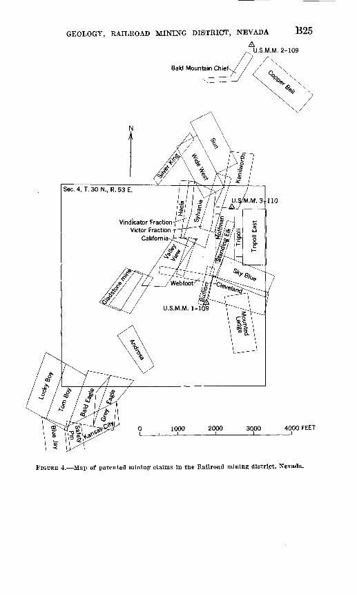
2. View of Railroad district________________________________ 43. Stratigraphic column____________________--___-_---_------ 64. Map of patented mining claims_---_-----__---_-_---------- 25
m

IV CONTENTS
TABLES
Page TABLE 1. Spectrographic analyses of intrusive rocks, Railroad district,
Nevada---. - _______-_ __- _- - - B122. Recorded production of the Railroad mining district, Nevada,
1871-1956____________________________________________. 173. Spectrographic analyses of fine-grained dump material._______ 18

CONTRIBUTIONS TO ECONOMIC GEOLOGY
GEOLOGY OF THE RAILROAD MINING DISTRICT, ELKOCOUNTY, NEVADA
By KEITH B. KETNER and J. FRED SMITH, JR.
ABSTRACT
The Railroad mining district, covering an area of 3 square miles in the Pinon Range in northeastern Nevada, has produced about $2 million worth of copper, lead and silver. Exposed rocks include the Pogonip Group, Eureka Quartzite, and Hanson Creek Formation of Ordovician age, Lone Mountain Dolomite of Silurian age, Nevada Formation and Devils Gate Limestone of Devonian age, and unnamed clastic units of Mississippian age. These rocks were folded into an overturned anticline and then broken by high-angle normal and reverse faults. Paleozoic rocks were intruded by a granitic stock having a rhyolite porphyry core and by rhyolite porphyry dikes. Primary pyrite, chal- copyrite, galena, and sphalerite and tetrahedrite in host rocks of marble and diopside and garnet skarn have been altered by weathering to oxide, carbonate, sulfate and silicate minerals. Some mineralized rock contains remarkably high concentrations of rare earth elements and beryllium.
INTRODUCTION
Rocks of the Piiion Range were first studied by Clarence King and Arnold Hague about the year 1870. Their observations, which in cluded bare references to the newly discovered Railroad mining dis trict (fig. 1), were published by Hague (1877). Hague's remarks were later supplemented with a geologic cross section of the Pinon Range in the vicinity of the Railroad district by C. D. Walcott (in Hague, 1892, p. 200); the section is virtually correct. The first geo logic examination of the mineral deposits was made in 1908 when W. H. Emmons spent a few days in the district. At that time many early mines had been closed for years. Emmons (1910, p. 88-95), however, described the deposits then being worked. More recently Granger and others (1957, p. 126-132) summarized geologic data on the district, compiled production figures, and made a geologic sketch map of the district.
Bl
B2 CONTRIBUTIONS TO ECONOMIC GEOLOGY
117° 116° 115°
20
IDAHONEVADA"
ELKO COUNTY
Wells
Elko o
Carlin 5
Battle Mountain » X-RAILROAD
V £ DISTRICT
I £
EUREKA
O
Eureka i
20
I COUNTY I
"an MH~F«5~~ ~~x.
WHITE
PINE
COUNTY
40MILES
42°
41°
40"
39'
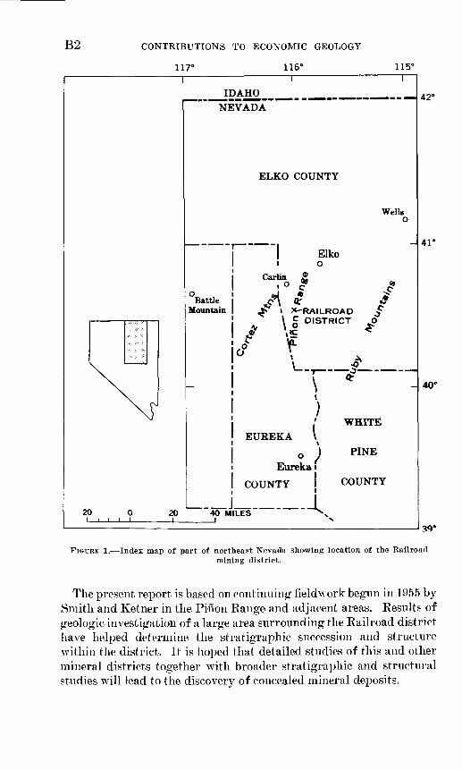
FIGURE 1. Index map of part of northeast Nevada showing location of the Railroadmining district.
The present report is based on continuing field work begun in 1955 by Smith and Ketner in the Pinon Range and adjacent areas. Results of geologic investigation of a large area surrounding the Railroad district have helped determine the stratigraphic succession and structure within the district. It is hoped that detailed studies of this and other mineral districts together with broader stratigraphic and structural studies will lead to the discovery of concealed mineral deposits.

GEOLOGY, RAILROAD MINING DISTRICT, NEVADA B3
We appreciate help in the field by Robert Crosson in 1960 and by J. A. Wolfe and P. Gelabert in 1959 and the analytical services by A. P. Marranzino and Uteana Oda.
This work was done in cooperation with the Nevada Bureau of mines.
GEOLOGIC SETTING OF THE RAILROAD MININGDISTRICT
The Railroad mining district straddles the highest ridge of the Pifion Range (fig. 2), one of the lesser mountain chains of the Great Basin. Typically, basin ranges are long and narrow; they trend northward or a little east of north and are separated from one another by broad flat valleys. Most ranges are topographically asymmetrical in cross section; however, the Pinon Range trends more northward than most neighboring ranges, is more symmetrical in cross section, and has more irregular lateral boundaries. A broad valley broken by low hills separates the Pifion Range from the Ruby Range on the east and a narrow valley separates it from the Cortez Range on the west.
The Pinon Range consists mainly of Paleozoic rocks. These can be separated into three distinct sequences on the basis of lithic composi tion and depositional environment:1. Carbonate rocks and quartzite of early Paleozoic age totaling about
3,000 feet in thickness; autochthonous.2. Chert, shale, and mudstone of early Paleozoic age carried from the
west on the Roberts thrust fault.3. Conglomerate, sandstone, shale and limestone of late Paleozoic age
which overlap both sequences of lower Paleozoic rocks; autoch thonous.
Paleozoic rocks of the Pinon Range are folded in an anticline nearly parallel with the northerly trend of the range. The anticline is broken by both normal and reverse faults of moderate displacement.
Certain topographically asymmetrical basin ranges seem to be the eroded upthrown edges of tilted fault blocks. The adjoining valleys seem to be underlain by the sloping downthrown parts of the fault blocks that have been built up to almost level surfaces by detritus from the ranges. Many topographically symmetrical ranges seem to be horsts with grabens on both sides. The Pinon Range, however, which is unusually symmetrical, does not seem to be faulted continuously on either side. This difference, plus the fact that the range is anticlinal, suggests that the Pifion Range is the physiographic expression of a fold rather than of a fault block.

B4 CONTRIBUTIONS TO ECONOMIC GEOLOGY
GEOLOGY, RAILROAD MINING DISTRICT, NEVADA B5
GEOLOGIC HISTORY OF THE PINON RANGE
During the early part of the Paleozoic Era light-colored sediments, composed of carbonate material and quartz sand, were deposited in the sea which covered the area now occupied by the Pinon Range. At the same time, many miles to the west, black siliceous mud was accumulat ing. In middle Paleozoic time, about the end of the Devonian Period, the ocean floor to the west was upheaved, and some of the dark sili ceous rocks slid eastward and came to rest on the carbonate and quartz- ose sediments a few miles from the site of the Railroad district (Rob erts and others, 1958, p. 2816).
Throughout the rest of the Paleozoic Era aprons of gravel, sand, and mud were spread out by streams from the uplifted western rocks and deposited at the present site of the Pinon Range. This area had remained below sea level most of the time and the detrital siliceous sediments were interbedded with carbonate sediments which continued to accumulate.
After the close of the Paleozoic Era the region was uplifted and deeply eroded. The Pinon Range anticline and associated reverse faults were formed by compressive forces probably in the Mesozoic or early Cenozoic Era.
In the Cenozoic Era new disturbances broke up earlier formed struc tures along myriads of high-angle normal faults. Magma intruded Paleozoic rocks, broke through to the surface in places, and poured out as sheets of lava and volcanic ash. In the Railroad district, skarn rock was formed, and metalliferous sulfide minerals were deposited deep in Paleozoic rocks penetrated by the intrusives. Erosion exposed the mineral deposits to weathering, and many early-formed sulfide min erals were altered to oxide, sulf ate, and carbonate minerals which now compose most of the ore.
STRATIGRAPHY
In the following discussion, Ordovician, Silurian, and Devonian rocks belong to the autochthonous sequence, that is, rocks deposited close to their present location. Mississippian rocks are the lower part of the clastic sequence which was deposited on both the overthrust and autochthonous sequences of rocks. (See pi. 1, fig. 3.) Overthrust rocks are not exposed in the Railroad district.
675123 O 63

B6 CONTRIBUTIONS TO ECONOMIC GEOLOGY
SYSTEM SERIES
Quaternary
Tertiary
Several thousa ou
Lower Mississippian
Upper Devonian
Middle Devonian
Lower Devonian
Silurian
Upper Ordovician
MiddleOrdovician
Middle & Lower Ordovician
GROUP FORMATION
MEMBER
nd feet of secti tside Railroad n
Argillite unit in
Lee Canyon
Argillite. quartzite
unit in Lee Canyon
Devils Gate Limestone
Nevada Formation
Lone Mountain Dolomite
Hanson Creek
FormatiorL Eureka
Quartzite Pogonip Group
MAXIMUM THICKNESS
EXPOSED
Few. feet /
Few hundred feet
on exposed in Pino lining district
About 1000 ft
About 2000 ft
About 800 ft, beds repeated
in northern outcrop area
About 500 ft
About 100 \ ft exposed
In Pifion Range c road mining district
350ft\
130ft
70ft /
350ft
LITHOLOGY
". !itt- ? ,-.". '°9
~TI=fIiE^- 1i
n Range
1 I 11 1
/ / / // / / /< i' \ r \ '
1 ' 1 ' 1 LT L
'/.//.
i \
' / /
'' / / /
/ / / /
/'/'/'/-
*7- -^ ^::^f-
utside the Rail-/ / /
j / /-
/ / // '/ f > '"
LITHOLOGIC DESCRIPTION
Alluvium, sand and gravel, and colluvium on steep slopes. \ In the northern part of the outcrop area, landslide \ boulder deposits of Mississippian rock are included
Tuff, lava flows, and sedimentary sand and conglomerate. Conglomerate distinguished from Paleozoic conglomerate
\ by content of igneous clasts. Tuffs are mainly quartz \ latite. Flows are mainly rhyolite' UNCONFORMITY
Siliceous argillite and chert, thin bedded, black
THRUST FAULT
Siliceous argillite and quartzite, thick- to thin-bedded. Rocks are gray to black and weather brown. Groups of mudstone beds alternate with groups of quartzite beds. Altered near base to diopside-garnet-quartz skarn
, DISCONFORMITY
Limestone and dolomite. Thick- to thin-bedded. Beds of dolomite alternate with beds of limestone. Limestone is bluegray to white. Dolomite is black to white. Lighter colored carbonate is coarse grained. Spaghetti- like (Amphipora) coral is common. Breaks down to loose crystal sand. Altered to marble in places. Altered to skarn, especially near intrusive. Joints not so closely spaced as in Nevada Formation
(Dolomite, thick- to thin-bedded, creamy white, less com- 1 monly gray. Closely spaced joints. Thin-bedded part
1 breaks down to loose crystal sand. Altered in places I to coarse-grained white marble and to skarn. Less
susceptible to contact alteration than Devils Gate Lime stone
/Quartzite, massive to obscurely thin-bedded, white or brown. / Quartz grains well rounded, poorly sorted, fine- to / medium-grained. Original dolomite cement altered to ' diopside. Joints closely spaced/Dolomite obscurely thick-bedded, gray. Basal 20 feet limy / and dolomitic quartz siltstone that weathers yellow
(Dolomite, thick- to thin-bedded, black, brecciated. Abun- | dant poorly preserved fossils. Upper 10 feet light ' colored and coarsely crystalline
/ Forms cliff. Quartz grains fine to medium grained, well I sorted
Dolomite, thick-bedded to mainly thin-bedded, gray. Thininterbeds of cherty shale in upper part. Cherty shale weathers yellow to brown. Abundant poorly preserved fossils
FIGURE 3. Stratigraphic column of rocks exposed in the Railroad mining district, Nevada.

GEOLOGY, RAILROAD MINING DISTRICT, NEVADA B7
ORDOVICIAN SYSTEM
POGONIP GROUP
Nolan and others (1956, p. 23) give the history of usage of the term Pogonip and assign to the Pogonip Group in ascending order the Goodwin Limestone, Ninemile Formation, and Antelope Valley Lime stone. Beds in the Railroad district assigned to the Pogonip Group resemble the Antelope Valley Limestone in appearance and fauna but are mainly dolomite rather than limestone. R. J. Ross, Jr. (written communication, 1959), stated that the faunal assemblage is probably equivalent to the "Ainomalorthis zone" at the top of the Antelope Val ley Limestone in the Eureka area.
The lower part of the exposed Pogonip is uniformly dark-gray dolomite that contains many poorly preserved fossils. Beds range from about an inch to slightly more than a foot in thickness. In the upper part, beds of dark-gray dolomite, a few inches thick, alternate with thinner yellow.or brown shale partings and beds. In places shale alone or both shale and dolomite are silicified. Fossils are com monly silicified. The dolomite is medium grained and, where par tially recrystallized, is whitened. Probably the recrystallization and silicification are secondary alterations caused by the intrusive. Dolo mite may be either a primary mineral or a secondary mineral due to alteration by the intrusive. No ore has been found in the Pogonip in this area.
EUREKA QUARTZITE
The Eureka Quartzite is a remarkably widespread thin quartzite unit named by Hague for exposures near Eureka, Nev. (Nolan and others, 1956, p. 29). In the Railroad mining district the Eureka gen erally is similar to equivalent quartzite in the type area. It consists of white medium-grained pure quartz sandstone and quartzite. It is massive to thin bedded, but bedding is obscure in most exposures. Top and bottom contacts are not clearly visible, but seem to be sharp and not gradational. Unconformities above and below the quartzite noted by Nolan and others (1956, p. 39) in the Eureka district are not evi dent in the Railroad district.
The Eureka is only about 70 feet thick in the Railroad district. In the type area near Eureka it is as much as 500 feet thick. The appar ent northeastward thinning may be due to original thinning rather than to erosion (R. J. Ross, Jr., oral communication, 1960).
The threefold division of the Eureka recognized by Kirk (1933, p. 27-28) is not apparent in the Railroad district.
No significant alteration was observed in the Eureka and little or no ore was mined in it.
B8 CONTRIBUTIONS TO ECONOMIC GEOLOGY
HANSON CREEK FORMATION
The Hanson Creek Formation was named by Merriam (1940, p. 10). Nolan and others (1956, p. 32) ably describe the unit in its type area and give the history of its nomenclature.
In the Railroad district the Hanson Creek consists of thick- to thin- bedded fine-grained dolomite and a few limestone beds. It is com monly dark gray to black. Bedding is distinct in some areas but is more commonly obscure. Fossil corals and brachiopods are abundant in places but are poorly preserved; they rarely weather free, but appear as white sections against a dark background.
The Hanson Creek Formation is only 130 feet thick in the Railroad mining district, less than a quarter the thickness of the type section. Like the Eureka, the Hanson Creek probably thinned out originally against the Tooele Arch.
SILURIAN SYSTEM
LONE MOUNTAIN DOLOMITE
The Lone Mountain Dolomite was named by Hague in 1883 (p. 262- 263). The subsequent history of its nomenclature and its description in the type area are given by Nolan and others (1956, p. 37) and by Merriam (1940, p. 10).
In the Railroad district the lower 350 feet of the Lone Mountain Dolomite is exposed. Its contact with the Hanson Creek Formation seems to be conformable. The lower 20 feet of the Lone Mountain consists of limy and dolomitic quartz siltstone that is light olive gray and weathers yellow. This unit may be correlative with the Roberts Mountains Formation, but as no fossils were found in it a positive correlation is not possible. The rest of the exposed Lone Mountain is obscurely thick bedded gray dolomite.
The formation is mineralized locally at its fault contact with the eastern outcrop of rhyolite porphyry (pi. 1), but production from this unit was probably not great.
DEVONIAN SYSTEM
NEVADA FORMATION
History of the stratigraphic term Nevada is summarized and the formation is described near the type area by Nolan and others (1956, p. 40-48). Carlisle and others (1957, p. 2180) describe the Nevada Formation in the Piiion Range. In both papers the Nevada Forma tion is divided into a lower carbonate unit, a middle quartzite unit, and an upper carbonate unit. Nolan and others further subdivide the upper unit.
In the Railroad district the upper part of the quartzite unit and at least a part of the upper carbonate are recognized, but the lower
GEOLOGY, RAILROAD MINING DISTRICT, NEVADA B9
carbonate is not recognized if present. The quartzite unit is named the Oxyoke Canyon Sandstone Member by Nolan and the Union Mountain member by Carlisle. In the Railroad district the exposed part of this member consists of obscurely thick bedded to obscurely thin bedded quartzite that is closely jointed and that grades in color from white to colorless to brown. Well-rounded poorly sorted quartz grains, which range from 0.1 to 0.5 mm in diameter, are set in an origi nally dolomitic matrix. In the quartzite north of Bunker Hill the matrix has been altered to diopside. Little or no ore is known to have been mined from the quartzite unit.
Carbonate beds of the Nevada Formation resemble the upper car bonate unit more closely than the lower carbonate, although altera tion makes identification difficult. Beds range from thick near the presumed base to thin near the top. The rock is closely jointed, fine- to medium-grained, and creamy white or, less commonly, gray. The thin-bedded part weathers to loose crystal sand. This rock, formerly dolomite, has been altered in places to coarse-grained white marble and to skarn that consists principally of garnet and diopside. It seems to have been less susceptible to contact alteration than was the overlying Devils Gate Limestone.
Many of the ore deposits are in carbonate rocks of the Nevada Formation.
DEVILS GATE LIMESTONE
The Devils Gate Formation was defined on the basis of certain fos sils by Merriam in 1940 (p. 16). Nolan and others (1956, p. 48) redefined it on a lithologic basis and renamed it Devils Gate Lime stone. The Devils Gate, as Nolan and others describe it, is recogniz able in the Railroad mining district, but here it consists in part of dolomite, perhaps of secondary origin.
In the Railroad district the Devils Gate consists of sequences of limestone beds alternating with sequences of dolomite beds. Both limestone and dolomite are thick to thin bedded; alternate light and dark thin bands are a distinctive characteristic of much of the lime stone, particularly where the limestone has been recrystallized.
The limestone is blue gray to white, and original grain size is fine. The dolomite is black to white, and original grain size is fine to medi um. A few chalcedony-bearing beds are yellow. Spaghetti-like coral is common in the darker-colored beds. Both limestone and dolomite have been altered in places to white marble and to skarn. On weath ering the carbonate rock breaks down to loose crystal sand. Joints in the Devils Gate are more widely spaced than in the Nevada Forma tion.
BIO CONTRIBUTIONS TO ECONOMIC GEOLOGY
Most of the mines in the district are in the Devils Gate, and the formation has been more extensively altered to skarn than any other unit.
MISSISSIPPIAN SYSTEM
Siliceous argillite, siltstone, and quartzite aggregating more than1 mile in thickness overlie the Devils Grate Limestone. These beds are well exposed in Lee Canyon and in this report are designated as the argillite-quartzite and argillite units in Lee Canyon. Elsewhere the Mississippian rocks are undifferentiated.
ARGILLITE-QUARTZITE UNIT IN LEE CANYON
The argillite-quartzite unit exposed in Lee Canyon is about 2,000 feet thick. It is composed of interbedded siliceous argillite, siltstone, and lesser amounts of quartzite in beds ranging from a few inches to2 feet in thickness. Rocks of this unit are gray or black on fresh sur faces and brown on weathered surfaces. The siliceous argillite con sists mainly of very fine intergrown quartz grains, carbon, authigenic potassium feldspar, clay, and, near the base of the unit, of secondary diopside and garnet. The siltstone and quartzite are composed mainly of quartz grains and lesser amounts of chert grains.
Poorly preserved cephalopods in some of the lower beds are of probable Early Mississippian age, according to Mackenzie Gordon, Jr. (written communication, 1960). The contact between the Mississip pian rocks and the Devils Gate Limestone seems to be concordant in the mining district, but relations outside the district indicate an unconformity.
ARGILLITE UNIT IN LEE CANYON
The argillite unit which has been thrust over the argillite-quartzite unit in Lee Canyon is about 1 mile thick, but only the lower part of this unit is exposed in the area shown on plate 1. Beds range from an inch to several inches in thickness. The entire unit is composed of black siliceous argillite and chert which weather black also. The contact between the two Lee Canyon units is generally concordant, but relations outside the district indicate that the contact is a thrust fault.
No fossils were found in this unit in Lee Canyon, but rocks with which the unit can be reasonably correlated contain Early Mississip pian conodonts identified by W. H. Hass. The argillite unit in Lee Canyon outside the map area is overlain by shale, sandstone, and con glomerate of Early Mississippian age.
TERTIARY SYSTEM
Several hundred feet of quartz latite tuff and black vitrophyre are exposed in the eastern part of the map area. A small exposure of

GEOLOGY, RAILROAD MINING DISTRICT, NEVADA Bll
conglomerate containing igneous clasts near the portal of the Davis tunnel is assigned to the Tertiary System.
Tertiary rocks lie on Paleozoic units with profound unconformity.
QUATERNARY SYSTEM
Stream-laid sand and gravel, landslide debris, and colluvium com pose the material of the Quaternary System. This material is esti mated to be a few feet to a few hundred feet thick. Large quartzite boulders apparently derived from Bald Mountain form a landslide in the northeast corner of the map area.
INTRUSIVE ROCKS
Mississippian and Devonian rocks in the Railroad district are penetrated by a silicic stock about one quarter of a square mile in outcrop area. The stock consists of an outer shell of medium-grained granite, monzonite, and quartz diorite and a core and marginal bodies of rhyolite porphyry. A large dike of rhyolite porphyry, named the Bunker Hill dike, extends from the rhyolite core eastward through the outer shell of the stock and into the country rock on Bunker Hill. Although the Bunker Hill dike does not crop out continuously, a high concentration of halloysite, an alteration product of porphyry, in excavations and on dumps on the north side of Bunker Hill indi cates that the dike is continuous under a cover of Quaternary colluvium.
Typically, the granite, monzonite, and quartz diorite in the outer shell of the stock is hypautomorphic granular to porphyritic and fine to medium grained. Many of the larger plagioclase grains are zoned progressively outward but also show uncommon reversals. Biotite is the only mafic mineral. Two specimens of granitic rock analyzed spectrographically (table 1, samples 660 and 654) contain more than average amounts of titanium, barium, strontium, zirco nium, and molybdenum (Turekian and Wedepohl, 1961). In addition, sample 654 contains more than average amounts of copper and tung sten, and sample 660, of cobalt.
The rhyolite composing the core, the northeast margin of the stock, and a faulted body on the east side of the district typically is porphy ritic and consists of euhedral phenocrysts of quartz, sanidine, and, less commonly, plagioclase, 1 to 6 mm in diameter. The matrix con sists mainly of potassium feldspar and quartz grains 0.01 to 0.1 mm in diameter. Iron- and magnesium-bearing minerals are scarce. The rhyolite is interpreted as intrusive because of its sharp contact with the granitic shell.

B12 CONTRIBUTIONS TO ECONOMIC GEOLOGY
3
03
*
a030
BM
5
M*"
O
O
o
><
o
sg6
>
5
»H
s
Ol
03PQ
aB
"3
"a
£S3as
VVVVVV
iO LO ^O »O »O *O .
VVVVVVM
v^vv^v
«* ««-««LO U5 LO 10 10 10 t»
OOOOiOOM
VVVV V
vvvvvv0-
«VVV °-
CO
>OOOOO<Ni-i^ ""SJS V
ooooo 't--
VVV !
OOOOOOi-l
VVVVV
gggssss0000000
VVV VV
lOOioioS ^^-vvv10"*
IOOOOOOO5 i t N CO Ol Q i-< i t
.0,1010 lO-O^
oggggoo
RgSS§25
OOOOOgiO
§§§§§§!AA
VVVV V
!!gl8!-
a03
sB§
.. g
0>
0
903
id "3
$&&
73 "^
w-is ^
y§
4' Granitic outer 2 Rhyolite porph

GEOLOGY, RAILROAD MINING DISTRICT, NEVADA B13
Sulfide minerals occur in the core as minute crystals, mainly in quartz phenocrysts, not in veinlets. Pyrite, chalcopyrite, sphalerite, pyrrhotite, ruby silver, and galena were observed microscopically in polished sections. The small size of crystals made identification of all but pyrite and chalcopyrite uncertain. Sericite is present in small amounts throughout the porphyry. Two specimens of the rhyolite core of the stock analyzed spectrographically (table 1, samples 659 and 666) contain more than average amounts of copper and molyb denum ; in addition, sample 659 contains more than average amounts of yttrium and sample 666 more than an average amount of silver.
The Bunker Hill dike is generally similar petrographically to the porphyry core. It seems to contain more barite and sulfide minerals than any part of the stock, however. Two specimens analyzed spec trographically (table 1, samples 657 and 674) contain more than aver age amounts of barium and strontium. In addition, sample 657 contains more than average amounts of titanium, copper, lead, molyb denum, silver, tin, and tungsten, and sample 674, of copper and silver.
The structural relations indicate the following episodes in the de velopment of the stock:1. Intrusion of stock having granite to quartz diorite composition.2. Solidification of the outer parts.3. Displacement of the still-molten interior by magma of more silicic
composition.4. Fracturing of the outer shell of the stock an/d country rocks.5. Filling of some fractures by porphyry fyom the still-molten core
of the stock.
CONTACT ALTERATION
When magma comes in contact with carbonate rock, elements in the magma combine with calcium and magnesium in the carbonate to form skarn or contact metamorphic rock. Associated metal deposits are contact or pyrometasomatic deposits. In his text book on mineral deposits Lindgren (1933, p. 695) illustrated his discussion of pyro metasomatic deposits with a sketch map of part of the Railroad district originally drawn by W. H. Emmons.
Contact alteration in the Railroad district has resulted in the forma tion of skarn which consists mainly of andradite garnet and diopside and contains smaller amounts of penninite, phlpgopite, magnetite, pyrite, pyrrhotite, and chalcopyrite. The country rock must have received material from the intrusive body during contact metamor- phism, because none of the host rocks contain enough iron and alu minum to form such large amounts of garnet and diopside merely by recrystallization.
B14 CONTRIBUTIONS TO ECONOMIC GEOLOGY
By far the largest body of skarn in the district is near the contact between the Devils Gate Limestone and the granitic part of the stock. Lesser amounts of skarn occur at the contact between the Nevada Formation and porphyritic parts of the stock and in the Nevada For mation and Devils Gate Limestone as much as half a mile from exposed parts of the stock. Some skarn also occurs along the contact between Mississippian clastic rocks and the Devils Gate Limestone where much of it seems to have been formed in the clastic rocks rather than in the limestone. The Bunker Hill dike does not seem to have generated much skarn rock.
The Devils Gate Limestone contains more dolomite in the Railroad district than elsewhere in the Pinon Range. Probably much of this dolomite is secondary having been formed by solutions from the intru sive mass. Both limestone and dolomite have been marbleized in places as much as half a mile from exposed parts of the stock. Within the district marbleization seems to have been a general effect of the intru sive activity rather than a concentrated effect correlative with nearness to igneous rocks.
STRUCTURE
The major structural feature in the Railroad mining district is the Pinon Range anticline. Generally, beds on the western side of the district dip west, whereas those on the east dip east. East dipping beds along the western contact between the Nevada Formation and the Devils Gate Limestone on the west side of Bunker Hill indicate that the anticline is sharply overturned to the west (section B-B', pi. 1). In detail the structural complexity increases from south to north. Beds in the Devils Gate Limestone north of Bunker Hill and east of the stock are vertical or dip steeply west or east. Here the east limb of the anticline is almost vertical, and beds must be repeated in folds or by unrecognized faults that are parallel to the bedding; a normal se quence across the strike would require several hundred feet more of Devils Gate than are exposed elsewhere. In comparison with bed atti tudes farther south, the steepening of dips reflects an eastward tilting; this increased tilt of the beds along with the possible tight folding may reflect, eastward pushing and deformation by injection of the stock. The Pinon Range anticline is dated post-Permian because Upper Permian beds outside the Railroad mining district are folded.
Steeply dipping normal and reverse faults trend both parallel to and at angles to the trend of the anticline. A high-angle reverse fault, designated the Bunker Hill fault on plate 1, extends from southwest of Ravens Nest northward to a point about 1,000 feet north of the Davis Tunnel mouth where it ends or becomes impossible to trace in poorly exposed rocks. This fault brings older beds on the
GEOLOGY, RAILROAD MINING DISTRICT, NEVADA B15
east into contact with younger beds about 1,000 feet higher stra- tigraphically on the west. The position of this compression al fault parallel to the Pifion Range anticline suggests that it resulted from the same forces which made the anticline.
Another reverse fault designated the Bald Mountain fault trends generally eastward, dips southward, and separates older rocks on the south from younger ones on the north. In addition to several hundred feet of stratigraphic throw, this fault may have had con siderable right lateral strike-slip movement as indicated by the non- alinement of fold axes across the fault. South of the fault the axis of the Piiion Range anticline, by extension, passes through the east side of the stock. The meager data available indicate that the fold axis north of the fault is offset at least 1,000 feet to the east.
Other faults either are high-angle normal faults or cannot be classi' fied owing to poor exposure.
Apparently the Bunker Hill fault pre-dates the porphyry because a porphyry dike is intruded along it, whereas the Bald Mountain fault postdates the porphyry or, at least, postdates the granite because it cuts the granite. Normal and unclassified faults both antedate and postdate the porphyry. Evidently igneous intrusion accompanied an episode of normal and reverse faulting.
The effects of probable post-Permian deformation are more appar ent in the Railroad district than elsewhere in the Piiion Range. Only in the Railroad district is there an overturned anticline and only here are autochthonous beds as old as Ordovician exposed.
ORE DEPOSITS
HISTORY AND PRODUCTION
After the discovery of silver at Virginia City in 1859 and at Austin in 1862, prospectors discovered precious and base metals in all parts of Nevada. Deposits at Cortez were discovered in 1863, at Eureka in 1864, and at Mineral Hill in 1868. The Railroad mining district was established in June 1869, according to Raymond (1870, p. 186). Ray mond's remarks suggest that the district may have been named as a result of the miners' elation at being only a few miles from a railroad. As the Eureka and Palisade railroad line in Pine Valley was not con structed until 1875, reference must have been to the Central (now Southern) Pacific Railroad about 12 miles distant.
Ore was at first shipped to Chicago and San Francisco for smelting, but in 1872 a smelter was designed and erected by O. H. Halm of Frei berg at the town of Bullion (Raymond, 1873, p. 158). Charcoal fuel was obtained from the pines growing on nearby slopes and coke was shipped from Pennsylvania. Since 1905 newly mined ore, dump waste, and old slag have been shipped to Salt Lake City for reduction.

B16 CONTRIBUTIONS TO ECONOMIC GEOLOGY
The production of gold, silver, copper, lead, and zinc in the Railroad district cannot be estimated accurately. Reliable figures for the years 1869 to 1905 are not available, but certain evidence suggests that the district was not very productive in those years. Production estimates (table 2) given by Couch and Carpenter (1943, p. 43) for the years 1871-73 and 1883-87 are not very high except for 1885 and 1886. Ray mond (1873, p. 158) gave the capacity of an early smelter as only 20 tons of ore per day. A second small smelter was constructed later. Whitehill (1879, p. 22), the State Mineralogist, remarked that few mines were being worked in 1877 and 1878 and that good mines could be bought for a few hundred dollars each. Emmons (1910, p. 89) stated that in 1906 some of the mines were reopened after being worked in the 1870's and 1880's. We estimate the total value of production for the years 1869 to 1956 at about $2 million (table 2).
GENERAL FEATURES
The faults and the major fold that are prominent features of the district do not seem to have controlled ore deposition. Emmons' (1910, p. 91) remarks, together with our observations of presently accessible parts of mines, indicate that ore was found mainly along dikes and as vertical chimneys along intersections of joints in carbon ate rock of the Nevada Formation and Devils Gate Limestone. Lesser amounts of ore were found in skarn of the Devils Gate.
Brown gossans indicate where mineralized zones intersect the pres ent surface (pi. 1). Gossans stand out as dark rocky outcrops in places, but more commonly, because they are composed of soft earthy material, they form slight inconspicuous depressions. Most adits have been driven in on gossan zones, but, as Emmons (1910, p. 91) remarked, parts of the gossans do not seem to have been explored.
More than 100 adits scattered over an area of about 3 square miles indicate widespread exploration. The concentration of adits and sizes of dumps, the observations of Emmons, and the spectrographic anal yses of dumps (table 3), however, indicate that mineralization was con centrated in two areas. A central area, within a radius of 2,000 feet centering on the intersection of the Bunker Hill dike and the Nevada Formation, was probably more intensively mineralized than the peripheral areas. Both the Standing Elk and Delmas mines in the central area were large early producers, and the Standing Elk (now Aladdin) was the last mine in the district to be closed. The workings of the Standing Elk are more extensive than those of any other mine. Emmons (1910, p. 94) stated that the Copper Bell mine in the northern part of the district produced half a million dollars worth of ore. The high concentration of adits and large sizes of dumps confirm that this
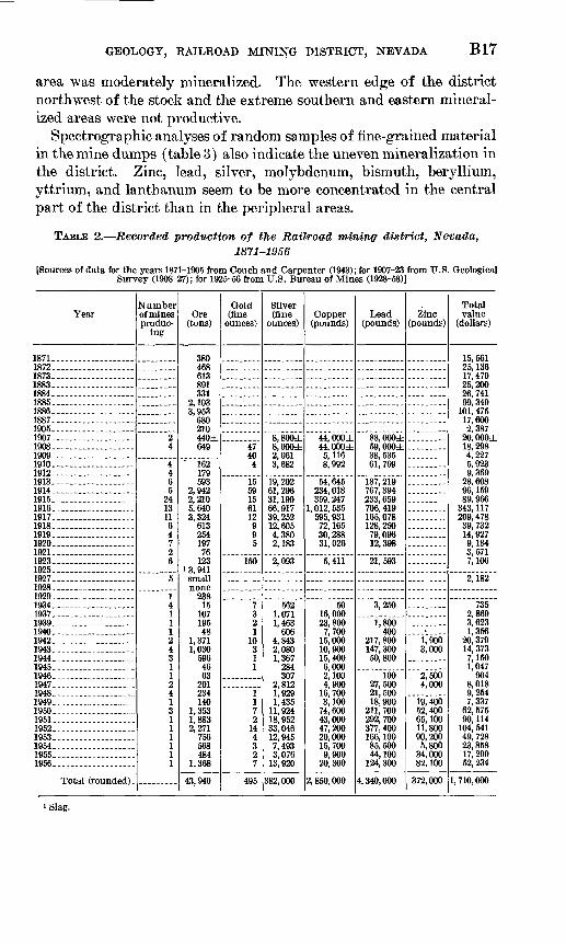
GEOLOGY, RAILROAD MINING DISTRICT, NEVADA B17
area was moderately mineralized. The western edge of the district northwest of the stock and the extreme southern and eastern mineral ized areas were not productive.
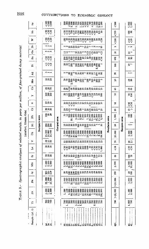
Spectrographic analyses of random samples of fine-grained material in the mine dumps (table 3) also indicate the uneven mineralization in the district. Zinc, lead, silver, molybdenum, bismuth, beryllium, yttrium, and lanthanum seem to be more concentrated in the central part of the district than in the peripheral areas.
TABLE 2. Recorded production of the Railroad mininff district, Nevada,1871-1956
[Sources of data for the years 1871-1905 from Couch and Carpenter (1943); for 1907-23 from U.S. Geological Survey (1908-27); for 1926-56 from U.S. Bureau of Mines (1928-58)]
Year
1871- 1872 1873 1883- 1884 1885 1886 1887 1905 1907 1908 1909 1910 1912- 1913 1914 1915 1916 1917. 1918 1919 1920 1921. 1923 1925 1927 1928. 1929. .1934. 1937. 1939 1940.----..--- ___ ---1942 1943. 1944 1945 1946 1947- 1948 1949. 1950 1951 1952 1953 1954 1955- 1956.-
Total (rounded) .
Number of mines produc
ing
24
4465
24131164726
5
14111243112413111111
Ore(tons)
380468613891331
2,1033,953
680210440±649
' 162179593
2,9422,2105,6403,324
61325419776
123"3,941
23815
10719548
1,3711,030
5964663
201234140
1,3531,8832,271
756568484
1,368
43, 940
Gold (fine
ounces)
1
4740
4
15KQ
156112995
150
7321
10311
1172
144327
495
Silver (fine
ounces)
8,800±8,000±2,0613,682
19,20261,296
39, 25212,6054,3802,183
2,093
5621,0711,463
6064,8439 nan1,367
284307
2,8121,9291,435
11,92418, 95233,04612,9457,4933,076
13,920
382,000
Copper (pounds)
44,000±44,000±5,1168,992
54,645234, 018359, 247
1,012,535595, 931
72, 16530,28831, 026
5,411
5016,00023,8007,700
15,00010,90015, 4006,0002,1004,900
16,7003,100
74,60043,00047, 20020,00015,7009,900
20,300
2, 850, 000
Lead (pounds)
88,000±59,000±38, 53561, 769
187,219767, 394233, 659706, 419165, 078128,25079,09612,398
21,593
3,250
1,800400
217,800147, 30050,800
10027,50021,50018,900
211, 700292, 700377, 400166, 10085,50044,100
124,300
4,340,000
Zinc (pounds)
1,9003,000
2,5004,000
19,40052, 40065,10011,80090,2005,800
34,00082,100
372,000
Total value
(dollars)
15,56125, 13617, 47025,20026,74199,349
101, 47517,6002,387
20,000±18,2984,2275,9239,369
28,60896,15989,966
343, 117209, 478
39, 73214,9279,1843,5717,106
2,182
7352,8693,6231,356
20,37914, 3737,1501,047
904.8,0189,2547,337
62, 57590,114
104, 54149,72823,85817, 29952,234
1,710,000
i Slag.
TA
BL
E 3
. Sp
ectr
agra
phic
ana
lyse
s of
sele
cted
met
als,
in p
arts
per
mil
lion
, of f
ine-
grai
ned
du
mp
mat
eria
l
[Ana
lyst
, U
tean
a O
dal
Sam
ple
(pi.
1)T
iZ
nB
aSr
Mn
Zr
La
VC
uN
iP
bO
rB
YC
oM
oA
gB
iSn
Ga
BP
WSb
As
Nor
ther
n ar
ea
34 24
35 -
-----
500
500
700
5,00
0 7,
000
2,00
0
20,0
00
7,00
0 10
,000
200
150
150
7,00
0 5,
000
5,00
0
50
30
30
50
50
50
50
15
50
10, 0
00
10,0
00
10,0
00
200
200
200
100 20
20
20
10
20
10
20
15
100
100
100
30
20
70
15
10
10
5 1 1
<5
<5
<5
<10
<
10
<10
5 5 5
5 5 5
<20
<
20
<20
<50
<
50
<50
<500
<
500
<500
Cen
tral
are
a
30
46
28
27
21
22
13... _
_-_
---.
9
. ...
. -.
14
10
12
45
8 .... -- _
-3
3
__ -_
- 1
6
15
17
700
1,50
030
050
050
01,
000
1,00
01,
000
300
300
500
300
700
2,00
070
070
070
0
1,50
015
05,
000
50,0
0015
,000
50, 0
0015
,000
7,00
010
,000
50,0
0050
, 000
20,0
007,
000
2,00
050
,000
50, 0
0010
0, 0
00
1,00
01,
000
7,00
010
,000
7,00
015
,000
15,0
002,
000
1, 5
0010
,000
10,0
005,
000
1,00
01,
500
1,00
03,
000
5,00
0
20 30 100
100
100
200
100 50 20 70 70 50 50 50 20 30 20
2,00
02,
000
20,0
0015
, 000
7,00
03,
000
5,00
03,
000
3,00
010
,000
15,0
0020
,000
5,00
03,
000
2,00
03,
000
2,00
0
50 70 20 30 30 100
100 70 20 50 50 70 50 100
150 70 20
<50
<50 10
0 50 500
<50 50
020
010
050
050
0 50<
50<
50<
50<
501,
000
15 30 20 20 20 70 70 30 10 10 20 10 20 50 30 15 15
7,00
03,
000
10, 0
0020
,000
20,0
0020
,000
5,00
07,
000
7,00
07,
000
10,0
005,
000
7,00
02,
000
1,50
02,
000
50,0
00
15 10 30 50 50 20 200 20 20 300
500 15 15 10 5 5 30
70 15 100
50,0
00 200
2,00
01,
500
2,00
07,
000
100
1,50
010
,000
15,0
001,
000
20,0
0015
,000
1,00
0
10 10 <5 5 5 50 30 20 5 10 10 <5 20 15 10 5 15
10 10<T
10<r
io<
10 10 15 15 10 15 10<T
W 10 20 10 10 10
20 15 300
200
700 70
1,50
0 70 150
500
700
150
<10 10 10 20 50
0
20 20 <10 50 50 30 20 50 20 15 20 50 20 15 10 15 15
70 70 500
2,00
0 10 200 20 150
150 2
150 70 100 50 200
100 5
5 2 30 100 2 30 10 30 20 7 20 20 30 15 300 50 30
20 10 <5
200 5
150
100
200
100 10 200
100
500 30
2,00
020
0 5
200
500
<T10
200
<-io
200
200
200 30 15 30 50 150
100
200
150
<10
15 15 5 5 5 20 10 10 5 5<
5<
5<
5 10 15 7<
5
5 2 15 10 50 10 15 2 7 70 70 7 5 2 1 1 20
150 50
<20
<20
<20 15
010
015
0<
20<
20 30<
20 100 50 50 30
<20
<50
<50
<50 70
0<
50 700
<50 20
030
0<
50<
50<
50<
50<
50 50 100 50
500
500
<50
02,
000
500
1,00
070
01,
50C
|1,
000
<50
0<
500 ,roo
<50
050
05,
000
3,00
01,
500
Sout
hern
are
a
62R
- ..
. .....
700
> 1
0, 0
00>
10,
000
700
3.00
050
<50
7010
,000
501,
000
3010
1030
1020
200
200
503
<10
0<
100
<50
0
Eas
tern
are
a
42
41
1,00
070
01,
500
3,00
01,
000
5,00
030 10
03,
000
10,0
0010
0 70<
50<
5020 15
2,00
05,
000
5 710
050
010 5
<10 <rw
20 150
10 5050 20
7 720 7
30 2010 5
1 2<
20<
2010
0 501
OfX
1 0(
K
w I * cx>
GEOLOGY, RAILROAD MINING DISTRICT, NEVADA B19
Areal and textural relations suggest that mineralization took place in three stages. Stage 1 was the contact-metamorphic stage conse quent on intrusion of the stock, mainly the granitic part. Stage 2 was a hydrothermal stage which took place soon after intrusion into the country rock of the Bunker Hill dike which emanated from the core of the stock. The minerals deposited at this time are common in mesothermal base-metal deposits of the region. Stage 3 took place much later when earlier formed minerals were exposed to oxidation. The brown gossan zones were formed during this stage. Minerals which are assigned to these three stages are listed in the following table.
Stage 1
Formed earlymainly at time ofintrusion oif stock
DiopsideGarnet
Magnetite
PhlogQpitePenninitePyrrhotite
Stage 2
Formed mainly afterintrusion of dike
BariteCalcite
Chalcopyrite
GalenaPyriteQuartzSphaleriteTetrahedrite
Stage 3
Formed last as a result of alteration of earlier minerals
AnglesiteAzuriteCalamineCerussite
ChrysocollaCopper pitchCovelliteDuftiteHalloysiteIron oxide minerals
(except magnetite)
KaoliniteMalachite
Manganese oxideminerals
MarcasiteMontmorilloniteOpal
Willemite
Other minerals which cannot be confidently assigned a position in one of these stages are listed as follows.
MINERALS OF THE RAILROAD DISTRICT
Andalusite (Al2Si05 ). This aluminum silicate was reported by Emmons (1910, p. 90), but was not identified by us.
Anglesite (PbS04 ). Lead sulfate is an uncommon oxidation product of galena. It replaces galena along cleavage joints.
Andradite. See garnet.Aragonite (CaC03 ). This fibrous form of calcium carbonate is an
uncommon vein material.Azurite (2CuC03 C.u(OH) 2 ). Basic copper carbonate is a common
ore of copper in the area. It is easily identified by its brilliant blue color. Azurite commonly forms from oxidized copper sulfides.
Barite (BaSO4 ). Barium sulfate is a common mineral of the ore deposits. The heavy, clear or white, soft mineral found on the dumps in the northern part of the district is most likely to be barite. It is probably a primary mineral rather than an alteration product of some other mineral.

B20 CONTRIBUTIONS TO ECONOMIC GEOLOGY
Beryllonite (NaBeP04 ). Sodium beryllium phosphate was identi fied by X-ray in association with duftite by Shirley K. Mosburg.
Bornite (Cu5 FeS). This copper iron sulfide is a scarce ore of copper, as indicated by its occurrences on dumps. It seems to replace galena in one specimen.
Calamine (H2Zn2Si05 ). Hydrous zinc silicate forms crusts of radi ating crystals on oxidized rock.
Calcite (CaC03 ). Calcium carbonate is a ubiquitous mineral in the district. It constitutes much of the Devils Gate Limestone and is a very common vein mineral. Some crystals are several inches long. These commonly are banded with brown manganiferous impurities.
Cerargyrite (AgCl). Silver chloride, also called horn silver, was reported in the Railroad district by Emmons (1910, p. 91). It is alteration product of silver-bearing sulfides. We did not see any cerargyrite.
Cerussite (PbC03 ). Lead carbonate is a common alteration product of galena. It commonly replaces galena along cleavage fractures.
Chalcocite (Cu2S). This copper sulfide, also known as copper glance, is a scarce ore mineral in the district as indicated by its scarcity on the dumps. It seems to alter to copper pitch.
Chalcopyrite (CuFeS2 ). This copper iron sulfide is the commonest copper-bearing sulfide observed on dumps. It is commonly asso ciated with sphalerite. It can be recognized by its bright greenish- gold color.
Chrysocolla (CuSi02 2H20). Hydrous copper silicate is a common ore in the district. It is formed by alteration of copper sulfides. It can be recognized by its light-blue color and layered appearance.
Copper (Cu). Native copper is a scarce mineral seen only micro scopically as minute grains.
Copper pitch. The commonest copper-bearing secondary mineral in the district is copper pitch, a mixture of copper, manganese and iron oxides with silica. The more dense varieties tend to be black, lus trous, and smoothed as if by the action of running water. The porous varieties are brown, dull, and rough. Copper pitch is one of the end products of the complete oxidation of copper sulfides.
Copper glance. See chalcocite.Covellite (CuS). This copper sulfide is common in sulfide ores of
the district, but occurs as such tiny grains that it can be seen only with the aid of a microscope. It is generally associated with chal- copyrite and galena and appears to replace those minerals.
Cuprite (Cu2O). This copper oxide was reported by Emmons (1910, p. 91). Specimens resembling cuprite in color tested by us turned out to be iron oxide.

GEOLOGY, RAILROAD MINING DISTRICT, NEVADA B21
Diopside (CaMgSi2 O6 ). Calcium magnesium silicate is one of the most abundant minerals in the district. It is most abundant where igneous rock has come in contact with limestone and dolomite but occurs in small patches, especially in carbonate rocks, throughout the district.
Dolomite (CaCO3 MgC03 ). Calcium magnesium carbonate consti tutes much of the Nevada Formation and Devils Gate Limestone in which the ore occurs. Some of the dolomite in the Devils Gate Lime stone may have been formed by the effect of the igneous intrusive on limestone.
Duftite (PbCu(As04)(OH). Lead copper arsenate is a common mineral in the district. The mineral Emmons reported (1910, p. 91) as pyromorphite may have been duftite. The color ranges from bright yellowish green to brown to transparent. It encrusts the sur face of veins and cavities and occurs within a matrix of other sec ondary minerals.
Fluorite (CaF2 ). Calcium fluoride was observed in microscopic amounts in only one specimen.
Galena (PbS). Lead sulfide is one of the most common sulfides probably following pyrite and chalcopyrite in order of abundance. It alters to cerussite, anglesite, and probably duftite.
Garnet (Ca3 Fe3 (Si04)3). This calcium iron silicate is one of the more abundant minerals of the district especially near the granitic intrusive. It is commonly green or brown and is formed in equidi- mensional grains a few millimeters in diameter. Specific gravity of this garnet ranges between 3.6 and 3.9, and refractive index is about 1.87. This indicates the garnet is of the variety called andradite which has the composition just given or contains a small proportion of aluminum substituting for some of the iron.
Goethite. (See iron oxides.)Halloysite (A1203 2Si02 ). This clay mineral is an abundant con
stituent of many of the mine dumps in the district. It is a white soft chalky substance apparently derived from the alteration of quartz porphyry dikes. Quartz grains imbedded in lumps of halloysite have the angular appearance of the quartz phenocrysts in unaltered dike rock.
Hematite. See iron oxides.Horn silver. See Cerargyrite.Iron oxides. The common red to yellow color of the soil and dumps
and many outcrops in the district is due to iron oxide. Microscopic examination of specimens containing sulfides indicates that much iron oxide is formed by alteration of pyrite. Surrounding corroded grains of pyrite is an inner layer of dense iron oxide and an outer

B22 CONTRIBUTIONS TO ECONOMIC GEOLOGY
layer or matrix of porous yellower iron oxides. Hematite, goethite, and lepidocrocite were uncertainly identified.
Kaolinite (A1203 2Si02 2H2O). This aluminum silicate, like halloy- site, may have been formed by alteration of dike rock.
Lepidocrocite. See iron oxides.Limonite. See iron oxides.Magnetite (Fe304). This iron oxide occurring as black octahedra
disseminated in silicate rocks is not an alteration product of sulfides but a primary mineral formed with the garnet and diopside. It is intergrown with blades of hematite in places.
Malachite (CuCO3 Cu(OH) 2). This copper carbonate is the com mon green mineral of the district. It was probably formed by the alteration of copper-bearing sulfides. It can be distinguished from green duftite by its bluish rather than yellowish cast and the radi ating habit of the crystals.
Manganese oxide. The dull black soft earthy mineral commonly occurring with white halloysite is amorphous manganese oxide. It also occurs with copper oxide and silica in copper pitch, as dark bands in calcite crystals, and black blotches on copper carbonates. It is not present in sufficient concentration to be commercially valuable.
Marcasite (FeS2 ). This iron sulfide has the same composition as pyrite but does not have the same crystal form. It is an uncommon mineral in the district.
Montmorillonite. This hydrous calcium, magnesium, and aluminum silicate is present in altered rock. Like halloysite, it may have formed by alteration of dike rock.
Opal (Si02 nH20). Hydrous amorphous silica is a common mineral of the district. It encrusts cavities in oxidized ores. It was one of the latest minerals to be deposited.
Penninite. This magnesium silicate is a member of the chlorite group of minerals. It is a green micaceous mineral occurring in aggregates associated with magnetite.
Pentlandite. Iron nickel sulfide is associated in small amounts with pyrrhotite.
Phlogopite (H4K2Mg6Al2Si6024). This potassium, magnesium sili cate is a member of the mica group of minerals. It occurs with diopside and is .undoubtedly formed in the same way by contact alteration of carbonate.
Pyrite (FeS2 ). This iron sulfide is the most abundant sulfide in the district. It alters to iron oxides and may be the source of most iron oxide in the district.

GEOLOGY, RAILROAD MINING DISTRICT, NEVADA B23
Pyrrhotite. This ferrous sulfide has an indefinite ratio of iron to sulfur. It is a rather abundant sulfide widely disseminated in sedi mentary rocks of the district.
Pyromorphite. See duftite.Quartz (Si02 ). Quartz is a common constituent of sedimentary
rocks in the district and also occurs commonly with ore minerals.Silver (Ag). Native silver probably forms minute blebs in galena in
one specimen observed.Sphalerite (ZnS). Zinc sulfide is a common sulfide in the district
but considerably less abundant than galena. Chalcopyrite is almost invariably associated with sphalerite. Sphalerite probably alters to calamine and willemite and other secondary zinc-bearing minerals.
Stibnite (Sb2S 3 ). Antimony sulfide is an uncommon mineral in the district. It was observed in one specimen from the southwest side of the district.
Tetrahedrite. This complex copper, iron, zinc, silver, antimony sul fide is a scarce associate of galena in the district.
Willemite (Zn2Si04 ). Zinc silicate is an uncommon mineral formed as perfect crystals with and on duftite. It is probably formed by alteration of sphalerite.
Zoisite (HC2Al3Si3Oi3). This uncommon calcium aluminum silicatewas uncertainly identified in association with garnet and diopside.
GUIDES TO PROSPECTING
In many base-metal deposits copper and other elements are carried downward by percolating water from the oxidation zone near the sur face and redeposited in the primary ore zone just below the zone of oxi dation. It seems certain from examination of dumps and mines and from the remarks of early observers that all ore mined in the district was at least partially oxidized. Since a distinct zone of secondary enrichment has not been reached, one should be sought in the central part of the district where mineralization was concentrated. Probably the Davis Tunnel is below the zone of secondary enrichment, as the only sulfide minerals seen by us in the tunnel are the primary ones, pyrite and chalcopyrite.
Spectrographic analyses (table 3) indicate that some of the dumps contain remarkable concentrations of beryllium and the rare earth ele ments, lanthanum and yttrium. A more intensive geochemical search of the dumps and gossans might reveal concentrations of minable grade.
A logical method of exploration would be to drill to a depth below the zone of oxidation in parts of gosans determined to be favorable by systematic sampling and analysis.

B24 CONTRIBUTIONS TO ECONOMIC GEOLOGY
MINE DESCRIPTIONS
Descriptions of individual mines are reprinted from Emmons (1910, p. 93-95) who was able to investigate the workings of several mines while mining was in progress. The approximate positions of some of the mines and claims mentioned by Emmons are shown on plate 1 and figure 4. The locations of others are unknown except as vaguely indi cated by Emmons.
Standing Elk mine. The Nevada Bunker Hill Mining Company controls the Standing Elk, Tripoli, Red Bird, and other mines, and is driving a crosscut tunnel to intersect the several lodes in depth. This tunnel in July, 1908, was 1,500 feet long but was still several hundred feet from the nearest lode. The Standing Elk, the most important mine of this group, is opened on seven levels, mainly adits, having altogether a vertical range of 600 feet. There are several thousand feet of workings on this claim, the principal level being adit No. 5. When the camp was visited the workings above this level were not accessible.
The ore bodies are irregular replacement veins in limestone, which intersect to form chimneys of ore, the largest being about 50 feet in diameter. The country rock varies from a hard gray limestone to a massive marble which locally is very coarsely crystalline. The limestone is sheeted, brecciated, and filled with white calcite. In a few places garnet rock is developed in the mine, but none of the Standing Elk deposits consist of the typical garnet ore. The intruding quartz porphyry is much decomposed and is locally silicified, and a considerable mass of it carries copper. Nearly everywhere the ore is highly oxidized. The principal ore minerals are lead and copper carbonates, copper and iron oxides, bornite, pyrite, chalcopyrite, and a copper-antimony sulphide, which is probably gray copper. Calcite and quartz are the important gangue minerals; a little fluorite is present in microscopic crystals, intergrown with quartz.
Tripoli mine. The Tripoli mine, about 800 feet northeast of the Standing Elk, is owned also by the Nevada Bunker Hill Mining Company. A tunnel is driven into the mountain for 100 feet to an engine station, where a winze is sunk to a depth of 175 feet. Levels are turned at vertical intervals of about 50 feet and a second winze is sunk from the lowest level, giving a maximum depth of 300 feet below the surface. The country rock is marbleized gray limestone which on the surface strikes N. 20° W. and dips from 85° SW. to 90°. The limestone is intruded by an acidic phase of granodiorite. The incline and drift are driven on a fissured zone, which strikes about N. 25° W. and is approximately vertical. The zone of crushed limestone is crossed by two fissures, approximately at right angles, and these dip steeply toward the northwest. Chimneys of rich silver- lead ore are formed at or near the Intersections. Lead carbonate and pyromorphite are mixed with galena and copper carbonates, and the ore is highly oxidized as deep as development goes. In the bottom of the winze, 300 feet below the surface, garnet and tremolite are extensively developed. At this place the metamorphosed rock is crushed and greatly altered, and it is said to carry about $25 in lead and silver.
At the surface to the east of the Tripoli claim the limestone is medium-grained marble containing reefs and patches of garnet rock, with which are intergrown small masses of pyrite and chalcopyrite, stained here and there with copper carbonates.
GEOLOGY, RAILROAD MINING DISTRICT, NEVADA B25
U.S.M.M. 2-109
Bald Mountain Chief-
Vindicator Fraction Victor Fraction
California
4000 FEET
FIGURE 4. Map of patented mining claims in the Railroad mining district, Nevada.

B26 CONTRIBUTIONS TO ECONOMIC GEOLOGY
Red Bird mine. The Red Bird mine, of the Bunker Hill group, is about half a mile northeast of the Standing Elk and nearest the portal of the low-level adit. A tunnel is driven for 250 feet on a steeply dipping lode, and 80 feet below this a second tunnel is driven for 200 feet. About 150 feet from the portal of the lower tunnel a raise connects the two levels. The lode, which at some places is 4 feet wide, carries good values in lead and silver.
Copper Belle mine. The Trimetal Mining Company controls a large acreage which joins the Nevada Bunker Hill holdings on the northwest. This group includes the Copper Belle, Copper King, and Philippine claims, on each of which considerable development work has been done. The Copper Belle mine is about half a mile northeast of the Standing Elk. The principal tunnel is driven for 325 feet S. 60° E. to the ore body, which is a large irregular mass of oxidized ore carrying lead, silver, and copper. It is said to have produced about half a mil lion dollars' worth of ore, which was smelted in the copper smelter at Bullion. The ore body, which is nearly everywhere inaccessible, resembles the deposits of the Standing Elk in that it is a replacement of marbleized limestone. On the surface above the ore body and at several other places near by the rock is stained with iron oxides and copper carbonates.
Delmas mine. The Delmas Copper Company owns several claims which are located near the crest of the mountain range and extend southwestward from it.
On the Sweepstakes claim, which is the most extensively explored, are the copper deposits of contact-metamorphic origin which have been mentioned above. These deposits, as already stated, are composed of garnet, tremolite, and other contact-metamorphic minerals, which at some places are intergrown with pyrite, chalcopyrlte, bornite, galena, and zinc blende. Locally the copper-iron sulphides, which are unquestionably primary, are coated over with secondary copper glance. Here and there the copper sulphides have oxidized to copper carbonates and iron oxides, but the oxidation is not complete, even at the surface, and at some places less than 10 feet below the surface the sulphides are much more abundant than the carbonates and oxides. Shipments of 210 tons of ore from this claim averaged 70 ounces of silver to the ton, 10.4 per cent of copper, and 2.8 per cent of lead. There is a considerable tonnage of low-grade ore partly developed. It will probably be found that the high-grade ore is restricted to that which carries chalcocite-coated sulphides, or to that which has resulted from the oxi dation of such ore.
Other claims. The Kenilworth claim, north of the Standing Elk; the Sylvania claim, west of the Standing Elk; and the Blue Belle, northwest of the Sylvania, have each produced considerable ore from workings1 which were inaccessible when the camp was visited by the writer. The principal deposits of these mines appear to resemble those of the Standing Elk rather than the contact-meta morphic deposits of the Delmas group.

GEOLOGY, RAILROAD MINING DISTRICT, NEVADA B27
REFERENCES
Carlisle, Donald, Murphy, M. A., Nelson, C. A., and Winterer, E. L., 1957, Devon ian stratigraphy of Sulphur Springs and Pinon Ranges, Nevada: Am. Assoc. Petroleum Geologists Bull., v. 41, no. 10, p. 2175-2191.
Couch, B. F., and Carpenter, J. A., 1943, Nevada's metal and mineral production: Univ. Nevada Bull., v. 37, no. 4, Geology and mining, ser. 38.
Emmons, W. H., 1910, A reconnaissance of some mining camps in Elko, Lander, and Eureka Counties, Nevada : U.S. Geol. Survey Bull. 408, 130 p.
Granger, A. E., Bell, M. M., Siimnons, G. C., and Lee, F., 1957, Geology and min eral resources of Elko County, Nevada: Nevada Bur. Mines Bull. 54, 190 p.
Hague, Arnold, 1877, Diamond and Pinon Ranges, sec. 5, in Descriptive geology, U.S. Geol. Explor. of the Fortieth Parallel: v. 2, p. 549-569.
1883, Abstract of report on geology of the Eureka district, Nevada: U.S. Geol. Survey 3d Ann. Rept., p. 237-290.
1892, Geology of the Eureka district, Nevada: U.S. Geol. Survey Mon. 20,419 p.
Kirk, Edwin, 1933, The Eureka quartzite of the Great Basin region: Am. Jour.Sci. 5th ser., v. 26, no. 151, p. 27-44.
Lindgren, Waldemar, 1933, Mineral Deposits, 4th ed.: New York, McGraw-Hill,930 p.
Merriam, C. W., 1940, Devonian stratigraphy and paleontology of the RobertsMountains region, Nevada: Geol. Soc. America Spec. Paper 25, 114 p.
Nolan, T. B., Merriam, C. W. and Williams, J. S., 1956, The stratigraphic sectionin the vicinity of Eureka, Nevada : U.S. Geol. Survey Prof. Paper 276, 77 p.
Raymond, R. W., 1870, Statistics of mines and mining in the States and Terri tories west of the Rocky Mountains: U.S. Treasury Dept., 2d Ann. Rept. forthe year 1869.
1873, Statistics of mines and mining in the States and Territories west ofthe Rocky Mountains: U.S. Treasury Dept., 5th Ann. Rept. for the year 1872.
Roberts, R. J., Hotz, P. E., Gilluly, James, and Ferguson, H. G., 1958, Paleozoicrocks of north-central Nevada : Am. Assoc. Petroleum Geologists Bull., v. 42,no. 12, p. 2813-2857.
Turekian, K. K., and Wedepohl, K. H., 1961, Distribution of the elements in somemajor units of the earth's crust: Geol. Soc. America Bull., v. 72, no. 2, p.175-191.
U.S. Bureau of Mines, 1928-32, Mineral resources of the United States, 1925-29:Washington, U.S. Govt. Printing Office.
1935-58, Minerals yearbook, 1934-56: Washington, U.S. Govt. PrintingOffice.
U. S. Geological Survey, 1908-27, Mineral resources of the United States, 1907-23:Washington, U.S. Govt. Printing Office.
Whitehill, H. R., 1879, Biennial report of the State mineralogist of the State ofNevada for the years 1877 and 1878, 212 p.
U. S. GOVERNMENT PRINTING OFFICE : 1963 O - 675-123
