geology of the north end of the ruby? … of the north end of the ruby? range, southwestern montana...
TRANSCRIPT
O
GEOLOGY OF THE NORTH END OF THE RUBY?
RANGE, SOUTHWESTERN MONTANA
Russell G. Tysdal
ABSTRACT
This study consists of two parts: stratigraphy and sedimentation, and structure of rocks in the northern one-third of the Ruby Range of southwestern Montana. Detailed studies of Cambrian marine dolomite rocks in the Red Lion Formation and in the upper part of the Pilgrim Limestone resulted in their division into distinct rock units, termed lithofacies. These lithofacies contain features suggestive of sub- tidal, intertidal, and supratidal environments similar to those pre sently forming in the Persian Gulf. Stromatolitic structures occur ring in the uppermost part of the Red Lion Formation are similar to those presently forming in Shark Bay, Australia.
The Ruby Range within the map area is broken into a series of northwest-plunging basement (Precambrian metamorphic rock) blocks, differentially uplifted during the Cretaceous-Tertiary orogenic period. These blocks are bordered by upthrust faults, which are nearly vertical in their lower segments and are low-angle in their uppermost parts. Asymmetrical folds in Paleozoic sedimentary rocks formed in response to the differential uplift of the blocks; thus they too plunge to the northwest. Displaced masses of rock border the range on the three sides within the map area and are interpreted as gravity-slide features resulting from uplift of the range. Normal faulting began blocking out the present range margins by Oligocene time.
CONTENTS
PageIntroduction............................................. 1
Procedure............................................. 1Previous Work......................................... 3Acknowledgements...................................... 4
Stratigraphy............................................. 5PreCambrian........................................... 7
Age.............................................. 7Cambrian.............................................. 8
Flathead Sands tone................................. 8Origin........................................... 9Age.............................................. 10
Wolsey Shale....................................... 11Origin........................................... 13Age.............................................. 14
Meagher Limestone.................................. 14Lower Unit....................................... 15Middle Unit...................................... 16
Lime Mudstone................................. 16Oncolitic Packstone........................... 17Pelletal Packstone............................ 19Oolite Grainstone............................. 20
Upper Unit....................................... 22Mottled Pelletal Lime Mudstone................ 22
Age.............................................. 24Park Shale......................................... 25
Origin!.......................................... 25Age.............................................. 29
Pilgrim Limestone.................................. 29Lower Member..................................... 30Upper Member..................................... 32
Sandy Laminated Boundstone.................... 32Nodular Boundstone............................ 35Bioclastic Packstone.......................... 39Intraclastic Crystalline Dolomite............. 40Shaly Crystalline Dolomite.................... 41Cross-bedded Sandstone........................ 43Dolomite Mudstone............................. 47Sandy Crystalline Dolomite.................... 48
Age.............................................. 49Red Lion Formation................................. 51Dry Creek Member................................. 51
Fissile Clay Shale............................ 52Dolomitic Quartz Sandstone.................... 53
Sage Member, lower part.......................... 55Bioclastic Grainstone......................... 55Ribboned Boundstone........................... 56Mud-cracked Boundstone........................ 58Laminated Crystalline Dolomite................ 60

iiPage
Sage Member, upper_ part......................... 61Thin-bedded-Boundstone...................... 63Medium-bedded Boundstone.................... 64Dome-shaped Boundstone...................... 65Columnar Boundstone......................... 67Pebble Conglomerate Grainstone.............. 70
Age..........**.*.*............................. 71Discussion...........*.^............................ 72
Thickness....................................... 72Dolomitization*.................................. 75
Devonian................................................ 78Jefferson Formation................................. 78
Discussion... ....«...»:............................ 78Age............................................. 80
Three Forks. Formation-................................ 80Age............................................. 81
Mississippian........................................... 82Lodgepole Formation. ................................. 82
Age............*..*............................. 83Mission Canyon Limestone............................ 87
Age............................................. 87Kibbey? Formation................................... 88
Age............................................. 89Pennsylvanian.. ..........».*............................ 90
Quadrant Sandstone...,.............................. 90Age............................................. 91
Cretaceous-Tertiary..................................... 91Beaverhead Formation.v.............................. 91
Historical Review............................... 91Description..................................... 94Source.......................................... 96Age and Discussion.............................. 96
Tertiary, Oligocene.*».»................................ 98Tertiary-Quaternary, .v.................................... 99
Tufa................................................ 99Unnamed Conglomerate................................ 100Alluvium............................................. 100Colluvium........................................... 101Mass Movement Deposits'.............................. 101Glacial Deposits.......v............................ 101
Igneous Rocks............................................... 102Intrusive Rocks...vv.v.v............................ 102Extrusive Rocks........v............................ 102
Structure................................................... 103Regional Setting........................................ 103Basement Blocks......................................... 105
iiiPage
Faults................................................ 106Upthrust Faults.................................... 106Origin of Fault Pattern.........................i.. 110
Folds................................................. IllAnticlines......................................... 112Mechanics of Folding*.............................. 114Synclines.......................................... 118
Normal Faults......................................... 119Western Margin..................................... 120Eastern Margin..................................... 122Northern Margin.................................... 123
Gravity Slide Masses.................................. 124Cretaceous-Tertiary Structural History................ 129
Conclusions.............................................. 130Appendix................................................. 132
Measured Sections..................................... 133References Cited......................................... 180
FIGURES
Figure 1 Index maps..................................... 22 Classification of carbonate rocks.............. 73 Correlation chart for Middle and Upper
Cambrian rocks............................... 124 Facies map of lime mudstone and oncolitic
packstone................................... 185 Facies map of lime mudstone, pelletal pack-
stone, and oolitic grainstone............... 216 Dolomite "pod" from Park Shale................. 277 Abbreviated measured section of rocks in
lower member* of Pilgrim Limestone........... 318 Vertical sequence of lithofacies in upper
member of Pilgrim Limestone................. 339 Facies map of nodular boundstone and bio-
clastic packstone........................... 3610 Facies map of- nodular boundstone and intra-
clastic crystalline dolomite................ 3811 Facies map of shaly crystalline dolomite and
intraclastic' crystalline dolomite........... 4212 Facies map of intraclastic crystalline
dolomite, sandy laminated boundstone, cross-bedded sandstone, and dolomite muds tone..................................... 45
13 Facies map of sandy laminated boundstone andsandy crystalline' dolomite.....*.............. 50
14 Facies map of fissile clay shale, dolomitic quartz sandstone, bioclastic grainstone, ribboned boundstone, and mud-cracked boundstone.................................. 54

ivPage
Figure 15 Facies map of laminated crystalline dolomite, bioclastic grainstone, and ribboned bound- stone. ........................................ 62
16 Facies map of thin^bedded boundstone, medium- bedded boundstone, dome-shaped boundstone, and columnar boundstone........................... 69
17 Cross-section of Cambrian formations inRuby Range...................................... 74
18 Isopach map of Meagher.Limestone in south western Montana............................... 76
19 Isopach map of Cambrian system in south western Montana............................... 76
20 Regional tectonic map......................... 9221 Diagram outlining blocks and master faults
in Ruby Range..................................10422 Stress system.for block uplift model.......... 10823 Three dimensional view of upthrust fault
system model.................................. 10824 Diagram of sequential.formation of Spring
Creek anticline..,............................. 11325 Cross-section of slab, showing stress zones... 11626 Index map for locations of measured sections.. 132
PLATES
Plate 1 Geologic map of northern part of Ruby Range... in pocket2 Photographs of rocks from Meagher Limestone... following p. 233 Photographs of rocks from upper member of Pil
grim Limestone.................................. following p. 404 Photographs of rocks from upper member of Pil
grim Limestone'and from Sage Member of Red Lion Formation................................. following p. 50
5 Photographs of rocks from Sage Member of RedLion Formation................................ following p. 64
6 Stratigraphic column.......................... in pocket
TABLES
Table 1 Generalized section of stratified sedimentary rocks.........................................
INTRODUCTION
This paper concerns the stratigraphy and structure of the nor
thern part of the Ruby Range of southwestern Montana. The area is
enclosed by 45° 15 f to 45° 24' N. lat., and 112° 07' 30" to 112°
22' 30" W. long. (Fig. 1, dark stippled area). It occupies about
85 square miles and includes the mountainous region of the following
quadrangles: Beaverhead Rock SE, Beaverhead Rock NE, Laurin Canyon,
and Sheridan. The altitude ranges from about 5,000 feet to 9,500
feet.
Numerous workers have studied the Cambrian rocks of Montana
and adjacent areas, but detailed studies are lacking. Thus, one
major objective of this project was to study the Cambrian carbonate
rocks of the Ruby Range, specifically the Red Lion Formation and the
upper part of the Pilgrim Limestone. The second major objective was
to analyze the post-Precambrian structural features in an effort to
determine the structural history of the area. This phase of the pro
ject was facilitated by preparation of a detailed geologic map.
PROCEDURE
During the summers of 1967 and 1968 about 6 months were spent in
the field measuring stratigraphic sections and compiling a detailed
geologic map of the sedimentary strata in the northern part of the
Ruby Range. Cambrian formations were sampled in detail, especially
. 2
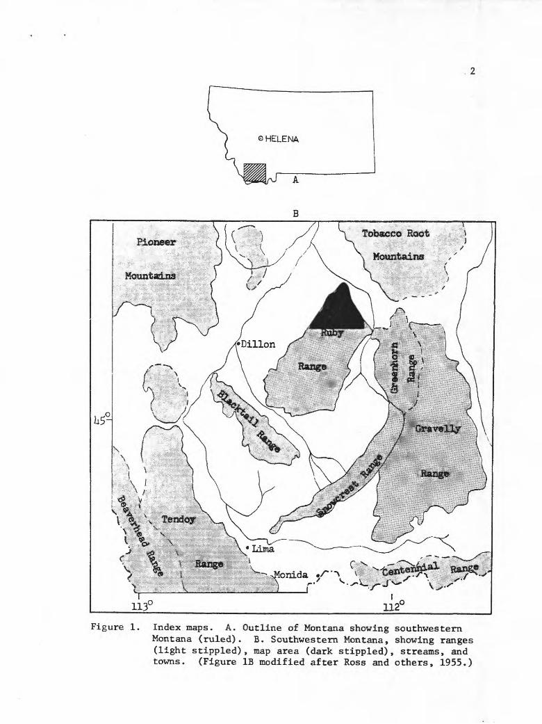
Figure 1. Index maps. A. Outline of Montana showing southwesternMontana (ruled). B. Southwestern Montana, showing ranges (light stippled), map area (dark stippled), streams, and towns. (Figure IB modified after Ross and others, 1955.)

the upper part of the Pilgrim Formation and the Red Lion Formation
which were studied closely. Other formations were sampled mainly
in an effort to obtain representative samples. Thin sections, pol
ished slabs, and hand specimens were examined to analyze the units.
Fossils were collected from most of the formations to facilitate
regional correlation.
Mapping was done directly on Mylar topographic maps (scale,
1:24,000) cut into quarters for field use; data were transferred to
duplicate maps at the end of each day.
PREVIOUS WORK
The first geologic notation on the Ruby Range was recorded by
a Hayden Survey party that briefly observed the mountains in Sep
tember, 1871, calling them the Stinking Water Range (Hayden, 1872,
p. 36-39, 143, 259-261). A more detailed examination was made by
Earl Douglass who collected Cambrian and Mississippian fossils from
the northeastern part of the range in 1902 and again in 1905
(Douglass, 1905; 1909). A Cambrian stratigraphic section was measured
by Ranson (1952) in the McHessor Creek drainage area and used for
regional correlation in southwestern Montana, and a small Precambrian
sedimentary iron ore deposit in the northern part of the Ruby Range
was mapped by James and Wier (1960).
Other studies of the Ruby Range (south of the area of this
report) include those of Klepper (1950), Heinrich (1960), Seeker

(1961), Dorr and Wheeler (1964), Wier (1965), and Giletti (1966).
Reference to many economic geology papers pertaining to the southern
two-thirds of the range are recorded in Heinrich (1960).
ACKNOWLEDGMENTS
Sincere appreciation is extended to my adviser, Dr. James A.
Feterson, for his counsel and thought provoking discussions.
Thanks are also expressed to Dr. G. W. Crosby, structural adviser,
for discussion of structural problems; to Dr. W. J. McMannls of
Montana State University for discussion of field problems and for
originally pointing out the area; and to Dr. E. T. Ruppel of the U. S.
Geological Survey for many helpful discussions of field problems.
Drs. R. M. Weidman and A. G. Canaris are thanked for their suggestions
and constructive criticisms, and Mr. A. R. Palmer and J. T. Dutro, Jr.,
for identification of fossils. Many happy hours were spent with
R. M. Petkewich discussing mutual geologic problems.
STRATIGRAPHY
The major emphasis in this part of the project applies to the
Cambrian, especially from the standpoint of sedimentologic and
environmental studies of the carbonate units. The strata were
divided into "lithofacies," rock units that exhibit a unique recog
nizable outcrop character and have a similar genetic significance.
Presentation of the data is twofold descriptive and interpretative.
Description is both megascopic and microscopic and is separate from
the environmental interpretation.
Significant lateral facies changes were not observable within
the relatively small area this project encompasses probably because
the regional Cambrian depositional environments were widespread and
uniform. However, by using Walther's Law (cf., Visher, 1965), which
states that lateral positioning of sedimentary facies tends to be
similar to that of their vertical superposition, an interpretation
of facies positioning was possible.
Strata other than those of Cambrian age were studied in only
moderate detail in the field and laboratory, but fossil collections
were made where possible.
The classification of carbonate rocks used in this study is
that of Dunham (1962), shown in Figure 2. Observations of polished
slabs and hand specimens were commonly more useful than those of
thin sections because dolomitization of much of the strata is intense,

AGE
a?o1 elE-
nr
£ o
Is;s«a.
MISSISSIPPIAN
§C2
CAMBRIAN
Va,
jj(0r-»PH
£
0 r-»T3 'O ;rfX--.
irH S-irtC£:J
>3r-i
1
O) P<s1 -(
<u -P5
Middle
UNITTufaunnamed cglTertiary-QuaU undivided
Oligocene sed.BeaverheadFm.
Quadrant Sandstone
Kibbey Fm. ?
Mission Canyon Limestone
Lodgopole Limustone
Thren Forks FmJefforsonFm.
Red jionFm.Pilg .*im Limestone
Park Shale
\A& i o»V^o*
Limestone
Wolsey ShaleFlathead SS
Metamorphic Rocks
THICK. ffft«t.}3-10050-7
varies
150-7
?
1200?
25-100
1370
600
150
250-268
0-170
295-395
175
550- 750
5o-ioo10-50
7
3J3G,i __>>L ,.?Wrsjle>iflo^
. o 'a *5 >-tfLJI
?*
j. L. . *l**-t* *
,L U.-4-rJ .L
J44. >: -
^Mrii i
,1r» /. . .«T^n
\^AJ .
1 .'
1.r l1
1
1
1
1
Vf1,1 ,1,1 ,1.1 r-l-LV
oaot>
W\ \
Vr.' V»
1_ \. \'- ';V \L_\-ZHT^c"T^L-, \
I '^ ,
\^ ,yr^ , \-rV
DESCRIPTIONlimestone, spring depositpebbles and cobbles in sandy matrixmainly basin deposits, but also young unstratified deposits
mudstone, siltstone f eel sandstoneconglomerate composed of quartzite or carbonate clasts, or both
interbedded fine-grained quartz sandstone and light-gray weathering limestone thick-bedded.
reddish silty dolomite, thin-bedded
light-gray weathering thick-bedded limestone forms massive outcrops, solution breccia in upper part, chert nodules and stringers occur locally.
upper one-half is light-gray medium- and thick-bedded fossiliferous limestone, lower part is dark shaly laminae.
clay shale, evaporite breccia, limestonemostly brown dolomite, but also silty shaly beds and evaporite breccia.clay shale of Dry Creek Member at base» Sage Member is dolomite, sandy. Algae.lower member is massive gray dolomite, uoper member is aleal dolomite, sandy.green clay shale, with thin beds of carbonate rocks in lower and upper parts
pale yellowish brown dolomite in most places, but light-gray limestone Iocally0 thin- to thick-bedded, middle part forms good outcrops.
-j:r
" clay shale, sandstone in lower part.£3\ quartz sandstone, locally conglomeratic »
I many rock types, includes metadolomite, amphibolite, quartzite, quartzo-felds- pafchic gneiss, granite gneiss locally.
Table I. Generalized section of stratified sedimentary rocks.

OEPOSITIONAL TEXTURE RECOGNIZABLE
Original Components Not Bound Together During Deposition
(particContains mud
es of clay and fine silt six* )
Mud-supported
Less than 10 percent grains
Murtstone
More than 10 percent grains
Wackestone
Grain- supported
Pack jlone
Ucksmud and Is
grain-supported
Original components were bound together during deposition...
as shown by intergrowit skeletal matter,
lamination contrary to gravity, or sediment-floored cavities that
are roofed over by organic or questionably organic matte* and are too large to be interstices.
Boundstone
OEPOSITIONAL TEXTURE NOT RECOGNIZABLE
Crysiallme Carbonate
( Subdivide according to classifications designed to bear
on physical texture or diagenesis.)
Figure 2. Classification of carbonate rocks according to deposi- tional textures (after Dunham, 1962).
PRECAMBRIAN
Metamorphic rocks are described only briefly because this study
is primarily concerned with younger rocks. A detailed treatment of
them can be found in Heinrich (1960).
Extensive areas of Precambrian metamorphic rocks are present
in the south-central part of the map area and to a lesser extent
in the southwestern and southeastern parts (Plate 1). Good out
crops are scattered, the rocks typically forming smooth-surfaced
ridges with rounded crests. The foliation trends generally
northeast, in accordance with the regional structural grain in south
western Montana. Rocks include metadolomite, quartzite, amphibolite,
many varieties of quartzo-feldspathic gneiss, and some granite gneiss
in the southwestern part of the map area.
Age Radiometric age determinations in the Ruby Range suggest
the last metamorphic event occurred about 1600 million years ago
and was accompanied by intrusion of a granite gneiss (Giletti, 1966;
Giletti and Cast, 1961).
CAMBRIAN
FLATHEAD SANDSTONE
Nearly pure quatzitic sandstone makes up the oldest Cambrian
rocks in the area and is assigned to the Flathead Sandstone.
Exposures range from nearly complete in vertical outcrops, to
covered slopes, although typically only a few beds of the middle
part crop out. Locally the unit makes a broad outcrop, reflecting
its tendency to form a dip slope. Thickness of the Flathead ranges
from 10 to 50 feet.
The basal Flathead is exposed only in laylor Canyon where it
is unconformable on Precambrian metamorphic rocks The upper con
tact is gradational with the Wolsey Shale and is placed at the
first occurrence of a shale bed more than 5 feet thick; where the
shale section is covered 9 the contact is arbitrarily placed where
the highest sandstone ledge meets the dip slope of the Wolsey.
Quartz grains makes up more than 99% of the Flathead. Minor
constituents include chert a wisps of clay, mica, hematite, limonite,
heavy minerals and a few metamorphic rock fragments. Glauconite
occurs locally in the upper part. Light brown and shades of orange
are typical Flathead colors in the Ruby Range.
Grain size ranges from fine to coarse, but much of the Flathead
is fine- and medium-grained. Most quartz grains are subrounded to
rounded (3.5 to 5, classification of Powers, 1953), and are cemented
by overgrowths that are optically continuous. Sutured contacts,
however, are not common. At one locality (NWiSEi sec. 34, T. 6 S.,
R. 6 W.) rounded quartz grains with double overgrowths are common,
and one grain with a triple overgrowth was observed.
Sorting ranges from moderately to well-sorted (classification
of Folk, 1968, p. 105), with the well-sorted sands being the fine-
to medium-grained sizes. Moderately sorted sands are commonly bi-
modal, consisting of coarse sand interlaurtnated with fine- to medium-
grained sand.
Conglomerate lenses are common in the basal part, containing
subangular to subrounded quartz granules and pebbles in coarse
grained sandstone. Higher in the formation occur lentils of quartz
clast conglomerate. Typically the clasts are subangular, range from
1 to 15 centimeters in diameter, form lentils no thicker than the
largest clast, and are assorted with coarse sand grains in a bed
that is otherwise made of fine- to medium-grained sand.
Pebbles of clay shale up to 3 centimeters in length but only a
few millimeters thick occur at the top of the Flathead in the
SEiNWi sec. 2, T. 7 S., R. 6 W. The enclosing rock is thinly
laminated fine- to medium-grained sandstone, except for envelopes
of coarse-grained sand around some of the pebbles.
Origin The Flathead is a transgressive marine sandstone that
must be either a first cycle deposit derived by erosion of Precambrian
metamorphic rocks, a second cycle deposit derived by erosion of Belt
10
sedimentary rocks, or a combination of both. Multiple overgrowths on
some grains are indicative of a recycled sediment. The high Founding
values for most of the grains is suggestive of a second cycle
sediment. Conversely, much quartz must have been freed upon disag
gregation of underlying metamorphic rocks; indeed, the only clasts
of metamorphic rock present in the Flathead are cobbles and pebbles
of quartz.
It seems improbable that the formation represents an ancient
beach deposit. Very few fossil beaches are known, and those that
have been described are narrow, linear features commonly in regres
sive deposits. In a transgressive sea relative sea level is rising,
however slowly, and the beach deposits are constantly being reworked
as they migrate shoreward. Because the offshore zone must follow
the same migration route, offshore processes would be expected to
restructure any beach deposits encountered.
One possible depositional environment for the Flathead is the
offshore area, extending seaward from the low tide line. Features
present in the formation fine lamination, bimodal sorting, stranded
pebbles and cobbles that could be formed on a beach are also
typical of submerged offshore bars (Thompson, 1937). In addition,
steeply-inclined cross beds like those noted at one place in the
Flathead are common on the landward side of bars.
Age No fossils were found in the Flathead in the Ruby Range.
Middle Cambrian trilobites of the genus Glossopleura occur in the

11
Flathead in the Gallatin Range, about 60 miles east-northeast of the
map area (Tysdal, 1966), whereas about 40 miles to the north the
Glossopleura fauna occurs in the lower part of the Wolsey (Alexander,
1955). These data indicate the Flathead is older to the west and
suggest that the formation in the Ruby Range is older than Glosso-
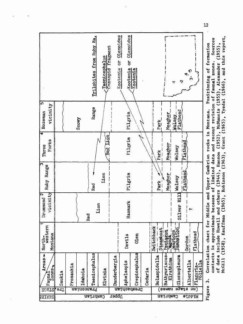
pleura Zone time (Fig. 3). Because sedimentation was apparently
continuous from the base of the Flathead to fossiliferous strata in
the lower part of the Wolsey, it is not unreasonable to infer that
the Flathead is also of Middle Cambrian age, but it could be older.
Chaudhuri and Brookins (1969) used radiometric techniques to
date glauconite from the upper part of the formation in Montana.
They obtained an age of 542 million years, considering it Middle
Cambrian. Their sample localities were not published, however.
WOLSEY SHALE
The Wolsey is transitional between the Flathead and Meagher
formations, forming broad benches or gentle grass-covered slopes.
Natural outcrops of the unit are not present in the Ruby Range and
the only exposure occurs in a mining exploration trench cut in the
basal part. Because the thickness of the unit ranges from only
about 50 to 100 feet, the formation is mapped with the Flathead.
Regionally the Wolsey is divisible into three parts: a basal
shale unit, containing intercalated sandstone, siltstone, and shale;
a middle carbonate unit; and an upper shale unit that grades into
SERIE^ 1
Upper
Cambrian
1
Middle
Cambrian
§ g CO <o F-i EH Franc
onian Dresbachian
CO
<D Q)
txO rt
-P CO £
^^^Areas-*-
FaunaT"\^
Zones-*^\
Saukia
Pros
auki
a
Idahoia
Taen
icep
halu
s
Elvinia
Dunderbergia
Aphelaspis
Crep
icep
halu
s
Cedaria
Bola
spid
ella
Bath
yuri
scus
- El
rath
ina
Glossopleura
Albe
rtel
laPl
agur
ia-
Poli
ella
Nort
h-
1 western
Montana
Devils
Glen
Switchback
Stea
mboa
tPe
ntag
on_?3goaa_
Dear
born
Ip
amna
tlon
_
Gordon
Flat
head
2Dr
ummo
ndvi
cini
ty
Red
Lion
Hasmark
Silver t
tL13
?
3 Ru
by R
ange
Red
-r _
Lion
Pilgrim
Park *^^
Meagher
Wolsey
Flat
hgas
L^
Thre
e 4
Forks
L/^R
ed~I
don~
Pilgrim
Park
Meag
her
Wolsey
£lat
head
__^
Bozeman
5 vicinity
Snowy Ra
nge
"- - _
Pilgrim^^
Park
Meagher
_Wol
s^y_
__
jOat
he§d
^__
Tril
obit
es fr
om Ruby
Ra.
^_^ Taenicephalus
Cona
spid
fr
agme
nt
^ Kootenia o
r Ol
enoi
des
/Kootenia
or O
leno
ides
^-^^-Kootenia
r~
.
-,
\ '
\S
'2
j /
4
| S
3-
'5
jL
f~-
-'--
-
V.^J^
Figure 3.
Corr
elat
ion
char
t fo
r Middle and
Upper Cambrian ro
cks
in Mon
tana
. Positioning of formation
cont
acts
is
ap
prox
imat
e because of li
mite
d da
ta an
d recent re
visi
on of fa
unal
zones.
Sources
of da
ta in
clud
e Howell and
others (1944),
Hanson (1
952)
, McMannis (1955),
Alexander (1955),
McGi
ll (1958),
Kauffman (1
965)
, Ro
bins
on (1963),
Grant
(196
5),
Tysdal (1966),
and
this re
port
.

13
limestone of the overlying Meagher Formation (Ranson, 1952; Lebauer,
1964).
Siltstone exposed in the basal Wolsey unit in the Ruby Range is
brown, thin-bedded, and is interstratified with coarsely micaceous
olive green clay shale. The siltstone consists of quartz (85-90%),
feldspar (5-10%), glauconite (1-10%), mica (1-2%), and hematite (<1%).
Grain size is commonly in the coarse silt range, except that glau
conite ranges from coarse silt to fine sand. Host grains are
angular to subangular, except for the fine sand size glauconite
grains which are commonly rounded. Silica cements the siltstones and
sutured grain contacts are common. Sorting ranges from moderate- to
well-sorted. Sorting is commonly very good except for the presence
of the slightly coarser glauconite grains.
Origin The basal siltstone of the Wolsey is transitional between
quartz sandstone of the Flathead and clay shale of the Wolsey. This
is suggested by (1) the stratigraphic position of the siltstone between
the sandstone and the shale, (2) grain size in between that of sand
stone and shale, (3) presence of both quartz grains and shale flakes
in the siltstone, (4) presence of silt-size grains which would be
sorted out of the depositional environment of the Flathead, and (5)
regional paleontologic data showing that both Flathead sand and
Wolsey shale were being deposited at the same time. The basal Wolsey
sediments probably are offshore winnowed elastics of the Flathead and
the intercalated shale and siltstone are indicative of fluctuations

14 .
in the ancient shoreline.
Glauconite denotes a low or negative sedimentation rate (Cloud,
1955). Some of the fine sand-size glauconite is angular and platy
and perhaps could have formed in place by alteration of clay chips.
This theory is supported by Lebauer's (1964) data showing a similarity
in composition of glauconite pellets and illitic shale.
Age No fossils were found in the Wolsey of the Ruby Range.
Alexander (1955) reported Middle Cambrian Glossopleura and Kootenia
from the Wolsey in the Whitehall area, about 30 miles to the north.
A similar age is probable for the formation in the Ruby Range (Fig. 3).
MEAGHER LIMESTONE
Strata of the Meagher comprise the thickest Cambrian formation
in the Ruby Range, ranging from 550 to 750 feet. The thicker section
is present north of McHessor Creek (NEiSEi sec. 19, T. 6 S., R. 5 W.),
the thinner one near the head of Laurin Canyon (EiNEi sec. 8, T. 6
S., R. 5 W.). In the northern one-third of the map area faulting and
limited depth of erosion permit exposures of only the upper 100-200
feet of the Meagher. Strata adjacent to the Wolsey-Meagher contact
are unexposed in the Ruby Range, but rocks near the Meagher-Park
contact are locally exposed and are transitional. Shale beds
lithologically similar to the Park Shale are intercalated with
carbonate beds 50 to 100 feet below the contact, and near the top of
15 .
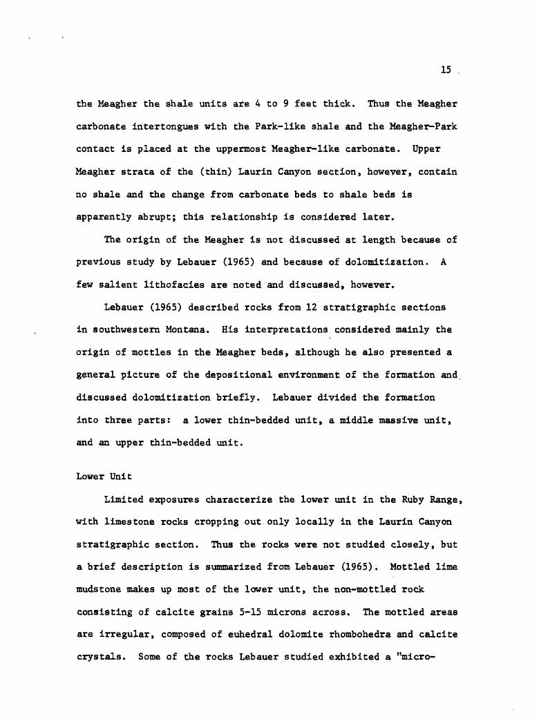
the Meagher the shale units are 4 to 9 feet thick. Thus the Meagher
carbonate intertongues with the Park-like shale and the Meagher-Park
contact is placed at the uppermost Meagher-like carbonate. Upper
Meagher strata of the (thin) Laurin Canyon section, however, contain
no shale and the change from carbonate beds to shale beds is
apparently abrupt; this relationship is considered later.
The origin of the Meagher is not discussed at length because of
previous study by Lebauer (1965) and because of dolomitization. A
few salient lithofacies are noted and discussed, however.
Lebauer (1965) described rocks from 12 stratigraphic sections
in southwestern Montana. His interpretations considered mainly the
origin of mottles in the Meagher beds, although he also presented a
general picture of the depositional environment of the formation and,
discussed dolomitization briefly. Lebauer divided the formation
into three parts: a lower thin-bedded unit, a middle massive unit,
and an upper thin-bedded unit.
Lower Unit
Limited exposures characterize the lower unit in the Ruby Range,
with limestone rocks cropping out only locally in the Laurin Canyon
stratigraphic section. Thus the rocks were not studied closely, but
a brief description is summarized from Lebauer (1965). Mottled lime
mudstone makes up most of the lower unit, the non-mottled rock
consisting of calcite grains 5-15 microns across. The mottled areas
are irregular, composed of euhedral dolomite rhombohedra and calcite
crystals. Some of the rocks Lebauer studied exhibited a "micro-

16
clotted" texture, rounded silt-size clots of finely crystalline
calcite surrounded by lime mudstone. Fragments of trilobites
locally occur in the finely crystalline calcite. Lebauer interpreted
the sediments as having formed in quiet water, and he attributed
the mottling to burrowing, dolomitization, and movement of solu
tions along stylolites and small fractures with resultant alter
ation of adjacent sediments.
Middle Unit
Rocks of the Middle part of the Meagher, and those of most of
the younger Cambrian carbonate formations, are described and inter
preted as lithofacies units. Lateral facies patterns depicted for
the lithofacies units are shown in figures accompanying the text.
It is important to note that the patterns were not actually observed,
but are interpretations based on Walther's Law.
Rocks making up lithofacies of the middle unit of the Meagher
include (1) lime mudstone, (2) oncolitic packstone, (3) pelletal,
and pelletal- and intraclastic packstone, and (4) oolitic grainstone.
Figures 4 and 5 illustrate a possible lateral facies pattern for
these rock units.
Lime Mudstone Lime mudstone of the middle unit of the Meagher
is similar to that of the lower unit, except that mottled areas are
not abundant. Figure A of Plate 2 shows the main texture.
Environment Rock of this lithofacies appears similar to that
of the mud facies on the Bahamian platform west of Andros Island

17
(cf., Purdy, 1963; Cloud, 1962). Origin of the mud is not completely
resolved, but Purdy (1963) speculated that it may be formed by dis
integration of fecal pellets and Cloud (1962) proposed precipitation
by physicochemical processes.
Stratigraphic Position The lime mudstone is transitional with
the mottled lime mudstone of the lower unit of the Meagher and a
boundary between the two is difficult ot determine, except that the
middle unit tends to be cliff-forming. The lime mudstone also
occurs above and below oncolitic packstone, and below pelletal pack-
stone. The interpreted lateral facies patterns are shown in Figures
4 and 5.
Oncolitic Packstone Oncolites (Plate 2, Fig. B) of the Meagher
locally exhibit algal-like filaments which are similar to those termed
Girvanella. Measurements of the long diameter range from 5 to 10
millimeters, that of the short diameter 1.5 to 4 millimeters. The
oncolites are thus flattened, but orientation of long diameters is
not typically parallel to bedding. Flattening, therefore, occurred
before burial. The oncolites occur in lime mudstone matrix.
Environment Oncolites occur in water sufficiently agitated to
permit almost continual motion of the spheroid (Logan and others,
1964). In a study of modern oncolites Ginsburg (personal communica
tion, in Freeman, 1964) found flattened forms more characteristic
of the intertidal zone, with dome-shaped and spheroidal forms
present in the subtidal zone. Although the Meagher oncolites may
have thus formed in the intertidal zone, the abundance of mud matrix
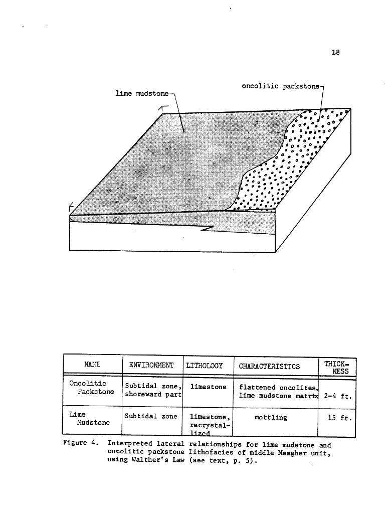
1-8
lime mudstoneoncolitic packstone-
NAME
Oncolitic Packstone
Lime Mud stone
ENVIRONMENT
Sub tidal zone, shoreward part
Sub tidal zone
LITHOLOGY
limestone
limestone, recrystal- H«»d
CHARACTERISTICS
flattened oncolites, lime muds tone matrix
mottling
THICK NESS
2-4 ft.
15 ft.
Figure 4. Interpreted lateral relationships for lime mudstone and oncolitic packstone lithofacies of middle Meagher unit, using Walther's Law (see text, p. 5).
19
argues for a subtidal burial site. The stratigraphic position of
the oncolitic packstone marginal to, and intertonguing with, (sub-
tidal) lime mudstone suggests this rock formed in the shoreward
part of the subtidal zone.
Stratigraphic Position The oncolitic packstone is both over
lain and underlain by lime mudstone. Interpreted lateral relations
are shown in Figure 4.
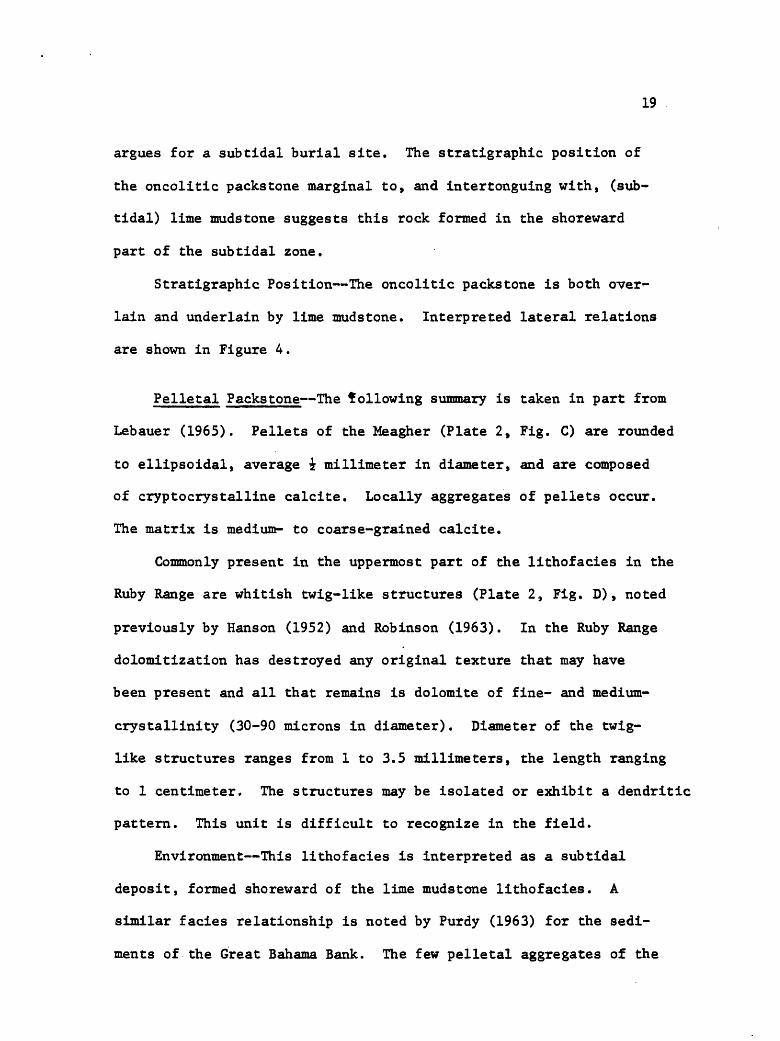
Pelletal Packs tone The following summary is taken in part from
Lebauer (1965). Pellets of the Meagher (Plate 2, Fig. C) are rounded
to ellipsoidal, average i millimeter in diameter, and are composed
of cryptocrystalline calcite. Locally aggregates of pellets occur.
The matrix is medium- to coarse-grained calcite.
Commonly present in the uppermost part of the lithofacies in the
Ruby Range are whitish twig-like structures (Plate 2, Fig. D), noted
previously by Hanson (1952) and Robinson (1963). In the Ruby Range
dolomitization has destroyed any original texture that may have
been present and all that remains is dolomite of fine- and medium-
crystallinity (30-90 microns in diameter). Diameter of the twig-
like structures ranges from 1 to 3.5 millimeters, the length ranging
to 1 centimeter. The structures may be isolated or exhibit a dendritic
pattern. This unit is difficult to recognize in the field.
Environment This lithofacies is interpreted as a subtidal
deposit, formed shoreward of the lime mudstone lithofacies. A
similar facies relationship is noted by Purdy (1963) for the sedi
ments of the Great Bahama Bank. The few pelletal aggregates of the
20
Meagher sediment occur near the transition into oolitic rocks. This
parallels a like relationship in the Bahamas noted by Purdy (1963)
and by Ball (1967). The aggregates may reflect the change into an
environment of greater current action and be, in effect, intraclasts
of pelletal material.
Origin of the twig-like structures is unknown, but they have
been suggested as organic (cf., Robinson, 1963). Their occurrence
in this facies is commonly near the transition into oolitic rocks,
suggesting an environmental control.
Stratigraphic Position The pelletal packstone unit overlies
lime mudstone and underlies oolite grainstone, being transitional
with it. Figure 5 shows the interpreted facies pattern.
Oolite Grainstone Extensive description of much oolitic rock
of the Meagher was presented by Lebauer (1965) and is briefly sum
marized here; dolomitization of this lithofacies is extensive in
the Ruby Range, obscuring most of the detail.
Oolites average i millimeter in diameter and exhibit both
concentric and radial structure. Nuclei of the oolites are com
posed of cryptocrystalline calcite, pellets, and less commonly fossil
fragments. Crystalline calcite (dolomite in the Ruby Range) makes
up the matrix material.
Environment Oolites form in water supersaturated with calcium
carbonate and where sediment is subjected to strong current action
(Eardley, 1938; Illing, 1954; many others). The water is commonly
shallow, typically less than 6 feet deep in the Bahamas (Furdy, 1961)

21
oolitic grainstone
pelletal packstonelime mudstone
NAME
Oolitic Grains tone
Pelletal Packstone
Lime Mud stone
ENVIRONMENT
intertidal zone
sub tidal zone
sub tidal zone
LITHOLOGY
dolomite
limestone, recrystal-H*PH
limestone, re crystal lized
CHARACTERISTICS
structures almost totally destroyed
rounded to ellipsoidal pellets
mottling
THICK NESS
100 ft.
30 ft.
15 ft.
Figure 5. Interpreted lateral relationships for lime mudstone, pelletalpackstone, and oolitic grainstone of middle Meagher unit,using Walther's Law (see text, p. 5).

22
and in the Persian Gulf (Kinsman, 1964; 1969).
Oolite deposits of the Meagher are extensive, thus may have
formed over extensive area or may simply have migrated as bars
across shallow areas. Similar deposits in the Bahama Islands occur
at the platform margins adjacent to sites of upwelling from hundreds
of feet below sea level. In contrast, those of the Persian Gulf
occur near lagoon entrances, the water shoaling from depths of
only 125 feet below sea level. No evidence of a bank environment
comparable to that of the Bahama Islands was found in the Ruby Range,
nor was evidence for one reported by Lebauer (1965) in his regional
study. It seems, therefore, an analogy with the Persian Gulf is
the more probable comparison.
Stratigraphic Position Oolite grainstone overlies pelletal
packstone, a possible lateral relationship shown in Figure 5.
Upper Unit
Yellowish-mottled dolomitic lime mudstone similar to that of
the lower unit characterizes much of the upper unit of the Meagher.
Except at the thin Laurin Canyon section, the upper 100-150 feet
of the Meagher contains a few oolite grainstone beds, flat pebble
conglomerate, and interbedded clay shale.
Mottled Pelletal Lime Mudstone Pelletal lime mudstone (Plate 2,
Figs. E,F) makes up the gray part of the rock in this lithofacies.
The pellets range from 40 to 80 microns in diameter and are made of
mudstone with grains less than one micron in diameter; grains of the
23
mudstone matrix range to 5 microns in diameter. The yellowish mottled
areas are composed of calcareous dolomite grains that are dominantly
euhedral and 30 to 60 microns across.
Typical of the lime mudstone is small-scale, very low angle
cross-lamination. Thin-sections reveal a laminar arrangement of the
larger pellets and concentration into a few laminae. A few recrystal
lized fossil fragments also are present. Yellowish silty calcareous
dolomite makes up the mottled areas (Plate 2, Fig. F). Shapes of
the mottled areas are irregular, measuring to 1 centimeter thick and
1 to 4 by 5 to 10 centimeters across. Mudstone laminae are abruptly
truncated by sediment forming the mottled areas.
Environment Rock of this lithofacies is like that of the
pelletal mud facies of the Bahamas (Purdy, 1963), except for the
yellowish silty mottled areas. It is also similar to part of the
subtidal lagoonal complex in Khor Al Bazam, Persian Gulf, described
by Kinsman (1969). Absent are typical intertidal features such as
the persistent algal mats of the Persian Gulf and the intensive
burrowing and resultant non-laminated sediment of the Bahamas.
Desiccation features were not observed.
The small-scale low angle cross-lamination attests to some
current action, and distribution of larger pellets into particular
laminae argues for variability in current strength. Weak currents
are probable as suggested by the mud matrix (lack of winnowing)
and by preservation of the pellets themselves, structures shown to
be fragile (Purdy. 1963).

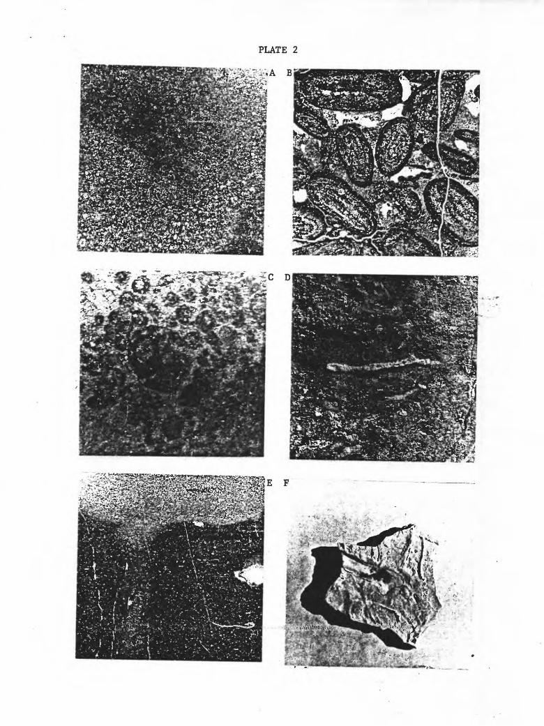
PLATE 2
Figure A. x 95 plane light. Common texture of lime mudstone in middle unit of Meagher Limestone.
Figure B. x 4 plane light. Oncolitic packstone of middle unit ofMeagher Limestone. Note differing orientations of flattened oncolites.
Figure C. x 30 plane light. Pellets and pelletal aggregate of middle unit of Meagher Limestone. Apparent structure of pellets is due to recrystallization of calcite.
Figure D. x 2. Twig-like structures present in middle part of Meagher Limestone.
Figure E. x 3 plane light. Mottled pelletal lime mudstone frommiddle unit of Meagher Limestone. Figure shows vertical burrow, yellowish mottled area at top. Section is a vertical slice across long axis of mottled area of sample in Figure F below.
Figure...F. x i. Mottled pelletal lime mudstone from middle unit of Meagher Limestone, with yellowish mottled area outlined.
24
Infilling of erosion-formed depressions would be a likely mode
or origin for the mottled areas, although they could possibly be
formed by burrowing. Clearly, abrupt termination of the mudstone
laminae shows that the depressions and mottled areas formed after
the mudstone. In addition, the quartz silt present only in the
mottled areas suggests a new sediment type (and source?). A higher
energy environment may be suggested to explain cutting of the
depressions, for transporting the quartz silt, and because of the
presence of vertical burrows. Compared to the environment of
horizontal burrows, vertical burrows are commonly found where higher
energy conditions exist at the sediment-water interface (Rhoads,
1967). Indeed, some of the depressions are elongate and appear
similar to small-scale linquoid ripple marks, structures presently
forming in turbulent water with sinuous flow lines (Alien, 1963).
Age Fossils obtained from the Meagher are poorly preserved.
Collections were made from the upper 100 feet of the formation in
the NEiNEi sec. 29, T. 5 So, R. 5 W., and identified by A. R.
Palmer (written communication, 1968). The fossils include the
brachiopods Micromitra and Opisthotreta, and the trilobites
Kootenia?, a pygidium of either Kootenia or Olenoides, and marjumids,
Palmer stated that "the total aspect...is of faunas of late Middle
Cambrian age" (Fig. 3).

25
PARK SHALE
Rocks assigned to the Park Shale rarely crop out and a gently
sloping grassy bench commonly marks the trace of the formation. A
fairly well exposed outcrop of the basal part occurs in the NEiNEi
sec. 19 9 To 6 S., R. 5 W., and an excellent outcrop of the upper 50
feet is exposed in the SWiSWi sec. 33, T. 5 S., R. 5 W.
As described above, the contact of the Park with the underlying
Meagher was placed at the uppermost bed of Meagher-like carbonate
rock. Commonly, the upper contact is concealed by float from the
Pilgrim Formation, but where exposed the contact is sharp. The
significance of this contact is discussed later.
Thickness of the formation is about 175 feet, most of which is
finely micaceous grayish-olive fissile clay shale. Near the base
are scattered layers of thin-bedded yellow and orange nodules of
limestone; these commonly contain trilobite hash, phosphatic
brachiopods, oncolites, or limestone pebbles. Dolomite nodules
crop out near the top of the Park.
Origin The Park is commonly thought to represent a temporary
regression in the dominantly eastward transgression of the Cambrian
seas. It is thus implied that the source of the sediment was to the
east, but some of the sediment may have come from central Idaho,
as Robinson (1963) has pointed out.
Palmer (1960) has shown that Cambrian sediments in the Great

26
Basin are divisible into an inner and an outer detrital belt, with
a carbonate belt in between. He stated (Palmer, 1966) that "during
most periods of contraction of carbonate sedimentation, the carbonate
belt was interrupted across central Idaho," and that "an important
tectonic positive area west of central Idaho is indicated by...re
peated interruptions of the carbonate belt across central Idaho..."
Hobbs and others (1968) described quartzites in central Idaho of
Early to Middle Cambrian age which are separated from early Middle
Ordovician rocks by an undated quartzite unit. Perhaps some of the
Park sediment was winnowed from this western facies.
The nodules of dolomite cropping out in the upper part of the
Park occur in Robinson Canyon (SWiSWi sec. 33, T. 5 S., R. 5 W.).
The nodules are "pod" shaped (see sketch, Fig. 6) with dimensions
averaging about 5 by 3 by 3/4 inches. Pods are isolated within the
soft clay shale of the formation, although many occur at the same
stratigraphic levelo Silty dolomite mudstone forms the inner part
of each pod, with micaceous dolomitic siltstone enveloping it.
A cross-section of one of the pods shows the laminae to be
terminated abruptly on one end and tapered on the other as if
pulled laterally; the inner part, or "core" reflects this pattern.
Formation of the pods may be reconstructed in sequence as follows:
(a) deposition of detrital material, coarsening from clay to silt
and forming a thin layer of quartz silt; (b) deposition of a layer
of carbonate mud, containing less than 20 percent quartz silt;
(c) deposition of another layer of silt, grading upward to detrital
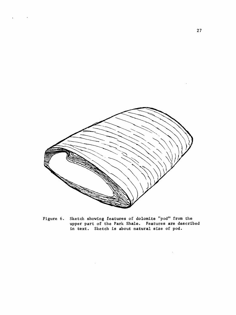
27
Figure 6. Sketch showing features of dolomite "pod" from theupper part of the Park Shale. Features are described in text. Sketch is about natural size of pod.
28
material of clay size; and (d) differential compaction and formation
of the pods after burial of the layers. As the weight of the over
lying sediment increased the still plastic carbonate mud flowed
laterally. The thicker parts of the irregular mud layer may have
served as loci for pod formation. Shearing in the silty laminae
paralleled flowage of the mud, creating a tapering of the laminae
(right side of Fig. 6) and abrupt truncation of laminae (at left)
where the mud layer broke abruptly.
Grant (1965, p. 14-15) explained limestone pods in shale of
the Sage Member of the Snowy Range Formation as concentrates of
lime mud in depressions such as ripple troughs. The method is
attractive, but fails to account for the structures in the pods of
the Park. Another possibility is that calcareous algae could have
concentrated the lime and trapped silt, but no evidence of algae
was observed in the pods.
The contact of the Park with the overlying Pilgrim is sharp in
the Ruby Range. Silty dolomite mudstone occurs in the upper 15
inches of the Park and is overlain by dolomite-pebble conglomerate
grainstone of the basal Pilgrim. Two factors suggest that perhaps
this sharp contact represents an environmental change rather than a
break in the sedimentary record: (1) the occurrence of dolomite
mudstone in the upper 15 inches of the Park instead of fissile
clay shale, and (2) the presence of fossils in the upper part of
the mudstone. In general, fossils in Cambrian rocks seem to be most**
common in beds transitional between those dominating the formations

29
above and below a mutual contact.
The change from Park to Pilgrim strata in southwestern Montana
is considered by most authors to be gradational, exemplified by
interbedding of shale and limestone or dolomite rocks. A survey of
the literature shows that in most cases the contact is concealed,
however, and where exposed it is sharp (cf., Hanson, 1952, sections
3, 19, 20, and 21; Robinson, 1963; McMannis and Chadwick, 1964; Karlstrom,
1948). In south-central Montana, though, Hanson (1952) found the
contact to be clearly transitional.
Age* Fossils collected from the Park are poorly preserved and
were obtained from the lower part of the formation. They were identi
fied as Kootenia or Olenoides, along with undetermined ptychoparioids,
and were assigned a Middle Cambrian age (written communication, A. R.
Palmer, 1970). Palmer noted that "one undetermined ptychoparioid
is similar to several late Middle Cambrian forms, but without a
larger sample a meaningful determination cannot be made." (See
Fig. 3.)
PILGRIM LIMESTONE
Thickness of the Pilgrim ranges from 295 to 395 feet. The
thickest section was measured just north of McHessor Creek in the
SWiSEi sec. 18, T. 6 S., R. 5 W., the thinnest near the head of
Laurin Canyon (EiNEi sec. 8, T. 6 S., R. 5 W.). The basal beds of
30
the unit are almost everywhere covered, with the Park-Pilgrim contact
exposed only in one place, Robinson Canyon. This contact was dis
cussed above in the description of the Park. Good exposures charac
terize the remainder of the formation. The upper contact is
thought to be conformable with the overlying Dry Creek Member of the
Red Lion Formation and is discussed with that member.
The Pilgrim in the Ruby Range is divisible into two distinct but
informal members lower and upper. The lower member is mainly dolo
mite, whereas the upper one is dolomite and quartz sandstone.
Lower member
The lower member ranges from 200 to 270 feet thick. The lower
and upper few tens of feet of the member are characterized by thicker
bedding than the main body of the unit. Thin-section study reveals
few details due to dolomitization, but polished slabs of the rock
show faint mottling, hints of replaced oolites, and white twig-like
structures similar to those noted in the Meagher. In addition,
glauconite occurs locally. Medium and thick beds are typical of
these strata, which weather light gray.
A distinctive repetition of 2 to 10-inch-thick intervals of
yellowish shaly dolomitic laminae characterize the main part of
the lower member of the Pilgrim. Features of the dolomite between
the intervals of shaly laminae are obscured by dolomitization and
weathering in most outcrops. Part of the McHessor Creek section
is less weathered than elsewhere, however, revealing the thinly
31
e-«
g
30
29
28
27
26
25
2U
23
22
21
20
19
18
17
16
15
Hi
13
®* 63
::;::.;;|;:;i:§;i
:;2': jt:::;::::?v:": :£:£;JK:£::S--:
ItSlsi
illS:S:**!;-:?SiiJlli
£^j(!£:3;S::S
l^Pi
liiiI1MII*:fp;«?:: £:' ::^::: ;::':-x>: ;$
:i^*|li: ;St5v||i::s::|-:
x : ^-VSWX
111
i:fjS|i;i4:|;i
p:: :S: :t:ll
^?: ' : '3(B|;-:;: : ' :S>I';:*lll
Pii:-"^ irtli
:!;:&: .*
Si! llisR Ipp:;!: : i;S :;' . / -f
|j|;|; ^i'^lPI-^v.::;::;:::j|y|;W;:;::;>
^If^^l
IHIi!|l;^:;:-:4Bfr.-^g
&, .S^
DESCRIPTION OF UNITS
Shaly laminae
Laminated dolomite
Pebble conglomerate, dolomite
Laminated dolomite
Shaly laminae
Laminated dolomite
Mottled dolomite
Mottled dolomite?
Mottled dolomite
Bioclastic dolomite
Pebble conglomerate, dolomite
Bioclastic dolomite
Pebble conglomerate, dolomite
Laminated dolomite
Pebble conglomerate, dolomite
Laminated dolomite
Mottled dolomite
Shaly dolomite laminae
THICKNESS (INCHESS)
6
18
3
6
3
6
11
k
6
3
3
3
3
12
3
5
3
10
w§ §«CO
£SwCt,
i Ol-loU
-175
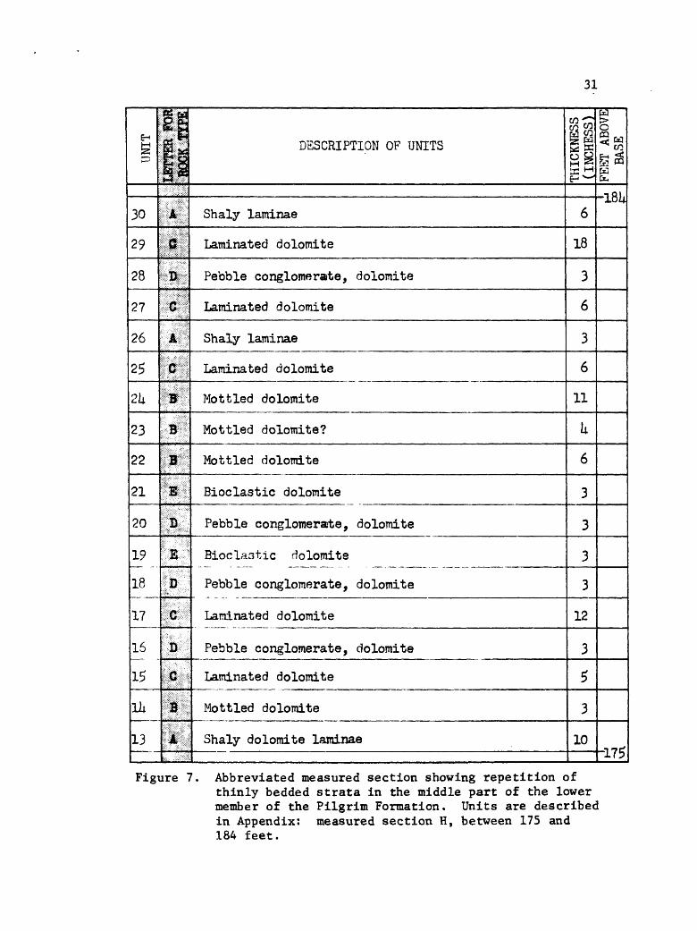
Figure 7. Abbreviated measured section showing repetition ofthinly bedded strata in the middle part of the lower member of the Pilgrim Formation. Units are described in Appendix: measured section H, between 175 and 184 feet.
32
bedded, repeated strata of the 175 to 184-foot interval shown in
Figure 7. The presence of similar rocks a few miles to the north
(Robinson, 1963) suggests widespread deposition of these beds in a
very broad, flat depositional environment in which relative sea
level changes regularly occurred. Unfortunately, because of
dolomitization, thin-sections reveal even less than the polished
slabs, thus limiting the possibility of further interpretation.
Upper member
Dolomite with an abundance of quartz sand distinguishes the
upper member of the Pilgrim. The outcrop expression is more like
that of the overlying Red Lion than the underlying Pilgrim. As
signment of this unit to the Red Lion seems incorrect, however,
because shale of the Dry Creek Member of the Red Lion is present
near the middle of the combined sequence and. by definition, marks
the base of the Red Lion Formation (cf., Lochman, 1950).
Figure 8 shows a generalized vertical sequence of the litho-
facies units making up the upper member of the Pilgrim and the
overlying Red Lion Formation in the Ruby Range. The lithofacies
units of the Pilgrim are described below in ascending order.
Sandy Laminated Boundstone Thin beds of finely laminated silty
and sandy dolomite characterize this lithofacies (Plate 3, Fig. A).
The silt and sand grains are quartz and are commonly concentrated
along laminae which weather in relief on the outcrop face. .Typically
the laminae are flat, but locally they are wavy, somewhat like

33
SUB- TIDAL NAME OF LITHOFACIES UNIT FM
Columnar Boundstone
Dome-shaped Boundstone
Medium-bedded Boundstone
Thin-bedded Boundstone55 oM
Laminated Crystalline Dolomite
Mud-cracked Boundstoneg
£2 O
Ribboned Boundstone
Bioclastic Grainstone
Dolomitic Quartz Sandstone
Fissile Clay Shale
Sandy Crystalline Dolomite
Sandy Laminated Boundstone
Dolomite Mudstone
Cross-bedded Sandstone
Sandy Laminated Boundstone
<D
03
Intraclastic Crystalline Dolomite
Shaly Crystalline Dolomite
Intraclastic Crystalline Dolomite
Nodular Boundstone
Bioclastic Packstone
o e-iCO
5H
Nodular Boundstone
Sandy Laminated Boundstone
Figure 8. Vertical sequence of lithofacies units occurring in the upper member of the Pilgrim Limestone and in the over lying Red Lion Formation. Jagged line slopes to left for sediments deposited during transgression of sea, to the right for sediments deposited during regression of sea.

34
stromatolltic mat algal structures.
Dolomite makes up 75-80% of the rock, except near bedding sur
faces where the beds are mainly composed of closely-spaced sandy
laminae. Grain size of the dolomite commonly ranges from 60 to 120
microns, but near bedding surfaces grains may be no larger than 5
microns. Quartz comprises the remainder of the rock (20-25%),
consisting mainly of subangular to subrounded coarse silt (30-60
microns) grains. Near bedding surfaces, however, the quartz grains
are rounded and of fine sand size.
Environment The inferred environment for this rock type is
intertidal. The stromatolitic mat algae suggest binding of the
grains in the intertidal zone, and where the algae are absent the
sand may be considered part of a beach deposit. Kendall and
Skipwith (1969) found adjacent beaches and intertidal flats composed
of quartz-rich sediment in the Khor Al Bazam Lagoon, southwest Persian
Gulf. In addition, the abundance and large size of the quartz grains
in the sandy laminated boundstone suggest that they are not of sub-
tidal or supratidal origin. The quartz grains in the Khor Al
Bazam Lagoon show a distribution similar to that noted here, and grain
transport is along the shore zone.
Frequent changes in wave energy are suggested by the observation
that the laminae show changes in grain size from coarse silt adjacent
to the mat algae and coarse silt to fine sand elsewhere. The algae
probably persisted or grew more rapidly during times of lower energy
and trapped the finer grained sediment. Under higher energy conditions
35 .
they may have been killed as suggested by the association of coarser
grains with fewer algal laminations or none at all. Some of the
laminae present in these latter beds may be explained by the segre
gation of quartz grains into different size distributions. The
coarser grains or mixed fine and coarse grains reflect higher energy
conditions and'/or rapid deposition. In either case mat algae were
unlikely to be established. The suggested energy changes may reflect
only a change in tidal amplitude, perhaps due to daily tidal fluctua
tions .
Stratigraphic Position In the basal strata of the upper Pilgrim
member this lithofacies commonly overlies oolite grainstone of the
lower member and underlies nodular boundstone. Upward, the unit
reappears many times and is commonly interbedded with dolomite mud-
stone, although it also occurs below the cross-bedded sandstone unit.
The interpreted lateral facies patterns are show in Figures 11, 12
and 13.
Nodular Boundstone Strata of this lithofacies (Plate 3, Fig. B)
are thinly-bedded, grayish red-weathering, and consist of interlayered
dolomite and mat-algal laminated dolomite. Dolomite makes up 55-70
percent of the rock and quartz 30-45 percent, the quartz grains being
concentrated along algal laminae. Rounded intraclasts of dolomite
are present locally, measuring i to li centimeters in diameter and
composed of the same sediment as that of the matrix. Small-scale
cross stratification is evident in the intraclastic rock and mat-
algal fragments occur locally. Burrows are present but are not
abundant. Dolomitic casts of worm trails to one centimeter across

36
bioclastic packstonenodular boundstone-
NAME
Bioclastic Packs tone
Nodular Bound stone
ENVIRONMENT
sub tidal to intertidal
intertidal zone, upper part?
LITHOLOGY
dolomite
dolomite
CHARACTERISTICS
ghosts of spines common
interlayered dolo mite and algal-lami nated dolomite
THICK NESS
5-7 ft.
3 ft.
Figure 9. Interpreted lateral relationships for nodular boundstone and bioclastic packstone lithofacies, using Walther's Law (see text, p. 5).

37
are present at the surfaces of a few beds and disrupt the stromato-
litic laminae.
Microscopic examination shows the dolomite of both the intra-
clasts and the matrix to be anhedral, the grains ranging between 30
and 60 microns in diameter. Quartz grains are of sand size and
commonly range from 100 to 150 microns in diameter (fine sand). A
few grains with 300 to 400 micron diameters are also present but
they comprise less than 5% of the sand. Overgrowths are exhibited
by the larger, rounded grains; the smaller grains are subangular and
lack overgrowths.
Environment This lithofacies is interpreted as a deposit of the
intertidal zone by analogy with the stomato11tic intertidal deposits
of the Persian Gulf, described by Kendall and Skipwith (1968; 1969)
and Kinsman (1969). Interlayering of algal and non-algal sediments
may reflect a periodic shifting of the facies environment, with the
non-algal sediment being deposited more rapidly. Thus algae would
not have had sufficient time to become established. The nodular
tendency probably reflects differential compaction.
The rounded intraclasts may be indicative of the upper part of
the intertidal zone, rather than the supratidal zone, as no desic
cation features as associated with the strata. However, the clasts
may be of supratidal origin, with deposition occurring in the inter
tidal zone perhaps during storm action. Cross-bedding suggests rapid
deposition, as shown by the range in clast size (i to li centimeters).
The presence of rippled-up mat algal sediment in the clastic rock and

38
nodular boundstone- intraclastic crystalline dolomite
NAME
Intraclastic Crystalline Dolomite
Nodular Bound stone
ENVIRONMENT
inter tidal
intertidal, upper part?
LITHOLOGY
dolomite
dolomite
CHARACTERISTICS
thick-bedded, near ly featureless dolo mite
interlayered dolo mite and algal-lam inated dolomite
THICK NESS
5-7 ft.
3 ft.
Figure 10. Interpreted lateral relationships for nodular boundstone and intraclastic crystalline dolomite lithofacies, using Walther's Law (see text, p. 5).
39
capping of the beds with continuous algal laminae are characteristic
of an intertidal sediment.
Stratigraphic Position The nodular boundstone lithofacies occurs
between sandy laminated boundstone (below) and bioclastic packstone
(above), and also sandwiched between units of intraclastic crystal
line dolomite. Interpreted lateral facies relationships are
illustrated in Figures 9 and 10.
Bioclastic Packstone This lithofacies is mainly composed of
fossil hash (50-70%) in a matrix of fine-grained dolomite (30-50%).
Spicule ghosts (Plate 3, Fig. C) commonly make up the only identifiable
fragments, with minor intraclasts and oolites. Spicules are oriented
about parallel to bedding, measure to 10 millimeters in length, and
range from 150 to 300 microns in diameter. They are largely sup
ported by a fine-grained dolomite matrix with grain size ranging from
10 to 50 microns. Local patches of 300-microns grain-size dolomite
occur at random, and some of the patches are probably burrows.
Intraclasts range from 2 to 12 millimeters long and are mainly
composed of dolomite grains 10-25 microns in diameter. Other com
ponents include angular quartz grains of coarse silt (60 microns across)
and oolites that show concentric structure. The latter are made of
dolomite grains 10-15 microns in diameter and are themselves 300-400
microns in diameter.
Environment Deposition of this lithofacies probably took place
in the subtidal zone as the sediment is similar to that described by
40
Kendall and Skipwith (1968; 1969; 1969a) and Kinsman (1969) in the
subtidal zone of the Khor Al Bazam Lagoon, southwest Persian Gulf.
A lack of sorting is shown by the types of components present and by
the contrast in size of the components. The abundance of fine
grained dolomite suggests a lack of currents for winnowing; the
oolites and intraclasts are thus interpreted as admixed constituents,
perhaps deposited during storms.
Stratigraphic Position Bioclastic packstone occurs at only one
position in the upper member of the Pilgrim above and below nodular
boundstone. Interpreted facies relations are shown in Figure 9.
Intraclastic Crystalline Dolomite Crystalline dolomite (75-90%)
is the main component in this lithofacies (Plate 3, Fig. D) with
quartz (12-25%) and feldspar (1-3%) grains also present. The rocks
are thick-bedded and weather dark yellowish brown. Grain size is
typically medium-crystalline, ranging between 100 and 250 microns.
Quartz grains are very fine sand size, 60 to 125 microns. Most of
them are subangular, the larger ones rounded. Feldspar grains are
angular. No preferred orientation of grains are noted.
Intraclasts make up 10 to 25 percent of the rock and, except in
the upper few feet of the lithofacies, are of subrounded dolomite
grains 1 to 2 centimeters in diameter. Intraclasts in the upper
part of the lithofacies range from 2 to 6 centimeters in diameter
and are composed of mat algal dolomite.
Environment An intertidal position is suggested by its strati-
graphic ,position immediately above and below a rock (shaly crystalline

PLATE 3
Figure A. Sandy laminated boundstone from upper member Pilgrim Limestone. Note wavy laminae in NEi of picture.
Figure B. Nodular boundstone (thin beds above hammer) from upper member of Pilgrim Limestone.
Figure C. x 6 plane light. Ghosts of spicules in bioclastic grainstone of upper member of Pilgrim Limestone.
Figure D. Thick beds of intraclastic crystalline dolomite, upper member of Pilgrim Limestone.
Figure E. Zone near center of picture is shaly crystalline dolomite in upper member of Pilgrim Limestone. Scale is about 6 inches long. See Figure F, below.
Figure F. x 3. Boudins in shaly crystalline dolomite. Picture shows one large boudin enveloped by numerous smaller ones.

w U)
41
dolomite) of probable supratidal origin. The lack of detail and
distinctive features limits further interpretation.
Stratigraphic Position Intraclastic crystalline dolomite is
present only in the lower part of the member. It commonly occurs
between nodular boundstone (below) and shaly crystalline dolomite
(above), or locally overlies the latter and underlies sandy laminated
boundstone. Interpreted stratigraphic relations are show in Figures
10, 11 and 12.
Shaly Crystalline Dolomite This rock (Plate 3, Fig. E) consists
of thinly- bedded finely-laminated silty dolomite that is locally
stromatolitic. The silt fraction is composed of feldspar grains
that range from 60 to 100 microns in diameter and diagenetically
replace dolomite rhombohedra, making up 20 to 40 percent of the rock
locally. The dolomite is medium crystalline, ranging from 60 to 100
microns across. The lithofacies occurs in sequences to 10 centimeters
thick.
Grayish mud chips bordered above and below by mat algae occur
locally on the facies. The chips are angular and to 5 millimeters
across. Boudinage-like structures are also present, shown in Plate
3, Figure F.
Environment This lithofacies is interpreted as representative
of,the supratidal zone. Shinn (1968), Shinn and others (1969), and
van Stratten (1954, cited in Matter, 1967) have described and
illustrated modern marsh sediments containing mud chip structures
similar to those described for the Pilgrim. Braun and Friedman (1969)

42
shaly crystalline dolomite-
intraclastic crystalline dolomite
NAME
Intraclastic Crystalline Dolomite
Shaly Crystalline Dolomite
ENVIRONMENT
intertidal
supra tidal
LITHOLOGY
dolomite
dolomite
CHARACTERISTICS
thick-bedded, non- descriptive
yellowish shaly chips locally has small boudins
THICK NESS
4-8 ft.
0-6 inches
Figure 11. Interpreted lateral relationships for shaly crystallinedolomite and intraclastic crystalline dolomite lithofacies, using Walther f s Law (see text, p. 5).

43
have described boudinage structures in Ordovician strata similar to
that of the Pilgrim, and interpreted it as a marsh deposit.
Origin of the mud chip structures (called "lumpy structure" by
Matter, 1967) is attributed to deposition during storms, followed
by desiccation and mud-cracking (Shinn and others, 1969). Some
chips may have originated in part from burrowing, as described
both by Shinn (1968) and Matter (1967). Boudinage structures probably
owe their origin at least in part to differential compaction.
Stratigraphic Position Rock of this lithofacies is present at
only one interval in the upper member, and is bounded above and
below by intraclastic crystalline dolomite (the clasts being made of
algal boundstone). The interpreted lateral facies relationships
are illustrated in Figure 11.
Cross-bedded Sandstone Rock of this lithofacies (Plate 4,
Fig. A) is composed of quartz (40-100%) and dolomite (0-60%). The
quartz grains are of fine to medium sfcnd* gl«cr;Air§fii^e froM" 90 to 300
microns in diameter, are mostly rounded,:and are moderately to well-
sorted. Overgrowths are common, even where grains appear isolated
in dolomite. The dolomite is finely crystalline, with grain dia
meters of 15 to 35 microns.
Thickness of the unit is not consistent; it ranges from about
4 feet to as much as 7 feet, although the latter thickness is
unusual. Where thick, the sandstone unit commonly does not crop
out, but instead weathers into blocks which form talus piles.
44
Tabular and locally trough cross-beds are distinctive features
of this lithofacies, the forms corresponding to the avalanche and
accretion deposits of Imbrie and Buchanan (1965). Avalanche deposits
are composed of steeply inclined (about 30°), tabular cross strata
that terminate abruptly at the lower boundary surface of the set.
Thickness of sets commonly ranges from 15 to 30 centimeters. The
accretion deposits are gently inclined, curved, tapering cross strata,
with the maximum angle of dip less than 30°. The cross strata meet
the lower boundary surface at a low angle or are tangential. Thick
ness of the sets is typically about 15 centimeters. Accretion deposits
are not common in the Pilgrim but they do occur locally.
Environment A clue to the origin of the cross stratified unit
is its stratigraphic position above strata of probable intertidal
origin and beneath strata of probable supratidal origin. Deposits
with similar characteristics extend along the seaward margin of the
supratidal zone west of Andros Island, Bahamas (Shinn and others,
1969), where they make up beach ridges, measuring 1 to 5 feet high
and hundreds of feet across. Ridges less than 2 feet high are
laminated, whereas those 3 to 5 feet high show trough and tabular
cross-bedding (Shinn and others, 1969, p. 1212). The cross-bedded
sandstone of the Pilgrim displays similar trough and tabular cross
beds, although the Pilgrim ridges are made of quartz grains, whereas
those of the Bahamas, in the absence of quartz, are made of carbonate
shell debris. In both cases, however, the grains are of sand size,
important when considering dimensions of the deposits, as pointed
45
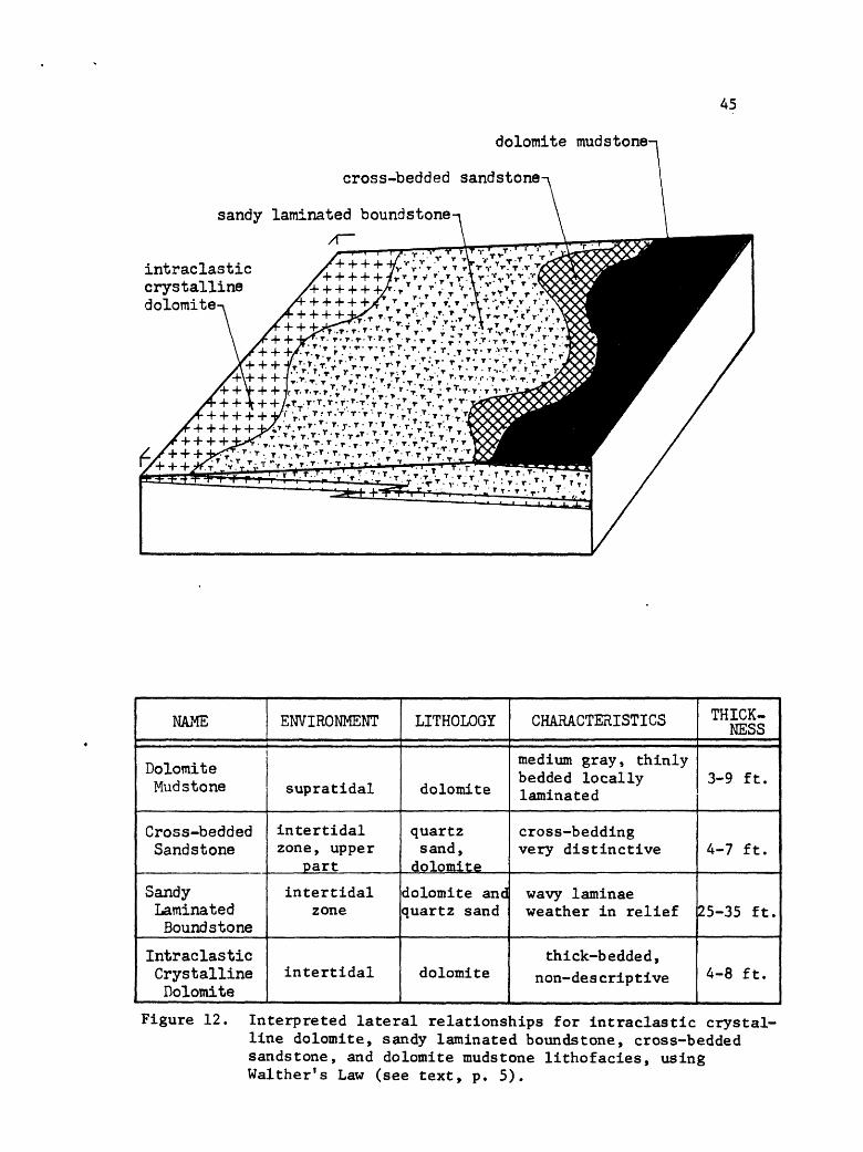
dolomite mudstone-
cross-bedded sandstone-
sandy laminated boundstone /I
intraclasticcrystallinedolomite
NAME
Dolomite Mud stone
Cross-bedded Sandstone
Sandy Laminated Boundstone
Intraclastic Crystalline Dolomite
ENVIRONMENT
supratidal
intertidal zone, upper
part
intertidal zone
intertidal
LITHOLOGY
dolomite
quartz sand,
dolomite
dolomite and quartz sand
dolomite
CHARACTERISTICS
medium gray, thinly bedded locally laminated
cross-bedding very distinctive
wavy laminae weather in relief
thick-bedded, non-descriptive
THICK NESS
3-9 ft.
4-7 ft.
25-35 ft.
4-8 ft.
Figure 12. Interpreted lateral relationships for intraclastic crystal line dolomite, sandy laminated boundstone, cross-bedded sandstone, and dolomite mudstone lithofacies, using Walther's Law (see text, p. 5).

46
out by Shepard (1960, p. 191). He showed that sand beaches are of
litnited height above a plain because waves can easily move the sand
inland across the plain. Accordingly, sandy beach ridges of storm
origin are raised only a few feet above the tide level which produced
them* Shepard also noted that these ridges are very broad, quite
in contrast to the steep-sided ridges composed of gravel and shell
material. Thus the beach ridges of the Pilgrim (and the Bahamas) are
only a few feet high, but hundreds of feet in width.
The beach ridges of the Pilgrim are thought to be part of a
regressive sequence. If so, the zone of broad, low deposits might be
expected to have migrated laterally, with later deposition of additional
ridges. The small vertical dimension makes it very difficult to
distinguish individual ridges in a lateral sequence of like deposits
such as in the Pilgrim. Furthermore, at least the upper strate of
the deposits have been reworked.
A range of thicknesses have been noted for the ridges in the
Pilgrim Formation. Shinn and others (1969) found a similar character
istic in the Bahamas, noting that the higher ridges occur in embayed
areas of the shore whereas the lower ridges are present on headlands.
Sand in the cross stratified unit and in the upper member of
the Pilgrim has apparently been recycled. This is shown by quartz
grains with overgrowths "floating" in dolomite.
A general source for the sand grains must have been west or
southwest of the Ruby Range inasmuch as the sandy strata thin and
pinch out in all other directions (cf., Hanson, 1952). Possible
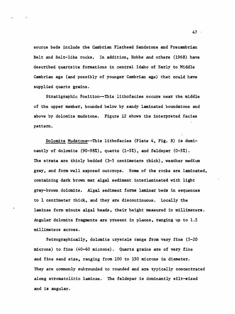
47
source beds include the Cambrian Flathead Sandstone and Precambrian
Belt and Belt-like rocks. In addition, Hobbs and others (1968) have
described quartzite formations in central Idaho of Early to Kiddle
Cambrian age (and possibly of younger Cambrian age) that could have
supplied quartz grains.
Stratigraphic Position This lithofacies occurs near the middle
of the upper member, bounded below by sandy laminated boundstone and
above by dolomite mudstone. Figure 12 shows the interpreted facies
pattern.
Dolomite Mudstone This lithofacies (Plate 4, Fig. B) is domi-
nantly of dolomite (90-98%), quartz (1-5%), and feldspar (0-5%).
The strata are thinly bedded (3-5 centimeters thick), weather medium
gray, and form well exposed outcrops. Some of the rocks are laminated,
containing dark brown mat algal sediment interlaminated with light
gray-brown dolomite. Algal sediment forms laminar beds in sequences
to 1 centimeter thick, and they are discontinuous. Locally the
laminae form minute algal heads, their height measured in millimeters.
Angular dolomite fragments are present in places, ranging up to 1.5
millimeters across.
Petrographically, dolomite crystals range from very fine (5-20
microns) to fine (40-60 microns). Quartz grains are of very fine
and fine sand size, ranging from 100 to 150 microns in diameter.
They are commonly subrounded to rounded and are typically concentrated
along stromatolltic laminae. The feldspar is dominantly silt-sized
and is angular.
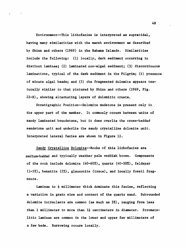
48
Environment This lithofacies is interpreted as supratidal,
having many similarities with the marsh environment as described
by Shinn and others (1969) in the Bahama Islands. Similarities
include the following: (1) locally, dark sediment occurring in
distinct laminae; (2) laminated non-algal sediment; (3) discontinuous
laminations, typical of the dark sediment in the Pilgrim; (4) presence
of minute algal heads; and (5) the fragmented dolomite appears tex-
turally similar to that pictured by Shinn and others (1969, Fig.
22-B), showing alternating layers of dolomitic crusts.
Stratigraphic Position Dolomite mudstone is present only in
the upper part of the member. It commonly occurs between units of
sandy laminated boundstone, but it does overlie the cross-bedded
sandstone unit and underlie the sandy crystalline dolomite unit.
Interpreted lateral facies are shown in Figure 12.
Sandy Crystalline Dolomite Rocks of this lithofacies are
medium bedded and typically weather pale reddish brown. Componentsi
of the rock include dolomite (40-60%), quartz (40-50%), feldspar
(1-5%), hematite (2%), glauconite (trace), and locally fossil frag
ments .
Laminae to £ millimeter thick dominate this facies, reflecting
a variation in grain size and content of the quartz sand. Subrounded
dolomite intraclasts are common (as much as 5%), ranging from less
than 1 millimeter to more than li centimeters in diameter. Stromato-
litic laminae are common in the lower and upper few millimeters of
a few beds. Burrowing occurs locally.
49
Dolomite crystals range from 100 to 125 microns (medium crystal
line) , and quartz and feldspar grains are of sand size. The quartz .
sand is subrounded to rounded and exhibits overgrowths.
Environment The environment inferred for this lithofacies is
subtidal to intertidal. The sediment is dominantly poorly sorted,
contains quartz sand, with intraclasts ranging from silt to granule
size, in a matrix of medium-crystalline dolomite. If one assumes
that the dolomite is a replacement of calcite and that recrystal
lization results in an increased grain size (Folk, 1965), then the
original matrix can be considered a fine-grained carbonate mud.
This suggests deposition in a low energy environment even though the
intraclasts may have formed under high energy conditions.
The stromatolitic algae occurring in the upper and lower parts
of some beds suggests that at least some of the sediment is inter-
tidal. Concentration of spines along these laminae perhaps indicates
deposition from receding waves in the intertidal environment.
Stratigraphic Position This unit forms the uppermost beds of
the Pilgrim, occurring above a sandy laminated boundstone unit and
beneath the reddish clay shale of the Red Lion Formation. Inter
preted facies relations are shown in Figure 13.
Age No identifiable fossils were found in the Pilgrim, presum
ably due to dolomitization. Fossil debris, consisting mainly of
fragmented spines, is present in the bioclastic rocks. . The Pilgrim
is considered Late Cambrian in age because of its position below Red
PLATE 4
Figure A. Cross-bedded sandstone of upper member of Pilgrim Limestone.
Figure B. Dolomite mudstone of upper member of Pilgrim Limestone, Rock is actually thinly bedded but weathers to form massive outcrops.
Figure C. Ribboned boundstone of upper member of Pilgrim Lime stone. Thin dark wavy layers are interpreted as mat algae, outlining boudins.
Figure D. x 3i. Ribboned boundstone. Dark layers are inter preted as mat algae, light areas are probably bio- clastic grainstone.
Figure E. x 4. Mud chips (outlined) enveloped by mat algal sediment in mud-cracked boundstone lithofacies of upper member of Pilgrim Limestone.
Figure F. x 2. Laminated crystalline dolomite lithofacies of upper member of Pilgrim Limestone. Note occurrence of dark gray laminae at top and bottom of rock, medium gray rock in between.
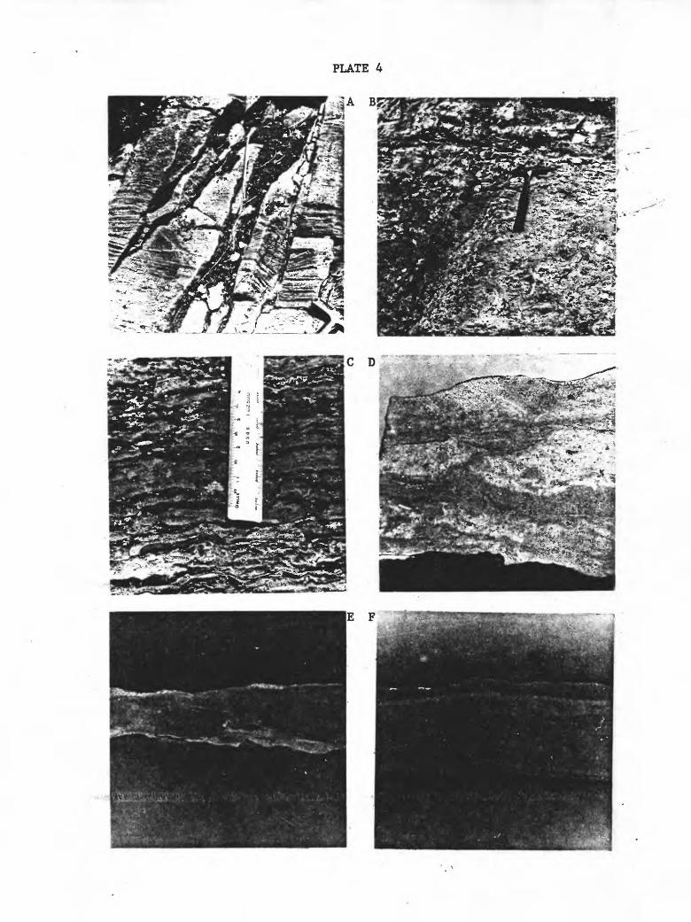
i w

50
sandy laminated boundstone
sandy crystalline dolomite
NAME
Sandy Crystalline Dolomite
Sandy Laminated Bound stone
ENVIRONMENT
sub tidal to intertidal
intertidal
LITHOLOGY
dolomite & quartz sand
dolomite & quartz sand
CHARACTERISTICS
reddish, mottled, sandy with local laminae and intra- clasts
wavy laminae weather in relief
THICK NESS
6-8 ft.
3-5 ft.
Figure 13. Interpreted lateral facies relationships for sandy laminated boundstone and sandy crystalline dolomite lithofacies, using Walther's Law (see text, p. 5).

51.
Lion beds of Late Cambrian age and above Park strata of probable
late Middle Cambrian age, shown in Figure 3.
RED LION FORMATION
Cambrian beds above the Pilgrim in southwestern Montana are
referable to either the Red Lion or Snowy Range formations. In
some cases the same sequence of strata has received both names.
Because this is the case in the nearby Gravelly Range (cf., Hanson,
1952; 1960; Hadley, 1960) it seems best to state my reasons for
assigning the sequence ot the Red Lion Formation in the Ruby Range.
Features in common with the Red Lion of the type section
(Emmons and Calkins, 1913) include the presence of (1) siliceous
laminae, and (2) quartz silt, with the propostion of siliceous
material to carbonate being greater in the lower part. Features not
present in the Ruby Range, but which are typical of the Sage Member
of the Snowy Range include (1) the so-called Cdllenia magna stromato
lites at the base, and (2) clay shale intercalated with the carbonate
rock. In addition intraformational conglomerate, characteristic of
the Snowy Range Formation, is present only locally in the Ruby Range,
occurring only at the base and has a maximum thickness of 2 feet.
Dry Creek Member
Exposures of the Dry Creek Member are commonly poor. Thickness
of the unit ranges from about 10 to 15 feet north of McHessor Creek
and from 0 to 5 feet at the south, where it is mapped with the Pilgrim
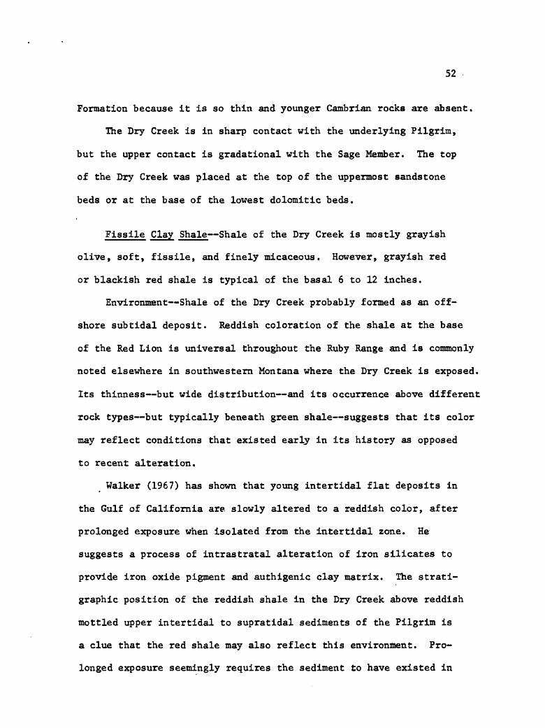
52
Formation because it is so thin and younger Cambrian rocks are absent.
The Dry Creek is in sharp contact with the underlying Pilgrim,
but the upper contact is gradational with the Sage Member. The top
of the Dry Creek was placed at the top of the uppermost sandstone
beds or at the base of the lowest dolomitic beds.
Fissile Clay Shale Shale of the Dry Creek is mostly grayish
olive, soft, fissile, and finely micaceous. However, grayish red
or blackish red shale is typical of the basal 6 to 12 inches.
Environment Shale of the Dry Creek probably formed as an off
shore subtidal deposit. Reddish coloration of the shale at the base
of the Red Lion is universal throughout the Ruby Range and is commonly
noted elsewhere in southwestern Montana where the Dry Creek is exposed.
Its thinness but wide distribution and its occurrence above different
rock types but typically beneath green shale suggests that its color
may reflect conditions that existed early in its history as opposed
to recent alteration.
Walker (1967) has shown that young intertidal flat deposits in
the Gulf of California are slowly altered to a reddish color, after
prolonged exposure when isolated from the intertidal zone. He
suggests a process of intrastratal alteration of iron silicates to
provide iron oxide pigment and authigenic clay matrix. The strati-
graphic position of the reddish shale in the Dry Creek above reddish
mottled upper intertidal to supratidal sediments of the Pilgrim is
a clue that the red shale may also reflect this environment. Pro
longed exposure seemingly requires the sediment to have existed in
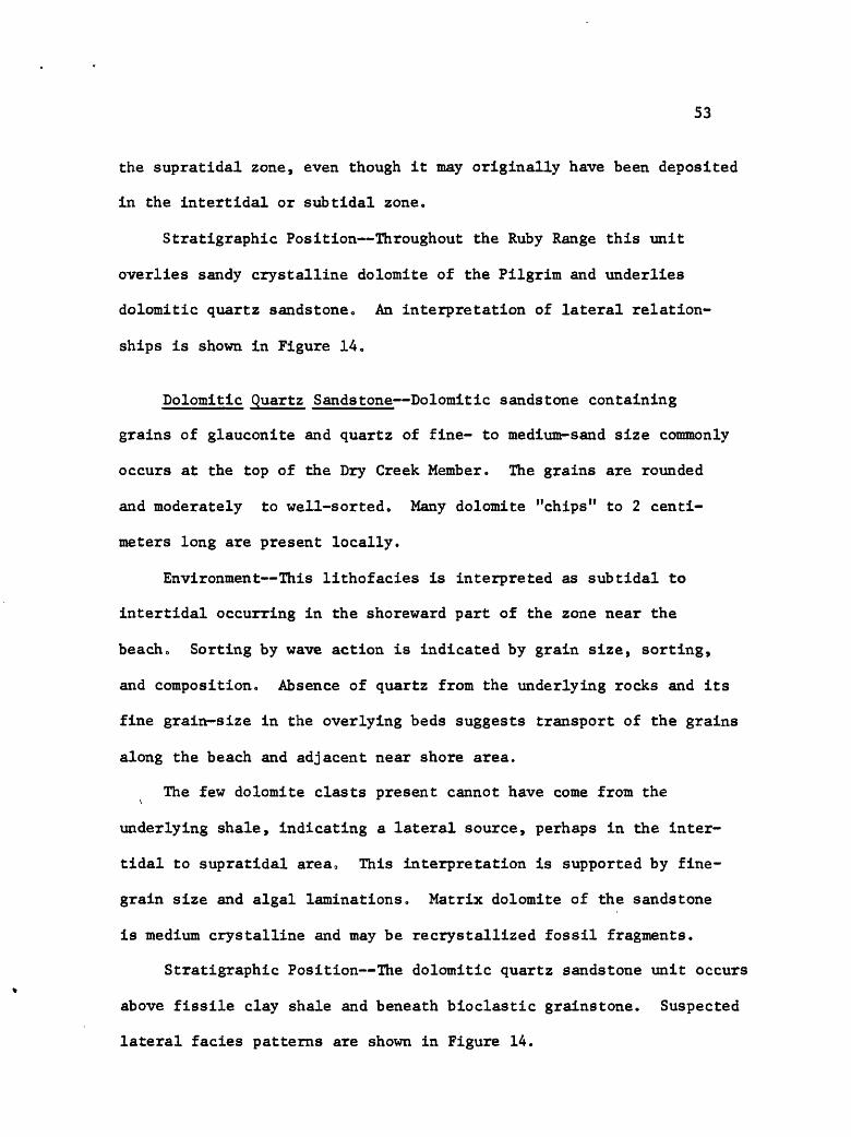
53
the supratidal zone, even though it may originally have been deposited
in the intertidal or subtidal zone.
Stratigraphic Position Throughout the Ruby Range this unit
overlies sandy crystalline dolomite of the Pilgrim and underlies
dolomitic quartz sandstone. An interpretation of lateral relation
ships is shown in Figure 14.
Dolomitic Quartz Sandstone Dolomitic sandstone containing
grains of glauconite and quartz of fine- to medium-sand size commonly
occurs at the top of the Dry Creek Member. The grains are rounded
and moderately to well-sorted. Many dolomite "chips" to 2 centi
meters long are present locally.
Environment This lithofacies is interpreted as subtidal to
intertidal occurring in the shoreward part of the zone near the
beach. Sorting by wave action is indicated by grain size, sorting,
and composition. Absence of quartz from the underlying rocks and its
fine grain-size in the overlying beds suggests transport of the grains
along the beach and adjacent near shore area.
The few dolomite clasts present cannot have come from the
underlying shale, indicating a lateral source, perhaps in the inter
tidal to supratidal area. This interpretation is supported by fine-
grain size and algal laminations. Matrix dolomite of the sandstone
is medium crystalline and may be recrystallized fossil fragments.
Stratigraphic Position The dolomitic quartz sandstone unit occurs
above fissile clay shale and beneath bioclastic grainstone Suspected
lateral facies patterns are shown in Figure 14.
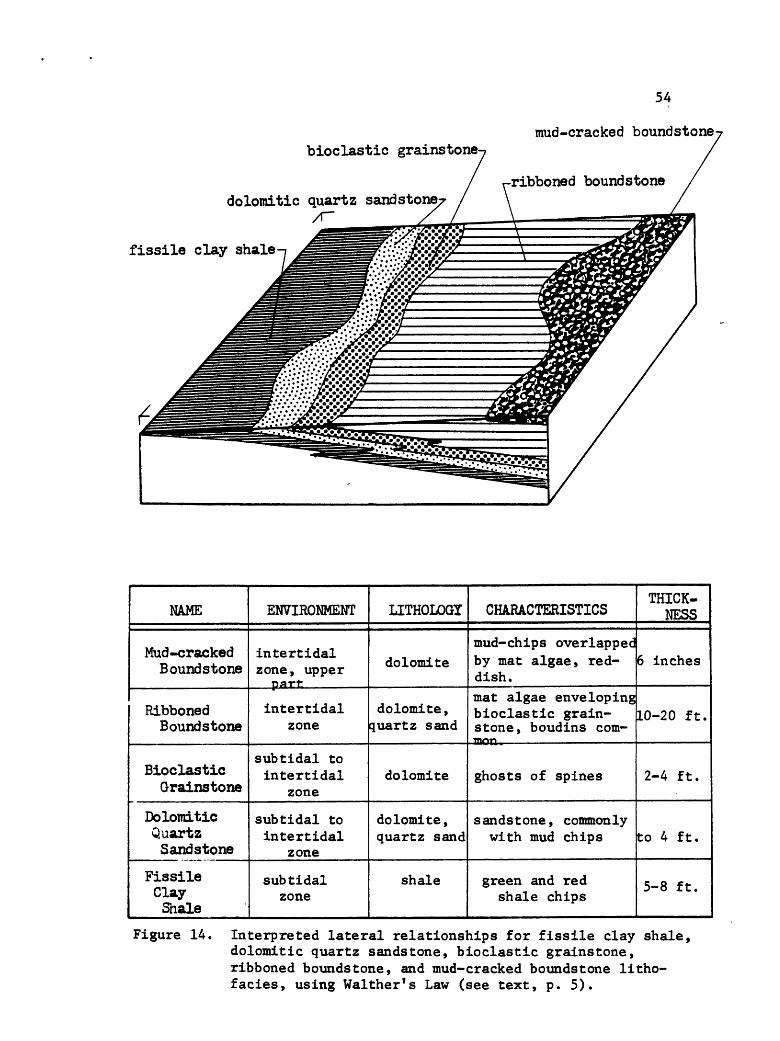
54
mud-cracked boundstone-bioclastic grainstone
dolomitic quartz sandstone/r
fissile clay shale
ribboned boundstone
NAME
Mud-cracked Boundstone
Ribboned Boundstone
Bioclastic Grainstone
Dolomitic Quartz Sandstone
Fissile Clay Shale
ENVIRONMENT
intertidalzone , upper part
intertidal zone
sub tidal to intertidal
zone
subtidal to intertidal
zone
subtidal zone
LITHOLOGT
dolomite
dolomite , quartz sand
dolomite
dolomite, quartz sand
shale
1 THICK- CHARACTERISTICS NESS
mud-chips overlapped by mat algae, red dish.mat algae enveloping bioclastic grain- stone, boudins com-
...mon,
ghosts of spines
sandstone, commonly with mud chips
green and red shale chips
6 inches
10-20 ft.
2-4 ft.
to 4 ft.
5-8 ft.
Figure 14. Interpreted lateral relationships for fissile clay shale, dolomitic quartz sandstone, bioclastic grainstone, ribboned boundstone, and mud-cracked boundstone litho- facies, using Walther's Law (see text, p. 5).

55
Sage Member
Exposures of the Sage Member are commonly good, with the thick
ness ranging from about 110 to 150 feet north of McHessor Creek,
being absent southward near Trout Creek. The lower contact is
conformable, as previously noted, and the upper contact is uncon-
formable below the Devonian Jefferson Formation. The Sage in the
Ruby Range is easily divisible into distinct lower and upper parts,
which are described separately below.
Sage Member, lower part
Bioclastic Grainstone Composition of this lithofacies is dolo
mite (90-95%), quartz (5-10%), and glauconite (1-5%). Bedding
ranges from thin to thick. Most of the dolomite occurs as a replace*
ment of fragmented fossil material of which the only identifiable
fragments are from trilobites. The dolomite is medium- to coarsely
crystalline, the grain size ranging from 180 to 240 microns. Dolo
mite of this type also forms subrounded intraclasts, commonly of
about one centimeter diameter, and making up 10 to 15 percent of
the dolomite components.
The quartz and glauconite grains occur together in small dis
turbed areas that are probably burrows. Grain size of the two
constituents ranges from 30 to 60 microns (coarse silt) for the
quartz grains, 60 to 100 microns (very finely crystalline) for the
dolomite fraction. The quartz is angular.
56
Environment Sediments with characteristics similar to those
described above are forming at present in Khor Al Bazam Lagoon of
the Persian Gulf (Kendall and Skipwith, 1969, 1969a; Kinsman, 1969).
The depositional environment is interpreted as the shoreward part
of the subtidal zone, perhaps extending into the lower intertidal
zone,, The absence of finely crystalline dolomite and the presence
of medium and coarsely crystalline dolomite may indicate this facies
formed in a higher energy environment. The dominant uniformity of
grain size may connote a uniform and continual sorting process.
Another mechanism for breakdown of skeletal material is that of
burrowing animals. However, recognizable burrows occur within the
uniformly grained dolomite and are identified by the smaller size
of dolomite crystals and by the introduction of quartz silt and
glauconite. This suggests that the abundant larger grains are a
product of physical parameters.
Stratigraphic Position The unit overlies dolomitic quartz
sandstone and underlies ribboned boundstone. Locally it occurs
between units of ribboned boundstone. Figures 14 and 15 show the
interpreted facies pattern.
Ribboned Boundstone Dolomite (85-90%), quartz (10-15%), and
glauconite (1-5%) make up the rock in this lithofacies (Plate 4,
Fig. C), which is similar to that termed "ribboned" by Matter (1967)
Most of the beds are made up of three parts: the upper and lower
thirds of each bed consist of laminated stromatolitic dolomite,

57
with the middle third composed of crystalline dolomite or rarely
dolomitic bioclastic grainstone. Medium crystallinity is character
istic of the dolomite, with the only identifiable fossil fragments
being recrystallized spines. Commonly, small pieces of laminated
sediment are contained within the crystalline dolomite.
Polished slabs of ribboned rock show that the bioclastic grain-
stone tends to become pinched off and form boudins between the lami
nated mat sediment. Conversely, the laminated sediment between the
boudins may be "streaked off," forming wisps of laminated sediment
(see Plate 4, Fig. D).
Quartz grains are concentrated along the stromatolltic laminae,
although some grains (10-15%) are isolated in the coarser grained
dolomite. The quartz weathers in relief on the outcrop face, thus
making the laminae very prominent. Glauconite grains are also con
centrated along the laminae. Both the quartz and glauconite grains
are of silt size (30-60 microns), but the quarts is angular whereas
the glauconite is rounded.
Environment The bioclastic dolomite is interpreted as a
deposit of the shoreward subtidal to lower intertidal environment
(see section entitled Bioclastic Grainstone, p. 55). The algal
laminated sediment is thought to represent the intertidal zone, as
described for the Persian Gulf by Kendall and Skipwith (1968) and
Kinsman (1969) 0
Alternating stromatolitic and fragmental layers characteristic
of the ribboned rocks suggests that this facies represents an inter-

58
tonguing of intertidal and intertidal to subtidal strata. The
dominance of stomatolitic layers, however, indicates that the
fragmental debris may have been derived from the subtidal zone and
deposited in the intertidal zone. In either case, sedimentation
was rhythmic.
The laminated part of the ribboned beds contain small angular
pieces of laminated sediment within the bioclastic fragmental rock
of the ribboned beds. The contact between sedimentation units of a
bed thus reflects scour and reworking, with intraclasts of underlying
material incorporated in the fragmental sediment. These data, there
fore aid the interpretation of an intertidal origin for the ribboned
beds, with derivation of fragmental material from the subtidal zone.
Burial must have occurred before either sediment type became
lithified at least both were still plastic. Boudins formed, probably
due to differential compaction. "Streaking" of the stromatolitic
sediment suggests it was less viscous than the fragmental sediment.
Stratigraphic Position Ribboned boundstone is a common litho-
facies unit in the Sage Member, typically overlying bioclastic grain-
stone and underlying mud-cracked boundstone. The interpreted facies
pattern is shown in Figures 14 and 15.
Mud-Cracked Boundstone Rock components in this lithofacies
(Plate 4, Figo E) are dolomite (90-95%) and quartz (5-10%). The
dolomite is of medium crystallinity with grains ranging from 60 to
100 microns, except in burrows where it ranges from 100 to 240
microns. Quartz grains are of coarse silt size, range from 30 to
59
60 microns, are angular, and tend to form laminae.
Beds are commonly one-half to one centimeter thick and are
composed of mat algae in the upper and lower parts, with chips of
mud sandwiched in between. The chips are flat, strung out in
discrete but discontinuous layers, and are parallel to continuous
laminated mat algal layers. They are like the mud-cracked sediment
in the laminated and ribboned strata pictured by Matter (1967, p. 604).
In cross-section the cracks show nearly vertical walls, but seldom
can the cracks be traced to the surface. This is due to overlap
of the mud chips, and infilling of the cracks by mat algal sediment.
The algal laminated sediment is thicker in the cracks than above
the chips. This observation corresponds with that of Shinn (1968)
who found modern examples of algal mats growing preferentially in,
and accentuating, the mudcracks.
Environment -Many workers have described mud-cracked sediments
from modern intertidal and supratidal flats. In the Red Lion of the
Ruby Range this rock type occurs interbedded with non-mud-cracked
ribbon strata thought to be of intertidal origin. Factors suggestive
of a position transitional between the intratidal and supertidal
zones are thinness and only local presence of the rock type.
Thinness is prominent in two ways: (1) The beds themselves are
thin relative to those of the ribbony strata. This probably represents
a lack of sediment, as the quantity of sediment would have been low
during subaerial exposure. (2) The mat algae and chips which make
up the thin beds show an intertonguing of intertidal sediment (mat
60
algae) and desiccated sediment more typical of a supratidal environ
ment (mud chips and cracks).
Stratigraphic Position Mud-cracked boundstone occurs interbedded
between units of ribboned boundstone. Figure 14 shows the interpreted
lateral facies pattern.
Laminated Crystalline Dolomite Composition of the rock (Plate 4,
Fig. F) in this lithofacies is finely-crystalline dolomite (30-60
microns). Finely laminated pale yellowish brown beds 1 to 4 centi
meters thick make up most of the rock, but medium gray and dark gray
interlaminated layers occur locally in the lower part of the litho
facies. The unit intertongues with (intertidal) stromatolltic
sediment in the uppermost part of the lithofacies. Burrows occur
in the pale yellowish brown dolomite and uncommonly in the medium
gray laminae; none were observed in the dark gray laminae.
Occurring locally in the upper part of this lithofacies unit are
thin beds of bioclastic grainstone, separated by shaly laminae.
These laminar zones are less than one-half centimeter thick and
contain all of the well preserved brachiopods found in the Red Lion
of the Ruby Range.
Environment A subtidal origin is postulated for most of the rock
in the unit. Conditions transitional from slightly oxidizing to
slightly reducing are suggested for the interlaminated medium gray
sparsely burrowed sediment and the dark gray undistubed layers in
the lower part of the lithofacies. Characteristics suggesting deeper
and/or quiet water deposition for the pale yellowish brown sediments

61
include: (1) small grain size, which must have been even smaller be
fore recrystallization to dolomite; (2) uniform grain size; (3) homo-
generous composition; (4) thin and consistent laminae; and (5) simi
larity of the brown sediment and the gray sediment, except the
former lacks the dark laminae.
The pale yellowish brown sediment probably formed shoreward of
the gray sediment, or at least in a less restricted environment.
Evidence for this is (a) a lack of dark laminae, (b) a slight thick
ening of individual laminae, and (c) intertonguing of the sediment
with intertidal mat algal rocks. The bioclastic rocks are probably
of the upper subtidal to intertidal zone.
Stratigraphic Position The lower contact of this unit is
commonly concealed, the covered interval occurring above ribboned
boundstone. The unit underlies thin-bedded boundstone of the upper
part of the Sage Member of the Red Lion. Figure 15 shows the
interpreted facies pattern.
Sage Member, upper part
The upper part of the Sage Member is easily distinguished from
the underlying part by its light gray color and more intense dolo-
mitization. The unit is composed of a variety of stromatolite forms
in an area north of McHessor Creek (sees. 13 and 18, T. 6 $., R. 5 W.)
The algal structures form thin laminated beds (termed thin-bedded
boundstone), small columns in broad, low 6 to 18 inch thick beds
(termed dome-shaped boundstone), and columnar stromatolites (termed

62
laminated crystalline dolomite
ribboned boundstone- bioclastic grainstone
NAME
Ribboned Bound stone
Bioclastic Grainstone
Laminated Crystalline Dolomite
ENVIRONMENT
intertidal
intertidal
sub tidal
LITHOLOGY
dolomite and
quartz sand
dolomite
dolomite
CHARACTERISTICS
mat algae envelop ing bioclasticgrainstone, boudins commoTL
ghosts of spines
commonly finely laminated
THICK- NESS
1-3 ft.
±-1 ft.
12-15 ft.
Figure 15. Interpreted lateral relationships for laminated crystalline dolomite, bioclastic grainstone, and ribboned boundstone lithofacies, using Walther's Law (see text, p. 5).
63
columnar boundstone). Elsewhere the unit is thin- to thick-bedded,
dense featureless dolomite. Interpreted lateral facies relations
for the upper part of the Sage Member are shown in Figure 16.
Thin-bedded Boundstone- Thin beds of laminated dolomite make up
most of the upper part of the Sage. Adjacent to the dome-shaped
mounds the beds dip beneath them, are draped over them, or sharply
abut the structures (Plate 5, Fig. A). Thickness of these beds
ranges from 1 to 4 centimeters, with most beds showing very faint
lamination. The upper one-third of some otherwise evenly laminated
beds show wavy laminae that are flexed .over pellets or small intra-
clasts. These same laminae are locally distubed by small dolomite-
filled burrows that are reflected by casts of worm-like trails on
the bedding surface (Plate 5, Fig. B).
Environment Sediment with the characteristics of this litho-
facies is forming today in the upper part of the intertidal zone
in the Bahamas west of Andros Island (Black, 1933; many subsequent
authors), in Shark Bay, Australia (Logan, 1961), and in the Persian
Gulf (Kendall and Skipwith, 1968, 1969, 1969a). All of these existing
depositional sites have in common a protected lagoonal or bay environ
ment where the upper intertidal flats are characterized by a firm,
smooth or slightly undulatory algal mat surface. In some places
desiccation polygons are present in the zone but not everywhere;
none were found in the upper part of the Sage. Perhaps the mats of
the Sage remained moist.

64
Draping of the thin-bedded strata over algal mounds is sug
gestive of differential compaction. Draping can only partly be
explained by compaction, however, because individual beds are not
much thinner above a stromatolite mound than lateral to it. More
probable, the dips displayed by the beds are largely initial,
resulting from sediment-binding mat algae overlapping the stromato-
litic domes.
Kendall and Skipwith (1968) found this form of mat established
in intertidal areas where moderately high energy conditions prevail.
This observation is significant to the present interpretation
because the thin-bedded boundstone is the initial deposit in the
stromatolltic sequence of the upper part of the Sage Member.
Medium-bedded Boundstone These beds (Plate 5, Fig. C) range
from 6 to 18 inches thick, commonly extend laterally more than 100
feet, and may have a thin unit of pebble conglomerate grainstone at
the base. The few stromatolites preserved in the beds are small
columnar-shaped structures that range from 2 to 4 inches wide at
the base to 4 to 8 inches high. The columns are separate and con
tain dolomite grains of 30 to 60 microns diameter; intercolumn
dolomite is commonly of 30 to 60 micron size, but is locally 100 to
200 microns. Columns may become laterally linked at some level, with
subsequent development of a second layer of stacked hemispheroids.
Environment This type of stromatolite is similar to that
described by Kendall and Skipwith (1968) as occurring in the inner
part of their Cinder Zone, the most seaward zone of stromatolites in

PLATE 5
Figure A. Thin-bedded boundstone, overlapping dome-shapedboundstone (upper part of Sage Member of Red Lion Formation).
Figure B. Worm-like casts on bottom of bed of thin-beddedboundstone, upper part of Sage Member of Red Lion Formation. Pen is 5i inches long.
Figure C. Medium-bedded boundstone, overlain by thin-bedded boundstone (upper part of Sage Member of Red Lion Formation).
Figure D. x 3i. "Spongy" fabric (Aitken, 1967) in stromatolite (dark areas).
Figure E. Columnar stromatolite (outlined) in columnar boundstone of upper part of Sage Member of Red Lion Formation. Stromatolite is about 5 feet high.
Figure F. Columnar stromatolites (outlined) "stacked" atop one another, in columnar boundstone lithofacies of upper part of Sage Member of Red Lion Formation.
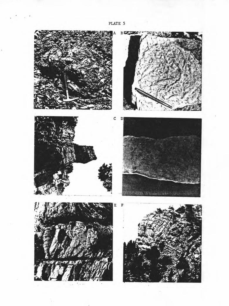
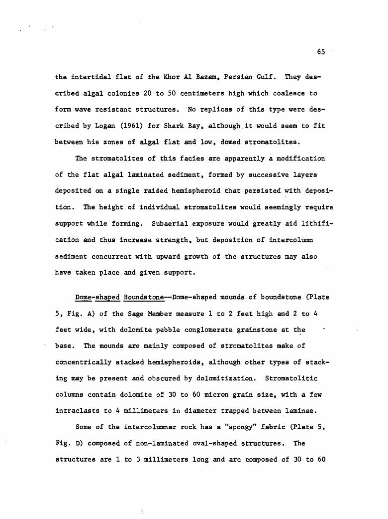
65
the intertidal flat of the Khor Al Bazam, Persian Gulf. They des
cribed algal colonies 20 to 50 centimeters high which coalesce to
form wave resistant structures. No replicas of this type were des
cribed by Logan (1961) for Shark Bay, although it would seem to fit
between his zones of algal flat and low, domed stromatolites.
The stromatolites of this facies are apparently a modification
of the flat algal laminated sediment, formed by successive layers
deposited on a single raised hemispheroid that persisted with deposi
tion. The height of individual stromatolites would seemingly require
support while forming. Subaerial exposure would greatly aid lithlfi-
cation and thus increase strength, but deposition of intercolumn
sediment concurrent with upward growth of the structures may also
have taken place and given support.
Dome-shaped Boundstone Dome-shaped mounds of boundstone (Plate
5, Fig. A) of the Sage Member measure 1 to 2 feet high and 2 to 4
feet wide, with dolomite pebble conglomerate grainstone at the
base. The mounds are mainly composed of stromatolites make of
concentrically stacked hemispheroids, although other types of stack
ing may be present and obscured by dolomitization. Stromatolitic
columns contain dolomite of 30 to 60 micron grain size, with a few
intraclasts to 4 millimeters in diameter trapped between laminae.
Some of the intercolumnar rock has a "spongy" fabric (Plate 5,
Fig. D) composed of non-laminated oval-shaped structures. The
structures are 1 to 3 millimeters long and are composed of 30 to 60
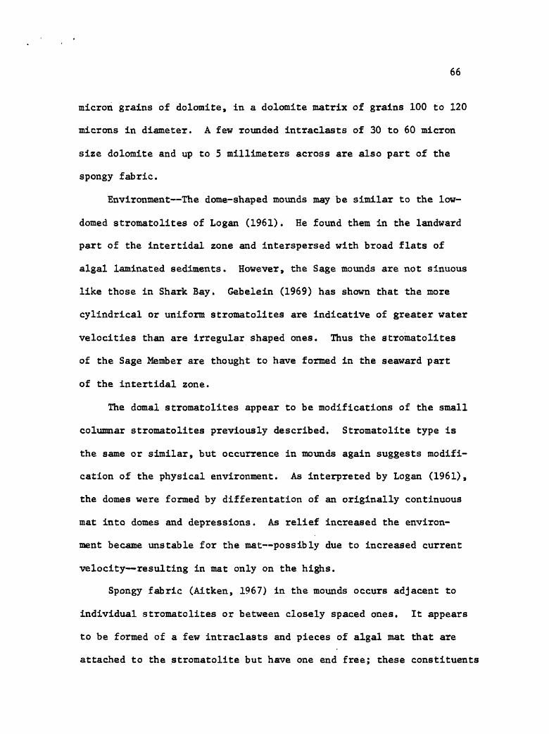
66
micron grains of dolomite, in a dolomite matrix of grains 100 to 120
microns in diameter. A few rounded intraclasts of 30 to 60 micron
size dolomite and up to 5 millimeters across are also part of the
spongy fabric.
Environment The dome-shaped mounds may be similar to the low-
domed stromatolites of Logan (1961). He found them in the landward
part of the intertidal zone and interspersed with broad flats of
algal laminated sediments. However, the Sage mounds are not sinuous
like those in Shark Bay. Gebelein (1969) has shown that the more
cylindrical or uniform stromatolites are indicative of greater water
velocities than are irregular shaped ones. Thus the stromatolites
of the Sage Member are thought to have formed in the seaward part
of the intertidal zone.
The domal stromatolites appear to be modifications of the small
columnar stromatolites previously described. Stromatolite type is
the same or similar, but occurrence in mounds again suggests modifi
cation of the physical environment. As interpreted by Logan (1961),
the domes were formed by differentation of an originally continuous
mat into domes and depressions. As relief increased the environ
ment became unstable for the mat possibly due to increased current
velocity resulting in mat only on the highs.
Spongy fabric (Aitken, 1967) in the mounds occurs adjacent to
individual stromatolites or between closely spaced ones. It appears
to be formed of a few intraclasts and pieces of algal mat that are
attached to the stromatolite but have one end free; these constituents

67
became embedded in the intercolumn sediment. Kendall and Skipwith
(1968) attributed spongy fabric to forcing of trapped air through
algal mats by rising tides. Subsequently, sediment filled the air
pockets.
Columnar Boundstone Columnar boundstone stromatolites are 4 to
5 feet high, 1 to 2 feet across, and are of smaller diameter at the
base than upward. The form is discrete, composed of vertically
stacked hemispheroids in which the upper laminae do not reach the
base of the preceeding ones, shown in the photograph of Plate 5,
Figure £. At one place columnar stromatolites are stacked one
atop another (Plate 5, Fig. F).
The stromatolites are severely dolomitized and the preserved
features are only faintly evident. However, thin sections show a
clotted fabric composed of rounded intraclasts to 1.5 millimeters
in diameter and angular clots to 4 millimeters across. Grain size
of the clasts averages about 40 microns, whereas the matrix grain
size is commonly about 60 microns. Differential weathering and a
mottled pattern represent the surface expression of the clotted
fabric.
A pebble conglomerate grainstone typically occurs at the base
of columnar stromatolites (Logan, 1961; Aitken, 1967), but none
was observed in the Ruby Range. Dolomitization and weathering could
easily have obscured this feature if originally present, however.
Environment The stromatolitic structures of this facies are
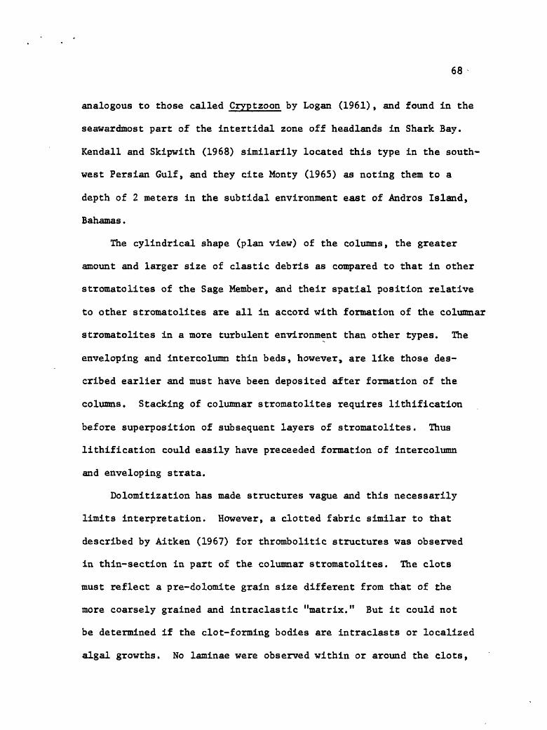
68
analogous to those called Cryptzoon by Logan (1961), and found in the
seawardmost part of the intertidal zone off headlands in Shark Bay.
Kendall and Skipwith (1968) similarily located this type in the south
west Persian Gulf, and they cite Monty (1965) as noting them to a
depth of 2 meters in the subtidal environment east of Andros Island,
Bahamas.
The cylindrical shape (plan view) of the columns, the greater
amount and larger size of clastic debris as compared to that in other
stromatolites of the Sage Member, and their spatial position relative
to other stromatolites are all in accord with formation of the columnar
stromatolites in a more turbulent environment than other types. The
enveloping and intercolumn thin beds, however, are like those des
cribed earlier and must have been deposited after formation of the
columns. Stacking of columnar stromatolites requires lithification
before superposition of subsequent layers of stromatolites. Thus
lithification could easily have preceeded formation of intercolumn
and enveloping strata.
Dolomitization has made structures vague and this necessarily
limits interpretation. However, a clotted fabric similar to that
described by Aitken (1967) for thrombolitic structures was observed
in thin-section in part of the columnar stromatolites. The clots
must reflect a pre-dolomite grain size different from that of the
more coarsely grained and intraclastic "matrix." But it could not
be determined if the clot-forming bodies are intraclasts or localized
algal growths. No laminae were observed within or around the clots,

69
thin-bedded boundstone-
medium-bedded boundstone-
dome-shaped bound stone-
columnar boundstone-
NAME
Columnar Boundstone
Dome shaped Boundstone
Medium-bedded Boundstone
Thin-bedded Boundstone
ENVIRONMENT
intertidal zone
intertidal zone
intertidal zone
intertidal zone
LITHOLOGY
dolomite
dolomite
dolomite
dolomite
CHARACTERISTICS
columns of stromat olites to 5 feet high, 1 to 2 feetaf*TnSS
mounds to 2 feet high and 4 feet wide. Containstrrvmnt-nl -f f *> G
6 to 18 inch-thickbeds to 100 feet long , contain e't"Trinatolitfls
thinly bedded, laminated
THICK NESS
4-5 ft.
2 ft.
i-li ft.
to 20 ft.
Figure 16. Interpreted lateral relationships for thin-bedded bound- stone, medium-bedded boundstone, mound-shaped boundstone, and columnar boundstone lithofacies, using Walther's Law (see text, p. 5).

70
but it seems some binding agent was necessary to retain the structures
in the stromatolite; if the agent was not mucilaginous algae, then
perhaps it was subaerial exposure and cementation by calcium carbonate.
Pebble Conglomerate Grainstone Dolomite conglomerate grainstone
occurs beneath stromatolltic structures. Pebbles range to 40 milli
meters across, are rounded, and are typically disc- or oval-shaped.
Orientation of most dasts is at a small angle to bedding, but some
exhibit a high angle. Fine lamination is characteristic of the pebbles
and grain size is in the 30 to 60 micron range.
A few of the pebbles (less than 2%) have a pin-size hole through
them surrounded by a mottle of about 2 millimeters diameter. Others
may have similar mottle but lack the hole. Grant (1965) and Dorf
and Lochman (1940) noted the association of this "peculiar" type of
pebble with a matrix containing pelmatozoans, but I did not find
any pelmatozoans.
Rock in between the pebbles consists of coarse sand size and
granule size subangular to subrounded dolomite intraclasts in a
matrix of dolomite. Grain size in the clasts ranges from 30 to 60
microns, whereas that of the matrix ranges from 10 to 200 microns.
Environment The dolomite pebble conglomerate grainstone was
probably derived from ripped-up mat algal sediments. The clasts
are lithologically like the thin-bedded boundstone and their sorting
is poor, suggesting local derivation. In addition, the clasts must
have been somewhat plastic when deposited as some pebbles are embayed

71
along their contacts with other pebbles. Commonly, pebble conglo
merates were observed in the upper part of the Sage.
Pebbles cannot be considered abundant in the upper part of the
Sage but they are very Important as they seem to be a prerequisite
for growth of vertical stromatolites. That the pebbles are more
common beneath medium-bedded boundstone suggests that the pebbles
there were closer to their source. Pebbles in the domal and columnar
boundstone are fewer but better sorted; this may suggest a greater
distance from the source and some sorting. Perhaps the pebbles were
formed during higher than normal tides or during storms.
Age Fossils from the Red Lion obtained from the SWiSEi sec. 18,
T. 6 S., R. 5 W., were identified by A. R. Palmer (written communica
tions, 1968; 1970). Fossils collected about 75 feet above the base
of the Red Lion include the brachiopod Billingsella and the trilobite
Taenicephalus, An indeterminate conaspid trilobite was collected from
near the top of the formation. The fossils are of Late Cambrian
(Franconian) age (see Fig. 3).
Regional Correlation The Billingsella and Taenicephalus fossils
are common in the Sage Member throughout western and southern Montana.
Few conaspid trilobites have been reported in Montana but those
reported must correlate with the Taenicephalus Zone of Grant (1965),
which in southern Montana is equivalent to part of the Conaspis Zone
of the Cambrian Correlation Chart (see Howell and others, 1942).
The Taenicephalus Zone is the most populous zone of the Sage Member
72
in southwestern Montana and in northwestern Wyoming (Grant, 1965).
In addition, the overlying Idahoia Zone of the Franconian Stage is
also confined to the Sage Member (Grant, 1965). The above data are
emphasized because the unit in the upper part of the Sage Member in
the Ruby Range that contains the conaspid trilobite has similarities
with the Grove Creek as described by Dorf and Lochman (1940) and
Grant (1965). The unit is assigned to the Sage Member, however,
because of the very widespread and near uniform thickness of Upper
Cambrian rock units in Montana and adjacent areas and their common
parallelism to fossil zones.
DISCUSSION
Thickness Thicknesses of the Cambrian formations at different
places in the Ruby Range are shown in the cross-section of Figure 17.
The total thickness of Cambrian strata in the McHessor Creek section
is about 1650 feet, in contrast with about 1250 feet in the Laurin
Canyon section. The difference is apparently not related to post-
Cambrian removal of sediments from the area of the Laurin Canyon
section because individual formations and members are present but
thinner there
The Meagher is about 750 feet thick in the McHessor Creek section
and about 550 feet in the Laurin Canyon section. The thicker section
includes in its uppermost part a lithofacies not otherwise present
at either locality. Strata below the upper Pilgrim unit and above

73
the Park Shale are about 300 feet thick at Laurin Canyon, but poor
exposures preclude determination of the stratigraphic level of thin
ned or "missing" rocks. The Sage Member of the Red Lion is about
150 feet thick at HcHessor Creek and about 100 feet thick at
Laurin Canyon. The lithofacies units in the Laurin Canyon section
are commonly thinner than the correlatable ones in the Red Lion
at HcHessor Creek and a similar relationship was noted for the litho
facies units of the upper part of the Pilgrim. The data seem to
indicate continued slow uplift for the area of the Laurin Canyon
section.
A major fault now exists between the Laurin Canyon and HcHessor
Creek sections and possibly was active during Cambrian deposition.
If so, it would be a growth fault a fault across which correlative
strata show a thickening on the downthrown side (Dennis, 1967).
All of the Cambrian formations attain their greatest thicknesses
in the HcHessor Creek section near this fault. Conversely, their
average thicknesses are between the two extremes, but are closer to
the maximum. Thus the reatest thickness contrast occurs across
the fault in sections only 2 miles distant; hence the supposition
that the fault may have been active during Cambrian time.
A growth fault could not, however, account for all of the thick
ness change, the general tendency of all Cambrian formations toward
the maximum thickness arguing against it. The growth fault concept
may account for the stromatolite buildup being located in the
HcHessor Creek section of the Red Lion Formation, as organic buildups

3i mi
2 mi
IFmT
sec* K
North
end
Ra,
sec,
G
Laur
in Canyon
sees
, H,
I
McHe
ssor
Cr.
Red
Lion
Fra
(upp
er)
Pilg
rim
Ls
(lower)
Park S
h
Meagher
Ls
-300
Vertical
200
Scale
(fee
t)100
-0
Wolsey Sh
Flat
head
Ss
sec,
J
Trou
t Cr.
Figu
re 17
. Northerly
tren
ding
cr
oss-section
of Ca
mbri
an fo
rmat
ions
. Da
shed
contact
divi
des
Pilgrim
Lime
ston
e in
to m
embers.
Brok
en co
ntac
t between
sees.
G an
d H,
I, in
dica
te possible
pres
ence
of
Ca
mbri
an growth fault
(see text,
p. 73).
Loca
tion
of
se
ctio
ns ar
e shown
in Appendix.

75
in the geologic record are locally found along active faults.
An isopach map of the Cambrian system constructed by Hanson
(1952) and shown here in Figure 18, delineates an isopach thick in
southwestern Montana, its center near the Ruby Range. Fart of this
isopach basin results from the 1000 feet of Meagher measured by
Hanson at McHessor Creek, as illustrated in Hanson's Heagher isopach
map shown here in Figure 19. Structural complications invalidate
his measurement 750 feet is the maximum Meagher present, with an
average range of 675 to 700 feet being more common. Thus a down
ward revision in thickness largely eliminates the basin shown for
the Meagher and reduces that shown for the total Cambrian isopach
map to 1500 feet. Thus a slight thickening is still evident for
the Ruby Range area but an unpublished isopach map of Christina L.
Balk suggests that it may be only the northern marginal part of a
slight thickening which extends southeastward.
Dolomitization Dolomitization of the Cambrian rocks is part
of a regional problem in that Cambrian dolomite is common in off-
shelf (miogeosynclinal) areas of southwestern Montana and central
Idaho, whereas limestone characteristizes the shelf strata. Although
the Ruby Range is in the shelf province, it is near the miogeosyncline
and contains both limestone and dolomite.
The entire Cambrian carbonate sequence in the Ruby Range has
been dolomitized except for part of the Meagher. In the McHessor
Creek drainage and southwestward the Meagher is all dolomite, but
northeastward it contains limestone and dolomite. Thin-section

Figure 18. Isopach map of the Meagher Limestone in southwestern Montana (after Hanson, 1952).
Figure 19. Isopach map of the Cambrian system in southwestern Montana (after Hanson, 1952).
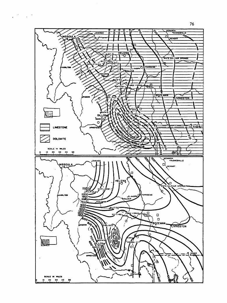
76
\ .s \_____IA.X ___.! _______1% \ WHITE SUt I'HUH 3FHIH05 |
CMC IM MH.CS
0 IO tO SO 4O SO Iv3 -n
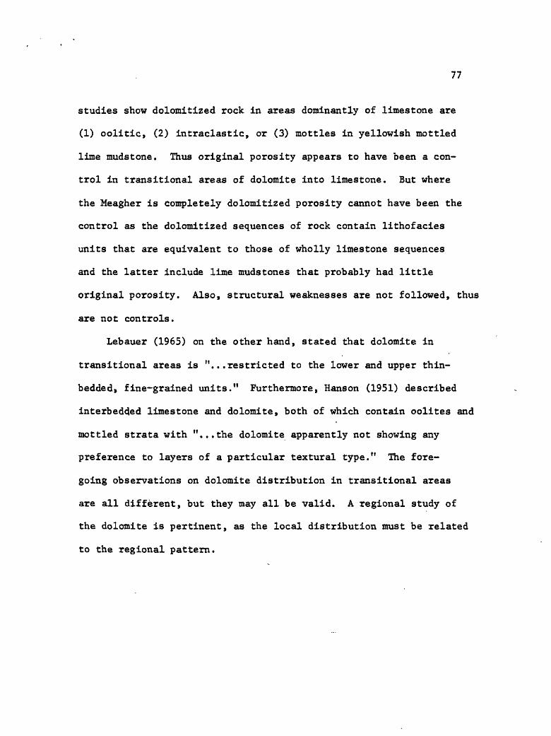
77
studies show dolomitized rock in areas dominantly of limestone are
(1) oolitic, (2) intraclastic, or (3) mottles in yellowish mottled
lime mudstone. Thus original porosity appears to have been a con
trol in transitional areas of dolomite into limestone. But where
the Meagher is completely dolomitized porosity cannot have been the
control as the dolomitized sequences of rock contain lithofacies
units that are equivalent to those of wholly limestone sequences
and the latter include lime mudstones that probably had little
original porosity. Also, structural weaknesses are not followed, thus
are not controls.
Lebauer (1965) on the other hand, stated that dolomite in
transitional areas is "...restricted to the lower and upper thin-
bedded, fine-grained units." Furthermore, Hanson (1951) described
interbedded limestone and dolomite, both of which contain oolites and
mottled strata with "...the dolomite apparently not showing any
preference to layers of a particular textural type." The fore
going observations on dolomite distribution in transitional areas
are all different, but they may all be valid. A regional study of
the dolomite is pertinent, as the local distribution must be related
to the regional pattern.

78
DEVONIAN
JEFFERSON FORMATION
The Jefferson Formation is a distinctive, cyclically bedded
unit commonly occurring in good exposures. Its thickness ranges
between 250 and 268 feet, being thinnest in the southern part of the
map area. The contact with the underlying Cambrian strata is dis-
conformable, whereas the upper contact is apparently conformable.
Two members are present a lower unnamed one and the overlying
Birdbear Member.
Lower member
Rocks of the lower member are mostly pale yellowish brown dolo
mite with a very few beds being slightly calcareous. Outcrops are
marked by repetition of three main rock types: (1) silty and sandy
(quartz) shaly dolomitic beds, termed detrital units by Benson
(1966); (2) rubbly weathering dolomite breccia beds, probably
evaportie solution breccias; and (3) medium- and thick-bedded
dense or sucrosic dolomite beds.
Discussion Wilson (1955) described cycles of the Jefferson in
northwestern Montana and noted a sequence in which ideally unit 1
(above) occurred at the top and units 2 and 3 successively below,
except that unit 3 consisted of massive sucrosic dolomite in the
upper part and dense limestone in the lower part. With later detailed
79
study of equivalent rocks in eastern Montana, Wilson (1967) noted
that the clastic content increased near the Jefferson (Duperow)
depositional margin in southeastern Montana and adjacent Wyoming.
In addition, the limestone beds, which he interpreted as open
marine deposits, were not common; but the sucrosic dolomite and
evaporite units, interpreted as restricted marine deposits, inter-
ton gued with elastics. The ideal cycle is uncommon in southeastern
Montana and adjacent Wyoming.
Wilson's ideal cycle was not recognized in the Ruby Range and
limited thin-section studies failed to establish if the strata are
correlatable with Wilson's (1967) "restricted marine carbonates."
Much of the uncertainity is due to intense dolomitization of the
rocks and the absence of equivalent limestone strata for comparison,
but also because there are no data on the Jefferson between the two
areas to facilitate reliable correlation. Furthermore, the Ruby
Range is 50 miles north of the Tendoy Dome (Scholten, 1957; Lemhi
Arch of Sloss, 1954) and the effect of this feature on carbonate
sedimentation patterns is unknown, other than on the thicknesses.
Birdbear Member
The Birdbear Member overlies the uppermost detrital unit of the
lower member and ranges from about 55 to 65 feet thick. The basal
9 to 12 feet of the unit is thin-bedded dolomite, whereas the
remainder is a massive ledge-forming dolomite breccia a probable
evaporite solution breccia.
80
Age Except for Amphipora, fossils were not found in the Jeffer
son. The age of the formation is considered Late Devonian on the
basis of correlation with the Jefferson of the Three Forks area
(Robinson, 1963).
THREE FORKS FORMATION
Poor exposures characterize the Three Forks Formation, except
for a middle limestone unit that serves as a stratigraphic marker.
In the one good exposure in the range (SWiNWi sec. 28, T. 5 S., R.
5 W.)> the formation is about 150 feet thick. The lower contact is
apparently conformable with the Jefferson and the upper contact is
everywhere concealed.
Sandberg (1965) divided the type section of the Three Forks For
mation (near Logan, Montana) into three members, which in ascending
order are: (1) Logan Gulch Member, 111 feet thick and dominantly
composed of evaporite solution breccia; (2) Trident Member, 73 feet
thick and composed of clay shale with a 9 foot-thick limestone unit
at the top; and (3) Sappington Member, 57 feet thick and dominantly
siltstone. In the Ruby Range the Logan Gulch Member is about 110
feet thick. The lower part consists mainly of dolomite (evaporite)
breccia that is locally interbedded with green clay shale; the upper
part is about 50 feet thick, consisting of ledge-forming thin-
bedded limestone. The Trident Member is largely olive green clay
shale and is about 25 feet thick. The Sappington Member is about 15

81
feet thick. It is commonly covered but the lower few feet are
composed of thin-bedded siltstone where the section was measured.
The above correlations need further investigation because,
although the rocks physically correlate with the type section as
measured by Sandberg (1965), the fossils collected from the ledge-
forming limestone of the Logan Gulch Member (listed below) were
thought by J. T. Dutro, Jr., to be from the Trident Member (see
below).
Age The faunal elements listed below are from the Logan
Gulch Member in SEiSWiNWi sec. 28, T. 5 S., R. 5 W., and are of
Late Devonian age, probable middle Famennian (J. T. Dutro, Jr.,
written communication, 1968). The fossils are:
Schuchertella sp.
"Camarotochia" sp.
Crytospirifer monticola (Haynes)
Crytospirifer sp.
Cyrtiopsis? sp.
Cleiothyridina devonica Raymond
82 .
MISSISSIPPIAN
LODGEPOLE LIMESTONE
Good exposures of the Lodgepole are displayed on ridge crests
near the northeast flank of the range, the formation measuring 600
feet in thickness. The basal contact is everywhere concealed but
the upper contact is conformable with the Mission Canyon and was
placed at the base of the first ledge-forming outcrop. This also
marks a change.from medium and thick, distinct beds to thicker
(greater than 2 feet) but less distinct beds.
Much of the lower 300 feet is made up of 6 to 12 centimeter beds
of laminated limestone, the laminae weathering into "books" of one
millimeter thick "pages." The rock weathers pale to dark yellowish
brown, but appears dark gray on fresh exposures.
Silty, pelletal packstone is the main rock type, with limited
studies showing the pellets making up 40 to 70 percent of a sample.
Pelletal diameters range between at least 15 and 60 microns, with
the range for any particular sample commonly less. Medium-and coarse-
grain size (20-50 microns) characterize the silt fraction, which is
mainly quartz. Its percentage range is typically 1 to 10, but may
be more. The matrix is largely lime mudstone but it also contains
a few percent recrystallized comminuted fossil debris, some of which
is siliceous (spines?).
The upper strata were not observed in thin section, but field
83
sampling shows they are partly clastic limestones with a few chert
nodules and stringers present. The beds are medium and thick and
are separated by thin silty, shaly laminae. Contact with the under
lying is transitional, thus arbitrary.
Age "The faunas listed below are of Early Mississippian age,
and were identified by J. T. Dutro, Jr. (written communication,
1968). They are from a measured section (see Appendix) on the ridge
crest north of Robinson Canyon.
1. From about 120 feet above the base:
Retichonetes cf. Ji. logani (Norwood and Pratten)
Rugosochonetes cf. _R. loganesis (Hall and Whitfield)
Unispirifer sp. (small)
Eumetria? sp.
productid brachiopod, indet.
2. From about 215 feet above the base:
echinoderm debris, indet.
Suleoretopora sp.
Ptilopora sp.
bryozoans, indet.
Rugosochonetes cf. 11, loganesis (Hall and Whitfield)
productid, undet. (large)
Spirifer cf. S_. gregeri Weller
Cleiothyridina cf. £. tenuilineata (Rowley)
Punctospirifer cf. P. solidirostris (White)

84
3. From about 275 feet above the base:
Spirifer cf. £. gregeri Weller
syringothyroid, indet.
4. From about 320 feet above the base:
Sulcoretopora sp.
fenestrate and ramose bryozoans, indet.
productold, indet.
Unispirifer? sp.
Ac t ino chon chus sp.
5. From about 350 feet above the base:
echinoderm debris, indet.
Rhipidomella sp.
Axiodeania? sp.
Unispirifer sp.
Composita sp. ,
Cleiothyridina cf. £. obmaxima (McChesney)
6. From about 370 feet above the base:
echinoderm debris, indet.
horn coral, indet.
worm tubes and burrows, indet.
productoid, undet.
Unispirifer sp..
Composita sp.
85
7. From about 480 feet above the base:
echinoderm debris, indet.
Platycrinites sp. (columnals) >
Schuchertella? sp.
Retichonetes cf. R. loganensis (Hall and Whitfield)
Unispirifer sp.
Composita sp.
Cleiothyridina cf. £. tenuileneata (Rowley)
Punctospirifer cf. .P. solidirostris (White)
8. From about 490 feet above the base:
echinoderm debris, indet.
Platycrinites sp. (columnals)
horn coral, indet.
Schuchertella? sp.
Straparollid gastropod, indet.
9. From about 500 feet above the base:
fenestrate bryozoans, indet.
rhynchonellid brachiopods, indet.
productoid brachiopod, undet.
Conularia? sp.
10. From about 510 feet above the base:
echinoderm debris, indet.
Leptagonia cf. .L. analoga
Schuchertella sp. (small)
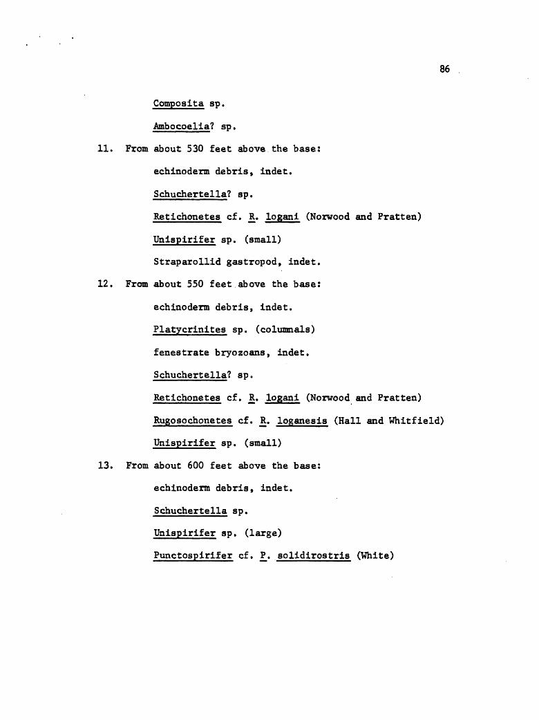
86
Composita sp.
Ambocoelia? sp.
11. From about 530 feet above the base:
echinoderm debris, indet.
Schuchertella? sp.
Retichonetes cf. JR. logani (Norwood and Pratten)
Unispirifer sp. (small)
Straparollid gastropod, indet.
12. From about 550 feet above the base:
echinoderm debris, indet.
Platycrinites sp. (columnals)
fenestrate bryozoans, indet.
Schuchertella? sp.
Retichonetes cf. R. logani (Norwood and Pratten)
Rugosochonetes cf. R. loganesis (Hall and Whitfield)
Unispirifer sp. (small)
13. From about 600 feet above the base:
echinoderm debris, indet.
Schuchertella sp.
Unispirifer sp. (large)
Punctospirifer cf. P. solidirostris (White)

87
MISSION CANYON LIMESTONE
The Mission Canyon Limestone forms much of the eastern flank
of the Ruby Range within the map area. Prominent ledges typify
this unit adjacent to recent stream incisions, but exposures are
poor elsewhere. Bedding is typically thick and indistinct, result
ing in massive outcrops. A thickness of 1370 feet was measured
for the Mission Canyon, considered a maximum figure because the
measurement was necessarily made on a dip slope.
With the exception of a 30-foot interval of dolomite 240 to
270 feet above the base, the entire formation is limestone. The
carbonate beds weather light gray, but fresh exposures are pale
to dark yellowish brown. Recrystallization is evident in much of
the rock, obscuring features in hand specimens; no petrographic
studies were made. Chert forms stringers locally but is not
common. Solution breccias occur in the upper strata, exhibit a
silty, grayish orange limestone matrix, and may be silicified.
Angular limestone blocks to three feet across were observed in some
of the breccias.
Age No fossil collections were made from the Mission Canyon.
Its age is considered Mississippian on the basis of its conformable
occurrence above the Lodgepole, its presence below (Mississippian)
Kibbey? strata and its likeness to dated Mission Canyon strata in
nearby areas. The formation could contain rocks as young as Chester,
88
if the unit correlates with Mission Canyon rocks to the south in the
Blacktail Range (Huh, 1967).
KIBBEY? FORMATION
Upper Paleozoic red beds in the Ruby Range are like those of the
Kibbey and unlike those of the Amsden Formation, according to William
L. Harris.* He has traced the Kibbey and Amsden (Mississippian-
Pennsylvanian) formations into southwestern Montana form the central
Montana area and was able to distinguish between the formations by
(1) the intense redness of the Kibbey, (2) presence of pinkish chert
in the Kibbey, and (3) absence of quartz sand from the Amsden. It
is not a purpose of this project ot undertake a study of this problem,
but it should be noted that (a) the Amsden of southwestern Montana
is at least locally an intense red, but conversely (b) to the east
in the Gravelly and Greenhorn ranges measured sections (furnished by
J. B. Hadley, U. S. Geol. Survey) reveal little sand in the Amsden,
thus supporting Mr. Harris 1 interpretation. In addition, Harris
noted that much more work needs to be done on the two formations in
the area south of the latitude of Jefferson Canyon (45° 45' N. lat.),
the southern margin of his project area.
Kibbey? rocks are present only along the margins of the Ruby
*A Ph.D. candidate at the University of Montana, studying the Big Snowy Group for his dissertation.
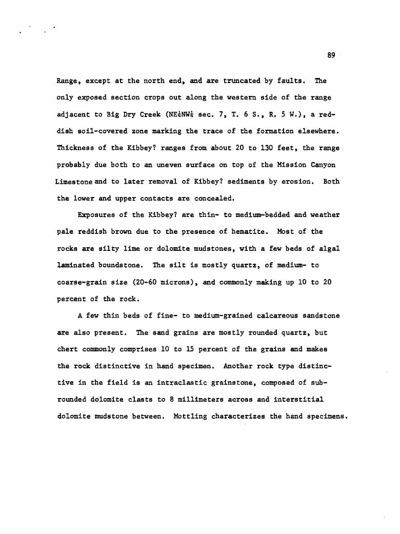
89
Range, except at the north end, and are truncated by faults. The
only exposed section crops out along the western side of the range
adjacent to Big Dry Creek (NEiNWi sec. 7, T. 6 S., R. 5 W.), a red
dish soil-covered zone marking the trace of the formation elsewhere.
Thickness of the Kibbey? ranges from about 20 to 130 feet, the range
probably due both to an uneven surface on top of the Mission Canyon
Limestone and to later removal of Kibbey? sediments by erosion. Both
the lower and upper contacts are concealed.
Exposures of the Kibbey? are thin- to medium-bedded and weather
pale reddish brown due to the presence of hematite. Most of the
rocks are silty lime or dolomite mudstones, with a few beds of algal
laminated boundstone. The silt is mostly quartz, of medium- to
coarse-grain size (20-60 microns), and commonly making up 10 to 20
percent of the rock.
A few thin beds of fine- to medium-grained calcareous sandstone
are also present. The sand grains are mostly rounded quartz, but
chert commonly comprises 10 to 15 percent of the grains and makes
the rock distinctive in hand specimen. Another rock type distinc
tive in the field is an intraclastic grainstone, composed of sub-
rounded dolomite clasts to 8 millimeters across and interstitial
dolomite mudstone between. Mottling characterizes the hand specimens.
90
PENNSYLVANIA
QUADRANT SANDSTONE
As interpreted here the Quadrant Formation includes as its
basal bed the first sandstone unit above the Kibbey? red beds.
There are no Amsden red beds in the Ruby Range and the entire sec
tion above the Kibbey? is considered to be Quadrant.
Quadrant rocks are present only at the north end of the range
(NWi sec. 21, T. 5 S., R. 5 W.) in an outcrop terminated by faults
on three sides and cut by at least one and probably two more. About
1200 feet of Quadrant strata were measured in the section, but the
minimum unfaulted thickness is only about 300 feet. The basal contact
of the formation is concealed but the reddish beds beneath are con
sidered part of the Kibbey? and thus the contact is presumed uncon-
formable. A fault terminates the uppermost Quadrant strata.
Interbedded limestone and quartz sandstone in about equal
amounts make up the formation, with good exposures characterizing
the limestone beds and covered intervals marking the location of san ci
st on g strata. Bedding of the limestone is medium to thick, that of
the sandstone thin to medium.
Quartz grains 60 to 150 microns in diameter make up the very
well sorted and rounded fine-grained sandstone. The cement is
largely silica occurring as grain overgrowths, although calcite
comprises a small amount of it.
91
The limestone beds include much lime mudstone and wackestone,
with some packstone and algal laminated boundstone. Pellets seem to
be abundant as are fossils and fossil debris, although recrystal
lization has obscured much of the fauna.
Age Fossils identified from the Quadrant of the Ruby Range are
Anthracospirifer, aff. A. occidus (Sadlick), and Composita, aff. JC«
subtilita Hall. They are probably Early or Middle Pennsylvanian in
age (written communication, J. T. Dutro, Jr., 1968).
CRETACEOUS -TERTIARY
BEAVERHEAD FORMATION
Historical Review Two detailed studies (Wilson, 1967; Ryder,
1968) of the Beaverhead Formation have recently been completed.
Ryder 1 s work was.partially published in 1967, whereas that of Wilson
is published only in abstract (Wilson, 1967). These studies are
briefly reviewed here because they are germane to the structural
interpretation of the Ruby Range.
From the distribution of the Beaverhead Conglomerate in extreme
southwestern Montana, Scholten and others (1955) concluded that it
was derived from uplift of the Blacktail and Snowcrest ranges,
mountains which they believed formed opposite flanks of a single arch,
the Blacktail-Snowcrest uplif£ (Fig* 20). Later Scholten (1967)
postulated that the arch was one anticline of several major folds

92
Scale (miles)
Figure 20. Regional tectonic map, showing major regionalstructures, area of basement rock (light stippled), and major intrusives (dark stippled).
93
radiating from a domal uplift centered in the Tobacco Root Mountains.
Basin and range faulting later segmented the anticline into distinct
intermontane basins and intervening ranges, one of which is the Ruby
Range.
Ryder (1968) described several units in the Beaverhead Formation
of the Monida area, and he and Wilson (1967) noted that one of these
the Lima Member occurs adjacent to the southeast and south margins
of the Blacktail-Snowcrest uplife. Wilson indicated the Lima Member
to be made of clasts derived from strata of the uplife and deposited
in an order inverted from the original depositional sequence of the
eroded formations represented. Clasts derived from the Madison Group
are by far the most dominant type present; clasts and sediment from
Precambrian metamorphic rocks occur at the top of the member.. Along
the southwestern.margin of the uplift the Lima member intertongues
with and is overlapped by conglomerate containing clasts derived
largely from Belt strata, which are exposed in areas to the west by
uplift concurrent with that of the Blacktail-Snowcrest arch.
Age of the formation is partly in dispute, Ryder (1968) believing
the basal strata are of latest Albian age and Wilson (1967) believing
early to middle Campanian age. The dispute is two-part: Wilson's
(1967) palynological material is thought by Ryder to indicate middle
Turonian to Coniacian ages, instead of Campanian; and Wilson (1967)
considers Ryder T s latest Albian strata to be older than that of the
Beaverhead Formation. Wilson (1967) dated the uppermost part of the
Lima Member (that part containing sediment from a metamorphic rock
94
source) as latest Cretaceous or earliest Paleocene and Ryder (1968)
apparently concurs. In the earliest Paleocene the quartzite conglo
merate started to cover the southwestern margin of the Blacktail-
Snowcrest uplife and by mid-Paleocene time as more extensive.
Beaverhead sedimentation continued until the late Paleocene, when
regional northwest trending thrust faults advanced from the west and
the wouthwest (Ryder, 1968).
Description Conglomerate of the Beaverhead Formation in the
Ruby Range forms two main rock groupings, one composed of carbonate
clasts derived largely from the Madison Group and the other composed
of quartzite clasts eroded from Precambrian Belt rocks. Both group
ings are largely restricted to the western margin of the range, with
exposures ranging from good for the carbonate conglomerate to poor
for the quartzite conglomerate. Thickness of the formation is un
known, but the maximum thickness of that exposed is approximately
150 feet.
The carbonate conglomerate occurs on the downthrown sides of
cross-range faults and cemented on carbonate formations at the outer
margin of that part of the range deformed before initiation of normal
faulting. Poor sorting characterizes the conglomerate with clast
size ranging from that of cobbles to boulders 2 to 3 feet across.
Most of the clasts are subrounded and those that are disc-shaped
locally reveal a crude imbrication.
Making up the matrix is fine- to coarse-grained sandstone, the
95
grains comprised of limestone, quartz, and chert. Quartz grains are
of medium-and fine-sand size and most are angular, but a few are
euhedral; granule size material is made of carbonate and chert
grains. Calcite cements the rock and iron oxide has stained the
matrix, giving the formation its characteristic reddish color.
Conglomerate made of quartzite clasts occurs basinward from the
limestone-cobble conglomerate (see map, Plate 1). Good sorting is
typical of this unit, most clasts being of cobble size. The cobbles
are rounded to well-rounded, commonly exhibit a high polish, may
contain ere s cent-r shaped percussion marks, and are highly fractured
where adjacent to faults.
Within the map perimeter only one outcrop of the Beaverhead
occurs high in the range (Plate 1, SEi sec. 35, T. 6 S., R. 6 W.,
SEi sec. 2, T. 7 S 0 , R, 6 W.). It differs from the foramtion else
where in that it contains clasts derived from Belt, Heagher, Flathead,
and Precambrian metamorphic rocks older than the Belt, and it overlies
the Cambrian Heagher Limestone. Only one isolated outcrop was observed
on the eastern flank of the range, 3 miles south of the map area
(Metzel Ranch quadrangle, sec. 4, T. 7 S., R. 5 W.). There the
Beaverhead overlies Precambrian metamorphic rocks and contains Belt
cobbles in the lower few feet but upward rapidly grades into rock
containing Madison limestone clasts. A maximum thickness of about
100 feet is present.
To summarize, Belt quartzite clasts at the eastern margin of the
range overlie Precambrian metamorphic rock; and at the western margin

96
Belt quartzite clasts are down-faulted, commonly adjacent to Beaver-
head clasts derived from Paleozoic carbonate rocks. Paleozoic clasts
show a similar distribution in that younger Paleozoic formations
are represented in the more westward exposures of the carbonate con
glomerate. An exception occurs at the Metzel Ranch quadrangle
locality where Madison clasts are present; there is a nearby source
area for these, however.
Source^ The source of the Belt cobbles in the Beaverhead Forma
tion was probably to the west, suggested by the following factors.
(1) No Belt strata are known east of the Ruby Range. (2) Belt strata
to the north make up the LaHood Formation, a unit that differs litho-
logically from clasts in the conglomerate. No Beaverhead-type conglo
merate has been reported from the Tobacco Root Range. Pediments
adjacent to the west side of the Ruby Range contain Belt clasts
apparently reworked from the Beaverhead, whereas pediments adjacent
to the west side of the Tobacco Root Range do not. (3) Studies of
Wilson (1967) and Ryder (1968) indicate the Blacktail and Snowcrest
ranges to the wouth were source areas for clasts exclusive of Belt
in the Beaverhead, thus a southern source for the Belt clasts is
unlikely. To the west Belt strata are present in the overthrust
plates of the Pioneer Mountains (Myers, 1952) ,
Age and Discussion 1 No fossils were obtained form the Beaverhead
Formation in the Ruby Range, thus its age cannot be directly deter
mined. A minimum age is Eocene, however, as Dorr and Wheeler (1964)

97
and Backer (1960) postulated a late Eocene age for basinal deposits
at the eastern side of the range, 3 miles south of the map area.
These deposits are of strikingly different aspect from the Beaverhead.
Early and middle Oligocene sediments adjacent to the western and
northern margins of the Ruby Range also differ from the Beaverhead,
although they are locally conglomeratic.
Regionally, it seems the Beaverhead of the Ruby Range should be
about time correlative with the formation southward, especially if
the Ruby Range is actually part of the Blacktail-Snowcrest uplift
as postulated by Scholten (1967). The northeast corner of the Ruby
Range (outside of the map area) is structurally continuous with the
Greenhorn Range (northern extension of the Snowcrest Range; see
Fig. 1), the northern margin of the connecting rocks being overlain
by Flathead and Wolsey formations which dip steeply to the north.
This plus the outcrop pattern of rocks in the Snowcrest-Greenhorn,
Blacktail, and Ruby ranges, suggests the combined area may have
comprised one arch. Additionally, the proposed arch is about the same
size as those to the east which are more easily demonstrated (see
map, Fig. 20). If the present ranges were not originally part of
the proposed but were separate from the time of their inception, then
the basin between the Ruby and Snowcrest-Greenhorn ranges should
contain conglomerate of the Beaverhead Formation. No Beaverhead has
been reported (cf., Klepper, 1950; Lowell and Klepper, 1953; Dorr
and Wheeler, 1964) except for the one outcrop noted 3 miles south
of the map area and it is near the northern margin of the proposed

98
arch. Thus Scholten's (1967) postulate seems to be valid.
The distribution of the non-Belt clasts within the range sug
gests the lower Paleozoic and Precambrian metamorphic clasts are a
younger part of the Beaverhead than the upper Paleozoic ones. The
Belt clast-conglomerate overlies only Precambrian metamorphic rocks
and locally the Heagher Limestone, and it occurs downdropped adjacent
to carbonate-clast conglomerate at the western margin of the range
and thus must have originally been stratigraphically higher than
the latter. An inverted sequence for the represented formations is
thus indicated, a feature noted by Wilson (1967) for the Lima Member
of the Beaverhead. This interpretation agrees with that of Ryder
(1968) who found conglomerate made of Belt clasts overlapping the
carbonate-clast conglomerate as the Belt clasts began to spread
across the southwestern margin of the Blacktail-Snowcrest uplife.
Seemingly, the influx into the two areas should be roughly synchronous
as the material is thought to have come from the same general area.
TERTIARY, OLIGOCENE
Sediments of Oligocene age crop out locally at the north end of
the range and along the western flank. Making up the strata at the
north end of the range is gray and green mudstone interspersed with
pebbles, cobbles, and boulders (to 7 feet in diameter) of basaltic
and andesitic volcanic rock (Fields and Petkewich, 1967). Tertiary
sediments cropping out near McHessor Creek along the western flank

99
of the range were assigned to the Oligocene by R. M. Petkewlch
(personal communication, 1969). They consist of mudstone inter-
stratified with poorly sorted locally conglomeratic siltstone and
sandstone. The sand and silt grains are quartz, feldspar, biotite,
and rock fragments, and the conglomerate clasts are largely of
metamorphic rock.
TERTIARY QUATERNARY
Strata in the basins beyond the margins of the Ruby Range were
not mapped in detail; hence, they are grouped under one heating,
Tertiary-Quaternary undivided (TQu). These strata include Oligocene
and Miocene Pliocene deposits, minor volcanic rocks, loess deposits,
gravel deposits, alluvium, and colluvium.
QUATERNARY
Quaternary deposits were studied only superficially and mapped
for completeness or to aid interpretation of structures. These map
units include tufa, an unnamed conglomerate, alluvium, colluvium,
mass movement deposits, and glacial deposits.
TUFA
Spring deposits made of tufa crop out at two locations
100
in the map area, both along the western flank of the range. Springs
are no longer active at the deposit near Trout Creek but near the
McHessor Creek deposit warm water still issues from the spring,
although deposition of calcium carbonate is very minor.
These deposits are probably very young, suggested by the still
active spring water at McHessor Creek. In addition, the deposit
near McHessor Creek is planed off by a pediment, the latter feature
considered to be of Pleistocene age. The Trout Creek deposit is
not truncated by this pediment so it must be young, too.
UNNAMED CONGLOMERATE
An unnamed conglomerate crops out locally along the flanks of
the range and is assigned to the Quaternary because it intertongues
with the tufa deposits near McHessor Creek. Making up the conglomerate
are angular to subangular pebbles, cobbles, and locally boulders in
a coarse sand matrix, the clasts reflecting the lithologies of
nearby formations. The deposits are believed to be fanglomerate.
ALLUVIUM
Unconsolidated material deposited along streams was mapped as
alluvium. Most of this sediment is probably of Recent Age. Alluvium
also occurs as a veneer atop the pediments marginal to the range on
the west and is mapped with the undivided Tertiary-Quaternary deposits.
101
COLLUVIUM
Deposits mapped as colluvium include unconsolidated angular
rock fragments, hillwash, and talus. These deposits are most abundant
along the western flank of the range where they overlap pediments, are
adjacent to stream deposits, and mask bedrock. Locally the colluvium
is mixed with old stream deposits. Thickness of the colluvium ranges
up to as much as 50 feet and locally may exceed that. Colluvial
deposits were not mapped where they constitute only a thin cover.
MASS MOVEMENT DEPOSITS
Deposits formed by mass movements include landslides, earthflows,
and slump deposits. Landslide deposits are caused by removal of
support from beneath cliffs, most commonly due to erosion of shale
beneath carbonate formations. Earthflows occur in hydrated shale
units, the toes of which are undergoing erosion by streams. Slump
deposits occur in unconsolidate deposits that may be hydrated; the
toes of these deposits are typically undergoing stream erosion, too.
GLACIAL DEPOSITS
Glacial deposits are not common in the Ruby Range, only two being
noted. One is a small terminal moraine occurring high in Laurin
Canyon (SWi sec. 9, T. 6 S., R. 5 W.), the other a protalus rampart
present near the head of Trout Creek (NW 1/16 sec. 6, T. 7 S., R. 5 W.)

IGNEOUS ROCKS
INTRUSIVE ROCKS
Igneous rocks intrude formations ranging in age from Precambrian
to Oligocene, with most intrusions present along fault zones or in
clay shales of the Cambrian strata. Host of the intrusives are
basaltic, but andesite and rhyolite are present near McHessor Creek
on the western flank of the range.
EXTRUSIVE ROCKS
Andes!tic breccia occurs in the W£ sec. 6 T. 6 S., R. 5 W.
These rocks are in fault contact with the neighboring strata, except
they grade upward into volcanic ash containing rounded clasts from
the andesite unit below and quartzite clasts from the Beaverhead
Formation. The age of this breccia is unknown.

STRUCTURE
REGIONAL SETTING
The Ruby Range is elongate north-south, measuring about 30
miles in length and 10 to 15 miles across (Figure 1). It occurs
at the western edge of the foreland of the Rocky Mountains in a
structural setting characterized by (1) high-angle faults that cut
basement rocks, (2) extensive exposures of Precambrian metamorphic
rocks in the cores of mountain uplifts, and (3) a thin cover of
Paleozoic and Mesozoic sedimentary rocks. In the Ruby Range these
sedimentary strata had an aggregate thickness of about 10,000 feet
or less during deformation in the Late Cretaceous-early Tertiary,
whereas correlative strata plus Late Precambrian Belt sediments
to the west in the miogeosyncline may have totaled as much as
35,000 to 50,000 feet or more. (See Figure 20 for regional tectonic
map.)
The range is flanked on all sides by intermontane basins con
taining Tertiary sedimentary rocks. Major normal faults border
the range on the west, north, and much of the eastern side. Outcrop
patterns, field observation, and Bouger gravity anomaly data
(Burfeind, 1967) suggest the remainder of the range is delimited
by faults, too, except for the northeastern corner which is structurally
continuous with the Greenhorn Range to the east.

3,00
0-
Figu
re 21.
Reproduction of major
part of
map
area,
showing
(met
amor
phic
) basement bl
ocks
an
d master fa
ults
. Cross-section
show
s su
rfac
e of me
tamo
rphi
c ro
ck.

105
BASEMENT BLOCKS
Basement rocks, as used here, are the metamorphic rocks which
unconfonnably underlie the unmetamorphosed, dominantly sedimentary
rocks of the Ruby Range. In the northern part of the range (the map
area) the basement is segmented into discrete blocks by a relatively
few major high-angle faults. The faults are termed master faults
and are shown in Figure 21, reproduced from the geologic map (Plate 1)
to illustrate the relationships among the blocks. Relative positioning
of the basement blocks is shown in the cross-section of Figure 21.
The blocks make a pattern of stair-steps, ascending to the Ruby
Peak block from both the northeast and southwest. The northeastern
stair-steps are irregular because of a graben formed in between the
Ruby Peak and Taylor Canyon basement blocks (see Fig. 21).
Basement rock exposed in the blocks shows a nearly planar
contact with the overlying Cambrian strata and permits a determination
of the dip of the blocks. The direction of dip ranges from about
N 18 E to N 36 E and the dip itself is commonly 30 to 40 degrees,
although one block is inclined almost 60 degrees. The dips are a
result of the blocks plunging to the northwest and tilting to the
northeast. Resulting is a series of en echelon faults, folds, blocks
and outcrop patterns. The nearly planar basement-sedimentary rock
contact suggests rupture, plunge, and tilt of the blocks was
accomplished with only minor internal flexing.

106
FAULTS
Two main directions of faulting are readily apparent within
the map area, namely northwest to north-northwest and northeast.
Trending northwest to north-northwest are the master faults, which
exhibit greatest throw and, except rarely, truncate those faults
trending northeast. The McHessor and Hinch creek faults (see Fig. 21
and Plate 1) exhibit maximum throw for faults within the map area.
They show about 6,000 and 7,000 feet*of throw. Throw on a fault
is commonly difficult to measure because (1) sedimentary rocks
overlying the immediately adjacent parts of two basement blocks
are typically folded, and/or (2) key Paleozoic sedimentary rocks
may be absent near a fault on one or both of the blocks, and
the contacts have to be projected from as far away as 2 miles.
Faults trending northeast are high-angle and exhibit displace
ments less than those of the master faults. They are truncated
by the master faults (cf., sec. 31, T. 6 S., R. 5 W.).
Upthrust Faults The basement blocks are bordered by major
faults which extend upward from the basement into the overlying
sedimentary rocks. The structural style of the map area is thus
one of block faulting, with the basement being closely involved ini
the deformation of the overlying sedimentary rocks.
The theoretical stress field for block uplift was developed
by Hafner (1951) and experimental model studies were made by
Sanford (1959). The geometry of the theoretical structure

107
associated with a block uplift affecting deep-seated crystalline
rocks is shown in Figure 22 (after Crosby, manuscript), and in three
dimensions in Figure 23 (after Prucha and others, 1965, p. 971).
The principal stress trajectories at the surface are parallel
and perpendicular to the surface of the earth because no shear
stress can exist on a free surface. Further, the subvertical fault
in the crystalline basement block is a shear while one block is
uplifted relative to the other; therefore, maximum principal stress
is oriented about 30° to the fault at the level of the top of the
basement (Hubbert, 1951, p. 361). Its orientation in space is
indicated by the sense of displacement on the fault. The three
principal stresses, mutually perpendicular, must curve continuously
(exceptionally, intermediate principal stress does not curve in
2-dimensional deformation, but lies in the fault surface) between
the top of the basement and the air-earth interface where maximum
stress is horizontal in the vicinity of the fault. Inasmuch as
the fracture that results from the differential stress forms at
about 30° to the maximum principal stress, th fault surface will
be curved, and thus reflect the curvature of the stress trajectories.
Accordingly, the fault which is steep at depth flattens progressively
toward the surface. Faults with these characteristics are termed
upthrusts and have been treated theoretically and produced in
model experiments by Sanford (1959). Field examples have been
described by numerous authors (e.g., Berg, 1962).

108
Figure 22. Block uplift model. Stress system does not take into account the modifying effects of the topography produced by faulting. (Diagram after Crosby, manuscript.)
Figure 23. Diagram showing dip of upthrust fault as a function of level of observation relative to corresponding structural segment of fault. Fault is vertical in segment of bed A, high-angle reverse in segment of bed B, and low-angle reverse in segment of bed C (after Prucha and others, 1965).

109
Cross-section B-B 1 (Plate 1) and a telescoped reproduction
of the fold in the E2/3 sec. 6 and Ei sec. 7, T. 6 S., R. 5 W.,
(Fig. 24e) clearly show a series of related upthrust faults which
are nearly vertical in their lower segments and curve progressively
in their upper parts. As predicted by theory they curve upward
and away from the uplifted block. In this example and in all
others within the map area, the axis of curvature of the upthrust
plunges to the northwest in accordance with the northwestward
plunging of the basement blocks.
Prucha and others (1965) noted that the attitude of an
upthrust depends on the thickness of the sedimentary section above
the basement, the type of rocks involved, the attitude and magnitude
of the discontinuity in the basement, topographic effects produced
by faulting, and other factors. Thus the structurally lower, near
vertical parts of the upthrusts shown in Figure 24 involve crystal
line basement rocks on one or both sides, whereas the curved segments
typically involve sedimentary rocks on one or both sides.
The lower parts of upthrusts within the map area are topograph
ically higher than the upper segments because the basement blocks
and overlying sedimentary rocks plunge to the north. In addition,
erosion has cut deeper into the section at higher elevations than
at lower elevations. Thus because the orientation of the surface
trace of an upthrust is dependent upon the depth of erosion, fault
traces commonly change trends toward the margins of the range.
Indeed, some are sinuous whereas the basement fractures may be

110
linear (cf., northern central part of map).
Imbricate upthrust slices occur in the Wi sec. 23, T. 68.,
R. 5 W., of the Laurin Canyon quadrangle, the formations making
up the three slices stacked in a sequence inverted from their
depositional order (the strata are not overturned). As each slice
was emplaced uplift must have continued, severed each slice from
its "roots," and permitted emplacement of the succeeding slice
from older strata.
A scissors relationship exists between the Ruby Peak and
Taylor Canyon basement blocks (ignoring the graben in between) be
cause northwestward plunge of the two blocks is different. The
axial area for the scissors must occur about in the Si sec. 9,
T. 6 S., R. 5 W. South of the axial area the Ruby Peak basement
block is up relative to the Taylor Canyon basement block and the
graben. Thus in theory (Sanford, 1959) the upthrust should flatten
eastward at the highest structural level and that it does Is suggested
by overturned strata in the graben adjacent to the fault. North
of the axial area the relationship is reversed, strata overlying
the Taylor Canyon basement block being upthrust over that of the
Ruby Peak basement block.
Origin of the Fault Pattern The master faults display a pattern
that may be of Precambrian origin, reactivated during the Cretaceous-
Tertiary erogenic period. Jack Garihan (Penn. State Univ., written
communication, 1970) described the fault system in the Ruby Range
south of the map area as very pervasive, exhibiting a series of

Ill
northwest-trending strike-slip faults with left-lateral offsets of
at least 2 to 3 miles. The movement is considered to be Precambrian
in age because later movement on the northwest-trending faults
throughout the range is dominantly dip-slip, and because diabase
dikes of probable Precambrian age are locally intruded along the
faults in the middle and southern parts of the range. Intense
shearing is associated with the strike-slip movement but not with
post-Precambrian dip-slip movement.
Foliation trends within the Ruby Peak block (see map, Plate 1)
curve progressively from an easterly trend to a southeasterly trend
adjacent to the fault bordering the western side of the graben
(Fig. 21, and Plate 1). This may be due to strike-slip movement,
but no investigation was made to prove it. Thus, although there
is no reason to expect the pervasive strike-slip deformation pattern
to cease its existence abruptly at the southern margin of the map
area, its existence has not been proven and thus must remain as
a possibility.
FOLDS
Folds in the sedimentary strata have formed in response to
differential uplift of basement blocks. Strata adjacent to a
master fault and on the downthrown side are commonly upturned
sharply, whereas correlative strata on the upthrown side are commonly
downturned sharply. If a fault between differentially uplifted

112
basement blocks fails to penetrate the sedimentary section a mono
cline may exist, as shown in Figure 24e, The fold axis parallels
the contour of the basement surface and the fault plane. Failure
of the sedimentary rocks to adjust by folding results in faulting,
and continued uplift will permit formation of a syncline on the
downthrown side of the fault and an anticline on the upthrown side.
Northward plunge is characteristic of all folds within the
map area, whether anticline or syncline, and results from the
northward plunge of basement blocks. Because the basment blocks
all dip to the northeast and exhibit an asymmetric surface profile
due to uplift along their western margins (except for one), the
steepest limb of each syncline is always along the eastern margin
of a block and the steepest limb of each anticline is always along
the west. The largest folds are adjacent to faults exhibiting
the graatest throw.
Anticlines All anticlines in the map area show similar
characteristics, thus only one needs detailed explanation. The
Spring Creek anticline is the example used because it is the
most complete and best exposed.
The series of diagrams in Figure 24 shows dlagrammatlcally
a possible sequence of events resulting in formation of the
Spring Creek anticline. Interpretation of the sequence is as
follows, (a) Differential uplife of basement blocks occurred
with the sedimentary strata adjusting to the fracture by folding,
(b) With continued differential uplift the sedimentary strata

113
B
\
E LEGEND
Gpfc Park Shale
6m Meagher Limestone
Flathead Sandstone& Wolsey Shale
pCm(j Metadolomite
p m Crystalline meta- morphic rocks
Figure 24. A series of diagrams illustrating a possible sequence of events in formation of the Spring Creek anticline.

114
adjusted by fracturing, (c) Another fracture then formed with more
uplift. The easternmost block of the three rose farther than either
of the other two and the Intermediate block was rotated mainly
because of differential movement between the neighboring blocks.
(d) More differential uplift occurred and another fracture formed
but It did not penetrate the sedimentary strata or metadolomlte
that occurs In the uppermost part of the basement block; rather,
the sedimentary rocks adjusted by folding, (e) Differential uplift
continued and the fold continued to develop.
Mechanics of Folding Structural features in the Paleozoic
carbonate strata of the Spring Creek anticline suggest the fold is
of the flexural slip type. Folding of the carbonate beds was
apparently accomplished mainly by slip between layers. The shale
units (Wolsey and Park), however, do not obey the rules of flexural
slip folding, but rather display characteristics of flexural flowage
folding (Donath and Parker, 1964). The shales show nearly constant
thicknesses in the eastern limb and thin drastically in the
western limb. Both types of folding can occur in the same fold
because the two rock types exhibit a ductility contrast. The fold
as a unit, however is best termed a flexural flow fold.
Folds associated with upthrusting ideally are expected to
display geometric characteristics compatible with the stress field
of upthrusting. Thus the axial plane of the Spring Creek anticline
curves and flattens to the west and, in its upper part, is slightly
overturned to the west. In addition, cross section B-B f and the

115
sketch in Figure 24 show the anticline is slightly asymmetrical
and that the asymmetry is greater in the upper part of the fold.
Some of the asymmetry can be attributed to thinning of the shales
in the western limb. But perhaps part can also be attributed to
horizontal compression because the low angle or flattened part
of the upthrusts and the fold are in a zone of horizontal compression,
as shown by the stress trajectories in Figure 22.
The Precambrian metamorphic rocks of the exposed basement
block adjusted to the folding in two ways. (1) Metadolomite in
the upper part of the block seems to have folded passively and is
continuous from one limb of the fold to the other. It does not
show appreciable thickening or thinning in the axial area as
expected for a passive fold, but instead maintains a near constant
thickness from one limb to the other. In part this is because
the unit is only a few feet thick and is bounded above and below
by rocks of less ductility. (The Flathead Formation, a quartz
sandstone, overlies the dolomite.) A more improtant reason is
found in a mechanical analogy with a slab of material that is
bent into a fold (Fig. 25). Upon bending the convex side is under
tensional or extensional stress, the concave side is under compressional
stress, and separating thse zones is a neutral surface. In the Spring
Creek anticline the zone of extension is exemplified by'the flexurally
folded sedimentary rocks and the zone of compression by the gneiss
and amphibolite. Thus the metadolomite probably contains the surface
of neutral stress, and presumably it occurs in the center of the unit

116
tensions! area
neutral surface
Figure 25. Cross-section of slab, showing stress zones. Figure isused as a model for interpretation of folded metadolomite in core of Spring Creek anticline.
midway between the zones of extension and compression. Therefore,
even though the metadolomite deformed passively, there need be no
thickness change in the hinge area because the two different stress
fields should affect equal but opposite areas and a change necessitated
by stresses in one area should be compensated in the other.
(2) The second way in which the metamorphic rocks adjusted to
the folding was by faulting of the gneiss and amphibolite units;
west of the fault these -rocks rotated in sympathy with the folded
metadolomite and sedimentary strata (Fig. 24c,d,e). The folded
slab in Figure 25 shows that a wedge of material in the zone of
compression must be compensated if the fold is to exist. Compensation
for a wedge, made of amphibolite and gneiss in the Spring Creek
anticline, was accomplished by slippage and granulation along folia
in the crystalline rock west of the fault.
The fault within the crystalline rocks is also the axial plane
for the compressional part of the Spring Creek anticline, and
117
projected upward It coincides with the axial plane of the folded
sedimentary rocks. Coupled with the other data cited for the
anticline, this is strong evidence that the geometry of the inter
nally deformed basement block is very closely related to that of
the folded sedimentary strata. Studies made by some other workers
have also shown internal deformation of basement blocks to be
related to that of the overlying sedimentary strata (cf., Hudson,
1955; Berg, 1962; LeMasurier, 1970), Conversely, other studies
of uplifted basement blocks have revealed no evidence for deformation
related to that of the overlying folded sedimentary strata; and
the sedimentary strata folded simply by draping over the surface
of the uplifted block (cf., Wise, 1962; Prucha and others, 1965;
Hodgson, 1965; Palmquist, 1967).
A controversy has developed over which of the above viewpoints
is correct (LeMasurier, 1970). According to the theoretical geometry
associated with foreland-type uplifts (see Fig. 22) stresses exist
within the uplifted basement block, as they do in the associated
sedimentary rock. Whether the block reacts to the stresses by
folding, fracturing, or resists deformation depends on the properties
of the rock. Thus, if the uplifted block resists the applied stresses,
the sedimentary strata may simply drape over the faulted flank of
te block. If the block does not resist the stresses, then its
internal geometry will show deformation which should be correlatable
with that of the overlying folded sedimentary strata, deformed
within the same stress system.
118
Synclines' The McHessor Creek syncllne occurs adjacent to the
McHessor Creek master fault (Plate 1, sees. 24, 25, 26, T. 6 S.,
R. 6 W., sees. 30, 31, T. 6 S., R. 5 W.), and Is used as the synclinal
model because of its good exposure. Except near its northwestern
terminus, the syncline is progressively more deformed toward the
southeast. This is shown by increasing tightness of the fold,
steepening of the eastern limb (which becomes vertical and then
overturned), intense shearing and fracturing about the nose, and
(farther to the southeast) by faulting which terminates the fold.
A roughly north-south trend is exhibited by the major faults
southeast of the synclinal nose. The western two of these faults
are demonstrably of the upthrust type, the fault planes flattening
upward to the west. The overturned axial plane of the syncline
also becomes flatter to the west and curves from a southeasterly
trend to a southerly trend about parallel to that of the faults.
These data indicate the fold and faults are closely related.
The block containing the syncline narrows toward the nose of
the fold and the basment block to the east has a corresponding
bulge (SWi sec. 30, T. 6 S., R. 5 W.). Visualizing northwestward
plunging, northeastward tilting, and formation of the syncline all
occurring together, the bulge of the upthrown eastern block must
impinge upon rock of the downthrown block. (This argument assumes the
faults along which the blocks adjust are not defined by unique proper
ties wherein one block can move completely independent of another.)
It is difficult to determine if the impinging bulge is an inherent

119
feature of the uplifted block and is thus complimented by a re-enrant
in the basement part of the downthrown block, or if the bulge formed
by outward movement in accordance with the horizontal component of
stress in the upper part of the upthrust model (see Fig. 22). In
either case part of the stress must be directed horizontally.
Assuming the north trending faults near the synclinal nose
formed in response to a compressive stress directed about 30° to
teh faults, one possible stress direction is oriented about N 25 E
to N 30 E. This direction agrees closely with the dip direction
of the basement blocks, measured as ranging from N 18 E to N 36 E,
and a result of the northeastward tilting of the basement blocks.
The above data do not prove that the fold formed due to compression
related to block upthrust, more data being needed, but they are
suggestive of it.
In the constricted area the easiest movement direction for relief
of stress was probably upward. Thus most of the small fault slivers
bordered by the north-trending faults are uplifted, relative to rocks
northwestward.
NORMAL FAULTS
Blocking out of the present range took place by normal faulting.
Steeply dipping northeast trending normal faults along the western
margin of the range clearly truncate the older northwest trending
structural features within the range. Normal faults along the
120
northeastern margin are not as evident, but must trend northwest and
be about parallel to structural features within the range. Normal
faults delimit most of the range margin south of the map area (cf.,
Burfeind, 1967; Dorr and Wheeler, 1964; Pardee, 1950; and Klepper,
1950), an exception occurring along the eastern margin where the
Ruby Range is structurally continuous with the Greenhorn Range.
Using gravity data, Burfeind (1967) calculated basin fill along
the western margin of the range to be about 6,000 feet, that along
the northeastern margin to be about 4,000 feet, and that south of
the map area along the eastern margin of the range to be as great
as 7,000 feet. Throw on the faults bordering the range is not
directly determinable, but assuming a nearly complete stratigraphic
section on the downthrown basin blocks, individual throws could easily
exceed 12-14,000 feet. The structural relief from the range crest
(within the map area) to the basin bottom is a minimum of about
10,000 feet and could exceed 20,000 feet, using the above assumption.
Western Margin The marginal normal fault bordering the Ruby
Range on the west is not one continuous feature, but is locally
segmented where it intersects older cross-range faults. It is expressed
by a fault-line scarp along much of its lenth, but southwestward from
Trout Creek no scarp is present and there is no surface expression
of the fault. Locally in gullies, however, the fault has been
exposed by erosion.
Inward from the marginal normal fault occur normal and high
angle faults that are clearly of the same vintage as the marginal
121
fault. These faults commonly outline small grabens, the infaulted
strata being Oligocene sediments and Belt-cobble-bearing conglomerate
of the Beaverhead Formation. The grabens are not everywhere simple;
indeed, the superposition of a new fault system upon a pervasive
older one might be expected to result in a complex intersection.
Three important differences exist between the sediments basin-
ward from the marginal normal fault and the Tertiary sediments
contained within the system of normal faults at the range flank.
(1) No strata younger than Oligocene are present within the range
but those in the basin include distinctive Miocene-Pliocene strata.
(2) The Beaverhead and Oligocene strata, displaying a great variety
of strikes and dips, are intricately faulted. In fact the strata
are believed to contain more faults than shown on the map, but
poor exposures preclude definite proof of their existence. Conversely,
the exposed strata within the basin are not greatly diversified in
orientation, all strata dipping gently. (3) Quartzite cobbles
of the Beaverhead make up quartzite conglomerate, whereas quartzite
clasts of the same rock types occur as pebbles and small cobbles
interspersed with other clast types within Miocene-Pliocene conglomerate
of the basin.
The above data may be indicative of at least two stages of normal
faulting: One before deposition of strata younger than Oligocene and
another later. Belt quartzite clasts occur in the Miocene-Pliocene
rocks and are nearly absent from Oligocene sediments. Because the
Beaverhead Formation must be the source of the Belt clasts, it

122
must not have been exposed to erosion until Miocene-Pliocene deposition,
This indicates concealment of Beaverhead and Oligocene rocks in post-
Oligocene time and exposure of the same strata during deposition of
Miocene-Pliocene sediments. This may indicate a step-fault relation
ship exists for the hasin-and-range structure, the normal-faulted rocks
at the range margin forming one step and the other formed by the
basin floor. Conversely, the rocks may simply have been covered by
younger sediments and exposed to erosion during Miocene-Pliocene
deposition.
Eastern Margin The fault bordering the northeastern side of the
range is not as easily demonstrated as that along the western side.
East of the map area Cambrian Flathead and Wolsey formations of the
range front are clearly upfaulted relative to Oligocene strata (R. M.
Petkewich, personal communication, 1969). Immediately adjacent to
the eastern margin of the map area the Wolsey is highly contorted
along the same fault-line scarp, the scarp being easily traced
along the northeast margin of the Ruby Range. The actual fault is
concealed by fan deposits within the map area, but its presence
is indicated by: (1) the scarp, (2) the faulted margins of the
unnamed conglomerate (Qcgl) of probable Quaternary age, (3).occurrence
of springs along the scarp, (4) steep dips (to 80°) of Paleozoic rocks,
and (5) faceted spurs of Paleozoic rock.
Between Porter and Robinson canyons the above criteria do not
apply and the fault is believed to pass beneath the alluvial fan.

123 .
Obvious steepening of the fan is evident along the projected fault
trace, probably caused by the presence of Mission Canyon strata
beneath the fan head. Northwestward beyond Bouge Canyon aerial
photographs reveal a slight topographic break in the alluvial fan
deposits, but it is difficult to discern on the ground.
Northern Margin The rock units present at the northern margin
of the range and their outcrop relationships are like those along
the western margin. Known faults fit this pattern, but some faults
are not readily demonstrated; hence, they were mapped as "probable
faults."
Pebbles, cobbles, and boulders of volcanic rocks occur in the
early Oligocene sediments at the northern margin of the Ruby Range
(Fields and Fetkewich, 1967), whereas the Oligocene sediments at
the western flank of the range contain cobbles mainly of metamorphic
rocks. Because such coarse material is uncommon in the Oligocene
sediments of southwestern Montana, even adjacent to the basin
margins (Fields and Petkewich, 1967); and because the sediments are
suggestive of a more humid climate than presently exists or existed
in the Miocene-Pliocene (R. M. Petkewich, personal communication,
1969) and thus formed in an environment not typically disposed
to production of coarse sediments; the conglomerate near the flanks
of the Ruby Range is probably due to uplift of the range. This
suggests outlining of the northern margin of the range may have
begun in the early Oligocene. Conversely, the conglomerate at the
124
north end of the range may not be of tectonic origin; then, regional
data suggest normal faulting began in perhaps middle Oligocene
time (R. W. Fields, personal communication, 1970)
GRAVITY SLIDE MASSES
A series of rock masses are common along the margins of the
range within the map area. They are commonly observed to be in
fault contact with underlying rock units, but where not observed to
be overlying a rock unit, they are separated from adjacent units by
high-angle faults. Along the southeastern margin of the range front
(Ni sec. 24 and Si sec. 13, T, 6 S., R. 5 W,) thin interfaulted
masses or slices of rock occur, the fault planes dipping less
than 30° hasinward, and at the northern margin of the range a 15°
inclination was determined for the fault separating the Mission
Canyon Formation form the overlying metamorphic rock unit. Those
masses along the western margin of the range are truncated by
near vertical faults or normal faults (sees. 14, 15, 21, 22, and 28,
T. 6 S., R. 6 W.).
Brecciation characterizes the basal strata of all the masses,
whereas the rocks immediately beneath are fractured but are not
commonly brecciated. For example, strata exposed beneath the rock
mass at the north end of the range show deformation consisting
mainly of small fractures, now filled with calcite.
125
Three possible methods for emplacement of the rock masses
include reverse faulting due to regional horizontal compression,
upthrust faulting, and gravity sliding. Where not truncated by
high angle faults, the masses can be viewed as separated from
underlying rock by reverse faults. It is difficult to attribute
such reverse relationships to regional horizontal compression
because (1) the range seems to have been formed by vertical uplift;
(2) it is unreasonable to find evidence of such compression only
at the range margins; and (3) distribution of the blocks on three
sides of the range would have required regional compression
directed east-west and north-south, presumably concurrently, but
perhaps alternately.
Emplacement of the masses along upthrust faults would require
the present basin areas to have been upthrust relative to the
mountain block and subsequently downdropped to form the present
basins. The rock masses would represent remnants of the upthrust
rock, later severed by normal faults which delimit the basins and
ranges. Stated another way, the range was uplifted as part of
the Blacktail-Snowcrest arch, was later downdropped relative to
the basin areas, and was rising again by Oligocene time.
Emplacement of the masses by gravity sliding is the third
possible method, requiring only that the masses slid off the flanks
of the range as the range was uparched. Contrasting upthrusts
within the range with the range-marginal masses, the following argu
ments are all cited as favorable to emplacement of the masses by
126
gravity sliding and unfavorable to the upthrusting hypothesis.
(1) Within the range, metamorphic rock is not present above the
upper flattened part of any upthrust, that part to which the range
marginal metamorphic rock masses would have had to belong. (2) The
Mission Canyon Formation is not displaced adjacent to the low angle
part of any upthrust fault within the range, but in the SEi sec. 20,
T. 5 S., R. 5 W., both it and Precambrian metadolomite are intricately
interfaulted. (3) Imbricate upthrust slices within the range show
an orderly emplacement in that they are stacked inversely to their
normal stratigraphic sequence. No preferred order is shown for
the fault slices at the range margin (cf., Ni sec. 24 and Si sec. 13,
T. 6 S., R. 5 W.). (4) The metamorphic rock within the displaced
masses at the range margin in all cases is metadolomite adjacent to
the fault surface, although other rock types are present away from
the fault surface. Within the range no preference is shown for
any particular metamorphic rock severed by an upthrust fault.
(5) Folding characterizes the metadolomite adjacent to upthrust
faults within the range, illustrated in the core of teh Spring Creek
anticline. Metadolomite adjacent to the faults of the displaced
masses at the range margins has deformed cataclastically and is
thoroughly brecciated. (6) Where data are abundant, foliation
trends in uplifted basement blocks adjacent to upthrust faults
within the range show a regular pattern, even where deformed. At
the range margins the foliation trends of the rock masses show no
general orientation, and at the north end of the range they appear
chaotic.

127 .
The data presented above certainly seem to rule out emplacement
of the rock masses at the range margin by regional compression, neither
do they favor an upthrust origin. A gravity mechanism is most easily
reconciled with observed relations.
The crestal region of the Ruby Range is thought to be the
source area of the rock masses. A source in the Tobacco Root Range
to the north is unrealistic because the displaced masses occur at the
western flank of the Ruby Range as well as the north and northeast
flanks. A western source in addition to a northern one is not probable
because the slide masses would have had to slide more than 15 miles.
The distance is not prohibitive, but a ready source is nearby within
the Ruby Range.
The Ruby Peak basement block (Fig. 21) is the highest uplifted
basement block within the map area. Thus it is a probable source
area for gravity slide masses, having provided the greatest potential
for sliding. This block contains the greatest volume of metadolomite
of any of the basement blocks and is therefore the most logical source.
Individual basement blocks within the Ruby Range are tilted to
the northeast, and the axis of the range itself is apparently inclined
northward because Paleozoic rocks occur only at the north end of
the range. These inclinations may have provided slopes down which
at least some of the blocks could have moved. Similar down-slope
movement of rock masses has been suggested by numerous workers (cf.,
Longwell, 1951; Pierce, 1957; Jones, 1963; Wise, 1963; Palmquist, 1967),
Inclination of the fault between the Mission Canyon Formation
128
and the overlying metamorphic rock at the north end of the range may
be about the same as when sliding took place. The profile of section
A-A1 is shown in Plate 1 and the dashed line above it represents the
southward projection of the fault plane. The Flathead-metamorphic
rock contact in the NWi sec. 9, T. 6 S., R. 5 W., dips about 35°
northward; a line representing the projection of this contact inter
sects the projected fault plane above the Ruby Peak basement block,
suggesting the block is a possible source area for the metamorphic
rock at the north end of the range.
The mechanism of detachment of the masses is unknown. Over-
steepening of slopes in conjunction with hydration of shale units
and upthrusts faulting may have permitted movement of the Paleozoic
rock masses. Shale is common along the fault planes of most of
the displaced masses of rock. Severing of the metadolomite and
overlying metamorphic rocks which make up some of the displaced masses
is more problematical. Perhaps a basement block was thrust upward
such that its upper part was not confined by a neighboring block.
Then gravity, acting on the metadolomite and overlying strata, may
have had a great enough effect to cause the metadolomite to deform
cataclastically and move downslope. The metadolomite presumably has a
low ultimate strength.
Displaced rock masses at the north end of the range are overlain
by early Oligocene sediments, thus emplacement must have occurred
earlier. How much earlier is uncertain as contact of the masses
with the Beaverhead Formation is everywhere along high angle faults.
129
The displaced masses overlie the Pennsylvania!! Quadrant Formation
at the north end of the range and the Cambrian Flathead and Wolsey
formations southeastward along the range front (immediately east of
the map area). Stripping of the sedimentary rock cover to these
formations thus had to occur prior to emplacement of the rock masses,
suggesting final movement took place after stripping was well under
way.
CRETACEOUS-TERTIARY STRUCTURAL HISTORY
The structural histroy summarized here was mostly gleaned from
within the map area. (1) The Ruby Range began to rise in the Late
Cretaceous, forming a part of the Blacktail-Snowcrest arch. (2) Con
current stripping of sedimentary strata took place, with deposition
of the eroded strata making up much of the Beaverhead Formation which
occurs at the range flanks and locally along the downthrown sides
of cross-range faults. (3) Uplift of the range was accompanied by
differential movement of discrete basement blocks within the range,
with resultant formation of upthrust-type faults marginal to the
blocks, (4) During the latest Cretaceous or Paleocene, quartzite
clasts derived from Belt strata west of the Ruby Range lapped upon
at least the western margin of the range. (5) Gravity slide masses
derived from the range crest were emplaced marginal to the range,
probably during the latter part of sedimentation which formed the
Beaverhead Formation, or immediately afterward. (6) Normal faulting
130
began to outline the present margins of the Ruby Range at least by
early or middle Oligocene time, with normal faulting continuing
into the Quaternary.
CONCLUSIONS
(1) The upper part of the Pilgrim Formation and the overlying Red
Lion Formation are divisible into distinct lithofacies units.
(2) The lithofacies units of the two formations are similar in that
they consist of sediments deposited mainly in shallow subtidal,
intertidal, and locally supratidal environments.
(3) The depositional environments were extensive, the lithofacies
units extending throughout the map area.
(4) The depositional environments for most of these units are much
like those existing presently in the Persian Gulf, although
features similar to those in the Bahama Islands are present, too.
Lithofacies units in the upper part of the Red Lion, however,
contain algal strutures like those found in Shark Bay, Australia.
(5) A series of discrete basement blocks dipping to the north-northeast
make up the northern part of the Ruby Range.
(6) These basement blocks are bordered by upthrust faults, which
typically flatten in their uppermost segments.
(7) Folds developed adjacent to the upthrusted basement blocks in
response to differential vertical uplift.

131
(8) All folds plunge northwestward and are asymmetrical due to
tilting of individual basement blocks.
(9) Displaced masses of rock present at the range margins were
probably emplaced by gravity sliding.
(10) The present margins of the range were delimited by normal
faulting, initiated by early or middle Oligocene time.

133
SECTION A
Section A occurs at the north end of the Ruby Range, NWiNWi sec. 21, T. 6 S., R, 5 W. The section is sheared, brecciated, contorted and faulted, but represents the only Quadrant strata present in the range. The thickness can only be approximate.
Fault. Unit Cumul.Thick. Thick.
QUADRANT FORMATION: (feet) (feet)50. Dolomite highly brecciated and contorted 75± 1204±
49. Limestone same as unit 46 150 1129
48. Quartzite medium bedded 4 979
47. Limestone same as unit 46, but thick bedded 40 975
46. Limestone pale yellowish brown (10 YR 6/2), weathers med. It. gray (N 6), thin and mad. bedded, cherty 5 935
45. Covered 9 930
44. Limestone same as unit 43, but with chertyzones * 2 921
43. Limestone pale yellowish brown (10 YR 6/2), weathers It. gray (N 7), medium and thick bedded, fossil hash 22 919
(Moved eastward about 300 feet and continued to measure section. Probably crossed"a fault in gully, thought to have minor throw.)
42. Covered 57 897
41. Limestone-Quartzite breccia 10 840
40. Covered 10 830
39. Quartzite breccia grayish orange (10 YR 7/4, weathers It. brown (5 YR 5/6), very fine grained 30 820
38. Limestone same as unit 26 40 790
37. Covered quartzite float common 45 750

132
APPENDIX
MEASURED SECTIONS
Measured sections and their locations are described in this
section, the locations plotted in the figure below.
Figure 26. Map outlining major part of area studied, showingprominent streams and location of measured sections, Exact locations of sections are given in text of Appendix.
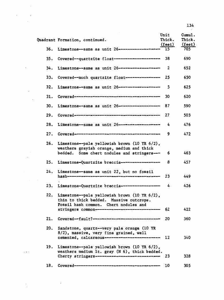
134
Unit Cumul.Quadrant Formation, continued. Thick. Thick.
(feet) (feet)36. Limestone same as unit 26 15 705
35. Covered quartzite float 38 690
34. Limestone same as unit 26 2 652
33. Covered much quartzite float 25 650
32. Limestone same as unit 26 5 625
31. Covered 30 620
30. Limestone same as unit 26 87 590
29. Covered 27 503
28. Limestone same as unit 26 4 476
27. Covered 9 472
26. Limestone pale yellowish brown (10 YR 6/2), weathers grayish orange, medium and thick bedded. Some chert nodules and stringers 6 463
25. Limes tone-Quart zite breccia 8 457
24. Limestone same as unit 22, but no fossilhash 23 449
23. Limes tone-Quart zite breccia 4 426
22. Limestone pale yellowish brown (10 YR 6/2), thin to thick bedded. Massive outcrops. Fossil hash common. Chert nodules and stringers common 62 422
21. Covered fault? 20 360
20. Sandstone, quartz very pale orange (10 YR 8/2), massive, very fine grained, well cemented, calcareous 12 340
19. Limestone pale yellowish brown (10 YR 6/2), weathers medium It. gray (N 6), thick bedded. Cherty stringers 23 328
18. Covered 10 305

135
Quadrant Formation, continued.UnitThick.(feet)
17. Limestone pale yellowish brown (10 YR 6/2), weathers grayish orange (10 YR 7/4), medium and thick bedded. Chert stringers locally 4
16. Covered - 19
15. Sandstone, quartz, calcareous moderate orange pink (5 YR 8/4), fine grained. Breccia of tectonic origin- - - 5
14. Limestone same as unit 11, with chertpresent locally - - - 3
13. Covered quartzite float 4
12. Limestone dark yellowish brown (10 YR 4/2), weathers It. gray (N 7), thick bedded, finely crystalline 32
11. Quartzite and quartzitic limestone limestone is like that of unit 8. Quartzite moderate orange pink (5 YR 8/4), thin bedded, very fine grained. Brecciated. Quartzite stands in relief in quartzitic limestone 32
10. Limestone same as unit 8, lithilogically 12
8. Limestone very pale orange (10 YR 8/2),massive. Brecciated. Vuggy - 15
/. hovered """" *"*"* """""* » » " « « ^o
6. Limestone dark yellowish brown (10 YR 4/2), weathers It. gray (N 7), medium and thick bedded. Locally contains chert, most prominent on bedding surfaces, is grayish brown (5 YR 3/2) 7
5. Covered float much like that of unit 2 60
4. Limestone same as unit 2 - 20
3. Covered 30
2. Limestone dark yellowish brown (10 YR 4/2), weathers It. gray (N 7), thin and medium bedded, finely crystalline. Poor exposure 39
Cumul. Thick. (feet)
295
291
272
267
264
259
259
227
215
205
190
162
155
95
75
45

136
Unit Cumul.Quadrant Formation, continued. Thick. Thick.
(feet) (feet)1. Covered 6 6
Kibbey Fm not measured.
SECTION B
Section B occurs on the west side of the Ruby Range, SiNE^NWi sec. 7, T. 6 S., R. 5 W. In this 1/16 part of sec. 7 the measured section is north of the northernmost fork of Big Dry Creek and immediately above (west of) the Mission Canyon Formation. It is nearly vertical and was measured at an altitude of about 6700 feet.
Fault. Unit Cumul.Thick. Thick.
KIBBEY FORMATION: (feet) (feet) 24. Sandstone, Mudstone, and Dolomite as
below. Unit is in fault contact with Lodgepole Fm.- 39 138.5
23. Sandstone, quartz same as unit 12 2.5 99.5
22. Mudstone, dolomitic same as unit 10 4.5 97
21. Sandstone, quartz same as unit 12 .5 92.5
20. Sandstone, quartz same as unit 17 3 92
19. Dolomite, silty mottled. Like unit 7 .5 89
18. Limestone, dolomitic, sandy same as unit 9- 5 88.5
17. Sandstone, quartz pale reddish brown (10 R5/4), medium bedded. Fine to medium grained 2 83.5
16. Limestone, dolomitic sandy same as unit 9 2.5 81.5
15. Sandstone, quartz--same as unit 12 1 79
14. Covered ' 7 78
13. Sandstone, quartz pale reddish brown (10 R5/4), thin bedded, fine to medium grained 2.5 71
12. Sandstone, quartz moderate orange pink (10 R 5/4), medium bedded, medium grained. Con tains pink chert grains : 2 68.5
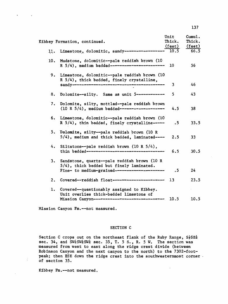
137
Unit Cumul.Kibbey Formation, continued. Thick. Thick.
(feet) (feet)11. Limestone, dolomitic, sandy 10.5 66.5
10. Mudstone, dolomitic pale reddish brown (10R 5/4), medium bedded 10 56
9. Limestone, dolomitic pale reddish brown (10 R 5/4), thick bedded, finely crystalline,
8. Dolomite silty. Same as unit 5 5 43
7. Dolomite, silty, mottled pale reddish brown(10 R 5/4), medium bedded 4.5 38
6. Limestone, dolomitic--pale reddish brown (10R 5/4), thin bedded, finely crystalline .5 33.5
5. Dolomite, silty pale reddish brown (10 R5/4), medium and thick bedded, laminated 2.5 33
4. Siltstone pale reddish brown (10 R 5/4),thin bedded 6.5 30.5
3. Sandstone, quartz pale reddish brown (10 R 5/4), thick bedded but finely laminated. Fine- to medium-grained - .5 24
2. Covered reddish float 13 23.5
1. Covered questionably assigned to Kibbey. Unit overlies thick-bedded limestone of Mission Canyon 10.5 10.5
Mission Canyon Fm. not measured.
SECTION C
Section C crops out on the northeast flank of the Ruby Range, StSEi sec. 34, and SWiSWiSWi sec. 35, T. 5 S., R. 5 W. The section was measured from west to east along the ridge crest divide (between Robinson Canyon and the next canyon to the north) to the 7302-foot- peak; then ESE down the ridge crest into the southwesternmost corner of section 35.
Kibbey Fm. not measured.

138/
Unit Cumul. Thick. Thick.
MISSION CANYON FORMATION: (feet) (feet) 51. Limestone same as unit 43. Contact with
Kibbey Formation 30 1370
50. Covered 30 1340
49. Limestone same as unit 43 40 1310
48. Covered 120 1270
47. Limestone same as unit 43 130 1150
46. Covered 50 1020
45. Limestone same as unit 43 30 970
44. Covered 50 940
43. Limestone dark yellowish brown (10 YR 4/2), thick bedded (massive), fine grained. Chert uncommon 45 890
42. Solution breccia, evaporitic matrix isgrayish orange (10 YR 7/4). Limestone blocksto 3 ft. diameter, all angular. Matrix issilty and calcareous 15 845
41. Covered 50 830
40. Limestone dark yellowish brown (10 YR 4/2), thick bedded (massive), fine grained. Some chert present 80 780
39. Covered 10 700
38. Limestone, slightly dolomitic dark yellowish brown (10 YR 4/2), thick bedded, fine grained. Chert stringers present 5 680
37. Limestone, dolomitic pale yellowish brown (10 YR 6/2), thin and medium bedded, fine grained 30 675
36. Covered 95 497
35. Limestone same as unit 33 58 555
34. Limestone same as unit 32 8 497
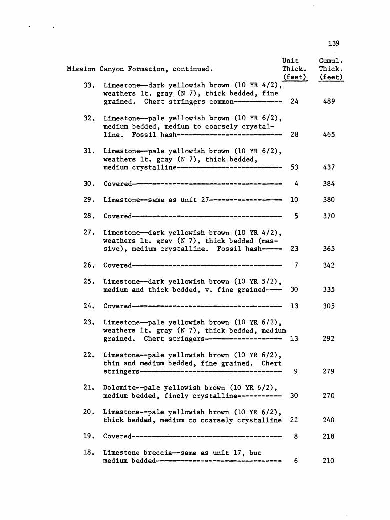
139
Unit Cumul.Mission Canyon Formation, continued. Thick. Thick.
(feet) (feet)33. Limestone dark yellowish brown (10 YR 4/2),
weathers It. gray (N 7), thick bedded, fine grained. Chert stringers common 24 489
32. Limestone pale yellowish brown (10 YR 6/2), medium bedded, medium to coarsely crystal line. Fossil hash 28 465
31. Limestone pale yellowish brown (10 YR 6/2), weathers It. gray (N 7), thick bedded, medium crystalline 53 437
30. Covered 4 384
29. Limestone same as unit 27 10 380
28. Covered 5 370
27. Limestone dark yellowish brown (10 YR 4/2), weathers It. gray (N 7), thick bedded (mas sive), medium crystalline. Fossil hash 23 365
26. Covered 7 342
25. Limestone dark yellowish brown (10 YR 5/2),medium and thick bedded, v. fine grained 30 335
24. Covered 13 305
23. Limestone pale yellowish brown (10 YR 6/2), weathers It. gray (N 7), thick bedded, medium grained. Chert stringers 13 292
22. Limestone pale yellowish brown (10 YR 6/2), thin and medium bedded, fine grained. Chert stringers 9 279
21. Dolomite pale yellowish brown (10 YR 6/2),medium bedded, finely crystalline 30 270
20. Limestone pale yellowish brown (10 YR 6/2),thick bedded, medium to coarsely crystalline 22 240
19. Covered 8 218
18. Limestone breccia same as unit 17, butmedium bedded 6 210
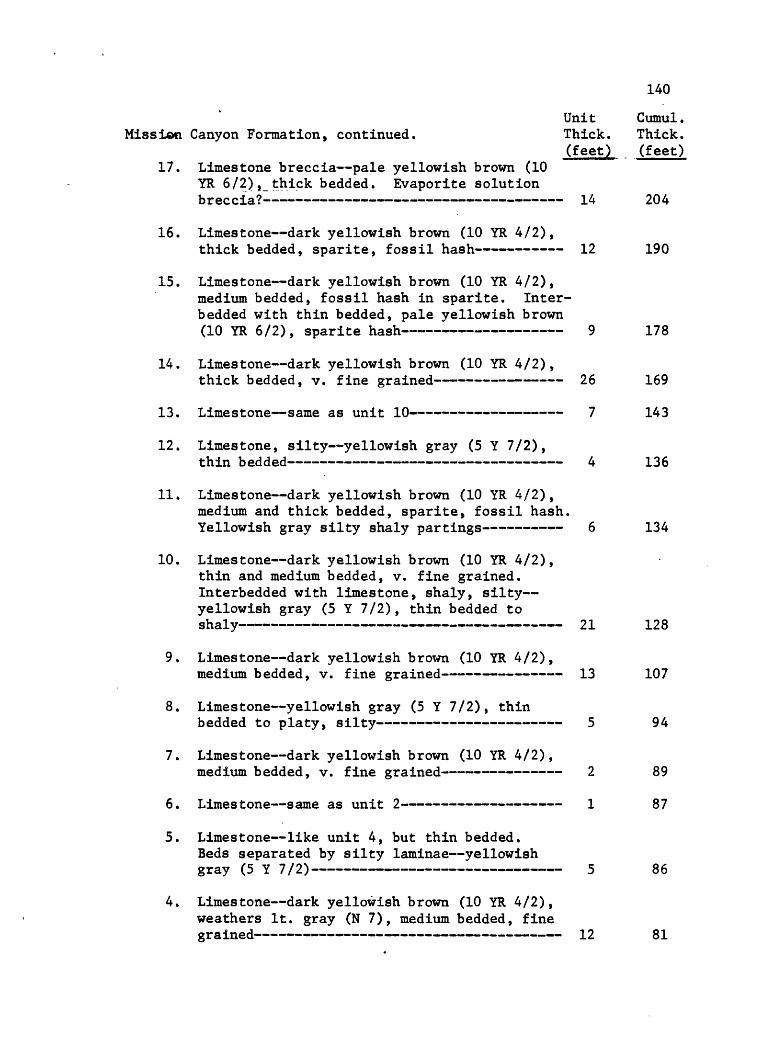
140
Unit Cumul.Mission Canyon Formation, continued. Thick. Thick.
(feet) (feet)17. Limestone breccia pale yellowish brown (10
YR 6/2), thick bedded. Evaporite solution breccia?-- - 14 204
16. Limestone dark yellowish brown (10 YR 4/2),thick bedded, sparite, fossil hash 12 190
15. Limestone dark yellowish brown (10 YR 4/2), medium bedded, fossil hash in sparite. Inter- bedded with thin bedded, pale yellowish brown (10 YR 6/2), sparite hash 9 178
14. Limestone dark yellowish brown (10 YR 4/2),thick bedded, v. fine grained 26 169
13. Limestone same as unit 10 7 143
12. Limestone, silty yellowish gray (5 Y 7/2),thin bedded 4 136
11. Limestone dark yellowish brown (10 YR 4/2), medium and thick bedded, sparite, fossil hash. Yellowish gray silty shaly partings 6 134
10. Limestone dark yellowish brown (10 YR 4/2), thin and medium bedded, v. fine grained. Interbedded with limestone, shaly, silty yellowish gray (5 Y 7/2) , thin bedded to snsJ.y " " " 2.1
9. Limestone dark yellowish brown (10 YR 4/2),medium bedded, v. fine grained 13 107
8. Limestone yellowish gray (5 Y 7/2), thinbedded to platy, silty 5 94
7. Limestone dark yellowish brown (10 YR 4/2),medium bedded, v. fine grained 2 89
6. Limestone same as unit 2 1 87
5. Limestone like unit 4, but thin bedded. Beds separated by silty laminae yellowish gray (5 Y 7/2) 5 86
4. Limestone dark yellowish brown (10 YR 4/2), weathers It. gray (N 7), medium bedded, fine grained 12 81

141
Unit Cumul .Mission Canyon Formation, continued. Thick. Thick.
(feet) (feet) 3. Limestone yellowish gray. (5 Y 7/2), thin
bedded, platy., fine grained, silty ; 4 69
2. Limestone dark yellowish brown (10 YR 4/2), thick bedded, crinoidal debris, weathers It. gray (N 7) 56 65
1. Limestone dark yellowish brown (10 YR 4/2), weathers It. gray (N 7), medium and thick bedded. Fossil hash mainly crinoid debris. Parting laminae, silty, shaly, yellowish gray (5 Y 7/2). Contact with Lodgepole is conform-
- _____________ ____ 9 9
LODGEPOLE FORMATION:23. Limestone dark yellowish brown (10 YR 4/2),
thick bedded, fine grained, dense. Forms steep slope. Contact with cliff-forming Mission Canyon Fm. is conformable 34 594
22. Limestone same as unit 21, interbedded with limestone, shaly grayish orange (10g YR 7/4). Slope-forming unit 25 560
21. Limestone dark yellowish brown (10 YR 4/2), thin bedded, fine grained. Top of prominent
20. Limestone dark yellowish brown (10 YR 4/2), weathers It. gray (N 7), medium bedded, v. fine grained, dense. Interbedded with zones to 3 inches thick of laminae, silty grayish orange (10 YR 7/4) 33 498
19. Limestone dark yellowish brown (10 YR 4/2), weathers dark yellowish orange (10 YR 6/6) due to silty calcareous laminae. Thin bedded to rubbly 3 465
18. Limestone dark yellowish brown (10 YR 4/2), weathers It. gray (N 7), thick bedded, v. fine grained. Interbedded with zones to 3 inches thick of laminae, silty, calcareous pale red (5 R 6/2) to very pale orange (10 YR 8/2), containing much fossil debris 61 462

142
Unit Cumul.Lodgepole Formation, continued. Thick. Thick.
(feet) (feet)17. Limestone dark yellowish brown (10 YR 4/2),
medium bedded, v. fine grained. Interbedded with zones to 3 inches thick of limestone, argillaceous, silty, shaly pale yellowish brown (10 YR 6/2) to grayish orange (10 YR 7/4) - 47 401
16. Limestone dark yellowish brown (10 YR 4/2), weathers It. gray (N 7), thick bedded, v. fine grained. Contains chert lenses and nodules. Between beds are laminae, silty, calcareous, form zones to 3 inches thick grayish orange (10 YR 7/4) 14 354
15. Limestone pale yellowish brown (10 YR 6/2), weathers grayish orange (10 YR 7/4), thin bedded to shaly. Locally argillaceous 6 340
14. Limestone pale yellowish brown (10 YR 6/2), medium and thick bedded, v. fine grained, dense. Forms base of prominent ledge. Marks abrupt appearance of abundantly fossiliferous strata 11 334
13. Covered 52 323
12. Limestone pale yellowish brown (10 YR 6/2), weathers It. bluish gray (5 B 7/1), medium bedded, v. fine grained, dense 2 271
11. Covered 16 269
10. Limestone dark yellowish brown (10 YR 4/2),medium bedded, v. fine grained 8 253
9. Limestone dark yellowish brown (10 YR 4/2), weathers pale yellowish brown (10 YR 6/2) to grayish orange (10 YR 7/4), thin bedded to shaly. Forms book-like beds 100 245
8. Limestone dark yellowish brown (10 YR 4/2), medium bedded, interbedded with limestone, argillaceous, shaly pale yellowish brown (10YR6/2), thin bedded 12 145
7. Limestone, argillaceous, shaly dark yellow ish brown (10 YR 4/2), weathers pale yellow ish brown (10 YR 6/2), to grayish orange (10 YR 7/4), fine grained 13 133

143
Unit Cumul.Lodgepole Formation, continued. Thick. Thick.
(feet) (feet)6. Limestone dark yellowish brown (10 YR 4/2),
thin bedded, fine grained, interlaminated with limestone, argillaceous, shaly yellow ish gray (5 Y 7/2). Worm-like trails local ly present on bedding, surf aces - 17 120
5. Limestone dark yellowish brown (10 YR 4/2),thin bedded, v. fine grained - 8 103
4. Limestone, argillaceous dark yellowish brown (10 YR 4/2), thin bedded to paper- thin. Beds parted by limestone, argilla ceous, shaly yellpwish gray (5 Y 7/2) 14 95
3. Limestone, argillaceous, shaly dark yellow ish brown (10 YR 4/2), paper-thin, finely laminated. "Wavy" beds 4 81
2. Limestone, argillaceous, shaly dark yellow ish brown (10 YR 4/2), thin bedded to paper-
1. Covered 60 60
Three Forks Fm. covered.
SECTION D
Section D occurs in the SEiSWiNWi sec. 28, T. 5 S., R. 5 W. It is exposed on a slight ridge between two draws, all trending NE-SW, between 7000 and 7200 feet in altitude.
Lodgepole Fm. not measured.Unit Cumul.
THREE FORKS FORMATION, Thick. Thick. Sappington Member: (feet:) (feet)
20. Covered contact with Lodgepole concealedLodgepole exposed at 150 foot level 9 150
19. Siltstone same as unit 18, but mediumbedded 4 141
18. Siltstone, calcareous grayish orange (10 YR7/4), thin bedded 3 137
Trident Member:17. Covered 9 134
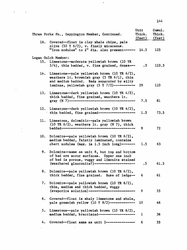
144
Unit Cumul .Three Forks Fm. , Sappington Member, Continued. Thick. Thick.
(feet) (feet)16. Covered float is clay shale chips, pale
olive (10 Y 6/2), v. finely micaceous. "Iron nodules" to i" dia. also present 14.5 125
Logan Gulch Member:15. Limestone moderate yellowish brown (10 YR
5/4), thin bedded, v. fine grained, dense .5 110.5
14. Limestone pale yellowish brown (10 YR 6/2), weathers It. brownish gray (5 YR 6/1), thin and medium bedded. Beds separated by silty laminae, yellowish gray (5 Y 7/2) 29 110
13. Limestone dark yellowish brown (10 YR 4/2), thick bedded, fine grained, weathers It. gray \M «/~ ~ "*** " "' " " « - « « ». » «»« /.j tsi
12. Limestone dark yellowish brown (10 YR 4/2),thin bedded, fine grained 1.5 73.5
11. Limestone, dolomitic pale yellowish brown (10 YR 6/2), weathers It. gray (N 7), thick
"""""""""""""""""""~*"i""""""""<~~ """""""""<"""""" *""""""<~""""<~""" " 12.
10. Dolomite pale yellowish brown (10 YR 6/2), medium bedded, faintly laminated, contains chert nodules (max. is 1.5 inch long) 1.5 63
9. Dolomite- same as unit 8, but top and bottom of bed are scour surfaces. Upper one inch of bed is porous, vuggy and limonite stained (weathered glauconite?) .5 61.5
8. Dolomite pale yellowish brown (10 YR 6/2),thick bedded, fine grained. Base of ledge 6 61
7. Dolomite pale yellowish brown (10 YR 6/2), thin, medium and thick bedded, vuggy (evaporite solution) 9 55
6. Covered float is shaly limestone and shale,pale greenish yellow (10 Y 8/2) 10 46
5. Limestone pale yellowish brown (10 YR 6/2),medium bedded, brecciated 1 36
4. Covered float same as unit 2 6 35

145
Unit Cumul.Three Forks Formation, Lower Part, continued. Thick. Thick.
(feet) (feet) 3. Limestone yellowish gray_ (5 Y 7/2), thick
bedded, finely brecciated 4 29
2. Covered float is clay shale chips, grayishyellow green (5 GY 7/2) - " 21 25
1. Dolomite pale yellowish orange (10 YR 8/6), thin and medium bedded, brecciated. Contact with Jefferson apparently conformable 4 4
Jefferson Fm. not measured.
SECTION E
Section E is on the east side of the Ruby Range, SWiSWi sec. 34, T. 5 S., R. 5 W. It occurs north of the northernmost fork of the creek in Robinson Canyon, and at the base of the cliff in the western 1/3 of the above noted 1/16 part of sec. 34. The altitude is about 7650 feet.
Pilgrim Fm.- not measured.Unit Cumul. Thick. Thick.
PARK SHALE: (feet) (feet) 7. Mudstone grayish orange (10 YR 7/4), thin
bedded, silty. Contact with Pilgrim is sharp no shale in dolomite of Pilgrim .5 196.5
6. Shale grayish olive (10 Y 4/2), finelymicaceous, fissile chips 28.5 196
5. Dolomite grayish green (5 GY 5/2), weathersIt. brown (5 YR 6/4), thin bedded .5 167.5
4. Shale and Dolomite as in unit 1, but dolo mite is nodular 6.5 167
3. Dolomite same as in unit 1, but mediumb edded .5 160.5
2. Shale grayish olive (10 Y 4/2), finelymicaceous, fissile chips. Interbedded withdolomite grayish green (10 GY 5/2), weathersIt. brown (5 YR 6/4), thin bedded 10 160
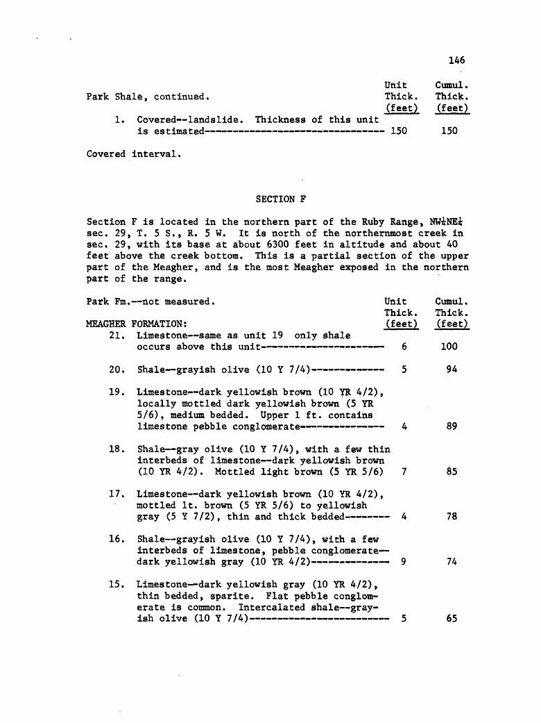
146
Park Shale, continued.
1. Covered landslide, is estimated
Thickness of this unit
UnitThick.(feet)
- 150
Cumul. Thick. (feet)
150
Covered interval.
SECTION F
Section F is located in the northern part of the Ruby Range, NWiNEi sec. 29, T. 5 S., R. 5 W. It is north of the northernmost creek in sec. 29, with its base at about 6300 feet in altitude and about 40 feet above the creek bottom. This is a partial section of the upper part of the Meagher, and is the most Meagher exposed in the northern part of the range.
UnitThick.(feet)
Park Fm. not measured.
MEAGHER FORMATION:21. Limestone same as unit 19 only shale
occurs above this unit -
20. Shale grayish olive (10 Y 7/4) -
19. Limestone dark yellowish brown (10 YR 4/2), locally mottled dark yellowish brown (5 YR 5/6), medium bedded. Upper 1 ft. contains limestone pebble conglomerate 4
18. Shale gray olive (10 Y 7/4), with a few thin interbeds of limestone dark yellowish brown (10 YR 4/2). Mottled light brown (5 YR 5/6) 7
17. Limestone dark yellowish brown (10 YR 4/2), mottled It. brown (5 YR 5/6) to yellowish gray (5 Y 7/2), thin and thick bedded 4
16. Shale grayish olive (10 Y 7/4), with a few interbeds of limestone, pebble conglomerate dark yellowish gray (10 YR 4/2) 9
15. Limestone dark yellowish gray (10 YR 4/2), thin bedded, sparite. Flat pebble conglom erate is common. Intercalated shale gray ish olive (10 Y 7/4) 5
Cumul. Thick. (feet)
100
94
89
85
78
74
65

147
Unit Cumul .Meagher Formation, continued. Thick. Thick.
(feet) (feet)14. Limestone dark yellowish brown (10 YR 4/2),
weathers pale yellowish brown (10 YR 6/2), locally mottled grayish orange (10 YR 7/4), thin bedded. Locally nodular. Parting laminae shaly, dolomitic, or silty grayish olive (10 Y 4/2) 6 60
13. Limestone pale yellowish brown (10 YR 6/2), locally mottled yellowish gray (5 Y 7/2) , medium and thick bedded. Finely crystalline 19 54
12. Shale grayish olive (10 Y 4/2), finelymicaceous 3 35
11. Limestone pebble conglomerate dark yellowish brown (10 YR 4/2), thick bedded 3 32
10. Limestone pale yellowish brown (10 YR 6/2), mottled grayish orange (10 YR 7/4) , thin
-. -. . -.-.-.-. . . -.-. 9 9Q - .--mmimm,mmmmmmimmimm:mmmmmmmmmmmmmm,mmmmm mm ^ f^-j
9. Shale grayish olive (10 Y 4/2), finelymicaceous 1 27
8. Limestone dark yellowish brown (10 YR 4/2), weathers pale yellowish brown (10 YR 6/2) to It. brown (5 YR 5/6). Thick bedded. Sparite 4 26
7. Shale grayish olive (10 Y 4/2), finely micaceous. Interbedded sparingly is lime stone dark yellowish brown (10 YR 4/2) , mottled grayish orange (10 YR 7/4), thin bedded. Locally silty and glauconitic. Sparite and micrite 4 22
6. Limestone same as unit 5, but no pebbles orglauconite 6 18
5. Limestone dark yellowish brown (10 YR 4/2), weathers pale yellowish brown (10 YR 6/2), mottled grayish orange (10 YR 7/4), medium bedded. Contains glauconite and limestone pebble conglomerate. Mottles are slightly dolomitic and seem to parallel bedding. Parting laminae greenish gray (5 GY 6/1), finely micaceous 2 12
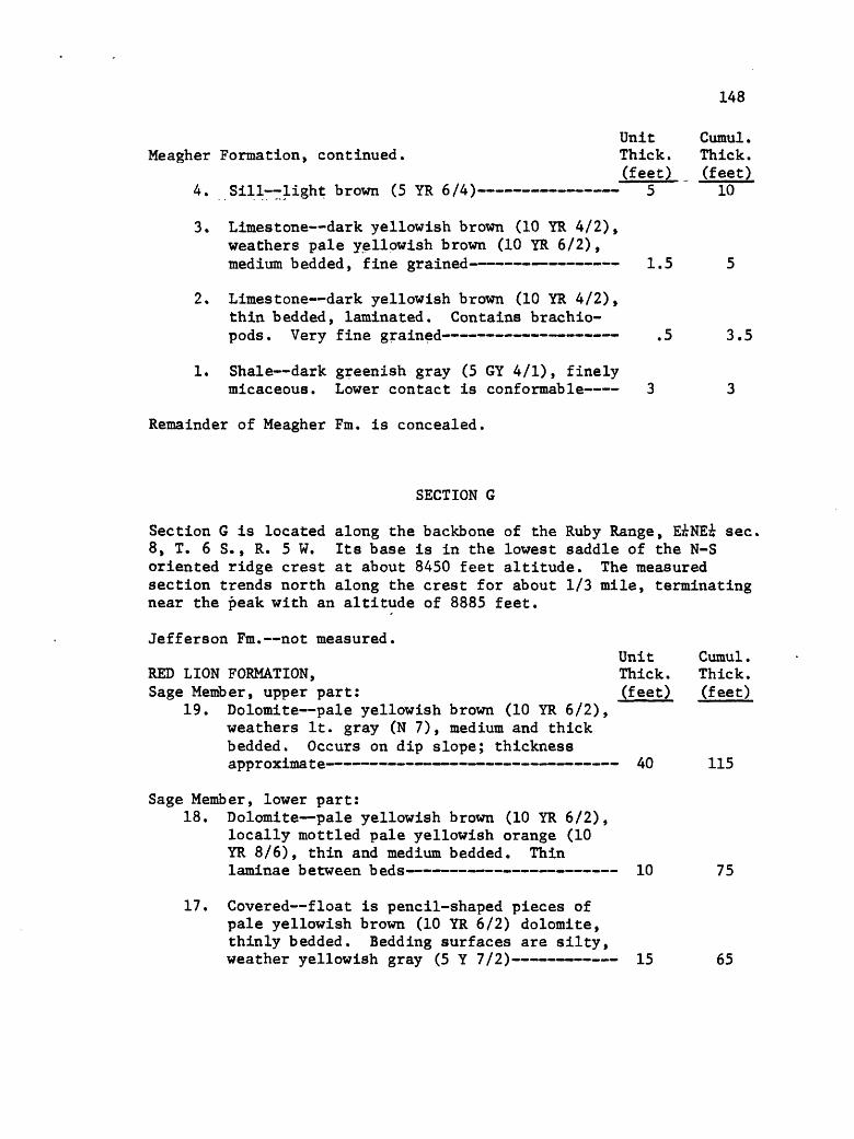
148
Unit Cumul.Meagher Formation, continued. Thick. Thick.
(feet) (feet)4. Sill light brown (5 YR 6/4) 5 " 10
3. Limestone dark yellowish brown (10 YR 4/2), weathers pale yellowish brown (10 YR 6/2), medium bedded, fine grained 1.5 5
2. Limestone dark yellowish brown (10 YR 4/2), thin bedded, laminated. Contains brachio- pods. Very fine grained .5 3.5
1. Shale dark greenish gray (5 GY 4/1), finelymicaceous. Lower contact is conformable 3 3
Remainder of Meagher Fm. is concealed.
SECTION G
Section G is located along the backbone of the Ruby Range, EiNEi sec, 8, T. 6 S., R. 5 W. Its base is in the lowest saddle of the N-S oriented ridge crest at about 8450 feet altitude. The measured section trends north along the crest for about 1/3 mile, terminating near the peak with an altitude of 8885 feet.
Jefferson Fm. not measured.Unit Cumul.
RED LION FORMATION, Thick. Thick. Sage Member, upper part: (feet) (feet)
19. Dolomite pale yellowish brown (10 YR 6/2), weathers It. gray (N 7), medium and thick bedded. Occurs on dip slope; thickness approximate 40 115
Sage Member, lower part:18. Dolomite pale yellowish brown (10 YR 6/2),
locally mottled pale yellowish orange (10 YR 8/6), thin and medium bedded. Thin laminae between beds 10 75
17. Covered float is pencil-shaped pieces of pale yellowish brown (10 YR 6/2) dolomite, thinly bedded. Bedding surfaces are silty, weather yellowish gray (5 Y 7/2) 15 65
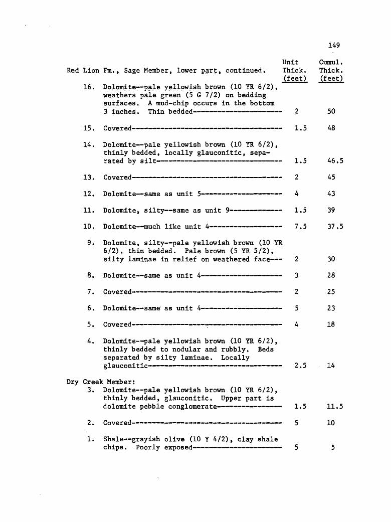
149
Unit Cumul.Red Lion Fm., Sage Member, lower part, continued. Thick. Thick.
(feet) (feet)16. Dolomite pale yellowish brown (10 YR 6/2),
weathers pale green (5 G 7/2) on bedding surfaces. A mud-chip occurs in the bottom 3 inches. Thin bedded 2 50
15. Covered 1.5 48
14. Dolomite pale yellowish brown (10 YR 6/2), thinly bedded, locally glauconitic, sepa rated by silt 1.5 46.5
13. Covered 2 45
12. Dolomite same as unit 5 4 43
11. Dolomite, silty same as unit 9 1.5 39
10. Dolomite much like unit 4 7.5 37.5
9. Dolomite, silty pale yellowish brown (10 YR 6/2), thin bedded. Pale brown (5 YR 5/2), silty laminae in relief on weathered face 2 30
8. Dolomite same as unit 4 3 28
/. LtOvereQ""*"^""""""""^^""*"""""""""""""""""' " """""" "^"" 1 ""- ^""^ ""* """ ^ ^D
6. Dolomite same as unit 4 5 23
5. Covered 4 18
4. Dolomite pale yellowish brown (10 YR 6/2), thinly bedded to nodular and rubbly. Beds separated by silty laminae. Locally glauconitic 2.5 14
Dry Creek Member:3. Dolomite pale yellowish brown (10 YR 6/2),
thinly bedded, glauconitic. Upper part is dolomite pebble conglomerate 1.5 11.5
2. Covered 5 10
1. Shale grayish olive (10 Y 4/2), clay shalechips. Poorly exposed 5 5
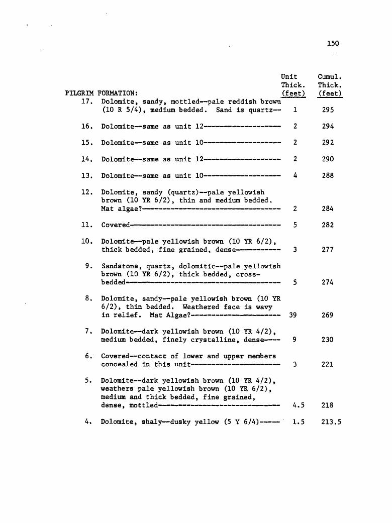
150
Unit Cumul. Thick. Thick.
PILGRIM FORMATION: (feet) (feet) 17. Dolomite, sandy, mottled pale reddish brown
(10 R 5/4), medium bedded. Sand is quartz 1 295
16. Dolomite same as unit 12 2 294
15. Dolomite same as unit 10 2 292
14. Dolomite same as unit 12 2 290
13. Dolomite same as unit 10 4 288
12. Dolomite, sandy (quartz) pale yellowish brown (10 YR 6/2), thin and medium bedded. Mat algae? 2 284
11. Covered 5 282
10. Dolomite pale yellowish brown (10 YR 6/2),thick bedded, fine grained, dense 3 277
9. Sandstone, quartz, dolomitic pale yellowish brown (10 YR 6/2), thick bedded, cross- bedded 5 274
8. Dolomite, sandy pale yellowish brown (10 YR 6/2), thin bedded. Weathered face is wavy in relief. Mat Algae? 39 269
7. Dolomite dark yellowish brown (10 YR 4/2),medium bedded, finely crystalline, dense 9 230
6. Covered contact of lower and upper membersconcealed in this unit 3 221
5. Dolomite dark yellowish brown (10 YR 4/2), weathers pale yellowish brown (10 YR 6/2), medium and thick bedded, fine grained, dense, mottled 4.5 218
4. Dolomite, shaly dusky yellow (5 Y 6/4) 1.5 213.5

151
Unit Cumul. Thick. Thick.
Lower part of Formation: (feet) (feet) 3. Dolomite- pale red (5 R 6/2), weathers pale
yellowish brown (10 YR (6/2), thin bedded, weathered faces are silty to feel 2 .212
2. Dolomite pale yellowish brown (10 YR 6/2),thick bedded, mottled 5 210
1. Covered talus slope contact with Park isconcealed 205 205
PARK FORMATION:1. Covered float is mostly shale pale olive
(10 Y 6/2), finely micaceous, fissile. Other float includes fossil fragmental lime stone pale yellowish brown (10 YR 6/2), thin bedded. Also dolomite with oncolites to 1 cm. diameter 150 150
MEAGHER FORMATION:35. Limestone dark yellowish brown (10 YR 4/2),
mottled grayish orange (10 YR 7/4), weathers It. gray (N 7), thin bedded. Contact with Park at 565 34 565
34. Limestone dark yellowish brown (10 YR 4/2), weathers pale yellowish brown (10 YR 6/2), mottled yellowish gray (5 Y 7/2) to pale red (5 R 6/2), medium bedded 20 531
33. Limestone same as unit 32, but thin bedded- 6 511
32. Limestone dark yellowish brown (10 YR 4/2), weathers medium gray (N 7), mottled yellowish gray (5 Y 7/2), medium and thick bedded 35 505
31. Limestone, dolomitic dark yellowish brown (10 YR 4/2), medium bedded, fine grained, suggary, locally mottled, oolitic 98 470
30. Limestone dark yellowish brown (10 YR 4/2), weathers medium gray (N 7), thick bedded. Mottles not common. White twig-like bodies present. Top of unit is top of cliff 31 372
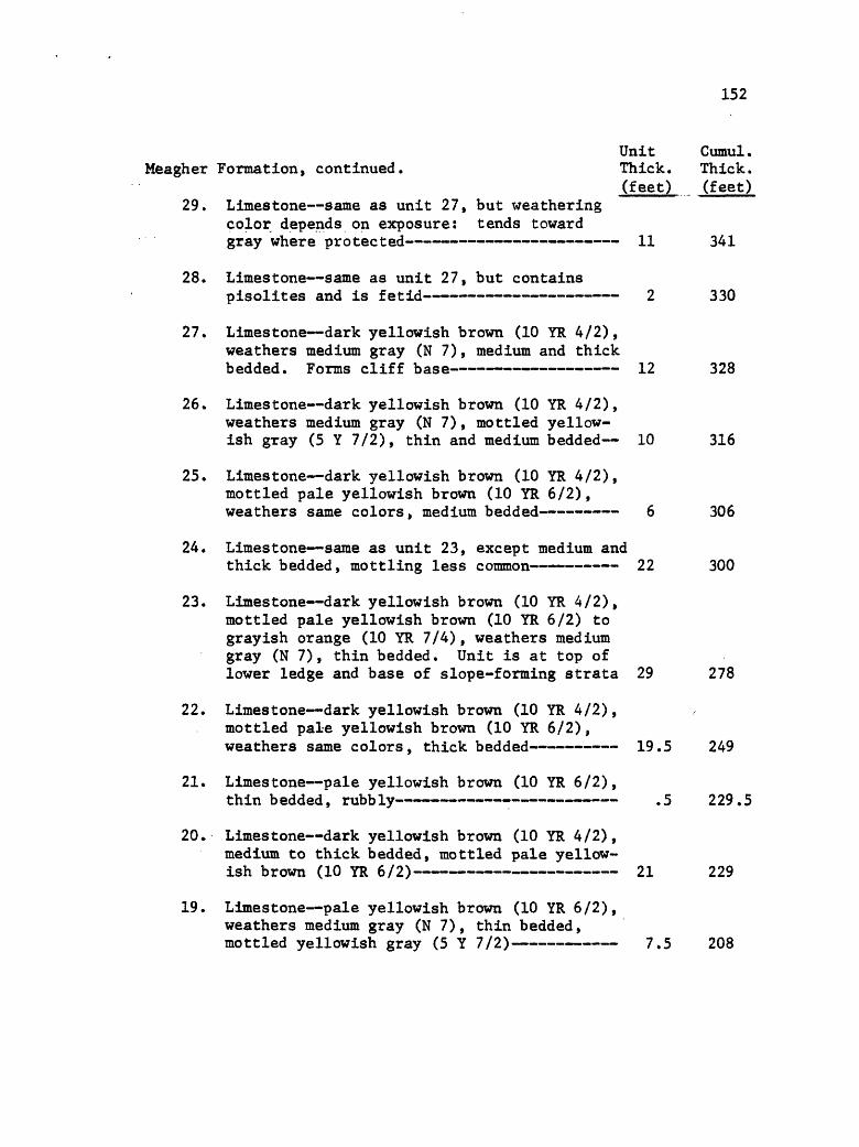
152
Unit Cumul.Meagher Formation, continued. Thick. Thick.
(feet) (feet)29. Limestone same as unit 27, but weathering
color depends on exposure: tends toward gray where protected 11 341
28. Limestone same as unit 27, but containspisolites and is fetid 2 330
27. Limestone dark yellowish brown (10 YR 4/2), weathers medium gray (N 7), medium and thick bedded. Forms cliff base 12 328
26. Limestone dark yellowish brown (10 YR 4/2), weathers medium gray (N 7), mottled yellow ish gray (5 Y 7/2), thin and medium bedded 10 316
25. Limestone dark yellowish brown (10 YR 4/2), mottled pale yellowish brown (10 YR 6/2), weathers same colors, medium bedded 6 306
24. Limestone same as unit 23, except medium andthick bedded, mottling less common 22 300
23. Limestone dark yellowish brown (10 YR 4/2), mottled pale yellowish brown (10 YR 6/2) to grayish orange (10 YR 7/4), weathers medium gray (N 7), thin bedded. Unit is at top of lower ledge and base of slope-forming strata 29 278
22. Limestone dark yellowish brown (10 YR 4/2), mottled pale yellowish brown (10 YR 6/2), weathers same colors, thick bedded 19.5 249
21. Limestone pale yellowish brown (10 YR 6/2),thin bedded, rubbly .5 229.5
20. Limestone dark yellowish brown (10 YR 4/2), medium to thick bedded, mottled pale yellow ish brown (10 YR 6/2) 21 229
19. Limestone pale yellowish brown (10 YR 6/2), weathers medium gray (N 7), thin bedded, mottled yellowish gray (5 Y 7/2) 7.5 208

153
Unit Cumul.Meagher Formation, continued. Thick. Thick.
(faet) (feet)18. Laminae zone greenish yellow (10 Y 8/2),
with some shaly limestone "lenses" i inch x li inch, medium gray (N 7) .5 200.5
17. Limestone same as unit 14 7 200
16. Limestone medium gray (N 7), medium bedded,mottling less common (i.e., not continuous)- 4 193
15. Limestone like unit 14, but subordinate to the mottles, which are really laminate with limestone contained in between: thus lime stone tends to be nodular 3 189
14. Limestone medium gray (N 7), thin bedded, fine grained, mottled yellowish gray (5 Y 7/2). Mottles are parallel to bedding 11 186
13. Limestone medium gray (N 7), thin bedded, mottled pale red (5 R 6/2). Mottles are silty and calcareous 1 175
12. Limestone same as unit 10 19 174
J. J. . oovered "" «.«.«.«.«. __» __.._.._.._ _.._ ^
10. Limestone medium gray (N 7), mottled yellowish gray (5 Y 7/2), thin bedded. Mottles are silty, calcareous; most are along irregular bedding surface- 3 151
9. Covered 25 148
8. Dolomite same as unit 3, except it is
7. Covered 2 122
6. Dolomite same as unit 3 4 120
j % Covered - ^ llo
4. Dolomite dark yellowish brown (10 YR 4/2),medium and thick bedded, fine grained, dense- 2 112

154
Unit Cumul.Meagher Formation, continued Thick. Thick.
(feet) (feet)2. Dolomite, calcareous pale yellowish brown
(10 YR 6/2), medium to thick bedded, fine grained, dense, mottled 20 105
1. Covered contact with Wolsey concealed 85 85
WOLSEY FORMATION:1. Covered float is shale, grayish olive (10
Y 4/2) 58 58
FLATHEAD FORMATION:5. Sandstone, quartz grayish red (5 YR 4/2),
thin bedded, fine grained to v, fine grain ed. Grains are round, small limonite spots. Some intercalated shale grayish olive (10 Y 4/2), micaceous 6 47
4. Sandstone, quartz It. brown (5 YR 6/4), thin and medium bedded, medium grained. Grains round. Limonite and hematite spots to i inch diameter burrowing? 4 41
3. Covered- 7 37
2. Sandstone, quartz It. brown (5 YR 6/4),medium bedded, fine to coarse grained.Grains are round, well cemented 5 30
1. Covered contact concealed 25 25
Precambrian Metamorphic Rock
SECTION H
Section H occurs in the McHessor Creek drainage, W^-SW^SEi sec. 18, T, 6 S., R. 5 Wo The measured section is north of the McHessor Creek tributary in this i sec,, its base being about 50 feet up the hill (directly north) from where the 6880-foot contour intersects the tributary stream.
Lodgepole Fm. not measured.

155
Unit Cumul.JEFFERSON FORMATION, Thick Thick Birdbear Member: (feet) (feet)
56. Dolomite pale yellowish brown (10 YR 6/2), thick bedded (massive), fine grained, dense. Brecciated and rubbly. Faintly fetid local ly. Forms prominent ledge. Beds in upper 10 ft. are mottled grayish orange (10 YR 7/4) coloring occurs between clasts 51 268
55. Dolomite pale yellowish brown (10 YR 6/2),thin bedded, v. fine grained, dense 4 217
54. Dolomite same as unit 50 1 213
53. Covered contact of lower and Birdbearmembers concealed in this unit 12 212
Lower Member:52. Dolomite same as unit 50 2.5 200
51. Dolomite, silty? yellowish gray (5 Y 7/2),thin bedded, rubbly .5 197.5
50. Dolomite, si. calcareous pale yellowishbrown (10 YR 6/2), medium and thick bedded,fine grained, evaporite breccia 4 197
49. Dolomite pale yellowish brown (10 YR 6/2),medium bedded, v. fine grained, dense 1 193
48. Shale, silty yellowish gray (5 Y 7/2), thinbedded to paper-thin (book-like) 5 192
47. Dolomite dark yellowish brown (10 YR 4/2),thick bedded, suggary, fetid 6 187
46. Dolomite pale yellowish brown (10 YR 6/2),
45. Dolomite pale yellowish brown (10 YR 6/2),thick bedded, fine graineed, not dense 16.5 180
44. Dolomite same as unit 42 .5 163.5
43. Shale, silty yellowish gray (5 Y 7/2) .5 163
42. Dolomite pale yellowish brown (10 YR 6/2),medium bedded, fine grained, dense .5 162.5
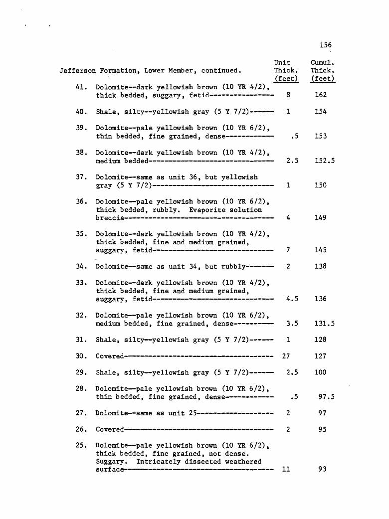
156
Unit Cumul.Jefferson Formation, Lower Member, continued. Thick. Thick.
(feet) (feet) 41. Dolomite dark yellowish brown (10 YR 4/2),
thick bedded, suggary, fetid 8 162
40. Shale, silty yellowish gray (5 Y 7/2) 1 154
39. Dolomite pale yellowish brown (10 YR 6/2),thin bedded, fine grained, dense .5 153
38. Dolomite dark yellowish brown (10 YR 4/2),medium bedded 2.5 152.5
37. Dolomite same as unit 36, but yellowishgray (5 Y 7/2) 1 150
36. Dolomite pale yellowish brown (10 YR 6/2), thick bedded, rubbly. Evaporite solution breccia 4 149
35. Dolomite dark yellowish brown (10 YR 4/2), thick bedded, fine and medium grained, suggary, fetid 7 145
34. Dolomite same as unit 34, but rubbly 2 138
33. Dolomite dark yellowish brown (10 YR 4/2), thick bedded, fine and medium grained, suggary, fetid 4.5 136
32. Dolomite pale yellowish brown (10 YR 6/2),medium bedded, fine grained, dense 3.5 131.5
31. Shale, silty yellowish gray (5 Y 7/2) 1 128
30. Covered 27 127
29. Shale, silty yellowish gray (5 Y 7/2) 2.5 100
28. Dolomite pale yellowish brown (10 YR 6/2),thin bedded, fine grained, dense .5 97.5
27. Dolomite same as unit 25 2 97
26. Covered 2 95
25. Dolomite pale yellowish brown (10 YR 6/2)^ thick bedded, fine grained, not dense. Suggary. Intricately dissected weathered surface 11 93

157
Unit Cumul .Jefferson Formation, Lower Member, continued. Thick. Thick.
(feet) (feet) 24. Dolomite yellowish gray (5 Y 7/2), rubbly,
sixty " ""*""~*"i"<*" ~*"" ""* """"*"*" """""" """"""" """""""*"""" "* »j oz
23. Covered float is dolomite, yellowish gray(5 Y 7/2), rubbly 1.5 81.5
22. Dolomite pale yellowish brown (10 YR 6/2) to dark yellowish brown (10 YR 4/2) , medium and thick bedded, fine grained but not dense. Suggary, fetid 5 80
21 . Covered 4.5 75
20. Dolomite same as unit 16 .5 70.5
19. Dolomite dark yellowish brown (10 YR 4/2),thick bedded, suggary, fetid .5 70
18. Dolomite same as unit 16 .5 69.5
17. Shale, dolomitic, silty yellowish gray (5
16. Dolomite pale yellowish brown (10 YR 6/2), medium bedded, finely laminated, fine grain-
15. Dolomite dark yellowish brown (10 YR 6/2),thick bedded, suggary, fetid 2.5 67.5
14. Dolomite same as unit 13, but fractured .5 65
13. Dolomite pale yellowish brown (10 YR 6/2),thick bedded, fine grained, dense 2 64.5
12. Dolomite dark yellowish brown (10 YR 4/2), thick bedded, suggary, fetid. Scour surface at to """*"""""" """ ""*" " "* """"" " ' " " " X j oZ * D
11. Shale, dolomitic, silty yellowish gray (5 Y7/2), finely laminated to thin bedded 1 61
10. Dolomite pale yellowish brown (10 YR 6/2),medium bedded, fine grained, dense, slightly
___________ __ ______ _ . _ ___ ___ _ ___ i ^ AH- « «-«- »_ __ .___ i.J OV
9. Dolomite grayish orange (10 YR 7/4), thinbedded, rubbly, silty 1 58.5

158
Unit Cumul.Jefferson Formation, Lower Member, continued. Thick. Thick.
(feet) (feet)8. Dolomite pale yellowish brown (10 YR 6/2),
thick bedded, fine grained, slightly fetid. Rubbly weathering. Solution breccia? 3 57.5
7. Dolomite dark yellowish brown (10 YR 4/2),thick bedded, fetid, suggary. Forms ledge 13.5 54.5
5. Dolomite same as unit 3 4 28
4. Covered 15.5 24
3. Dolomite dark yellowish brown (10 YR 4/2),thick bedded, fetid, suggary 4 8.5
2. Dolomite pale yellowish brown (10 YR 6/2), thick bedded, hint of lamination. Dense, fine grained 1 4.5
1. Dolomite dark yellowish brown (10 YR 4/2), medium and thick bedded, fine grained, fetid. Lower contact is irregular, unconformable 3.5 3»5
RED LION FORMATION,Sage Member, upper part:
54. Dolomite pale yellowish brown (10 YR 6/2), weathers It. gray (N 7), thin and medium bedded, dense, fine grained. Contact with Jefferson Formation irregular 15.5 170
53. Dolomite same as unit 44 .5 154.5
52. Dolomite same as unit 36 1 154
51. Covered 3 153
50. Dolomite same as unit 36 3 150
49. Mound 4 ft. high, 4 ft. wide Dolomite pale yellowish brown (10 YR 6/2), weathers It. gray (N 7), finely crystalline, dense 4 147
48. Dolomite same as unit 44 1.5 143
47. Mound Dolomite pale yellowish brown (10 YR 6/2), weathers It. gray (N 7), fine grained, dense ,5 141.5
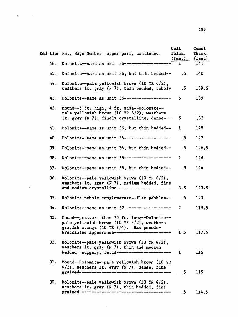
159
Red Lion
46.
45.
44.
43.
42.
41.
40.
39.
38.
37.
36.
35.
34.
Unit Fm., Sage Member, upper part, continued. Thick.
(feet)Dolomite same as unit 36 1
Dolomite same as unit 36, but thin bedded .5
Dolomite pale yellowish brown (10 YR 6/2), weathers It. gray (N 7), thin bedded, rubbly .5
Dolomite same as unit 36 6
Mound 5 ft. high, 4 ft. wide Dolomite pale yellowish brown (10 YR 6/2), weathers It. gray (N 7), finely crystalline, dense 5
Dolomite same as unit 36, but thin bedded 1
Dolomite same as unit 36 .5
Dolomite same as unit 36, but thin bedded .5
Dolomite same as unit 36, but thin bedded .5
Dolomite pale yellowish brown (10 YR 6/2) , weathers It. gray (N 7), medium bedded, fine
Dolomite pebble conglomerate flat pebbles .5
Dolomite same as unit 32 2
Cumul. Thick. (feet)141
140
139.5
139
133
128
127
126.5
126
124
123.5
120
119.5
33. Mound greater than 30 ft. long Dolomite- pale yellowish brown (10 YR 6/2), weathers grayish orange (10 YR 7/4). Has pseudo- brecciated appearance 1.5 117.5
32. Dolomite pale yellowish brown (10 YR 6/2), weathers It. gray (N 7), thin and medium bedded, suggary, fetid 1 116
31. Mound DolomitB pale yellowish brown (10 YR 6/2), weathers It. gray (N 7), dense, fine
30. Dolomite pale yellowish brown (10 YR 6/2), weathers It. gray (N 7), thin bedded, fine
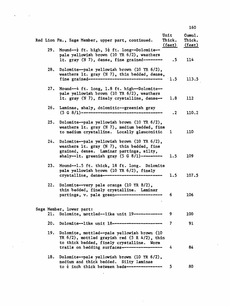
160
Unit Cumul.Red Lion Fm., Sage Member, upper part, continued. Thick. Thick,
(feet) (feet)29. Mound -i ft. high, 5i ft. long Dolomite
pale yellowish brown (10 YR 6/2), weathers It. gray (N 7), dense, fine grained .5 114
28. Dolomite pale yellowish brown (10 YR 6/2), weathers It. gray (N 7), thin bedded, dense, fine grained 1.5 113.5
27. Mound 4 ft. long, 1.8 ft. high Dolomite pale yellowish brown (10 YR 6/2), weathers It. gray (N 7), finely crystalline, dense 1.8 112
26. Laminae, shaly, dolomitic greenish gray(5 G 8/1) .2 110.2
25. Dolomite pale yellowish brown (10 YR 6/2), weathers It. gray (N 7), medium bedded, fine to medium crystalline. Locally glauconitic 1 110
24. Dolomite pale yellowish brown (10 YR 6/2), weathers It. gray (N 7), thin bedded, fine grained, dense. Laminar partings, silty, shaly It. greenish gray (5 G 8/1) 1.5 109
23. Mound 1.5 ft. thick, 18 ft. long. Dolomite pale yellowish brown (10 YR 6/2), finely crystalline, dense 1.5 107.5
22. Dolomite very pale orange (10 YR 8/2),thin bedded, finely crystalline. Laminarpartings, v. pale green 6 106
Sage Member, lower part:21. Dolomite, mottled like unit 19 9 100
20. Dolomite like unit 18 7 91
19. Dolomite, mottled pale yellowish brown (10 YR 6/2), mottled grayish red (5 R 4/2), thin to thick bedded, finely crystalline. Worm trails on bedding surfaces 4 84
18. Dolomite pale yellowish brown (10 YR 6/2), medium and thick bedded. Silty laminae to i inch thick between beds 5 80

161
Unit Cumul.Red Lion Fm., Sage Member, lower part, continued. Thick. Thick.
^feet) (feet)17. Dolomite pale yellowish brown (10 YR 6/2),
weathers pale greenish yellow (10 Y 8/2), finely crystalline. Glauconite present. Laminar partings to 1 inch thick pale greenish yellow (10 Y 8/2) 4 75
16. Dolomite pale yellowish brown (10 YR 6/2), medium and thick bedded. Silty laminae to i inch thick. Pebble conglomerate at base, 4 inches thick 3 71
15. Dolomite same as unit 17, lower part cover-
14. Dolomite, silty like unit 10 7.5 51
13. Dolomite, nodular silty shale peripheral to
12. Dolomite, silty like unit 10 9 43
11. Dolomite pale yellowish brown (10 YR 6/2), medium bedded, medium crystalline, glauco- nitic. Fossil hash 2 34
10. Dolomite, silty pale yellowish brown (10 YR 6/2), thin bedded, laminated. Weathered face has laminated silt in relief 2 32
9. Dolomite, silty, nodular like unit 7 1 30
8. Dolomite, silty like unit 6 2 29
7. Dolomite, nodular, silty 4 27
6. Dolomite, silty pale yellowish brown (10 YR 6/2), thin bedded. Weathered face has silty laminae in relief. Intercalated shaly, silty beds i to i inch thick 5 23
5. Dolomite, silty pale yellowish brown (10 YR6/2), thin bedded, finely laminated 6 18
Dry Creek Member:4. Sandstone, quartz, glauconite medium and
thick bedded, fine to medium grained. Lower part has mud chips and dolomite pebble

162
Unit Cumul.Red Lion Fm., Dry Creek Member, continued. Thick. Thick.
(feet) (feet)3. Covered 5 8
2. Shale grayish olive (10 Y 4/2), fissile,clay, v. fine micaceous 2 3
1. Shale grayish red (5 R 4/2) to blackish red (5 R 2/2), fissile, clay, v. fine
PILGRIM FORMATION, Upper Member:
65. Dolomite same as unit 63. Contact with RedLion is conformable 1 390
64. Dolomite, sandy same as unit 63, butweathers gray orange (10 YR 7/4) 5 389
63. Dolomite, sandy moderate orange pink (10 R 7/4), weathers pale red (10 R 6/2), medium bedded. Mottled sand is quartz 3 384
62. Dolomite and sandy dolomite interlaminated- much like unit 52 7 381
61. Dolomite same as unit 57 4 374
60. Dolomite same as unit 56 4 370
59. Dolomite same as unit 57 6 366
58. Dolomite same as unit 56 3 360
57. Dolomite, laminated similar to unit 51. Contains some wavy laminae, probably mat
56. Dolomite weathers medium gray (N 5), knobbyweathered surface. Thin bedded 9 351
55. Sandstone, dolomitic cross bedded, tabular,steep. Sand is quartz 7 342
54. Dolomite, sandy same as unit 52 3 335
53. Dolomite, sandy interlaminated with dolo mite, medium gray (N 5), thinly bedded 2 332

163
Unit Cumul.Pilgrim Formation, Upper Member, continued. Thick. Thick.
(feet) (feet)52. Dolomite, sandy similar to unit 51, but
laminae not commonly wavy. Suspect more sand, less dolomite. Local small-scale, cross-bedding 15 330
51. Dolomite, sandy thin bedded, with wavylaminae. Sand is quartz » 21 315
50. Dolomite, "mud chip" same as unit 48 1.5 294
49. Shaly Laminae, dolomitic dark yellow orange(10 YR 6/6), forms zone 6 inches thick .5 292.5
48. Dolomite, "mud chip" dark yellowish brown (10 YR 4/2), except chips which are yellow ish, thick bedded 2 292
47. Dolomite dark yellowish brown (10 YR 4/2),thick bedded, no structures 6 290
46. Dolomite same as unit 43 4 284
45. Dolomite pale yellowish brown (10 YR 6/2),medium bedded, with some reddish laminae 4 280
44. Dolomite, silty pale yellowish brown (10 YR 6/4), medium bedded. Laminar partings gray yellow (5 Y 8/4), silty, dolomitic 3 276
43. Dolomite pale red (5 R 6/2), thin bedded, nodular to rubbly. Prominent marker unit in immediate area 2 273
42. Dolomite, sandy pale yellowish brown, thinbedded, platy. Laminated mat algae? 3 271
Lower Member:41. Dolomite, oolitic, sandy weathers v. light
gray (N 8), thick bedded. Sand is quartz. White twig-like bodies present 3 268
40. Dolomite similar to unit 34 10 265
39. Dolomite like unit 38, but no glauconite ortwig-like material 9 255
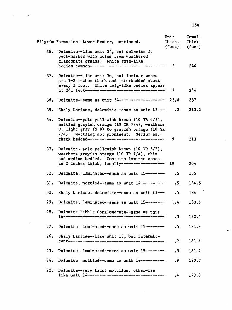
164
Unit Cumul.Pilgrim Formation, Lower Member, continued. Thick. Thick.
(feet) (feet)38. Dolomite like unit 34, but dolomite is
pock-marked with holes from weathered glanconite grains. White twig-like bodies common 2 246
37. Dolomite like unit 36, but laminar zones are 1-2 inches thick and interbedded about every 1 foot. White twig-like bodies appear at 241 feet 7 244
36. Dolomite same as unit 34 23.8 237
35. Shaly Laminae, dolomitic same as unit 13 .2 213.2
34. Dolomite pale yellowish brown (10 YR 6/2), mottled grayish orange (10 YR 7/4) , weathers v. light gray (N 8) to grayish orange (10 YR 7/4). Mottling not prominent. Medium and thick bedded 9 213
33. Dolomite pale yellowish brown (10 YR 6/2), weathers grayish orange (10 YR 7/4), thin and medium bedded. Contains laminae zones to 2 inches thick, locally 19 204
32. Dolomite, laminated same as unit 15 .5 185
31. Dolomite, mottled same as unit 14 .5 184.5
30. Shaly Laminae, dolomitic same as unit 13 .5 184
29. Dolomite, laminated same as unit 15 1.4 183.5
28. Dolomite Pebble Conglomerate same as unit
27. Dolomite, laminated same as unit 15 .5 181.9
26. Shaly Laminae like unit 13, but intermit-- - ..__ _....... __________....__________.... 9 1 ftl A~~ « « « « ...« .. <_..... __________«__> ».. ^ ^r J.O J, . t
25. Dolomite, laminated same as unit 15 .5 181.2
24. Dolomite, mottled same as unit 14 .9 180.7
23. Dolomite very faint mottling, otherwiselike unit 14 .4 179.8

165
Unit Cumul.Pilgrim Formation, Lower Member, continued. Thick. Thick.
(feet) jfeet)22. Dolomite, mottled same as unit 14 .5 179.4
21. Dolomite, fossil fragmental same as unit 19 .3 178.9
20. Dolomite Pebble Conglomerate same as unit
19. Dolomite, fossil fragmental grayish orange (10 YR 7/4) to pale yellowish brown (10 YR 6/2), thin bedded. Abundant fossil frag ments , especially spines. Commonly glauco- nitic .3 178.3
18. Dolomite Pebble Conglomerate same as unit1 A- -- x.^-- ..--- - -. um -rm _._.__»_. J. -_.-_.......-. ^ 1 78j.O"»"" ~l «"~~ ~~ -" -> "" - " " "" "" -J JL / O
17. Dolomite, laminated same as unit 15' 1 177.7
16. Dolomite Pebble Conglomerate dark yellowish brown (10 YR 4/2) matrix; pebbles are dusky yellowish brown (10 YR 2/2). Thinly bedded- .3 176.7
15. Dolomite, laminated grayish orange (10 YR 7/4) vs, dark yellowish brown (10 YR 4/2) alternating bands of fine laminae. Bands to 1 cm. thick. Differential weathering .4 176.4
14. Dolomite, mottled pale yellowish brown (10 YR 6/2), mottles are dark yellowish brown, thinly bedded .2 176
13. Shaly Laminae, dolomitic grayish orange (10 YR 7/4), shaly, fissile to platy. Finely laminated in part .8 175.8
12. Dolomite pale yellowish brown (10 YR 6/2), weathers grayish orange (10 YR 7/4), thin and medium bedded. Contains laminae zones to 2 inches thick. Laminae are dolomitic, silty dark yellowish orange (5 YR 5/6) 31 175
11. Dolomite pale yellowish brown (10 YR 6/2), medium bedded, fine grained. White twig- like bodies uncommon- - - 52.8 144
10. Dolomite same as unit 4 .2 91.2

166
Unit Cumul.Pilgrim Formation, Lower Member, continued. Thick. Thick.
(feet) (feet)9. Dolomite same as unit 7 1.5 91
8. Dolomite pale yellowish brown (10 YR 6/2), thin to medium bedded. Contains "pores" with glauconite in them. Upper surface is undulatory a scour surface. White twig- like bodies equally abundant above and below scour surfaces .5 89.5
7. Dolomite same as unit 3, with local glauco- z nite grains « «p - « o.j tjy
6. Dolomite same as unit 4 1 82,5
5. Dolomite same as unit 3, except mottlingmore prominent 4.5 81.5
z 4. Dolomite yellow gray (5 Y 7/2), weathers dusky yellow (5 Y 6/4), thin bedded, fine grained. Knobby weathering 1 77
3. Dolomite- same as unit 2, but faint mottling evident. Mottles are pale brown (5 YR 5/2), weathering grayish orange (10 YR 7/4) 20 76
2. Dolomite pale yellowish brown (10 YR 6/2), thick bedded, fine grained. Contains small white twig-like bodies. Stylolites 6 56
1. Covered talus 50 50
Park Fra. not measured.
SECTION I
Section I occurs in the McHessor Creek drainage, NWiSEi sec. 19, T. 6 S., R. 5 W. It is north of the creek that trends E-W through the southern half of sec. 19, with its base at about 7200 feet altitude on the ridge that trends NE-SW across this 1/16 part of sec. 19.
Pilgrim Fm. not measured. Unit Cumul.Thick. Thick.
PARK FORMATION: (feet) (feet) 1. Covered float is shale chips, grayish olive
/in v L 1 9"S ________________ ..... -._- . ... 175\ J.V7 JL *T / i- ] .1 i 111 » _ » JL f j

167
Unit Cumul . Thick. Thick.
MEAGHER FORMATION: (feet) (feet) 31. Dolomite dark yellowish brown (10 YR 4/2),
weathers pale yellowish brown (10 YR 6/2) to grayish orange (10 YR 7/4), medium bed ded. Locally has mottles, moderate reddish brown (10 YR 4/6). Only (Park) shale above this unit 15 745
30. Covered 15 730
29. Dolomite dark yellowish brown (10 YR 4/2),thin bedded, medium crystalline- 1 718
28. Covered greenish shale chips in float. Dolomite nodules in float pale red brown (10 R 5/4) and dark yellowish orange (10 R 6/6) 6 717
27. Dolomite Pebble Conglomerate dark yellowish brown (10 YR 4/2), weathers pale yellowish brown (10 YR 6/2) to grayish orange (10 YR 7/4), medium bedded. Most pebbles are flat but a few are edgewise. Differential weathered, with pebbles being the more resistant 1 711
26. Covered A few greenish shale chips in"' *"> """*" "" "" " """""" """" D /J.U
25. Dolomite same as unit 21 1 705
24. Covered 4 704
23. Dolomite same as unit 21 18 700
22 . Covered 22 682
21. Dolomite dark yellowish brown (10 YR 4/2), weathers grayish orange (10 YR 7/4) to pale yellowish brown (10 YR 6/2), thin and medium bedded, finely crystalline. Mottled. Contains white twig-like bodies. Not fetid 14 660
20. Covered 9 646
19. Dolomite same as unit 18, but mottling isvery prominent on weathered surface 20 237

168
Unit Cumul.Meagher Formation, continued. Thick. Thick.
(feet) (feet)18. Dolomite pale yellowish brown (10 YR 6/2),
weathers some to grayish orange (10 YR 7/4) and yellowish orange (10 YR 8/6), thin and medium bedded, finely crystalline. Mottled. Parting laminae, silty pale yellowish orange (10 YR 8/6) to dark yellowish orange (10 YR 6/6) 27 617
17, Dolomite same as unit 15 28 590
16. Dolomite same as unit 12 4 562
15. Dolomite dark yellowish brown (10 YR 4/2) to dusky yellowish brown (10 YR 2/2), weathers pale yellowish brown (10 YR 6/2) to dark yellowish brown (10 YR 4/2), thick bedded. Fine to medium crystalline. Fetid. Mottling is faint to absent. No twig-like bodies 28 548
14. Dolomite same as unit 12 35 520
13. Dolomite dark yellowish brown (10 YR 4/2), weathers grayish orange (10 YR 7/4) to pale yellowish brown (10 YR 6/2). Thin and medium bedded. Weathered surface is mot tled, but fresh surface does not appear mottled. Base forms recession in cliff. Fetid, no twig-like bodies 21 485
12. Dolomite same as unit 11, but no pisolitesand unit is mottled 25 464
11. Dolomite dusky yellowish brown (10 YR 2/2), weathers pale to dark yellowish brown (10 YR 6/2 to 4/2), medium and thick bedded. White twig-like bodies appear, then pisto- lites with them. Dolomite is vuggy and fetid 1 439
10. Dolomite dusky yellowish brown (lo YR 2/2), weathers pale yellowish brown (10 YR 6/2), Vugs common. Locally mottled. Twig-like bodies present between 426 and 428 ft. Pale yellowish brown rock has dark yellowish brown mottles and mottles have whitish to tan twig-like bodies in centers. Rock is fetid 12 438
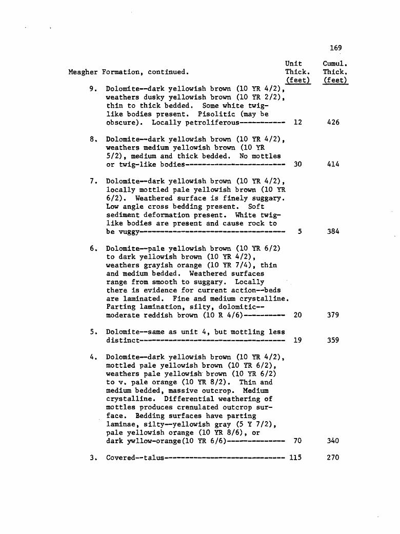
169
Unit Cumul.Meagher Formation, continued. Thick. Thick.
(feet) (feet)9. Dolomite dark yellowish brown (10 YR 4/2),
weathers dusky yellowish brown (10 YR 2/2), thin to thick bedded. Some white twig- like bodies present. Pisolitic (may be obscure). Locally petroliferous 12 426
8. Dolomite dark yellowish brown (10 YR 4/2), weathers medium yellowish brown (10 YR 5/2), medium and thick bedded. No mottles or twig-like bodies 30 414
7. Dolomite dark yellowish brown (10 YR 4/2), locally mottled pale yellowish brown (10 YR 6/2). Weathered surface is finely suggary. Low angle cross bedding present. Soft sediment deformation present. White twig- like bodies are present and cause rock to be vuggy 5 384
6. Dolomite pale yellowish brown (10 YR 6/2) to dark yellowish brown (10 YR 4/2), weathers grayish orange (10 YR 7/4), thin and medium bedded. Weathered surfaces range from smooth to suggary. Locally there is evidence for current action beds are laminated. Fine and medium crystalline. Parting lamination, silty, dolomitic moderate reddish brown (10 R 4/6) 20 379
5. Dolomite same as unit 4, but mottling lessdistinct 19 359
4. Dolomite dark yellowish brown (10 YR 4/2), mottled pale yellowish brown (10 YR 6/2), weathers pale yellowish brown (10 YR 6/2) to v. pale orange (10 YR 8/2). Thin and medium bedded, massive outcrop. Medium crystalline. Differential weathering of mottles produces crenulated outcrop sur face. Bedding surfaces have parting laminae, silty yellowish gray (5 Y 7/2), pale yellowish orange (10 YR 8/6), or dark ywllow-orange(10 YR 6/6) 70 340
3. Covered talus 115 270

170
Unit Cumul.Meagher Formation, continued. Thick. Thick.
(feet) (feet)2. Dolomite; medium yellowish brown (10 YR
5/2), weathers pale yellowish brown (10 YR 6/2), massive outcrop, v. fine grained. Mottling locally faint. Brecciated (tectonic). Rock surface intricately dissected on small scale due to weathering of breccia 35 155
1. Covered talus 120 120
Wolsey Fm. not measured.
SECTION J
Section J is on the west side of the Ruby Range, NEiNWi sec. 36, T. 6 S., R. 6 W. The section is in the Trout Creek drainage, north of the creek, and between 7200 and 7500 feet in altitude. The section was measured northeast, up the slight ridge nose present in the western part of the 1/16 fraction of sec. 36.
Three Forks Fm. not measured.Unit Cumul.
JEFFERSON FORMATION, Thick. Thick. Birdbear Member: (feet) (feet)
38. Dolomite pale yellowish brown (10 YR 6/2),evaporite breccia 45 250
37. Dolomite pale yellowish brown (10 YR 6/2),thin bedded, fine grained, dense- 9 205
Lower Member:36. Dolomite, shaly pale reddish brown (10 R
5/4) to grayish orange (10 YR 7/4) 4 196
35. Dolomite pale yellowish brown (10 YR 6/2),medium bedded, fine grained 5 192
34. Dolomite, shaly pale yellowish brown (10 YR6/2), thin bedded, book-like 7 187
33. Dolomite dark yellowish brown (10 YR 4/2), mottled pale yellowish brown (10 YR 6/2), thick bedded, suggary, fetid 2 180

171
Unit Cumul.Jefferson Formation, Lower Member, continued. Thick, Thick.
(feet) (feet) 32. Dolomite dark yellowish brown (10 YR 4/2),
thick bedded, suggary, fetid 20 178
j J. »
30. Dolomite dark yellowish brown (10 YR 4/2),medium bedded, suggary, fetid 2 143
29. Dolomite same as unit 27 .5 141
28. Dolomite, shaly grayish orange (10 YR 7/4)- 1.5 140.5
27. Dolomite pale yellowish brown (10 YR 6/2),medium bedded, fine grained, dense .5 139
26. Dolomite dark yellowish brown (10 YR 4/2), medium and thick bedded, laminated, suggary,
______________________________ _ . _ _____ IE:»__»«»_.»-._»____.»_____.».»_________.»________ J. . J
25. Dolomite pale yellowish brown (10 YR 6/2),stained pale red (5 R 6/2), medium bedded 1 137
24. Dolomite dark yellowish brown (10 YR 4/2),medium and thick bedded, suggary, fetid 1.5 136
23 , Dolomite, shaly grayish orange (10 YR 7/4),thin bedded 1.5 134.5
22. Dolomite pale yellowish brown (10 YR 6/2),medium and thick bedded 2 133
21. Dolomite pale yellowish brown (10 YR 6/2),thin bedded, rubbly, evaporite breccia 2.5 131
20. Dolomite pale yellowish brown (10 YR 6/2) to dark yellowish brown (10 YR 4/2) , thick bedded, fine grained 21.5 128.5
19. Dolomite, shaly, silty grayish orange (10YT? 7 /A"» . _ _ »_.____________ ___ 9 in?LR. I I *T / ~~ _ __-_ __ ___. J ___ unmm .-____LJ| ».. ___u _._ J.VJ /
18. Dolomite pale yellowish brown (10 YR 6/2),medium bedded, fine grained, dense 2.5 105
17. Dolomite* same as unit 15 1.5 102.5

172
Unit Cumul .Jefferson Formation, Lower Member, continued. Thick. Thick.
(feet) (feet) 16. Dolomite pale yellowish brown (10 YR 6/2),
thick bedded - 2 101
15. Dolomite dark yellowish brown (10 YR 4/2), medium and thick bedded, suggary, fetid. Amphipora from 92-93 and 95-96 feet 10 99
14. Dolomite pale ywllowish brown (10 YR 6/2), weathers yellowish gray (5 Y 7/2) , tends to be nodular 1 89
13. Dolomite* dark yellowish brown (10 YR 4/2), medium bedded, suggary, fetid. Upper one foot contains Amphipora 3 88
12. Dolomite pale yellowish brown (10 YR 6/2),medium bedded, fine grained, dense 1 86
11. Covered 13 85
10. Dolomite dark yellowish brown (10 YR 4/2),medium and thick bedded, suggary, fetid 9 72
j t covered L » "« - -»m- _ . . .m __ « ._ . .-. . _ __».__mML « ^ o o
8. Dolomite, shaly, silty grayish orange (10YR 7/4) 1.7 62
7. Dolomite pale yellowish brown (10 YR 6/2),medium bedded, fine grained, dense .3 60.3
6. Dolomite same as unit 2 2 60
5. Dolomite same as unit 2, except appearsbrecciated evaporite? 1 58
4. Dolomite* same as unit 2 2 57
3. Dolomite dark yellowish brown (10 YR 4/2), thin and" medium bedded, appears laminated,
2. Dolomite dark yellowish brown (10 YR 4/2), medium and thick bedded, fine grained, suggary, fetid 3 53
1. Covered contact with Pilgrim is concealed 50 50
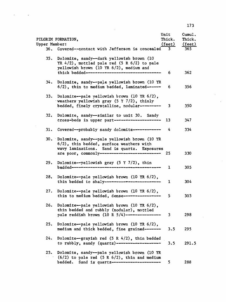
173
Unit Cumul.PILGRIM FORMATION, Thick. Thick.Upper Member: (feet) (feet)
36. Covered contact with Jefferson is concealed 3 365
35. Dolomite, sandy dark yellowish brown (10 YR 4/2), mottled pale red (5 R 6/2) to pale yellowish brown (10 YR 6/2), medium and thick bedded 6 362
34. Dolomite, sandy pale yellowish brown (10 YR6/2), thin to medium bedded, laminated 6 356
33. Dolomite pale yellowish brown (10 YR 6/2), weathers yellowish gray (5 Y 7/2), thinly bedded, finely crystalline, nodular 3 350
32. Dolomite, sandy similar to unit 30. Sandycross-beds in upper part 13 347
31. Covered probably sandy dolomite 4 334
30. Dolomite, sandy pale yellowish brown (10 YR 6/2), thin bedded, surface weathers with wavy laminations. Sand is quartz. Exposures are poor, commonly 25 330
29. Dolomite yellowish gray (5 Y 7/2), thinbedded 1 305
28. Dolomite pale yellowish brown (10 YR 6/2),thin bedded to shaly 1 304
27. Dolomite pale yellowish brown (10 YR 6/2),thin to medium bedded, dense 5 303
26. Dolomite* pale yellowish brown (10 YR 6/2), thin bedded and rubbly (nodular), mottled pale reddish brown (10 R 5/4) 3 298
25. Dolomite pale yellowish brown (10 YR 6/2),medium and thick bedded, fine grained 3.5 295
24. Dolomite grayish red (5 R 4/2), thin beddedto rubbly, sandy (quartz) 3.5 291.5
23. Dolomite, sandy- pale yellowish brown (10 YR - (6/2) to pale red (5 R 6/2), thin and mediumbedded. Sand is quartz 5 288
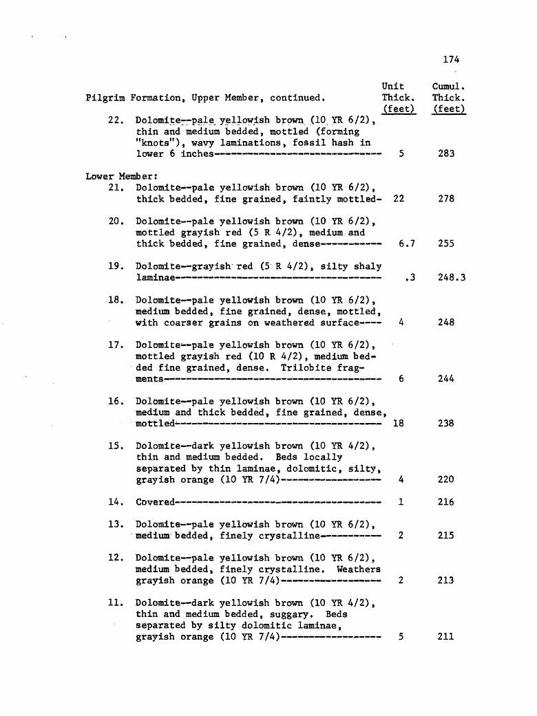
174
Unit Cumul.Pilgrim Formation, Upper Member, continued. Thick. Thick.
(feet) (feet)22. Dolomites-pale yellowish brown (10 YR 6/2),
thin and medium bedded, mottled (forming "knots"), wavy laminations, fossil hash in lower 6 inches 5 283
Lower Member:21. Dolomite pale yellowish brown (10 YR 6/2),
thick bedded, fine grained, faintly mottled- 22 278
20. Dolomite pale yellowish brown (10 YR 6/2), mottled grayish red (5 R 4/2), medium and thick bedded, fine grained, dense 6.7 255
19. Dolomite grayish red (5 R 4/2), silty shaly.Laminae . j 2.40. .3
18, Dolomite pale yellowish brown (10 YR 6/2), medium bedded, fine grained, dense, mottled, with coarser grains on weathered surface 4 248
17. Dolomite--pale yellowish brown (10 YR 6/2), mottled grayish red (10 R 4/2), medium bed ded fine grained, dense. Trilobite frag ments 6 244
16. Dolomite pale yellowish brown (10 YR 6/2), medium and thick bedded, fine grained, dense, mottled- 18 238
15. Dolomite dark yellowish brown (10 YR 4/2), thin and medium bedded. Beds locally separated by thin laminae, dolomitic, silty, grayish orange (10 YR 7/4) 4 220
14. Covered 1 216
13. Dolomite pale yellowish brown (10 YR 6/2),medium bedded, finely crystalline 2 215
12. Dolomite pale yellowish brown (10 YR 6/2), medium bedded, finely crystalline. Weathers grayish orange (10 YR 7/4) 2 213
11. Dolomite dark yellowish brown (10 YR 4/2), thin and medium bedded, suggary. Beds separated by silty dolomitic laminae, grayish orange (10 YR 7/4) 5 211
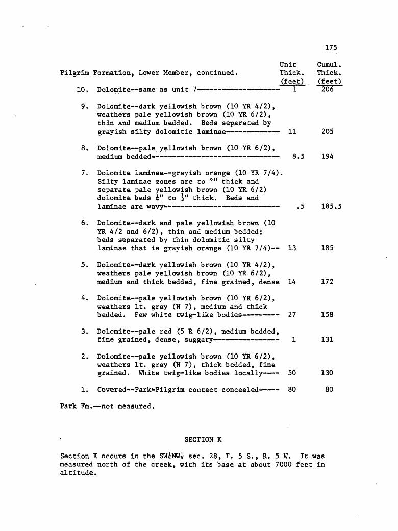
175
Unit Cumul.Pilgrim Formation, Lower Member, continued. Thick. Thick.
(feet) (feet)10. Dolomite same as unit 7 1 206
9. Dolomite dark yellowish brown (10 YR 4/2), weathers pale yellowish brown (10 YR 6/2), thin and medium bedded. Beds separated by grayish silty dolomitic laminae 11 205
8. Dolomite pale yellowish brown (10 YR 6/2),medium bedded 8.5 194
7. Dolomite laminae grayish orange (10 YR 7/4). Silty laminae zones are to °" thick and separate pale yellowish brown (10 YR 6/2) dolomite beds i" to 3" thick. Beds and laminae are wavy--- .5 185.5
6. Dolomite dark and pale yellowish brown (10 YR 4/2 and 6/2), thin and medium bedded; beds separated by thin dolomitic silty laminae that is grayish orange (10 YR 7/4) 13 185
5. Dolomite dark yellowish brown (10 YR 4/2), weathers pale yellowish brown (10 YR 6/2), medium and thick bedded, fine grained, dense 14 172
4. Dolomite pale yellowish brown (10 YR 6/2), weathers It. gray (N 7), medium and thick bedded. Few white twig-like bodies 27 158
3. Dolomite pale red (5 R 6/2), medium bedded,fine grained, dense, suggary 1 131
2. Dolomite pale yellowish brown (10 YR 6/2), weathers It. gray (N 7), thick bedded, fine grained. White twig-like bodies locally 50 130
1. Covered--Park-Pilgrim contact concealed 80 80
Park Fm. not measured.
SECTION K
Section K occurs in the SWiNWi sec. 28, T. 5 S., R. 5 W. It was measured north of the creek, with its base at about 7000 feet in altitude.

176
Jefferson Fm. not measured.Unit Cumul.
RED LION FORMATION, Thick. Thick. Sage Member, upper part: (feet) (feet)
21. Dolomite same as unit 20, but is mediumand thick bedded 45 146
20. Dolomites-pale yellowish brown (10 YR 6/2),weathers It. gray (N 7), thin bedded 4 101
19. Covered 6 97
Sage Member, lower part:18. Dolomite, mottled same as unit 16 6 91
17. Dolomite same as unit 15 1.5 85
16. Dolomite, mottled* pale ywllowish brown (10 YR 6/2), mottled moderate red (5 R 5/4), medium bedded 2.5 83.5
15. Dolomite pale yellowish brown (10 YR 6/2), medium bedded. Beds separated by silty laminae, grayish orange (10 YR 7/4) 12 81
14. Dolomite same as unit 11 2 69
13. Dolomite* pale yellowish brown (10 YR 6/2), thin and medium bedded. Beds separated by silty laminae, grayish orange 12 67
11. Dolomite float pale yellowish brown (10 YR 6/2) to medium dark gray (N 4), thinly bed ded. Laminar partings, pale greenish yellow (10 Y 8/2) 10 51
10. Dolomite* same as unit 6 2 41
9. Dolomite same as unit 5 2 39
8. Dolomite--same as unit 6 4 37
7. Dolomite pale yellowish brown (10 YR 6/2), weathers moderate reddish orange (10 R 6/6), medium bedded. Medium crystalline 3 33

177
Unit Cumul.Sage Member, lower part, continued. Thick. Thick.
(feet) (feet)6. Dolomite, silty pale yellowish brown (10
YR 6/2), thinly bedded (about 4 inch thick). Pale greenish laminae between beds- 1 30
5. Dolomite pale yellowish brown (10 YR 6/2), thin and medium bedded, some beds nodular. Silty laminae weather in relief on outcrop face 17 29
4. Limestone pale yellowish brown (10 YR 6/2),medium bedded 1 12
Dry Creek Member:3. Limestone pebble conglomerate pale yellow
ish brown (10 YR 6/2), medium bedded, glauconitic. Flat pebbles- 1.5 11
2. Shale pale olive (10 Y 6/2), soft clay chips 9 9.5
1. Shale--grayish red (10 R 4/2), clay chips,finely micaceous .5 .5
PILGRIM FORMATION,Upper Member (partial section):
6. Dolomite, sandy, mottled moderate orange pink (10 R 7/4) to gray orange (10 YR 7/4), thin and medium bedded. Sand is quartz 12 93
5. Dolomite (same as unit 3) and sandy dolomite (like unit 1) interbedded as units 3 to 6 ft. thick 25 81
4. Dolomite, sandy same as unit 1 4 56
3. Dolomite pale yellowish brown (10 YR 6/2) to medium gray (N 7), thin and medium
2. Sandstone, quartz, dolomitic pale yellowish brown (10 YR 6/2), medium bedded, cross- bedded 6 46
1. Dolomite, sandy (quartz) pale yellowish brown (10 YR 6/2), thinly bedded. Wavy
Fault. Remainder of upper Pilgrim member not present.
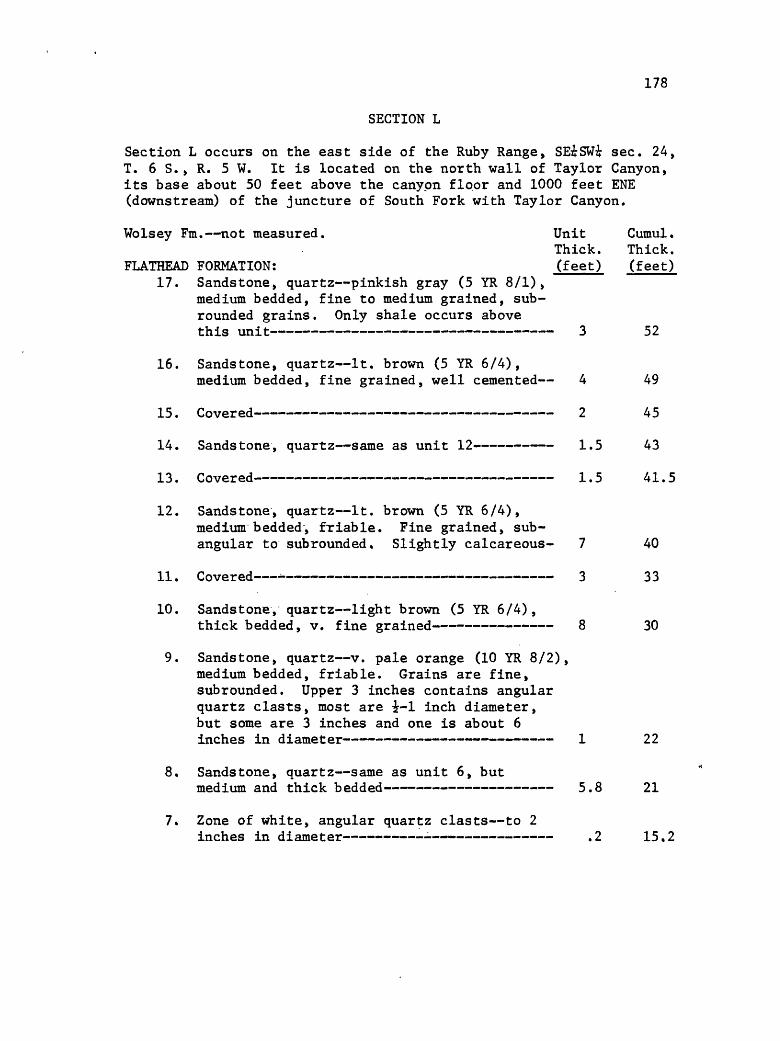
178
SECTION L
Section L occurs on the east side of the Ruby Range, SE^SWi sec. 24, T. 6 S., R. 5 W. It is located on the north wall of Taylor Canyon, its base about 50 feet above the canyon floor and 1000 feet ENE (downstream) of the juncture of South Fork with Taylor Canyon.
Wolsey Fm. not measured. Unit Cumul.Thick. Thick.
FLATHEAD FORMATION: (feet) (feet) 17. Sandstone, quartz pinkish gray (5 YR 8/1),
medium bedded, fine to medium grained, sub- rounded grains. Only shale occurs above this unit 3 52
16. Sandstone, quartz It. brown (5 YR 6/4),medium bedded, fine grained, well cemented 4 49
15. Covered 2 45
14. Sandstone, quartz same as unit 12- 1.5 43
13. Covered 1.5 41.5
12. Sandstone, quartz It. brown (5 YR 6/4),medium bedded, friable. Fine grained, sub- angular to subrounded. Slightly calcareous- 7 40
11. Covered *- 3 33
10. Sandstone, quartz light brown (5 YR 6/4),thick bedded, v. fine grained 8 30
9. Sandstone, quartz v. pale orange (10 YR 8/2), medium bedded, friable. Grains are fine, subrounded. Upper 3 inches contains angular quartz clasts, most are i-1 inch diameter, but some are 3 inches and one is about 6 inches in diameter 1 22
8. Sandstone, quartz same as unit 6, butmedium and thick bedded 5.8 21
7. Zone of white, angular quartz clasts to 2inches in diameter - .2 15.2

179
Unit Cumul.Flathead Formation, continued. Thick. Thick.
(feet) (feet)6. Sandstone dark yellowish orange (10 YR 6/6),
thick bedded. Quartz is fine grained, round ed. Limonite and some hematite spots throughout 5 15
5. Sandstone same as unit 3 3.5 10
4. Sandstone, quartz moderate orange pink (5 YR 8/4), mottled moderate reddish brown (10 R 4/6). Fine grained, subrounded to round ed grains. A few quartz pebbles to 1 inch diameter--angular 1 6.5
3. Sandstone, quartz light brown (5 YR 6/4), thick bedded, v. fine to fine grained. Well cemented 4.5 5.5
2. Sandstone, quartz, conglomeratic same colors as below. Clasts are quartz, pebble- and cobble-size, subangular to subrounded .5 1
1. Sandstone, quartz dusky yellowish brown(10 YR 2/2) to brownish black (5 YR 2/1) and dark yellowish orange (10 YR 6/6). Medium and coarse-grained, subangular to sub- rounded quartz grains. Manganese and limonite stained .5 .5
Precambrian Metamorphic Rock.

180
REFERENCES CITED
Aitken, J. D,, 1967, Classification and Environmental Significanceof Cryptalgal Limestones and Dolomites, with Illustrations from the Cambrian and Ordovician of Southwestern Alberta: Jour. Sed. Pet., v. 37, p. 1163-1178.
Alexander, R. G., 1955, Geology of the Whitehall Area, Montana: Yellowstone-Bighorn Research Assoc., Contrib. 195, 111 p.
Alien, J. R. L., 1963, Asymmetrical Ripple Marks and the Origin of Water-laid Cosets of Cross-strata: Liverpool and Manchester Jour. Geol., v. 3, p. 187-236.
Becker, H. F., 1960, The Tertiary Flora of the Ruby-Gravelly Basin in Southwestern Montana, in West Yellowstone-Earthquake Area: Billings Geol. Soc. llth Ann. Field. Conf. Guidebook, p. 244-252
_________, 1961, Oligocene Plants from the Upper Ruby River Basin,Southwestern Montana: Geol. Soc. Amer. Mem. 82, 127 p.
Berg, R. R., 1962, Mountain Flank Thrusting in Rocky Mountain Fore land, Wyoming and Colorado: Bull. Amer. Assoc. Petrol. Geol., v. 46, p. 2019-2032.
Black, M., 1933, The Algal Sediments of Andros Island, Bahamas: Royal Soc. London Phil. Trans., Ser. B, v. 222, p. 165-192.
Braun, M., and Friedman, G. M., 1969, Carbonate Lithofacies andEnvironments of the Tribes Hill Formation (Lower Ordovician) of the Mohawk Valley, New York: Jour. Sed. Pet., v. 39, p. 113-135.
Burfeind, W. J., 1967, A Gravity Investigation of the Tobacco Root Mountains, Jefferson Basin, Boulder Batholith, and Adjacent Areas of Southwestern Montana: unpub. Ph.D. Dissert., Indiana Univ., 90 p.
Chaudhuri, S., and Brookins, D. G., 1969, The Isotopic Age of theFlathead Sandstone (Middle Cambrian), Montana: Jour. Sed. Pet., v. 39, p. 364-368.
Cloud, P. E., 1955, Physical Limits of Glauconite Formation: Bull. Amer. Assoc. Petrol. Geol., v. 39, p. 484-492.
Dennis, J. G., International Tectonic Dictionary-English Terminology: Amer. Assoc. Pet. Geol. Mem. 7.
Donath, F. A., and Parker, R. B., 1964, Folds and Folding: Bull. Geol, Soc. Amer., v. 75, p. 45-62.

181
Dorf, E., and Lochman, C., 1940, Upper Cambrian Formations inSouthern Montana: Geol. Soc. Amer, Bull., v. 51, p. 541-556.
Dorr, J. A., and Wheeler, W. H., 1964, Cenozoic Paleontology,Stratigraphy, and Reconnaissance Geology of the Upper Ruby River Basin, Southwestern Montana: Contrib. Mus. Paleon., Univ. Mich., v. 13, p. 297-339.
Douglass, E., 1905, Some Notes on the Geology of Southwestern Montana: Carneige Museum Annals., v. 3, p. 407-428.
_________, 1909, A Geological Reconnaissance in North Dakota,Montana, and Idaho; with Notes on Mesozoic and Cenozoic Geology: Carneige Mus. Ann., v. 5, p. 211-288.
Dunham, R. J., 1962, Classification of Carbonate Rocks According to Depositional Texture, in Classification of Carbonate Rocks, a symposium: Tulsa, Amer. Assoc. Petrol. Geol. Mem. 1, p. 108-121.
Eardley, A. J., 1938, Sediments of Great Salt Lake, Utah: Bull. Amer. Assoc. Petrol. Geol., v. 22, p. 1305-1411.
Emmons, W. H., and Calkins, F. C., 1913, Geology and Ore Deposits of the Philipsburg Quadrangle, Montana: U.S. Geol. Survey Prof. Paper 78, 271 p.
Fields, R. W., and Petkewich, R. M., 1967, Tertiary Stratigraphy and Geologic History of the Upper Jefferson, Ruby, Lower Beaverhead and Lower Big Hole River Valleys: Mont. Geol. Soc, 18th Ann. Field Conf. Guidebook, p. 71-78.
Folk, R. L., 1965, Some Aspects of Recrystallization in AncientLimestones, in Dolomitization and Limestone Diagenesis: S.E.P.M. Sp. Pub. 13, p. 14-48.
_________, 1968, Petrology of Sedimentary Rocks: Austin, Hemphill's(Univ. of Texas), 170 p.
Freeman, T,, 1964, Algal Limestones of the Marble Falls Formation (Lower Penn.), Central Texas: Bull. Geol. Soc. Amer., v. 75, p. 669-676.
Gebelein, C. D., 1969, Distribution, Morphology, and Accretion Rate of Recent Subtidal Algal Stromatolites, Bermuda: Jour. Sed. Pet., v. 39, p. 49-69.
Giletti, B. J., 1966, Isotopic Ages from Southwestern Montana: Jour, of Geophys. Res., v. 71, p. 4029-4036.

182
Giletti, B. J., and Cast, P. W., 1961, Absolute Age of Precambrian Rocks in Montana and Wyoming: N. Y. Acad. Sci. Ann., v. 91, p. 454-458.
Grant, R. A., 1965, Faunas and Stratigraphy of the Snowy RangeFormation, Southwestern Montana and Northwestern Wyoming: Geol. Soc. Amer. Memoir 96, 171 p.
Hadley, J. B., 1960, Geology of the Northern Part of the GravellyRange, Madison County, Montana, in West Yellowstone-Earthquake Area: Billings Geol. Soc. llth Ann, Field Conf. Guidebook, p. 149-153.
Hafner, W., 1951, Stress Distributions and Faulting: Bull. Geol. Soc. Amer., v. 62, p. 373-398.
Hanson, A. M., 1951, Distribution and Origin of Cambrian Limestone and Dolomite in Southwestern Montana: Proc. Mont. Acad. Sci., v. 10, p. 53-67.
_________, 1952, Cambrian Stratigraphy in Southwestern Montana:Mont. Bur. of Mines and Geol. Memoir 33, 46 p.
_________, 1960, Cambrian of the Madison River Valley, in WestYellowstone-Earthquake Area: Billings Geol. Soc. llth Ann. Field Conf. Guidebook, p. 207-212.
Hayden, F. V., 1872, Preliminary Report of the United States Geological Survey of Montana and Portions of Adjacent Terrritories, being a Fifty Annual Report of Progress: Washington.
Heinrich, E. W., 1960, Geology of the Ruby Mountains, pt. 2 of Pre- Beltian Geology of the Cherry Creek and Ruby Mountains Areas, Southwestern Montana: Mont. Bur. of Mines and Geol. Memoir 38, p. 15-40.
Hobbs, S. W., Hays, W. H., and Ross, R. J., 1968, The KirinikinicQuartzite of Central Idaho Redefinition and Subdivision: U. S. Geol. Survey Bull. 1254-J, 22 p.
Hodgson, R. A., 1965, Genetic and Geometric Relations BetweenStructures in Basement and Overlying Sedimentary Rocks, With Examples from Colorado Plateau and Wyoming: Bull. Amer. Assoc. Petrol. Geol. p. 935-949.
Howell, B. F., and others, 1944, Correlation of the Cambrian Formations of North America: Bull. Geol. Soc. Amer., v. 55, p. 993-1003.
Hubbert, M. K., 1951, Mechanical Basis for Certain Familiar Geologic Structures: Bull. Geol. Soc. Amer., v, 62, p. 355-372.

183Huh, 0. C., 1967, The Mississippian System Across the Wasatch Linej
East Central Idaho, Extreme Southwestern Montana, in Centennial Basin of Southwestern Montana: Mont. Geol. Soc. 18th Annual Field Conf. Guidebook, p. 31-62.
Illing, L. V., 1954, Bahaman Calcareous Sands: Bull. Amer. Assoc. Pet. Geol., v. 38, p. 1-95.
Imbrie, J., and Buchanan, H., 1965, Sedimentary Structures in Modern Carbonate Sands of the Bahamas, in Primary Sedimentary Structures and Their Hydrodynamic Interpretation: S.E.P.M. Sp. Pub. 12, p. 149-172.
James, H. L., and Wier, K. L., 1960, Geologic Map of the Kelley Iron Deposit, Madison County, Montana: U. S. Geol. Survey Open File Kept.
Johnson, K. G., and Friedman, G. M., 1969, The Tully ClasticCorrelatives (Upper Devonian) of New York State: A Model for Recognition of Alluvial, Dune(?), Tidal, Nearshore (Bar and Lagoon), and Offshore Sedimentary Environments in a Tectonic Delta Complex: Jour. Sed. Pet., v. 39, p. 451-485.
Jones, R. W., 1963, Gravity Structures in the Beaver Dam Mountains,Southwestern Utah, in Geology of Southwestern Utah: Intermountain Assoc. of Petrol. Geol. 12th Ann. Field Conf. Guidebook, p. 90-95.
Karlstrom, T. N. V,, 1948, Geology and Ore Deposits of the Hecla Mining District, Beaverhead County, Montana: Mont. Bur. Mines and Geol. Mem. 25, 87 p.
Kauffman, M. E., 1965, Cambrian Stratigraphy in the Drummond-GarnetRange Area, in Geology of the Flint Creek Range, Montana: Billings Geol. Soc. 16th Ann. Field Conf. Guidebook, p. 79-88.
Kendall, C. G. St. C., and Skipwith, P. A. d f E., 1968, Recent Algal Mats of a Persian Gulf Gulf Lagoon: Jour. Sed. Pet., v. 38, p. 1040-1058.
_________, 1969, Holocene Shallow-water Carbonate and EvaporiteSediments of Khor Al Bazam, Abu Dhabi, Southwest Persian Gulf: Bull, Amer. Assoc. Petrol. Geol., v. 53, p. 841-869.
_________, 1969a, Geomorphology of a Recent Shallow-water Carbonate Province: Khor Al Bazam, Trucial Coast, Southwest Persian Gulf: Geol. Soc. Amer. Bull., v. 80, p. 865-892.
Kinsman, D. J. J., 1964, The Recent Carbonate Sediments near Halat elBahrani, Trucial Coast, Persian Gulf, in Developments in Sedimento- logy, L. Deltaic and Shallow Marine Deposits: Amsterdam, Elsevier, p. 129-135.
________, 1969, Modes of Formation, Sedimentary Associations, andDiagnostic Features of Shallow-water and Supratidal Evaporites: Bull. Amer. Assoc. Pet. Geol., v. 53, p. 830-841.

184Klepper, M. R., 1950, A Geologic Reconnaissance of Parts of Beaver-
head and Madison Counties, Montana: U. S. Geol. Survey Bull. 969-C, p. 55-84.
Lebauer, L. R., 1964, Petrology of the Middle Cambrian Wolsey Shale of Southwestern Montana: Jour. Sed. Pet., v. 34, p. 503-511.
_________, 1965, Genesis and Environment of Deposition of theMeagher Formation in Southwestern Montana: Jour. Sed. Pet., v. 35, p. 428-447.
LeMasurier, W. E., 1970, Structural Study of a Laramide Fold Involving Shallow-seated Basement Rock, Front Range, Colorado: Bull. Geol. Soc. Amer., v. 81, p. 421-434.
Lochman, C. L., 1950, Status of Dry Creek Shale of Central Montana: Bull. Amer. Assoc. Petrol. Geol., v. 34, p. 2200-2222.
Logan, B. W., 1961, Cryptzoon and Associate Stromatolites from the Recent, Shark Bay, Western Australia: Jour. Geol., v. 69, p. 517-532.
Logan, B. W., Rezak, R., and Ginsburg, R. N. , 1964, Classificationand Environmental Significance of Algal Stromatolites: Jour. Geol., v. 72, p. 68-83.
Longwell, C. R., 1951, Megabreccia Developed Down-slope from Large Faults: Amer. Jour. Sci., v. 249, p. 343-355.
Lowell, W. R., and Klepper, M. R., 1953, Beaverhead Formation, aLaramide Deposit in Beaverhead County, Montana: Bull. Geol. Soc. Amer., v. 64, p. 235-244.
Mann, J. A., 1954, Geology of Part of the Gravelly Range, Montana: Yellowstone-Bighorn Research Project Contribution 190, 92 p.
Matter, A., 1967, Tidal Flat Deposits in the Ordovician of Western Maryland: Jour. Sed. Pet., v. 37, p. 601-609.
McGill, G. E., 1958, Geology of the Northwest Flank of the Flint Creek Range: unpub. Ph.D. dissert., Princeton Univ.
McMannis, W. J., 1955, Geology of the Bridger Range, Montana: Bull. Geol. Soc. Amer., v. 66, p. 1385-1430.
McMannis, W. J., and Chadwick, R. A., 1964, Geology of the Garnet Mountain Quadrangle, Gallatin Co., Montana: Mont. Bur. Mines and Geol. Bull. 43, 47 p.
Monty, C., 1965, Recent Algal Stromatolites in the Windward Lagoon, Andros Island, Bahamas: Annales de la Societe Geologique de Belgique Bull., v. 88, p. 269-276.
185
Myers, W. B., 1952, Geology and Mineral Deposits of the Northwest Quarter Willis Quadrangle and Adjacent Brown f s Lake Area, Beaverhead County, Montana: U. S. Geol. Survey Open File Report, Spokane, Washington, 46 p.
Palmer, A. R., 1960, Some Aspects of the Early Upper CambrianStratigraphy of White Pine County, Nevada, in Guidebook to the Geol. of E. Cent. Nevada: llth Ann. Field Conf. Guidebook, Intermtn. Assoc. Petrol. Geol., p. 53-58.
__________, 1966, Regional Relationships in Cambrian of CordilleranRegion (abs.): 19th Ann. Meeting, Rocky Mtn. Sect, of Geol. Soc. Amer., Las Vegas, p. 46-47.
Palmquist, J. C., 1967, Structural Analysis of the Horn Area, BigHorn Mountains, Wyoming: Bull. Geol. Soc. Amer., v. 78, p. 283-298
Pardee, J. T., 1950, Late Cenozoic Block Faulting in Western Montana: Bull. Geol. Soc. Amer., v* 61, p. 359-406.
Pierce, W. G., 1957, Heart Mountain and South Fork Detachment Thrust of Wyoming: Bull. Amer. Assoc. Petrol. Geol., v. 41, p. 591-626.
Prucha, J. J., Graham, J. A., and Nickelson, R. P., 1965, Basement- Controlled Deformation in Wyoming Province of Rocky Mountains Foreland: Bull. Amer. Assoc. Petrol. Geol., v. 49, p. 966-992.
Powers, M, C., 1953, A New Roundness Scale for Sedimentary Particles: Jour. Sed. Pet., v. 23, p. 117-119.
Purdy, E. G., 1961, Bahamian Oolite Shoals, j.n Geometry of Sandstone Bodies: Tulsa, Amer. Assoc. Pet. Geol., p. 53-62.
_________, 1963, Recent Calcium Carbonate Facies of the GreatBahama Bank. 2. Sedimentary Facies: Jour. Geol., v. 71, p. 472-497,
Rhoads, D. C., 1967, Biogenic Reworking of Intertidal and Subtidal Sediments in Barnstable Harbor and Buzzards Bay, Massachusetts: Jour. Geol., v. 75, p. 461-476.
Richards, P. W., 1955, Geology of the Area East and Southeast ofLivingston, Park County, Montana: U. S. Geol. Survey Bull. 1021-L, p. 385-438.
Robinson, G. D,, 1963, Geology of the Three Forks Quadrangle, Montana: U. S. Geol, Survey Prof. Paper 370, 143 p.
ROBS, C. P., Andrews, D. A., and Witkind, I. J., 1955, Geologic Map of Montana: U. S. Geol. Survey.

186
Ryder, R. T., 1967, Lithosomes in the Beaverhead Formation, Montana- Idaho, ±r± Centennial Basin of Southwestern Montana: Mont. Geol. Soc. 18th Annual Field Conf. Guidebook, p. 63-70.
_________, 1968, The Beaverhead Formation: A Late Cretaceous-Paleocene Syntectonic Deposit in Southwestern Montana and East- Central Idaho: unpub. Ph.D. dissert., Penn. State Univ., 153 p.
Sandberg, C. A., 1965, Nomenclature and Correlation of Lithologic Subdivisions of the Jefferson and Three Forks Formations of Southern Montana and Northern Wyoming: U. S. Geol. Survey Bull. 1194-N, 18 p.
Sanford, A. R., 1959, Analytical and Experimental Study of Simple Geologic Structures: Bull. Geol. Soc. Amer., v. 70, p. 19-52.
Scholten, R., 1957, Paleozoic Evolution of the Geosynclinal Margin North of the Snake River Plain, Idaho: Bull. Geol. Soc, Amer., v. 66, p. 151-170.
__________, 1967, Structural Framework and Oil Potential of ExtremeSouthwestern Montana: Mont. Geol. Soc. 18th Ann. Field Conf. Guidebook, p. 7-19.
Scholten, R., Keenmon, K. A,, and Kupsch, W. 0,, 1955, Geology of the Lima Region, Southwestern Montana and Adjacent Idaho: Bull. Geol. Soc. Amer., v. 66, p. 448-455.
Shepard, F. P., 1960, Gulf Coast Barriers, _Ln Recent Sediments, Northwest Gulf of Mexico: Tulsa, Amer. Assoc. Petrol. Geol., p. 197-220.
Shinn, E. A., 1968, Selective Dolomitization of Recent Sedimentary Structures: Jour. Sed. Pet., v. 38, p. 612-616.
Shinn, E. A., Lloyd, R. M., and Ginsburg, R. N., 1969, Anatomy ofa Modern Carbonate Tidal-Flat, Andros Island, Bahamas: Jour. Sed. Pet., v. 39, p. 1202-1228.
Sloss, L. L., 1954, Lemhi Arch, a mid-Paleozoic Positive Element in South-Central Idaho: Bull. Geol. Soc. Amer., v. 65, p. 365-368.
van Stratten, L. M. J. U., 1954, Composition and Structure of Recent Marine Sediments in the Netherlands: Leidse Geol. Medel., v. 19, p. 1-110.
Thompson, W. 0., 1937, Original Structures of Beaches, Bars and Dunes: Geol. Soc. Amer. Bull., v. 48, p. 723-752.

187
Tysdal, R. G., 1966, Geology of a part of the north end of theGallatin Range, Gallatin County, Montana: unpub. M.S. thesis, Montana State Univ., Bozeman, 95 p.
Visher, G. S., 1965, Use of Vertical Profile in EnvironmentalReconstruction: Bull. Amer. Assoc. Petrol. Geol,, v. 49, p. 41-61.
Walker, T. R., 1967, Formation of Red Beds in Modern and Ancient Deserts: Geol. Soc. Amer. Bull, v. 78, p. 353-368.
Wier, K. L., 1965, Preliminary Geologic Map of the Black Butte Iron Deposit, Madison County, Montana: U. S. Geol. Survey Open File Report.
Wilson, J. L., 1955, Devonian Correlations in Northwestern Montana, in Sweetgrass Arch: Billings Geol. Soc. 6th Ann. Field Conf. Guidebook, p. 70-77,
_________, 1967, Carbonate-Evaporite Cycles in Lower DuperowFormation of Williston Basin: Bull. Can. Petrol. Geol., v. 15, p. 230-312.
Wilson, M. D., 1967, The Stratigraphy and Origin of the BeaverheadGroup in the Lima Area, Southwestern Montana: unpub. Ph.D. dissert., Northwestern Univ., 171 p.
_________, 1968, The Stratigraphy and Origin of the BeaverheadGroup in the Lima Area, Southwestern Montana: Ann Arbor, Mich., Dissert, Abs., p. 2487-88B.
Wise, D. U., 1963, Keystone Faulting and Gravity Sliding Driven by Basement Uplift of Owl Creek Mountains, Wyoming: Bull. Amer. Assoc. Petrol. Geol., v. 47, p. 586-598.