geology and ore deposits of east shasta copper-zinc district shasta county, california ·...
TRANSCRIPT
Geology and Ore
Deposits of East Shasta
Copper-Zinc District
Shasta County, CaliforniaGEOLOGICAL SURVEY PROFESSIONAL PAPER 338
Prepared in cooperation 'with the
State of California^ Department of
Natural Resources , Division of Mines

Geology and Ore
Deposits of East Shasta
Copper-Zinc District
Shasta County, CaliforniaBy JOHN P. ALBERS and JACQUES F. ROBERTSON
GEOLOGICAL SURVEY PROFESSIONAL PAPER 338
Prepared in cooperation with the
State of California^ Department of
Natural Resources^ Division of Mines
UNITED STATES GOVERNMENT PRINTING OFFICE, WASHINGTON : 1961

UNITED STATES DEPARTMENT OF THE INTERIOR
FRED A. SEATON, Secretary
GEOLOGICAL SURVEY
Thomas B. Nolan, Director
The U.S. Geological Survey Library catalog card for this publication appears after page 107.
For sale by the Superintendent of Documents, U.S. Government Printing OfficeWashington 25, D.C.

CONTENTS
Abstract.._________________________________________Introduction.______________________________________
Location and accessibility________________________Topography _ _________________________________Climate and vegetation__________________________Previous work in district_______________________Purpose of this report and methods of investigation. _ Fieldwork and acknowledgments________________
General geology and geologic history__________________Sedimentary and volcanic deposits._______________
Copley greenstone._________________________Nonf ragmental mafic lava _______________Block lava_____________________________Pyroclastic rocks _______________________
Balaklala rhyolite_________________________Nonf ragmental quartz keratophyre______Block lava.____________________________Volcanic breccia._______________________Tuff and tuff breccia_______________
Kennett formation..._______________________Dark-gray siliceous shale ________________Pyroclastic rocks and tuffaceous sandstone. Fossiliferous shale_____________________Limestone.____________________________
Bragdon formation_______________________Shale and mudstone_________________Siltstone and sandstone________________Conglomerate. _________________________Tuff and volcanic breccia._______________
Baird formation ____________________________Pyroclastic rocks _______________________Tuffaceous sandstone__________________Mudstone____________________________Limestone and chert.___________________Greenstone and breccia in upper part of
Baird_ ______________________________McCloud limestone.________________________
Limestone.____________________________Chert_______________________
Nosoni formation.__________________________Mudstone and tuffaceous mudstone_______Tuff and tuffaceous sandstone.___________Mafic lava and tuff breccia_____________Conglomerate. _________________________
Dekkas andesite.___________________________Keratophyre and spilite_________________Intrusive spilite________________________Quartz keratophyre_____________________Pyroclastic rocks_______________________Mudstone___________________________
Page 1 4 4 4 4 6 667
10101111111213131313141414151516161717171818191920
202122232425252525262728282829
General geology and geologic history Continued Sedimentary and volcanic rocks Continued
Bully Hill rhyolite. _____ __ -Porphyritic quartz keratophyre ___ Nonporphy ritic quartz keratophyre ___ Fragmental quartz keratophyre __ Columnar structure_____________----Vermicular intergrowths of quartz and
Pit formation. _____ _______ _______Shale, mudstone, and siltstone ________Pyroclastic rocks____________-_-----_-_-Lava flows______---_____-_ ___________Limestone. _-_--____-_---_-----_-_-_-_-
Hosselkus limestone_-_---__-__--._---__---_- Intrusive rocks____---_-_-_-_------- _________
Pit River stock __________ Location and relation to adjacent rocks _ Granodiorite ___________________________Hornblende quartz diorite ___________ Albite granite__________--_-_____ ____Contact effects___-______-_-___-_ __
Quartz diorite surrounding the McCloud lime stone..---- --------------------------- -
Fine-grained mafic quartz diorite ________Medium-grained augite quartz diorite- _ _ _
Dikes. __________ --____. Fine-grained quartz diorite, diorite, and
metadiabase_ ___________________ ___Medium-grained quartz diorite and grano-
diorite__ _________________________Metadiabase. __________________________Dacite porphyry _____________________Aplite ____ ----- __ ____-_ -__-. __
Rock alteration __ _________________________________Dynamic metamorphism _ ______________________Igneous metamorphism____-_ ____________________
Thermal metamorphism adjacent to intrusive bodies. _ _________________________________
Contact metasomatism adjacent to intrusive
Hydrothermal metamorphism- ___________________Albitization___ _____________________________
Evidence for widespread metasomatic albi- tization _ ________________________ _ _
Time of albitization_____________________Nature and source of the albitizing fluids. _ _
Chloritization. _____________________________Hydrous mica alteration.. __________________Silicification __ ____________________ _ ______Calcitization. __________________________ _ _
Page
3031313233
3435363637373838383839394040
41414142
42
42424343434344
44
444445
45494950515152

IV CONTENTS
PageStructure.____________________________.____ 53
General features.________________________ 53Age of deformation.___________________ 53Folds____________________________ 53
Northeastward-trending folds ______ __ ______ 53O'Brien Mountain anticline._____________ 53Small folds that trend northeastward____ 54Possible syncline marked by outcrop pat
tern of the Pit formation_»________ 54Northwestward-trending folds________________ 54Cross folds______________________________ 55
Cleavage and schistosity____________________ 55Lineation_________ _______________ 56Age relation of northeast and northwest folding___ 56Faults___________________________ 56
General features__________________________ 56Distribution and orientation _________________ 57Types of faults_________________________ 57
Low-angle thrust faults______________ 57McCloud fault___ _ ____________ 57High-angle strike faults______________ 61
Afterthought area____________ 61Central part of area_______________ 61Strike faults in the McCloud lime
stone___________________ 61High-angle transverse faults_________ 62
Packers Gulch fault___________ 62Shear zones.__________________________ 62
Summary of deformation.____________________ 62Postorogenic history______________________________ 63
Tuscan formation _ _ __________ 63General character and distribution. _ _____ _ 63Topographic expression_________________ 63Lithology and petrography ______ 63Age_. _ _____ 64Pre-Tuscan topography _. _________ 64
Basalt flows ___ 64Petrography and age _________ __ 65
Dark-gray fine-grained basalt.___ ___ 65Hypersthene-augite basalt.__________ 65Diabase. _____ ____________ 65
Unconsolidated deposits._ _______ ______ 65Physiography. __ _____ 65Weathering. _____ ____________ 67
Ore deposits _______________________ ... ..._ 67General features...-.__________________ 67History of mining ___________________________ 68Production. _________________________ 68Massive sulfide deposits.______________________ 69
General features___________________ 69Mineralogy and grade of ore_______________ 70Minor elements in the sulfide ores__________ 71Structural control_________________ 72Rock alteration and paragenesis_____________ 73Oxidation and enrichment._____________ 76Origin __ __. 76Suggestions for prospecting...._ ______ 78
Page Ore deposits Continued
Contact metasomatic magnetite deposits,_ ___ 80Quartz veins____ -- _- 80
Descriptions of mines and prospects ________________ 80Afterthought mine __ _ 80
Location and ownership-__ __ 80History and production 80Geology______ ___ - - 82
Bully Hill rhyolite_______________ 82Pit formation..._______ ___ 83
Alteration...- ______ __ 83Structure. ___--__---------_- - 84Sulfide deposits _______________________ _ 86
Asher prospect.----------------- -_--------- 88Prospects in the Brushy Canyon area____ 88Bully Hill and Rising Star mines____ 88
Location and ownership.________ ___ 88History and production __________ 88General geology.-- 90
Bully Hill rhyolite_______ ___ 90Porphyritic quartz keratophyre flows
and breccia___ _____ _____ ___ 91Quartz keratophyre crystal-lithic tuff 91Metadacite tuff and breccia______ 91Feldspathic quartz keratophyre 92
Pit formation... 92Meta-andesite tuff 93 Metadacite and quartz keratophyretuffs_________ . 93
Mudstone and siltstone __ 93Intrusive rocks. ___ 93
Metadiabase. _ ____ 93Structure. _ - _____ 94
Folds__ _ - - 94Shear zones and faults. 94
Bully Hill shear zone and Contactfault zone. 94
Shear zones in the Rising Star minearea 95
Rock alteration __ ... 96Silicification 96Pyritization. ___ . 97Hydrous mica alteration ____ ______ _ 97Sulfatization__ 97
Ore deposits. . __________ 98General features_ _____ 98
Deposits in the Bully Hill mine _ 99Deposits in the Rising Star mine 99
Cook prospect 100Copper City mine area__ 100Cowboy (Abe Lincoln) prospect-____ -- 100Donkey mine________________________ ___ 101Old Indian (F. J. Ward) prospect 101Shasta May Blossom prospect _ __________ __ 101Sugarloaf prospect 102
Selected bibliography.._________ 102Index__________... ________ ----- - 105
CONTENTS
ILLUSTRATIONS[Plates 1-16 are in plate volume]
PLATE 1. Geologic map and sections of the East Shasta copper-zinc district, Shasta County, Calif.2. Map showing structural features of the East Shasta copper-zinc district.3. Map of the East Shasta copper-zinc district showing the location of mines and prospects and the distribution of miner
alized rocks in relation to faults, intrusive bodies, and favorable rock units.4. Composite map of underground workings, Afterthought mine.5. Geologic map and sections of the Afterthought mine area.6. Geologic maps of upper adits, and 100, 200, 300, 400, 450, 500, 600, 700, and 800 levels of the Afterthought mine area.7. Isometric diagram of the Afterthought mine.8. Geologic map of the Bully Hill and Rising Star mines area.9. Composite level map of the Bully Hill and Rising Star mines.
10. Composite map of stopes and principal workings, Bully Hill and Rising Star mines.11. Geologic maps and sections of the 300, 470, 570, and 870 levels, Bully Hill mine.12. Geologic maps and section of upper adits, and 500, 600, 700, 800, 900, and 1000 levels, Rising Star mine.13. Longitudinal projection of the Bully Hill mine along the 19,000 E. coordinate, showing location of stopes.14. Map of the Copper City mine.15. Geologic map and sections of the Cowboy (Abe Lincoln) prospect, sec. 4, T. 33 N., R. 2 W.16. Geologic map and sections, Donkey mine area, sec. 11, T. 33 N., R. 2 W. Page17. A, Photomicrograph of porphyritic quartz keratophyre; B, Blocky nonporphyritic quartz keratophyre__ Facing 3418. A, Photomicrograph of glomeroporphyritic keratophyre; B, Photomicrograph of porphyritic, amygdaloidal
spilite with pilotaxitic groundmass__________________________________-___--_-___-_---_----_ Following 3419. A, Photomicrograph of metadacite pyroclastic rock; B, Vermicular relation between quartz and albite in quartz
keratophyre-_____-_-__-_-__-___________________-_______--_--__-------_--------------- Following 3420. A, Vermicular quartz in quartz keratophyre tuff; B, Crosscutting, irregular contact between the Pit River stock
and the Baird formation.._____________________-_________-_-_--__----__-_--------------- Facing 3521. A, Photomicrograph of schistose quartz keratophyre showing cataclastic structure; B, Photograph showing inter-
fingering relation between sulfide and shale_____________________-______-___--____--_-_------ Facing 7422. A, Typical zinc-rich banded sulfide ore from the Afterthought mine; B, Photomicrograph of zinc-rich sulfide ore
from 420 stope, Afterthought mine________-_-_--__-_-----__------_----------_------------ Following 7423. A, Photomicrograph showing mottled texture produced by chalcopyrite blebs; B, Photomicrograph of barite
replacement by galena_________-_________________________-____-__-_-_---_--_-_----_-_------ Facing 75FIGURE 1. Index map showing location of the East Shasta copper-zinc district________-----___--_-_-_---------------- 5
2. Generalized diagrammatic section showing the principal rock units in the East Shasta district._______________ 83. Sketch of chert bodies in the McCloud limestone on ridge between Marble and Potter Creeks._______________ 234. Map of the East Shasta copper-zinc district showing distribution of specimens of feldspathic rock collected at
random containing albite of doubtful origin and albite of demonstrable secondary origin___________________ 465. Sketch showing kinds of secondary albite seen in thin sections of rocks from the East Shasta copper-zinc district. _ 476. Contour diagram of poles of 130 faults in the Afterthought mine______----__-_--__--------------_-------- 587. Contour diagram of poles of 132 faults in the Rising Star mine-___-----___-----_--------------------_-_-- 598. Contour diagram of poles of 117 faults and fractures in road cuts along U.S. Highway 99 between the Pit bridge
and north edge of the map area________________________________-_-__---_-----_-_-----_------------- 609. Sketch showing saw-tooth relation between banded sulfide and shale at the northwest end of the 412 stope,
Afterthought mine__-______-_________________-______________-____-_---_-_------------------------- 7010. Sketch (section) of part of the Afterthought mine showing structural control of ore bodies and path of ore-bearing
fluids__-________________________________________________________-_--__--___---------- ------ 7211. Sketch showing preservation of a drag fold in banded sulfide ore near northwest end of the 420 ore body, After
thought mine____-___-_-_-_-__-_-________--_______________-------_----- _____-_____---._-------- 7312. Assay map of the 220 stope, Afterthought mine______________-__.__--__-_------------------------------ 87

VI CONTENTS
TABLES
Page TABLE 1. Analyses of spilite and keratophyre samples-___________________________________________________________ 27
2. Analyses of quartz keratophyres from the Bully Hill rhyolite_____________-_______---__-_____--____-_-__ 323. Analysis of partly albitized granodiorite from the Pit River stock_________________________________________ 394. Summary of sulfide ore produced from the East Shasta copper-zinc district 1900-52.________________________ 695. Minerals of the massive sulfide ore produced from the East Shasta copper-zinc district._____________________ 706. Quantitative spectrographic analysis for germanium, cadmium, cobalt, nickel, and gallium in 14 ore samples,
East Shasta copper-zinc district___________________________________________________________________ 717. Quantitative spectrographic analyses for copper and zinc in four rock samples from the East Shasta copper-zinc
district_______________________________________________ ____ 778. Summary of ore produced from the Afterthought mine, 1905-52____________________________-__________-_- 819. Summary of ore produced from the Bully Hill and Rising Star mines____________________________________ 90
GEOLOGY AND ORE DEPOSITS OF EAST SHASTA COPPER-ZINC DISTRICT, SHASTA COUNTY,CALIFORNIA
By JOHN P. ALBERS and JACQUES F. KOBERTSON
ABSTRACT
Introduction. The East Shasta copper-zinc district in central Shasta County, northern California, lies largely in the south ern Klamath Mountains and includes the eastern part of what has long been known as the Shasta copper belt. The principal base-metal mines are the Bully Hill, Rising Star, and After thought mines. The area mapped includes about 90 square miles. A large part of Shasta Lake, which was formed by the impounding of the waters of the Sacramento, McCloud, and Pit Rivers, and of Squaw Creek behind Shasta Dam, is within the boundaries of the area mapped. Maximum relief is about 3,500 feet. The highest mountains are Horse and Town Mountains, which rise to altitudes of more than 4,000 feet.
General geology. The area is underlain by interbedded sedi mentary and volcanic rocks that range in age from probable Middle Devonian to Late Triassic. These rocks were laid down in a eugeosynclinal trough that was elongate in a north-south direction. The thickness of the stratigraphic section totals about 20,000 feet, of which 50 to 60 percent is volcanic rock. During Late Jurassic or Early Cretaceous time the layered rocks were folded and faulted, and were intruded by a small stock of granodiorite, by an irregular elongate mass of mafic quartz diorite, and by many dikes and sills of fine-grained mafic igneous rocks. The assemblage of sedimentary, volcanic, and intrusive rocks listed above are the basement rocks of the area. In places in the southeastern part of the area the basement rocks are overlain unconformably by a poorly lithi- fied tuff breccia of Pliocene age and by basaltic lava of Pliocene or Pleistocene age. Recent slope wash, talus, landslide debris, and alluvium obscure the bedrock in much of the area.
Copley greenstone, consisting of 2,000 feet or more of inter mediate lavas (keratophyre) and pyroclastic rocks is the oldest rock unit exposed. The age of the Copley is not precisely known but this formation underlies rocks of Middle Devonian with apparent conformity and is presumed to be Devonian.
The Balaklala rhyolite, a series of silicic lava flows and pyroclastic rocks altered to quartz keratophyre, overlies and is interbedded with the Copley greenstone on the west side of O'Brien Mountain. The Balaklala, which is highly lenticular and of small areal extent, has a maximum thickness of about 1,000 feet in the East Shasta area.
Overlying the Balaklala rhyolite and Copley greenstone with structural conformity is the Kennett formation, composed of shale, tuff, and limestone. The thickness of the Kennett ranges from 0 to about 400 feet. It is the oldest formation exposed that contains fossils and is of Middle Devonian age.
The Bragdon formation of Mississippian age and consisting of shale, mudstone, conglomerate, and minor tuff, overlies the Kennett with probable unconformity. The Bragdon ranges in thickness from a thin film to about 3,000 feet.
The Baird formation of Mississippian age overlies the Brag don in the stratigraphic column. These two units are probably separated by a disconformity but the evidence is inconclusive. The Baird is 3,000 to 5,000 feet thick and it consists of mafic to intermediate pyroclastic rocks and flows, mudstone, and minor limestone and chert. The formation contains abundant fossils of Mississippian age.
The McCloud limestone is next above the Baird formation but the two units are almost everywhere separated by intrusive rocks. The McCloud consists of medium-gray limestone with chert lenses and nodules. It contains abundant fusulinids and other fossils of Permian (Hueco) age. The thickness of the McCloud is difficult to determine because the formation is not everywhere present and is separated into discrete blocks by faults filled by intrusive rocks. The maximum thickness is probably about 2,500 feet.
The Nosoni formation, also of Permian age, is the next younger unit above the McCloud limestone but the two forma tions are separated by a fault along which mafic quartz diorite is intruded. Probably owing in part at least to this fault the Nosoni is missing in some places. The Nosoni, which contains abundant fossils of Permian (Leonard or Guadalupe) age, consists chiefly of mudstone and fine-grained tuffaceous rocks. The maximum thickness of the Nosoni is about 2,000 feet.
Overlying the Nosoni formation with probable erosional dis cordance is the Dekkas andesite, which consists chiefly of mafic to intermediate lava flows and pyroclastic rocks now altered to spilite and keratophyre, and lenses of mudstone. Some of the mudstone lenses in the lower part of the Dekkas contain fusulinids of late Permian (Guadalupe) age. The upper part of the Dekkas, which consists chiefly of lava flows, may be of Triassic age. The thickness of the Dekkas andesite ranges from 1,000 to 3,500 feet.
The Dekkas andesite is overlain by the Bully Hill rhyolite, a series of silicic lava flows and pyroclastic rocks largely altered to quartz keratophyre. Silicic rocks typical of the Bully Hill rhyolite are locally interbedded with the Dekkas andesite, and mafic rocks typical of the Dekkas andesite are likewise interlayered in places with the Bully Hill rhyolite. This interlayering indicates that the volcanism which gave rise to the Dekkas andesite continued intermittently after extrusion of silicic lavas of the Bully Hill rhyolite had commenced. The thickness of the Bully Hill rhyolite ranges from about 100 feet to possibly 2,500 feet.
The Pit formation, which conformably overlies the Bully Hill rhyolite, consists principally of shale, mudstone, and pyro clastic rocks, and subordinate limestone and siltstone. The pyroclastic rocks are lithologically similar to those in the Bully Hill rhyolite, indicating that the volcanism that give rise

GEOLOGY AND ORB DEPOSITS, EAST SHASTA COPPER-ZINC DISTRICT
to the Bully Hill rhyolite continued sporadically after deposi tion of the Pit began. The Pit formation contains fossils of Middle and Late Triassic age and reaches a thickness of about 5,000 feet.
The Hosselkus limestone of Late Triassic age conformably overlies the Pit formation. The Hosselkus, which forms the northeastern boundary of the area, was not studied in detail.
A small stock of granodioritic rock, referred to in this report as the Pit River stock, partly altered to albite granite intrudes the above sequence of sedimentary and volcanic rocks. Many dikes of altered fine-grained mafic quartz diorite, meta- diabase, and dacite porphyry also intrude the sequence. These intrusive rocks were emplaced after the sedimentary and volcanic rocks were deformed and are of probable Late Jurassic age.
Rock alteration. Practically all the basement rocks in the district have undergone some form of alteration. Most of the volcanic rocks and the majority of the intrusive rocks are mineralogically reconstituted to a great or less extent but retain their original texture and structure. Only locally in the extreme southeastern part of the area and in the vicinity of Bully Hill where the rocks have a secondary foliation are the original texture and structure largely obliterated. Sedi mentary rocks, because of their more stable mineral assem blages, have undergone less alteration than volcanic and in trusive rocks.
Alteration processes that have been operative in the area include dynamic, igneous, and hydrothermal metamorphism. The alteration of rocks with secondary foliation, mainly in the eastern part of the district, is ascribed in part to dynamic metamorphism but this process was relatively unimportant for the district as a whole. Igneous metamorphism has re sulted in the local recrystallization of rocks adjoining the Pit River stock to hornfels, and in the recrystallization of the McCloud limestone to marble near the Shasta Iron mine. Bodies of skarn, consisting of lime silicate minerals and mag netite, have formed by contact metasomatism locally in rocks adjacent to the quartz diorite along the McCloud fault. Hydro- thermal metamorphism was the most important alteration process in the area. It resulted in widespread metasomatic albitization, chloritization, and silicification, and in somewhat more restricted hydrous mica alteration and calcitization. Sodium and silicon were the main constituents added during the alteration process and calcium was the main constituent re moved.
Structure. The sedimentary and volcanic components of the basement rocks are complexly deformed by folding and fault ing. The oldest formations are exposed in the core of a large anticline, the O'Brien Mountain anticline, in the western part of the area, and successively younger rocks crop out toward the east in a sequence that is homoclinal. The trend of the O'Brien Mountain anticline and of major rock units in the homocline is north-northeast. A few small folds, and a fault between the McCloud and Nosoni formations along which mafic quartz diorite is intruded, disrupt the homocline in the western part of the area. In marked contrast to the north-northeast structural trend shown by the outcrop pattern of major rock units, a northwest trend, defined by a series of northwestward- trending folds and a steeply dipping secondary foliation pre dominates in the eastern and southeastern parts of the area. Lineations and observed plunges indicate that these northwest ward-trending folds plunge alternately northwestward and southeastward. Weakly developed northwestward-trending
cross folds are superimposed on the north-northeastward-trend ing anticline and homocline in the western part of the area.
The sedimentary and volcanic basement rocks are also dis rupted by a series of high-angle faults and shear zones in addition to the preintrusive fault that separates the McCloud and Nosoni formations. In the eastern and southeastern parts of the area these high-angle faults strike predominantly northwestward, but from Bully Hill and vicinity westward faults that strike northeast are about as abundant as those that strike northwest and are probably of greater importance. The high-angle faults are subdivided into strike and transverse faults. On most of the high-angle faults the hanging wall is displaced downward with respect to the footwall, but most of the larger faults show either strike-slip or reverse movement. Because of the lack of reliable reference beds and parallelism of many faults to the strike of rock units, the displacement could be determined on only a few of the high-angle faults. The Main fault in the Afterthought mine, a reverse fault with a probable dip-slip displacement of 450 to 500 feet, has the largest determinable displacement, but is probably not the largest fault. In the central and extreme southeastern parts of the area the Bully Hill rhyolite and Pit formation are cut by shear zones consisting of crushed and highly schistose rock. These zones are as much as 1 mile long and 200 feet thick. Thin sections show that a good deal of distributed movement has taken place within the shear zones, but adjacent rock units seem to be displaced very little by the shear zones.
Folding occurred in two stages. The north-northeast folds were formed first, followed by the formation of the northwest folds at a later stage. Most of the faulting occurred during the latter part of the later stage. The Pit River stock was prob ably emplaced after the northeast folds were formed but the mafic quartz diorite and related rocks occupy faults and frac tures formed mostly during the later stage of deformation when the northwest folds and the McCloud fault were formed. Mineralization postdated most rock deformation, as shown by the fact that sulfide bodies are localized mostly along shear zones and faults.
Although many unconformities and an abundance of volcanic material and orogenic sediments indicate that the East Shasta area was tectonically unstable at least from Devonian through Triassic time, all the recognizable folding and faulting, as well as igneous intrusion, rock alteration, and mineralization, prob ably took place during Late Jurassic or possibly Early Cretaceous time.
Postorogenic history. The Tuscan formation of Pliocene age, consisting of poorly lithified tuff breccia, overlies the base ment rocks in the eastern part of the area with marked uncon formity. The Tuscan is overlain in turn locally by basaltic lava flows.
The basement rocks are also masked in places by slope wash, talus, landslide debris, and alluvium.
Weathering extends to depths ranging from a fraction of an inch to as much as 300 feet, but in most places it extends to depths of only a few feet. Feldspathic rocks are weathered most easily and commonly yield a rotten rock with a red or buff coloration.
The area lies mostly in the Klamath Mountain geomorphic province but that part of the area south of the Pit River arm is in the Cascade Range province. Two of the five main streams, the Sacramento and McCloud Rivers, are nearly parallel to the gross structure but the other three Little Cow Creek, the Pit River, and Squaw Creek are transverse to the structure. Since the Tuscan formation was deposited, Little

ABSTRACT
Cow Creek has incised itself into the basement rocks 600 to 800 feet, and the Pit Biver has cut its canyon 375 feet into the basement rocks. This indicates that the area has been uplifted since Pliocene time.
Mineral deposits. From 1900 through 1952 nearly 60 million pounds of copper, 50 million pounds of zinc, and significant amounts of silver, gold, and lead were produced from the dis trict. The total value of these metals is about $16 million, of which copper has accounted for about half. The district has also yielded several hundred thousand tons of iron ore the value of which is not known. Mining activity, which began in 1853 with the discovery of placer gold in Town Creek east of Bully Hill, has been sporadic. The principal periods of activity were from 1900 to 1910 when copper was the principal metal produced, and from 1922 to 1927 when zinc was pro duced. The most recent production from the district was from 1949 to 1952, when copper-zinc ore was produced.
Three types of deposits in the district are (a) massive sulfide replacement deposits (b) contact metasomatic magnetite de posits, and (c) gold-bearing quartz veins. Virtually all the base and precious-metal production has been from the massive sulfide deposits.
The massive sulfide deposits are lenses ranging from a few inches to 400 feet in greatest dimension. They are localized along shear zones in the Bully Hill rhyolite and along fault contacts between the Bully Hill and Pit formations. The sulfide replaces either sheared and altered quartz keratophyre or shale. Sulfide lenses are commonly closely grouped along shear zones, but isolated lenses are not rare. Contacts between massive sulfide and country rock are in most places sharp but in a few places gradational. Typical ore is an intimate mixture of fine-grained pyrite, sphalerite, and chalcopyrite, and smaller amounts of galena, tetrahedrite-tennantite, and bornite. Gangue minerals, which are intimately mixed with the ore minerals, include barite, quartz, clay minerals (mainly hydrous mica), chlorite, anhydrite, gypsum, and calcite. Anhydrite and gypsum occur only at the Bully Hill and Rising Star mines. Much of the ore is banded parallel to foliation or bedding in the host rock. Typical ore assays 15 to 20 percent zinc, 3 per cent copper, 1 or 2 percent lead, 5 ounces of silver, and 0.03 ounce of gold. Although reversals are not uncommon the general paragenetic sequence among the principal ore minerals is, from oldest to youngest: pyrite, sphalerite-chalcopyrite, bornite, and tetrahedrite-galena. The gangue minerals are mostly older than the ore minerals and there seems to be no consistent age relation among them. In general, microcrystal- line quartz is oldest, calcite and anhydrite are youngest, and barite, hydrous mica, and chlorite are intermediate in age. In places stringers and veinlets of quartz, calcite, barite, and anhydrite or gypsum cut sulfides, indicating at least two stages of deposition for these gangue minerals.
Rocks in the vicinity of sulfide deposits are in general more strongly silicified and altered to clay minerals, mainly hydrous mica, than elsewhere, but no distinctive alteration envelope surrounds individual sulfide lenses.
The structural environment indicates that the sulfide lenses were localized mainly along zones of crushed, brittle, silicified Bully Hill rhyolite but partly along fault contacts between the Bully Hill and Pit formations. The faults and shear zones served as feeder channels. Deposition in some places occurred beneath the intersection of a feeder channel and a fault that cuts the feeder channel at a considerable angle and formed an impermeable barrier that retarded the ascending mineralizing fluids. In other places, deposition of sulfide ore occurred
553967 61' 2
where the dip of the feeder channel flattens slightly or where drag folds in shaly beds retarded the mineralizing fluids.
The massive sulfide lenses are of replacement origin, as shown by: (a) the unsupported masses of country rock within sulfide lenses; planar structures in many of these masses are demonstrably concordant with those in the rock enclosing the sulfide lens, showing that the horses of country rock were not moved during mineralization; (b) banding in the sulfide at places parallels bedding or schistosity in the country rock; the banding is nowhere crustified as might be expected if the deposits were fissure fillings; (c) the presence, in some places, of a gradational contact between massive sulfide and country rock.
The deposits probably formed from ascending hydrothermal fluids. Two possible sources of these fluids and the substances they carried were: (a) a subjacent igneous mass of which the Pit River stock may be a cupola; and (b) the volcanic and sedimentary rocks that lie beneath the Bully Hill rhyolite and the Pit formation.
A subjacent igneous mass of trondhjemite and quartz diorite beneath the East Shasta district seems highly probable. The Pit River stock is probably one cupola of this mass, and others, outside the boundaries of the district, include the Mule Moun tain stock in the West Shasta district and a small body of quartz diorite about 5 miles southeast of the East Shasta dis trict. The location of sulfide deposits near the Mule Mountain stock in the West Shasta district suggests a genetic relation to the stock. No similar spatial relation between sulfide de posits and the Pit River stock can be demonstrated in the East Shasta district. Nevertheless, the possibility that the minerali- zers were derived from the postulated subjacent mass cannot be dismissed.
Quantitative spectographic analyses show that the copper contained in samples of volcanic rocks from the Dekkas and Baird formations remote from mineralized areas is about 0.01 percent, or about the average for the earth's crust. The zinc content of these rocks is about 0.030, which is 2 to 3 times greater than the average of 0.013 percent for the basic igneous rocks. No quantitative data are available for the Copley greenstone but because of its lithologic similarity to the greenstone of the Dekkas and Baird it seems fair to assume that it contains similar amounts of copper and zinc. Using the most conservative values for copper and zinc content, the Dekkas and Baird formations, and probably the Copley as well, contain about 1 million tons of copper and 2% million tons of zinc per cubic mile. Thus it seems that these rock units would have been a more than adequate source for the 30,000 tons of copper and 25,000 tons of zinc that the district has so far produced.
Assuming that the mafic volcanic rocks of the eugeosyncline were the source of the mineralizing fluids, two mineralization mechanisms are suggested. One would require that by an increase in temperature and pressure during orogenesis, sea water held in pore spaces of the rocks was mobilized and thereby made a vehicle of transport for the mineralizing sub stances. These hydrothermal fluids moved generally toward areas of lower pressure such as provided by faults and shear zones, carrying in solution small amounts of metals and sulfur derived from the rocks through which the fluids passed. The faults and shear zones served as collecting channels for the mineralizers, and finally, in siliceous, much fractured rock such as the Bully Hill rhyolite, as loci of deposition. This mechanism requires a pervasive movement of fluids through the pore spaces of the rocks but the regional metasomatic

GEOLOGY AND ORE DEPOSITS, EAST SHASTA COPPER-ZINC DISTRICT
albitization and chloritization by hydrothermal processes indi cates that such pervasive movement has taken place in the district.
An alternative mineralization mechanism might result from the granitization of mafic volcanic rocks buried deep in the geosyncline. In the formation of a granitic rock by replace ment processes the valuable elements of ore deposits are con centrated in inverse ratio to the extent to which they are incorporated by isomorphous substitution in the common rock forming minerals. Consequently, in the granitization of mafic rocks rich in metals such as copper and zinc, the metals cannot all be incorporated into the granitic rock by isomorphous sub stitution but are expelled into the surrounding rocks. There is evidence suggesting that some granitic rocks in the district formed in part by replacement processes. Thus the possibility exists that a significant volume of Copley greenstone and other mafic rock deep in the geosyncline was replaced or assimilated by granitic rocks, or converted to granitic or quartz dioritic magma by palingenesis. If so, the copper and zinc expelled would have been available for concentration in structurally favorable places higher in the crust.
The depth at which the sulfides formed was not greater than 11,500 feet, as this is the maximum thickness of the strati- graphic sequence that could have overlain the Bully Hill rhyolite. Inasmuch as deformation largely preceded sulfide mineralization it seems probable that considerable erosion of the stratigraphic sequence took place before mineralization; thus the deposits may have formed at depths much less than 11,500 feet.
Five blocks of ground are outlined as geologically favorable for prospecting. High-grade sulfide lenses may be present in these areas. However, judging from known deposits, they will be small and hard to find. Detailed mapping of shear zones and faults and prospecting by geophysical methods should precede diamond drilling in any search for hidden sulfide deposits.
The principal base-metal mines and prospects in the district are described.
INTRODUCTION
LOCATION AND ACCESSIBILITY
The area described in this report includes about 90 square miles in west-central Shasta County, Calif, (fig. 1). It lies in the southern Klamath Mountains and includes the eastern part of what has long been known as the Shasta copper belt. Inasmuch as sulfide depos its in the eastern part of the Shasta copper belt con tain at least as much zinc as copper the area is here called the East Shasta copper-zinc district.
The area mapped measures about 17 miles in an east- west direction by 5 miles in a north-south direction and includes parts of the Lamoine, Bollibokka Mountain, and Millville 15-minute quadrangles. The area mapped is bounded on the west by long 122°22%' W., and on the south by lat 40°45' N., although the extreme south eastern part extends about 3 miles south of that par allel.
U.S. Highway 99, and the Southern Pacific railroad cross the western part of the area, and U.S. Highway 299E crosses the southeastern part. A large part of
Shasta Lake lies within the boundaries of the area and much of the central part including the Shasta Iron mine and most of the area west of Horse Mountain, is accessible only by boat. The Bully Hill mine is accessible by boat or via U.S. Highway 299E and a good dirt road.
TOPOGRAPHY
The topography ranges from that of a partly dis sected plain with a few hundred feet of relief in the southeastern part of the area, to that of a rugged, maturely dissected surface with more than 3,500 feet of relief in the north-central part (pi. 1).
North of Backbone Kidge the canyons of Squaw Creek and the Pit, McCloud, and the Sacramento Kivers, now inundated by the waters of Shasta Lake, are the dominant topographic features. The highest peaks are O'Brien Mountain, altitude 2,709 feet, on the divide between the Sacramento and McCloud arms of Shasta Lake, Horse Mountain, altitude 4,025 feet, and Town Mountain, altitude 4,325 feet, on the divide between the McCloud Kiver and Squaw Creek arms, and Brock Mountain, altitude 2,724 feet, on the divide between the Squaw Creek and Pit Kiver arms. The waters of Shasta Lake have a maximum altitude of 1,065 feet but generally are at an altitude of 1,000- 1,050 feet. The maximum depth of the lake is about 350 feet.
South of Backbone Kidge, the canyon cut by Little Cow Creek, about 800 feet deep, dominates the topog raphy. The uplands on either side of Little Cow Creek canyon have gentle relief.
CLIMATE AND VEGETATION
The climate is characterized by hot, dry summers, and cool wet winters. A weather station near the junc tion of the Pit and McCloud Kiver arms of Shasta Lake was established by the U.S. Bureau of Reclama tion in 1947. Kecords for the 5-year period from Jan uary 1, 1948 through December 31, 1952 show a mean annual temperature of 60.78°F, and a mean annual precipitation of 61.79 inches.1 The mean average tem perature during the coldest month, January, was 42.04°F for the 5-year period, and a minimum of 22°F was recorded on January 25, 1950. The mean average temperature in July, the hottest month, was 80.86°F for the 5-year period. The highest reading, 111°F, was recorded on September 2 and 3, 1950.
Most hill slopes in the area are brush covered, prin cipally with manzanita (Arctostophylos sp.). Several species of scrub oak and chaparral are other common types of brush, one of which generally predominates on a given hill side. At higher altitudes, especially on
1 Weather data furnished by U.S. Bureau of Reclamation, (written communication, 1948-52).

INTRODUCTION
AREA SHOWN ON INDEX MAP
FIGURE 1. Index map showing location of the East Shasta copper-zinc district.

6 GEOLOGY AND ORE DEPOSITS, EAST SHASTA COPPER-ZINC DISTRICT
north hill slopes, groves of sugar pine (Pinus lamber- tiana), and ponderosa pine (P. ponderosa) stand out in marked contrast to the surrounding brush-covered areas. At lower altitudes, especially in the southeast ern part of the area, digger pine (P. sabiniana), and oak (Quercus douglassi), and (Q. wizlezenii) dot many of the low, grassy hills.
PREVIOUS WORK IN DISTRICT
Many geologists have worked in the area covered by this report and geologic literature is abundant; how ever, most earlier reports were based on reconnaissance surveys^
The earliest reference to the geology of the area is in a report by Trask (1855), in which, referring to the formation now called the McCloud limestone, he men tions the "Carboniferous limestone" that forms the "limestone mountains" along the McCloud Biver.
After Trask's reconnaissance, no further geologic work was done in the area until the early 1890's but from 1893 to 1906 several geologic reports were pub lished. A broad-scale geologic map of northern Cali fornia by Diller (1893), and a report on the geology and mineralogy of Shasta County by Fairbanks (1893) were published in 1893. Included in Fairbanks' report is a map of the county, showing large-scale geologic features.
Smith (1894) reported on the stratigraphy and paleontology of the deformed rocks and described part of the stratigraphic column. Hershey (1901), in a report describing the metamorphic formations of northwestern California, briefly mentions the rocks east of the Sacramento Kiver in the present area.
The general stratigraphy of the Klamath Moun tains, and also the geology of the copper deposits in the Bedding area, were reviewed by Diller in 1903 (1903a, 1903b); in 1906 the Eedding folio, also by Diller (1906), was published. The excellent geologic map and descriptive text in the Bedding folio has served as a basis for practically all geologic work done in the Bedding area since 1906.
In a report by Graton (1910) on the copper deposits of the Shasta region brief reference is made to the Bully Hill, Copper City, and Afterthought mines. The geology of the Bully Hill mining district was de scribed by Boyle (1914).
More recent literature on the geology of the area includes reports by Hinds (1932) on the "Paleozoic eruptive rocks" of the southern Klamath Mountains, Hinds (1933) on the geologic formations in the Bed ding and Weaverville quadrangles, Hinds (1935) on "Mesozoic eruptive rocks" of the Klamath Mountains, and Hinds (1940) on the Paleozoic section in the southern Klamath Mountains. Wheeler (1940) refers
to the Dekkas andesite in a discussion of Permian vol- canism in western North America. The geology of the Shasta Iron mine is described in a report by Lamey (1948), and the geology of the Afterthought mine is described in a report by Albers (1953). A report by Kinkel and others (1956) [1957] describes the geology and base-metal deposits of the West Shasta copper- zinc district, which adjoins the area on the west.
In addition to the literature mentioned above short references to mining activity and to local aspects of the geology appear in reports published by the Cali fornia State Division of Mines after 1900.
PURPOSE OF THIS REPORT AND METHODS OF INVESTIGATION"
A study of the East Shasta copper-zinc district was undertaken in 1949 by the U.S. Geological Survey in cooperation with the California State Division of Mines for a fourfold purpose: (a) to work out the stratigraphy and structure of the area in detail; (b) to determine the stratigraphic, structural, and altera tion environment of the known sulfide deposits; (c) to locate geologically favorable areas to prospect for hidden sulfide deposits; and (d) to tie the geology of the East Shasta copper-zinc district to the geology of the West Shasta copper-zinc district.
Mapping of the part of the area south of Backbone Bidge was done on aerial photographs and compiled on a topographic base at a scale of 1:24,000. The re mainder of the area was mapped on a topographic base on enlargements of the Lamoine and Bollibokka Moun tain 15-minute quadrangles at a scale of 1:24,000. The lithology of formations and small-scale structural fea tures were mapped in as much detail as the mapping scale would allow. Age of the rock units are deter mined by fossils and by stratigraphic relations.
The accessible workings of the Afterthought and Bully Hill mines were mapped at a scale of 1 inch to 40 feet. The surface geology of the areas of the After thought and Bully Hill-Bising Star mines was mapped by planetable methods at a scale of 1 inch to 100 feet.
The writers studied about 300 thin sections and 65 polished sections by conventional petrographic meth ods. Chemical analyses were made of 11 rock samples, and samples of sulfide ore were analyzed spectroscopi- cally for minor elements in the laboratories of the U.S. Geological Survey.
FIELDWORK AND ACKNOWLEDGMENTS
Fieldwork was begun by Albers in July 1949 and completed in September 1952. Bobertson joined the project in February 1950 and took part in all phases of the fieldwork until its completion. E. M. Mac- Kevett and C. D. Binehart assisted in the field mainly

GENERAL GEOLOGY AND GEOLOGIC HISTORY
with planetable mapping for about 1 month each dur ing 1949 and 1951, respectively. A total of about 30 man months was spent in the field.
Fossil collections were identified by R. C. Douglass, Helen Duncan, J. T. Dutro, Jr., L. G. Henbest, C. W. Merriam, S. W. Muller and J. B. Reeside. Messrs. Merriam and Muller also spent 4 days with the writer collecting fossils. Robert L. Smith determined the optical properties of fine-grained white mica in speci mens of the Bully Hill rhyolite and identified the mineral as hydrous mica. H. E. Hawkes determined the copper, lead, and zinc content of 20 limonite sam ples by geochemical prospecting methods.
Chemical analyses were made by Harry F. Phillips, Katrine White, Joseph Dowd, Harry M. Hyman, and W. Pollard, all of the U.S. Geological Survey. Quan titative spectrographic analyses were made by Harry Bastron, also of the Geological Survey.
The logging of diamond-drill core and mapping of underground workings at Bully Hill was done by J. F. Robertson and R. G. Reeves under the auspices of the Defense Minerals Exploration Administration.
The main part of the report was written by Albers. Robertson wrote the section on the Bully Hill and Rising Star mines. The writers are indebted to Drs. C. O. Hutton, Adolph Knopf, Eleanor Bliss Knopf, B. M. Page, and C. F. Park, Jr., of Stanford Univer sity, and to L. D. Clark, W. E. Hall, A. R. Kinkel, Jr., and C. W. Merriam of the Geological Survey for val uable advice concerning stratigraphic, structural, and petrologic problems. Photomicrographs were taken by James A. Denson of the U.S. Geological Survey.
The California State Division of Mines, under Dr. Olaf P. Jenkins, chief, and J. C. O'Brien, district engi neer for northern California, kindly provided office space and stenographic service at Redding from 1949 to 1951.
Thanks are due officials of the Glidden Co., partic ularly Mr. E. L. Ralston, for allowing access to the Bully Hill and Rising Star properties, for furnishing and allowing the publication of mine maps and pro duction data, and for other courtesies. Officials of the Coronado Copper and Zinc Co., especially Messrs. R. W. Moore, K. C. Richmond, Lyttleton Price, and M. G. Grant, were equally cooperative in allowing access to the Afterthought mine, in furnishing and permitting the publication of mine maps and production data, and in providing many other courtesies.
The U.S. Bureau of Reclamation provided mooring space for a U.S. Geological Survey boat for several months during two field seasons and furnished barge service for transporting packhorses and supplies across Shasta Lake.
GENERAL GEOLOGY AND GEOLOGIC HISTORY
The East Shasta area is underlain by sedimentary, volcanic, and intrusive rocks that range in age from probable Middle Devonian to Late Jurassic or possibly Early Cretaceous. These rocks constitute what will henceforth be referred to as the "basement rocks." In general, except for intrusive units, the oldest forma tions in the basement-rock sequence crop out in the western part of the area and successively younger units crop out toward the east.
About 50 to 60 percent of the layered basement rocks are of volcanic origin, irregularly distributed through the stratigraphic column. Virtually all are hydro- thermally metamorphosed and they now range in com position from mafic spilite to silicic quartz kerato- phyre. A noteworthy stratigraphic feature is the oc currence of two markedly similar lithologic sequences in different parts of the column. The Copley green stone of probable Devonian age, and the BalaHala rhyolite and Kennett formation of Devonian age, are similar lithologically to the Dekkas andesite of Per mian age, and the Bully Hill rhyolite and Pit forma tion of Triassic age. Mafic and intermediate volcanic rocks make up the lower part of each of these two sequences; silicic volcanic rocks overlain by shale and tuff make up the middle and upper part; and lime stone occurs in the upper part. The existence of two different sequences rather than a single repeated se quence is conclusively shown by paleontologic, litho logic, and structural data.
Intruding the layered basement rocks is a small stock composed of granodiorite and albite granite, an irregular, elongate, dikelike mass of mafic quartz dio- rite, and many dikes and sills of fine-grained igneous rocks, chiefly of mafic character.
The thickness of the sedimentary and volcanic base ment rocks could not be accurately measured owing to the lenticular nature of most of the units, to marked f acies changes within short distances, to recurrent lith ologic types, to complex structure, and to poor outcrop. Thicknesses shown in figure 2 are estimated mainly from map measurements. The total mean thickness of the basement rocks, computed from map measure ments, is about 19,000 feet, of which about 12,400 feet are rocks of Paleozoic age and about 6,800 feet are rocks of Mesozoic age. These mean thicknesses cannot be measured, however, along any one line of section. The approximate thickness along section A-A' (pi. 1) is 22,500 feet, including about 12,500 feet of Paleozoic rocks and 10,000 feet of Mesozoic rocks.
The outstanding feature in the geologic history of the East Shasta area is the dominant and persistent role played by volcanism in the buildup of the strati-

8 GEOLOGY AND ORE DEPOSITS, EAST SHASTA COPPER-ZINC DISTRICT
Formation Age rhickness in feet
Lithologic description Economic value
Number ondiagrammatic
sectionDiagrammatic
sectioo'
Uncoosolidated deposits
Basalt
Tuscan formation
Quaternary
UNCONFORMITY
Pleistocene orPliocene
UNCONFORMITY(?)
Plioceoe
0-100Includes alluvial material in stream val
leys, rock and soil mantle on hill slopes, talus, local terrace deposits, and land slide debris.
None
0-200Small bodies of basalt that locally cap
hilltops and ridges in southeastern part of the map area.
None
Quartz dioriteand related
rocks
Igneous rocks of the Pit
River stock
Hosselkus limestone
Pit formation
Bully Hill rhyolite
Dekkas andesice
Nosoni formation
Permian
UNCONFORMITY(?
Permian(Leonard orGuadalupe)
UNCONFORMITY
McCloud limestone
Baird formation
Bragdon formation
Kennett formation
Balaklala rhyolite
Copley greenstone
UNCONFORMITYEarly
Cretaceous(?)or Late
Jurassic(?)Early
Cretaceous(?)or Late
Jurassic(?)UNCONFORMITY
Late Triassic
Middle andLate
Triassic
Triassic
Permian (Hueco and Leonard?)
UNCONFORMITY
Mississippian
UNCONFORMITY<?
Mississippian
UNCONFORMITY
Middle Devonian
Middle Devonian
Devonian(?)
0-360Tuff breccia, consisting of poorly lithified
aggregate of blocks, lapilli, and volcanic ash.
None
Includes fine-grained mafic quartz diorite, medium-grained augite quartz diorite, fine-grained diorite, albite diabase, and minor granodiorite. ___
None
Leucocratic granodiorite, albite granite and quartz diorite, with minor aplite. None
0-250Thick- to thin-bedded light-gray limestone
containing abundant fossils.
Potential source of lime prod ucts.
2000-4400
Predominantly medium-gray to black shale and siltstone, with abundant lenses of metadacite tuff and quartz keratophyre tuff. Also includes lenses of limestone and lava flows.
Hostirock for sulfide de posits.
100-2500
Chiefly quartz keratophyre lava flows and pyroclastic rocks but includes meta dacite, keratophyre, and shaly tuff. Also includes quartz keratophyre dikes in the Dekkas andesite.
Host|rock for sulfide de posits.
1000-3500
Chiefly keratophyre and spilite lava flows and pyroclastic rocks, with lenses of siliceous mudstone and quartz kerato phyre in upper part.
None
0-2000
Chiefly tuffaceous mudstone and tuff in- terlayered with subordinate Cuff breccia. Fossils abundant in some tuff aceous mud- stone beds.
None
500-2500
Thin- to very thick-bedded light-gray lime stone, with local layers of chert and chert nodules. Many beds contain abun dant fossils.
Host for con tact metaso- matic magne tite deposits. Potent ial source of lime pro ducts.
3000-5000
Lower part consists dominantly of pyro clastic rock with subordinate mudstone and keratophyre flows; middle part chiefly siliceous mudstone, with subor dinate tuff and minor limestone; upper part is keratophyre, lava and volcanic breccia.
None
0-3000
Mainly shale and mudstone, with numerous lenses of grit and chert conglomerate; locally a few lenses of tuff and sand stone.
None
0-400
Chiefly dark gray siliceous mudstone, tuff, and brownish-gray tuffaceous mudstone containing fossils; small lenses of light gray limestone in upper part.
Potential source of lime p r o- ducts.
1000± Quartz keratophyre lava flows and pyro clastic rocks.
Host for mas sive sulfide deposits in West Shasca copper -zinc district.
2000-Keratophyre and spilite lava flows and breccias; includes minor quartz kerato phyre tuff.
None
16
15
14
13
12
11
10
FIOUBB 2. Generalized diagrammatic section showing the principal rock formations in the Bast Shasta district.

GENERAL GEOLOGY AND GEOLOGIC HISTORY 9
graphic column. Volcanic rocks occur in 10 of the 12 geologic units exposed within the area, and according to Diller (1906, columnar section), they also occur in 3 of the 4 formations of Triassic and Jurassic age ex posed east of the area. Only the McCloud and Hossel- kus limestones, of the basement-rock sequences are lacking in volcanic constituents. Much of the volcanic material was extruded into the sea as indicated by the intimate interbedding of volcanic rocks with sedimen tary rocks containing marine fossils in many parts of the column.
The great thickness of the stratigraphic column about 30,000 feet if rocks of Triassic and Jurassic age exposed east of the area are included and the char acter of the rocks, indicate deposition in a eugeosyn- clinal trough. Regional distribution of rocks of Paleo zoic and Mesozoic age, indicates that the trough was probably elongate in a north-south direction. Within the trough, there were probably volcanic island archi pelagos, and from vents on these islands lava flows and pyroclastic rocks were ejected intermittently.
Unconformities record at least five disturbances dur ing Paleozoic and early Mesozoic time but folding and faulting, as well as igneous intrusion and hydrother- mal metamorphism, occurred mainly during Late Ju rassic or possibly Early Cretaceous time.
The basement rocks are overlain with marked un conformity in the southeastern part of the area by poorly lithified tuff breccia of Pliocene age. Small bodies of basalt, probably also of Pliocene age, overlie the tuff breccia with erosional unconformity. Quater nary deposits include slope wash, talus, terrace de posits, alluvial fan deposits, landslide debris, and alluvium.
The earliest recognizable event in the history of the area was the extrusion probably during Early and Middle Devonian time, of the lavas and pyroclastic materials that make up the Copley greenstone and the Balaklala rhyolite. The intertonguing of these two units in places shows that lavas and pyroclastic rocks of mafic, intermediate, and silicic composition were being erupted penecontemporaneously. The mixing of fragments of keratophyre and quartz keratophyre in pyroclastic rocks in the Waters Gulch area as well as the local interlayering of intermediate and silicic flows at the same locality suggests that both intermediate and silicic material was being erupted intermittently from the same vent or vents. One possible vent was in the western part of sec. 20, T. 34 N., R. 4 W.
During late Middle Devonian time at least the west ern part of the area was submerged beneath a shallow sea and the shaly rocks that form the lower part of the Kennett formation were deposited. Volcanoes were still active, at least during early Kennett time, but
tuffaceous material on the flanks of the volcanoes was being reworked, giving rise to the tuffaceous sediments in the Kennett. During late Kennett time coral reefs probably grew on seamounts formed by eroded vol canoes. A warm shallow sea is inferred during late Middle Devonian time from the abundance of corals in sedimentary rocks of the Kennett formation.
During Late Devonian or Early Mississippian time the area was uplifted and the Kennett formation was in part eroded. Later, during Mississippian time, at least part of the area subsided rapidly and was cov ered with several thousand feet of mud, silt, and poorly sorted gravel comprising the Bragdon forma tion. This formation was derived partly from erosion of the Kennett.
Deposition of the Bragdon was followed by minor uplift and erosion, after which there was renewed sub sidence and a resumption of volcanic activity. The eruptions produced many hundreds of feet of ande- sitic pyroclastic rocks that make up most of the lower part of the Baird formation. During middle Baird time volcanic activity diminished and fossiliferous mudstone and minor limestone were deposited in a shallow sea. However, the youngest rocks of the Baird are greenstone and breccia, showing that volcanism again prevailed during the latter part of Baird time.
The Pennsylvanian seems to have been a period of nondeposition as no rocks of Pennsylvanian age are known in northern California. Probably the area stood slightly above sea level and underwent some ero sion during Pennsylvanian and possibly during the earliest part of Permian time. Early in Permian time the area was submerged and most of the McCloud limestone was deposited. Most of the McCloud is of Hueco age, but deposition of the youngest beds of Mc Cloud limestone possibly took place during Leonard time. Emergence, northward tilting, and partial ero sion of the limestone followed.
Resubmergence and a renewal of volcanic activity took place during Guadalupe time in the Permian pe riod, giving rise to the tuffaceous mudstone, mafic lava and pyroclastic material of which the Nosoni forma tion is comprised. Uplift, tilting, and erosion fol lowed deposition of the Nosoni but before the end of the Paleozoic era the region was again submerged and the Dekkas andesite, a great thickness of intermediate pyroclastic rocks, with intercalated lenses of andesitic lava and fossiliferous mudstone was deposited. This volcanism seems to have continued into the Mesozoic era but the evidence is inconclusive. The lower part of the Dekkas andesite contains fossils of Permian age but the upper part may be Triassic. In Triassic time the character of the lava and pyroclastic material erupted changed from andesitic to dacitic and the

10 GEOLOGY AND ORE DEPOSITS, EAST SHASTA COPPER-ZINC DISTRICT
Bully Hill rhyolite was formed. A large part of the lava and pyroclastic material forming the Dekkas andesite and Bully Hill rhyolite was probably erupted into the sea. Possible vents for the Bully Hill rhyo lite were in the NW*4 sec. 4, T. 33 N., K. 2 W. and in the NE*4 sec. 16, T. 34 N., K. 3 W. A possible vent for the Dekkas andesite was in the NW1̂ sec. 9, T. 34 N., K. 3 W.
During Middle Triassic time the intensity of vol- canism decreased and the area slowly subsided. Mud- stones were deposited, first in basins between volcanoes, and eventually, as a result of continued subsidence and contemporaneous erosion, layers of mudstone were de posited over the crests of most but not all volcanoes. Intermittent volcanism, chiefly of the explosive type, continued throughout deposition of the Pit formation, forming layers of dacitic pyroclastic rocks interbedded with the mudstone of the Pit. The area remained largely submerged throughout late Middle and early Late Triassic time, permitting deposition of the upper part of the Pit as well as the Hosselkus limestone.
Profound orogeny, including folding, faulting, ig neous intrusion, metamorphism, and widespread meta- somatic albitization and chloritization, and mineraliza tion, occurred probably during Late Jurassic or pos sibly Early Cretaceous time.
No record of sedimentation or volcanism exists within the immediate area between Late Triassic and Pliocene time. However, marine sedimentary rocks as well as volcanic rocks of Late Triassic and Early and Middle Jurassic age crop out just east of the area. These rocks show that sedimentation and volcanic ac tivity continued, with possibly one or more periods of uplift, until Middle Jurassic time.
Extensive erosion of newly formed mountain ranges followed the orogeny. Relations outside the area sug gest that the region was again submerged and covered with sedimentary rocks during Cretaceous time. This was followed by further uplift and by the deposition during Eocene time of coarse gravels at least locally east of the area. Erosion was dominant during Oli- gocene and Miocene time and a surface of low relief was formed in the southeastern part of the area. The Tuscan formation was deposited on this surface during Pliocene time. Because of the higher and more rugged topography the mudflows of the Tuscan extended only a little way north of the Pit River. Minor uplift and erosion of the Tuscan was followed by the extrusion of basaltic lavas in the eastern part of the area during late Pliocene or possibly early Pleistocene time. A small body of diabase near the south edge of sec. 26, T. 34 N., R. 2 W. may mark one vent from which these lavas were extruded.
During the Pleistocene and Recent epochs uplift and erosion have been dominant. Little Cow Creek has incised its canyon about 600 to 700 feet into the pre- Tuscan erosion surface. The Pit River, meanwhile, has deepened its canyon about 350 feet. Remnants of a thin layer of limonite at an altitude of about 1,700 feet in the First Creek area northeast of Bully Hill marks a high-water level during probable Pleistocene time. Alluvial gravels at an altitude of 1,000 to 1,100 feet on several small benches along the canyon of Squaw Creek mark another and more recent high- water level. Landslides have occurred on Horse and Town Mountains and an alluvial fan has formed downslope from the toe of one large landslide on Town Mountain. The area is presently undergoing vigorous erosion.
SEDIMENTARY AND VOLCANIC DEPOSITS
COJMJEJY GREENSTONE
DISTRIBUTION, STRATIGRAPHIC RELATIONS, AND THICKNESS
The Copley greenstone (Kinkel and Albers, 1951, p. 4), formerly called the Copley meta-andesite (Dil- ler, p. 7, 1906), is the oldest formation exposed. It crops out over an area of about 5 square miles in the western part of the area and forms the core of a large anticline that passes through O'Brien Mountain (pi. 1). On the west, north, and east sides of O'Brien Mountain the Copley is overlain in some places by the Kennett formation of Middle Devonian age, and in other places by the Bragdon formation of Mississip- pian age. On the southwest flank of O'Brien Moun tain, west of the mouth of Waters Gulch, the Copley is overlain by the Balaklala rhyolite of Devonian age and east of Waters Gulch it intertongues with the Balaklala rhyolite. The intertonguing of the Copley greenstone with the Balaklala rhyolite shows that the two formations are at least in part contemporaneous.
The base of the Copley greenstone is not exposed, and therefore the thickness is indeterminable. Section B-B' through O'Brien Mountain (pi. 1) suggests a minimum thickness of 2,000 feet or more.
LITHOLOGY AND PETROGRAPHY
The Copley greenstone consists chiefly of f ragmental and nonfragmental mafic lava and mafic pyroclastic rocks. These rocks have undergone low-grade meta somatism, with the result that most primary igneous minerals are replaced by albite, chlorite, and other sec ondary minerals. The primary igneous textures and structures are preserved, however, so that the original volcanic character of the rock can readily be recog nized in most places.

GENERAL GEOLOGY AND GEOLOGIC HISTORY 11
Although several lithologic types are recognized in the Copley, gradation between the different types is common and in many places it is difficult or impossible to accurately draw lithologic contacts. Blocky lava grades into massive lava in many places and into coarse volcanic breccia of probable pyroclastic origin in a few places. Likewise, coarse pyroclastic rocks grade into fine pyroclastic rocks, amygdaloidal lava grades into nonamygdaloidal lava, and porphyritic lava grades into nonporphyritic lava.
Bedding is rare and secondary foliation is absent in the Copley.
The chief lithologic types of the Copley greenstone are described below.
NONFBAGMENTAL MAFIC LAVA
The nonfragmental mafic lava is a dark greenish- gray to greenish-black aphanitic rock that contains sparse to locally abundant feldspar phenocrysts rang ing from 1 to 6 mm in diameter. Amygdules are com mon, and in a few places they are as much as 1 cm across. White quartz, calcite, and dark-green chlorite are the most common minerals filling amygdules.
Thin sections show that most of the mafic lava con sists of about 50 to 60 percent albite (An4 ) and 20 to 25 percent chlorite. Other components, of irregular distribution, include calcite, pumpellyite, epidote, zoi- site(?), celadonite, fine-grained white mica, sphene, leucoxene, quartz, kaolinite, and limonite. The texture is commonly porphyritic. Phenocrysts are of albite pseudomorphous after original, more calcic plagioclase. Groundmass textures are pilotaxitic or felty. Accord ing to petrographic evidence most of the mafic lava is classified as keratophyre, derived from andesitic rocks by hydrothermal alteration. A small percentage of the mafic lava may be spilite similarly derived from rock of basaltic composition.
BLOCK LAVA
As used here the term "block lava" applies to frag- mental volcanic rocks of monolithologic composition. It is similar to aa, and according to Macdonald (1953, p. 182), is characteristic of lavas more salic than basalts and basaltic andesites.
The block lava in the Copley greenstone consists of angular to subrounded fragments of massive dark greenish-gray porphyritic keratophyre in a slightly darker matrix. The fragments, or blocks, range from 2 to 15 inches in diameter, although the majority range from 6 to 10 inches. The mineralogy and texture of the block lava are identical to the mineralogy and tex ture of the nonfragmental lava described above and contacts between the two types of rock are commonly gradational.
PYEOCLASTIC BOCKS
The classification of pyroclastic rocks used herein is virtually that of Wentworth and Williams (1932), slightly modified:
Volcanic breccia consists chiefly of angular and (or) spheri cal fragments greater than 32 mm in diameter and of hetero geneous texture and composition. Fragments predominate over the matrix. The heterogeneity of the fragments is the chief criterion by which volcanic breccia is distinguished from block lava.
Tuff breccia is similar to volcanic breccia except that the matrix predominates over the fragments. Tuff breccia and volcanic breccia are commonly gradational one into the other. These rocks are well indurated.
Tuff is indurated pyroclastic rock consisting of particles smaller than 4 mm in diameter. It may consist predominantly of crystal clasts of quartz, feldspar, and ferromagnesian minerals, in which case it is called "crystal tuff;" or it may consist predominantly of fragments of lava and sedimentary rocks, containing subordinate crystal clasts, in which case it is called "lithic tuff." In some places lithic tuff and crystal tuff grade into one another.
Lapilli tuff consists of fragments ranging from 4 to 32 mm in diameter in a fine tuff matrix. Lapilli tuff grades on the one hand into tuff, and on the other hand into tuff breccia.
Tuffaceous sandstone and tuffaceous mudstone are miner- alogically similar to tuff but are better sorted and more dis tinctly bedded. In thin section the constituent particles are commonly subangular to subrounded.
The fragmental rocks of presumed pyroclastic origin in the Copley greenstone are more heterogeneous than the block lavas, as shown mainly by the heterogeneity of composition and texture of the fragments. Volcanic breccia, tuff breccia, and tuff are the chief size cate gories of pyroclastic rock in the Copley.
Volcanic breccia is abundant in the southwestern part of the Copley greenstone outcrop area and is much less common in the northern part (pi. 1). Much of the breccia consists of subrounded and subangular fragments of mafic lava, closely packed, in a subordi nate matrix. The fragments average 4 to 12 inches in diameter and include porphyritic and nonporphyritic mafic lava, amygdaloidal and nonamygdaloidal lava, and flow-banded lava. In some places, especially where the Balaklala ryholite is interlayered with the Copley greenstone, the volcanic breccia contains frag ments of porphyritic and nonporphyritic quartz kera tophyre. The quartz keratophyre 2 is a light-gray rhyolitic rock that commonly weathers buff, and frag ments of it stand out in marked contrast to the neigh boring dark-colored keratophyre fragments. The ma trix of volcanic breccia containing quartz keratophyre
8 Quartz keratophyre, as used In this report, applies to fine grained siliceous rocks composed largely of quartz and albite. The albite Is a pseudomorphous replacement of originally more callc plagioclase. Some quartz keratophyre is porphyritic, whereas some is nonporphyritic. The groundmass IB aphanitic.

12 GEOLOGY AND ORE, DEPOSITS, EAST SHASTA COPPER-ZINC DISTRICT
fragments is commonly keratophyre but in a few places it is quartz keratophyre.
Tuff and tuff breccia are subordinate to volcanic breccia in the Copley greenstone but are lithologically important in that they commonly show bedding. The tuff and tuff breccia beds range from a few feet to about 100 feet in thickness. These rocks are commonly medium gray or dark greenish gray and consist of volcanic rock fragments and crystal clasts of feldspar and quartz. The lithic fragments are generally less than a centimeter in diameter but in some place sparse fragments as much as 6 inches across are unevenly dis tributed in a tuffaceous matrix.
ORIGIN AND AGE
The character of the rocks that make up the Copley greenstone shows that the formation is of extrusive volcanic origin. Whether the volcanic rocks were ex truded into the sea or onto dry land is not known al though small lenses of bedded tuff suggest that part of the Copley in the O'Brien Mountain area was depos ited in water. In the West Shasta copper-zinc district (Kinkel and others, 1956 [1957], p. 54) abundant pil low lava and tuffaceous mudstone in the Copley sug gest that much of the formation was extruded into the sea. The great areal extent of the Copley greenstone in northern California (Hinds, 1933, geol. map) sug gests that the formation was ejected from several vol canic centers.
No fossils have been found in the Copley greenstone and its age must be deduced from its relation to the overlying rocks. It is interbedded with rocks typical of the Balaklala rhyolite and is overlain with apparent conformity by the Balaklala rhyolite in the West Shasta district. The Kennett formation and the Ba laklala rhyolite are of Middle Devonian age (Kinkel and others, 1956, p. 16). Therefore the Copley green stone is probably also of Middle Devonian age or older.
BALAKLAL&. KHYOLJTE
DISTRIBUTION, STRATIGRAPHIC RELATIONS, AND THICKNESS
About 1 square mile in sees. 19, 20, 29, and 30, T. 34 N., R. 4 W. on the south flank of O'Brien Mountain is underlain by siliceous quartz keratophyre, quartz keratophyre breccia, and tuff. These siliceous volcanic rocks are correlated on the basis of lithology and stratigraphic relations with the Balaklala rhyolite, which was named by Diller (1906, p. 7) from expo sures at the Balaklala mine in the nearby West Shasta copper-zinc district. The Balaklala rhyolite is the host rock for massive sulfide deposits in the West Shasta district and is lithologically similar to the Bully Hill rhyolite of Triassic age, which is the chief host rock for sulfide deposits in the East Shasta dis trict.
The Balaklala rhyolite overlies and intertongues with the Copley greenstone. On the south flank of O'Brien Mountain (pi. 1), the Balaklala is overlain in part by the Kennett formation but in part by a tongue of the Copley greenstone. In the West Shasta district, where the Balaklala rhyolite is more extensive than in the East Shasta district, the main body of Balaklala overlies the Copley greenstone but in places the con tact is transitional, with sheets of quartz keratophyre locally interbedded with volcanic rocks of the Copley greenstone, and layers of mafic rocks interbedded lo cally with the Balaklala rhyolite. Interbedding is common not only in the vicinity of the contact between the two formations but also occurs in places hundreds of feet above or below the contact. Moreover, where the upper part of the Copley and the lower part of the Balaklala are made up of pyroclastic rocks, fragments of quartz keratophyre and fragments of mafic lava are commonly intermixed (Kinkel and others, 1956, p. 20). This relation was seen near the mouth of Waters Gulch and in other places on the south flank of O'Brien Mountain. The contact between the Balak lala and the Copley is purely arbitrary in such places and its position depends upon whether quartz kerato phyre fragments or fragments of mafic volcanic rocks predominate. It seems from the above described rela tions that the Balaklala rhyolite is at least in part con temporaneous with the Copley greenstone.
The maximum thickness of the Balaklala rhyolite is about 1,000 feet as measured from a cross section drawn normal to the strike in the eastern part of sec. 30, T. 34 N., R. 4 W. However, as is apparent from the map pattern, the thickness differs markedly from place to place. The absence of the Balaklala in much of the O'Brien Mountain area is attributed to the orig inal discontinuity of the formation.
LITHOLOGY AND PETROGRAPHY
The Balaklala rhyolite consists of siliceous, light- colored lava flows, block lava, volcanic breccia, tuff, and minor mafic lava. These rocks are interbedded, and in many places gradational into each other. In sofar as it was possible to do so the rock types listed above are differentiated on the geologic map. The tuffaceous rocks, which crop out mainly east of the mouth of Waters Gulch, commonly show bedding but the other lithologic types do not. Most of the lava contains quartz and feldspar phenocrysts in an apha- nitic groundmass. Crystals and crystal clasts of quartz and feldspar are commonly visible in the tuffaceous rocks. The quartz phenocrysts and clasts and the gen erally lighter color are the main features by which the Balaklala rhyolite is distinguished from the Copley

GENEKAL GEOLOGY AND GEOLOGIC HISTOKY 13
greenstone. The main lithologic types are described below.
NONFRAGMENTAL QUARTZ KERATOPHYRE
Most of the quartz keratophyre is light olive gray to medium gray on fresh surface and weathers to whitish gray, or buff. Commonly it is porphyritic, and con tains phenocrysts of quartz and feldspar, although in some places it is nonporphyritic. Phenocrysts in the porphyritic facies range from 0.5 to 6 mm in diameter, and are quantitatively subordinate to the groundmass. Quartz phenocrysts, although less abundant, are more conspicuous than those of feldspar. Commonly in dividual flows contain phenocrysts that fall within a particular size range. Phenocrysts range from 1 to 3 mm in diameter in some flows, and as much as 6 mm in diameter in others; a few flows are nonporphyritic or contain only sparse phenocrysts less than 1 mm in diameter. In general, flows containing the largest phe nocrysts occur in the upper part of the Balaklala rhyo- lite.
Thin sections show that quartz and albite commonly make up about 90 percent of the quartz keratophyre. Fine-grained white mica and chlorite are minor com ponents in almost all thin sections studied, and celado- nite, apatite, fine-grained biotite, and leucoxene occur locally in very small amounts. The texture is com monly porphyritic (pi. 17.4.); in some slides albite phenocrysts are grouped in clusters, giving a glom- eroporphyritic texture. Groundmass textures include felty, microgranular, and granophyric.
The albite phenocrysts have negative relief with re spect to Canada balsam and are weakly twinned ac cording to albite, Carlsbad, and pericline-acline twin ning laws. Most albite phenocrysts are subhedral to euhedral. Maximum symmetrical extinction in the zone normal to 010 is 16°. The optic sign is (-+-), and the optic angle is large. These properties correspond to plagioclase at least as sodic as An5. Albite of about the same composition forms laths in the groundmass of the quartz keratophyre.
Quartz forms bipyramidal phenocrysts ranging from 0.5 to 6 mm in diameter and microcrystalline grains intergrown with albite in the groundmass. The phenocrysts are commonly rounded and show marked undulatory extinction, although some are euhedral and show uniform extinction. A few phenocrysts showing undulatory extinction, or strain shadows, are fractured and sheared. In some slides the groundmass quartz occurs as spherulitic intergrowths with albite. The radiating fibers of these spherulites commonly have negative elongation and indices of refraction slightly greater than 1.54. This material may be chalcedony.
BLOCK LAVA
Block lava is a common constituent of the Balaklala rhyolite although it is not easily recognized except in weathered exposures. It commonly consists of por phyritic quartz keratophyre fragments ranging from about an inch to a foot in diameter, in a matrix of similar rock. Although the fragments are of the same composition and texture as the matrix they are of slightly different color and show sharp contacts with the matrix in weathered outcrops. The block lava grades in many places into massive quartz keratophyre; in a few places it seems to grade into volcanic breccia of probable pyroclastic origin.
VOLCANIC BRECCIA
The diversity of lithologic types in the volcanic breccia distinguishes it from the block lava. Most commonly several textural varieties of quartz kerato phyre, including porphyritic, nonporphyritic, flow banded, and massive, occur as fragments; in some places fragments of mafic lava are mixed with the fragments of light-colored quartz keratophyre. The fragments range from less than 1 to about 15 inches in diameter. They predominate over the matrix, which generally has the composition of quartz keratophyre except in some places near contacts with the Copley greenstone where it consists of more mafic material. The close time relation between the Copley greenstone and the Balaklala rhyolite is shown by the intimate mixture of siliceous and mafic rock fragments in much of the volcanic breccia.
TUFF AND TUFF BRECCIA
Tuff is a prominent constituent of the Balaklala rhyolite along the east shore of the Waters Gulch arm of Shasta Lake in sees. 29 and 30, T. 34 1ST., R. 4 W. It forms lenticular beds as much as 100 feet thick in- terstratified with quartz porphyry and volcanic brec cia. The tuff is medium gray or dark greenish gray, distinctly bedded, and composed of fragments of vol canic rocks, together with crystals and clasts of quartz and feldspar. In most tuffs the lithic fragments are less than 1 cm in diameter, but in a few places frag ments as much as 6 inches in diameter are found in tuff breccia.
In thin section the tuff consists of lithic fragments and crystal clasts in about equal amounts. The lithic fragments include several textural varieties of quartz keratophyre and keratophyre. Quartz and albite form crystals and crystal clasts. The matrix is in most places a mixture of fine-grained white mica, biotite, and quartz.
ORIGHf
The origin of the Balaklala rhyolite has long been a matter of controversy. Diller (1906, p. 7) recognized

14 GEOLOGY AND ORE, DEPOSITS, EAST SHA8TA COPPER-ZINC DISTRICT
it as a series of lava flows and tuffs lying chiefly be tween the Copley greenstone (meta-andesite) and the Kennett formation but in part interlayered with the Copley. Graton (1910, p. 81-85), from a study of the mining district west of the Sacramento River, believed the unit to be an intrusive mass and renamed it alas- kite porphyry. The character of the Balaklala rhyo- lite in the East Shasta area, and the lack of intrusive relations to adjoining rock units show that Diller was correct in his interpretation that the formation is largely of extrusive origin. A more complete discus sion of the origin of the Balaklala rhyolite is given in a report on the West Shasta copper-zinc district by Kinkel and others (1956 [1957], p. 31-32).
AGE
No fossils were found in the Balaklala rhyolite in the area, but it has been shown by Kinkel and others (1956 [1957]), that in the West Shasta district the formation is overlain conformably by the Kennett for mation of Middle Devonian age. Presumably the Ba laklala rhyolite is also of Middle Devonian age.
KENNETT FORMATION
GENERAL CHARACTER AND DISTRIBUTION
The Kennett formation, which is the oldest fossilifer- ous unit in the area, was named by Smith (1894, p. 591-593) from exposures between Squaw and Back bone Creeks in the West Shasta copper-zinc district. At the type locality on Backbone Creek the Kennett formation consists chiefly of dark, siliceous shale, tuff, and thick-bedded limestone containing fossils (Kinkel and others, 1956 [1957], p. 32).
In the East Shasta area the Kennett formation forms a discontinuous belt as much as 1,800 feet wide on the flanks of the O'Brien Mountain anticline (pi. 1). Dark-gray siliceous shale, light brownish-gray fossiliferous shale, pyroclastic rocks, tuffaceous sand stone, and lenticular limestones are the chief lithologic constituents. The Kennett is recognized in the field mainly by the dark siliceous shale and the lenses of limestone.
STRATIGRAFHIC RELATIONS AND THICKNESS
The Kennett formation overlies the Copley green stone except west of Waters Gulch where the Balaklala rhyolite lies between the Kennett and the Copley. Poor exposures and faulting obscure the details of the relation between the Kennett and the underlying for mations. However, from relations seen in the West Shasta district (Kinkel and others, 1956 [1957], p. 33) it appears likely that the Kennett was deposited con formably on the underlying volcanic rocks. Absence of the Balaklala rhyolite in much of the O'Brien Mountain area is probably due to the original discon tinuity of the Balaklala rhyolite rather than to partial
erosion of the formation prior to deposition of the Kennett.
The Kennett, which reaches a maximum thickness of 400 feet, maintains a uniform thickness of 300 to 400 feet where it is present. This uniformity is a puz zling feature in view of the heterogeneous lithology and local absence of the formation.
LITHOLOGY
No well-defined stratigraphic sequence was recog nized in the Kennett formation within the area. In general tuff and coarse pyroclastic rocks interbedded with siliceous shale make up the lower part of the for mation, and light-brown fossiliferous shale, overlain by small lenses of limestone make up the upper part. Only the limestone is differentiated on the geologic map (pi. 1).
DARK-GBAY SILICEOUS SHALE
One of the most characteristic rocks in the Kennett formation is dark-gray siliceous shale that forms units ranging from a few feet to about 100 feet in thickness. The shale is in layers ranging from 1 to 6 inches in thickness and separated by planes of parting. Only rarely was a color difference observed between adjacent layers. The hardness of the shale differs from place to place, apparently reflecting differences in the silica content. The most siliceous phases commonly weather medium bluish gray and in a few places contain mega- scopically visible radiolaria, which stand out in relief on weathered surfaces. In many places the dark, sili ceous shale is greatly contorted and veined with milky quartz. This highly contorted siliceous shale may mark a low-angle fault between the Kennett and the underlying volcanic units.
PYBOCLASTIO BOOKS AND TUFFACEOTJS SANDSTONE
Interbedded with shale in the lower part of the Kennett formation are tuff, coarse pyroclastic rocks, and tuffaceous sandstone. Most of the tuff is crystal- lithic tuff of keratophyric and quartz keratophyric composition; it is similar to the tuff in the Copley greenstone and the Balaklala rhyolite. Fragments of volcanic rocks and crystals and crystal clasts of quartz and feldspar are the principal constituents. The grain size ranges from less than 1 to about 2 mm. Most of the tuff is poorly stratified.
Lenses of coarse fragmental rock are common in the Kennett formation, chiefly in the lower part. Some of the fragmental material is pyroclastic rock and some is flow breccia. In sec. 9, T. 34 N"., E. 4 W., along the old highway near O'Brien Creek a lense of agglom erate about 50 feet thick consisting of rounded porphy- ritic keratophyre fragments ranging from 2 to 6 inches in diameter in a tuffaceous matrix is overlain by light- brown fossiliferous shale and underlain by gray shale.

GENERAL GEOLOGY AND GEOLOGIC HISTORY 15
In sec. 29, T. 34 N., E. 4 W., a layer of flow breccia similar to flow breccia in the Copley greenstone is interbedded with shale and tuff.
A few beds in the Kennett formation consist of sub- rounded and partly sorted particles of feldspar, quartz, and rock. This material is classed as tuffaceous sand stone probably formed largely from reworked tuff.
FOSSILIFEBOUS SHALE
A bed of light brownish-gray fossiliferous shale about 50 feet thick, overlies the dark siliceous shale and tuff in most places. Commonly this rock is soft and deeply weathered. Bedding planes are marked in some places by layers of fossils and in other places by partings spaced a fraction of an inch to about a foot apart. It is a lithologically important unit be cause it is the oldest rock in the East Shasta area that has been dated by fossils. The best exposure is in the <jut of an abandoned road in the NW^ sec- 9 ? T. 34 N., E. 4 W.
LIMESTONE
The youngest lithologic unit of the Kennett forma tion is massive to poorly bedded, fine-grained, light- gray limestone. This unit forms several discrete bodies ranging from 100 to 325 feet in length and 40 to 50 feet in thickness on the east side of O'Brien Mountain. Locally, chert is a minor component. Sparse, poorly preserved fossils, mainly corals, were seen in a few places. The absence of recognizable clastic material suggests that the limestone is autochthonous. The presence of corals shows that it must have been formed in shallow, warm seas, and probably, as was first sug gested by Diller and Schuchert (1894, p. 418), that it is at least in part a reef deposit. Kinkel and others (1956 [1957], p. 35) from studies in the West Shasta district reached a similar conclusion.
CONDITIONS OF DEPOSITION
Corals in sedimentary facies of the Kennett forma tion suggest shallow-water deposition in a warm sea. The interstratification of volcanic material with the sedimentary rocks indicates intermittent volcanism. That volcanic activity gradually diminished and finally ceased in the immediate area during late Kennett time is suggested by the gradual decrease in volcanic rocks from the lower to the upper part of the unit and the virtual absence of volcanic rocks in the upper part. The volcanoes that give rise to the tuffs and frag- mental rocks in the lower part of the Kennett may have been in or near the map area. Erosion of these volcanoes and the reworking of tuff deposits probably supplied the materials constituting the tuffaceous sand stones.
AGE AND FAUNA
The Kennett formation has long been known to be of Devonian age (Diller and Schuchert, 1894, p. 416). Age is determined chiefly by material collected from limestone in the Backbone Creek locality of the West Shasta district, and from shaly rocks near the sub merged settlement of Morley, sec. 19, T. 34 N., E. 4 W., in the East Shasta district. The relative stratigraphic position of the limestone on Backbone Creek and the shaly rocks at Morley is not definitely known but lith ologic evidence indicates that the limestone overlies the shaly rocks. The present investigation has shown that the fossiliferous shale beds exposed near Morley also crop out on the east side of O'Brien Mountain where they underlie small bodies of limestone. If these bod ies are stratigraphically equivalent to the limestone on Backbone Creek the underlying fossiliferous shale is the oldest fossil-bearing rock in the district.
During the summer of 1951 C. W. Merriam and S. W. Muller spent several days with the writers making collections from some of the better fossiliferous shale of the Kennett formation at several places in the East Shasta district and from the limestone in the Backbone Creek area of the West Shasta district. C. W. Mer riam, who examined this material and who has other wise given much attention to the Devonian problem of northern California reports on the age and correlation of Devonian rocks as follows:
Fossils in the past identified as Devonian (Diller and Schuchert, 1894, Stauffer, 1930) occur in the two distinct deposi- tional facies in the Redding district. Limestones represented on Backbone Creek in the West Shasta district yield a poorly preserved coral fauna assigned with qualification to Devonian; specific relationships of these corals are unknown and the general facies and character of the assemblage is not unlike certain western coral assemblages of Silurian age. Braehio- pods of the genera Atrypa and Cryptonella are much less com mon. The Atrypa could be Silurian but the Cryptonella be longs to a genus generally regarded as restricted to Devonian. While a Devonian age appears probable it is believed that this assignment should be viewed with reservation pending possible discovery of better fossil material and until the rela tionships of the corals can be worked out. It should be men tioned that certain of the limestones with similar but actually different faunas in Siskiyou County, California are rather con fidently referred to the Silurian. In several instances the limestones in question rest like the Kennett Devonian? on dark shales, the age of which has not been determined with assur ance.
The light tan or grayish brown Devonian shales of the East Shasta district, representing the second facies, contain Atrypa and the coral Cladopora in abundance, most localities appar ently yielding few other fossils. While the abundance of these two genera as such does not eliminate possibility of Silurian, the Atrypa is a medium to large form which may be compared with Middle Devonian forms from the Great Basin. One assemblage from these shales near Morley (Merriam, 1940, p. 48) is more diverse including a small Schizophoria, Cyrtina

16 GEOLOGY AND ORE DEPOSITS, EAST SHASTA COPPER-ZINC DISTRICT
sp. and Stropheodonta sp. It is believed to be Devonian and possibly late Middle Devonian.
Whereas several rather lengthy fossil lists have in the past been published and reported to have come from the Kennett limestones, actually almost none of the listed forms are known to be conspecific with other western Devonian types and as a matter of fact cannot yet be identified as to species. Following are a few of the commoner Kennett limestone fossils:
Cyathophyllid corals, several typesCystiphyllid coralsCladoporaHeliolitesAlveolitesStromatoporoidsSmall trilobites, undeterminedAtrypa sp.Cryptonella cf. C. plawirostra (Hall)
BRAGDON FORMATION
GENERAL CHARACTER AND DISTRIBUTION
The Bragdon formation, named by Hershey (1901, p. 236-238), underlies about 6 square miles of the East Shasta area. It wraps around the nose and forms the flanks of the O'Brien Mountain anticline. On the west flank and on the nose of the anticline the Bragdon crops out for a width of several miles, extending be yond the limits of the mapped area, but on the east flank of the anticline the maximum outcrop width is about 3,000 feet (pi. 1). The belt of Bragdon forma tion on the east flank of the anticline is cut out by a fault near the divide between Goat Creek and Packers Gulch, but it reappears a few hundred feet farther southwest and crops out continuously to the north edge of Shasta Lake. It is absent on the south side of the lake opposite the present mouth of Packers Gulch and just south of the map boundary. The Brag don consists principally of shale, mudstone, and con glomerate, but also includes subordinate sandstone, siltstone, and pyroclastic rocks. The most reliable cri terion for recognizing the Bragdon formation is the conglomerate beds consisting mainly of chert pebbles.
STRATIGRAPHIC RELATIONS AND THICKNESS
The Bragdon formation overlies the Kennett forma tion in most places, but in sees. 8 and 9 on the north side of O'Brien Mountain it apparently overlies the Copley greenstone. The contact between the Kennett and Bragdon formations is poorly exposed but can be mapped fairly accurately on the basis of lithology. The lower part of the Bragdon is very thinly bedded, dark-gray shale and siltstone that commonly weathers brownish gray, whereas the Kennett formation con sists of siliceous, more thickly bedded shale, fossilifer- ous shale, and lenticular limestone. Conglomerate, the most characteristic rock of the Bragdon, is absent near the base of the formation.
Diller (1906, p. 3, geol. map, and columnar section) concluded from regional mapping that the Kennett and Bragdon formations are separated by an uncon formity. He points out that in many places the Ken nett formation is missing and assumes that it was com pletely eroded locally before deposition of the Brag don. He also notes that conglomerate beds in the Bragdon formation contain much material derived from the Kennett, and that fossils indicate a Missis- sippian age for the Bragdon, whereas the Kennett is Middle Devonian.
Kinkel and others (1956 [1957], p. 34-35) interpret the Bragdon and Kennett in the West Shasta copper- zinc area to be virtually conformable. According to this interpretation, differences in the lithology of the Kennett immediately beneath the Bragdon are due to facies changes, and places where the Kennett forma tion is absent were topographic highs where deposition did not occur. The fragments of fossiliferous lime stone in conglomerate beds of the Bragdon were de rived from the Kennett formation beyond the limits of the area where erosion was taking place.
In the East Shasta area the contact between the Kennett and Bragdon formations is so poorly exposed and the two units are so disrupted by faulting that their stratigraphic relations could not be definitely ascertained. An unconformity is suggested by the absence of the Kennett in some places (pi. 1) and by the different lithologic features of the Kennett imme diately beneath the Bragdon. However these features can also be explained by faulting. The fragments of limestone containing characteristic Kennett fossils in conglomerate beds in the Bragdon suggests an uncon formity.
The Bragdon formation ranges in thickness from a a thin film near the mouth of Packers Gulch to 3,000 feet or more in the extreme northwestern part of the area, but the top of the formation is not exposed. Therefore the maximum thickness is without doubt greater than 3,000 feet. Along the east side of O'Brien Mountain the maximum thickness is about 1,600 feet and the average thickness is about 1,000 feet.
LITHOLOGY
The Bragdon formation is principally shale, mud- stone, and conglomerate, but includes a minor amount of siltstone, sandstone, tuff and volcanic breccia. On the geologic map (pi. 1) beds of conglomerate and beds of pyroclastic rock are differentiated from shale, mudstone, siltstone, and sandstone.
SHALE AND MUDSTONE
About 75 percent of the Bragdon formation is shale and mudstone. On fresh surfaces these rocks are dark gray to black but they commonly weather to light

GENERAL GEOLOGY AND GEOLOGIC HISTORY 17
brownish gray or medium gray. The shale is platy and in most places it is thin bedded to laminated, whereas the mudstone is flaggy, and the beds are sev eral inches thick. In both the shale and the mudstone bedding is marked by slight differences in color and locally by slight differences in grain size.
SILTSTONE AND SANDSTONE
Siltstone and sandstone form thin and inconspicuous layers throughout the Bragdon formation and make up about 5 percent of the unit. In many places thin beds of siltstone, sandstone, or interstratified siltstone and sandstone, are interlayered with shale and mud- stone. In a few places conglomerate grades upward through grit, sandstone, and siltstone, into shale or mudstone.
Most sandstone beds are medium gray but some are light brownish gray or brownish gray. Quartz, form ing subangular grains, is the dominant mineral. The siltstone is commonly medium gray to dark gray and is also composed mainly of quartz.
CONGLOMERATE
Conglomerate, the most distinctive rock of the Brag don formation, occurs as lenticular beds throughout the formation and constitutes about 15 to 20 percent of its volume, but is absent at the base. The beds form hard, light-gray or medium-gray outcrops that stand out in marked contrast to the adjoining shale and mud- stone. They are common north and west of O'Brien Mountain but are sparse east of the mountain.
These conglomerate beds range from about 2 to 50 feet in thickness, but most are 10 to 20 feet thick. The conglomerate beds maintain a fairly uniform thickness for as much as several thousand feet along strike, only to end abruptly. On the other hand, a few of the beds lens out gradually along strike.
The conglomerate consists largely of chert frag ments, but includes sparse fragments of limestone, greenstone, shale, white quartz, and sandstone. The fragments in most conglomerate beds range from grains a few millimeters to cobbles about 4 inches in diameter. In general, the conglomerate beds are poorly sorted, with pronounced maxima near the ends of the size-distribution curve. The matrix of most conglom erate beds is sandy or silty material so firmly cemented that the rock breaks smoothly across the pebbles. A few beds grade upward from cobble or pebble con glomerate to sandstone or to siltstone. The bases of almost all these beds are sharp, smooth, and conform able but the effects of scouring and channeling were observed in a few places. The chert pebbles are angu lar to rounded. The degree of roundness shows no consistent relation to stratigraphic position or to grain
size. Fragments of rock types other than chert are much more rounded than those of chert.
A few dark-gray conglomerate beds, composed chiefly of subangular pebbles of chert and cherty mudstone in a dark, mudstonelike matrix, crop out in the lower part of the Bragdon formation. One bed, about 50 feet above the base of the formation, crops out in sec. 16, T. 34 N., K. 4 W. on the east side of O'Brien Moun tain. It averages about 5 feet in thickness and was traced for about half a mile. A similar bed crops out at about the same stratigraphic position on the west side of the mountain in sec. 17, T. 34 N., K. 4 W. Other beds of similar rock occur at stratigraphically higher positions in the Bragdon but they are sparse. Thin sections show that the dark-gray conglomerate con sists of subangular to subrounded granules of chert, cherty shale, mudstone, and quartz in a subordinate matrix of microcrystalline quartz, carbonaceous mate rial, and a small amount of chlorite. The fragments are poorly sorted and range from about 1 to 10 mm in diameter. The dark color of the rock is due princi pally to carbonaceous material.
TUFF AND VOLCANIC BEECCIA
Tuff is a minor constituent of the Bragdon forma tion and was seen in only three places. The thickest and most extensive bed is in the extreme northwest corner of the area (pi. 1). This tuff bed, which lies about 3,000 feet above the base of the Bragdon forma tion, is dark greenish gray and massive. It contains feldspar crystals averaging about 1 mm in diameter, sparse, small crystals of ferromagnesian minerals, and sparse fragments of greenstone as much as half an inch in diameter. The matrix seems to be chiefly chlorite. Locally, this lithic crystal tuff grades into fine-grained silty tuff.
Tuff was also seen near the present mouth of Packers Gulch, where at least two beds of tuff are interbedded with the epiclastic rocks. One bed is about 100 feet above the base of the Bragdon formation and lies a few feet above a 5-foot-thick bed of chert conglomer ate. Except in one place where it grades into volcanic breccia this tuff is similar in composition and texture to that described previously.
A third tuff locality is in sec. 16, T. 34 K, K. 4 W., just west of U.S. Highway 99. This tuff, which forms a bed too small to be shown on the map, lies at about the same stratigraphic position as the bed in Packers Gulch. It is interbedded with shale but the underlying shale is only a few feet thick and is in turn underlain by dark-gray, muddy conglomerate.
A study of thin sections reveals that the tuff in sec. 16 is lithic crystal tuff of two distinct petrographic types, one of andestitic or basaltic composition, con-
18 GEOLOGY AND ORE DEPOSITS, EAST SHASTA COPPER-ZINC DISTRICT
taining labradorite feldspar clasts, and the other of keratophyric composition, containing clasts of albi- tized feldspar.
CONDITIONS OF DEPOSITION
Much too small an area of Bragdon formation was mapped during the present study to permit much speculation regarding source rocks and conditions of sedimentation but several features suggest its source and mode of deposition. Most of the chert and all the limestone debris in the conglomerate was probably derived from the Kennett formation, and may thus have been of local origin. The marked angularity of most chert pebbles in the conglomerates also suggests short transport and therefore local origin but does not necessarily imply deposition in shallow water. The sediments of the Bragdon probably were deposited in. the bathyal depth zone, near steep shores, in a tectoni- cally active eugeosyncline. Pyroclastic rocks in the formation indicate that the volcanoes were active inter mittently. One shore of the earliest Bradgon seas may have been near the now submerged mouth of Packers Gulch where shale of the Bragdon seems to lens out between the Copley greenstone and the Baird formation.
AGEThe stratigraphic position of the Bragdon forma
tion between the Kennett and the Baird formations establishes it as Late Devonian or Early Mississippian age. Diller (1906, p. 3), on the basis of fossils found near Lamoine, a few miles north of the present mapped area, dates the Bragdon formation as early Carboniferous, and a Mississippian age is retained for this report.
BAIRD FORMATION
GENERAL CHARACTER AND DISTRIBUTION
The Baird formation crops out on both sides of the McCloud Eiver arm of Shasta Lake and is assumed to be continuous beneath the submerged McCloud Eiver valley. The outcrop width of the formation ranges from about 1 to a little more than 2 miles and dips generally eastward. Mudstone, pyroclastic rocks, and greenstone make up the bulk of the Baird formation. Tuffaceous sandstone, limestone, and chert are minor constituents. The formation is intruded by the Pit Eiver stock of light-colored granodiorite and is also intruded in many places by tabular bodies of mafic quartz diorite.
The Baird formation is named from exposures near the now submerged Baird fish hatchery, which was located on the McCloud Eiver near the junction with the Pit Eiver. The formation was originally called the Baird shale by Smith (1894, p. 594-599) but Diller (1906, p. 3) changed the name to Baird formation.
The Baird shale of Smith included about 500 feet of black, metamorphic, siliceous shale, and subordinate beds of diabase and other eruptive rocks at the top. Diller, in renaming the unit the Baird formation, extended the lower limits of the Baird shale to include "the tuffaceous rocks and adjoining sandstones and shales which overlie the topmost Bragdon conglom erate."
STRATIGRAPHIC RELATIONS AND THICKNESS
The contact between the Baird and the underlying Bragdon formation is drawn at the upper limit of the platy shale which characterizes the Bragdon. Over lying this platy shale are pyroclastic rocks and inter- layered mudstone lenses assigned to the Baird. It is possible that the Bragdon and Baird formations are separated by a disconformity although this could not be proved because of poor outcrop and minor faulting. The sparse conglomerate and thinness of the Bragdon on the east flank of O'Brien Mountain suggests that only the lower beds of the formation are present at that locality. The upper beds were either never de posited, were removed by erosion before deposition of the Baird, or have been faulted out. There seems to be no reliable evidence to prove which of these condi tions is true.
The thickness of the Baird formation cannot be measured accurately owing to lack of data on the submerged part of the formation. It is also difficult to estimate the thickness because the formation is cut by many small faults and by tabular intrusive bodies. If the unknown influence of faults is neglected, but allowance is made for folds and intrusive bodies, a line of section drawn just north of Bailey Creek (pi. 1) shows a maximum thickness of about 3,000 feet. A similar section, drawn just north of the junction between the McCloud Eiver and Pit Eiver arms of Shasta Lake, shows a thickness of about 5,000 feet.
LITHOLOGY AND PETROGRAPHY
The Baird formation consists chiefly of pyroclastic rocks interbedded with tuffaceous sandstone, mud- stone, and mafic flows in the lower part; siliceous mudstone, and minor amounts of limestone, chert, and tuff in the middle part; and greenstone in the upper part. The formation is intruded in many places by tabular bodies of mafic quartz diorite many of which are nearly parallel to bedding and are difficult to distinguish from mafic flows.
PYEOCLASTIC ROCKS
West of Goat Creek the pyroclastic rocks in the lower part of the Baird formation include greenish- gray to greenish-black volcanic breccia, tuff breccia, and tuff. The fragmental character of this material

GENERAL GEOLOGY AND GEOLOGIC HISTORY 19
is difficult to recognize on fresh surface but is brought out clearly by weathering. Bedding is rare. Most of the lithic fragments in the coarse pyroclastic rocks are of porphyritic rocks containing phenocrysts of ferromagnesian minerals and plagioclase; the frag ments range from a fraction of an inch to about a foot in diameter. Plagioclase, and in some places quartz, form crystals and clasts. Irregular clots of ferromagnesian minerals and quartz clasts are com mon constituents of the tuffaceous matrix of the coarse pyroclastic rocks.
Thin sections show that tuffaceous rocks west of Goat Creek consist of angular to subangular frag ments of volcanic rocks and mudstone, and clasts of quartz and feldspar in a matrix of green acicular amphibole and plagioclase. Most fragments of vol canic rocks are porphyritic and contain plagioclase (An43-53) phenocrysts and pyroxene crystals replaced pseudomorphously by uralite in a groundmass of green amphibole, plagioclase, chlorite, stilpnomelane, epi- dote, magnetite, sphene, and leucoxene. Commonly the uralite crystals contain small remnants of unre- placed augite. Most plagioclase phenocrysts are sub- hedral and range from 0.25 to 2.0 mm in diameter. They show normal oscillatory zoning, and the cores are slightly more calcic than the rims. Albite, fine grained white mica, chlorite, pumpellyite, and stilpno melane are common alteration products in plagioclase phenocrysts. Groundmass textures of the fragments of porphyritic volcanic rocks range from microgranu- lar to intersertal. Most porphyritic rock fragments are meta-andesite. Some lithic fragments in the pyro clastic rocks have about the same mineralogic compo sition as the fragments of porphyritic rock but differ from the latter in that they contain no phenocrysts.
East of Goat Creek, along the west side of the Mc- Cloud River arm to the north edge of the area, tuff interbedded with subordinate tuffaceous sandstone and mudstone is the dominant lithologic constituent of the Baird formation. Commonly the tuff forms beds ranging from a few feet to about 50 feet in thickness. The tuff is poorly stratified, rarely shows bedding, and ranges from light greenish-gray through brownish- gray, to greenish-black. Lithic tuffs are more common than crystal tuffs but all gradations occur.
Under the microscope the tuffs show great diversity in composition but three main compositional types, meta-andesite tuff, keratophyre tuff, and quartz kera- tophyre tuff, were recognized.
The meta-andesite tuff is commonly a dark-greenish- gray to greenish-black rock containing angular frag ments of meta-andesite and clasts of slightly albitized intermediate plagioclase, hornblende, and augite in a
matrix of celadonite, chlorite, sphene, leucoxene, epi- dote, and fine-grained white mica. In some places the meta-andesite tuff contains sparse fragments of mud- stone and devitrified volcanic glass in addition to the materials listed above.
The keratophyre tuff is similar to the meta-andesite tuff except that the feldspar in lithic fragments as well as the feldspar forming crystal clasts is albite rather than intermediate plagioclase.
Quartz keratophyre tuff is interbedded with the more mafic tuffs and in a few places it is interbedded with mafic flows in the lower part of the Baird forma tion. Commonly the quartz keratophyre tuff is a light greenish-gray to light-gray rock consisting of quartz and feldspar clasts as much as 3 mm in diameter in an aphanitic matrix. Bedding is rare. In thin section the quartz keratophyre tuff commonly consists of anhedral crystals and clasts of quartz and albite, and fragments of keratophyre, in a matrix of albite, stilp nomelane, microcrystalline quartz, chlorite, epidote, sphene, leucoxene, fine-grained white mica, and pyrite. Striking features of the quartz keratophyre tuff are the rounded and lobate quartz crystals and crystal clasts. In detail the edges of the quartz grains show narrow, microscopic overgrowths of the microcrystal line groundmass quartz.
TTTFFACEOTTS SANDSTONE
Tuffaceous sandstone forms beds as much as 10 feet thick interlayered with tuff and mudstone in the lower part of the Baird formation along the west side of the McCloud River arm. The tuffaceous sandstone in contrast to tuff is a well-bedded rock and commonly has a high proportion of mineral clasts to lithic frag ments. Subrounded clasts of quartz and feldspar, fragments of mafic volcanic rocks, and black opaque minerals are the most common constituents. The opaque minerals are chiefly magnetite concentrated in discrete layers generally about a half an inch apart. A thin section of a typical tuffaceous sandstone con sists of clasts of albite, quartz, and magnetite, and fragments of keratophyre, in a matrix of chlorite, microcrystalline quartz, fine-grained white mica, and limonite. The sandstone contains detrital grains of albitized feldspar as much as 2 mm in diameter. These make up 50 percent of the rock. Quartz clasts and lithic fragments are mixed with the albite. Mag netite in layers averaging about 1 mm in thickness forms about 10 percent of the rock.
MTTDSTONE
About 25 to 30 percent of the Baird formation is mudstone. It is the principal lithologic constituent of the middle part of the formation and forms lenses interbedded with pyroclastic rocks, tuffaceous sand-
20 GEOLOGY AND OKE DEPOSITS, EAST SHASTA COPPEK-ZINC DISTRICT
stone, and mafic lava in the lower part. Most of the mudstone is dark gray and siliceous. A smaller amount is tuffaceous. The siliceous mudstone is gen erally not laminated and is in beds ranging from 4 to 12 inches in thickness. Some beds contain abundant fossils. The tuffaceous mudstone commonly shows faint bedding and in a few places shows crossbedding.
In thin section the siliceous mudstone consists chiefly of microcrystalline quartz, but includes minor clay minerals, stilpnomelane, fine-grained white mica, chlo- rite, feldspar, and carbonaceous material. A faint lamination is discernible in some slides owing to a slightly different concentration of colored components in adjacent layers. The average grain size is about 0.01 mm.
The tuffaceous mudstone commonly consists of 65 to 75 percent plagioclase and 10 to 20 percent quartz. Stilpnomelane, fine-grained white mica, chlorite, and pyrite are minor components. The grain size of most of the rock is about 0.01 mm, but in some thin sections layers consisting of detrital grains of plagioclase as much as 0.5 mm in diameter were seen.
LIMESTONE AND CHERT
Limestone partly replaced by chert crops out at an altitude of 1,950 feet on a ridge at the north edge of sec. 3, T. 33 N., K. 4 W. This body of limestone, which is about 25 feet thick, has an outcrop width of about 200 feet on the crest of the ridge. The limestone is light gray and contains abundant lithostrotionoid cor als and other fossils characteristic of the Baird forma tion.
About 50 percent of the limestone is replaced by chert, which forms lenses, nodules, and irregular masses. Some chert layers parallel bedding in the limestone whereas others cut across the bedding. Locally, masses of chert several feet thick contain irregular, unreplaced remnants of limestone and silici- fied fossils identical to those in the limestone.
GREENSTONE AND BEECCIA IN THE UPPER PART OP THE BAIKD
The dark greenish-gray fine-grained porphyritic greenstone and associated breccia that crops out along the east side of the McCloud Kiver arm and in sees. 34 and 35, T. 34 N., K. 4 W. probably is volcanic material in the upper part of the Baird formation. These rocks apparently overlie mudstone containing fossils char acteristic of the Baird and lie stratigraphically below the McCloud limestone although they are almost everywhere separated from the limestone by intrusive mafic quartz diorite.
Diller (1906, geol. map) apparently regarded these rocks as a f acies of the quartz augite diorite intrusive mass. This interpretation cannot positively be refuted
as certain features of these rocks, notably their massive character and the marked lack of continuity of breccia f acies, suggest an intrusive rather than extrusive mode of origin. On the other hand, the continuity of this rock unit through the area as a layer of rather uni form thickness, the lack of crosscutting relations to adjacent rock units and the local lenses of pyroclastic- like breccia (pi. 1) suggest an extrusive origin.
The greenstone closely resembles the mafic flows of the Copley greenstone, but differs from the Copley in that it is more massive in outcrop, contains few if any amygdules and contains as much as 15 percent primary quartz. In some places the greenstone seems to grade into mafic pyroclastic rock and flow breccia and in other places sheets of quartz keratophyre tuff are intercalated with the greenstone.
Thin sections show that plagioclase, epidote, chlo rite, and quartz are the chief mineralogic constituents of the greenstone; and apatite, amphibole, sphene, leucoxene, celadonite, leptochlorite, biotite, fine-grained white mica, pumpellyite, pyrite, and magnetite are the minor constituents. Groundmass textures range from trachytic to hypidiomorphic microgranular.
The plagioclase forms phenocrysts ranging from 1 to 10 mm in diameter and forms laths in the ground- mass. In some slides the feldspar is calcic andesine (An45.5o) but in other slides it is poorly twinned and much altered albite (An5.i0 ).
Epidote makes up as much as 20 percent of the greenstone in places. It replaces plagioclase and forms small grains and irregular clots in the ground- mass. In some slides epidote is altered to chlorite, which in turn is altered to leptochlorite. Pale-green chlorite is common in the groundmass. Quartz, which forms 5 to 15 percent of the rock, is interstitial to plagioclase laths in the groundmass and in places encloses several plagioclase laths poikilitically. It forms 5 to 15 percent of most thin sections.
Fibrous, blue-green amphibole, probably actinolite, was seen only in slides containing andesine feldspar. The amphibole forms radiating clusters, surrounds a few plagioclase phenocrysts, and is interstitial to plagioclase laths in the groundmass.
CONDITIONS OF DEPOSITION
The stratigraphic distribution of volcanic and sedi mentary components of the Baird formation shows that volcanism was dominant during early Baird time and again during late Baird time. Marine sedimenta tion was dominant during the intervening periods. As suggested by the interbedded pyroclastic rocks, tuffaceous sandstone, and mudstone, the lower part of the formation was probably deposited in a sea dotted with volcanoes or in a sea adjacent to a volcanic high-

GENERAL GEOLOGY AND GEOLOGIC HISTORY 21
land. The well-sorted tuffaceous sandstone beds com posed of slightly abraded feldspar grains and cleanly segregated layers of heavy minerals indicate that the water in which these sediments were deposited was probably shallow. Abundant shallow-water marine fossils including corals in the mudstone and limestone likewise show that the middle part of the Baird was deposited in warm, shallow water. The greenstone in the upper part of the formation may have been extruded onto dry land.
AGE AND FAUNA
The mudstone and limestone in the middle part of the Baird formation contain abundant invertebrate fossils. The type locality for the Baird is now sub merged, but its fauna was reported by Smith (1894, p. 595-597) and assigned to the Lower Carboniferous.
During the present study fossil collections were made from two localities in the Baird. One collection is from limestone and chert in the NW^4, sec. 3, T. 33 N., R. 4 W. (colln. E779), and the other is from beds in sec. 14, T. 34 N., R. 4 W. Mr. J. Thomas Dutro and Miss Helen Duncan have studied collection E779 from sec. 3 (USGS 14983) in detail. Mr. Dutro ex amined the brachiopod-molluscan part of the assem blage, and Miss Duncan examined the bryozoans and coral Mr. Dutro (written communication, 1953) states:
This collection contains a fauna which is typical of the Baird formation * * * The fauna includes:
crinoid columnalsOrMculoidea aff. 0. damanensis Sokolskaja Orthotetes sp.Isogramma cf. /. pachti (Dittmar) Chonetes sp. Linoproductusf sp."Cancrinella" cf. "0." undata (de France) Dictyoclostus cf. D, scabriculoides Paeckelmann "Productus" aff. "P". JceoJcuJc Hall Echinoconchus aff. E. punctatus (Martin) Spirifer cf. S. J>razerianus Girty
sp.Torynifer? sp. Parallelodon aff. P. reticulatus (McCoy)
P. cingulatus (McCoy)P. verneuilianus (deKoninck)sp.
Schizodus sp. Aviculipecten aff. A. fimbriatus (Phillips)
A. dissimilis (Fleming)sp.
Amusium? sp. Pinna ? sp. Pteronitesf sp.Straparollus (Straparollus) sp. bellerophontid gastropod, genus indet. pleurotomarian gastropod, genus indet. pseudozygopleurid gastropod, genus indet. murchisonid (?) gastropod, genus indet.
Mooreocerasf sp.ostracodes, genus indet.
The Baird fauna previously has been considered of Mera- mecian or Visean age. Some faunal elements in this collec tion are similar to the fauna from the Brazer formation in Idaho (Spirifer cf. 8. Brasierianus Girty, "Productus" cf. "P." JceoJcuJc Hall, the chonetid, and certain of the pelecypods). Other species are found in the upper Visean of central Russia, specifically in the CiBt (Steshevskiy) horizon. These include:
Orbiculoidea aff. 0. damanensis SokolskajaIsogramma cf. I. pachti (Dittmar)"Cancrinella" cf. "C" undata (de France)Echinoconchus aff. E. punctatus (Martin)Dictyoclostus cf. D. scaJ>riculoides Paeckelmann
Gigantoproductid brachiopods similar to those found in the Baird, but not present in this collection, are also found in the Upper Visean of western Europe, Russia, and Alaska.
The pelecypod assemblage is typical of lower Carboniferous faunas described by Hinds (1896-1905).
There seems little doubt that the shale fauna is of Visean age, related to the Brazer, Alaskan, and European faunas of approximately that same age.
Concerning bryozoans and corals from the same locality (USGS 14983) in sec. A, T. 33 N., R. 4 W. (colln. E779), Miss Duncan (written communication, 1952) reports:
This collection contains indications of several types of bryozoans. Many of the specimens are so poorly preserved, however, that they are not generically determinable, and none of the material is identifiable as to species. The following genera have been recognized: Fenestella, Polypora, "Thamnis- cus," and Rhabdomeson. Most of the ramose forms are crushed and cannot be accurately placed; they appear to belong to the group ordinarily called rhomboporoid bryozoans. All the genera identified range through the Carboniferous and Permian, but the general aspect of the assemblage is Carboniferous rather than Permian because several generic types that almost invariably occur in western Permian bryozoan faunules are not present. The specimens I am calling "Thamniscus" appear to be very much like a bryozoan I collected in the Mississippian (probable Brazer equivalent) of north central Nevada. The bryozoan material in this collection, however, is not adequate for discrimination of Mississippian from Pennsylvanian.
The fragment of colonial coral found in associated limestone is Lithostrotion aff. L. pauciradiale (McCoy). Forms that are identical with or closely related to this species are widely dis tributed in the upper Mississippian rocks of western North America and in the upper part (Visean) of the Lower Carboni ferous of other continents.
The collection from sec. 14, T. 34 K, R. 4 W., has not been examined in detail, but C. W. Merriam (oral communication, 1953) reports a fragment of a giganto- productid brachiopod in this material. Gigantopro- ductus is a formation characteristic of the Baird and is indicative of a Mississippian age.
McCLOUD LIMESTONE
GENERAL CHARACTER AND DISTRIBUTION
The McCloud limestone is the most prominently exposed formation in the area. It consists mainly of

22 GEOLOGY AND ORE, DEPOSITS, EAST SHASTA COPPER-ZINC DISTRICT
light-gray limestone that forms large cliffs along the east side of the McCloud Biver arm of Shasta Lake from the Shasta Iron mine in sec. 26, T. 34 N., E. 4 W. northeastward to the boundary. It also crops out south of the Pit Eiver arm in sees. 34 and 35, T. 34 N., E. 4 W., and in sees. 2 and 3, T. 33 ST., E. 4 W. The limestone forms discrete masses that are separated from each other by mafic intrusive rock (pi. 1); the smallest masses have an areal extent of only a few hundred square feet, whereas the largest mass under lies an area of about 1 square mile. The McCloud limestone is a potential source of lime for cement and is a host rock for contact metasomatic magnetite deposits.
The first mention of the formation now known as the McCloud limestone was in a report by Trask (1855, p. 50-53) who referred to it as the "Carboniferous limestone" that forms "limestone mountains" along the east side of the McCloud Eiver. Features of the for mation were also described by Meek (1864, p. 1-16; pis. 1-2), Whitney (1865, p. 326-327), Fairbanks (1893, p. 35) (1894, p. 28-30), Smith (1894, p. 599- 601), and Diller (1906, p. 3-4). Fairbanks (1893, p.35) first referred to the unit specifically as the Mc Cloud limestone and showed its distribution on a geo logic map of Shasta County. Diller, (1906, p. 3-4) be lieved the McCloud limestone to be of Pennsylvanian (Upper Carboniferous) age. More recently Wheeler,3 and Thompson, Wheeler, and Hazzard (1946, p. 21-36) have contributed systematic studies of the fauna of the McCloud limestone, especially the fusulinids, which show the formation to be of Permian age.
STRATIGRAPHIC RELATIONS AND THICKNESS
The McCloud limestone lies geographically in a belt between the Baird formation on the west and the No- soni formation and Dekkas andesite on the east. How ever, within the area, the limestone is almost every where separated from these three formations by mafic quartz diorite. The quartz diorite is intruded mainly along a fault separating the McCloud from the Nosoni and Dekkas formations and partly along the contact between the McCloud and Baird. The only places where the McCloud is not in contact with quartz dio rite are in the southeastern part of sec. 12, in the cen tral part of sec. 23, and in the southwestern part of sec. 35, T. 34 N., E. 4 W. (pi. 1). In these localities the McCloud limestone is underlain by greenstone of the Baird formation, but owing to poor exposures and the absence of bedding in the lava the character of the contact could not be determined. The strike of bed ding in the limestone in sees. 13 and 23, T. 34 K, E.
"Wheeler, H. E., The fauna and correlation of the McCloud lime stone of northern California: Unpublished thesis, Stanford Univ., p. 1-166.
4 W. is markedly discordant to the general strike of the McCloud and Baird formations, suggesting the presence of a preintrusive fault between these two for mations as well as between the McCloud and ISTosoni formations.
Paleontologic evidence and stratigraphic relations in unfaulted sections exposed outside the map area show that the McCloud limestone lies in its correct strati- graphic position between the Baird and the ISTosoni formations even though it is probably separated from these two units by preintrusive faults. Fossils indi cate that an interval including at least all of Pennsyl vanian time separates the McCloud from the Baird. Whether uplift and erosion of the Baird took place during this interval is not known.
Because the McCloud limestone is surrounded by intrusive rocks and broken by many faults its thickness is difficult to estimate. A cross section drawn from near the mouth of Marble Creek northeastward to Curl Creek suggests a thickness of at least 2,500 feet and possibly as much as 5,000 feet, depending on how much of the section is repeated by faulting. A more accu rate determination of the thickness of the limestone in the large block north of Marble Creek might be ob tained by detailed mapping of fusulinid zones as was done by Wheeler 4 in several places south of Marble Creek. If it is assumed that there is no repetition of beds by faulting, the apparent thickness of the lime stone on the ridge between Marble and Potter Creeks is about 2,000 feet. South of the Pit Eiver arm the maximum exposed thickness is about 500 feet but in this locality much of the upper part of the unit has probably been removed by faulting and recent erosion.
LITHOLOGY
LIMESTONE
The McCloud limestone consists of about 95 percent light-gray limestone and about 5 percent chert. The chert forms lenses and nodules throughout the forma tion but is most common in the lower part.
The limestone forms beds ranging from a few inches to about 10 feet in thickness. Most of the limestone is light bluish gray to medium gray, fine grained, and effervesces freely in cold dilute hydrochloric acid. A few blunt-ended, dark-gray layers ranging from 2 to 6 inches in thickness, react weakly with cold dilute hy drochloric acid. These dolomitic layers probably form less than 1 precent of the formation.
Some limestone beds are richly fossiliferous, and are commonly a fraction of an inch to several feet thick. One type of fossiliferous limestone contains mainly corals, crinoid stems, and brachiopods; a second type contains mainly fusulinids. Most of the fossils are
4 Wheeler, H. E., op. cit., p. 1-166.

GENERAL GEOLOGY AND GEOLOGIC HISTORY 23
fragmentary and are composed of fine-grained calcite, fine-grained quartz, or a mixture of calcite and quartz. Beds containing abundant fusulinids commonly have a mottled appearance owing to a slightly lighter shade of gray than the matrix. A limestone of similar mot tled appearance in the upper part of the McCloud limestone between Marble and Potter Creeks consists of ovoid bodies of calcite, ranging from 1 to 2 inches in diameter. Wheeler 5 regards these ovoid masses as stromatoliths of inorganic origin.
In a few places near mafic quartz diorite the lime stone is coarsely crystalline or is altered to tactite. The most altered phases 6 of the McCloud limestone are near the Shasta Iron mine in see. 26, T. 34 N., R. 4 W. Here a small peak is capped by white, equigranu- lar coarsely crystalline limestone having an average grain size of about 6 mm. Bedding and fossils have been destroyed although a few layers of chert that may be approximately concordant with the bedding are dis cernible. The marble is underlain by skarn, and is intruded by dikes of fine-grained mafic quartz diorite.
CHEKT
Chert of replacement origin, which comprises about 5 percent of the McCloud limestone, occurs irregularly throughout the formation but is most common in the lower part. The chert forms nodules, irregular lenses as much as 2 feet thick and 100 feet long, and irregu lar, kidney-shaped bodies as much as 2 feet in diam eter. Most chert lenses are nearly parallel to bedding in the limestone but some cut across the bedding. The upper and lower edges of the lenses are commonly very irregular in detail. In places the nodules seem to coalesce into lenses along strike. Locally chert pre dominates over limestone throughout a stratigraphic thickness of several feet.
A few kidney-shaped bodies of chert are concentri cally banded and contain remnants of limestone (fig. 3), and locally, irregular bodies of chert contain silici- fied fusulinids. The same type of fusulinids are un- silicified in contiguous beds of limestone crosscut by the chert.
CONDITIONS OF DEPOSITION
The abundance of colonial corals and fusulinids, which favored warm, shallow water, indicates that deposition of the McCloud limestone took place in a clear, warm, shallow sea, possibly far from shore. The abundance of fossils in most parts of the formation suggests that the limestone is probably largely of bio-
6 Wheeler, H. E., op. cit, p. 1-166. C. L. and M. A. Fenton (1930, p. 145-153) define the term "phase"
as "* * * a local or regional aspect or condition of a stratum of group of strata, as determined both by original nature and secondary change; the latter the determining factor." This usage of the term "phase" is followed in this report.
i Foot
FIGURE 3. Sketch of chert bodies in the McCloud limestone on ridge between Marble and Potter Creeks. Note the concentric banding in the largest body of chert, and the remnant of unreplaced limestone in the central part of the kidney-shaped body.
genie origin and the fragmental nature of the fossils shows that at least part of the limestone is calcarenite. The absence of biohermal and biostromal structures indicates that the limestone is not a reef. The abun dance of fusulinids shows that deposition may have taken place far from shore because, according to Moore and others (1952, p. 63), studies of fusulinid ecology show that these organisms lived chiefly in a clear- water marine environment far from shore.
AGE AND FAUNA
Three collections of fusulinids from the McCloud limestone taken from the ridge between Marble and Potter Creeks were identified by Lloyd G. Henbest and Kaymond C. Douglass (written communication, 1952). Their findings are as follows:Field USGS col- No, lection No,
31 F-9009
Stratigraphic position (approximate)
McCloud lime stone:
Upper 15-20 ft exposed
Age
Hueco
28 F-9008
25a F-9013
About 1,500 _do ft above ap parent base
About 250 ft above ap parent base
Hueco, pos sibly Leonard
Fauna
Pseudofusulinellaaff.
P. occidentalis (Thompson and Wheel er).
Schwagerina sp.Parafusulina sp.Pseudoschwager-
ina sp.
Bradyina sp. Schwagerina sp. Pseudoschwager-
ina sp.

24 GEOLOGY AND ORB DEPOSITS, EAST SHASTA COPPER-ZINC DISTRICT
Two specimens, one a horn coral, and the other a colonial coral, were also collected from beds about 250 feet above the apparent base of the McCloud limestone (field No. 25a). Helen Duncan reports on these as follows: (written communication, 1951 and 1956):
The fragmentary horn coral was found to be a siliceous mold in which only traces of the septa are preserved. As informa tion on critical structures is not obtainable, the specimen cannot be identified. About all one can say is that the coral appears to have a cardinal fossula and is therefore a Paleozoic form.
Minute fracturing and recrystallization have obscured and obliterated diagnostic internal characters of the colonial coral. The specimen is probably one of the forms that have been referred to Waagenophyttum. At present, five genera are dis tinguished in the group of corals formerly included in Waageno- phyllum. Unfortunately, the characters needed to determine which genus is represented are not preserved in this altered specimen. Meek described (under the name Lithostrotion) some species from the McCloud limestone that are believed to be "waagenophyllids," and corals of this type are fairly widely distributed in the rocks of Permian age in the Pacific Coast region.
Faunal data indicate that most of the McCloud lime stone is of Hueco (Wolfcamp) age although the F- 9013 collection may be of Leonard age.
Thompson, and others (1946, p. 22) classify the lower part of the McCloud limestone as Wolfcamp in age, but believe that the development of certain fusu- linids strongly suggests a Leonard age for the upper part of the formation.
NOSONI FORMATION
GENERAL CHARACTER AND DISTRIBUTION
The Nosoni formation, the next stratigraphic unit above the McCloud limestone, consists mainly of mud- stone and fine-grained tuffaceous rocks. It has two areas of outcrop. One area extends from the north western part of sec. 25, T. 34 N., B. 4 W. northward to the west-central part of sec. 24, T. 34 N., K. 4 W. (pi. 1). The other extends from the northwestern part of sec. 18, T. 34 N., K. 3 W. northeastward to the edge of the area. Elsewhere the Nosoni is missing, due in part to faulting and possibly in part to an erosional unconformity at the top of the Nosoni.
The Nosoni formation was named by Diller (1906, p. 4) from exposures on Nosoni Creek about 6 miles north of the East Shasta area. As defined by Diller the Nosoni included all the sedimentary and volcanic rocks between the top of the McCloud limestone and the top of the uppermost bed containing fossils of Paleozoic age. The Dekkas andesite, which overlies the Nosoni formation, was considered by Diller to be of Triassic age. The present fieldwork has shown, however, that between Horse and Town Mountains (pi. 1) lenses of tuffaceous rock containing Paleozoic
fossils interfinger with lavas and pyroclastic rocks that are characteristic of the Dekkas andesite. Moreover, the fossil-bearing lenses of tuffaceous rock are at dif ferent stratigraphic positions so that they cannot be used as a formation boundary. Therefore, in this re port the contact between the Nosoni and Dekkas is drawn several hundred feet stratigraphically below the highest fossil-bearing lens, in a zone where pre dominantly fine grained tuffaceous sedimentary rocks are overlain by generally coarser grained pyroclastic rocks and mafic lava characteristic of the Dekkas ande site. As thus delimited the Nosoni formation consists mainly of mudstone and fine-grained tuffaceous rock but includes some coarse pyroclastic rock and lava.
STRATIGRAPHIC RELATIONS AND THICKNESS
Within the mapped area the Nosoni formation and the McCloud limestone are separated by intrusive rock and by a preintrusive fault (pi. 1) so that the strati- graphic relations between the two units are indetermi nate. Paleontologic data and stratigraphic relations observed by Wheeler 7 outside the area, where the two units are in contact indicate that the Nosoni formation succeeds the McCloud limestone in the stratigraphic column.
The Nosoni is probably separated from the McCloud by a disconformity as is suggested by: (a) the absence of fossils of early Leonard age in rocks above the Mc Cloud limestone; (b) the observation of Wheeler that southward from Potter Creek successively lower strata are absent from the McCloud limestone, implying up lift, northward tilting, and erosion of the limestone before deposition of the Nosoni; and (c) the finding of Wheeler that:
Basal conglomerate of the Nosoni formation resting on the McCloud limestone, and containing boulders and pebbles of the McCloud is exposed * * * in an old magnetite prospect in the SWi sec. 22, T. 33 N., R. 4 W.
This locality is about 4 miles south of the East Shasta area.
The maximum thickness of the Nosoni formation on the ridge between Marble and Potter Creeks, in sec. 24 and 25, T. 34 N., R. 4 W., is about 900 feet. However, on the northwest flank of the ridge between Horse and Town Mountains the thickness, assuming an average southeast dip of 30° and no repetition of beds by fault ing, is estimated to be about 2,000 feet.
IITHOIOGY AND PETROGRAPHY
The principal lithologic components of the Nosoni formation are mudstone, tuffaceous mudstone, tuffa ceous sandstone, and tuff. The formation also includes
'Wheeler, H. B., 1934, The fauna and correlation of the McCloud limestone of northern California: Unpublished thesis, Stanford Univ., p. 1-166.
GENERAL GEOLOGY AND GEOLOGIC HISTORY 25
minor conglomerate, mafic lava, and mafic tuff breccia. These rock types are so closely interbedded and in most places are so poorly exposed that they could not be delineated on the map.
MUDSTONE AND TUFFACEOUS MtTDSTONE
About half of the Nosoni formation is mudstone and tuffaceous mudstone. In most places these rocks are interbedded with each other and with tuffaceous sand stone and tuff. Many beds of mudstone and tuffaceous mudstone are fossiliferous. Fusulinids are common in some beds, whereas brachiopods, bryozoans, and other fossils are common in other beds. Fusulinids rarely occur in the same bed with other kinds of fossils.
Thin sections show that quartz, chlorite, and fine grained white mica are the chief mineral components of the mudstone and that plagioclase, chlorite, calcite, quartz, and minor sphene are the most common min eral constituents of the tuffaceous mudstone. The pla gioclase is andesine or labradorite in part replaced by albite. Calcite commonly occurs as a replacement of other minerals.
TUFF AND TUFFACEOUS SANDSTONE
Tuff and tuffaceous sandstone make up about 40 to 45 percent of the Nosoni formation. These rocks range from olive gray to greenish black, are poorly bedded, and in most places could not be distinguished from each other in the field. As shown by thin section, the tuffs are commonly composed largely of albite clasts and keratophyre fragments in a matrix of pale-green chlorite. Fragments of mudstone and chert, and leu- coxene, epidote, fine-grained white mica, clay minerals, limonite, and calcite are minor components. Albite is the most common feldspar but andesine and labrador ite were seen in a few slides. The tuffaceous sandstone, in thin section, consists of plagioclase and quartz clasts, fragments of volcanic rocks, and irregular masses of calcite, in a matrix of chlorite. The plagioclase and quartz clasts generally are slightly abraded. The abra sion of feldspar clasts and the generally better develop ment of bedding are the main criteria by which tuffa ceous sandstone was distinguished from tuff.
MAFIC LAVA AND TUFF BBECCIA
Dark-greenish-gray porphyritic lava and mafic tuff breccia make up about 5 percent of the Nosoni forma tion. Commonly the lava is massive or slightly brec- ciated and contains plagioclase phenocrysts 1 to 3 mm in diameter in an aphanitic groundmass. It is similar in hand specimen and in thin section to the kerato phyre of the Copley greenstone, the Baird formation, and the Dekkas andesite. The tuff breccia is composed of fragments of keratophyre as much as 10 inches in diameter in a tuffaceous matrix.
CONGLOMERATE
A bed of conglomerate about 5 feet thick, consisting of rounded to angular pebbles and cobbles of siliceous mudstone in a tuffaceous mudstone matrix, is exposed at the apparent base of the Nosoni formation on the ridge between Marble and Potter Creeks. Whether this conglomerate is actually at the base of the forma tion is not known because the conglomerate is sepa rated from the McCloud limestone by about 15 feet of intrusive rock. Probably none of the fragments in the conglomerate were derived from the McCloud lime stone. However, Wheeler,8 found basal conglomerate of the Nosoni formation resting on the McCloud lime stone and containing boulders and pebbles of the lime stone in several places south of the East Shasta area.
CONDITIONS OF DEPOSITION
Volcanic rocks interbedded with mudstone contain ing shallow-water marine fossils indicate that Nosoni time was characterized by intermittent volcanism, and that between volcanic episodes marine organisms lived in shallow waters in the general region of the volca noes. During periods of quiescence pyroclastic mate rial that had fallen on land was eroded and redeposited in nearby seas as tuffaceous mudstone and tuffaceous sandstone. The abundance of fusulinids suggests that the waters of the Nosoni seas were probably warm.
AGE AND FAUNA
Fossils were collected from the Nosoni formation at two localities. Locality 58 is in sec. 24, T. 34 N., E. 4 W., on the ridge between Marble and Potter Creeks, 200 feet above the apparent base of the Nosoni forma tion. Locality 33 is in the same section, on the same ridge, 500 feet above the apparent base of the forma tion.
Messrs. L. G. Henbest and E. C. Douglass (written communication, 1952-1953) report that the fusulinids in the collection taken from locality 58 (USGS F- 9010) include:
fParafusulina califomica ( Staff)nosonensis Thompson
Schwagerina sp.Parafusulina sp. advanced type, probably at least as late
as upper Leonard, and possibly Word age.
With regard to other fossils in the collection from locality 58, James Steele Williams (written communi cation, 1953) reports:
The collection consists mostly of molds of incomplete single valves of brachiopods. Detailed features of the ornamentation are preserved on few of them. The molds were studied from rubber casts made from the molds. A few natural casts are present.
Tentatively identified from the molds were a Punctospirifer that is close to if not identical with P. pulcher (Meek), two
Wheeler, H. E., op. clt., p. 16.

26 GEOLOGY AND ORE, DEPOSITS, EAST SHASTA COPPER-ZINC DISTRICT
undetermined species of spiriferinoid shells, a Hustediaf, a Chonetesf, a piece of shell that resembles a Neospirifer, and a Leiorhynchus-like shell (possibly the same as the leiorhyn- choid in collection D from the Dekkas andesite), and a pro- ductoid shell. There are also indeterminate fenestrate bryo- zoans and a fragment of a gastropod shell.
I believe that this collection is of Permian age, possibly of nearly if not precisely the same age as the Phosphoria forma tion. I would be inclined to assign it to the age equivalent of the Nosoni formation.
Concerning the bryozoans in the collection from locality 58 Miss Helen Duncan (written communica tion, 1953) reports:
This collection exhibits a great many indications of bryo zoans, but as the fossils are preserved almost exclusively as molds or impressions, the bryozoan component is almost uniden tifiable. Fenestrate, ramose, and bifoliate zoaria are present. A very few fenestrate specimens show enough structure to distinguish the genera Polypora and Fenestella. The ramose and bifoliate forms are generically indeterminate. About all that can be safely said about the bryozoan assemblage is that it is indicative of Paleozoic age. It is hoped that better pre served bryozoa from the Nosoni may eventually be found as the material examined suggests that the ramose and bifoliate forms in particular might provide useful information for correlation of the western Permian.
Concerning collection from locality 33, which is about 300 feet stratigraphically above locality 58, James Steele Williams (written communication, 1953) states:
It consists mainly of remains of brachiopods but a few inde terminate molds may be of pelecypods. Many of the forms are indeterminate even as to genus. Noted were a productoid shell that may represent a lino-productid, an indeterminate spiriferinoid form, and smooth forms that do not retain surface ornamentation, which may be Dielasmas or phricodothyrid brachiopods. The above forms are sufficient to indicate a Carboniferous or Permian age but are not sufficient for any closer age determination. There would be no conflict to its assignment to Nosoni.
DEKKAS ANDESITE
GENERAL CHARACTER AND DISTRIBUTION
The Dekkas andesite consists chiefly of mafic frag- mental laval flows and pyroclastic rocks but includes beds of mudstone and tuffaceous sandstone. The for mation was named by Diller (1906, p. 7) from expo sures on Dekkas Creek about 3 miles north of the East Shasta area.
Within the area the Dekkas andesite is prominently exposed in a belt as much as 2 miles wide extending from the vicinity of Cove Creek northeastward through Horse and Town Mountains (pi. 1). Mafic volcanic rocks correlated with the Dekkas andesite also crop out in the cores of anticlines in the southeastern part of the area. Altogether, the Dekkas andesite is exposed throughout an area of about 10 square miles within the map boundaries.
STRATIGRAPHIC RELATIONS AND THICKNESS
The Dekkas andesite overlies the Nosoni formation in sees. 24 and 25, T. 34 N., E. 4 W. and in sees. 7, 8, and 18, T. 34 N., E. 3 W. Elsewhere the Nosoni for mation is missing and the lowest part of the Dekkas andesite exposed is in contact with quartz diorite.
The contact between the Nosoni formation and the Dekkas andesite is difficult to determine owing to the presence of rocks of similar lithology and fauna in both formations and to the lenticular character of most mappable lithologic units. As stated in the sec tion on the Nosoni formation, Diller (1906, p. 4) placed the contact at the top of the uppermost bed con taining fossils of Paleozoic age. However, during the present mapping it was found that the uppermost beds containing Paleozoic fossils are small lenses a few hun dred to a few thousand feet long that are at different stratigraphic positions. Moreover, between Horse and Town Mountains these lenses interfinger with and are underlain by mafic lava and coarse pyroclastic rocks similar to material that makes up the bulk of the Dek kas andesite. Because of these relations the contact between the Dekkas and Nosoni formations, as denned by Diller, could not be used during the present map ping. Instead, the contact is here drawn at the lower limit of the main mass of lava and coarse pyroclastic rock that characterizes the Dekkas andesite. Beneath this volcanic rock in most places is dominantly fine grained tuffaceous mudstone and mudstone typical of the Nosoni formation, interbedded with a minor amount of lava and coarse pyroclastic rock.
The absence of the Nosoni formation between the Dekkas andesite and the McCloud limestone southwest of Horse Mountain and in sec. 35 south of the Pit Eiver arm (pi. 1) probably results mainly from a pre- intrusive fault along the east side of the McCloud limestone (pis. 1 and 2) but may in part be due to an erosional unconformity between the Nosoni formation and the Dekkas andesite.
The thickness of the Dekkas andesite, as measured in cross section, ranges from about 1,000 to 3,500 feet.
LITHOLOGY AND PETROGRAPHY
Dark-greenish-gray to olive-gray keratophyre and spilite lava containing sparse plagioclase phenocrysts is the chief constituent of the Dekkas andesite. Much of the lava is fragmental or blocky. Intercalated with the lava are sheets of mafic pyroclastic rocks, lenses of mudstone, and a few small lenses of porphyritic quartz keratophyre. Intrusive spilitic rock correlated with the Dekkas andesite crops out in the northwestern part of sec. 9, T. 34 N., E. 3 W.
The volcanic character of the Dekkas andesite is readily recognized in most places because original tex-

GENERAL GEOLOGY AND GEOLOGIC HISTORY 27
tures and structures have not been destroyed by defor mation and metamorphism. Only in the extreme south eastern part of the area, where the andesite is weakly foliated, is the original character of the rock obscure.
KEBATOPHYBE AND SPHJTE
Thin sections and chemical analyses show that the lava constituting most of the Dekkas andesite is chiefly keratophyre. A minor amount is spilite. These two petrographic types could not be differentiated in the field and are difficult to distinguish even in thin sec tion.
The spilites are dark-greenish-gray, aphanitic rocks containing albite phenocrysts with an average diam eter of about 2 mm and sparse amygdules as much as 5 mm in diameter. Much of the spilite is f ragmental. Thin sections show that the spilites consist commonly of 40 to 50 percent albite in the form of phenocrysts and microlites, 25 to 40 percent chlorite, which is mainly interstitial to the albite, and magnetite, sphene, leucoxene, calcite, fine-grained white mica, and epidote. Commonly the albite phenocrysts contain abundant in clusions of chlorite. Some specimens of spilite contain 15 to 20 percent augite, which forms microphenocrysts averaging about 0.5 mm in diameter. The texture is commonly porphyritic; in places it is glomeroporphy- ritic (pi. 18A). The groundmass texture in some spec imens is pilotaxitic (pi. ISB). In other specimens it is intersertal.
A chemical analysis of a spilite is given in table 2, and the analysis of an average spilite, as computed by Sundius (1930, p. 9) is given for comparison. The analysed spilite contains no modal augite.
The keratophyres, like the spilites, are dark green ish gray, porphyritic, and slightly amygdaloidal and are commonly blocky or fragmental. The microscope shows that the keratophyres contain the same minerals as the spilites but the proportion of albite, the chief mineral, to mafic constituents, is greater. Albite makes up 50 to 65 percent of the keratophyres but only 40 to 50 percent of the spilites. Typically, the albite forms phenocrysts as much as 4 mm in diameter and micro lites in a pilotaxitic or intersertal groundmass. Chlo rite, sphene, leucoxene, magnetite, calcite, epidote, and fine-grained white mica are other common minerals in 'the keratophyres. The chlorite is interstitial to albite microlites; locally it replaces albite phenocrysts. Of the other minerals, one or all may be absent in a given specimen. An analysis of a keratophyre sample from along the Horse Mountain trail in sec. 20, T. 34 N., R. 3 W., is given in table 2, and the analysis of a keratophyre from Cornwall (Dewey and Flett, 1911) is given for comparison. A thin section of this kerato-
553967 61 8
phyre contains about 10 percent secondary quartz as microscopic veinlets and irregularly shaped masses.
TABLE 1. Analyses of spilite and keratophyre samples
[An asterisk (*) indicates that the analyses were made by rapid methods]
SiO2.__ ________________Al2O3---------_--------Fe_O3 _______________FeO___________________MgO-_______________._CaO __ _ _ _ _ _ _ _Na2O_____.__-_________K_0___________________H2O___________________H20+_________________Ti02 ._________________C02 ___________________P205 ___________________MnO_.________________
Total.. ________Bulk density. __________Powder density. ________
"i
52.317.6
3. 15.86.42.86.2
. 15(')(')
. 641. 64
. 16
. 16
972. 682.72
2
51.2213.66
2. 849.204.556. 894.93.75
0)1.883.32.94. 29.25
100. 720)(')
3
65.5214.906.251. 551.10.64
4. 851.97.39
2.03.47.00. 16.05
99.882. 65(')
4
66.0513.29
3. 225.071. 36.50
6. 67.87.96
1. 88.49
(?).09
(?)
100. 450)0)
1 Not determined.
1. Laboratory No. 52-1655. Spilite from upper Norton Gulch, south east of Little Cow Creek, Shasta County, Calif., (Dekkas andesite). Analysts, Harry F. Phillips, Joseph Dowd, and Katrine White.
2. Average spilite, according to N. Sundius, 1930, Geol. Mag., v. 67, p. 9.
3. Laboratory No. ID 2116 CD. Keratophyric lava from exposures near Horse Mountain trail in sec. 20, T. 34 N., R. 3 W., Shasta County, Calif. Analyst, Harry M. Hyman.
4. Keratophyre, Tervennen, Cornwall, Dewey and Flett, 1911, no. 2, p. 209. Analyst, W. Pollard.
Most of the spilites and keratophyres contain amyg dules. In a few places amygdules are abundant and conspicuous but in general they are sparse and errati cally distributed. The amygdules, which are more common in the spilites than in the keratophyres, range in maximum diameter from a fraction of a millimeter to more than an inch; those less than 5 mm in maxi mum diameter are most common. The shape of the amygdules ranges from spherical to prolate; the smaller ones are nearly spherical, whereas the larger ones have ratios of length to width as great as 10 to 1.
Chlorite is the most common mineral in the amyg dules but quartz, calcite, pumpellyite, albite, barite, and celadonite also occur. Commonly two, or even three minerals, occur in separate layers of a single amygdule. Typical combinations of this sort include: (a) albite crystals oriented normal to and lining the wall of amygdules whose central part is filled with chlorite; (b) quartz linings with chlorite in the cen ters; (c) chlorite linings with an intermediate layer of a different type of chlorite, and pumpellyite in the center; (d) quartz lining with calcite in the center; and (e) chlorite linings with celadonite in the center. Several of the above combinations are shown in some slides. Evidence suggesting possible feeders to the
28 GEOLOGY AND ORB DEPOSITS, EAST SHASTA COPPER-ZINC DISTRICT
amygdules was found in one thin section. In this section veinlets lined with macrocrystalline quartz, containing calcite in the center of the veinlet, join amygdules filled with quartz and calcite.
INTBUSIVE SPILITE
A body of intrusive spilitic rock that is possibly part of the Dekkas andesite is exposed in the north western part of sec. 9, T. 34 N., K. 3 W. near the summit of Town Mountain. It underlies an irregular area of about 100 acres. Locally well developed pris matic columns oriented normal to a steep unf aulted contact with gently dipping mudstone indicate that the mass is of intrusive origin. Also, a few angular fragments of mudstone are enclosed in the intrusive rock near its borders.
In hand specimen this spilite is dark olive gray, very finely granular, and nonporphyritic. It contains a few greenish-black chlorite amygdules. A thin section shows that lathlike crystals of albite, having an aver age length of 0.5 mm, make up about 50 percent of the rock. Other components are fresh augite, pale- yellowish-green chlorite, sphene, leucoxene, and pump- ellyite. The albite laths show a marked fluidal arrangement, thus giving the rock a trachitic texture. Augite, which makes up about 20 percent of the rock, is nearly colorless and occurs as microphenocrysts as much as 0.5 mm in maximum dimension and as small grains averaging 0.1 mm in diameter. Some crystals are twinned. The optic angle is about 55°. The augite is remarkably fresh in spite of its close associa tion with chlorite and with weakly twinned albite.
Augite also occurs as unaltered to partly altered microphenocrysts in some flows of the Dekkas ande site. The most notable occurrence of augite is in a spilite flow that directly overlies the prominent mud- stone layer extending between Horse and Town Moun tains. This spilite flow is cut by the intrusive spilite described above. The close spatial relation of the augite-bearing instrusive spilite with an augite-bear- ing spilite flow lithologically similar suggests that the intrusive body may mark the vent from which the flow was extruded.
The chlorite in the intrusive spilite is pale yellowish green. It fills amygdules, is a main constituent of the groundmass, and occurs as a replacement of albite. In the amygdules the chlorite forms rosettes that show a deep anomalous blue interference under crossed nicols. Its optic sign is negative and the mean index of refraction is 1.605.
Sphene, including its alteration product leucoxene, occurs as cloudy patches and constitutes about 2 per cent of the rock. Pumpellyite locally lines amygdules.
QUAETZ KEBATOPHYBE
Quartz keratophyre correlated with the Dekkas andesite crops out in the extreme southeastern part of the area and in a few other places. This rock is simi lar mineralogically and chemically to the quartz keratophyres forming the Bully Hill rhyolite, which overlies the Dekkas andesite, but is darker, and in most places enclosed by the mafic lavas of the Dekkas andesite. The rock, which is dense, siliceous, and dark gray, contains feldspar phenocrysts as much as 4 mm across, and sparse rounded quartz phenocrysts. Thin sections show that albite, forming subhedral pheno crysts and microlites, makes up about 70 percent of the quartz keratophyre. Quartz, as highly corroded phenocrysts, forms about 5 percent and chlorite makes up 10 to 15 percent. Fine-grained white mica, calcite, epidote, leucoxene, and magnetite are found in some sections. The porphyritic quartz keratophyres have a felty groundmass.
PYBOCLASTIC BOCKS
Pyroclastic rocks, including volcanic breccia, tuff breccia, and tuff, make up about 20 percent of the Dekkas andesite. These rocks occur as lenticular bodies in all parts of the formation but are most com mon in the upper part.
Volcanic breccia crops out prominently on the south slopes of Horse and Town Mountains, and locally in the extreme southeastern part of the area. The breccia generally consists of fragments of several textural types of keratophyre and spilite. In a few places fragments of granitic rocks and quartz keratophyre are in a subordinate tuffaceous matrix. The frag ments are commonly angular and average about 6 inches in maximum dimension. The mixture of litho- logic types contained as fragments, and a matrix of tuff rather than lava distinguishes volcanic breccia from blocky lava. The volcanic breccia grades into tuff breccia.
The tuff of the Dekkas andesite ranges from fine silty tuff to lapilli tuff, and forms beds ranging from 2 to 100 feet in thickness. The thinnest beds persist for less than 100 feet along strike but the thicker beds continue for several thousand feet. The fine-grained tuff is commonly dark gray or dark greenish gray and closely resembles mudstone in outcrop. Within some tuff layers bedding is shown by slight differences in color, or in grain size, but more commonly internal bedding structure is absent. The attitude of the layer is defined by its contacts with the enclosing rocks. Thin beds of fine-grained tuff are exposed in the upper part of Seaman Gulch and near the upper part of Norton Gulch in the southeastern part of the area, and on the south slopes of Town and Horse Mountains.

GENERAL GEOLOGY AND GEOLOGIC HISTORY 29
In most places the fine-grained tuffs are interbedded with coarser pyroclastic rocks. Fusulinids and other marine invertebrate fossils are abundant in lenses of tuff that crop out in the area between Horse and Town Mountains.
MUDSTONE
Gray, siliceous mudstone is interbedded with the volcanic rocks of the Dekkas andesite on the upper slopes of Horse and Town Mountains. The most con tinuous mudstone bed was traced from the southwest side of Horse Mountain northeastward to the top of Town Mountain, about 3i£ miles (pi. 1). The mud- stone is olive black on fresh surface but weathers to light brownish gray, and has a faint color lamination in some places. It commonly parts along planes spaced 8 to 12 inches apart. Thin sections show that microcrystalline quartz, clay minerals, chlorite, biotite, and feldspar are the chief minerals. The average grain size is about 0.005 mm but sparse grains of plagioclase, quartz and magnetite are as much as 0.1 mm in diameter.
ORIGINThe lithology of the Dekkas andesite shows that the
formation is largely of volcanic origin. Layers of mudstone and tuff containing marine fossils, inter bedded with the lava and coarse pyroclastic rocks, indicate that at least part of the volcanic material was extruded into the sea. The lenticular nature of the tuff beds suggests that the environment of deposition was a series of shallow basins, probably intercon nected, rather than a large, continuous body of water.
On the other hand, the absence of pillow structure in the mafic lavas, while not conclusive, suggests deposition on dry land. Possibly the lavas and some of the pyroclastic material were extruded onto dry land, whereas the finer grained, well-sorted and well- bedded tuffs were deposited in shallow basins in thevolcanic field.
AGEFossils were found in tuffaceous beds in the Dekkas
andesite in the east-central part of sec. 8, T. 34 N., E. 3 W. (loc. D-207), and near the north edge of sec. 1, T. 33 N., E. 4 W. (loc. F-142). Locality D-207 is several hundred feet above the base of the Dekkas andesite as here mapped; the stratigraphic position of locality F-142 in sec. 1 is unknown. The rocks at both localities were mapped as Dekkas andesite by Diller (1960, geol. map and p. 4), although according to his description of the Nosoni formation he might have included them in the Nosoni had the fossils come to his attention.
Concerning the collection from locality D-207 (USGS F-9010b), L. G. Henbest and E. C. Douglass
of the U.S. Geological Survey (written communica tion, 1953) state that:
This collection contains at least two species of Parafusulina or possibly of Polydiexodina. The Guadalupian epoch of the Permian is indicated. These fusulinids are possibly as late as Capitan age.
James Steele Williams (written communication, 1953) examined the fossils other than fusulinids con tained in the collection from locality D-207 and re ports that:
It contains a specimen tentatively referred to Dictyoclostus cf. D. occidentalis (Newberry), a Meekellaf sp. indet., chonetid brachiopod, possibly a new genus, and other brachiopods not generically determinable. The form tentatively identified as D. occidentalis is somewhat crushed, smaller than typical forms of that species, and may represent a closely related species. There is enough evidence in this collection to refer it to late Paleozoic, very probably Permian age. My impres sion is that it is as young or younger than the Leonard formation of West Texas.
Mr. Williams also studied collection F-142 from the northern part of sec. 1, T. 33 N., E. 4 W. and reports as follows:
This collection contains many crinoid columnals and many molds of fossils. Rubber casts were made from many of these molds and tentative identifications were made from these casts. None of the casts showed completely preserved speci mens. A productoid of the same general configuration and structure as Dictyoclostus occidentalis (Newberry) occurs in the collection. This is smaller and narrower than typical forms of this species. Many molds and a few imperfect casts of interiors belonging to one or more species of brachiopods generally referred to Leiorhynchus (Nudirostra of recent au thors) are also present. These may belong to closely related genera distinguishable only by characters not revealed on these specimens. The average specimen is rather large and I cannot identify the species represented. There is also a fragment of a dorsal valve of a large Dictyoclostus. From the general aspect of the fauna I believe that the age is Permian and that it is very probably of Leonard or younger age.
A single indeterminate Fenestella, was also noted by Miss Helen Duncan (written communication, 1953) in collection F-142.
Fossil evidence indicates that the lower part of the Dekkas andesite is of late (Capitan) Permian age. The fusulinids from sec. 8, T. 34 N., E. 3 W., suggest that the Dekkas is somewhat younger than the Nosoni formation, according to Henbest and Douglass (writ ten communication, 1953) but not significantly younger.
Diller (1906, p. 8) states that the Dekkas andesite is conformable with and interbedded with shale of the Pit formation, which is of Triassic age. He concludes that the Dekkas andesite was extruded largely during the early part of the Mesozoic and is therefore Tri assic but notes that this volcanic activity actually began during the latter part of the Carboniferous.

30 GEOLOGY AND ORE, DEPOSITS, EAST SHASTA COPPER-ZINC DISTRICT
No evidence was found by the writers to indicate that the upper part of the Dekkas is uncomformable be neath the Pit formation and it seems probable that the volcanic activity that gave rise to the Dekkas ande- site began during late Permian and perhaps continued intermittently into the Triassic.
BTJLJLY HILL, KHYOL.ITE
GENERAL CHARACTER AND DISTRIBUTION
The Bully Hill rhyolite, named by Diller (1906, p. 8) from exposures on Bully Hill, crops out in the central and extreme southeastern parts of the area. It also forms the cores of several anticlines east of the junction between the Squaw Creek and Pit Eiver arms. The Bully Hill consists principally of silicic lava flows and pyroclastic rocks, but includes subordinate hypa- byssal intrusive bodies. Much of the Bully Hill rhyo lite is porphyritic, and contains phenocrysts of quartz and plagioclase in a dense aphanitic groundmass. A subordinate amount is nonporphyritic. The compara tively light color and common presence of quartz phenocrysts are the chief features that distinguish the Bully Hill rhyolite from the underlying Dekkas ande- site. The Bully Hill rhyolite is economically the most important formation in the area because most of the sulfide deposits occur as a replacement of its siliceous rocks.
The Bully Hill rhyolite is most prominent in the cen~ tral and extreme southeastern parts of the area (pi. 1). The outcrop width of the belt of Bully Hill rhyolite that underlies Bully Hill ranges from about 100 feet ^west of Horse Creek to about iy2 miles in the upper reaches of Second Creek where the formation occupies a dipslope. In the southeastern part of the area the Bully Hill rhyolite occupies the troughs of synclines and the flanks and noses of two large anticlines.
STRATIGRAPHIC RELATIONS AND THICKNESS
The Bully Hill rhyolite overlies the Dekkas andesite and is overlain by the Pit formation of Middle and Late Triassic age. Eocks lithologically similar to the Bully Hill rhyolite are also interbedded with the Dekkas andesite and with the Pit formation in many places, so that the limits of Bully Hill rhyolite are difficult to define. In most places the contact between the Bully Hill rhyolite and the Dekkas andesite is drawn at the lower limit of the main mass of siliceous, light-colored volcanic rocks that characterize the Bully Hill rhyolite. However, in places where mafic lavas typical of the Dekkas andesite are interbedded with siliceous rocks typical of the Bully Hill rhyolite, correlation is based on which type of rock predomi nates. In sec. 30, T. 34 N., E. 3 W., for example, (pi. 1) siliceous, light-colored lava and tuff interbedded in
subordinate amounts with mafic volcanic rocks are mapped with the Dekkas andesite. On the other hand, subordinate mafic lavas in the upper part of Seaman Gulch interbedded with silicic lavas are included with the Bully Hill rhyolite.
The Bully Hill rhyolite is also interbedded with the overlying Pit formation, which as a whole, consists mainly of shale and siltstone. The contact between these two formations is drawn at the base of the lowest bed of shale. However, in many places above the contact, as near the end of the peninsula between the Squaw Creek and Pit Eiver arms of Shasta Lake, silicic volcanic rocks are almost as abundant as shaly sedimentary rocks. Here some ambiguity exists as to the position of the Bully Hill-Pit contact.
Interbedding of volcanic rocks of the Bully Hill rhyolite type with the underlying Dekkas andesite and the overlying Pit formation is interpreted to mean that the Bully Hill rhyolite is virtually conformable with the enclosing units.
The thickness of the Bully Hill rhyolite ranges from about 100 feet in sec. 21, T. 34 K, E. 3 W. (pi. 1) to possibly 2,500 feet in the extreme southeastern part of the area (section A-A'). In the Bully Hill area the maximum thickness is estimated to be about 1,500 feet.
LITHOLOGT AND PETROGRAPHY
The chief lithologic components of the Bully Hill rhyolite are lava flows and pyroclastic rocks of quartz keratophyric composition. Subordinate components include metadacite pyroclastic rocks, intrusive bodies of quartz keratophyre, mafic lava flows, mafic pyro clastic rocks, and shaly tuff. In most places the litho logic components of the Bully Hill rhyolite can be distinguished from one another with confidence, but in the extreme southeastern part of the area shearing and alteration are locally so intense that the distinction between lava flows and pyroclastic rocks is impossible. Therefore, some highly sheared and altered phases of the formation, shown as nonfragmental quartz kerato phyre on the geologic map (pi. 1), may be pyroclastic material.
A consistent lithologic sequence, applicable through out the district, was not recognized in the Bully Hill rhyolite. A reliable correlation of an individual lava flow or pyroclastic layer in a given locality with a rock of similar lithology elsewhere cannot be made because rocks of a given lithology occur at many stratigraphic positions in the Bully Hill rhyolite. The most per sistent lithologic sequence recognized is in sec. 15, T. 34 N., E. 3 W., northeast of Bully Hill. Here a flow of partly fragmental, porphyritic quartz keratophyre several hundred feet thick overlies mafic pyroclastic

GENERAL GEOLOGY AND GEOLOGIC HISTORY 31
rocks of the Dekkas andesite and is overlain by quartz keratophyre with faint flow banding and sparse quartz phenocrysts 1 to 2 mm in diameter. This quartz kera tophyre with faint flow banding is in turn overlain by quartz keratophyre showing marked flow banding and containing large quartz phenocrysts as much as 6 mm in diameter. Finally, on top, is volcanic breccia con sisting chiefly of slightly porphyritic quartz kerato phyre fragments of mixed sizes. This sequence was traced for about one-half mile along strike. Other sequences of lithologic types, sufficiently persistent and distinctive to be utilized in mapping structure in small areas, were recognized in the Bully Hill-Kising Star mine area and in a few other places in the district.
A description of the main types of rock forming the Bully Hill rhyolite follows:
PORPHYRITIC QUARTZ KERATOPHYRE
Porphyritic quartz keratophyre is the most common petrographic type in the Bully Hill rhyolite. It occurs as massive and blocky lava flows, as dikes and irregularly shaped intrusive bodies in the Dekkas andesite and in the lower part of the Bully Hill rhyo lite, and as fragments in pyroclastic rocks. Most commonly the porphyritic quartz keratophyre is light-greenish-gray to gray, siliceous rock containing quartz and feldspar phenocrysts in an aphanitic groundmass. The size and abundance of phenocrysts differ markedly among the units but at no place do phenocrysts predominate over groundmass. Indi vidual flows commonly are characterized by the size and abundance of the quartz phenocrysts. Some flows contain only sparse quartz phenocrysts about 1 mm in diameter, whereas others contain abundant quartz phenocrysts ranging from 1 to 6 mm in diameter. In general, the largest phenocrysts are in the facies that contain the most abundant phenocrysts. Quartz kera tophyre containing phenocrysts ranging from 1 to 3 mm in diameter is most common.
Feldspar phenocrysts are generally about the same size and are more abundant than quartz phenocrysts, but are much less conspicuous and therefore not as useful in the field as distinguishing lithologic features. Moreover, in some places the quartz keratophyres are so sheared and altered that the feldspar phenocrysts are completely obliterated and the quartz phenocrysts alone testify to the original petrographic character of the rock.
Thin sections show that the porphyritic quartz keratophyres consist chiefly of quartz and albite. Both minerals occur as phenocrysts and in the groundmass. The albite ranges in composition from Ab90 to nearly Abioo, most of which is more sodic than Ab95. Fine grained white mica, calcite, chlorite, stilpnomelane,
clinozoisite, epidote, leucoxene, and pyrite are sparse secondary minerals of irregular distribution.
Groundmass textures in the porphyritic quartz keratophyres include felty, microspherulitic, and trachitic. In many speciments the groundmass con sists of anhedral microcrystalline quartz and fine grained white mica. Flakes of fine-grained white mica are arranged subparallel in schistose facies.
Albite phenocrysts are commonly euhedral in un- sheared and slightly altered phases of porphyritic quartz keratophyre but in altered phases the pheno crysts are partly replaced by microcrystalline quartz, fine-grained white mica, or calcite, or by combinations of these minerals. In some places albite crystals are completely replaced pseudomorphously by these sec ondary minerals.
Quartz phenocrysts range from euhedral bipyra- mids to very irregular crystals with lobate outlines. Most commonly the quartz crystals are rounded and slightly embayed. The rounded and lobate shapes of a few quartz phenocrysts may result in part from cor rosion by the magma, but many of the most irregular grains are optically continuous quartz that has re placed plagioclase phenocrysts probably in the late magmatic stage. In some facies quartz and feldspar phenocrysts are fractured and fragmented into dis crete clasts that are strung out in trains. The fractur ing and fragmentation of the quartz phenocrysts are attributed in part to shearing in very viscous magma, and in part to shearing during orogenesis. Analyses of the quartz keratophyres are given in table 2.
NONPORPHYRITIC QUARTZ KERATOPHYRE
About 25 percent of the Bully Hill rhyolite is non- porphyritic quartz keratophyre. The nonporphyritic facies is most common in the Little Cow Creek area but also occurs in the Copper City mine area and in a few other places. It is not restricted to a particular stratigraphic position in the Bully Hill rhyolite. Locally it seems to form individual flows, but more commonly it grades into porphyritic quartz kerato phyre containing very sparse quartz phenocrysts as much as 1 mm in diameter. The nonporphyritic quartz keratophyre cannot be used as a marker unit even in small areas.
In thin section the nonporphyritic quartz kerato phyres are mineralogically and texturally similar to porphyritic facies containing sparse phenocrysts. Most slides show a few microphenocrysts of quartz and albite generally about 0.5 mm in diameter, in a felty or microspherulitic groundmass of quartz and albite. Fine-grained white mica, chlorite, pyrite, and limonite after pyrite are sparse minerals irregularly distributed.
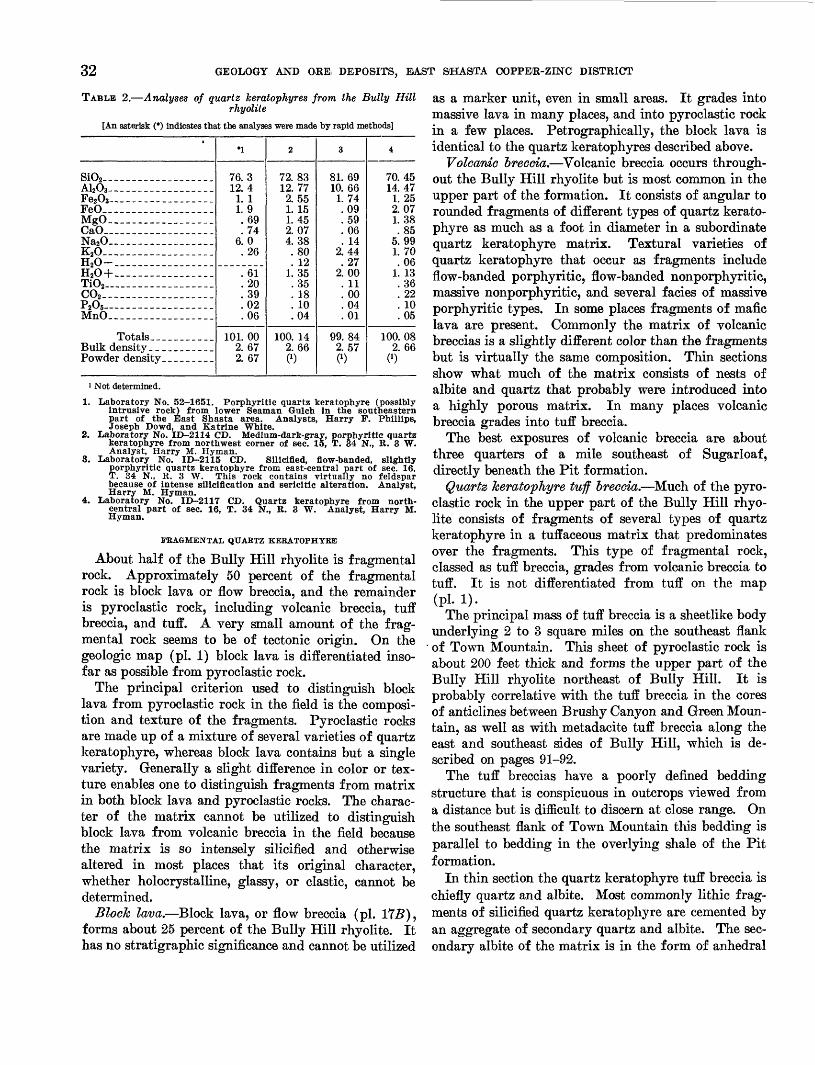
32 GEOLOGY AND ORE, DEPOSITS, EAST SHASTA COPPER-ZINC DISTRICT
TABLE 2. Analyses of quartz keratophyres from the Bully Hillrhyolite
[An asterisk (*) Indicates that the analyses were made by rapid methods]1
SiO2-________ -._....._.Al2O3---------_-__ -_.Fe2O3- -_- _ -._._.___FeO--_-_. ____________MgO_. __._._..___..._.CaO_-_-_--_-______-_.Na2O.__. .__-..._..._._K2O__-___-__-_-____-_.H20-._ .._... _________H20+._______________.Ti02 ______-_-___-____._CO2 __-__-_-______-_.__P_05_ _---_MnO---_----__________
Totals____ _ _ __Bulk density___________Powder density ____ .___
*i
76 312 4
1 11 9
6974
6 026
6120390206
101 002 672 67
2
72.8312. 772.551. 151. 452.074.38.80. 12
1. 35.35. 18. 10.04
100. 142.660)
3
81. 6910. 661.74.09.59.06. 14
2.44.27
2.00. 11. 00.04.01
99.842.570)
4
70.4514.47
1. 252.071.38.85
5.991.70.06
1. 13.36.22. 10.05
100. 082. 66
0)
1 Not determined.
1. Laboratory No. 52-1651. Porphyritic quartz keratophyre (possibly intrusive rock) from lower Seaman Gulch in the southeastern part of the East Shasta area. Analysts, Harry F. Phillips, Joseph Dowd, and Katrine White.
2. Laboratory No. ID-2114 CD. Medium-dart-gray, porphyritic quartz keratophyre from northwest corner of sec. 15, T. 34 N., R. 3 W. Analyst, Harry M. Hyman.
3. Laboratory No. ID-2115 CD. Silicified, flow-banded, slightly porphyritic quartz keratophyre from east-central part of sec. 16, T. 34 N., R. 3 W. This rock contains virtually no feldspar because of intense sllicificatlon and sericitic alteration. Analyst, Harry M. Hyman.
4. Laboratory No. ID-2117 CD. Quartz keratophyre from north- central part of sec. 16, T. 34 N., R. 3 W. Analyst, Harry M. Hyman.
FRAGMENTAL QUARTZ KEBATOPHYEE
About half of the Bully Hill rhyolite is fragmental rock. Approximately 50 percent of the fragmental rock is block lava or flow breccia, and the remainder is pyroclastic rock, including volcanic breccia, tuff breccia, and tuff. A very small amount of the frag mental rock seems to be of tectonic origin. On the geologic map (pi. 1) block lava is differentiated inso far as possible from pyroclastic rock.
The principal criterion used to distinguish block lava from pyroclastic rock in the field is the composi tion and texture of the fragments. Pyroclastic rocks are made up of a mixture of several varieties of quartz keratophyre, whereas block lava contains but a single variety. Generally a slight difference in color or tex ture enables one to distinguish fragments from matrix in both block lava and pyroclastic rocks. The charac ter of the matrix cannot be utilized to distinguish block lava from volcanic breccia in the field because the matrix is so intensely silicified and otherwise altered in most places that its original character, whether holocrystalline, glassy, or clastic, cannot be determined.
Block lava. Block lava, or flow breccia (pi. 1T5), forms about 25 percent of the Bully Hill rhyolite. It has no stratigraphic significance and cannot be utilized
as a marker unit, even in small areas. It grades into massive lava in many places, and into pyroclastic rock in a few places. Petrographically, the block lava is identical to the quartz keratophyres described above.
Volcanic breccia. Volcanic breccia occurs through out the Bully Hill rhyolite but is most common in the upper part of the formation. It consists of angular to rounded fragments of different types of quartz kerato phyre as much as a foot in diameter in a subordinate quartz keratophyre matrix. Textural varieties of quartz keratophyre that occur as fragments include flow-banded porphyritic, flow-banded nonporphyritic, massive nonporphyritic, and several facies of massive porphyritic types. In some places fragments of mafic lava are present. Commonly the matrix of volcanic breccias is a slightly different color than the fragments but is virtually the same composition. Thin sections show what much of the matrix consists of nests of albite and quartz that probably were introduced into a highly porous matrix. In many places volcanic breccia grades into tuff breccia.
The best exposures of volcanic breccia are about three quarters of a mile southeast of Sugarloaf, directly beneath the Pit formation.
Quartz keratophyre tuff breccia. Much of the pyro clastic rock in the upper part of the Bully Hill rhyo lite consists of fragments of several types of quartz keratophyre in a tuffaceous matrix that predominates over the fragments. This type of fragmental rock, classed as tuff breccia, grades from volcanic breccia to tuff. It is not differentiated from tuff on the map(PL v-. .
The principal mass of tuff breccia is a sheetlike body underlying 2 to 3 square miles on the southeast flank of Town Mountain. This sheet of pyroclastic rock is about 200 feet thick and forms the upper part of the Bully Hill rhyolite northeast of Bully Hill. It is probably correlative with the tuff breccia in the cores of anticlines between Brushy Canyon and Green Moun tain, as well as with metadacite tuff breccia along the east and southeast sides of Bully Hill, which is de scribed on pages 91-92.
The tuff breccias have a poorly defined bedding structure that is conspicuous in outcrops viewed from a distance but is difficult to discern at close range. On the southeast flank of Town Mountain this bedding is parallel to bedding in the overlying shale of the Pit formation.
In thin section the quartz keratophyre tuff breccia is chiefly quartz and albite. Most commonly lithic frag ments of silicified quartz keratophyre are cemented by an aggregate of secondary quartz and albite. The sec ondary albite of the matrix is in the form of anhedral
GENERAL GEOLOGY AND GEOLOGIC HISTORY 33
grains averaging 0.05 to 0.1 mm in diameter. Many grains show imperfectly formed Carlsbad twins whose exact position of extinction is difficult to determine. Albite and pericline-acline twins were not observed. In a few places the diversely oriented grains of sec ondary albite seem to have recrystallized to untwinned albite porphyroblasts as much as 0.5 mm across sieved with tiny blebs of quartz. A few albite porphyro blasts, which apparently achieved a more advanced stage of growth, show checkerboard twinning.
The quartz phenocrysts, which are probably the only original mineral remaining in the rock, are commonly fractured and strung out in trains. The fragmented quartz crystals are cemented by secondary quartz whereas fractured albite crystals are cemented by albite. Partial replacement of abite phenocrysts by optically continuous quartz of probable late mag- matic origin, forming vermicular intergrowths of quartz and albite, is common. In its replacement of the albite the quartz seems to have been guided to some extent by crystallographic directions in the feldspar.
Tuff. Tuff and lapilli tuff make up about 5 percent of the Bully Hill rhyolite, forming lenticular beds and poorly defined bodies that grade vertically into tuff breccia.
Tuff is mapped separately on the geologic map but lapilli tuff either forms bodies too small to be mapped separately or is so intimately mixed with tuff breccia that it could not be differentiated.
Tuff beds, some of which are well bedded and others that are poorly bedded, range from a few inches to about 50 feet in thickness and are as much as half a mile in strike length. In color they range from light brown ish gray to dark gray. The tuff is most common in the southeastern part of the mapped area and in the Bully Hill area.
In well-bedded tuff the bedding is shown by slight differences in grain size and color between adjacent layers. Clasts of quartz and tiny pellets of lava, each crudely concentrated in discrete layers, are the princi pal components of most tuff.
Lapilli tuff occurs in close association with and is commonly gradational into coarse-grained tuff.
Metadacite tuff and tuff breccia. Possibly 5 percent of the pyroclastic rock in the Bully Hill rhyolite ap proximates the composition of metadacite. This rock cannot be distinguished from quartz keratophyre pyro clastic rocks in the field and is not delineated on plate 1. Thin sections show that it occurs mainly along the east and southeast sides of Bully Hill in a zone about parallel to the stratification. Metadacite pyroclastic rocks may occur elsewhere in the Bully Hill rhyolite but have not been found.
The metadacite fragments in these pyroclastic rocks are olive gray to medium greenish gray. Microscopic examination shows that they consist of quartz, albite, plagioclase ranging in different specimens from calcic oligoclase to calcic andesine An27.4g, chlorite, fine grained white mica, sphene, and leucoxene. The tex ture is commonly porphyritic, with a xenomorphic mi- crocrystalline groundmass. Quartz and plagioclase form phenocrysts; some vermicular intergrowths of quartz and plagioclase resemble phenocrysts in hand specimen. The plagioclase commonly shows oscillatory zoning, and the cores are slightly more calcic than rims. In all slides, veinlets and irregular masses of clear, untwinned albite partly replace the plagioclase phenocrysts. The groundmass of the metadacite pyro- clastics is commonly anhedral microcrystalline quartz.
Mafic lava and pyroclastic rock. A few lenses of mafic lava and pyroclastic rocks are interstratified with the light-colored siliceous rocks of the Bully Hill rhyolite but make up less than 5 percent of the forma tion. Most of the mafic lava is in the southeastern part of the area between Little Cow Creek and Backbone Eidge (pi. 1). This mafic lava is indistinguishable petrographically from the mafic lava of the Dekkas andesite. Amygdaloidal structure is common. Chlo rite, albite, sphene, leucoxene, and calcite are the chief minerals.
Mafic pyroclastic rocks, including volcanic breccia and tuff breccia, are interbedded with silicic rocks in the upper part of Seaman Gulch, on the east flank of Town Mountain, and in the vicinity of Brushy Canyon. Fragments in these pyroclastic rocks are chiefly kerato phyre; a few light-colored fragments are quartz kera tophyre. The matrix of some mafic pyroclastic rocks contains clasts of quartz.
COLUMNAR STRUCTURE
Columnar structure, consisting generally of 4-, 5-, and 6-sided columns occurs locally in the porphyritic and nonporphyritic quartz keratophyres. It is most conspicuous in nonporphyritic quartz keratophyre in the Afterthought mine area and in porphyritic quartz keratophyre on the south flank of Town Mountain (pi. 1).
The columns are of two sizes. Some columns have cross-sectional diameters averaging about 6 inches; others, which are more common, have diameters rang ing from 1 to 2 inches. Larger columns show an in ternal fracture pattern that causes them to break down into columns in the smaller size range. The columns are rarely straight but commonly have a sinuous form. In some outcrops the orientation of neighboring groups of columns differs by as much as 90° within a few feet. Individual columns or groups of columns
34 GEOLOGY AND ORE DEPOSITS, EAST SHA8TA COPPER-ZINC DISTRICT
are as much as 10 feet long but most columns fade out or become fragmented and brecciated within a few feet. Petrographically, the quartz keratophyres with prismatic structure are identical to those in which the structure is absent.
Presumably the prismatic columns formed in re sponse to the contraction of cooling lava and are ori ented normal to the surface of cooling. The sinuous form of many columns and the markedly diverse orien tation of neighboring groups of columns within short distances may have resulted of slight movements in the lava when it was nearly consolidated. Or, if the Bully Hill rhyolite was extruded partly into the sea as seems probable, the diversely oriented columns may have resulted from many different cooling centers that would likely occur in the extruded lava under subma rine conditions. Slight fragmentation and brecciation of the columns in many places may also be in part attributed to minor movements of the lava after it was almost solidified, but intensely brecciated phases of quartz keratophyre with columnar structure probably result mainly from shearing during orogenesis.
VERMICULAR INTERGROWTHS OF QUARTZ AND PLAGIOCLASE
The porphyritic facies of the Bully Hill rhyolite contains vermicular intergrowths of quartz and pla- gioclase that commonly have euhedral outlines. In thin section these intergrowths consist of discrete ver miform masses of quartz that extinguish simultane ously under crossed nicols. The largest vermicular intergrowths may consist of two or three such masses of quartz, each mass extinguishing at a different posi tion. Discrete bodies of plagioclase interstitial to ver miform masses of quartz also extinguish simultane ously and represent single crystals in which twinning and even oscillatory zoning is preserved. In quartz keratophyres the plagioclase is albite, whereas in met- adacites it is oligoclase or andesine. Plate 19 J., B show typical quartz-feldspar intergrowths.
Evidence suggests that the vermicular quartz is a replacement of plagioclase rather than an eutectic in- tergrowth owing to the exceedingly irregular pattern of the quartz in the plagioclase and the vastly different proportions of quartz and plagioclase in the inter growths (pis. 19; A, B\ 20). Many intergrowths con sist of only 20 to 25 percent quartz, whereas others are at least 90 percent quartz. A few plagioclase pheno- crysts may be completely replaced by quartz.
A late magmatic rather than hydrothermal origin for the vermicular quartz is postulated because it oc curs in rocks having both silicified and unsilicified groundmasses. There is no correlation between the
degree of replacement of a feldspar crystal by ver micular quartz and the intensity of silicification of the groundmass. Moreover, inasmuch as vermicular inter growths and clasts thereof are common in pyroclastic rocks, it seems likely that the intergrowths formed before the material was ejected from the volcano (pi. 20).
In silicified phases of the Bully Hill rhyolite the feldspar of vermicular intergrowths, as well as the groundmass, is commonly replaced by secondary, mi- crocrystalline quartz, leaving vermiform quartz masses that extinguish simultaneously, surrounded by micro- crystalline quartz. Key thin sections (pi. 19A) show that the microcrystalline quartz has actually replaced plagioclase.
ORIGIN
The origin of the Bully Hill rhyolite, like the origin of the Balaklala rhyolite, has been a subject of con troversy among geologists who have worked in the area. Diller (1906, p. 8) described the formation as a series of flows and tuffs that dip beneath shale of the Pit formation; but he states that the Bully Hill rhyo lite locally cuts the shale and envelopes its fragments. Fairbanks (1893, p. 32) also noted the tuffaceous char acter of the rock later named the Bully Hill rhyolite and he also believed it to be mainly extrusive.
Graton (1910, p. 82), after making a study of the mines in the Shasta copper district, concluded that the Bully Hill rhyolite, as well as the Balaklala rhyolite, intruded their surrounding rocks; he refers to the siliceous rocks comprising these two formations as "alaskite" and "alaskite porphyry." Most geologists who have worked in the area since Graton (Boyle, 1915, p. 69; Hinds, 1933, p. 107-109; and others) re garded Bully Hill rhyolite and the Balaklala rhyolite as intrusive masses of similar age and character.
The writers conclude that the Bully Hill rhyolite, like the Balaklala rhyolite, is chiefly of extrusive ori gin. The main reasons for this conclusion are:1. The abundance, throughout the section, of bedded
pyroclastic rock interlayered with fine-grained rocks many of which are flow banded.
2. The general lack of intrusive contact relations to the enclosing sedimentary and volcanic forma tions, especially to the overlying Pit formation. Bodies of quartz keratophyre that are demon- strably of intrusive origin are restricted to the Dekkas andesite and to the Bully Hill rhyolite itself. They do not occur in the overlying Pit formation although pyroclastic rock and lava typical of the Bully Hill rhyolite is interstrati- fied with shale in the Pit formation. If the Bully

GEOLOGICAL SURVEY PROFESSIONAL PAPER 338 PLATE 17
A. PHOTOMICROGRAPH OF PORPHYRITIC QUARTZ KERATOPHYRE FROM EASTERN PART OF SEC. 30, T. 34 N., R. 4 W.
Note the angular albite phenocrysts (a), and embayed quartz phenocrysts (g) in groundmass of albite laths, microcrystalline quartz, and minor fine-granedwhite mica.
B. BLOCKY NONPORPHYRITIC QUARTZ KERATOPHYRE
On ridge above the Copper City mine in the SW1̂ sec. 21, T. 34 N., R. 3 W. Dark material (L) is limonite that replaces discrete blocks as well
as the hreccia matrix.

GEOLOGICAL SURVEY PROFESSIONAL PAPER 338 PLATE 18
A. PHOTOMICROGRAPH OF GLOMEROPORPHYRITIC KERATOPHYRE
Phenocrysts are nearly pure albite. Groundmass is albite laths with interstitial chlorite.
B. PHOTOMICROGRAPH OF PORPHYRITIC, AMYGDALOIDAL SPILITE WITH PILOTAXITIC GROUNDMASS
Principal minerals are albite (a), chlorite (cl), pumpellyite (p), and quartz (q) which fills centers of amygdules. Black grains are magnetite,
which is disseminated throughout the rock. Some calcite is present.

GEOLOGICAL SURVEY PROFESSIONAL PAPER 338 PLATE 19
A. PHOTOMICROGRAPH OF METADACITE PYROCLASTIC ROCK
Phenocrysts are quartz (5),calcic oligoclase (o), and vermicular intergrowtlls of the two minerals. The vermicular quartz, a replacement of plagio- clase, is probably late magmatic. Groundmass is anhedral microcrystalline quartz of hydrothermal origin that replaces plagioclase of vermicular intergrowths. leaving vermicular quartz embedded in a groundmass of microcrystalline quartz.
B. VERMICULAR RELATION BETWEEN QUARTZ (q) AND ALBITE (a) IN QUARTZ KERATOPHYRE
Near A and B the microcrystalline groundmass has partly replaced the albite of the intergrowth. Compare with (A), photomicrograph
of metadacite pyroclastic rock.

GEOLOGICAL SURVEY PROFESSIONAL PAPER 338 PLATE 20
A. VERMICULAR QUARTZ IN QUARTZ KERATOPHYRE TUFF
Groundmass is secondary quartz and albite that partly replaces ragged albite crystals. The vermiform quartz (q) is a replacement of plagioclase (a). The plagioclase of the intergrowth has been replaced by the secondary groundmass, leaving the irregular quartz. Compare with plate 19.
B. CROSSCUTTING, IRREGULAR CONTACT BETWEEN THE PIT RIVER STOCK AND THE BAIRD FORMATION
Bedding in the tuffaceous rocks of the Baird dips gently to the right. Blocks of the Baird are enclosed in the stock a few hundred feet
to right of photograph. Railroad cut is about 30 feet high.

GENERAL GEOLOGY AND GEOLOGIC HISTORY 35
Hill rhyolite were of intrusive origin one would expect to find apophyses in the overlying forma tion.
3. The Bully Hill rhyolite is not thick compared to its great lateral extent. Including the part that is presumably covered by the Pit formation, the Bully Hill rhyolite must have an areal extent of at least 35 to 40 square miles in the map area, and judging from Diller's regional map (1906, geol. map) it probably underlies a total of at least 100 square miles. The thickness, however, ranges from less than 100 to about 2,500 feet. A tabular intrusive body of this size and shape, and consisting of such heterogeneous lithology, seems highly improbable. On the other hand, considera tion of the Bully Hill rhyolite as a volcanic pile of silicic lavas and pyroclastic rocks or more prob ably a group of interfingering and overlapping piles of volcanic rocks, with subordinate feeder dikes and plugs, seems much more reconcilable with the facts.
Kinkel and others (1956 [1957], p. 31-32), after mapping the Balaklala rhyolite in the West Shasta copper-zinc district at a scale of 1:24,000 and studying its lithologic and structural relations in commensurate detail, have also concluded that the Balaklala is largely of extrusive origin.
Differences in thickness and lithology suggest that the lavas and pyroclastic rocks of the Bully Hill rhyo lite were probably ejected from more than one vent. In the Bully Hill-Town Mountain area the volcanic rocks may have come from, a vent about a half a mile northeast of Bully Hill. This is suggested by (a) the heterogeneous lithology (pi. 1), (b) by the abundance of pyroclastic material, (c) by the great thickness in the vicinity of Bully Hill compared to the thickness in nearby areas, and (d) by the presence in the north- central part of sec. 15, T. 34 N., R. 3 W., of a mass of flow-banded quartz keratophyre the banding of which dips mostly inward toward the center of the mass sug gesting a cumulo dome. A second volcanic center may have been about a mile southwest of Sugarloaf where pyroclastic material is also abundant and where a great variety of rock types is present.
AGEThe Bully Hill rhyolite overlies the Dekkas ande-
site which is at least partly of Permian age, with ap parent conformity and is overlain conformably by the Pit formation of Middle and Late Triassic age. These relations indicate that silicic volcanic material of the Bully Hill rhyolite was being erupted intermittently through a long interval of time. The Bully Hill rhyo lite is considered to be of Triassic age.
553967 61 4
PIT FORMATION
GENERAL CHARACTER AND DISTRIBUTION
The Pit formation, which consists principally of shale, mudstone, and pyroclastic rocks, and includes subordinate siltstone, limestone, and lava, underlies a crudely triangular area covering about 25 square miles in the northeastern part of the area (pi. 1). As orig inally defined by Fairbanks (1894, p. 28) and Smith (1894, p. 601-604) the "Pitt formation" included all sedimentary rocks that lay stratigraphically between the McCloud limestone and the Hosselkus limestone, whereas the "Pitt shale" applied to the sedimentary rocks of Triassic age beneath the Hosselkus limestone. Diller (1906, p. 4) restricted the Pit formation to the sedimentary and pyroclastic rocks lying above the Bully Hill rhyolite and Dekkas andesite and beneath the Hosselkus limestone. Diller's definition of the Pit formation is followed in this report, except that three small bodies of limestone and one mass of lava near the east-central edge of the area, which Diller cor relates with the Hosselkus limestone and with the Bully Hill rhyolite, respectively, are here included in the Pit formation.
STRATIGRAPHIC RELATIONS AND THICKNESS
The Pit formation overlies the Bully Hill rhyolite everywhere in the area except in the vicinity of Cove Creek where it overlies the Dekkas andesite with ap parent structural discordance (pi. 1). The contact between the Pit formation and the underlying volcanic units is drawn at the base of the lowest bed of shale. In many places, however, shale intertongues with pyro clastic rocks of the Bully Hill rhyolite, showing that the Pit formation and Bully Hill rhyolite are at least in part contemporaneous in age.
The intertonguing of the Pit formation and the Bully Hill rhyolite leads locally to ambiguity and un certainty in determining the contact between the two units. This is especially true on the lower part of the peninsula between the Squaw Creek and Pit Kiver arms of Shasta Lake and it is not known with cer tainty whether the quartz keratophyre breccias and tuffs exposed in the cores of anticlines (pi. 1) belong to the Bully Hill rhyolite or whether they are merely layers of pyroclastic material in the Pit formation underlain by more shale. The large mass of metada- cite and quartz keratophyre about a mile northeast of the Afterthought mine is mapped as a flow in the Pit formation but it may be part of the Bully Hill rhyo lite. However, the pyroclastic rock in the cores of these anticlines consists mostly of coarse f ragmental mate rial more typical of pyroclastic rocks in the Bully Hill rhyolite and therefore is correlated with that forma tion.

36 GEOLOGY AND ORE DEPOSITS, EAST SOHASTA COPPER-ZINC DISTRICT
The apparent structural discordance between the Pit formation and the Dekkas andesite in the Cove Creek area is a local feature contradictory to relations seen in other parts of the area that suggest structural con cordance between the Dekkas andesite and the Bully Hill rhyolite and between the Bully Hill rhyolite and the Pit formation. A possible explanation for the local structural discordance in the Cove Creek area is that volcanic material of the Dekkas andesite was de posited with steep initial dips and later was covered discordantly by sediments of the Pit formation.
The thickness of the Pit formation is difficult to estimate because the rocks are closely folded in most places and because of the intertonguing of the Bully Hill rhyolite with the Pit. However, a section drawn from Second Creek east to Gray Rocks, the only place where the top of the Pit formation is exposed, sug gests a thickness of about 5,000 feet (pi. 1, section B- Bf ). Diller (1906, p. 4) estimated the thickness to be "somewhat over 2,000 feet."
LITHOLOGY
SHALE, MUDSTONE, AND SILTSTONE
About 60 to 70 percent of the Pit formation is shale, mudstone, and siltstone, undifferentiated on plate 1. These rocks occur throughout the formation but they are probably more abundant in the upper than in the lower part. Shale and mudstone form beds that range from a fraction of an inch to about 2 feet in thickness; individual beds are separated by planes of parting or by slight color differences. Siltstone, which is much less abundant than shale and mudstone, forms beds as much as 6 feet thick. The color of the shale, mudstone, and siltstone ranges from medium gray to black on fresh surfaces; weathered exposures are commonly me dium dark gray. Some shale beds have a faint lami nation. Poorly preserved fossils are fairly common in some of the darker shale beds. Round or oblate concretions as much as 3 inches in diameter occur locally in fossil-bearing beds.
At least two beds of mud-pellet conglomerate are interbedded with shale west of Green Mountain. These beds range from 1 to 3 feet in thickness and have a strike length of about 1 mile.
Thin sections show that the beds of shale and mud- stone are composed principally of anhedral microcrys- talline quartz, carbonaceous material, and fine-grained white mica. Quartz commonly makes up more than 50 percent of most thin sections. Much of the quartz occurs in irregular clots. Dark-brown to black car bonaceous material forms cloudy masses that locally coalesce into larger elongate masses along bedding planes. Fine-grained white mica, kaolinite, leucoxene, chlorite, pyrite, hematite, and limonite, are minor com
ponents of irregular distribution. In addition, a few beds of shale and mudstone contain sparse, tiny clasts of quartz and feldspar. The clasts average about 0.05 mm across, are markedly angular, and are subordinate to the matrix in all slides examined. Rocks that con tain as much as 10 or 15 percent of clastic quartz and feldspar clasts are classed as siltstones. In some silt- stones the feldspar clasts are albite, whereas in others they are andesine or labradorite. One type of silt- stone, which forms a bed about 25 feet thick, contains abundant evenly distributed oval white spots about 1 mm in diameter, composed of aggregates of anhedral microcrystalline quartz.
PYBOCLASTIC BOOKS
About 20 percent of the Pit formation is pyroclastic rock, including crystal and lithic tuff, and tuff breccia. These volcanic rocks form beds ranging from a few inches to more than 100 feet in thickness. They are interlayered with shale, mudstone, and siltstone throughout the formation, and with quartz kerato- phyre and metadacite lava locally in the lower part. It was not possible to separate the lavas from the pyroclastic rocks everywhere in the field, and therefore some lava is included with the pyroclastic rocks shown on plate 1, especially in the lower part of the forma tion southwest of Bully Hill and also northeast of the Afterthought mine. In the Susanville Canyon-Brock Mountain area the outcrop pattern of volcanic rocks in the Pit formation could not be determined owing to poor outcrop and marked lensing of the beds.
The pyroclastic rocks are commonly medium gray to dark greenish gray on fresh surface but weather to tannish gray or light gray. The tuff breccias and lithic tuffs consist chiefly of quartz keratophyre, kera- tophyre, metadacite, shale, and mudstone fragments in a tuffaceous matrix. The fragments of volcanic rocks range from well rounded to angular, whereas most shale and mudstone fragments are elongate. Volcanic rock fragments range from a fraction of an inch to about 6 inches in diameter, whereas some shale and mudstone fragments are as much as several feet in maximum dimension. Bedding is uncommon in most tuff breccias and lithic tuffs.
The crystal tuffs and lithic-crystal tuffs consist chiefly of plagioclase clasts and also contain sparse quartz crystal clasts and lithic fragments in a siliceous or chloride matrix. The crystal clasts are as much as 5 mm in diameter in some beds but the average grain size of most beds is about 1 mm. Within a given bed the clasts are predominantly the same size, al though a few beds show graded bedding. Plagioclase and quartz clasts greatly predominate over the matrix in all the crystal tuffs.

GENERAL GEOLOGY AND GEOLOGIC HISTORY 37
Thin sections show that the crystal tuffs and lithic- crystal tuffs are of two main compositional types, metadacite and quartz keratophyre. These composi tional types cannot be differentiated in the field. A metadacite crystal tuff from the NWi/4 of sec. 22, T. 34 N., R. 2 W., which is typical of the group, consists largely of plagioclase clasts mixed with a few quartz crystal clasts and sparse lithic fragments, in a matrix of chlorite, fine-grained white mica, macrocrystalline quartz, calcite, sphene, leucoxene, pyrite, and limonite. The plagioclase clasts range in composition from An30 to An53. Many show normal oscillatory zoning; others are extensively veined and replaced by untwinned albite.
The quartz keratophyre crystal tuffs differ from the metadacite tuffs in that the feldspar clasts are poorly twinned albite rather than plagioclase of intermediate composition partly replaced by albite, and the matrix is commonly macrocrystalline quartz or microcrystal- line albite. Other secondary minerals in the matrix are chlorite, fine-grained white mica, calcite, leucoxene, sphene, pyrite, and limonite. The proportion of quartz crystal clasts to feldspar clasts is about the same in the quartz keratophyre tuffs as in the metadacite tuffs. One specimen of crystal tuff from the upper part of Norton Gulch is unusual in that albite clasts are clouded with tiny grains of clinozoisite.
LAVA FLOWS
Quartz keratophyre and metadacite lava forms 5 to 10 percent of the Pit formation exposed in the area. The largest body of lava underlies about 1 square mile centering in sec. 2, T. 33 N., R. 2 W.; several smaller bodies crop out near the end of the peninsula between the Squaw Creek and Pit 'River arms of Shasta Lake. Other lava flows, not separable from pyroclastic rocks, are in the lower part of the Pit formation south of Bully Hill and north of the Afterthought mine.
The mass of lava, centered mostly in sec. 2, T. 33 N., R. 2 W., is principally massive rock containing abun dant, unevenly distributed feldspar phenocrysts as much as 6 mm in diameter, and less abundant quartz phenocrysts in a medium-gray to dark greenish-gray, aphanitic groundmass. Sparse, subrounded fragments of mafic lava measuring a few inches in diameter are irregularly distributed throughout the mass. Locally, the rock is composed entirely of fragments.
Thin sections show that the mineralogy of the vol canic rock underlying sec. 2 and adjoining areas differs markedly from place to place but the textures remain about the same. Near the northwest end of the unit the rock contains albite and quartz phenocrysts as much as 5 mm in diameter, and augite micropheno- crysts as much as 0.5 mm in diameter, in a felty
groundmass of albite laths, chlorite, sphene, and leu coxene. Minor amounts of calcite, prehnite, and pyrite replace other minerals in some slides.
About 1,000 feet north of U.S. Highway 299E, in the north-central part of sec. 2, the lava contains phenocrysts of oscillatory zoned plagioclase (compo sition about An50), a few quartz phenocrysts, 20 to 25 percent chlorite, 10 to 15 percent calcite, and a small amount of sphene and leucoxene. Albite, chlorite, and calcite replace plagioclase phenocrysts; anhedral, macrocrystalline albite forms part of the groundmass. Specimens showing similar mineralogy were collected from the extreme eastern part of sec. 2 and from the western part of sec. 1, T. 33 N., R. 2 W.
Thin sections of material from road cuts along U.S. Highway 299E, in the same body of lava, consist chiefly of quartz and albite phenocrysts in a ground- mass of anhedral, macrocrystalline quartz and chlorite.
Some of the quartz keratophyre lava flows near the end of the peninsula between the Squaw Creek and Pit River arms are underlain by shale (pi. 1) and are therefore mapped as part of the Pit formation. They are light-green to light-olive-gray rocks containing sparse, tiny quartz phenocrysts, and rounded feldspar crystals as much as 3 mm in diameter. Much of this lava has a closely spaced, platy parting that parallels the bedding in adjoining shale beds.
Thin sections show that this lava contains sparse, strongly corroded quartz and albite crystals in a trachitic groundmass of albite laths and interstitial quartz. Minor components include chlorite, celadonite, sphene, leucoxene, fine-grained white mica, and limo nite. The feldspar forming phenocrysts is nearly pure albite.
LIMESTONE
Several lenses of light-gray limestone containing abundant fossils are exposed in the extreme east-central part of the area, north of U.S. Highway 299E. The limestone lenses range in size from beds 1 foot thick and 10 feet long to beds 100 feet thick and at least 2,000 feet long. Individual lenses are separated by shale. Some beds within the limestone lenses are as much as several feet long, and are composed chiefly of small brachiopods, ammonites, and belemnites.
The limestone was correlated with the lithologically similar Hosselkus limestone by Diller (1906, p. 4-5) but it is here considered as part of the Pit formation because: (a) the limestone is interbedded with shales and tuffs that are indistinguishable from those of the Pit formation; (b) the age of fauna in the limestone lenses is Middle Triassic, whereas the Hosselkus lime stone according to Diller (1906, p. 5) is of Late Tri assic age.

38 GEOLOGY AND ORE, DEPOSITS, EAST SHASTA OOPPER-ZINC DISTRICT
CONDITIONS OF DEPOSITION
Deposition of the Pit probably took place in the neritic depth zone as is indicated by ammonites and other shallow-water marine organisms throughout the formation. The abundance of volcanic material, espe cially the viscous silicic flows in the lower part of the formation, necessitates the proximity of vents, and therefore a sea of deposition containing scattered vol canoes is postulated. The distribution and composi tion of volcanic rocks suggest that the same vents from which the Bully Hill rhyolite was extruded were the source of the volcanic material in at least the lower part of the Pit formation. One vent was probably in the vicinity of Bully Hill, another was northeast of the Afterthought mine, and a third was near the end of the peninsula between the Squaw Creek and Pit Eiver arms of Shasta Lake. Whether these same vol canoes were intermittently active throughout Pit time is not known.
AGE AND FAUNA
Collections of fossils from shale and limestone beds in the Pit formation are reported by John B. Eeeside (written communication, 1951) as follows:
The preservation of much of the material is such as to leave identification uncertain. Nevertheless, it is my best judgment that it is of Middle Triassic age. J. P. Smith re ports both Upper and Middle Triassic from the Pit shale, but I do not find here the forms he reports for Upper Triassic.
A list of the fossils determined by Eeeside follows. Numbered localities are shown on plate 1.
Locality No.
C-120
C-213
USGSNo. Lithology
23313 Mudstone frag ments in tuff.
23314 Limestone..-_--
C-214
C-435 C-856 D-273
D-572 D-646
E-139
23315 Limestone-
23316 Shale.._.23317 _____do.23318 ___..do.
23319 _._..do.23320 _._..do.
23321 _._do.
Fauna
Juvenile ammonites, un determined.
Small rhynchonellid brachiopods, unnamed.
Eutomoceras? sp.Arcestes (Proarcestes) sp.Ceratites? cf. C. occiden-
talis Smith.Ceratites? sp.Ceratites (Paraceratites)?
sp.Arcestes (Pararcestes)? sp.Daonella sp.Arcestes (Proarcestes)? sp.Indeterminable fragments
of ammonites.Eutomoceras? sp.Undetermined impressions
of ammonites.Algae(?), undetermined.Monotisl sp.Arcestes (Proarcestes)? sp.Tropigastrites? sp.
Two additional collections from the SW1̂ sec. 36, T. 34 N., E. 4 W. (loc. E-434 and E-437) were ex amined by S. W. Muller (oral communication, 1951)
of Stanford University, who reported the following fauna:HalobiaTrachycerasTracliyceras?
Dr. Muller believes the evidence to be fairly substan tial that this material is of Late Triassic age. There fore, the general area about sec. 36 may have been a topographic high during Middle Triassic time for the beds containing these fossils are less than 50 feet above the base of the Pit formation at this locality.
HOSSELKUS LIMESTONE
The Hosselkus limestone, of Late Triassic age (Dil- ler, 1906, p. 5), is exposed at the northeast boundary of the area, where it seems to conformably overlie the Pit formation. Superficially, the Hosselkus resembles the limestone in the Pit formation near the southeast edge of the area, north of the Afterthought mine, but the Hosselkus lithology was not studied in detail.
INTRUSIVE ROCKS
Intrusive rocks in the East Shasta area include, in addition to the minor intrusive phases of the Balaklala rhyolite, Bully Hill rhyolite, and Dekkas andesite already described; (a) a small stock of coarse-grained light-colored rock called the Pit Eiver stock; (b) an elongate irregular mass of medium- and fine-grained quartz diorite that surrounds the McCloud limestone; (c) abundant tabular bodies of quartz diorite, diorite, and metadiabase; and (d) a few tabular bodies of granodiorite and aplite. Virtually all the intrusive rocks except a few dikes at Bully Hill are west of the belt of volcanic rocks underlying Horse and Town Mountains.
PIT RIVER STOCK
LOCATION AND RELATION TO ADJACENT BOCKS
The Pit Eiver stock (Hinds, 1933, p. 106) is a plutonic body about 3 miles long and 1 mile wide, extending into the area from the south. The northern part of the stock underlies about iy2 square miles near the Pit bridge. The stock consists chiefly of coarse-grained, light-colored granodiorite and albite granite. In some places it contains abundant inclusions of mafic hybrid rocks having the composition of hornblende quartz diorite. The Pit Eiver stock is part of the quartz horn blende diorite of Diller (1906, p. 8) and is lithologically similar to a much larger plutonic body, the Mule Moun tain stock (Hinds, 1933, p. 105; Kinkel and others, 1956 [1957]) in the West Shasta copper-zinc district.
The stock cuts the Baird formation with a trans- gressive contact. This contact is well exposed in rail road cuts just north of the Pit bridge where bedding

GENERAL GEOLOGY AND GEOLOGIC HISTORY 39
in slightly hornfelsed mudstone and tuff of the Baird dips gently southeast, and the irregular, crosscutting contact dips north. Small apophyses of the stock ex tend at least 50 feet into the Baird, and blocklike bodies of mudstone and tuff protrude into the plutonic rock (pi. 20Z?). In some places 'the plutonic body is slightly finer grained near the contact but more commonly it is not.
An extension of the Pit River stock to the north beneath O'Brien Mountain is suggested by the north ward dip of the contact at the Pit bridge, and by the abundant dikes of quartz diorite, granodiorite, dacite porphyry, and aplite, and abundant quartz veins on O'Brien Mountain.
LITHOLOGY AND PETROGRAPHY
The Pit River stock is principally light colored, granitoid rock composed of feldspar, quartz, and sub ordinate ferromagnesian minerals. The average grain size is 2 to 3 mm, but some f acies have a pseudopor- phyritic texture formed by the occurrence of irregular bodies of milky quartz as much as 1 cm across con taining poikilitic inclusions of feldspar. The micro scope shows that most of the light-colored rock is granodiorite and albite granite. These two phases are transitional and not distinguishable in hand specimen.
South of the Pit bridge the stock contains abundant xenoliths of intermediate and mafic holocrystalline rocks ranging from about 1 inch to as much as 50 feet in diameter. Most of the xenoliths are well rounded but a few are subangular. They show marked varia tions in mineralogy, grain size, and fabric. Most have the composition and texture of hornblende quartz diorite but some are inclusions of the Baird formation recrystallized to hornfels, and there are many inter mediate types. All the inclusions could have been de rived from the Baird formation.
Sharp-walled aplite dikes, ranging from a few inches to a foot in thickness, cut marginal parts of the stock and adjacent wallrocks.
GBANODIOBITE
Thin sections show that the granodiorite is typically 30 to 40 percent plagioclase (An25-An37 ), 10 to 20 per cent microperthite, 35 to 45 percent quartz, 10 percent hornblende and biotite, and minor apatite, magnetite, chlorite, fine-grained white mica, and epidote. The texture is hypidiomorphic granular, poikilitic, with tendency toward porphyritic development of the plagioclase.
The plagioclase occurs as subhedral grains that commonly show normal oscillatory zoning, with slight difference in composition between cores and rims. Some crystals, however, have irregular rims of nearly pure albite, and others are slightly veined by albite.
The origin of the albite is probably either deuteric or hydrothermal.
Microperthite, consisting of orthoclase containing tiny veinlets of albite parallel to crystallographic di rections is interstitial to and forms a rim around some plagioclase crystals and occurs as unreplaced remnants in quartz.
TABLE 3. Analysis of partly albitized granodiorite from the Pit River sfocfc1
[Lab. No. 52-1657; field No. B-76. Analysts, Harry F. Phillips, Joseph Dowd, and Katrine White]
Percent SiO* ____ 74.0
Percent Na2O ___ 3.8
A12O3 _____ 13.4Fe2O3 ___ 1.3FeO _________ 1.2MgO __________ .62CaO __________ 3.0
Bulk density _____ 2.61
K2O ______TiO* _ P20B _____ MnO _____Ignition 88
2.0 .30 .01 .04 .69
Total _____ 100 Powder density 2.66
1 Analysed by rapid methods.8 Includes gain due to oxidation of FeO.8 Includes 0.06 percent COs.
Quartz forms poikilitic crystals as much as 1 cm across and shows diverse relations to other minerals, especially feldspar. Optically continuous quartz is interstitial to and encloses small euhedral crystals of plagioclase. Much of the quartz seems to replace feldspar. It encroaches on feldspar crystals as lobe- shaped embayments and encloses irregular remnants of microperthite that have a common orientation.
Green hornblende and brown biotite are about equal in over-all abundance but their relative abundance differs greatly from place to place. The biotite is in part an alteration after hornblende. Some grains of hornblende show blotches of blue especially near their ends in the Z' vibration direction. This suggests an appreciable amount of Na2O in the amphibole. Minor chlorite and epidote are alteration minerals after bio tite and hornblende.
HOBNBLENDE QUARTZ DIOBITE
Hornblende quartz diorite occurs in the Pit Eiver stock mainly as inclusions in different stages of assimi lation and recrystallization, and hence the varietal name hornblende quartz diorite includes diverse tex- tural and mineralogical types. Thin sections show that most coarser grained inclusions consist of 40 to 50 percent plagioclase (Angg-Anue), 25 to 35 percent quartz, 25 to 35 percent hornblende, and minor ortho clase, biotite, magnetite, fine-grained white mica, chlo rite, and epidote. The texture is hypidiomorphic granular, poikilitic; irregular-shaped quartz crystals as much as 1 cm across enclose plagioclase, hornblende, and magnetite. The plagioclase is in the form of euhedral and subhedral crystals many of which show normal oscillatory zoning. Hornblende forms sub-
40 GEOLOGY AND ORE, DEPOSITS, EAST SHA8TA COPPER-ZINC DISTRICT
hedral grains and has the following optical properties: Extinction angle Z Ac 11°; optically ( ); 2F=82°; X pale green, Y moderate green, Z brownish green. Chlorite and epidote are minor alteration products of the amphibole.
Some specimens of hornblende quartz diorite are partly albitized. In a porphyritic facies containing phenocrysts 2 to 3 mm across and smaller crystals 0.3 to 0.5 mm across the smaller grains are nearly pure albite, poorly twinned, and clouded with white mica, whereas the phenocrysts show oscillatory zoning and have an average composition of An45. In a few places around the edges of phenocrysts the andesine is re placed by albite.
ALBITE GRANITE
Granodiorite locally grades into albite granite, a light-colored rock similar in hand specimen to the granodiorite. Thin sections show that the albite gran ite consists of about 45 percent albite, 40 percent quartz, 5 percent biotite, and minor chlorite, epidote, sphene, leucoxene, celadonite, fine-grained white mica, kaolinite, and rutile. The texture is xenomorphic granular. The albite is twinned according to Carls bad, albite, and pericline-acline twinning laws, but some grains are very poorly twinned, with irregularly spaced, discontinuous lamellae. Extinction angles X'A G i*1 the zone normal to (010) range from 15° to 16i/£°, and indices of refraction for all optical orienta tions are less than Canada balsam. These properties indicate that the feldspar is at least as sodic as Ab95.
Quartz forms bizarre-shaped blebs, lobes, and vermi form masses extensively replacing albite. In some places it forms a pseudographic intergrowth with albite, and in other places it replaces albite along crys- tallographic directions. Locally, the quartz is inter stitial to albite.
Biotite occurs as aggregates of radiating flakes partly altered to chlorite, epidote, and sphene. Fine grained white mica, celadonite, kaolinite, and epidote are minor alterations of albite.
The albite granite is interpreted as albitized grano diorite. In its texture, mineralogy, and lithogic asso ciations the albite granite here described is similar to the albite granite near Sparta, Oreg., described by Gilluly (1933), and interpreted by him to be of re placement origin. Gilluly recognized zones of cata- clastic texture in the albite granite near Sparta and used the cataclastic texture to demonstrate the stage of albitization and the probable channelways. No cataclastic textures suggesting possible channelways for the albitizing solutions and giving a clue to the stage of albitization (whether late magmatic, or hydro- thermal), are recognized in the Pit River stock. How
ever, for reasons given in the section on albitization the writers believe that the albite granite resulted from hydrothermal metamorphism.
The milky quartz, which encloses feldspar and ferro- magnesian crystals, forms vermicular intergrowth with feldspar and lobe-shaped embayments against feldspar; it is as abundant in the unalbitized or slightly albitized granodiorite and quartz diorite as it is in the albite granite. The quartz encroaches on intermediate plagioclase and albite alike, and seems to have preceded and to be not directly related to albiti zation. These features suggest that the quartz formed during the last stages of emplacement of the pluton.
CONTACT EFFECTS
The only metamorphism clearly related to emplace ment of the Pit River stock is the recrystallization of tuffs of the Baird formation to biotite-oligoclase horn- fels in a few places along the periphery of the plutonic mass. The maximum width of the hornfels aureole is about 100 feet, on the peninsula in sec. 33, T. 34 N., R. 4 W.; in most places the aureole is much less than 100 feet wide. During metamorphism little new material was added. AGE
The age of the Pit River stock cannot be closely determined from relations in the map area owing to the fact that the stock cuts only the Baird forma tion of Mississippian age. Therefore, from direct ob servation about all that can be said is that the stock is post-Mississippian. The stock is but slightly deformed by faulting, whereas the Baird formation was folded before the stock was emplaced. Other formations in the region, including those as young as the Potem formation, which according to Sanborn,9 is of early Middle Jurassic age, have undergone about the same degree of deformation as the Baird, suggesting that the time of deformation and igneous activity did not take place earlier than late Middle Jurassic.
The Pit River stock is correlated by lithologic features with the Mule Mountain stock of the West Shasta district described by Kinkel and others (1956 [1957], p. 43-48). The Mule Mountain stock is in truded by apophyses of the Shasta Bally batholith, which in turn is overlain nonconformably by fossil- iferous rocks of Early Cretaceous (Hauterivian and Valanginian) age according to Hinds (1934, p 190), (Hauterivian) age according to Murphy (1956, p. 2098) .10 If allowance is made for the time required by
9 Sanborn, Albert, 1952, The geology of the Big Bend area, Shasta County, California: Unpublished thesis, Stanford Univ.
M Michael A. Murphy (1956) has recently redefined certain Lower Cretaceous stratlgraphlc units at the north end of the Sacramento Valley. His Rector formation, a thin sandstone and conglomerate unit that lies nonconformably on the Shasta Bally batholith Is of Hauterivian age and includes beds referred to as Middle Paskenta and Lower Horsetown by F. M. Anderson (Hinds, 1934, p. 182-192).

GENERAL GEOLOGY AND GEOLOGIC HISTORY 41
erosion to unroof the Shasta Bally batholith before the Cretaceous sediments were deposited, a Late Jurassic rather than Early Cretaceous age for the batholith seems likely. It seems probable from these relations that the Pit River stock was emplaced during Late Jurassic time. Nevertheless, an Early Cretaceous age cannot be positively ruled out.
QUARTZ DIORITE SURROUNDING THE McCLOUD LIMESTONE
The elongate, irregular mass of intrusive rock that virtually surrounds the McCloud limestone (pi. 1) is chiefly finely granular to aphanitic, mafic quartz dio- rite, but includes subordinate, medium-grained quartz diorite. This mass of intrusive rock is part of the quartz augite diorite of Diller (1906, p. 8), and part of the Eedding dike of Hinds (1933, p. 106-107).
Within the area the quartz diorite separates the McCloud limestone into a number of discrete masses and almost everywhere isolates the limestone from adjacent formations of sedimentary or volcanic origin. The shape and location of the intrusive mass, and the apparent structural discordance between the McCloud limestone and adjacent formations (pi. 1), suggest that the intrusive mass in part occupies faults along the limestone. A few dikes of quartz diorite in the limestone also are along faults that predated the intrusion.
LITHOLOGY AND PETROGRAPHY
FINE-GBAINED MAFIC QUABTZ DIOBITE
Most of the intrusive rock surrounding the McCloud limestone and separating it into discrete blocks is massive, nonporphyritic, dark-greenish-gray quartz diorite with a finely granular to aphanitic texture. Thin sections show that this rock is composed prin cipally of plagioclase, quartz, and augite. Apatite, magnetite, pyrite, sphene, leucoxene, and uralitic amphibole, are minor constituents. Chlorite, epidote, fine-grained white mica, calcite, prehnite, and celado- nite are commonly present and are locally abundant as alteration products. Plagioclase forms about 50 per cent of most thin sections of mafic quartz diorite. The plagioclase is poorly twinned albite that is strongly altered to fine-grained white mica. One thin section contains remnants of andesine crystals surrounded and largely replaced by albite. Quartz makes up 5 to 25 percent of the mafic quartz diorite. Augite was seen in one slide, of which it constitutes about 15 percent.
The mafic quartz is altered to differing degrees of intensity. In some specimens most of the original minerals remain except plagioclase, which is altered to albite, whereas other specimens consist almost
entirely of secondary minerals. A specimen of a highly altered dike in the McCloud limestone consists of about 90 percent of fine-grained white mica and calcite; remnants of unreplaced quartz and albite constitute the remaining 10 percent.
MEDIUM-GBAINED AUGITE QUABTZ DIOBITE
Medium- to light-gray, medium-grained augite quartz diorite crops out mainly south of the Shasta Iron mine in sees. 25 and 26, T. 34 N., R. 4 W. (pi. 1). The rock is holocrystalline and ranges in grain size from 1 to 6 mm. Thin sections show that it consists typically of about 50 percent plagioclase, 20 to 30 percent quartz, 15 to 20 percent augite, and minor uralite, magnetite, ilmenite, leucoxene, apatite, epi dote, chlorite, garnet, fine-grained white mica, and kaolinite. The most common texture is hypidiomor- phic granular, poikilitic, with optically continuous quartz grains as much as 6 mm in diameter enclosing closely packed euhedral crystals of plagioclase and augite. The plagioclase in almost all specimens ex amined is of two compositions. The larger crystals range from An32 to An48. Many of these crystals show weak oscillatory zoning, with rims only slightly more sodic than cores. The smaller plagioclase crystals in most slides are nearly pure albite clouded with fine grained white mica, chlorite, and epidote. The albite crystals are weakly twinned. Augite forms subhedral grains as much as 1 mm across, and also occurs as small rounded grains poikilitically enclosed in plagio clase. Its optical properties, determined on the uni versal stage, are optic sign (+); 2F=52°; extinction angle ZAc=4Q°. On the basis of optical properties, this augite is a variety containing a high content of lime and iron and a low content of magnesia (Win- chell, 1951 p. 408-410). It is partly altered to uralitic amphibole and chlorite. Ilmenite and mag netite form anhedral grains and fill cracks in augite. Some grains are surrounded by leucoxene. Epidote and chlorite are alteration products of feldspar and also occur, commonly together, as fracture fillings. Garnet is a minor mineral in most slides, forming scattered, euhedral crystals.
The distribution and composition of the medium- grained augite quartz diorite suggest that it may be simply a coarser grained phase of the fine-grained mafic quartz diorite.
AGE
Quartz diorite enclosing the McCloud limestone is of probable Late Jurassic age and is presumably younger than the Pit River stock because dikes of fine-grained mafic quartz diorite cut the stock.
42 GEOLOGY AND ORB DEPOSITS, EAST SHASTA COPPER-ZINC DISTRICT
BIKES
Many dikes of quartz diorite, diorite, metadiabase, and dacite porphyry, and a few dikes of granodiorite and aplite crop out in the western part of the area, especially west of the intrusive mass enclosing the McCloud limestone. Most dikes are steeply inclined or vertical, but a few dip at low angles. Strikes range from northwest to northeast but the dominant strike is northwest (pis. 1 and 2). Many of the dikes occupy tension faults or joints. The most continuous dikes were traced for about a mile along strike. They range in thickness from about 5 to nearly 500 feet.FINE-GRAINED QUARTZ DIORITE, DIORITE, Aim METADIABASE
Most of the dikes in the O'Brien Mountain area are fine grained mafic quartz diorite. A few that contain no quartz are classified as diorite, and fewer still, although altered, have an intergranular or diabasic texture and are classed as metadiabase. Except for the metadiabase dikes at Bully Hill these dike rocks are undifferentiated on plate 1 and are mapped as mafic quartz diorite.
The fine-grained mafic quartz diorite dikes are litho- logically similar to the mafic quartz diorite surround ing the McCloud limestone. They are dark greenish gray; textures in hand specimen range from sugary grained to aphanitic. Thin sections show that plagio- clase, augite, quartz, and chlorite are the most common minerals. Apatite, magnetite, leucoxene, epidote, cal- cite, uralite, biotite, fine-grained white mica, and kaolinite occur in variable amounts. Textures are generally intergranular or granophyric.
A fine-grained mafic dike about 4:0 feet thick and typical of the mafic fine-grained dikes in the O'Brien Mountain area shows systematic changes in grain size, texture, and mineralogy from the center outward. In the center of the dike the feldspar crystals average 1.0 by 2.5 mm in size, whereas near the border they aver age about 0.1 by 0.025 mm. Granophyric textures and myrmekitic intergrowths of quartz and plagioclase (Anio-2o) are commonly superimposed on an inter granular fabric in the central part of the dike, but decrease gradually and ultimately disappear in the peripheral parts of the dike. Likewise, quartz de creases in amount from about 15 percent in the center to a trace near the margin; A similar gradual decrease in calcite from 10 percent in the center to none in the outer part was observed. Sphene increases at the expense of ilmenite from the center outward. Augite, the chief ferromagnesian component, is altered to uralite in the central part, and to biotite in the outer part. Feldspar is partly albitized in all parts of the dike, and no systematic variation in intensity of albiti- zation was observed. Chlorite, fine-grained white
mica, and epidote likewise seem to be equally common as alteration products in all parts of the dike.
MEDIUM-GRAINED QUARTZ DIORITE AND GRANODIORITE
Dikes shown by the symbols in plate 1 are in the western part of the area. They are holocrystalline gray to greenish-gray rocks and range in grain size from 1 to 2 mm. Most of these medium-grained rocks are quartz diorite but a few contain sufficient ortho- clase to be classed as granodiorite. A typical speci men of quartz diorite from near the south edge of sec. 8, T. 34: N., K. 4 W., consists of about 40 to 50 percent plagioclase (An2o)j 25 percent hornblende, 15 percent epidote, 10 percent quartz, and minor ortho- clase, augite, chlorite, apatite, magnetite, leucoxene, biotite, fine-grained white mica, and kaolinite. The texture is intergranular and locally granophyric.
The plagioclase occurs as subhedral, lath-shaped crystals some of which are strongly replaced by grano phyric intergrowths of quartz and orthoclase. It shows maximum extinction angles of 8° in the zone normal to 010, is optically (+), and has a large optic angle. Hornblende, with brown and green pleochroic colors, occurs as euhedral crystals. It has the follow ing optical properties: optic sign ( ); 2F=85°; extinction angle ZA<?=14°; and naj'=1.67±:0.002. Some hornblende crystals include tiny kernels of augite. Green biotite and chlorite are alteration prod ucts after hornblende. Quartz is interstitial to plagio clase, and occurs with orthoclase as granophyric inter growths replacing plagioclase. Magnetite occurs as tiny kernels surrounded by leucoxene, and apatite forms thin needles. Epidote occurs as large clots and as a coarse-grained replacement of discrete feldspar crystals. In the early stages it replaces feldspar along the 001 crystallographic direction.
METADIABASE
A group of dark greenish-gray to greenish-black metadiabase dikes of heterogeneous character intrude the Bully Hill rhyolite on the east and south flanks of Bully Hill. The majority of the dikes are along a shear zone in the Bully Hill rhyolite and form an anastamosing pattern within this zone. The dikes strike generally northeast and dip at angles ranging from 60° NW. to 75° SE. They range in thickness from 5 to 165 feet and the most continuous dikes were traced for several hundred feet along strike.
In hand specimen the metadiabase is similar to the mafic lavas of the Dekkas andesite except that it is slightly more granular. Some porphyritic facies con tain feldspar phenocrysts as much as 4 mm in diame ter, whereas other facies are nonporphyritic. The texture commonly ranges from porphyritic to non-

ROCK ALTEJIATION 43
porphyritic even within some dikes, and amygdules are common in a few facies. Locally the metadiabase grades into fragmental rock that looks like tuff.
Thin sections show that the metadiabase consists of albite, chlorite, sphene, leucoxene, magnetite, epidote, and calcite. The texture is intergranular or in places diabasic, and the chlorite is interstitial to divergently oriented albite laths averaging 0.3 to 0.4 mm in length. The albite is poorly twinned and a few crystals show a crude zonal structure marked by alteration products. The alteration suggests that the zones were originally plagioclase of different composition but it is now nearly pure albite. Sphene and leucoxene are in small cloudy masses and together make up about 5 percent of the metadiabase. Magnetite forms about 1 percent. Epidote, calcite, and chlorite are irregularly dis tributed as alteration products on feldspar crystals and in the groundmass. Calcite and quartz-calcite veinlets cut the albite diabase in a few places.
DACITE PORPHYRY
Dikes of dacite porphyry, commonly called birdseye porphyry by local miners, intrude the Bragdon for mation in the extreme northwestern part of the area (pi. 1). Most dikes are along faults. Strikes range from N. 75° W. to N. 25° E., and dips are nearly vertical.
A conspicuous feature of the dacite porphyry dikes is the abundant and commonly zoned plagioclase phe- nocrysts. These phenocrysts generally range from 5 to 10 mm in diameter, but in a few dikes they are as much as 15 mm across. The dikes also contain a few round phenocrysts of quartz.
Thin sections show that the dacite porphyry is com posed of oscillatory-zoned plagioclase phenocrysts, sparse, round quartz phenocrysts, and a few horn blende phenocrysts in a groundmass of feldspar, quartz, apatite, and hornblende. The plagioclase ranges from An45 to about Ann but commonly the cores of the zoned plagioclase crystals are only slightly more calcic than rims. In some slides the plagioclase is ex tensively veined and replaced by albite. Fine-grained white mica is locally abundant as an alteration ofplagioclase.
APLITEAplite dikes occur chiefly in and adjacent to the Pit
Kiver stock. A notable exception and the only aplite dike mapped is about 30 feet thick and occurs along a fault in the Kennett formation in the SW*4 sec. 16, T. 34 N., K. 4 W. It is a white aphanitic rock contain ing a few phenocrysts of quartz and feldspar about 1 mm in diameter. Thin sections show the rock to con sist of 90 percent albite, 5 percent quartz, and 5 percent clinozoisite. The texture is trachitic.
ROCK ALTERATION
Practically all the basement rocks in the district have undergone some form of alteration since their consolidation. The volcanic rocks as well as the bulk of the intrusive rocks are mineralogically reconstituted to a greater or less degree although they retain their orignal structures and textures. In a few places origi nal structures and textures are obscured by secondary foliation. Kocks of sedimentary origin, probably ow ing to their more stable mineral assemblages, have in general undergone less alteration than those of vol canic and intrusive origin.
Processes that have brought about alteration in clude: (a) dynamic metamorphism; (b) igneous meta- morphism, including thermal metamorphism and con tact metasomatism; (c) hydrothermal metamorphism that is spatially unrelated to any exposed intrusive mass; and (d) weathering. Of these processes, hydro- thermal metamorphism, accompanied by metasoma tism, has been most important in the East Shasta dis trict. Weathering is discussed in the section on post- orogenic history.
DYNAMIC METAMORPHISM
Dynamic metamorphism, as defined by Turner (1948, p. 5) is the "structural and mineralogical re- constitution of rocks caused by erogenic movements." Turner states that stress is the main factor determining the structure of rocks that have undergone metamor phism of this type but that the mineral assemblage of such rocks is influenced more by temperature than any other condition.
With minor exceptions, the basement rocks through out the district are mineralogically reconstituted to an assemblage of minerals equivalent in grade to the greenschist facies. But only in the southeastern part of the area and locally in the vicinity of Bully Hill (pi. 1) are the rocks structurally reconstituted. In these areas the basement rocks commonly have a sec ondary layering that ranges from a weak, discontinu ous fracture cleavage to a well-defined schistosity. In the schistose rocks original structures and textures, both megascopic and microscopic, are largely obliter ated. In outcrop and hand specimen amygdules and phenocrysts are markedly elongated parallel to schis tosity. Some thin sections show strained and frag mented quartz and feldspar phenocrysts (fig. 15), giv ing a porphyroclastic texture; chlorite or fine-grained white mica are concentrated in layers spaced a fraction of a millimeter to a few millimeters apart marking planes of schistosity.
Inasmuch as the shistose rocks in the southeastern part of the area and hi the vicinity of Bully Hill

44 GEOLOGY AND ORB DEPOSITS, EAST 8HASTA COPPER-ZINC DISTRICT
clearly formed under conditions of stress, their altera tion is assigned in part to dynamic metamorphism. However, a large-scale metasomatic transfer of mate rials, notably sodium, silicon, calcium, and aluminum, attributed to hydrothermal activity, has taken place in the rocks of the East Shasta district. This transfer of materials has occurred in nonschistose as well as in schistose rocks as shown by the similarity of the min eral assemblages and chemical composition of schistose and nonschistose rocks of like parentage. Therefore, although dynamic metamorphism effected rock altera tion in parts of the district, it was either accompanied or followed by hydrothermal metamorphism and meta somatism.
IGNEOUS METAMORPHISM
THERMAL, METAMORPHISM ADJACENT TO INTRUSIVEBODIES
Thermal metamorphism, an isochemical process not involving directed stress, is the simplest type of meta morphism that has been operative in the area. In this type of metamorphism wallrocks adjacent to an intru sive mass tend to recrystallize to an assemblage of min erals stable under the prevailing temperature condi tions.
The principal examples of thermally metamorphosed rocks in the are are: (a) coarse-grained marble formed by recrystallization of the McCloud limestone in the NEi/4 sec. 26, T. 34 N., R. 4 W., and in a few other places along the contact between the limestone and the mafic quartz diorite; and (b) biotite-oligoclase horn- fels formed by recrystallization of tuffaceous beds of the Baird formation adjacent to the Pit River stock in sees. 28 and 33, T. 34 N., R. 4 W. The thickness of marble and hornfels adjacent to intrusive contacts ranges from a fraction of an inch to about 100 feet. The distribution of marble and hornfels along igneous contacts is irregular. At the Shasta Iron mine coarse grained marble is locally in contact with, and under lain by masses of skarn formed by contact metasoma tism.
Thermal metamorphism is relatively unimportant because only a very small volume of rocks has been altered by this process.
CONTACT METASOMATISM ADJACENT TO INTRUSIVE BODIES
Between Marble Creek and the south boundary of the area in sec. 3, T. 33 N., R. 4 W. are small masses of skarn consisting chiefly of lime silicate minerals and magnetite. These masses are metasomatic replace ments of limestone, tuffaceous mudstone, pyroclastic rocks, lavas, and quartz diorite. All except two small masses that replace tuffaceous rocks of the Nosoni for mation in sees. 24 and 25, T. 34 N., R. 4 W. (pi. 1)
are adjacent to, or within augite quartz diorite or mafic quartz diorite.
The skarn masses range from nests a few inches across, or layers a few inches thick, to masses as much as 700 feet in outcrop width. The largest mass centers at the Shasta Iron mine in the NE% sec. 26, T. 34 N., R. 4 W. This mass has a maximum outcrop width of about 700 feet and a strike length of about 2,000 feet.
The principal minerals in the skarn bodies are gros- sular-andradite garnet, epidote, hedenbergite, diopside var. salite, clinozoisite, calcite, and magnetite. Sub ordinate minerals are ilvaite, quartz, pyrite, chalcopy- rite, chlorite, actinolite(?), and serpentine(?). The minerals vary in proportion in different masses and commonly are mixed with remnants of unreplaced country rock. In places south of Marble Creek dikes of fine-grained mafic quartz diorite that cut the Mc Cloud limestone are enclosed by an envelope of coarsely crystalline hedenbergite a few inches to a few feet thick. The hedenbergite crystals are as much as 10 inches long and are oriented perpendicular to the walls of the dikes.
The close spatial relation of nearly all the skarn masses to the augite quartz diorite and mafic quartz diorite indicates that the skarn was formed by contact metasomatic action accompanying the intrusion of the quartz diorite. An introduction of iron, aluminum, silicon, copper, and possibly sulfur was required for the formation of those masses that replace limestone, whereas in the replacement of lava, pyroclastic rocks, tuffaceous mudstone, and quartz diorite by calc-sili- cate-magnetite rock an addition of iron and lime was probably necessary. The main substances removed during contact metasomatism were probably lime and carbon dioxide from the limestone, and aluminum, po tassium, and sodium from the volcanic, sedimentary, and intrusive rocks.
HYPBOTHEBTVTAL METAMORPHISM
The principal alteration in the area has resulted in the metasomatic replacement of primary minerals in the basement rocks by secondary minerals, including albite, chlorite, quartz, hydrous mica, calcite, epidote, celadonite, sphene, and leucoxene. These secondary minerals are of widespread distribution but most of them differ greatly in abundance from place to place. Secondary minerals of more restricted distribution than those above include actinolite, anhydrite, gypsum, barite, hematite, pyrite, and base-metal sulfides. All of the above minerals are spatially unrelated to any exposed intrusive mass.
To facilitate discussion, hydrothermal metamor phism is subdivided into discrete processes named from the particular secondary mineral formed. For exam-
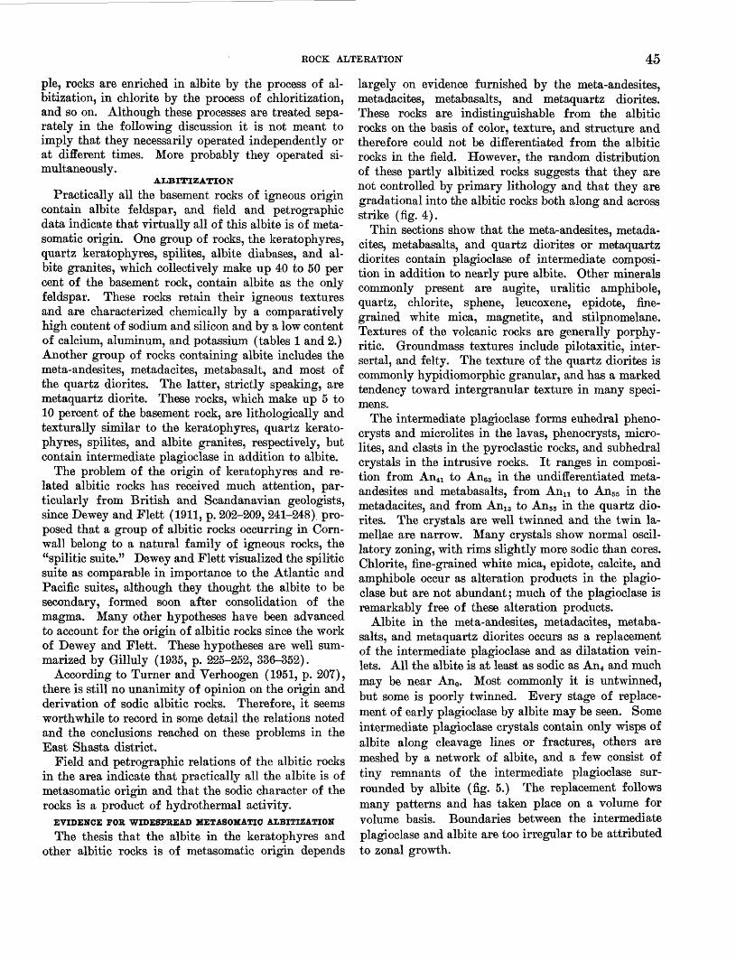
ROCK ALTERATION 45
pie, rocks are enriched in albite by the process of al- bitization, in chlorite by the process of chloritization, and so on. Although these processes are treated sepa rately in the following discussion it is not meant to imply that they necessarily operated independently or at different times. More probably they operated si multaneously.
ALBITIZATION
Practically all the basement rocks of igneous origin contain albite feldspar, and field and petrographic data indicate that virtually all of this albite is of meta- somatic origin. One group of rocks, the keratophyres, quartz keratophyres, spilites, albite diabases, and al bite granites, which collectively make up 40 to 50 per cent of the basement rock, contain albite as the only feldspar. These rocks retain their igneous textures and are characterized chemically by a comparatively high content of sodium and silicon and by a low content of calcium, aluminum, and potassium (tables 1 and 2.) Another group of rocks containing albite includes the meta-andesites, metadacites, metabasalt, and most of the quartz diorites. The latter, strictly speaking, are metaquartz diorite. These rocks, which make up 5 to 10 percent of the basement rock, are lithologically and texturally similar to the keratophyres, quartz kerato phyres, spilites, and albite granites, respectively, but contain intermediate plagioclase in addition to albite.
The problem of the origin of keratophyres and re lated albitic rocks has received much attention, par ticularly from British and Scandanavian geologists, since Dewey and Flett (1911, p. 202-209, 241-248) pro posed that a group of albitic rocks occurring in Corn wall belong to a natural family of igneous rocks, the "spilitic suite." Dewey and Flett visualized the spilitic suite as comparable in importance to the Atlantic and Pacific suites, although they thought the albite to be secondary, formed soon after consolidation of the magma. Many other hypotheses have been advanced to account for the origin of albitic rocks since the work of Dewey and Flett. These hypotheses are well sum marized by Gilluly (1935, p. 225-252, 336-352).
According to Turner and Verhoogen (1951, p. 207), there is still no unanimity of opinion on the origin and derivation of sodic albitic rocks. Therefore, it seems worthwhile to record in some detail the relations noted and the conclusions reached on these problems in the East Shasta district.
Field and petrographic relations of the albitic rocks in the area indicate that practically all the albite is of metasomatic origin and that the sodic character of the rocks is a product of hydrothermal activity.
EVIDENCE FOR WIDESPREAD METASOMATIC ALBITIZATION
The thesis that the albite in the keratophyres and other albitic rocks is of metasomatic origin depends
largely on evidence furnished by the meta-andesites, metadacites, metabasalts, and metaquartz diorites. These rocks are indistinguishable from the albitic rocks on the basis of color, texture, and structure and therefore could not be differentiated from the albitic rocks in the field. However, the random distribution of these partly albitized rocks suggests that they are not controlled by primary lithology and that they are gradational into the albitic rocks both along and across strike (fig. 4).
Thin sections show that the meta-andesites, metada cites, metabasalts, and quartz diorites or metaquartz diorites contain plagioclase of intermediate composi tion in addition to nearly pure albite. Other minerals commonly present are augite, uralitic amphibole, quartz, chlorite, sphene, leucoxene, epidote, fine grained white mica, magnetite, and stilpnomelane. Textures of the volcanic rocks are generally porphy- ritic. Groundmass textures include pilotaxitic, inter- sertal, and felty. The texture of the quartz diorites is commonly hypidiomorphic granular, and has a marked tendency toward intergranular texture in many speci mens.
The intermediate plagioclase forms euhedral pheno- crysts and microlites in the lavas, phenocrysts, micro- lites, and clasts in the pyroclastic rocks, and subhedral crystals in the intrusive rocks. It ranges in composi tion from An4i to An63 in the undifferentiated meta- andesites and metabasalts, from Ann to An55 in the metadacites, and from An13 to An55 in the quartz dio rites. The crystals are well twinned and the twin la mellae are narrow. Many crystals show normal oscil latory zoning, with rims slightly more sodic than cores. Chlorite, fine-grained white mica, epidote, calcite, and amphibole occur as alteration products in the plagio clase but are not abundant; much of the plagioclase is remarkably free of these alteration products.
Albite in the meta-andesites, metadacites, metaba salts, and metaquartz diorites occurs as a replacement of the intermediate plagioclase and as dilatation vein- lets. All the albite is at least as sodic as An4 and much may be near An0. Most commonly it is untwinned, but some is poorly twinned. Every stage of replace ment of early plagioclase by albite may be seen. Some intermediate plagioclase crystals contain only wisps of albite along cleavage lines or fractures, others are meshed by a network of albite, and a few consist of tiny remnants of the intermediate plagioclase sur rounded by albite (fig. 5.) The replacement follows many patterns and has taken place on a volume for volume basis. Boundaries between the intermediate plagioclase and albite are too irregular to be attributed to zonal growth.

O \ A
PP
RO
XIM
AT
E
ME
AN
DE
CL
INA
TIO
N,
1960
Speci
men c
onta
inin
g a
lbite a
s th
e o
nly
feld
spar;
origin
of
the a
lbite
in
de
term
ina
te i
n t
hin
section
Speci
men c
on
tain
ing
alb
ite
an
d c
alc
ic p
lagio
clase
, alb
ite o
f se
condary
orig
in s
een i
n t
hin
section
O M O
FIG
UR
E 4
. M
ap
of
th
e E
ast
Sha
sta
copp
er-z
inc
dist
rict
, C
alif
orni
a,
show
ing
dist
ribu
tion
of
spec
imen
s of
fel
dspa
tbic
roc
k co
llec
ted
at r
ando
m,
cont
aini
ng a
lbit
e of
dou
btfu
l or
igin
and
albi
te o
f de
mon
stra
ble
seco
ndar
y or
igin
.

ab X
50
X75
EX
PLA
NA
TIO
N
ab
a
lbite
an
an
de
sin
e a
nd l
abra
dorite
ba
ba
rite
chl
chlo
rite
X5
0
H
FIG
UBE
5.
Sk
etch
sho
win
g ki
nds
of s
econ
dary
alb
ite
in t
hin
sect
ions
of
rock
s fr
om t
he E
ast
Sha
sta
copp
er-z
inc
dis
tric
t (t
race
d fr
om p
hoto
mic
rogr
aphs
).
A,
B,
and
C s
how
pro
gr
essi
ve
stag
es
of
repl
acem
ent
of p
lagi
ocla
se
crys
tals
of
inte
rmed
iate
com
posi
tion
by
al
bit
e;
D,
albi
te
crys
tal
inte
rpre
ted
as
pseu
dom
orph
af
ter
plag
iocl
ase
of
inte
rmed
iate
co
mpo
siti
on
(not
e th
e di
scon
tinu
ous
twin
la
mel
lae)
;
E,
amyg
dule
li
ned
wit
h se
cond
ary
albit
e;
P,
albi
te h
ost
crys
tal
wit
h ov
ergr
owth
of
se
cond
ary
albi
te c
ryst
als
orie
nted
ap
prox
imat
ely
para
llel
to
the
ho
st;
G,
albi
te
host
cr
ysta
l w
ith
over
grow
th
of
seco
ndar
y al
bite
cry
stal
s or
ient
ed a
bout
nor
mal
to
the
host
; H
, al
bite
vei
nlet
fill
ing
a fr
actu
re
in a
lbit
e ho
st c
ryst
al;
par
tly d
evel
oped
tw
in l
amel
lae
in t
he v
einl
et t
end
to b
e in
opt
ical
con
tinu
ity
wit
h l
amel
lae
adja
cent
to
the
vein
let.

48 GEOLOGY AND ORB DEPOSITS, EAST SHASTA COPPER-ZINC DISTRICT
In general, epidote, clinozoisite, calcite and other calcium-bearing minerals are rare as alteration prod ucts in the plagioclase as well as in the rocks as a whole. The scarcity of these minerals shows that the replacement of intermediate plagioclase by albite is not merely a saussuritic alteration involving the break down of the anorthite molecule to albite and a member of the epidote group or to calcite in response to low grade metamorphic conditions. Saussurite occurs in a few places but is rare.
From the above relations it seems that in the meta- andesites, metadacites, metabasalts, and metaquartz di- orites albite has replaced a more calcic plagioclase on a volume for volume basis and that the transformation has added sodium and silicon to the rock, and simul taneously removed calcium and aluminum. Possibly the reaction proceeded according to the equation pro posed by Turner and Verhoogen (1951, p. 208):
NaCaAlsSi5Oi6+Na++Si+*-»2NaAlSi3O8+Ca+a+Al+3
Oxygen, which constitutes the framework of feldspars, is assumed to remain constant in this reaction. The reaction is virtually equivalent to the spilite reaction:
CaAlsSiaOg+NasCOs-HSiOif* 2NaAlSi3O8+CaCO3found experimentally by Eskola and others (1937, p. 61-68) to take place most effectively at about 300°C.
The keratophyres, quartz keratophyres, spilites, al bite diabases, and albite granites are megascopically indistinguishable from the partly albitized rocks de scribed above by lithology, texture, and structure, but the microscope reveals that the only feldspar present is albite. Chlorite or fine-grained white mica is gen erally present with the albite; other minerals that may be present include augite, quartz, calcite, sphene, leu- coxene, celadonite, uralitic amphibole, and epidote. Volcanic rocks are commonly porphyritic; groundmass textures range from pilotaxitic and intersertal in the keratophyres and spilites to felty and microspherulitic in the quartz keratophyres. Pyroclastic f acies of these rock types have clastic textures. Albite diabase com monly has an intergranular texture, and albite granite has hypidiomorphic granular texture.
Albite occurs mainly as phenocrysts and microlites in the lavas, as phenocrysts, clasts, and microlites in the pyroclastic rocks, and as subhedral crystals in the in trusive rocks. It occurs also in subordinate amounts as dilatation veinlets, as amygdule fillings, as nests of water-clear crystals apparently filling cavities in some pyroclastic rocks, and as porphyroblasts (fig. 5). Com monly the albite phenocrysts and clasts in the volcanic roeks, and the subhedral albite crystals in the intrusive rocks are clouded with chlorite, fine-grained white mica, celadonite, calcite, or one of the epidote group of minerals as alteration products. Some slides, how
ever, show albite almost free of alteration products, and poorly twinned with checkerboard-type, discon tinuous lamellae (fig. 5Z>), whereas in other slides (pi. 18A) the albite is well twinned, with broad, continu ous lamellae. The composition ranges from An0 to An9, but albite more calcic than An4 is rare.
Albite that occurs as veinlets, as amygdule fillings, and as nests of crystals apparently filling cavities is commonly free of alteration products. In most places it is either untwinned, or poorly twinned with ill- defined lamellae whose exact position of extinction is difficult to determine. The albite (H) in one veinlet (fig. 5) is untwinned except where the veinlet cuts through a twinned albite phenocryst. There the albite shows partly developed twinning, with composition planes and lamellae oriented parallel to composition planes and lamellae in the phenocryst. Some pyro clastic rocks contain nests of clear, poorly twinned al bite crystals. In places groups of these crystals have apparently recrystallized to porphyroblasts showing sutured boundaries and sieve texture.
The secondary origin of albite, occurring as veinlets, as amygdule fillings, and as nests of crystals inter stitial to lithic fragments in pyroclastic rocks seems beyond doubt. Likewise, the secondary origin of albite occurring as a replacement of intermediate plagioclase in meta-andesites and in other partly albitized rocks is clear.
The occurrence of demonstrably secondary albite in many places throughout the area (fig. 4) suggests that the albite that forms phenocrysts, clasts, microlites, and subhedral crystals in the albitic rocks is also sec ondary, and is a pseudomorphous replacement of an originally more calcic plagioclase. This origin would apply to all albite in the area. The keratophyres are thus albitized andesites, the quartz keratophyres albi tized dacites, and spilites albitized basalts, and the albite granites albitized quartz diorites.
Differences in the intensity of albitization are ap parently unrelated to the geologic age of the rocks. If a pulse of albitization had accompanied each epoch of volcanic activity the albitization would have been cumulative and Devonian rocks should be more com pletely albitized than Triassic rocks. But this hypoth esis is not substantiated, nor is the degree of albitization related to the proximity of rocks to exposed intrusive bodies. Differences in albitization intensity seem, in stead, to have been controlled at least in part by the relative permeability of the rocks and the consequent accessibility of albitizing fluids to them. Evidence for this conclusion lies mainly in the observation that lenses of pyroclastic rocks enclosed in impermeable shaly rocks of the Bragdon, Baird, Nosoni, and Pit forma-

ROCK ALTERATION 49
tions commonly show only partly albitized clasts of intermediate plagioclase, whereas large masses of vol canic breccia and block lava such as are common in the Copley greenstone, Dekkas andesite, and Bully Hill rhyolite, commonly contain completely albitized plagi oclase. Although exceptions to the above generaliza tion can be found, (completely albitized plagioclase in pyroclastic lenses enclosed in shale, and partly albi tized plagioclase in thick volcanic rock units) the exceptions seem sufficiently rare as to suggest a causal relation.
TIME OF AXBITIZATION
Rocks ranging in age from probable Devonian to Late Jurassic are albitized. The albitization postdates all the intrusive rocks in the East Shasta district, as well as the Mule Mountain stock in the West Shasta district, but apparently it predates the intrusion of the Shasta Bally batholith in the West Shasta district. This plutonic mass it not albitized and has formed around it a contact aureole consisting of gneissic rocks containing intermediate plagioclase. The Shasta Bally batholith is overlain nonconformably by rocks of Early Cretaceous (Valanginian and Hauterivian) age accord ing to Hinds (1934, p. 190), and Hauterivian age ac cording to Murphy (1956, p. 2098).
Except for the lack of albitization in the Shasta Bally batholith, the intensity or degree of albitization seems unrelated either to the age of the rocks or to the kind of rocks; intrusive rocks, as well as extrusive and sedimentary rocks are affected. In some places albite veinlets fill small fractures in the rocks. These obser vations suggest that albitization took place probably in Late Jurassic time contemporaneously with or slightly later than rock deformation and intrusion of all igneous rocks except the Shasta Bally batholith and its apophyses. Whether albitization also occurred one or more times before this could not be determined. Cer tainly the possibility of several episodes of albitization during the geologic history of the area cannot be dis missed, but the fact that intensity of albitization shows no cumulative effect and is apparently unrelated to the age of rocks suggests otherwise.
NATURE AND SOURCE OF THE ALBITIZING FLUIDS
Abundant chlorite, fine-grained white mica, and other hydrous secondary minerals are associated with and seem to be virtually contemporaneous with albite in the altered rocks. This evidence and the experi mental finding of Eskola and others (1937, p. 68) that the spilite reaction takes place most effectively at about 300 °C, suggest that the albitizing agents were hot aqueous fluids charged with Na+ and Si+4 ions, and capable of exchanging these ions for Ca+ 2 and A1+ 3 ions, probably according to the equation given on page
48. The same aqueous fluids may also have served as the vehicle of transport for Mg*2, Fe*2, K+, and CO2 in the redistribution of these substances to form chlorite, fine-grained white mica, calcite, and other sec ondary minerals associated with albite.
As already noted on page 45, the distribution of completely albitized specimens shown on figure 4, indi cates that the intensity of albitization is spatially un related to any exposed intrusive body. Alteration of shaly rocks to adinoles adjacent to intrusive bodies by addition of new albite has apparently not occurred in the area, and the degree of replacement of intermediate plagioclase by albite is in some places actually less complete near intrusive bodies than in places remote from them. Moreover, the plagioclase in the intrusive rocks themselves is so completely albitized in many places that autolytic albitization by fluids indigenous to altered parts of the intrusive rocks seems precluded. Such alteration would require far too much sodium and silicon retained in the residual magma fluids to account for all the albite present in albitized intrusive rock it self, disregarding the albite in surrounding rocks.
Other possible sources for the albitizing fluids in clude (a) sea water trapped in the pores or inter- granular spaces of marine sedimentary rocks and in volcanic rocks that had been deposited in the sea; (b) a subjacent plutonic mass as yet largely unexposed by erosion; and (c) water that had been chemically bound in minerals in deeper zones, and which was set free during the metamorphism of these deeper zones.
Which of these possible sources is most probable is highly speculative; possibly all contributed. The area is part of a eugeosyncline in which wet sediments accumulated and were buried. No doubt the sea water trapped in the pores of these sediments contained an ample supply of sodium ion. Heating of this water by deep burial, by magmatism, or by radioactive means could have caused it to become resurgent and to react with minerals in the rocks through which it passed. But what of the other substances, especially chloride ion, which must have been as abundant as sodium in this resurgent sea water? None of the rocks in the area contain scapolite or other chlorine-bearing minerals. The absence of minerals containing chlorine is no proof that the fluids did not contain chloride ion, for it could have been taken up in rocks either already removed or not yet exposed by erosion; or, it may have been completely expelled either during volcanism or during alteration. Nevertheless, the complete ab sence of chlorine-bearing minerals is difficult to ex plain if the hypothesis is adhered to that resurgent sea water supplied the sodium in the albitizing process.

50 GEOLOGY AND ORE DEPOSITS, EAST SHASTA COPPER-ZINC DISTRICT
The possibility that a subjacent plutonic mass as yet largely unexposed may have been the source of the albitizing fluids is suggested by the distribution of three small, lithologically similar stocks the Pit River stock in the area studied, the Mule Mountain stock in the West Shasta district (Kinkel, and others, 1956 [1957]), and a small body of coarse-grained intrusive rock exposed in sees. 5 and 6, T. 32 N., R. 1 W., about 5 miles southeast of the East Shasta area (Diller, 1906, geol. map). The rock forming these three stocks was originally hornblende quartz diorite and tron- dhjemite, now altered in places to albite granite. Be cause of the lithologic similarity of the three stocks it seems permissible to suppose that they are eminences rising above the general level of a subjacent mass that may underlie the entire area at depth. The albitiza- tion may be a result of a trondhjemitic differentiation in this subjacent mass, which is suggested by the low- potassium content in the volcanic and intrusive rocks of the area as well as by the presence of trondhjemite facies in the intrusive rocks. This type of differentia tion, which was first described by Goldschmidt (1922, p. 7), and later subscribed to by Gilluly (1935, p. 336) to explain the albitization near Baker, Oreg., is sup posed to be typical of geosynclinal belts (Barth, 1952, p. 232). This differentiation is thought to be condi tioned by a high-water content in the magma, which results in the early and abundant crystallization of biotite. This crystallization of biotite causes a defi ciency of potassium in the magma so that little or no potassic-feldspar is formed in the later stages of crystallization. The magma also becomes somewhat deficient in aluminum which causes sodic plagioclase to be favored over calcic plagioclase in the magmatic crystallization because there is insufficient alumina to meet the requirements of anorthite. The result is a rock consisting of quartz, oligoclase or sodic andesine, and biotite, or, if the biotite has been separated out, quartz and oligoclase or sodic andesine. Residual fluids from a hydrous magma such as this are apt to be abundant and rich in sodium and silicon. They are thus ideally suited for the role of albitizing the surrounding and overlying rocks.
If trondhjemitic differentiation has taken place in a subjacent magma chamber beneath the Shasta area it may actually have been going on from Middle Devo nian to Late Jurassic or Early Cretaceous time, cul minating in the emplacement of the Pit River and Mule Mountain stocks. This is suggested by the siliceous volcanic rocks markedly low in potassic feldspar at several places in the stratigraphic column. It seems possible that the Balaklala rhyolite and Bully Hill
rhyolite are extrusive facies of this trondhjemitic magma.
The metamorphism of rocks at depth containing hydrous minerals such as chlorite, micas, and clay minerals to rocks containing less hydrous minerals as amphiboles and pyroxenes also represents a potential source for the albitizing fluids. Certainly a large quantity of chemically bound water would be set free in the conversion of rocks of the greenschist facies to those of a higher facies as the amphibolite or granulite facies. That sufficient sodium and silicon could also be derived from the metamorphism to effect extensive albitization of rocks elsewhere seems improbable unless accompanied perhaps by magnesium or calcium meta somatism. Under such circumstances, sodium and sili con might well be displaced along with water from the rocks undergoing the higher grade metamorphism and thus made available as albitizing agents.
CKLORITXZATION
Throughout the area intermediate and mafic vol canic rocks that are strongly albitized are also strongly chloritized. Chlorite occurs in these rocks as amyg- dule fillings, as a replacement of phenocrysts, and as a component of the groundmass. Chlorite is also a widespread but minor constituent in the more silicic rocks and locally it has extensively replaced such rocks. The Bully Hill rhyolite is so strongly chlori tized locally in the southeastern part of the area that only the quartz phenocrysts remain as testimony of the original character of the rocks.
Chlorites, identified by optical properties and ac cording to Winchell's (1951, p. 383) data, include delessite, diabantite, penninite( ), aphrosiderite, and clinochlore. The most common varieties in the albi tized intermediate and mafic rocks are delessite and diabantite; these two minerals probably make up 75 percent of all chlorite in the rocks of the area. Other varieties are much less common. Clinochlore was seen only at Bully Hill and locally in the core of the After thought anticline (pi. 2) in the southeastern part of the area west of U.S. highway 299E. In both places clinochlore is a replacement of the Bully Hill rhyolite.
Thin sections show every stage of replacement of augite, actinolite, hornblende, and plagioclase pheno crysts by chlorite. In early stages of replacement the chlorite forms wisps along cleavage planes and zonal growth lines in the host crystal. In later stages it spreads out until in the extreme stage it forms a pseudomorphous replacement of the entire host crystal. In some chlorite pseudomorphs after augite and plagioclase the twinning of the host crystal is pre served and is conspicuously shown under crossed nicols

ROCK ALTERATION 51
by a marked difference in the orientation of chlorite plates in adjacent replaced twin lamellae.
The process of chloritization seems to have been contemporaneous with the albitization of intermediate and mafic rocks. Where such rocks are albitized they are also strongly chloritized. And, conversely, where they are not albitized or only slightly albitized, as is the mass of meta-andesite pyroclastic rock of the Baird formation between Goat Creek and Packers Gulch northwest of the Pit bridge, the mafic alteration mineral is acicular blue-green actinolitic amphibole instead of chlorite. In a few places the actinolite is in turn partly altered to chlorite, generally with the appearance of some albite in the rock. In the chlori tization process the iron, magnesium, silicon, and oxy gen may have been derived from ferromagnesian minerals in a mafic rock undergoing alteration, but unless aluminous amphibole is abundant, the source of the aluminum for the chlorite must come from else where. A potential source within rocks undergoing alteration is the anorthite molecule of plagioclase in the process of being altibized. Marked parallelism in distribution of albitized and chloritized mafic rocks throughout the area suggests that this was the source of aluminum for the chlorite in the East Shasta area. If this is true, the processes of albitization and chlori tization must have occurred contemporaneously.
HYDROUS MICA ALTERATION
Most of the silicic volcanic rocks in the area contain a very fine grained claylike white micaceous mineral. This material is most abundant along shear zones and in strongly schistose phases of the Bully Hill rhyolite. In places it forms as much as 15 percent of the rock. This micaceous mineral marks planes of parting in the schistose rocks and commonly forms an anastomos ing network around lozenge-shaped fragments in the highly sheared rocks. In a few places feldspar pheno- crysts are selectively replaced by a felted mass of this mineral whereas the groundmass contains virtually none.
Seven specimens of Bully Hill rhyolite containing this claylike micaceous mineral were collected from the Bully Hill and Little Cow Creek areas and sub mitted to the U.S. Geological Survey laboratories for examination. Robert L. Smith identified the material as hydrous mica by its indices of refraction (Robert L. Smith, written communication, 1953). The highest gamma index obtained was 1.58±0.003 and most of the material examined has gamma in the range of 1.570 to 1.575. The gamma index for muscovite, on the other hand, should range above 1.585. One specimen was checked under the electron microscope by Fred A. Hildebrand of the Geological Survey and its identity
as hydrous mica confirmed. The physical and optical similarity of fine-grained white micaceous material from other parts of the area to hydrous mica in the seven specimens examined in the Survey laboratories suggests that most of the fine-grained white micaceous material in the silicic rocks is hydrous mica rather than sericite. However, the possibility that some may be sericite or paragonite cannot be ruled out. B. S. Butler (Graton, 1910, p. 88) inferred that some of the micaceous material at Bully Hill is paragonite.
The hydrous mica seems to bear the same relation to albitization in the silicic rocks as chlorite bears to albitization in the intermediate and mafic rocks. Hy drous mica is abundant in albitized silicic rocks but is sparse or absent in those that are not albitized. Para- genetic relations suggest that albitization either slightly preceded or was contemporaneous with hy drous mica alteration. Possibly the aluminum oi the hydrous mica was derived from the anorthite molecule of plagioclase during the albitization process. This type of alteration seems to have no definite spatial re lation to sulfide mineralization except that hydrous mica is generally most abundant in shear zones, as also are the sulfides.
SELICIFICATION
Rocks of many kinds throughout the area are silici- fied. Limestone of the Baird and McCloud formations is in places largely replaced by chert. Shale and mud- stone in parts of the Kennett and Baird formations have a siliceous character, which thin sections show is due to a mosaic of microcrystalline quartz that has re placed original rock constituents. The Copley green stone and Dekkas andesite locally contain abundant microscopic quartz veinlets. Moreover, as was shown on page 48, much silicon as well as sodium must have been added during albitization of the intermediate plagioclase that was originally in the Copley and Dek kas formations. Although this is not silicification in the sense that new quartz is formed, it nevertheless does show that these rocks were enriched in silicon.
Probably the most markedly silicified rock unit in the area is the Bully Hill rhyolite. At least 75 percent and possibly as much as 90 percent of this formation is silicified. But except where silicification is intense, as on the ridge above the Rising Star mine, silicified phases are difficult to recognize in the field because virtually all the rocks that make up the Bully Hill rhyolite were siliceous originally. Only by examining thin sections is it possible to ascertain to what extent a given specimen is silicified.
At least two degrees of silicification are discernible in thin section. In the least silicified types only the groundmass of quartz keratophyres is replaced by anhedral microcrystalline quartz. Feldspar pheno-

52 GEOLOGY AND ORE DEPOSITS, EAST SHASTA COPPER-ZINC DISTRICT
crysts and microphenocrysts are unsilicified. Quartz phenocrysts retain their original shape but commonly have narrow overgrowths of the microcrystalline groundmass quartz. These overgrowths give the phe nocrysts a fuzzy border under crossed nicols, and the phenocrysts that have irregular, lobate outlines seem to be corroded and replaced by the groundmass quartz (pis. 18B and 20J.). However, because in some sheared specimens angular clasts of quartz phenocrysts strung out in trains parallel to foliation also have nar row overgrowths of the groundmass quartz (pi. 2LA). The angular clasts show no rounding of edges or re entrants that might be construed as resulting from corrosion.
In more intensely silicified phases of Bully Hill rhyolite not only the groundmass but feldspar pheno crysts as well are replaced by anhedral microcrystal line quartz. The identity of these rocks as altered quartz keratophyre depends largely on the presence of relict quartz phenocrysts, which are the only original mineral components that remain.
An unusual variety of secondary quartz in some specimens of pyritized quartz keratophyre is feather quartz that partly surrounds and radiates from pyrite cubes. Individual quartz feathers are elongate normal to the pyrite face with which they are in contact. Most are extended parallel to schistosity and occupy what Pabst (1931) has called pressure shadows. It seems that this feather quartz in large part represents quartz expelled and replaced by pyrite cubes.
Although silicification doubtless occurred several times during orogenesis the principal silicification is believed to have taken place at about the same time as albitization. The ultimate source of the silicon intro duced is debatable and it may have come from several sources. It seems very improbable that it could have been "sweated out" of any rocks now exposed for they nearly all show enrichment rather than impoverish ment in silicon. Therefore, a deeper seated source is probable. If, as seems likely, a subjacent mass of trondhjemite underlies much or all of the area, the silicon as well as the sodium that must have been in troduced during alteration may have come from it.
During later cycles of silicification no new silicon need to have been introduced but silicon already pres ent in the rocks was redistributed. One small-scale example of this is the feather quartz surrounding pyrite cubes, which generally replaces a mixture of microcrystalline quartz and white mica. The quartz set free during the growth of a pyrite cube seems to have moved the shortest possible distance before being redeposited. A larger scale example is the intensely silicified Bully Hill rhyolite over the Rising Star mine.
Beneath this silicified zone are bodies of massive sul- fide and also masses of anhydrite and gypsum that replaced the Bully Hill rhyolite. It seems highly prob able that at least part of the silicon expelled by this re placement enriched the overlying rocks in silicon.
CALCITIZATION
In the southeastern part of the area beds of tuff be longing to the Pit formation are extensively replaced by calcite, forming masses of medium dark-gray rock locally known as lime rock. These masses of calcitized tuff, which are generally parallel to the bedding, are common in the synclinal belt of Pit formation north of the Afterthought mine (pis. 1 and 5) but are rare elsewhere. The largest masses in the Afterthought area are about 100 feet wide and at least 1,000 feet long. A few masses, too small to be shown on the geologic map, were seen near the end of the peninsula east of Baxters Gulch and on the south side of the Squaw Creek arm of Shasta Lake, across from Bully Hill. Although tuff is the rock most commonly re placed by calcite, quartz keratophyre belonging to the Bully Hill rhyolite is calcitized locally along the mar gins of sulfide bodies in the Afterthought mine. The amount of calcite is extremely variable; it forms from 10 to as much as 90 percent of the altered rock. Thin sections show that calcite occurs as subhedral crystals 1 to 5 mm in diameter. Commonly numerous grains adjoin each other and form a mass of calcite several centimeters across. The calcite thus replaces, on a volume for volume basis, all the mineral constituents of the host rock without regard for their composition and apparently does not follow any recognizable pattern of selectivity. The calcite is in turn cut locally by microscopic veinlets of quartz and white mica and is replaced by sulfide minerals.
Although paragenetic relations indicate that cal- citization took place after albitization, silicification, and hydrous mica alteration, it may not have been much later. One possible source of the calcium could have been intermediate plagioclase that was under going albitization elsewhere. On the other hand, the calcium, as well as the carbon dioxide, with which the fluids responsible for calcitization must have been saturated, could also have come from: (a) a subjacent body of cooling magma that had assimilated a mass of limestone and whose residual fluids were rich in cal cium and carbon dioxide or (b) a mass of limestone which lay somewhere beneath the calcitized rocks and which was being replaced by some other mineral or minerals. The Pit formation about a mile north of the area where calcitized rocks occur contains lenses of limestone that dip south toward the area of cal citization (pi. 1). Such limestone lenses could be pres-

STRUCTURE 53
ent at not too great a depth in the Pit formation near the Afterthought mine where the calcitized rock is so abundant.
STRUCTURE
GENERAL FEATURES
The sedimentary and volcanic basement rocks are complexly deformed by many folds and faults. Two prominent structural trends, one north-northeast and the other northwest, are recognized. The oldest rocks occupy the core of a large northward-plunging anti cline in the western part of the area, and successively younger rocks crop out toward the east in a sequence that in gross aspect is homoclinal (pi. 1). The trend of major rock units in the homocline ranges from nearly north in the O'Brien Mountain area to about N. 40° E. in the Town Mountain area. The homocline is disrupted east of the McCloud River arm by an ir regular belt of mafic quartz diorite that virtually iso lates the McCloud limestone from the underlying Baird formation and the overlying Nosoni formation. This quartz diorite probably in part occupies a fault zone between the McCloud and Nosoni formations. This structure is herein referred to for convenience as the McCloud fault. Many dikes, mostly of mafic quartz diorite, cut the McCloud limestone and other formations west of this fault zone but few if any are present to the east. Most of these dikes strike northwest and occupy normal tension faults and frac tures.
In marked contrast to the north-northeast structural trend that dominates in the western part of the map area, a northwest trend dominates south and east of Town Mountain. This northwest trend is represented chiefly by a series of folds involving the Pit forma tion, Bully Hill rhyolite, and Dekkas andesite. Lo cally, in the eastern part of the area, the rocks have a secondary foliation that strikes northwest and gener ally parallels the axial planes of folds. This foliation ranges from a weak cleavage to a strong schistosity.
In the western part of the area the northwest struc tural trend is present but not prominent. It is marked by the nearly ubiquitous northwest strike of bedding in the McCloud limestone as well as locally in the Baird and Nosoni formations, and by a few poorly defined cross folds and warps.
AGE OF DEFORMATION
A complex structural history is indicated, not only by the two fold systems nearly at right angles to each other but also by many unconformities and an abun dance of volcanic rocks and erogenic sediments throughout the stratigraphic column. The latter fea tures show that the area was tectonically unstable from
at least Middle Devonian well into Mesozoic time. Prior to Late Jurassic, however, deformation seems to have consisted mainly of recurrent uplift and tilting; it seems doubtful that much folding and faulting took place until the Late Jurassic orogeny. The basis for this conclusion is that all the stratified basement rocks within the area, plus the Bagley andesite, and the Modin and Potem formations, which crop out east of the area, have undergone about the same degree of deformation. Crickmay (1931, p. 88) assigned the Potem formation to the Ludwigian stage of Middle Jurassic, but more recent data by A. E. Sanborn xl in dicate that it is probably of Bajocian age. On the other hand, the oldest formation in the region that has not undergone orogenesis is the Paskenta formation of Early Cretaceous age. If allowance is made for time to unroof the Shasta Bally batholith which postdates deformation and which lies nonconformably beneath the Lower Cretaceous sedimentary rocks it seems likely that deformation took place in Late Jurassic rather than Early Cretaceous time.
FOLDS
Two prominent fold systems, a north-northeast sys tem and a northwest system, are indicated on plate 2. Also present, although not conspicuous, are a few small folds in the O'Brien Mountain area that seem to trend nearly east-west. The homocline through Horse and Town Mountains is probably ultimately part of a large regional fold and is included in the northeast fold system.
As measured along section B-B' (pi. 1), which trends N. 84° W., folding has resulted in a crustal shortening of 15 to 20 percent. Along section A-A', which trends N. 33° E., the crustal shortening is about 25 to 30 percent.
NORTHEASTWAKD-TKENDINO FOIJ5S
Folds that trend northeastward include, in addition to the homocline through Horse and Town Mountains: (a) the O'Brien Mountain anticline; (b) small folds in the Bragdon formation on the west side of O'Brien Mountain, in the McCloud limestone south of Curl Creek, in the Dekkas andesite on Horse Mountain, and in the Pit formation and Bully Hill rhyolite west of Baxters Gulch; and (c) possibly the large mass of Pit formation, lying chiefly between the Squaw Creek and Pit River arms of Shasta Lake and which in gross aspect seems synclinal.
O'BRIEN MOUNTAIN ANTICLINE
The largest complete fold in the area is an anticline that strikes N. 10° to 25° E. through O'Brien Mountain
"A. E. Sanborn, 1952, The geology of the Big Bend area, Shasta County, California: Unpublished thesis, Stanford Univ.

54 GEOLOGY AND OREi DEPOSITS, EAST SHASTA COPPER-ZINC DISTRICT
and plunges northeastward at a low angle. This fold is called the O'Brien Mountain anticline (pi. 2). The outline of the anticline is best shown by the outcrop pattern of the Kennett and Bragdon formations, which wrap around the nose and flanks of the structure, with the Copley greenstone and Balaklala rhyolite forming the core (pi. 1). Along the west flank of the anticline the Kennett formation dips steeply east in most places and is presumably overturned. Throughout most of sec. 17, T. 34 N., K. 4 W., it is also highly sheared and may be in fault contact with the Copley greenstone. In the east-central part to sec. 8, T. 34 N., K. 4 W, fine grained conglomerate beds that dip southeast show in verted graded bedding, suggesting that the Bragdon formation as well as the Kennett is overturned at least locally along the west flank of the anticline. On the east flank of the anticline sedimentary beds dip mostly east at moderate angles. The overturned beds on the west limb show that the anticline is overturned slightly to the west and a steep east ward dip on its axial plane is inferred.
The scarceness of bedding or original layering 12 in the Copley greenstone and Balaklala rhyolite in the core of the O'Brien Mountain anticline, and the intertonguing of the two formations, prevents the pre cise location of the anticlinal crest. Bedding in pyro- clastic rocks on the east side of the Waters Gulch arm dips 40 to 60° E., suggesting that the crest is farther west. Also, opposed bedding attitudes in the Brag don formation on the nose of the anticline north of O'Brien Creek help to define the position of the crest in that locality. But elsewhere the only guide is the shape of the core of Copley greenstone and Balaklala rhyolite; the crest is assumed to almost bisect this core.
SMALL FOLDS THAT TREND NORTHEASTWARD
In addition to the O'Brien Mountain anticline small northeastward-trending folds are shown in the Brag don formation on the west side of O'Brien Mountain, in the Baird formation on the peninsula in sec. 33, T.
12 The intermediate and silicic volcanic rocks that make up such a large percentage of the stratigraphic column lack continuous marker beds and very likely were not laid down flat like marine sediments. Initial dips of 30° or more are common in many recent undeformed lavas of the type constituting the Copley greenstone, Dekkas andesite, Balaklala rhyolite, and Bully Hill rhyolite. Also, the volcanic rocks that make up each of these formations probably came from several different vents. Thus, the resulting volcanic pile for each of these units, consisting of interflngering flows and pyroclastic rocks, and with each lithologic unit possibly having a different initial dip, no doubt contained many unconformities and was structually complex even before orogenesis. For these reasons, in our interpretation of the structure and the amount of actual deformation, greater reliance is placed on structural features in sedimentary units than on those in volcanic units. Strikes and dips taken in laminated sedimentary rocks are regarded as a more reliable measure of deformation than strikes and dips taken on layering in lava flows or pyroclastic ma terials. Probably least reliable are strikes and dips on flow banding in silicic lavas.
34 N., K. 4 W., in the McCloud limestone south of Curl Creek, in the Dekkas andesite on Horse Mountain, and in the Bully Hill rhyolite and Pit formation southwest of Baxters Gulch (pis. 1 and 2). The wavelengths and amplitudes of these folds range from a few feet to a few hundred feet.
POSSIBLE SYNCLINE MARKED BY OUTCROP PATTERN OF THE PIT FORMATION
The large mass of Pit formation that lies largely between the Squaw Creek and Pit Kiver arms of Shasta Lake (pi. 1) may mark: (a) a topographic depres sion between volcanic highlands in which the sediments that form the Pit formation accumulated during Triassic time; (b) a shallow northeastward-trending synclinal trough; or (c) a combination of (a) and (b). The latter seems most probable. Evidence suggesting that it occupies a topographic depression lies in the distribution and different thickness of the underlying Bully Hill rhyolite along the margin of the mass, and in the probable presence of volcanic centers north of Bully Hill and south of Sugarpine Canyon. Evidence of a syncline is suggested by the fact that northeast of Bully Hill and also southwest of Baxters Gulch the Pit formation strikes northeast and dips southeast off the underlying rocks of the main homocline. Along the irregular southeast margin of the mass of Pit forma tion evidence of a northeast structural trend is lacking. If such a trend ever existed it has been obliterated by the system of northwest folds.
The Pit formation probably accumulated in a trough that at least within the area had a northeasterly trend. Deformation that produced the main homocline tilted the northwestern part of the trough toward the southeast. Therefore, the mass of Pit formation may be considered as a shallow synclinal warp associated with the northeast homocline and related to northeast folding.
NORTHWESTWARD-TRENDING FO3LDS
The outstanding structures in the eastern part of the area are a series of northwestward-trending folds in volving the Hosselkus limestone, Pit formation, Bully Hill rhyolite, and Dekkas andesite. These folds are well marked by bedding attitudes in the sedimentary rocks and by the outcrop pattern of lithologic units. The most continuous fold in this series includes the Afterthought mine on its north limb and is here called the Afterthought anticline (pi. 2). The strike of the folds ranges from approximately N. 70° W. in the Little Cow Creek area to about N. 25° W. in the Brock, Mountain area. Just north of the Squaw Creek arm of Shasta Lake, near Bully Hill, many of the northwest folds define a cymoid curve by making a bend north- northeast for a few thousand feet before resuming their

STRUCTURE 55
northwest trends and eventually terminating on the flanks of Horse and Town Mountains. The wave lengths and amplitudes of the northwest folds range from a few hundred feet to about a mile. The con sistently steep southwest dip of foliation as well as the attitude of drag folds a few feet across seen in many places on the flanks of larger structures suggests that most of the folds south of the Pit River arm are asymmetrical and have northeast limbs a few degrees steeper than southwest limbs. This is also true locally north of the Pit River arm but the majority of folds in the latter area are more nearly symmetrical.
As shown by the outcrop pattern of the Pit forma tion in relation to the underlying volcanic units, the dominant plunge of the folds is northwest south of the Pit River arm and southeast north of the Squaw Greek arm. Between the Squaw Creek and Pit River arms of Shasta Lake lineations (pi. 2) indicate that northwest and southeast plunges are about equally common. The folds in this part of the area are arranged en enchelon, and alternate folds plunge in opposite directions.
CROSS FOLDS
West of a line roughly joining Town Mountain and the Cove Creek arm of Shasta Lake (pi. 1) cross folds that trend northwestward are superimposed on the northeastward-trending homocline and on the O'Brien Mountain anticline. These cross folds are identified with the system of northwest folds in the eastern part of the area and include: (a) warps in the general northeasterly trend of lithologic units in the homo cline; (b) warps on the O'Brien Mountain anticline; (c) small folds a few feet across that were seen in the field; and (d) folds indicated by opposed bedding attitudes.
The strike of the cross folds ranges overall from about north-south to about east-west. However, the majority strike in the range N. 20 to 40° W. All the small folds that were seen in the field as well as those indicated by opposed attitudes are shown on plates 1 and 2.
Warps and cross folds on the homocline are indicated by opposed bedding attitudes in mudstone beds near the summit of Town Mountain and by the sinuous form of mudstone beds between Town and Horse Mountains (pi. 1). Most prominent in this area is a synclinal warp that strikes about N. 30° W. from the summit of Horse Mountain.
Several cross warps on the O'Brien Mountain anti cline are indicated by the shape of contacts between formations. The contact between the Bragdon and Baird formations in the southwestearn part of sec. 21, T. 34 N., R. 4 W. strongly suggests a synclinal warp plunging southeastward into the adjoining sec. 28.
Just east of this synclinal warp, in the south-central part of sec. 21, the Bragdon and Baird contact is con vex toward the southeast, indicating an anticlinal warp. This anticlinal warp is also suggested by opposed bed ding attitudes in the Baird formation in sec. 28.
The form of the contact between the Copley green stone and the Kennett and Bragdon formations sug gests a synclinal cross warp extending from near the southwest corner of sec. 17, T. 34 N., R. 4 W. south eastward to about the southeast corner of sec. 20, T. 34 N., R. 4 W., where it is interrupted by a fault.
Convexities in the contact between the Copley green stone and overlying formations suggest an anticlinal cross warp extending from the south-central part of sec. 8, T. 34 N., R. 4 W., about S. 35° E. to the south- central part of sec. 21, T. 34 N., R. 4 W.
In addition to the cross folds and warps noted above, the nearly ubiquitous northwest strike and northeast dip of bedding in the McCloud limestone and in parts of the Baird and Nosoni formations indicate tilting on a northwesterly axis. Although the present attitude of bedding in the McCloud limestone is probably in part the result of faulting, the similar attitude of bedding in so much of the Baird and Nosoni forma tion suggests that folding also played a part.
CLEAVAGE AND SCHISTOSITY
The basement rocks in many places in the eastern part of the area have a secondary planar structure that ranges from a weak cleavage to a prominent schistosity. This planar structure is especially conspicuous south of Backbone Ridge where it occurs in about 75 percent of the rocks. It strikes northwest or west-northwest and dips from vertical to 55° SW. (pi. 1). North of Back bone Ridge and between the Pit River and Squaw Creek arms of Shasta Lake it is less common and is generally restricted to crests and troughs of folds. The strike makes a gradual swing to a more northerly di rection between Backbone Ridge and Squaw Creek as does also the strike of folds. Between Squaw Creek and Horse and Town Mountains cleavage and schistos ity strikes mainly northwest but in places northeast; easterly dips are almost as common as westerly dips in this area. South and west of Horse Mountain cleavage and schistosity are virtually absent.
Rocks with cleavage have subparallel fractures or cleavage planes spaced a fraction of a millimeter to locally as much as a foot apart. In many places this cleavage approximately parallels the axial planes of drag folds in shaly rocks of the Pit formation. Thin sections cut normal to the cleavage show that the part ing planes are commonly marked by thin layers of fine grained platy minerals, chiefly chlorite in the mafic
56 GEOLOGY AND ORE» DEPOSITS, EAST SHASTA COPPER-ZINC DISTRICT
volcanic rocks, and fine-grained white mica in the siliceous volcanic rocks and shale beds. Individual platy minerals are mostly alined parallel to cleavage planes. However, the minerals between cleavage planes are chiefly feldspar, microcrystalline quartz, and other minerals of nontabular crystal habit, only rarely are fine-grained platy minerals present through out the rock. The platy minerals along cleavages may have formed either contemporaneously with or later than the cleavage planes.
In several places near the Afterthought mine and in the Bully Hill-Baxters Gulch area rocks with cleavage, or, rarely, massive rocks contain lenses of strongly sheared rock as much as 200 feet thick and half a mile long. The rock within these lenses or zones is in some places soft and gougy and in other places strongly schistose, containing abundant platy minerals visible to the naked eye. Thin sections of the schistose rock cut normal to the schistosity show typical cata- clastic structures. Augen of crushed rock are sur rounded by braided or anastomosing stringers of fine grained white mica (pi. 21 A). Quartz and feldspar phenocrysts are commonly fragmented and the result ing clasts are strung out in trains parallel to schistos ity, showing that marked displacement has occurred along the schistosity surfaces.
LINEATION
Two types of lineation in the area are the plunge of drag folds and the intersection of fracture cleavage and bedding. The first type is common in the Pit formation in the eastern part of the area and also in the Bragdon formation in the O'Brien Mountain area. The second type was seen only in the Pit formation in the eastern part of the area. All the lineations are plotted on plate 2.
Lineation in the Pit formation strikes northwest parallel to the axes of northwest folds. The plunge is either southeast or northwest and ranges from hori zontal to about 70°; plunges of 10° to 25° are most common. Southeast of the Pit River arm of Shasta Lake most lineations plunge northwestward. Between the Squaw Creek and Pit River arms of the lake northwest and southeast plunges are about equally common. In the Bully Hill area lineations are vari able; northwest and northeast plunges are about equally common and there are also a few southerly plunges. Northeast of Bully Hill the plunge of linea tion is dominantly southeastward.
On the south and east sides of O'Brien Mountain minor folds plunge dominantly eastward and south eastward at low angles, whereas on the west side of the mountain they plunge mainly westward and north westward. On the nose of the O'Brien Mountain
anticline a few small folds plunge north-northeast ward.
AGE RELATION OF NORTHEAST AND NORTHWEST FOLDING
Evidence on the relative age of northeast and north west folds is not conclusive but the following relations strongly suggest that the northeast folds predate the northwest folds:1. The large northeastward-trending homocline and
the O'Brien Mountain anticline are warped along axes that trend northwestward.
2. The homocline through Horse and Town Moun tains locally has a cleavage that strikes mostly northwestward (pi. 1), in approximate concord ance with cleavage in the Pit formation and Bully Hill rhyolite in the Squaw Creek area, and also about parallel to the axes of northwest ward-trending folds. If this cleavage had existed in the rocks at the time the strong northeast deformation (which locally produced dips as steep as 80°) occurred the cleavage most probably would not have escaped severe crum pling. However, no crumpling of cleavage was seen in this area. Moreover, if the cleavage and fold axes on Horse and Town Mountains had been present when the rocks there acquired their southeast dip they probably would have been pushed out of alinement with the cleavage and fold axes in the Squaw Creek area where the rocks have little if any component of dip as a re sult of northeast folding.
3. In many places northwest-bedding strikes prevail for several hundred feet within incompetent for mations that in gross aspect strike northeast. An example of this is the Baird formation in the vicinity of Johns and Baileys Creeks. If the northeast folding were younger it seems unlikely that these incompetent rocks could have escaped being pushed into an orientation more compati ble with the northwest-southeast compressive forces that would have been operative.
FAULTS
GENERAL FEATURES
A few moderately large faults and many small ones disrupt the basement rocks in the district. The larg est fault, along the east side of the McCloud lime stone, is interpreted as a left-lateral strike-slip fault (pi. 1). Most faults are high-angle faults, having dips greater than 45°. The majority of the larger faults and many of the smaller ones were formed before emplacement of hypabyssal igneous rocks and

STRUCTURE 57
before sulfide mineralization. Some small faults, however, are of postintrusive age and a few occurred after sulfide mineralization.
DISTRIBUTION AND ORIENTATION
The accompanying geologic and tectonic maps (pis. 1 and 2) show four principal areas of faulting. They are (a) the general vicinity of the Afterthought mine; (b) an area extending from the peninsula in the west- central part of sec. 31, T. 34 N., E. 3 W. northeastward through Bully Hill to the eastern slopes of Town Mountain; (c) the area occupied by the McCloud limestone and mafic quartz diorite; and (d) the O'Brien Mountain area.
In the Afterthought mine area about 80 percent of the faults strike N. 50 N. 75° W.; northeastward- trending faults are rare. In the vicinity of Bully Hill northwestward- and northeastward-trending faults are about equally abundant but the northeast faults are larger. Also, the strike of northwestward-trending faults is more northerly, ranging from about N. 5° to N. 50° W. The northeastward-trending faults strike mostly N. 10° to 20° E. and N. 60° to 75° E. The Mc Cloud limestone is apparently bounded on the east side by a strike-slip fault that trends about N. 30° E., but a series of northwestward-trending normal faults also disrupt the limestone. The strike of faults in the O'Brien Mountain area virtually boxes the compass but 3 principal directions, N. 60° W., N. 60° E., and N. 20° E., dominate. Easterly dips predominate over westerly dips.
Variations in the attitude of faults in different parts of the district are illustrated on the contour diagrams (figs. 6, 7, and 8).
TYPES OP FAULTS
Owing to poor exposure, to the parallelism of many faults to bedding or schistosity, and to the lack of reli able marker units, the direction and amount of dis placement could be determined for only a few of the many faults in the area. For this reason, the classifi cation adopted here is largely geometric rather than genetic. The following types of faults will be de scribed: (a) Low-angle faults; (b) the McCloud fault; (c) high-angle strike faults; (d) high-angle transverse faults; and (e) shear zones.
LOW-ANGLE THRUST FAULTS
Faults that dip less than 45° are uncommon in the district and most of those recognized have displace ments of only a few feet. Probably the largest low- angle fault is the Afterthought mine where a block of Bully Hill rhyolite between the 200 and 400 levels is
thrust northeastward for about 150 feet on the Pit formation (pi. 5, section A-A').
On the crest of the ridge leading north from Horse Mountain, at an altitude of about 3,400 feet are 2 faults marked by slickensided surfaces of quartz each about 50 feet square. These faults strike N. 75° E. and dip northwest at an angle of about 25°; the grooves on the slickensided surfaces plunge downdip. Displacement could not be determined but is probably only a few feet. A few low-angle faults, some show ing reverse and others normal movement, were also seen in road cuts in the O'Brien Mountain area.
McCLOUD FAULT
The largest fault in the area is a preintrusive fault trending about N. 30° E. along the east side of the McCloud limestone. This fault is not exposed but its position is marked in most places by a continuous belt of intrusive rock (pis. 1 and 2). The following rela tions indicate the presence of this fault:1. The McCloud limestone and the Nosoni formation
are both missing for a strike length of about iy2 miles in the area of the Pit River arm (pi. 1); likewise, the Nosoni formation is missing for a mile or more between the upper part of Marble Creek and the upper part of Curl Creek; and the Dekkas andesite is partly cut out in the northeastern part of sec. 24, T. 34 N., E. 4 W. Inasmuch as fossil data shows the presence of time gaps between the Baird and McCloud, between the McCloud and Nosoni, and probably between the Nosoni and Dekkas, tilting and erosion during these intervals may be partly re sponsible for the absence of these formations in the places mentioned. However, if considered in conjunction with other evidence given below, it seems that faulting is probably the main cause.
2. The discordant attitude of bedding in the McCloud limestone with respect to the Nosoni and Dekkas formations is perhaps the strongest indication of a fault. In gross aspect, these 3 units strike about N". 20°-25° E. However, the strike of bedding in the McCloud limestone is northwest throughout most of the area (pis. 1 and 2). Thus, the limestone beds, if projected southeast ward along their strike through the mafic quartz diorite, would either butt against or override the Nosoni and Dekkas formations. The strike of bedding in the Nosoni and Dekkas formations is also north or northwest in some places, particu larly in sec. 24, T. 34 N., E. 4 W., indicating the same type of discordant relation.
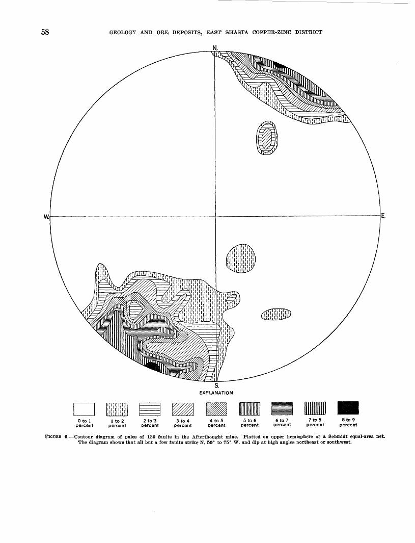
58
w.
GEOLOGY AND ORB DEPOSITS, EAST SHASfTA COPPER-ZINC DISTRICT
N.
S.EXPLANATION
Oto 1 percent
8 to 9 percent
FIGURE 6.- -Contour diagram of poles of 130 faults in the Afterthought mine. Plotted on upper hemisphere of a Schmidt equal-area net. The diagram shows that all but a few faults strike N. 50° to 75" W. and dip at high angles northeast or southwest.

59
EXPLANATION
ijljljljljl
1 to 2 percent
FIGURE 7. Contour diagram of poles of 132 faults in the Rising Star mine. Plotted on upper hemisphere of a Schmidt equal-area net. The diagram shows that faults strike predominatly N. 5° B. to N. 50° W. and dip steeply either northeast or southwest. Another group of faults strikes N. 70° B. and dips mainly southeast at angles of 70° to 90°. Faults associated with the Bully Hill shear zone east of the Rising Star mine, which strike N. 10° to 30° E., are not shown.
553967 61-

60 GEOLOGY AND ORE, DEPOSITS, EAST SHASTA COPPER-ZINC DISTRICT
S.
EXPLANATION
Oto 1 percent
1 to 2 percent
2 to 3 percent
3 to 4 percent
4 to 5 percent
5 to 6 percent
FIGURE 8. Contour diagram of the poles of 117 faults and fractures In road cuts along U.S. Highway 99 between the Pit bridge and the north edge of map area. Plotted on upper hemisphere of a Schinidt equal-area net. The diagram shows that on the basis of attitude the faults along the highway fall into three main groups: a group that strikes N. 60° W. and dips 60° NE.; a group that strikes N. 60* E. and dips 65° SE.; and a group that strikes N. 20° E. and dips 60° to 90° SE.

STRUCTURE 61
3. North of Curl Creek the upper greenstone unit of the Baird formation lies directly opposite the Nosoni formation, separated by a few hundred feet of mafic quartz diorite; the McCloud lime stone is on a small peak only a few hundred feet west of the greenstone outcrop but it strikes east-west and dips north, about at right angles to the younger Nosoni and Dekkas formations that lie to the east.
The McCloud fault apparently dips west at a mod erately steep angle, but the precise dip is impossible to determine because the limestone west of the fault is disrupted by a series of northwestward-trending nor mal strike faults, most of which are preintrusive and occupied by dikes of mafic quartz diorite. The north west strike of these faults, coupled with the dominant northwest strike of mafic quartz diorite dikes in the O'Brien Mountain area (pi. 1), and the anomalous northwest strike of bedding in the limestone, indicate left-lateral and reverse movement on the McCloud fault. The limestone was broken into discrete blocks that were rotated by the left-lateral motion into their present po sition of northwest strike. The regional outcrop pat tern of the McCloud limestone and the dominant northwest strike of dioritic dike rocks shown on Diller's (1906) map of the Redding 30-minute quadrangle also strongly suggest left-lateral movement along this zone. The amount of movement is unknown but it may not exceed a few thousand feet.
HIGH-ANGLE STRIKE FAULTS
Most faults in the southeastern part of the area and many as far west as the McCloud River arm of Shasta Lake strike about parallel to adjacent rock units, and, with one notable exception, dip at high angles to these units. These faults are classed as strike faults. For purposes of description they are subdivided according to the three main areas in which they occur.
Aftertnougnt area
As shown in figure 6, the vast majority of faults in the Afterthought mine strike N. 50°-75° W. and dip at steep angles, mostly southwest. The areal mapping shows, moreover, that this is the dominant attitude of faults throughout the southeastern part of the area. In the Afterthought mine the direction of movement on many of these strike faults is shown by the dis placement of the contact between the Bully Hill rhyo- lite and the Pit formation. Most of the faults on which the displacement can be demonstrated dip steeply southwest and show the northeast side dis placed downward with respect to the southwest side; the amount of apparent dip-slip displacement ranges from a few feet to as much as 250 feet (pi. 5). The
553967 61 6
strike-slip component is not known. Inasmuch as the hanging wall shows upward displacement with respect to the foot-wall, most of these faults would be reverse faults in a genetic classification. A few that show downward displacement on the southwest side have normal movement. At depth many of the strike faults in the Afterthought mine seem to branch out into shear zones.
The largest fault in the Afterthought mine is called the Main fault. It strikes northwest and dips north east, about parallel in places to bedding in the Pit formation. It cuts all other faults in the mine. For reasons given on page 85 the northeast or hanging- wall side of Main fault probably moved upward about 450 feet relative to the footwall side. On the assump tion that the strike faults in the Afterthought mine are representative of strike faults elsewhere in the south eastern part of the area, it is concluded that most of the strike faults in this part of the area have reverse movement.
CENTRAL PART OF THE AREA
The principal high-angle strike faults in what may be called the central part of the area are the Bully Hill Contact fault, which strikes about N. 45° E. through the central part of sec. 29, T. 34 N., R. 3 W., and a fault between the Dekkas andesite and Pit for mation straddling the boundary between sees. 35 and 36, T. 34 N., R. 4 W. (pi. 1). All these faults dip west or northwest at angles ranging from 60° to 80°, have the older rocks on their hanging-wall side, and are probably reverse faults. The Bully Hill Contact fault at the surface dips 60° NW. but at a depth of 500 feet in the Bully Hill mine it joins the Bully Hill shear zone and at lower levels dips about 70° SE. (pi. 12).Strike faults In the McCloud limestone
The McCloud limestone in the Marble Creek area is cut by at least three or more faults that strike north west, about parallel to bedding, and dip about 70° SW. (pi. 2). Two of these faults are partly filled with mafic quartz diorite and from this it seems likely that sev eral other mafic quartz diorite dikes that cut the limestone parallel to strike likewise mark faults. The displacement on the strike faults could not be determined owing to the homogeneous Ethology of the limestone and to the fact that the faults, where not filled by quartz diorite, are largely healed by recrystal- lization of the limestone. Indirect evidence suggests that the southwest side on the faults may have moved down. A cross section drawn from near the mouth of Marble Creek northeastward across strike to Curl Creek shows an apparent thickness of 5,000 to 6,000

62 GEOLOGY AND OREi DEPOSITS, EAST SHASTA COPPER-ZINC DISTRICT
feet of limestone, disregarding the strike faults. However, if each of the three or four south westward- dipping faults crossed by the line of section is assumed to have normal movement (southwest side dropped) the apparent thickness of the limestone would be reduced to a more reasonable figure. Reverse move ment, on the other hand, would increase the limestone thickness. Mapping of fusulinid zones throughout the McCloud limestone as was done by Wheeler 13 in a small area is necessary to resolve the problem of thick ness and faulting in the formation.
HIGH-ANGLE TRANSVERSE FAULTS
The principal high-angle transverse fault in the area is the Packers Gulch fault (pis. 1 and 2). Other note worthy faults in the group include: (a) those that disrupt the nose and flanks of the O'Brien Mountain anticline; (b) a fault striking about east-west in the Pit formation between sees. 33 and 34, T. 34 N., R. 3 W.; and (c) a fault striking N. 10° E., lying largely in sec. 2, T. 33 N., R. 2 W., near the extreme east edge of the area. Most of these faults were not seen in the field but are inferred from the offset of rock units.Packers Gulch fault
The Packers Gulch fault (pis. 1 and 2) extends from west of the mouth of Packers Gulch about N. 10° E. for three-quarters of a mile where it turns N. 60° E. and continues to Johns Creek. The presence of this fault is inferred from the fact that shale of the Brag- don formation exposed south of the fault is generally strongly sheared and dips north toward the Copley greenstone. Further evidence of a fault is inferred from the fact that the Kennett formation is missing for more than 1 mile between sec. 21 and 29, T. 34 N., R. 4 W., and the Bragdon formation, which is missing locally in sec. 21, leaving Copley greenstone in contact with the Baird formation. The distribution of strati- graphic units on either side of the Packers Gulch fault shows that the northwest side moved either upward or northeastward relative to the southeast side. How ever, the direction of movement on the fault is indeter minate because the direction of dip, although steep, is unknown.
SHEAR ZONES
In the Bully Hill-Baxters Gulch area, and also in the area of the Afterthought mine, are zones of highly crushed and sheared rock as much as 200 feet thick. One shear zone was traced for about 1 mile and an other for 3,000 feet along strike, but few extend for more than 1,000 feet. In the Afterthought mine area all the shear zones strike northwest and dip southwest
M Wheeler, H. E., 1934 The fauna and correlation of the McCloud limestone of northern California: Unpublished thesis, Stanford Univ., p. 1-166.
about parallel to schistosity. These shear zones are: (a) the Afterthought; (b) those exposed mainly in the lower levels of the Afterthought mine (pi. 5); and (c) several exposed mainly northwest of the Afterthought mine (pi. 2). In the Bully Hill-Baxters Gulch area the Bully Hill shear zone and one in sees. 20 and 29, T. 34 N., R. 3 W., strike northeast, whereas others, including the Rising Star and the Middle shear zones, strike northwest. Although the crushing and string ing out of fragmented quartz phenocrysts (pi. 21 A) shows that movement has taken place within the shear zones, the displacement of rock units seems to be small. At no place is a measureable offset of map units ap parent, and the direction of movement on most of the shear zones is indeterminate.
The shear zones seem to be older that most of the high-angle faults and may have formed contempora neously with folding. This is suggested by the fact that the shear zones are largely in siliceous, brittle rocks of the Bully Hill rhyolite. These siliceous rocks probably tended to rupture and shear out during stress rather than yield plastically as did the overlying shaly rocks of the Pit formation.
The shear zones are of economic importance because many of the known sulfide lenses in the district are localized along them.
SUMMARY OE DEFORMATION
The sedimentary and volcanic rocks in the East Shasta area were deformed and intruded by plutonic and hypabyssal rocks probably during Late Jurassic time. Although there was doubtless a good deal of overlap, the general sequence of events during the orogeny seems to have been about as follows:1. Compression in an east-west or northwest-southeast
direction resulted in the tilting of most of the rocks toward the east and formation of the O'Brien Mountain anticline and a few small northeastward trending folds.
2. The Pit River stock was probably emplaced at this stage although the evidence is not conclusive and its emplacement may have followed stage (3) of the orogeny. However, in the West Shasta dis trict the Mule Mountain stock, which is probably the same age as the Pit River stock is much faulted and sheared, and a subsidiary stock of the same lithology in the aureole of the Shasta Bally batholith is strongly foliated. This folia tion probably formed at the same time as the folds in stage (3) described below.
3. A right-lateral shear couple acting generally in a north-south direction resulted in the superposi tion of a series of northwestward-trending folds on the northeast fold system. These folds are

POSTOROGENIC HISTORY 63
most prominent in the southeastern part of the area, and west of Bully Hill and Cove Creek they are represented only as poorly defined warps. With continuing stress, and possibly as a result of the resistance of massive limestone and greenstone to folding, a rupture, the Mc- Cloud fault, was ultimately formed along the east side of the McCloud limestone. The move ment on this fault was left-lateral, and the block of Dekkas andesite and Nosoni formation east of the fault moved northward relative to the McCloud limestone. The limestone was rotated into its present position of northwest strike and northeast dip and torn apart into discrete blocks as a result of this left-lateral movement. The Baird formation and other units west of the Mc Cloud limestone likewise were under tension at this time as shown by the multitude of dikes, most of which strike northwest, in the O'Brien Mountain area.
It seems likely that the Packers Gulch fault, the fault between the Dekkas and Pit formations on the boundary between sees. 35 and 36, T. 34 N., K. 4 W., the Bully Hill 'Contact fault, and the southwestward continuation of the Bully Hill Contact fault in the Baxters Gulch area, wer© formed in conjunction with the McCloud fault. All are probably reverse faults with the north west side displaced upward and with possibly some left-lateral movement.
4. Probably nearly contemporaneous with the forma tion of the faults in stage (3) came the injection of mafic quartz diorite and related dikes along the faults, and, in places, along bedding. It is noteworthy that, with a few minor exceptions, these dikes are virtually restricted to the area west of the McCloud fault.
5. Hydrothermal activity, which resulted in wide spread albitization, silicification, chloritization, and other types of alteration may have begun, culminating in sulfide mineralization, during stage (3) but continued after the intrusive rocks were emplaced, as indicated by the highly altered instrusive rocks. Normal faulting slightly pre ceded or accompanied mineralization.
6. The youngest structures in the area are minor high- angle faults that cut dike rocks and in a few places cut sulfide bodies. Whether these formed during the final stage of the orogeny or at some later date could not be ascertained.
POSTOROGENIC HISTORY
Postorogenic deposits in the area include the Tuscan formation of Pliocene age, basalt flows of Pliocene or
Pleistocene age, and other unconsolidated deposits of Pleistocene and Recent age. No rocks of Cretaceous or early Tertiary age are exposed within the area, but marine sedimentary rocks of Late Cretaceous age crop out about a mile south of the boundary, and fluviatile conglomerate of Eocene age crops out just east of the area.
TUSCAN FORMATION
GENERAL CHARACTER AND DISTRIBUTION
The Tuscan formation was first described and named by Diller (1895, p. 1), and later renamed the Tuscan tuff by Turner (1896, p. 540-542). Diller (1906, p. 6) followed Turner's revised nomenclature in his descrip tion of the Redding quadrangle. Anderson (1933, p. 215-276), applied the name Tuscan formation because very little of the unit is tuff and the name Tuscan tuff is therefore misleading; the writers have followed Andersen's terminology.
In the East Shasta area, the Tuscan formation, con sists entirely of soft, friable tuff breccia. It occurs chiefly southeast of the Pit River arm of Shasta Lake and underlies many of the low, rounded hills in the southeastern part of the area. Two outliers north of the Pit River arm in sec. 36, T. 34 N., R. 3 W., and in sec. 30, T. 34 N., R. 2 W., are the northernmost known occurrences of the Tuscan formation.
The undef ormed Tuscan formation lies with marked unconformity on deformed basement rocks, including the Dekkas andesite, the Bully Hill rhyolite, and the Pit formation. The Tuscan lies on a surface of low relief.
The thickness of the Tuscan formation ranges from a few feet to a maximum of about 360 feet on a hill between sees. 34 and 35, T. 34 N., R. 2 W.
TOPOGRAPHIC EXPRESSION
The topographic surface on the Tuscan formation is characterized by broad, shallow valleys and rounded ridges that stand out in marked contrast to the com monly sharp ridges and V-shaped valleys carved in the basement rocks. The subdued topography appar ently results from the permeable character of the tuff breccia that has a resulting high rate of infiltration. Surface runoff is thus at a minimum, and the forma tion of gullies in the tuff breccia is much slower than in the older rocks. Abundant small springs that issue from the base of the Tuscan during the spring and early summer further attest to the permeability of the Tuscan formation.
:LITHOIX>GY AND PETROGRAPHYThe Tuscan formation in the East Shasta copper-
zinc district is composed of massive imbedded tuff breccia. It consists of blocks of several kinds of vol canic rocks erratically distributed in a light-gray to
64 GEOLOGY AND ORB DEPOSITS, EAST SHASfTA COPPE'R-ZDSTC DISTRICT
brownish-gray, friable, tuffaceous matrix. The blocks make up 10 to 50 percent of the tuff breccia. They are angular and range from a fraction of an inch to about 6 feet in diameter. Blocks or fragments ranging from 1 to 6 inches in diameter are most common. The blocks are composed of dacite porphyry, dark-brown and black obsidian, andesite, and several textural varieties of basalt. Thin sections show that the light- gray matrix of the tuff breccia in thin section consists of lithic fragments of andesite, basalt, and banded glass, and angular clasts of quartz, plagioclase, augite, hypersthene, and magnetite in a fine-grained mesostasis of crystal clasts and glass particles. Erosion tends to scour away the soft matrix leaving the blocks of the tuff breccia concentrated as residuals on the surface.
AGE!
No fossils have been found in the Tuscan formation. However, Anderson (1933, p. 236), has shown that the Tuscan is the same age as the Tehama formation, which crops out on the west side of the Sacramento River valley south of Redding and contains vertebrate fossils of late Pliocene age.
PRE-TTTSCAN TOPOGRAPHY
The surface on which the tuff breccia of the Tuscan formation was deposited was different south of Back bone Ridge than north of the ridge. South of Back bone Ridge the pre-Tuscan landscape was apparently a plain of low relief sloping gently westward, or southwestward, whereas north of the ridge the land scape was much more rugged.
The low relief south of Backbone Ridge is suggested by: (a) the present uplands on either side of Little Cow Creek are broad surfaces of low relief, including many of the highest ridges capped by the Tuscan for mation; (b) the base of the Tuscan formation slopes gently southwestward, with the altitude of discrete outliers coinciding closely with a hypothetical sloping base throughout the area; and (c) the thickness of complete sections of the Tuscan formation beneath a basalt capping is fairly uniform south of Backbone Ridge.
The distribution of tuff breccia north of Backbone Ridge suggests that in places it was guided along val leys that nearly coincide with the present Sugarpine Canyon and Pit River (pi. 1). In sec. 22, T. 34 N., R. 2 W., near the head of present Sugarpine Canyon, the base of the tuff breccia is at an altitude of 2,275 feet, whereas V/2 mile farther south, in sec. 34, T. 34 N., R. 2 W., it is at an altitude of 1,600 feet. From this locality in sec. 34 the ancestral Sugarpine Canyon apparently turned westward, as shown by the series of tuff breccia outliers extending from sec. 34 along the north side of the canyon. Near the Pit River, in
sec. 32, T. 34 N., R. 2 W., the base of the Tuscan for mation is at an altitude of 1,200 feet (pi. 1). Within 3 to 4 miles, therefore, the altitude of the base of the formation decreases about 1,075 feet, and throughout the entire distance the tuff breccia outliers are flanked by higher ground underlain by basement rocks. This evidence suggests a valley in pre-Tuscan time in about the same location as the present Sugarpine Canyon.
Outliers of tuff breccia along the Pit River in the SWi/4 sec. 36, T. 34 N., R. 3 W., and in the NEi/4 sec. 32, T. 34 N., R. 2 W., shows that: (a) the Pit River, at least between sees. 36 and 32, was in about the same position when the Tuscan formation was deposited as it is today; and (b) that, inasmuch as the altitude of the present canyon floor beneath the lake is about 825 feet and the base of the tuff breccia in outliers along the canyon is 1,200 feet, the amount of downcutting of its canyon since deposition of the Tuscan is not less than 375 feet. If downcutting of the canyons is used as a measure, the amount of uplift since Tuscan time is at least 375 feet.
BASAXT FLOWS
GENERAL CHARACTER AND DISTRIBUTION
Basalt crops out in the southeastern part of the area as small discontinuous bodies. The basalt in most places overlies the Tuscan formation but in a few places it lies on the basement rocks. Individual bodies of basalt range in size from a few hundred square feet to about a quarter of a square mile.
The basalt is differentiated into three general types on the map (pi. 1). One type exposed mainly north and east of Sugarloaf, is dark gray, fine-grained, and locally vesicular. Another type, which forms smaller bodies, is exposed north and south of Sugarloaf. It is medium gray and commonly porphyritic, and con tains phenocrysts of plagioclase and pyroxene. A third type, which has a diabasic texture, is exposed in two small areas near the extreme east edge as shown on the map.
The basalt bodies seem to overlie the Tuscan forma tion with erosional unconformity. This relation is suggested in several places, for example in the north eastern part of sec. 35, T. 34 N., R. 2 W., where the contact between the dark-gray fine-grained basalt and the tuff breccia of the Tuscan is steeply inclined or vertical. Apparently the basalt filled steep-walled gullies in the tuff breccia.
The maximum thickness of the dark-gray fine grained basalt is about 200 feet in the eastern part of sec. 35, T. 34 N., R. 2 W., and the greatest thickness of medium-gray, porphyritic basalt is about 125 feet near the head of Sugarpine Canyon.

POSTOROGENIC HISTORY 65PETROGRAPHY AND AGE
DARK-GRAY FINK-GRAINED BASALT
Thin sections show that the dark-gray fine-grained basalt is composed of plagioclase, augite, and glass in about equal proportions, and about 5 percent magne tite disseminated as very fine grains. The texture is microporphyritic, with a hyalopilitic groundmass. Plagioclase (An60-64) occurs as sparse, strongly cor roded microphenocrysts, and as microlites in the groundmass. Augite also occurs as partly corroded microphenocrysts, but the bulk of the augite is in the form of tiny grains in the groundmass. The pale- green glassy groundmass has an index of refraction slightly less than canada balsam.
Some vesicular f acies of the dark-gray fine-grained basalt differ from the nonvesicular facies described above in that olivine occurs in amounts as great as 10 percent, and iddingsite and saponite occur as altera tion products.
HYPERSTHENE-ATTGITE BASALT
The hypersthene-augite basalt is medium gray, with a porphyritic, and locally a diktytaxitic, texture. Thin sections show that it consists of about 60 percent pla gioclase (An61), with hyperthene and augite in about equal proportions as varietal minerals, and oxyhorn- blende, apatite, and magnetite as accessory minerals. The groundmass texture is microgranular. Plagioclase forms microphenocrysts as much as 1 mm long and microlites in the groundmass. The microphenocrysts show marked oscillatory zoning with cores only slightly more calcic than the rims. Hypersthene and augite each make up about 10 to 15 percent of the rock. Both minerals occur as crystals 0.1 to 0.3 mm across. Augite also forms phenocrysts as much as 2 mm long. Magnetite and apatite each make up about 5 percent of the rock, and a few microphenocrysts of oxyhornblende with wide, nearly opaque borders arealso present.
DIABASESmall bodies of equigranular diabase are exposed in
sec. 26, T. 34 N., E. 2 W., at the northwest end of a mass of dark-gray fine-grained basalt and in sees. 3-4 and 35, T. 34 N., E. 2 W., within a body of dark-gray fine-grained basalt. The diabase occurs mainly as a jumble of blocks mantling the surface and hence its relation to the basalt could not be determined. It weathers to a dark-brown soil.
A thin section shows that the diabase contains about 60 percent plagioclase (An72 ) as laths, 25 percent au gite enclosing plagioclase ophitically, and about 5 per cent olivine, 5 percent magnetite, 3 percent apatite, and minor saponite as an alteration of olivine.
The diabase, which is younger than the Tuscan for mation, may mark a fissure from which basalt was extruded, or it may be the more coarsely crystalline interior of a thick basalt flow.
The basaltic flows overlying the Tuscan formation are probably of late Pliocene or early Pleistocene age.
TTNCONSOLIDATED DEPOSITS
Unconsolidated deposits of Quaternary age include coUuvium, talus, landslide debris, alluvium, alluvial fan deposits, and terrace deposits.
Colluvium or slope wash forms a veneer on many hill slopes, but it was mapped only where it effectively obscures the bedrock. The main occurrences are east of the McCloud Eiver arm, and on Town Mountain. Talus is not differentiated from colluvium. It occurs mainly beneath cliffs of McCloud limestone and is in part cemented by calcite.
Landslide deposits occur on the upper slopes of Town Mountain, on the west side of Horse Mountain, and on the southeast side of the canyon of Little Cow Creek just north of the Afterthought mine. These deposits are distinguished from colluvium by their humniocky topography and commonly by a scar on the uphill side. Most of the landslides on Town and Horse Mountains grade into colluvium on the downhill side.
Alluvial fan and terrace deposits occur mainly at low altitudes along Squaw Creek arm of Shasta Lake. The largest alluvial fan underlies the low ridge east of Bully Hill. It consists of subrounded rock frag ments derived from the bedrock of Town Mountain in a silty matrix. The base of this deposit slopes south at an angle of about 6°; and the maximum thickness is about 20 feet. The upper end of the alluvial fan grades into colluvium and landslide debris. Terrace deposits occur mainly at altitudes of 1,000 and 1,250 feet. The base of the deposits is nearly horizontal. Eock fragments are of local origin, and the matrix shows about the same degree of lithification as the al luvial fan deposits.
An unusual type of deposit consisting of angular rock fragments in a matrix of limonite is exposed at altitudes of 1,650 to 1,700 feet in the upper part of First Creek. This material is in bodies too small to map but is traceable as discontinuous bodies for several thousand feet along the contour. It apparently marks a high-level terrace.
PHYSIOGRAPHY
The East Shasta area lies within two geomorphic provinces. That part of the area north of the Pit Eiver arm of Shasta Lake is in the Klamath Mountain province (Diller, 1906, p. 1; Jenkins, 1938), whereas

66 GEOLOGY AND ORE DEPOSITS, EAST SHASTA COPPER-ZINC DISTRICT
that part south of the Pit River arm is in the Cascade Range province (Jenkins, 1938). Diller (1906, p. 1) included the area south of the Pit River in a province called the Piedmont plain but this is no longer recog nized.
The topography of the area is dominated by the canyons cut by five large streams, all of which flow southwestward. From west to east these streams are Sacramento and McCloud Rivers, Squaw Creek, Pit River, and Little Cow Creek. The first four streams join each other within the boundaries of the area (fig. 1 and pi. 1) and their canyons are partly flooded by Shasta Lake. Squaw Creek, Pit River, and Little Cow Creek are transverse to the structure of the base ment rocks, whereas Sacramento and McCloud Rivers are almost parallel to the structure. In general, the topography north of the Pit River arm of Shasta Lake is in late youth, whereas south of the Pit River arm the topography is in early youth.
The divide formed by Backbone Ridge between Pit River and Little Cow Creek and the divide southeast of Little Cow Creek are remnants of a surface of low relief that slopes southwestward at about 140 feet per mile within the area. Sugarloaf, standing about 250 feet above the general level of Backbone Ridge (pi. 1), was probably a monadnock on this surface. The sur face is incised by Little Cow Creek and its tributaries to depths of 600 to 800 feet. The tributaries of Little Cow Creek are closely spaced within y2 to 1 mile of the main stream, and are separated by fairly sharp ridges underlain by hard basement rocks. But farther from the main stream the divides between tributaries are broad and are commonly capped by 50 to 100 feet of soft tuff breccia of the Tuscan formation. In gen eral, the tributaries where deeply incised into the older rocks adjacent to Little Cow Creek and Pit River have a crudely trellised pattern, whereas higher toward the main divides where the streams are not yet deeply in cised the pattern is dendritic. The trellised pattern probably forms in response to the northwestward- trending secondary foliation in the older rocks.
The divide between Pit River and Squaw Creek is slightly higher than the Backbone Ridge divide. It is dominated by Brock Mountain (altitude 2,724 feet), and by Green Mountain (altitude 2,247 feet). Squaw Creek and Pit River are transverse to the structure of the basement rocks. The tributary canyons to Squaw Creek and Pit River are V-shaped, and the intervening ridges are sharp. The drainage has a crudely trel lised pattern trending northwestward and reflecting a weak structural control by the northwestward-trend ing beds of the underlying Pit formation (pi. 1).
The divide between Squaw Creek and McCloud River is dominated by Town Mountain (altitude 4,325
feet) and Horse Mountain (altitude 4,025 feet), the highest peaks in the area. Another conspicuous physiographic feature in this sector of the area is the belt of McCloud limestone along the east side of Mc Cloud River. In some places between Marble and Curl Creeks the limestone forms cliffs almost 2,000 feet high, which stand out in marked contrast to the less resistant formations adjacent to the limestone. West of Second Creek drainage basin on the Horse Mountain-Town Mountain divide, where the bedrocks are chiefly massive volcanic rocks, the drainage pat tern is dendritic. But Second Creek and its tribu taries and the small streams east of Second Creek have a trellised-pattern, reflecting control by the bedded shale and tuff of the underlying Pit formation.
The upper slopes of Town and Horse Mountains are scarred by landslides (pi. 1). These landslides are recognized by their steplike tops and by the jumble of boulders and loose rock debris that compose them. The absence of cracks in the landslides and the pres ence of evergreen trees as much as 3 feet in diameter indicate that the landslides have not moved much in recent times. Small permanent springs issue from near the toes of some landslides, reflecting their greater permeability and capacity for absorbing water as compared to the underlying bedrock.
North of Backbone Ridge traces of probable old valley levels are visible along the canyons of the four principal streams. These old valley levels are marked by small peaks and flat-topped spurs with common altitudes. Some levels, however, are marked in part by deposits of gravel, of the Tuscan formation, or of spongy transported limonite. The most conspicuous levels are at an altitude of about 1,025,1,250 and 1,750 feet.
The 1,025-foot level appears most prominently along Squaw Creek where it is marked by benchlike deposits of gravelly material consisting of boulders and cobbles in a silty matrix. The 1,250-foot level is marked by flattopped spurs and small peaks along Pit River and Squaw Creek. Along Pit River it is also marked by outliers of Tuscan formation in the SW*4 sec. 36, T. 34 N., R. 3 W., and the NEi/4, sec. 32, T. 34 N., B. 2 W. These two outliers of the Tuscan formation are especially significant in that they show that the amount of downcutting by the Pit River since Tuscan time is about 375 feet, inasmuch as the present canyon bottom is 825 feet. The level at 1,750 feet is marked on the divide between First and Second Creeks by a deposit of spongy transported limonite as much as 20 feet thick in some places. It crops out intermittently, forming a skim on the hillsides, and was traced for about V/2 miles.

ORE DEPOSITS 67
The old levels apparently mark temporary base levels during which streams widen their valleys by lateral cutting. No levels of this type were observed along Little Cow Creek, suggesting that this stream came into being after the Tuscan formation had been deposited. Little Cow Creek has incised its canyon about 600 to 800 feet into the pre-Tuscan rocks while the Pit River has been cutting its canyon 375 feet into the pre-Tuscan rocks.
WEATHERING
The rocks of the district are weathered to depths ranging from a fraction of an inch to as much as 50 feet. Barely, weathering has penetrated to depths as great as 100 feet along strong fractures. The most deeply weathered rocks are the feldspathic volcanic and intrusive rocks. The limestone, shale, and sili ceous volcanic rocks contain mineral assemblages that are relatively stable under conditions of weathering and are therefore the least altered.
Weathering of the feldspathic rocks causes the feld spars to alter to clay minerals, chiefly kaolinite, and the ferromagnesian minerals to oxidize. This weath ering process yields a rotten rock or saprolite that commonly has a red or buff coloration owing to the presence of iron oxide. The mafic and intermediate volcanic rocks weather to red or reddish brown, whereas the siliceous rocks commonly weather buff.
The agents of weathering generally penetrate down ward from the surface along small faults and frac tures. In areas where weathering is a few feet or more deep the rock adjacent to the fractures is altered first and, with time, weathering penetrates more and more deeply into the rock masses between fractures until the rocks are completely altered to saprolite. At the surface this saprolite gradually breaks down to colluvium and soil and is eroded away.
ORE DEPOSITSGENERAL, FEATURES
The East Shasta copper-zinc district has produced, in the approximate order of dollar value, copper, zinc, silver, gold, iron, and lead. The total value of these metals, excluding iron, is about $16 million, of which copper has accounted for slightly more than half. The value of iron produced is not known. The Bully Hill-Rising Star-Copper City area and the After thought-Donkey area (pi. 3) have produced all the base metals and most of the precious metals. The Shasta Iron mine in sec. 26, T. 34 N., R. 4 W. has pro duced iron ore.
Three types of ore deposits are in the district: (a) massive sulfide deposits, (b) contact metasomatic
magnetite deposits, and (c) quartz veins. The massive sulfide deposits have produced virtually all the base metals. The remainder of this report is devoted chiefly to the description of these deposits. The other two types of deposits have produced much less and are discussed only briefly in the report.
During this investigation the only base-metal mines accessible were parts of the Afterthought mine and parts of the Bully Hill mine. Probably only 10 per cent of the individual stopes and ore bodies in the district were seen. Hence we have necessarily had to rely on maps, records, and reports kindly made avail able by the Glidden Co. and by the Coronado Copper and Zinc Co. The history of the district and certain descriptive data, are taken largely from published sources. These sources of information, both published and unpublished, are in many ways incomplete and even contradictory. We have tried to be objective in assimilating this material with that derived from our own observations in order to give as complete a description of the sulfide deposits as possible. How ever, most of the detailed description and practically all of the interpretation is based on the few ore bodies that were accessible during the present study. For this reason, some features of the deposits may be over emphasized, and other features deserving of more attention may be underemphasized or even overlooked.
The sulfide deposits consist of isolated lenses or groups of lenses that replace chiefly the Bully Hill rhyolite and to a lesser extent the Pit formation. Most of the lenses are along shear zones in the Bully Hill rhyolite or along fault contacts between the Bully Hill and Pit formations. The lenses are mostly tabu lar and are steeply inclined from the horizontal, although a few are cigar shaped. They range from a few inches to as much as 400 feet in greatest dimen sion. In the Bully Hill mine about 15 discrete lenses, separated by only a few feet of country rock, are localized along a steeply dipping shear zone, and thus form a deposit that in gross aspect has the shape of a tabular lode (pis. 10 and 13). However, in the After thought and Rising Star mines discrete sulfide lenses occur along several faults and shear zones; some lenses in these mines are isolated from others by as much as several hundred feet of barren country rock.
The sulfide lenses are structurally controlled by steeply dipping shear zones and faults within the Bully Hill rhyolite and between the Bully Hill and Pit formations, and by a stratigraphic cover of shale of the Pit formation that acted as a barrier to the miner alizing fluids. The shear zones and faults served as feeder channels and the crushed siliceous rock within the shear zones, beneath the shale cover, was a favor-

68 GEOLOGY AND OREi DEPOSITS, BAST SHASTA COPPER-ZINC DISTRICT
able locale for the deposition of sulfide minerals. Locally the sulfide minerals replace shale.
The ore consists typically of a fine-grained mixture of pyrite, sphalerite, chalcopyrite, galena, and tetra- hedrite-tennanite, as well as quartz, barite, and calcite. The proportions of these minerals vary greatly from place to place. The individual sulfide and gangue minerals commonly are segregated into discrete layers, so that much of the ore has a banded structure.
The overall assay of most of the ore mined is about 15 to 20 percent zinc, 3 percent copper, 0 to 2 percent lead, 5 ounces of silver, and 0.03 ounce gold. Iron commonly ranges from 10 to 25 percent and insoluble material from 25 to 40 percent. The ratio of copper to zinc varies greatly from one ore body to another and even within an individual ore body. As a result, some sulfide lenses have been mined principally for copper and others for zinc.
The last base metals produced from the district were from the Afterthought mine in 1952. From 1952 to 1956 two lenses of sulfide ore were discovered in the Bully Hill mine by the Glidden Co. under a contract with the Defense Minerals Exploration Ad ministration. It seems likely that an intensive pros pecting program in the district would reveal addi tional sulfide lenses. Geologically favorable areas most likely to contain such lenses are shown on plate 3.
HISTORY OF MINING
Mining in the East Shasta copper-zinc district first began in 1853, when placer gold was discovered in Town Creek east of Bully Hill. A gold rush ensued as a result of this discovery and many placer claims were located, most of which, according to Aubury (1902, p. 33) were of little value. The placer gold was derived in large part from the lode deposits on Bully Hill, and silver and copper were found with gold in the placers.
In 1862, about 10 years after the initial placer dis covery, gold was found in the surface rock on the Excelsior claim near what was to become the mining town of Copper City, by two men named Jack Kill- inger and J. P. Williams. As a result of this discov ery, Aubury (1902, p. 33) reports that: "* * * another rush into this district was begun for the location of the supposed rich veins of gold and silver. The hills were covered by locations for many miles." This activity resulted in the further discovery, in 1862, of the Bully Hill and Copper Hill (Afterthought) deposits. The Bully Hill-Copper City area was in what had been named the Pittsburg mining district during the 1850's and the Copper Hill (Afterthought)
deposit was in what was known as the Cow Creek mining district.
The history of the district has been one of inter mittent activity. Prior to 1900, repeated attempts were made to treat the base-metal ores but little success was attained. The main periods of activity were from 1900 to 1910, and from 1921 to 1927. A summary of activity in the district and a more detailed history are given in the description of individual mines.
Mining history is chronologically separable into about seven distinct phases as follows:1853-61. Interest was entirely in placer mining, which was
on a small scale and not very successful.1862-99. Oxidized ores overlying the sulfide deposits were
mined, mainly for their precious-metal content and to a lesser extent for copper. Probably some sul fide ore was mined from the Afterthought and Donkey deposits. A few ore shipments were made to Swansea, Wales and many attempts were made to treat the ore locally. These attempts were all economically unsuccessful although some metal was produced.
1900-10. The boom years. Copper ore was mined in quantity and smelted locally. The product was blister cop per that was shipped elsewhere for refining. Gold and silver were produced in quantity as a by product.
1911-20. Copper mining was largely dormant owing to smelter-smoke litigation and to depletion of copper- rich ore in Bully Hill mine. Much experimenting was done to devise ways to treat smelter fumes so as to make them harmless. Other experiments were conducted in an effort to find a method to recover zinc from the ore. Copper-rich sulfide ore, overlooked during the 1901-10 operations, was mined from Rising Star mine in 1917-18. Iron ore was produced on small scale from Shasta Iron mine.
1921-27. Zinc-rich sulfide ore was mined and treated mainly at Bully Hill smelter. The chief product was zinc oxide, which was in great demand. Operations ceased in August 1927. Iron ore was produced at a small but steady rate from the Shasta Iron mine.
1928-41. Virtually no mines were operating in the district owing to the low price of metals. A few small quartz veins were probably worked for gold but production was negligible.
1942-55. Magnetite was produced from the Shasta Iron mine from 1942 to 1944 as ballast for use in the U.S. Navy. The Afterthought mine was reopened and operated for 3 years from 1949 to 1952, and in 1953 the Bully Hill mine reopened and new ore bodies were discovered but no ore was produced. Dia mond drilling was done at both the Afterthought and the Bully Hill mines.
PRODUCTION
Data on production of base and precious metals from the East Shasta district are sketchy and incom-

ORE DEPOSITS 69
plete for the period before 1900 but are fairly complete since 1900. The Bully Hill, the Rising Star, and the Afterthought mines produced virtually all the ore. Production is summarized in table 4.
TABLE 4. Summary of sulfide ore produced from the East Shasta copper-zinc district, 1900-52
Mine
Bully Hill-Rising Star'.......... _ .
Total...... _ .
Tons mined
166, 424
579, 857110
300
746, 700
Copper (pounds)
10,730,580
48, 788, 4514,600
59,523,631
Zinc (pounds)
23,635,840
25, 113, 10523,560
48, 772, 505
Lead (pounds)
1,738,300
1, 738, 300
Silver (ounces)
923, 653
2,215,270
3,138,923
Gold (ounces)
4,992
38,2241
44,217
1 Data furnished by the Coronado Copper and Zinc Co. Published with per mission.
»Data furnished by the Glidden Co. Published with permission. 3 Production prior to 1900; no data on grade of ore available.
The record shows that copper has been the most important metal produced, having accounted for about half the total value of base and precious metals. It should be borne in mind, however, that during the main period of mining, from 1900 to 1910, zinc was not recovered from the sulfide ores.
An accurate record of iron produced from the Shasta Iron mine is not available. According to Lamey (1948, p. 140) ore was mined for the Noble Electric Steel Co. between 1907 and 1926. How much of this period the mine was actually in operation is not known. Brown (1916, p. 805) reports that in 1913 the Shasta Iron mine produced 25 tons daily. In 1921 according to Tucker (1922, p. 732) the mine produced 12 to 15 cars per month averaging 65 percent iron. In 1925 the mine produced at the rate of 15 to 20 cars per month (Tucker, 1926, p. 192). February 1, 1942 through 1944 ore was mined for U.S. Navy ballast at the rate of 100,000 tons per year (Lamey, 1948, p. 140).
Production of gold from quartz veins has been very small but no quantitative data are available.
MASSIVE SUICIDE DEPOSITS
GENERAL FEATURES
The massive sulfide ore bodies occur as lenses that replace the Bully Hill rhyolite, the Pit formation, and metadiabase dikes that locally intrude the Bully Hill rhyolite. The three principal areas where sulfide lenses have been mined are: (a) the Bully Hill-Rising Star area; (b) the Copper City area, about a mile southwest of Bully Hill; and (c) the Afterthought- Donkey area in the extreme southeastern part of the district. These principal deposits, as well as other deposits of sulfide minerals and limonite, are shown on plate 3.
Most of the sulfide lenses are tabular and are steeply inclined. A few are cigar shaped. The lenses range
from a few inches to as much as 400 feet in greatest dimension. Most tabular lenses are not markedly elongate but are nearly circular in a section drawn parallel to the greatest dimension of the lens. Few lenses have a well-defined rake. The largest lenses reach a maximum thickness of 35 to 40 feet.
In the Bully Hill mine the sulfide lenses are closely grouped along a steeply dipping shear zone. The lenses, as a group, rake steeply north, as shown in plate 13. In the Rising Star mine they are closely grouped (pis. 10 and 12) along or near a series of faults and shear zones. In the Afterthought mine the lenses are more widely dispersed along a series of faults and shear zones and are separated from each other by several tens of feet to as much as several hundred feet of barren rock (pi. 7). In the Donkey mine an isolated lens contains a few hundred tons of high-grade sulfide ore (pi. 16), and in the Copper City mine (pi. 14) several small lenses are grouped along a shear zone. Generally, owing to their small size, isolated lenses cannot be mined profitably, and the only successful mines are those in which several lenses are grouped closely together.
Virtually all the sulfide lenses parallel either schistos- ity or bedding in the enclosing host rock. The walls of most lenses are either frozen to the country rock or are separated from it by a layer of clayey gouge ranging from a thin film to a few inches thick. In most places the country rock adjoining a sulfide lens is barren, but a few lenses are enveloped by rock con taining abundant disseminated sulfide minerals com monly arranged in stringers parallel to schistosity. The walls of most sulfide lenses are sharp and smooth but the edges, in contrast, are commonly irregular. Some lenses taper to a single knife edge. Others pinch out in many thin layers or sheets extending a few inches to a few feet into the host rock along bedding or schistosity planes. The edges of these individual sulfide layers may in turn pinch out to a knife edge or come to a blunt end. In section this gives either a saw tooth or an interfingering form, respectively (fig. 9 and pi. 215).
Much of the sulfide ore is banded. The banding results from the crude segregation of component min erals into more or less discrete layers a fraction of a millimeter to a few millimeters thick. In places, near the edges of lenses, banding in the sulfide parallels bedding or schistosity in the enclosing host rock (figs. 9 and 11). The perfect parallelism of this banding with schistosity or bedding indicates that the banding was inherited from the host rock and that the sulfide is of replacement origin.

70 GEOLOGY AND OREi DEPOSITS, EAST SHASfTA COPPEOR-ZINC DISTRICT
TABLE 5. Minerals of the massive sulfide deposits, East Shasta copper-zinc district
4 Feet
FIGURE 9. Sketch showing saw-tooth relation between banded sulfide and shale at the northwest end of the 412 stope, Afterthought mine. Note the parallelism of sulfide banding to bedding in the host rock.
MINERALOGY AND ORADE OF ORE
Minerals associated with the massive sulfide deposits are listed in table 5. The main hypogene ore minerals are pyrite, sphalerite, chalcopyrite, galena, and tetra- hedrite-tennantite. Other minerals of minor impor tance include bornite and luzonite. Quartz, barite, calcite, anhydrite, and gypsum are the principal gangue minerals; anhydrite and gypsum are found only in the Rising Star and Bully Hill mines. Typical sulfide ore is an exceedingly fine-grained mixture of the above minerals (pi. 224). Some of the hypogene deposits, particularly those at Bully Hill, were capped by a rich layer of supergene minerals including chalco- cite, covellite, cuprite, native copper, gold, and silver, azurite, and malachite. However, these deposits were mined out in the early 1900's and the workings are now inaccessible so that little information on super- gene minerals was obtained during the present study.
Mineral and composition Albite, NaAlSisOj___
Alunite, KA13 (SO4) 2 (OH) 8__
Anhydrite, CaSC>4 _____
Azurite, Ca3 (CO3) 2 (OH) 2___
Barite, BaSO4 -_
Bornite, Cu6FeS4 --
Calcite, CaCO3-___-----
Chalcocite, Cu2S _______
Chalcopyrite, CuFeS2 ____-
Chlorite, complex hydrous silicate of Fe, Mg, and Al.
Copper, Cu.
Covellite, CuS.
Cuprite, Cu2O.
Galena, PbS_.
Gold, Au.
Gypsum, CaSO4-2H2O.
Geologic occurrenceWidespread hydrothermal replace
ment of more calcic feldspars. Minor gangue mineral in Bully
Hill-Rising Star mines area. Identified in 2 thin sections.
Abundant as a replacement of the Bully Hill rhyolite in lower levels of the Bully Hill and Rising Star mines.
Occurs in pits and shallow adits in the Afterthought mine area, and in oxidized zone just beneath the gossan at Bully Hill.
One of the most abundant gangue minerals in the sulfide ores. Com monly forms the matrix in which sulfide minerals are embedded. Barite also present as replace ment of country rock remote from known sulfide minerals.
A minor constituent of the massive sulfide ores. Sparsely present in most sulfide lenses.
A gangue mineral in the sulfide ore. Also abundant as a replacement of country rock along margins of some sulfide lenses in the After thought mine area. Also forms irregular masses in magnetite bodies.
Product of supergene enrichment. Occurs in all the mines but is not abundant. Was an important ore mineral in the upper part of the Bully Hill mine.
The most important copper mineral. Common in all mines. It is generally mixed with pyrite, sphalerite, and other sulfide min erals but locally forms masses virtually free of other minerals.
Common as an alteration product throughout the district. Variety clinochlore is locally present along shear zones in which sulfide lenses are localized.
Reportedly occurred in minoir amounts along walls and joint planes in oxidized parts of ore bodies in Bully Hill mine. Also as disseminations in volcanic breccia in a prospect on Horse Mountain.
A minor supergene mineral seen in some specimens from the After thought mine. Replaces chalco pyrite.
Reportedly occurred in small amounts in the oxidized zone at Bully Hill.
Irregularly distributed in virtually all the sulfide deposits but more abundant in the Afterthought area. Commonly mixed with sphalerite and tetrahedrite-ten- nantite.
Occurred in oxidized parts of sulfide bodies and in placers below out- croppings of oxidized ore. All the sulfide ore contains gold in recoverable quantities.
Abundant as a replacement of anhydrite in the Rising Star and Bully Hill mines.

ORE DEPOSITS 71TABLE 5. Minerals of the massive sulfide deposits, East Shasta
copper-zinc district ContinuedMineral and composition
Hematite, Fe3O3______.
Hydrous mica, K<iAl3 (Al Si203)010 (OH)>3.
Kaolinite, Al2Si2O6 (OH)i-__
Limonite, Fe2O3-»H2O.
Luaonite,
Malachite, Cu3 (Ca3)(OH)2.
Pyrite, FeS2________.
Quartz, SiO2 .
Geologic occurrenceForms small lenses in sheared rocks
near Baxter's Gulch northwest of Copper City mine area. Was not seen associated with sulfide deposits but seems to occur in similar structural environment.
Commonly occurs as an alteration product in siliceous volcanic rocks throughout the district. Abundant in shear zones along which sulfide lenses occur but rarely as a gangue mineral in the sulfide deposits.
Occurs in small amounts along shear zones in areas of the Bully Hill and Afterthought mines. Also is weathering product after feldspar throughout the district.
Occurs as gossan capping over mas sive sulfide, as pseudomorphs after pyrite, and as skims or isolated masses marking former high-water levels on hillsides in the vicinity of First and Second Creeks.
A rare mineral seen in 2 specimens of sulfide ore.
A minor mineral in the zone of oxidation over sulfide deposits.
One of the three most abundant sulfide minerals in massive sulfide lenses. Also widespread as dis seminations in the Bully Hill rhyolite.
An abundant gangue mineral in sulfide ore. Quartz also has ex tensively replaced country rock in the vicinity of sulfide deposits.
Beautiful specimens are reported to have occurred in oxidized parts of sulfide lenses.
Fine-grained dark-gray sphalerite is the principal zinc mineral in all the massive sulfide lenses.
Present in practically all sulfide ore but is rarely abundant. Closely associated with galena.
The average overall grade of ore mined since 1900 has been about 15 to 20 percent zinc, 3 percent copper, 0 to 2 percent lead, 5 ounces of silver and 0.03 ounce gold. However, the proportion of the ore minerals differs greatly, not only from one sulfide lens to another but within single lenses. Consequently, some lenses or parts thereof were relatively rich in chalco- pyrite and were selectively mined as copper ore, whereas others, consisting largely of sphalerite, were treated as zinc ore (pi. 22.4, B). A few lenses were composed mainly of pyrite. During the early years of the district, when the ore was treated by direct smelt ing methods, zinc-rich ore bodies, as well as those consisting mainly of pyrite, were avoided as much as possible during mining operations.
Galena is irregularly distributed in virtually all the massive sulfide lenses; many of these contain appre ciable amounts of this mineral. About 2 percent lead, all from galena, was recovered during the 1948-52
Silver, Ag ___.
Sphalerite, ZnS.
Tetrahedrite - tennantite, (Cu, Fe)i2SbiS«(Cu,Fe)i2
mining operations of the Afterthought mine. Ore rich in copper or zinc may contain galena but it is most abundant in zinc-rich ore. A mineral that etch tests indicate is intermediate in the tetrahedrite- tennantite isomorphous series is a common but not abundant mineral in the masive sulfide ore. Distribu tion of this mineral is closely related to that of galena. No silver minerals were seen in the hypogene ores and it seems that virtually all the silver is contained in the tetrahedrite-tennantite and galena. Ore rich in these minerals is also rich in silver. Ore produced from the Afterthought mine contained as much as 40 ounces of silver per ton, although the overall average from the district has been about 5 ounces. Gold is more evenly distributed throughout all types of ore and averages about 0.03 ounce per ton. No free gold was seen in the hypogene ore although oxidized parts of ore bodies yielded free gold during early mining in the district.
MINOR ELEMENTS IN THE! SUJLFEDX! ORES
Fourteen samples of sulfide ore from the Bully Hill, Eising Star, and Afterthought mines were analysed spectroscopically in the laboratories of the Geological Survey for five minor elements: germanium, cad mium, cobalt, nickel, and gallium. The results, given in table 6, show that cadmium is the only element present in significant amounts. Assuming an average zinc assay of 18 percent in the 11 samples classed as zinc ore (table 6), the ratio of cadmium to zinc is about 1:40. This is significantly greater than the
TABLE 6. Quantitative spectrographic analyses for germanium, cadmium, cobalt, nickel, and gallium^in 14 ore samples, East Shasta copper-zinc district
[Analyst, Harry Bastron]
Laboratory No.
63-1988 SW 1989 SW 1990 SW 1991 SW 1992 SW
1993 SW 1994 SW
1995 SW
1996 SW 1997 SW
1998 SW 1999 SW
2000 SW
2001 SW
Field No.
BH-00 OD-9051
9052 9053 9054
9062 9071
RS-00
01 02
OD 11158 11161
11165
11171
Locality and kind of ore
Bully Hill mine: Copper-zinc ....
Copper-zinc ....
Rising Star mine (800 level):
Pyriticzinc __ .do .... ...... Rising Star mine
(700 level):
Rising Star mine (900 level):
Zinc.. _______ .do....... __ ..Afterthought mine
(120stope): Pyritic copper. .
Afterthought mine (220stope):
Pyriticzinc .... Afterthought mine
(420stope): Zinc ............
Percent
Ger mani um
0 0 .003
0 0
0 0
0
.0022
.0026
0 .011
.010
0
Cad mium
0.62 0 .32.74 .22
.56
.36
.32
.64
.64
.04
.22
.28
.22
Cobalt
0.0011 .012
0 0 0
0 0
0
0 0
0 0
0
0
Nickel
0.006 .0014 .0015 .0024 .0009
0 0
.0007
.0011
.0018
0 0
0
0
Gal lium
0.0056 . 0015 .0002
0 .0012
.0027
.0004
0
.0016
.0007
.0012 0
.0030
.0037

72 GEOLOGY AND O'REj DEPOSITS, EAST SHASfTA COPPER-ZINC DISTRICT
average ratio of 1:200 for zinc ores given by Clarke and Steiger (1914, p. 61). Probably much of the cadmium substitutes for zinc in the sphalerite lattice, but in view of the high cadmium content it seems likely that the ores contain some greenockite. How ever, greenockite was not identified during the present study.
STRUCTURAL CONTROL
The massive sulfide lenses are chiefly localized along moderate to steeply dipping faults and shear zones within the Bully Hill rhyolite and along faults be tween the Bully Hill and Pit formations. It is prob able that the shear zones and faults served as feeder channels for the mineralizing fluids and that the crushed siliceous rock within the shear zones was a favorable environment for deposition of sulfide min erals.
Unlike the sulfide bodies of the West Shasta district, which are localized within the middle unit of the Balaklala rhyolite (Kinkel and others, 1956 [1957]), the deposits of the East Shasta district, though largely restricted to the Bully Hill rhyolite, are not controlled by a particular lithologic unit or units within that formation. However, the Pit formation which con sists largely of shale, probably overlay the Bully Hill rhyolite at the time of mineralization and it seems likely that this shale acted as an impermeable barrier which retarded the ascending ore-bearing fluids, thus resulting in the localization of sulfide largely in the more permeable Bully Hill rhyolite.
Although large-scale control of sulfide lenses along shear zones and faults is apparent from the localiza tion of most lenses along these structures, the reason a given lens lies in a particular position along a fault or shear zone is not fully understood. Features that may have played a part in the detailed localization of lenses include: (a) transection of a feeder channel by a fault; (b) favorable dip of beds or schistosity adja cent to a feeder channel; and (c) drag folds in or adjacent to a feeder channel.
Detailed structural control by the transection of a feeder shear zone by a fault seems demonstrable in at least one place in the Afterthought mine (fig. 10 and pi. 5), and probably in one place between the 470 and 570 levels in the Bully Hill mine (pi. 12, section B-B'). Ore body 450 in the Afterthought mine was localized largely in a shear zone that dips steeply southwest in the Bully Hill rhyolite. Just above the 450 ore body this shear zone is transected by the Main fault, which dips 50° SE. Shale in the hanging wall of the Main fault near the 450 level also dips southeast about parallel to the fault and thus would have formed an impermeable barrier to fluids rising along the
SW. NE.
/Sheared Bully Hill rhyolite
.COPPER HILL NO 2 ORE BODY
COPPER HILL NO 1 ORE BODY
50 50 100 Feet _1
Horizontal and vertical scale
FIGURE 10. Diagrammatic section of the Afterthought mine showing structural control of ore bodies and the path followed by ore-bearing fluids. Fluids from A, temporarily blocked at B by Maim fault, de posited a concentration of ore. Then, following the Main fault, fluids were again diverted where shear zone and bedding in hanging wall dips toward Main fault. Here another concentration of ore formed.
south westward-dipping shear zone (fig. 10). The ascent of the fluids would presumably have been retarded beneath the juncture of the Main fault and the shear zone, thus giving the fluids additional time to react with and replace the crushed rock in the shear zone. This type of structural control is most clearly applicable to the 450 ore body but many also have been a factor in the localization of the 700a ore body (pi. 5, section B-B').
As figure 10 illustrates, the Main fault apparently served as a channelway for the ore-bearing fluids, at least between the 400 and 200 levels in the After thought mine. Bedding in the shale in the hanging wall of the fault between these levels is about parallel to the fault, thus forming an impermeable barrier that would have prevented the fluids from access to the

ORE DEPOSITS 73
rock in the hanging wall. A short distance above the altitude of the 200 level, however, bedding in the Pit formation and schistosity in the Bully Hill rhyolite dip steeply toward and intersect the Main fault at an angle of about 45° (pi. 5). Here fluids ascending along the Main fault were able to penetrate shale beds along bedding and schistosity planes and thus replace the host rock. The Copper Hill ore bodies at the Afterthought mine seem to have formed in this type of structural environment. The 120 and 220 sulfide ore bodies in the Afterthought mine are similarly replacements of shale beds that dip toward feeder channels at a favorable angle (pi. 5).
Minor structural control by a drag fold having an amplitude of a few feet was seen near the north end of the 420 sulfide ore body in the Afterthought mine (fig. 11). This type of control seems to be of only minor importance.
4 Feet
FIGURE 11. Sketch showing preservation of a drag fold in banded eulfide ore near northwest end of the 420 ore body, Afterthought mine. Note the unreplaced remnants of shale In the sulflde.
ROCK ALTERATION AND PARAGENESIS
As described on pages 45-53, most rocks of the dis trict have undergone extensive hydrothermal altera tion. However, this alteration predates the deposition of sulfide minerals and is not restricted to the vicinity of known sulfide deposits. Nevertheless, certain types of alteration, notably silicification, pyritization, hy drous mica alteration, and calcitization, are locally more intense in areas of known deposits. Sulfatization seems largely restricted to the general vicinity of sul fide deposits. Anhydrite and gypsum occur only in the Bully Hill and Eising Star mines. Barite is a common gangue mineral in the sulfide ores and locally elsewhere.
The alteration that seems most clearly associated with sulfide deposits is at the Eising Star mine (pis. 8 and 12) where a group of sulfide lenses are overlain and largely surrounded by intensely silicified Bully Hill rhyolite and are underlain and partly surrounded by massive anhydrite and gypsum. The spatial rela tion between rock replaced by sulfates and sulfides and the intensely silicified rock suggests that as replacement of the siliceous Bully Hill rhyolite by sulfates and sulfides took place the silica that was liberated in the process moved upward where it replaced mainly feldspar and resulted in almost com plete silicification of the Bully Hill rhyolite. As shown in plate 8, virtually all of this intensely silici fied rock is on the hanging-wall side of the Eising Star shear zone, which presumably was one of the main feeder channels for mineralizing fluids in the Eising Star area. Silicification is also intense in places along the Bully Hill shear zone, above the Copper City mine workings, and locally in the After thought mine.
Anhydrite and gypsum, which extensively replace the Bully Hill rhyolite in the Eising Star mine, are closely related. The gypsum probably is formed by hydration of anhydrite in place. In the Bully Hill mine these minerals replace altered and sheared Bully Hill rhyolite and metadiabase along the Bully Hill shear zone on a much smaller scale than in the Eising Star mine, but locally they form fairly large pods and elongate lenses (pi. 11, 870 level). Although they occur in large amounts at depth, gypsum and anhy drite are less abundant at higher levels, and neither mineral crops out at the surface.
In the Bully Hill mine, the highest point at which gypsum has been reported is near the 300 level (Boyle, 1914, p. 100), about 350 feet below the surface. On the 770 and 870 levels of the Bully Hill mine gypsum and anhydrite were seen in lenses as much as 30 feet thick and 80 feet long, and as streaks and dissemina-

74 GEOLOGY AND ORB DEPOSITS, EAST SHASTA COPPEIR-ZESTC DISTRICT
tions in the Bully Hill shear zone. They seem to have replaced sheared and altered porphyritic quartz keratophyre and metadiabase. Gypsum predominates in the Bully Hill mine; anhydrite occurs as small isolated masses within the gypsum.
The gypsum is brilliantly white, crystalline, and sugary grained. It has a banded appearance owing to preservation of schistosity from the replaced rock, and emphasized by discontinuous thin screens and remnants of schistose chloritic and sericitic country rock. Remnants of country rock range from a frac tion of an inch to 2 inches or more in thickness. The masses of gypsum and anhydrite do not seem to have been much faulted or sheared, but in the Bully Hill mine they are limited to the main shear zone, except for minor amounts in veinlets and along fractures and shears in the adjacent wallrock.
Information concerning the occurrence of gypsum and anhydrite in the Rising Star workings, which were inaccessible at this writing, has been taken largely from Boyle (1914, p. 99-103) and from private reports kindly made available by the Glidden Co. As far as can be ascertained from existing records, gyp sum has not been found above the 500 level of the Bising Star mine, where it is barely 100 feet below the surface (pi. 12, section A-A'). Below the 500 level gypsum and anhydrite become more abundant as a replacement of country rock; on the 900 level they constitute about 75 percent of the wallrock, and on the 1000 level nearly 100 percent. Gypsum is the predominant sulfate mineral on the 500 level; the amount of anhydrite relative to gypsum increases with depth below that level. Anhydrite is reportedly the predominant sulfate mineral on the 1000 level. The lateral extent or outline of the large masses of gypsum and anhydrite in the Rising Star mine is not known.
In places, the boundaries with country rock are reportedly irregular and gradational, but gypsum or anhydrite gradually feathers out as the proportion of country rock increases outward from the mass. Small lenses, veinlets, and fracture-fillings of gypsum or anhydrite locally extend into the country rock. At other places, however, the boundaries are sharp and deposition of gypsum and anhydrite seem to have been limited by gouge-filled faults and shear zones. Although banding preserves relict shear structures of the replaced rock in places, preexisting structures tend to be obliterated by the introduced anhydrite. In the lower levels of the Rising Star mine, traces of the main shear zones become obscure or lost entirely. Masses of porphyritic quartz keratophyre are enclosed by gypsum and anhydrite. Some of these masses of
country rock contain ore bodies, as well as pods, streaks, and disseminations of the sulfide minerals, which also occur in the anhydrite.
Thin sections show that the anhydrite has excellent rectangular cleavage, commonly lamellar twinning, and high birefringence. Gypsum commonly appears as an alteration of anhydrite in the form of a mat of fine-grained, randomly oriented, acicular crystals. In places the gypsum occurs as a fringe surrounding the anhydrite grains, showing that the replacement of anhydrite by gypsum proceeds from the grain bound aries inward. In areas where replacement is nearly complete, anhydrite crystals are isolated grains in a mass of fine-grained gypsum.
The origin of the large masses of anhydrite and gypsum at Bully Hill has been much discussed in the literature but is still speculative. Graton (1910, p. 103) believes that the anhydrite at Bully Hill is of hydrothermal origin, and that the gypsum is derived secondarily from anhydrite. This belief is shared by Rogers (1915, p. 133). Boyle (1914, p. 103) suggests that either anhydrite or gypsum was formed from hydrothermal solutions; if gypsum had been depos ited first, he believes that it could have been trans formed to anhydrite, then later reconverted to gypsum.
Petrographic evidence and general relations in the Bully Hill and Rising Star mines indicate that anhy drite was derived from ascending hydrothermal solu tions, whereas gypsum seems to have been formed secondarily from anhydrite with the aid of supergene agencies. Anhydrite increases in amount with depth below the zone of oxidation, replacing vast quantities of siliceous country rock, whereas gypsum decreases in relative amount. Anhydrite occurs in the mines at depths attained by little or no ground water except through openings provided by mine workings. It is not accompanied by oxidized ore minerals, nor does it occur in the oxidized or enriched zones as might be expected if it were formed under supergene conditions. Instead, it is closely associated with the primary sulfide minerals to the deepest levels of the mines. Moreover, it is at least in part if not largely older than the sulfide minerals.
Barite occurs as a gangue mineral in sulfide ore in the three principal mines of the district, and massive barite was seen as a replacement of a tuff bed in sec. 29, T. 34 N., R. 3 W. (pi. 3). Small masses of crystal line, light-gray to white barite 1 to 2 feet thick by several feet long are exposed along the Bully Hill shear zone in the vicinity of Bully Hill adit 0 (pi. 8). The gully below the adit contains many boulders of barite apparently dug out in mining or eroded from this zone. It is fine to medium grained, massive or

GEOLOGICAL SURVEY PROFESSIONAL PAPER 338 PLATE 21
A. Photomicrograph of schistose quartz keratophyre showing cataclastic structure. A quartz phenocryst at left has been crushed and elongated parallel to schistosity. Groundmass is mainly microcrystalline quartz and fine-grained white mica. li. Photograph showing interfingering relation between sulfide and shale, 120 slope, Afterthought mine. Sulfide (s) ; shale
(sh). Pencil at lower right is 6 inches long.

GEOLOGICAL SURVEY
A. Typical zinc-rich banded sulfide ore from the Afterthought mine. Minerals are sphalerite (sp), galena (ga), and pyrite (py). Successful milling of this ore is difficult because of the extreme fineness of grain and intimate admixture of Sphalerite and galena.
B. Photomicrograph of zinc-rich sulfide ore from 420 slope, Afterthough mine. Sphalerite (sp) ; galena (ga) ; pyrite (py) ; tetrahedrite-tennantite
(te) ; barite (ba) quartz (9). Note the association of galena and tetrahedrite-tennantite.


GEOLOGICAL SURVEY PROFESSIONAL PAPEE 338 PLATE 23
r
A. Photomicrograph showing mottled texture produced by chalcopyrite blebs (cp) in sphalerite (sp). The geometric arrangement of the blebs suggests that they are in part along crystallographic directions in the sphalerite.
B. Photomicrograph of barite replacement by galena. Isolated blebs of galena (go) in barite (ba) are probably an initial stage of replacement whereas coalesced masses may be an advanced stage. Other minerals present include chalcopyrite (cp) and quartz (g).

ORE DEPOSITS 75
banded, and replaces sheared rock in a manner similar to the anhydrite. Barite is a common gangue mineral in the sulfide ores, mostly occurring in minor amounts; it also occurs in post sulfide veinlets with calcite and quartz.
Thin sections show that barite is in the form of anhedral to subhedral tabular crystals. Well-defined cleavage parallels the length of the crystals at right angles; cleavage is poorly defined. Barite commonly forms the matrix in which sulfide minerals are em bedded and in most places is replaced by the sulfides.
Disseminated pyrite occurs in virtually all the prin cipal mine areas (pi. 3) but is almost equally common in places remote from known lenses of massive sulfide. Some sulfide lenses are surrounded by country rock containing no disseminated pyrite.
Hydrous mica alteration is generally more intense along shear zones that contain sulfide lenses, but within the shear zones hydrous mica is no more abundant in proximity to lenses than remote from them.
Calcitized rock occurs along the margins and at the edges of some sulfide lenses in the Afterthought mine (pi. 6) but forms much larger masses remote from known sulfide bodies (pis. 1 and 5).
Textural relations as determined by a study of thin and polished sections indicate that, with a few local exceptions, rock alteration and the deposition of gangue minerals at least slightly preceded the deposi tion of sulfide minerals. The sequence of deposition of gangue minerals differs from place to place and only a general age sequence could be determined. Ma crocrystalline quartz is the oldest of these minerals, as shown by the fact that it is everywhere replaced by other gangue minerals. Calcite and anhydrite are in general the youngest, but they were not seen together in the same slide and therefore their age in relation to each other is not known. Clinochlore, hydrous mica, and barite in most places seem to be of intermediate age between macrocrystalline quartz and calcite, or anhydrite. The age of clinochlore, hydrous mica, and barite in relation to each other seems to vary in differ ent places and no general age sequence among these three minerals could be established.
In a few places deformed calcite crystals are cut by hydrous mica stringers, although in most places cal cite replaces hydrous mica. This relation suggests either virtual contemporaneity of hydrous mica and calcite, or two generations of one or the other. Like wise, barite, quartz, anhydrite or gypsum, and calcite are commonly replaced by sulfide minerals. On the other hand, stringers of one or more of these minerals locally cut sulfide lenses, showing that they were de
posited during at least two different stages. Feather quartz adjacent to pyrite crystals replaces all other gangue minerals and is virtually contemporaneous with pyrite.
Pyrite is the oldest sulfide mineral and generally replaces microcrystalline quartz rather than other gangue minerals. Where pyrite is enclosed in gangue minerals it is commonly in the form of euhedral or subhedral crystals; in a few places it forms tiny spher ical blebs in gangue. But where it is enclosed in other sulfide minerals pyrite is commonly rounded or em bayed and is evidently older than the enclosing sulfide minerals. Sphalerite, chalcopyrite, and bornite fol lowed pyrite in the depositional cycle, and galena and tetrahedrite-tennantite seem to be the youngest of the ore minerals.
Sphalerite is probably older than chalcopyrite al though it may be in part contemporaneous. Dark- gray sphalerite commonly forms the matrix of the massive sulfide ore and encloses masses of gangue as well as other sulfide minerals (pi. 22.4, B). It cor rodes and embays pyrite and is therefore younger. In places sphalerite shows mutual boundary relations with chalcopyrite, but locally small masses of chalcopyrite are along the boundary between sphalerite and either pyrite or gangue and seem to encroach on sphalerite, suggesting that the sphalerite is older. Sphalerite also contains tiny blebs of chalcopyrite, producing the well- known mottled texture (Bastin and others, 1931, p. 570; Edwards, 1947, p. 80). The chalcopyrite blebs are mostly elongate and irregular but some are spheri cal. In places the blebs are arranged in geometric pat terns, suggesting that they formed along crystallo- graphic directions in the sphalerite (pi. 23.4.). In other places the arrangement of blebs appears highly irregu lar. The amount of chalcopyrite as blebs visible in sphalerite differs markedly from place to place even within a single specimen. Visual estimates range from less than 1 to about 15 percent, of chalcopyrite blebs in sphalerite. Spherical blebs of galena in gangue (pi. 235), blebs of chalcopyrite in gangue, blebs of pyrite in gangue, blebs of galena in sphalerite, and blebs of tetrahedrite-tennantite in sphalerite are also seen in sulfide ores from the district.
The significance of the chalcopyrite in sphalerite mottled texture is difficult to evaluate. Bastin and others (1931, p. 570) state that mottled textures com monly form by exsolution in metal alloys, but they also state that similar textures in ores probably in some places represent the beginning of replacement of sphalerite by chalcopyrite, and in still others may be the residuals of nearly complete replacement of chal copyrite by sphalerite. Buerger (1934) has shown
76 GEOLOGY AND ORE. DEPOSITS, EAST SHASTA COPPER-ZINC DISTRICT
experimentally that chalcopyrite can exist in solid solution in sphalerite and that exsolution, or unmix- ing, producing a mottled texture, can take place under certain conditions on cooling.
Although the chalcopyrite blebs in sphalerite in the East Shasta ores can possibly be explained in part as a result of exsolution, the blebs of sulfide minerals in gangue, which are markedly similar in appearance to the blebs of chalcopyrite in sphalerite, cannot be explained by this process. They are, however, reason ably explained as the product of an early stage of replacement of gangue by sulfide minerals. The simi larity of the mottled texture produced by chalcopyrite in sphalerite to that produced by other sulfide minerals in gangue, in conjunction with the apparent highly variable amounts of chalcopyrite in sphalerite (less than 1 to about 15 percent), suggests that the chalco pyrite blebs in sphalerite did not result entirely from exsolution. Instead they probably in part represent a very early stage in the replacement of sphalerite by chalcopyrite. If this interpretation is correct chalco pyrite is in the main younger than sphalerite in the paragenetic sequence, although there was doubtless some overlap in the deposition of the two minerals.
Bornite forms small veinlets and irregular masses in sphalerite but in most places shows mutual boun dary relations to chalcopyrite. Locally, bornite seems to embay chalcopyrite, but in one specimen from the Afterthought mine veinlets of chalcopyrite cut bornite. The chalcopyrite in this slide may, however, be super- gene as it is closely associated with and is partly replaced by covellite. Although the relations are ambiguous, available data indicate that hypogene chal copyrite and hypogene bornite are virtually contempo raneous.
Galena and tetrahedrite-tennantite are closely re lated spatially and show mutual boundary relations in most specimens. Commonly mixtures of these two minerals are enclosed in sphalerite but locally tetra hedrite-tennantite occurs along irregular boundaries between sphalerite and galena. This relation suggests that tetrahedrite-tennantite formed in part after galena, but the two minerals may be virtually con temporaneous.
OXIDATION AND ENRICHMENT
The zone of oxidation and enrichment is highly irregular. In most places it extends to depths of only a few feet, but locally, along strong fractures, it extends to depths as great as 100 feet. The deepest oxidation of sulfide lenses was reportedly in the Bully Hill mine.
The principal product in the oxidation of sulfide lenses is limonite gossan. Gold and silver are not
readily taken into solution and thus remained behind during oxidation causing the gossan to be enriched in precious metals. This feature led to the discovery of the district. Lead is also relatively insoluble and much of this metal remained in the gossan. Most of the zinc and copper were taken into solution and removed from the gossan. Virtually all the zinc was carried away in streams, probably owing to lack of lime in the surface waters which prevented its fixation as carbonate. A small amount of copper was rede- posited in the zone of oxidation as azurite, malachite, cuprite, and native copper.
Most of the copper set free in the oxidation process moved downward and was precipitated as black sooty chalcocite directly beneath the gossan. This zone of secondary enrichment formed a highly irregular blanket as much as 10 feet thick at Bully Hill (Diller, 1903b, p. 129), but elsewhere in the district it was less conspicuous. According to Diller (1903b, p. 129) chalcocite was most abundant near the borders of pyritic ore, but minor nodules and stringers of chal cocite were found in the Bully Hill and Eising Star mines as deep as 500 feet. Diller (1903b, p. 129) reports that secondary bornite and secondary chalco pyrite were found associated with chalcocite in the zone of enrichment at Bully Hill. In the After thought mine secondary sulfides occur in minor amounts as deep as the 120 stope, about 250 feet below the surface.
ORIGIN
Evidence is compelling that the massive sulfide deposits are of replacement origin and that the Bully Hill rhyolite, the Pit formation, and metadiabase dikes that intrude the Bully Hill rhyolite, are the rock units replaced. The replacement origin has been rec ognized by practically all geologists who have worked in the district (Diller, 1906, p. 13; Graton, 1910, p. 91; Boyle, 1914, p. 97), and is shown by the following features: (a) Unsupported horses of country rock within sulfide lenses; planar structures in many of these horses are demonstrably concordant with those in the rock enclosing the sulfide lens, showing that the horses of country rock were not moved during mineralization; (b) banding in the sulfide in many places parallels bedding or schistosity in the adjacent country rock, strongly indicating, if not proving, replacement (figs. 9 and 11); nowhere is the banding symmetrically crustified as might be expected if the deposits were fissure fillings; (c) in a gradational contact between massive sulfide and host rock; massive sulfide grades outward into rock containing heavily disseminated sulfide and the latter, in turn, grades into barren country rock.
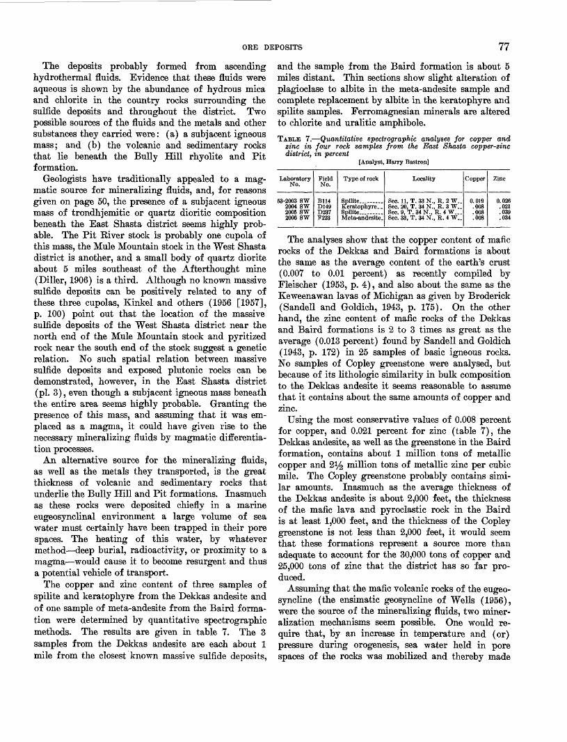
ORE DEPOSITS 77
The deposits probably formed from ascending hydrothermal fluids. Evidence that these fluids were aqueous is shown by the abundance of hydrous mica and chlorite in the country rocks surrounding the sulfide deposits and throughout the district. Two possible sources of the fluids and the metals and other substances they carried were: (a) a subjacent igneous mass; and (b) the volcanic and sedimentary rocks that lie beneath the Bully Hill rhyolite and Pit formation.
Geologists have traditionally appealed to a mag- matic source for mineralizing fluids, and, for reasons given on page 50, the presence of a subjacent igneous mass of trondhjemitic or quartz dioritic composition beneath the East Shasta district seems highly prob able. The Pit River stock is probably one cupola of this mass, the Mule Mountain stock in the West Shasta district is another, and a small body of quartz diorite about 5 miles southeast of the Afterthought mine (Diller, 1906) is a third. Although no known massive sulfide deposits can be positively related to any of these three cupolas, Kinkel and others (1956 [1957], p. 100) point out that the location of the massive sulfide deposits of the West Shasta district near the north end of the Mule Mountain stock and pyritized rock near the south end of the stock suggest a genetic relation. No such spatial relation between massive sulfide deposits and exposed plutonic rocks can be demonstrated, however, in the East Shasta district (pi. 3), even though a subjacent igneous mass beneath the entire area seems highly probable. Granting the presence of this mass, and assuming that it was em- placed as a magma, it could have given rise to the necessary mineralizing fluids by magmatic differentia tion processes.
An alternative source for the mineralizing fluids, as well as the metals they transported, is the great thickness of volcanic and sedimentary rocks that underlie the Bully Hill and Pit formations. Inasmuch as these rocks were deposited chiefly in a marine eugeosynclinal environment a large volume of sea water must certainly have been trapped in their pore spaces. The heating of this water, by whatever method deep burial, radioactivity, or proximity to a magma would cause it to become resurgent and thus a potential vehicle of transport.
The copper and zinc content of three samples of spilite and keratophyre from the Dekkas andesite and of one sample of meta-andesite from the Baird forma tion were determined by quantitative spectrographic methods. The results are given in table 7. The 3 samples from the Dekkas andesite are each about 1 mile from the closest known massive sulfide deposits,
and the sample from the Baird formation is about 5 miles distant. Thin sections show slight alteration of plagioclase to albite in the meta-andesite sample and complete replacement by albite in the keratophyre and spilite samples. Ferromagnesian minerals are altered to chlorite and uralitic amphibole.
TABLE 7. Quantitative spectrographic analyses for copper and zinc in four rock samples from the East Shasta copper-zinc district, in percent
[Analyst, Harry Bastron]
Laboratory No.
53-2003 SW2004 SW 2005 SW2006 SW
Field No.
B114D149 D237F223
Type of rock
Spilite-- _ . _Keratophyre-. Spilite... ...Meta-andesite.
Locality
Sec. 11, T. 33 N., R. 2 W__Sec. 20, T. 34 N., R. 3 W__ Sec. 9, T. 34 N., R. 4 W Sec. 33, T. 34 N., R. 4 W__
Copper
0.019.008 .008.008
Zinc
0.026.021 .039.034
The analyses show that the copper content of mafic rocks of the Dekkas and Baird formations is about the same as the average content of the earth's crust (0.007 to 0.01 percent) as recently compiled by Fleischer (1953, p. 4), and also about the same as the Keweenawan lavas of Michigan as given by Broderick (Sandell and Goldich, 1943, p. 175). On the other hand, the zinc content of mafic rocks of the Dekkas and Baird formations is 2 to 3 times as great as the average (0.013 percent) found by Sandell and Goldich (1943, p. 172) in 25 samples of basic igneous rocks. No samples of Copley greenstone were analysed, but because of its lithologic similarity in bulk composition to the Dekkas andesite it seems reasonable to assume that it contains about the same amounts of copper and zinc.
Using the most conservative values of 0.008 percent for copper, and 0.021 percent for zinc (table 7), the Dekkas andesite, as well as the greenstone in the Baird formation, contains about 1 million tons of metallic copper and 2^ million tons of metallic zinc per cubic mile. The Copley greenstone probably contains simi lar amounts. Inasmuch as the average thickness of the Dekkas andesite is about 2,000 feet, the thickness of the mafic lava and pyroclastic rock in the Baird is at least 1,000 feet, and the thickness of the Copley greenstone is not less than 2,000 feet, it would seem that these formations represent a source more than adequate to account for the 30,000 tons of copper and 25,000 tons of zinc that the district has so far pro duced.
Assuming that the mafic volcanic rocks of the eugeo- syncline (the ensimatic geosyncline of Wells (1956), were the source of the mineralizing fluids, two miner alization mechanisms seem possible. One would re quire that, by an increase in temperature and (or) pressure during orogenesis, sea water held in pore spaces of the rocks was mobilized and thereby made

78 GEOLOGY AND ORB DEPOSITS, EAST SHASTA COPPER-ZINC DISTRICT
a potential vehicle of transport for the mineralizing substances. As these hydrothermal fluids moved through the rocks in the geosyncline, particularly the mafic volcanic rocks, they took into solution a small percentage of the copper and zinc (and also sulfur, iron, precious metals, and lead) in these rocks. The direction of movement of the fluids was presumably toward areas of lower pressure such as faults, shear zones, and masses of fractured brecciated brittle rock like the Bully Hill rhyolite. These structures thus served as the collecting channels and, finally, as loci of deposition for the mineralizers. A noteworthy feature of this hypothesis is that the volume of poten tial source rock can be very large, thereby necessitat ing the subtraction of only a small fraction of the contained metals to account for all the known sulfide deposits of the district. On the other hand, the hypothesis requires the movement of fluids pervasively through the pore spaces of a large volume of rock. Kegional albitization and chloritization in the district indicate that such pervasive movement of fluids is possible and has taken place.
An alternative mechanism of mineralization might result from the granitization of mafic volcanic rocks deep in the geosyncline. Sullivan (1948) relates ore deposits and granitization. He points out that owing to the laws governing the geochemical distribution of elements as set forth by Goldschmidt (1937) the for mation of a granitic rock by replacement processes causes the valuable elements of ore deposits to be con centrated in inverse ratio to the extent to which they are incorporated by isomorphous substitution in the common rock-forming minerals. Copper, for example, because of its similar ionic radius, is believed to sub stitute for ferrous iron in ferromagnesian minerals, particularly augite (Rankama and Sahama, 1950, p. 697), and is thus more abundant in mafic igneous rocks than in granitic rocks. Zinc behaves similarly except that it is more abundant in biotite than in augite (Ran kama and Sahama, 1950, p. 710). In the granitization of mafic rocks, therefore, the copper and zinc cannot all be incorporated into the granitic rock by isomor phous substitution and is expelled into the surrounding rocks.
There is evidence that exposed parts of the Pit River and Mule Mountain stocks formed at least in part by replacement processes. Therefore, the possibility ex ists that a significant volume of Copley greenstone and other rocks deep in the geosyncline were either replaced or assimilated by granitic rocks, or were converted to granitic or quartz dioritic rock by palingenesis. In the replacement of such mafic rocks as the Copley and Dekkas formations a relatively large
percentage of the copper and zinc would be expelled and thus made available for concentration in ore de posits in structurally favorable places higher in the earth's crust.
Based on Diller's (1906) data for the thickness of preorgenic formations younger than the Pit, and on the writer's estimate of 5,000 feet for the Pit forma tion, the maximum thickness of stratigraphic cover that could have overlain the Bully Hill rhyolite at the time of orogeny is 11,650 feet. The depth at which the sulfide deposits were formed was certainly not greater than 11,650 feet. Moreover, inasmuch as folding and faulting almost entirely preceded sulfide mineralization, it seems likely that a good deal of ero sion may have taken place before mineralization, and the sulfide deposits may therefore have formed at depths much less than 11,650 feet.
The assemblage of sulfide minerals is typically a mesothermal assemblage as given by Lindgren (1933, p. 530) and therefore supposedly formed at tempera tures of 175° to 300° C. The similarity in texture and mineral composition of sulfide lenses throughout the district suggests that the same general temperature conditions prevailed throughout the district during the period of sulfide deposition.
SUGGESTIONS FOR PROSPECTING
All the sulfide ore bodies that crop out at the sur face have probably been found but it seems likely that blind sulfide lenses within a few hundred feet of the surface still remain undiscovered. These lenses are likely to be high-grade ore but they will be small and unevenly distributed. Exploration costs will be high- and unless several lenses are found close together mining will be unprofitable.
The areas regarded as geologically most favorable for prospecting are shown on plate 3. These areas are generalized and it is not meant to imply that they are all considered equally promising. They are outlined according to the following criteria:1. All the areas are either in the Bully Hill rhyolite,
or in the Pit formation close to the contact with the Bully Hill rhyolite. Known deposits are restricted to these two formations and it is improbable that deposits will be found in other rock units.
2. The rocks within the outlined areas are in many places highly sheared and contain abundant faults that could have served as feeder channels for the mineralizing fluids and as loci of deposi tion; some of these structures are contiguous with shear zones or faults along which known sulfide lenses occur.

ORE DEPOSITS 79
3. The rocks within the areas outlined are in general strongly silicified and in places contain dissemi nated base-metal sulfides, barite, disseminated pyrite, or limonite.
The Bully Hill rhyolite is probably much more favorable for prospecting than the Pit formation and deserves the most attention. Past production has been mainly from the Bully Hill rhyolite and it appears that that formation was both physically and struc turally a highly favorable host rock for the mineraliz ing fluids. The siliceous, brittle, locally brecciated and faulted character of the rock provided abundant fractures and small openings that allowed the fluids easy access and channeled them toward areas of lower pressure. The stratigraphic position of the Bully Hill rhyolite beneath the impermeable shale of the Pit formation was also a favorable environment for the deposition of sulfide minerals, as the rising fluids were probably retarded by the shale. Any prospecting in the Pit formation should be restricted to within a few hundred feet of its contact with the Bully Hill rhyolite, preferably to within a few hundred feet of fault contacts with the Bully Hill rhyolite.
The only direct surface indication of massive sulfide is structureless, cellular limonite gossan derived from the oxidation, in place, of a massive sulfide lens exposed by erosion. However, only about half a dozen of the 40 or more known sulfide lenses were thus exposed and therefore gossans are not particularly prominent.
Although gossans are not prominent, limonite and heavily iron stained rock is abundant, and in places it is difficult to distinguish between the true gossan de rived from the oxidation of massive sulfide and limonite formed by other processes. A few masses of structureless, cellular limonite interpreted as residual limonite overlie small bodies of massive or heavily disseminated pyrite (pi. 3). Also, on the divide between First and Second Creeks (pi. 3), and locally in the Bully Hill area (pi. 8) are masses of dense to spongy limonite that are far removed from any known sulfide mass. This limonite commonly has a weakly defined layering, as opposed to the structureless and generally more cellular residual limonite gossan. Dis crete masses of this limonite are commonly at about the same altitude on hillsides, indicating that the limonite was probably deposited along the margins of a body of water during late Tertiary or Pleistocene time. The highest masses of this transported limonite are at an altitude of about 1,750 feet.
Heavily iron stained rock, derived from rock con taining much disseminated pyrite, occurs at many places in the district and locally marks shear zones in
553967 61 7
which massive sulfide lenses are localized, either at depth, or along strike. The Afterthought shear zone (pi. 5) is an example. However, some areas of heavily iron stained or pyritized rock have been explored extensively by diamond drilling without success. The Cowboy (Abe Lincoln) prospect in sec. 4, T. 33 N., R. 2 W. is an example (pi. 15). Massive sulfide lenses, if present in these areas, are evidently neither directly beneath nor directly downdip from the heavily iron stained rock at the surface. This heavily iron stained rock therefore may or may not indicate massive sulfide nearby.
Eighteen chip samples of limonite, collected from several exposures in the area, were submitted in 1951 to H. E. Hawkes for chemical analysis for copper, zinc, and lead content. The results are shown on plate 3. Sample 1J13 represents limonite gossan collected from a few inches to about 2 feet above a small lens of massive sulfide unusually rich in lead. Sample B686 represents gossan collected from a few inches to a few feet above a lens of low-grade disseminated sulfide minerals. Samples D922, D608, and D611 are of limonite that occurs as a skim along the contour of hillsides in the First Creek area and which has obvi ously been water deposited. The remaining samples shown on plate 3 seem to be mainly of limonite derived from the oxidation, in place, of heavily disseminated sulfide.
The results of the geochemical tests are not promis ing and it seems unlikely that further geochemical analysis of limonites for copper, zinc, and lead, at least, will be of much value in prospecting for hidden sulfide deposits. No geochemical tests on bedrock were made in the East Shasta district. However, systematic sampling of bedrock for copper in the Mammoth mine in the West Shasta district gave negative results. Conditions in this locality are similar to those in the East Shasta district. Possibly geochemical testing of bedrock for cadmium or other minor elements might prove worthwhile.
Silicified rock containing in relative abundance one or more of a group of minerals that includes barite, anhydrite, calcite, hydrous mica or sericite, and pyrite in close proximity to a shear zone or fault is regarded as a favorable indication of sulfide mineralization. Sulfide bodies at the Rising Star mine, and also in the Copper City area are not exposed at the surface but are largely overlain by intensely silicified rock that commonly contains sparse stringers and small irregu lar bodies of limonite. Veinlets and blebs of barite are present in a few places. Cutting this intensely altered rock locally are shear zones containing gougy material composed of clay minerals mixed with silici-

80 GEOLOGY AND ORB DEPOSITS, EAST SHASTA COPPER-ZINC DISTRICT
fied rock. In the absence of limonite gossan, the com bination of intensely altered rock cut by shear zones may be an indirect surface expression of sulfide bodies. It is, however, not as reliable an indication of sulfide ore as residual limonite gossan, and therefore must be used with caution in searching for hidden deposits.
In our opinion, any serious prospecting program should begin with the detailed mapping of shear zones, faults, and alteration features. This should be fol lowed by a geophysical and possibly geochemical sur vey of the most promising localities in order to define as closely as possible potential targets for diamond- drill exploration.
CONTACT METASOMATIC MAGNETITE DEPOSITS
Virtually all the skarn masses that crop out between Marble Creek and the southern boundary of the area (pis. 1 and 3) contain magnetite in minor amounts. However, the only mass containing magnetite of min- able grade is that which constitutes the Shasta Iron mine in sec. 26, T. 34 N., E. 4 W. This deposit was not mapped in detail during the present study, as an excellent paper on the geology of the deposit by Lamey (1948, p. 139-164), including detailed maps and sections, has been published by the California Division of Mines. The following summary descrip tion of the ore deposits is quoted from Lamey's paper (1948, p. 139-140), but the reader is referred to the original report, especially to the detailed geologic map and sections and to the magnetic map.
The deposits consist of very discontinuous and irregular lenses of magnetite intercalated between lenses composed chiefly of garnet, epidote, and pyroxene, accompanied by some serpentine, a mineral resembling anthophyllite, and small amounts of pyrite and chalcopyrite. In general the deposits lie between a late Jurassic or early Cretaceous quartz diorite and the Permian (?) McCloud limestone, and were formed by contact-metamorphic replacement and by fracture filling. In addition to iron, materials introduced by the mineralizing solu tions include silica, some manganese and chromium, probably alumina, and perhaps magnesia.
The structure of the rocks is somewhat obscure, but two dominant structural trends are apparent, one of which is nearly northeast, the other nearly northwest. A magnetic map compiled from detailed dip-needle observations shows that the ore zone follows these two directions, especially the one trend ing northeast.
The total reserves, estimated by the Geological Survey from the magnetic map, mine pits, and five diamond drill holes put down by the Bureau of Mines, U.S. Department of the Interior (project No. 934), amount to 4,680,000 tons of ore having the following percentage composition: Fe, 37.82; SiO2, 13.24; S, 0.173; P, 0.014; Mn, 0.273. If all material containing less than 25 percent iron is omitted from consideration, the reserves estimated by the Geological Survey amount to 3,893,000 tons containing 41.28 percent iron. About 40 percent of the ore analyzed contains more than 40 percent iron, about 21 percent
of it more than 50 percent iron, and only 4 percent of it more than 60 percent iron.
QUARTZ VEINS
Quartz veins are common in two principal areas in the district. One is on the southeast slope of O'Brien Mountain in sec. 21, T. 34 N., K. 4 W.; the other is in the Backbone Kidge area in sees. 4 and 10, T. 33 N., K. 2W. (pi. 3).
The veins on O'Brien Mountain are as much as 10 feet thick and one was traced for about 1,400 feet. These veins have been prospected by means of a few pits and short adits, but whether any gold or other metal has been produced could not be ascertained.
The veins in the Backbone Ridge area are smaller and less continuous than those on O'Brien Mountain but have been worked more extensively and reportedly contained pockets of rich ore. Included in this group are the Old Indian (F. J. Ward) prospect, and the Cook prospect (pi. 3). Most of the veins strike N. 45° W. to east-west and dip either northeast or south west at moderate to steep angles. The veins range from 1 to 3 feet in thickness and continue for a few tens of feet to a few hundred feet along strike. Some veins contain numerous vugs lined with quartz crystals.
DESCRIPTIONS OF MINES AND PROSPECTS
AFTERTHOUGHT MINE
LOCATION AND OWNERSHIP
The Afterthought mine is near the east end of the East Shasta copper-zinc district in sees. 10 and 11, T. 33 N., E. 2 W. (pi. 3). The mine plant and main haul age level are about a third of a mile northeast of the village of Ingot on the east bank of Little Cow Creek, at an altitude of 1,125 feet. The mine is developed to a depth of 729 feet by 10 levels. It is owned by the Coronado Copper & Zinc Co.
HISTORY AND PRODUCTION
The history of the Afterthought mine dates back to 1862 when the Copper Hill claim was staked (Frank and Chappell, 1881, p. 23-25). During the first few years after discovery the oxidized ore near the surface was mined on a small scale for gold and silver. In 1873 C. M. Peck, who had erected the first ore mill in the Copper City area, purchased the property for a reported $6,000 and named it the Peck mine. During his first 2 years of ownership Peck and his men mined copper ore from shallow workings and carried it in sacks to the top of the hill east of the mine, where it was loaded on wagons and hauled to Stockton, Calif. At Stockton it was transferred to ships that trans ported it to Swansea, Wales.

DESCRIPTIONS OF MINES AND PROSPECTS 81
According to Anbury (1908, p. 45), Peck, in 1875, built a reverberatory furnace, in which wood was to be used as a fuel in the reduction of the base ores beneath the oxidized surface ores. This furnace proved unsuc cessful, and upon the advice of a Mr. Williams, a water-jacket furnace was built, in which charcoal was to be used. Owing to the refactory character of the ore, which caused repeated freezing and other difficul ties that could not then be surmounted, this attempt to smelt the ore also ended in failure.
Later, according to Aubury (1908, p. 45), the prop erty was acquired by Joseph Conland and associates, who built a small water-jacketed blast furnace of 25- ton capacity. Two attempts to treat the ore in this furnace were made but both were unsuccessful. In 1896, according to Aubury (1902, p. 66), 200 tons of ore were smelted. This yielded 32 tons of copper matte containing 37 percent copper, 45 ounces of silver, and $7 in gold per ton.
In 1903 The Great Western Gold Co. acquired the Afterthought property and built a 250-ton water- jacketed blast furnace (Tucker, 1924, p. 425). Ore was successfully reduced in this furnace for the first time in 1905 and the operation continued successfully until 1908. During this period the average yearly out put is reported to have been $350,000 (Brown, 1916, p. 757-770). The copper matte produced in the blast furnace was shipped to a smelter in Salt Lake City where it was converted to blister copper (Aubury, 1908, p. 103). However, the high zinc content of the ore made it extremely refractory, necessitating a large coke charge and causing the furnace to freeze fre quently.
In 1909 the property was acquired by the After thought Copper Co. but no further mining was done until 1919. A 300-ton oil-flotation mill and a 300-ton reverberatory furnace were completed in 1919, with the objective of treating the sulfide ore by the Har- wood process. In this process the ore was first pre- roasted in the reverberatory furnace and then treated by flotation (Averill, 1939, p. 174). This operation continued from July 1919 to February 1920. The re sults were unsuccessful because the zinc and copper sul- fides could not be cleanly separated.
Late in 1923 the Afterthought Copper Co. lost con trol of the property through foreclosure. Early in 1925 the California Zinc Co., owners of the Bully Hill- Eising Star property, began mining ore under lease and option. This ore was sent by aerial tram to Bully Hill for milling. The company operated successfully until 1927 when the mine closed owing to a drop in the price of metals. Zinc was the principal product dur ing this period.
No further work was done at the Afterthought mine until 1945-46 when the mine was reopened by the Cor- onado Copper & Zinc Co. New ores bodies were found by exploratory drilling and the company purchased the property in 1947 for $110,000. A 100-ton flotation plant was built and mining was started in October 1948. In July 1949, the mine was closed, owing to a drop in the price of metals. It was reopened in July 1950 and operated continuously until August 1952, when it was again closed owing to the depletion of ore.
During the period of operation by the Coronado Copper & Zinc Co. the crude sulfide ore was ground to 94 percent minus 200 mesh and 2 concentrates were made by selective flotation. One, a copper-lead con centrate, was shipped to a smelter at Tooele, Utah; the other, a zinc concentrate, was shipped to a smelter at Great Falls, Mont. This method of treating the ore was reasonably successful, although a large amount of sphalerite was continuously lost in the copper-lead con centrate because of the fineness of grain and intimate admixture of sphalerite, chalcopyrite, and galena, and also because of marked variation in the character of ore from different stopes and even from the same stope. Smaller amounts of copper and lead minerals were lost in the zinc concentrate. These losses were kept within reasonable limits, thereby permitting profitable operation of the mine, owing to astute mine and mill management.
According to data furnished by the Coronado Cop per & Zinc Co.14 the gross production of the After thought mine since 1905 has been 166,424 tons of ore averaging about 16 percent zinc, 2.7 percent copper, 2 percent lead, 5 ounces of silver and 0.04 ounce of gold (table 8). Zinc was not recovered in the direct smelt ing methods of ore treatment before 1919. Production between 1862 and 1905 is unknown but was probably small.
TABLE 8. Summary of ore produced from the Afterthought mine, 1905-52 l 3
Year
1905-07- .....1917-19 1919-20- .....1925 __ ...1926-27 194&-49- __ -1950-52- .....
Total..
Length of opera
tion (months)
11 Ji 5 6 3
20 10 26
81 Ji
Tons mined
52, 150 12,490 23,669 4,939
33,123 18,989 21,064
166,424
Copper (percent)
4.30 3.06 2.96
(3 ) 2.71 2.38 2.57
*3.23
Zinc (percent)
NR NR NR
(«) 16.01 15.43 17.02
* 16. 15
Lead (percent)
NR NR NR
(») NR 2.17 2.18
2.17
Silver (ounces)
7.44 5.30 3.11
(») 4.90 5.35 4.96
*5.55
Gold (ounces)
0.03 .02 .01
(») .02 .04 .04
.03
i Data furnished by Coronado Copper & Zinc Co. Published with permission.* Mine was not in operation except during years listed. »No assays available.* Weighted assay.NR Not recovered.
"Published with owners permission.
82 GEOLOGY AND ORB DEPOSITS, EAST SHASfTA COPPER-ZINC DISTRICT
Workings. The principal workings of the After thought mine include 10 levels and extend vertically for 729 feet (pi. 4). The 400 level, which is the main haulage level, extends 2,910 feet in an easterly direc tion from its portal on Little Cow Creek. At 1,450 feet from the portal a 329-foot vertical shaft called shaft 1 connects the 400 level with the surface. Two vertical underground shafts, one 300 feet deep and the other 400 feet deep, connect the 400 level with lower workings. The mine workings total about 19,400 linear feet, including 17,200 feet of drifts, crosscuts, and stopes and 2,200 feet of raises and shafts (pi. 4).
Sources of geologic data. During the present study (1949-50) 9,790 feet of the mine workings were acces sible and were mapped at a scale of 1 inch equals 40 feet. An additional 3,200 feet of workings, inaccessi ble at the time of this study, had been mapped in 1946 by F. W. Stewart, a consulting geologist retained by the Coronado Copper & Zinc Co., and his maps and report were made available to the writers through the courtesy of the company. The remaining 5,710 feet of workings were inaccessible in 1946 as well as at the time of the present study. Information on these work ings is scanty and is taken largely from unpublished maps by C. O. Lindberg who examined the property in 1919. The areas where geologic data have been taken from maps by Stewart and Lindberg are shown on plate 6. However, the interpretation of these data, as presented on cross sections and in the text of the present report is entirely the authors' responsibility.
About 720 feet of new workings on the 500 and 600 levels were driven after completion of the present field- work. These workings are shown on the composite map of the mine (pi. 4) but the geology was not mapped.
GEOL.OGY
The Afterthought mine lies astride the contact be tween the Bully Hill rhyolite and Pit formation on the northeast limb of the Afterthought anticline (pis. 1 and 3). The contact between the two formations strikes about N. 45° W. and in general dips northeast at moderately steep angles. Within the immediate min eralized area, however, the contact is disrupted by a series of steeply dipping strike faults, so that in sec tion it has an irregular benchlike or steplike form. The benchlike form of the contact is shown by the ac companying sections (pi. 5) and in three-dimensional aspect by the block diagram (pi. 7).
BTTLLY HILL BHYOLITE
The Bully Hill rhyolite crops out in the western part of the Afterthought mine area as shown in plate 5 in cludes nonporphyritic and porphyritic quartz kerato- phyre flows and at least three kinds of quartz keroto-
phyre breccia of volcanic or tectonic origin. About 70 percent of the formation, including brecciated facies, is nonporphyritic; the remaining 30 percent is por phyritic. Quartz and albite phenocrysts in the por phyritic facies range from 1 to 4 mm in diameter. Contacts between nonporphyritic and porphyritic fac ies are sharp in some places but gradational in others. The two facies are not differentiated on underground maps. In some places both the nonporphyritic and porphyritic quartz keratophyre have columnar struc ture. This structure is most common in the upper part of the Bully Hill rhyolite within about 400 feet of the contact with the Pit formation (pi. 5). The columns are 4-, 5-, or 6-sided, commonly have a somewhat sinu ous form, and in cross section average 1 to 2 inches in diameter. In most places they plunge northwestward or southwestward at moderate angles but in a few places they plunge southeastward.
Breccias. Three main types of breccia were recog nized in the Bully Hill rhyolite in the mine area. They are: volcanic breccia, monolithologic breccia (breccia composed of a single type of rock) and crackle breccia of probable tectonic origin, and shear breccia.
The volcanic breccia is a coarse breccia consisting of angular fragments of quartz keratophyre as much as a foot in diameter in a quartz kerotophyre matrix. The fragments are commonly closely packed and are of two types of rock: flow-banded quartz keratophyre and quartz keratophyre without flow structure. As shown on the surface map (pi. 5), this volcanic breccia crops out in the southwestern part of the Afterthought area, remote from the main area of mineralization.
At many places in the upper part of the Bully Hill rhyolite, within a few hundred feet of the contact with the Pit formation, quartz keratophyre with columnar structure grades into crackle breccia characterized by much fractured rock with but little disarrangement of the segments of columns, and thence into a mono lithologic breccia consisting of closely packed angular fragments similar in size, cross-sectional outline, and composition to nearby columns. It seems evident that this breccia formed by the breaking up and dislocation of the small brittle columns, either by differential movements during late stages of consolidation of the lava, or, more probably, by tectonic movements during deformation.
Two types of breccia interpreted as shear breccia crop out in the mine area. One type, which crops out mainly north of the buildings, consists of sparse frag ments of hard, unsheared quartz keratophyre in a matrix of softer sheared quartz keratophyre. The fragments are slightly elongate or lens shaped and most are a fraction of an inch in diameter. They are

DESCRIPTIONS OF MINES AND PROSPECTS 83
somewhat lighter in color than the sheared matrix and therefore stand out in sharp contrast to it. Contacts between this type of breccia and the unbrecciated rocks surrounding it are gradational.
A second type of tectonic breccia is referred to as puddinhead breccia by local miners. It consists of angular to subrounded quartz keratophyre fragments in a matrix of dark-gray to black, soft, commonly slickensided shaly material. Many fragments are simi lar in size and cross-sectional outline to prismatic col umns in rocks with columnar structure and are evi dently fragments of columns. A thin section of the shaly matrix of the puddinhead breccia shows that its dark color is due to carbonaceous material. Other constituents of the matrix are quartz and clay min erals. The matrix is probably sheared mudstone.
The distribution of the puddinhead breccia is irregu lar; it occurs near, but not everywhere adjacent to, shale of the Pit formation. Its contacts with the shale are commonly sharp and seem to be faults of small displacement. Observed contacts between puddinhead breccia and quartz keratophyre also are faults. Con tacts with monolithologic quartz keratophyre breccia are commonly gradational. The largest exposed body of puddinhead breccia is on the 400 level a few feet northeast of the shaft 1. This body has an outcrop width of 40 feet and a strike length of 140 feet or more.
The puddinhead breccia is probably of tectonic origin although the shaly material that forms the matrix may originally have been mixed with columnar jointed volcanic rock by sedimentary processes.
PIT FORMATION
The shale and tuff that crop out in the northeastern part of the Afterthought area belong to the Pit forma tion. The shale is medium gray to black and is indis tinctly bedded. At most places it has a prominent cleavage that locally parallels bedding but more com monly does not. Most of the shale effervesces slightly in dilute hydrochloric acid.
More than half of the Pit formation in the After thought area is tuff that forms beds interlayered with shale. Individual tuff beds commonly differ slightly in color, grain size, and composition but these differ ences are too slight and too variable to use in correlat ing the beds from one part of the area to another. Most of the tuff is light gray, poorly bedded, and con sists mainly of fine chlorite, crystals and clasts of quartz and feldspar, and small lithic fragments, gen erally less than half an inch in diameter. Some tuff beds contain shale fragments as much as a foot long. Inasmuch as most of the tuff is about the same com position as the Bully Hill rhyolite, it is difficult to dis
tinguish the two kinds of rock in places where they are poorly exposed and much sheared and altered.
ALTERATION
Five main kinds of alteration that have affected the rocks in the Afterthought area are albitization, silicifi- cation, hydrous mica alteration, calcitization, and pyritization. Although the effects of these alteration processes are not restricted to the mine area, all except albitization are, nevertheless, locally more conspicuous in the mine area than elsewhere. As shown by the sec ondary minerals, the effects of all 5 alteration processes can be seen in some places, whereas in others the effects of only 1 or 2 processes can be seen. The kind of al teration as well as the intensity seem to be dependent in part on the composition of the original rock and in part on local structural conditions at the time altera tion occurred. In general, silicification, hydrous mica alteration, and pyritization are the most conspicuous alterations affecting the Bully Hill rhyolite, whereas calcitization is more conspicuous as an alteration of the Pit formation. The feldspar in all the rocks is albi- tized.
In many places along shear zones and faults in the mine the Bully Hill rhyolite, as seen in thin section, is intensely altered to a rock consisting of quartz, pyrite, hydrous mica, and calcite, in various porportions. Vir tually none of the original mineral components except quartz remain; the quartz is largely recrystallized to a mosaic of microcrystalline grains, or to feather or ribbon quartz surrounding pyrite cubes. Pyrite, which forms euhedral and subhedral crystals, and hydrous mica, are concentrated in discrete layers parallel to schistosity. Bounded to irregular masses of calcite a few millimeters in diameter, characterized by wavy extinction, are present locally. These masses of in tensely altered rock range from a few feet to several hundred feet in maximum dimension. They are local ized largely along shear zones and faults and down- dip and laterally from sulfide bodies. Below the 500 level this intensely altered rock is contiguous to and forms envelopes around sulfide lenses that replace Bully Hill rhyolite. In the upper part of the mine, the 120, 122, and 220 ore bodies (pi. 6) replace shale but the mineralizing fluids that formed them appar ently traveled along faults that extend into the Bully Hill rhyolite downdip from the sulfide bodies. Along these faults the Bully Hill rhyolite is intensely silici- fied and moderately pyritized.
Elongate masses of calcitized tuff belonging to the Pit form conspicuous dark-gray, locally iron stained outcrops in the Afterthought area. The largest masses of calcitized tuff are several hundred feet long and as much as 100 feet wide. All are parallel to bedding. A

84 GEOLOGY AND ORB DEPOSITS, EAST SHASTA OOPPE.R-ZINC DISTRICT
few small masses of calcitized rock also occur locally underground along the margin of the 120, 220, and 420 ore bodies. These small masses replace the Bully Hill rhyolite. The calcitized rock, locally known as lime rock, consists of calcite crystals ranging from 1 to 5 mm in diameter that have partly to completely re placed the original constituents as well as earlier formed secondary constituents of the parent rock. Be cause the calcite replaces all other minerals except sul- fides it seems that calcitization was the last alteration process, except sulfide mineralization, to be imprinted on the rocks in the area. Calcitized rock occurs along the margins of some ore bodies but its presence is not a reliable indication of sulfide mineralization because large masses of rock remote from known sulfide lenses are also calcitized.
STRUCTURE
Although the structural setting of the Afterthought mine, on the northeast limb of a large anticline and astride the contact between the Bully Hill rhyolite and Pit formation, is simple from a broad viewpoint, the detailed structural pattern of the immediate mineral ized area is complex. The complexity results mainly from the many faults and shear zones that virtually surround the mineralized area and divide it into a group of fault blocks. Folds, though locally present, are of secondary importance in the shaping of the de tailed structural pattern.
Interpretation of the detailed structural pattern is difficult owing in part to the lack of marker units in either the Bully Hill rhyolite or the Pit formation and in part to locally intense alteration that masks the original character of the rocks. The only marker that could generally be recognized with certainty is the contact between the two main rock units; but even this is subject to doubt in a few places because of the litho- logic similarity between altered Bully Hill rhyolite and altered tuffaceous rocks of the Pit formation. On the other hand, interpretation of the structure has been greatly facilitated by the density of mine workings and by an abundance of diamond-drill core data. Without these data it would have been impossible to determine the shape of the highly irregular contact between the two formations.
Cleavage and schistosity. Cleavage or schistosity, at an angle to bedding, is present in most rocks of the area as shown on the detailed geologic map (pi. 5). They are unequally developed and grade into each other locally; in a few places they are absent. Both cleavage and schistosity strike northwest and dip steeply southwest. They grade into each other in many places by a decrease in the distance of parting planes from several inches or a fraction of an inch
apart in rocks with cleavage, down to a fraction of a millimeter in schistose rocks. The most strongly schistose rocks mark irregular zones of intense shear ing that locally, at least, have controlled sulfide min eralization. In a few places where cleavage or schistosity is associated with small folds it parallels the axial planes.
Folds. In the Pit formation 6 small folds having amplitudes and wavelengths of a few feet were seen underground and 9 slightly larger folds were mapped on the surface in the Afterthought area (pi. 5). Most of the folds are interpreted as drag folds on the north east limb of the Afterthought anticline. The strike of all the small folds seen underground and of 7 of the 9 folds mapped on the surface ranges from N. 30° to 70° W. Fold axes plunge as much as 25°, either northwest or southeast, and axial planes dip steeply southwest, parallel to schistosity. Two folds on either side of coordinate E. 5,000 near the north edge of the surface map (pi. 5) strike nearly north and are at an angle to the main structural trend in the area. The divergence of these two folds may be due to faulting or to local buttressing during folding, caused by depo- sitional irregularities in the contact between the com petent Bully Hill rhyolite and the incompetent Pit formation.
In addition to the folds described above, a south eastward plunging troughlike structure occupied by the Pit formation and outlined by the contact between the Pit formation and the Bully Hill rhyolite is be tween the 400 and 600 levels in the mine (pis. 5 and 6). On its southwest side the trough is bounded by fault 420, which is nearly vertical. Northeast of the trough the southeastward-plunging nose of Bully Hill rhyo lite is in part replaced by the 450 ore body and cut off on its northeast flank by the Main fault. This nose is exposed on the 400 level between the shafts 2 and 3. The overall shape of this combined trough and nose structure suggests a large drag fold plunging south eastward at an angle of about 30°. However, contacts between the 2 rock units that outline the structure, wherever they have been observed (on the 400, 450, and 500 levels), are faults, and if the structure is a drag fold it is certainly much modified by faulting. An alternative explanation to the drag fold hypothesis is that the "trough" of Pit formation is a depressed fault block bounded on the northeast as well as on the southwest side by structurally higher blocks. This is the preferred interpretation as it removes the neces sity of drag folding the highly competent Bully Hill rhyolite and is in better accord with the fact that all observed contacts between the Pit formation and the Bully Hill rhyolite outlining the structure are faults.

DESCRIPTIONS OP MINES AND PROSPECTS 85
Faults and shear zones. The detailed structure of the Afterthought mine is largely determined by faults and shear zones. The immediate mineralized area, which is virtually surrounded by faults (pi. 5), is bounded by the Afterthought shear zone on the south west side, by the Main fault and the fault to northeast of the glory hole on the northeast side, and by the Northeast fault on the southeast side. Faults and shear zones are also abundant in the underground workings. They can be subdivided into four main groups on the basis of their attitude and also roughly on the basis of age, as follows: (a) Low-angle thrust faults; (b) high-angle normal and strike-slip faults and shear zones that strike northwest; (c) moderately high-angle normal faults that strike northeast; and (d) the Main fault, a reverse fault that strikes northwest and dips 45° to 60° NE.
Low-angle thrust faults are the oldest. These faults, which were seen in only a few places on the 200, 300, and 400 levels, are scarce and data on them are scanty. Most of these faults dip south at angles ranging from 10° to 25°. They clearly cut cleavage but are offset by high-angle faults. The largest and principal thrust fault, is exposed on the 400 level about 65 feet south west of shaft 1 (pis. 5 and 6, section A-A'}. This fault, which strikes about east-west and dips 20° S., has Bully Hill rhyolite on the hanging wall and Pit formation on the footwall. The Bully Hill rhyolite on the hanging wall forms a block about 100 feet thick between the 200 and 400 levels, which is thrust north eastward over the Pit formation for about 150 feet (pi. 5, section A-A'}. This block has been displaced and modified by younger high-angle faults and it is possible that the total horizontal displacement on the thrust fault is greater than the 150 feet shown on section A-A'.
The most abundant and probably the most impor tant faults from an economic standpoint in the mine are high-angle faults that strike N 60° to 80° W., al most parallel to the general trend of the contact be tween the Bully Hill rhyolite and Pit formation, and dip vertically or steeply southwest. Locally, the dip is steeply northeast. These faults, which are largely responsible for the benchlike form of the contact be tween the two formations, will henceforth be called strike faults. Included in this group are faults 122, 220, 420, and 412, and many smaller unnamed faults.
Along faults 122, 220, 420, and probably No. 412 the northeast side is displaced downward relative to the southwest side but along at least three of the unnamed faults (pi. 5) the southwest side is displaced down ward. Apparent dip-slip displacements range from a few feet to 250 feet or more. Strike-slip displace ments are known but are probably small.
All except one of the strike faults, No. 122, intersect and are cut off underground by the Main fault and therefore do not crop out at the surface. Fault 122 (pi. 5, sections A-A', B-B', and C-C') should reach the surface but is not exposed. At depth, where the strike faults are entirely within the Bully Hill rhyo lite, they seem to branch or splay out into shear zones and thereby lose their identity as individual faults.
Zones of highly sheared Bully Hill rhyolite are common in the deeper parts of the Afterthought mine and locally elsewhere. The attitude of these shear zones is parallel to cleavage and also nearly parallel to the strike faults except that the dip is consistently southwest. The Afterthought, and other shear zones along which the 450, 700a, and 800 sulfide ore bodies are localized are typical (pis. 5 and 7). These zones of intensely sheared rock were probably formed in part at least during the same stage of deformation that produced the strike faults.
About 5 to 10 percent of the faults in the mine area are high-angle faults that strike northeast and dip either northwest or southeast at moderately steep an gles. The Northeast, the principal fault in this group, is a normal fault with a dip-slip displacement of about 75 feet. Evidence on the relative age of the faults that strike northeast is scarce. They are younger than the low-angle thrusts and are older than the Main fault but their age relative to the strike faults is not known. Probably they are contemporaneous or slightly younger.
The Main fault, the largest and most continuous fault in the mine area, strikes N. 45° W., dips 45° to 60° NE., and cuts all other faults (pi. 5). In some places, as on the 200 level, the Main fault is a shear zone as much as 12 feet thick; in other places, as on the surface above adit 4, it is a shaly breccia zone a few inches thick bounded by slickensided surfaces. Grooves on the slickenside surfaces plunge directly downdip. Evidence regarding the direction of move ment on the Main fault is scarce and inconclusive but it is intrepreted to have reverse movement with a dip- slip displacement of about 450 feet. This conclusion is based on the premise that the wedge-shaped segment of Bully Hill rhyolite in the hanging wall of the Main fault (pi. 5), is an upthrown segment of the nose of Bully Hill rhyolite that forms the footwall of the fault below the 400 level. Above the 400 level a block of sedimentary rock belonging to the Pit formation forms the footwall of the fault. This block gradually widens toward the surface (pi. 5) because the average north east dip of the contact between the Bully Hill rhyolite and Pit formation is less than the dip of the Main fault. Under such circumstances, if the Main fault

86 GEOLOGY AND ORE) DEPOSITS, EAST SHASTA COPPER-ZINC DISTRICT
were a normal fault, there would be no source for the segment of Bully Hill rhyolite in the hanging wall.
It is possible that above the present erosion surface the contact between the Bully Hill rhyolite and Pit formation dipped at a steeper angle than the Main fault. Under these conditions, with normal movement on the fault, the wedge-shaped segment of Bully Hill rhyolite could be down-dropped. Owing to the known geometry of the contact this is here considered un likely.
Virtually all the faults and shear zones, including the Main fault are of premineral age. This is shown by: (a) the presence of sulfide minerals as well as gangue minerals at many places along the faults and shear zones, especially along the strike faults (pi. 5); and (b) by the lack of brecciation or slickensiding of these secondary minerals. The premineral age of the Main fault, which is the youngest fault, is less well established than for the other faults, because many of the workings exposing this fault were inaccessible at the time the mine was mapped. The Main fault prob ably preceded mineralization because calcite-quartz veins, which are closely related in age to the sulfide minerals, were seen in the fault on the 200 and 300 levels and in adit 7 (pi. 6), and because sulfides in the hanging wall of the fault in adit 7 are not broken or slickensided and in part occur in the fault zone. In direct evidence suggesting that the Main fault is pre mineral lies in the fact that the fault zone was ex plored at six different mine levels by hundreds of feet of workings, now largely inaccessible; although no geologic records for these exist it seems probable that at least small lenses of sulfide were found in places along the fault to encourage continued exploration.
Minor postmineral movement is postulated on the Main fault because locally the calcite-quartz veinlets in the fault zone are slightly crumpled.
Bench structure. One of the most puzzling struc tural problems in the Afterthought mine is the irreg ular benchlike cross-sectional form of the contact be tween the Bully Hill rhyolite and the Pit formation (pi. 5). Five benches, ranging in width from 20 to about 200 feet, have been recognized. The benches, which slope gently southeastward occur through a vertical range of about 500 feet. In some places bed ding in the Pit formation is conformable to the benches but locally, as in the 120 stope, it seems to be at an angle.
In an earlier report (Albers, 1953, p. 10) it was postulated that part of the Bully Hill rhyolite in the mine area was an intrusive body and that the bench structure resulted in part from intrusion of viscous magma into the Pit formation and in part from fault
ing. However, with additional data on the Bully Hill rhyolite now available from the areal study, it seems unlikely that any of the Bully Hill rhyolite in the mine area is intrusive. Also, a reexamination of all data, including new drill-core data not available at the time the earlier report was prepared, indicates that the bench structure in the mine area can be explained more reasonably by the combination of a local flatten ing of the dip between the Bully Hill rhyolite and Pit formation and high-angle faulting.
StTLFIDE DEPOSITS
Mineralogy. Primary sulfide minerals in the After thought mine are, in order of decreasing abundance, sphalerite, pyrite, chalcopyrite, galena, tetrahedrite- tennantite, bornite, and luzonite. Gangue minerals are calcite, quartz, and barite. The ore is a fine grained mixture of these sulfide and gangue minerals and is commonly banded. Grain size ranges from less than 0.01 to 4 or 5 mm, and averages probably about 0.1 mm. Supergene minerals include covellite, chalco- cite, chalcopyrite, azurite, malachite, and reddish- brown iron oxide.
Grade. According to data furnished by the Coro- nado Copper & Zinc Co. (written communication, 1953), the average assay of sulfide mined from the Afterthought mine was about 16 percent zinc, 2.7 per cent copper, 2 percent lead, 5.0 ounces of silver, and 0.04 ounce of gold. However, the grade of individual ore bodies may differ markedly from this overall aver age. Also, the grade within a given ore body is not uniform. Figure 12 is an assay map of the 220 stope. The grade of ore in this stope was somewhat higher than the average grade for the mine as a whole but was not as high as the grade of ore from the 450 stope. Most of the ore in the 220 stope replaced shale that overlay a bench of Bully Hill rhyolite.
Form and size. Individual sulfide bodies are tabular to cigar-shaped lenses ranging from a few inches to about 400 feet in maximum dimension and from a few ounces to possibly 50,000 tons in mass. About 16 sep arate and discrete ore bodies have been mined. Some ore bodies were virtually massive sulfide but others con sisted of many thin closely spaced layers of sulfide separated by septa of unreplaced country rock.
Practically all the lenslike sulfide ore bodies strike northwest parallel to the grain of the country rocks and dip vertically or steeply southwest. Some lenses plunge as much as 10° SE. but most are nearly hori zontal, so that their maximum dimension or rake length is approximately in the horizontal plane. The thickness of the lenses, including those that consist of closely spaced layers of sulfide separated by bands of country rock, ranges from 0 to about 40 feet.

DESCRIPTIONS OF MINES AND PROSPECTS 87
19°30S
Data furnished by the Coronado Copper and Zinc Co.
FIGURE 12. Assay map of the 220 stope, Afterthought mine. Data are given in the following table.
Assay data of samples from the 220 stope, Afterthought mine
[Sample numbers are shown in figure 12. Data furnished by the Coronado Copper and Zinc Co.]
Sample
123456789101112131415161718192021222324252627282930
Total sample width Weighted averages
Horizontalwidth
9.64.65.43.74.66.08.18.16.06.06.06.07.04.73.85.16.46.46.06.16.26.77.07.07.02.74.03.04.86.8
174.8
Percent
Zn
14.028.032.219.64.61.61.81.27.7
20.03.50.3
20.510.18.4
15.335.127.014.622.728.219.230.731.231.210.027.025.325.022.5
17.8
Cu
1.683.502.271.552.822.541.112.582.303.256.725.735.803.153.403.281.10.95
1.682.461.305.60
11.033.583.80.55
2.463.302.702.05
3.21
Pb
1.13.81.93.02.4.8.6.3.2
2.44.01.32.2.7.5
2.05.84.92.41.12.31.54.55.01.9.6
2.66.63.34.3
2.4
Ounces
Au
0.05.04.04.04.04.02.01.02.02.04.01.03.13.04.06.08.08.03.08.08.05.04.06.07.08.03.06.06.06.06
.05
Ag
4.05.47.06.25.27.6.8
4.49.77.7
40.212.413.66.29.66.65.54.45.67.05.57.2
11.913.713.91.67.4
18.019.814.4
9.3
For convenience in reference, the 16 ore bodies that have been mined are given a name or a number. The Afterthought, Copper Hill No. 2, AU 5, 450, 600, 700a, 700b, and 800 ore bodies are in the Bully Hill rhyo- lite, and the Copper Hill No. 1, 120, 122, AS 6, 220, 412, 420, and AU 40 ore bodies are in the Pit forma tion or along contacts between the Bully Hill rhyolite and Pit formation. Practically all the ore bodies mined are shown in plan and section on plates 6 and 7.
Structural control. Three structural features that have influenced the localization of ore bodies in the Afterthought mine are: (a) the strike faults and shear
553967 61 8
zones; (b) the Main fault; and (c) drag folds in the sedimentary rocks.
The Copper Hill No. 2, Afterthought, 450, 600, 700a, 700b, and 800 ore bodies were along shear zones that strike northwest and dip southwest in the Bully Hill rhyolite. All these shear zones except the first two are in the footwall of the Main fault and are trun cated by the fault. Below the 200 level this fault has a shale hanging wall, and the bedding in the shale is nearly parallel to the fault plane. The 450 stope, which contained the highest grade ore in the mine, is in a shear zone that is cut off directly above the stope by the Main fault. As illustrated in figure 10, it seems likely that ore-bearing fluids rising along the shear zone were sufficiently retarded by the Main fault and the impermeable shale barrier to force a change in direction, thereby allowing time for reaction with, and replacement of, the host rock to take place. Other ore bodies in shear zones beneath the 450 ore body (pi. 5, section B-B'} may have formed in a similar manner but the evidence is less conclusive. The Copper Hill No. 2 ore body is in a shear zone in the wedge of Bully Hill rhyolite in the hanging wall of the Main fault. The shearing dips into the Main fault at an angle and, as illustrated in figure 10, this shear zone as well as the fault along which the Copper Hill No. 1 ore body was localized were structurally favorable for the reception of ore-bearing fluids rising along the Main fault.
The 120, AS 6, and possibly the AU 5 sulfide bodies replaced shale above benches of Bully Hill rhyolite. All these ore bodies were not immediately above the Bully Hill rhyolite but were separated from it by several feet of almost barren shale (pi. 5). Although no fault or shear zone is known to underlie these ore bodies it seems probable that such structures, with minor displacement, do exist. They probably served as feeders for the ore-bearing fluids in the same man ner in which the strike faults and shear zones served as feeders along which other ore bodies in the mine were localized. What part, if any, the bench structure played in the localization of deposits, and why the bodies formed in shale above the Bully Hill rhyolite benches is not understood. Possibly the shale was chemically more receptive to replacement than the Bully Hill rhyolite.
The Copper Hill No. 1, 122, 220, 420, and AU 40 ore bodies were along strike faults between the Bully Hill rhyolite and Pit formation. The dip of these faults is not uniform but ranges from steep to the northeast, through vertical, to steep to the southwest. Where the dip is southwest the massive Bully Hill rhyolite steeply overhangs the Pit formation (pi. 5,

88 GEOLOGY AND ORB DEPOSITS, EAST SHASTA COPPE'R-ZDSTC DISTRICT
sections A-A' and B-Bf ) and the sulfide lenses formed beneath these overhangs mainly as a replacement of shale. Elsewhere, mineralization along the faults is chiefly in the form of disseminated sulfide and quartz- calcite veins.
ASHER PROSPECT
The Asher prospect, located in the northeastern part of sec. 2, T. 33 1ST., K. 2 W., is along a fault in the Pit formation (pi. 3). The fault strikes about 1ST. 10° E. and is almost vertical. The prospect is developed by an adit about 50 feet long that extends beneath U.S. Highway 299E and by a 60-foot inclined shaft. Eock containing heavily disseminated sphalerite is exposed for a width of about 2 feet in the adit, and the dump near the shaft has rock fragments containing sphaler ite and galena. There is no record of ore having been produced from this prospect.
PROSPECTS IN THE BRUSHY CANYON AREA
The Brushy Canyon area embraces a group of adits and pits in the central and northern part of sec. 34, T. 34 N., K. 3 W. (pi. 3). It probably includes two prospects formerly known as the De Dallis and Brushy Canyon prospects (Brown, 1916, p. 763-764).
The area is underlain by shale and mudstone inter- bedded with quartz keratophyre flows and tuff of the Bully Hill rhyolite (pi. 1). These rocks strike gener ally northwest and dip northeast at moderate angles. They are strongly silicified and contain lenses of red and brown limonite as much as 10 feet thick and sev eral hundred feet long. The limonite lenses seem to be derived from sulfide that has replaced quartz kerato phyre breccia or tuff, and to be parallel to bedding in the enclosing silicified shale. Four samples of limon ite, tested by geochemical methods for copper, zinc, and lead (pi. 3), showed a copper content ranging from 50 to 130 ppm, a zinc content ranging from 90 to 270 ppm, and no lead (H. E. Hawkes, written com munication, 1952). Pyrite found on the dump of the northernmost adit in sec. 4 (pi. 3) was the only sulfide mineral seen in the area. This pyrite is heavily dis seminated in a matrix of coarsely crystalline calcite.
The limonite lenses in the Brushy Canyon area are similar in their geologic environment to those at the Shasta May Blossom prospect (pi. 3). At both locali ties the limonite (and sulfide from which it was de rived) replace beds of siliceous volcanic rocks that are either within or just beneath the Pit formation. The lenses seem to be unrelated to fractures or shear zones, at least in the sense that they do not occur along such structures, and also, the sulfide at both localities is mainly pyrite in a matrix of calcite.
Owing to the abundance of limonite and the intense ly silicified rock, the area northwest of Brushy Canyon (pi. 3) must be regarded as at least moderately favor able ground for prospecting at depth. We do not en dorse it as one of the most favorable areas, however, because of the low content of base metals in the four samples of limonite tested geochemically and in un- oxidized sulfide minerals found on one mine dump.
BULLY HELL AND RISING STAR MINES
LOCATION AND OWNERSHIP
The Bully Hill and Kising Star mines are on the Squaw Creek arm of Shasta Lake in sees. 15, 16, 21, and 22, T. 34 1ST., K. 3 W.
The sulfide deposits occur close together in a local prominence known as Bully Hill, which has an alti tude of 2,030 feet, and lies in the drainage basin be tween Horse and Town Mountains (pis. 1 and 3). The mines are owned by the Glidden Co.
HISTORY AND PRODUCTION
The first mining in the Bully Hill-Eising Star area produced placer gold on Squaw Creek and in the gul lies around Bully Hill in the early 1850's. In 1862 gold and silver were discovered in surface rock be tween Baxters and Zinc Creeks, 1 mile southwest of Bully Hill. This deposit became the Copper City mine. A gold rush into the district ensued and mining claims were staked out over the entire area, including several on Bully Hill. Oxidized rock and gossan con taining gold and silver were stripped from the surface and mined from shallow adits. Most of these opera tions were on a small scale. A notable exception was the Extra Mining Co., which built the first mill at Cop per City in 1877, and in 3 or 4 years reportedly pro duced $640,000 in precious metals from surface ores at Bully Hill. When the copper- and zinc-rich parts of the deposits were reached a short distance below the surface the free-milling processes became useless. Sev eral attempts were made to adapt milling processes to the reduction of base ores with no success, and interest in the district waned.
In 1895 interest in mining activity was aroused in the high-grade secondarily enriched copper ore below the gossan. Old adits were reopened and retimbered, and much development work was done in the follow ing years. J. E. Delamar bought the Bully Hill prop erties in 1899 and began large-scale operations in the Bully Hill mine. In 1901 the mine was incorporated under the name Bully Hill Copper Mining and Smelt ing Co.; a copper smelter erected on the property be gan production of blister copper in May of the same year. Controlling interest in the company passed to the General Electric Co. in 1903.
DESCRIPTIONS OF MINES AND PROSPECTS 89
Production of copper and associated gold and sil ver was high between 1900 and 1910, except in 1906 and 1907 when the smelter was extensively remodeled and enlarged. At the outset, enriched and oxidized ores from the upper levels constituted the main yield from the Bully Hill mine. A high content of chalco- cite characterized these ores, but they were too low in iron for proper treatment in the smelter. For a time iron was added to the furnace from outside sources. When chalcopyrite ore bodies were developed lower in the mine, the problem of iron supply was ideally solved.
Large ore bodies of high-grade zinc were frequently found, but were bypassed by the company. No means of profitably separating zinc from mixed sulfides by milling had been devised, and it introduced several difficulties to the direct smelting of copper.
Oxidized and secondary ores were gradually de pleted in the Bully Hill mine. To sustain smelter pro duction at a high level, development of the adjacent Rising Star mine began about 1902. High-grade zinc ore was found in the Eising Star deposits and the cop per content dropped from the high grade mined earlier, whereas the zinc content increased. Analysis of the combined ore from the Bully Hill and Eising Star mines, smelted during 1909 shows:
Copper percent 3.61 Zinc _____________________________do__ 7.83 Iron _____________________________do__ 13.40 Silver _ _ ______ounces per ton_ 7.15 Gold ____________________________do__ .118
The smelter and mine were closed in 1910, presum ably because of damage from smelter fumes. Although this may have been the deciding factor, the under lying cause probably was that the zinc-to-copper ratio in the ore mined increased to a point where direct smelting could no longer eliminate the zinc economi cally.
The General Electric Co. thereafter experimented in the treatment of zinc ore by roasting, leaching, and electrolytic deposition of zinc. A plant for the pro duction of zinc by electrolysis of zinc sulf ate was oper ated in 1915. This method of extraction proved im practical, and the property became idle.
Early in 1917 the Bully Hill Mines Co., Inc., took an option on the property, unwatered the Eising Star mine, and mined lenses of copper ore left by the Gen eral Electric Co. The Bully Hill mine was not re opened at this time. In the Rising Star mine a large tonnage of high-grade zinc ore was developed, and pioneer methods of extraction were investigated.
Tests were conducted to determine recovery and grade of concentrate obtainable by flotation in order
to raise the grade of zinc ore for an electrolytic plant. In 1918 a flotation plant was built to treat 150 tons of ore per day, but operated for only 3 months. It pro duced a selective zinc concentrate assaying 48 percent zinc, and a zinc recovery of 80 percent.
In 1920 D. C. Jackling acquired the property under the name of Shasta Zinc and Copper Co., and deter mined to make a zinc oxide product by a fuming process and to recover copper from the matte. An ex perimental plant was completed in 1921 and prelimi nary tests were conducted. Assays of about 9,000 tons of ore, treated in this plant in 1922 averaged:
Zinc___________________________percent 20.92 Copper______________________. ____do__ 2.42 Silver____________________ounces per ton__ 1.19 Gold_______________.___________do__ .033
The plant operated from June to December 1922, dur ing which period nearly 4 million pounds of zinc oxide were produced.
In August 1924 the Glidden Co. acquired the Bully Hill and Eising Star mines and adjacent properties, and operated the Eising Star mine, along with the Afterthought and Copper City mines, under the name of California Zinc Co. Considerable zinc oxide was produced in the fuming plant left by the previous op erators, but this method of treatment was abandoned in late 1925 in favor of concentration by oil flotation. A bulk concentrate containing zinc, copper, gold, and silver was produced, and was shipped to Belgium for further treatment and smelting. During this period experimental work sought a suitable selective notation process. Operations at the property were terminated in 1927, probably because concentrating and shipping costs could not compete with the steady decline of cop per and zinc market prices.
No further interest in the mines was shown until 1952, when the Glidden Co. conducted a surface dia mond-drilling program at Bully Hill, with financial assistance from the Defense Minerals Exploration Ad ministration, to explore the northward extensions of the Bully Hill ore zone. In 1953 the company began operations to rehabilitate workings in the Bully Hill mine and to explore for new ore bodies.
Production from Bully Hill prior to 1900 is not re corded. Several reports relate that mining operations before 1900 were mainly for extraction of gold and silver from gossan and near-surface oxidized zones; evidence of this early activity is abundant. Serious development of Bully Hill copper ores began with the erection of a smelter on the property about 1900. From 1900 through 1927, in intermittent operations by several companies, the Bully Hill and Eising Star mines produced about 580,000 tons of ore containing

90 GEOLOGY AND ORB DEPOSITS, EAST SHASTA OOPPER-ZINC DISTRICT
nearly 49,000,000 pounds of copper, 2,200,000 ounces of silver, and 38,000 ounces of gold (table 9). Al though mined only for copper and precious metals be fore 1913, the ores were rich in zinc. Before 1913 the zinc was lost in mine waste and in copper smelter slag and fumes, but from 1913 to 1927 zinc production, cal culated for recoverable metal, amounted to about 25 million pounds.
GENERAL GEOLOGY
The area of Bully Hill is underlain by volcanic and sedimentary rocks of Triassic age. Tuffs and mud- stones of the Pit formation occupy the east side of Bully Hill to an altitude of 1,700 feet, and volcanic flows and pyroclastic rocks of the Bully Hill rhyolite underlie the rest of the hill (pi. 8). The latter forma tion forms the core of a southward-plunging anticline.
Although the Bully Hill and Bising Star mines are close together and both lie in hydrothermally altered Bully Hill rhyolite, they have slightly different struc tural settings. Ore bodies in the Bully Hill mine occur in and near the prominent northward-striking Bully Hill shear zone, which is in the east limb of the steeply dipping, partly overturned anticline. Diabase has also been intruded along this shear zone. The Bising Star ore bodies, about 1,000 feet to the southwest, are closely related to northwestward-trending, steeply dipping shear zones near the crest of the anticline. The differ ence in the structural settings of the two mines is ap
parent in comparing the arrangement of underground workings on the composite level map (pis. 9 and 10) and in relating them to the structures shown on the geologic map of the mines area (pi. 8).
BULLY HILL RHYOLITE
In the mines area the Bully Hill rhyolite is differen tiated into four mappable units (pi. 8). These units are: (a) porphyritic quartz keratophyre flows and breccia; (b) quartz keratophyre crystal-lithic tuff; (c) metadacite tuff and breccia; and (d) feldspathic quartz keratophyre.
All the Bully Hill rhyolite has undergone some hy- drothermal alteration. Flow banding and bedding are widespread features that agree, in gross aspect, with bedding attitudes in the sedimentary rocks. Layering in the metadacite unit of the Bully Hill rhyolite is ap parently conformable with bedding in the overlying sedimentary rocks, but in the porphyritic quartz kera tophyre unit uniform flow layering passes into swirl patterns at many places. Volcanic and tectonic brec cias are common, especially on the ridges of silicified porphyritic quartz keratophyre. Weakly denned cleav age occurs in places as on the anticlinal fold axis in the Rising Star mine area. Schistosity is well denned in large shear zones. Quartz keratophyre that is highly sheared disintegrates readily at the surface producing friable, clayey soil.
TABLE 9. Summary of ore produced from Bully Hill and Rising Star mines, 1900-50
Year
1900-1901- _____ - __1902 _1903 1904. 1905 1906 1907 _ 1908 1909 __________________ - _1910 1911.. __ .. _______ . _________ -1912 ________ - ___ - ____ - ____1913 1914 _ 1915 1916 1917 1918 1919 _ 1920 1921.. ________ ____ - _ -_-. __1922 1923 1924 1925 1926 1927 1928-50
Dry tons
Crude ore
250,000 33,012 27, 727 52,748 47,354 10,000
'NP 70,231
4 101, 400 58,643
'NP 3NP
129 25
400 265
4,692 25,269
«NP 88
2,953 13,968
3NP9,065
29, 118 8 29, 471 6 13, 418
(8)
579, 976
Mine
Bully Hill_____
Bully HiU & Rising Star
.do............... ... do... .
Bully Hill.... . ...... ...................Bully HiU & Rising Star
Rising Star..... _ .___. __ do ___________________ _ . __
Rising Star.. _____ ______._
__ .do............ .......................
do.... _
(8)
Recovered metal
Copper (pounds) net
4,281,170 2,316,367 4,410,365 4,628,270
735, 405
4,150,228 6,577,059 3, 717, 407
6,782 45,051 30,000
623, 516 3,091,548
9,238 99,133
613, 482
360,000
\ 1,875,230
18,200
48, 788, 451
Zinc (pounds) net
93, 914
150, 000
1,057,731 2, 954, 250
3,060,000
17,797,210
25,113,105
Gold (ounces)
3,513 4,494 2,241 4,064 1,914
677
5,660 8,135 4,750
58
108 820
1 51
529
200
951
58
38, 224
Silver (ounces)
439, 227 224,618 162,326 257, 564 100,921 32, 522
227, 562 347, 777 202,076
12 2,067
13, 651 12, 976
246 2,926
15,390
22,500
150,053
856
2,215,270
i Except where otherwise noted, these data are from records of the Mineral Re sources and Economics Div., U.S. Bureau of Mines, and were compiled for the Qlidden Co. in 1936. Published with permission of the Glidden Co.
» Data from Aubury (1908, p. 54).* NP, no production.
< According to S. H. Ball (written communication, 1919), 46,761 tons of the 101,400 tons total were from the Rising Star mine.
1 Includes 70 tons mined from Copper City mine. ' Includes 49 tons mined from Copper City mine.7 Data obtained from U.S. Bureau of Mines records by J. F. Robertson.8 Matte from furnace.

DESCRIPTIONS OF MINES AND PROSPECTS 91
Porpliyrltlo quartz keratopkyre flows and toreccla
This unit is the oldest exposed and consists of inter- layered flows, flow and tuff breccias, and tuffs that are for the most part not differentiated on plate 8. Some of the larger tuff and tuff breccia beds are differenti ated where they can be denned, however, and are mapped as quartz keratophyre crystal-lithic tuff (pi. 8). Sparse but ubiquitous quartz phenocrysts are the main features that distinguish the porphyritic quartz keratophyre unit as a whole from other units in the Bully Hill rhyolite. Eocks of this unit are exposed on bold, craggy ridges in rough, knobby outcrops pro duced as a result of differential weathering between tuff and breccia fragments and their matrices. Flow breccias are probably the most abundant type in the unit, but other varieties of the porphyritic quartz kera tophyre, ranging from unbrecciated flows to tuff brec cias and coarse crystal-lithic tuffs, are common. The various types occur in poorly denned beds or lentils that range in thickness from a few feet to more than 100 feet. Only a few beds were traced for as much as 200 feet and boundaries between types are mostly gradational.
Quartz phenocrysts, mostly 1 to 4 mm in diameter, generally are sparsely distributed (less than 10 to the square inch) in a layered or flow-banded, aphanitic groundmass. Locally quartz phenocrysts are abund ant, and in places they are uniformly less than 1 mm across.
Feldspar phenocrysts are scarce, except in the tuf- faceous rock, where they are abundant. Fresh rock ranges from a medium greenish gray to very light gray. Lighter parts commonly indicate concentrations of silica, but in places are caused by calcite or gypsum. Dark-green irregular patches scattered through the quartz keratophyre indicate concentrations of chlorite and epidote. Weathered rock is bleached to a very light gray or white. Brown iron oxides stain the rock surfaces and penetrate along fractures and bedding planes, but only locally have they invaded the rock matrix. Widespread brecciation and shearing have al tered the original character of the rock in many places.
Banded flows are well exposed along the road near Eising Star adit 4, and above the upper road in the gully between the Eising Star and Bully Hill mines (pi. 8). The flow layers in these outcrops are fairly uniform and consistent, ranging in thickness from 10 inches to paper-thin partings, which are emphasized locally by differential weathering and by iron oxide stains. Contorted flow banding occurs in outcrops between Eising Star adit 5 (pi. 8) and the upper road, and in the saddle north of Bully Hill west of Town Creek.
The flow breccia, in general, consists of angular to subrounded fragments of porphyritic quartz kerato phyre in a matrix of the same flow-banded rock. In addition, it contains a few fragments of other quartz keratophyric types. Fragments range from an inch to more than a foot in diameter, and commonly are deformed and elongated, many into rough ellipoids. Flow breccia is abundantly exposed in the craggy ridges above both mines.
Tuff breccias and crystal-lithic tuffs occur inter calated throughout the porphyritic quartz kerato phyre flows and flow breccias. They are especially well displayed in cores from diamond-drill holes Al-3, 4, and 5 (pi. 8). Some tuff beds are differentiated on the map as quartz keratophyre crystal-lithic tuff where they form distinct mappable entities. The majority of the tuffs, however, are thin and lenticular, and so poorly exposed or discontinuous that they are mainly included in the porphyritic quartz keratophyre unit. Crystal-lithic tuff and tuff breccia make up about 20 percent of the porphyritic quartz keratophyre unit. In general, the tuff breccias contain angular to sub- rounded rock fragments as much as 4 inches in diame ter of mostly porphyritic quartz keratophyres, plus fragments of andesitic and dacitic type rocks. The tuff breccia grades into coarse crystal-lithic tuff.Quartz keratopfcyre crystal-lit&lc tuff
This unit occurs as lenticular beds interlayered with porphyritic quartz keratophyre flows and breccia, and is only partly differentiated from the latter unit. It forms lenticular beds that range from a few feet to as much as 100 feet in thickness. Most lenses are short and stubby. However, one bed, in the northern part of the area (pi. 8), was traced for 900 feet and probably continues 400 feet farther. The unit is composed of closely packed quartz and feldspar clasts and lithic fragments a fraction of an inch across in an aphanitic matrix. The quartz and feldspar clasts range from a fraction of a millimeter to a few milli meters in diameter. The crystal-lithic tuff is a key map unit in that it locally shows bedding and thereby helps greatly in delineating the structure.
Metadacite tuff and breccia
Metadacite tuff and breccia form a distinct unit of the Bully Hill rhyolite, lying stratigraphically be tween the porphyritic quartz keratophyre unit and the sedimentary rocks of the Pit formation. The unit shown on plate 8 is about 200 feet thick and includes about 10 percent of the area mapped. From the south western part of the area it extends northeastward along the east flank of Bully Hill. The metadacite tuff and breccia unit is separated from the porphyritic quartz keratophyre unit by faults and intrusive rocks
92 GEOLOGY AND ORE* DEPOSITS, EAST SHASTA COPPE<R-ZINC DISTRICT
throughout the area. Its stratigraphic position, there fore, is determined indirectly from structural data, from lithologic affinities, and from its conformable relation to the overlying basal tuff member of the Pit formation.
Exposures of the metadacite tuff and breccia in the southeastern part of the area, where weathering effects are least conspicuous, reveal what seems to be flow breccia that consists of medium greenish-gray, flow- banded, aphanitic fragments in a matrix of the same material. Included also are structureless light-gray to white, cherty fragments. These fragments are mostly lenticular, range from half an inch to more than a foot in length, and are generally oriented with their length parallel to the direction of the flow layering in the matrix. The layering is a distinctive character of this unit, being regular and continuous along strike, and parallel to bedding in the overlying sedimentary rocks. This feature is in marked contrast to the dis continuous and chaotic flow structures of the porphy- ritic quartz keratophyre unit.
This same unit where seen underground in the Bully Hill mine and in the drill cores of diamond-drill holes Al-1 and Al-2 near the north end of the Bully Hill mine area, contains few breccia fragments, is apha nitic, flow banded or massive, medium-dark to light- greenish gray, and may be hard and cherty or soft and clayey, depending on the degree and type of alteration.
The rock exposed at the southwest edge of the mines area (pi. 8) is similar to the rock described above except that it contains a few quartz and plagioclase phenocrysts 1 to 3 mm across that are sparsely dis tributed in the matrix and in some of the fragments. This rock occupies the same relative position strati- graphically as the aphanitic metadacite, and is prob ably a variety of it.
Feldspathic quartz keratopHyre
Feldspathic quartz keratophyre forms a lenticu lar sill-like mass, about 300 feet thick in the thickest part, between the porphyritic quartz keratophyre unit and the metadacite unit in the south-central part of the mines area (pi. 8). Irregular masses of the same rock intrude mudstone and tuff beds of the Pit forma tion in the gully of Town Creek in the northeast sector of the mines area. It seems to be restricted to the basal part of the Pit formation and is regarded as a slightly later shallow intrusive phase of the volcanism that formed the Bully Hill rhyolite; it was probably emplaced at the same time that felsitic pyroclastic material from surface vents was being added to the Pit formation.
The feldspathic quartz keratophyre is characterized by abundant and conspicuous, white, euhedral plagio
clase phenocrysts that range from 2 to 5 mm in diame ter. Euhedral quartz phenocrysts, commonly of dipyramidal crystal form, are equally as abundant, but are generally smaller, 1 to 3 mm across, and are not as conspicuous. The crystals are in a flow-banded, aphanitic groundmass, which is cherty and hard in the fresh, dark-gray variety exposed in the gully of Town Creek (such as that near the portal of Bully Hill adit 3), but is somewhat softer and medium greenish gray from alteration in the sill in the south- central part of the mines area.
The feldspathic quartz keratophyre forms bold out crops in Town Creek, where it has prominent joints that are especially well defined parallel to the regular flow layering which strikes northwest and dips north east at a moderate angle. In the sill in the south- central part of the area, the rock, in large part, is an intrusive breccia, consisting of pebble to boulder-size fragments in a flow-banded matrix of the same rock. Flow banding has no consistent pattern, but is highly contorted. A coarse angular breccia along the western border of the mass probably is a tectonic feature formed by movement along the Bully Hill shear zone. It is silicified and otherwise altered, as shown by its generally white and bleached appearance.
Microscopic examination of the feldspathic quartz keratophyre reveals a microcrystalline groundmass that is somewhat felty from the formation of sec ondary micaceous minerals. In one of the thin sec tions studied the texture is spherulitic, consisting of closely packed, spherical aggregates of microlites that radiate outward from many centers. Locally the tex ture is decussate with spherules randomly oriented, but on the whole they are oriented along flow lines. The microgranular to aphanitic matrix and spherulitic texture suggest an originally glassy rock now de- vitrified.
Phenocrysts of plagioclase and quartz occur abun dantly in clusters or singly. Plagioclase phenocrysts are mostly albite although some unablitized remnants of sodic oligoclase were seen.
PIT FORMATION
Only the lower 400 feet of the Pit formation is included on the Bully Hill-Rising Star mines map (pi. 8). In the Bully Hill area, meta-andesite tuff, which contains thin lenses of siltstone, makes up the lower unit of the formation. In most other parts of the East Shasta district this unit is absent. Above this basal unit, clastic quartz keratophyre and meta dacite tuffs are interbedded with mudstone and silt- stone in nearly equal amounts. Sulfide deposits have not been found in the Pit formation at Bully Hill,

DESCRIPTIONS OF MINES AND PROSPECTS 93
but the favorable contact area has not been prospected to any great extent.Meta-andesite tuft
The meta-andesite tuff (pi. 8) is fairly well exposed in the gully at the southeast end of the mines area, on the placered slope above Bully Hill adit 1, and along the road north of Bully Hill adit 2 (pi. 8). It forms a bed that strikes slightly east of north along the east flank of the hill. It parallels layering in the underlying metadacite tuff and breccia unit of the Bully Hill rhyolite. It pinches and swells along strike, owing partly to primary differences in thick ness and partly to the effects of folding and faulting. The thickness is estimated to range from 100 to 150 feet. A few thin layers of siltstone are interbedded in the meta-andesite tuff.
Unweathered meta-andesite tuff is medium- to light- greenish gray, but the rock is generally moderate olive brown in surface exposures. It is fine grained to coarse grained, and in places is silty. Commonly it contains lapilli that look like altered glass shards; their odd angular shapes, flattened parallel to bedding, give the rock a peculiar mottled appearance. Feld spar crystals and mafic minerals are abundant in some places, and locally quartz crystals are present.
Thin sections show that the meta-andesite tuff con sists of abundant angular- and lenticular-shaped lapilli fragments in a clastic, fine-grained, xenomor- phic groundmass of crystal fragments. The lapilli in plain light show faint flow structures. Some have a sort of bird's-eye structure produced by flow lines that bow around knots of crystalites. In contrast to the surrounding groundmass, most of the fragments stand out as colorless and textureless. Under crossed nicols the lapilli are nearly isotropic, but consist of a felty mass of very fine grained chlorite. A few subrounded to angular fragments of other volcanic rocks are also found in the meta-andesite tuff.Metadacite and quartz keratopnyre tufts
As shown on the mines map (pi. 8) the metadacite and quartz keratophyre tuffs that are interbedded with the mudstone and siltstone seem to make up a small percentage of the Pit formation, but most of the rock represented as mudstone and siltstone contains thin interbeds of tuff that could not be differentiated at the scale of mapping. In general, these tuffs consist of lapilli in a medium- to coarse-grained matrix that includes silt, clay, and clasts of quartz and feldspar. Locally, it grades into tuff breccia containing frag ments of volcanic rock of several compositions, and minor amounts of shaly material. Unweathered speci mens are medium greenish gray to gray, but weath ered rock is dark yellowish orange to light brown.
Mudstone and siltstoneMudstone and siltstone, shown on the map (pi. 8)
make up most of the Pit formation in the mines area. These beds are medium gray to black in fresh under ground exposures, but on the surface they weather to medium- and light-grayish brown. Bedding is well shown by parting, and by slight differences in hard ness and grain size. Fissility is developed only locally, so the term "mudstone" rather than shale is generally more applicable to this rock in the mines area. The mudstone is commonly siliceous; some layers in the diamond-drill cores are chertlike in texture and hard ness. A few beds are slightly limy.
INTRUSIVE ROCKS
Two rocks of intrusive origin were mapped in the Bully Hill-Eising Star mines area feldspathic quartz keratophyre and metadiabase. The feldspathic quartz keratophyre is described in the section on the Bully Hill rhyolite.Metadiabase
The metadiabase intrudes all rocks in the mines area including the feldspathic quartz keratophyre. It is exposed discontinuously from the vicinity of the Rising Star main haulage tunnel 5, northeastward to the northern limit shown on the map. In the south- central part of the mines area (pi. 8), dikes of meta diabase, 2 to 20 feet thick, are exposed along the west margin of the sill-like mass of feldspathic quartz keratophyre and trend diagonally northeastward through the sill for nearly its whole length. North of the sill the metadiabase occurs as a large mass, dis placing and engulfing parts of the metadacite unit of the Bully Hill rhyolite; it is limited on the west by the Contact fault. From coordinate 18,500 N. (pi. 8) the metadiabase follows the east side of the Contact fault northward. Underground, metadiabase is local ized along the Bully Hill shear zone as well as along the Contact fault. So far as known, the metadiabase does not intrude the large mass of porphyritic quartz keratophyre that underlies the Eising Star mine area.
Fresh metadiabase is medium gray to dark greenish gray, but it weathers to dark yellowish brown. Hydrothermal alteration has colored it locally a pink ish to purplish gray, like that prominently exposed above Bully Hill adit 0. It is sugary grained to aphanitic and is commonly massive or amygdaloidal. Most amygdules are filled with calcite; a few are filled with quartz. They are as much as 2 centimeters in diameter. Vesicular metadiabase is common at the surface, but none was seen underground, which sug gests that it is produced through weathering or leach ing out of calcite amygdules. Barely, the metadiabase is porphyritic with plagioclase phenocrysts 2 to 4 mm

GEOLOGY AND O>REI DEPOSITS, EAST SHASTA COPPER-ZINC DISTRICT
in diameter. The metadiabase is silicified at many places, locally to jasperoid.
STRUCTURE
FOLDS
The porphyritic quartz keratophyre that underlies Bully Hill forms the core of a broad anticline, the axis of which plunges at an angle of about 40° SE., and passes through the Rising Star mine area (pi. 1). East of the anticline is a southeastward-plunging syncline in the Pit formation. The trough of the syncline is about in the canyon of Town Creek. East of Bully Hill the limbs of syncline dip west and the structure is overturned to the east. Feldspathic quartz keratophyre locally intrudes the sedimentary rocks.
Beds that underlie the east slope of Bully Hill are on the east limb of the anticline and strike generally N. 10° E. At the southeast edge of the mines area (pi. 8) the beds dip /T0°-80° E., but toward the north they are overturned and dips range from 50° W. to vertical. With increasing depth the dip of beds changes from overturned to vertical, then to steep east dips (pi. 12, section C-C'}. Drag folds are abundant in the sedimentary rocks, and commonly are highly contorted, or tight and isoclinal. Many are asymmetrical or overturned; the axial planes dip steeply west and the axes plunge mostly north. On the surface map (pi. 8), minor drag folds are indi cated between the larger folds. The contact between the sedimentary rocks of the Pit formation and the metadacite tuff and breccia unit of the Bully Hill rhyolite (pi. 8) seems to have the same attitude as bedding in the Pit formation.
Flow layering within the mass of porphyritic quartz keratophyre shows intricate fold patterns, but they probably result mostly from primary flowage in the molten lava. Minor drag folds undoubtedly have been superimposed, but the primary and secondary fold structures could not be separated.
SHEAR ZONES AND FAULTS
The most economically important structures in the mines area are shear zones along which the sulfide lenses are localized. The principal shear zones are the Bully Hill, Rising Star, Middle, and East shear zones (pi. 8). They consist of gouge and highly crushed and schistose rock, are as much as 40 to 50 feet thick and were traced for as much as 3,000 feet along strike. The shear zones are poorly exposed and are difficult to trace to the surface, but underground they are much more prominent and are easy to trace. In places individual shear zones branch and coalesce, forming an anastomosing pattern. The absence of a significant offset in rock units cut by shear zones is a
unique feature common to all the shear zones. Never theless, the gougs, and crushed and schistose rock indi cate that the zones mark belts of shear along which a large amount of differential movement occurred.
The Contact fault zone (pi. 8) is physically similar to the shear zones but differs from them in that rock units on opposite sides show a reverse dip-slip dis placement of possibly 500 feet. The rocks in the mines area are cut by many smaller faults having dis placements ranging from a few feet to a few tens of feet. These faults are generally younger than the shear zones and the Contact fault.
The metadacite unit, which dips steeply west, is truncated at an acute angle by the Contact fault. This fault is not exposed in any of the Bully Hill mine workings that were accessible to the writers, but is defined by the general relation of rock units (pi. 12, sections B-B' and C-C'. Total displacement on the Contact fault is not known, because it is cut off by the Bully Hill shear zone, but the porphyritic quartz keratophyre on the hanging wall seems to be displaced updip a minimum of 500 feet along the line of section B-B' (pi. 12). The position of the Contact fault is uncertain northeast of the collar of DDH Al-3 (pi. 8), but it probably continues on a northeasterly trend through the area underlain by metadiabase near DDH Al-4 and beyond.
The Contact fault coalesces with, and is cut off by, the Bully Hill shear zone near Bully Hill adit 0 at the surface. Here the Bully Hill shear zone is poorly ex posed in the shallow opencut, between outcrops of altered and sheared metadiabase and porphyritic quartz keratophyre. From this point the Bully Hill shear zone trends southwestward at least as far as the Rising Star dump and may extend beyond. It forms the contact between porphyritic quartz keratophyre unit to the west and other rocks to the east, mainly the intrusive feldspathic quartz keratophyre. Although the fault plane is not exposed, the rocks on either side are brecciated, sheared, and altered, and the zone con tains many metadiabase dikes. Particularly well ex posed is the tectonic breccia in the feldspathic quartz keratophyre.
Bully Hill shear zone and Contact fault zone
The Bully Hill shear zone and the Contact fault (pi. 8) probably represent shear zones along which differential movement occurred. At the surface, the Contact fault forms the boundary between the por phyritic quartz keratophyre and metadacite units of the Bully Hill rhyolite. It is a reverse fault, with a dip that average 60° W., but which may flatten some what with depth. Metadiabase follows the Contact fault in many places indicating that the intrusion was

DESCRIPTIONS OP MINES AND PROSPECTS 95
guided by the shear zone. Sheared metadiabase indi cates that locally some shearing also took place after intrusion. The zone of shearing is indicated by a wide zone lacking in outcrop, in which abundant fragments of highly altered and sheared metadacite, as well as metadiabase and gossan occur as float in a clayey, limonitic soil. Porphyritic quartz keratophyre in the hanging wall near the fault is brecciated and silicified.
North of Bully Hill adit 0 the location and trend of the Bully Hill shear zone on the surface is inferred from its prominent occurrence underground. It has a northerly strike and is entirely within the porphyritic quartz keratophyre unit. Sheared and brecciated rock, although poorly exposed, locally attests to its presence. Its northern extent is not known, but underground on the 870 level it extends 1,800 feet (pi. 11).
The Bully Hill shear zone is the main ore zone in the Bully Hill mine; it has been developed on nearly every level by long drifts, and by stopes between lev els. Except for minor dislocations it is persistent downdip and along strike. From the surface to the 570 level it dips about 90° (pi. 12, section B-B'). From the 570 level to the 1100 level, which is the low est, it dips about 60° E. with minor undulations along it. Between the 300 and 470 levels it seems to either cut off or merge with the Contact fault. Below the 470 level the shear zone is close to the contact between the porphyritic quartz keratophyre and metadacite units of the Bully Hill rhyolite. The east wall of the Bully Hill shear zone, as well as the shear zone itself, is intruded in many places by metadiabase. Shearing also occurred after the intrusion, as metadiabase in places is highly sheared and mylonitized though not so extensively as the quartz keratophyres. The shear zone is 5 to 40 feet thick and includes several segments. Tectonic breccia is present locally but is not common in the shear zone. Although differential movements in the Bully Hill shear zone were probably extensive it seems that net displacement was relatively small.
About 100 feet to the east in metadiabase a subsid iary fault or shear zone roughly parallels the Bully Hill shear zone on the 570 and 670 levels (pi. 12), and coalesces with it at the 1100 level. Above the 570 level this subsidiary fault seems to feather out or is cut off by a fault sympathetic with the Contact fault. It contains sulfide lenses of minable size.
The Contact fault and Bully Hill shear zone prob ably have formed as a result of shearing and bedding slippage along the contact between units of greatly different competencies, acting under stresses that com pressed the weaker rocks to the east into a tight at tenuated synclinal fold. The limbs of the syncline were highly deformed into drag folds, and were
sheared out, whereas the competent Bully Hill rhyo lite was more resistant to folding and moved upward and eastward as a block relative to the weaker beds. Continued application of stress caused the block of less competent rocks to the east at an acute angle to the bedding, thus forming the Contact fault.
Later, while the rocks were still under compression, and possibly in response to a right-lateral shear cou ple, the overthrust part of the block was broken along a plane extending vertically through the porphyritic quartz keratophyre on the west side of the Contact fault zone. This break in part coincided with the earlier formed zone of slippage between the Bully Hill and Pit formations and constitutes the Bully Hill shear zone (pi. 12, section B-B'). This shear zone either cuts off or merges with the Contact fault zone at depth and along strike (pis. 8 and 12, section B-B'). Diabase dikes intruded both zones, followed by con tinued shearing, at least in the Bully Hill shear zone and along parallel faults. Some of these later faults disrupted the Contact fault. Sulfide lenses formed lo cally along the shear zone after faulting had ceased.
Shear zones in the Rising Star mine area
Three main shear zones, the Rising Star, Middle, and East occur in the Rising Star mine. In common with the other shear zones at Bully Hill, they are poorly defined at the surface although fairly well de fined underground, judging from maps made by min ing company geologists underground during the period of the mines' operation (pi. 12). They diverge to the northwest from a point near Rising Star main adit 5, where they seem to be truncated by the Bully Hill shear zone (pi. 8). Other similar shears occur along and parallel to the northwestward-trending contact between the porphyritic quartz keratophyre unit and the metadacite unit in the southwestern part of the mines area. Lesser shear zones and faults occur as offshoots of the main shear zones named above. Al most all the larger subsidiary shear zones have a northwesterly trend also. They are restricted to the porphyritic quartz keratophyre unit and seem to have no great displacements, although differential shearing probably was extensive.
The Rising Star shear zone strikes N. 60° W. but curves to the north near the western limit of the area (pi. 8). It is nearly 40 feet thick in places, and thins gradually with depth in the mine. From the surface to the 700 level mining company maps indicate that the shear zone dips about 80° NE. Below the 700 level the dip flattens to about 60° and the zone is penetrated by massive anhydrite and gypsum, which so engulf and replace the shear zone that it has not been identi fied on the 900 level (pi. 12, section A-A').
96 GEOLOGY AND ORE DEPOSITS, EAST SHA8TA OOPPER-ZINC DISTRICT
The Middle shear zone is irregular and not well de nned, but in general strikes N. 30° W., and dips south west from 85° on the 500 level to 70° on the 700 level. The shear zone is as much as 30 feet thick; it is also replaced at depth by anhydrite and gypsum and loses its identity.
The East shear zone is exposed in Kising Star adits 4 and 7, and on the 500 level (pi. 12), but is best known from surface features. The gully, in which the portal to Kising Star adit 4 is located, is developed in the East shear zone. Porphyritic quartz keratophyre exposed in the gully is highly altered and sheared; fine-grained white mica is abundant and the rock is schistose. Limonite gossan is present locally, and limonite and pyrite are generally distributed through the brecciated rock in and along the margins of the shear zone. Shear planes exposed along part of the zone dip vertically, and strike from N. 10° W. to N. 28° W., from south to north. The East shear zone is about 30 feet thick throughout a greater part of its exposed length. Postmineral faulting and shearing are not obvious, and probably were minor as in the Bully Hill mine.
There is little evidence from which to determine the direction and amount of displacements on the shears and faults in the Rising Star mine area. Ore shoots that terminate against the Rising Star shear zone, as shown in section A-A' (pi. 12), suggest that post- mineral normal faulting. One explanation, however, is that as mineralizing fluids moved upward they were prevented from penetrating gouge of the shear zone, but were guided along it to more permeable zones and faults.
The shear zones in the Rising Star area were not intruded by the metadiabase, suggesting that most of them were not as strongly nor as deeply developed as the Bully Hill shear zone at the time of the diabase intrusion. Later hydrothermal fluids were guided by the shear zones, however, as the zones are mineralized. Anhydrite masses seem to have destroyed many of the shear zones at depth by wholesale replacement of large quantities of country rock.
BOCK ALTERATION
All the igneous rocks of the Bully Hill-Rising Star mines area are strongly altered, and new minerals have largely replaced the original country rock. The prin cipal types of alteration are: albitization, silicification, chloritization, hydrous mica alteration, sulfatization, and pyritization. Albitization and chloritization are widespread throughout the district and have no ap parent spatial relation to sulfide mineralization. Silic ification is also widespread but the occurrence of in tensely silicified rocks throughout the Rising Star
mine and locally adjacent to the Bully Hill shear zone (pi. 8) suggests a genetic relation between this type of silicification and sulfide mineralization. Hydrous mica is generally abundant in the shear zones but is hardly more common at Bully Hill or near sulfide bodies than elsewhere in the Bully Hill rhyolite. Clay min erals other than hydrous mica include montmorillonite and kaolinite. They are not abundant, however. Dis seminated pyrite or its alteration product limonite oc curs throughout the mines area but is most abundant over the Rising Star mine and adjacent to the Bully Hill shear zone (pi. 8). The close spatial relation be tween barite, anhydrite, and gypsum, and sulfide lenses suggests a genetic relation between sulfatization and sulfide mineralization.
SILICIFICATION
The rocks in the mines area are for the most part silicified; in places, as above the Rising Star mine, adjacent to the Bully Hill shear zone, and locally else where silicification is intense. Intensely silicified por- phyritic quartz keratophyre crops out on the surface in bold ridges. Commonly the rock in these ridges is stained and veined with limonite and locally contains concentrations of pyrite. Generally, the silicified rock contains numerous small irregular cavities where the sulfides and other minerals have been leached out, leaving in places, a quartz-limonite boxwork.
Quartz makes up more than 90 percent of the most intensely silicified rock. Close examination shows that the introduced quartz, which is in white, finely crys talline masses, has permeated along fractures and flow lines, and has surrounded and infiltrated breccia and lapilli fragments. As seen under the microscope these masses are coarser grained areas of the groundmass that display xenomorphic-granular and sutured tex tures. Large quartz phenocrysts and clasts have cox comb boundaries and ragged overgrowth. In places the quartz has replaced virtually all the other miner als, producing a coarsely crystalline, seriate-replace ment texture. Feather or ribbon quartz is locally present around individual pyrite crystals. Fresh rock generally contains numerous quartz veinlets that tran sect the rock in all directions.
A dense, flintlike jasperoid rock that contains red dish-brown, cloudy masses of limonite and hematite was seen in the Bully Hill mine. One mass of this material is on the 870 level, exposed in the 2 short west crosscuts and in the drift north of the First ore body (pi. 11). Another mass is at the west edge of the east ore body on the 570 level. Here the jasperiod rock may be extensive. This siliceous rock seems to be in irregular masses within metadiabase, which suggests that it is a replacement of the metadiabase. However,

DESCRIPTIONS OF MINES AND PROSPECTS 97
inasmuch as the metadiabase intruded the metadacite (pi. 8) and displaced fairly large volumes of it, the jasperoid rock conceivably could be silicified inclu sions of the metadacite.
In thin section the original character of the jasper- iod rock is obscured by complete replacement of the primary rock-forming minerals by microcrystalline quartz. The crystal development and peculiar texture, however, may be a clue, because the quartz crystal grains are elongate and lath shaped and occur in a random arrangement; this feature suggests that the quartz may have replaced lath-shaped plagioclase and partly preserved the ophitic or felty texture of origi nal diabase. The rock contains abundant very fine grained pyrite and in places other sulfides; it is veined by chalcopyrite. In the 570 east stope the jasperoid rock contains high concentrations of ore minerals. Its presence near prominent ore shoots seems to be an important indicator of mineralization within the meta diabase.
Veinlets of white quartz, with or without calcite, and rarely barite, irregularly transect all the country rocks and shear zones. They are thin, generally less than 1 foot thick, and commonly about 3 to 4 inches thick. Some contain chalcopyrite, but most are later than the sulfides. The quartz and calcite in these vein- lets are virtually contemporaneous. They have no regular pattern of deposition, and only locally form clearly denned crystals in open spaces or vugs. The quartz and quartz-calcite veinlets seem to have been formed in the waning stages of hydrothermal activity.
PYRITIZATION
Pyrite occurs in practically all the rocks in the Bully Hill-Rising Star area. It is the oldest sulfide mineral but seems to be, in the main, younger than most of the gangue minerals.
Commonly the disseminated pyrite in the weakly silicified quartz keratophyres and metadacites has well-defined cubic or pyritohedral forms and is con centrated along schistosity planes, or, rarely, bedding. In highly silicified phases of these rocks the pyrite crystals are generally larger and seem to be concen trated along fractures as well as along schistosity planes. It forms replacement veinlets ranging from a fraction of a millimeter to about 6 inches in thickness. The veinlets generally have no great continuity and may pinch out abruptly or coalesce with other veinlets. Pyrite is also concentrated in bunches or occurs in a fine network of veinlets or seams. Bock between seams may contain abundant pyrite in disseminations. Some chalcopyrite is commonly associated with pyrite. Py rite is abundant in the main shear zones and in frac tures subsidiary to the shear zones in the adjacent
wallrocks. In the shear zones the pyrite occurs as aggregates of fine-grained crystals, either massive or arranged in bands parallel to the schistosity, and com monly interlayered with screens of sericitic or chloritic rock. Other sulfide minerals extensively replace pyrite and its host rock in the shear zones, and form ragged boundaries with them, or contain the earlier pyrite as myriad tiny islands randomly dispersed or alined in chains.
The metadiabase contains, throughout, clusters or blebs of fine pyrite crystals 1 mm in diameter or smaller.
HYDROUS MICA ALTERATION
Hydrous mica is a common mineral in virtually all the rocks in the mines area, and is most abundant in the strongly schistose rocks of the shear zones. These rocks generally are poorly exposed and produce soft, clayey, friable soils. Where wet, rocks consisting largely of this fine-grained white mica produce a soft white sticky clay.
SULFATIZATION
The sulfate minerals barite, anhydrite, and gypsum are important gangue minerals in the Bully Hill and Rising Star mines. Barite is mostly in minor amounts but locally it is abundant. Barite and quartz, com monly form a matrix for the sulfide minerals in the massive sulfide lenses. Barite is also found admixed with quartz and calcite in veinlets in and near these lenses. Anhydrite and gypsum are closely related and extensively replace the Bully Hill rhyolite in the Ris ing Star mine. Elongate lenses of the same two minerals also occur as a replacement of sheared Bully Hill rhyolite and metadiabase in the Bully Hill mine.
Anhydrite and gypsum do not crop out at the sur face. The highest point at which gypsum has been reported in the Bully Hill mine is near the 300 level (Boyle, 1914, p. 100), about 350 feet below the surface. Some gypsum may occur at higher levels but presum ably most of the gypsum has been dissolved from rocks at altitudes above the present water table. On the 770 and 870 levels of the Bully Hill mine gypsum and anhydrite lenses as much as 30 feet thick and 80 feet long were observed. Streaks and disseminations of these minerals were also observed in the Bully Hill shear zone. They seem to have replaced porphyritic quartz keratophyre and metadiabase. Gypsum pre dominates over anhydrite; the latter mineral occurs commonly as small isolated masses within the gypsum.
The gypsum is white and sugary grained. Com monly it is banded owing to the preservation of folia tion inherited from the replaced rock and locally to the preservation of thin screens and remnants of chlo ritic and micaceous host rock.
98 GEOLOGY AND OREi DEPOSITS, EAST SHASTA COPPEB-ZINC DISTRICT
So far as can be determined from existing mining company maps and records gypsum did not occur in the Rising Star mine above the 500 level, or about 100 feet below the surface. Below the 500 level anhydrite and gypsum become increasingly abundant with depth; on the 900 level they constitute about 75 per cent of the wallrock and on the 1000 level nearly 100 percent. Gypsum predominates on the 500 level; but anhydrite increases proportionately and predominates on the 1000 level in the Rising Star mine.
Light-gray anhydrite and gypsum replace both sheared and unsheared Bully Hill rhyolite, forming large irregular masses hundreds of feet thick. The lateral extent of this gypsum and anhydrite in many places is not known. Locally, boundaries between the sulfate minerals and country rock are irregular and gradational; in other places, where deposition of gyp sum and anhydrite seems to have been limited by gouge-filled faults and shear zones, the contacts with country rock are sharp.
ORE DEPOSITS
GENERAL FEATURES
The sulfide bodies are lenticular masses that range from nodules a few inches in maximum dimension to masses up to 300 feet in length and height, by as much as 40 feet thick. Their distribution is controlled by major shear zones and subsidiary faults in the Bully Hill rhyolite and locally in the metadiabase dikes. The ores consist of a mixture of dense, fine-grained hypogene sulfides pyrite, sphalerite, chalcopyrite, galena, tetrahedrite-tennantite, and bornite, listed in order of decreasing abundance. Secondary minerals native copper, bornite, chalcocite, covellite, cuprite, malachite, azurite, and limonite derived by alteration of the primary sulfide minerals, occur only in minor amounts below a depth of 300 feet in the mines. In the early days of mining at Bully Hill the supergene ore minerals near the surface constituted, along with free gold and silver, an enriched copper ore. Neither gold nor silver has been found in the free state in the primary ores. Silver occurs in fairly large amounts, and is chiefly contained in galena and tetrahedrite- tennantite ; gold occurs uniformly throughout the pri mary ores in minor amounts.
Reports of former mine operators ascribe domi- nantly zinc ore to the Rising Star mine and copper ore to the Bully Hill mine. This idea may have been fostered by the more enriched secondary copper ore that was mined from the upper workings of the Bully Hill mine in the early days, and later by meager in formation available on the primary ores of Bully Hill mine during most of the period that ore bodies were actively worked in the Rising Star mine. Observa
tions made subsequent to reopening of the Bully Hill mine in 1954 and 1955, however, indicate that primary ores in the two mines are similar mineralogically and in relative abundance of primary ore minerals.
Although they have many mineralogic features in common, ore bodies in the Bully Hill and Rising Star mines have somewhat different structural settings and show differences in wallrock and gangue-mineral asso ciations. Ore bodies in the Bully Hill mine are ori ented principally along one major shear zone, near and parallel to the edge of the porphyritic quartz kerato- phyre (pi. 8), whereas Rising Star ore bodies are dis tributed along several divergent shear zones within the porphyritic quartz keratophyre unit. The Rising Star ore bodies also spread out and away from the main shear zones and extend along subsidiary faults and shears. The difference between the two mines in the distribution of ore bodies is reflected in the develop ment of mine workings, as shown by plates 9 and 10. Ore in the Bully Hill mine is partly in metadiabase, whereas no metadiabase has been found in the Rising Star mine. Great mases of anhydrite and gypsum occur with the ores in the Rising Star mine, but in the Bully Hill mine gypsum and anhydrite are local and minor gangue minerals. Because of such differences, ore deposits of the two mines are discussed under sepa rate headings, but generalizations that apply to both are first considered.
The ore is separable into three main types. One type is represented by sphalerite in concentrations con taining as much as 20 percent or more of zinc, with less pyrite, and some chalcopyrite. The chalcopyrite generally yields 2 percent copper, but ranges from a trace to 5 percent. The second type of ore consists mostly of pyrite, with small amounts of chalcopyrite and sphalerite. The third type consists mostly of chalcopyrite with pyrite and a minor amount of sphal erite. Galena, tetrahedrite-tennantite, chalcocite, born ite, and luzonite are also present and locally may occur in important quantities in the first and third types. Each of the three main types of ore is found in iso lated deposits, and also closely associated within ore shoots as alternating bands or as pockets of one in an other. The boundary between the types of ore may be sharply defined or may be gradational.
The boundary between ore and gangue is sharp and well defined, generally, with little suggestion of sul fide zoning. Ore bodies may be directly in contact with quartz keratophyre, metadiabase, or anhydrite, but commonly clay selvage or gouge, from a thin film to several feet thick, intervenes between ore and wall- rock. Pyrite is nearly ubiquitous, and locally it is heavily disseminated and forms a halo around lenses of massive sulfide.
DESCRIPTIONS OF MINES AND PROSPECTS 99Deposits in the Bully Hill mine
Sulfide lenses in the Bully Hill mine are mostly in the Bully Hill shear zone, which strikes slightly east of north and dips steeply, closely following the con tact between porphyritic quartz keratophyre and meta- diabase and approximately paralleling the layering in volcanic and sedimentary rocks on the east flank of the Bully Hill anticline. The sulfide lenses are scat tered along the shear zone for about 1,500 feet and occur as a replacement of sheared and altered quartz keratophyre and metadiabase. A few sulfide lenses of minable size occur along smaller faults that parallel or diverge from the main Bully Hill shear zone.
The sulfide lenses reach their greatest dimensions in the plane of the Bully Hill shear zone. They range from a few inches to more than 300 feet in length and about the same in height. The thickness is about % to % 0 the length. Isolated lenses have no marked rake but the pattern of stope development shown on plate 13 indicates that as a group they rake about 70° N.
That the Bully Hill shear zone provided the main control for the deposition of ore minerals is apparent from the location of most of the mine workings along this structure (pi. 11 and 12). The underground work ings consist mainly of drifts that follow the shear zone for a little more than 1,500 feet. Twelve levels ex tending vertically one above the other for 1,100 feet follow approximately the same pattern of develop ment. The deepest level, the 1100, has an altitude of 607 feet.
Structural features that may have governed the de tailed distribution of sulfide lenses within the Bully Hill shear zone are obscure. The only noticeable var iations in the character of the shear zone near sulfide lenses is slightly greater shearing and fracturing and possibly a slightly greater intensity of rock alteration. However, these variations do not apply to all the lenses and it is therefore difficult to evaluate their impor tance. The greater permeability provided locally by more intense shearing and fracturing may, neverthe less, account for the localization of some lenses.
Although the sulfide lenses are mostly in Bully Hill rhyolite and in general are bounded on the east by metadiabase, a few massive sulfide lenses are in the metadiabase. One such lens, which is the easternmost on the 570 level (pi. 11), is in a shear zone that is parallel to but lies about 100 feet east of the Bully Hill shear zone. Ore was mined from a stope measur ing about 120 feet long, 60 feet wide, and 70 feet high, but the shear zone is mineralized along a developed length of 440 feet. The ore is a replacement in part of jasperoid, a highly silicified metadiabase, and in part of metadacite that is engulfed in the metadiabase.
This easternmost sulfide body on the 570 level (pi. 11) is apparently overlain by a fault that dips west at an angle of 45° and thus truncates the shear zone. Possibly the gouge along this fault served as an imper meable barrier that retarded the rising ore-bearing fluids and thus caused them to deposit their valuable metals. The structural environment of this sulfide body is similar to that of the 450 sulfide lens in the Afterthought mine (fig. 11) although no shale imme diately overlies it.
A sulfide lens on the 870 level cut by Defense Min erals Exploration Administration diamond-drill hole Al-2 (pi. 11) is likewise beneath a fault that dips west at an angle of 55° to 65°. Here also the ascent of the mineralizing fluids may have been sufficiently retarded to cause deposition of the sulfides.
Inasmuch as the mineralized Bully Hill shear zone is on the east flank of an anticline (pi. 1) and was probably overlain by shaly rocks of the Pit formation at the time of mineralization it seems likely that the shale served as an impermeable barrier which caused the rising ore-bearing fluids to be retarded beneath the shale. The sheared and fractured siliceous rock in the shear zone might thus have been generally favor able ground for mineralization, and the most highly sheared and fractured areas within the shear zone may have been the specifically most favorable locales for ore deposition.Deposits in tlie Rising Star mine
The Rising Star mine was inaccessible at the time of the present study and all information on the ore bodies in this deposit is taken from maps and private reports prepared during the period of the mine's operation and kindly made available to the writers by the Glidden Co. These data have been extremely use ful and are gratefully acknowledged. They are, nev ertheless, not a satisfactory substitute for information gained from firsthand observations, and for this rea son our discussion of the Rising Star ore bodies must necessarily be brief.
The Rising Star mine is developed by 6 principal levels extending vertically for 644 feet (pi. 12). The altitude of the lowest or 1000 level is 743 feet. As may be inferred from inspection of the map showing the map of mine workings and stopes (pi. 9), the sulfide lenses in the Rising Star are more widely dispersed and do not make as simple a pattern as do those in the Bully Hill mine. In general, the lenses are scattered along three main northwestward-trend ing shear zones the Rising Star, Middle, and East shear zones (pi. 12, section A-A'} and along several smaller faults. However, the relation between the larger sulfide lenses and shear zones is obscure. The
100 GEOLOGY AND ORB DEPOSITS, EAST SHASTA COPPER-ZINC DISTRICT
trend of one of the largest lenses in the mine is nearly parallel to the Rising Star shear zone but its dip is opposed to that of the shear zone (pi. 12, section A-A'} ; the shear zone dips northeast at an angle of 60° to 70°, whereas the sulfide lens dips southwest at an angle of about 60°. No offset of the ore shoot is discernible on opposite sides of the shear zone, but instead mineralization seems to have spread out along the shear zone. Judging from the environment of other sulfide lenses in the district a southwestward- dipping structure seems necessary to account for this lens but apparently no such structure was recognized and if one existed it probably has been obscured or obliterated by alteration.
Notwithstanding the above exception, a spatial rela tion to the three main northwestward-trending shear zones in the Eising Star mine is apparent. Also, unlike in the Bully Hill mine, sulfide lenses along cross faults and faults divergent from the shear zones are common. Many northeastward-trending faults as well as northwestward-trending faults probably were present in the Bully Hill rhyolite in the Eising Star area at the time of mineralization. The sulfide lenses were localized along both the northeast and the north west structures, although the mineralizing fluids prob ably ascended along the stronger northwestward- trending shear zones.
The Eising Star area is slightly west of the crest of the Bully Hill anticline and it seems valid to assume that relatively impermeable shaly rocks of the Pit formation overlay the area at the time of mineraliza tion. As elsewhere in the district this impermeable shale cover was probably a factor in the localization of the sulfide deposits in the underlying sheared and fractured Bully Hill rhyolite.
COOK PROSPECT
A prospect locally known as the Cook prospect (pi. 3), in the north-central part of sec. 10, T. 33 N., E. 2 W., consists of 2 quartz veins explored by 2 short adits and 2 pits. The principal quartz vein is 12 to 15 inches thick, strikes N. 15° W., and dips 25° SW. The size and shape of the workings suggest that some ore has been produced, but the amount could not be ascertained.
COPPER CITY MI1TE AREA
The Copper City mine area is between Zinc Creek and Baxters Gulch, about 1 mile southwest of Bully Hill (pi. 3). The discovery of native gold and silver in oxidized outcrops of ore by Jack Killinger and J. P. Williams in 1862 resulted in the first mining
boom in the East Shasta district and led shortly there after to the discovery of the Bully Hill and After thought mines.
Exploration of the small but spectacular surface showings was done in the Copper City mine area dur ing the early years. The principal work consisted of drifting, at 3 principal levels (altitude 815, 936, and 1,060 feet), along the Copper City shear zone (pis. 2 and 14). In addition, many short adits were driven to explore small gossan outcrops at several places around the hill (pi. 3). Despite the fairly extensive amount of work, the only known production from the Copper City mine area was 250 tons of ore assaying 8 percent copper, $40 per ton in gold, and $20 per ton in silver, shipped in 1863 to Swansea, Wales (Aubury, 1908, p. 34), and 119 tons of sulfide ore mined in 1926 and 1927 and smelted at Bully Hill (table 9).
The geologic environment of the Copper City mine area is almost identical to that of Bully Hill. The sulfide deposits are in the Bully Hill rhyolite on the east flank of a southward plunging anticline (pi. 1). Much of the country rock is strongly silicified, blocky quartz keratophyre of the type illustrated in plate 17.Z?. The Copper City shear zone, which strikes about N. 20° E. and dips nearly vertical, cuts the Bully Hill rhyolite along the east limb of the anticline. Smaller fractures cut the Bully Hill rhyolite on the west limb of the anticline.
One small massive sulfide lens is partly exposed near the portal of tunnel 10 of the Copper City mine (pi. 14) at an altitude of 1,060 feet. The workings are inaccessible but judging from the stopes shown on the mine map (pi. 14), at least 3 or 4 additional sulfide lenses were found underground along the Copper City shear zone.
From a geologic standpoint, the Copper City mine area, particularly the part between Zinc Creek and Baxters Gulch, is one of the more favorable localities in the district for prospecting. The structural and lithologic environment is favorable, and there is abun dant evidence of mineralization in the form of sulfide minerals, limonite, and intensely silicified rock. More over, despite the fairly large amount of work done in the early days, there still remains large areas of untested ground between the level of Shasta Lake and the top of the ridge (altitude 1,450 feet). Work below an altitude of 1,065 feet may not be possible because of the ingress of water from the lake.
COWBOY (ABE LIHCOLU) PROSPECT
The Cowboy prospect, which in 1954 was owned by the Lyon Street Trust Co. of San Francisco, is on

DESCRIPTIONS OF MINES AND PROSPECTS 101
Backbone Eidge in sec. 4, T. 33 N., E. 2 W. (pi. 3). The country rock is Bully Hill rhyolite which is strongly iron stained and in places largely replaced by limonite (pi. 15). The prospect lies near the axis of the Afterthought anticline. The rocks locally are weakly schistose and strike northwest and dip steeply southwest. Part of the mineralized area projects beneath the Tuscan formation (pis. 3 and 15). The prospect is explored by four short adits and several pits. According to Aubury (1908, p. 108), the adits have an aggregate length of 200 feet. Heavily dis seminated pyrite and in places minor chalcopyrite in a siliceous matrix are on the dumps.
Four samples of limonite were analysed by geo- chemical methods for copper, zinc, and lead (pi. 3). The copper content ranged from 50 to 1,350 ppm, zinc from 70 to 230 ppm, and lead from 0 to 40 ppm (H. E. Hawkes, written communication, 1951).
In 1950-51 the Coronado Copper and Zinc Co. drilled six holes on the prospect, designed to explore the most favorable limonite exposures at depth down the dip of schistosity. The location of these holes and the mineralized rock found are shown on plate 15. Hole CS-4 cut through 13 feet of mineralized rock containing 1.2 to 11.9 percent zinc. The other five holes were mostly in rock containing disseminated pyrite but the only base-metal sulfide found was minor chalcopyrite.
DONKEY MINE
The Donkey mine is in sec. 11, T. 33 N., E. 2 W. about half a mile southeast of the Afterthought mine (pi. 3). According to Brown (1916, p. 765) the prop erty was discovered in 1876 by A. J. Cook, and was believed to be an extension of the Afterthought lead. Prior to 1900 about 300 tons of high-grade sulfide ore was mined and shipped to a reduction plant at South San Francisco. The property is presently owned by the Coronado Copper and Zinc Co. Workings consist of pits, 2 short adits, a 200-foot shaft, and about 550 feet of drifts extending from the shaft (pi. 16).
A small amount of sulfide exposed in the surface workings is localized along a narrow fault zone in the Bully Hill rhyolite about 300 feet south of its contact with the Pit formation. The fault zone strikes about east-west and dips 75° S. (pi. 16). Presumably the sulfide at depth was along the same fault zone.
In 1951 the Coronado Copper and Zince Co. drilled three holes in the Donkey area. The first hole was designed to explore the shear zone at depth beneath the stoped sulfide lens. The second hole was designed for testing the shear zone a few hundred feet east of
the known sulfide mineralization. The third was designed to test the contact between the Bully Hill and Pit formations. As shown on plate 16, sparsely disseminated sulfides were found in some places in these drill holes but no massive sulfide was found.
OLD INDIAN (F. J. WARD) PROSPECT
The Old Indian prospect, in sec. 4, T. 33 N., E. 2 W., was owned in 1950 by F. J. Ward. It includes three principal quartz veins along which several pits and short adits have been dug. Veinlets and blebs of galena, chalcopyrite, sphalerite, and pyrite are visible in the veins and on the dumps. According to F. J. Ward (F. J. Ward, oral communication, 1950), 1 of the 3 veins contained a small but very rich pocket that yielded $47,000 in gold.
SHASTA MAY BLOSSOM PROSPECT
The Shasta May Blossom prospect is on a prominent hill in the west-central part of sec. 14, T. 34 N., E. 3 W. (pi. 3). The prospect is developed by seven adits, and many pits and trenches.
The country rock is highly silicified shale and quartz keratophyre belonging to the Pit formation and the Bully Hill rhyolite, respectively. Interlayered with the silicified country rock are lenses of dense limonite gossan as much as 20 feet thick. The limonite layers dip southeast parallel to bedding in mudstone of the Pit formation.
The principal workings are on the southeast side of the hill. Many dumps of these workings contain heavily mineralized rock consisting of much pyrite and minor chalcopyrite in a matrix that is mainly calcite. The adits were not mapped during the pres ent study and the following information is taken from Tucker (1923, p. 91).
The main tunnel is on the east slope of the hill at an altitude of 1,250 feet. It trends N. 50° W. for 720 feet and thence due north for 26 feet. At 320 feet from the portal a drift trends S. 70° W. for 120 feet. In this drift is an 18-foot winze in which a small lens of ore rich in gold and silver is reported to have been found. In 1921 a diamond-drill hole 170 feet long was sunk from the surface and connected with the drift.
Tucker (1923, p. 91) describes a second tunnel north of the main tunnel at an altitude of 1,350 feet, called the Porter tunnel, as trending due west for 600 feet. At 250 feet from the portal a 100-foot raise connects with the surface. An ore shoot about 40 feet long and 4 to 6 feet wide, containing 6 percent copper and $8
102 GEOLOGY AND ORE) DEPOSITS, EAST SHASTA COPPER-ZINC DISTRICT
in gold and silver, is reported to have been developed in this raise.
A third tunnel described by Tucker (1923, p. 91) is 80 feet long and cuts a sulfide lens 50 feet long and 8 feet wide. The lens strikes N. 30° E. and dips 30° SE. (probably parallel to bedding). The sulfide min erals are chiefly pyrite and a little chalcopyrite.
No ore has been produced from the Shasta May Blossom prospect, but because of the strong showing of sulfide minerals, intense silicification, and favor able host rocks it is regarded as a moderately favor able prospecting area. The one feature that seems to be missing is a strong shear zone, and for this reason we do not regard the Shasta May Blossom prospect as favorable an area for prospecting as other areas outlined on plate 3.
SUGABLOAF PROSPECT
The Sugarloaf prospect, in the northeastern part of sec. 4, T. 33 K, E. 2 W., is on the contact between the Bully Hill rhyolite and the Pit formation. A quartz vein 1 to 2 feet thick strikes about east-west and dips about 50° N. (pi. 3). In places the quartz contains pyrite, galena, and sphalerite. In other places sulfide minerals occur as a replacement of the wallrock. According to Averill (1939, p. 162) the prospect is explored through a vertical range of about 160 feet by a 25-foot shaft and 2 adits, an upper adit 250 feet long, and a lower one about 800 feet long. The last 50 feet of the upper adit is a drift along the contact between the Bully Hill and Pit formations and sulfide min erals are exposed at several places. The last 400 feet of the lower adit, which is 120 feet lower than the upper one, also follows the Bully Hill and Pit contact. Averill (1939, p. 162) states that sulfide minerals occur in the last 25 to 30 feet of the lower adit, and that the face, which is in the Bully Hill rhyolite, shows 2 feet of ore containing pyrite, sphalerite, and galena. Apparently this sulfide ore is a replacement of the Bully Hill rhyolite.
So far as could be determined no ore has been pro duced from the Sugarloaf prospect. However, the showing here and at the Old Indian (F. J. Ward) prospect nearby is sufficiently promising to make this locality one of the more favorable prospecting areas.
SELECTED BIBLIOGRAPHY
Albers, J. P., 1953, Geology and ore deposits of the After thought mine, Shasta County, California: California Div. Mines, Spec. Kept. 29,18 p.
Anderson, C. A., 1933, The Tuscan formation of northern Cali fornia, with a discussion concerning the origin of volcanic breccias: California Univ. Pub., Dept. Geol. Sci. Bull., 23, no. 1, 56 p.
Aubury, L. E., 1902, The copper resources of California: Cali fornia Mining Bur. Bull. 23, p. 31-96.
1908, The copper resources of California: California Mining Bur. Bull. 50, p. 31-112.
Averill, C. V., 1939, Mineral resources of Shasta County, Cali fornia: California Jour. Mines and Geology, v. 35, p. 108-191.
Earth, T. F. W., 1952, Theoretical petrology: New York, John Wiley & Sons, 387 p.
Bastin, E. S., Graton, L. C., Lindgren, Waldemar, Newhouse, W. H., Schwartz, G. M., and Short, N. M., 1931, Criteria of age relations of minerals with especial reference to polished sections of ores: Econ. Geology, v. 26, p. 561-610.
Billings, M. P., 1954, Structural geology: New York, Prentice Hall, 514 p.
Blackwelder, E., 1914, The orogenic epochs in North America: Jour. Geology, v. 22, p. 643-645.
Boyle, A. C., 1914, The geology and ore deposits of the Bully Hill mining district, California: Am. Inst. Mining Engi neers Bull. 85, p. 57-105.
1915, The geology and ore deposits of the Bully Hillmining district, California: Am. Inst. Mining EngineersTrans. 48, p. 67-117.
Brown, G. C., 1916, The counties of Shasta, Siskiyou, andTrinity; Shasta County: California Mining Bur. Kept. 14,p. 757-770, 805.
Buerger, N. W., 1934, The unmixing of chalcopyrite fromsphalerite: Am. Mineralogist, v. 19, p. 525-530.
Butler, B. S., 1919, Primary (hypogene) sulfate minerals inore deposits: Econ. Geology, v. 14, p. 581.
Clarke, F. W., and Steiger, G., 1914, The relative abundance ofseveral metallic elements: Washington Acad. Sci. Jour.,v. 4, p. 61.
Clarke, F. W., and Washington, H. S., 1924, The compositionof the earth's crust: U.S. Geol. Survey Prof. Paper 127,117 p.
Crickmay, C. H., 1931, Jurassic history of North America: Am.Philos. Soc. Proc., v. 70, p. 88ff.
Dewey, H., and Flett, J. S., 1911, On some British pillow-lavasand the rocks associated with them: Geol. Mag. [GreatBritain] 8, p. 202-209, and 241-248.
Diller, J. S., 1893, Tertiary evolution of the topography of thePacific Coast: U.S. Geol. Survey, 14th Ann. Kept., pi. 45,p. 414.
1895, Description of the Lassen Peak quadrangle [Cali fornia] : U.S. Geol. Survey Geologic Atlas Folio 15, 4 p.
1903a, Klamath Mountain section, California: Am. Jour. Sci., 4th ser., v. 165, p. 342-362.
1903b, Copper deposits of the Redding region, Cali fornia : U.S. Geol. Survey Bull. 213, p. 123-132.
1904, Mining and mineral resources in the Redding quadrangle, California, in 1903: U.S. Geol. Survey Bull. 225, p. 169-177.
1906, Description of the Redding quadrangle [California] : U.S. Geol. Survey, Geol. Atlas Folio 138, 14 p.
Diller, J. S., and Schuchert, Charles, 1894, Discovery ofDevonian rocks in California: Am. Jour. Sci., v. 47, p.416-422.
Dutro, J. Thomas, Jr., 1955, Occurrence of the brachiopodIsogramma in the Baird formation in California: Jour.Paleontology, v. 29, no. 5, p. 920-922.
Edwards, A. B., 1947, Textures of the ore minerals and theirsignificance: Melbourne, Australasian Inst. Mining andMetallurgy, 185 p.
SELECTED BIBLIOGRAPHY 103
Bskola, P., Vuoristo, U., and Rankama, K., 1937, An experi mental illustration of the spilite reaction: Gomm. geol. Finlande Bidl. 119, p. 61-68.
Fairbanks, H. W., 1893, Geology and mineralogy of Shasta County, California: California Mining Bur., Kept. 11, p. 24-53.
1894, Localities of Mesozoic and Paleozoic in Shasta County, California: Am. Geologist, v. 14, p. 25-31.
Fenton, C. L., and Fenton, M. A., 1930, Ecologic interpreta tions of some biostratigraphic terms: Am. Midland Naturalist, v. 12, no. 5, p. 145-153.
Fleischer, Michael, 1953, Recent estimates of the abundances of the elements in the earth's crust: U.S. Geol. Survey Circ. 285, 7 p.
Frank, F. B., and Chappell, H. W., 1881, History and business directory of Shasta County, California: p. 23-25.
Gilluly, James, 1933, Replacement origin of the albite granite near Sparta, Oregon: U.S. Geol. Survey Prof. Paper 175, p. 65-81.
1935, Keratophyres of eastern Oregon and the spiliteproblem: Am. Jour. Sci., 5th ser., v. 29, p. 225-252, and 336-352.
Goddard, E. N., and others, 1948, Rock-color chart: Washington,Natl. Research Council; repub. 1951, Geol. Soc. America.
Goldschmidt, V. M., 1922, Stammestypen der Eruptivgesteine:Norske Videnskaps Skr., Mat. Naturwiss. Klasse 1, no. 10,p. 3-12.
1937, The principles of distribution of the chemical ele ments in minerals and rocks: Chem. Soc. London Jour., p. 655-673.
Graton, L. C., 1910, The occurrence of copper in Shasta County, California: U.S. Geol. Survey Bull. 430-B, p. 71-111.
Hershey, Oscar H., 1901, Metamorphic formations of north western California: Am. Geologist, v. 27, p. 225-245.
Hinds, N. E. A., 1932, Paleozoic eruptive rocks of the southern Klamath Mountains: California Univ. Pub. Geol. Sci. Bull., v. 20, p. 375-410.
1933, Geologic formations of the Redding-Weaverville districts, northern California: California Jour. Mines and Geology, v. 29, p. 76-122.
1934, The Jurassic age of the last granitoid intrusives in the Klamath Mountains and Sierra Nevada, Cali fornia : Am. Jour. Sci. 5th ser., v. 27, no. 159, p. 182-192.
1935, Mesozoic and Cenozoic eruptive rocks of the southern Klamath Mountains, Calif.: California Univ. Pub. Geol. Sci. Bull., v. 23, no. 11, p. 313-380.
1940, Paleozoic section in the southern Klamath Mountains, California, in Pacific Sci. Gong., 6th, Berkeley, Calif., 1940, Proc.: California Univ. Press, v. 1, p. 273-287.
Jenkins, O. P., 1938, Geologic map of California: California Div. Mines.
Kinkel, A. R., Jr., and Albers, J. P., 1951, Geology of the massive sulfide deposits at Iron Mountain, Shasta County, California: California Div. Mines Spec. Rept. 14, 19 p.
Kinkel, A. R., Jr., Hall, W. E., and Albers, J. P., 1956, Geology and base-metal deposits of the West Shasta cop per-zinc district, Shasta County, California: U.S. Geol. Survey Prof. Paper 285,156 p. [1957].
Lindgren, Waldemar, 1933, Mineral deposits, 4th ed.: New York and London, McGraw-Hill Book Co., 930 p.
Lamey, C. A., 1948, Shasta and California iron-ore deposits, Shasta County, California: California Div. Mines Bull. 129, p. 139-164.
Larsen, B. S. f Jr., Keevil, N. B., and Harrison, H. C., 1952, A method of determining the age of igneous rocks using the accessory minerals: Geol. Soc. America Bull., v. 63, no. 10, p. 1045-1052.
Macdonald, G. A., 1953, Pahoehoe, aa, and block lava: Am. Jour. Sci., v. 251, p. 169-191.
Meek, F. B., 1864, Description of Carboniferous fossils: Cali fornia Geol. Survey, Paleontology, v. 1, 16 p.
Merriam, C. W., 1940, Devonian stratigraphy and paleontology of the Roberts Mountain region, Nevada: Geol. Soc. America Spec. Papers 25, p. 46-49.
Moore, R. C., Lalicker, Cecil G., and Fischer, Alfred G., 1952, Invertebrate fossils: New York, McGraw-Hill Book Co., 766 p.
Murphy, Michael A., 1956, Lower Cretaceous stratigraphic units of northern California: Bull. Am. Assoc. Petroleum Geolo gists, v. 40, no. 9, p. 2098-2119.
Pabst, Adolph, 1931, "Pressure-shadows" and the measurement of the orientation of minerals in rocks: Am. Mineralogist, v. 16, p. 55-70.
Park, C. F., 1946, The spilite and manganese problem of the Olympic Peninsula, Washington: Am. Jour. Sci., v. 244, p. 305-323.
Prescott, Basil, 1908a, Ilvaite from Shasta County, California: Am. Jour. Sci., v. 24 (4), p. 14-16.
1908b, The occurrence and genesis of the magnetiteores of Shasta County, California: Econ. Geology, v. 3,p. 465-480.
Rankama, K., and Sahama, T. G., 1950, Geochemistry: ChicagoUniv. Press, p. 697, 710.
Rogers, A. F., 1915, Notes on the occurrence of anhydrite in theUnited States: Columbia Univ. School Mines Quart., v. 36,p. 123-142.
Sandell, E. B., and Goldich, S. S., 1943, The rarer metallic con stituents of some American igneous rocks: Jour. Geology,v. 51, p. 167-189.
Short, M. N., 1940, Microscopic determination of the oreminerals: U.S. Geol. Survey Bull. 914, 314 p.
Smith, J. P., 1894, The metamorphic series of Shasta County,California: Jour. Geology, v. 2, p. 588-612.
Stauffer, C. R., The Devonian of California: California Univ.Pub. Geol. Sci., v. 19, no. 4, ^ 81-118.
Sullivan, C. J., 1948, Ore and granitization: Econ. Geology,v. 43, p. 471-498.
Sundius, N., 1930b, On the spilitic rocks: Geol. Mag., v. 68,p. 1-17.
Thompson, M. L., Wheeler, H. E., and Hazzard, J. C., 1946,Permian fusulinids of California: Geol. Soc. America Mem.17, 77 p.
Trask, J. B., 1855, Report on the geology of the Coast Moun tains : Calif. Senate Doc. No. 14, p. 50-53.
Tucker, W. B., 1922, Mining in California: California MiningBur., Rept. 18, 767 p.
1923, Mining in California: California Mining Bur., Rept. 19, p. 91.
1924, Mining in California: California Mining Bur., Rept. 20, 473 p.
1926, Mining in California: California Mining Bur.,Rept. 22, p. 143-215.
Turner, F. J., 1948, Mineralogical and structural evolution of the metamorphic rocks: Geol. Soc. America Mem. 30, 342 p.
Turner, F. J., and Verhoogen, Jean, 1951, Igneous and meta morphic petrology: New York, McGraw-Hill Book Co., p. 202-212.
104 GEOLOGY AND ORB DEPOSITS, EAST SHASTA COPPER-ZINC DISTRICT
Turner, H. WM 1896, Further contributions to the geology of the Sierra Nevada: U.S. Geol. Survey 17th Ann. Rept., p. 540-543.
Wells, F. G., 1956, Relation entre gltes mineraux et geo- synclinaux: Revue de 1'industrie minerale, Num6ro special 1 R, p. 95-107.
Wentworth, C. K., and Williams, Howel, 1932, The classification and terminology of the pyroclastic rocks: NatL Research Council Bull. 89, Rept. Comm. Sedimentation, p. 19-53.
Wheeler, H. B., 1940, Permian volcanism in western North America, in Pacific Sci. Cong., 6th, Berkeley, Calif., 1940, Proc.: California Univ. Press, v. 1, p. 369-376.
Whitney, J. D., 1865, Geological Survey of California: Geology, v. 1, Report of progress and synopsis of the fieldwork from 1860 to 1864, p. 325-329.
Winchell, A. N., and Winchell, Horace, 1951, Elements of opti cal mineralogy, part 2, Descriptions of minerals: New York, John Wiley & Sons, 551 p.

INDEX
A Page Aa . ........_____........_.___. .. ....................... 11Accessibility..._________._____________________.... 4Acknowledgments________________________________ 6-7 Actinolite. ............................................................. 20,44,60Afterthought anticline..__....._..._.__....._...__...... 54,84,101; pi. 2Afterthought mine, assay data....______________________... 86,87
bench structure in_____. _______________________ 86 breccia in__________________________________ 82 columnar structures in.... _____._.........__________ 33,83faults in__._.__...._______...___.................. 68,61,62,85location of _________________________________ 80; pi. 3 ore produced from _.__.......... ____._.__ 69,80-81ownership _..._.. ________________________ 80 path of ore-bearing fluids in.._________.__._________... 72,87 previous reports on ___._______________________ 6 source of geologic data .... ... .._......__... 82structural control.. ________..__..__________ 87 sulfide lenses in......___.._______ _______________ 67,69,86underground workings...___.___________. ________ 82; pi. 4
Afterthought shear zone ____.... ......____.....___. 79,85Alaskite-.......... ... . .-............................................ 34Alaskite porphyry._______________________________ 14,34 Albite_........._._____....._ 11,19,27,28,31,32,33,36,37,40,43,46,47,48,70Albitegranite . ..... .. . 40Albitization...................................................... 45,48,63,78,83,96
agents in_____________________. _____. _. ___ 49,50sources of fluids. _____________________________.. 49time of ____________________________________ 49,52
Alteration, hydrothermal- _______.... ___._... 44,74,90,93hydrous-mica.____________..._.....___.... 61,52,73,75,83,96,97processes__________________________________ 43,63
Altitude of district...................................... ................... 4,66Alunite..... ....... ................ 70Amphibole____.__.._............._._.._.. .... ..... 19,45,48Analyses______._.........__.......__......_.. 27,32,39,71,77,79,87,89Anhydrite. . . .. -..... .. 44,70,73,74,75,97,98Apatite.... . . 39,41,42,65Aphrosiderite..__________________________________ 50 Aplite dikes in Pit River stock...... ............ . 39,43Asher prospect ____ ...____...___.. _............. 88Assays of ore__________..___________________.. 71,81,87,89 Augite.__. . 19,27,28,41,42,45,48,50,65Azurite....... ... 70,76,86,98
BBagley andesite. . - ... . 63 Baird formation, age. . .... .. . . . 8,9,21
conditions of deposition. __....___... _.... .. 20distribution........._______._...__............................ 18lithology... ___.....__.-. -. 18-20stratigraphic relations-.________________.__._____ 18,22thickness.. . . 18
Balaklala rhyolite, age 7,14distribution. - 12geologic history. 9 lithology..... ... . 12,13,14origin...____ . . - 13stratigraphic relations.. 12thickness. 1 12
Barite . 27,44,68,70,73,74,75,79Basalt flows, distribution 64
hypersthene-augite 65 types-. . 64,65; pi. 1
Bastron, Harry, analyst 71,77 Bench structure- 86 Bibliography______ ____ . . - 102 Blotite ....................... ..... 20,42,50Birdseye porphyry__ .. 43
Page Bornite ... ... ...... .... ......... ..... ....... ..... .... ...... .. 70,75,76.98Bragdon formation, age. __ _ ..... . 8,9,10,16,18
conditions of deposition____-__ _._.___....__ ___ 18distribution__________________________________ 16 geologic history.. . 9,10,18 lithology.... ___._______.._________..___..__.. 16-18stratigraphic relations.._...___. _ ... __ . 16,18thickness. .._________-_________________ ___ 16
Breccia, in Baird formation... . 20tuff ...___..____..... ........ ........ ..... 11,13,25,32,33,91,93volcanic__ ________________________ 11,13,17,32,33,70,91
Brushy Canyon, prospects in 88 Bully Hill anticline . ..... . . - 94,100Bully Hill mine ...... ..............___.......... ... .. 99; pis. 1,3
location. ____.__....__ __ _ .. ... 88; pL 3ore bodies in__________.___________....__ __... 90,99ore produced from_____________________.___-__ 89,90 ownership . .. _ . 88 previous reports on _ ___ __ _ 6 sulfide deposits_______________________ __ __ 69,74,99
Bully Hill rhyolite, age . 7,8,9,35calcitization in._ ___ ___ __ 52,83 columnar structure in...___.________ _ 33,82 distribution________________________ _ 30 economic importance 30 geologic history..._ ___ ___ . . 9,34 lithology..________________________________...... 30-34origin________________________.__ 34 porphyritic fades - __ ........__ - 31,82,91,92siliciflcation in - __ 52,73,83,96stratigraphic relations.._ ___-__ 30,35thickness_______-_____________-_ 30
Bully Hill shear zone 62,73,93,94,99
Calcite.- .. 11,23,27,28,31,33,37,41,42,43,44,48,52,68,70,75,83,88,97Caldtization . _..___.____________.__ 52-53,73,75,83Celadonite - __-__-___-________-_ 11,19,20,27,37,40,41,44,48Cement, source of lime for__._________________________ 22Chalcedony. 13Chalcocite- . _ _._______________ 70,75,76,86,98Chalcopyrite___.__._______..__________ 44,68,70,75,76,86,97,98Chert, Baird formation..-_.__________________________ 20
McCloud formation_____________________________ 23of replacement origin... __._ __... . __ 23
Chlorite__ __-_______ 11,17,19,27,28,31,33,36,37,39,41,43,44,45,48,50,70 Chloritization__________.__.________________ 45,50-51,63,78,96 Cleavage-. 55-56,84,90Clinochlore ........... ... ............... ............. 50,75Clinozoisite .______________..._________________ 31,44,48 Columnar structure __-__-_______________-__-__-__ 33-34,82 Conglomerate, Bragdon formation . 17 Conglomerate, Nosoni formation...... .. _... .. 25Contact fault________-__________._____- 61,63,93,94,95; pL 12 Cook prospect _________________________-_ . 80,100Copley greenstone, age. . - 7,8,12
distribution.- __.__.__... . 10 geologic history.._ . . . . 9 lithology .__________..._______._____________ 10-11 origin.________._______________-_.... . _ . 12stratigraphic relations. _______________.__.__... .. 10thickness 10
Copper 70,75,76,98Copper City mine area.. - . . . 31,88,100
ore in 69,73,79,100siliciflcation in..__.___.___.....____.________.__.... 73
Copper City shear zone..._________..____._... . 100
105

106 INDEX
Page Copper Hill No. lore body---------------.______________ 87, pis. 6, 7Copper HIU No. 2 ore body _______._._._____.____ 87, pis. 6, 7 Covellite-__ ________________._______.______... 70,86,98 Cowboy (Abe Lincoln) prospect________________________ 79,100 Crystal-little tuff......__ ____........___.....___......._ 36,90,91Cuprite . ...___.____..___.____..__.___._..... 70,76,98
DDacite porphyry____________________________________ 43 Dekkas andesite, age..._ ..... . __....__ 7,8,9,29
geologic history...__ ______ ...____ ____________ 9,10 lithology......___________________________________ 26-29origin. __.. 29 stratigraphic relations..- .... .. __... 22,24,26,35,38thickness- ..__ ____ ___ ~__________ 26
Delessite__ __________.______. __________ 50 Diabanite__-__________________________________ 50 Diabase ... . . .. 65 Diagrammatic section_.. ..__ ..._ ___._....___ 8Donkey mine, sulflde deposits in____________...__________ 69,101 Douglass, E. C., quoted............................._.................._ 23,25,29Drainage in area.._______________._______ ___ __ .. 4,66 Dunean, Helen, quoted____________________________ 21,24,29 Dutro, J. T., quoted_________.___.__.__.___.___......... 21
EEast shear zone. ____________________________.. 94, 95, 96; pi. 12 Enrichment, zone of________________________ _. __........ 76Epidote........................................... 11,19,20,27,31,39,40,41,43,45,48Erosion.____________________________________ __ 10,15
FFaults, contour diagrams_____________________________... 58-60
high-angle.................................................... 56,57,58,61,62,85low-angle. __. ___________________________ 57, 85; pis. 5, 6
Feldspar................__...................... 12,19,20,31,33,36,37,40,42,43,91Folds, cross_________________________ ____ __ __. ___ 55
northeastward-trending_______..____________.....____ 56,62 northwestward-trending.________. ____________ 53,54,55,56-57, 62 systems of- ....__. .______._......__...................__ 53-54
Fossils................................... . 9,14,15,16,20,21,22,23,24,25,26, 29,37,64
GGalena.__________________________________ 68,70,75,76,88,98 Garnet.... ___._____________.__________________ 41,44 Geomorphic provinces___________________.____________ 65-66 Gold.. _ __.__ _ __ __.... 69,70,88,100,101Granodiorite______________________________________ 39 Greenockite._____.._______________________________ 72 Gypsum............................................................. 70,73,74,75,98
HHawkes, H. E., analyst___________________________ 79; pi. 3 Hedenbergite__________.________________________ 44 Hematite_______________________ ________. _... 36,44,71,96 Henbest, L. G., quoted__.........._..................................... 25,29History of mining district__________..........._.............. 68,80,81,88Hornblende quartz diorite____________________________ 39 Hosselkus limestone____________________ ___. 9,10,35,37,38,54 Hydrous mica alteration.......................................... 51,52,73,75,83,97
index of refraction______________________________ 51 in sulflde deposits_________________________.___ 71,83,97
Iddingsite________........Ilmenite........................Ilvaite..__.........._.......Intrusive rocks, distribution of.
Kaolinite ........................................ 11,36,40,41,42,71Kennett formation, age._________. ___________. ___ 7,8,14,16,18
conditions of deposition._________ __________________ 15 geologic history.__________________________. ____ 9 thickness_____________._____________...___... 14
Keratophyre, Dekkas andesite__________________________ 27 fragmental quartz_________.____________________ 32 nonporphyritic quartz_______________________.____ 31,33 porphyritic quartz. ______..............__......._....... 31,33,90,91quartz....................................................... 12,28,30,32,91,92
Labradorite ____________ . _____ ... . ...... . ...... 36Lamey, O. A., quoted . .... 80Lava, block..... ..............-..-...... ...... 11,12,26,31,32
in Fit formation.. _____ . _ . _ . _ . ...... . ...... 37mafic ________ . ________ . ___ . _ . _ ..---. .. ..... 25,33nonfragmental mafic. ___________ _ .. ........ 11
Lapilli tuff, classification. _ . __ ........ ............... ........... 11Leptochlorite. ________________ . .. ___ .. 20 Leucoxene ...... ......... .... 11, 19, 20, 27, 28, 31, 33, 36, 37, 41, 42, 43, 44, 45, 48Levels, old valley _______________________________ . 64, 66-67Limestone, Baird formation . _____ ... 20
Kennett formation. ________ . ___ . _ . __ .. ___ ..... 15McCloud formation . . ........ . . 22
Limonite ... _ .. ........... .... 11,19,36,37,65,66,71,76,79,80,88,96,98Location of area _________ _ .. ... .. 4,5 Luzonite ___ . _____ .... _ ........ ___ . ___ . _ . ..-....... 71,86,98
M McCloud fault... __ ........... . . _ .. 53,56,57,61,63McCloud limestone, age __ . __ ........ .... . ... .... 8,9,22,23
conditions of deposition... _ . ___ ........ _ . ___ __ .. 23distribution..................... . ....... 21-22lithology... . . ... - .... ... .. 22physiographic feature __ .. . ___ . _ .. _ . .. 66 quartz diorite surrounding. ________ ... _____ ..... __ .... 41,42stratigraphic relations _____________________ . ______ 22,24 thickness.......... ....... - . .. 22
Magnetite ...... . . . .. 19,20,22,27,39,41,42,43,44,45,65Main fault....... .. . . ... .. 61, 72, 73, 84, 85, 86, 87; pis. 5, 6, 7Malachite ____ .. _________ .... ___ . _____ ... . __ - __ .. 71,76,86,98Mapping of area, methods _ . _ 6, 7 Merriam, C. W., quoted. __ .. _ . __ .. ..._.. ......... . 15Meta-andesite tuff... -....... ... . -.... . 92, 93; pi. 8Metadadte...... . ..... - 33,35,91,92,93Metadlabase.. ....... ... .... . - - -. 42,93,95,96,97Metamorphism, dynamic.. __________ .. ___ .. _ . __ _ -...-.. 43-44
hydrothermal. _ ...-- _ .... __ . . ... 44Igneous. _____ ... ___ -.-.-.. ... 44
Metamorphism, thermal- ___ ... __ . ______ . ___ . _______ .. 44 Metasomatism, contact.. ____ _.... _ . __ . 44Mica. -- .- 11,19,20,27,31,33,37,39,41,42,45,71Middle shear zone.... _ . ___ ...... ___ ........... ...... 62,94,95,96; pi. 12Modin formation. _ . _ .. 53 Mudstone _ .. _____ . _ -... . _ . __ ... .. 19-20,25,36,93
Balrdtormation... . . .. 19-20Bragdon formation... __ .. ___ ... _ .. .... . 16Dekkas andesite- _____ . _________________________ 29 Nosonl formation. __ . __ . ____ __ ..-------. .... _ ... 25Pit formation..... . _ ..... _ .. . . 36tuflaceous __________ _____ .. . 25
Muscovite, index of refraction _____ ..... _ . __ .. __ 51
NNortheast fault. .. __ .. _____ .. ... .. .. ... 85Nosoni formation, age.... ____ .... __ .. .. 25
conditions of deposition _________ _ ...... .. .. ___ . 25distribution.. _____ .. _ . ... .. .. ...... ...- 24geologic history 9 lothology ... 24-25stratigraphic relations... . _ ... _ ..... .... . 22,24,26thickness _ 24
OO'Brien Mountain anticline.... _ .., __ ... 53,54,55,62O'Brien Mountain,
conglomerate beds on .. .. 17 quartz veins on, . . 39,42
Old Indian prospect . - 80, 101, 102Ore bodies, structural control .. _____ ___ ....... 72,87,98
types..-. __ .. . . . . 67Oxidation, zone of 76
PPackers Gulch fault _ _____ _____ ... _____ ... 62 Penninite-.... ... ___ 50Pit formation, age _ .... _ 7,8,35,38
calcitizedtuffin. ____ ....... ......... ..... . 52,83conditions of deposition.. __ ____ .... _ .. ____ __ 38distribution. . -..- - 35fossils in... ..... _ 38lithology . . - 36-37,83,92-93meta-andesite tuff in_. ... . . ... ..... .. 92; pi. 8
INDEX 107Pit formation Continued Page
relation to adjacent rocks________________.___ ___.___ 38 stratigraphie relations________------__________________ 35-36sulflde deposits in__________....._.__.._________ 67thickness...... ______.._________.__________ 36
Pit River stock, age_____ _____________...__________ 40 lithology .....__-. . .................................... 39-40location.. __.._.....____________________ 38
Potem formation _____...._______.___________ 53Precipitation____....____________________________ 4Prehnite___________.____.___......................_....._ 37,41Previous work in district . .__..__.-..-_________ 6 Production of ore from district. ___. _________ - ________ 67,68-69 Puddinhead breccia-____.________-____________.__ 83 PumpeUyite._________.______._._._....._..... 11,19,20,27,28Pyrite__....... ___.. .. 19,20, 31,36,44,68,71,75,88,96,97Pyritization ..................... ... . .. .... ..- 73,83,97Pyroclastic rocks....___. .. ..-. .............__... 11,18,28,33,36
Q Quartz_.....__..__......................... 11,12,19,23,31,32,48,68,71Quartz diorite, age.. ..... ...________________ 41
dikes_____________________________________ 39,42 lithology_...... __ .... ... - 41relation to McCloud limestone________________________ 41 tuffs________......._____....._._.__._.___ 13,32,37,93; pis. 1,8
R Reeside, J. B., quoted. __.._.. ..................___......._... 38Replacement processes ... _____---- _--._. .. 77,78Rising Star mine, faults in____________________________ 59,95
location.......__................................ . ............. 88ore produced from_____._____...____ ___....___.. 90ownership . 88sulflde lenses-__.___.................................... 67,69,73,74,79,99
Rising Star shear zone. ...___._______.......__ 62,94,95; pis. 3,8,12
8 Sallte__.__.____ _ ._.. 44Sandstone, Bragdon formation. . . .... ... ...... 17
tvSaceovs.......................................................... 11,14,19,25Saponite_.________________ __________________ 65 Saprolite___________________.._._______________ 67 Saussurite __._.___.... .... .. __. 48Schmidt equal-area net.____._.____...__..._ _.... ___ 58-60Schistosity.__........................................... ... . 55-56,84,90Secondary sulfides____....__________.____________ 76,86,98Serpentine ... _...... . .. 44Shale, Bragdon formation...__............._ _ ...__._..... 16
fossiliferous______________________._ ________ 15 Pit formation_____._____.____..._______..........__ 36siliceous.._.____... ....... 14
Shasta Iron mine _________________________________ .. 6,23,69 Shasta May Blossom prospect _.___.._.___...__....... 88,102; pi. 3Shear zones.___...____.___________.__._______. 62,85,94-96
Page SUiciflcation...................................................... 51-52,63,73,83,96Siltstone, Bragdon formation. __________________________ 17
Pit formation..._._....__....__.. ___.__......_........... 36SUver...... . ........_..__-.__...__.._ _ 71,81,98Smelters_______________________________________ 81,88,89 Spectrographicanalyses....__.___._______.__._____ __ 71,77Sphalerite.............. ................ ..._ 71,72,75,76,88,98Sphene........ ............... .-...... ............. 11,19,20,27,33,40,42,43Spilite.. .-......... ................. 27,38,45StUpnomelane.__....__. ...___ ...._____...... ___ 19,20,45Sugarloaf prospect________________________________ 102Tuscan formation, age___. __________________________ 63,64
distribution_______...._________.._____._______.. 63geologic history.____.___ .....__.__ ....__....._ 10lithology-.____...............................___.................. ' 63outliers of_____._.___________________..______ 66 thickness__.__._.._ . _ 63 topographic surface.... ...- 63
UUnconsolldated deposits 65 Urallte______________-_ __ ___._ 19,41,42,45
Vegetation-_ 4,6 Vermicular intergrowths 33,34 Volcanic activity. 7,9,10,18,20Volcanic breccia, classification 11
in Baird formation.. . . . 18,20in Bragdon formation 17,18
WWeathering, agents of 67
effects of - 67Wentworth and Williams, quoted. 11Williams, James Steele, quoted .. .... . - 25-26,29Sulfatization.__ . - . - - - - 73,96,97 Sulfide deposits, form....... _.. .... ................. 67,69,86,98grade 68,86,98mineralogy_.___ 70,86,98 origin_________________ _ 76-78 size 67,86,99structural control- . 72-73,86,99
Suggestions for prospecting 78-80
T23Tactite . - - -
Terraces. See Levels.Tetrahedrite-tennanite- - - 68,71,75,76,86,98 Topography of area 4,66 Tuff ....... ....... - ..... - 11,13,17,23,25,33,36
Zoisite. 11
o

The U.S. Geological Survey Library has cataloged this publication as follows:
Albers, John Patrick, 1919-Geology and ore deposits of East Shasta copper-zinc dis
trict, Shasta County, California, by John P. Albers and Jacques F. Kobertson. Washington, U.S. Govt. Print. Off., 1961.
vi, 107 p. illus., maps, diagrs., tables, and portfolio (maps (part col.) diagrs.) 29 cm. (U.S. Geological Survey. Professional paper 338)
Prepared in cooperation with the State of California, Dept. of Nat ural Resources, Division of Mines.
Bibliography: p. 102-104.(Continued on next card)
Albers, John Patrick, 1919- Geology and ore deposits of East Shasta copper-zinc district, Shasta County, California. 1961. (Card 2)
1. Copper ores California Shasta Co. 2. Zinc ores California Shasta Co. 3. Ore-deposits California Shasta Co. 4. Geology California Shasta Co. I. Robertson, Jacques Francis, 1920- joint author. II. California. Division of Mines. III. Title: East Shasta copper-zinc district, Shasta County, California. (Series)