geology and mineral occurrences of the mess laki: area
TRANSCRIPT
GEOLOGY AND MINERAL OCCURRENCES OF THE MESS LAKI: AREA (104G/7W)
By .J.M. Logan and J.R. Drobe .--
KEYWORDS: Regional geology, Mess Creek. Schaft Creek, calcalkeline porphyry, Stikine assemblage, Stuhini Group, Mount Edriza Volcanic Complex.
INTRODUCTION The Schaft Creek project culminates three years of
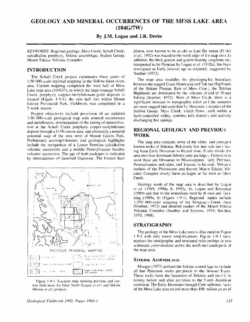
150 000.scale regional mapping in the Stikinr-lskut rivers area. Current mapping completed the west half of Mess Lake map area (IO4C/7), in which the large-tonnage Schaft Creek porphyry copper-molybdenum-g[,Id deposit is located (Figure 1-9-l); the east half lies within Mount Edzira Provincial Park. Fieldwork was completed in a 5.week season.
Project objectives include provision of an updated I:50 000.scale geological map with mineral occurrences
and metallotects. determination of the timing of mineralira- tion at the Schaft Creek porphyry copper-molybdenum deposit through a IJ-Ph Lircon date. and ultimately a mineral potential map of the area west of Mount Edrira Park. Preliminary accomplishments and geological highlights include the recognition of a Lower Permian calcalkaline volcanic succession and a middle Pennsylvanian bnsal~ic volcanic succession. The age of both packages is indicated by intercalations of fusulinid limestone. The Forrest Kerr
_1(/
pluton, now known to he as okI as Late De ronian (D-‘ah; ef nl.. 1992) was traced to the ~north edge of tt e map arel. In addition, the thick granite and ql~wtz-bearing zonplomextc, interpreted to he Permian by L.ogan er ul. (I Y 22~1). has been reassigned an Early Jurassic age as originall: suggeste~i by Soother (1972).
The map area straddles thi: physiogrqhic boun’iary between the rugged Coast hlowmains and Tab tan HighLmds of the Stikine Plateau. East of Mess Cree ;, the Tahltan Highlands are dominated by I:hs ,volcanic si- ield of h4xmt Edziza (Soother, 1972). West (of Mess Crr:k, then: is a significant increase in topographic relief an I the sumnils are more rugged and underlain b,y Meswoic I alcanics ot the Stuhini Group. Mess Creek, which flows uorth within a fault-controlled valley, contain:; tufa depos? i and actively discharging hot springs.
REGIONAL GEOLOG,Y .AND PR EVIOU:3 WORK
The map area contains some of the oldes and youri:e<t known rocks of Stikinia. Relatively few intewls are r:is:;- ing from Early Devonian to Re,:ent time. Fz ults divide tte area into four dominant lithotwtonic package j. From ei rit to west these are Devonian to Mississippian, ‘:arly Perrlian, Pennsylvanian and older, and Triassic 10 Jur wit. Volc:;m c outlien of the Pleistocene and Recent Mou It Edziza ‘Vol- canic Complex overly these lpackages as fai west as Ivlex Creek.
Geology south of the map ;uea is descr bed by Lr~gan ef a/. (19x9, 1990~1, h, lY92a, b), Logan and Koyanagi (1989) and that to the immedixe west by B own and. ‘GUI- ning (IYXYa, h) (Figure l-9,-1). Regional tudies in&de I:250 OUO-scale mapping oF I:he Telegrap, Creek :;hezt
(Souther, 1972) and detailed studies of the Mount I%~Jzi:!a Volcanic Complex (Southcr a;~td Symons, 1974: Souhu,
lY70, 198X).
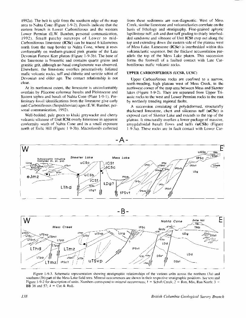
STRATIGRAPHY The geology of the Mess L&z iarea is illus rated in F~,gure
l-9-2 with only minor simplif’.cations. Figl~re l-Y-3 sur- marizes the stratigraphic and wuctural r&r onships irl two schematic cross-sections ilcros~, the north ana I south pa-& nf the map area.
STIKINE ASSEMBLAGE Monger (1977) defined the Stikine asseml lage to int:lude
all late Paleozoic rocks perpheral to the Bower E asin. These rocks form the basemerIt of Stikinia and recod :ts history before and after accretion to the I‘orth Ameriun continent. The Early Devonian I:hrough Carh miferous -ocks of the Mess Lake area record more than I00 nillion ye,rs of
135

136
Figure l-9-2. Simplified geology of the Mess Lake area. SW facing pge for legend.

LEGEND LAYERED ROCKS
WATERNAil” PElSTOCENE IWD RECENT
island arc volcanism and cxl:~onete hccw iulation inter- rupted by tectonism and upliii. Calcalkaline volcaniwl, in part subaerial, was followed by (carbonate dq osition dt,ling the Early Permian interval (Brown er ol.. IS91).
DEVONIAN OR OLDER (D&t, DSqs)
Penetratively foliated, polydeformed it termediatc 10 mafic volcanic rocks underlie a~ narrow belt along the :ast- em margin of the area mapped (Figure 1-9-Y ). These rocl:s crop out sparsely between Nehta Cone and E tile Hill \\here they are overlain by Tertiary I;:Iw flows. Cc ,ntact relatiow ships with Early Carboniferous and younger ocks are either
faulted or hidden beneath overburden. To he east, IG!r:y Drvoniun hornblende diorite ;rr,d biotitr grar ndiorite (I. nits LDd and LDg) intrude the vol::anic rocks ( Ggure l-9-3?).
Purple and green tuffs. aphyric to play ioclase-phyric flows and rare silicified, ankeritic carhc nate horizons (D&t) are exposed in a wr!;t~flowinp tree < 3 kilomctres north of Nahta Cone. Farther Inorth are pla :ioclasr-plyric volcanic rocks, including lapilli ash flow t Iff (D&t: and intermixed phyllite, chlorite ,and quartz ericite schists (DSqs). These volcanic rock:, are variably fc #liared ant as- nulated and distinguished from younger ro, ,ks in the map arca by their degree of deformatmn.
LOWER CARBONIFEROUS (ICSt, ICSc)
A distinctive orange-weathering belt of lir ratone ext~m~s southward 7 kilometres from Tadekho Creek to just n’x-:h of Arctic Lake in the Forrest Ken map area (Logan CI ol.,
lYY2a). The belt is split from the southern edge of the map area to Nahta Cone (Figure l-9-2). Fossils indicate that the eastern branch is Lower Carboniferous and the western Lower Permian (E.W. Bamber, personal communication, 1992). Small patchy outcrops of Lower to mid- Carboniferous limestone (ICSc) can be traced 6 kilometres north from the map border to Nahta Cone, where it rests conformably on medium-greined pink granite of the Late Devonian Forrest Kerr pluton (Figure I-Y-3b). The base of the limestone is limonitic and conpains quartz grains and granitic grit, although no basal conglomerate was observed. Elsewhere, the limestone overlies penetratively foliated mafic volcanic rocks, tuff and chlorite and sericite schist of Devonian and older age. The contact relationship is not &%+I.
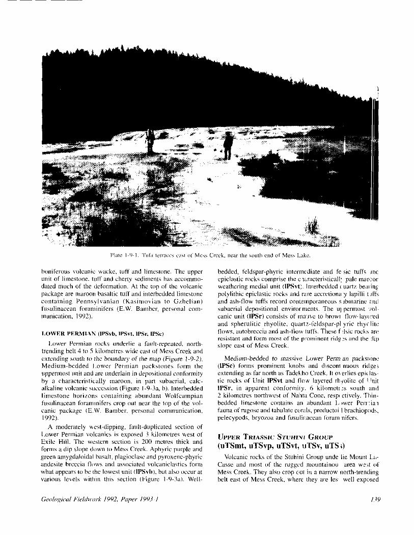
At its northmost extent, the limestone is unconformably overlain by Pliocene columnar basalts and Pleistocene and Recent tephra and basalt of Nahta Cone (Plate 1-9-l). Pre- liminary fossil identifications from the limestone give early mid-Carboniferous (Serpukhovian) ages (E.W. Bamber. prr- sonal communication, 1992).
Well-bedded, pale green to khaki greywacke and cherty volcanic siltstone of Unit ICSt overly limestone in apparent conformity south of Nahta Cone and in il small exposure north of Exile Hill (Figure I-Y-3b). Macrofossils collected
from these sediments are non-diagnostic. West of Mess Creek, similar limestone and volcaniclastics correlate on the basis of lithology and ctratigraphy. Fine-grained aphyric lapillistone luff. ash and dust tuff grading to thinly interbed- ded sandstone and siltstone of Unit ICSt crop out along the top and extending down the eastern side of the plateau west of Mess Lake. Limestone (ICSc) is interbedded within this volcaniclastic sequence, but the thickest accumulation par- allels the top of the Mess Lake pluton. This succession fotms the footwall of a faulted contxt with Late Car- boniferous mafic volcanic rocks.
UPPER CARBONIFEROUS (UCSB, UCSC)
Upper Carboniferous rocks are confined to a nal~ow, north-trending, high plateau west of Mess Creek, in the northwest corner of the map area between Mess and Skeeter lakes (Figure l-Y-2). They are separated from Upper Tri- assic rocks to the west and Lower Permian rocks to the east by northerly trending regional faults.
A succession consisting of polydeformed, structurally thickened limestone, chert and siliceous tuff (UC.%) is exposed east of Skeeter Lake and extends to the top of the plateau. It structurally overlies a lower package of massive, amygdaloidel basalt flows and tuffs (uCSb) (Figure 1-9-3~1). These lacks are in fault contact with Lower Car-
-A-
Figure l-Y-3. Schematic representation showing stratigraphic relationships of the various units across the northern (3a) and southern (3b) pan ofthc Mess Lake tirld wea. Mineral DCCCU~T~~C~S arc shown in their rrspective stratigraphic positions. Sw text and Figure l-9-2 for description of units. Numbers correspond to minerill occurrences; I = Schaft Creek: 2 = Run. Mix, Run North: 3 = BB 38 and 57; 4 = Cot & Bull.
boniferous wlcanic wacke, tuff and limestone. The upper unit of limestone. tuff and cherty sediments has accwnmo- dated much of the det?mnation. At the top of the volcanic package are maroon basaltic tuff and interbedded limestone containin& Pennsvlvaninn (Kasimovian to Gzhelian) fusulinacean foran;inifers (E.W. Bamhcr, personal con- munication. 1992).
Lower Permian rocks undzrlir a fault-repeated. north- trending belt 4 to 5 kilometrcs wide east of Mess Creek and wending south 10 the boundary of the map (Figure I-Y-2). Medium-bedded I.ower Permian packstones form the uppermost unit and are underlain in dep~xirional conformity by a characteristically maroon, in part subaerial, calc- alkaline volcanic succession (Figure I-Y-3a, b). Interbedded limestone horizons containing abundant Wolfcempian fusulinecean foramlnifers crop out near the top of the vol. canic package (E.W. Bamber. personal communicirtion. 1992).
A moderately uest-dipping, fault-duplicated section of Lower Permian volcanics is exposed 3 kilomctrrs west of Exile Hill. The western section is 200 metres thick and forms a dip slope down to Mess Creek. Aphyric purple and green amygdaloidal hasalt, plagioclasc and pyroxenc-phyric andesite breccia flows and associated volcaniclastics form what appears to hc the lowest unit WSvh), but also occur at various levels wnhin this section (Figure I-9.31). Well-
bedded, feldspar-phyric interme~Sate and fc sic turfs ~nc cpiclastic rocks comprise the c:xrxteristicall: pale mar’~or wrathwing medial unit OPSvt:. Imerbedded ( uartz-bexing~ polylithic epiclastic rocks and ra~re accrctioni~ ‘y lapilli trff!; and ash-llow tuifs record contzrnporaneous s rbmarine a~ntl subaerial depositional environments. The UI ,permost ,101,. canic unit (IPSr) consists of mwre to hrowr tlow-lay:red and spherulitic rhyolite, quart;:-feldspar-pl yric rhycliti: tlows, autobreccia and ash-llow luffs. These f :Isic rock:s an: resistmt and fcxm most of the prominent ridp :s and the dip slope cast of Mess Creek.
Medium-bedded to mxsiw: Lower Perm an packwne (IPSc) forms prominent knobs and disconc nuous ridgs extending us far north as TadcLho Creek. It 01 erlirs epi<las~ tic rocks of Unit IPSvt and f1o.w layered rh polite of IUnit IPSr, in apparent conformity. 6 kilometrx south and 2 kilomrtres northwest of Nnhta Cone, respt ctivcly. ‘Thin- bedded limestone contains an abundant L’wer Perrlial fauna ofrugose and tabulate cwds, productoi I brachioprrd!,, pelecypods, hryozoa and fusulirxxean forem nifers.
UPPER TRIASSIC STUHI:VI GROUP (uTSmt, uTSvp, uTSvt, uTSv, uTS s)
Volcanic rocks of the Stuhini Group unde lie Mount Lz- Casse and most of the rugged mountainou area w:;t of Mess Creek. They also crop c,ut in a narrow north-trending hclt east of Mess Creek, where they we Ia well exposed
I.19
(Figure l-9-2). They lie unconformably on Lower Permian limestone 3 kilometres northwest of Nahta Cone. They are unconformably overlain by Lower Jurassic conglomerate southwest of Nahta Cone and in two localities went of Mess Creek (Figure I-Y-3.?, b). They are truncated on both east and v&t sides by several lerge intrusions.
West of Mess Creek, Upper Triassic rocks are divided into five volcanic and one sedimentary unit (Figure I-Y-3b). The lowermost unit is green-blue, recessive weathering, mafic lapilli tuff with minor flows (uTSmt). The scoriaceous I;tpilli are altered to serpentine, talc and chlo- rite. East of Mess Creek. Unit uTSmt overlies Lower Per- mian carbonate of Unit IPSc in two areas; the contact in one is partly faulted. Volcanic rocks of Unit uTSvp were not observed to directly overlie Unit uTSmt, but they usuelly crop out nearby. Dark grey, massive, plagioclase-phyric basalt flows and related similarly textured intrusive rocks crop out south of the Schaft Creek porphyry copper deposit. Contacts with other units are poorly exposed, except where Unit uTSvp is intruded by Unit LThd. Tuffs of Unit uTSvt were observed to overlie these basaltic rocks in only one place. Unit uTSvt comprises massive to weakly stratified, polylithic, grey to mauve lapilli tuff and crystal tuff that form thick sections underlying the east-facing slope above Mess Creek. Both plagioclase and augite crystals are com- mon. although augite is generally less than 5 per cent of the rock. Measurable bedding attitudes are rare: the few mea- sured indicate steep dips. The thickest Upper Triassic unit comprises augite-phyric, plagioclase-phyric, augite and plagioclase-phyric, and aphyric basaltic and&e flows CuTSv). It extends the full length of the western edge of the map area snd hosts the Schaft Creek deposit. Subvolcanic intrusive rocks are difficult to distinguish and separate from the extrusive rocks and are included with them. Tuffs and flows occur subequally and vary in colour from maroon to green; it is common for purple tuff to be interbedded with green tuff. The basaltic andesite is pillowed for 3 kilometres both northeast and southeast of Schaft Creek. All bedding attitudes of intercalated tuffs observed were steeply inclined to the northeast and southwest. Locally the unit is very likely tightly folded, but the lack of good stratification makes the extent of this difficult to ascertain. Unit uTSs comprises about 150 metres of well-bedded green dust tuff, tuffaceous siltstone-sandstone and wackes which crop out on the eastern flank of Mount LaCasse, 4 kilometres north- east of the Schaft Creek deposit. Near its western margin, the well-bedded section thins considerably where it is faulted against Unit uTSv. The tuffs also apparently thin to the northeast, limiting their usefulness as a marker unit. Steeply dipping, tightly folded sediments consisting of vol- canic conglomerate, interbedded sandstone and siltstone, pyroxene crystal sandstone and limy siltstone (Unit UT%) are exposed about 4 kilomares south of the Schaft Creek deposit. A thin maroon quartz and limestone-bearing vol- caniclastic unit (possibly Unit IJcg) may overlie these sedi- ments conformably but is faulted against pyroxene-phyric volcanics of Unit uTSv farther east. Fossils from thin inter- bedded siltstone, sandstone and conglomerate are identified as Upper Triassic (Norian: E.T. Tozer, personal communica- tion, 1992).
East of Mess Creek, Upper Triassic rocks are limited to units uTSmt. uTSvp and uTSs (Figure I-9.3b). Unit uTSmt is highly visible in creek exposures where alteration and weathering have produced characteristic dun to bluish green hues. It is intruded along its western limit by the Loon Lake stock (Unit LTmz) and may be overlain by silicified dust Luff and turbiditic siltstone of Unit uTSs, as it is west of Mess Creek on the More Creek sheet (Logan PI al., IYYZa, b). Massive tuffs and flows of Unit uTSvp include associ- ated subvolcanic intrusive rocks which could not be mapped separately. Both are predominantly plagioclase phyric with lesser pyroxrne. Pillowed and breccia flow textures occur locally in the massive sequence of plagioclasr-phyric basal- tic andesite. The unit is unconformably overlain by Lower Jurassic conglomerate.
LOWER TO MIDDLE JURASSIC (IJcg)
West of Mess Creek, Lower to Middle Jurassic rocks rest with angular unconformity on volcanics of the Upper Tri- assic Stuhini Group (Figure l-9-2). East of the Schaft Creek porphyry deposit, on Mount LaCasse, the Jurassic unit com- priscs conglomerate xvith equal proportions of well-rounded crowded plagioclase porphyritic and&e and aphyric basalt clasts, interbedded with coatxe sandstone containing high proportions of quartz and potassium feldspar. The con- glomerate overlies propylitically altered pyroxene vol- canics. The nature of the contact is uncertain, but the con- glomerate appears to occupy a fault-bounded graben (Figure I-9.3~1). The conglomerate itself is pervasively epidotized (due in pan to its permeability). Alteration is probably related to dike swtrtns associated with the Middle Jurassic Yehiniko pluton.
Moderately south-dipping Jurassic conglomerates rest unconformably on steeply dipping Upper Triassic pyroxene-phyric flows and volcaniclastics in a second exposure 3 kilometres south of the Schaft Creek deposit (Figure l-9-2). The section comprises 90 mares of quattz- bearing polymictic volcanic conglomerate above a lower quartz and feldspar crystal tuff layer 20 mews thick. The sediments are well-bedded granule or weakly stratified to massive boulder conglomerates and lesser sandstones. Clasts are generally subangular, purple, maroon and green plagioclase and/or pyroxene-phyric and&e. Epidotized clasts are common and clasts of quartz feldspar crystal tuffs increase in abundance down section. The volcanic lower zone is a pale maroon, pink-weathering feldspar and quattr- eye crystal-lapilli tuff. Upper and lower contacts are grada- tional and therefore conformable with the conglomerate.
East of Mess Creek, the conglomerates outcrop in a belt 2 to 2.5 kilometres wide belt extending north from Arctic Lake to Nahta Cone (Figure l-9-2). At the northern end of this exposure, they overlie volcanic rocks of the Stuhini Group with structurel conformity, but farther south they unconformably overlie Late Triassic plagioclase hornblende porphyritic diorite (LTmz). The conglomerate is at least 250 metres thick. In general, the lowermost sections are maroon. well-bedded, immature, volcanic-derived conglomerate. In places they are graded and consist entirely of maroon plagioclese-phyric andesite clasts in B plagioclase-rich

groundmass. Up section, quartz and potassium feldspar grains and granite clasts appear then increase in abundance. Layers of coarse carbonate boulders are prominent within the unit. The 4 to S-metre well-rounded boulders are Meso- zoic reefoid limestone. Rare interbedded limestone and sandstone lenses have been sampled for radiolaria.
UPPER CRETACEOUSTO TERTIARY SUSTUT GROUT
Small isolated remnants of Sustut Group sediments (Unit uKSs) are preserved on Exile Hill snd north of Nagha Creek (Souther, 1988). On Exile Hill, they are well-bedded, pale green weathering and friable qunrtzose sands.tone and poly- lithic then-granule conglomerate thut rest unconformably on Late Devonian diorite of Unit LDd (Figures l-9-2 and I-9-3@. The sediments are limonitic, and thoroughly fract- ured and veined by calcite. Granitic, aphyric volcanic, chat and quartz clasts comprise roughly equal proportions of the granule conglomerate.
PLIOCENE-NIDO (TNb) AND SPECTRUM (TSr) FORMATIONS
Subaerial llows of aphyric and olivine-phyric basalt with inrercalated tluvial gruvel of fhe Nido Formation (TNb) and peralkaline rhyolite flows of the Spectrum Formation (TSr) underlie the Arctic I..ake pleteau and Quaternary members of the Mount Edria Volcanic Complex on the eastern border of the map area (Figure l-Y-2). These Pliocene rocks were not specifically examined because they were mapped by Souther (198X) at a scale of I:50 000. The Nido Forma- tion unconformably overlies Paleozoic carbonate. intrusive and volcanic rocks and also Upper Cretaceous sedimentary rocks (Figure I-Y-31, h). It is overlain by the Spectrum Formation. Flows iu both formations are essentially flat lying. At one locality, an intraflow cobble conglomerate is exposed between flows of the Nido Formation.
QIIATERNARY ARCTIC LAKEF"HMATIoN(Qb)
Basalt flows of Ihe Arctic Lake Formation (Qb) form erosional outliers eat of Mess Creek (Figure l-Y-2). Most are exposed at elevations above 1000 metres (3500 feet), but one flow crops out on the floor of Mess Creek valley. A whole rock K-AI date of 0.4520.07 Ma was obtained from flows at the head of More Creek. Unit Qb is characterized by flat to gently inclined, brown to grey weathering, thick, usually vesicular beds of plegioclase, augite and olivine- phyric basalt.
BIG RAVEN FORMATION (Qub)
The youngest consolidated unit in the map area consists of olivine basalt flows of the Big Raven Formation (Unit Qob) which form Nahta Cone (Figures l-9-2 and I-Y-3b). The cone is approximately 70 metres high and consisIs mainly of black and brick-red scoria blocks. Nahta Cone was breached on its east side and at least two highly fluid laves flowed to the north along a drainage where rhey are still preserved. Levees of tlow breccia mark the path of the
flaws down the creek. The cone :s iifuated on the conlac:t between Lower Devonian volcanic rocks of Lhlit ICSt zulld g’anitic rocks of Unit LDg. A V-shaped apro 1 of lapil i- sized tephra covers these units for a~ distance ( f about ‘700 metres north and 500 metres we:8 of the mai I cone. The apron provides evidence that the cone erupted ( n two “cc& sions with differing wind directions. Souther (I 970) carbon dated the tlows at 1340 years b.p.
HoTSpRING DEPOSITS (Qt, Hotspring deposits of tuft (Un’t Qt) occupy an elong,l:e
area of about SO hectares southeaut of Mess Lake (Pl;,!e l-9. I ). The hotsprings are loc:aled along ni rth-trendi ?g faults. They are discharging ad depositing tufa into a connected series of poorly drained flat-bottom ned valle:is. Water percolating in the active springs is belo v body t’e’w perature. Most of the deposits w.: of the low- Iill. terraced type, but six small circular conl:s I to 4 mctre i high autl a hill of wavertine up to 10 metres high xe also p rsent. Many of the tufa terraces have raised ‘,ressure ridges prcsunxdly reflecting recent fault movemer,f. The ridges hwe relief <>n the order of IO to 40 centimetre:; and lengths 01 the order #Jf 50 to 100 metres. According 1o a local tlmppel, new rid::<% appear each year, suggesting the faults are sti I active.
INTRUSIVE ROCKS Three intrusive episodes are -ecognized in tl le Mess I>:lke
area: Late Devonian, Late Triassx or younge , and Middle Jurassic. These correspond in part with episo les descrilxd by Anderson and Bevier, (199C’): Holbek (198 3) and L~:,:;an e, al., (IY9Oa. 1992~1).
LATE DEVONIAN Tonalite, granodiorite, diorite and hornhler dite crop OUI
along the eastern margin of the map area (I ‘igure l-9-2). These rocks are the norrhward ex[ension of Lt e Law Devo- nian Forrest Kerr pluton that is exposed aroun 1 Arctic Li,kr in the More Creek map area (Lo!gan PI ul., 19’12b). Ourcro~ of the intrusion extends north ,as far as Taiekho Crwk, where thr pluton is covered by Lower Carb miferow ant, Lower Permian limestone and volcanic rock. and Tert :q lava tlows. Tertiary and Recelt lava tlows i Is” cover :hr: eastern edge of the pluton. Alc~ng the westt m edge, if i:i faulted against Lower Permian volcanic rocks and is loc;.ll! unconformably overlain by Lower Carhonifer :xs cxb8oxa: (Figure I-9.3b).
As ro the sourh (Logan (if al., l9YOa. 199: a), the pluton comprises three phases: a granitic phase of ( oarse-grained biotite tonalite, granite and gr,modiorite (LD :), chlorit I:& hornblende diorite (LDd) and minor hornb enditelgabbro (LDum). Most of the rock lhas an equigr;nular texlurt. Weakly foliated and passively folded gneissic textures o:cur close to intrusive contacts and phase bounda ,ies wither thz intrusion. The pluron intrudszs penctrati-ely folialec, schistose metatuffs of Unit D%t.
Pink. coarse-grained, equigranular granite west of Mess Lake resembles rocks of the Forrest KZIT plu on, but hi!: an unclear relationshjp with overlying carbow e of pmbable Early Carboniferous age. The Ivless Lake body crops cmt
I41

only on the east side of the ridge between Skeeter and Mess lakes and, therefore, presumably has a moderate to steep westerly dip (Figure l-9-2 and I-9-38). The granite, limr- stone and tuffaceous wacke (ICSc and ICSt) are cut by a north-trending west-dipping diorite dike swarm. From a distance this gives the cliffs a bedded appearance. The contact between the intrusive and the limestone strikes north-northwest and dips moderately southwest.
LATE TRIASSIC OR YOUNGER
HICKMAN PLUTON
A medium to fine-grained, pink or grey elongate stock of monzonite to diorite (LTHd) is exposed IO kilometres south of the Schaft Creek deposit (Figure l-9-2). It crops out on the east-facing slope above Mess Creek and is probably an eastern extension of the Hickman pluton. Along ifs western margin numerous aplitic dikes extend from the main stock into Upper Triassic volcanic rocks of the Stuhini Group (Unit UT.%). The eastern contact is more problematic. The stock is monzonite near the top (i.e., western margin) where it intrudes Upper Triassic rocks, but grades eastward and downwad into hornblende d&rite, commonly with occur- rences of dark grey hornblendite. To the north, it appears to be faulted against grey plagioclase-porphyriric d&rite of unkown age. It is possible that the plagioclase porphyry is a border phase of the yuigranular stock or plagioclase por- phyry of Unit LTmz.
The monzonire portion of the stock is pink and equi- granular with up to I5 per cent oxidized hornblende. Where the percentage of hornblende is higher, pink, fine-grained, equigranular dikes to about 30 centimetres wide are com- mon. The mafic content of the stock increases until the rock is fine to coerse-grained hornblendite, with hornblende crystals up to a centimetre in length. The crystals are mostly weakly chloritized, though vitreous hornblende is present. Narrow carbonate-epidote and zeolite veinlets are a com- mon alteration feature.
UNIT I,Tmz - LOON LAKE STOCK
A north-trending hypabyssal stock of plagioclase hornblende monzonite porphyry (LTmz) forms the eastern slope above Mess Creek (Figure l-9-2). On its eastern side it intrudes Upper Triassic sediments and volcanic rocks of Units uTSvp and uTSs and, farther north, Lower Permian rocks. The intrusion is unconformably overlain by Lower Jurassic conglomerate of Unit IJcg in a creek exposure, about I.5 kilometres north of the south boundary of the map sheet. The western limit of the Loon Lake stock appears to be faulted against intrusive Unit LTpp but the contact may be in part intrusive (Figure I-9.3b).
The typical texture of the Loon Lake stock is crowded porphyry with 20 to 40 per cent euhedral plagioclase laths to 7 millimetres in length and 0 to IO per cent hornblende to 3 millimetres in length. The rock is mostly salmon pink to mauve grey. Common variations in the texture include darker grey, less crowded plagioclase porphyry and fine to medium-grained, equigranular grey diorite.
142
UNIT LTpp
Hypabyssal plagioclase diorite, not unlike the monronitic Loon Lake stock, crops out along the lower slopes of Mess Creek valley, west of the creek between the Loon Lake stock and intrusive unit LTHd (Figure l-9-2). It was mapped as ii separate body, but may be a border phase or related to the Loon Lake stock. The diorite is typically pale green and contains stubby plagioclase phenocrysts to 4 millimetrrs in length and rare chloritic hornblende or pyroxenz.
UNIT LTpd
Plugs of pyroxene dioritc crop out in several areas west of Mess Creek (Figure l-9-2). About 5 kilometres south of the Schaft Creek deposit, a small plug intrudes Upper Triassic sediments. About 2 kilometres south of the deposit, and also about 5 kilometres north of the deposit, similar plugs intrude Upper Triassic volcanic rocks. A similar, larger stock intrudes Upper Triassic volcanic rocks in the north- west corner of the map area.
The plugs are mainly medium-greined, green-grey augite plagioclase diorite. They are generally associated with plagioclase-phyric and coarse pyroxene-phyric dikes and are probably related to them.
YEHINIKO PLUT~N (MJmz)
Middle Jurassic monzonite of the Yehiniko pluton intrudes volcanic rocks of the Stuhini Group east of Schaft Creek and north of the Schaft Creek deposit. Most of the contxt is gradational and consists of numerous aplite and/or rhyolite apophyses in the country rock (Figures l-9-2 and l-9-&). In places the contact is a simple curviplanar sur- face. Several small outcrops of the intrusion on the north edge of the Schaft Creek deposit are mineralized together with adjacent volcanic rocks. The southern contact with the Late Triassic Hickman batholith is covered by overburden.
The main phase of the Yrhiniko pluton is pink, medium to coarse-grained biotite granite (Brown and Gunning, 1989a). Near its contacts with Upper Triassic volcanic rocks, the texture is finer, more fractured and the colour is grey to orange. Within the Schaft Creek deposit, the intru- sion is white, argillically altered, equigranular monzonite to quartz monzonite. North of the deposit, the apophyses of the intrusion are aphanitic to fine-grained, flow-layered pink rhyolitr dikes and sills of quartz-eye feldspar porphyry that are possibly younger. These alter the country rock locally.
DIKES
West of Mess Creek, at least four distinct dike and/or sill suites are recognized within the Upper Triassic Stuhini Group. Most are I to IO metres wide. Plagioclase-phyric dikes (pl) are the most common. They typically have 5 to IO per cent opaque, pale green plagioclase crystals averaging 2 to 6 millimetres in length. Pyroxene diorite dikes (pp) have textures very similar to those of extrusive rocks within the Stuhini Group and are probably in pat coeval with them. In the larger dikes, plagioclase averages 2 to 4 millimetres, augite 5 to IO millimetres, and the groundmass is finely

crystalline rather than aphanitic, as it is in the equivalent extrusive rocks. Hornblende-porphyritic diorite (h) is less common and f~xms irregular bodies (plugs or smzdl dike/sill complexes), mainly north of the Schaft Creek deposit. Vitreous hornblende to IO per cent and averaging 3 to IO millimetres long forms glomerocrysts in a prey, aphyric vitreous or sparsely feldspar-phyric groundmass. The age relationships of these dikes is not known. The felsic aphyrx and quanr-feldspar-phyric apophyses (f) of the Yehiniko pluton cut them. The youngest dikes are aphyric andesite and basalt. These are typically green to grey ill colour, average less then 3 metres wide, and arc commonly wnyg- daloidal near the margins. They postdate mineralization at the Schaft Creek deposit.
STRUCTURE
Forms Lower Devonian rocks of Unit DSst are penetratively
foliated and schistose. The foliation dips gently to the west and is folded isocltnelly about northwest-trending axes. Folds are typically recumbant and northeast verging. Macrofolds are overprinted by nonpenetrative and penetra- tive crenulation folds on millimetre and centimetre scales respectively; related crenulation cleavage is present.
ILower Carbonifcrous carbonate rocks (ICSc) ewt of Mess Creek, which unconformably overlie Units LDp, and DSst, are unaffected by this penetrative deformation. The rocks are deformed into open gentle folds on a scale of hundreds of metres. The folds are the only deformation recognized in the carbonates and may reflect movement in the underlying rocks.
The same fold geometry and relationships of Lower Devonian rocks are seen in Upper Carboniferous rocks underlying the plateau between Skeeter and Mess lakes. Foliated, thin-bedded tuffs and carbonates display recum- bent isoclinal and tight parallel folds in cliff exposures on both sides of the plateau. Most folds have amplitudes on a scale of several metres. Fold axes plunge gently either northwest or southeast, and verbence appears to be to the northeast. Schistose and slaty beds also have millimetre and centimetre-scale crenulation folds. The mttssive basalt of Unit uCSb is weakly foliated but shows no evidence of folding.
The poor correlation between stratigraphic position and deformation suggests strata forming the ridge between Skeeter and Mess lakes hew undergone a localized defor- mational event, possibly related to unrecognised thrust f&Jhing.
Lower Permian volcanic rocks and carbonates east of Mess Creek are homoclinal; minor deviations in attitude are due to brittle faulting and disruption by intrusion of the Loon Lake stock. On the south slope of Tadekho Creek, the carbonate is involved in some large open folds. It is also drag folded adjacent to a minor north-trending fault about 4 kilometres southwest of Exile Hill. The most extensive deformation is adjacent to a well-exposed listric fault that places Lower Jurassic conglomerate against Lower Permian
limestone. Approaching the faJll from the east, bedding dips in the carbonate steepen horn west to rertical, and become east dipping adjacent t(~l the fault. The east-dipping beds are either overturned or the cat-honate is t ghtly folded into an upright syncline in which the closure is not exposwi.
Upper Triassic rocks east of Mess Creel have steep westerly dips. Most of the variation in attitt da in these rocks is probably caused by i,wueion by thl Loon I.;l!<e stock. Exposure is too poor to recognize larg z-scale fol:ls; minor folds were observed in a small :reek abljut 7 kilometres southwest of Nahta Cone. West 01 Mess Cre?k. Upper Triassic rocks dip steeply to rhe southwr ,st and north- east, suggesting tight folding. The paucity of bedding atti- tudes in much of the section hinders recognitisa of folding. Tight noncylindrical folds do occur in well- ledded sa:d- stone of Unit uTSsn. Well-heddszd tuffs of 1 nit uTSs ire drag folded into a shallow, open anticline against a normal f&t, 5 kilometres north of the Schaft Creek Jeposit.
FAULTS
Curvilinear north-trending faults are the ml 1st significanl structures in the Mess Lake area They contrail topogra:h), and affect the distribution of nearly all rock units Northeast-trending splays cut the ridge betwet n Skeeter ~,ntl Mess Lake valleys.
Movement along the faults took place duril g at least two separate episodes. The first episode of nr rtnal faul:ing uplifted rocks east of Mess Creek and Skeeta Lake relative to rocks to the vast. The second episode hz 1 an opp,!;ite sense of displacement and uplifted rocks vest of I\lesc Creek and Skeeter Lake relat,vc to rocks to the east. Th,: first episode brought Devonian rocks to tie surfaw i:l Eocene time. Most of the mo\ernent was alo tg faults ores- ently located in Mess Creek and Skater Lake valleyn.. However, rocks as young as Exly Jurassic \‘ere presewj in a listric fault block east of L.oon Lake. Tile trace 01’ the listric fault is well exposed and c:ao he traced tlong the czlge of the Arctic Lake plateau frotnjust south of vahta Colt: t3 west of Arctic Lake in the More Creek map rea. The ‘,m,t juxtaposes a tilted block of east-dipping cc nglomer:ar: c,f Unit IJcg and west-dipping volcanic, sedimet tary and intni- sive rocks of Units uTSvp, uT!k and I,Tm: against west- dipping Lower Permian carbonate of Unit IF’ SC. A maroon, quartz-bearing fragmental unit is exposed a ong the er,tite length of the fault and appears to underlie Jnit lPSc W believe that the fragmental ulil may he fau t breccia (i.e., milled Unit l&g).
The second episode of f&thing uplifted rocks west tof Mess Creek and Skeeter Lake along faults m. .inly to thr: east of the creek. The uplift war. young enougt to affe,ct the distribution of Eocene and youmger rocks to :he east, and to cattse the dramatic difference in topograpt y across {iless Creek. East of Mess Creek, uaest-side-u!, faults xpeat Lower Permian stmtigraphy south of ‘Tadek ho Creek. Evi- dence of the sense of movement along thest faults is iound in a minor creek 4 kilometres southwest of E <ile Hill, where drag folds in Unit IPSc clearly indicate wes -side-up nobe- ment along a minor north-tn:nding structur : (Plate 1 5.2).
I 43

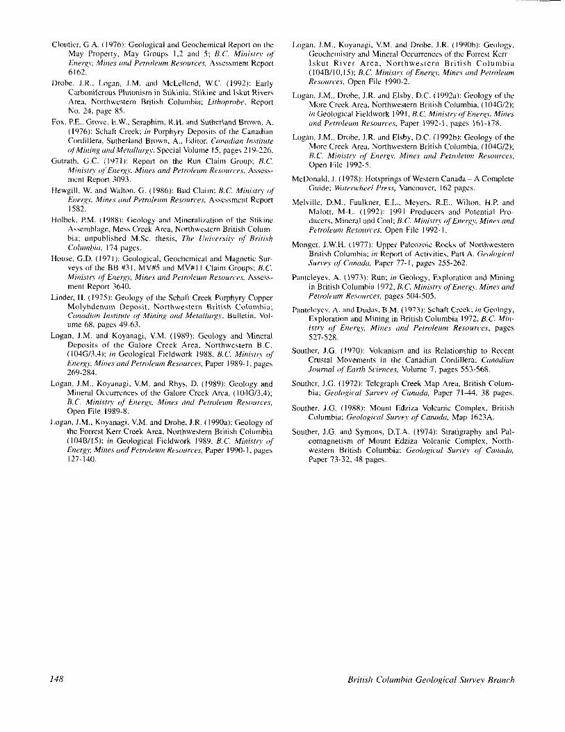
MlNERAL PROPERTIES The locations of mineral properties are shown in Figure
l-9-4. Their stratigraphic positions are shown in Figure I-Y-3 and details are summarized in Table I-9-I.
SCHAFT CHEEK PORPHYRY DEPOSIT
The Schaft Creek porphyry copper-molybdenum deposit is situated at the western edge of the map area, at an elevation of 1000 metres on the west-facing slope above Schaft Creek (Figures I-9-1 and l-9-4; Plate l-9-3). Since its discovery in 1957, successive drill programs by Silver Standard Mines Ltd., American Smelting and Refining Company, He& Mining Company and Teck Corporation, the present owner, tested the property. The deposit is classi- fied as a high-level calcalkaline volcanic porphyry (Linder, 1975; Fox et al., 1976). It consists of a linear intrusive tourmaline breccia pipe, the Breccia ozone, and the Main zone; a fracture-controlled zone of mineraliration. Both are hosted in andesite flows and epiclastic rocks. Mineralization includes pyrite, chalcopyrite, bornite and molybdenite. Reserves are Y IO million tonnes grading 0.3 per cent cop- per, 0.03 per cent molybdenum, 0. I 13 gram per tonne gold and 0.992 gram per tonne silver (Melville cf al., 1992).
The geology of the deposit is complicated and poorly exposed. Our visit consisted of one day looking at drill core and one day mapping drill roads and outcrops along the
eastern edge of the deposit. Regional mapping trxed the slretigraphy along ridges from the north and south into the deposit area. The Ibllowing discussion presents our obser- vations but the reader is directed to Linda (I 975) and Fox ef a/. (1976) for discussions of the genesis. stratigraphy and mineralogy of the deposit.
Our observations of the Upper Triassic stratigraphy in the area of the deposit aerce with observations of Fox er ul. (1976). They note that 90 per cent of the deposit is in plagioclase-phyric and aphyric basalt flows and associated subvolcanic intrusions (uTSvp), massive tuffs, and bedded green and purple epiclastics (uTSvt). The epiclastic rocks are overlain by weakly mineralized mixed purple and green flow breccias and tuft:? of units uTSvt and uTSv. Dike swarms of plagioclase porphyry, pyroxene plagioclase por- phyritic dioritr. felsite iaplite and quartz-eye feldspar por- phyry) and hornblende porphyry, in order of abundance, cut the Upper Triassic volcanic rocks (Figure 1-9-3~1). The fel- sic intrusives are bleached, altered and mineralized with disseminated and fracture-controlled sulphides.
No simple lithologic or stratigraphic difference was rcc- ognized between the purple volcanics and the mineralized green andesitic volcanics distinguished by earlier workers. The colour difference may reflect proximity to the intrusive and the centre of alteration and mineralization. Epidote clasts. originally probably mafic pumice fragments that have been completely replaced by epidote, and volcanic and
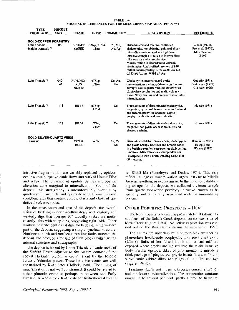
TABLE I-9-1 MINERAL 0CC”HKENCES FOR THI? MESS CREllK MAP AREA (I”4G,“7’N,
TWW MINFlLE PROB. AGE ,040 NAME HOST COMMODITY DESCRWTION ___ REI ERENCE
GOLD-COPPER PORPHYRY Late Triassic - 015 SCHAFI’ UTSVP. “TSv, Middle Jurassic ? CREEK LTIW
Late Triassic ? 040. RUN. MIX, uTSvp, 41 RUN LTlllZ
NORTH
Late Triassic ? 119 BS 38 “TS”,. “TSv
GOLD-SILVER-GUARTZ VEINS Jurassic 057 COT & UC%
BULL
-
Cu. Au. Mo
C”
C”
A& Cu. AU
intrusive fragments that ttre variably replaced by epidote, occur within purple volcanic flows and tuffs of Units uTSvt and uTSv. The presence of epidote defines a propylitic alteration zone marginal to mineraliretion. South of the deposit, this stratigraphy is unconformably overlain by quanr-eye felsic t&s and quartz-bearing Lower Jurassic conglomerates that contain epidote clasts and clasts of epi- dotized volcanic rocks.
In the areas south and east of the deposit, the overall strike of bedding is north-notthwesterly with easterly and westerly dips that average 70”. Locally strikes are notth- easterly, also with steep dips, suggesting tight folds. Other workers describe gentle east dips for bedding in the western part of the deposit, uggesting a simple synclinal structure. Northwest, north and northeast-trending faults truncate the deposit and produce a mosaic of fault blocks with varying internal structure and stratigrephy.
The deposit is hosted by Upper Triassic volcanic rocks of the Stuhini Group adjacent to the eastern contact of the coeval Hickman pluton, where it is cut by the Middle Jurassic Yehiniko pluton. These intrusive events are well constrained by K-AT dates (Holbek, lY8X). The timing of mineralization is not well constrained. It could be related to either plutonic event or perhaps in between and Early Jurassic. A whole-rock K-Ar date for hydrothermal biotite
Geological Fieldwork 1992, Paper 1993-l 145
Lhll er (197% Pox I tat. (,976),
Me ville et at. :1992,
Guts ah (1971). Fmte eye” (1971)
Cl0 ttier (t976:l
Trace amounts of disseminated chatcopyrite. magnetite and pyrite occur in fraeturut a:nd sheared andesite.
Disseminated hlehs oftetrahedrite. chatmpyrite *etnanis(t981). and pyrite occupy fmeturer and breccia z:ones R wgill and in a bedding-parallel, east-trending fault cutting Wt lb” (t986:l timeaone. Mineralization either predab!; 01 is syngenetie with a north-trending ba!;al~l dike dike swarm.
__-.-
is 18525 Ma (Panteleyev and Dudas, 197: 1. This may reflect: the age of mineraliratiun, argon lost t ue to Middle Jurassic resetting, or excess argon. In the hope of establish- ing an age for the deposit, WI: <collected a zircon sample from quartz monzonite porphyl-y intrusive xwn to be spatially and temporally associated with the minerall?ine SYSMll.
OTHER PORPHYRY PKOS,PIECTS - Rk N
The Run property is located :approximately 0 kilometres southeast of the Schaft Creek deposit, on thr east side ot Mess Creek (Figure l-9-4). NC, active explore tion was GIT- ried out on the Run claims during the sum ner of lYY2.
The claims are underlain by .I salmon-pir k weathtxing plagioclase hornblende porphyritic munzon tic intrusior (LTmz). Rafts of hornfelsed I;:ipilli and cr ‘stal tuff itrc exposed where creeks are incised into the n lain intrutive body. Farther upslope, dikes of pink monzo lite intmds 2 thick package of plagioclase-ph:yric basalt tl< ws, tuff>: IX subvolcanic gabbro dikes and plugs of Late Triassic uge’ (Figure I-Y-3b).
Fractures, faults and intrusive breccias con:rol altera,ion and stockwork mineralization. The monzc nite contitins magnetite to several per cent, partly alteret to hemaxte.

146
Figure l-Y-4. Mineral occurrence map showing locations of OCCU~~CCS discuswi in text and shown in stratigraphic position in Figure l-Y-3.

Locally pyrite range to IO per cenr. Chalcopyritc. nrolyh- denite and local chalcocite occur as disseminations and fracture fillings in the monronite and in quartr xinlrts in the wlcanic rocks.
ACKNOWLEDGMENTS Our thanks to W~ayne Spilshury and Andy Bctmanis of
Teck Exploration Ltd. for providing [maps and drill scclions. and for geological discussions ahout the Schaft Creek deposit. Ken Cottrcl provided lodging and hospitality il l Mess Lake. The saf? tlyinp provided by Bob Paul and Dar-y1 Adrich of Vancouver- Island Helicopters Ltd. was ~rarefully nppreciated, as wa> Norma Jeans haking and enpcdiling expertise. Fossils were promply identified by 1i.T. Twzer (GSC, Vancouver), W.E. Bamher. Lin Rui and S. Pinard (ISPG-GSC. Calgary). Critical reviews of Ihr manuscript hy Bill McMillan, John Newell and Brian Grant improved the final product.
REFERENCES Anderson. R.G. and Buirr, ML. ~1990): A Note on Meswoic and
Tertiary K-Ar Gcuchronomctry 01 Platonic Suitix. Iskill Riw Map Area. Northwrslrrn British Columbia: it) Currcnl Research, hr, F. &,>,,,g;~i,l .E,rw~ i,fcmih, ,‘;,pT 90~ 1 E. pages IJI-147.
Drohe. J.R., Logan, J.M. and McLellcnd, W.C. (1992): Early Cahonifrrnus Plutonism in Stikinia. Stikine and lskut Rivers Area. Northwcslern British Columbia: Lirlwpmhu. Report No 24, page 85.
Holhek. P.M. (1988): Geology and Mineralizttion of the Stikinr Asemblage, Mess Creek Area, Northwestern British Colom- hia: unpublished M.Sc. thesis. The Llniwr.sir~ of Brirish ColMrbiii. 174 pages.
House, G.D. (1971 j: Geological. Geocbcmical and Magnetic Sur- veys of the BB #3l, MV#S and MV#I I Claim Groups: B.C. Ministry of Energy, Miws md Prln~lrsm Rrrourws. Assess- ment Report 3640.
Logan, J.M. and Koyanagi, V.M. (1989): Geology and Mineral Deposits of the Galore Creek Area, Northwestern B.C. (IO4G/3.4): it, Geological Fieldwork 1988. B.C. Minixf~ c$ Dwrgy. M;ws orrd P~m,leurn Rerosrce,r, Paper 1989.1, pages 26Y-284.
Logan, J.M., Koyanegi. V.M. and Rhys, D. (1989): Geology and Mineral Occurrences of the Galore Creek Area, (104613.43: B.C. Minisrry of Enur~~, Miner rind Pm-&em Resosrcc.r. Open File 1989.8.
Logan, J.M., Koyanagi. V.M. and Drohe, J.R. (199&t): Geology of the Forrest Kerr Creek Arca. Northwestern British Columbia (104B/lS): in Geological Fieldwork 1989. B.C. t4ini.q c,f Enc,rg\: Mines rend P~rmlem Rcwr~nrs, Paper 1990. I. pages 127.140.
Logan, J.M.. Koyanagi. V.M. and Dmhe. J.R. ( IOYOh): Geology. (ieochrmisrry and Mineral Occurrences of the Forrest Kerr lskut River Area, Northwestern British Columbia (104BilO. 15): B.C. M;n;,sn? q(~?nner,qy, Minrs onrl Perrokw,,, Rr.wu~r.r. Open File 1990-2.
Logan, J.M.. Drohc, J.R. and Elshy. D.C. (I’)920 Geology of the More Creek Arca, Northwestern British Columbia, (IO4G/2); in Geological Fieldwork 199 I, R.C. Minisr~ ofEnrr~y~, Miws and PP?roIPI11n Kesourcer. P;uper 1992-1, pages 161-17X.
Logan, J.M.. Drohe, J.R. and Elshy. D.C. (1992h): Geology of the More Creek Area, Nonhwrstern British Columbia, (104G/2): B.C. Minisir? of Enrrg~, Mines and Pum,lrsrn Rcrourms. Open File 1992-S.
McDonald. J. (1978): Hotsprings of Western Canada A Complete Guide: WrerwhePi Prers, Vancouver, I62 pages.
Melville. D.M., Faulkner. E.L., Meyers. R.E., Wilton, H.P. and hlalott. M-L (1992): 1991 Producers and Potential Pro- ducers. Mineral and Coal: B.C. Minisrcv ~$,?nrr~~, Minrs and Prrmlur~~ R~~sourcrs. Open File 1992. I.
Monger, J.W.H. (1977): Upper Palcoroic Rocks of Northwestern British Columbia: in Repon of Activities. Parl A, Groiogicnl Survey of Cm<& Paper 77 I, pages 255.262.
Pantcleyev. A. (1973): Run: in Geology. Exploration and Mining in British Columbia 1972, B.C. Mini.rr~,,r?fEEner~?: Minvs and Perrdrrrm RPsosr~rr, pages 5014-505.
Pmdcyev. A. and Dudas, B.M. (1973): Schaft Cicck; in Geology, Exploration and Mining in British Columbia 1972, B.C. Mb,- i.vw of Enrrgy, Miner and Prtrolrrm Rrsoun~es. pages 527-528.
Southcr. J.G. (1970): Volcanism and its Relationship to Recent Crustal Movements in the Canadian Cordillera: Canrrdiun Journnl qf Earth Srimrrr, Volume I, pages 553-568.
Southrr. J.G. (1972): Telegraph Creek Map Area, British Colum- hia; Geulq?icnl Suwey of Canodu. Paper 71-44. 38 pages.
Souther. J.G. (198X): Mount Edziza Volcanic Complex. British Columbia: Gwlopiazl Ssnq of Canada Map 1623A.
Souther, J.G. and Symons, D.T.A. 11974): Stratigraphy and Pel- eomagnelism of Mount Edrira Volcanic Complex, Narth- western British Columbia: Geolo,+rrl Suwq of Cmndo. Paper 13.32, 48 pages.