geology and geophysics of the foreland fold-thrust belt of
TRANSCRIPT

AN ABSTRACT OF THE THESIS OF
James W. McDougall for the degree of Doctor of Philosophy
in Geology presented on September 29. 1988
Title: Geology and Geophysics of the Foreland Fold-Thrust
Belt of Northwestern Pakistan
1
Abstract approved:
Robert S. Yeats
Himalayan collision produced frontal and lateral
ramps and associated Pliocene to Quaternary tectonic
geomorphic features in the foreland fold-thrust belt of
northwestern Pakistan. The transpressional right-lateral
Kalabagh tear fault zone displaced the emergent Surghar
Range frontal thrust from the western Salt Range by 16-19
km since 1.9-2.1 Ma: the age of youngest Siwalik molasse
strata erosionally truncated during the southward advance
of decollement thrusting. Folds and fanglomerate
deposits resulting from decollement thrusting were also
cut by the Kalabagh fault. North of the eastern Surghar
Range, the N15W-trending Kalabagh fault bends to the west
into north-dipping thrust faults that sole out beneath
the southern Kohat Plateau. Foreland subsidence
associated with the southward advance of thrusting
controlled the distribution of Indus River conglomerates
during the late Pliocene and Quaternary. Uplift in the
northern Kalabagh fault zone diverted the Indus river
eastward to its present course.
South of the Main Boundary thrust (MBT) and west of
the Indus River, decollement thrusting dominated by
layer-parallel slip of as much as 32 km on a single
thrust fault emplaced blind thrust sheets and fault-bend
folds. Balanced cross sections show over 50% line-length
shortening in sedimentary strata between the top of the
basement and the base of the elastic wedge of the Murree
and Kamlial formations and the Siwalik Group. A NNW-
trending basement ridge modeled from Bouguer gravity data
may have nucleated the similarly-oriented Kalabagh fault
lateral ramp along the western Salt Range. A basement
fault may have produced the frontal ramp at the Surghar
Range. Low friction along the basal decollement thrust,
with rapid underthrusting and internal thickening,
produced a subcritical wedge tapering approximately 2°
across the 70-km-wide Kohat foreland fold-thrust belt
between the MBT and the Surghar Range thrust.

Geology and Geophysics of the Foreland Fold-Thrust Beltof Northwestern Pakistan
by
James W. McDougall
A THESIS
submitted to
Oregon State University
in partial fulfillment ofthe requirements for the
degree of
Doctor of Philosophy
Completed September 29, 1988
Commencement June 1989

APPROVED:
Professor of Geology of major
Head glepartment of'GeologV
Dean of the Gr, uate SCho
Date thesis is presented Se tember 29 1988
Typed by researcher for James W. McDougall

ACKNOWLEDGEMENTS
Shahid Hasan Khan and Mohammad Ahktar of the
Geological Survey of Pakistan, Lahore, and students and
faculty of the Centre of Excellence in Geology,
University of Peshawar, provided valued assistance in the
field. Field work was undertaken with assistance from
the Geological Survey of Pakistan and the University of
Peshawar, and generous access to the Kalabagh dam site
was provided by Kalabagh Consultants. The author found
discussions with Rowland Gee, Abul Farah, Bob Lawrence,
John Petrie, Mahmoud Reza, Bob Yeats, and Javed Khan
especially helpful, as well as colleagues in the Oregon
State University group studying the Salt Range and Potwar
Plateau. Reviews of Chapter III by Bob Lawrence and
Karen Lund are gratefully acknowledged. The author
gratefully acknowledges the abundance of loving support
provided by his parents, Doris and Bill McDougall, his
brother, Bob McDougall, his friends, Scott Hughes and
Vivian Golightly, and especially his wife, Katie Howard.
The author was supported by N.S.F. grants INT-8118403 and
EAR-8318194, and a fellowship from Chevron Oil Company.

TABLE OF CONTENTS
I. GENERAL INTRODUCTION
II. STRIKE-SLIP FAULTING IN A FORELAND FOLD-THRUST
1
BELT: THE KALABAGH FAULT AND WESTERN SALT
RANGE, PAKISTAN 3
Abstract 3
Introduction 5
Structural and stratigraphic setting of the
Kalabagh fault zone 7
Observations 10
Western Salt Range and Kalabagh area 10
Chisal Algad and northern extension
of the Kalabagh fault 12
Basement structure and the Kalabagh fault zone 15
Gravity data: 15
Seismic reflection data: 16
Implications: 17
Discussion 19
Comparison with other structures: 19
Structural evolution: 22
Neotectonics: 25
Conclusions 27
References 52

III. TECTONICALLY-INDUCED DIVERSION OF THE INDUS
RIVER WEST OF THE SALT RANGE, PAKISTAN 57
Abstract 57
Introduction 58
Depositional-deformational relationships in
the vicinity of the Indus River 59
Neotectonics 62
Conclusions 64
References 74
IV. FOLD-AND-THRUST PROPAGATION IN THE WESTERN
HIMALAYA, BASED ON A BALANCED CROSS SECTION
OF THE SURGHAR RANGE AND KOHAT PLATEAU,
PAKISTAN 76
Abstract 76
Introduction 78
Data and observations 81
Surface geology: 81
Wells and stratigraphic data: 83
Seismic reflection profiles: 85
Structural detail: balanced cross
sections A -A', B-B', and C-C' 87

Discussion
Sequence of thrust faulting and
associated deformation:
Fault-bend folding:
Implications: thrust fault propagation
and associated erosion and deposition
of molasse
Conclusions
References
90
90
92
94
100
123
BIBLIOGRAPHY 127
APPENDIX 1: TECTONIC MAP AND DESCRIPTION OF THE
NORTHERN KALABAGH FAULT ZONE AND VICINITY,
NORTHERN PAKISTAN
Introduction
Description of tectonic units
134
134
135

LIST OF FIGURES
Figure Page
2.1 Index map showing Kalabagh fault zone, 30Potwar Plateau, Kohat Plateau, andsurrounding regions of northern Pakistan.
2.2 Tectonic map of Kalabagh fault zone 32with accompanying Landsat scene.
2.3 Lithostratigraphic sections of post- 34collisional molasse deposits.
2.4 Faulted lake beds in vertical cliff near 36Khairabad.
2.5 Map of the Kalabagh area wih displacement 38of piercing points along Kalabagh fault andalong Surghar fault.
2.6 Map restoration of of folds and faults of 40the Kalabagh area prior to Kalabagh faultzone offset of figure 2.5.
2.7 Map of the Shakardarra-Nandrakki area and 42northern Chisal Algad.
2.8 A: A-portion of a Bouguer gravity composite 44map.B: Bouguer gravity residual anomalies 46where gravity values were contoured fromthe regional gradient.
2.9 Schematic drawing of the Kalabagh fault 48lateral ramp.
2.10 Comparison between the left-slip Jacksboro 50tear fault zone, southern Appalachians, andthe Kalabagh right-lateral tear fault zone.
3.1 Stratigraphic position and thicknesses 66of lithostatigraphic units.
3.2 A: Area of Quaternary diversion of the Indus 68River along the Kalabagh fault with majorstructural, tectonic, and geomorphic elements.B: Three-dimensional sketch of tilted blockwith cutaway along ENE line of cross section.
3.3 Longitudinal profiles of the Chisal Algad 72and Lagori Algad.

4.1 Index map of the western Himalayan fold- 101and-thrust belt, northern Pakistan.
4.2 Tectonic map of the Kohat Plateau, northern 103Kalabagh fault zone and eastern SurgharRange, including lines of balanced crosssections and seismic profiles illustratedin other figures.
4.3 Schematic diagram of stratigraphic columns 105from the Kundian, Dhermund, and Dhurnalwells and measured stratigraphic sections.
4.4 Seismic reflection line across the northern 107Kohat Plateau.
4.5 Seismic refection line in the northeastern 109Kohat Plateau, west of the Indus River.
4.6 Seismic reflection line in the Shakardarra 111area, intersecting the Hukni fault.
4.7 Sesimic reflection line in the Kalabagh re- 113entrant, that extends from the Kundian wellto the south.
4.8 Balanced cross sections of Himalayan fold- 115and-thrust belt south of the Main Boundarythrust in northern Pakistan.
4.9 (A-G) Palinspastic restoration of thedecollement thrust propagation sequence inwestern Himalayan fold-and-thrust belt.
117
4.10 Taper of the Kohat wedge of cross section 119A-A' compared with cross sectional taper ofother wedges.
4.11 Wedging beneath Siwalik molasse duringemplacement of blind thrust sheets toproduce passive roof backthrusts.
121

GEOLOGY AND GEOPHYSICS OF THE FORELAND FOLD-THRUST BELT
OF NORTHWESTERN PAKISTAN
I. GENERAL INTRODUCTION
The effects of rapid strain accumulation in an
active collisional mountain belt may be examined in the
Himalayan foreland fold-and-thrust belt in northern
Pakistan. The geologically youthful stage of deformation
of the southern flank of the Himalayan Range may be
compared with similar tectonic environments in other
active and ancient mountain belts.
The work producing the manuscripts in this thesis
and related material concentrated on structural analysis
of primarily macroscopic geological structures. However,
observations of geological features at all scales were
used. Interpretations required extensive geological
mapping, seismic reflection data, Bouguer gravity data,
and well data. Fields of geology represented in the
thesis include structural geology, tectonics,
neotectonics, sedimentology, geomorphology, and
geophysics. Each of the manuscripts contains more
specific background material.

2
Field work by the author was undertaken in Pakistan
in successive field seasons during 1982-85. An appendix
includes a 1:50,000-scale tectonic map that has been an
important data base for the thesis project.

3
II. STRIKE-SLIP FAULTING IN A FORELAND FOLD-THRUST BELT:
THE KALABAGH FAULT AND WESTERN SALT RANGE, PAKISTAN
James W. McDougall
Department of Geology, Oregon State University,
Corvallis, OR, 97331-5506, U.S.A.
Abstract
The 120-km-long Kalabagh fault zone is formed by
transpressive right-lateral strike-slip along the western
Salt Range-Potwar Plateau allochthon in northern
Pakistan. Lateral ramping from a decollement thrust
along an Eocambrian evaporite layer produced NNW- to NW-
oriented folds and NE- to N-dipping thrust faults in a
topographically emergent zone up to 5 km wide. Piercing
points along the main Kalabagh fault indicate 12-14 km of
middle to late Quaternary right-lateral offset. The
older right-lateral Surghar fault displaced axes of
frontal folds of the eastern Surghar Range by 4-5 km.
Total displacement is reduced northward in the Kalabagh
fault zone where north-dipping thrust faults splay to the
west. Cumulative right-slip offset in the Kalabagh fault
zone compares with displacement along the Salt Range
frontal thrust, at a minimum average displacement rate of

4
7-10 mm/year near the Indus River since 2 Ma. A NNW-
trending discontinuous ridge in the basement, plunging 2-
3` north along the Kalabagh fault, is interpreted from
residual Bouguer gravity anomalies. The eastern flank of
this basement ridge probably ramped allochthonous strata
upward from a depth of over 5 km in the northern Kalabagh
fault zone, which shallows to the south. Kalabagh
faulting displaced and uplifted Recent terrace deposits
and shifted the course of the Indus River eastward. A
high slip rate and associated seismicity indicate that
the Kalabagh fault zone should be considered active and
capable of earthquakes.

5
Introduction
Shallow subduction of the Indian plate beneath the
Himalaya forms a major north-dipping decollement thrust
that brings the Salt Range and Trans-Indus Salt Range
over the Punjab foreland of Pakistan. Seismicity
associated with foreland thrust faulting reaches depths
of 10 km or more and suggests that thrusting may extend
150-350 km north of the Salt Range (Seeber and others,
1979, 1981). The N15W-trending Kalabagh tear fault zone
terminates the WSW-trending Salt Range thrust front on
the west and extends north of the Surghar Range to the
southern margin of the.Kohat Plateau (Figure 2.1). The
Kalabagh fault zone intersects the Indus River near the
town of Kalabagh, for which the longest continuous strand
of the fault is named.
The Kalabagh fault zone was recognized by Gee (1945,
1947, 1980), whose work was published as a series of
geological maps (1:50,000) extending from the eastern
Salt Range to the Kalabagh area. Previously unpublished
is a geological map of the northern end of the Kalabagh
fault begun by Gee and completed by the author. The
Kalabagh fault appears on a map of active faults (Kazmi,
1979) on the tectonic map of Pakistan (Kazmi and Rana,
eds., 1982), and in the Kohat Landsat scene (De Jong,
1986). Splays of the Kalabagh fault were mapped during
site investigation for the proposed Kalabagh dam at the

6
confluence of the Indus and Soan Rivers (John Petrie and
George Hallowes, pers. comm., 1983)
Seismicity recorded during six months of 1977
(Seeber and Armbruster, 1979; Seeber and others, 1981)
show microearthquakes 0-30 km deep in zones parallel to
and south of the Kalabagh fault zone. A correlation
between basement seismicity and surface faulting (Seeber
and Armbruster, 1979) is ambiguous. Quaternary
deformation along the Salt Range thrust and Kalabagh
fault was described by Yeats and others (1984).
Present-day convergence of India relative to Eurasia
is approximately 40 mm/year in the western Himalaya at
longitude 70-75°E (Minster and Jordan, 1978).
Displacement on the Salt Range frontal thrust fault and
associated Kalabagh fault system reflects only movements
of the Indian plate relative to the Himalaya and is
comparable to an instantaneous convergence rate of 18±7
mm/year at the frontal fault of the Himalaya in northern
India (Molnar and others, 1984, 1987). The rate of
shortening at the Salt Range frontal thrust, that
connects with the Kalabagh fault, is calculated at 9-14
mm/year (Baker and others, 1988).

7
Structural and stratigraphic setting of the Kalabagh
fault zone
The Kalabagh fault zone extends 120 km from the
southwest corner of the Salt Range near Khushab to the
southern Kohat Plateau and is characterized by right-
lateral transpression (Harland, 1971) (Figures 2.1 and
2.2). Evidence of thin-skinned deformation includes NW-
to NNW-trending pressure ridges and thrust faults that
indicate relative southward transport of the Salt Range
allochthon east of the Kalabagh fault zone. Models of
transpression (Harland (1971) predict these fold and
fault orientations in a compressional strike-slip
environment. The zone of transpression along the
Kalabagh fault system is probably confined to the
allochthon and decoupled from the basement. A Paleozoic
and younger sedimentary sequence 4-5 km thick, underlain
by Eocambrian evaporite deposits of the Salt Range
Formation, ramps to the surface along the southern three-
fourths of the Kalabagh fault zone. The northern
Kalabagh fault zone curves to the west into a zone of
north-dipping thrust faults and associated compressional
folds.
Isostatic loading by southward-advancing thrust
sheets of the western Himalaya created a southward-
migrating depocenter for late Cenozoic Siwalik
synorogenic elastic rocks (G. Johnson and others, 1985).

8
Time-transgressive lithologic boundaries in the Siwaliks
are also younger to the west across the Kalabagh fault
zone (Figure 2.3). To the east of the Kalabagh fault
zone are Siwalik sections dated as 18.3 Ma to 0.5 Ma,
based on magnetic polarity stratigraphy at the Jalalpur,
Chakwal-Bhaun, and Chinji-Nagri stratigraphic sections
(N. Johnson and others, 1982, 1985). Khan (1983)
reported 12.0 Ma to 0.5 Ma paleomagnetic ages of Siwaliks
west of the Kalabagh fault zone in the Surghar Range at
Chichali gorge and to the northwest. From the Trans-
Indus Salt Range, Khan (1983) reported 3.7 Ma to less
than 1.0 Ma paleomagnetic ages of Siwaliks and a maximum
age of 4.5 Ma for fossils at the base of the Siwaliks.
Stratigraphic sections east of Daud Khel (Hussein and
others, 1979), near Makhad in the western Soan syncline
(Gill, 1952), and in the Kundian well (unpublished data,
Geological Survey of Pakistan) are tied by lithologic
descriptions to sections with paleomagnetic age control
(Figure 2.3). The Chinji, Nagri, and Dhok Pathan
Formations of Pilgrim (1913) and Tatrot and Pinjor mammal
zones as described by Pilbeam and others (1977) have been
correlated across the Kalabagh fault zone. The upper
Siwalik section in the Kalabagh fault zone includes a
far-derived polymictic conglomerate sequence 1.5-km-thick
near Makhad and west of the Indus River. Deposits
include well-rounded clasts of crystalline rocks from the
Karakoram and Kohistan areas of northern Pakistan.

9
Possibly similar in age to this Indus River conglomerate,
but entirely different in provenance, is the Kalabagh
Conglomerate of Gee (1945, 1947, 1980) that overlies
tilted lower and middle Siwalik strata near Kalabagh and
to the southeast. Kalabagh Conglomerate clasts are
predominantly Tertiary limestone and ferruginous
sandstone, similar to strata mapped in the local emergent
folded and thrusted ridge to the southwest. The
unconformity at the base of the Kalabagh Conglomerate,
that dates the Kalabagh fault, is 2.1 Ma in age or
younger.

10
Observations
Western Salt Range and Kalabaah area
Where the Kalabagh fault juxtaposes the Indian shelf
sequence underlain by Eocambrian evaporites against
deposits of the Indus River floodplain, the Indian shelf
sequence is deformed by SW-verging folds and NE-dipping
reverse and thrust faults. This zone of deformation
reaches a width of 9-10 km at the lobate segment of the
fault at Ghundi, with thrust faults on its southern
margin dipping 20-30°N. The thrust fault east of Ghundi
also cuts late Quaternary alluvial fans on its southern
end (Yeats and others, 1984).
The linear Kalabagh fault scarp at Khairabad bounds
lake deposits that are displaced by a NNW-trending
reverse fault (Figure 2.4). These lake deposits fill a
sag pond within the strike-slip fault zone (R.S. Yeats,
oral commun., 1986). South of Khairabad, the Kalabagh
fault displaces older alluvial fan deposits and steepens
E-W slope profiles. Youngest alluvial fans along the
western Salt Range are not cut by the Kalabagh fault.
North of Khairabad, the Kalabagh fault branches to
the east along NNE-trending splay faults. The Salt Range
Formation crops out along the Ainwan fault, the
westernmost of these splay faults (Figure 2.5). Near
Mari village, the Kalabagh fault continues N15W toward
the Chisal Algad and branches along the N30W-trending

11
Surghar fault. Steeply east-dipping strike ridges of the
Paleocene and Eocene Lockhart and Sakesar limestones are
stacked along high-angle reverse faults near Mari and the
junction of the projected Surghar fault and the Kalabagh
fault. Jurassic and Triassic sedimentary rocks make up
lens-shaped tectonic slices in the fault zone southwest
of Mari.
The Kalabagh fault truncates folds and thrust faults
in Eocambrian to Quaternary sedimentary rocks cropping
out near Kalabagh. A doubly-plunging anticline cored by
Paleozoic limestone is overlain on its north limb by
deformed Quaternary Kalabagh Conglomerate. This steep
anticline and the Kalabagh Conglomerate are displaced 12-
14 km in a right-lateral sense along the main strand of
the Kalabagh fault (piercing points p-p', Figures 2.5 and
2.6). The Kalabagh Conglomerate progrades over tilted
Siwalik strata of the Chinji and'Nagri Formations
(similar to "toplap" of Mitchum and others, 1977), near
Kalabagh and to the south-southeast. The Kalabagh
Conglomerate is not in contact with upper Siwalik strata
20 km WNW of Kalabagh that were paleomagnetically dated
by Khan (1983) to be 0.5 Ma.
The Surghar fault of the Kalabagh fault zone
truncates the emergent Surghar Range thrust front.
Right-lateral offset along the Surghar fault of 4-5 km is
defined by displaced vertical strike ridges of Eocene
Sakesar limestone and an associated sequence of deformed

12
sedimentary strata (piercing points s-s': Figures 2.5 and
2.6). This displacement essentially predates the
deposition of the Kalabagh Conglomerate between s and s'.
However, the underlying Siwaliks are deformed by tight
folds trending NNW to WNW in the Surghar fault zone. The
Kalabagh area is shown with continuous E-W- to NW-
trending compressional folds and thrust faults prior to
right-lateral translation along the Kalabagh and Surghar
faults (Figure 2.6).
The Surghar fault extends beneath Quaternary
alluvium to the south and may be overridden by the
Cemetery fault, less than 1 km northwest of Kalabagh.
The east-dipping Cemetery fault displaces the Eocambrian
Salt Range Formation over Quaternary gravels of the Indus
River floodplain to the west.
Chisal Algad and northern extension
of the Kalabagh fault
North of the Indus River, the Kalabagh fault trends
N15W and follows the stream channel of the Chisal Algad.
Tectonic slivers of the Salt Range Formation and Permian
limestone were noted by Gee (1980 and unpublished
mapping) along the Kalabagh fault (Figures 2.5 and 2.7).
The fault is nearly vertical north of the Indus River
(e.g., figure 8 of Yeats and others, 1984) and cuts a
sedimentary section that includes the 3-4 km thick
Siwalik clastic wedge. Tectonic lenses of Salt Range

13
evaporite in the Kalabagh fault zone indicate a fault
depth of at least 5 km, the thickness of the post-
evaporite section.
In the northern Chisal Algad, polymictic
conglomerate beds unconformably overlying tilted Siwalik
strata are also cut by the Kalabagh fault. These
conglomerate deposits contain about 80% igneous and
metamorphic rock clasts and are probably recycled
conglomerates from the upper Siwalik section to the north
and east. Strain in cobbles of these conglomerates near
Tabi Sar indicates post-depositional right-slip offset.
On its northern end, the Kalabagh fault bends to the
west along several north-dipping thrust faults that
repeat the Siwalik sequence (Figure 2.7). The
southernmost thrust fault, the Visor fault, dips from 45°
N to at least 79°N with more than 1 km of stratigraphic
separation within the Siwalik section. The northernmost
continuous strand of the N15W-trending Kalabagh fault
changes strike to the west near Shakardarra where the
Nagri section is repeated along a thrust fault. In the
northernmost Kalabagh fault zone, estimated displacement
of 2-4 km on surface thrust faults is only 20-30% of
right-lateral displacement of 12-14 km near Kalabagh.
The Hukni fault bounds the southern Kohat Plateau
and the Nandrakki deformed zone 5 km northeast of the
Kalabagh fault bend near Shakardarra (Figure 2.7). Tight
box folds in Eocene strata along the Hukni fault die out

14
upsection in Siwalik strata that are not similarly
deformed. The Hukni fault dips 35°N where it trends N8OW
and steepens to the SSE to 75-80*E where it trends S60E.
The Hukni fault extends approximately 10 km south of the
Nandrakki area in a zone parallel to the Kalabagh fault
but does not connect with splay faults of the Kalabagh
fault near the Indus River. South of the Nandrakki
deformed zone, fluvial terraces of polymictic
conglomerate overlie the Hukni fault.

15
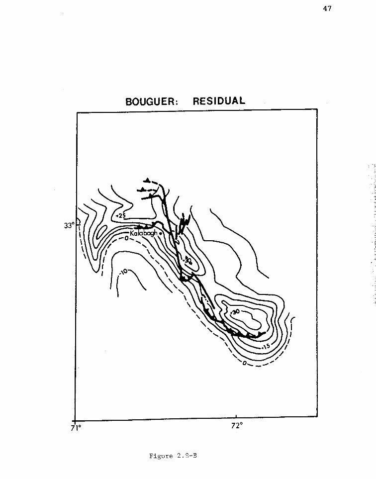
Basement structure and the Kalabagh fault zone
Gravity data:
A NNW-trending discontinuous ridge in the 2-3.
northward-sloping top of basement of the Indian plate is
interpreted from positive Bouguer gravity anomalies along
the Kalabagh fault zone. The regional (low frequency)
Bouguer gravity gradient is based on contour lines that
extend across the Potwar Plateau and project into the
Kalabagh re-entrant (Figure 2.8-A). The higher frequency
residual is separated from the regional gradient, giving
residual anomalies along the fault exceeding +30 mgal
(Figure 2.8 -B). The residual anomaly in general
increases to the SSE toward the Sargodha high (+100 mgal)
where Indian-shield basement crops out in the Kirana
Hills (e.g., Farah and others, 1977).
Basement structures are modeled with a minimum
relief of 500 meters above surrounding basement, in
calculations using symmetrical E-W cross sectional
gravity profiles and a basement to sedimentary overburden
density contrast of 0.6 gm/cm . The gravity anomaly is
predicted by an equation for a horizontal cylinder of
excess mass:
Z ir cr
91(1 +
where T= density, z = depth to center of the anomalous
mass, x = horizontal distance from the edge to the center

16
of the gravity anomaly, R = radius, and G = gravity
constant (Griffiths and King, 1981). The radius of the
cylinder: R = 550 meters, suggests 500-1000 meters of
relief on the basement ridge. Two-dimensional modeling
using methods of Talwani and others (1959) produces
similar basement structures, while not significantly
elucidating the cross sectional shape of the ridge.
Where E-W cross sections of the ridge are asymmetric, the
basement ridge may be asymmetric. Alternatively, an
asymmetric gravity anomaly in E-W profiles may indicate
repetition of allochthonous strata.
Seismic reflection data:
A seismic reflection profile extending from Kohat
city 30 km southward toward the northern right-angle bend
in the Kalabagh fault (located on Figure 2.1) shows a
nearly flat basal decollement surface at approximately 8
km (4 sec. 2-way travel time). This flat decollement
surface projects eastward along strike to the northern
Potwar Plateau, where seismic reflection data constrain
the basal decollement of the Salt Range-Potwar Plateau
allochthon at a similar depth (e.g., Leathers, 1987;
Baker, 1987; Lillie and others, 1987; Baker and others,
1988). Southwest of the Kalabagh fault near Mianwali,
the Kundian well penetrates the Salt Range Formation that
overlies basement. The Kundian well, and an intersecting
seismic line that extends southward toward the Sargodha
17
high, constrain the 2-3° northward slope of the basement
toward the Surghar Range and the Potwar Plateau.
Implications:
The Kalabagh fault system is formed by a lateral
ramp that extends to the base of the Salt Range-Potwar
Plateau allochthon (Figure 2.9). The base of the
allochthon and top of basement exceed a depth of 5 km in
the northern part of the Kalabagh fault and shallow
southward. The Kalabagh tear fault is decoupled from
basement and propagates over the basement feature.
Right-slip separation determined at the surface near
Kalabagh town (Figure 2.5) extends to the south.
Residual gravity anomalies derived from the regional
gradient indicate a ridge along the Kalabagh fault zone
rather than a step in the basement. Wrench faulting
along upward-diverging fault splays or "flower"
structures (Harding and Lowell, 1979) may uplift the
basement blocks to form the ridge independently of the
lateral ramp. This may also corroborate earthquake focal
mechanisms reported by Seeber and Armbruster (1979) and
Seeber and others (1981) that indicates an overall right-
lateral sense of shear in basement to the south of the
Kalabagh fault zone. Concentrations of earthquake
hypocenters southwest of the Kirana Hills in the Kalabagh
re-entrant are shown to define fault zones approximately
parallel to, but largely west of the trend of the

18
Kalabagh fault zone (Seeber and others, 1981). The
gravity anomaly beneath the Kalabagh fault zone merges
with the regional WNW-trending zone of basement
seismicity of Menke and Jacob (1976), although trends of
these two features vary by 10-15 degrees. The Kalabagh
fault probably ramped up over the basement ridge, which
follows an older zone of weakness. Wrench faulting in
the basement to produce the ridge may also be in part
contemporaneous with Kalabagh fault displacement,
producing contemporaneous seismicity.
In the Idaho-Wyoming thrust belt, Wiltschko and
Eastman (1983) show that faulted basement structures and
slope changes in basement control frontal ramping of
thrust faults. An E-W-trending upthrown basement fault
block is interpreted to control the position of the ENE-
trending Salt Range frontal thrust ramp 70 km east of the
Kalabagh fault (Baker and others, 1988). An upthrown
basement block is a natural deflection line for a lateral
ramp involving oblique compression, such as the Kalabagh
fault. In addition to the basement ridge, a generally
shallowing basement west of the Kalabagh fault is
suggested by the Kundian well, which penetrates the
Cambrian section. This provides a favorable overall
geometry for a lateral ramp to occur here, however, a
westward-shallowing basement does not explain the western
part of the Kalabagh re-entrant.

19
Discussion
Comparison with other structures:
In a thin-skinned thrust system, a lateral ramp
along a basement structure would be likely to form a tear
fault at the toe of the allochthon, as compared with
basement control on a frontal ramp (Wiltschko and
Eastman, 1983). The Kalabagh fault propagated from the
basement along the western Salt Range and extended to the
north to conserve slip. Strike-slip offset of 16-19 km
along the Kalabagh and Surghar faults decreases
northward, in part by transfer of motion to west-trending
folds and thrust faults that crop out north of the
Surghar Range.
The Kalabagh fault may be compared with the
Jacksboro fault that bounds the Pine Mountain thrust
sheet in the southern Appalachians (Figure 2.10). Both
faults terminate a major thin-skinned decollement thrust
along a low strength sedimentary layer, and are oriented
similarly, i.e., with respect to the fold-thrust belt.
The thickness of the Chattanooga Shale probably
controlled the northwestward advance of the Pine Mountain
thrust sheet and the related left-lateral Jacksboro fault
(Harris, 1970, 1977). In contrast, although the Salt
Range evaporites may vary in thickness, the top of the
basement was the primary control on lateral ramping of
the Kalabagh fault. Folds that trend E-W to NW on either

20
side of the Kalabagh fault were truncated and
significantly displaced by strike-slip faulting. In the
Pine Mountain thrust sheet, in addition to frontal ramp-
related folds such as the Powell Valley anticline, folds
are parallel to the Jacksboro fault (Harris, 1970) and
were probably contemporaneous with left-lateral
displacement. Cambrian strata follow the strike of the
fault in the transition zone between the Jacksboro tear
fault and the Chattanooga frontal thrust (Figure 2.10).
Stratigraphically-controlled decoupling would produce a
more gradual transition between the Chattanooga thrust
and Jacksboro fault, whereas the comparable bend of the
Kalabagh tear fault zone is offset by right-slip faults.
Truncation of the eastern Surghar Range by the Surghar
fault and truncation in the Kalabagh area by the Kalabagh
fault produced segmentation of folds and faults in
emergent lower Tertiary and older strata. The Pine
Mountain thrust and Jacksboro fault are mapped as more
discrete linear zones at the surface when compared with
the Salt Range-Potwar Plateau decollement thrust and
Kalabagh fault. The Kalabagh fault zone shows a greater
compressional component of strike-slip displacement as
well as more influence by basement structures when
compared with the Jacksboro fault.
Basement structures are associated with large tear
faults in the Swiss Jura, such as the Vallorbe-Pontarlier
fault, that trend 20-60° to the axes of compressional

21
folds (Rutten, 1969; Anderson, 1978; Trumpy, 1980).
Structures that die out or are truncated by these strike-
slip faults lack consistent horizontal displacement,
i.e., thin-skinned compressional folds typically were
developed independently on either side of the major tear
faults in the Jura (Rutten, 1969). The Kalabagh fault
zone is characterized by consistent right-lateral offset
along the western Salt Range, in contrast with tear
faults of the Swiss Jura. In the Kalabagh fault segment
north of the Indus River, the northward reduction of
offset documented at the surface may be comparable with
variable offset along tear faults in the Jura.
The 120-km-long (N-S) Kalabagh re-entrant on its
eastern side includes 16-19 km of offset in the Kalabagh
fault zone. Subsurface data indicate a 2-3°N dip of
basement and the base of the allochthon beneath the
western Potwar Plateau, east of the Kalabagh fault zone.
Similar shallow N-dipping basement to the west of the
Kalabagh fault zone may be offset by a down-to-the-north
fault at the Surghar Range frontal ramp (McDougall, 1988,
in prep.). This limits southward propagation of
decollement thrusting at the Surghar Range. The Kalabagh
re-entrant may also be controlled by a flexure in the
lithosphere with a wavelength of 60-150 km, approximately
parallel to the east-southeastern trend of the central
Himalaya east of the Hazara syntaxial bend. The re-
entrant may be a primary structural feature on which the

22
north-plunging basement ridge and Kalabagh fault lateral
ramp have been superimposed.
The compressional component of slip in the Kalabagh
fault zone may have increased by syntectonic clockwise
rotation of the principal compressive stress axis (c5).
Separation between hanging-wall and footwall cutoff lines
in an E-W cross section of the Ghundi lobe is shown as 8-
10 km (Figure 2.9). This indicates transverse shortening
that decreases to the north. The east-dipping back limb
of the lateral ramp crops out in strike ridges of Sakesar
Limestone along the western margin of the Potwar Plateau,
that generally dip more steeply to the north. N-S- to
N30E-oriented splay faults that diverge from the Kalabagh
fault near the Indus River, that include the Dinghot and
Ainwan faults, may be Riedel shears (e.g., Tchalenko,
1970).
Structural evolution:
Cumulative strike-slip offset of 16-19 km along the
Kalabagh and Surghar faults can be compared with frontal
thrust displacement of the central Salt Range, as both
measure movement of the Salt Range-Potwar Plateau
allochthon with respect to the Punjab foreland.
Shortening of 19-23 km in the central Salt Range was
determined from seismic reflection profiles and a
balanced N-S cross section of the south-central Potwar
Plateau (Baker, 1987; Baker and others, 1988). Frontal

23
thrust displacement at the eastern Surghar Range of 3-4
km (McDougall, 1988, in prep.) adds to displacement along
the Kalabagh and Surghar strike-slip faults in comparing
offset of the frontal Salt Range. The interconnection
between the Kalabagh tear fault system and the Salt Range
thrust front implies synchroneity of offset. The
difference between 5-8 km of cumulative thrust
displacement at the surface in the Surghar Range and
northern Kalabagh fault zone and 16-19 km along the
Kalabagh and Surghar faults suggests that the Kalabagh
fault projects into blind thrusts north of the Surghar
Range.
Radiometrically-dated volcanic ashes and associated
paleomagnetically-dated stratigraphic sections give a
1.9-2.1 Ma time interval for erosional truncation of the
northern limb of the Soan syncline 15 km south of
Rawalpindi (Reynolds and Johnson, 1985). This indicates
southward transfer of active compressional deformation
and incipient ramping of the Salt Range front at about 2
Ma (e.g., Baker and others, 1988). The emergent Salt
Range front remains active to the present day and
continues to step toward the foreland to the south (Yeats
and others, 1984). Southward tectonic transport of the
Salt Range-Potwar Plateau allochthon probably correlates
in time with emergent thrust faulting at the Surghar
Range front. The Surghar Range thrust was succeeded by

24
the Surghar right-slip fault, and finally by the Kalabagh
right-slip fault.
Slip rates for the Kalabagh fault system average
7.6-10 mm/year, with 16-19 km of offset in the last 1.9-
2.1 Ma. If the base of the Kalabagh Conglomerate is
significantly younger than 2 Ma, displacement of this
unit 12-14 km along the Kalabagh fault would be at a
higher rate. The Kalabagh Conglomerate, by association
with the basement ridge (Figure 2.2), marks upward
ramping of pre-Siwalik rocks along the Kalabagh fault.
Deformation and erosional dissection of the Kalabagh
Conglomerate indicates a migration of the depositional
axis or deceleration of uplift since maximum Kalabagh
fanglomerate deposition.

25
Neotectonics:
The emergence of the western Salt Range front over
the Indus River floodplain along the Kalabagh fault is
visible from space imagery (Figure 2.2). The Quaternary
Kalabagh fault has displaced the Kalabagh Conglomerate,
Indus River floodplain deposits, and lake beds near
Khairabad (Figure 2.4), and has thrust Cambrian strata
over alluvial fan gravels along the Ghundi lobe.
Tectonic control of the linear Chisal Algad in the
northern Kalabagh fault zone is remarkable. Uplifted
stream terraces, faulted cobbles in late Quaternary
conglomerate, tectonic blocks of evaporite and limestone,
and truncated alluvial fans mark the northern segment of
the Kalabagh fault. Regional uplift and neotectonic
tilting because of right-lateral transpression in the
Kalabagh fault zone suggests active faulting and folding.
The paleo-Indus River deposited far-derived channel
conglomerates in the Chisal Algad drainage that was later
separated from the source of these deposits and the
modern Indus River. Uplift of the northern Kalabagh
fault zone by transpression and thrust faulting may have
diverted the Indus River to the east from a former course
in the Chisal Algad (McDougall, 1988). Uplift in the
area south of Nandrakki has exposed a section over 1500 m
thick of these far-derived channel conglomerates (Figures
2.3 and 2.7).

26
Despite geomorphic and geological expression of
Quaternary Kalabagh faulting, there are no known fault
scarps on modern aggrading alluvial fans. Continual
rejuvenation of topography with large alluvial fans
emanating from the Salt Range, high erosion rates, and a
large compressional component of strike-slip faulting
contribute to poor preservation of earthquake-generated
fault scarps.
Right-lateral displacement averaging 7-10 mm/year
for the last 2 Ma classifies as a high activity rate,
with abundant and discontinuous evidence of activity
(Slemmons and DePolo, 1986). The recurrence interval for
major earthquakes may be quite long, measured in
thousands of years (Yeats and others, 1984). The
Kalabagh fault is not known to have produced major
historic earthquakes, however, conversations with local
inhabitants suggest repeated moderate earthquakes in the
northern Kalabagh fault zone. The Salt Range-Potwar
Plateau decollement thrust has been described as
relatively aseismic when compared with other frontal
faults of the Himalayan Range. Microseismic activity
recorded in the broad zone including the Kalabagh fault
zone (Seeber and Armbruster, 1979; Seeber and others,
1981) indicates some release of accumulated strain,
however much of this seismicity was south of the Salt
Range.

27
Conclusions
Strike-slip offset in the Kalabagh fault zone
conserves slip between frontal thrust ramps in the Salt
Range and eastern Surghar Range. Cumulative displacement
of piercing points along the Kalabagh and Surghar right-
slip faults of 16-19 km gives an average displacement
rate of 7-10 mm/year for the last 2 Ma. The Kalabagh
fault system developed in the following sequence: (1)
folding of the Nandrakki deformed zone of the southern
Kohat Plateau, (2) inception of the eastern Surghar Range
frontal thrust ramp and Salt Range frontal thrust ramp,
(2) inception of the Surghar right-slip fault, truncating
the eastern Surghar Range thrust, (3) inception of the
Kalabagh right-slip fault, (4) formation of splay faults,
including the Ainwan and Dinghot faults, east of the
Kalabagh fault. The Surghar Range and Salt Range fold-
thrust front emerged as thrust faulting propagated
southward from the Kohat Plateau, beginning at 1.9-2.1
Ma. Uplift of the basement ridge beneath the lateral
ramp of the western Salt Range must have preceded
inception of the right-lateral Kalabagh tear fault zone.
The N30W- to N-S-oriented Surghar fault underwent 4-5 km
of right-lateral displacement during the time of early
Salt Range frontal thrusting. Right-slip offset of 12-14
km along the N15W-trending Kalabagh fault followed

28
Kalabagh Conglomerate deposition and was contemporaneous
with continued Salt Range decollement thrusting.
The configuration of basement rather than evaporite
thickness was the fundamental structural control on the
lateral ramp of the Kalabagh fault zone. The decoupled
Salt Range allochthon was deflected upsection along a
linear basement ridge below the western Potwar Plateau,
interpreted from Bouguer gravity anomalies. Two major
+30 mgal residual gravity anomalies trend SSE along the
western Salt Range. The anomalies trend beneath the
Indus and Jhelum River floodplains toward the Sargodha
basement high.
NNW-trending folds and reverse faults in the
northern Kalabagh fault zone and in the Ghundi lobe
indicate compressional right-slip motion by tectonic
transport in an approximately N-S direction. The
Kalabagh fault zone is emergent topographically in a zone
at least 5 km in width. Tectonic tilting along the
Kalabagh fault system probably diverted the Quaternary
Indus River away from the Chisal Algad segment of the
fault.
The Kalabagh fault was active during the late
Quaternary and is a seismic hazard. Earthquake
hypocenters in the shallow tear fault zone (0-6 km), may
result from release of significant amounts of strain
energy. Although the Salt Range-Potwar Plateau
allochthon is decoupled from basement, a basement

29
earthquake of significant magnitude would produce shaking
at the surface. Seismic events up to magnitude 5 were
clustered along possible southward extensions of the
Kalabagh fault zone in basement, as observed by Seeber
and others (1981).

30
Figure 2.1: Index map showing Kalabagh fault zone
(center left), Potwar Plateau (center), Kohat Plateau
(center left), and surrounding regions of northern
Pakistan. Thrust faults are bold lines, dashed where
approximate, and teeth point toward upper plate. Shaded
areas are Quaternary deposits, primarily in structural
basins or depressions in the foreland fold-thrust belt
and the Indus River floodplain. Patterned outcrops in
Kirana Hills near Sargodha (lower right) are exposures of
Precambrian basement.

31
70 E
35 N+KOHISTAN
loo)J;10MANTLE
HI41.4(.4),A75E
35 N+
ASIN
7KOHAT7
rHRu7;..ik
K UNMANWELL Khushob1
72 E
4 32N
3
AB ELAND
S5, --+ Seismic lines
100 150
Km
Figure 2.1

32
Figure 2.2: Tectonic map of Kalabagh fault zone with
accompanying. Landsat scene (Bands 4,5, and 7, E -2691-
04550, 1976). Outlines of modern alluvial fans shown as
dotted lines along the western Salt Range and Surghar
Range escarpments. Maps are based on geological mapping
by author and by E.R. Gee.

Figure 2.2
C
Kalabagh,.
OLL
0 Khairabad
POTWAR
PLATEAU
Ghundi
KALABAGH FAULT ZONE.0 Faults, teeth on upper plate,
dashed where approximate
Folds
NammalLake
Quaternary deposits, undifferentiated.Outlines of nonvegetated alluvialfans are dotted.
Quaternary Kalabagh Fanglomerate
Mid-Tertiary to Early Quaternaryfluvial deposits. Primarily SiwalikGroup including Indus RiverConglomerate.
Eocene and older sedimentary rocks
Warchha
33

Figure 2.2
33a

34
Figure 2.3: Lithostratigraphic sections of post-
collisional molasse deposits including the Murree and
Kamlial Formations (Rawalpindi Group), the Chinji, Nagri,
and Dhok Pathan Formations of the Siwalik Group,
informally defined, and the Indus River conglomerate.
Numbered sections are located on index map.
Paleomagnetic age control is represented by bold solid
bar in representative sections. Time lines are projected
to sections 2, 4, and 5 without age control, assuming
similar sedimentary accumulation rates and similar
stratigraphic position for adjacent sections. Kundian
well correlations are from the Geological Survey of
Pakistan.

BANDARAMARWAT R.(Khan,1983)
0.6 MA
2.5 MA
CHICHALI -CHANI KHEL. MAKHAD,
KUNDIAN SURGHAR R. W. POTWARWELL (Khan,1983) (6111,1953)
3 4
5 MA
VERTICAL 0SCALE 500
1000 M
DAUD KHEL'(Hussein et aI.1979)
5
BHAUN
CHINA -NAGRI
(Johnson et a1,1982)Tan
6
7.88 MA
t(Johnsone a1,1985)
,,44121111MMIMINIAr__111111411111111111111:10 MA
(20X VERT. EXAGGERATION IN CROSS SECTION)
eeo
Tsu
T61'
Ten
Tkm.,
INDUS RIVER CONGLOMERATE
UPPER SIWALIK
DHOK PATHAN FORMATION
NAGRI FORMATION
CHINJI FORMATION
KAMLIAL/MURREE FORMATION
mm RADIOMETRICALLY DATED ASH BED
TIME LINES
E4
Figure 2.3
(DER BELOW
JALALPUR, E. POTWAR(Johnson Cl 81.1982)
8
14.3 MA
Is 3 MA
0.5 MA
2.5 MA
5 MA7.88 MA
10 MA
13.48 MA

36
Figure 2.4: Faulted lake beds (L) in vertical cliff near
Khairabad, in view facing south with person for scale.
The fault dips 40°E with the upthrown block to the left.
Lake beds are overlain by Quaternary gravels (Q) that
indicate dip separation (S) along the fault. Photo by
R.S. Yeats.


38
Figure 2.5: Map of the Kalabagh area with displacement
of piercing points along Kalabagh fault (p-p'), and along
Surghar fault (s-s'). The Kalabagh Conglomerate is not
offset by the Surghar fault, but is offset 12-14 km by
the Kalabagh fault. Lower right portion of map is from
Gee (1980).

Figure 2.5
KALABAGH AREA DETAIL71° 30' 71° 35' 71° 40' E
29 \22
CEMETERY F.
Kalabagh
(z.
/4.-0 Faultsf / approximate
inferred
o Kalabagh Fanglomerate,;=,IMiddle Tertiary to Early
10uaternary MolasseEarly Tertiary Strata
Mesozoic Strata
Paleozoic Strata
Eocambrian Evaporite
FIG. 4Khaira-5
bad
Kilometers
33° 05' N
33°00'
32° 55'
32°50'
39

40
Figure 2.6: Map restoration of folds and faults of the
Kalabagh area prior to Kalabagh fault zone offset of
figure 2.5. This fold pattern in figure 2.5 is masked,
in part, by Siwalik and younger deposits at the surface.

41
KA.LABAGH AREA. PRIOR TODISPLACEMENT ALONG
SURGHAR AND KALABAGH FAULTS'
Aftrimom"-"F7
SURGZ-11 otONT F.
s'14-5kmi
PA FaultsP-
11 2-14 kml
Early Tertiarystrata
Mesozoicstrata
Paleozoic 0 1 2 3strata P I I 1
Km
Figure 2.6

42
Figure 2.7: Map of the Shakardarra-Nandrakki area and
northern Chisal Algad with thrust faults including the
Visor fault branching to the west from the northern part
of the Kalabagh fault. Salt Range evaporite crops out in
the northern Chisal Algad.

Figure 2.7
SHAKARDARRA AREA7r30' 71°40' E
40
36 \68
% A 'cs., o 0 a0/0 Q 0
NANDRAKIOAREA rs4 0 0 C) 0
10 0 040.O 0 g V 0 .
O8 \O 67 0
6 0
O.64 I
. 0
Tabi Sa
Visor
Faultsapproximateinferred
Middle Tertiary to Early Quaternary fluvial deposits,primarily Siwalik Group including Indus River Conglomerate
Early Tertiary Strata
Eocambrian Salt Range Formation
0 1 2 3 4 5ILI'Km
43
33°15' N
31°10'
33°05'

44
Figure 2.8-A: A portion of a Bouguer gravity composite
map, in mgal, recorded by Oil and Gas Development Corp.
of Pakistan and published in Farah et al, 1977. Shaded
lines are the gradient from which the residual map was
constructed, projected westward from the central Potwar
Plateau and eastward across the Kalabagh re-entrant.

45
BOUGUER GRAVITY
Figure 2.8-A

46
Figure 2.8-B: Bouguer gravity residual anomalies, in
mgal., where gravity values were contoured from the
regional gradient of negative Bouguer gravity values
increasing northward in 2.8-A to show the higher
frequency component. Bold lines superimpose the Kalabagh
fault zone and Surghar Range front fault.
47
BOUGUER: RESIDUAL
Figure 2.S-B

48
Figure 2.9: Schematic drawing of the Kalabagh fault
lateral ramp with cutaway E-W cross section of the
southern Ghundi lobe, located in figure 2.2. The
basement ridge extends north to the Kalabagh area where
it dies out, as suggested by reduction of the residual
gravity anomaly of figure 2.8-B. Depths to basement and
approximate thicknesses of section are projected from
reflection seismic and well data east of area of diagram
(Leathers, 1987).

KEYSCHEMATIC DIAGRAM OF KALABAGH FAULT ZONE WITH CROSS SECTION OF GHUNDI LOBE
Siwalik Moittaa
Paleozoic -Late Tertiary Strata
Eocambrin Salt Range Formation
Bwment
Faults, with Teethon Upper Plata
Sub a ur acProIetionSurteStructure
Figure 2.9
49

50
Figure 2.10: Comparison between the left-slip Jacksboro
tear fault zone at southwest corner of the Pine Mountain
thrust plate, southern Appalachians, and the Kalabagh
right-lateral tear fault zone, northern Pakistan. Only
major structures and geological units are shown. Figures
are oriented to compare thrust fault to strike-slip fault
transition zones and are at the same scale. The
Jacksboro fault zone map is after Harris (1970, 1977).

JACKSBORO FAULT ZONE,
SOUTHERN APPALACHIANS
KEY
Pennsylvanian Strata
Mississippian toUpper C Strata
ElUpper to Lower C Strata
.1,79Faults
KALABAGH FAULT ZONE
Figure 2.10
51

52
References:
Anderson, J.G.C., 1978, The Structure of western Europe:New York, Pergamon, 250 p.
Baker, D.M., 1987, Balanced structural cross section ofthe central Salt Range and Potwar Plateau of Pakistan:Shortening and overthrust deformation: (M.S. thesis),Corvallis, Oregon, Oregon State Univ.
Baker, D.M., Lillie, R.J.Yousuf, M., and Zamin,the Himalayan frontalPakistan: Geology, v.
, Yeats, R.S., Johnson, G.D.,A.S.H., 1988, Development ofthrust zone: Salt Range,16, P. 3-7.
De Jong, K.A., 1986, Plate T-46: Kohat, in Short, N.M.,and Blair, R.W., eds., Geomorphology from Space:Washington D.C., N.A.S.A., p. 134-135.
Duroy, Y., 1986, Subsurface densities and lithosphericflexure of the Himalayan foreland in Pakistaninterpreted from gravity data: (M.S. thesis),Corvallis, Oregon, Oregon State Univ., 74 p.
Duroy, Y., Farah, A., and Lillie, R.J., (1988) in review,Reinterpretation of the gravity field in the Himalayanforeland of Pakistan, in Malinconoco, L.L., andLillie, R.J., eds., Tectonics and geophysics of thewestern Himalaya: Geol. Soc. America Special Paper.
Farah, A., Mirza, M.A., Ahmad, M.A., and Butt, M.H.,1977, Gravity field of the buried shield in the Punjabplain, Pakistan: Geol. Soc. America Bull., v. 88, p.1147-1155.
Gee, E.R., 1945, The age of the saline series of thePunjab and of Kohat: India National Acad. Sci. Proc.,Sec. B, v. 14, p. 269-310.
Gee, E.R., 1947, Further note on the age of the salineseries of the Punjab and of Kohat: India NationalAcad. Sci. Proc., Sec. B, v. 16, p. 95-153.
Gee, E.R., 1980, Pakistan geological Salt Range series,1:50,000, 6 sheets: Directorate of Overseas Surveys,United Kingdom, for the Government of Pakistan and theGeological Survey of Pakistan.
Gill, W.D., 1952, The stratigraphy of the Siwalik seriesin the northern Potwar, Punjab, Pakistan: Quart. Jour.Geol. Soc. London, v. 107, p. 375-394.

53
Griffiths, D.H., and King, R.F., 1981, Applied geophysicsfor geologists and engineers: New York, Pergamon, ch.7
Harding, T.P., and Lowell, J.D., 1979, Structural styles,their plate tectonic habitats, and hydrocarbon trapsin petroleum provinces: American Assoc. PetroleumGeol. Bull., v. 63, p. 1016-1058.
Harland, W.B., 1971, Tectonic transpression in CaledonianSpitsbergen: Geol. Mag., v. 108, p. 27-42.
Harris, L.D., 1970, Details of thin-skinned tectonics inparts of Valley and Ridge and Cumberland Plateauprovinces of the southern Appalachians, in Fisher,G.W., Pettijohn, F.J., Reed, J.C., and Weaver, K.N.,eds., Studies of Appalachian geology: central andsouthern: New York, Interscience, p. 161-173.
Harris, L.D., and Milici, R.C., 1977, Characteristics ofthin-skinned style of deformation in the southernAppalachians and potential hydrocarbon traps: U.S.Geol. Surv. Prof. paper 1018, 40 p.
Hussein, S.T., Munthe, J., Shah, S.M.I., West, R.M., andLukacs, J.R., 1979, Neogene stratigraphy and fossilvertebrates of the Daud Khel area, Mianwali district,Pakistan: Geol. Surv. Pakistan Memoirs, v. 13, 36 p.
Johnson, G.D., Raynolds, R.G.H., and Burbank, D.W., 1985,Deformation in the Himalayan foredeep margin,Pakistan: the timing and duration of a thrust rampingevent: Foreland Basins Conference, Fribourg,Switzerland, Sept. 2-4, 1985.
Johnson, G.D., Reynolds, R.G.H., and Burbank, D.W., 1986,Late Cenozoic tectonics and sedimentation in thenorthwestern Himalayan foredeep: Thrust ramping andassociated deformation in the Potwar region, in Allen,P.A., and Homewood, P, eds., Foreland Basins: Intl.Assoc. Sedim. Spec. Public. 8, p. 273-291.
Johnson, N.M., Opdyke, N.D., Johnson, G.D., Lindsay,E.H., and Tahirkheli, R.A.K., 1982, Magnetic polaritystratigraphy and ages of Siwalik Group rocks of thPotwar Plateau, Pakistan: Paleogeogr., Paleoclimat.,Paleoecology, v. 37, p. 17-42.
Johnson, N.M., Stix, J., Tauxe, L., Cervany, P.F., andTahirkheli, R.A.K., 1985, Paleomagnetic chronology,fluvial processes, and tectonic implications of theSiwalik deposits near Chinji Village, Pakistan: Jour.of Geology, v. 93, p. 27-40.

54
Kazmi, A.H., 1979, Active fault systems in Pakistan, inFarah, A., and DeJong, K.A., eds., Geodynamics ofPakistan: Geol. Surv. Pakistan, p.
Kazmi, A.H., and Rana, R.A., 1982, Tectonic map ofPakistan, 1:2,000,000, Govt. of Pakistan and theGeological Survey of Pakistan.
Khan, M.J., 1983, Magnetostratigraphy of Neogene andQuaternary Siwalik Group sediments of the Trans-IndusSalt Range, northwestern Pakistan: (Ph.D. thesis): NewYork, Columbia Univ., 217 p.
Leathers, M. R., 1987, Balanced structural cross sectionof the western Salt Range and Potwar Plateau,Pakistan: deformation near the strike-slip terminus ofan overthrust sheet: (M.S. thesis): Corvallis, Oregon,Oregon State Univ., 271 p.
McDougall, J.W., 1988, Tectonically-induced diversion ofthe Indus River west of the Salt Range, Pakistan:submitted to Paleogeogr., Paleoclimat., Paleoecology.
McDougall, J.W., in prep., (1988), Decollement thrustingalong a balanced N-S cross section of the forelandfold-thrust belt west of the Indus River, N. Pakistan
Menke, W.H., and Jacob, K.H., 1976, Seismicity patternsin Pakistan and northwestern India associated withcontinental collision: Seismol. Soc. America Bull., v.66, p. 1695-1711.
Minster, J.B., and Jordan, T.H., 1978, Present day platemotions, J. Geophys. Res.: v.83, p. 5331-5354.
Mitchum, R.M., Vail, P.R., and Thompson, S., 1977,Seismic stratigraphy and global changes in sea level,Part 2: The depositional sequence as a basic unit forstratigraphic analysis, in Payton, C.E., ed., SeismicStratigraphy-applications to hydrocarbon exploration:American Assoc. Petrol. Geol. Memoir 26, p. 53-62.
Molnar, P., 1984, Structure and tectonics of theHimalaya: constraints and implications of geophysicaldata: Ann. Rev. Earth Planet Sci., v. 12, p. 489-518.
Molnar, P., Burchfiel, B.C., K'uangyi, L., and Ziyun, Z.,1987, Geomorphic evidence for active faulting in theAltyn Tagh and northern Tibet and qualitive estimatesof its contribution to the convergence of India andEurasia: Geology, v. 15, p. 249-253.
55
Pilbeam, D., Barry, J., Meyer,Pickford, M.H.L., Bishop, W.Jacobs, L.L., 1977, GeologyNeogene strata of Pakistan:689.
G.E., Shah, S.M.I.,W., Thomas, H., andand palaeontology ofNature, v. 270, p. 684-
Pilgrim, G.E., 1913, The correlation of the Siwaliks withmammal horizons of Europe: Rec. Geol. Surv. India,v.43, p. 264-326.
Quittmeyer, R.C, Farah, A., and Jacob, K.H., 1979, Theseismicity of Pakistan and its relation to surfacefaults, in Farah, A., and DeJong, K.A., eds,Geodynamics of Pakistan, Geol. Surv. Pakistan, p. 271-284.
Raynolds, R.G.H., and Johnson, G.D., 1985, Rates ofNeogene depositional and deformational processes,northwest Himalayan foredeep margin, Pakistan, inSnelling, N.J., ed., Geochronology and the geologicalrecord, Geol. Soc. London Memoir 10, p. 291-311.
Rutten, M.G., 1969, The Geology of Western Europe:Amsterdam, Elsevier, 520 p.
Seeber, L., and Armbruster, J.G., 1979, Seismicity of theHazara arc in northern Pakistan: Decollement vs.basement faulting, in Farah, A., and DeJong, K.A.,eds., Geodynamics of Pakistan, Geol. Surv. ofPakistan, p. 131-142.
Seeber, L., Armbruster, J.G., and Quittmeyer, R.C., 1981,Seismicity and continental subduction in the Himalayanarc, in Gupta, H.K., and Delany, F.M., eds., Zagros-Hindu Kush-Himalaya geodynamic evolution: Am. Geophys.Union Geodynamics series, v.3, p. 215-242.
Slemmons, D.B., and DePolo, C.M., 1986, Evaluation ofactive faulting and associated hazards; in Wallace,R.E., ed., Active Tectonics: Washington D.C., NationalAcad. Press, p. 45-62.
Talwani, M., Worzel, J.L., and Landisman, M., 1959, Rapidgravity computations for two-dimensional bodies withapplication to the Mendocino submarine fracture zone:Jour. Geophys. Res., v. 64, p. 49-59.
Tchalenko, J.S., 1970, Similarities between shear zonesof different magnitudes: Geol. Soc. America Bull., v.81, p. 1625-1640.
Trumpy, R., 1980, An outline of the geology ofSwitzerland: New York, Wepf and Co., Publishers, 104P

56
Wiltschko, D.V., and Eastman, D.B., 1983, Role ofbasement warps and faults in localizing thrust faultramps, in Hatcher, R.D., Williams, H., and Zeitz, I.,eds, Contributions to the tectonics and geophysics ofmountain chains: Geol. Soc. America Memoir 158, p.177-190.
Yeats, R.S., Khan, S.H., and Akhtar, M., 1984, LateQuaternary deformation of the Salt Range of Pakistan:Geol. Soc. America Bull., v. 95, p. 958-966.

57
III. TECTONICALLY-INDUCED DIVERSION OF THE INDUS RIVER
WEST OF THE SALT RANGE, PAKISTAN
James W. McDougall, Department of Geology, Oregon State
University, Corvallis, OR 97331-5506, U.S.A.
Abstract
Neogene and Quaternary molasse deposition at the
west end of the Salt Range in the foreland fold-thrust
belt of northern Pakistan produced an unusually thick
upper Siwalik section near the Indus River. Here,
Siwalik sedimentary rocks coarsen upsection to 1500-m-
thick, stacked channel-conglomerate deposits with a
distant provenance, similar to gravels forming the
bedload of the modern Indus River. The Chisal Algad, an
underfit stream separated from the Indus River by a
tectonically-induced drainage divide, contains a bedload
clast assemblage resembling that of the Indus River. The
Indus channel migrated eastward, abandoning the Chisal
Algad and leaving high terrace remnants of Indus gravels
unconformably overlying tilted Siwalik sedimentary rocks
north of Shakardarra. Thrust faulting and transpression
in the right-slip Kalabagh fault zone tilted and uplifted
a block measuring 15 km east-west by 30 km north-south.

58
The block has been incised by juvenile consequent
drainage toward the Indus River. The Indus River was
diverted eastward since 0.5 Ma and now occupies the lower
part of the Soan River valley.
Introduction
Neogene and Quaternary molasse sedimentation and
deformation characterize the foreland fold-and-thrust
belt in the western Potwar Plateau and southeastern Kohat
Plateau of Pakistan. The region received fluvial
sediments from mountainous areas as far as 600 km to the
north and northeast that were uplifted as a result of
continental collision. A broad elastic wedge stretching
across the frontal Himalaya is involved in Pliocene and
Quaternary deformation. The Salt Range thrust that
bounds the Potwar Plateau on the south is still active
(Yeats and others, 1984; Baker and others, 1988).
The Murree and Siwalik molasse sequence in the
eastern Potwar Plateau ranges in age from mid-late
Miocene to late Pleistocene (Gill, 1952). Gill
recognized lateral changes and the time-transgressive
nature of stratigraphic units within the Siwaliks,
previously named by Pilgrim (1913) and others.
Paleomagnetic stratigraphy and radiometric ages of
volcanic ashes within the Siwalik sequence define an

59
18.3-5.1 Ma age range in the south-central Potwar Plateau
(Johnson and others, 1982, 1985). In the Trans-Indus
Salt Range and Surghar Range, west of the Indus River,
Siwaliks are assigned paleomagnetic ages of 11.8-0.5 Ma
(Khan, 1983). Raynolds and Johnson (1985) described
southward migration of a synorogenic depression across
the the eastern Potwar Plateau since 2.1 Ma as the
foreland depocenter advanced ahead of the deformation
front.
Depositional deformational relationships in the vicinity
of the Indus River
Faults cutting the pre-molasse section north of the
Himalayan frontal fault typically die out as blind
thrusts within the Siwalik molasse section, producing
uplift of their hanging walls. Faults associated with
the right-lateral Kalabagh fault system cut the entire
section and reach the surface. Siwalik strata were
deformed as the deformational front of the fold-thrust
belt migrated from the Kohat Plateau southward. A
regional angular unconformity, dated near Rawalpindi,
indicates cessation of deformation and uplift of the Soan
syncline at 1.9-2.1 Ma (Johnson and others, 1986), but a
comparable unconformity has not been recognized near the
Indus River. Nearly continuous syntectonic fluvial

60
deposition appears to have occurred near the channel axis
of the Indus River during Neogene and Quaternary time.
The upper 1500 meters of the Siwalik section near
the Indus River north of Kalabagh is dominated by channel
conglomerate. This conglomerate averages 80% metamorphic
and igneous rock clasts and 20% sedimentary rock clasts;
dominantly limestone. The provenance for this clast
assemblage is as far as 600 km to the north in the upper
Indus drainage and includes the Karakoram and Kohistan
regions of northern Pakistan. Rock exposures of
polymictic upper Siwalik conglomerate are
indistinguishable in clast content from modern Indus
River channel deposits. Paleo-channels align
approximately N-S, as do the modern channels. These
conglomerates fill the depocenter of the Plio-Pleistocene
Indus River in the Indus River and Chichali sections
(Figure 3.1).
The Indus River conglomerate compares with true
polymictic conglomerates described previously by Anderson
(1927) and others, and implied to be far-derived. Gill
(1952) showed a conglomerate-dominant section in the
western Potwar Plateau in the upper Nagri, Dhok Pathan,
and younger stages of Siwalik deposition. Gill (1952)
also recognized an unconformity between the upper
Siwaliks and flat-lying Lei Conglomerate in the central
Potwar Plateau that corresponds to the unconformity dated
at 1.9-2.1 Ma in the Soan syncline by Johnson and others

61
(1986). An absolute age for the Indus River conglomerate
has not been determined, and time correlations from
magnetostratigraphic sections 60 km to the southeast
(Johnson and others, 1982, 1985) and 20 km to the west
(Khan, 1983) are tenuous. Figure 3.1 shows the lithology
and relative age of the Indus River section based on
current Siwalik age determinations from fossils and
correlation with sections elsewhere that have been dated
by tephrochronology and magnetic stratigraphy. In
contrast to the Indus River conglomerate, fanglomerates
such as the Kalabagh Conglomerate of Gee (1945, 1947,
1980) are dominated by clasts of locally-derived lower
Tertiary limestone.
Indus River conglomerate deposits dominate the upper
Siwalik succession throughout the region between the
south-draining Chisal Algad and north-draining Lagorai
Algad (algad = small stream) on the west and the modern
Indus River on the east (Figure 3.2). Indus River
terrace remnants also cap flat-topped hills immediately
north of Shakardarra. Recycled far-derived conglomerate
cobbles occur throughout the drainage systems of the
Chisal Algad and Lagorai Algad, including tributaries
draining eastward. Fluvial terraces containing far-
derived cobbles occur more than 50 meters above present
base level in tributaries of the Chisal Algad. The
Chisal Algad and Lagorai Algad are now characterized by
intermittent sediment discharge typical of an arid region

62
and are underfit. For example, at its confluence with
the Indus River near Kalabagh, the Chisal Algad
braidplain is nearly 500-m-wide. I conclude that the
Indus River formerly occupied the drainage area now
occupied the Chisal Algad and formed the channel of the
Chisal Algad. The Lagorai Algad may also have been part
of the paleo-Indus channel.
Neotectonics
Eastward diversion of the Indus River channel away
from the Chisal Algad indicates uplift due to oblique
compression in the active right-lateral Kalabagh fault
zone. Gentle eastward dips in erosionally-resistant
conglomerate beds west of the Indus River, opposite the
Soan-Indus confluence, indicate eastward tilting of an
elongate crustal block measuring approximately 15 km
east-west by 30 km north-south, between the modern Indus
channel and the proposed abandoned channel (Figure 3.2).
Topographic profiles across the block indicate
uplift as well as incision by the Chisal Algad and
Lagorai Algad (Figure 3.3). The undissected N-S profile
of high topography of the block is a broad convex upward
curve with a maximum elevation of 659 meters above the
modern Indus River, indicating minimum vertical uplift.
Longitudinal profiles of the Chisal Algad and Lagorai
63
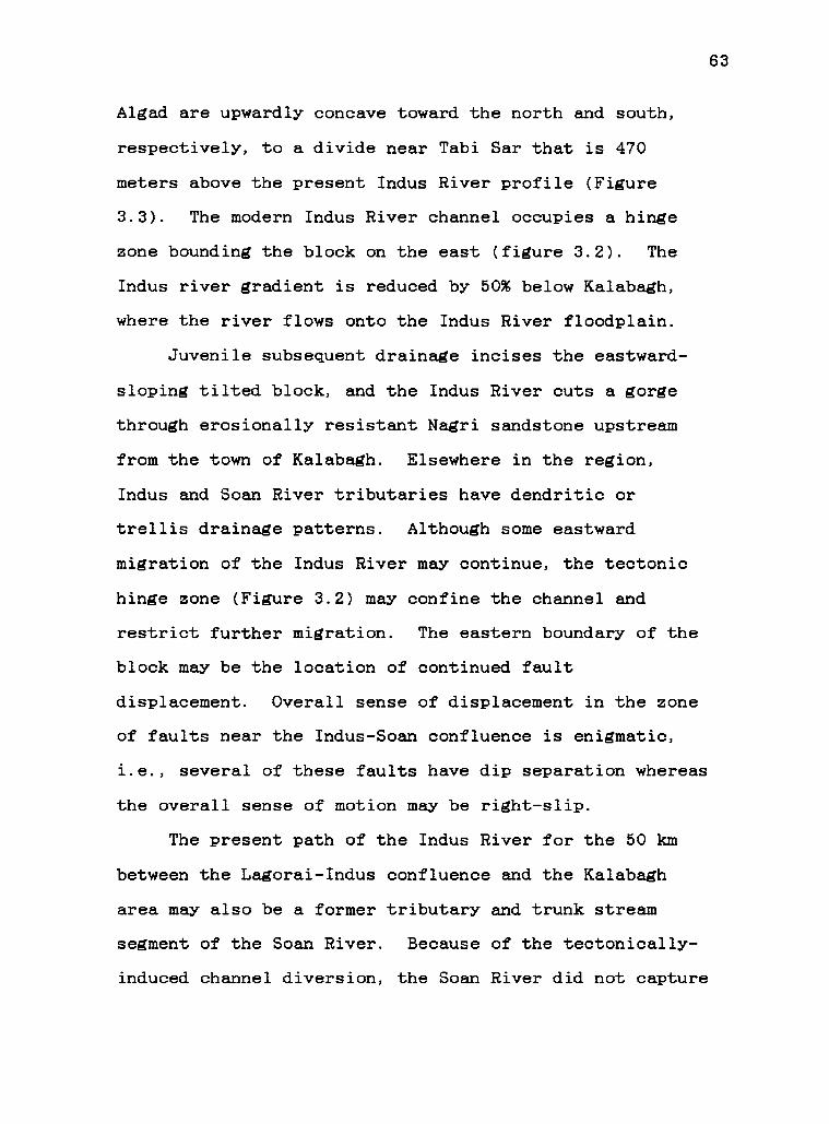
Algad are upwardly concave toward the north and south,
respectively, to a divide near Tabi Sar that is 470
meters above the present Indus River profile (Figure
3.3). The modern Indus River channel occupies a hinge
zone bounding the block on the east (figure 3.2). The
Indus river gradient is reduced by 50% below Kalabagh,
where the river flows onto the Indus River floodplain.
Juvenile subsequent drainage incises the eastward-
sloping tilted block, and the Indus River cuts a gorge
through erosionally resistant Nagri sandstone upstream
from the town of Kalabagh. Elsewhere in the region,
Indus and Soan River tributaries have dendritic or
trellis drainage patterns. Although some eastward
migration of the Indus River may continue, the tectonic
hinge zone (Figure 3.2) may confine the channel and
restrict further migration. The eastern boundary of the
block may be the location of continued fault
displacement. Overall sense of displacement in the zone
of faults near the Indus-Soan confluence is enigmatic,
i.e., several of these faults have dip separation whereas
the overall sense of motion may be right-slip.
The present path of the Indus River for the 50 km
between the Lagorai-Indus confluence and the Kalabagh
area may also be a former tributary and trunk stream
segment of the Soan River. Because of the tectonically-
induced channel diversion, the Soan River did not capture

64
the much larger Indus River by headward erosion of its
tributary.
Uplift rates for the block may be related to late
Quaternary right-lateral displacement rates of 7-10
mm/year or more along the Kalabagh fault, with uplift
related to oblique compression (McDougall, 1987, 1988).
Uplift is not confined to the block itself. Uplifted
terrace deposits north of Shakardarra and in east-
draining tributaries of the Chisal Algad indicate uplift
along thrust faults branching west from the main Kalabagh
fault that bounds the block on the west.
Although the time of channel migration has not been
determined, displacement of the Kalabagh fault is post-
2.1 Ma in age and may be dominantly post-0.5 Ma in age
(McDougall, 1988). The Indus River diversion occurred
during a period of rapid uplift in the Kalabagh fault
zone, probably in the last 500,000-100,000 years. Active
faulting affecting the course of the Indus River
continues to the present day.
Conclusions
Conglomerate deposits associated with the paleo-
Indus River occur in an area over 20 km wide (E-W), west
of the Indus River, that has been tectonically separated
from the source region of these deposits. These far-
derived polymictic conglomerates occur as a thick bedded

65
sequence that was later exposed by uplift, as high
terrace remnants north of Shakardarra, and in the bed
load of the Chisal Algad and Lagorai Algad. Block
tilting because of transpression and thrust faulting in
the Kalabagh fault zone restructured the drainage system
since 2.1 Ma. Rapid uplift probably diverted the Indus
River eastward since 0.5 Ma., causing it to occupy part
of the paleo-Soan River system.

66
Figure 3.1: Stratigraphic position and thicknesses of
lithostratigraphic units of the Indus River section (2)
of this paper relative to the Chichali-Chani Khel
composite paleomagnetic section (1) of Khan (1983) in the
Surghar-Shinghar Ranges, the Daud Khel section (3) of
Hussein and others (1979), and the Chinji-Nagri
paleomagnetic section (4) of Johnson and others (1985) in
the south-central Potwar Plateau. Thicknesses of units
in the Indus River section compare with those near Makhad
in the western part of the lithostratigraphic section of
Gill (1952, p. 389). Siwalik divisions are based on
Pilgrim's (1913) Chinji, Nagri, and Dhok Pathan
Formations and fossil ages summarized by Pilbeam and
others (1977). Location of sections (1-4) are shown on
index map.
.72-.97 Ma1.67 -2.5 Ma
6.4-8 Ma
10 Ma
0
5001000 meters
VERTICAL SCALE
00
2 3
20
Ozdl
O
0ti
0
4
(EOCENE AND OLDER ROCKSBELOW BASAL UNCONFORMITY)
INDUS RIVER CONGLOMERATE
rru UPPER SIWALIK (UNDEFINED)
Fd71) DHOK PATHAN FORMATION
NAGRI FORMATION
Tsc CHINJI FORMATION
Fkm KAMLIAL/MURREE FORMATIONS
7.88 MaT n 9.5 Ma
10 Ma
18.3 Ma
RADIOMETRICALLY-DATED ASH BED
TIME CORRELATION BASED ON FOSSILS
Figure 3.1
34°
7 2' E
0 400 KM
67

68
Figure 3.2-A: Area of Quaternary diversion of the Indus
River along the Kalabagh fault with major structural,
tectonic, and geomorphic elements at the surface. The
ridge line is on the high side of the tilted block.
Large arrows indicate general sense of shear in the
Kalabagh fault zone, and the hinge line is shaded at the
center right.

33° 00 N
71 °30'E
Figure 3.2-A
69

70
Figure 3.2: (Bottom) Three-dimensional sketch of tilted
block with cutaway along ENE line of cross section.
Indus River conglomerate is shown as upper Siwalik bedded
unit and terrace deposits in upper left (near
Shakardarra). Indus gravels indicated with cobble
pattern are polymictic conglomerates with similar distant
provenance.

KOHAT PLATEAU
terraceremnantse V
Shakardarrawools
406.
SNP 406110
ad;-0.
Jr:
;pr AO!
IKALABAGHFAULT
N.1c;,oe
Tolded Early Tert. Seds.
"4 gLagoraiAlgad70.'o'. 62.. o.. d .- -.0. AT TwEAARt
.. .a 0
. ..1a 0 0 °
c:, .
,0 ,,..
ctr.eV .
° : 0 °. C:' 0 0
'a 9t
*
I
e
oO
aINGML
aNa.'OMM
tiltedblock
uence
Figure 3.2B
hinge zonefaulted to south
-6a R.
71

72
Figure 3.3: Longitudinal profiles of the Chisal Algad
and Lagorai Algad (A-A'), the divide of the uplifted
block (B-B'), and the modern Indus River (C-C'), with
vertical exaggeration where indicated. Line with shorter
dashes in B-B' indicates an idealized profile of the
tectonically-induced high topography of the divide prior
to erosion. Gradient changes were not detected in the
modern Indus River except downstream from the confluence
with the Chisal Algad, where the gradient is reduced 50%
from that indicated on the figure.

CHISAL ALOAD-INDUS RIVERCONFLUENCE
(2013 m)
B
C
NORTHSOUTH LONGITUDINAL PROFILES
CHISAL ALOAD
(295 m) (373 ml
No.
LAGORAI ALGAD-INDUS RIVER
TABI SAR LAGORAI ALGAD CONFLUENCE
(8813 m)
4X VERT. EXAGG.
(533 ml (374 ml (223 ml
PALEO-INDUS DRAINAGE CHISAL AND LAGORAI ALGADS o 14111Km
BANGLE SAR(875 ml
/I*4X VERT EXAGG.
(772 m) (223 m)/
RIDGE LINE PROFILE OF UPLIFTED BLOCK
MAKHAD
(218 ml
I3X VERT1EXAGG. S.L.
(223 ml
0 5
MODERN INDUS RIVER o 10
GRADIENT: 0.33m/Km Km1.79 feet/mile
Figure 3.3
Km
73
S.L. A'
B'S.L.

74
References
Anderson, R.V.V., 1927. Tertiary stratigraphy and orogenyof the northern Punjab. Geol. Soc. America Bull.,38:665-720.
Baker, D. M, Lillie, R.J., Yeats, R.S., Johnson, G.D.,Yousuf, M., and Zamin, A.S.H., 1988. Development ofthe Himalayan frontal thrust zone: Salt Range,Pakistan. Geology, 16:3-7.
Gee, E.R., 1945. The age of the saline series of thePunjab and of Kohat. India National Acad. Sci.Proc., Sec. B, 14:269-310.
Gee, E.R., 1980. Pakistan geological series, 1:50,000, 6sheets: Directorate of Overseas Surveys, UnitedKingdom, for the Government of Pakistan and theGeological Survey of Pakistan.
Gee, E.R., 1947. Further note on the age of the salineseries of the Punjab and of Kohat. India NationalAcad. Sci. Proc., Sec. B, 16:95-153.
Gill, W.D., 1952. The stratigraphy of the Siwalik Seriesin the northern Potwar, Punjab, Pakistan. Quart.Jour. Geol. Soc. London, 107:375-394.
Hussein, S.T., Munthe, J., Shah, S.M.I., West, R.M., andLuklacs, J.R., 1979. Neogene stratigraphy and fossilvertebrates of the Daud Khel area, Mianwalidistrict, Pakistan. Geol. Surv. Pakistan Memoirs,13:1-36.
Johnson, G.D., Reynolds, R.G.H., and Burbank, D.W., 1986.Late Cenozoic tectonics and sedimentation in thenorthwestern Himalayan foredeep: Thrust ramping andassociated deformation in the Potwar region. In:P.A. Allen and P. Homewood (Editors). ForelandBasins: Intl. Assoc. Sedim. Spec. Public. 8:273-291.
Johnson, N.M, Opdyke, N.D., Johnson, G.D., Lindsay, E.H.,and Tahirkheli, R.A.K., 1981. Magnetic polaritystratigraphy and ages of Siwalik Group rocks of thePotwar Plateau, Pakistan. Paleogeogr., Paleoclimat.,Paleoecology, 37:17-42.
Johnson, N.M., Stix, J., Tauxe, L., Cervany, P.F., andTahirkheli, R.A.K., 1985. Paleomagnetic chronology,fluvial processes, and tectonic implications of theSiwalik deposits near Chinji Village, Pakistan.Jour. of Geology, 93:27-40.

75
Khan, M.J., 1983. Magnetostratigraphy of the Neogene andQuaternary Siwalik Group sediments of the Trans-Indus Salt Range, northwestern Pakistan. (Ph.D.thesis) Columbia University, New York, 217 pp.
McDougall, J.W., 1987. Tectonic map and interpretation ofthe Kalabagh tear fault, Himalayan foreland fold-thrust belt, western Salt Range area, Pakistan.Geol. Soc. America Abst. with Programs, 19:765.
McDougall, J.W., and Khan, S.H., (1988). Strike-slipfaulting in a foreland fold-thrust belt: theKalabagh fault and western Salt Range, Pakistansubmitted to Tectonics.
Pilbeam, D., Barry, J., Meyer, G.Pickford, M.H.L., Bishop, W.Jacobs, L.L., 1977. GeologyNeogene strata of Pakistan.
E., Shah, S.M.I.,W., Thomas, H., andand palaeontology ofNature, 270:684-689.
Pilgrim, G.E., 1913. The correlation of the Siwaliks withthe mammal horizons of Europe. Rec. Geol. Surv.India, 43:264-326.
Raynolds, R.G.H., and Johnson, G.D., 1985. Rates ofNeogene depositional and deformational processes,northwest Himalayan foredeep margin, Pakistan. In:N.J. Snelling (Editor), Geochronology and thegeological record. Geol. Soc. London Memoir, 10:291-311.
Yeats, R.S., Khan, S.H., and Akhtar, M., 1984. LateQuaternary deformation of the Salt Range ofPakistan. Geol. Soc. America Bull., 95:958-966.

76
IV. FOLD-AND-THRUST PROPAGATION IN THE WESTERN HIMALAYA,
BASED ON A BALANCED CROSS SECTION OF THE SURGHAR RANGE
AND KOHAT PLATEAU, PAKISTAN
James W. McDougall
Department of Geology, Oregon State University
Corvallis, OR 97331-5506, U.S.A.
Abstract
Layer-parallel slip dominated a wedge tapering
approximately 20 across the 70-km-wide Kohat foreland
fold-thrust belt, between the Main Boundary thrust (MBT)
and the Surghar Range of northern Pakistan. Decollement
thrust sheets with individual displacement as much as 32
km were deformed by fault-bend folds. Balanced cross
sections show over 50% line-length shortening by blind
thrusting of which less than half is documented in faults
and folds at the surface. This discrepancy may be
explained by buried tip lines and decoupling at the base
of the overlying Siwalik elastic wedge, a surface across
which fold harmonics also vary. Folds, thrust faults,
and backthrusts in the Kohat Plateau commonly die out in
the overlying molasse that probably pre-dates the
structures.

77
Decollement thrusting advanced across the Kohat
Plateau toward the southernmost frontal thrust ramp at
the Surghar Range that emerged at about 2 Ma. The
Surghar Range thrust appears to pre-date thrust faults
12-20 km to the north in the Kalabagh fault zone. This
out-of sequence thrusting is interpreted as a taper-
building response to increased decollement dip. Surface
geology, seismic reflection data, and a Bouguer gravity
anomaly were used to interpret a north-facing fault scarp
in the basement below the Surghar Range.
Low basal shear traction (7g.s1 MPa) along Eocene and
Eocambrian evaporite layers predicts the low critical
taper of the Kohat-Surghar wedge. The wedge is presently
subcritical and undergoing taper-preserving deformation
internally over a nearly flat basement.

78
Introduction
The active Himalayan fold-thrust belt south of the
Main Boundary thrust (MBT) in northern Pakistan (Figure
4.1) is an allochthonous wedge of deformed sedimentary
rocks with a low (<4°) cross-sectional taper that
propagated rapidly southward during the Quaternary. The
lower boundary for decollement thrusting is the top of
the north-dipping Indian shield basement, mapped with
seismic reflection profiles (Lillie and others, 1987) and
modeled regionally with gravity data (Farah and others,
1977; Duroy and others, 1988). Mechanical models of
deformation in the foreland fold-thrust belt north of the
Salt Range thrust (Jaume and Lillie, 1988) indicate
decoupling along a stratigraphic horizon dominated by
evaporites, following Davis and Engelder (1985).
Earthquakes concentrated at depths 10 km in the Hazara
and Indus-Kohistan seismic zones north of the MBT (Seeber
and Armbruster, 1979; Seeber and others, 1981) locate a
probable backstop for the active wedge. Slip extends
beneath the wedge south of the MBT, with low seismicity,
to active frontal thrust faults at the Salt Range (Yeats
and others, 1984; Baker and others, 1988), and the
Kalabagh fault zone (McDougall and Khan, 1988).
Commercial seismic reflection profiles were used in
determining the low north slope of the top of basement in
the Kalabagh re-entrant (McDougall, 1988) and beneath the

79
western Potwar Plateau (Leathers, 1987). A cross section
of the central Salt Range thrust from seismic reflection
profiles was used to estimate lateral shortening of about
20 km at the frontal ramp (Baker and others, 1988).
Surface geology, seismic reflection data, drill hole
data, and a Bouguer gravity map were used to constrain a
balanced cross section of the foreland fold-thrust belt
of the Kohat Plateau and western Potwar Plateau.
Geological mapping of Yeats and Hussain (1987), A.
Hussain (unpublished data), Meissner and others (1974),
E.R. Gee (1980, unpublished data), McDougall (1988), and
McDougall and Khan (1988) was used with seismic
reflection profiles to locate thrust ramps and major
folds and the depth to basement in the Kohat foreland
fold-thrust belt. Construction of balanced
(retrodeformable) cross sections incorporates ideas of
Rich (1934), Dahlstrom (1969), Boyer and Elliott (1982),
Suppe (1983), Woodward and others (1985), and many
others.
The 75 km long cross section extends from the Main
Boundary thrust (MBT) to the Surghar Range frontal thrust
fault and the edge of the Indus River floodplain (Figures
4.1, 4.2). Data from the northeastern Kohat Plateau,
northern Potwar Plateau, southern Kala Chitta Range, and
western Salt Range are used in the cross section. These
data represent the fold-thrust belt between the MBT on
the north, the Kalabagh re-entrant on the south, the

80
Indus River on the east, and the western Kohat Plateau
(-71°15') on the west.
Horizontal shortening along major decollement thrust
faults in the foreland fold-thrust belt is calculated
from balanced cross sections. The style of deformation
is shown in the direction of tectonic transport. The
stability of the wedge, implications for surface
faulting, and the sequence of thrust propagation are
addressed.

81
Data and observations
Surface neology:
The Main Boundary thrust (MBT), as defined by Yeats
and Hussain (1987) along the south flank of the Kala
Chitta Range, truncates subparallel folds of the foreland
fold-thrust belt in the northern Kohat Plateau (Figure
4.2). A window in the MBT at Mazari Tang, exposing the
Eocene Kuldana Formation 2 km north of the thrust front,
indicates the shallow north dip of the MBT.
At least two groups of folds characterize the Kohat
Plateau south of the MBT, where folded lower Tertiary
rocks underlie strata of the Murree amd Kamlial
formations, and the Siwalik Group. E-W to ENE-trending
folds (F1), with wavelengths of 1 km or less, were
deformed into broader, elongated domes and basins of
similar trend (F2) with wavelengths of 3-5 km. Folds are
either cogenetic or Fi preceded F. The broader folds
include the Panoba dome in the northeastern Kohat Plateau
and the Nandrakki dome near Shakardarra (Figure 4.2).
The F4 folds commonly have overturned limbs by passive
amplification, e.g., limbs of the ENE-trending Panoba
dome dip steeply toward the core of Paleocene-Eocene
Patala Formation. Parasitic ENE-trending F1 folds on the
Panoba dome include a tight syncline at the crest of the
dome. A steeply north-dipping thrust fault bounds the
Panoba dome to the south. At the Nandrakki dome (Ft) in

82
the southern Kohat Plateau, tight (F1) box folds of
Eocene Jatta Gypsum, Mami Khel Clay, and Kohat Limestone
plunge east below the -3-km-thick Siwalik molasse. The
Hukni fault bounds the southern Kohat Plateau and the E-
to SSE-trending Nandrakki dome to the south and west.
South of the Hukni fault (Figure 4.2), the northern
Kalabagh fault zone is characterized by thrust faults and
W- to NW-trending folds of less than 1 km wavelength in
Siwalik strata. Cumulative shortening in the northern
Kalabagh fault is estimated to be 2.5-4 km at the surface
(McDougall and Khan, 1988). The Siwalik sequence
thickens southward to more than 4 km on the northern
flank of the Surghar Range.
Emergent Paleozoic to early Tertiary rocks of the
Surghar Range are flanked on the north by Siwalik strata
that dip 30°N. The Surghar Range is bounded on the south
by a thrust fault bringing the foreland fold-thrust belt
over Indus floodplain sediments of the Kalabagh re-
entrant. A nearly vertical fault displaces the north
limb of a tight uplifted syncline in the eastern Surghar
Range. Evaporite deposits of the Eocambrian Salt Range
Formation do not crop out in the Surghar Range, but are
exposed at Kalabagh, 5-6 km SSE of the Surghar Range, and
farther to the SSE along the western Salt Range.

83
Wells and stratigraphic data:
Deep wells, including the Dhermund and Dhurnal wells
in the western Potwar Plateau, and the Kundian well in
the Kalabagh re-entrant (Figure 4.1) provide regional
stratigraphic control (Figure 4.3). The Kundian well
penetrates an 1478 m-thick molasse section and a 685 m-
thick Paleozoic section. The Dhermund well, in the west-
central Potwar Plateau near the Soan River, penetrates a
3059 m-thick Siwalik-Kamlial-Murree molasse section, 401
m of lower Tertiary strata, a 230 m-thick Mesozoic
section, 660 m of Paleozoic section, and the upper 42 m
of the Salt Range Formation. The Dhurnal well, near the
Kala Chitta Range, penetrates a 3742 m-thick molasse
section generally older than that of the Dhermund well, a
comparable 427 m-thick lower Tertiary section, no
Mesozoic section, a 571 m-thick Paleozoic section, and
the upper 27 m of the Salt Range Formation.
Stratigraphic sections include the Surghar Range
section of Meissner and others (1974), with a lower
Tertiary section about 1 km thick, and a Mesozoic section
over 1 km thick that is not completely exposed. The
Chichali section (Figure 4.3) combines the thickness of
pre-Miocene rocks of the Surghar Range section with a
Siwalik molasse section over 4 km thick (E.R. Gee,
unpublished mapping).
The northern Kohat Plateau section (Figure 4.3),
used in the cross section of the foreland fold-thrust

84
belt, is projected from regional deep wells and
stratigraphic sections. The Siwalik Group, Kamlial, and
Murree formations in general thicken southward. The
lower Tertiary section (including Eocene evaporite
deposits) and Mesozoic section thicken to the west from
the Potwar Plateau toward the Surghar Range and do not
reach the Kundian well in the Kalabagh re-entrant. The
northern Kohat Plateau section incorporates a thickness
of the lower Tertiary and Mesozoic section similar to the
Surghar Range to the south (Meissner and others, 1974).
The northern Kohat Paleozoic section is extrapolated from
the Dhurnal and Dhermund wells. A total thickness of
about 2300 m for lower Tertiary (pre-molasse), Mesozoic,
and Paleozoic strata is predicted for the northern Kohat
Plateau section.
The Eocambrian Salt Range Formation is predicted at
the base of the northern Kohat section from deep drill
hole data of the Potwar Plateau (Dhurnal, Dhermund, and
other wells) and the style of deformation in the Kohat
foreland fold-thrust belt south of the MBT. The pre-
Miocene (pre-molasse) section thickness in the fold-
thrust belt south of the MBT compares (±1000 m) with
thicknesses of strata of equivalent age north of the MBT.
Uncertainty in stratigraphic thickness estimation
increases to the north because of deformation and poor
resolution by seismic reflection data.

85
Seismic reflection profiles:
Seismic reflection lines are from a data set with
the highest density of coverage in the southernmost Kohat
Plateau. Seismic data quality is generally low and lines
are not tied to wells with velocity surveys, therefore
representative interval velocities, based in part on
stacking velocities, were applied to lines. Regional
seismic reflection data from the Potwar Plateau and the
Kalabagh re-entrant were also used to model the N-S cross
section between the MBT and the Surghar Range frontal
thrust.
Seismic line AW-15-AM (Figure 4.4), extending from
near Kohat city across the Kohat Plateau (Figure 4.2),
shows reflections at 4.0 sec. (2-way time), interpreted
as the top of basement, that may dip north at the very
northern end of the line, near the MBT. Along strike to
the east, comparable basement reflections at 4.0-4.2 sec.
on northern Potwar Plateau lines indicate a similar
thickness of the allochthon (e.g., Lillie and others,
1987). The flat crest of a major fault-bend fold was
interpreted in the center of line AW-15-AM, at 1.8 to 3.0
sec., 2-way time. The southern part of the line shows
highly diffracted seismic energy from a zone of north-
dipping thrust faults.
In the northeastern Kohat Plateau, N-S seismic line
AW-15-AL near the Indus River (Figure 4.5) shows a major
thrust ramp to basement. This ramp, below the projection
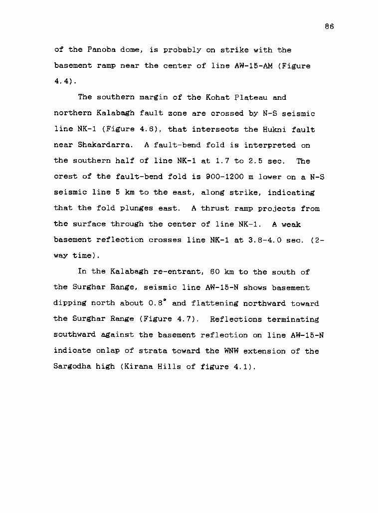
86
of the Panoba dome, is probably on strike with the
basement ramp near the center of line AW-15-AM (Figure
4.4).
The southern margin of the Kohat Plateau and
northern Kalabagh fault zone are crossed by N-S seismic
line NK-1 (Figure 4.6), that intersects the Hukni fault
near Shakardarra. A fault-bend fold is interpreted on
the southern half of line NK-1 at 1.7 to 2.5 sec. The
crest of the fault-bend fold is 900-1200 m lower on a N-S
seismic line 5 km to the east, along strike, indicating
that the fold plunges east. A thrust ramp projects from
the surface through the center of line NK-1. A weak
basement reflection crosses line NK-1 at 3.8-4.0 sec. (2-
way time).
In the Kalabagh re-entrant, 60 km to the south of
the Surghar Range, seismic line AW-15-N shows basement
dipping north about 0.8° and flattening northward toward
the Surghar Range (Figure 4.7). Reflections terminating
southward against the basement reflection on line AW-15-N
indicate onlap of strata toward the WNW extension of the
Sargodha high (Kirana Hills of figure 4.1).

87
Structural detail: balanced cross sections A-A', B-B',
and C-C'
On northern cross section line C-C' (Figure 4.8),
the window in the MBT at Mazari Tang overlies a 45° kink
bend in the underlying plate. Weakening of the
allochthon as it passed through this bend and compression
probably produced tight folds (Ft) in the "M" thrust
sheet (lines C-C', B-B'). Late-stage thrusting along the
MBT, which lies to the north, may also have deformed the
already mobile thrust sheet "M".
The large (5-6 km wavelength) F2. fold culminating in
the Panoba dome, strikes ENE across section B-B' in
thrust sheet "M". The 50°N-dipping thrust fault on the
south flank of the Panoba dome and shortening producing
it and other Ft folds may result from backlimb thrusting
along the "N" thrust ramp to the south.
In northern cross section line A-A' (Figure 4.8),
the major thrust sheet "M" was displaced at least 32 km
and deformed by a fault-bend fold and imbricate thrust
faults to the south. The "M" thrust sheet extends
eastward to lines B-B' and C-C' where southward
displacement is estimated as about 29 km. The crest of
the fault-bend fold underlying the northern Kohat Plateau
(center: line AW-15-AM; km marks 45-60 on line A-A') is
overlain by emergent F1 folds at the surface. The upper
thrust plate propagated downsection and delaminated the

88
crest of the fault-bend fold to the south, at km marks
30-45 on line A-A'. The Eocene Bahadur Khel Salt of the
southern Kohat Plateau probably controlled delamination
and shallow compressional deformation north of the Hukni
fault.
Imbricate thrust faults in the southern Kohat
Plateau overlie a major fault-bend fold beneath the
northern Kalabagh fault zone. This fault-bend fold (on
line NK-1, figure 4.6; km marks 23-33 on line A-A') dies
out eastward beneath more tightly folded Siwalik strata.
These strata repeat along the Visor fault and other
thrust faults branching from the Kalabagh fault (Figure
4.8).
South of seismic line NK-1, surface dips project to
the basal decollement thrust between axes of kink bends,
following techniques of Suppe (1983, 1985). A keystone
block in the emergent Surghar ramp (Figure 4.8: km marks
4-6 on line A-A') is bounded on the north by a down-to-
the-north fault. This fault is shown to continue in
basement from the cutoff line where it was truncated and
rotated counterclockwise about 20° during displacement of
3-4 km along the thrust ramp. A normal fault in basement
below the Surghar Range is interpreted from surface
geology, projected seismic lines including AW-15-N (from
the Kundian well to the Sargodha high, figure 4.7), AW-
15-AM (Figure 4.4), NK-1 (Figure 4.6), and seismic lines
and deep drill holes in the western Potwar Plateau. An

89
E-W-trending +25-30 mgal residual Bouguer gravity anomaly
also follows the Surghar Range.

90
Discussion
Sequence of thrust faulting and
associated deformation:
Decollement thrusting and folding in the Kohat
foreland fold-thrust belt west of the Indus River
developed from an undeformed foreland in the following
sequence, determined from sequential palinspastic
restoration of the balanced cross section (Figure 4.9):
(A) Succeeding 2.8-0.6 Ma displacement along the
MBT, as discussed by Yeats and Hussein (1987), the blind
"M" thrust sheet ramped in front of the MBT and began
uplifting the Kohat Plateau (Figure 4.9-A). Displacement
along this major decollement thrust eventually reached
-32 km along A-A' and 29 km along B-B' and C-C'. Wedging
beneath overlying Tertiary strata probably concealed the
tip line of thrust sheet "M", although associated
compressional deformation probably reached the surface.
Deformation within this thrust sheet included tight F1
folds (less than 1 km wavelength), broader FL folds such
as the Panoba dome, and associated thrust faults and
backthrusts that were later exposed in the Kohat Plateau
by erosion of the molasse cover. Between this thrust
sheet and the MBT is a thrust sheet with unknown relative
timing that was later involved in backlimb thrusting near
the frontal MBT (Figure 4.9-A).

91
(A to B) As the major blind thrust sheet of (A) was
transported southward, a fault-bend fold "0" developed
below and in front of it (Figure 4.9-B), so that total
slip was distributed between the two faults. A thrust
system also developed along a ramp "N" to the south as
the local taper of the wedge was increased. The earlier-
formed major thrust sheet "M" of (A) converged on the "N"
ramp, probably rotating the thrust fault south of the
Panoba dome to a higher north dip (Figure 4.9-B).
(B to C) Movement on thrusts "M" and "0" continued
and this northern thrust stack impinged on the "N" ramp
to the south. Uplift and possible emergence of the toe
of the "M" thrust sheet is shown.
(C to D) Continued convergence along the major
thrust sheet "M" toward the simple step thrust ramp "N"
to the south produced decoupling downsection to the lower
Tertiary section of the flat fold hinge. Tight folds and
thrust faults of the southern Kohat Plateau "P" were
formed, that sole out along the Eocene Bahadur Khel Salt.
These include tight F1 folds exposed at the Nandrakki
dome. No movement in thrust sheet "0" occurs at this
stage. Backlimb thrusting at "Q" uplifted the northern
Kohat Plateau.
(D to E) As deformation beneath the Kohat Plateau
continued, the decollement thrust system stepped -50 km
to the south. Decollement thrusting over the top of
basement, and probably along bedding planes of the Salt

92
Range Formation, produced the emergent frontal ramp that
uplifted the Surghar Range. The basal thrust fault was
probably deflected to the surface at a previously
existing step in the basement (Figure 4.9-D). The step
may have formed in association with loading of the
lithosphere by thrust sheets farther to the north, as
discussed by Lillie and others (1987) and Duroy and
others (in press) for a similar feature north of the Salt
Range. A fault propagation fold "R" also developed at
this time 14 km to the north of the Surghar Range ramp.
(E to F) A fault-bend fold "S" developed between the
Surghar Range and southern Kohat Plateau (Figure 4.9-F)
beneath the Shakardarra area and northern Kalabagh fault
(on line NK-1, figure 4.6). The tip line of this thrust
fault reaches the surface as the Visor fault.
(F to G) Thrusting on ramp "T" along the backlimb of
ramp anticline "S" produced deformation in the overlying
molasse that includes E-W to ENE-trending branch faults
"U" of the northern Kalabagh fault zone. This thrust
emplacement along "T" also uplifted the southern Kohat
Plateau.
Fault-bend folding
Fault-bend folds associated with blind thrust faults
may be characterized by the following:
(1) Flat fold hinges that conform to a flat thrust
below.

93
(2) Flat thrusted toe ends, i.e., a low-dipping
panel at the toe of the thrust, with the angle of dip the
same as the cutoff angle of the decollement thrust.
(3) Cutoff angles at incipient ramps from 14° to 32°
for fault-bend folds in the Kohat Plateau-Surghar Range
fold-thrust belt. Cutoff angles for a simple step fault-
bend fold generally range from 8° to 24° and the maximum
cutoff angle for a simple step fault-bend fold is 30°
(Suppe, 1983). Beneath the Kohat Plateau, cutoff angles
of ramps determined from seismic reflection profiles are
associated with broad, low relief structures. Higher
cutoff angles up to 32° are normally associated with
younger out-of-sequence faults that may have been
influenced by earlier ramp systems in front of the
faults. A northward increase in the north dip of
basement may produce the high cutoff angle of the lower
thrust plate of cross section C-C'.
(4) A ramp spacing of 12-22 km beneath the Kohat
Plateau that generally exceeds the thrust fault spacing
of a simple imbricate stack.
Sedimentary layers deformed by F1 and F1 folds and
associated thrust faults that crop out in the Kohat
Plateau area are shown decoupled from the underlying
broader wavelength fault-bend folds. In the southern
Kohat Plateau, annihilation of a flat fold crest produced
tight (less than 1 km wavelength) folding over a shallow
decollement thrust that projects down the north flank of

94
the fault-bend fold. This blind decollement thrust fault
became emergent as the Hukni fault.
Backlimb thrusting along fault-bend folds in the
Kohat Plateau area occurred where the original ramp
provided a geometrically favorable condition to produce
an overlapping thrust ramp. Backlimb roof thrusting
characterizes ramps "M" and "N" on line A-A' (km marks
57-70, 30-45), ramp "N" below the Panoba dome on line B-
B', and the imbricate stack forming the northern Kalabagh
fault zone that is thrust over the fault-bend fold "S"
south of the Kohat Plateau on line A-A' (km marks 27-42).
Implications: thrust fault propagation and associated
tr2sion and dePosition_2f_molasse
The Kohat foreland fold-thrust belt propagated along
blind thrusts including fault-bend folds beneath a roof
thrust (figure 4.9-B,C), of which several are shown to be
contemporaneous. Decollement thrusting generally
propagated southward with increasing displacement,
however the Surghar Range frontal thrust preceded
deformation in the Kalabagh fault zone to the north.
Backlimb thrusting also propagated downsection along the
Bahadur Khel Salt and flat crest of a fault-bend fold in
the southern Kohat Plateau (figure 4.9-D). The Kohat
wedge has a very low topographic slope of 0.1° southward
and seismic reflection profiles indicate a low
decollement dip above a nearly flat basement.

95
Lithospheric flexure during stacking of thrust sheets may
step the basement along faults below the MBT and the
Surghar Range with intervening flat basement. Low
instrumental seismicity in the Kohat foreland fold-thrust
belt may support moderate vertical loading of the
lithosphere and low strength of the wedge formed by
decollement thrusting.
The critical taper for stable sliding of the wedge
(Coulomb behavior) is based on the critical sum of
topographic slope and decollement dip. The addition of
extra mass in front of an already critical wedge results
in a taper-preserving series of deformations, which
enlarge the wedge by propagating toward the back" (Davis
and others, 1983). Frontal growth of a thrust system
indicates adjustment to a supercritical state (Roeder,
1988).
Basal shear traction may vary over time, causing a
previously critical wedge to become supercritical (Davis
and others, 1983). This probably occurred during late
Pliocene to early Quaternary time when the thrust system
was extended southward -50 km to the Surghar Range ramp
(Figure 4.9-D,E). The Surghar Range frontal thrust
formed at 1.9-2.1 Ma and was then displaced by the right-
slip Surghar fault of the Kalabagh fault zone (McDougall
and Khan, 1988). Rapid thrust propagation southward over
the foreland exceeded the present-day instantaneous plate
convergence rate of about 40 mm/year of Minster and

96
Jordan (1978) to form the Salt Range thrust (Yeats,
1986). The critical taper of the Kohat fold-thrust belt
effectively decreased during this southward advance of
the decollement thrust system.
Properties within the Kohat wedge are not well
known, however, the taper of 1.90-2.0° indicates basal
decollement thrusting along a layer of low-strength
evaporite (Figure 4.10). The plasticity of evaporite in
a thin low-temperature wedge will produce exceptionally
low basal shear traction MPa, e.g., Davis and
Engelder, 1985) and thus violate Coulomb behavior (Davis
and others, 1983). The taper of the Kohat wedge is
greater than that of the eastern Potwar Plateau (0.8°),
and compares with that of the western and central Potwar
Plateau (S4°) (Jaume and Lillie, 1988). Drill hole data
show the Potwar Plateau wedge to be underlain by
evaporites of the Eocambrian Salt Range Formation. Taper
of the Kohat wedge is significantly less than critical
taper of 8.0° -9.5° of the wedge of decollement thrusts
in the arc-continent collision zone of western Taiwan
(Davis and others, 1983)
The increase in decollement dip of the Surghar Range
ramp thickens the critical wedge. Out-of-sequence
thrusting in the active northern Kalabagh fault zone,
north of the Surghar Range, was probably a taper-
preserving response to a basement-induced ramp at the
Surghar Range. A fault propagation fold (Suppe, 1985),

97
14 km north of the Surghar Range thrust ramp, may also
indicate failure of the thrust sheet because of
resistance to sliding at the Surghar Range ramp.
Siwalik strata were uplifted and tilted at the
Surghar Range ramp, but are up to 4 km thick near the toe
of the Kohat wedge, 0-20 km to the north of the Surghar
Range (Chichali section, figure 4.3). Out-of-sequence
thrusting and moderate uplift, with good preservation of
the molasse section north of the Surghar ramp, suggest
that the wedge is presently subcritical.
An emergent thrust (Morley, 1986) may divide molasse
depocenters in an area of relatively low topography, such
as the Salt Range thrust (Burbank and Raynolds, 1988).
As blind thrusting builds topographic slope and wedge
taper, increased sediment bypassing is likely to occur,
and this was probably the case for the Kohat Plateau.
Large Quaternary intermontane basins such as the Peshawar
Basin (Figure 4.1) are not developed along the Kohat
cross section. The depocenter for clastic sediments was
diverted south of the Kohat wedge during the Quaternary
period.
Cumulative line-length shortening along the major
thrust ramps south of the MBT is 84 km, with a restored
length of 154 km along cross section A-A', giving 54.4%
strain (-AL/L0-100, from Suppe, 1985). A composite cross
section along lines C-C', B-B', and the southern part of
line A-A' gives a restored length of 220 km and AL = 105-

98
110 km, indicating 50% shortening. Along line A-A'
(Figure 4.8), emergent thrust faults have cumulative
offset of approximately 14 km, accounting for only 7.5-
10% strain (15-20% of AL). Intra-Siwalik sinuous bed
shortening of 14-16% (26-30% of AL) in folds at or near
the surface is documented on line A-A' (Figure 4.8),
between the Hukni fault of the southern Kohat Plateau and
the Surghar Range thrust. North of the Hukni fault to
the MBT on line A-A', sinuous bed restoration at the top
of the lower Tertiary section gives 13-14% shortening.
Surface fault displacement and fold shortening are 50%
of AL for the foreland fold-thrust belt along line A-A'.
Dermal sinuous bed shortening was about half the
calculated shortening in a cross section of the Valley
and Ridge province of the central Appalachians in
Pennsylvania, described by Gwinn (1970).
Decoupling at the base of the Siwalik-Kamlial-Murree
molasse sequence allows emplacement of underlying blind
thrust sheets relatively southward in the Kohat wedge.
Tight folds (F1 ) and faults in lower Tertiary strata that
die out upsection, such as those at the Nandrakki dome,
may characterize the zone of decoupling. Fold harmonics
also vary upsection from thrust sheets with large
horizontal displacement at depth to overlying F1 and F2
folds (e.g. Panoba dome) near the surface. Wedging of
thrust sheets below passive roof backthrusts is reported
in thrust systems that include the Kirthar and Sulaiman

99
thrust belts of Pakistan (Banks and Warburton, 1986). A
similar process in the Tertiary cover of the Kohat wedge,
integrated during emplacement, may compose over 50% of
the 84-110 km horizontal line-length shortening of the
Kohat wedge (Figure 4.11). Backthrusts with this
magnitude of displacement are not mapped. Tip lines
(Boyer and Elliott, 1982) of blind thrusts of large
displacement (up to 32 km) remain concealed.

100
Conclusions
Balanced cross sections of the Kohat foreland fold-
thrust belt of northern Pakistan, from the MBT to the
Surghar Range, resolve thrust propagation dominated by
layer-parallel slip. Emplacement of blind thrust sheets
over a nearly flat basement produced collapse of footwall
ramps to form fault-bend folds and southward wedging
beneath the Tertiary Siwalik clastic wedge. Fl and 4
folds, decollement thrusts, and backthrusts in exposed
Tertiary strata overlie concealed blind thrust sheets
having about 50% more cumulative horizontal shortening
than documented at the surface. Emergent thrusting
uplifted the Surghar Range before out-of-sequence thrust
faults formed in the Kalabagh fault zone, 12-20 km north
of the Surghar Range. The subcritical wedge tapers -2°
overall and is undergoing taper-preserving deformations
that increase its thickness. The wedge was probably
supercritical when propagating into an area of low basal
friction at about 2 Ma. These mechanical considerations
may be applied to decollement thrust systems with low
strength bedding planes, low topographic slope and
decollement dip, and high rates of underthrusting.

101
Figure 4.1: Index map of the western Himalayan fold-and-
thrust belt, northern Pakistan. Thrust faults are bold
lines, dashed where approximate, with teeth toward the
upper plate. Quaternary deposits are shaded. Patterned
outcrops in the Kirana Hills, lower right, are
Precambrian basement. The Kohat Plateau is center left,
with lines of cross section A-A', B-B', and C-C'. The
Kundian well and intersecting seismic line AW-15-N,
Dhurnal well, and Dhermund well are discussed in text.
India-Eurasia convergence vectors are from Minster and
Jordan (1978).

70°E
35°N
34°
33°
32°N
71° 7201
73° 74°
102
75°E
X06
MAIN/
..\MANTLE
PESHAWAR BASIN
Peshawar
Kohat 116;
PLATEAU
CD
Cr
(/)c/1/N4,
1
04-("
V-
tz-
,R
1J
37
K
Rawalpindi
DHURNALWELL
POTWAR P\1,,A'LE1A,Un R,
+DHERMUND*S. ,WELL
.1AGEVt."
KUNDIANWELL
LT
SargodhacaZt)
-3.6?t°
/17,94,1,
45(0
Od
Jhe
KASHMIRt,BASIN
U
t
N
50 100
Km 1111P
TURANBLK
HIRAI ELT.
AFGHABLK
MIR
NMIKw .;
TARIMBASIN
TIBET ,I eLocK
1
KUN LUNG e,
INDIANPLATE
70E 80C
30 N
20N
0 1000ION
Km90E 100E
Figure 4.1

103
Figure 4.2: Tectonic map of the Kohat Plateau, northern
Kalabagh fault zone and eastern Surghar Range, including
lines of balanced cross sections and seismic profiles
illustrated in other figures. Rock units are simplified
as (1) mid-Tertiary and younger: including molasse strata
of the Rawalpindi and Siwalik Groups and more recent
deposits and (2) Lower Tertiary and older: including all
pre-molasse sedimentary strata above the basement.

3303d-
33°
Figure 4.2
71°30'
TECTONIC MAPWITH LINES OF CROSS SECTION
Cross sectionlines
.................. 4 Seismic lines
MP MP
MAZARTANG
/
MBA/
ect714°hat\ m
7:Fr:ID
CD
KOHAT PLATEAUoolitic;lefe:ragalmVrose"' oils, It
s
0- IA
1
A 1
(LLi
As.0000.09:012016 000/ ,
At;Shakardarralp
046 \lik
VISOR F.
SURGHAR (i\
Kalabagh
A7'r
NANDRAKKIM AREA
Khushalgar
POTWARPLATEAU
MIN
-N-
1
ireFA ULTS,
TEETH ONUPPER PLATE
FOLDS
MID- TERTIARYAND YOUNGERSTRATA
LOWERTERTIARY ANDOLDER STRATA
0 5 10
Km
104

105
Figure 4.3: Schematic diagram of stratigraphic columns
from the Kundian, Dhermund, and Dhurnal wells with tops
from the Geological Survey of Pakistan and the Oil and
Gas Development Corp. of Pakistan (see figure 4.1 for
location). The eastern Surghar Range stratigraphic
section (Meissner and others, 1974), and the Chichali
Gorge section, both in the Surghar Range, are based on
surface data. The predicted northern Kohat section is
based on extrapolation from these and other regional
stratigraphic data. Correlations of Siwalik formations
are lithologic and do not imply time equivalence.

PREDICTED N. KOHAT
SECTION
-EoC
SURGHAR R.
Tan
Tsc
Tk/m
Tart
Mz
CHICHALI G.COMPOSITE
Tk/m
Tan
Tsc
LT ert
VIATan
Tsc
DHERMUND
WELL
Tadp
Tan
Tac
Tk/mL Tert
L Tert
041
I/EYKUNDIAN
WELL
Tan
PzTsc
C
EoC
Figure 4.3
Ts 1
IT k/ m
LTert
11:11
PzC
EoC?
DHURNAL #3WELL
Tsn
Tac
Tk/m
rreFf
9
EoC9
Dhok-Pathan Fm.
Negri Fm.
Chinli Fm.
Kamlial/Murree Fm.
Mz
meters
0
1000
2000
3000
Middle Tertiary to Quaternary Strata(SIWALIKS)
Kamlial-Murree Fm.
Lower Tertiary Strata
Mesozoic Strata
Paleozoic Strata
Cambrian Strata
Eocambrian Salt Range Fm.
106

107
Figure 4.4: Seismic reflection line AW-15-AM (not
migrated), across the northern Kohat Plateau,
intersecting Kohat city on the northern end, located on
figure 4.2. A major roof thrust (thrust sheet "M")
overlies a fault-bend fold in a footwall duplex (e.g.,
Boyer and Elliott, 1982) across the center of the line.

20
O
TWO-WAY TIME (SEC.)
tri
Figure 4.4
108

109
Figure 4.5: Seismic reflection line AW-15-AL (migrated),
in the northeastern Kohat Plateau, west of the Indus
River, located on figure 4.2. The interpretation is
limited by data quality, however, the thrust ramp "N",
from the top of basement appears as dipping reflections
at 3.0-4.0 sec in the northern half of the line.

2LC)
0
00
00
rri0
0
b0=w
Figure 4.5
110

111
Figure 4.6: Seismic reflection line NK-1 (not migrated),
in the Shakardarra area, intersecting the Hukni fault,
located on figure 4.2. A large fault-bend fold is
interpreted below the Kalabagh fault zone, that is best
defined at its crest. South dipping reflections, e.g, at
3.0-4.0 sec below the Hukni fault, may be diffractions
from kink bends in strata climbing the ramp.

TW
O-W
AY
TIM
E (S
EC
.)
O0
00
0(N
Irfi
41
11
0
O
112
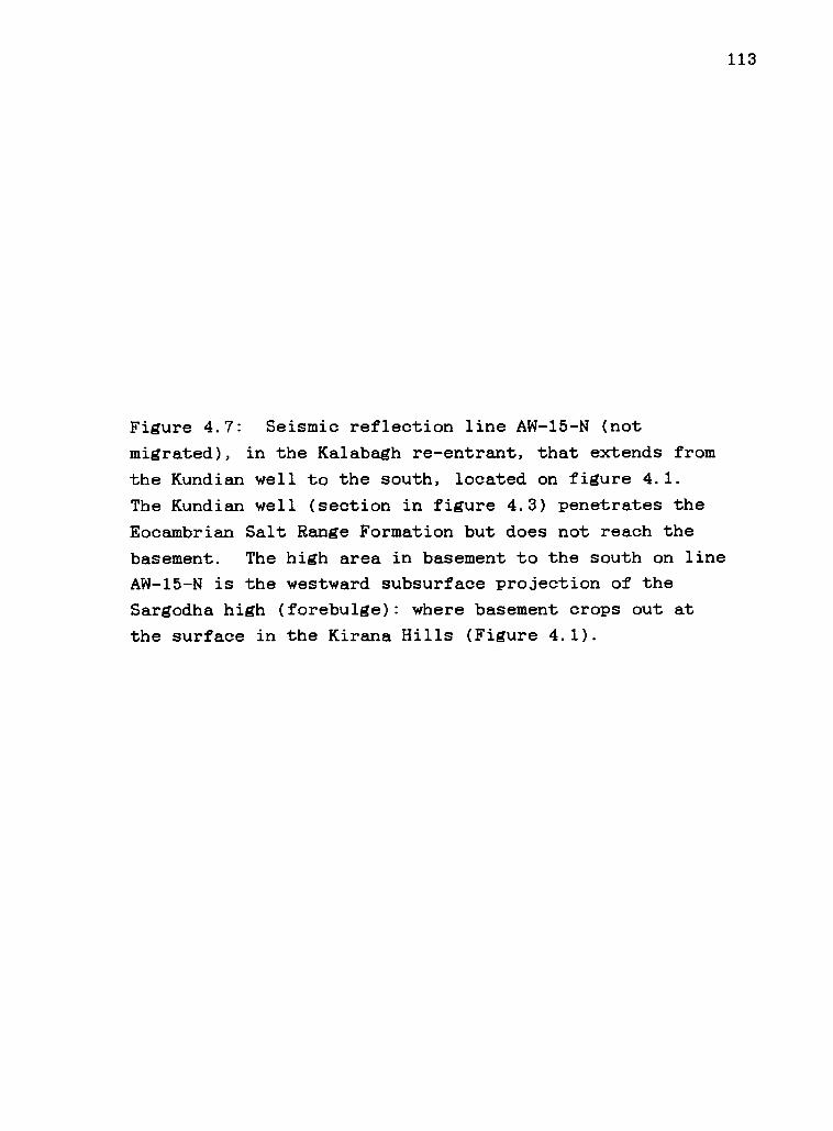
113
Figure 4.7: Seismic reflection line AW-15-N (not
migrated), in the Kalabagh re-entrant, that extends from
the Kundian well to the south, located on figure 4.1.
The Kundian well (section in figure 4.3) penetrates the
Eocambrian Salt Range Formation but does not reach the
basement. The high area in basement to the south on line
AW-15-N is the westward subsurface projection of the
Sargodha high (forebulge): where basement crops out at
the surface in the Kirana Hills (Figure 4.1).

°Cn
2O0
00c\J
TW
O-W
AY
TIM
E (S
EC
)
00
114
it4f 0Ali
I+ 41
t.:_,_4 .10.?,..sw,v.tA
tv"... 3StW
il<P
A.'11)41
1
-4,
liglk
CaN
ialliqP404
'
ItanantigIT
Al
...t.r
IPtittiA
\rifr1,:ttai',1
;Vet
4'itilift1tiles
'll4'
i?444 9 i,( 4'
fri.IP
1 i
t11;111.111R
: ;ig3,I,,
iOrs
Silitttillii1 ttlifier4a*P
elA rIt'14(6141.51i4411",4.4.:
\'N
\IRW
1 lc?' 4Pwainno
oe,
l'141PV
YiV
/NN
Its? VS
viii`
",'
1.t) Wffiegetirck\
sTiliA
.44114 V ei
titR
OV
INtilltttts?,4 ; A
'
)1
it IIIFFP0'etefirglin", icitu,ifiii,
k v.ft /44 O
M )9i b) ..;:c
t t i1CA
t
1.196airtillt\\ ItrenVV
41111 401till R
i ITO
IIP
AR
AIN
IIC,W
1,1)/WilitkclO
ic;ij
V 41411fs i
IIIM LA
I AP
Pii02444),A
math
'',041.,illiIii A ill, 0111,40".30,P,M
. Ai/
1
;eit,
r1' 1t'Ihi
Ws
1§V1411;1) #1
0m
itt itT, 0 e,
A
1 1111 W 11111r4F4
1111111311111111 Irti1411\Sf ii\
WIllt 11
11
)ft. O
YZ
:it,4t$*.c }1.
siat
AtV
IIIR11 41 kt V
iltiet ftSt01114.44:4,
IWIlatditt iPaiiiiil1 lW
AR
yilitON
(MR
P4ti
=Z
ing 40111b011:44,44ttikt:ly
laiN4PM
,11 EIMM
NItM
tYiSff SR
VIV
Tat
014ae.C1 g 141)/ r1W
et4
mit
.:(.0 tti
AN
04 ratPlis.ci
ni44
,; ,.w 4
..Y`).
101/44.41.) ir
:'1oN
s, A.i P.
160.iIY
il Yfr' kI'
s)
Ifilvritm
r04.'
0Ai A
I 0 fUs 1;4(
,,Z
11;d4itakatitsi;:/4
.
"4/1014QP
IMA
Y4
cwt;
WatIkvittbka? 0 O
a;.11
io imitioi
ibe 6',1
:Sif1'114110
4?.4). "N
),Cii?.1):41Z
1
VA
VrItiq
lbappiNh
arilvc,,,,A
tho(itvw
tikty)w
ag,
T4V
allA
nrat, le'll(M
O L
qtitlipqra i .,r.
wct
.amilik w
ii wi.r,r.,1,01$4,
,,,,,,,.0.,,..
Apas,p,p,i 0.40(vi,...
ttg,,,,Irk
teolifilrfill* IftEP
cf4.0); h,
f fr.A".L
.1,figi r i iiit I fragnt4
tilW
illfriqPIT"I4A
1-
.,, 1,
,if
,11
4 frifie 4,1d 14,11W.,041i
Wed! tiR
MIN
( t)0104041NP8A
VIN
N
0w
in+w
Figure 4.7

115
Figure 4.8: Balanced cross sections of Himalayan fold-
and-thrust belt south of the Main Boundary thrust in
northwestern Pakistan, located on figures 4.1 and 4.2.
Cross section A-A' extends from the MBT, near Kohat city,
to the eastern Surghar Range, near Kalabagh. Section B-
B' crosses the Panoba dome north of Khushalgar. Section
C-C' crosses the MBT and the Mazari Tang window and
extends B-B' to the north, with a 4 km offset. B-B' and
C-C' incorporate geological mapping of Ahmad Hussein and
A-A' incorporates geological mapping of Meissner and
others (1974), E.R. Gee (unpublished data), and McDougall
(1988).

ANORTH .c
Alla" APF2L1111.1Mg"..41F,49112155111,741InzigamosogrAlat
KOHAT PLATEAU
SURGHARRANGE
liqI\ //`1...---441211iImanrowAANIN.drAloniaiIIIIMeseinisammwordliamaesmatim
A' Km
SOUTH_
7177x x x x x x x x xxx x x xxx xxx xxxxx X xxxxxXxxxxx x xx x x X xx xxxxxx xxx xxxxxxxxxxxxxxxxxxxxxxxxxxxxxxxxXxxxxxxxxxxxxxxxxx xxxxxxxxx
PRECAMBRIAN BASEMENT
/11111PV''XXXXXXXXXXXXXXXXXXXX
X
70 65 60
BASEMENT
CNORTH
MAZARI TANGWINDOW
55FIGURE 4
C' B
50 45 40
B'SOUTH
Km
0
1
2
3
4
5
6
7
8
xxxxxxxxxxxxxxxxxxxx 9
PANOBA DOME
Ie
LOWER TERTIARY
MESOZOIC
LOWER TERTIARY
MESOZOIC
PALEOZOIC
40gtONERNOMM
FIGURE 5 10
35 25 20 5
Figure 4.8
0 Km
2
I
0I
-2-3
4
5
-67
8
9
-10
116

117
Figure 4.9: Palinspastic restoration of the decollement
thrust propagation sequence in western Himalayan fold-
and-thrust belt along the line of cross section A-A'
(Figure 4.8). The asterisk indicates a supplemental pin
line to conserve space.
(A) Thrust sheet "M" developed in front of the Main
Boundary thrust and driven under elastic wedge.
(B) Development of fault-bend folds ("N","0") beneath and
in front of the thrust sheet "M" during southward advance
of thrusting and continued motion on "M".
(C) Backlimb thrusting, increasing the thickness of the
wedge and decoupling at "Q" and along the flat hinge of
"N".
(D) Annihilation of the flat hinge of the fault-bend fold
by thrust propagation downsection beneath the southern
Kohat Plateau "P" with development of a small backthrust.
(E) Frontal ramp development by -50 km horizontal toe
addition to the future Surghar Range. Footwall horses
(Boyer and Elliott, 1982) in the Salt Range Formation
develop above the normal fault in basement.
(F) Fault-bend folding at "S" and inception of backlimb
thrusting "T" to begin general uplift of southern Kohat
Plateau.
(G) Modern configuration, showing development of thrust
faults "S" and "T" that reach the surface in the northern
Kalabagh fault zone "U".

Figure 4.9 PALINSPASTIC RESTORATIONKOHAT PLATEAU SURGHAR RANGE
Vs ro A4r0857AI AM, AI dr 4WZ .07
G
F
E
C
B
NORTH
X X
X X X X X X X X X X X X X X X X X X X X X X X X,/
.gtft2tftwo:w
ZI.Z/ZII 40! #71)/M
SOUTH
f
X X X X X X X X X X X X X X XX X X X X XX X X X
0
-ooeost
Agf I I Irz
x x
PINLINE
,r/ /4/NzX X X X XXX X XX X X XXX X X XX X X X X X X XX X X
.4*MEMSOP'
X X
XX x x x x x x x x x X X X X X X XX X X X X
-40,41agtaysgilM...7.14,:avA446,
-0244X5X
X K XX X
X X X XX X X x X X x X X XX X X X
ZZ.Z.Z.e7 27.ZZCZx x x x x x x x x x\x
ZzZCZCZ.Z7X X X XX X XXX
118

119
Figure 4.10: Taper of Kohat wedge of cross section A-A'
(Figure 4.8) compared with cross sectional taper of the
Potwar Plateau wedge (Jaume and Lillie, 1988) and average
critical taper of the wedge of decollement thrusts in
western Taiwan (Davis and others, 1983). Angle alpha
refers to topographic slope and angle beta refers to
decollement dip.

KOHAT WEDGE0.1°
.16,1.8°
TAPER 2°
X X BASEMENT X X X X X
0 10KM
X
POTWAR PLATEAU WEDGE (JAUME- and LILLIE, 1988)
04-0° (W. POTWAR) TO 0.2° (E. POTWAR)
Yek o (Irr(E. POTWAR)
19-4° (W. POTWAR)
TAIWAN (DAVIS and OTHERS, 1983)
TAPER0.8° (E.)
Figure 4.10
TAPER,N,80_ 9.50
120

121
Figure 4.11: Wedging beneath Siwalik molasse during
emplacement of blind thrust sheets produces passive roof
backthrusts. Erosion of roof thrusts accompanies
progressive emplacement of simple step fault-bend fold
(above). Hypothetical configuration of eroded roof
backthrusts (below) is shown for the Kohat Plateau during
stage B (Figure 4.9).

122
WEDGING BY PASSIVE ROOF BACKTHRUSTS
KOHAT PLATEAU: STAGE ®
Figure 4.11

123
References:
Baker, D.M., 1987, Balanced structural cross-sections ofthe central Salt Range and Potwar Plateau ofPakistan: Shortening and overthrust deformation:Oregon State Univ., Corvallis, M.S. thesis, 120 p.
Baker, D.M., Lillie, R.J., Yeats, R.S., Johnson, G.D.,Yousuf, M., and Zamin, A.S.H., 1988, Development ofthe Himalayan frontal thrust zone: Salt Range,Pakistan: Geology, v.16, p. 3-7.
Banks, C.J., and Warburton, J., 1986, 'Passive-roof'duplex geometry in the frontal structures of theKirthar and Sulaiman mountain belts, Pakistan: Jour.Struct. Geol., v. 8, p. 229-237.
Boyer, S.E., and Elliott, D., 1982, Thrust systems:American Assoc. Petrol. Geol. Bull., v. 66, p. 1196-1230.
Burbank, D.W., and Raynolds, R.G.H., 1987, Stratigraphickeys to the timing of deformation: an example fromthe northwestern Himalayan foredeep, in Paola, C.,and Kleinspehn, K., eds., New perspectives in basinanalysis: Minneapolis, Univ. of Minnesota Press.
Dahlstrom, C.D.A., 1969, Balanced cross sections:Canadian Jour. Earth Sci., v. 6, p. 743-757.
Davis, D.M., and Engelder, T., 1985, The role of salt infold-and-thrust belts: Tectonophysics, v. 119, p.67-88.
Davis, D.M., Suppe, J., and Dahlen, F.A., 1983, Mechanicsof fold-and-thrust belts and accretionary wedges:Jour. Geophys. Res., v.88, p. 1153-1172.
Duroy, Y., 1987, Subsurface densities and lithosphericflexure of the Himalayan foreland in Pakistan,interpreted from gravity data: Oregon StateUniversity, Corvallis, M.S. thesis, 76 p.
Duroy, Y., Farah, A., and Lillie, R.J., 1988, in press,Reinterpretation of the gravity field in theHimalayan foreland of Pakistan, in L.L. Malinconicoand R.J. Lillie, eds., Tectonics of the westernHimalaya, G.S.A. Special paper 232.
Farah, A., Mirza, M.A., Ahmad, M.A., and Butt, M.H.,1977, Gravity field of the buried shield in thePunjab plain, Pakistan: Geol. Soc. America Bull.,v.88, p. 1147-1155.

124
Gee, E.R., 1980, Pakistan geological Salt Range series,1:50,000, 6 sheets: Directorate of Overseas Surveys,United Kingdom, for the Government of Pakistan andthe Geological Survey of Pakistan.
Gwinn, V.E., 1970, Kinematic patterns and estimates oflateral shortening, Valley and Ridge and GreatValley provinces, central Appalachians, south-central Pennsylvania: Studies in AppalachianGeology: Central and Southern, Fisher, G.W., andothers, eds., Interscience, New York, p. 127-146.
Jaume, S.C., and Lillie, R.J., 1988, Mechanics of theSalt Range-Potwar Plateau, Pakistan: a fold-and-thrust belt underlain by evaporites: Tectonics, v.7, p. 57-71.
Leathers, M., 1987, Balanced structural cross section ofthe Salt Range and western Potwar Plateau, Pakistan:Deformation near the strike-slip terminus of anoverthrust sheet: Oregon State Univ., Corvallis,M.S. thesis, 228 p.
Lillie, R.J., Johnson, G.D., Yousuf, M., Zamin, A.S.H.,and Yeats, R.S., 1987, Structural development withinthe Himalayan foreland fold-and-thrust belt ofPakistan, in Beaumont, C. and Tankard, A.J., eds.,Sedimentary Basins and Basin-forming Mechanisms:Canad. Soc. Petrol. Geol. Memoir 12, p. 379-392.
Lyon-Caen, H., and Molnar, P., 1983, Constraints on thestructure of the Himalaya from an analysis ofgravity anomalies and a flexural model of thelithosphere: Jour. Geophys. Res., v. 88, p. 8171-8191.
Lyon-Caen, H., and Molnar, P., 1985, Gravity anomalies,flexure of the Indian plate, and the structure,support and evolution of the Himalaya and GangaBasin: Tectonics, v. 4, p. 513-538.
McDougall, J.W., 1988, Geological and geophysicalinterpretation of the foreland fold-thrust belt ofnorthwestern Pakistan: Oregon State Univ.,Corvallis, Ph.D. thesis.
McDougall, J.W., and Khan, S.H., 1988, in review, Strike-slip faulting in a foreland fold-thrust belt: theKalabagh fault and western Salt Range, Pakistan:Tectonics.
Meissner, C.R., Master, J.M., Rashid, M.A., and Hussain,M., 1974, Stratigraphy of the Kohat Quadrangle,Pakistan: U.S. Geol. Surv. Prof. paper 716-D.

125
Minster, J.B., and Jordan, T.H., 1978, Present day platemotions: Jour. Geophys. Res., v. 83, P. 5331-5354.
Morley, C.K., 1986, A classification ofAmerican Assoc. Petrol. Geol. Bull.25
thrust fronts:, v. 70, p. 12-
Ramsay, J.G. and Huber, M.I., 1987, The Techniques ofModern Structural Geology: London, Academic Press,700 p.
Rich, J.L., 1934, Mechanics of low angle overthrustfaulting as illustrated by Cumberland thrust block,Virginia, Kentucky, and Tennessee: American Assoc.Petrol. Geol. Bull., v. 18, p. 1584-1596.
Roeder, D., 1988, Andean-age structure of easternCordillera (province of La Paz, Boliva): Tectonics,v. 7, p. 23-39.
Seeber, L., and J.G. Armbruster, 1979, Seismicity of theHazara arc in northern Pakistan: Decollement vs.basement faulting, in A. Farah and K. DeJong, eds.,Geodynamics of Pakistan, Geol. Surv. Pakistan, p.131-142.
Seeber, L., Armbruster, J.G., and R.C. Quittmeyer, 1981,Seismicity and continental subduction in theHimalayan arc, in H.K. Gupta and F.M. Delany, eds,Zagros, Hindu Kush, Himalaya Geodynamic Evolution,American Geophys. Union Geodynamics series, v. 3, p.215-242.
Suppe, J., 1983, Geometry and kinematics of fault-bendfolding: American Jour. Sci., v. 283, p. 684-721.
Suppe, J., 1985, Principles of Structural Geology:Englewood Cliffs, New Jersey, Prentice-Hall, 537 p.
Wiltschko, D., and Eastman, D., 1983, Role of basementwarps and faults in localizing thrust ramps: Geol.Soc. America Memoir 158, p. 177-190.
Woodward, N.B., Boyer, S.E., and Suppe, J., 1985, AnOutline of balanced cross sections: Univ. ofTennessee, Studies in Geology 11, Geol. Soc. Americashort course notes.
Yeats, R.S., 1986, Active faults related to folding, inR.E. Wallace, ed, Active tectonics: Wash. D.C.,National Acad. Press, p. 63-79.

126
Yeats, R.S., and Hussein, A., 1987, Timing of structuralevents in the Himalayan foothills of northwesternPakistan: Geol. Soc. America Bull., v. 99, p. 161-176.
Yeats, R.S., and Lawrence, R.D., 1984, Tectonics of theHimalayan thrust belt in northern Pakistan, in B.U.Haq and J.D. Milliman, eds., Marine geology andoceanography of the Arabian Sea and coastalPakistan: New York, Van Nostrand Reinhold, p. 177-198.

127
COMPREHENSIVE BIBLIOGRAPHY
Anderson, R.V.V., 1927. Tertiary stratigraphy and orogenyof the northern Punjab. Geol. Soc. America Bull.,38:665-720.
Baker, D.M., 1987, Balanced structural cross section ofthe central Salt Range and Potwar Plateau of /Pakistan: Shortening and overthrust deformation:(M.S. thesis), Corvallis, Oregon, Oregon State Univ.
Baker, D.M., Lillie, R.J.,Yousuf, M., and Zamin,the Himalayan frontalPakistan: Geology, v.
Yeats, R.S., Johnson, G.D.,A.S.H., 1988, Development of
thrust zone: Salt Range,16, P. 3-7.
Banks, C.J., and Warburton, J., 1986, 'Passive-roof'duplex geometry in the frontal structures of theKirthar and Sulaiman mountain belts, Pakistan: Jour.Struct. Geol., v. 8, p. 229-237.
Bossart, P., Dietrich, D., Greco, A., Ottiger, R., andRamsay, J.G., 1988, The tectonic structure of theHazara-Kashmir syntaxis, southern Himalayas,Pakistan: Tectonics, v.7, p. 273-297.
Boyer, S.E., and Elliott, D., 1982, Thrust systems:American Assoc. Petrol. Geol. Bull., v. 66, p. 1196-1230.
Burbank, D.W., and Raynolds, R.G.H., 1987, Stratigraphickeys to the timing of deformation: an example fromthe northwestern Himalayan foredeep, in Paola, C.,and Kleinspehn, K., eds., New Perspectives in Basinanalysis: Minneapolis, Univ. of Minnesota Press.
De Jong, K.A., 1986, Plate T-46: Kohat, in Short, N.M.,and Blair, R.W., eds., Geomorphology from Space:Washington D.C., N.A.S.A., p. 134-135.
Dahlstrom, C.D.A., 1969, Balanced cross sections:Canadian Jour. Earth Sci., v. 6, p. 743-757.
Davis, D.M., and Engelder, T., 1985, The role of salt infold-and-thrust belts: Tectonophysics, v. 119, P.67-88.
Davis, D.M., Suppe, J., and Dahlen, F.A., 1983, Mechanicsof fold-and-thrust belts and accretionary wedges:Jour. Geophys. Res., v.88, p. 1153-1172.

128
Duroy, Y., 1986, Subsurface densities andflexure of the Himalayan foreland ininterpreted from gravity data: (M.S.Corvallis, Oregon, Oregon State Univ.
lithosphericPakistanthesis),, 74 p.
Duroy, Y., Farah, A., and Lillie, R.J., 1988, in review,Reinterpretation of the gravity field in theHimalayan foreland of Pakistan, in L.L. Malinconicoand R.J. Lillie, eds., Tectonics and Geophysics ofthe western Himalaya, G.S.A. Special paper.
Farah, A., Mirza, M.A., Ahmad, M.A., and Butt, M.H.,1977, Gravity field of the buried shield in thePunjab plain, Pakistan: Geol. Soc. America Bull., v.88, p. 1147-1155.
Gee, E.R., 1945, The age of the saline series of thePunjab and of Kohat: India National Acad. Sci.Proc., Sec. B, v. 14, p. 269-310.
Gee, E.R., 1947, Further note on the age of the salineseries of the Punjab and of Kohat: India NationalAcad. Sci. Proc., Sec. B, v. 16, p. 95-153.
Gee, E.R., 1980, Pakistan geological Salt Range series,1:50,000, 6 sheets: Directorate of Overseas Surveys,United Kingdom, for the Government of Pakistan andthe Geological Survey of Pakistan.
Gill, W.D., 1953, The stratigraphy of the Siwalik seriesin the northern Potwar, Punjab, Pakistan: Quart.Jour. Geol. Soc. London, v. 107, p. 375-394.
Griffiths, D.H., and King, R.F., 1981, Applied geophysicsfor geologists and engineers: New York, Pergamon,ch. 7.
Gwinn, V.E., 1970, Kinematic patterns and estimates oflateral shortening, Valley and Ridge and GreatValley provinces, central Appalachians, south-central Pennsylvania: Studies in AppalachianGeology: Central and Southern, in Fisher, G.W., andothers, eds., Interscience, New York, p. 127-146.
Harding, T.P., and Lowell, J.D., 1979, Structural styles,their plate tectonic habitats, and hydrocarbon trapsin petroleum provinces: American Assoc. PetroleumGeol. Bull., v. 63, p. 1016-1058.
Harland, W.B., 1971, Tectonic transpression in CaledonianSpitsbergen: Geol. Mag., v. 108, p. 27-42.

129
Harris, L.D., 1970, Details of thin-skinned tectonics inparts of Valley and Ridge and Cumberland Plateauprovinces of the southern Appalachians, in Fisher,G.W., Pettijohn, F.J., Reed, J.C., and Weaver, K.N.,eds., Studies of Appalachian geology: central andsouthern: New York, Interscience, p. 161-173.
Harris, L.D., and Milici, R.C., 1977, Characteristics ofthin-skinned style of deformation in the southernAppalachians and potential hydrocarbon traps: U.S.Geol. Surv. Prof. paper 1018, 40 p.
Hussein, S.T., Munthe, J., Shah, S.M.I., West, R.M., andLukacs, J.R., 1979, Neogene stratigraphy and fossilvertebrates of the Daud Khel area, Mianwalidistrict, Pakistan: Geol. Surv. Pakistan Memoirs, v.13, 36 p.
Jaume, S.C., and Lillie, R.J., 1988, Mechanics of theSalt Range-Potwar Plateau, Pakistan: a fold-and-thrust belt underlain by evaporites: Tectonics, v.7, p. 57-71.
Johnson, N.M., Opdyke, N.D., Johnson, G.D., Lindsay,E.H., and Tahirkheli, R.A.K., 1982, Magneticpolarity stratigraphy and ages of Siwalik Grouprocks of th Potwar Plateau, Pakistan: Paleogeogr.,Paleoclimat., Paleoecology, v. 37, p. 17-42.
Johnson, G.D., Reynolds, R.G.H., and Burbank, D.W., 1985,Deformation in the Himalayan foredeep margin,Pakistan: the timing and duration of a thrustramping event: Foreland Basins Conference, Fribourg,Switzerland, Sept. 2-4, 1985.
Johnson, G.D., Raynolds, R.G.H., and Burbank, D.W., 1986,Late Cenozoic tectonics and sedimentation in thenorthwestern Himalayan foredeep: Thrust ramping andassociated deformation in the Potwar region, inAllen, P.A., and Homewood, P, eds., Foreland Basins:Intl. Assoc. Sedim. Spec. Public. 8, p. 273-291.
Johnson, N.M., Stix, J., Tauxe, L., Cervany, P.F., andTahirkheli, R.A.K., 1985, Paleomagnetic chronology,fluvial processes, and tectonic implications ofSiwalik deposits near Chinji Village, Pakistan,Jour. of Geology, v. 93, p. 27-40.
Kazmi, A.H., 1979, Active fault systems in Pakistan, inFarah, A., and DeJong, K.A., eds., Geodynamics ofPakistan: Geol. Surv. Pakistan, p.

130
Kazmi, A.H., and Rana, R.A., 1982, Tectonic map ofPakistan, 1:2,000,000, Govt. of Pakistan and theGeological Survey of Pakistan.
Khan, M.J., 1983, Magnetostratigraphy of Neogene andQuaternary Siwalik Group sediments of the Trans-Indus Salt Range, northwestern Pakistan: (Ph.D.thesis): New York, Columbia Univ., 217 p.
Leathers, M. R., 1987, Balanced structural cross sectionof the western Salt Range and Potwar Plateau,Pakistan: deformation near the strike-slip terminusof an overthrust sheet: (M.S. thesis): Corvallis,Oregon, Oregon State Univ., 271 p.
Lillie, R.J., Johnson, G.D., Yousuf, M., Zamin, A.S.H.,and Yeats, R.S., 1987, Structural development withinthe Himalayan foreland fold-and-thrust belt ofPakistan, in Beaumont, C., and Tankard, A.J., eds.,Sedimentary Basins and Basin-forming Mechanisms:Canad. Soc. Petrol. Geol. Memoir 12, p. 379-392.
Lyon-Caen, H., and Molnar, P., 1983, Constraints on thestructure of the Himalaya from an analysis ofgravity anomalies and a flexural model of thelithosphere: Jour. Geophys. Res., v. 88, p. 8171-8191.
Lyon-Caen, H., and Molnar, P., 1985, Gravity anomalies,flexure of the Indian plate, and the structure,support and evolution of the Himalaya and GangaBasin: Tectonics, v. 4, p. 513-538.
McDougall, J.W., 1987. Tectonic map and interpretation ofthe Kalabagh tear fault, Himalayan foreland fold-thrust belt, western Salt Range area, Pakistan.Geol. Soc. America Abst. with Programs, 19:765.
McDougall, J.W., 1988, in review, Tectonically-induceddiversion of the Indus River west of the Salt Range,Pakistan: Palaeogeog., Palaeoclimat., Palaeoecology.
McDougall, J.W., and Khan, S.H., 1988, in review, Strike-slip faulting in a foreland fold-thrust belt: theKalabagh fault and western Salt Range, Pakistan:Tectonics.
Meissner, C.R., Master, J.M., Rashid, M.A., and Hussain,M., 1974, Stratigraphy of the Kohat Quadrangle,Pakistan: U.S. Geol. Surv. Prof. paper 716-D.

131
Menke, W.H., and Jacob, K.H., 1976, Seismicity patternsin Pakistan and northwestern India associated withcontinental collision: Seismol. Soc. America Bull.,v. 66, p. 1695-1711.
Minster, J.B., and Jordan, T.H., 1978, Present day platemotions: Jour. Geophys. Res., v. 83, P. 5331-5354.
Mitchum, R.M., Vail, P.R., and Thompson, S., 1977,Seismic stratigraphy and global changes in sealevel, Part 2: The depositional sequence as a basicunit for stratigraphic analysis, in Payton, C.E.,ed., Seismic Stratigraphy-applications tohydrocarbon exploration: American Assoc. Petrol.Geol. Memoir 26, p. 53-62.
Molnar, P., 1984, Structure and tectonics of theHimalaya: constraints and implications ofgeophysical data: Ann. Rev. Earth Planet Sci., v.12, p. 489-518.
Molnar, P., Burchfiel, B.C., K'uangyi, L., and Ziyun, Z.,1987, Geomorphic evidence for active faulting in theAltyn Tagh and northern Tibet and qualitiveestimates of its contribution to the convergence ofIndia and Eurasia: Geology, v. 15, p. 249-253.
Morley, C.K., 1986, A classification of thrust fronts:American Assoc. Petrol. Geol. Bull., v. 70, p. 12-25.
Pilbeam, D., Barry, J., Meyer, G.Pickford, M.H.L., Bishop, W.Jacobs, L.L., 1979, GeologyNeogene strata of Pakistan:689.
E., Shah, S.M.I.,W., Thomas, H., andand palaeontology ofNature, v. 270, p. 684-
Pilgrim, G.E., 1913, The correlation of the Siwaliks withmammal horizons of Europe: Rec. Geol. Surv. India,v.43, p. 264-326.
Quittmeyer, R. C, Farah, A., and Jacob, K.H., 1979, Theseismicity of Pakistan and its relation to surfacefaults, in Farah, A., and DeJong, K.A., eds,Geodynamics of Pakistan, Geol. Surv. Pakistan, p.271-284.
Ramsay, J.G. and Huber, M.I., 1987, The Techniques ofModern Structural Geology: London, Academic Press,700 p.

132
Raynolds, R.G.H., and Johnson, G.D., 1985, Rates ofNeogene depositional and deformational processes,northwest Himalayan foredeep margin, Pakistan, inSnelling, N.J., ed., Geochronology and thegeological record, Geol. Soc. London Memoir 10, p.291-311.
Rich, J.L., 1934, Mechanics of low angle overthrustfaulting as illustrated by Cumberland thrust block,Virginia, Kentucky, and Tennessee: American Assoc.Petrol. Geol. Bull., v. 18, p. 1584-1596.
Roeder, D., 1988, Andean-age structure of easternCordillera (province of La Paz, Boliva): Tectonics,v. 7, p. 23-39.
Rutten, M.G., 1969, The Geology of Western Europe:Amsterdam, Elsevier, 520 p.
Seeber, L., and Armbruster, J.G., 1979, Seismicity of theHazara arc in northern Pakistan: Decollement vs.basement faulting, in Farah, A., and DeJong, K.A.,eds., Geodynamics of Pakistan, Geol. Surv. ofPakistan, p. 131-142.
Seeber, L., Armbruster, J.G., and Quittmeyer, R.C., 1981,Seismicity and continental subduction in theHimalayan arc, in Gupta, H.K., and Delany, F.M.,eds., Zagros-Hindu Kush-Himalaya geodynamicevolution: Am. Geophys. Union Geodynamics series,v.3, p. 215-242.
Shah, S.M.I., ed., 1977, Stratigraphy of Pakistan:Pakistan Geol. Surv. Memoir, v. 12, 138 p.
Slemmons, D.B., and DePolo, C.M., 1986, Evaluation ofactive faulting and associated hazards; in Wallace,R.E., ed., Active Tectonics: Washington D.C.,National Acad. Press, p. 45-62.
Suppe, J., 1983, Geometry and kinematics of fault-bendfolding: American Jour. Sci., v. 283, p. 684-721.
Suppe, J., 1985, Principles of Structural Geology:Englewood Cliffs, New Jersey, Prentice-Hall, 537 p.
Talwani, M., Worzel, J.L., and Landisman, M., 1959, Rapidgravity computations for two-dimensional bodies withapplication to the Mendocino submarine fracturezone: Jour. Geophys. Res., v. 64, p. 49-59.
Tchalenko, J.S., 1970, Similarities between shear zonesof different magnitudes: Geol. Soc. America Bull.,v. 81, p. 1625-1640.

133
Trumpy, R., 1980, An Outline of the Geology ofSwitzerland: New York, Wepf and Co., Publishers, 104P
Wiltschko, D.V., and Eastman, D.B., 1983, Role ofbasement warps and faults in localizing thrust faultramps, in Hatcher, R.D., Williams, H., and Zeitz,I., eds, Contributions to the tectonics andgeophysics of mountain chains: Geol. Soc. AmericaMemoir 158, p. 177-190.
Woodward, N.B., Boyer, S.E., and Suppe, J., 1985, Anoutline of balanced cross sections: Univ. ofTennessee, Studies in Geology 11, Geol. Soc. Americashort course notes.
Yeats, R.S., 1986, Active faults related to folding, inR.E. Wallace, ed, Active tectonics: Wash. D.C.,National Acad. Press, p. 63-79.
Yeats, R.S., Khan, S.H., and Akhtar, M., 1984, LateQuaternary deformation of the Salt Range ofPakistan: Geol. Soc. America Bull., v. 95, p. 958-966.
Yeats, R.S., and Hussein, A., 1987, Timing of structuralevents in the Himalayan foothills of northwesternPakistan: Geol. Soc. America Bull., v. 99, p. 161-176.
Yeats, R.S., and Lawrence, R.D., 1984, Tectonics of theHimalayan thrust belt in northern Pakistan, in B.U.Hag and J.D. Milliman, eds., Marine geology andoceanography of the Arabian Sea and coastalPakistan: New York, Van Nostrand Reinhold, p. 177-198.

APPENDICES

134
APPENDIX 1: TECTONIC MAP AND DESCRIPTION OF THE NORTHERN
KALABAGH FAULT ZONE AND VICINITY, NORTHERN PAKISTAN
James W. McDougall, E. Rowland Gee
Introduction
The tectonic map of the northern Kalabagh fault zone
is the result of a field study and data compilation that
includes nearly all of the Survey of Pakistan 15 minute
quadrangle map 38/0/12 and adjacent areas to the south
and west. The map overlaps and is a northern extension
of the Salt Range map series of Gee (1980). Unpublished
field data of Gee were also used extensively in
geological mapping by McDougall in 1982-85. More field
data are expected to be acquired within the area of the
map and an enlarged area to be studied with future work.
Rock units are grouped according to tectonic
importance, both structurally and stratigraphically.
Divisions are based on interpretation of significant
tectonic events or periods between events. Resolution of
tectonic units is better in the more recent part of the
geological record.
The area covered by the 1:50,000 scale map is
important to work by McDougall on the Kalabagh fault
system. Although the density of observations has been

135
collectively quite good, the map is a regional tectonic
map. Some units of Gee (1980) were retained, including
the Kalabagh Conglomerate.
Descriiption of tectonic units.
Qal: QUATERNARY ALLUVIUM
These surficial deposits include modern alluvial
fans and Indus River floodplain deposits. Deposits
within this group also include lake bed deposits (Nammal
Lake, Khairabad sag feature in Kalabagh strike-slip fault
zone). Sedimentary rocks in this group from neighboring
regions include those sediments (e.g., Potwar silt) that
were ponded in intermontane basins such as the Soan River
depression, Campbellpore basin, and Peshawar basin.
An age assignment of 0.5 Ma and younger for these
deposits does not restrict some of them from being older
Quaternary. Deposits from the underlying Siwalik
sequence were given a magnetostratigraphic age as young
as 0.5 Ma age by Khan (1983) in a stratigraphic section
immediately west of the map.
Most of the sediment being deposited as Quaternary
alluvium bypasses the western Salt Range and aggrades on
the Indus River floodplain. These deposits reflect the
modern tectonic regime.

136
Qkc: KALABAGH CONGLOMERATE
The Kalabagh Conglomerate of Gee (1945, 1947, 1980)
is a fanglomerate deposit associated with emergent thrust
faulting (Morley, 1986) in areas that probably include
the Surghar Range, Kalabagh hill, and the western Salt
Range. This unit was deposited prior to right-lateral
offset along the main Kalabagh fault, but not before
significant offset along the right-lateral Surghar fault
(McDougall, 1988). The locally-derived Kalabagh
Conglomerate is composed of dominantly Tertiary limestone
clasts, with subordinate ferruginous sandstone clasts of
the Siwalik Group.
The Kalabagh Conglomerate overlies tilted lower and
middle Siwalik strata (Chinji and Nagri formations) with
an unconformable relationship at Kalabagh hill that is
probably toplap (terminology of Mitchum and others,
1977). The age relationship between the Kalabagh
Conglomerate and the Siwalik strata given a 0.5 Ma age by
Khan (1983) is uncertain. The Kalabagh conglomerate is
younger than incipient propagation of the thrust front of
the Himalaya to the Surghar Range, that occurred at
approximately 2 Ma. This corresponded with the closely-
timed emergence of the Salt Range frontal thrust at 1.9-
2.1 Ma, based on a similar age of erosional truncation of
the Soan syncline (Raynolds and Johnson, 1985).
Local folding and thrust faulting produced uplift of
source areas for the Kalabagh Conglomerate. Peak

137
deposition of fanglomerate probably corresponded with
peak emergence of these source areas (that may include
the Kala Chitta Range to the north). Rates of
accumulation and associated uplift may have decreased to
the present day.
Tee: INDUS RIVER CHANNEL CONGLOMERATE
Channel conglomerates of the paleo-Indus River were
deposited before local tectonic tilting and channel
migration associated with Kalabagh faulting. These
deposits contain distantly-derived clasts (80%
metamorphic and igneous rock clasts and 20% sedimentary
rock clasts, dominantly limestone), that are similar to
deposits of the modern Indus River.
These deposits are dominantly Quaternary in age,
occurring in the uppermost Siwalik section and are also
recycled in terrace and fluvial deposits. The age of
transition from net accumulation to net erosion of Indus
River channel conglomerates in the map area is not
determined.
Ts: SIWALIK AND RAWALPINDI GROUPS
Tertiary Siwalik and Rawalpindi group rocks are
fluviatile molasse deposits derived from the main
Himalayan mountain range. Deposition in the modern Kohat
and Potwar Plateau areas of the foredeep included the
area south of the modern frontal thrust on the Indus

138
River floodplain. Ts deposits are post-collisional and
in general onlap a basal unconformity that is younger
southward and westward in the area of the tectonic map.
While the Murree Formation is a transitional marine
deposit in the Hazara-Kashmir syntaxis, with a Paleocene
age (Bossart and others, 1988), Ts strata in the map area
are continental deposits. 7-10 km northwest of Chichali
Pass (33°N, 71.25°E), the top of a paleomagnetic section
by Khan (1983) is younger than the Bruhnes-Matuyama
polarity reversal, indicating overlying Siwaliks as young
as 0.5 Ma. The maximum age of Ts in the map area is
probably comparable to an 18-20 Ma magnetostratigraphic
age at the base of the Kamlial member of the Rawalpindi
Group, from the Chinji village area in the south-central
Potwar Plateau (Johnson and others, 1985).
Tem: LOWER TERTIARY STRATA
Early Tertiary marine shelf and basin deposits
include the Chharat Group (Nammal, Sakesar, Kohat, Mami
Khel, Shekkan, and Jatta Formations) and Makarwal Group
(Patala, Lockhart, and Hangu Formations). This
stratigraphic succession ranges from a 38-40 Ma age at
the top to a major unconformity at the base of the
Tertiary. Limestone strata dominate the lower Tertiary
section in the area of the tectonic map.

139
Mz-Pz: MESOZOIC AND PALEOZOIC STRATA
Mesozoic and Paleozoic sedimentary rocks were
largely marine deposits on the pre-collisional stable
shelf of the N-facing Indian plate margin. Older stratain this stratigraphic succession pre-date the breakup ofthe Gondwana supercontinent. Included in this tectonicunit are Permian glacial deposits of the Tobra Formation.
Mesozoic rocks pinch out to the east against the
overlying angular unconformity at the base of the
Tertiary (see, 1980)
SRF: SALT RANGE FORMATION
Eocambrian evaporite deposits of the Salt Range
Formation may have been deposited in a euxinic basin
associated with rifting. Cambrian deposits that crop outto the west of the tectonic map area pinch out to the
west along a major unconformity above the middle
Cambrian.

KALABAGH FAULT
W + E0
.5 MA
1.6-2.1 MA
11.8 MA
38-40 MA
66.4 MA
260 MA
280 MA
PC
Coal
sunGHAFt tK4,41
M P
kalfAsTOBRA
KEY
15 MA
160 MA
(L. PERM)
S N
(M.-L. MIOC)
M.-U. EOC)