geological survey - usgs survey bulletin no. 184. pl. i map showing oil and gas localities julius...
TRANSCRIPT
DE-PAKTMEHT OF THE TUTBEIOli
OF THK
UNITED STATES
GEOLOGICAL SURVEY
. 184
SERIES A, ECONOMIC CEOLOOY, 13
WASHINGTONOOVKllNMENT PRINTING OFFICE
1901


UNITED STATES GEOLOGICAL SURVEYCHARLES D. WALCOTT, DIRECTOR
OIL AND GAS FIELDS
OF THE
BIAS COALAND OF THE
UPPER CRETACEOUS AND TERTIARY OF THE ' WESTERN GULF COAST
BY
G-EORG-E I. ADAMS
WASHINGTONGOVERNMENT PRINTING OFFICE
1901


OIL AND GAS FIELDS OF THE WESTERN INTERIOR AND NORTHERN TEXAS COAL MEASURES
GEORGE I. ADAMS

CONTENTS.
Page.Introduction. .... _.____.._......_..._._... ._......_... .._-._..___...__._ 11
Location of the Coal Measure areas ..._..-._._..._._. ............ 11Character of the sediments ........... ............................ 11General structure ...... ...........-..---.-.-...--...-........_... 12Origin of the oil and gas....... .-.....-.--..-.--. .................. 12Discovery of the field.. . ;.'___._._. ......'.......... ................ 12Present productive area ........... ................................ 12
Geology of the Kansas-Indian Territory field........ ..................... 18Lower Carboniferous ................................................. 13
Mississippian limestone................... ........................ 13Upper Carboniferous _.---..............--.---..--..........-.-.-.... 14
Cherokee shales or lower formations .............................. 14Fort Scott limestone.......--....--.-..........- ...._.............. 15Higher formations................-.-..-._......-.................. 15
Structure of the oil and gas field.......... ._..... .............. .......'. 16Oswego-Independence section .................. ............... .... 16Fort Scott-Iola section........................................ ...'., 17Chelsea-Bartlesville section..................----..._-..,---.- ... 17Deformation of the field ..... .................. ,-...... .......... 18
Conditions of the occurrence of oil and gas............................. 19Development in the Kansas-Indian Territory field .... .... ................ 20
Paola.. ........ ........ .. ..... ........... .................... 21Louisburg, Lacygne, and Mound City.........--.-.._......-...... 21Osawatomie .. ......._.....--.-......_...---_.........._....--._... 21Fort Scott................... ..........-..-.-.....--.-._'.-...-..... 21Wyandotte, Rosedale, and Kansas City...._-....._..-..-.--........ 21Greeley ............. .......................................... ... 22Western border of Missouri..........--.....-......-.---..-....... 22Tola and La Harpe........-........--........-..-..-...-.-.--..-.. 22Chanute......................'..-.....--.-'-... ....................... 23Independence...............-.....----..--.. ...................... 24Peru ..................................................... ....... 24Cherry vale .-.---.. .-...- --.----....---.--......-.--.-....-.-.--. 24Coffeyville ..................^............ _................... ... 24Humboldt.................. ...................................... 24Benedict ......................................................... 25Neodesha field and refinery............................... .......... 25.Thayer........................................................... 25Guilford ............................. ...............:........... 25Larimer......-.....--....--,....-.-...-.-..........-..--..-.-...-. 25Buffalo........... ................................................. 25Chetopa...... ........... .......--...--.-..----..-.-.-...----.... 25
7

8 CONTENTS.
Development in the Kansas-Indian Territory field Continued. Page.Erie...........---....-..--....... ................;............... 26Mound Valley .......... ........ .............I..--.....--........-. 26Neosho Falls ...................................................... 26Chelsea, Indian Territory..................................-........ 26Bartlesville, Indian Territory .........__. j..-_._..---.......-.-.---.. 26Red Fork, Indian Territory..... ..... ............................. 26
Value of the oil and gas produced in the Kansas-Indian Territory field ..... 26Oil and gas in central Indian Territory and western Arkansas....--..-.... 28Oil and gas in the northern Texas Coal Measure area ............_.._..... 28
ILLUSTRATIONS.
Page. PLATE I. Map showing oil and gas localities of the Western Interior and
northern Texas Coal Measures and area of special map ......... 11It. Geological map of the special area of the gas and oil fields of the
Western Interior Coal Measures, with sections through Fort Scott and lola (A A), Oswego and Independence (B B), and Chelsea and Bartlesville (C C) . ...................... 16
FIG. 1. Vertical column of the Kansas Coal Measures...................... 16


U. S . GEOLOGICAL SURVEY BULLETIN No. 184. PL. I
JULIUS BIEN 6 CO. LITH. N.I
MAP SHOWING OIL AND GAS LOCALITIESOF THE
WESTERN INTERIOR AND NORTHERN TEXAS GOAL MEASURES AND AREA OF SPECIAL MAP
BY GEORGE I, ADAMS.
1OO 5O
Scale 100 3OO MI LE S

OIL AND GAS FIELDS OF THE WESTERN INTERIOR AND NORTHERN TEXAS COAL
By GEORGE I. ADAMS.
INTRODUCTION.
Location of the Coal Measure areas. The rocks of Coal Measure age which constitute the coal fields of the United States lying between the Mississippi River and the Rocky Mountains outcrop in two areas. The larger is known as the Western Interior coal field. It extends from southern Iowa through northwestern Missouri, the southeastern portion of Nebraska, and the eastern part of Kansas into eastern Oklahoma, Indian Territory, and the western part of Arkansas. It is bordered on the south by the Arbuckle and Ouachita mountains. To the south of the Arbuckle Mountains, in Indian Territory, and extend ing into Texas beyond the Colorado River, is the smaller area, known as the Northern Texas coal field. The southern border of this field is the mountainous region of central Texas.
Character of the sediments. The rocks of Coal Measure age are a portion of a vast sheet of sediments deposited during Upper Carbon iferous time, and were laid down as sands and muds in seas of Avide extent. The vertical section of the formations in Kansas measures approximately 2,500 feet (see fig. 1, on p. 16). At the base of these rocks there are 450 feet of shales and sandstones, while above this por tion interstratified limestones are a conspicuous element. The Coal Measure rocks in Missouri and Iowa are similar in character to those of Kansas. In Indian Territory and Arkansas the section aggregates more than 12,000 feet and is composed almost wholly of sandstones and shales. This section includes at the base a great thickness of sediments, probably aggregating 9,000 feet, which are not represented farther north. In the Texas area the basal portion of the section is likewise composed largely of sandstones and shales, while in the upper part limestones are prominent. The character of the sediments and the structure and geologic history of the region as a whole indicate that
11

12 OIL AND GAS FIELDS OF WESTERN INTERIOR, ETC. [BULL. 184.
during the time of deposition land areas were adjacent to the deposits in Indian Territory and Arkansas and that from them the great mass of material which constitutes the sandstone and shale formations was derived. More open-sea conditions seem to have prevailed in the remoter portion of the Coal Measure sea, especially in the later part of the period, arid consequently the sediments were frequently of calcareous character and- formed limestones.
General structure. The eastern limit of the present exposure of the Coal Measure rocks in the Western Interior field is the contact of the base of the series with older rocks. Along their western border they pass under younger sediments. In the southeastern part of the Indian Territory and in Arkansas the rocks have a folded structure, but in the remaining portions of the field they have a relatively slight west erly inclination and regular dips. The rocks in the Texas coal field dip to the west. On their western border they are concealed by the Permian formation and on the eastern border by the Cretaceous. SOrigin of the oil and gas. The shales of the Coal Measures are very bituminous and give evidence of the presence of organic matter in great abundance at the time of their deposition. The burying of this material and its subsequent decomposition under cover of the overlying sediments and the continental seas is regarded as having given rise to the oil and gas. The reservoirs in which these products were received were the sandstones and more porous beds. Where these formations outcrop at the surface they not infrequently give off an odor which suggests oil; and gas springs and seeps, as well as maltha, were noted by the earlier explorers and were considered indications of valuable deposits of petroleum. These occurrences represent surface leakages. The valuable supply consists of such bodies as exist in the permanent reservoirs which are deeply buried by superincumbent beds.
Discovery of the field. With the beginning of the settlement of the Country some prospecting was done, and predictions were made that oil would be found in this field. In 1860 a company was organized which did some drilling in the hope of finding petroleum; and an active interest was taken in the survey of Miami County by the first geolog ical survey of Kansas because of the tar springs which occur there. With the sinking of deep wells for water and the occasional drilling of prospect holes for coal other indications appeared. Borings which penetrated the formations where they are under sufficient cover and have a structure which retains the oil and gas have revealed the present productive fields. Many of the earlier indications of gas were for a long time neglected because those who drilled the wells were looking for coal and did not care to prospect for oil and gas. An instance of this is the Acres well at lola, drilled in 1873, which furnished water for a mineral-water resort and gave off sufficient gas to burn with a constant flame. Later prospecting in this vicinity resulted in the discovery of the lola gas field.

ADAMS.] MISSISSIPPIAN LIMESTONE. 13
Present productive area. About 1890 outside capital came into the field, interest in the oil and gas resources became very active, and many commercial enterprises developed. At present the productive territory is being constantly extended, as there is a demand for the gas as fuel, and the oil is proving to be a profitable resource. The principal productive field of the Western Interior area is in south eastern Kansas and the northern part of Indian Territory, although both gas and oil in limited quantities have been found as far north as Kansas City and along the western border of Missouri. The Coal Measure rocks of Iowa have thus far not proved productive. The small flows of gas which have been encountered in that State are from the glacial deposits and are of sporadic occurrence. The exploita tion of the field has been attended with considerable uncertainty and pecuniary risk. Considering the number of wells and the limited areas which have been developed in the various localities, the per centage of producing wells is encouraging. The northern Texas area can not be considered as having been exploited very largely, and it may not prove to contain large deposits, although the number of wells which shoAV gas and oil are sufficient to warrant further prospecting.
GEOLOGY OF THE KANSAS-INDIAN TERRITORY FIELD
LOWEK CARBONIFEROUS.
In that portion of the Coal Measures of southern Kansas and northern Indian Territory which at present constitutes a productive oil and gas field the rocks have a very simple structure. The accom panying geological map, together with the sections, will help to explain the relations of the various formations. 1
Mississippian limestone. The floor upon which the Coal Measures rest is the Mississippian limestone. This formation outcrops in the Ozark region, and a small area is found in southeastern Kansas and in Indian Territory. The outcrop lies principally to the east of Spring River and Grand River, although it extends for a short distance to the west of these streams. The rocks dip toward the west, or away from the Ozark region, and in the Prairie Plains region are concealed by the overlap of the Coal Measures. The unvarying character of the forma tion and its generally uniform structure beneath the overlying shales and sandstones make it a valuable datum in prospecting. It consists of white limestone interbedded with flint, and in the vicinity of Joplin and northwestern Arkansas, where the section has been studied, has a thickness of from 325 to 400 feet. In all the wells in the oil arid gas
1 The stratigraphy of the Kansas Coal Measures is described in the report of the University Geological Survey of Kansas, particularly in Vol-. Ill, by Haworth. The writer was engaged during two summers in the field work which was done in southeastern Kansas, and has drawn freely upon the published descriptions, many of which were based 011 his own observations. In preparing this report the field was revisited and additional stratigraphic. work was done, espe cially in Indian Territory.

14 OIL AND GAS FIELDS OF WESTERN INTERIOR, ETC. [BUM,. 184.
field which have been drilled deep enough the formation has been encountered. It is known to the drillers as the "flint rock," and experience has taught that it is useless to penetrate it for oil and gas.
The inclination of this rock floor varies with the direction from its outcrop. From the southwest corner of Kansas northward the dip is a little less than 15 feet to the mile; to the northwest it is^approx- imately 17 feet to the mile, while to the west it is a little over 20 feet to the mile. The records of the wells in Indian Territory are insuffi cient to show the structure of the Mississippian, since but few of them have been drilled deep enough to reach it, but the overlying Coal Measure formations show considerable increase in thickness and it is probable that the dip is much more rapid.
UPPER CARBONIFEROUS.
Cherokee shales or loiver formations. The basal beds of the Coal Measures in southeastern Kansas consist of 450 feet of shales with interstratified sandstones. They have been described as the Chero kee shales. They overlie the Mississippian, and the beveled edges of the formation outcrop in a belt approximately 20 miles wide, extend ing northeastward into Missouri. Above these shales there is a lime stone formation, which has been traced from Fort Scott northeastward into Missouri and southwestward to Catoosa, Ind. T. In Indian Ter ritory, beyond Catoosa, the limestone becomes less important, and the horizon is marked by a conspicuous sandstone, which was followed to a point between Wewoka and Holdenville. This enables a cor relation to be made with the section of the Coal Measure rocks in the central portion of Indian Territory, where the formations occur ring below this horizon are approximately 9,000 feet in thickness. Considered in connection with the fact that the Cherokee shales are only 450 feet in thickness, this would indicate either a great thicken ing of the shales toward the south or that the contact of the Coal Measures with the Mississippian is one of overlap. Observations made in the field, although insufficient for a decision, are favorable to the latter opinion. The name Cherokee shales, which has been used by the University Geological Survey of Kansas in the discussion of the geology of the Coal Measures, is in this article applied only to the exposures in the southeastern part of Kansas, and not to the very much thicker section of rocks in Indian Territory which are included between the Mississippian and the Fort Scott limestones.
Some gas has been found in the higher formations, but the most important oil- and gas-producing horizons of the Kansas-Indian Ter ritory field are in the shales and sandstones below the Fort Scott lime stone. A continuation of the formations to the west under cover of the higher rocks has been studied by means of the numerous well records and found to be quite uniform in character and thickness. With increasing distance from the outcrop and increasing depth

ADAMS.] FORT SCOTT LIMESTONE. 15
there is greater probability of more complete retention of the gas, and when present it is found to have a higher static pressure.
Fort Scott limestone. 1 This is the first important limestone forma tion in the section of the Coal Measures in southern Kansas. It occurs at the top of the Cherokee shales, and its outcrop has been shown on the map with symbols indicating the direction of the dip. The trend of the formation has already been described in a general way. At Fort Scott, the locality where it was originally described by- Swallow, it' consists of a lower member, which is only a few feet thick and is quarried for the purpose of making hydraulic cement; then a stratum of bituminous shale from 4 to 12 feet thick, and, at the top, a limestone 10 to 25 feet thick. The formation is remarkably reg ular in character, and its outcrop can be followed easily in the field. A few feet below the lower limestone there is a bed of coal, which is obtained at many places near Fort Scott and for some distance south ward by quarrying the rock from above it. The line of outcrop of the formation passes east of Girard to Oswego and enters Indian Ter ritory just west of Chetopa. Thence it was followed by the writer from Kinnison and Eagle to a point just west of Chelsea. It occurs in a prominent escarpment, and from the Indian Territory line south ward coal is stripped at short intervals, and the quarrying of the limestone for this purpose renders the horizon conspicuous in the field. From Chelsea the outcrop is parallel with the railroad to Claremore and Catoosa, and is plainly visible in a low escarpment. Through this interval the limestones are less important. A sandstone, which is interbedded between the two limestones, gradually develops, and the loAver limestone is seldom seen. At Catoosa the upper limestone is conspicuous and can be traced to the Arkansas River west of Weer post-office. The associated sandstone, which has been mentioned above, together with some limestone beds, continues in a southwest erly direction and passes between Holdenville and Wewoka to the Canadian River, beyond which point its course changes to the west as a result of the structure of the Arbuckle Mountain region.
Higher formations. The formations above the Fort Scott lime stone are shales and sandstones with interstratified limestones. The limestone formations are the more easily followed in the field; their lines of outcrop in southern Kansas have been mapped, and some of
1 The name Fort Scott limestone was applied by Swallow (Prel. Eept. Geol. Surv. Kansas, 1866) to a heavy bed of limestone at Fort Scott, Kans. Subsequently the name Oswego limestones was used by Haworth and Kirk (Kansas Univ. Quart., Vol. II, p. 105) for two beds exposed at Oswego, the upper of which is the same as the Fort Scott. In subsequent publications the statement is made that the name Fort Scott is equally applicable. The lower member is called the Fort Scott cement rock and the upper the Fort Scott limestone, and for the two the name Oswego is used. (Haworth, Vol. Ill, p. 30.)
Oswego had already been used by Prosser (Bull. Geol. Soc. America, Vol. IV, pp. 100,108,116) as the name of a formation in the Silurian of New York, and is therefore preoccupied. Inas much as the name Fort Scott has been extended to the lower of the two members and was pro posed by Swallow for the upper and more important one, it is here accepted as a formation name for these closely associated limestones.

16 OIL AND a AS FIELDS OF WESTERN INTERIOR, ETC. [BULL. 184.
them have been traced into Indian Territory. They serve as con venient .data in determining the horizons at which wells start and in studying the logs obtained by the drillers. The limestones are relatively thin, varying from a few feet up to 30 or 40 feet in thick ness. The intervening shales and sandstones are not uniform in
character in their lateral extent, usually be coming more arenaceous southward. Some of them are as much as 200 feet in thick ness. In passing from central Kansas into Indian Territory the outcrops of the lime stones diverge and the escarpments in which they are the essential element are rendered less conspicuous because of the sandstones which take the place of the shales.
The section of these rocks in the northern part of Indian Territory is considerably thicker. This is more particularly true of the formations lying on the western border of the present productive oil and gas field.
The general section for southern Kansas is displayed in fig. 1. and the horizons of some of the principal gas localities are
m
Higher formations.
Horizon of Tola and Laharpe.
Horizon of Independ ence and Neodesha.
Horizon of Cherry vale 'and Coffeyville.
noted in the margin.
STRUCTURE OF THE OIL AND GAS FIELD.
JFoirt Scott limestone.
The structure may be best explained by horizontal sections which show the under ground relations of the formations, as deter mined from careful study of the records of many wells. Three sections accompany the map of the field. The northern one extends from Fort Scott westward through lola. Its direction is east and west. The second ex tends through Oswego and Independence and bears slightly north of west. The third, for which the data are incomplete, extends through Chelsea and Bartlesville. The direction of this section is north of west.
Oswego-Independence section. The horizontal "oion which passes through Oswego and Independence (B B, PL II) will be described first, since it represents more fully than do the other two the condi tions under which oil and gas are found.
At the eastern end of the section the Mississippian limestone out-
Cherokee shales.
Mississippian lime stone.
FIG. 1. Vertical column of the Kansas Coal Measures.

U.S. GEOLOGICAL SURVEY BULLETIN No. 184 PL. II
GEOLOGICAL
MAP AND SECTIONSOF THE
__ ^_\_ /S SPECIAL AREA OF THK GAS AND OIL FIELDS
OF THK I
WESTERN INTERIOR COAL MINSURESBY GKORGE L ADAMS
Scale
JJPPER CARBONIFEROUS
i Hi^hCoal Measure formations
lorokee slialos.and low
I.()\VK C C.ARBONIFEROUS
Mississippian limestone
JULIUS BIEN 8 CO. I.ITH N.V,

ADAMS.] STEUCTUEE OF OIL AND GAS FIELD. 17
crops. This is the floor upon which the Coal Measures were deposited. Its continuation under ground is represented in accordance with the data obtained from the deep wells which have reached it. Above it lie the Cherokee shales, which outcrop at the surface for a distance of 20 miles.^ Their vertical thickness is about 450 feet. The dip of this forniation carries it under ground to the westward, and wells have passed through it in many places. The Avell at Oswego started a short distance above it; that at Cherry vale, which is situated much farther west, penetrated a considerable thickness of superincumbent beds before reaching it. Intervening wells show it to have about the same thickness, and it may be relied upon as a definite forniation, limited upward by the Fort Scott limestone. This formation, which consists of two beds of limestone closely associated, has a regular dip west- ward from Oswego, and is reported by the drillers as being quite uniform in character. In some of the wells in the vicinity of Inde pendence there are three beds instead of two. In prospecting, oil and gas are usually not expected until this rock lias been passed through. The higher beds of the Coal Measures are indicated in the
. se'ction. They consist of a number of limestones interbedded with sandstones and shales, and the section of them which must be passed through in drilling is greater toward the western part of the field. An attempt has been made to correlate these limestones from the records obtained by drilling. They are quite uniform in their thickness and extent, but are not important horizons for oil and gas, although some has been found in them. The outcrops of the individual beds may be taken as data from which the depth to the oil and gas in the Cherokee shales may be computed.
Fort Scott-Iola section. At the eastern end of this section (A A, PI. II) the Fort Scott limestone is at the surface. A \vell drilled at this point shows the Cherokee shales, which lie below it, to have their usual thickness, and underneath them the Mississippian limestone was penetrated for a considerable depth. The outcrop of the shales and Mississippian limestone occurs in Missouri farther to the east.
Westward the wells at La Harpe and lola pass through the higher formations of the Coal Measures and reveal the Fort Scott limestone, the Cherokee shales, and the Mississippian limestone in the same rela- tive positions as at Fort Scott. To the west 'of lola the wells which, have been drilled have not reached the Mississippian, but no doubt it continues in that direction with the same general dip.
Clielsea-Bartlesville section. Along the line of this section (C C, PI. II) the wells which have been drilled are relatively few, and the data are incomplete for showing the relations of the Mississippian limestone and the shales above it, since some of the records indicate that the wells did not reach sufficient depths to determine the positions of the formations. Along Grand River east of Adair the Mississippian outcrops at the surface. The wells at Chelsea encountered it at a
Bull. 184 01 2

18 OIL AND GAS FIELDS OF WESTERN INTEBIOR, ETC. [BUM* 184. f
depth of 950 feet. These wells started only a short distance above the > Fort Scott limestone, and the thickness of shales and sandstones below indicates a considerable increase in the amount of sediments, which are * the equivalent of the Cherokee shales in the southern part of Kansas. "^
A well drilled at Nowata, which lies adjacent to this section, passed through the Fort Scott limestone at a depth of 498 feet and continued ;n shales and sandstones to 800 feet, but did not reach the Mississip- pian limestone. :
The well at Bartlesville passed through the Fort Scott limestone at 950 feet and had encountered no flint at a depth of 1,345 feet, where drilling Avas stopped. What thickness of shales and sandstones may be expected below the Fort Scott limestone in Indian Territory is ; difficult to determine. From the section it will be seen that the dip is ;( much greater in this part of the field than farther north. The area of shales between the Fort Scott limestone and the Mississippian in > Kansas, when followed southward, does not change materially in : width, but the increased degree of dip permits the occurrence of the greater thickness of the beds which are their equivalent farther south.
The oil and gas which have been found in Indian Territory occupy '; about the same relative position with respect to the Fort Scott lime- . '" stone that they do in southern Kansas. With the further develop- , ment of the field the deeper borings will probably determine the posi- tion of the Mississippian limestone, since it no doubt continues under ground far to the west of the point at which it has been reached by the- present deep wells. The direction of the Chelsea-Bartlesville section / is nearly at right angles to the strike of the rocks and indicates a dip of about 40 feet to the mile, while the Oswego-Iudependence section : shows a dip of a little over 20 feet to the mile, and the Fort Scott-Iola "--. section has a somewhat smaller dip. '
Deformation of the field. By means of deformation contours the approximate depth at which the Fort Scott limestone lies has been > indicated on the map. Below this depth the Cherokeo shales in Kan sas and the equivalent productive formations in Indian Territory will be found. They have a thickness of 450 feet or more. The 500-foot I contour passes near Bronson, Erie, Mound Valley, and Nowata. To the east of it the depth to the shales gradually decreases until the '< outcrop of the formation is reached.
The 1,000-foot contour passes Yates Center, Elk City, and Bartles ville. It will be observed that the present productive field lies prin cipally between the 500-foot and 1,000-foot contours, and that the deformation contours converge in the southern part of the field. This ; convergence is due to the increased dip of the formations, which car- j ries them under ground much more rapidly. To the west of the 1,000- , foot contour but little prospecting has been done. The increased I depth at which the top of the Cherokee shales will be reached makes \ drilling more expensive, and the uncertainty of finding oil and gas has deterred the prospectors.
ADAMS.] MODE OF OCCUEEENCE OF OIL AND GAS. 19
The deposits of oil and gas which have been reached east of the 500- foot contour have been small, the pressure of the gas is not very great, and the supply is exhausted in a relatively short time.
CONDITION OP THE OCCURRENCE OF OIL AND GAS.
The oil and gas reservoirs are usually sandstones which vary in porosity and are often quite compact. They are interbedded with shales and represent deposits of sand which were laid down under the Carboniferous sea. The shales were deposited as beds of mud and fine silt. Considering the character of the formations, it can not be expected that they are continuous with any marked degree of uni formity over large areas; indeed, the prospecting which has been done indicates that the sands grade into shales or pinch out entirely within short distances of places where they are known to be importantreservoirs. The shales which are associated with, the sandstones serve to seal in the oil and gas. If the sandstones were continuous to a point where they would outcrop at the surface their contents would leak out. No doubt this has happened toward the eastern border of the field, where the Cherokee shales, which contain the principal productive horizons, appear at the surface. The wells which have been drilled adjacent to this belt of outcrop occasionally find smalL flews of gas, and this indicates that formerly there may have been larger quantities present. The. oil seeps and springs and the mineral tar or maltha represent surface exposures and leakages of the oil. If the gas-bearing sandstones in the Cherokee shales are lentils, as they appear to be, the productive localities will probably be found to be in limited areas and will not form a continuous field. The conditions which make the sandstones permanent reservoirs would largely preclude the possibility of the gas sand being a general horizon.
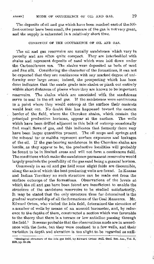
Commonly in an oil and gas field some slight folds are discernible, along the axis of which the best producing wells are found. In Kansas and Indian Territory no such structure can be made out from the surface outcrops of the formations. Observations of the levels at which the oil and gas have been found are insufficient to enable the structure of the sandstone reservoirs to be studied satisfactorily. It may be stated that the only structure thus far determined is the gradual westward dip of all the formations of the Coal Measures. Mr. EdAvard Orton, who visited the lola field, determined the elevation of a number of wells by means of an aneroid barometer, and, by refer ence to the depths of them, constructed a section which was favorable to the theory that there is a terrace or low anticline passing through the field. 1 It seems probable that the observations made are in accord ance with the facts, but they were confined to a few wells, and their variation in depth and elevation is too slight to be regarded as suffi-
1 Geological structure of the lola gas field, by Edward Orton: Bull. Geol. Soc. Am., Vol. X, 1899, pp. 99-106.
20 OIL AND GAS FIELDS OF WESTERN INTERIOR, ETC. [BULL. 184.
cient proof of the existence of a terrace, especially in view of the fact that the eastern limit of the field has not been determined by pros pecting. There are, no doubt, local variations in the dip of the oil and gas sands which are due to the unevenness of the sea bottom on which they were deposited, and this may account for the variation in depth to the sand which has been, observed in small areas of the field, but such structure has not been found to be continuous for any great distance or in any definite direction;
While the Cherokee shales have produced the principal commercial supply of oil and gas, a large number of wells have obtained flows from local beds of sandstone in the shales lying above the Fort Scott limestone. Such flows have supplied the gas at Rosedale, Wyandotte, and Osawatomie, and at a number of towns lying between Tola and Kansas City. Frequently no sandstones are found, and the gas appears to come from the shales. Such occurrences are referred to as shale gas, and the history of the field shows that in the course of a few years such a supply is exhausted. This may be due to the fact that the original quantity was never very large or to the fact that the gas is not found under conditions which are favorable to its flow.
Commonly throughout the field salt water is found to invade the wells when they begin to diminish in capacity, and sometimes on the borders of a productive area gas and salt water are both found in a well under such conditions that the supply of gas can not be utilized. The relation of the oil and gas has not been studied sufficiently to warrant a definite statement, but from the observations which have been made it would appear that where both are found in the same dis trict the oil commonly lies to the west of the gas or at a lower level and is in turn bordered by salt water in the lower portion of the sand. Not infrequently a well produces both oil and gas, and such a wellis probably situated near the line of contact of the two in the commonreservoir.
DEVELOPMENT IN THE KANSAS-INDIAN TERRITORY FIELD.
The oil and gas of the Kansas-Indian Territory field have been developed at a number of towns where conditions have been favoi-able for drilling and where local interests have promoted the exploitation. The principal supply is found within the area of the special map, although gas is utilized at many of the towns mentioned in the dis cussion of the history of the field and has been found at other places near them. The two products are frequently associated in the same well, but the gas is of much wider occurrence than the oil and has been more largely developed because of the demand for it as fuel. In the following discussion of the field the developments will be consid ered with respect to the more prominent towns near which the wells have been drilled. During the earlier period of exploitation the center of the field was regarded as being at Paola. This was due to the fact

ADAMS.] DEVELOPMENT. 21
that in Miami County a number of tar springs were found, which led to prospecting for oil and gas. The early history of the development of gas in Kansas has been reported upon by Robert Hay, in the Biennial Reports of the State Board of Agriculture for 1885-86 and 1891-92.
The Annual Bulletin of Mineral Resources of Kansas, by Haworth, published by the University Geological Survey of Kansas since 1897, contains much information and gives statistics showing the production from year to year. In the following summary it is intended to set forth the general character of the field, and the history of the devel opments at the various towns is not uniformly explicit.
Paola. As early as 1865 some drilling Avas done near Paola, Miami County, Kans., and two wells, situated 2 miles east of the town, showed some gas. In 1882, at a point 7 miles east of the town, three wells were drilled which gave a pressure of 66 pounds. The supply from these wells was utilized for fuel and light. The depth of the various wells was 288, 300, and 304 feet. A well 76 feet deep, which was situated 5 miles east of the town, also yielded a small flow of gas.
The wells above described diminished in flow so that in 1891 they could not be.used. About sixty additional borings which had been made up to that time developed six new wells which Avere used. The pressure of these Avells varied from 100 to 125 pounds. A well at the waterworks, which had a depth of 275 feet, showed a pressure of 145 pounds.
Louisburg, Lacygne, and Mound City. At Louisburg, near Paola, a gas well 325 feet deep furnishes a supply to a hotel. At Lacygne a small flow was encountered at 180 feet, and at Mound City at a depth of 125 feet.
Osawatomie. The first wells were drilled at this place in 1886 and gave indications of gas. In 1891 eight wells, having a pressure vary ing from 160 to 250 pounds, were utilized by the town. The greatest depth at which the gas was obtained was 685 feet, and this is the well which showed the highest pressure.
Fort Scott. Fort Scott was the second town to obtain a supply of gas sufficient for commercial use. In 1885 three wells had been drilled, which varied in depth from 175 to 195 feet, and the flow obtained from them was used for a few years, but by 1891 it had so diminished that it was not a profitable source of supply.
Wyandotte, Rosedale, and Kansas City. At Wyandotte, in the immediate vicinity of Kansas City, a prospect hole for coal struck a flow of gas at a depth of 400 feet which was utilized for a short time. In 1885 three wells had been drilled which supplied fuel for some small industries. At Rosedale four wells, varying in depth from 320 to 430 feet, struck a flow of gas in shale. In Kansas City a number of wells have been drilled at various times, which find a small amount of gas at a depth of 400 feet, sufficient to supply fuel and light for a few houses.
22 OIL AND GAS FIELDS OF WESTERN INTERIOR, ETC. [BULL. 184.
Greeley. During the last year gas has been struck at Greeley, and it is now supplied to the town.
Western border of Missouri. In Missouri, near the Kansas line, gas has been obtained at a number of places, but not in very large quan tity. One of these localities is Deerfield, in Vernon County, where it occurred in a shallow well. At present, in Bates County, near Merwin, Burdett, and Adrian, shallow wells are supplying a considerable amount of gas, which is being used in a small way. At Merwin a heavy oil is obtained, which is used for lubricating purposes.
lola and La Harpe. Gas was found in the Tola mineral well, so called, which was drilled on the Acres property as a prospect hole for coal in 1873. In ]S91 five wells were supplying gas to the town. Although considerable prospecting was done, no great quantity Avas obtained until 1893, when a strong flow was struck. The flow was unexpected and, being very strong, was not controlled for three months. From this time on the development of the field was very rapid, and it has been extended to the neighboring town of La Harpe. lola has become the center of large commercial interests, Avhich employ this economical and inexpensive fuel.
The Lanyon Zinc Company has smelters at lola containing 4,200 retorts, and at La Harpe containing 3,00.0 retorts. At the neighbor ing town of Gas, the Cherokee, Lanyon, and McRey smelters have each a capacity of 1,500 retorts. There are three brick plants which employ gas as fuel, and the plant of the lola Cement Company, with a capacity of 3,000 barrels a day, likewise uses a very large quan tity. In addition, smaller mills and foundries are supplied, and the town, is lighted and heated by gas.
The static pressure of the gas in 1896 was 325 pounds per square inch in certain of the strongest wells. Measurements made a year and a half later showed the pressure to be practically the same. At present, after the field has been used considerably, the pressure is somewhat reduced. Certain of the wells, which have been connected by pipe line, have a pressure of 300 pounds near La Harpe and 270 pounds at lola. The volume of the strongest wells of the field has been 7,000,000 cubic feet a day. The depth of the wells varies from 850 to 950 feet, those in. the western part of the field, although on lower ground, reaching a greater depth. The gas sands, which are reported by the drillers to occur in two beds separated by a few feet of shale and overlain by a hard cap rock, vary from a few feet to 25 feet in thickness. Occasionally a flow of gas is struck at a depth of 300 to 400 feet, although this is not generally utilized, inasmuch as it is not strong enough to furnish a commercial supply. As the wells passing through this sand are not cased, there is some doubt as to its ever proving a valuable source, and it maybe that, in some cases the gas is the result of leakage from greater depth.
In the western part of the field a few wells show oil in small quan tity. No attempt has been made to develop oil wells, and they have
ADAMS.] DEVELOPMENT. 23
never been used commercially. The oil is reported to be a black, heavy oil, of from 20° to 20^-° gravity Baunie. It has been obtained and used locally for lubricating purposes. Throughout the field occasional dry holes and salt-water holes have been reported. The sand does not appear to be very uniform in character, and it is possi ble that the dry wells are at places where the stratum is not suffi ciently pervious to allow gas to flow into them." On the other hand, drillers have reported that there are local variations in the structure of the field, and if so the nonproducing wells are possibly located along the axes of slight folds or structural basins. A careful log of the wells is not usually kept after the gas is reached, and the thick ness of the sand is often not learned by the drillers because it is not essential to penetrate it. The borders of the field have not been determined, and prospecting is constantly adding new territory. The indications are that to the west at increased depth some oil may be expected and salt water will be found to border the field. If the terrace structure, which has been .reported by Mr. Orton, is a correct interpretation of the reservoir in which the gas is confined, the east ward limit will probably be coincident with it. Sufficient develop ment has not been 'made in this part of the field to determine this point. Thus far wells ha>re been drilled to supply the various indus tries which have been located along the railway lines, and an abund ance of fuel has beeir obtained. With the increased demand further extension, of the field to the north and south will no doubt be made.
Chamde. During the early prospecting in the field some wells were drilled at Chanute and generally reported as dry holes, although they showed some indications of oil. Gas was piped to the city from Ben edict and used for lighting and heating and also by brick plants and small factories. The indications of oil in certain of the wells led Mr. I. N. Knapp to resume drilling, and about twenty-five wells have been sunk near the town. The purpose for which they were drilled was to obtain oil, arid they were successful in. a large number of cases. Fourteen are now operated by him as oil wells, and one shows some oil and a good flow of gas. In addition, a brick plant uses the gas, and the city gas company has .wells which supply the town with gas for fuel and lighting. The oil which was found varies in gravity from "29° to 30° Baume, and is of a dark-green color. In certain of the wells, it is of heavier gravity, being as low as 21°. The wells are all small producers, a 7-barrel well being ^a good average. The oil is. piimped into a 10,000-barrel tank, built near the railway, and is shipped to be utilized in the making of gas by the Omaha Gas Company. The static pressure of the gas at Chanute is reported to be from 250 to 350 pounds, and one of the strongest gas wells is said to have produced originally 4,000,000 cubic feet. The wells used by the city are very close together and have materially decreased in volume.

24 OIL AND GAS FIELDS OF WESTERN INTERIOR, ETC. ' [BUU,. 184.
Independence, At Independence there are fourteen producing gas wells, which supply the city with light and fuel, and are piped to a brick plant, two flouring mills, ice plant, waterworks, elevator, cracker factory, cotton-twine mill, and small machine shop. The static pres sure in these wells varies from 340 to 470 pounds, being somewhat greater in the wells in the western part of the field, which are deeper. The capacity has been estimated at 4,000,000 cubic feet. With use the wells have decreased slightly in flow. In the development of the gas wells oil was found in considerable quantity, and ten wells are reported as producing oil, although it is not used commercially.
Peru. The first prospecting done at Peru resulted in the discovery of oil, and subsequent drilling has resulted in the development of a small field which produces both oil and gas. The oil has a gravity of 33.9° 'Baume, and has an asphalt base and a black color. There are eight wells at present in the vicinity of the town, five of which pro duce oil, one oil and gas, and two gas only. The oil is shipped to the refinery at Neodesha, while the gas is utilized for fuel and light by the town. Between Peru and Sedan six wells were drilled, three of which yielded oil in small quantities, but as they were not considered large enough, the casing was withdrawn and the wells were abandoned.
Cherryvcde. In 1891 nine wells, which had depths of approximately 600 feet, were reported as having had pressures varying from 150 to 240 pounds. The one of greatest capacity supplied 4,750,000 cubic feet per day. There has been considerable development, and the supply is of commercial importance. The gas is utilized principally by the smelters of the Edgar Zinc Company, which has 3,000 retorts. Twenty-four wells have been drilled, twelve of which are connected and used as gas wells. One of the wells proved to be an oil well, sup plying about 3 barrels per day. This product is used as a lubricant.In addition, the Cherryvale Vitrified Brick Company has three gasAvells and one oil well. The town is likewise heated and lighted from gas wells controlled by the city gas company. The pressure in this district is reported to vary from 200 to 275 pounds, and the supply in some wells is 6,000,000 cubic feet a day.
Coffeyville. At Coffeyville there are about thirty gas wells. All of these are not utilized, however. About ten of them, which have high pressures, are connected with a pipe line. The pressure varies considerably with the depth of the well, and ranges from. 325 pounds east of the town to 475 pounds in a well 4 miles to the west, which has a depth of 930 feet. The supply is utilized for lighting and heating the city, and at a brick plant, three flouring mills, a paper mill, and a pottery kiln. Several of the wells drilled in this locality show oil, and four or five of them found it in considerable quantities, but it has never been made a commercial supply.
Humboldt. At Humboldt gas and oil have been found in a number of wells, although the field, has not yet been largely developed. The

ADAMS.] DEVELOPMENT. 25
gas is used for lighting and heating the town and by the brick plant and flouring mills.
Benedict. At Benedict a strong flow of gas was found when pros pecting was first carried on in the field. Three of the wells, which are reported to have had a flow of 6,000,000 cubic feet, were piped to Chanute and used until that city obtained producing wells. At present the pipe line is supplying a brick plant at Chanute at a greatly reduced pressure and volume.
Neodeslia field and refinery. Six miles east of Neodesha a group of seven wells has been developed, varying in production from 1,500,000 to 4,000,000 feet each, and with original static pressures of from 270 to 325 pounds. The gas from these is piped to Parsons, to supply the town with light and fuel, and is also utilized by several industries located there. At Neodeslia there are a number of wells producing gas. The pressure is from 325 to 340 pounds, and the supply is used by the town and for some small industries. In this field, however, oil is the more important product. There are forty-five producing wells 'in the vicinity of the town. The gravity of the oil varies from 32° to 34.5° Baume. The wells are all small producers, a 25-barrel well being exceptional; an 8-barrel well is considered good, and the average of the field would be considerably lower. There is a refinery in the town, and oil is piped from adjacent territory and is also shipped from the other oil districts. The refinery consists of two crude stills, one agitator, and one steam still. It began operations in .1.897. The tank age of the district is about 140,000 barrels, besides 38,000 barrels at the refinery. The oils which are distilled vary from 25° to 35° gravity, and produce approximately 40 per cent of light oils. This goes into the market of Kansas and adjacent States, while the heavier product is sold or utilized for fuel purposes.
Tliayer. At Thayer a small oil field .has been developed, having seventeen wells that are producing. They are connected with a pipe line which extends to the refinery at Neodesha. The gravity of the oil in this field is from 21° to 28° Baume.
Gkiilford. At the Guilford station, just north of Neodesha, oil has been found, the supply of which has been utilized at the Neodeslia refinery.
Larimer. Near Larimer, between Independence and Neodeslia, there are some oil wells of commercial importance, but the supply is not used at present.
Buffalo. At Buffalo twelve oil wells have been drilled arid are at present small producers.
Clietopa. The Chetopa Oil and Gas Company has attempted to dis cover sufficient gas to supply the town, although the wells are located on the eastern border of the producing area. Five wells were drilled, three of which furnish a small supply of gas. The original pressure in these was 147 pounds, the depth of the wells being 368 feet. The

26 OIL AND GAS FIELDS OF WESTERN INTERIOR, ETC. [BULL. 184.
now was never very great and has diminished considerably with use; at present the gas is nsed only for lighting purposes.
Erie. A number of wells have been drilled at Erie, and a supply of gas has been found sufficient for domestic use, but as yet the amount available does not appear to be very great.
Mound Valley. -A small flow was reported as having been discov ered at this town in the well drilled previous to 1885. It was utilized for a short time, but was soon drowned out by salt water.
Neosho Falls. Drilling has been successful in finding a small amount of oil and some gas near Neosho Falls. The oil is reported to be a black oil of about 20° Baume.
Chelsea, Ind. T. A few miles west of Chelsea a number of shallow wells have been drilled, from which a grade of oil was obtained suit able for lubricating purposes. It was found in sandstone from 100 to 300 feet below the surface. The supply has been marketed, occa sionally being shipped in barrels as a lubricating oil. At present the field is idle.
Bartlesville, Ind. T. At Bartlesville there are at present five wells which produce oil. They reach a depth of approximately 1,300 feet. The wells are located just over the Cherokee line in the edge of the Osage country. Tanks have been constructed and the supply is at present settled and shipped to the refinery at Neodesha, Ivans. Two of the wells drilled at this place have a strong flow of gas, which has been piped to the town this year and is used for domestic purposes. There is also a well drilled just north of town which is reported to have found oil, but it is shut in and is nonproductive.
Red Fork, Ind. T. A flow of gas and some oil were obtained in a well which was drilled while this report was in press.
VALUE OF THE OIL AND GAS PRODUCED IN THE KANSAS-INDIAN
TERRITORY FIELD.
The total production of oil in Kansas, so far as records have been obtained by the Division of Mining and Mineral Resources, is as follows:
Production of petroleum in Kansas from 1SS9 to 1900.
Year.
1889.....................................1890..-.-.......-.......-...-.---.. ......1891... ................................. .1S92.. ......-.-.......-..---.......--'....1893..---.-.-.......-.---. ............1894.....................................1895..................--.-.....-----.....
Amount.
Ban-els. 500
1,200 1,400
18,000. 40,000
44,430
Year.
1896.... .............................. -...1897.. ...... ............ .............. ...1898-...................................1899............. ........................1900................... ...__ ............
Total................. ............
Amount.
Barrels. 113,571 81,098 71,980 69, 700 74, 714
516,593

ADAMS.] VALUE OF OIL AND GAS PBODUCED. 27
The product is refined at Neodesha arid supplies the adjacent mar ket. The average price paid during 1899 was 75 cents per barrel for the crude oil.
During 1900 the oil produced in the Kansas field was obtained from 109 wells. Thirty-eight new producing wells were drilled that year and 14 old ones were abandoned. The location of the producing wells by counties is as follows: Chautauqua, 4; Montgomery, 1; Neosho, 26; Wilson, 78.
The oil produced by the four wells in the border of the Osage Nation, near Bartlesville, Ind. T., amounted to 8,074 barrels. This was sold to the refinery at Neodesha, Kans.
.During 1899 the amount of oil produced in the United States was about eight hundred times as great as that from the Kansas field. It will, be seen, therefore, that the field is not a very important one, but its situation is relatively advantageous. The value of the gas consumed in Kansas has been estimated by the Division of Mining and Mineral Resources to have been as follows:
Value of natural gas produced in Kansas from 1889 to 1900.
Year.
188!) ......................................18'JO ......................................1891 ........................ ..............1892...'...................................189;?......................................1894......................................
Value.
§15,873'12,000
5,50040, 79550,00086,600
Year.
1895......--...--..--..---.---..-.-......1896......;......-...-......-.............1897.............. ........................1898.. ..--......:..-................ ......1899.............. ........................1900.. .................... ..........'......
Value.
§112,400124,750105,700174, 640S52,592356, 900
The value of the natural gas consumed in the United States for 1899 was a little over seventy times that of the Kansas field.
The production for 1899, as stated in the above table, is the amount received for the gas, or the estimated value of what was
. consumed, and is relatively small compared with the value of the fuel displaced, which is estimated at $473,381. The gas during that year was used for 10,071 domestic fires, in'addition to furnishing light in fully as many homes. The largest commercial use was in smelt ing lead and zinc ores shipped in from the southwestern Missouri mining district. Next in importance were the plants which used it in the manufacture of building and paving brick and cement. In addition, it was utilized as fuel at foundries, machine shops, and power plants. The amount consumed by the industries is relatively great compared with what is supplied for domestic uses.
The history of the gas field everywhere teaches that the supply must eventually be exhausted. In view of these facts it seems appar ent that through false economy the people may be deprived of a natural resource which should be held as a luxury.

28 OIL AND GAS FIELDS OF WESTERN INTERIOR, ETC. [BULL. 184.
OIL AND GAS IN CENTRAL INDIAN TERRITORY AND WESTERNARKANSAS.
South of the line of outcrop of the Fort Scott limestone, which is shown on the general map of the Western Interior coal field (PL I), some prospecting has been done for oil and gas, but no commercial quantities have been found, except possibly at Muscogee, where a number of wells have been drilled which are reported to have struck oil. In one well, at a depth of 1,100 feet, oil was obtained which is reported to have a gravity of 38° Baume. In another well oil was found at a depth of 665 feet. These wells were pumped and yielded a con siderable quantity of oil, but are not producing at present. In the vicinity of Fort Smith several deep holes have been drjlledj and in two of them a small amount of gas was found, sufficient in one case to fire the boiler for drilling. Additional prospecting, which has not resulted favorably, has been carried on at various places, but usually the enterprises have not been very systematically conducted and have terminated with the drilling of one hole. The thickness of the sand stone and shale formations in this part of the field, as has already been stated in the discussion of the geology, will aggregate 9,000 feet down to the lowest coal. Of course, this entire section would prob ably not be encountered in drilling at any one locality. The structure of the field is similar to that of the Pennsylvania region. 1 Low anti clines and synclines traverse the eastern part of the field with a general east-west direction and die out in the Prairie Plains region along a line passing a short distance west of Muscogee, South Cana dian, and McAlester. In the Arkansas Valley region this structure should be taken into consideration in prospecting, because of the probable association of the oil and gas with the anticlines. While it is impossible to say what the future of this portion of the field will be, there is every reason to believe that conditions are favorable forthe development of oil and gas resources.
OIL AND GAS IN THE NORTHERN TEXAS COAL-MEASURE AREA.
The formations which occur in the northern Texas area consist of shales and sandstones, especially in the lower portion, and of lime stones alternating with shales in the upper portion. They exhibit the following general section:
At the base is the Millsap formation, consisting of shales and sand stones, its greatest thickness being 1,000 feet. The Strawn forma tion, which succeeds it, is very similar in character and has a thick ness of 300 to 900 feet. In the Canyon formation limestones are conspicuous, the strata aggregating 900 feet. Above this is the Cisco, which contains shales and sandstones and has a thickness of 800
1 See Geology of the Eastern Choctaw coal fields, Indian Territory, by Joseph A. Taff and George I. Adams: Twenty-first Ann. Rept. U. S. Geol. Survey, 1899-1900, Pt. II, p. 279.

ADAMS.] NORTHERN TEXAS OIL AND GAS. 29
feet. The highest formation is the Albany, with a maximum thick ness of 1,200 feet. It consists very largely of limestones.
The character of the sediments, especially in the Millsap, Strawn, and Cisco, is largely carbonaceous and the original organic matter may have given rise to oil and gas. The belts in which these beds out crop lie along the eastern border of the field and to the westward dip under the succeeding formations. On the map the outcrop of a coal bed Avhich occurs in the Cisco formation has been indicated with sym bols showing the direction of dip. It will be seen from the following data that the wells which have produced the small quantity of oil and gas thus far found are relatively shallow. 1 At Gordon the depth at which gas was found was 371 feet; another well near Gordon reached it at a depth of 360 feet. At Thurber drilling was carried to 480 feet; near Palo Pinto to 384 feet. The well at Trickham has a depth of 220 feet. The prospecting which was carried on at Brown- wood was successful in. finding oil at shallow depths. Further deep drilling, which probably passed entirely through the Coal Measures, did not obtain any large additional amount of gas or oil.
The position of these localities will be seen, by reference to the map, to be well toward the eastern border of the field, where the gas- and oil-bearing strata are not under very great coyer. If the condi tions here prove to be similar to those in the Kansas field, as has been outlined, the wells may perhaps be compared with those at localities toward the outcrop of the Fort Scott limestone, which have found only small flows of gas and limited quantities of oil. Pros pecting farther west, where the oil and gas horizons lie at greater depths, may result in the finding of gas at higher pressure and pos sibly in larger quantities. The same will probably be true of oil in case it exists in large quantities anywhere in the field.
1 S«o Second Aim. Kept. G-eol. Survey Texas, pp. 535-548; also iVourth Ann. Rept., p. 43C.


OIL AND GAS FIELDS OF THE UPPER CRETACEOUSAND TERTIARY FORMATIONS OF THE
WESTERN GULF COAST
GEORGE I. ADAMS
31


CONTENTS.
rage.
Introduction ............. ...... ......... ................................ 37Position of the fields .----..-...-..--......-. ..._........... 37
Geology of the fields............_......-....._-..--.....-....-.--.--........ 37Upper Cretaceous .._...__.._____.._.....--._._._.. -.. ............... 37
Woodbine formation....................................... 38Eagle Ford formation.................................... 38Austin chalk . _.............................-...-.-...... 38Taylor marls .................... ........................... 38Navarro marls .............................. ............. 38Section of Upper Cretaceous ....,.....---.-.--.--... ....... 39Outlying areas ........................................... 39Structure of the Upper Cretaceous .....-..-...-- ......... 40
Tertiary and Pleistocene ............................................... 41Eocene ........... . ....................... ..................... 42
Willspoint clays or Midway stage ......................._... 42Lignitic stage ......................._............ .... ...... 42Marine beds or Lower Clai borne stage......... ............ 42Yegua clays or Jackson stage ............................. 43Vicksburg stage ...... ............ ..'........-...-..-..-... 43Fayette sands............................................... 43Frio clays ......................... .................. ...... 43Section of the Texas Eocene..---.----.._-..-----.-----.--. 43
Neocene ........................................................... 44Grand Gulf formation................. .... L .... ....... . 44Lafayette gravels............. ..-......--..-...,---. ...... 44
Pleistocene.......... ... _................................-........ 44Louisiana Pleistocene.. ...... ...^................ ........... 44
Basal gravel.............. ...-..---......-..-............_- 44Port Hudson formation ............................... ... 44Loess and yellow loain................. .....-_.---.-...,- 45Alluvium and recent coastal formations................... 45
Undifferentiated area in Texas................ ...........---..._.-. 45Rockland to Sabine Pass.............. .................... 45Vicinity of Beaumont ....:.............................-... 46
Structure of the Tertiary and Pleistocene ........... ............. 47Oil and gas horizons ........... ........................................... 48
Cretaceous horizons .............................. .... . 48Tertiary horizons........ ................................. 48
Association of petroleum, sulphur, gypsum, and rock salt...._..-.--........ 49Development of the oil and gas fields....... ....---....--.........-.-...... 53
Nacogdoches field ............._..........-.-..-_.......-__. 53
Bull. 184 01 3 " 33

34 CONTENTS.
Development of the oil and gas fields Continued. Page.Corsicana field............... ..............,......._...... 54Elgin and Lockhart 4 ....... .-..-..-...-----..---.-.-...-.. 55San Antonio ....... ......................... .............. 56Sour Lake ................. ............^. ................ 56Beaumont___._._____..-.-..-. ....-.-..---....-....... .... 56Gas wells in Louisiana............ _-...--..---..........-. 59
Present prospecting in the Texas field..................... ................ 60Value of oil and gas production in Texas ................................... 61

ILLUSTRATIONS.
I'.lgO.
PI.A.TK III. Map showing location of oil and gas fields of Upper Cretaceous and Tertiary formations of Western Gulf coast and area embraced in geological map .............. ........ ...-..-- .. 37
IV. Geological map of Louisiana and eastern Texas......-...------ 38V. Map showing development of Corsicana field.................. 48
VI. View of oil wells in Corsicana and of the Corsicana refinery.... 52VII. Map of Beaumont and vicinity showing location of oil wells at
Spindle Top Heights......... ....-.....-..................'. 54VIII. Photograph of the Lucas gusher............................... 56
IX. Photograph of the Beatty gusher... .......................... 58X. Photograph of the Hey wood gusher... ........ ......._........ 60
Fio. 2. Section showing relation of Cretaceous and Tertiary formationsin Louisiana (by Hopkins).............. .;...................-... 40
3. Section from Corsicana to Beaumont, shoeing surface relation offormations.............. ..... ..... ....... .................... 47
4. Section showing occurrence of oil at Nacogdoches (by Walker).... 5435


U. S- GEOLOGICAL SURVEY BULLETIN No 184. PL. Ill
MAP SHOWING THE UPPER CRETACEOUS ANDTERTIARY OIL AND GAS FIELD OF THE WESTERN GULF COAST
AND AREA OF SPECIAL MAPBY GEORGE I.ADAMS
ScaleaOO ISO IQO 50 o __________________200M1LES
JULIUS Bl EN SCO. LITH N.Y.

OIL AND GAS FIELDS OF THE UPPER CRETACEOUS AND TERTIARY FORMATIONS OF THE WESTERN GULF COAST.
By GEORGE I. ADAMS.
INTRODUCTION.
Position of the fields. Extending from southern Arkansas near Arkadelphia through Texas and forming a belt in which lie. the cities of Sherman, Dallas, Austin, and San Antonio are the Upper Creta ceous rocks of the Western Gulf coast. The higher formations which constitute the southern border of this belt are oil and gas bearing in a number of places, and at Corsicaua, Tex., there is a productive oil field. Small quantities of oil have also been obtained in wells at Elgin and San Antonio. Coastward from the Cretaceous rocks and overlapping onto them are the later deposits known as the Tertiary, in which there are many localities where oil and gas are found. The small productive oil field near Nacogdoches, the occurrences at Sour Lake, and the recent remarkable discoveries of oil at Beaumont, Tex., occur within this area. The occurrence of oil in limited quantities in the country bordering the Gulf has long been known. The contin uation of this region into Mexico has also attracted considerable attention, and at Espenal, 150 miles south of Tampico, in the north ern part of the State of Vera Cruz, an American company began operations in 1898.
GEOLOGY OF THE FIELDS.
UPPER CRETACEOUS.
The Upper Cretaceous rocks are found in Texas in the area known as the Eastern Cross Timbers and the Black Prairie. This belt of rocks extends from Eagle Pass on the Rio Grande through central Texas northward to the Red River and thence eastward into Arkansas. It consists of five formations, which represent as many varying con ditions of sedimentation. They are the Woodbine, Eagle Ford, Aus tin chalk, Taylor marls, and Navarro beds. Their distribution in eastern Texas is shown on the accompanying geological map.
37

38 .OIL AND GAS FIELDS OF WESTERN GULF COAST. [BULU 184.
Descriptions of them may be found in the Twenty-first Annual Report of the United States Geological Survey, Part VII, which con sists of a paper on the geography and geology of the Black and Grand prairies, by Robert T. Hill, and in the various reports of the Texas survey.
Woodbine formation. This formation consists of ferruginous sand stones and argillaceous beds characterized by brownish discolorations. Impressions of leaves and lignite attest the presence of shallow-water conditions during this stage of sedimentation. The formation is regarded as the equivalent of .the deposits of Dakota time. It is esti mated to be 600 feet thick in the northern part of the area, and toward the south it thins out or disappears as a result of the overlap of higher beds.
Eagle Ford formation. This is essentially a bituminous clay-shale, formation, which is frequently gypsiferous and contains in places thin limestone beds and nodular septaria. It is the equivalent of the Benton formation of the general section of the Cretaceous. It has its chief development northward near Red River, where the formation is about 600 feet thick, and from this point extends southward across the State, gradually diminishing in thickness.
Austin chalk. This is a conspicuous formation which is white in color and which serves as a convenient datum in studying the Upper Cretaceous. The chalk has an earthy texture, and when freshly exposed is easily cut. Underneath the surface it has a bluish color. Some of the beds of the formation are marly, and interspersed in the chalk are flint concretions and occasional masses of pyrite. The thickness of the formation is estimated to vary from 410 to G25 feet. The main belt extends northward through Austin to Shermau. From Sherman it runs eastward in Arkansas, where it changes con siderably in character, becoming more shaly. Along its western bor der it forms a low scarp, and for a distance to the east of this it occursas low; rounded hills. Its eastern border is difficult to delineate, since it forms a part of the black-land belt and is concealed by the heavy covering of soil.
Taylor marls. The Cretaceous formations above the Austin chalk are not indurated. They consist of calcareous clay marls, and form the belt of black waxy land in Texas which is so well known from the character of the soil. The Taylor marls are seen to be laminated in their exposures, and locally contain beds of sand which are oil and gas bearing, notably at Corsicana. The thickness of the Taylor forma tion-is difficult to estimate, but it is somewhere near 1,000 feet.
Navarro 'marls. This is the highest division of the Cretaceous in eastern Texas. It can not be separated from the Taylor marls below except upon slight lithologic ground and from paleontologic evidence. The beds contain more or less sand and glauconitic material, which serve to distinguish them from the undei'lying formation. They occur

U. S. GEOLOGICAL SURVEY BULLETIN No. 184 PL. IV
LEGEND
TEXAS AREA
UNDIFFERENTIATED
PLEISTOCENE-NEOCENE
LEGENDGEOLOGICAL MAP
LOUISIANA AND°EASTERN TEXASScale
LOUISIANA AREA
PLEISTOCENE
\ I Compiled from the LouisianaState Report and a manuscript map by W m Kennedy
Midway stage
UPPER CRETACEOUS
JULIUS BIE:N a co. LITH N.Y.

Ai-AMS.l OUTLYING AEEAS OF UPPER CRETACEOUS. 39
in the prairie region and are not well exposed. On. their eastern border they are overlapped by the unconsolidated Tertiary formations, and the contact has been only approximately mapped. In their extent they vary in character, and a number of subdivisions have been described. They are found in Arkansas as inliers in the Tertiary and Pleistocene areas, where the beds are overlapped by these later depos its. The term "Ripley," used for certain beds in Mississippi which are partially the equivalent of the Navarro, has been applied to the beds in Texas, but is not used specifically.
Section of the Upper Cretaceous*.Feet.
Navarro marls-.... -.-.._...-.-_-.._...-.....___..._.. ................ 800Taylor marls ... ....................................................... 1,000Austin chalk ........................................................ 410-625Eagle Ford.......... .... . ,...-. .......................... .......... 600 or lessWoodbine .... ................................... ..................... 600 or less
Outlying areas. There are some outliers in the Tertiary of eastern Texas, and in Louisiana local occurrences of Cretaceous rocks have been described and referred to the Ripley stage. In eastern Texas the Cretaceous appears at three places, which have been indicated on the map (PL IV), within the area of the Tertiary. Salt springs are asso ciated with these occurrences. In Smith County there are two outcrops of rather limited extent, at Brook Saline and Steen Saline. In Auder- son County there is an outcrop at the saline 6 miles west of Palestine. In these occurrences the Cretaceous rocks appear as low hills sur rounding the salines, and consist of limestones and marls, which are presumably the Taylor mavis or Navarro beds. There is also a saline near Butler, in Freestone County. Salt has been manufactured at these places from the brine obtained by sinking shallow wells, and there appear to be extensive salt deposits closely associated with them. At Grand Saline, in Van Zandt County, about 30 miles north west of Steen Saline above mentioned, at a depth of about 200 feet, a deposit of rock salt was found. At this place salt works are now operated. It does not definitely appear as yet what relation the salt sustains to the Cretaceous deposits, although it is probably referable to that period. The rock salt at Petit Ause, in southern Louisiana, is possibly of similar occurrence, and has also been referred to the Creta ceous period. At various other localities in Louisiana where brines have been obtained and salt was manufactured during the war, Creta ceous rocks are believed to be near the surface, and in some cases are known to outcrop in the vicinity.
The localities in Louisiana at which the Cretaceous is found are Avidely separated and are of very small extent. 1 At Rayburn salt works, 10 miles southeast of Bienville, there is an outcrop of chalk- like limestone, and there is a similar occurrence at the head of Lake
] Seo Geol. Survey Louisiunu, 1809, by Harris, pp. 537(!2.

40 OIL AND GAS FIELDS OF WESTEEN GULF COAST. [BULL. 184.
Bistineau. Near Winfield there is a mass of dislocated and faulted limestone, a conspicuous portion of which is known as the '' Tower" or "Chimney Rock." On Coochie Brake an outcrop which has the structure of a low dome occurs, and on Bayou Chicot limestone hav ing a steep dip has been described. At other localities- in the State the structure indicates that probably the Cretaceous is near the sur face, although definite evidence has not been obtained. It is believed that the Cretaceous rocks have been brought up through the Tertiary at these localities by faulting or folding, which extends in a northeast- southwest direction, roughly paralleling the shore line, which lies to the northwest of the embayment in which the Tertiary deposits were laid down. The Cretaceous floor appears to be very uneven, and such a condition is entirely in accordance with the records of the deep wells and the varying depths at which the rocks are found.
Structure of ilie Upper Cretaceous. In the main area of outcrop the Cretaceous formations consist of rock sheets dipping quite regu larly toward the coast in a general southeast direction. They prob ably continue with the same attitude for a considerable distance
CflETA CEO U S
Flo. 2. Section showing relation of Cretaceous and Tertiary formations in Louisiana (byHopkins).
under the Tertiary. Along Red River there is evidence of faultingwith considerable throw, but it is not known to affect this generalstructure.
The Balcones fault, or fault zone, which extends from Austin south- westward past San Antonio to Bel Rio, is approximately parallel with the strike of the Cretaceous formation. 1 Coastward from this line the Cretaceous rocks are found at an elevation several hundred feet lower. Along the line of this faulting there are some volcanic necks and igneous intrusions which are considered to be of late Creta ceous age, or in part possibly younger, since some of them cut the Austin chalk and are consequently of subsequent origin. The fault ing above mentioned is considered to have taken place in the Eocene and was probably continuous into later time. The bearing of this structure upon the area under discussion will be understood when it is remembered that the direction of the Balcones fault is approxi mately parallel to the Tertiary shore and at right angles to the oscil-
1 Geology of the Edwards Plateau and Rio Grande Plain, by R. T. Hill and T. W. Vaughan: Eighteenth Ann. Kept. U. S. Geol. Survey, Part II, p. 258.

ADAMS.] BOCKS OF TERTIARY AND PLEISTOCENE AGE. 41
lations which occurred with the advance and retreat of the sea during the deposition of the Tertiary sediments. No additional faulting or folding of considerable amount has been observed in the coastal plain, excepting in the small outlying areas of Cretaceous rocks in eastern Texas and Louisiana, which protrude through the Tertiary. The structure of those in Louisiana has been shown by Harris to have a northeast-southwest direction, and he argues that the forces which have brought them to the surface are local faulting and folding par allel to the Tertiary embayment in Eocene time. Certain of these occurrences are shown to have been the result of disturbances which happened subsequent to the deposition of the Lower Claibdrne, since it involves these beds.
In the report by F. V. Hopkins, published in 1869, is given a trans verse section of Louisiana which conveys his idea of the stratigraphic relations of the Cretaceous and overlying Tertiary. The section iy reproduced herewith (fig. 2). It should be noted that the various formations which he has indicated in the section are now somewhat differently identified and designated and that the section is a general one. Too little is known to warrant a more definite delineation of the attitude of the Cretaceous floor in the region as a whole.
TERTIARY AND PLEISTOCENE.
The Tertiary rocks of eastern Texas, southern Arkansas, and Louisi ana outcrop in the coastal plain between the Upper Cretaceous area, which has already been described, and the Gulf coast. They were deposited during a period when the sea made wide encroachments in the Gulf region. They consist largely of unconsolidated sediments, and are difficult to study because of their consequent meager out crops and their lithologic similarity. The low relief of the country, the absence of extensive artificial cuttings, and the mantle of vege tation and surficial deposits render difficult the solution of problems connected with them. The data derived from the study of well sec tions, while most helpful, is often unsatisfactory because of the con dition of the material when it comes from the well and the fact that the fossil shells brought up with it are seldom preserved. Moreover, the problems are so extensive that they have been too broad to com pass under the hitherto restricted provisions for geological research. The portion embraced in southern Arkansas and Louisiana was studied by a number of the earlier geologists and later by Harris. The early literature has been reviewed by him, and his observations are embodied in the Arkansas and Louisiana reports. 1 The area of eastern Texas embraced in the accompanying map was studied by various members of the Texas survey, and an article on the Cenozoic of eastern Texas, by E. T. Bumble, was published as a summary of the
1 Tertiary geology of southern Arkansas: Ann. Kept. Geol. Survey Arkansas, Vol. II, 1893; Geol. Survey Louisiana, 1899.

42 OIL AND GAS FIELDS OF WESTEEN GULF COAST. [BULL. 184.
work.* Mr. William Kennedy, who was a member of the Texas survey, has likewise published his observations in a paper entitled The Eocene Tertiary of Texas east of the Brazos River. 2 The accompany ing- geological map (PL IV) is compiled from the maps embodied in the Louisiana and Arkansas State reports, which are by Harris, and a manuscript map made by Mr. Arthur Kennedy. The latter map cor relates quite closely with that for Louisiana. In Texas the coastal portion has not yet been mapped,' and in Louisiana near the coast no revision has been made since the work of the earlier geologists. There are consequently some discrepancies and deficiencies in the map here-, with presented.
EOCENE.
Willspoint clays or Midway stage. These beds, which occur at the base of the Eocene, are described, from localities in Texas, as consisting of stiff laminated clay, yellowish or bluish green in color, with some laminae and beds of sand and indurated strata of calcare ous material containing in places many fragments of shells. The bowlders are irregularly distributed through the clay, and some times form continuous bands for considerable distances. Another phase assumed by the lime is the small cauliflower-like concretions which abound in certain places. Gypsum crystals are also plentiful. The beds are named from typical exposures which occur at Wills- point, Tex. This formation lies in a belt bordering the Cretaceous. There are outcrops of the clays in Arkansas, near Little Rock, but between that point and the outcrops in Texas the clays appear to be absent or concealed by overlap. In Louisiana two localities have been shown to belong to this stage. The beds have been correlated by Harris, from paleontologic evidence, with the Midway stage of Alabama. There; are probably occurrences at manj^ points which will be found tlirough detailed study and collecting of the fossils.
Lignitic stage. This formation consists of sandy and clayey beds containing more or less lignitic material and beds of lignite. Cal careous beds and concretions occur in it, and pyrite'nodules and fer ruginous masses are common. Beds of lignite from a few inches to 12 feet in thickness are found, which supply the brown coal of east ern Texas and southern Arkansas and occur at several places in northwestern Louisiana. Numerous traces of oil and gas have been found in these beds. The area of this formation, as shown on the map, extends from the Rio G-rande in Texas into Arkansas, forming an irregular belt which widens in eastern Texas and has a peninsula- like form running into northwestern Louisiana.
Marine beds or Lower Claiborne stage. These beds consist of sands and glauconitic material with clays and a large amount of fer ruginous matter. The iron ores ,of eastern Texas and northern
1 Jour. Geol., Vol. II, 1894, pp. 549-567. 2 Proc. Acad. Nat. Sci. Phila., 1895, pp. 89-160.

ADAMS.] EOCENE FORMATIONS. 43
Louisiana belong to this horizon. The ferruginous sandstones and iron-bearing rocks resist erosion and are found capping the hills or strewn over the surface as bowlders. The area of outcrop of this formation is quite irregular. It lies to the coastward from the Lig nitic and forms a continuous belt. There are outlying patches within the area of the Lignitic, and where the peninsular area of that formation extends into Louisiana the Marine beds appear to have been eroded.
Yegua clays or Jackson stage. Yegua clays is the name applied to gypsiferous clays and sands which overlie and border the Marine beds toward the south. The clays are dark blue, but weather to a yellowish color. They contain as much lignite as does the Lignitic formation. One bed on the Colorado River measures 16 feet in thick ness. In Louisiana there is a belt which appears to be continuous with the Yegua clays. It consists of clays and sands with dark-colored limestone concretions. On paleontologic grounds they arereferred to the Jackson stage. It has not yet been shown that the two formations are equivalents.
Viclcsburg stage. Beds of this age have been recognized in only a limited area in Louisiana, and as yet there is no evidence of their occurrence in Texas.
'Fayette sands. This series consists of sandstone with some clays, and its members vary considerably in degree of hardness. In places they are quartzitic and contain considerable chalcedonic material. The northern border of this belt of rocks is marked by a range of dis connected hills, which rise above the level of the Yegua clays as a result of the hardness of the sandstone. Southward the surface of the formation has a gentle slope. This line of hills is a conspicuous topographic feature extending across Louisiana into Texas. In Louisi ana the Fayette sands have not been differentiated from, the Grand Gnlf formation of Hilgard, although the northern portion of the Grand Gulf has been described as having the same general character a? the Fayette sands.
Frio clays. In Texas succeeding the Fayette beds is a series of gypsiferous clays, sands, and sandstones, which are found well developed on the Frio and Nueces rivers. The mapping of them is not complete. These beds have not been recognized as far east as Louisiana, and perhaps do not occur there, or they may be included in the Grand Gulf formation.
Section of the Texas Eocene.Feet.
Frio clays........................................................ ........ 160Fayette sands .........-....-.....-.......__.................... D.......... 400Yegua clays............ ................ ..........._......,...... ....... 1,000Marine beds................. ........--...--.......-..-... .,. .'. ..... .... . 650Lignitic............. .................................... ................. 1,060Willspoint clays.............. . ......................... ............ 260
Total estimated thickness... ........................................ 3,530

44 OIL AND GAS FIELDS OF WESTERN GULF COAST. [BULL. 184.
NEOCENE.
Grand G-ulf formation.^ A wide belt of this formation is shown on the geological map as occurring in southern Louisiana. Its contin uance into Texas is represented in part by the Fayette sand and possibly also the Frio clays, which are there referred to the Eocene. Its subdivisions have not been differentiated as yet, and the follow ing description applies to the formation as a whole as described by Hilgard. It consists typically of light-colored sandstones and clay stones of gray or yellowish tint. The sandstones are never very thick and are quite variable in hardness. Beds of loose sand are unusual. In places the sandstones have a siliceous cement and resemble quartzite. The formation has resisted erosion more than the under lying beds, so that the northern border of the area presents a line of hills. This is the portion which is perhaps to be regarded as the equivalent of the Fayette sands. To the south of the hilly belt the formation has a gentle slope and contains less indurated material. The thickness has been estimated at about 300 feet.
Lafayette gravels. These are beds containing chert and quartz pebbles, often with casts of Paleozoic fossils. Their distribution has not been mapped. Their thickness in northern Louisiana is seldom over 10 to 20 feet, but in some places it. is reported to reach 400 feet. They are perhaps to be regarded as a shore deposit which has been considerably eroded, and all parts may not be contemporaneous.
PLEISTOCENE.
PLEISTOCENE IN LOUISIANA.
Three phases are recognized in the Pleistocene history of Louisiana. The first is a period of deposition, during which there were varying conditions of altitude and sedimentation. The second is a period of erosion, during which the land was elevated and its surface somewhat modified. The third is the recent and present period of deposition. To the first belong the deposits known as the basal gravel, the Port Hudson beds, and the loess and yellow loam. During the second period the rivers cut out their channels, making excavations to a depth of 60 feet in the northern part of the State. To the third period belong the alluvium and recent coastal formations.
Basal gravel. At the beginning of the Pleistocene the gravels of the preceding formation were in part redeposited. Occurrences of this character are recognized with difficulty and are known at only a few localities.
Port Hudson formation. This formation consists of dark-colored clay, commonly blue, black, or green, but sometimes gray and yellow, containing calcareous concretions and occasional beds of gray sand- and silt. Stumps and trunks of cypress trees are sometimes found deeply buried in this deposit. The formation shows two distinct
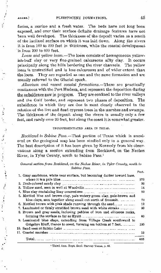
ADAMS.] PLEISTOCENE FORMATIONS. 45
facies, a marine and a freshwater. The beds have not long been exposed, and over their surface definite drainage features have not been well developed. The thickness of the deposit varies as a result of the inclined surface on which it was laid down. Along the rivers it is from 100 to 200 feet in thickness, while the coastal development is from 200 to 600 feet.
Loess and yellow loam. The loess consists of homogeneous yellow ish-buff clay or very fine-grained calcareous silty clay. It occurs principally along the hills bordering the river channels. The yellow loam is unstratified and is less calcareous and of wider extent than the loess. They are regarded as one and the same formation and are usually referred to the Glacial epoch.
Alluvium and recent coastal formations. These are practically continuous with the Port Hudson, and represent the deposition during the subsidence now in progress. They are confined to the river valleys and the Gulf border, and represent two phases of deposition. The subsidence to which they are due is most clearly observed in the relation of the live and dead cypress trees in the marshes and swamps. The thickness of the deposit along the rivers is usually only a few feet, and rarely over 20 feet, but along the coast it is somewhat greater.
UNDIFFERENTIATED AREA IN TEXAS.
Eockland to Sabine Pass. That portion of Texas which is uncol- ored on the geological map has been studied only in a general way. The best description of it has been given by Kennedy from his obser vations along a section extending from Rockland, on the Neches River, in Tyler County, south to Sabine Pass. 1
General section from Rockland, on the Neches River, in Tyler County, south toSabine Pass.
Feet.1. Gray sandstone, white near surface, but becoming darker toward base,
where it is a pale blue..;_.._.... ...._..... _.... ... ....... .......... 2702. Drab-colored sandy clay .......__,...._._.........._.........--..._._. 303. Yellow sand, seen in well at Woodville................................. 144. Blue clay containing limy concretions......... ....................... 905. Mottled blue and brown clay, pale watery-green clay, pale-brown and
blue clays, seen together along small cut north of Summit. ......... 706. Mottled brown with pink shade running through the sand..... ....... 127. "Laminated or thinly stratified brown sand with white streaks.......... 308. Brown and gray sands, inclosing pebbles of iron and siliceous rocks,
forming the surface as far as Hyatt........................ .......... 609. Laminated blue clays, extending from Village Creek southward to
G-rigsbys Bluff, thence to coast, forming sea bottom at 7 feet......... 10010. Sand seen at Sabine Lake .............................................11. Coastal marshes ...................................................... 12
Total .
1 Third Ann. Rept. Geol. Survey Texas, p. 63.

46 OIL AND GAS FIELDS OF WESTERN GULF COAST. [BUM,. 184.
The thickness, as estimated from surface exposures, is liable to considerable error, through no fault of the observer, because of the limited exposures and the variable lithologic charapter of the beds. The basal portion of the above section as far as Woodville is equiva lent in part to the Fayette sands and Frio clays. The succeeding formations occur in the undifferentiated area.
Vicinity of Beaumont. The prairie in the vicinity of Beaumont has been described by Kennedy as follows:
The Gulf coast along east Texas is occupied by an extensive prairie or plain, in many places cut by bayous and occupied by marshes, and in no place except the region of High Islands, about 15 miles east of the eastern extremity of East Bay, elevated more than a few feet above the level of the waters of the Gulf and Sabine Lake.
Beginning near Beaumont, in Jefferson County, a belt of recent material nearly a mile wide, mostly marsh and subject to overflow, extends southward along the west bank of Snow River as far as Grigsbys Bluff, where it broadens out along both sides of the river. From Grigsbys Bluff this belt of low land widens west ward, its approximate line of contact with the underlying blue clay being a line running westward and southward, crossing Hillebrands Bayou near the junction of Point Bayou on the C. Hillebrand headright.*******
From the nature of the country no sections could be obtained in any portion. Its structure appears, from a surf ace examination, to be chiefly a sandy ridge along the Gulf coast, slightly elevated above the back country, which, as already stated, is to a great extent made up of or covered by marsh. The depth of this marsh is probably not very great, and may only be a surface formation resting upon the dark blue clay outcropping near. Spindle Top about 4 miles south of Beaumont. These blue clays, according to the observations of the United States Coast Survey, appear in Sabine Pass and aloug the Gulf coast at a depth of only 6 or 7 feet, and are also found about 2£ miles north of the entrance to the Pass at a depth of 12 feet.
From Beaumont to Sabine Pass the distance is about 80 miles, and these clays disappear about 6 miles south of Beaumont, or at an elevation of about 20 feetabove tide level. This would give the clay, assuming the upper bed at both places to be the same, a dip of about 1 foot per mile, and give the marsh an average thick ness of 12 feet.
Grigsbys Bluff forms a prominent feature along the Neches River about 4 miles north of the entrance of the stream in the Sabine Lake. The bluff itself is made up chiefly of recent material. It is about 150 yards long and from 10 to 15 feet high; The main feature is the presence of shells of the Gnathadon cuneatus in vast quantities mingled with vegetable molds, and having a few scattering shells of an oyster associated with the Gnathadon forms. Similar shells and molds occur at several other places along the Neches as far up as Beaumont. 1
Lieut. George Bell, of the United States Coast Survev, has also described the coast prairie in the vicinity of Beaumont, as follows: 2
From the head of East Bay to High Islands the land is low wet prairie, covered with ponds, and in many places impassable for wagons. The High Islands are the only highlands on the Gulf coast between Galveston and Sabine, and probably the highest on the coast of Texas. Their elevation is 80 to 150 feet above high water,
1 Win. Kennedy in Third Ann. Kept. Geol. Survey Texas, 1891, pp. 68-70.2 United States Coast Survey, 1861, p. 264.

ADAMS.] STEUCTUEE IN TEETIAEY AND PLEISTOCENE AEEAS. 47
and their area about 2,000 acres. The central point of the islands is about 1£ miles from the Gulf shore.
From the High Islands to the Sabine all is prairie, in some places impassable marsh to a breadth of 7 miles in the wet season, sinall bayous running through in various directions and entering the lake or ponds. Firm land at all seasons can not be found short of from 6 to 9 miles from the coast, and in many places not short of 15 or 20 miles.
STRUCTURE OF THE TERTIARY AND PLEISTOCENE.
The general attitude of the Tertiary formation is similar to that of the Cretaceous. The various beds form an overlapping series dip ping toward the coast, the oldest being in contact with the Cretaceous and the younger deposits bordering the Gulf. The thickness o£ the individual formations has been variously estimated, but no satis- factory section has been compiled. Along their northern borders they thin to irregular feather edges, and southward they are overlapped by successively higher beds. Inasmuch as there is a general lack of induration, and the sediments consist of materials which are similar in many respects, divisions based on lithologic characters are not very
UPPCK CRETACEOUS TERTIARY AND PLEISTOCENE __________
Sea level
Underground relations not known
FIG. 3. Section from Corsicana to Beaumont, showing surface relations of formations.
distinctive. The age of the formations, in so far as it has been deter mined, is based upon paleontologic grounds. Fossils are not always abundant, and even when they occur characteristic species ar6 not always present. The section of the Tertiary formations at any one place would probably not include the same thickness of beds which would be exhibited in a section constructed from data obtained by measuring the outcrops of the formations which are geologically lower. This is due to the fact that there was considerable erosion at inter vals during the periods of deposition. Moreover, the underlying Cretaceous floor is uneven, and some disturbances, such as slight folding and faulting, and oscillations of level, undoubtedly took place during deposition, and the concomitant planation of the surface may have resulted in the local elimination of certain of the beds.
The accompanying general section (fig. 3) across the region from Corsicana to Beaumont shows the relation of the Cretaceous forma tions at Corsicana, as determined from the records of the deep wells, and of the overlying Tertiary formations as indicated by their surface occurrences. The underground relations can not be discussed with any degree of certainty at present.
48 OIL AND GAS FIELDS OF WESTEKN GULF COAST. [BULL. 184.
OIL AND GAS HORIZONS.
Cretaceous horizons. The field at Corsicana has already been described, and it has been shown that the oil and gas occur in the Tay- lor marls, which lie above the Austin chalk. The records of the wells at Elgin seem to indicate that the oil found there occurs in local beds of sand in about the same horizon as at Corsicana, and the same is probably true concerning the wells at San Antonio. Many borings have been made for artesian water which have passed into the lower horizons of the Upper Cretaceous, but so far they have not revealed the presence of oil in any considerable quantity.
Tertiary horizons. Occurrences of oil have been reported from nearly every formation in the Tertiary, and in widely scattered local ities. The maltha and seeps of heavy oil are surface indications and are found where the productive horizons outcrop. Prospecting at such places has usually resulted in the finding of limited quantities near the surface, and any oil which has been obtained by deeper drill ing probably has its source in beds which outcrop at some distance from these localities' The valuable deposits occur where the oil- bearing formations are overlain by a sufficient thickness of sediments to seal in the oil, and surface indications of these resources are usu ally lacking.
In the case of the finding of oil at a depth in 'the Texas field, it may be generally assumed that the stratum which contains it outcrops at a considerable distance farther inland. This is due to a general southward dip. At the present time a large number of companies are engaged in prospecting, and no doubt the records of the wells which they sink and a study of the fossils obtained from drilling will determine the principal oil-bearing horizons. The oil in Nacogdoches County occurs near the contact of the Marine beds with the Yegua clays, and is obtained at a very shallow depth from formations whichoutcrop in the vicinity. The oil at Beaumont is found at a depth of approximately 1,050 feet, and the horizon from which it is obtained has not been definitely determined. According to the fossils which came from near the bottom of the well, it would appear that the low est determinable horizon is Neocene. When the well was flowing the force of the oil brought up several pieces of shell conglomerate. Specimens of this rock were loaned to the Survey by Messrs. A. F. Lucas, of Beaumont, and J. S. Cullinan, of Corsicana. They were submitted for determination to Mr. Stanton, who reported that in his opinion, the fossils, so far as determinable, are of Neocene age, but that it was impossible to state from what particular formation they were derived. -
Mr. Kennedy, who has studied the geology of Beaumont and the region lying toward the north, stated to the writer that he is of the opinion that beds similar to those passed through near the bottom of the well outcrop in the vicinity of Corrigan; The southward dip

U. S. GEOLOGICAL SURVEY BULLETIN No. 184. PL. V
* Oas wells-* Small producers
JULIUS BIEN B CO.LITH.
MAP OF THE CORSICANA OIL AND GAS FIELD SHOWING DEVELOPMENTFrom surveys toy the J. S.Cullma.n Oil Company
.APRIL 19 Ol
ADAMS. I HOKIZONS OF OIL AND GAS. 49
would carry them under Beaumont. It will be noticed that the oil found at Nacogdoches occurs in a somewhat lower formation, which likewise dips to the southward, and it is not impossible that this hori zon is the one which has been reached at Beaumont. In support of this theory it may be stated that the heavy character of the oil found at the two places might seem to justify this belief. On the other hand, it is not unusual to find oils of similar character in formations Avhich differ widely in geological age. Mr. Harris has advanced the theory that the Beaumont oil is found in the Cretaceous. 1 He bases this opinion upon the fact that the records of the wells show that a bed of sulphur was passed through before reaching the oil, and he believes the sulphur to be of Cretaceous age. The sulphur occurring at a considerable depth at Sulphur City, in Calcasieu Parish, La., lias been referred to the Cretaceous, but on somewhat better grounds, since it there occurs associated with gypsum and limestone beds. The sulphur bed which was reported by the drillers may have origi nated in a different way from that found at Sulphur City. There are at the present time surface occurrences of sulphur, and no doubt deposits of it have been formed at various horizons, since sulphureted hydrogen gas in that region everywhere penetrates the earth and can be detected escaping at many places. The depth at which the oil is found at Beaumont is not so great as the thickness usually assigned to the Tertiary beds occurring above the Cretaceous, and Harris has assumed that this is due to an anticlinal structure which brings the Cretaceous nearer the surface. Of such a structure there is at pres ent no proof. The wells drilled adjacent to the Spindle Top Heights, having failed to obtain either oil or gas, were continued to the depth of 1,800 to 2,000 feet, and consequently passed much below the hori zon of the oil. While the character of the cutting from these holes has not been definitely determined, the information at hand appears to indicate that the Cretaceous was not reached, and, moreover, that the gypsum and limestone beds which are found in Calcasieu Parish are not represented in the Beaumont field at the depth at which the sulphur was reported in the log of the Higgins well. Until evidence is gained through the sinking of deeper wells and the finding of fossils from lower beds, the conclusion that the oil at Beaumont is of Creta ceous origin must remain very questionable, especially in view of the known widespread occurrence of oil in the Tertiary formations of this region.
ASSOCIATION OF PETROLEUM, SULPHUR, GYPSUM, AND ROCK"SALT.
Near the close of the Cretaceous period beds of rock salt and gyp sum were evidently precipitated in the landlocked remnants of the retreating sea. Subsequent disturbances have brought these deposits
1 Science, April 20,1901, new series, Vol. XIII, p. 068.
Bull. 184 01 4

50 OIL AND CKAS FIELDS OF WESTERN GULF COAST. [HULL. 184.
near to the surface in several localities, where they have given rise to salines, and a number of wells have reached them beneath the Ter tiary beds. The rock, salt occiirs in beds of exceptional thickness and purity, and has been worked at Grand Saline in Texas and at Petit Arise and adjacent localities in Louisiana. The gypsum seems to have been reduced through subsequent agencies, and contains pockets of sulphur, and in some cases beds of pure sulphur occur. The abundance of the sulphur and its widespread occurrence have been noted near the Gulf coast, especially in Calcasieu Parish, La., and the vicinity of Sour Lake, Tex. The commercially important deposits of sulphur at Sulphur City, La., were encountered in pros pecting for petroleum. Small quantities of petroleum were found in the course of this prospecting, and also in a number of the holes which were subsequently drilled for the purpose of removing the sul phur. Furthermore, the oil discovered at Beaumont is found to con tain considerable sulphur, amounting approximately to 1 per cent. The Beaumont oil is a fuel oil and the presence of the sulphur does not interfere with its use in that capacity, but considerable inquiry and speculation have resulted from its association with the product.
F. V. Hopkins, in his report on the geology of Louisiana, published in 1869, commented upon the association of the sulphur, gypsum, limestone, and petroleum, and gave the following explanation con cerning their occurrence: He believed the sulphur to be formed by the reduction of gypsum beds through the agencies of decomposing organic matter which gave off carbon-dioxide gas. This, uniting with the lime in the gypsum, produced limestone and set free the sulphur. The petroleum, which is also a product of decomposition of the organic matter, is contaminated by the sulphur. lie also advocated the theory that the small, low mounds which are so char acteristic of the Gulf coast and the region sometimes referred to as the "pimple prairies" were formed by the escape of gases, which lifted up the mud in the form of mud lumps, similar to those observed in the delta of the Mississippi. It would seem that there need be very little stress laid upon the occurrence of these mounds, since they should probably be accounted for 1 through other causes. The association of the gypsum, sulphur, and petroleum, however, is an interesting subject, and the following discussion of the theoretical considerations is given by Mr. Eugene T. Alien, of the Division of Physical and Chemical Research:
Nearly all sulphur deposits which have any commercial value are intimately associated with gypsum, limestone, and frequently with salt, the marine origin of which is beyond doubt. Wherever such deposits have been carefully studied the conclusion has always been reached that the sulphur has also' been deposited by water. This is proved by the absence of volcanic agencies, by the persistence of the sulphur beds over wide areas at constant levels, and is sometimes

ADAMS.] ASSOCIATION OF SULPHUK^ WITH GYPSUM. 51
further confirmed by the structure of the sulphur, which is frequently amorphous and lacJdng in luster, like that formed artificially in the wet way. Sometimes, however, it is compact, like brimstone, and in geodes it forms well-developed crystals.
Now, sulphur is always thrown down from water solutions of hydro gen sulphide wherever they are reached by atmospheric oxygen. Such waters are common in nature and are continually depositing sulphur, a process which may be observed at any sulphur spring. But this deposition is not limited to the surface. Waters which have dissolved oxygen from the air, if brought in contact with aqueous solutions of hydrogen sulphide, would of course accomplish the same result.
The constant association of sulphur with gypsum has long been regarded as significant. In 1841 Brann suggested that the sulphur of the Province of Teruel, Spain,was derived from gypsum. l His hypoth esis was that the gypsum was reduced in the presence of water tocalcium hydrosulphide, which under the action of carbonic acid forms calcium carbonate and hydrogen sulphide. By the action of atmos pheric oxygen the latter is then oxidized to sulphur arid water. Granted that such a reduction of gypsum could occur, the other reac tions would follow of necessity, provided there was excess of carbonic acid and oxygen, such as all surface waters supply. These reactions may be represented thus:
Ca (SH)8 +H2C03 =CaC08 +2HaS.2I-12S+02 =2H20+2S.
If the carbonic acid were in sufficient excess, the lime would remain dissolved until the conditions were favorable to its deposition as lime-. stone and the sulphur would be precipitated. The reduction of the gypsum is generally conveniently ascribed to "organic matter." In the gypsum of the Sicilian deposits pockets of tarry matter are abun dant, and the same is true of other similar deposits. Petroleum is also very often found. It occurs in the beds of Sicily and in those of Louisiana and Texas. Hopkins, in the State geological report of Louisiana for 1869 (p. 81), stated that the sulphur of Calcasieu was formed from gypsum, through the reducing action of lignite.
Now, gypsum is a very stable sulphate, and, except at high temper atures and in the dry way, only a few conditions are known which suffice for its reduction. Certain varieties of algae, through the agency of their vital processes, can reduce solutions of gypsum, and in this way certain springs are now depositing sulphur, but it is doubtful whether these organisms abound anywhere except at the surface. 2
Gypsum is also reduced at ordinary temperatures bjr putrefying
1 Bull. Soc. geol. do France, 1st series, Vol. XII, p. 173."Plauchud, Comptes rendus Acad. sci., Paris, Vol. LXXXIV, p. 235; Vol. XCV, p. 1363. Etard
and Olivier, Coinptes rendus Acad. sci., Paris, Vol. XCV, p. 846.
52 OIL AND GAS FIELDS OF WESTEKN GULF COAST. [BULL. 184.
organic matter, either animal or vegetable. l Thus, Bischoff 2 instances the formation of hydrogen sulphide in beach pools by the action of the decomposing mussels on the sulphates of sea water.
Braun considered that the sulphur of Teruel was formed from gypsum by the reducing action of decomposing organic matter, and appears to have believed that the petroleum which is found there was one product of this reaction. 3
More recently Ochsenius has elaborated a similar theory. 4 He accepts Engler's hypothesis, 5 according to which the hydrocarbons of petroleum are derived from the fats of marine animals by some process akin, perhaps, to dry distillation under pressure, for in this way Engler obtained from fish oil a product similar to crude petroleum. To account for the lack of nitrogenous compounds in petroleum he supposed a preliminary putrefaction in which the less stable nitrogenous tissues yielded, the nitrogen being thus volatilized as ammonia, while the more stable fats were afterwards changed as above indicated.
Ochsenius holds, however, that the major part of the sulphur is derived, not from gypsum, but from the more soluble sulphates of magnesium and sodium, which are far more abundant in sea water. This theory appears to be the only one thus far advanced which gives any rational significance to the very frequent association of petroleum with sulphur and gypsum, but it must be confessed that quite unusual conditions are here demanded, and the theory would seem to postu late that the formation of petroleum is at present nowhere in prog ress. The hypothesis that gypsum gives rise to sulphur by some process of reduction has been more generally held than any other, and in support of this view a unique argument has been advanced which we may mention here. According to Mottura 6 the sulphurrock of Sicily (though quite variable in composition) contains on theaverage 24 per cent of sulphur. Now, if gypsum should be changed completely to limestone and sulphur the mixture would contain 24 per cent of sulphur. 7
Instead of regarding gypsum as the original source of sulphur, some consider it of secondary origin, formed by the chemical action of hydrogen sulphide and air on limestone. 8
This action has been studied in the laboratory, and has also been observed in the field. "Sulphur" waters percolating through
1 Graham-Otto. Lehrbuch der Chemie, Vol. I, p. 516, Vol. Ill, p. 569. 2 Bischoff, Chem. Geol. (Eng. ed.), Vol. I, p. 336. 3 Bull. Soc. geol. de France, 1st series, Vol. XII, p. 173.« Chein. Zeitung, Vol. XV, 1891, pp. 935, 1735; Vol. XVI, 1892,p. 1180; Vol.XX, 1896,No. 39,pp. .
Die Natur, 1896, p. 345. « Ber. Deutsch. chem. Gesell., Vol. XXI, 1888, p. 1816.6 Fuchs and De Launay, Gites Mineraux, Vol. I, pp. 270,274.7 From one molecule of gypsum we should obtain one atom of sulphur, 32 parts by weight, and
one molecule of calcium carbonate, 100 parts by weight. Of this mixture it is evident the sul phur would form 24 per cent.
8 Spezia, Braun's Chemische Mineralogie, p. 366.

U. S. GEOLOGICAL SURVEY BULLETIN NO. 184 PL. VI
OIL WELLS IN CORSICANA AND CORSICANA REFINERY.

ADAMS.] DEVELOPMENT OF THE FIELDS. ' 53
limestone are found to change the latter into a spongy mass of gypsum. 1
The explanation of this change is simple. Oxygen will not only oxidize hydrogen sulphide to sulphur and water, but, by further action, the sulphur may be partly oxidized to sulphuric acid. The latter, of course, would act on limestone, with the production of gypsum. Accord ing to Spezia, the extensive occurrence of silica (Tripoli) and celestite in the Sicilian deposits is evidence against the view that sulphur is deilved from the gypsum. He believes the hydrogen sulphide is there of volcanic origin. Most authorities, on the other hand, .find no con vincing evidence of volcanic action, in Sicily, and in other places the Louisiana deposits, for instance this argument is maintained with still less plausibility. In the latter region sulphur springs are found in abundance, and they seem to indicate that a deposition of sulphur may be still in progress. The facts known are altogether too few to form a safe basis for speculation, but if Mendeleef's theory of petro leum formation is correct, we may find in an analogous process a for mation of hydrogen sulphide. Mendeleef holds that petroleum is formed by the action of heated water on carbide of iron at consid erable depths. Conditions which suffice for the production of carbide of iron would be favorable also to the formation of the sulphide FeS, which by the action of heated water gives hydrogen sulphide.
DEVELOPMENT OF THE OIL AND GAS FIELDS.
Nacogdoches field. This field takes its name from the town and county near the eastern border of Texas. Oil was discovered here from seeps at a place known as " Oil Spring," about 15 miles south east of Nacogdoches. In 1870 some interest was taken in the place, and soon after a prospecting company was organized which drilled a number of wells. The first well reached a depth of 70 feet, when it struck a flow of oil. Drilling continued in this locality until 1889, since which time the wells have been only baled out occasionally, inasmuch as the supply has been small. Other companies have oper ated in the field, and oil has been found in several localities, but always at a shallow depth, usually not exceeding 100 feet. ' Some tanks were erected and a pipe line was laid to Nacogdoches, but the field has never become an important one. At present there are five wells on the Anderson property, which are being pumped and will supply less than 5 barrels each per day. The oil, because of its IvVavy character, is used by sawmills for lubricating purposes without any refining or other treatment.
The occurrence of the oil has been described by Joseph B. Walker 2 as being in sand beds which are associated with greensand marls. An ideal section of the locality is given which shows the occurrence of
1 Braun's Ohemische Mineralogie, p. 3C6.2 Second Aim. Eept. Geol. Survey Texas, 1890.
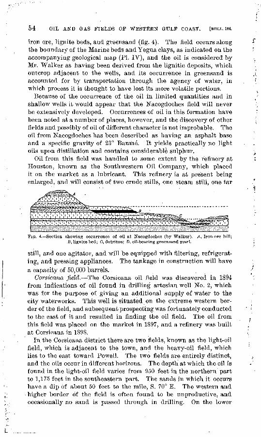
54 OIL AND GAS FIELDS OF WESTERN GULF COAST. [BULL. 184.
iron ore, lignite beds, and greensand (fig. 4). The field occurs along the boundary of the Marine beds and Yegua clays, as indicated on the accompanying geological map (PL IV), and the oil is considered by Mr. Walker as having been derived from the lignitic deposits, which outcrop adjacent to the wells, and its occurrence in greensand is accounted for b}r transportation through the agency of water, in which process it is thought to have lost its more volatile portions.
Because of the occurrence of the oil in limited quantities and in shallow wells it would appear that the Nacogdoches field will never be extensively developed. Occurrences of oil in this formation have been noted at a number of places, however, and the discovery of other fields and possibly of oil of different character is not improbable. The oil from Nacogdoches has been described as having an asphalt base and a specific gravity of 23° Baume. It yields practically no light oils upon distillation and contains considerable sulphur. .
Oil from this field was handled to some extent by the refinery at Houston, known as the Southwestern Oil Company, which placed it on the market as a lubricant. This refinery is at present being enlarged, and will consist of two crude stills, one steam still, one tar
xiimm.
FIG. 4. Section showing occurrence of oil at. Nacogdoches (by Walker). 4, Iron-ore hill; B, lignite bed; C, detritus; D, oil-bearing greensand marl.
still, and one agitator, and will be equipped with filtering, refrigerat ing, and pressing appliances. The tankage in construction will have a capacity of 50,000 barrels.
Corsicana field. The Corsicana oil field was discovered in 1894 from indications of oil found in drilling artesian well No. 2, which was for the purpose of giving an additional supply of water to the city waterworks. This well is situated on the extreme western bor der of the field, and subsequent prospecting was fortunately conducted to the east of it and resulted in finding the oil field. The oil from this field was placed on the market in 1897, and a refinery was built at Corsicana in 1898.
In the Corsicana district there are two fields, known as the light-oil field, which is adjacent to the town, and the heavy-oil field, which lies to the east toward Powell. The two fields are entirely distinct, and the oils occur in different horizons. The depth at which the oil is found in the light-oil field varies from 950 feet in the northern part to 1,175 feet in the southeastern part. The sands in which it occurs have a dip of about 50 feet to the mile, S. 70° E. The western and higher border of the field is often found to be unproductive, and occasionally no sand is passed through in drilling. On the lower

U. S. GEOLOGICAL SURVEY BULLETIN No. 184. PL. VII
SPIJNDLETOP
HEIGHTS.TTTNE15 1901
J E F F E R S
MAP OF BEAUMONT AND YICINITTShowing the location of oil wells at Spinclletop Heights
JULIUS BIEN 8 CO.UTH. N.V
Scale

ADAMS.] DEVELOPMENT OF THE FIELBS. 55
border of the field, as at present developed, salt water takes the place of the oil in some of the wells which have been drilled. The gas appears to be situated above the oil and is therefore found on the western border. The sands which contain the oil are found in a for mation of bine-clay shales which serve to seal in the oil and gas. In the heavy-oil field, or. Powell field, there are two sands, the upper of which is encountered usually at a depth of about 700 feet and the second 80 feet lower. The lower contains the larger supply of oil, and there is a difference in gravity in the product of these two sands. The sands in this field dip to the southeast at about the same angle as in the light-oil field, and the deepest wells which have been drilled reach a depth of 1,000 feet. The refinery at Corsicana consists of six crude stills, two steam stills and agitators, and the tankage capacity is about 150,000 barrels. The oil which is refined varies from 38° to 39° gravity and produces approximately 60 per cent of light oils. The heavier product is sold for fuel. Considerable gas has been developed about 3 miles south and a little east of Corsicana, the horizon of which has as yet not been definitely determined. The gas wells which supply the city of Corsicana are sixteen in number, seven of which are ordi narily used. They are located in the northeastern and southwestern portions of the field.
The light-oil fields of Corsicana produced 829,560 barrels during the year 1900. From the heavy-oil field, and other localities, the amount produced was 6,479 barrels.
Record of oil and gas loells in the Corsicana field.
Year.
1898.........-.....-........-.-.... ............ ..............--. .1899................................... ...................................1900........-.......-...--.-...-.....--..-...--.................-.--.-
Oil wells.
Produc ing.
a342 169
6261
Aban doned.
7 79
113
Gas wells.
4 9
14
a Includes all previous operations. b Includes 56 in heavy-oil field.
Elgin and Lockhart. Five wells have been drilled near Elgin, four of which are small producers of oil. The supply is not being used commercially. It has a gravity of 34° Baume and is reported to be a paraffin oil. A record of the strata passed through at this place is asfollows:
Section near Elgin.Feet.
Joint clay-_---.---.------.------.-..-..---- ...--... .....--_.-.._.-.._... 40Blue shale. ..__..._....._.....--..--..----.--.-...-........_..--.-...----.-.- 70Limestone streaks in chalky shale.......................---.-..-............ 100Coarse brown sand ...... ................ .................... .^.... ......... 10White shale.... .................. ....................................... 135Heavy lime shell........................ ................ .-..-. .............. 3Oil sand.............._..___ ._.....-......_.................. ............... 4White shale.

56 OIL AND GAS MELDS OF WESTERN GULF COAST. [BULL. 184.
At Lockhart oil is reported as having been found at a depth of from 300 to 400 feet. Its occurrence is similar to that at Elgin.
San Antonio. For several years a small supply of oil has been obtained from wells at San Antonio. The yield has been only a feAv barrels, and it is used locally as a lubricant. The oil is dark green in color and has a gravity of 24° Baume. Recently another Avell has been drilled which found oil similar in character and amount.
Sour Lake. Oil was discovered at Sour Lake about 1893, and some wells were sunk which have a depth of about 280 feet. In the vicin ity of the lake the water has the quality which is described as sour, and there is considerable sulphur to be found in the vicinity. A hotel was built and the place was used as a health resort, the mud and the sour water being used for baths. Developments at this place were made by J. E. Newton and associates and J. S. SaA^age. A small refinery was built by Mr. Newton and associates, who were known as the Gulf Coast Refining Company. This plant was never operated, and the wells never produced a commercial quantity of oil.
Beaumont. For many years it has been known that oil existed in small quantities in western Louisiana and Texas, within a radius of 100 miles, more or less, of Beaumont. Petroleum springs existed at several places, notably at Lake Charles, Louisiana, and near Sour Lake, Texas, and oil has been encountered in well borings at a num ber of places. In many of the older writings descriptive of the coast of Texas and Louisiana reference has been made to the occurrence of an oil pool on the surface of the Gulf of Mexico just off Port Sabine. Although considerable interest has been developed with respect to it, there are no authentic reports of its existence at present.
The well known as the Lucas gusher was struck on January 10, 1901. The drillers were not expecting a flow of oil, and while work ing with, the casing it began to rise out of the well. The force wastoo great for them to control it, and it shot up through the derrick, and a stream of oil followed which rose to a height of about 160 feet before the men on the derrick had time to descend. This flow con tinued for ten days before the well was shut in. The column of oil flowed steadily, and the height of the stream remained constant. The spray from the oil was blown to a considerable distance and saturated the prairie grass, and the escaping oil formed a large pool, which was dammed in by dikes. On March 3 a spark from a passing locomotive ignited the grass, and the pool of oil burned, making a remarkable spectacle because of the dense column of smoke. The capacity of the well was estimated after it was shut in by allowing it to flow into a 35,000-barrel tank which had been constructed. This tank was filled in a trifle less than twelve hours, and the flow of the well is generally reported to have been 70,000 barrels per day. The pressure of the oil, as shown by a steam gauge attached to the pipe at the well, reached 104 pounds per square inch.

U. S. GEOLOGICAL SURvEv BULLETIN NO. 184 PL. VHI
LUCAS GUSHER.

ADAMS.] BEAUMONT OIL. 57
The Beaumont oil has a gravity of 22° Baume. It lias an asphalt base and contains a considerable quantity of sulphur. Tests show that the percentage of light oils which it contains is very low, and it is therefore regarded as a fuel oil. The cluster of wells at Beaumont which have reached the oil deposits are situated about 4 miles south of the center of the town, on a slight elevation known as Spindle Top Heights, and are within a radius of half a mile from the first discov ery. Up to June 15 the wells which were actually recognized as pro ducers numbered eleven. Their location is shown on the accompany ing plat of Spindle Top Heights (PI. VII). They are known by the following names:
Lucas gusher; Beatty or National Oil and Pipe Line gusher; Higgins Oil and Fuel Company gusher; Gladys City or Guffey gusher No. 1; Gladys City or Gutfey gusher No. 2; Gladys City or Guffey gusher No. 3; Lone Star and Crescent gusher; Hey wood No. 1; McFaddin, Wiess&Kyle gusher No. 2; McFaddin.Wiess&Kyle gusher No. 3; Hey wood No. 2.
Log of Lucas ivell, near Beaitmont, Tex.
Character of cuttings.Thick ness. From i To
Yellow clay............................................................Coarse gray sand........................................................Blue clay, pretty hard ................................................Fine gray sand .........................................................Variegated gravel, ranging in size from that of a bean to that of a
goose egg.....................................................'.......Coarse gray sand......................................................Blue clay.................................................................Coarse gray sand, with pyrite concretions...........................Blue clay..............................,....:............................Fine gray sand, with lignite ............................................Marl shells-...-.........................................................Gray sand, with concretions and plenty of lignite....................Soft limestone..............................._.. .....................Gray clay and sulphuretedhydrogen gas.............................Hard-clay stone, with calcite depositions.............................Gray sand ...............................................................Compact hard sand, with pyrites...... ...............................Hard sandstone and limy concretions.................................Gray clay..............................................................Hard sand .............._................................._ ........Gray clay, with limy concretions..........................._........White limy shells .................................................... ..Gray clay...............................................................Gray sandstones of oil.................................................Gray clay, with limy concretions.......................................Gray clay,getting hard.................................................Limy concretions,with calcite ........................................Hard, gray clay, with limy concretions; plenty fine pyrite..........Hard clay (gray) with limy concretions; plenty fine pyrites .......Sandstone and pyrite,pretty hard....................................Hard rock, apparently limestone.....................................
Feet, 36 20 11475
20 53 45 14 19 45 8
60
i20
i34 25
i12* 1*
Feet.
03656170
245265317362376395440448
528*529563
600J602660666680686693716718785834854
170245
2653173623763954404485085084528^529563588588J600f602660666680686693716718785834854856

58 OIL AND GAS FIELDS OF WESTEKN GULF COAST. [BULL. 184.
Log of Lucas well, near Beaumont, Tex. Continued.
Character of cuttings.Thick ness. From
Fine oil sand, with hard layers toward bottom and heavy pressure under it, filling casing 100 feet above point of drilling.............
Hard clay .......................I.............. .....................Limy concretions with layers of hard sandstone .....................Struck heavy gas pressure and oil, which lasted about one hour,
then subsided ...................................._......:.............Sand mixed with limestone concretions and fossils.--..,----........
Feet.
248050
40110
Feet.
856830960
1,0101,050
Feet.
880960
1,010
1,0501,160
Oil was tapped at this depth, and the 4-inch pipe which was used in drilling was shot out of the well, carrying block and tackle with it, followed by the column of water used in drilling.
The well flowed unrestrained for nine days, shooting a steady column of oil 6 inches in diameter, and giving no signs of exhaustion before it was controlled by a gate valve.
The hydraulic system of boring was used. Owing to heavy banks of quicksand, this system- is admirably adapted .for the purposes intended of penetrating heavy beds of quicksand although very unsatisfactory to keep accurate log or record of the various strata.
The well was begun on October 27, 1900, and was completed on January 10, 1901.
Log of Higgins oil ivell, Beaumont, Tex. 1
Character of cuttings.Thick ness. From To-
Feet.1 Blue clay................................-............-..---.--.-... 302 Quicksand ................................-....... ............. 21
3 Very fine sand.......J...........-...-------------.-- --------- 1*4 Fine sand, mixed with clay...... .................................. 155 Fine sand,mixed with very fine clay.............--..-..-...-.... 206 Sandasfineas flour......-.-.........---..-.--.-............--..... 107 Fine sand ........................................................... 108 Clay,sand,and stone -............-..........-.------....--...--... 209 Fine sand, brackish water......................................... 20
10 Blue clay.... .-. ............................................... 1011 Coarse sand...-...-----.---..........--...----.-.------------------ 1012 Coarser sand......................................................... 2013 Mediumflnesand..................................... --..........- 2514 Sand a little finer.................................................. 2015 Sand getting coarser, with black pebbles ......"......----.-..---. 1516 Still coarser sand..............._...........-.-.-.......---...... 2017 Coarse sand,mixed with clay...........................-...-..--- 8018 Coarse sand,no clay................................................ 519 Very coarse sand........ .......................................... 3020 Coarse sand, with black pebbles and shells....................... 2121 Sharp, finer sand, with shells.............-. --.-.--..-.-... .-.- 9:22 Bluesand .......................................................... 20
1 New Orleans Times-Democrat, April 10,1901.
Feet. 0 30 51
65 80
. 100 110 120 "140 160 170 180 200 225 245 260 280 360 365 395 416 425
Feet. 30 51 65
80 100 110 120 140 160 170 180 200 225 245 260 280 360 365 395 416 425 445

U. S. GEOLOGICAL SURVEY BULLETIN NO. 184 PL. IX
BEATTY GUSHER.
ADAMS.] LOUISIANA GAS WELLS.
Log of Higgins oil loell, Beaumont, Tex. Continued.
w?42526
Wft889an313? 33
34
353fi37383!)4041
Character of cuttings.
Coarse sand, with black pebbles, sand, and another trace of oil
Blue shale, with trace of shell..........:.................. .....
Blue shale, ti-ace of oil... ...... ....................................
Oil..:...............................................................
Thick ness.
Feat. 702120
192020
1702020203025
45
35202010105
From
Feet. 445515536
556575
' 595615785
805825845875
900945980
1,0001,0201,0301,040
To-
Fevt. 515536556
575595615785805825845875900
945
9801,0001,0201,030.1,0401,045
Gas wells in Louisiana. In Louisiana a number of deep wells have been drilled for the purpose of obtaining water, and some of these have encountered a considerable flow of gas. At the Drake Salt Works, in Wmn Parish, a well was drilled about fifty years ago and is reported to have reached a depth of 1,011 feet. It has a flow of brine, in connection with which a considerable amount of gas is con stantly escaping and can be ignited when collected. It is reported to have been sunk nearly all the way in limestone, which is presumably of Cretaceous age, but accurate information concerning the character of the strata passed through is not obtainable and there are no sur face indications which corroborate this report. At Colfax, Grant Parish, an artesian well drilled to a depth of 1,103 feet yields a con stant stream of brine, and a considerably quantity of gas is given off, which burns readily when ignited. At Shreveport a well, known as the "Ice Factory" well, reached a depth of 960 feet and obtained a strong flow of water. It likewise gives off gas, which is collected and used for lighting the office at the factory. At the town, of Natchitoches a well drilled on the State Normal School grounds passed through strata similar to those at Shreveport and reached a depth of 637 feet. Samples from this well were examined and the character of the mate rial agrees very closely with that which was reported at a considerable depth in sinking the Colfax hole. The wells at Shreveport and Colfax appear to have been drilled into the Lignitic formation, from which they probably derived their flow of gas. Small amounts of gas are

60 OIL AND GAS FIELDS OF WESTERN GULF COAST. [BULL. 181
reported issuing from springs and shallow borings near the Gnlf bor der, especially at Breaux Bridge and Negreet Bayou and near Sulphur City. It seems not unlikely that additional occurrences of gas will be found in this region, and these already known, although not of commercial importance, would appear to justify further prospecting.
PRESENT PROSPECTING IN THE TEXAS FIELD.
Upon the discovery of the phenomenal flow of oil at Beaumont, oil men and capitalists were attracted to the field and the excite ment and speculation in oil lands were in the nature of a boom. Many oil companies were organized, and operations were begun in territory adjacent to Spindle Top Heights. The occurrence of oil springs and seeps at widely separated localities in the Tertiary served as a basis for the formation of prospecting companies, and leases were taken on large tracts of land in Louisiana and Texas adja-' cent to the Gulf coast. The localities outside of Beaumont which have attracted special attention, in addition to those already described in the foregoing report, are Sulphur City and Vinton in Calcasieu Parish, Breaux Bridge in Lafayette Parish, in Louisiana; Big Hill and High Island in Jefferson County, Damond Mound and Bryan Heights near Columbia in Brazoria County, Saratoga in Hardin County, San Diego in Duval County, and in Zapata County, in Texas. Thus far no producing wells have been found at any of these places, although the occurrence of oil in limited quantities has been claimed.
The active drilling has been nearly all confined to the vicinity of Spindle Top Heights and has thus far developed a field of limited extent. With the bringing in of the various gushers the oil craze was increased by the spectacular character of the wells. The sight of a column of crude oil spurting from the ground to a height of from160 to 210 feet attracted large numbers of spectators, and excursiontrains were run to the field.
This naturally brought investors, who took stock in the companies which had been formed, and furnished financial backing for many oil operations. As soon as machinery could be obtained wells were drilled, and some of them situated very near to the producing territory are now proved to be failures. This has caused a more conservative spirit among the operators, and the oil business is beginning to be conducted upon a more careful basis.
A number of explanations of the occurrence of the oil at Beaumont have been given by persons claiming to be geologists, and newspaper stories have been current setting forth the inexhaustible and practi cally limitless field which was surely to be found along the Gulf coast. One of the popular notions was that the oil occurred in a vast underground stream flowing from the northwest under Beaumont to the Gulf coast, where it issued, forming a pool of oil which floated
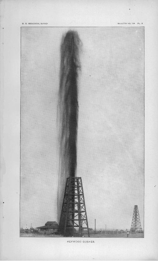
U. S. GEOLOGICAL SURVEV BULLETIN NO. 184 PL. X
HEYWOOD GUSHER.

ADAMS.] VALUE OF GAS AND OIL PKODUCTION. 61
upon the surface of the water just west of Sabine Pass. The report of the occurrence of this pool of oil was given some support through the statements made by earlier writers that in time of storm ships were wont to take refuge at a point off the G-ulf coast where the sea was calmed by oil floating on its surface; but careful search has failed to reveal, such an oil pool, and the only thing found which has seemed to furnish a basis for the report is the occurrence of a so-called sea ooze which rises to the surface when the waters are agitated by storms.
The occurrence of oil in so great quantities gave rise to a belief that an underground lake existed, and it has been supposed that upon the drilling of a sufficient number of wells the inlet and outlet of this body of oil would be discovered.
Besides these fanciful theories a number were set forth which were in accordance with conditions found in other oil fields. The common occurrence of oil along the axis of anticlinal folds led some to suppose that the same would be true in the Beaumont field. This was given support by observers who claimed that the slight elevation at Spindle Top Heights was due to such a fold and that-the axis would be found to extend northeast-southwest parallel with the structures reported in the Cretaceous rocks in Louisiana.- Thus far no data have been obtained which are favorable to this theory. The sand which con tains the oil appears rather to be a local bed, somewhat in the nature of a beach deposit or sand spit, occurring between beds of clay and now deeply buried by subsequent formations.
The probable extension of the field is a question which is agitating those who have interests in the leases around Beaumont. This can be determined only by additional drilling. The fact that the reservoir under Spindle Top Heights appears to have only a limited extent does not preclude the possibility of finding oil in the same general horizon in other places. It should be borne in mind that in all oil fields the productive localities are usually confined to small areas separated by intermediate barren zones. Instead of a continuous field, prospectors should expect to find a number of small fields occurring at wide intervals.
VALUE OF OIL AND GAS PRODUCTION IN TEXAS.
Between the years 1889 and 1896 the production from year to year was approximately 60 barrels. Since that time the Corsicana field has become important. The production of oil in 1899 was practically all from the Corsicana field, and was obtained from about 425 wells. The average price per barrel was 70 cents.
The production of oil in the Corsicana field for this year was a little less than one-ninetieth of the entire production in the United States.

62 OIL AND GAS FIELDS OF WESTERN GULF COAST. [BULL. 184
The following table is reproduced from a report of the Division of Mining..and Mineral Resources: ' -
Production of oil in the Corsicana field.Barrels.
1896..--...-..----.-..-.---.-.-..----....... ...._....................... 1,4501897.--......-. ........................... .......................... 65,9741898..---.-......-...--...-....------...-..-----....--.-....-----. .-... 546,0701899...---.--...--.--.,........---. _.........--..-....-,..-...._. 669,0181900--..-...-...-....-...-. .................... ...................... 836,039
Total.......................................................... 2,118,546
About the close of 1899 the gas was piped and utilized at Corsicana. No statistics have been obtained as to its value.

INDEX.
Page. Adrian, Mo., gas wells near. ........... 22Alien,E. T., cited ......................... 50-53Alhivium, occurrence of.................. 45Arkansas, oil and gas in................... 28Arkansas-Texas field, area of............ 37
geology of ..-.-.--.-.---..---- -- ----- 37-47Austin chalk, occurrence and character
Of .......-. .. - 38Bar.tlesville, Ind. T., development at..... 26
formations pierced by well borings at................................... IS
Beatty well, view of ...................... . 58Beaumont, Tex.; development at........ 50-59
horizon of oil at....................... 48-49map of region near.................... 54section from Corsicana to ............. 47topography and geology of region -
'near................................. 46-47Bell, Lieut. George, cited................. 4(5-47Benedict, Kans., development at......... 25Buffalo, Kans., development at.....-..... 25Bur dett, Mo., gas wells near.............. 22Carboniferous rocks, areas of ............ 11
character of sediments forming ..... 11-12formations composing ................ 13-16general structure of................... 12
Chanute, Kans., development at ...... 23Chelsea-Bartlesville horizontal section,
description of......_........ ...17-18Chelsea, Ind. T., development at.......... 26Cherokee shales, occurrence and charac
ter of ......--..7.................... 14-15Cherry vale, Kans., development at....... 24Chetopa,Kans.,development at .......... 25-26Coal Measures, sediments forming....... 11-12
structure of............................ 12vertical section of...................... 16western areas of....................... 11
Coffeyville, Kans., development at ....... 24Corsicana, Tex., horizon of oil at.......... 48
oil wells and refinery at, views show ing .................................. 52
section from Beaumont to ............ 47Corsicana field,development of .......... 54-55
map of....--..-.-...-.................... 48production of........................... 62
Cretaceous rocks, occurrence and charac ter of....................... ..... .. 37-41
oil and gas in .......................... 48sections of............................. 39-40structure of ........................... 40-41
Deerfleld,Mo.,gas well at................. 22
Pugo. Deformation of-Kansas-Indian Territory
field ................................ 18Eagle Ford formation, occurrence and
character of....................... 38Elgin,development near.................. 55
section near........................... 55Eocene rocks, occurrence and character
of.... ............................ 42-43section of .......... .................... 43
Brio, Kans., development at.... _ . ..._.. 26Fayette sands, occurrence and character
of..-..-...---.-. .............. 43Fort Scott,Kans.,development near..... 21Fort Scott limestone, occurrence and
character of....................... 15Fort Scott-Iola horizontal section, de
scription of ........................ 17Frio clays, occurrence and character of.. 43 Gasaad oil.discovery of.................. 12
horizons of............................. 48-49occurrence of.......................... 19-20origin of ............................... 12productive area of .................... 13value of.................................26,27
Grand Gulf formation, occurrence andcharacter of ....................... 44
Greeley,Kans.,development near........ 22Guilf ord, Kans., de velopmen tat.......... 25Gypsuin,occurrence of ................... 49-53Heywood well, Beaumont, Tex.,view of.. 60 Higgins well, Beaumont, Tex., log of..... 58-59Hopkins.F.V., cited.......:............... 50Humboldt,Kans..developmentat ........ 24-25Independence, Kans., development at .... 24Indian Territory, oil and gas in........... 28lola, Kans., development at .............'.. 22-23
formations pierced by well borings at. 17 Jackson stage,bedsof..................... 43Kansas, section of Coal Measures in ...... 16
value of gas and oil produced in...... 2(>-27Kansas Cityj Kans., development near ... 21 Kansas-Indian Territory field, develop
ment of.....,-.... ......._._......_. 20-26geology of.............................. 13-20value of oil and gas produced in...... 26-27
Kennedy,William,cited................... 46Lacygne, Kans., development near ....... 21Lafayette gravels, occurrence and char
acter of............................. 44Laharpe,Kans.,development near ....... 22-23
formations pierced by well boringsat................................... 17

64 INDEX.
Page. Ligiiitic stage, beds of..................... 42Lockhart, development at................ 58Loess,occurrence of....................... 45Loriiner, Kans., development at.......... 25Louisburg, Kans.. development near..... 21Louisiana, gas wells in .................... 59-60
Pleistocene rocks in................... 44section in ......................'........ 40
Lower Claiborne stage,beds of........... 42-43Lucas well, Beaumont. Tex.,history of ._ 56
log of................................... 57-58view of....................._......... 56
Marine beds, Arkansas-Texas region, oc currence and character of........ 42-43
Merwin,Mo..gas wells near............... 22Midway stage,beds of..................... 42Mississippiaii limestone, occurrence and
character of ....................... 13-14Missouri,gas wells in...................... 22Mound Valley, Kans., development at.... 26Nacogdoches field, developmen t of....... 53-54Navarro marls, occurrence and character
of..'................................. 38Neocene rocks, occurrence and character
of................................... 44Neodesha, Kans., development at......... 25Neosho Falls, Kans., development at..... 26Nowata, Kans., formations pierced by
well borings at... .............. 18Oil, association of sulphur, gypsum, and
salt with........................... 49-53Oil and gas, conditions of occurrence of- 19-20
discovery of............................ 12horizons of....... _.-.._................. 48-49origin of ............................... 12productive area of .................... 13value of production of................ 20,27
Osawatomie, Kans., development near... 21
Page. Osweeo limestone, occurrence of .... 15 (note)Oswego-Independence horizontal section,
description of ...................... lti-17Paola, Kans., development near .......... 21Peru, Kans., development at............... 24Pleistocene rocks, occurrence and char
acter of ................... 41-12,44-45,47structure of ........................... 4.7
Port Hudson formation, occurrence andcharacter of....................... 44-45
Red Fork, Ind.T., development at....... 26Rockland,Tex.,section-at ................ 45Rosedale, Kans., development near....... 21Sabine Pass, section from Rockland to... 45 Salt,occurrence of ........................ 49-50Salt springs, occurrence of................ 39San Antonio, development at............. 56Sulphur,occurrence of ................... 49-53Sour Lake,development at............... 56Taylor marls, occurrence and character
of................................... 8&Tertiary rocks, occurrence and character
of................................ 41-44,47oil and gas in .......................... 48-49structure of .............. .<-........... 47
Texas, oil and gas in.................... 28-29,37present prospecting in................ 60-61section of Eocene in................... 43value of oil and gas production of.... 61-62
Thayer, Kans., development at............. 25Vicksburgstage,beds of.................. 43Willspoint clays, occurrence and charac
ter of-.....-....-. .................. 42Woodbine formation, occurrence and
character of ........................ 38Wyandotte,Kans.,development near.... 21Yegua clays, occurrence and character
of................................... 43
O