geological survey - usgs states geological survey charles d. walcott, director the geology of the...
TRANSCRIPT
DEPARTMENT OF THE INTEKIOB
BULLETIN
UNITED STATES
GEOLOGICAL SURVEY
ISTo. 137
WASHINGTONGOVERNMENT PRINTING OFFICE
1896

UNITED STATES GEOLOGICAL SURVEYCHARLES D. WALCOTT, DIRECTOR
THE
GEOLOGY
OF THE
FORT RILEY MILITARY RESERVATION Al VICINITY
KANSAS
BY
HOBEUT HA.Y
WASHINGTONGOVERNMENT PRINTING OFFICE
1896


CONTENTS.
Pago.Letter of transraittal........................................................ 9Topography ................................................:............... 11
Description of district ........................ ...^.............. 11Kiver system.................................................... 12Eepublican Valley.............................................. 12Smoky Hill Valley.............................................. 13Union of the valleys ..............^............................. 13Creek valleys................................................... 13Rnggedness of the topography . i................................ 14The Kansas-Neosho watershed................................... 14Sink-holes....................................................... 15Neosho Valley .................................................. 16Typical character of the district................................. 16
Geology .................................................................... 16Paleozoic ............................................................... 16
Horizontal position of the strata..................................... 16Fort Eiley section.................................................... 17Description of strata................................................ 18
The Main ledge ................................................. 18The Quarry beds................................................. 19The Flint beds............ ...................................... 19The mid-Shale bed.............................................. 20The shales ...................................................... 20Gypsum ........................................................ 21
Littoral and shallow-water conditions of deposition................. 21Pre-Quateruary erosions............................................. 22Continental uplifts ................................................. 22
Cretaceous............................................................... 23Tertiary................................................................ 24Quaternary............................................................. 24
Moraines...............i.........................^.............. 24Occasional bowlders ............................................ 25Loess .of two periods............................................ 26Description of sink-holes ....................................... 26Late Tertiary and early Quaternary contemporaneous............ 27
. Late Quaternary.................................................... 27Gumbo ......................................................... 27River alluvium; sand dunes..................................... 28Baselevels...................................................... 28
Climatic changes ....................................................... 29Correlation of different regions..................................... .. 80
5
6 CONTENTS.
Page.Economic geology........................................................... 30
Soils.................................................................... 30Bottom soils.................................. ............... 30Upland soils.................................................... 31
Building materials...................................................... 31Brick clays ..................................................... 31Building stone.................................................. 31Lime........................................................... 32Cement......................................................... 32
Water supply........................................................... 32Springs and wells............................................... 32Measurement of rivers .......................................... 33
Paleontology............................................................... 33

ILLUSTRATIONS.
Page.PLATE I. General map of the Fort Riley Military Reservation and neighbor
hood, Kans...................................................... 11II. Profile and geological section across the Smoky Hill Valley at Junc
tion City, Kans.................................................. 16III. The Main ledge (limestone) in Wild Glen .......................... 18IV. Stratified alluvium in river bank, Republican River, abutting against
loess and gumbo................................................. 20V. Quarries on the military reservation above the Main lodge ......... 22
VI. Bluffs in Wild Glen showing turret-like weathering of the UpperFlint beds ...................................................... 24
VII. Red bluffs (loess), Smoky Hill River, south by east from Fort Riley. 28 VIII. Administration building, artillery post, Fort Riley, constructed of
the magnesian limestone of the district.......................... 32FIG. 1. Loess bluffs on the Republican River ................................ 14
2. Map showing the region of sink-holes in northern Morris County .... 153. Diagram of sink-hole ............................................... 154. Section of the Lower Flint bods south of Parkersville, Morris County,
showing the layers of flint in the limestone ....................... 207

LETTER OF TRANSMITTAL.
JUNCTION CITY, KANS., February 15,1895.SIR: I have the honor to transmit herewith, for publication as a bul
letin of the United States Geological Survey, a report on the geology of the Fort Eiley Military Reservation, Kans., and the country sur rounding it. Most of the work of which this report is the result was done as early as 1889. Delay in printing has led to the recasting of parts of the paper, but in only two particulars are there any important changes, and these involve the introduction of new matter obtained as late as the spring of 1893, concerning the Cretaceous (Dakota) deposits and the glacial moraines not many miles east of the district described.
Acknowledgments are due for aid received in this survey to yourself and to Prof. W. J.McGee, as well as to Colonel (now General) Forsyth, commanding the post at Fort Eiley; to Lieutenant (now Captain) Fuller, regimental quartermaster; and to Capt. George E. Pond, of the staff of the quartermaster-general.
Yery respectfully, EGBERT HAT,Geologist.
Hon. CHARLES D. WALOOTT,Director United, States Geological Survey.

U. S. GEOLOGICAL SURVEY. BULLETIN NO 137 PL. I.
GKNKKAL MAP
FOKT LEY MILITARY KESKRW OX IAM) NEIGHBORHOOD
(.KANSAS.)BY ROBKKT HAY".
THE GEOLOGY OF THE FORT RILEY MILITARY RESER VATION AND VICINITY, KANSAS.
By ROBERT HAY.1
TOPOGRAPHY.
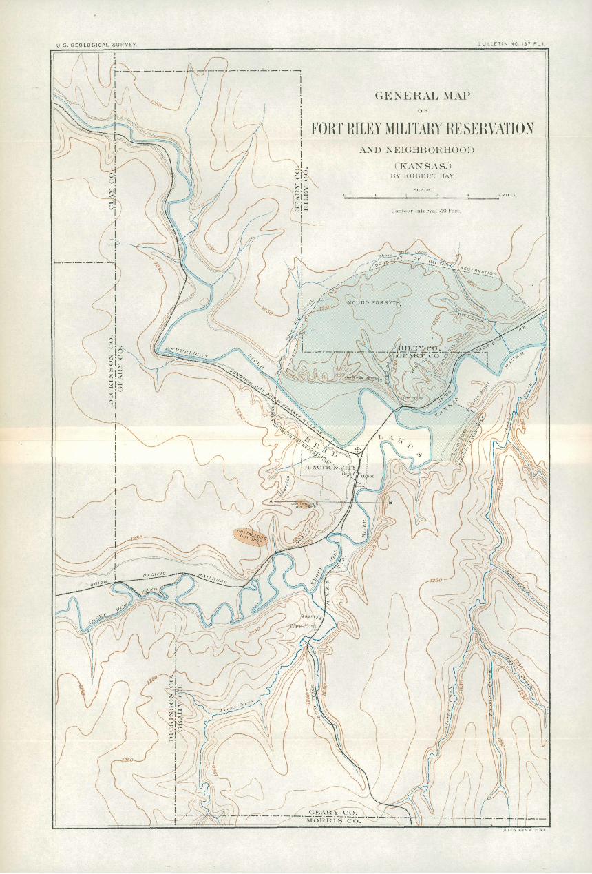
Description of the district. The military reservation at Fort Eiley, Kans., occupies an area of about 20,000 acres, in Eiley and Geary (formerly Davis) counties. The northern half of its boundary approxi mates an arc of a circle. The southern half may be roughly stated to be the Eepublican and Kansas rivers, which unite at an obtuse angle near Junction City, though a small part of the reservation lies on the right bank of the Kansas Eiver. The area of the reservation was originally larger than at present. The old boundary is indicated on the map (PI. I) by a broken line which passes diagonally through the site of Junction City and incloses bottom lands between the Eepub lican and Smoky Hill rivers. Very near the site of the military post these two rivers come together to form the Kaw or Kansas.2 The
1 This is a posthumous paper. It was written and submitted in the year 1889, but, owing to unavoid able circumstances, has remained unpublished. It was returned to Professor Hay for final revision in February, 1805, and this was probably the last work of -his life, for he died December 14,1895.
Since the preparation of the original manuscript ProfT Charles S. Prosser has made and published sections of the Carboniferous formations of the portion of Kansas discussed in this bulletin, giving paleontologic details of the Port Eiley section. (The Classification of the Upper Paleozoic Rocks of Central Kansas, by Charles S. Prosser: Jour, of Geology, Vol. in, Chicago, 1895.) By com parison of Professor Hay's section with Professor Prosser's classification the correct position of the Fort Riley beds in the Kansas, Carboniferous, and Permian series can be ascertained. According to Prosser the uppermost bed, No. 14 of Professor Hay's Fort Riley section, is probably the base of the Marion formation, the remainder of the section representing the Chase stage of Prosser's Permian section.
Professor Hay was an indefatigable worker and his contributions to the geology of the Kansas and plains region have been of great service. These were of a reconnaissance and introductory character rather than expositions of details, and although future work will greatly refine them, they have been of inestimable service, not only by their additions to our knowledge of the distribution and sequence of the formations of the plains region, but in many cases by reason of the new and original deductions they contain. His work was largely done in face of those obstacles which necessarily confront a scientific worker on the frontiers of knowledge, and his writings largely represent the product of voluntary research.
By a strange fatality, the opportunities for perfected publication of the two chief works of his life were interrupted. Just as the proofs of his report as geologist in charge of the special artesian and underflow investigation, conducted under the auspices of the Agricultural Department, were ready to be placed in his hands in Washington, he was called to his Kansas home to attend the last illness of his wife, who had been a constant and valuable assistant in his researches, and that report went to press without his final revision. It is a singular coincidence that his own death has prevented his seeing the proofs of the present paper. ROBERT T.-HILL.
2 The name Kansas will be hereafter used for this river in this report, in conformity with the ruling of the United States Board on Geographic Names.
11

12 GEOLOGY OF FORT EILEY RESERVATION, KANSAS.
northern part of the reservation is in Eiley County, but the post itself is in that part of it which belongs judicially to Geary County. The region described in the following pages which is outside the reserva tion includes the western half of Geary County and the panhandle comprising Milford Township, in its northwestern corner, with adjacent parts of Clay and Dickinson counties, to the ninety-seventh meridian. The thirty-ninth parallel passes about 6 miles south of the post.
| The geology of the region, with the exception of that jof the Quater nary deposits, is comparatively simple and is typically developed within the limits of the reservation, owing to the very striking features of the topography. With the assistance of the map (PI. I) this topography will be easily described and readily understood.
River system. The topographic feature which first strikes the eye on an inspection of the map is the great fluvial system of the region. The rivers ranking in size as third and fourth in the State of Kansas the Eepublican and the Smoky Bill here, by their confluence, form the Kansas Eiver, the second river of the State. Geary County may appro priately be designated the County of the Three Eivers, for all the streams of the region belong to the Three Eiver system.
Republican Valley. The Eepublican Eiver comes from the northwest through a broad valley in which its stream meanders at a depth of from 8 to 15 feet below the general level of the bottom. The bottom is bounded on both sides by steep bluff's that are in places precipitous. Where their abruptness is not softened by slopes of Quaternary deposits the bluff's show ledges of limestone definitely continuous for miles. These bluffs are mostly over 100 feet high, and are surmounted by slopes that reach back from the valley to double that height, or more. To the traveler coming into the region these bluffs constitute the most imposing feature of the topography. The fronts of the bluffs are broken by the outlets of ravines, which, often formed by the union of several others in the plateau immediately behind, ramify to such an extent as to produce a very broken country for several miles back from the river valley, the ravines and draws being separated by ridges, mounds, and promontories of a pronounced type. This feature is indi cated by the contours of the map, which show that it belongs to the whole region as well as to the Eepublican Valley. The abruptness of the sides of the main valley is more pronounced on the left bank of-the river, but diminishes on either side as we go toward the western limits of the district. This diminution of abruptness is due in nearly all cases to Quaternary deposits which are found buttressed against steep bluffs, making smooth upland at the heads of deep ravines. The river bottom north and northwest of Junction City, about 2 miles wide, is sandy and contains many true, wind-blown dunes. Most of these are now station ary, being covered with vegetation, and their regular arrangement testifies to the prevailingly southern direction of the winds during a long period.
HAY.] - TOPOGRAPHY. 13
SmolcyHill Valley. The topography of the Smoky Hill Valley is very similar to that of the Eepublican, with the distinction that it is the right side of the valley which has the steeper precipices and the more abrupt slopes. The resemblance is marked in the fact that abruptness on both sides sensibly diminishes westward within the limits of the district, and on the least abrupt banks of both rivers there is also a decided diminution at their lowest part, where easy slopes of Quaternary deposits may form a broad plain, as at the site of Junction City. The Smoky Hill has its bed mostly narrower but much deeper than that of the Republican, cutting into the Quaternary from 15 to 50. feet and in places reaching bed-rock.
Union of the valleys. The meeting of the waters of these two streams is at a very narrow part of the valley, not more than 1£ miles wide. The Eepublican, with long, sweeping reaches, has a general southwest erly direction, with the high wall of Sherman Heights to the north, which lower to a long promontory, and the coming in of the Smoky Hill from, the southwest has seemed to force the joint stream around another promontory, on which Fort Eiley is situated, to the northeast. The Kansas, taking a northerly direction, lies in a valley of rather uni form width in this region, being hemmed in by abrupt hills that rise 150 feet directly from the valley, go 50 to 100 feet higher at very short distances back, and are broken into narrow ridges and long promon tories by the valleys of the creeks and ravines immediately behind, as seen in Grant Cliff and Sheridan Bluffs. These ridges are at the same levels as well-defined plateaus seen in the distance beyond, and the most distant views show high prairie table-land nearly 400 feet above the level of the Kansas Valley. The sand dunes of the Kansas and Smoky Hill valleys are not so marked as those in the Eepublican, but the Smoky Hill side of the inesopotamian region has dunes near the high prairie level.
Creek valleys. The topography of the creek valleys is similar to that along the three rivers. There are abrupt bluffs on one side, and nearly level bottoms from a quarter to half a mile wide and smooth Quater nary slopes on the other side. The horizontal limestone ledges show in the steep cliffs like rows of giant teeth or mural defenses of cyclopean dwellers, and on the opposite side they crop out occasionally through the later sediments to attest their presence. On Lyons Creek and on Clark Creek the principal Quaternary deposits are on the west side of the valley, making long, smooth slopes to the western upland. In impor tant tributaries of these streams Otter Creek, Dry Creek, and Hum- boldt Creek the eastern side is the smoother slope, though there are exceptional localities. The meandering of the creeks in their Quater nary beds is as marked as that of the most tortuous of the three rivers, which a reference to the map shows at once is the Smoky Hill. Where the circumvolutions are not so close as in other places, a straight line from the railway station at Junction City to the station at Fort Eiley,
14 GEOLOGY OF FORT RILEY RESERVATION, KANSAS.
a distance but slightly over 3 miles, would cross the Smoky Hill River three times and the Kansas River once. A similar line from the Fort Riley railway station to the northwest corner of Junction City would cross the Republican twice, the Smoky Hill once, and the Kansas once. A straight line can be laid that in 10 miles will cross the Smoky Hill thirteen times.
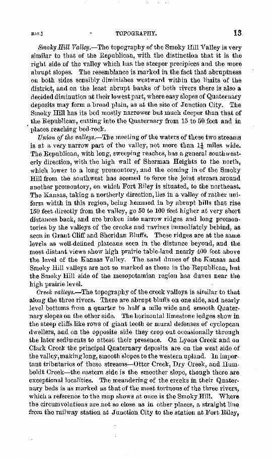
Ruggedness of the topography. The ruggedness of the district is nowhere more conspicuous than on the military reservation, where the headwaters of Three Mile, One Mile, and Four Mile creeks, Deep Dale, and Wild Glen begin in long draws in the upland, creating the phe nomena of a rolling prairie, and then below a certain limestone horizon drop suddenly into deep ravines 75 to 150 feet deep, separated by the ridges and promontories previously described, many not more than a few hundred feet across. This ruggedness is perhaps due to erosion of
FIG. 1. Loess bluffs on the Republican River.
greater activity than now exists anywhere in the region of the Great Plains. The evidence is here decided that this configuration represents a period of time preceding the great Ice age.- Some things appear to suggest that this time was immediately pre-Glacial, but one or two facts seem to indicate positively that it was before the mid-Tertiary epoch. But the discussion of these phenomena may properly be deferred to the geological part of this report, with the observation that the ruggedness is still much modified by Quaternary deposits, which would appear to have once smoothed it over entirely. (See fig. 1.)
The Kansas-Neosho watershed. In seeking to make this report as per manently useful as possible, it seemed desirable to go beyond the limit indicated by the map, so as to connect the stratigraphy of the Kansas Valley with that of the Neosho, that correlation might be made of the
HAY.] TOPOGRAPHY. 15
GEAHY CO.
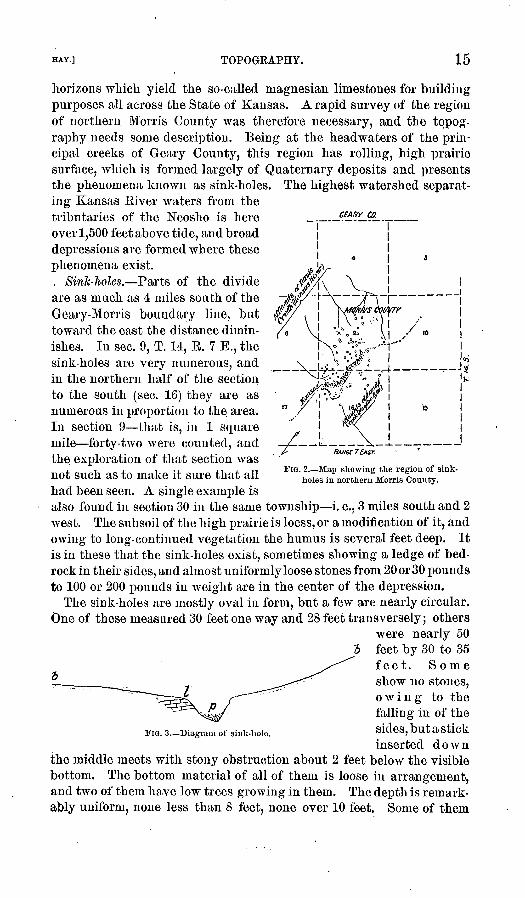
horizons which yield the so-called magnesian limestones for building purposes all across the State of Kansas. A rapid survey of the region of northern Morris County was therefore necessary, and the topog raphy needs some description. Being at the headwaters of the prin cipal creeks of Geary County, this region has rolling, high prairie surface, which is formed largely of Quaternary deposits and presents the phenomena known as sink-holes. The highest watershed separat ing Kansas Biver waters from the tributaries of the Neosho is here over 1,500 feet above tide, and broad depressions are formed where these phenomena exist.
, Sink-holes. Parts of the divide are as much as 4 miles south of the Geary-Morris boundary line, but toward the east the distance dimin ishes. In sec. 9, T. 14, B. 7 E., the sink-holes are very numerous, and in the northern half of the section to the south (sec. 16) they are as numerous in proportion to the. area. In section 9 that is, in 1 square mile forty-two were counted, and the exploration of that section was not such as to make it sure that all had been seen. A single example is also found in section 30 in the same township i. e., 3 miles south and 2 west. The subsoil of the high prairie is loess, or a modification of it, and owing to long-continued vegetation the humus is several feet deep. It is in these that the sink-holes exist, sometimes showing a ledge of bed rock in their sides, and almost uniformly loose stones from 20 or 30 pounds to 100 or 200 pounds in weight are in the center of the depression.
The sink-holes are mostly oval in form, but a few are nearly circular. One of these measured 30 feet one way and 28 feet transversely; others
were nearly 50 feet by 30 to 35 feet. Some
7i ^^-"^ show no stones, owing to the falling in of the
FIG. 3.-Diagram of sink-hole. sides > but a stick
inserted downthe middle meets with stony obstruction about 2 feet below the visible bottom. The bottom material of all of them is loose in arrangement, and two of them have low trees growing in them. The depth is remark ably uniform, none less than 8 feet, none over 10 feet. Some of them
HM6f 7 EAST.
TIG. 2. Map showing the region of sink holes in northern Morris County.

16 GEOLOGY OF FORT RILEY RESERVATION, KANSAS.
are single, but usually there are more than one in a large depression five in one instance, three and two commonly. A few small areas other wise resembling sink-holes have standing water in them. They appa rently are sink-holes in which the mud has become a clay puddle, checking subterranean drainage. The sink-holes proper carry away underground all the water that runs into them.
Neosho Valley. The main valley of the Neosho becomes rapidly deeper at the same horizon which marks that phenomenon in the Three Eivers region, but the ruggedness of the confluent valleys is not nearly so pronounced as in the more northern district.
Typical character of the district. The ruggedness of the Fort Eiley district is typical of a much more extended area stretching across Eiley, Pottawatomie, and Wabaunsee counties, and far to the north. It may be attributed to pre-Glacial erosion, the modification of which may as certainly be attributed everywhere to Glacial and post-Glacial deposits. It was because of this typical character that some details of the topography have been dealt with somewhat more minutely than would be necessary for the treatment of a larger district, and the same is true of the descriptive geology that follows.
GEOLOGY.
PALEOZOIC.
HORIZONTAL POSITION OF THE STRATA.
We have said that the geology is simple, corresponding with.the topography. A prominent feature is the increase in number of deposits westward, new formations coming in above, giving increment of eleva tion in that direction. Its strongest feature, however, is the almost horizontal position of the strata. There is some variation of the dip, but the general dip for the whole region is west-northwest. In parts, however, it is to the southwest, and small folds show a westerly uplift. There seems to be evidence of slight depression toward the stream valleys, indicating small synclines as the basis of the original drainage.
West of Chapman Creek, in Dickinson County, and up the Eepub- lican in Clay County, the flint beds again crop out, showing that there is a north-and-south trough of a syncline of considerable extent and of some depth, but the details have not been made out. The average west by north to northwest dip is probably not more than from 10 to 15 feet to the mile, or 0° 10', but local variations are as much as 3£ in 600, or 0° 25'. One of these to the south and west of One Mile Creek which gives easterly dip is conspicuous in the railway cutting on the river bank at Fort Eiley. This brings into view $ome of the lowest strata in the district, so that on the military reservation may be seen the outcrop of three-fourths of the more than 300 feet of deposits which come to the surface in this region. It is therefore appropriate to name this series the Fort Eiley section. It is as follows:
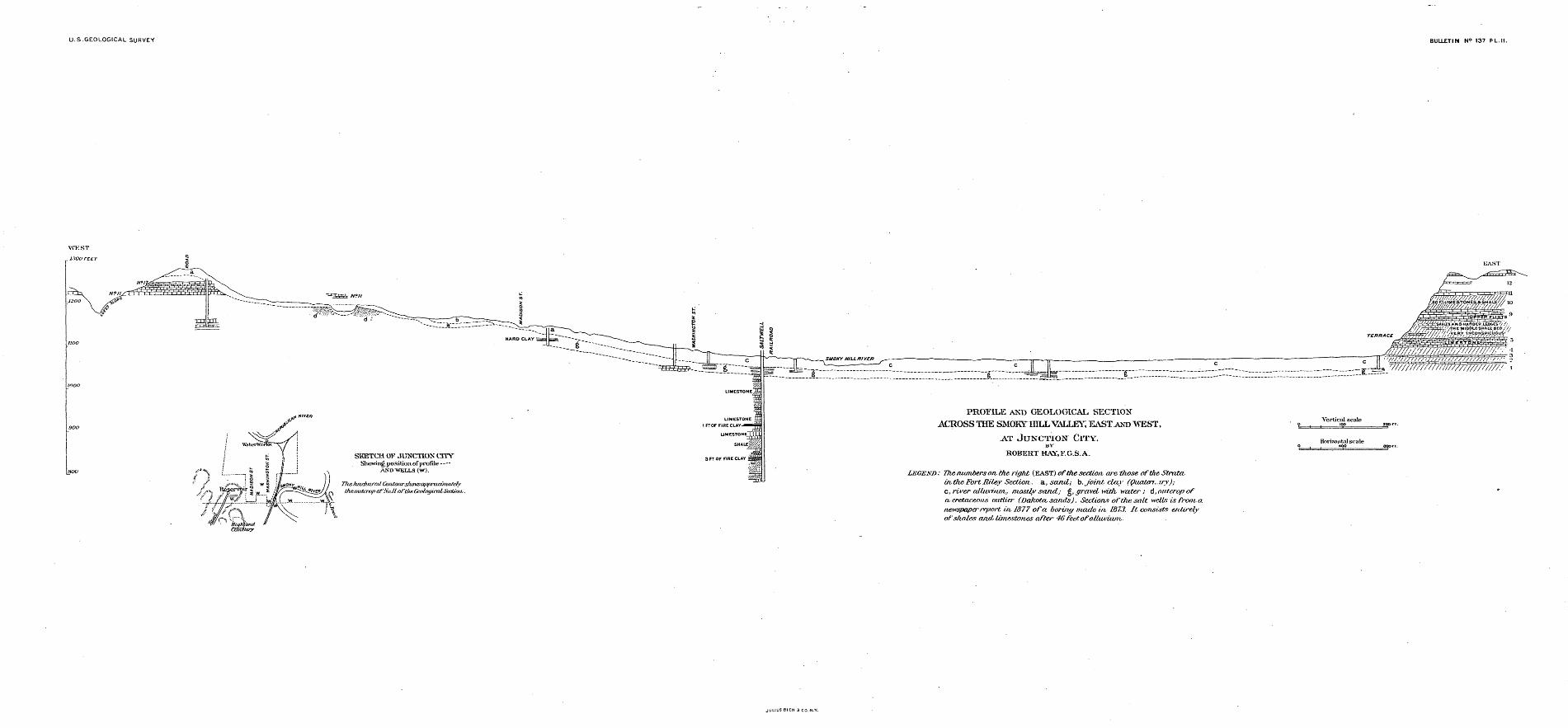
U.S.GEOLOGICAL SURVEY BULLETIN N9 137 PL.II.
SKETCH OF JUNCTION CTTVShowing, po.sition.of profile -
AND'WETVLS (W).
liarJiurKd Contoitrsfumsa/Jfii-admatefy VE5//>v theoutcropofNo.il oftAf.Gcntagi'XilSection,
' '! ^i-Hiffhttmd Cviittay
LEGEND: The-numbers on. the-right (SASTjof the section arc. those oftheStrata- in,(Ji&FortRiley Section., a., sand; b, joint clay (Quaten^iry); c, river alluti.tim,, mostly sand; g, gravel with water; A, outcrop of a, cretaceous outlier (Dakota, sands). Sections of the salt wells is from, a newspaperreport in, 1877 of a. boring mat/.e in, L873. It consists entirely of shales and, limestones after 46 feetofalluA-uwr,.
JULIUS BIEH 3 CO
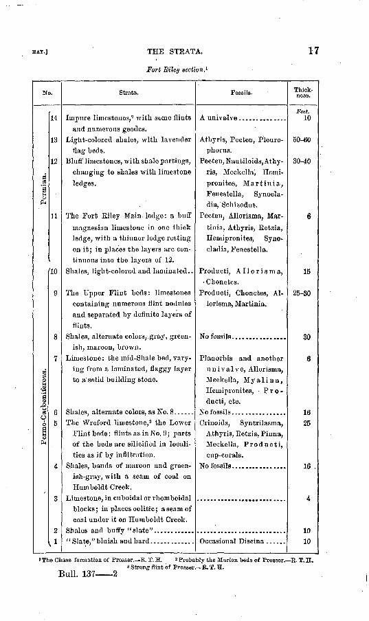
HAT.] THE STEATA.
Fort Riley section. 1
17
N
Permian.
arboniferous.
0 6
|PH
».
14
13
12
11
'10
9
8
7
6
5
4
3
2
'
Strata.
Impure limestones,2 with some flints
and numerous geodes.Light-colored shales, with lavender
flag beds.Blufl' limestones, with shale partings,
changing to shales with limestone
ledges.
The Fort Riley Main ledge: a buff
magneeian limestone in one thickledge, with a thinner ledge resting
on it; in places the layers are con
tinuous into the layers of 12.
Shales, light-colored and laminated..
The Upper Flint beds: limestonescontaining numerous flint nodules
and separated by definite layers of
flints. Shales, alternate colors,. gray, green
ish, maroon, brown.Limestone : the mid-Shale bed, vary
ing from a laminated, flaggy layer
to a solid building stone.
Shales, alternate colors, as No. 8 ......The Wreford limestone,3 the Lower
Flint beds: flints as in No. 9; partsof the beds are silicified in locali
ties as if by infiltration.
Shales, bands of maroon and greenish-gray, with a seam of coal on
Humboldt Creek. Limestone, in cuboidal or rhomboidal
blocks; in places oolitic; a seam of
coal under it on Humboldt Creek. Shales and buffy "slate"...... ......
"Slate," bluish and hard...... .......
Fossils.
A univalve ...... .... ....
Athyris, Pecten, Pleuro-phorus.
Pecten, Nautiloids, Athy
ris, Meekella', Herni-
pronites, Marti nia, Fenestella, Synod a- dia, 'Schizodus.
Pecten, Allorisma, Mar-tinia, Athyris, Eetzia,Heniipronites, Syiio-
cladia, Feuestella.
Producti , Allorisma,.' Chonetes.
Producti, Chonetes, Al
lorisma, Martinia.
Planorbis and another
univalve, Allorisma,
Meekella, Myalina, Heniipronites, Pro
ducti, etc.
No fossils.... ............Criuoids, Syntrilasma,
Athyris, Eetzia, Pinna,Meekella, Producti,cup-corals.
Occasional Discina ......
Thick ness.
Feet. 10
50-60
30^0
6
15
25-30
30
6
1625
16 .
4
1010
»The Chase formation of Prosser. R. T. H. « Probably the Marion beds of Prosser. R. T. H. 3 Strong flint of Prosser. R. T. H.
Bull. 137 2
18 GEOLOGY OF FORT RILEY RESERVATION, KANSAS.
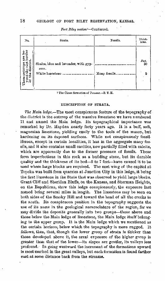
Fort Riley section 1 Continued.
No.
is are be st border
ict.
2'S|o o> £ *= jg 'o2^ ®°13A® a *>£§<HA ^° H
. Strata.
sum.
Fossils. Thick ness.
Feet. 30
5
» The Chase formation of Prosser. R. T. H.
DESCRIPTION OP STRATA.
The Main ledge. The most conspicuous feature of the topography of the district is the outcrop of the massive limestone we have numbered 11 and named the Main ledge. Its topographical importance was remarked by Dr. Hayden nearly forty years ago. It is a buff, soft, magnesian limestone, yielding easily to the tools of the mason, but hardening on its exposed surfaces. While not conspicuously fossil- iferous, except in certain localities, it has in the aggregate many fos sils, and it also contains small cavities, now partially filled with calcite, which are apparently due to the former presence of fossils. These form imperfections in this rock as a building stone, but its durable quality and the thickness of its bed 5 to 7 feet have caused it to be used where large blocks are required. The east wing of the capitol at Topeka was built from quarries at Junction City in this ledge, it being the first limestone in the State that was observed to yield large blocks. Grant Cliff and Sheridan Bluffs, on the Kansas, and Sherman Heights, on the Eepublican, show this ledge conspicuously, the exposure last named being several miles in length. The limestone may be seen on both sides of the Smoky Hill and toward the head of all the creeks to the south. Its conspicuous position in the topography suggests the use of its name in the geological nomenclature of the region, for we may divide the deposits generally into two groups those above and those below the Main ledge of limestone, the Main ledge itself belong ing to the upper group. It is the Main ledge which we mentioned as the certain horizon, below which the topography is more rugged. It follows, then, that, though the lower group of strata is thicker than those developed above it, the areal exposure of the higher group is greater than that of the lower its slopes are gentler, its valleys less profound. In going westward the increment of the formations upward is most marked in the great valleys, but each formation is found farther east at some distance back from the streams.
U. 8. GEOLOGICAL SURVEY BULLETIN NO. 137 PL.
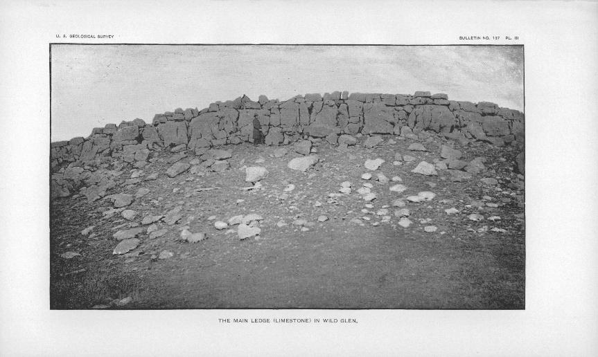
THE MAIN LEDGE (LIMESTONE) IN WILD GLEN.
HAY.] PALEOZOIC. 19
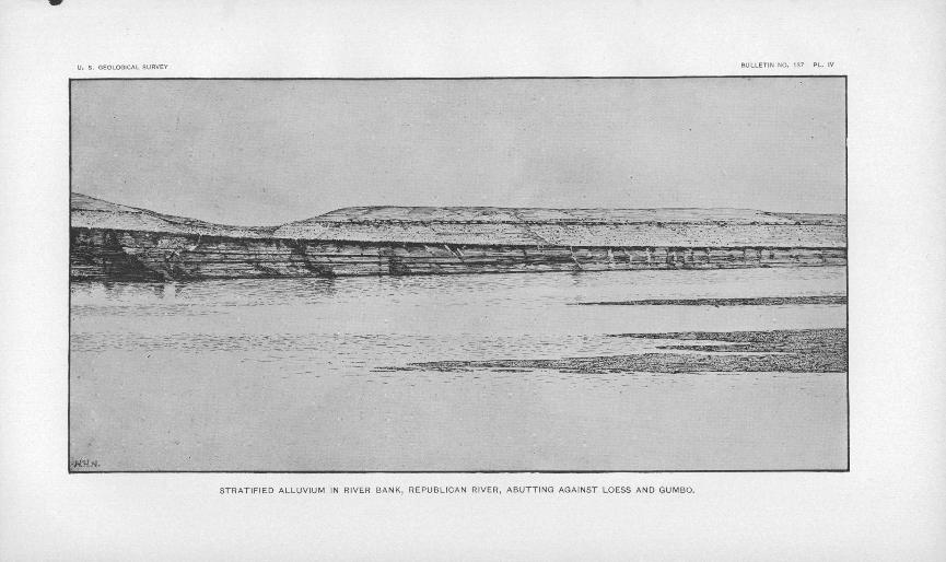
The first appearance of the Main ledge in the Sheridan Bluffs in the Kansas Valley is just below the old town-site of Pawnee. Plate III is a view of a typical exposure, showing also the stratum next above it. The view of Sherman Heights shows its position in the Eepublicau Valley with 100 feet of other strata resting on it (see PI. IV). It has very little areal exposure anywhere in the region, the largest areas being farther east and south of the river. Besides being conspicuous in the topography and stratigraphy of the region, the Main ledge seems to have paleontologic importance. It appears to be the upper limit of the Productidse. On the south line of Geary County we have found specimens of Productus semlreticulatus lying loose on the Main ledge, but in no other place have we found Producti above the shaly material at the base of that stratum. The specimen referred to might have been transported from a horizon only a few feet lower geologically and at a decidedly greater altitude only a few miles away.
It will be convenient to speak of this as the Main ledge, while its identity for comparison with other work in the State will be best estab lished by its number (11) in the Fort Eiley section.
The Quarry beds. The beds immediately above the Main ledge may be spoken of as the Quarry beds. Throughout all the region they yield good building stone, easy to work and of soft, warm tint, in layers from 6 to 18 inches thick, of jointed structure, which give masses 6 to 12 feet long and 3 to 5 feet wide. The shale partings thicken in places to shale beds several feet thick, and the stone changes to shaly flags with rhomboidal fracture, passing upward sometimes into a lavender shale of the hard kind, locally called slate, or into massive beds with hydraulic properties, as at Milford. These beds may be altogether 50 feet thick, above which shales predominate, with occasional ledges of stone, of which only the highest is numbered, and which attains the thickness assigned to it in the section only west of the ninety-seventh meridian, somewhat beyond the limits of the district. The geodes in this bed (No. 14), which is developed in force on Chapman Creek (11 miles west of Junction City), and also south of the Smoky Hill at the same meridian, are accompanied by cherty nodules, which are the source of the flinty (cherty) gravels occasionally found above the Main ledge.
The Mint beds. The two series of Flint beds, Kos. 5 and 9 of the sec tion, form a quite important part of the stratigraphy of the region and of much of the country to the east and south. The name flint is used designedly. The material appears to be much more siliceous than the chert of southeastern Kansas and Missouri. It appears undistinguish- able from the flints of the Cretaceous formations of England. The greater part of the beds consists of limestone, through which the flint is scattered in globular, ellipsoidal, and irregular nodules, with one or two bauds of black and white near their surfaces. Besides the irregu larly disposed nodules, there are flint layers 3 to 12. inches thick
20 GEOLOGY OF FORT RILEY RESERVATION, KANSAS.
between the limestone layers. Fig. 4 is a section on the Neosho in Morris County, which shows a little more than the average amount of flint farther north.
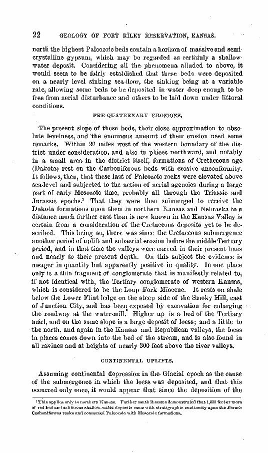
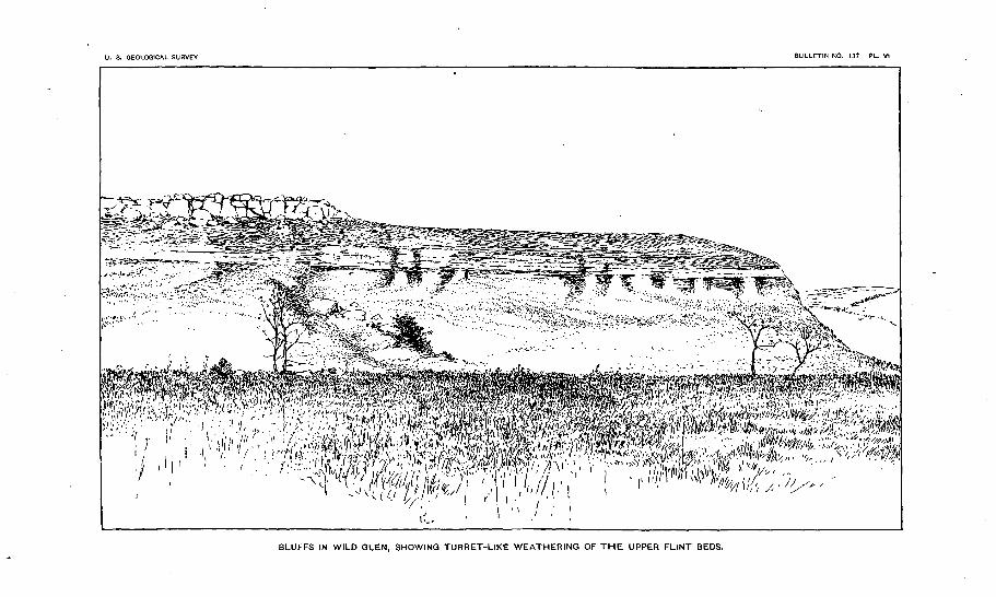
The presence of the flint serves to give a hardness to these beds, which, however, does not hinder their disintegration; for, under the influence of frost the flints themselves split into many fragments, with conchoidal, splintery, and smooth fracture; but under certain condi tions of exposure the broken flints acquire a vitreous surface and cease to break, and so form surfaces that slowly acquire a sedentary soil. Both series of flint beds, and also the Main ledge, frequently form vertical exposures, while through the wearing away of the shales beneath they overhang and topple over in large masses. On some faces there is a turret-like weathering which is peculiar (see PI. Y).
The.mid-Shale bed. The bed No. 7 in the section is very variable in structure. In some places it is only a laminated shale with vertical
fracture, in others it is a flaggyshale with one or two layers of real
FLINTS flags, and again it becomes a corn-£LIMESTONE ,\. , -i. *n f v. -n- v pact limestone suitable for building
purposes and massive through its whole thickness. In Eagle Ravine, southwest from Junction City, this bed there 3 feet thick is occa sionally oolitic.
The shales. The colored shales, Nos. 6 and 8, are not variegated, but are beds of different colors alter-
Some are purplish-brown,Fm. 4. Section of the Lower Fliiit beds south of Parkersville,Morris County, showing the layers others green, and SOUie red-brown, of flint in the limestone. each ^^ varying Qn exposure.
The bauds are from 3 inches to 2 feet in thickness, and the gray-greens exceed that. One of the red bauds seems to be of the texture for min eral paint. There are con spicuous outcrops, vertical exposures, of parts of these beds at the water-mill on the Smoky Hill, at Fort Riley rail way cut, and at other places. Shales that occur below these beds are mostly lavender or greenish, and those above the Main ledge are Avith few exceptions the same. "Where the shales have areal development they form a cold, intractable subsoil, which, hoAvever, has by long- continued growth of vegetation become in places a fertile humus.
The strata thus briefly described belong to the later part of the Carboniferous epoch. They are nearly at the top of Kansas Paleo- zoics. They have a facies, in the limestone, that is not found east of Manhattan in the Kansas Valley, but which appears at correspond ing positions farther north and south. This may be called the Permian facies. The limestones of the Coal Measures to the east are harder and rougher, and rarely have the milky or buff hue that prevails here. With the possible exception already mentioned, the "Producti are not
U. S. GEOLOGICAL SURVE IULLET1N NO. 137 PL. IV
^^T^^T^^
STRATIFIED ALLUVIUM IN RIVER BANK, REPUBLICAN RIVER, ABUTTING AGAINST LOESS AND GUMBO.

21
found in the higher beds. But without reference to the paleontology, there is a lithological reason for distinguishing these from the Coal Measures horizons which outcrop to the east. And yet Coal Measures characteristics-come up into these beds. On Humboldt Creek, just at the eastern limit of the district, in lower shales, is a seam of coal 12 inches thick, and a few miles away is another at a slightly higher hori zon. It is not of good quality, and is at probably the highest horizon in the west. The blue slate, No. 1 of the section, is similar to beds at much lower horizons, and contains occasional Discinoe. The term Permo-Carboniferous, though cumbrous, seems fully justified for the series below the Main ledge, while ISTos. 11 to 14 might properly be called Permian. There is no break in the succession of the strata from the Coal Measures below.
Gypsum. Below the beds of this section, in shales which preceded them, there is a gypsiferous horizon, revealed in wells. It is found on Clarks Creek, in Junction City, and on the military reservation. The gypsum occurs as satin-spar from half an inch to 2 inches thick, and in thicker, seinitrauslucent, crystalline masses. The exact horizon of the gypsum has not been made out, but there may be more than one, or it may be distributed all through a thick bed of shale the miner's soap- stone. At a still greater depth strong salt brine was reached some years ago in a deep well at Junction City.
LITTORAL AND SHALLOW-WATER CONDITIONS OF DEPOSITION.
The strata described above, of various texture, suggest diversity of origin. Occasionally the flaggy layers show ripple-marks, and there are univalves among the fauna that suggest a shallow sea. The higher beds also have abundance of Pecten, and, outside the district, a small Pleurophorus, that testify to the same fact. On the other hand, the uniform thickness of some of the limestones, their fine grain, and the still finer grain of some of the shales, suggest deposition in deeper water. There is no extended sheet of faunal remains like the enormous shell beds of the Cretaceous epoch or "the coral reefs of the mouutain limestone, which indicate uniform and moderate depths over great areas. Yet, there is one horizon that perhaps suggests littoral conditions for the time of its deposit. This is the horizon of the Upper Flint beds (No. 9). Apparently, this is the most persistently fossiliferous horizon. There are numerous Product]. One bed, less limy than the others and without flints, has Producti all crushed and Hemipronites in fragments. In the thicker beds the shells are less numerous, but they are not dis torted. Again, fossils having the internal structure of Producti are more numerous in these flints than anywhere else, so far as known to the writer. Synocladia and Fenestella are found both in the Flint beds and above. The 'Lower Flint beds (No. 5) show similar conditions, while the fossils of No. 7 are allied in the predominance of lamellibranchs to the beds above the Main ledge (Nos. 12 and 13). Farther west and
22 GEOLOGY OF FORT RILEY RESERVATION,
north the highest Paleozoic beds contain a horizon of massive and semi- crystalline gypsum, which may be regarded as certainly a shallow- water deposit. Considering all the phenomena alluded to above, it would seem to be fairly established that these beds were deposited on a nearly level sinking sea-lioor, the sinking being at a variable rate, allowing some beds to be deposited in water deep enough to be free from aerial disturbance and others to be laid down under littoral conditions.
PEE- QUATERNARY EROSIONS.
The present slope of these beds, their close approximation to abso lute levelness, and the enormous amount of their erosion need some remarks. Within 20 miles west of the western boundary of the dis trict under consideration, and also in places northward, and notably in a small area in the district itself, formations of Cretaceous age (Dakota) rest on the Carboniferous beds with erosive unconformity. It follows, then, that these last of Paleozoic rocks were elevated above sea-level and subjected to the action of aerial agencies during a large part of early Mesozoic time, probably all through the Triassic and Jurassic epochs.1 That they were then submerged to receive the Dakota formations upon them in northern Kansas and Nebraska to a distance much farther east than is now known in the Kansas Valley is certain from a consideration of the Cretaceous deposits yet to be de scribed. This being so, there was since the Cretaceous submergence another period of uplift and subaerial erosion before the middle Tertiary period, and in that time the valleys were carved in their present lines and nearly to their present depth. On this subject the evidence is meager in quantity but apparently positive in quality. In one place only is a thin fragment of conglomerate that is manifestly related to, if not identical with, the Tertiary conglomerate of western Kansas, which is considered to be the Loup Fork Miocene. It rests on shale below the Lower Flint ledge on the steep side of the Smoky Hill, east of Junction City, and has been exposed by excavation for enlarging the roadway at the water-mill. Higher up is a bed of the Tertiary marl, and on the same slope is a large deposit of loess; and a little to the north, and again in the Kansas and Eepublican valleys, the loess in places comes down into the bed of the stream, and is also found in all ravines and at heights of nearly 300 feet above the river valleys.
CONTINENTAL UPLIFTS.
Assuming continental depression in the Glacial epoch as the cause of the submergence in which the loess was deposited, and that this occurred only once, it would appear that since the deposition of the
1 This applies only to northern Kansas. Farther south it seems demonstrated that 1,000 feet or more of red-bed and saliferous shallow-water deposits came with stratigrapluc continuity upon the Permo- Carboniferous rocks and connected Paleozoic with Mesozoic formations.
U. S. GEOLOGICAL SURVEY BULLETIN NO. 137 PL, V
QUARRIES ON THE MILITARY RESERVATION ABOVE THE MAIN LEDGE.

HAT.] CRETACEOUS. 23\
Permo-Carboniferous strata there have been three periods of uplift and two of depression of the entire area. It would also appear that this upper Kansas Valley region has in these oscillations of level been very gently dealt with. Carboniferous strata in southeastern Kansas show a few faults; Cretaceous strata in the northwest are similarly broken; but the writer has seen no rupture of stratification in any part of the region under discussion. The folds indicated in places by the different dips on the opposite sides of the great valleys, and the greatest dips seen in a few short sections, are so small as to excite wonder that so many changes of level, aggregating a total of thousands of feet, should have been accomplished with so little disturbance of the strata. It has been remarked above that the slight average dip of 10 to 15 feet to the mile is to the north of west, and as farther east the-dip is increased, it may be assumed that it is connected with the Ozark uplift, and any elevation in Tertiary times that may have affected this region as theKocky Mountain uplift only decreased and did not obliterate the westerly dip. The most noticeable dip of the region, an easterly one, is seen in the railway cut at Fort Eiley, and a short fold is seen in the Main ledge near the confluence of Otter and Lyons creeks, on the east side of the valley. Similar short folds are suggested rather than seen in the position of the ledges on the sides of rocky gullies where the harder beds are partially eroded.
CRETACEOUS.
Allusion to the existence of fragments of Cretaceous (Dakota) and Tertiary deposits has already been made. Some of the former are so very small mere patches of gravel composed of nodules from the fer ruginous sandstones that they are not indicated on the map (PI. I). One of them is in the roadway on the hilltop near the Catholic ceme tery, southwest of Junction City. Six or seven miles west of this point masses of the dark-brown sandstones have been turned up by the plow. A more recent examination of the high-level sand dunes previously referred to revealed the fact that they are residual beds, resting on and abutting against undoubted outliers of the Dakota. In sec. 21, T. 12, E. 5 E., are two small areas of the rough sandstones in situ, both on slopes of rather deep draws, but where tall bunch grasses and blue-stem hide the rock from observation unless one actually walks on them. On neighboring parts of sections 16 and 17 the soft sandstone developed 20 miles to the northwest, on the Clay-Dickinson county line, is shown in round-topped mounds or promontories, having their elongations from north to south and their free ends to the south. All these are in a hollow of the Permian formations, the limestones outcropping at higher levels to the east. The incoherent sandstone has been preserved in situ by the amount of its own d6bris lying on its sides, now covered with vegetation, and to the north some of the wind-blown sand rests on Permian strata. For several miles west the
24 GEOLOGY OF FORT EILEY RESERVATION, KANSAS.
soil is entirely arenaceous, and is undoubtedly sedentary on the sand stones of which it is the d6bris. This discovery of an area of several square miles of an outlier of the Dakota on the north side of the Smoky Hill so far east, has suggested that a univalve obtained in an arena ceous limestone on the top of the hills on the south side of the river may be Turritella from a Mesozoic rock, but opportunity has not been had to verify this suggestion, as the fossil is not now in my possession.
TERTIARY.
At the junction of the two rivers, near the military post, the beds of the streams contain gravel composed largely of pebbles of igneous rock that make up the Tertiary conglomerate of western Kansas and the neighboring parts of Colorado and Nebraska. Under the alluvium of the Eepublican Valley, about a quarter of a mile from the river, the new wells supplying water to the fort obtain it from a gravel of the same material. These, like patches of Dakota d6bris embedded in the Quaternary, are manifestly the results of the erosive and trans porting power of the great rivers. But a patch of gravel with a hard layer of cemented concrete at the bottom, lying within this area, east of the ninety-seventh meridian, seems to be a fragment of the Tertiary grit of the West, in situ. It is more than 30 miles farther east than the most easterly extension of this formation hitherto noted in Kansas. In this case most of the pebbles are subangular ones, of the Flint beds of the district, with a vitreous surface, but running through the patch is a large quantity of quartz pebbles well rounded and small, with some feldspar in a limy matrix, which holds parts of it as a firm con glomerate, and there are also chalk pebbles and the hard chalk nodules characteristic of the Tertiary " mortar beds." The deposit rests on the banded shales (No. 4 of the section) below the Lower Flint beds, and is within 30 feet of the bottom of the present river bed, here cutting bed rock. It is possible that the deposit is not actually of Miocene age, but it is certainly pre-loess, for a typical deposit of the loess rests upon it, and near to it and above not above the loess is a bed more resem bling the Tertiary (Pliocene) marl of the West than it does the loess near to it.
QUATERNARY.
Moraines. Less than 20 miles from the northeastern limit of the district under consideration what seems to be a terminal moraine of the Ice age exists on the top of Carboniferous bluffs overlooking the Kansas Valley below St. George. It is in the shape of a large deposit of bowlders, mostly of the red quartzite so common in northeastern Kansas and western Iowa. There is also on the south side of the Kansas Biver, southeast from St. George, a magnificent development of terminal moraine. It is the southwest corner of ice-land. The trough of the Blue Eiver and the pass over the divide which the Eock
U. S. GEOLOGICAL SURVEY BULLETIN NO. 137 PL. VI
"' " " - '"' >:'^"h ^
" ;:"i'>"y£~'*.:>iwr.;;?*^ *:> "_,r/:?-"'-'" * ' '' l\i (' ti " ("(i p«if-'"''W 1'
%ww^' /̂;̂ '^^4(/l/a^fc., - " -r^-ir.^:;r'*-i*-i'Si«wi
BLUFFS IN WILD GLEN, SHOWING TURRET-LIKE WEATHERING OF THE UPPER FLINT BEDS.

HAT.] QUATERNARY. 25 -XM . .Island Eailway uses from the Kansas Yalley to Mill Creek were prob ably cut or largely deepened by the waters running around the ice front which here dammed the Kansas. If the ice was 500 or 600 feet thick it would be sufficient, without assuming continental depression, to send the loess-bearing waters to the top of the Kansas-Neosho divide on the Morris County boundary, where loess is found in quantity. With depression in the ice region the ice would have been thicker. In the Fort Eiley district, here treated of, are no such .deposits of bowlders, but the eastern limit of this investigation is only 20 miles from the region where the bowlder-laden ice had its front. It appears to be demonstrable that the loess of this district is a deposit of the true Glacial age from the water of the great rivers of the North deflected around the ice front and reinforced by the rivers on and under the ice sheet.
Occasional bowlders. A phenomenon of the entire period when the region was submerged in the cold sea, during both the advance and the retreat of the ice, would be the occasional floating off of bergs contain ing bowlders and the melting out of their load at distances from the usual termini of the ice. The positions of bowlders in loess well within the true ice region in northern Kansas admits of no other explanation, and when bowlders are found beyond the known limits of the ice, it appears certain that this dropping from wandering bergs is the true source of the erratics. Three bowlders have been obtained in the Fort Eiley district. The smallest is 2£ pounds in weight, the largest about 10 pounds. The two smaller ones are the red quartzite; the largest is a pink granite. The smallest was obtained on Three Mile Creek, on upland prairie, in the sod; the second was obtained in loess on the right bank of the Smoky Hill, east of Junction City; and the granite was found in the loess excavated for the sewer at Fort Eiley. These testify to the presence of ice in the district, however small the quantity. The comparative rarity of them in a westerly direction from the ice front indicates that the trend of the,water currents was to the south east. On a hill 6 miles south of Junction City, on the west of Lyons Creek, a surface layer of limestone has deep, definite grooves on its weathered surfaces. Similar marks are seen in a few other localities under the same conditions of exposure. They are not distinctly ice strias, like those in the glacial regions around the Great Lakes, and till further research is made it may be prudent to doubt their glacial origin. Should it be eventually decided that they are glacial strias, it would be proper to attribute them to the action of bergs grinding their way across the ridges on which these marks are situated. The marks have weathered edges, and if it be true that the ice of Kansas was of the first period, before the inter-glacial amelioration, it would be wonderful that any striaB should survive the weathering agencies of so long a time, and those not actually obliterated would naturally have such blurred edges as to suggest doubt concerning their origin. Such, is the
26 GEOLOGY OF FORT EILEY RESERVATION, KANSAS.
condition of these marks, and the writer has for a long time rejected any suggestion that they may be glacial, but it would appear to be proper to put on record the fact that the marks exist. 1 '
Loess of two periods. The presence in loess deposits of bowlders more or less angular, such as the three mentioned above, seems demon strative of the fact that the loess and the ice are of the same age. The ice being assumed to be that of the first Glacial epoch, it follows that the loess is also of that age. Professor McGee and others are of the opinion that the loess of the Missouri Valley and of parts of the Kan sas Valley is of the second Glacial period. Within the limits of this investigation, and notably on the military reservation, there are decided differences in deposits which the observer, considering each separately, regards as loess. Some of these differences seem explicable by assum ing modification of a deposit in situ by saturation and disturbance by floods of comparatively recent date, or even by ordinary percolation of meteoric waters. That some beds of loess have been so modified is manifest in railway cuts and other vertical sections, but such influences cease a few feet below the surface. But there are places where vertical sections show that an entire deposit is different from another close to it and which must have been subjected to the same influences in recent times. An example of this is seen near the mouth of One Mile Creek, where there are two bluffs fronting the river, each cut by the railway to the same depth. One is of bright-orange color and arenaceous in texture; the other is more argillaceous and of decidedly duller hue. It would seem that we have here loess of both the earlier and the later epochs together. The relative age can not here be made out by super position, but the totality of the evidence in the district is that the brighter-colored loess is the older deposit. Of this bright-colored loess there is an abundance all through the region, from the lowest stream beds to the highest plateaus. In the more westerly part of the region, besides having streaks of gravel of the local Carboniferous limestones it has streaks and patches of the unmistakable detritus of the Dakota sandstones, and it would seem that that formation is, by degradation, the source of the coloring matter of the loess, as farther south the Triassic "red beds " have colored the loess of large areas.
Description of sinJc-holes. In connection with the fact that the loess is found on the plateaus, it is well to recur to a consideration of the structure of the sink-holes which have been referred to in the topo graphical description. The structure of these depressions is fully revealed in the single one in section 30. It is just off the line of a "draw," in what seems to be the course of a branch draw which has an earthwork dam across it. This makes a little basin, in the middle of which is the sink-hole. This basin is about 150 feet in diame ter, and the sink-hole is about one-fifth of that. On one side of the
The marks on Lyons Creek were brought to the writer's notice by Mr. E. McCarthy, county com missioner of Geary County, on whose laud they are, and who for years has considered them as certainly of glacial origin.
QUATERNARY. 27
sink-hole, jast at the top, a ledge of rock crops out, and in the bottom are many loose rocks. The diagram on page 15 (fig. 3) illustrates it.
A few rods down the main draw the principal ledge of rocks (No. 11 of the section) shows itself in the descent to the Neosho. The ravine here is filled with alluvium from t the upland, and is so wide between the exposures of the Main ledge as to suggest that before the alluvial filling it had been cut down to other rocks, the Upper Flints, or lower still. The bottom of -the sink-hole is only a few feet above the Main ledge, and the suggestion is that under it the Main ledge is cut away, and that the under-draiuage is in d6bris of that and the Flint beds; or it is not necessary to assume that the Flint beds were eroded out, but simply that they were cracked and the shale partings worn where the surface was exposed. The great group of sink-holes lie much higher than this one, and the rocky debris in them is probably of beds higher than the Main ledge. The appearance of the nearest outcrop to the north suggests that IsTo. 14 is here below the level of the sink-holes. Deep road ruts and plowed slopes show that this high Kansas-lSeosho watershed is covered with loess from 5 to 15 feet thick. The under- drainage is in d6bris and broken surfaces of the upper Permo-Carbou- iferous rocks. The Kansas-Neosho divide in pre-loess times was very narrow, with rocky gorges on each side to the very top, and the filling of all these with loess high above the former ridge, to a height of which the present residue is over 1,500 feet, provided the conditions for the sink-holes, owing to the semicavernous character of the rocky debris underlying the loess.
It may be stated that 10 miles farther south there is another series of sink-holes, farther outside the true glacial area, and others again 70 miles to the north which are well within the region of undoubted glacial phenomena.
Late Tertiary and early Quaternary contemporaneous. On the western borders of this district, and to a greater extent beyond the ninety- seventh meridian, there are beds which, by their color more inclined to buff than orange their calcareous composition, and the presence of cal careous nodules, seem to be formed by a mingling of the loess and the materials of the Tertiary marl (Pliocene) of the Western plains, and a few fragments are certainly remnants in situ of that deposit. The jux taposition of these deposits suggests, as has been noted by others, that the so-called late Tertiaries of the West were contemporaneous with the so-called first Quaternaries. A full examination of the superficial deposits in eastern-central Kansas will reveal much on this subject.
LATE QUATERNARY.
Gumbo. The valleys of the great rivers contain recent alluvium, as do also the creek valleys. There is one alluvial deposit having a large areal development that requires some notice. Its position on the site of Junction City is shown in the profile (PI. II). It must be considered
28 GEOLOGY OF FORT RILBY RESERVATION, KANSAS.
a lake silt, which was deposited when the valleys were still flooded from bluff to bluff. .It is known locally as gumbo, joint clay, and hard- pan, though it is not the well-known waxy hard-pan of the true glacial region. The second name is descriptive, as in drying it breaks with subcuboidal fracture, and it is a clay of a dull-brown hue. It overlies the loess on the Junction City site and elsewhere, and it underlies the sandy alluvium of the great valleys and some of the smaller ones. It represents conditions of deposition that exist now only at long inter vals, .when floods leave muddy waters to deposit their fine sediment in old creek and river beds. When the gumbo was laid down there must have been wide expanses of quiet waters over great valley areas. It probably had its origin when the. lake waters were, on their margins, eroding the clay-shales, both within this region and far to the west among the Cretaceous formations. It is of very tenaceous texture, and is very hard. Floods that wash its surface scarcely erode it, and its pebbles will roll for great distances in the streams. Its thickness varies from a few inches to several feet. It has a fairly even surface, conforming in a general way to the trend of the valley bottoms. Where a comparatively small amount of sand lies over it there are pools of standing water, as among the sand hills of the river bottoms. A like deposit is accompanied by similar phenomena in the Arkansas Valley of southwest Kansas.
River alluvium; sand dunes. The recent alluvium of the rivers not that now being deposited on their flood-plains is in many parts very thick, in some places exceeding 20 feet. It is cut everywhere into steep, often vertical banks, and is marked by stripes of black humus showing the various levels at which, as a flood-plain, it supported veg etation till covered by a new deposit from the overflowing waters of the river. The thickness of the deposit shows the great length of time during which the present conditions have existed, but there is no standard by which this can be measured in years. In places it rests on the loess, in others on the gumbo,.and in a very few on the rocks or shales of the region. At its bottom in many places is the gravel formed of the debris of the Tertiary conglomerate of the West. The alluvium itself is mostly a fine-grained sand of quartz particles, minute and round, with argillaceous and calcareous cement formed from the degradation of the Cretaceous and Tertiary formations of the West. When exposed to the winds it is blown into dunes, but owing to the rapidity with which vegetation takes hold, there are few areas of naked sand.
Baselevels. The Smoky Hill Eiver is cutting into the bottom of its bed at one or two points only. At no place in this region is either the Republican or the Kansas making its channel deeper. The rivers have reached a baselevel of operations and are now-cutting only laterally. The bottoms have distinct benches, but the highest are formed of the gumbo and the loess, though occasionally there is alluvium on them.

U. S. GEOLOGICAL SURVEY BULLETIN NO. 137 PL. VII
RED BLUFFS (.LOESS), SMOKY HILL RIVER, SOUTH BY EAST FROM FORT RILEY.
HAT.] CLIMATE. 29
CLIMATIC CHANGES.
From the statements already made as to the position of the loess at the bottom of the great valley and of the small ravines, it follows that these valleys, both large and small, were eroded ont to more than their present depth before the Glacial epoch. It would appear, then, that since the withdrawal of the glacial waters by elevation of the land the precipitation of the region has not been sufficient, with the elevation, to wash out the glacial deposits. Again, there are numerous ravines in this region not more, some less, than a quarter of a mile wide and nearly 200 feet deep, and abruptly terminating with a length of from half a mile to 2 miles. This would point to a period of climatic condi tions different from the present perhaps not a long one in which pre cipitation was much greater and the erosive forces were much stronger than now. This period was pre-Glacial, Was it also mid-Tertiary, or pre-Tertiary, or both 1? The single fragment of Miocene grit seen in the Smoky Hill Yalley would suggest that to the depth at which, it lay within 30 or 35 feet of the very bottom of the erosion the great valleys had previous to that age been cut out; that is, that more than three- fourths of the erosion was cut out in pre-Miocene time. Or, if the conditions of the grit as a littoral deposit connected with the Rocky Mountain uplift made this eastern part of it contemporary with later Tertiary time, still the erosion before must have been down to this depth.
From the present evidence it is not possible to say whether all the side ravines and creek valleys were eroded to the same depth at that time. Fragments of the Tertiary marl at no great distance suggest pre-Pliocene erosion, such as occurred in western Kansas. The absence of early Mesozoic formations and unconformity of the Dakota on the Penno-Carboniferous also suggest a pre-Oretaceous period of erosion. It might be, then, that, even with all these opportunites of the ages, the tooth "of time had gnawed but slowly into the solid body of the land until it reached its immediate pre-Glacial state. There is, however, an appearance about the ravines and creek valleys of this region that seems positively to indicate rapid erosion under conditions of great precipitation. We incline to the opinion, with some reserve, that the greater lines of erosion were cut mainly in the early Tertiary period, but that the erosive forces were at their maximum in the age imme diately preceding the Glacial epoch, and that they were mainly attrib utable to two conditions decreasing temperature and increased precipitation.
The presence of much Dakota material in this western loess would indicate great erosion of those Cretaceous formations in the loess- forming age; and the upper beds of the Permian mostly shales and soft limestones must have suffered much erosion in the same period and in that immediately preceding, the high prairie elevations being reduced rather than the valleys deepened. These remarks are partially
30 GEOLOGY OF FORT RILEY RESERVATION, KANSAS.
suggested by conditions prevailing outside the limits of the district under discussion, but the conditions within the region are all in con sonance therewith.
CORRELATION OF DIFFERENT REGIONS.
Probably the most valuable part of this report is the definite identi fication of the various strata of the Fort Eiley section over the greater part of the area shown on the map. And with this must go the addi tional fact that the main features of the section, which may be cited as Nos. 5, 9, and 11 the Lower and Upper Flint beds and the Main ledge have been identified miles away, over the divide in the Feosho Valley. Whether there is a thickening or a thinning of these strata there, or of the intervening shales, has not been worked out, but with these landmarks plainly made out the way is open to complete cor relation with the strata of the Neosho Valley and of its affluent, the Cottonwood. This work will therefore take its place as an integral part of the geology of Kansas.
ECONOMIC GEOLOGY.
SOILS.
The soils of the Fort Eiley district are a very important part of tho economics of the region. There are mainly two divisions of these soils as to position, viz, bottom soils and upland soils. These again are divisible each into subgroups as to structure and origin, thus:
Bottom soils................{ River alluvium.I Lake silts: the gumbo and the loess.
Upland soils................ { Sedentary soils.1 Lake silts: the loess.
Bottom soils. The river alluvium makes light, warm, sandy soils of great fertility, which even in bad years have yielded crops in all this region. Some farmers point to fields on these bottom lands that have never entirely failed of a crop during a quarter of a century of cultiva tion. The loess is not of great areal extent in the valleys, but it forms the subsoil of the higher benches and is the best of wheat land. These bottom soils are constantly being improved by the wash from the steep slopes above them, which adds both lime and silica to the soils below. In large parts of the bottoms the original transported soils have become changed by the prolonged growth of vegetation to a rich, black humus many feet deep. On the military reservation are four series of river bottoms and some creek bottoms that illustrate all these forms of soil, which, when under cultivation, will be the most fertile lands of the State, and which now yield the most luxuriant grasses, supplying abundant hay for the military post. The bottoms on the Smoky Hill and on the larger creeks are similarly situated, and under a con stantly improving husbandry are showing increasing quantities of farm products.

HAT.] ECONOMIC GEOLOGY, 31
Upland soils. The upland soils may, in a certain sense, be all called sedentary; they have been formed on the spot and in many parts con verted into a deep humus by the long-continued growth of vegetation. But the best and, as it fortunately happens, the most extensive soils of the upland are those of which the subsoil is the loess in its original or a modified form. It is a soil from the first. Plant life will flourish in it at once, so that where it has remained on the upland it gives a smooth surface on which, where undisturbed, the buffalo grass (Buchloe dactyloides) has kept longest hold, and where plowed it yields fine wheat. Orchards on these loess uplands thrive well. The rolling prairie has mostly the loess for its floor. There are, however, seden tary soils which are formed from the limestones and the shales of the district, where the loess has been eroded away. These soils, which are also locally called gumbo, are cold and somewhat intractable, and are mostly thin, occupying the flat tops of narrow ridges and promontories and the slopes to them. Grasses usually grow well on them, but they succumb soon to the influence of dry weather. In some places, how ever, these soils have become several feet thick and .are fairly pro ductive. Cultivation, especially subsoiling, may aid in removing the principal defect of these soils thinness by facilitating the influences of meteoric agencies 'on their lower parts. Fortunately, these less val uable soils occupy but a small part of the tillable area of the soils of Geary, Eiley, and neighboring counties.
BUILDING MATERIALS.
Brick clays. The Quaternary deposits contain good materials for brickmaking. Bricks are in demand, and this demand has in past years somewhat encouraged a carelessness in western brickmaking that has perhaps not yet passed away, and the poor quality of bricks made has been wrongfully attributed to the clays used. The loess near Junction City is now yielding clay for a pressed brick which is of superfine quality, and the makers appear desirous to achieve the best possible results, which, so far, are satisfactory. As the true loess does not extend much farther west, the fine color of these bricks seems to insure a market for them all through western Kansas and Colorado. On the military reservation there is abundant loess, apparently of both Glacial epochs. Experiment would determine which is the better for brickmaking, but it is certain that both are good. The joint clay (gumbo) would also make good bricks.
Building stone. The so-called magnesian limestones of this district the Main ledge and the ledges above it are all useful for building pur poses. They can be sawed and otherwise easily cut by the mason, and they harden on their exposed surfaces. The layers above the Main ledge, giving range stone from 6 to 24 inches in thickness, are mostly used, the Main ledge itself being used only where blocks of large cubical dimensions are wanted. The new buildings at Port Eiley
32 GEOLOGY OF FOET RILEY RESERVATION, KANSAS.
(see PI. YIII) show the character of these stones, as do also numerous private dwellings in Junction City and the surrounding region. The mid-Shale bed (No. 7) is also of fine quality in many parts of the district. At Fort liiley it is 3 feet thick; is known as the u white ledge," and is used for caps and sills. On Clarks Creek, at the mouth of Dry Creek, it is still thicker, and of fine quality. East of the district it is also of value, and beds lower than the numbered section are extensively quarried. The building stone of this district must, as population increases, be largely exported to the western part of the State as well as to the East.
' Lime. The beds used for building stone are not good for the lime burner. The ledges of the flint beds are, however, better. This is especially true of the Lower Flints (No. 5), which give a very good qual ity of lime. They crop out on Three Mile Creek, on the military reser vation, in positions easily available for quarrying, and also at various points on Clarks Creek and on the uplands to the southeast. They are also well developed near the mouth of Lyons Creek, where, at Wreford, lime-burning is carried on, the product being sent all over the district, and beyond. If another name were required for these strata we might call the Lower Flint beds the Wreford limestone. These beds are, how ever, more extensively used for the same purpose in the Neosho Valley, and for a general designation some other geographic term would per haps be more appropriate.
Cement. Some of the ledges embedded in the shales have hydraulic properties, and some of the beds above the Main ledge have been worked for the purpose of making cement. This has been done at Milford, on the Eepublican Eiver, but the experiment has not been continued, nor perhaps thoroughly tried, though some of the material sent to Wyaii- dotte County was for a time used successfully when combined with the cement rock of that region.
WATER SUPPLY.
Springs and wells. There are numerous springs in this region, but none above the Main ledge. A few that come out just under the Main ledge do not last long in a dry season. The Upper Flint ledges yield copious springs of perennial flow. Some of them are simply inexhausti ble, and have scarcely diminished their flow in the driest years. Nearly all of them testify to the prevalent westerly dip of the strata. They come out on the west or northwest side of bluffs and hills. There are some springs on the military reservation which, though mostly con stant, are not copious, owing to the small areas of the promontories and ridges but of which they come. Among the copious springs of the region is Barefield Spring, northwest from Junction City, which the writer measured at a time of its probable average flow, and found it to yield 110,000 gallons per day. The Seven Springs, in the Smoky Hill Valley, about 7 miles from Junction City, yield not less than 150,000 gallons per day. .The flow at Spring Creek, 5 miles west of Skiddy, is
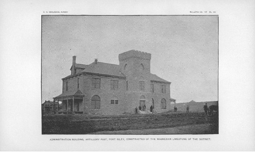
U. 8, GEOLOGICAL SURVEY
ADMINISTRATION BUILDING, ARTILLERY POST, FORT RILEY, CONSTRUCTED OF THE MAGNESIAN LIMESTONE OF THE DISTRICT.

HAY.] PALEONTOLOGY, 3
perhaps the largest in the region, as, coming straight from the earth, it drives a 16-foot overshot water wheel. In the neighborhood of each of these springs there is a group having smaller flow, and there are others elsewhere in this region. Of course these springs have "hard" water, but it is mostly free from organic matter. The alluvium of the river bottoms is a water holder, and the wells thereon are easily made and well supplied. The water is softer than that from springs or wells in the Carboniferous rocks. The gravel of Tertiary materials in which the wells of the military post find their source is probably of consider able extent in the three river valleys, and will insure large supplies of water, good for all domestic purposes.
Near the eastern boundary of Geary County, in Wabaunsee, there are flowing wells artesian of highly mineralized water. It is the same at Wainego and elsewhere down the Kansas Valley. The geology of eastern Kansas gives no explanation of the artesian flow of thesewells, but the occurrence of natural gas, and the known fact that in one or two instances the gas pressure raises the water to the surface, seem to suggest this as the reason of the artesian flow in the Kansas Valley. Wells on the upland usually obtain water in the horizon of the springs, viz, the Flint beds, and in the creek valleys beds of gravel under the alluvium yield large supplies.
Measurement of rivers. The rivers themselves are, of course, an inex haustible source of water supply to the municipal and military popu lations on their banks. The water of the three rivers has not been continuously measured anywhere, but single measurements in the dis trict have given the following figures:
Smoky Hill, June 15, 1891...... ....................Kansas at Fort Eiley, June 18, 1891 ................
Cubic feet per secoTid.
2,045OKI
6,961
PALEONTOLOGY.
It may be possible to supplement this report with a complete list of the Paleozoic fossils of the district, but in the absence of such list the names of the fossils occurring in the stratigraphic scheme of the Fort Eiley section will be of use. It would take comparatively little work to complete the survey of the Permian strata to the west and north, to their contact with the Dakota, and to give the fossils in their highest beds. For this the Fort Eiley section will be a valuable starting point.
It may be noted that trilobites (Phillipsia) have been found in the Main ledge, and this is probably the horizon of their highest occur rence. It has already been stated that the Productidae disappear at
Bull. 137 3

34 GEOLOGY OF FORT RILEY RESERVATION, KANSAS.
the same horizon. Some of the Quarry ledges have abundance of Pecten and other lamellibranchs which seem to be persistent over great areas. Nautiloid shells are also found, especially in the higher beds. One was found in the mid-Shale bed (No. 7), but the others are all above No. 11. Four are new species, and as the horizon of one of them is apparently limited in vertical extent, it might perhaps give name to No. 12 of the section, which might be called the Stenopoceras beds, from Stenopoceras (Phacoceras) dumbli Hyatt, the type specimen of which was obtained in the Fort Kiley quarries. Other specimens of this form have been since obtained at Junction City. The numerous Pecten and Pleurophorus casts might, however, suggest their names for the same beds.
The Quaternary deposits of this district seem almost entirely desti tute of fossils. At Manhattan some years ago fragments of Elephas 1 were found under 35 feet of loess. In the same neighborhood a loess nodule gave the teeth of a rodent. Farther down the Kansas Valley Professor St. John has found fragments of fish, but the beds of this region are singularly destitute of fossils. That there should be* no land fauna is suggested by the fact that the greatest elevations are surmounted by a sheet of loess. That the waters should have few or no remains of the fauna of temperate regions is understood, because those waters were cold, and the cold had come on only by secular mod ifications of preexisting conditions. If further research should dem onstrate that the loess is absolutely unfossiliferous having no arctic or subarctic fauna the reason is probably because the great continental ice-sheet lay between this region and the arctic waters, and the cur rents along the ice-front were southerly and easterly in direction.
1A tusk 10 feet 6 inches long, another 9 feet 10 inches, a tooth 15 by 8J by 4J inches, and fragmenta of other teeth.
INDEX.
Alluvium.................................. 27-28Baselevels.................................. 28Biographic note on the author, deceased.... 11Bowlders................................... 25Brick clays................................. 31Building materials......................... 31-32Carboniferous strata....................... 17,20Cement .................................... 32Clays for brickmaking..................... 31Climatic changes........................... 29Correlation of different regions ............ 30Creek valleys .............................. 13Cretaceous geology of the district......... 23-24Dakota deposits............................ 23Deposition, littoral and shallow-water con
ditions of................................. 21-22Dunes, sand................................. 28Economic geology.......................... 30-33Erosions, pre-Quaternary................... 22,29Fenestella.................................. 21Mint beds.................................. 17,19Fort Kiley section.......................... 17-18Fossils..................................... 21Glacial deposits......................... 24-25,29Grooves in limestone....................... 25-26Gumbo..................................... 27-28Gypsum.................................... 21,22Hardpan................................... 28Hemipronites, finding of, in the strata...... 21Hill, R.T., remarks by..................... 11Joint clay.................................. 28Kansas-^Neosho -watershed.................. 14-15Lime........................................ 32Littoral conditions of deposition........... 21-22Loess bluffs on the Republican River ...... 14Loess of two periods....................... 26Main ledge.............................. 17,18-19
Miocene grit in Smoky Hill Valley.........Moraines...................................Neosho-Kansas watershed..................N"eosho Valley...................:..........Paleontology of the district................Paleozoic geology of the district...........Pecten...............----. .................Permian strata.............................Permo-Carboniferous strata................Phillipsia, finding of.......................Pleurophorus ..............................Producti, finding of, in the strata..........Prosser, C. S., reference to work of, in
Kansas...................................Quarry beds................................Quaternary geology of the district.........Republican River, loess bluffs on the ......Republican Valley..........................River system of the district...............Rivers,' measurement of....................Sand dunes.................................Section at Fort Riley ......................Sink-holes ........................... 15-16,Shales......................................Shale (mid-) bed...........................Smoky Hill Valley.........................Soils .......................................Springs and wells..........................Stenopceras (Phacoceras) dumbli Hyatt... Stone for building purposes................Synocladia.................................Tertiary geology of the district............Topography of the district.................Trilobites, finding of.......................Uplifts, continental........................Water supply.............................."Wells and springs..........i..............
35
2924-25 14-15
1633-34 16-23 21, 34
17.2017.21
3321,34
21
11 19
24-29 14 12 12 33 28
17-18 26-27 17,20 17,20
1330-3132-33
3431-32
21 24
11-16 33
22-2332
32-33