geological society of connecticut
TRANSCRIPT

Geological Society of Connecticut
Fieldtrip Guidebook No. 2
Poly‐metamorphism and Poly‐deformation of Bronson Hill Rocks, Northeastern Connecticut
A fieldtrip led by Robert P. Wintsch, Indiana University

Geological Society of Connecticut
Second Annual Fieldtrip June 25, 2011
Fieldtrip Guidebook No. 2
Poly-metamorphism and Poly-deformation of Bronson Hill Rocks, Northeastern Connecticut
Robert P. Wintsch, Indiana University Mary Roden-Tice, Plattsburg State University
Michael J. Kunk, US Geological Survey
Sponsors The Geological Society of Connecticut
Burgundy Hill Quarry, a division of Midwood Quarry & Construction Connecticut Department of Environmental Protection
Dinosaur State Park State Geological and Natural History Survey of Connecticut

The Honorable Dannel P. Malloy, Governor State of Connecticut
Daniel C. Esty, Commissioner Department of Environmental Protection
Steven O. Fish, Director Office of Information Management
Geological Society of Connecticut Fieldtrip Guidebook No. 2
Editors
Janet Radway Stone U.S. Geological Survey
Margaret A. Thomas CPG Connecticut State Geologist
State Geological and Natural History Survey of Connecticut
ISBN 978-0-942081-18-3
Publication Availability
DEP Store 79 Elm Street Hartford, CT 06106 (860) 424-3555 www.ctdepstore.com
Dinosaur State Park 400 West Street Rocky Hill, CT 06067 (860) 257-7601 www.dinosaurstatepark.org
© 2011 Geological Society of Connecticut & Connecticut Department of Environmental Protection

1
______________________________________________________________________________________________________ Poly‐metamorphism and Poly‐deformation of Bronson Hill Rocks: Geological Society of Connecticut Fieldtrip Guidebook No.2
Poly‐metamorphism and Poly‐deformation of Bronson Hill Rocks, Northeastern Connecticut
Robert P. Wintsch, Department of Geological Sciences, Indiana University, Bloomington, IN Mary Roden-Tice, Center for Earth & Environmental Sci., Plattsburgh State Univ., Plattsburgh, NY
Michael J. Kunk, U.S. Geological Survey, MS 963, Denver Federal Center, Denver, CO
INTRODUCTION
Geologic mapping in New England over the last 100+ years has focused on ductile metamorphic stratigraphy, and on the regional-scale ductile structure that can be deduced from these stratigraphic assignments. This has led to the unfortunate under-emphasis of the structures associated with brittle deformation: joints and faults. The significance of such brittle bedrock structures has recently taken on new significance for at least three reasons. First, joints and associated faults define the bedrock aquifers that provide drinking water to millions of rural homes in all of New England. These brittle structures control the directions, rates and quality of ground water and its flow, and characterizing these fracture networks is vital to understanding and maintaining the quality of the consequent aquifers. Second, these same structures act as conduits for the escape of hazardous radon gas into basements. Third, they are the expected sites of seismic reactivation, or at least for potential seismically driven displacements.
With so much land use management dependent on these structures, and with so little data available on brittle structures, the USGS responded with a new mapping initiative entitled “Bedrock Regional Aquifer Systematic Study” (BRASS). As an early stage of this effort, the National Cooperative Geologic Mapping Program (through STATEMAP) funded the remapping of the Rockville quadrangle in Connecticut. Part of the justification for the remapping was the location of this quadrangle at the intersection of several ductile and brittle faults at the edge of, and cutting, the Mesozoic Hartford basin. This mapping has led to several reinterpretations. First the high grade ductile structures and even folding of the Bolton syncline are shown to be Alleghanian, caused by SE thrusting and crustal thickening. Second, these ductile structures are overprinted by two cycles of compressional and extensional Mesozoic structures that both predate and deform Mesozoic sediments as well as the adjacent crystalline rocks.
This field trip is designed to emphasize this Mesozoic overprint without slighting the interesting Alleghanian story. The text is taken with minimal modification from Wintsch et al., (2003a), while the trip itself will benefit from the continuing work and understanding of regional relationships (Aleinikoff et al., 2007; Walsh et al., 2007; Wintsch et al., 2003b; 2005a; 2005b; 2007). Outcrops, some borrowed from Wintsch et al. (1998; 2001), are chosen for safety considerations; road cuts on interstates with some compelling structures are not included because they are too dangerous. The text that follows is a first attempt to build on the results of this mapping (Wintsch, 1999) and on related regional work to develop a paradigm for regional Mesozoic structures. Some parts are purposefully speculative in hopes of stimulating discussion here, with the ultimate goal of integrating this mapping into a regional picture of Mesozoic tectonics inside and outside Mesozoic basins.

The Rockville quadrangle straddles the eastern margin of Hartford basin in north-central Connecticut (Fig 1). To the west are the poorly exposed sandstones and conglomerates of the Jurassic Portland Formation. These unconformably overlie rocks of the Connecticut Valley synclinorium (CVS), and in the discussion of the thermal history below, rocks of the Hartford basin and the CVS are mixed. Early to middle Paleozoic crystalline rocks to the east constitute the footwall of the west dipping Mesozoic faults where schists and orthogneisses of the Bronson Hill, Central Maine, and Merrimack terranes are exposed progressively eastward. Previous work on the bedrock geology of the Rockville area began with Percival (1842), and culminated with quadrangles and reports by Collins (1954), Herz (1955) and Aitken (1955). Snyder (1970) separated more units in the Marlboro quadrangle to the south, and compiled his work in the Rockville quadrangle at a small scale with the Marlboro quadrangle. Rodgers et al. (1959) reviewed previous work, and Rodgers (1985) compiled selected quadrangle map information in his map of the entire state. Most mapping in the 60s and 70s minimized or ignored brittle Mesozoic structures, although brittle faults did attract attention in the past (Davis, 1888; 1897; Wheeler, 1937; Aitken, 1955; Fritts, 1963) and more recently (Eberly, 1985). Other topical studies in the area include Busa and Gray (1992), Bell et al. (1997), Coleman et al. (1997), Hickey and Bell (1999), and Aleinikoff et al. (2002). Preliminary results of this work were reported by Wintsch et al. (1998; 2001).
2
______________________________________________________________________________________________________ Poly‐metamorphism and Poly‐deformation of Bronson Hill Rocks: Geological Society of Connecticut Fieldtrip Guidebook No.2
GEOLOGIC SETTING AND PREVIOUS WORK
BEDROCK GEOLOGY
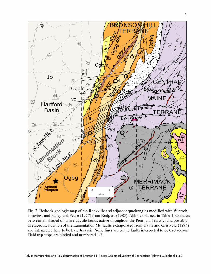
The geology and regional setting of the Rockville quadrangle is summarized in Fig. 2, with abbreviations in Table 1. It is dominated by relatively well exposed rocks of the Bronson Hill terrane in the middle portion of the map. Rocks of the Central Maine and Merrimack terranes are much less well exposed to the east, and outcrop of the Mesozoic sandstones and conglomerates in the west is limited to a few road and stream cuts. All crystalline rocks are intruded by migmatites, pegmatites, and quartz veins. Dikes of Early Jurassic basalt cut rocks of the Bronson Hill terrane in this quadrangle, and rocks of the Central Maine and Merrimack terranes in areas to the south and east (Rodgers, 1985; Fig. 2).
Bronson Hill Terrane
The most important rocks of the Bronson Hill terrane are the orthogneisses of the Glastonbury and Middletown complexes, and metasediments of the Bolton syncline. They all form a stack of N to NNW striking and NW dipping rocks. The Glastonbury gneiss of Aitken (1955), Leo et al. (1984), and Rodgers (1985) has been subdivided into four mapable units (Table 1): Glastonbury Late Ordovician (Aleinikoff et al., 2002) granodioritic orthogneiss (Ogbg), a discontinuous eastern granitic orthogneiss (not shown on Fig. 2, but similar to that mapped by Herz, 1955), a western amphibolite (Ogba), and several belts of phyllonite, the largest of which is the Dobsonville Pond fault zone (DPFZ). The latter contains rocks with recognizable protoliths of Ogbg and Ogba (Stop 7). Together these rocks are referred to as the Glastonbury complex (Ogb). The western margin of the complex is cut out by Mesozoic faults that place Jurassic sediments against these gneisses.
3
______________________________________________________________________________________________________ Poly‐metamorphism and Poly‐deformation of Bronson Hill Rocks: Geological Society of Connecticut Fieldtrip Guidebook No.2

4
______________________________________________________________________________________________________ Poly‐metamorphism and Poly‐deformation of Bronson Hill Rocks: Geological Society of Connecticut Fieldtrip Guidebook No.2
5
______________________________________________________________________________________________________ Poly‐metamorphism and Poly‐deformation of Bronson Hill Rocks: Geological Society of Connecticut Fieldtrip Guidebook No.2

6
______________________________________________________________________________________________________ Poly‐metamorphism and Poly‐deformation of Bronson Hill Rocks: Geological Society of Connecticut Fieldtrip Guidebook No.2
To the east lie rocks of the Bolton Syncline, with the basal Clough quartzite (Sc), locally a pebble conglomerate, the marly amphibole-sphene bearing Fitch Formation, and the Bolton muscovite-staurolite schist, or Littleton schist (Dl) of Snyder (1970) and Rodgers (1985). The latter is particularly well exposed, and locally defines the divide between the Connecticut and Thames river watersheds. These rocks were apparently deposited unconformably on rocks below them, but all contacts are now faults (Stop 5), and a sedimentary relationship between the Clough and rocks below cannot be proven. The Box Hill fault appears to cut out most of the Clough quartzite and Fitch Formation. Contacts among the three metasedimentary formations are interlayered and gradational.
The Middletown complex (Middletown Formation of Rodgers, 1985) occurs as a band of highly strained rocks (locally containing sheath folds) in a fault-bound slice between the Clough quartzite (Sc) on the east and Monson orthogneiss (Omo) to the west. It is dominated by a pinstriped amphibole orthogneiss (Omia, Stops 3B, 6), but also contains minor schist and quartzite. The Reed Hill fault on the western margin of the complex (Stop 5) has been reactivated in the Mesozoic as a brittle fault, and now places variably foliated amphibolite against Clough quartzite. The protolith of the amphibolite is a gabbro, whose igneous textures are still preserved locally in the Rockville quadrangle (Stop 5), but better preserved in the Ellington quadrangle on strike to the NE. With the amphibolite identified as an orthogneiss, it is likely that these metasediments occur in fault slices rather than as part of a conformable package within the Middletown complex. The eastern margin of the complex is a fault that locally cuts out the quartzite and schist.
The Monson gneiss (Stop 3A) is the eastern-most, and fault-bound unit of the Bronson Hill. It is dominated by plagioclase-quartz-biotite schist and granofels, but contains local layers of amphibolite. It is cut out in the southern part of the quadrangle by the Bonemill Brook fault, a terrane boundary separating rocks of the Bronson Hill and Central Maine terranes.
Central Maine Terrane
The Central Maine terrane is very poorly exposed in the Rockville quadrangle. The constituent Hamilton Reservoir and Bigelow Brook formations and Southbridge gneiss (undivided in Fig. 2) and the ductile EW faults that separate them have been extrapolated west from the South Coventry quadrangle (Fahey and Pease, 1979). The best exposures of these rocks are in the Hop River valley, where nearly flat-lying amphibolite, granofels, and plagioclase-quartz biotite schists of the Southbridge gneiss are exposed. they locally contain scapolite or garnet + diopside, consistent with upper amphibolite facies conditions.
Merrimack Terrane
The Hebron Formation is the only unit exposed in the Merrimack terrane. It is composed of purplish-brown biotite schist interlayered with olive green amphibole-diopside granofels (see Stop 2). Its upper contact with rocks of the Central Maine terrane is not exposed, but is mapped as a fault as inferred from regional relationships.
7
______________________________________________________________________________________________________ Poly‐metamorphism and Poly‐deformation of Bronson Hill Rocks: Geological Society of Connecticut Fieldtrip Guidebook No.2

8
______________________________________________________________________________________________________ Poly‐metamorphism and Poly‐deformation of Bronson Hill Rocks: Geological Society of Connecticut Fieldtrip Guidebook No.2
OUTCROP-SCALE STRUCTURES
Ductile Structures in the Crystalline Rocks
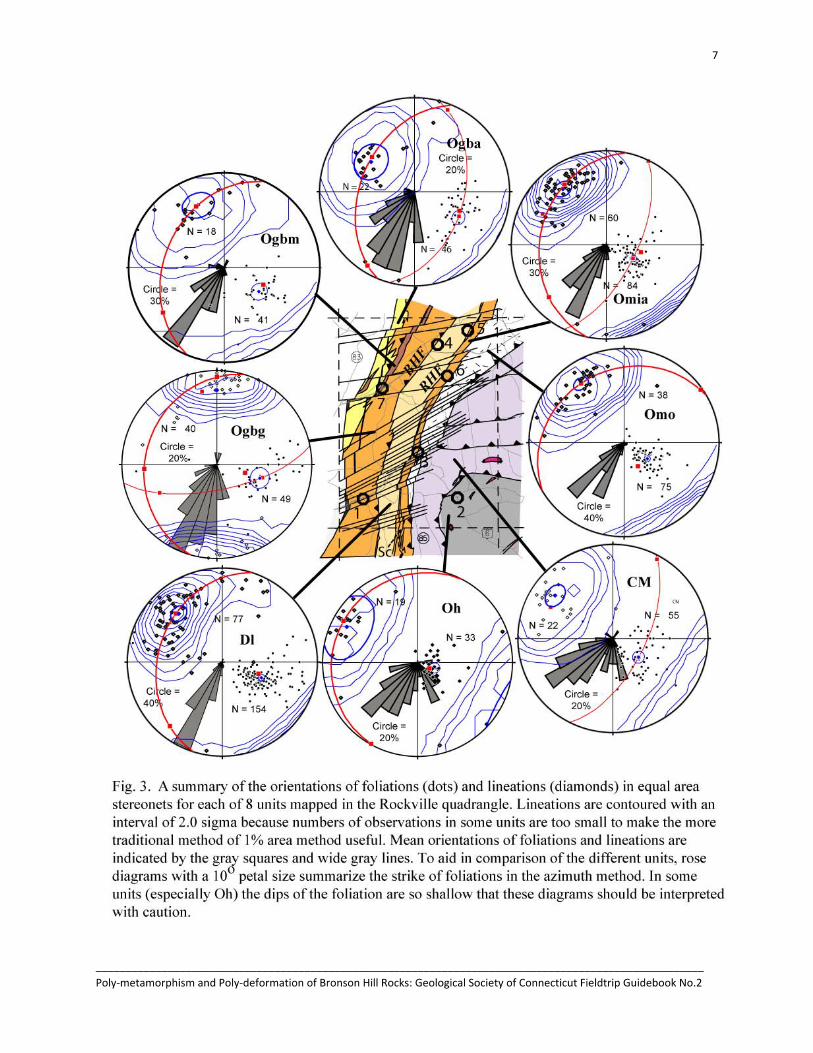
Fabrics. All of the pre-Jurassic crystalline rocks in the Rockville area are foliated and most are strongly lineated. Foliations dip moderately to the WNW, parallel to ductile fault boundaries between the mapped units. Mineral lineations are parallel to stretched pebbles and fold, and sheath fold axes, and are thus stretching lineations. They trend WNW with moderate plunges (Fig. 3). The larger eastern portion of the Glastonbury complex between the Dobsonville Pond fault zone (DPFZ) and the Box Hill fault is anomalous, in that its foliations strike NE, and lineations plunge very gently due north (Ogbg, Fig. 3).
Ductile faults and shear zones. Most mapped units in the Rockville quadrangle are separated by ductile faults (Table 1), characterized by mylonitic that are remarkably common within units as well. For example, Omia (Stops 3B and 6) commonly contains penetrative amphibole lineations, and Dl locally contains tectonic inclusions and lozenges of quartz schist within muscovite schist.
This mapping has also identified belts of phyllonitic rocks (Ogbm), some in Ogb wide enough to be mapped, and one named: the Dobsonville Pond fault zone (DPFZ, Fig. 2; Stop 7). This fault zone occurs as a mylonitic and phyllonitic belt of rocks up to 400 m wide that cuts the Glastonbury complex in the northern part of the quadrangle. It has been traced into the Ellington quadrangle, where it is poorly exposed, but merges with an extension of the Box Hill fault on the east side of Ogbg. Foliations in Ogbg define a fold with a great circle plunging 22° ~350°, indistinguishable from biotite streaks and quartz-feldspar rods that plunge 22° to 000°. This contrasts with the strongly WNW plunging fabrics of Ogba and Dl on either side of Ogbg. The greenschist and lower amphibolite facies fabrics within the fault zone are derived from Ogbg and Ogba, and reflect a smearing out of the two higher grade fabrics in the protoliths.
Minor phyllitic faults and shear zones too small to map were also identified in all units, but are most abundant in Dl and Ogbg (Fig. 4). The shear zones are dominated by muscovite +/- chlorite folia that define a WNW dip that is sub-parallel to foliations in Dl and Ogbg. Where sense of displacement could be determined, most showed sinistral, oblique slip displacement. The mineralogy and trend is one that seems to reactivate the existing foliation, but at the lower grade conditions of the greenschist facies.
Folds. Minor folds are common in fault zones (e.g. Ogbm) and highly strained units (e.g. Omia), present in most layered rocks, and rare in gneissic units Ogbg and Omo. Fold axes plunge about 35° toward the NW (315°), and their distribution defines a great circle trending 222° (Fig. 4). Axial planes dip ~30° toward 315° and their distribution defines a great circle plunging ~35° toward 315°. Thus these folds define a single family of structures, in spite of the fact that the folds occur in all mapped units. Such uniformity in the data suggest that the folds are part of a single generation that nucleated with NE trending axes and NW dipping axial planes, and rotated with high strain to folds with a NW trending fold axis, and a steeply dipping NW axial planes. Noting further that the fold axes are parallel to the strong stretching lineation (Fig. 3), it is likely that they are related to the same deformational event.

9
______________________________________________________________________________________________________ Poly‐metamorphism and Poly‐deformation of Bronson Hill Rocks: Geological Society of Connecticut Fieldtrip Guidebook No.2
Brittle Structures in the Crystalline Rocks
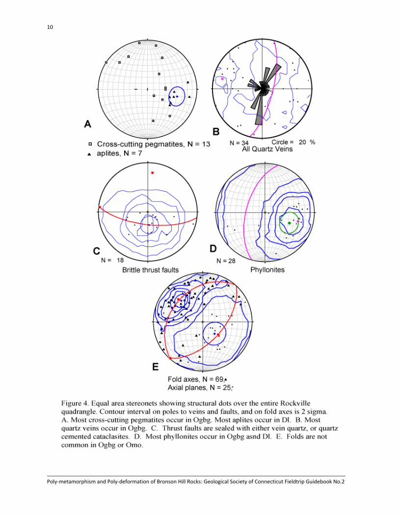
Igneous Intrusive Structures. Pegmatite and other felsic dikes and sills, and quartz veins are ubiquitous, and concordant sill-like structures are especially common. Larger pegmatites in the Central Maine and Merrimack terranes are mapped, but in many locations their contacts were not exposed, and their structural relationship to the country rocks is not known, though they are probably weakly discordant. Concordant migmatites and pegmatites up to one meter think are present in most larger outcrops in the Central Maine and Merrimack terranes (e.g. Stop 2), and are not mapped separately. Thinner discordant veins and dikes have been noted in the field, and though the data are sparse, a pattern emerges. Aplite dikes tend to occur primarily in the Bolton schist where their NW dip (Fig. 4) parallels the local foliation. Small discordant pegmatites primarily in the Glastonbury complex dip steeply SE and gently W (Fig. 4).
Four exposures of Jurassic basalt were mapped as dikes by Aitken (1955). These have subsequently been assigned to part of the Ware-Buttress dike and are slightly younger than the Higganum (Philpotts and Martello, 1986; Fig. 2). We have traced the locations of these dikes with a magnetometer, calibrating its magnetic susceptibility with these outcrops. These dikes are found to extend discontinuously to the southwestern portion of the quadrangle. Offsets in these dikes line up with offsets in the strike ridges of the metamorphic units to the east, and are interpreted to be caused by cross cutting (Cretaceous) faults. The trend of these dikes in the Rockville and southern Ellington quadrangles is about 010°, close to that of the eastern margin of the Hartford basin.
Hydrothermal Intrusive Structures. Quartz veins are common in all Bronson Hill rocks, but rare in Central Maine and Merrimack rocks. In schistose rocks, like Dl, they are concordant, while in gneissic and granofelsic rocks they are cross-cutting. Discordant quartz veins are most common in the Glastonbury complex, where they have a strong NNE trend (Fig.4). Map-scale quartz veins occur only along the Mesozoic border fault (VQ, Fig 2). These are thicker, and may be vuggy or mineralized (Percival, 1842, p 224; Davis and Griswold, 1894), as in the Wyllis copper prospect near the falls of Birch Mountain Brook.
Brittle faults
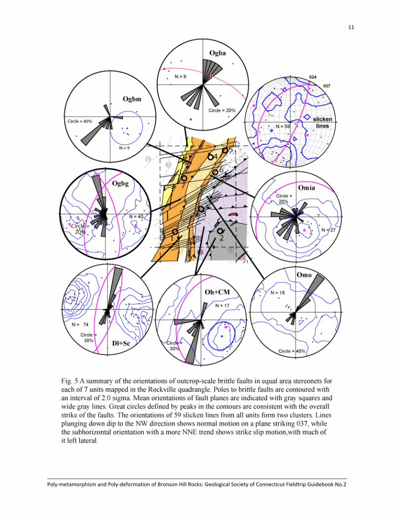
Brittle faults are present in all rock types. Some fault surfaces are slickensided, and others may host cataclasites, or are mineralized with calcite, drusy quartz, zeolite, or iron oxides. Most show normal motion, but some also show reverse and thrust motion. Cataclastic and slicken-lined thrust faults with gentle to moderate dips to the NW and NE, are described by a great circle plunging ~20° toward 007° (Fig. 4). This suggests N-S shortening was active during the later Mesozoic history of these rocks.
Normal faults in most units have a strong NNE strike, dipping steeply to the WNW; however, this is somewhat dependent on rock type (Fig 5). Faults in the massive and unlayered Glastonbury gneiss (Ogbg) are unique, trending strongly toward 345°, with steep dips E and W. In layered or well foliated rocks, the strike of brittle faults tends to parallel the strike of layering or foliation. The dip may be subparallel to this layering (NW), in which case slicken lines tend to plunge moderately to the NW as well. Where the dip crosses layering steeply to the SE, lineations tend to be subhorizontal (Fig.4), and where it can be determined, most of these strike-slip faults show left lateral displacement.
10
______________________________________________________________________________________________________ Poly‐metamorphism and Poly‐deformation of Bronson Hill Rocks: Geological Society of Connecticut Fieldtrip Guidebook No.2
11
______________________________________________________________________________________________________ Poly‐metamorphism and Poly‐deformation of Bronson Hill Rocks: Geological Society of Connecticut Fieldtrip Guidebook No.2

12
______________________________________________________________________________________________________ Poly‐metamorphism and Poly‐deformation of Bronson Hill Rocks: Geological Society of Connecticut Fieldtrip Guidebook No.2

13
______________________________________________________________________________________________________ Poly‐metamorphism and Poly‐deformation of Bronson Hill Rocks: Geological Society of Connecticut Fieldtrip Guidebook No.2
Joints
Jointing is common in all rocks, and takes two habits. In strongly foliated, but mica poor rocks, joints tend to open up along the inherited foliation plane. These are not measured separately from the foliation surface, due to the difficulty in discriminating between the two. Most measured joints dip moderately to steeply SE, at high angles to the foliation, with strikes clustering at 005°, 055°, and 095° (Fig. 6). These trends are not distributed randomly among the rock units, but vary with rock type. An exception to this is that Omi and Sc show indistinguishable trends, and have been combined in Fig. 6. West of the DPFZ (Ogba, Fig. 6) joints trend 005°, while east of it in Ogbg they trend 095° and 065° in addition to 005°. East of the Box Hill fault in Dl there is a maximum at 075°, which rotates to 065° in Omi + Sc, and to 355° in Omo. Finally in the Central Maine and Merrimack terranes joints trend 215° and 065°.
STRUCTURAL EVOLUTION
In this section the structural observations outlined above are related to one another in a history of prograde and retrograde deformation, followed by a sequence of overprinting deformation events that occurred under progressively shallower crustal conditions. The early high grade part of this history is Alleghanian. This orogenic event established an overthickened crust whose exhumation involved a sequence of ductile, and then brittle Mesozoic events that apparently persisted into the Cretaceous.
Prograde and Retrograde Alleghanian Structures
Prograde Thrust Nappes. Ductile, high grade metamorphic fabrics similar to those described by Swanson (1999), including foliations, mineral lineations, and fold and boudin axes share a strong NW plunge, and asymmetric structures show a strong SSE vergence. This vergence sense is unambiguously displayed by rotated veins that climb to the SE (most stops), especially in penetratively lineated Omia with sheath folds (Stop 7). Abundant sigma-type displacements around porphyroblasts (e.g. Ogbg, Stop 1) and around pegmatites and boudins (e.g. Oh, Stop 2) further reflect this displacement. All of these structures reflect at least middle amphibolite facies metamorphic conditions.
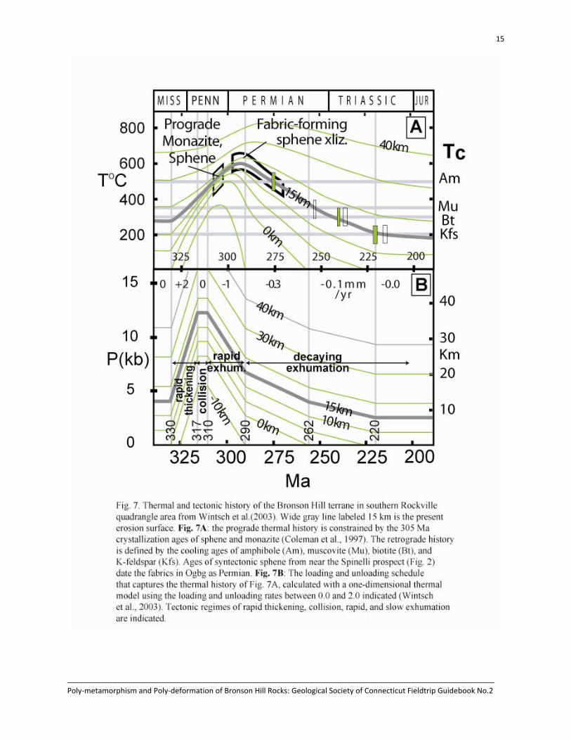
The timing of this deformation can be established in two ways. First, the Permian cooling history of the Bronson Hill terrane is revealed by amphibole, mica, and feldspar 40Ar/39Ar ages from near the Spinelli pegmatite prospect (Stugard, 1958; Fig. 2; Wintsch et al., 1999; 2003b; 2005, Stop 4), as well as from the Rockville quadrangle (Wintsch et al., 2003a). Second, direct dating by Coleman et al. (1997) of metamorphic sphene from the Fitch Formation and monazite from a pegmatite cutting the Bolton schist at Bolton Notch (Wintsch et al., 1998) near Stop 3, places the time of prograde metamorphism at ~305 Ma, or late Pennsylvanian. Direct dating of syntectonic metamorphic sphene (Aleinikoff et al., 2002) further demonstrates that the fabric is Permian. Together these data define the thermal history of these rocks for much of the late Paleozoic (Fig. 7A). The middle and upper amphibolite facies temperatures of the mineral assemblages that define these structures is hotter than the closure temperature of amphibole to Ar diffusion. Thus the time of these structures developed was at least as old as the amphibole cooling ages of ~280 Ma, and probably younger than 305 Ma (Fig. 7A). One-dimensional thermal modeling of these data (Fig. 7B) show that loading of these rocks began in the Pennsylvanian (from Wintsch et al., 2003).
Folding and overturning to the SE of the Bolton schist to form the Bolton syncline is consistent with this. Prograde staurolite grew over several foliations during folding (Hickey and Bell, 1999). With the
14
______________________________________________________________________________________________________ Poly‐metamorphism and Poly‐deformation of Bronson Hill Rocks: Geological Society of Connecticut Fieldtrip Guidebook No.2
time of prograde metamorphism established as late Pennsylvanian, the regionally overturned Bolton syncline can also be cited as evidence for the thrusting of the Glastonbury complex over the Bolton schist as an Alleghanian thrust nappe. Axes of crenulations included in staurolites (050°; Hickey and Bell, 1999) are at right angles to the dominant muscovite (and stretched pebble) lineation in the metasediments of the syncline (318°, Fig. 3, Dl ), and suggests a SE transport direction.
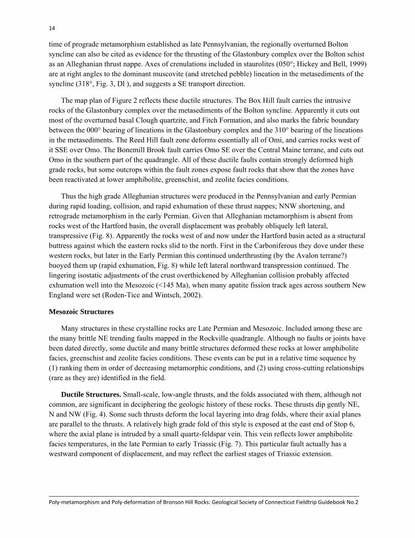
The map plan of Figure 2 reflects these ductile structures. The Box Hill fault carries the intrusive rocks of the Glastonbury complex over the metasediments of the Bolton syncline. Apparently it cuts out most of the overturned basal Clough quartzite, and Fitch Formation, and also marks the fabric boundary between the 000° bearing of lineations in the Glastonbury complex and the 310° bearing of the lineations in the metasediments. The Reed Hill fault zone deforms essentially all of Omi, and carries rocks west of it SSE over Omo. The Bonemill Brook fault carries Omo SE over the Central Maine terrane, and cuts out Omo in the southern part of the quadrangle. All of these ductile faults contain strongly deformed high grade rocks, but some outcrops within the fault zones expose fault rocks that show that the zones have been reactivated at lower amphibolite, greenschist, and zeolite facies conditions.
Thus the high grade Alleghanian structures were produced in the Pennsylvanian and early Permian during rapid loading, collision, and rapid exhumation of these thrust nappes; NNW shortening, and retrograde metamorphism in the early Permian. Given that Alleghanian metamorphism is absent from rocks west of the Hartford basin, the overall displacement was probably obliquely left lateral, transpressive (Fig. 8). Apparently the rocks west of and now under the Hartford basin acted as a structural buttress against which the eastern rocks slid to the north. First in the Carboniferous they dove under these western rocks, but later in the Early Permian this continued underthrusting (by the Avalon terrane?) buoyed them up (rapid exhumation, Fig. 8) while left lateral northward transpression continued. The lingering isostatic adjustments of the crust overthickened by Alleghanian collision probably affected exhumation well into the Mesozoic (<145 Ma), when many apatite fission track ages across southern New England were set (Roden-Tice and Wintsch, 2002).
Mesozoic Structures
Many structures in these crystalline rocks are Late Permian and Mesozoic. Included among these are the many brittle NE trending faults mapped in the Rockville quadrangle. Although no faults or joints have been dated directly, some ductile and many brittle structures deformed these rocks at lower amphibolite facies, greenschist and zeolite facies conditions. These events can be put in a relative time sequence by (1) ranking them in order of decreasing metamorphic conditions, and (2) using cross-cutting relationships (rare as they are) identified in the field.
Ductile Structures. Small-scale, low-angle thrusts, and the folds associated with them, although not common, are significant in deciphering the geologic history of these rocks. These thrusts dip gently NE, N and NW (Fig. 4). Some such thrusts deform the local layering into drag folds, where their axial planes are parallel to the thrusts. A relatively high grade fold of this style is exposed at the east end of Stop 6, where the axial plane is intruded by a small quartz-feldspar vein. This vein reflects lower amphibolite facies temperatures, in the late Permian to early Triassic (Fig. 7). This particular fault actually has a westward component of displacement, and may reflect the earliest stages of Triassic extension.
15
______________________________________________________________________________________________________ Poly‐metamorphism and Poly‐deformation of Bronson Hill Rocks: Geological Society of Connecticut Fieldtrip Guidebook No.2

16
______________________________________________________________________________________________________ Poly‐metamorphism and Poly‐deformation of Bronson Hill Rocks: Geological Society of Connecticut Fieldtrip Guidebook No.2

17
______________________________________________________________________________________________________ Poly‐metamorphism and Poly‐deformation of Bronson Hill Rocks: Geological Society of Connecticut Fieldtrip Guidebook No.2
Other ductile structures are phyllonitic faults and shear zones (Fig.4). Most of these occur in Ogbg and Dl. In Ogbg, their orientation is similar to that of the DPFZ rocks, and in Dl they are only slightly steeper than the composite muscovite foliation. Where motion sense can be determined, they are dominantly left lateral. These faults all contain fabric-forming muscovite, most also with chlorite. None contain biotite. They thus reflect sinistral motion under lower greenschist facies conditions, probably between 300- 200°C. This temperature range is dated by biotite and K-feldspar Ar cooling ages (Fig. 7), which are between 240 and 220 Ma, or middle Triassic.
These ductile structures produce a consistent tectonic pattern. N-S shortening seems to have persisted from Early Permian through the Triassic, as demonstrated by the small scale thrusts. Within the same time period sinistral strike slip faults were active. Together this outlines a transpressive regime for all of the early Mesozoic, until the time of Triassic sedimentation in the Hartford basin, when active faults on the eastern edge of the Hartford basin had a NNE bearing.
Brittle Structures. Three types of extensional brittle structures in the Bronson Hill terrane can be related to the Mesozoic. (1). Cm to outcrop scale quartz veins strike NNE and dip steeply E and W (Fig. 4), a trend that is found regionally (Eberly, 1985). They are never vuggy, but always completely filled with quartz, and locally also with minor black tourmaline. This reflects epizonal hydrothermal temperatures of ~200-250°C. As such they are probably Middle to Late Triassic in age. (2). Jurassic basaltic dikes (Jb, Fig. 2) that intrude the Glastonbury complex also strike NNE and by correlation with the flows they fed (Philpotts and Martello, 1985), are earliest Jurassic. Finally, (3) map scale bodies of massive quartz, or brecciated rocks strongly cemented by quartz are exposed at two places along the western margin of the Glastonbury complex. The mineralization here shows that the fault zone was reactivated at relatively high hydrothermal temperatures after considerable sedimentary loading of the Jurassic sediments above this contact. These temperatures would have been established in the Early Jurassic at ~185 Ma, as indicated by the oldest reset zircon fission track ages in the Portland Formation (Roden-Tice and Wintsch, 2002). The similar age and orientation of these three structures are consistent with an extension direction of ~100°, and would imply a transition from a transpressional to a transtensional regime at about 200 Ma, probably at ~220 Ma (Fig. 8).
Several brittle thrust faults show cataclastic textures in the fault zones (e.g. Omo, Stop 3A), reflecting the zeolite facies conditions of the early Jurassic. Another thrust that contains slicken lines produces a fold (Stop 3B) where mylonitic Omia is folded over the hanging wall of a small scale thrust. Here the chlorite associated with the slickensided surface reflects temperatures of ~200°C. This temperature lies between the low-end cooling age of K-feldspar at 200 Ma and the zircon fission track ages of ~150 Ma (Wintsch et al., 2003; Roden-Tice and Wintsch, 2002). As such it is probably a Middle Jurassic structure.
Many steep brittle normal faults strike ~195° and dip ~70° WNW, a trend found regionally (Eberly, 1985). They may contain drusy crystals in vuggy structures, iron oxides, or may be highly weathered. This orientation suggests a reactivation of ductile thrust faults or metamorphic foliation parallel to them, apparently due to continued collapse of the crust overthickened during the Alleghanian. The open fractures suggest the relatively cool temperatures of the shallow crustal environment. Late Jurassic zircon fission track ages that date cooling through ~200°C indicate that these temperatures occurred in Bronson Hill rocks after the Mesozoic sedimentary cover had begun to be eroded. The significance of the curious clock-wise rotation of the strike from ~345° to 035° from west to east across the Bronson Hill rocks (Fig. 5) is not known. However, the common occurrence of subhorizontal slickensides in the SE dipping faults
18
______________________________________________________________________________________________________ Poly‐metamorphism and Poly‐deformation of Bronson Hill Rocks: Geological Society of Connecticut Fieldtrip Guidebook No.2
indicates that left-lateral strike-slip movement persisted through Late Jurassic, but with the dominance of normal faulting, this regime was probably evolving toward transtensional. Consistent with this Eberly (1985) found a NE directed sigma 1 direction from his left-lateral brittle faults.
The NNE trend of these local brittle faults does not parallel the 060° trend of map-scale brittle faults that cut the Bronson Hill terrane in Fig. 2, and thus are probably not related to them. On the contrary, they are parallel to the more northerly trend of the eastern border faults. This fault was active during Early Jurassic hydrothermal alteration, but was also reactivated under completely brittle conditions (Davis and Griswold, 1894, p. 526).
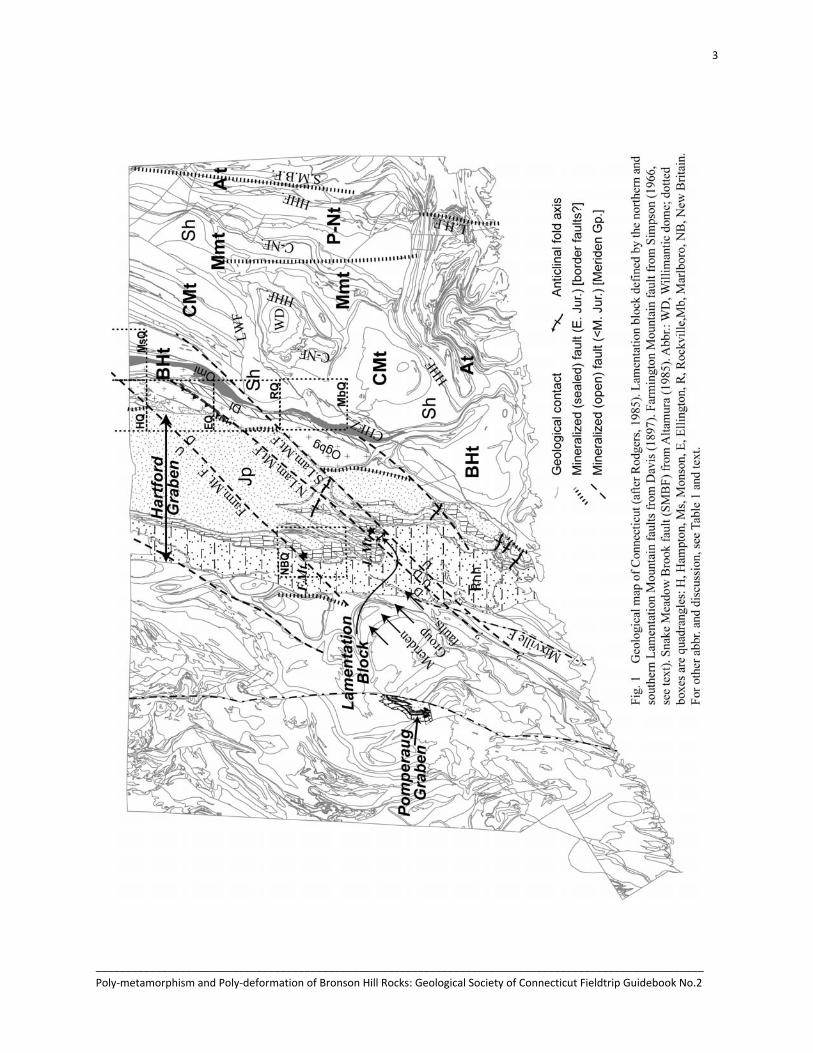
Lamentation Block and Meriden Group faults. In his mapping over 100 years ago, Davis (1897) identified several faults that cut across the entire Hartford basin. Two of these faults bracket Lamentation Mountain and between them define the Lamentation block extending from pre-Mesozoic rocks in Bethany to the SW and to the Rockville quadrangle in the NE (Fig. 1). Evidence for these faults in the central part of the state is strong in that the strike ridges of the three flows in the center of the basin are consistently offset. Davis (1897) argues in part from the offsets in the nearly NS trend of the border of the Hartford basin, that these faults in central Connecticut should continue to the NE into and across the Rockville quadrangle, and claims to have found evidence in areas east of the Rockville quadrangle. Davis argued that the same offset of West Rock sill in Bethany provided evidence for the extension of this fault to the SW. This interpretation was accepted by Krynine (1950) and Aitken (1955), and expanded upon by Wise (1992) who named this family of faults the Meriden group of faults. However, this interpretation of basin scale faulting was found ‘unnecessary’ by Fritts (1963).
Davis’ (1897) southern Lamentation fault (SLF) enters the Rockville quadrangle at the SW corner, and the northern Lamentation fault (NLF) cuts across the NW corner. The present mapping identified several lines of evidence supporting this interpretation. As described by Aitken (1955) there is a zone of brecciated rock associated with pseudotachylite (ultracataclasite) dikes exposed 0.5 km south and 0.5 km east of Bolton Notch. These structures trend NNE, but south of Bolton Notch they are on strike with the SLF. There is also a significant discontinuity in the strike and dip of Dl between Whites Hill (WH, Fig. 2) and the unnamed hill to the north in the SW quadrant of the map. On Whites Hill mean strike is 186°, dipping 55°W. On the hill to the north mean strike is 200°, dipping only 38°W. The small valley under Bolton Center Road is interpreted to be a fault. Evidence consistent with the existence of the NLF comes from a few brittle NE trending normal faults in the DPFZ, and from the offset in the trend of the Jurassic dike between Vernon Center Junior High School and the hill just north of it. Although poor outcrop prohibits following either of these faults farther to the NE, the occurrence of these structures along the strikes of the SLF and NLF are taken as evidence that these faults do indeed extend into the crystalline rocks (Fig. 2). They cut the 010 trending border fault, and are thus younger than ~180 Ma, but structures associated with it are weakly altered. This brackets the timing of these faults to the Late Jurassic to Early Cretaceous.
Many other faults of small displacement cut these strike ridges (e.g. Simpson, 1966; Rodgers, 1985; Wise, 1992). One of these seems more significant, in that it displaces the outcrop pattern of these ridges 5 km to the NE at Farmington Mountain in the New Britain quadrangle (F.Mt. Fig. 1). Following this fault on strike to the NE through areas with no outcrop, it would intersect Bronson Hill rocks in the Hampton and Monson quadrangles (Fig. 1). Peper (1977a; 1977b) maps brittle faults discontinuously across these

19
______________________________________________________________________________________________________ Poly‐metamorphism and Poly‐deformation of Bronson Hill Rocks: Geological Society of Connecticut Fieldtrip Guidebook No.2
quadrangles just where the Farmington fault projects. On the strength of this, the Farmington Mountain fault is inferred, and shown on Fig. 1.
Joints. Joints are the latest structures found in the Rockville quadrangle. Not only are they not commonly mineralized, but they cut all other structures. The bearing of the joints are in general parallel to the NE trending brittle faults mapped in Fig. 2. In particular, the 065-095° trend of joints in Ogbg, Dl, and Omi are undoubtedly related to these brittle faults. The joints generally dip steeply SE, and normal motion on these faults would produce the left-lateral sense of displacement of the map pattern identified in the detailed mapping. This pattern is not persistent regionally (Eberly, 1985), and is thus probably related to the proximity to the eastern edge of the Hartford basin.
The lack of mineralization in these joints, and even of alteration of feldspars indicates that the water that must have intruded these fractures was relatively cool, probably <100°C, close to the closure temperature of apatite fission tracks. The early to middle Cretaceous ages (140-120 Ma) of apatite fission tracks provide upper estimates of the ages of jointing. Many of these joints define open fractures and are probably the most significant in defining bedrock aquifers.
PALEOZOIC TECTONIC EVOLUTION
Bronson Hill Terrane
Acadian Metamorphism. There is little doubt that rocks in the region of the Rockville area experienced a Devonian metamorphism (Tucker and Robinson, 1990; Robinson et al., 1998), in spite of the fact that no direct evidence for the Acadian orogeny has been found there. Some evidence for pre-Alleghanian metamorphism comes from local observations integrated with regional relationships. East of the Willimantic dome (WD, Fig. 1) Merrimack rocks escaped Alleghanian metamorphism, but still contain high grade mineral assemblages and pegmatites presumably reflecting Acadian metamorphism. West of the Willimantic dome amphiboles in these rocks all show Permian cooling ages (Wintsch et al., 1993), reflecting Alleghanian overprint. However, two generations of pegmatites are present in Merrimack rocks: an earlier, highly deformed set, and a younger, syntectonic set (Stop 2). The earlier is interpreted to be Acadian, and the latter, with all its deformation, is interpreted to be Alleghanian. Similarly, the Acadian event is well characterized in rocks of the Central Maine terrane in central Massachusetts and New Hampshire, so the lack of evidence in the Rockville area does not seem critical.
Indirect evidence for the Acadian comes from rocks of the Bolton syncline. In the schists of the Bolton syncline garnets have inclusion trails that define foliation intersection axes (FIAs) with completely different trends than those in staurolites (Bell et al., 1997; Hickey and Bell, 1999). Moreover, garnet growth appears to have been prefolding, while staurolite growth was synfolding. With the age of high grade metamorphism established as late Pennsylvanian (Coleman et al., 1997), it is very likely that the earlier garnet grade metamorphism was Acadian. The argument that the rocks did not reach beyond garnet grade in the Acadian is strengthened by the lack of pre-Pennsylvanian sphene in either the Bolton rocks (Coleman et al., 1997) or in the Glastonbury gneiss to the south (Aleinikoff et al., 2002). With Alleghanian metamorphism reaching staurolite grade, all the structures visible in outcrops of the Bronson Hill terrane are Alleghanian or younger.

20
______________________________________________________________________________________________________ Poly‐metamorphism and Poly‐deformation of Bronson Hill Rocks: Geological Society of Connecticut Fieldtrip Guidebook No.2
Prograde Alleghanian Metamorphism. Prograde Alleghanian metamorphism of Bronson Hill terrane rocks was accomplished by middle Carboniferous SSE thrusting (Wintsch et al., 2003b; Fig. 8), presumably by rocks of the Connecticut Valley synclinorium to the N and W. Strain was concentrated in ductile fault zones, most at map unit boundaries (Fig. 2) where rheological contrasts would be expected to localize strain. Abundant evidence for this strain occurs as a strong and pervasive NW dipping foliation and NW plunging mineral lineations and boudin and fold axes including sheath folds. Deformed veins and sigma-type porphyroblasts show that motion was top to the SE rather than to the NW. The Bronson Hill rocks in turn were thrust over Central Maine and Merrimack terrane rocks also in the Permian. Structures reflecting this are well exposed at Stop 2, where 40Ar/39Ar amphibole cooling ages are ~280 Ma, similar to those in the adjacent Bronson Hill terrane (Wintsch et al., 2003b). East of the Willimantic dome amphibole cooling ages in the Merrimack terrane are >300 Ma (Wintsch, et al., 1993) suggesting that the Permian ages here were reset by the heating associated with this Alleghanian loading. These structures developed at temperatures above the 500°C closure temperature of amphibole, and thus probably occurred during the late Mississippian through mid-Pennsylvanian thickening of ~ 30 km (Fig. 7) and/or during early stages of Permian rapid exhumation (Fig. 8; Wintsch et al., 2003b). Regionalsupport for this event comes from high-pressure, prograde shear zones around the Willimantic dome (Moecher and Wintsch, 1994), and farther north along the BHt through Massachusetts (Robinson et al., 1998) and into New Hampshire (Spear et al., 2003).
Connecticut Valley Synclinorium
The thermal history of the rocks both under and above the unconformity of the New Haven arkose is ascertained from the thermochronometers of Fig. 8. Following an Acadian metamorphism, these rocks were exhumed throughout the late Paleozoic. There is no evidence that this exhumation was other than erosional, and a broad rocky, west dipping peneplane was established by early Triassic. Sediments collected on this plane first in Late Triassic (Weems and Olson, 1997), and by early Jurassic 8-10 km had accumulated. The heat generated by these sediments reset zircon fission track ages as old as ~185 Ma both within and west of the Hartford basin (Roden-Tice and Wintsch, 2002; Fig. 8). This time was slightly younger than the time of peak temperature, and perhaps 5-6 m.y. younger than the time of maximum sediment load (~190 Ma, Huntoon and Furlong, 1992; Fig. 9). Exhumation followed with zircon and apatite fission track ages of ~170 and ~150 Ma respectively (Roden-Tice and Wintsch, 2002). Cretaceous exhumation was protracted, perhaps by a Middle to Late Cretaceous marine transgression that incubated these rocks.
MESOZOIC TECTONIC EVOLUTION
The tectonic evolution of central Connecticut in the Mesozoic is controlled by the relative motions of rocks of the Bronson Hill terrane and Connecticut Valley synclinorium. The histories of each of these terranes can be ascertained through thermochronology and structural petrology, and the overall late Paleozoic and Mesozoic history of central Connecticut can be inferred by a comparison of the two histories. In order to do this, some knowledge of the direction of dip of the fault between the two domains must be assumed. Here we accept the western dip (Davis and Griswold, 1894; Wheeler, 1939; Philpotts and Martello, 1986) throughout its long history of activity. This is consistent with Alleghanian west-dipping ductile high strained rocks in Rockville (Fig. 2), with Mesozoic west-dipping mylonitic rocks and brittle fractures exposed in several places along and near the “border fault.” Thus CVS rocks are in the hanging wall, and Bronson Hill rocks are in the foot wall.

21
______________________________________________________________________________________________________ Poly‐metamorphism and Poly‐deformation of Bronson Hill Rocks: Geological Society of Connecticut Fieldtrip Guidebook No.2
Late Paleozoic Transpression
In the early Carboniferous Bronson Hill rocks were loaded with tens of km of rocks (Fig. 7B). Exactly what loaded them is not clear; whatever rocks they were, they must have been exhumed also in the early Carboniferous, as reflected in the thick clastics in the Appalachian basin. It is interesting that CVS rocks show a sympathetic time of exhumation, as indicated by the opposite slopes of the curves in Fig. 9. This coincidence is permissive evidence that CVS rocks were in part responsible for loading Bronson Hill rocks. At about 310 Ma loading ceased, and exhumation began, that would last until at least 220 Ma (Fig. 7). Normal motion between the terranes for this ~90 m.y. is indicated by the steeper Bronson Hill slope relative to the CVS curve throughout the Permian and Early Triassic. This normal motion occurred in spite of the fact that both terranes were being exhumed, with the BHt rising faster than the CVS.
During the early Permian higher grade deformation, most units in the Rockville area recorded left-lateral translation during exhumation with ductile SSE vergent structures. Lower grade shear zones also showing reverse motion (e.g. DPFZ) or left lateral displacements. Corroborating structural and petrologic evidence for left lateral transpression is described by London (1988) on strike to the south in the Cremation Hill fault zone (CHFZ, Fig. 1), and retrograde mylonitic rocks have been found along several areas of the western margin of the BHt (e.g. Wise, et al., 1992). It is thus clear that this was a time of regional oblique convergence, or transpression (Fig. 9).
Late Triassic Extension
By the late Triassic the CVS terrane had been reduced to a fluvial plain, and Bronson Hill rocks were also probably subdued hills. However, beginning at ~220 Ma (Weems and Olsen, 1997) sediments derived from the eroding Bronson Hill rocks began to collect on the CVS fluvial plane. During this time CVS rocks dropped relative to Bronson Hill rocks, as indicated by the convergent lines of Fig. 9. However, with the Bronson Hill curve nearly horizontal, most of this normal motion was accommodated by the dropping of the CVS terrane, rather than the rise of the BHt.
This extensional regime is well demonstrated by the sediments in the Hartford basin, as described by many workers. However, the down to the west sense of motion is best recognized from the study of sedimentary petrography and structures, and isotopically traced provenance by LeTourneau (1985), Hubert and Dutcher (1999), and Blevins-Walker et al. (2001). They show decreasing grain size to the west, transport directions to the SW, and an eastern provenance at least as far west as the Pomperaug basin. In fact, the extent was probably much larger (Kohn et al., 1993; McHone, 1996; Faill, 2003). Because the terrane boundary bordering faults dip west, relatively rapid normal displacement in the boundary is indicated, although some component of left-lateral motion probably made the motion trans-extensional. However, throughout most of this time, the topography sloped to the west; it was rarely a topographic basin.

22
______________________________________________________________________________________________________ Poly‐metamorphism and Poly‐deformation of Bronson Hill Rocks: Geological Society of Connecticut Fieldtrip Guidebook No.2
Middle Jurassic Transpression
By ~185 Ma, the time of resetting of zircon fission tracks, a total of 8-10 km of sediments had accumulated and begun to exhume (Roden-Tice and Wintsch, 2002). The delay in the time of peak temperature relative to peak pressure (e.g. Fig. 7) for sandstones is about 6 m.y. (Huntoon and Furlong, 1992), so the time of beginning of exhumation was about 190 Ma as shown on Fig. 9. At this time the curves for the CVS and BHt rocks in Fig. 9 diverge, with relatively rapid exhumation of Hartford basin rocks, and near steady state for the BHt rocks. Such relative motion requires reverse or thrust displacement between basin and Bronson Hill rocks between ~190 Ma and the time of setting of BH zircon fission track ages of ~150 Ma (Fig. 8). Reverse motion on the west dipping boundary requires not only exhumation of Mesozoic sediments, but also implies loading of BHt rocks. Such loading provides an attractive explanation for the saddle in the cooling curve of the BHt. It could not have been eroded or tectonically delaminated with Mesozoic rocks continuously riding over or eroding on to it. Even km-scale loading is possible, as indicated by the small queried peak at ~180 Ma in the BH curve (Fig. 9).
Shortening of these rocks at this time is consistent with geological observation made in the Rockville area. Outcrop scale thrust faults (Fig. 4C) with cataclastic textures cut all other structures except joints, and these 270° trending faults (Fig. 9) put northern rocks up to the south. Many outcrop scale steep brittle faults also show sub-horizontal slicken lines (Fig. 5) with left-lateral motion. The 150-200°C temperature range of these structures reflects both late Triassic and Jurassic conditions, but their sense of motion is not consistent with Late Triassic extension. On the contrary, they provide strong evidence for shortening of both the basin sediments and BHt rocks in the Middle Jurassic.
Other evidence for transpression is available in the Connecticut valley. First, the Mesozoic section in Connecticut is folded in several places along the eastern margin of the basin (Sanders, et al., 1963; Fig. 1). Fold axes plunge gently SW (Fig. 1) are consistent with NE directed shortening. Small scale thrusts are also found in the Deerfield basin (Goldstein, 1975), where Wise et al. (1992) describe shortening and left lateral motion following west down normal motion in the Deerfield basin, central Massachusetts. Wise (1992) further notes reverse drag near the edge of the Hartford basin at several localities. Although he explains this as a consequence of void filling, it remains evidence for the reverse motion found in the Rockville area.
Cretaceous Extension
A period of extension under completely brittle conditions is not indicated in the fission tack data until the latest Jurassic and early Cretaceous when zircon fission track ages in BH rocks were set (Fig. 8). These rocks were then exhumed to shallow depths between ~ 150 to 125 Ma, while basin sediments maintained essentially a steady-state condition (Fig. 9). These curves indicate renewed normal motion between ~200° and 100°C, under conditions of the zeolite facies. The gradients in the fission track ages in both basin sediments and BH rocks shows tilting of both basin and BH blocks between about 140 and 110 Ma (Roden-Tice and Wintsch, 2002). The convergence of the CVS and BH cooling curves at ~100 Ma, caused primarily by the exhumation of BH rocks indicates the time of ending of km scale motion between these two terranes.

23
______________________________________________________________________________________________________ Poly‐metamorphism and Poly‐deformation of Bronson Hill Rocks: Geological Society of Connecticut Fieldtrip Guidebook No.2

24
______________________________________________________________________________________________________ Poly‐metamorphism and Poly‐deformation of Bronson Hill Rocks: Geological Society of Connecticut Fieldtrip Guidebook No.2
Some of the brittle open faults of Fig. 5 must have been active during this time, detailed studies of the zeolites in some of these fractures is yet to be completed. For instance, the ~000° trend of brittle faults in Ogbg (Fig. 5) may reflect the reactivation of the ‘border fault,’ as excavated by Davis and Griswold (1894), where sandstone is dragged to a 45°W dip against silicified breccia. The Meriden group of faults trending ~050° must also be Cretaceous. They contain zeolites in cements of faults as well as in fractures (Davis, 1897, p. 111; Sohon, 1951; Myer, 1962; Fritts, 1963). Several minerals have relatively low thermal stabilities, such as heulandite, malachite, and stilbite (maximum T < ~125°C, Kiseleva, et al., 2001), thus restricting this faulting to the time of Cretaceous cooling. Other observations of brittle, open fractures and brittle faults in and east of the border fault region must also be Cretaceous. Most of these have strikes of 060-090°.
Regional evidence for Cretaceous deformation is accumulating. First, most of the tilting of the Hartford and Deerfield basins is now known from gradients in the fission track ages of apatites to be Early Cretaceous (Roden-Tice and Wintsch, 2002). The same gradient, but in K-feldspar 40Ar/39Ar intercept ages shows a similar tilting in New Hampshire (Harrison et al., 1989). Similar gradients in apatite fission track ages show that the Newark basin was also tilted in the Cretaceous (Steckler et al., 1993), an inference also made by Philpotts and Martello (1985), Faill (2003). The common presence of zeolites in both border faults (Ratcliffe and Burton, 1984) and within the basin (Mason, 1960) confirm a late Mesozoic age. Even farther a field, Cretaceous motion has been identified south of Long Island (Hutchenson and Grow, 1985), in the eastern Adirondacks (Roden-Tice et al., 2000), and in coastal (West and Roden-Tice, 2003) and off shore (Hutchenson et al., 1988) Maine. Thus Cretaceous brittle deformation seems to be pervasive throughout the region, even if neither penetrative nor conspicuous.
DISCUSSION
The tectonic scenario for the southern Connecticut valley region outlined above is consistent with and supported by several studies in the region. It also contradicts other studies, and challenges some geological interpretations long held in the geological literature.
Inversion: the Fundian Event
The identification of a Middle Triassic transpressive event is not unique (de Boer, 1992). Bothner and Hussey (1999) describe Mesozoic brittle faults in coastal Maine. Most show dip-slip slickensides, but two show km-scale left lateral displacements, consistent with the transpressive displacement describe above. Farther to the NE, Withjack et al. (1995) describe deformed Mesozoic sediments in the Bay of Fundy. They describe overturned folds and thrusts in Triassic sediments that constitutes inversion of the Fundy basin, and show that this deformation must have been in the Late Jurassic or Early Cretaceous. Going beyond this, they discuss related shortening events in other basin around the Gondwanan margin as far as Morocco. Since 1995 Le Roy et al. (1997) show that most of the Early Jurassic is missing from the Abda basin in western Morocco, and is associated with thrust and reverse faulting in pre-Torcian times (~180 Ma). Using arguments from sequence stratigraphy and geodynamics in the Essaouira basin (Morocco), Echarfaoui et al. (2002) also interpret a halt in crustal extension in most of the early Jurassic. Thus evidence for an Early Jurassic compressional event is growing, but because the evidence is strongest in the Fundy basin, we named this transpressional event “Fundian” in Figs. 8 and 9.

25
______________________________________________________________________________________________________ Poly‐metamorphism and Poly‐deformation of Bronson Hill Rocks: Geological Society of Connecticut Fieldtrip Guidebook No.2
The Hartford Graben?
It is now apparent that on the order of 30 km of overburden was removed from the rocks east of the present Mesozoic rocks, by erosion and probably minor normal faulting. This occurred during all of the Permian and two thirds of the Mesozoic. Much of the Permian and early Triassic sediment shed from this mountain range must have been transported W and SW. Consistent with this, the cooling curve for western Connecticut shows that these rocks were continuously undergoing erosion, not deposition until the Late Triassic, the age of the oldest sediments preserved. During this time the future site of deposition was not subsiding; rather the rocks to the east were rising. Thus perhaps 10 times the volume of sediment now present passed over SW New England in a fluvial plane without being deposited there. Even during the Late Triassic and early Jurassic the paleo-slope was to the west, as reflected in the Permian ages of detrital micas that could only have come from the east (Blevins-Walker et al., 2000). Thus with the exception of a lake under the Talcott lava, the Hartford sediments may never have accumulated in a depositional or topographic basin. On the contrary, the sediments may have accumulated in fans and braided streams in a broad, gently westward sloping, fluvial plane across most of Connecticut, if not a huge plane regionally (McHone, 1996). The regime of a fluvial plane probably became erosional again after ~185 Ma, the age of the oldest reset zircon fission track ages in Mesozoic sediments. This erosional plane has persisted, at least until middle Cretaceous, when a marine transgression may have reached as far as northern Connecticut.
So what is the Hartford basin? Its position lay in a region of erosion until Late Triassic, at which time sediments accumulated over all of SW New England, certainly joining the Hartford and Pomperaug grabens (and probably far beyond, McHone, 1996). Between the Late Triassic and Early Jurassic sediments accumulated to a thickness of as much as 9 km as indicated by pervasive resetting of zircon fission track ages to the Jurassic (Roden-Tice and Wintsch, 2002). It was then a region of erosion from Middle Jurassic to the present. It is clear that the present eastern limit of Mesozoic sediments is marked by faults that were active almost continuously for 200 m.y., from >300 Ma to as young as 100 Ma. The western margin of these sediments is also marked by the Mixville fault which is also mineralized at ~100°C (Silliman and Whitney, 1855; Bateman, 1922), the temperature that set the nearby Early Cretaceous apatite fission track ages. Thus all of these results support the interpretation of Wheeler (1937) that the Mesozoic sediments are trapped in a structure that is not syn-depositional, and now can be constrained to be an early to middle Cretaceous graben.
The Eastern, Bordering Faults
The faults marking the eastern margin of the Hartford graben have had a long history of displacement, and trend in various northeasterly directions. As such it is an over simplification to refer to the region of the western margin of the BHt as “the eastern border fault.” The 010° trend was active as a normal, reverse, and strike-slip fault for 200 m.y. The surface now marking the eastern limit of Jurassic sediments near Manchester is a brittle fault that cuts hydrothermally altered gneiss (Davis and Griswold, 1894). The same is true in Massachusetts (Wise, et al., 1992). Even during the deposition of Jurassic sediments, the active fault surface was probably not constant. For example, pebbles and cobbles in conglomerates in south Glastonbury and in Manchester contain clasts identifiable as schists of Dl, quartzites of Sc, and gneisses from the Central Maine terrane, but significantly none of from the Glastonbury complex. The absence of these gneisses which now constitute the immediate footwall of the “border fault” in the Rockville quadrangle is most easily explained by a Jurassic sedimentary cover over them, and a break in
26
______________________________________________________________________________________________________ Poly‐metamorphism and Poly‐deformation of Bronson Hill Rocks: Geological Society of Connecticut Fieldtrip Guidebook No.2
slope at the Box Hill fault. Thus the depositional “border fault” was probably stepping back and forth between several Paleozoic faults variably reactivating during (and after?) the deposition of Mesozoic sediments.
In addition to this history, the Meriden group of faults trending ~050° produced “cross grabens” (Wise, 1992) that created a zigzag pattern to the eastern margin. These and other faults accommodated on the order of two thirds of the eastern tilting of the sediments, as indicated by the gradient in fission track ages, and by the zeolites that partially seal these faults. Thus, it is probably prudent to revise our thinking that there is a ‘border fault.’
Environmental Applications
Many generations of fractures have broken the rocks in the Rockville area. We started this project thinking that the 010° trend of the “border fault” would be significant, but this is not the case. These fractures, while important, are early enough in the history to have been sealed by mineralizing fluids as veins or as basalt, and are not likely to be very productive. On the other hand, the sulfides sometimes associated with this mineralization would lower the quality of this ground water. The 050° trending faults would probably yield higher quality ground water, but still run the risk of being mineralized. In fact, the ENE trending fractures defined by the joint set especially in the eastern Bronson Hill rocks will probably provide the best quality and largest yields of ground water.
QUESTIONS
The question remains as to how these pieces fit into a larger picture in time and space. Many structures related to the Norumbega fault system show dextral motion (Swanson, 1999), which is at odds with the conclusions above. However, because the deformation occurred primarily in the Devonian (Ludman et al., 1999; West, 1999), which precedes the history discussed above, the apparent disagreement may be eliminated. Nevertheless, at least some of the dextral displacement could be Permian, and the relationship of these two areas is not resolved at this point. Ratcliffe and Burton (1985) also describe right-lateral motion around the Newark basin, deformation that is almost certainly Mesozoic. How this fits into the scenario developed around this Rockville mapping is also not resolved.
ACKNOWLEDGEMENTS
We thank Randy Steinen for originally suggesting that we emphasize the Mesozoic history in this guide, and for support during many weeks of field work. Our work has benefited from discussions with many, including T. Armstrong, D. Baker, J. Blevins-Walker, T. Byrne, M. Coleman, M. DiGiacomo-Cohen, Norm Gray, Ray Joesten, R. Lewis, G.& N. McHone, B.& J. Stone, and Greg Walsh. C. Amoto, helped with bedrock mapping, J. Blevins-Walker and S. Golaski conducted the magnetometer survey, and Kamini Singha assisted in the field. Mary DiGiacomo-Cohen created spread sheets of the structural data, and tirelessly prepared ArcInfo maps of the Rockville quadrangle. Randy Steinen and the McHone and Stone families helped support this work with room, board, and valuable discussions, and comments on earlier drafts. R. Droppo helped with manuscript preparation. This research was partially supported by the U.S. Geological Survey, through a USGS STATEMAP grant administered by the Connecticut Geological and Natural History Survey, and by NSF Grants EAR-9104495, 9418344, 9909410, and 0510293 to RPW.

27
______________________________________________________________________________________________________ Poly‐metamorphism and Poly‐deformation of Bronson Hill Rocks: Geological Society of Connecticut Fieldtrip Guidebook No.2
REFERENCES CITED
Aitken J. M., 1955, The bedrock geology of the Rockville quadrangle (with map): State Geological and Natural History Survey of Connecticut, Quadrangle Report No. 6, 55p.
Aleinikoff, J. N., Wintsch, R. P., Fanning, C. M., and Dorais, M. J., U-Pb, 2002, U-Pb geochronology of zircon and polygenetic titanite from the Glastonbury complex, Connecticut, USA: An Integrated SEM, EMPA, TIMS and SHRIMP study: Chemical Geology 188, 125-147.
Aleinikoff, J.N., Wintsch, R.P., Tollo, R. P., Unruh, D.M., Fanning, C.M., and Schmitz, M. D. (2007), Ages and originsof rocks of the Killingworth Dome, south-central Connecticut; implications for the tectonic evolution of southern New England: Am. J. Sci. 307, pp.63-118. doi:10.2475/01.2007.04
Altamura, R. J., 1987, The Snake Meadow Brook; Lantern Hill Fault systems, an en echelon(?) brittle fault zone, eastern Connecticut. Geological Society of America, Abstracts with Programs, v. 19; p. 2.
Bell, T.H., Hickey, K.A., and Wanj, J., 1997, Spiral and staircase inclusion trail axes within garnet and staurolite porphyroblasts from schists of the Bolton syncline, Connecticut: timing of porphyroblast growth and the effects of fold development: Journal of Metamorphic Geology, v. 15, 467-478.
Blevins-Walker, J. L., Kunk, M. J., and Wintsch, R. P., 2001, An eastern provenance for the New Haven Arkose and the Portland Formation of the Hartford and Pomperaug Basins: Broad Terrane revisited: Geol. Soc. Am. Abstracts with Program, 33, A 81.
Block, J. W., Clement, R. C., Lew, L. R., and de-Boer, J. 1979, Recent thrust faulting in southeastern Connecticut. Geology, v. 7; p. 79-82.
Bothner, W. A., and Hussey, A. H., II, 1999, Norumbega connections: Casco Bay, Maine, to Massachusetts? in Ludman, A., and West, D.P., Jr., eds., Norumbega Fault System of the Northern Appalachians: Geological Society of America Special Paper 331, p. 59-72.
Busa, M.D. and Gray, N.H., 1992, Rotated staurolite porphyroblasts in the Littleton Schist at Bolton, Connecticut, USA: Journal of Metamorphic Geology, v.10, p. 627-636.
Collins, G.E., 1954, The bedrock geology of the Ellington quadrangle: State Geological and Natural History Survey of Connecticut Quadrangle Report, Number 4, p. 44.
Coleman, M.E., Pulver, M.H., Byrne, T., Kiyokawa, S., Wintsch, R., Davidek, K., Martin, M., 1997, Late Paleozoic shortening and metamorphism within the Bronson Hill Terrane, central Connecticut: Geological Society of America Abstracts with Programs, v. 29, p. 231.
de Boer, J.Z., 1992, Stress configurations during and following emplacement of ENA basalts in the northern Appalachians, in Puffer, J.H. and Ragland, P.C., eds., Eastern North American Mesozoic Magmatism: Geological Society of America, Special Paper 268, p. 361-363.
Davis, W.M., 1888, The structure of the Triassic formation of the Connecticut Valley.U. S. Geological Survey Annual Report. 7; Pages 455-490.
Davis, W.M., 1898, The Triassic formation of Connecticut: U.S. Geological Survey Ann. Rpt. 18, p. 1-192. Davis, W.M. and Griswold, L.S., 1894, Eastern boundary of the Connecticut Triassic: Bulletin of the Geological
Society of America, v. 5, p. 515-530. Dietsch, C., and Sutter, J.F., 1987, Tectonic and metamorphic evolution of western Connecticut as interpreted from
40Ar/39Ar data. Geological Society of America, Abstracts with Programs, v. 19, p. 11. Eberly, P. O., 1985, Brittle fracture petrofabric along a west-east traverse from the Connecticut Valley to the
Narragansett Basin, Geology Department, University of Massachusetts, Contribution 57; 137 p. Echarfaoui, H., Hafid, M., Salem, A.A. and Abderrahmane, A.F., 2002, Analyse sismo-stratigraphique du bassin
d’Abda (Maroc occidental), exemple de structures inverses pendant le rifting atlantique: C.R. Geoscience, v. 334, p. 371-377.
Faill, R.T., 2003, The early Mesozoic Birdsboro central Atlantic margin basin in the Mid-Atlantic region, eastern United States: GSA Bulletin, v. 115, p. 406-421.
Fahey, R.J., and Pease, M.H., Jr., 1977, Preliminary bedrock geologic map of the South Coventry quadrangle, Tolland County, Connecticut: U.S. Geological Survey Open-File Report 77-584, 30 p., 2 pls., scale 1:24,000.
28
______________________________________________________________________________________________________ Poly‐metamorphism and Poly‐deformation of Bronson Hill Rocks: Geological Society of Connecticut Fieldtrip Guidebook No.2
Foye, W.G., 1949, The Geology of Eastern Connecticut: Hartford, State of Connecticut State Geological and Natural History Survey Bulletin No. 74, 100 pp.
Fridriksson, T., Neuhoff, P.S., Anórsson, S. and Bird, D.K., 2001, Geological constraints on the thermodynamic properties of the stilbite-stellerite solid solution in low-grade metabasalts: Geochimica et Cosmochimica Acta, v. 65, p. 3993-4008.
Fritts, C.E., 1962, The Barite Mines of Cheshire: Cheshire, The Cheshire Historical Society, 36 pp. Fritts, C.E., 1963, Late Newark fault versus pre-Newark peneplain in Connecticut. American Journal of Science.
261; 3, Pages 268-281. Goldstein, A.G., 1975, Brittle fracture history of the Montaque basin, north-central Massachusetts, Geology
Department, University of Massachusetts, Contribution 25; 151 p. Goldstein, A.G., 1994, A shear zone origin for Alleghanian (Permian) multiple deformation in eastern
Massachusetts: Tectonics, v. 13, p. 62-77. Goldstein, A. and Hepburn, J.C., 1999, Possible correlations of the Norumbega fault system with faults in
southeastern New England. in Ludman, A, and West, D. P., Jr., eds. Norumbega fault system of the Northern Appalachians. Special Paper, Geological Society of America, v. 331; p.73-83.
Harrison, T.M., Spear, F.S. and Heizler, M.T., 1989, Geochronologic studies in central New England II: Post- Acadian hinged and differential uplift: Geology, v. 17, p. 185-189.
Herz, N., 1955, The bedrock geology of the Glastonbury quadrangle (with map): State Geological and Natural History Survey of Conn. Quadrangle Report No. 5, 24 p.
Hickey, K. A., and Bell, T. H., 1999, Behavior of rigid objects during deformation and metamorphism: a test using schists from the Bolton syncline, Connecticut, United States of America: Journal of Metamorphic Geology, v. 17, p. 211–228.
Hubert, J.F. and Dutcher, J.A., 1999, Sedimentation, volcanism, stratigraphy, and tectonism at the Triassic-Jurassic boundary in the Deerfield Basin, Massachusetts: Northeastern Geology and Environmental Sciences, 21; 3, p. 188-201.
Hubert, J.F.; Taylor, J. M.; Ravenhurst, C.; Reynolds, P.; Panish, P. T., 2001, Diagenesis and thermal history of the sandstones in the early Mesozoic Deerfield rift basin, Massachusetts, Geological Society of America, Abstracts with Programs, 33 (1), p. 29
Huntoon, J.E. and Furlong, K.P., 1992, Thermal evolution of the Newark Basin: The Journal of Geology, v. 100, p. 579-591.
Hutchinson, D.R. and Grow, J.A., 1985, New York Bight fault: Geological Society of America Bulletin, v. 96, p. 975-989.
Hutchinson, D.R., Klitgord, K.D., Lee, M.W. and Trehu, A.M., 1988, U.S. Geological Survey deep seismic reflection profile across the Gulf of Maine: Geological Society of America Bulletin, v. 100, p. 172-184.
Kohn, B.P., Wagner, M.E., Lutz, T.M. and Organist, G., 1993, Anomalous Mesozoic thermal regime, Central Appalachian piedmont: Evidence from sphene and zircon fission-track dating: The Journal of Geology, v. 101, p. 779-794.
Krynine, P.D., 1950, Petrology, Stratigraphy, and Origin of the Triassic Sedimentary Rocks of Connecticut: Hartford, State of Connecticut Geological and Natural History Survey Bulletin No. 73, 247 pp.
Leo, G.W., Zartman, R.E., and Brookins, D.G., 1984, Glastonbury gneiss and mantling rocks (a modified Oliverian dome) in south central Massachusetts and north central Connecticut: Geochemistry, petrogenesis, and radiometric age: U.S. Geological Survey Professional Paper 1295, 45p.
Le Roy, P., Guillocheau, F., Piqué, A., and Morabet, A.M., 1997, Subsidence of the Atlantic Moroccan margin during the Mesozoic: Canadian Journal of Science, v. 35, p. 476-493.
LeTourneau, P.M., 1985, Alluvial fan development in the Lower Jurassic Portland Formation, Central Connecticut - implications for tectonics and climate, in Robinson, G.R., Jr., et al., eds., Proceedings of the Second U.S. Geological Survey Workshop on the Early Mesozoic Basins of the Eastern United States: Alexandria, VA, U.S. Geological Survey, pp 17-35.
29
______________________________________________________________________________________________________ Poly‐metamorphism and Poly‐deformation of Bronson Hill Rocks: Geological Society of Connecticut Fieldtrip Guidebook No.2
London, D., 1988, Characteristics and regional significance of the Cremation Hill ductile fault zone at the Bronson Hill-Merrimack boundary, south-central Connecticut: Am. J. Sci., v. 288, p. 353–375.
London, D., 1989, Bedrock geology of the Moodus seismic area, south-central Connecticut: State Geological Natural History Survey of Connecticut Report of Investigation, v. 11, p. 38.
Ludman, A., Lanzirotti, A., Lux, D., and Wang, C., 1999, Constraints on timing and displacement of multistage shearing in the Norumbega fault system, eastern Maine, in Ludman, A., and West, D.P., Jr., eds., Norumbega Fault System of the Northern Appalachians: Geological Society of America Special Paper 331, p. 179-194.
Mason, B. H., 1960, Trap rock minerals of New Jersey: New Jersey Geological Survey, Bureau of Geology and Topography. Trenton, N.J.
McHone, J.G., 1996, Broad-terrane Jurassic flood basalts across northeastern North America: Geology, v. 24, p. 319-322.
Merino, E., Girard, J-P., May, M.T. and Ranganathan, V., 1997, Diagenetic mineralogy, geochemistry, and dynamics of Mesozoic arkoses, Hartford Rift Basin, Connecticut, U.S.A.: Journal of Sedimentary Research, v. 67, p. 212-224.
Moecher, D.P., and Wintsch, R.P., 1994, Deformation induced reconstitution and local resetting of mineral equilibria in polymetamorphic gneisses: tectonic and metamorphic implications: J. of Metamorphic Geology, v. 12, p. 523-538.
Myer, G. H., 1962, Hydrothermal wurtzite at Thomaston Dam, Connecticut. H American Mineralogist. V. 47; p. 977- 979.
Peper, J.D., 1977a, Bedrock geology of the Hampton Quadrangle, Massachusetts and Connecticut: U. S. Geological Survey, Quadrangle Map GQ-1368, scale 1:24,000.
Peper, J. D., 1977b, Bedrock geology of the Monson Quadrangle, Massachusetts and Connecticut: U. S. Geological Survey, Quadrangle Map GQ-1374, scale 1:24,000.
Percival, J.G., 1842, Report on the geology of the state of Connecticut, New Haven, 495 pp. Philpotts, A.R., 1992, A model for emplacement of magma in the Mesozoic Hartford basin, in Puffer, J.H., Ragland,
P.C., eds., Eastern North American Mesozoic magmatism: Geological Society of America Special Paper, v.268, p. 137-148.
Philpotts, A.R. and Martello, A., 1985, Diabase feeder dikes for the Mesozoic basalts in southern New England: American Journal of Science, v. 286, p. 105-126.
Philpotts, A.R., 1992, A model for emplacement of magma in the Mesozoic Hartford basin: Geological Society of America Special Paper 268, p. 137-148.
Ratcliffe, N.M. and Burton, W.C., 1984, Brittle fault fabrics, mineralogy and geometry of border faults of the Newark Basin, N.Y.-N.J., from drill-core information. Abstracts with Programs, Geological Society of America. 16; p. 57. 1984.
Ratcliffe, N.M. and Burton, W.C., 1985, Fault reactivation models for origin of the Newark Basin and studies related to Eastern U.S. seismicity, in Robinson, G.R., Jr., et al., eds., Proceedings of the Second U.S. Geological Survey Workshop on the Early Mesozoic Basins of the Eastern United States: Alexandria, VA, U.S. Geological Survey, pp 36-45.
Robinson, P., Tucker, R.D., Bradley, D., Berry, H.N., IV, and Osberg, P.H., 1998, Paleozoic orogens in New England, U.S.A.: Geologiska Foreningen i Stockholm Forhandlingar (GFF), v. 120, p. 119–148.
Roden-Tice, M.K., Tice, S.J. and Schofield, I.S., 2000, Evidence for differential unroofing in the Adirondack Mountains, New York State, determined by apatite fission-track thermochronology: The Journal of Geology, v. 108, p. 155-169.
Roden-Tice, M.K. and Wintsch, R.P., 2002, Early Cretaceous normal faulting in Southern New England: Evidence from apatite and zircon fission-track ages: The Journal of Geology, v. 110, p. 159-178.
Rodgers, J., compiler, 1985, Bedrock Geological Map of Connecticut: Connecticut Geological and Natural History Survey, Natural Resources Atlas Series, Bedrock Geologic Map, 2 sheets, scale 1:125,000.

30
______________________________________________________________________________________________________ Poly‐metamorphism and Poly‐deformation of Bronson Hill Rocks: Geological Society of Connecticut Fieldtrip Guidebook No.2
Rodgers, J., Gates, R.M. and Rosenfeld, J.L., 1959, Explanatory Text for Preliminary Geological Map of Connecticut, 1956: Storrs, State of Connecticut, State Geological and Natural History Survey Bulletin No. 84, 64 pp.
Sanders, J.E., 1960, Structural history of Triassic rocks of the Connecticut Valley belt and its regional implications: Transactions of the New York Academy of Sciences, Sec. II, No. 2, p. 119-132.
Sanders, J.E., Guidotti, C.V. and Wilde, P., 1963, Foxon Fault and Gaillard Graben in the Triassic of Southern Connecticut: State Geological and Natural History Survey of Connecticut, Report of Investigations No. 2, 6 pp.
Snyder, G.L., 1970, Bedrock geology of the Marlborough quadrangle: U.S. Geological Survey, Quadrangle MapGQ-791, scale 1:24,000.
Steckler, M.S., Omar, G.I., Karner, G.D. and Kohn, B.P., 1993, Pattern of hydrothermal circulation within the Newark basin from fission-track analysis: Geology, v. 21, p. 735-738.
Swanson, M.T., 1999, Kinematic indicators for regional dextral shear along the Norumbega fault system in the Casco Bay area, coastal Maine, in Ludman, A. and West, D.P. Jr., eds., Norumbega Fault System of the Northern Appalachians: Geological Society of America Special Paper 331, p. 1-23.
Sohon, Julian A., 1951, Connecticut minerals; their properties and occurrence. State Geological and Natural History Survey of Connecticut. Bull. 77, 133 p.
Spear, F.S., Cheney, J.T., and Pyle, J.M., 2003, Monazite geochronology and the Alleghanian Assembly of central New England : in, Brady, J. B., and Cheney, J. T., Guide-book for geological field trips in the five college region:. 95th Annual Meeting of the New England Intercollegiate Geol. Conference, Department of Geology, Smith College, Trip B1, B1-B31.
Tucker, R.D., and Robinson, P., 1990, Age and setting of the Bronson Hill magmatic arc: A reevaluation based on U-Pb zircon ages in southern New England: Geological Society America, Bull., v. 102, p. 1404-1419.
Walsh, G.J., Aleinikoff, J.N., and Wintsch, R.P., 2007, Origin of the Lyme Dome and implications for the timing of multiple Alleghanian deformational and intrusive events in southern Connecticut: Am. J. Sci. 307 pp.168- 215. doi:10.2475/06.2007.06
Weems, R.E. and Olson, P.E., 1997, Synthesis and revision of groups within the Newark Supergroup, eastern North America: Geological Society of America Bulletin, v. 109, p. 195-209.
West, D.P., Jr., 1999, Timing of displacements along the Norumbega fault system, south-central and south-coastal Maine, in Ludman, A., and West, D.P. Jr., eds., Norumbega Fault System of the Northern Appalachians: Geological Society of America Special Paper 331, p. 167-178.
West, D.P., Jr. and Roden-Tice, M.K., 2003, Late Cretaceous reactivation of the Norumbega fault zone, Maine: Evidence from apatite fission-track ages: Geology, v. 31, p. 649-652.
Wheeler, G., 1937, The west wall of the New England Triassic lowland: Hartford, State of Connecticut, State Geological and Natural History Survey Bulletin No. 58, 73 pp.
Wheeler, G., 1939, Triassic fault-line deflections and associated warping: Journal of Geology, v. 47, p. 337-370. Wintsch, R.P., Sutter, J.F., Kunk, M.J., Aleinikoff, J.N., and Dorais, M.J., 1992, Contrasting P-T-t paths:
thermochronologic evidence for a late Paleozoic final assembly of the Avalonian composite terrane in the New England Appalachians: Tectonics, v. 11, p. 672–689.
Wintsch, R.P., Sutter, J.F., Kunk, M.J., Aleinikoff, J.N., and Boyd, J.L., 1993, Alleghanian assembly of Proterozoic and Paleozoic lithotectonic terranes in south central New England: New constraints from geochronology and petrology: in Cheney, J.T., and Hepburn, J.C., eds., Field Trip Guidebook for the Northeastern United States: 1993 Boston GSA, v. 1, H1-H30.
Wintsch, R. P., Coleman, M., Pulver, M., Byrne, T., Aleinikoff, J. N., Kunk, M. J., and Roden-Tice, M, 1998, Late Paleozoic deformation, metamorphic, and exhumation in central Connecticut, for: New England Intercollegiate Geol. Conference, University of Rhode Island, Trip C2, p. 1-25.

31
______________________________________________________________________________________________________ Poly‐metamorphism and Poly‐deformation of Bronson Hill Rocks: Geological Society of Connecticut Fieldtrip Guidebook No.2
Wintsch, R. P., Kelsheimer, K. L., Kunk, M. J., and Aleinikoff, J. N., 2001, A new look at the Alleghanian overprint of Acadian metamorphic rocks in southern New England: Evidence from structure, petrology and thermochronology, in, West, D. P., and Bailey, R. H., editors, Guide-book for geological field trips in New England: Geological Society of America Annual Meeting, Boston, p V1–V26.
Wintsch, R. P., Roden-Tice, M,., Kunk, M. J., and Aleinikoff, J. N., 2003a, Ductile to brittle Mesozoic overprint of Alleghanian structures, Bronson Hill terrane, Rockville area, Connecticut: in, Brady, J. B., and Cheney, J. T., Guide-book for geological field trips in the five college region:. 95th Annual Meeting of the New England Intercollegiate Geol. Conference, Department of Geology, Smith College, Trip A3, A1-A31.
Wintsch, R.P., Kunk, M.J., Boyd, J.L. and Aleinkoff, J.N., 2003b, P-T-t paths and differential Alleghanian loading and uplift of the Bronson Hill Terrane, South Central New England: American Journal of Science, v. 303, p. 410-446.
Wintsch, R. P., Aleinikoff, J. N., and Yi, K., 2005a, Foliation development and reaction softening by dissolution and precipitation in the transformation of granodiorite to orthogneiss, Glastonbury Complex, Connecticut, U.S.A.: Can, Min. 43, (1). 327-347. DOI: 10.2113/gscanmin.43.1.327
Wintsch, R.P., Aleinikoff, J.N., Webster, J.R., and Unruh, D.M., 2005b, The Killingworth Complex: A middle and late Paleozoic magmatic and structural dome: Guidebook for Field Trips in Connecticut, State Geological and Natural History Survey of Connecticut, Guidebook No. 8, p. 305-324
Wintsch, R.P., Aleinikoff, J.N., Walsh, G.J., Bothner, W.A., Hussey, A.M., II., and Fanning, C. M., (2007) SHRIMP U-Pb evidence for a Late Silurian age of metasedimentary rocks in the Merrimack and Putnam- Nashoba Terranes, eastern New England: Am. J. Sci. 307, pp.119-167. doi:10.2475/01.2007.05
Wise, D.U., 1992, Dip domain method applied to the Mesozoic Connecticut Valley rift basins: Tectonics, v. 11, p. 1357-1368.
Wise, D.U., Hubert, J.F.; and Belt, E. C., 1992, Mohawk trail cross section of the Mesozoic Deerfield Basin; structure, stratigraphy, and sedimentology. in Robinson, P. and Brady, J.B., (eds.), Guidebook for field trips in the Connecticut Valley region of Massachusetts and adjacent states. Contribution 66, Geology Department, University of Massachusetts., Vol. 1; Pages 170-198.
Withjack, M.O., Olsen, P.E. and Schlische, R.W., 1995, Tectonic evolution of the Fundy rift basin, Canada: Evidence of extension and shortening during passive margin development: Tectonics, v. 14, p.390-405.

32
______________________________________________________________________________________________________ Poly‐metamorphism and Poly‐deformation of Bronson Hill Rocks: Geological Society of Connecticut Fieldtrip Guidebook No.2
ROAD LOG.
Assembly Point is Dinosaur State Park in Rocky Hill, Connecticut. Consolidate cars. We will be returning here at the end of the fieldtrip.
Mileage
0.0 Turn left out of parking lot to travel west on West St. 0.7 Turn left at light to merge onto I-91 north. 8.6 Take exit 29 for CT-15 N toward I-84 east 10.7 Merge onto I-84 east. 12.5 Take exit 59 to merge onto I-384 east 18.0 Take exit 4 toward Wyllys and Highland streets. 18.5 Turn R at Wyllys street at the end of the ramp. 18.6 Turn left onto Spring Str. Extension, park cars.
Walk back to Wyllys Str. Turn R, and then R again onto the I-384 entrance ramp. Examine cuts.
STOP 1. GLASTONBURY GNEISS (Ogbg), Bronson Hill terrane, Rockville Quadrangle. Many of the more interesting features are near the east end of the entrance ramp on the left side of the road. The purpose of this stop is to show the large range of Paleozoic structures preserved in the Glastonbury gneiss, from early Alleghanian ductile strain to late Mesozoic brittle deformation.
These cuts show typical Late Ordovician granodioritic porphyry with large K-feldspar phenocrysts metamorphosed and deformed to an L-S granodioritic gneiss. The gneissosity is defined by wispy, biotite- and quartz-rich folia that anastomose around conspicuous K-feldspar porphyroblasts. The foliation may be difficult to see, but is parallel to the more easily noticed prolate mafic inclusions that strike roughly NNW and dip gently west. The prominent lineation is defined by aligned biotite aggregates, and rods of quartz and feldspar. Abundant S-C fabrics and extensional shear bands that dip parallel to the mineral lineation indicate a top to the SSW (left-lateral) sense of shear. Pegmatites are probably middle Permian, as are cross cutting aplite dikes. Small faults sealed with quartz locally cut the gneiss and these dikes with LL offset. The greenschist facies conditions of the quartz vein (~300°) show this offset is early Triassic.
Several later Triassic brittle faults cut these gneisses. Slicken lines show that most are normal, with some RL and some LL, but regionally the LL faults dominate. The slickensides and rare chert or zeolite in the faults show that they operated at <~100°C, and are thus Cretaceous. Strikes are near N and NE, parallel to the basin margin and Meriden group regional faults, supporting the interpretation that the faults are Cretaceous in age. Joints in this outcrop share the regional orientations of joints in Ogbg throughout the quadrangle (Fig. 6), that is N, NE and E. They locally cut all structures, and are thus also Cretaceous.
18.6 Return to cars. Return to I-384, bearing R in the on ramp passing of Stop 1. Proceeding E on I-384. 19.9 Passing outcrops of Bolton schist (Dl). 21.4 Bolton Notch, passing cuts of Bolton Schist, Fitch, and Clough fms. Keep R and follow 6 E. 21.7 Passing cut of the Middletown complex. 22.6 Cuts of Southbridge Formation. 23.7 Coventry town line. 24.1 Cuts on the W side of Rt. 6, Stop 2.

33
______________________________________________________________________________________________________ Poly‐metamorphism and Poly‐deformation of Bronson Hill Rocks: Geological Society of Connecticut Fieldtrip Guidebook No.2
STOP 2. HEBRON GNEISS, Merrimack terrane, Rockville quadrangle, (Aitken, 1955; Wintsch et al., 1998). The purpose of this stop is to show the rock types and both ductile and brittle structures in the structurally lowest unit in the Rockville area. These rocks are part of the Merrimack terrane of regional extent in eastern Connecticut (Oh, Fig. 1), correlating with the Oakdale and Paxton formations in Massachusetts, and the Berwick and Elliot formations in New Hampshire (Wintsch et al., 2007). The rocks at this exposure include alternating layers of quartz-plagioclase-hornblende-biotite granofels and quartz-plagioclase-biotite schist. In southern Massachusetts, near Webster, this same unit is at lower grade and contains alternating layers of quartz-muscovite-chlorite schist and quartz-muscovite-dolomite schist, reflecting protoliths of mudstone and calcareous mudstone, respectively.
The layers in this outcrop are highly attenuated, folded and boudinaged. Some of the folds are intrafolial. The rheological contrast between the calc-silicate granofels and schist layers is highlighted by the zone of high strain localized at a calc-silicate-schist contact. It occurs at chest height opposite the sign indicating the left turn lane. Extensional shear bands that dip parallel to a NNW trending stretching lineation indicate top-to-the south sense of shear. Several pegmatite veins intrude the schist and granofels and record several stages of deformation. Early pegmatites are strongly attenuated, foliated, folded, and boudinaged. Locally coarse-grained quartz-plagioclase veins can be traced into layers as thin as one cm, where the texture is aplitic. Some of these pegmatite attenuated layers are deformed by asymmetric folds overturned to the south, by extensional shear bands, and small scale thrust faults. Most of these structures indicate a top-to-the south sense of shear, although some small folds have north vergence. In contrast, thicker and coarser grained plagioclase-quartz-biotite (beryl) pegmatites are not foliated, but are boudinaged with quartz filling the boudin necks. Some contain subhedral plagioclase crystals up to 7 cm long with bands of randomly oriented biotite inclusions that seem to outline several stages of plagioclase growth. A hornblende age of 281 Ma from the hornblende granofels here (Kunk and Wintsch, unpub.) proves that this outcrop reached middle amphibolite facies in the Alleghanian, and places a minimum age on the ductile deformation. OH rocks east of the Willimantic dome contain only one generation of concordant pegmatites, and their amphibole and sphene ages are Pennsylvanian. Thus these structures are pre-Alleghanian, and most likely Acadian. In the rocks at this outcrop there is a second generation of pegmatites, and younger structures deforming them. We interpret these to be Alleghanian; thus these rocks show the effects for both the Acadian and Alleghanian orogenies.
The outcrops also contain brittle faults and joints. Part of the evidence that the Meriden group of faults affected this area is that the 050° faults show downward motion on the NW side. These, as well as other fractures and brittle faults are unmineralized (but note the limonite filling of one open joint at the north end of the outcrop), and were therefore formed at T much less than 100°C. The apatite fission track age of 130 Ma set at ~100°C is thus a maximum age of these structures, and their Early Cretaceous or younger age is certain.
24.1 Return to cars. Make a CAREFUL U-turn on Rt 6, and return NW on Rt 6. 25.2 Turn R (N) on South Road. 25.2 Passing nearly horizontal exposures of Southbridge Formation in the brook. 26.2 Passing Stony Road (left) proceed N. 26.7 Turn left (W) at stop light on Rt 44. 27.3 Pass road cut on the R. Park just W (Beyond) the “school bus stop ahead” sign.
STOP 3A, west of and behind the cars, and stop 3B in front of the cars.

34
______________________________________________________________________________________________________ Poly‐metamorphism and Poly‐deformation of Bronson Hill Rocks: Geological Society of Connecticut Fieldtrip Guidebook No.2
STOP 3A. MONSON GNEISS (Omo) Bronson Hill terrane, (Aitken, 1955; Wintsch et al., 1998). The purpose of this stop is to examine the lithology of the Monson orthogneiss, and variable high grade and low grade structures in it. This gneiss contains plagioclase, quartz and biotite, with accessory epidote, sphene, and locally amphibole, probably relict from its late Ordovician crystallization. Here the rocks are strongly layered and foliated. The strong layering is defined by nearly monomineralic layers of biotite, quartz, and plagioclase, and the foliation is defined by the preferred orientation of this biotite. The layering is further accentuated by very thin biotite-free layers of quartz and feldspar, interpreted to have been pegmatites, but now strongly attenuated by the very high strain. In lower strain outcrops mafic enclaves similar to those at stop 1 are present.
This gneiss is cut by unfoliated pegmatites and by quartz veins. The former formed at temperatures of 500- 600°C, or early Permian, while the ~300°C quartz veins are early Triassic (Fig. 8). The strong foliation cut by these structures must then be late Pennsylvanian. The biotite-rich folia have been reactivated with muscovite + chlorite, reflecting lowest greenschist facies conditions (Early Triassic Fig. 8). Quartz is a byproduct of the alteration of biotite to chlorite, and quartz lenses anastomose through these folia, further evidence of continued reaction and displacement in these zones.
All these rocks are cut by gently N dipping cataclastic thrusts. While the displacement is probably small, SE verging slickensides suggest shortening at temperatures <~200°C, or middle Jurassic. Thus these structures are some of the best direct evidence for our middle Jurassic “Fundian” event (Fig. 9).
Finally, the rocks and all these structures are cut by several unmineralized (and thus Cretaceous) joint sets. One set striking 040-055° is subparallel to the highway and defines the outcrop surface. These are candidates for the Meriden group faults. A still later set, striking 075-090°, is parallel to the late cross faults of Fig. 2, and is interpreted to reflect this very late deformation. The latter set may be rusty, showing that they have been open to ground water movement, and are the best candidates for ground water transmission. Walk west, past the cars to the next outcrop on the N (right) side of Rt 44, to stop 3B.
STOP 3B, MIDDLETOWN COMPLEX (Omi), Bronson Hill terrane, (Aitken, 1955; Wintsch et al., 1998). The purpose of this stop is to show the very strong deformation in the Middletown complex, and the younger overprint of these structures by Mesozoic structures. The rock here is a muscovite-chlorite schist, locally differentiated into 1 mm alternating layers of pinstriped mica and quartz. We interpret this structure to be a greenschist facies mylonitic schist, probably of early to middle Triassic age. There are tectonic inclusions of amphibolite in these schists, showing first that the strain is very high (mylonitic), and second that Omia may be cut by these rocks. Low angle thrust faults dip gently north, where deformation of the hanging wall forms north vergent folds. These are interpreted to have formed at ~200°C, a temperature warm enough to allow this ductility. Local displaced quartz veins in some of these faults show LL displacement. As such, they are middle Triassic, and provide more evidence for the LL, transpressive Fundian event. Joints dipping moderately to steeply N, some rusty, and some showing displacement as normal faults. This again is reflective of the late Cretaceous 070° family of cross faults.
27.3 Proceed W on Rt 44. 27.6 Turn R (N) on Quarry Road. Note trenches at the base of the hill to the left. Percival (1842) noted that the
quarries then active were not likely to remain commercially viable because the quartzite dipped west under Box Hill, and keeping the quarries dry and stable would be prohibitively expensive. As a consequence, the quarries expanded along strike, for almost a mile. In the 1700's this quartzite was used for head stones and building stones, but evolved by ~1810 to larger scale operations, when the properties of resistance to moisture, stain, and acid made it useful for door stoops in homes, and table tops in chemistry labs and hospitals. By 1820 slabs were exported as far as Philadelphia, Baltimore, Wash. D.C., and even New Orleans.
30.3 Follow Bolton Road left at Reservoir Road 30.6 Proceed straight (L) on Bolton Road.

35
______________________________________________________________________________________________________ Poly‐metamorphism and Poly‐deformation of Bronson Hill Rocks: Geological Society of Connecticut Fieldtrip Guidebook No.2
31.3 Passing over I-84. 31.3 Turn Right (NE) on Hartford Tnpk, Rt 30. 34.0 Crossing Rt 31. 34.6 Turn R (SE) at light on Industrial Park Drive West. 34.8 Turn R on Gerber Road, following it to the left. 35.0 Park on the side of the road between the two cuts.
STOP 4. BOLTON SCHIST (LITTLETON SCHIST), Bronson Hill terrane, Rockville Quad. (Aitken, 1955; Wintsch et al., 1998). The purpose of this stop is to view the argillaceous rocks of the Bolton syncline that are correlated with the Littleton Schist of central New England. The correlation of these rocks is based on the continuity of strike with rocks in central Massachusetts, and their lithologic correlation with fossiliferous rocks in northern Massachusetts, where conodonts show the rocks to be Late Silurian to early Devonian. Local evidence for the synclinal structure comes from the repetition of the Clough quartzite, and the calcareous Fitch Formation on both NW and SE sides of this schist. However, in the Rockville quadrangle quartzite on the NW flank is rare, and the Fitch is absent, probably because they were cut out by the Box Hill fault that puts the Glastonbury orthogneiss against these metasediments. Although the western overturned limb of the syncline is not well exposed in the northern Rockville quadrangle, this outcrop is inferred to be on this overturned limb.
Unusually fresh rock is exposed in these outcrops, which are typical of the rather monotonous muscovite-biotite-quartz-plagioclase-garnet+/-staurolite schist. Staurolite is not pervasive in this unit, but is more common in schists adjacent to quartz veins (locally present in the NE end of this outcrop). Several generations of foliation are preserved in the garnets, and younger foliations are also preserved in the staurolite porphyroblasts (Hickey and Bell, 1999); the composite matrix foliation dips moderately WNW. Muscovite in this foliation is intergrown with biotite and locally chlorite, showing it to have been last reactivated at lower greenschist facies conditions. However, the staurolite-kyanite grade of these rocks is certainly Alleghanian because hornblende ages as close as 4 km south are reset to 263 Ma (Wintsch et al., 2003), and the crystallization age of prograde monazite in a pegmatite at Bolton Notch ~305 Ma (Coleman et al., 1997). Early garnet growth could be an Acadian event.
Most kinematic indicators show oblique motion sense. Late quartz veins, both small and large, show sigma-type displacements of their ends. These always show a reverse sense of motion, to the S and E in the lower greenschist facies of the early Triassic. Grain scale S-C fabrics are also locally developed, also show Permo-Triassic transpressive deformation. A few brittle normal faults striking ~180° with steep W dips also show slickensides plunging ~30° SSW. Such motion is normal, but with a component of LL displacement. If the slickensides developed at ~ 200°C, then these faults may reflect the change from LL transpression to transextension in the early Cretaceous (Fig. 8). Still later joints strike between 060-090°, and dip moderately S. They are rusty, thus open to ground water, and developed in the middle Cretaceous. Finally, the drill holes bored to prepare this cut show a reverse sense of offset. These have been found before in the hanging wall of the Honey Hill fault (Block et al., 1979) and probably reflect the release of elastic strain energy in the rock. With such a varied and complicated history, it is surprising that the Bolton schist would retain strain that would show reverse motion. We can only speculate that minor crenulation of the mica folia in this schist has lingered since late Jurassic.
35.0 Return to cars. Turn around. 35.3 Turn left on Industrial Parkway. 35.5 Turn R (NE) on Rt 30. 36.7 At stop light turn R up a steep hill on Mountain Spring Road. 37.2 Turn left into the small driveway by the out building of the Burgundy Hill quarry. 37.8 Burgundy Hill quarry pit.

36
______________________________________________________________________________________________________ Poly‐metamorphism and Poly‐deformation of Bronson Hill Rocks: Geological Society of Connecticut Fieldtrip Guidebook No.2
STOP 5: CLOUGH QUARTZITE (Sc), MIDDLETOWN COMPLEX (Omia), Burgundy Hill Quarry. Rockville Quad. (Aitken, 1955; Wintsch et al., 1998; 2003). The purpose of this stop is to show the ductile and brittle structures of the Clough quartzite from the Middletown complex, and the fault separating the two. One of the more significant discoveries from our recent mapping of these rocks is the preservation of amphibolite with relic gabbroic textures as tectonic inclusions in the typically pinstriped amphibole orthoschist that is here seen to be an L-S tectonite. These gabbroic textures preserve a lath-like outline of plagioclase grains in a matrix of mafic minerals, now mostly amphiboles. They are best exposed on the SW facing cut of the lower quarry, where blocks are surrounded by the pervasively well foliated and lineated pinstriped amphibolite. The best exposure of this rock is in low, glacially polished and unquarried outcrops 100 m NE of the quarry behind stock piles of gravel. Other exposures of more schistose rock lie just east of the upper quarry, where the dominance of garnet stimulated mining of garnet for abrasives over 100 years ago. The metamorphic fabrics in them are the result of very high strain in mylonitic rocks
The strong layering in most of the Middletown complex rocks (see Wintsch et al., 2001, stop 11) has led most mappers to interpret these as metavolcanics. However, the preservation of these rocks here, and more extensive exposures of them on strike in the Ellington Quadrangle (Wintsch, unpub.) show that the protolith of these rocks is a slowly cooled, probably intrusive gabbro, and not a volcanic rock.
This quarry exposes the base of the Clough quartzite on the right-side-up limb of the Bolton syncline, where it is a quartzite and pebbly quartzite. Most quartz pebbles here are <5 mm in diameter, and do not define the strong NW lineation that larger pebbles do in the southern part of the Rockville quad. The quartzite is interlayered with muscovite-rich schists from 1 to 10 mm think. These typically contain burgundy red garnets from 0.1 - 2.0 cm in diameter. They have euhedral outlines in the schists, but are anhedral facing the quartzite layering from which they cannot grow. The quartzite tends to break along these muscovite-rich layers, sometimes into square meter sized slabs, bestudded with burgundy red garnets.
Brittle structures cut all rocks in this quarry. Late brittle faults with slickensides, but only minor displacement are both RL and LL. They tend to strike ~340° and 070°, dipping E. The sense of offset is consistent with these being a conjugate set of faults, but more work is needed to test this. Joints are common in the quarry. They commonly strike ENE and NNW, and are rusty. Another conspicuous rusty joint strikes ~010°, and dips east. The 070° strike is parallel to the late cross faults of Fig. 2, and is interpreted to reflect this deformation. The 010° striking joints could be related to reactivation of this strike as a bordering fault. However, the dip is probably wrong for this interpretation.
37.8 Return to cars and drive out of quarry. 38.1 At exit of quarry access road turn right on Mountain Spring Road. 38.7 Turn left at stop light onto Rt 30. 39.8 Passing Tolland Industrial Park 40.3 Turn L (S) on Rt 31. 40.8 Pass under I-84; proceed to the top of the hill. 42.0 Turn R on Dockerel Road, and park on the right side of the road. Walk back down the hill to Stop 6.
STOP 6: Middletown Complex (Omia), Rockville Quad. (Aitken, 1955; Wintsch et al., 1998). The purpose of this stop is to examine the strongly foliated and lineated orthoschists of the Middletown complex, and to examine the evidence for top to the SSE motion in the earliest Permian. These cuts expose both mafic and felsic metaigneous rocks as well as a conspicuous 1 m thick unmetamorphosed tonalitic dike in the center of the road cut.
The most abundant rock type exposed in this cut is the mafic amphibole schist. It dominates the structurally higher parts of Omi in general, and the western (higher) part of this exposure. At the SE end of the outcrop toward the Monson gneiss at the structural base of the amphibolite unit, it is interlayered with a plagioclase-quartz schist. Near the east end of this outcrop interlayering of decimeter thin layers is conspicuous, and demonstrates that layering is transposed into the NW dipping foliation. Thin amphibolite layers are obligingly boudinaged, reflecting

37
______________________________________________________________________________________________________ Poly‐metamorphism and Poly‐deformation of Bronson Hill Rocks: Geological Society of Connecticut Fieldtrip Guidebook No.2
the greater strength of amphibolite over plagioclase-quartz schist. Quartz-tourmaline veins in the boudin necks (middle greenschist facies and Late Permian?) recorded a SE stretch before being mined out by rock hounds.
Both amphibole and plagioclase schists are penetratively foliated and lineated, and locally hosts a pin striped layering parallel to foliation that dips gently WNW. Layering in the amphibolite is defined by different modes of amphibole, plagioclase and epidote, with amphibole varying from ~60-90% of each layer. Grain diameters are typically 100-300 μm, but small plagioclase grains can be up to 600 μm. Garnet is locally common in some layers, and may reach up to 2 cm in diameter, to produce a garnet amphibolite. Epidote is a common accessory interstitial mineral, as is biotite and locally calcite. The quartz-plagioclase gneiss is interlayered with the amphibolite, and is contains muscovite-chlorite streaks defining the foliation and a penetrative NNW plunging lineation. Garnet porphyroblasts from 1 to 6 mm in diameter occur in some layers, and these typically form sigma type structures indicating top to the SSE motion sense.
Veins and dikes are common in this outcrop. The meter thick dike opposite Docherel Road is unfoliated and nearly undeformed, whereas thinner, strike-parallel, plagioclase-quartz veins cut the amphibolite at a high angle, but are dragged and thinnned to the SE, showing ducitle reverse motion sense. This same SE vergense sense is demonstrated by marvelously beautiful chains of layered, pistachio-green epidote granofels boudins. On first glance the chains appear to be parallel to the foliation and layering, but with study they are seen to climb to higher structural level to the east. When restored to their former single layer, the boudins converge to the form a steeply cross cutting epidote-granofels vein. Once understood as veins, the large amount of top to the SE strain becomes apparent. In this context, the thin concordant plagioclase veins can also be interpreted as early veins transposed into virtual parallelism with the foliation. Finally, the degree of strain can be understood to be immeasurably high by the occurrence of sheath folds. They are very difficult to identify, but we have found them in the amphibolite at both ends of the outcrop. When viewed down lineation, they appear as ellipsoids 1-2 cm thick, 2-4 cm wide, and infinitely long. Their axes plunge ~330°, parallel to the penetrative amphibole and mica lineations in these rocks.
Taken together, then, the significance of this and the last outcrop is that the amphibolites are not part of a formation (Rodgers, 1985), but part of a complex of orthoschists. High strain imposed a penetrative foliation and lineation in these rocks, a strain that consistently shows top to the SSE. Pennsylvanian crystallization ages of sphene from the Glastonbury gneiss (Aleinikoff et al., 2002), and the Fitch formation (Coleman et al., 1997) together with the completely reset amphibole ages of central Connecticut (Wintsch et al., 2003, here 279 Ma) show that this deformation was Alleghanian.
The final stage in the ductile deformation of these rocks is present in the form sigma-shaped quartz tails on garnet porphyroblasts, and of rare drag folds with east dipping axial planes that fold the foliation and lineations in the amphibolite. Both structures show a W or NW vergence, for a reversal in motion sense. They are interpreted here to reflect the extensional deformation of the later Triassic, when the Hartford basin began to accumulate sediments. Finally NE striking joints, commonly filled with small amounts of zeolite show the latest deformation here to be Creatceous. Return to cars.
42.0 Return to Rt 31, turn L (N) and follow it to I-84. 43.4 Pass under I-84, then turn L on I-84 west. 45.6 Take exit 66, Tunnel Road (Vernon and Bolton). 45.8 Proceed straight at the end of the exit ramp, and park on the shoulder at the Memorial Park. Stop 7.

38
______________________________________________________________________________________________________ Poly‐metamorphism and Poly‐deformation of Bronson Hill Rocks: Geological Society of Connecticut Fieldtrip Guidebook No.2
STOP 7. MYLONITE AND PHYLLONITE (Ogbm), DOBSONVILLE POND FAULT ZONE, Bronson Hill terrane, Rockville Quadrangle, (Wintsch et al., 1998). The purpose of this stop is show the extreme deformation and retrogression of the Glastonbury Gneiss in one of several mappable shear zones. The shear zone strikes 210° and dips 40° NW and is separates rocks dominated by hornblende-bearing gneiss (Ogba) on the west and granodioritic gneisses (Ogbg) on the east. Some lenses of amphibolite are well preserved in cuts about 50 feet NE of the Ferguson memorial, further demonstrating the Glastonbury complex is the protolith. Because hornblende-bearing rocks tend to be stronger than feldspar bearing rocks, this ductile fault zone may have nucleated near this regional, rheological boundary. Most kinematic indicators show left lateral deformation. For example, near the Ferguson memorial (no sampling, PLEASE) extensional shear bands and S-C fabrics indicate left lateral shear and asymmetrically folded quartz veins are consistent with this.
These rocks are petrologically significant because they show a lower grade and more thorough retrogression of the Glastonbury Gneiss than the narrower zones present at other outcrop. Evidence that these rocks are derived from Glastonbury Gneiss comes from the lenses of amphibolite and granular gneiss that it includes, and from the gradational contacts between these mylonites and the host gneisses. In the past, such phyllonites were interpreted as metasedimentary units which tended to complicate structural and petrologic interpretations (Aitken, 1955, Herz, 1955). In these rocks biotite and amphibole are replaced by chlorite and epidote, and feldspars are replaced by muscovite and quartz via reactions such as:
3 plagioclase + K+ + 2H+ = muscovite + 6 quartz + 3 Na+.
These reactions require the introduction of acidic fluids, and are relatively common in fault zones into which meteoric water is intruded (Wintsch et al., 1995). The interpretation is that the relatively strong feldspar-bearing assemblage is replaced by a relatively weak muscovite + quartz assemblage. This process of reaction softening (White and Knipe, 1978) tends to localize further strain events in the zone. Continued strain allows for further introduction of meteoric fluid, which feed the reactions, and the cycle continues. Once so softened, these rocks can accommodate a lot of strain. Sheath folds have not been found, but omega folds are present just east of the memorial. The lower greenschist facies temperature reflected in this retrograde assemblage is strong evidence for transpression in the early Triassic (Fig. 9). Return to cars.
45.8 Turn around, and re-enter I-84, west bound. 55.7 Exit left for CT-15 south (signs for I-91 south) Charter Oak Bridge. 57.5 Take exit 86 to merge onto I-91 south. 64.8 Take exit 23 for West Street, Rocky Hill. 65.0 Turn left onto West Street. 65.9 Turn right into Dinosaur State Park.