geological formation educational hand sample collection · farmington 51-1-1 sample from fault zone...
TRANSCRIPT

Geological
Formation
TOWN Sample Numer Description
Cd Kent 46-1 Precambrian Dalton Formation, road cut just west of bridge, S side quartzite sitting above
PC, from Kent School outcrop, see R. Jackson 1982 NEIGC trip stop #1
New Milford 46-4 Dalton (Lowerre) from R. Jackson 1982 NEIGC field trip stop #5, Dalton is a Schist (as it is in
the E) and is described as being similar to Manhattan C or Canaan Mountain, which Jackson
believes is an eastern facies of Dalton, now Allochthonous
Sharon 16-5 Precambrian Dalton Formation, well exposed, fairly clean quartzite, contrasting rocks (dirty
Dalton) are exposed at head of Dean's Ravine in S. Canaan Quad and on south side of road
leading away from Dean's Ravine to the north
Ce Salisbury 16-3 b Precambrian Everett Schist sample from boulder and blocks, south side of Mt. Riga Rd.,
garnet-poor
Salisbury 16-3 a Precambrian Everett Schist sample from boulder and blocks, south side of Mt. Riga Rd.,
garnet rich, more typical of zone near contact with Walloomsac
Cma New Milford 46-3 Canaan Mountain, typical Manhattan C schist outcrops in Odovician? See R. Jackson 1982
NEIGC field trip stop #4, station 4-B
Csa North Canaan 2-1 b Precambrian Tremolite concentration, taken from blocks around quarry
North Canaan 2-1 a Precambrian Dolomite marble Unit, typical marble, taken from blocks around quarry
North Canaan 2-3 a 2-3' above top of marble- Iron ore? From Allyndale Quarry, Limonite Concentrations found
in red clay "Saprolite", NW side of quarry
North Canaan 2- 4 2' above marble Red clay "Saprolite", From Allyndale Quarry, NW side of quarry, Samples 2-
3 a,b from this clay
North Canaan 2-3 b 2-3' above top of marble- Iron ore? From Allyndale Quarry, Limonite Concentrations found
in red clay "Saprolite", NW side of quarry
CT Geological Survey
Geological Formation Educational Hand Sample CollectionContent last updated 06/30/2010

Geological
Formation
TOWN Sample Numer Description
CT Geological Survey
Geological Formation Educational Hand Sample CollectionContent last updated 06/30/2010
Csc Salisbury 16-4 Precambrian Dolomitic Marble Stockbridge Unit C, underlies a large area in the central part
of the quad, may have calcite cement around dolomite grains, the cement weathering
leaving a dolomite sand
D?d Willington 25-1 d Foliated quartz diorite, quartz diorite with lavender garnet, exit ramp from eastbound I-84,
exit 71 (Ruby Rd. Route 320) Willington
Willington 25-1 c Foliated quartz diorite, quartz diorite with lavender garnet, exit ramp from eastbound I-84,
exit 71 (Ruby Rd. Route 320) Willington
Willington 25-1 b Foliated quartz diorite, quartz diorite with lavender garnet, exit ramp from eastbound I-84,
exit 71 (Ruby Rd. Route 320) Willington
Dbl Glastonbury 54-3 a Along Algonquin Pipeline SW of Diamond Lake in Glastonbury
Dc Canterbury 57-6-1 Canterbury Gneiss, Note Muskovite and garnet?
Chester 84-7 In woods SW of Chester Elementary School, Ridge Rd, Chester
Lyme 84-3 Sample taken in area of old quarry, S of Hadlyme Ferry within sheared zone of Honey Hill
Fault
Salem 85-2 Canterbury, From Rt 11, Hamburg Quad
Scotland 57-5-1 Collected in bed of brook to the south of the road, somewhat more bio rich than typical
Dce Eastford 42-2-1 Eastford Gneiss phase of Canterbury Gneiss, collected N side at Rt. 44 near Frog Rock
Dl Lebanon 71-1 From boulder in fence by road, seems to be representative of Gabbro in this area
Dng Watertown 63-1 From Rt 6-202 Watertown, N side of road 1000-15000' east of Woodbury town line
DSt Burlington 35-5-1 Straits Schist, collected on road cut for entrance of side road on W side of Maine Rd

Geological
Formation
TOWN Sample Numer Description
CT Geological Survey
Geological Formation Educational Hand Sample CollectionContent last updated 06/30/2010
Thomaston 49-1 b Thomaston Dam area, mica Schists, typical of this area, samples collected from Railway cuts
below the dam and to the E, major rock type is pegmatite, above pegmatite is Muscovite
phyllite
Thomaston 49-1 a Thomaston Dam area, mica schists, typical of this area, samples collected from Railway cuts
below the dam and to the E, major rock type is pegmatite, large muscovite books quartz &
feldspar laths, within pegmatite are zenoliths of Muscovite schist
Thomaston 49-1 c Thomaston Dam area, mica Schists, typical of this area, samples collected from Railway cuts
below the dam and to the E, major rock type is pegmatite, Muscovite schist along road
across dam, very crenulated
DSts Southington 65-1 Collected at Roaring Brook at GSA Guidebook #7 Field Trip D stop #10, Gt unconformity
Jb East Hampton 69-1 Higganum Dike Sample collected along old Railroad grade
Haddam 83-2 Higganum dike, Diabase, collected in core of dike at exit ramp on southbound Rt 9 to 81
Jeb Cromwell 52-2 Arkose Sandstone Rt 72-9-91 Westbound Lane 72
Cromwell 52-3 Mudstone-Shale Rt 72-9-91 Westbound Lane 72
Cromwell 52-4 Dark Gray Shale Rt 72-9-91 Westbound Lane 72
Rocky Hill 52-5 a Track bearing layers from Dinosaur Park
Rocky Hill 52-5 b Miscellaneous Samples from Dinosaur Park
Rocky Hill 52-5 c Track bearing layers from Dinosaur Park
Rocky Hill 52-6 Shear Zone, NE end of Vexatron Hill, South side of Eastbound 291
Southbury 78-1-1 Grey shale with asphalt and oil like filling on open joints, from loose rock under bridge in
bed of stream
Jeb, Jha Cromwell 52-9 Miscellaneous Samples from Rt 91-72-9 road cut
Geological
Formation
TOWN Sample Numer Description
CT Geological Survey
Geological Formation Educational Hand Sample CollectionContent last updated 06/30/2010
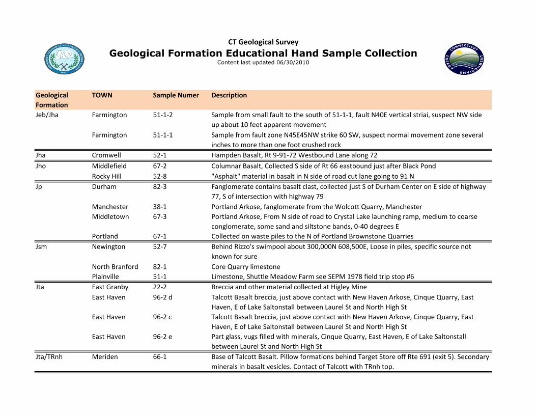
Jeb/Jha Farmington 51-1-2 Sample from small fault to the south of 51-1-1, fault N40E vertical striai, suspect NW side
up about 10 feet apparent movement
Farmington 51-1-1 Sample from fault zone N45E45NW strike 60 SW, suspect normal movement zone several
inches to more than one foot crushed rock
Jha Cromwell 52-1 Hampden Basalt, Rt 9-91-72 Westbound Lane along 72
Jho Middlefield 67-2 Columnar Basalt, Collected S side of Rt 66 eastbound just after Black Pond
Rocky Hill 52-8 "Asphalt" material in basalt in N side of road cut lane going to 91 N
Jp Durham 82-3 Fanglomerate contains basalt clast, collected just S of Durham Center on E side of highway
77, S of intersection with highway 79
Manchester 38-1 Portland Arkose, fanglomerate from the Wolcott Quarry, Manchester
Middletown 67-3 Portland Arkose, From N side of road to Crystal Lake launching ramp, medium to coarse
conglomerate, some sand and siltstone bands, 0-40 degrees E
Portland 67-1 Collected on waste piles to the N of Portland Brownstone Quarries
Jsm Newington 52-7 Behind Rizzo's swimpool about 300,000N 608,500E, Loose in piles, specific source not
known for sure
North Branford 82-1 Core Quarry limestone
Plainville 51-1 Limestone, Shuttle Meadow Farm see SEPM 1978 field trip stop #6
Jta East Granby 22-2 Breccia and other material collected at Higley Mine
East Haven 96-2 d Talcott Basalt breccia, just above contact with New Haven Arkose, Cinque Quarry, East
Haven, E of Lake Saltonstall between Laurel St and North High St
East Haven 96-2 c Talcott Basalt breccia, just above contact with New Haven Arkose, Cinque Quarry, East
Haven, E of Lake Saltonstall between Laurel St and North High St
East Haven 96-2 e Part glass, vugs filled with minerals, Cinque Quarry, East Haven, E of Lake Saltonstall
between Laurel St and North High St
Jta/TRnh Meriden 66-1 Base of Talcott Basalt. Pillow formations behind Target Store off Rte 691 (exit 5). Secondary
minerals in basalt vesicles. Contact of Talcott with TRnh top.
Geological
Formation
TOWN Sample Numer Description
CT Geological Survey
Geological Formation Educational Hand Sample CollectionContent last updated 06/30/2010
Jwr New Haven 95-1 Collected at S end of West Rock just above baseball field at Gustave X. Amrhyn Field
Ob Newtown 92-3-1 Young Granite sheared in broad Fault Zone nearly horizontal movement, nearby good
ultramylonite
Newtown 92-3-2 Rock exposures in sand pit
Newtown 77-2 Newtown Gneiss, massive porphyroblastic phase
Obr Old Saybrook 99-6-4 Amphibolite in Brimfield, 99-6-4F Felsic Gneiss which appears to intrude amphibole, see S.
Quarrier field notes 8/77
Old Saybrook 99-5-6 Conglomerate and quartzite from W of Pequot Swamp
Salem 70-1 Brimfield Schist
Union 26-1 Brimfield Schist, from valley north of unnamed brook north of Kinney Pond along Kinney
Hollow Road in Union
Westbrook 99-8 Rust-stained biotite-orthoclase-sillimanite-garnet schist, collected behind Westbrook
Factory Stores just S of rest area on I-95 in Westbrook
Westbrook 99-5-3 Quartzite and conglomerate from W side of Rt 153, Essex, see S. Quarrier field notes 8/77
Willington 25-2 Brimfield Schist, Collected along I-84 off exit 70 (Route 32) S side of I-84 just past end of
eastbound onramp
Willington 26-5 b Plagioclase quartz k-feldspar, biotite garnet schist, pink garnets, S side I-84, 2 miles E of
Ruby Road, exit 71, Route 320 before Potter School Rd overpass
Willington 26-5 c Plagioclase quartz k-feldspar, biotite garnet schist, pink garnets, S side I-84, 2 miles E of
Ruby Road, exit 71, Route 320 before Potter School Rd overpass
Willington 26-5 a Brimfield Schist, S side I-84, 2 miles E of Ruby Road, exit 71, Route 320 before Potter School
Rd overpass
Obrg Union 26-2 Gneiss (metovolcanic) member of Brimfield Schist, collected along Route 89 between exit
72 of I-84 and Route 190 in Union

Geological
Formation
TOWN Sample Numer Description
CT Geological Survey
Geological Formation Educational Hand Sample CollectionContent last updated 06/30/2010
Union 26-4 Gneiss (metavolcanic) member of Brimfield Schist, collected 1.1 miles along Webster Rd.
from Toute 190, Union
Union 11-2 b Gneiss (metavolcanic) member of Brimfield Schist, two pyroxene granulite and
orthopyroxen, k-feldspar granulite, Roadcut along exit ramp from Exit 74, I-84 westbound
and Route 171, Union
Union 11-2 a Gneiss (metavolcanic) member of Brimfield Schist, two pyroxene granulite, Roadcut along
exit ramp from Exit 74, I-84 westbound and Route 171, Union
Oc Oxford 78-4 Collected at Southford Falls State Park near stream along trail
Oc Thomaston 49-2 Aplite Dike in Reynolds Bridge Gneiss
Och East Hampton 68-13 Pegmatite with large tourmaline crystal from Halberg Quarry, East Hampton
East Hampton 68-4 Two colored feldspar samples from old pegmatite quarry, Meshomasic State Forest near
Cobalt
Haddam 83-4 Collins Hill Formation, Plagioclase Quartz Biotite (Hornblend?) Garnet Gneiss, E side of
northbound lane of Rt 9, almost coticule-like
Haddam 83-5 Collins Hill Formation, Muscovite? schist with abundant sulphides, weather rapidly to
yellow rusty color, Rt 9 N, E side
Haddam 68-15 Collected on Chamberlain Hill Rd in Haddam, just below Middletown border, 0.2 miles E of
Roberts Rd
Haddam 68-8 Feldspar with some muscovite from Rock Landing Quarry, East Hampton
Haddam 68-9 Piece of smokey quartz, blackness of quartz is due to radiation burns from Rock Landing
Quarry, East Hampton
Haddam 68-10 Smokey quartz with Uranium minerals from Rock Landing Quarry, East Hampton, CT
Middletown 68-6 Vein quartz and galena from former silver mine, Middletown
Middletown 68-7 a Vein contains quartz, bornite, sphalerite from former silver mine, Middletown
Middletown 68-5 Vein quartz and galena from former silver mine, Middletown

Geological
Formation
TOWN Sample Numer Description
CT Geological Survey
Geological Formation Educational Hand Sample CollectionContent last updated 06/30/2010
Portland 68-3 Two samples, mica and quartz feldspar and turmoline from debris on roadway at Strickland
Quarry
Ochv Haddam 82-2 Coticule Metavolcanic Rocks of Bible Brook, Eaton and Rosenfeld 1972, opposite side of
road from Millers Pond
Haddam 83-9 Coticule Metavolcanic Rocks of Bible Brook, Eaton and Rosenfeld 1972, Under power lines
Middletown 68-17 Metavolcanic member of Collins Hill Formation, amphibolite and hornblende schist,
collected from White Rocks Quarry, River Rd, Middletown
OCr Harwinton 34-7-1 Rowe Schist, Hartland II
Roxbury 62-1 Kyanite Gneiss, south of Berry Rd, Roxbury, sample has 1-2" kyanite blades, site has 6-8"
specimens
Roxbury 62-1 a Sample from Log Jam Schist
Roxbury 62-3 Mica schist with garnet porphyroblasts, Hartland formation
OCs Bethel 76-9-1 Inwood? Marble from W side of stream just below Cameron's Line
Og Bethel 92-4-1 Collected from Huntington State Park, site of large tourmaline
Redding 92-5 From Huntington State Park, intersection of blue and red trails
Redding 92-6 Biotite Schist with garnets from Huntington State Park along red trail near swamp
Roxbury 62-5 Mine Hill Granite Gneiss from operating quarry on Roxbury Landtrust land, noticeable
amounts of Biotite
Roxbury 62-5 a Includes white colored band of aplite, does not split
Roxbury 62-7 Sample from 1-2' wide vein along north wall of quarry, siderite, etc presumeably in part of
the vein network forming iron deposit, see also 62-4
Roxbury 62-4 Mine Hill Granite Gneiss from blocks in the Rockside Quarry, see Dale 1911 USGS Bull 484,
Muscovite Granite Gneiss, See also 62-6

Geological
Formation
TOWN Sample Numer Description
CT Geological Survey
Geological Formation Educational Hand Sample CollectionContent last updated 06/30/2010
Ogl Glastonbury 54-1 a Glastonbury Gneiss with Xenolith, Cliff Ambers at Indiana University working on this
outcrop
Glastonbury 54-1 b Several photos of this, large exposed area of polished and straited surface, glacial striate
Manchester 54-2 b Glastonbury gneiss collected from old curbstone? quarry
Manchester 54-2 a Glastonbury gneiss from large boulder that was split as part of local quarrying, may have
come from some distance north
Manchester 39-2 Glastonbury Gneiss- pegmatite phase, collected during NEIGC trip between I-384 and
eastbound entrance ramp from Wyllis St in Manchester (Highland Park)
Portland 68-12 Collected from Case Quarry, Portland
Portland 53-1 Collected along Algonquin Gas Pipeline trench
Portland 53-4 Pegmatite in Glastonbury Gneiss, Collected along Algonquin Gas Pipeline trench
Portland 53-3 Aplite Dike in Glastonbury Gneiss, Collected along Algonquin Gas Pipeline trench
Portland 53-2 Glastonbury Gneiss and aplite dike, Collected along Algonquin Gas Pipeline trench
Ohb Bridgeport 109-1 Collected in Beardsley Park, Bridgeport
Oma Milford 110-1 a Greenstone, collected along road into Silver Sands State Park
Milford 110-1 b Schist, collected along road into Silver Sands State Park
Oml Haddam 83-10 Middletown Formation, Haddam Map Om if microcline bearing gneiss, Light gneiss S of
Hackney Pond, W side of the swamp, S of road
Haddam 83-3 Amphibolite/Hornblende Gneiss, massive amphibolite E side, southbound lane Rt. 9, S end
of large amphibolite, just S of Beaver Meadow Rd
Haddam 83-11 Anthophylite, Hubbard Rd just N of Beaver Meadow Rd off Exit 8 of Rt 2, Haddam

Geological
Formation
TOWN Sample Numer Description
CT Geological Survey
Geological Formation Educational Hand Sample CollectionContent last updated 06/30/2010
Haddam 68-1 Pegmatite from Pegmatite sill in bottom of Middletown Formation, W side of Rt 9
southbound lane just past power lines
Omo Haddam 83-1 Collected E side of southbound lane Rt 9
Haddam 84-6 From small Farm Lot Quarry, S. Quarrier Field Notes 87-1-2
Killingworth 98-1 Chatfield Hollow State Park, W side of trail around Indian Caves
Killingworth 83-7 Monson Gneiss, Haddam Gneiss, N side Rt 148, N of Murry Ponds, cloudy quartz in joints in
this area, tan gneiss is typical of the area
Killingworth 83-8 N80E10N, E side road, typical Haddam Gneiss
Madison 97-5 Monson Gneiss, massive to well layered biotite gneiss, layering 1 cm to 1 m, some
interlayered amphibolite, sample shows moderately well-layered rock, foliation well-
developed on biotite mica layers
Westbrook 99-5-2 Rusty weathering monson gneiss, Bio, Hbl, Sulfide from W side of Rt 153, Essex, see S.
Quarrier field notes 8/77
Westbrook 99-5-1 Monson Hbl Gneiss from E side of Rt 153, Essex, see S. Quarrier field notes 8/77
Omu Haddam 83-6 Middletown Formation, Quartz Plagioclase (Gedrite-Anthophyllite) Gneiss, Rt 9 northbound
entrance ramp E side, Beaver Meadow Rd
Oo Milford 111-1 Collected from Merwin Point, Woodmont
Op North Stonington 88-1 From N side of Rt 2
Oq Plainfield 58-1 Gneiss from near the village of Wauregan, TILCON Wauregan Quarry
Or Bethel 76-9-2 Sheared Hartland? from E side of stream just above Cameron's Line
Danbury 76-8-1 Mylonite sample in granite behind Auto sales place
Harwinton 34-7-3 Ratlum Mountain Schist, Hartland I, N side of highway just before Rt. 8, gneiss
Harwinton 34-8-2 Ratlum Mountain Schist, Hartland III, S. side of road just NE of Kelly Pond, Burlington
Roxbury 62-2 Mica quartzite- Schist, Hartland formation
Geological
Formation
TOWN Sample Numer Description
CT Geological Survey
Geological Formation Educational Hand Sample CollectionContent last updated 06/30/2010
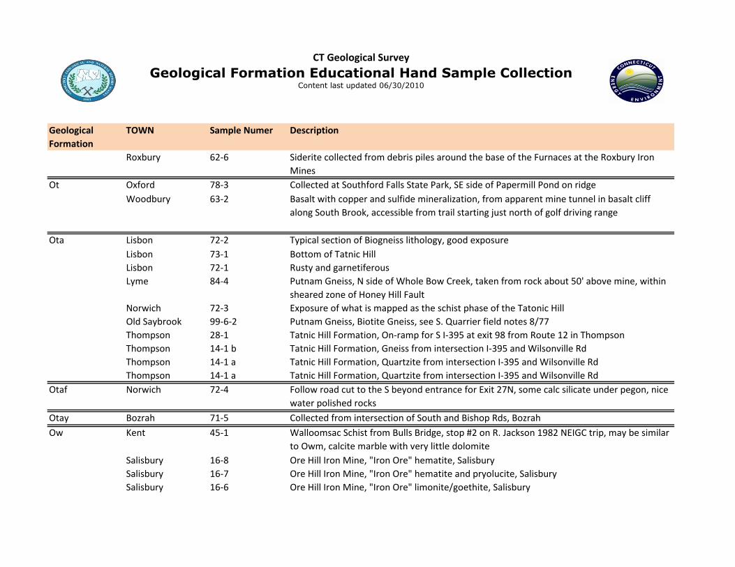
Roxbury 62-6 Siderite collected from debris piles around the base of the Furnaces at the Roxbury Iron
Mines
Ot Oxford 78-3 Collected at Southford Falls State Park, SE side of Papermill Pond on ridge
Woodbury 63-2 Basalt with copper and sulfide mineralization, from apparent mine tunnel in basalt cliff
along South Brook, accessible from trail starting just north of golf driving range
Ota Lisbon 72-2 Typical section of Biogneiss lithology, good exposure
Lisbon 73-1 Bottom of Tatnic Hill
Lisbon 72-1 Rusty and garnetiferous
Lyme 84-4 Putnam Gneiss, N side of Whole Bow Creek, taken from rock about 50' above mine, within
sheared zone of Honey Hill Fault
Norwich 72-3 Exposure of what is mapped as the schist phase of the Tatonic Hill
Old Saybrook 99-6-2 Putnam Gneiss, Biotite Gneiss, see S. Quarrier field notes 8/77
Thompson 28-1 Tatnic Hill Formation, On-ramp for S I-395 at exit 98 from Route 12 in Thompson
Thompson 14-1 b Tatnic Hill Formation, Gneiss from intersection I-395 and Wilsonville Rd
Thompson 14-1 a Tatnic Hill Formation, Quartzite from intersection I-395 and Wilsonville Rd
Thompson 14-1 a Tatnic Hill Formation, Quartzite from intersection I-395 and Wilsonville Rd
Otaf Norwich 72-4 Follow road cut to the S beyond entrance for Exit 27N, some calc silicate under pegon, nice
water polished rocks
Otay Bozrah 71-5 Collected from intersection of South and Bishop Rds, Bozrah
Ow Kent 45-1 Walloomsac Schist from Bulls Bridge, stop #2 on R. Jackson 1982 NEIGC trip, may be similar
to Owm, calcite marble with very little dolomite
Salisbury 16-8 Ore Hill Iron Mine, "Iron Ore" hematite, Salisbury
Salisbury 16-7 Ore Hill Iron Mine, "Iron Ore" hematite and pryolucite, Salisbury
Salisbury 16-6 Ore Hill Iron Mine, "Iron Ore" limonite/goethite, Salisbury
Geological
Formation
TOWN Sample Numer Description
CT Geological Survey
Geological Formation Educational Hand Sample CollectionContent last updated 06/30/2010
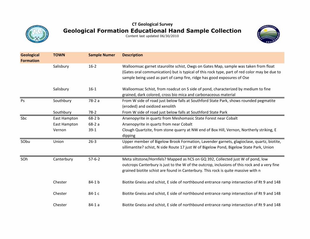
Salisbury 16-2 Walloomsac garnet staurolite schist, Owgs on Gates Map, sample was taken from float
(Gates oral communication) but is typical of this rock type, part of red color may be due to
sample being used as part of camp fire, ridge has good exposures of Ose
Salisbury 16-1 Walloomsac Schist, from roadcut on S side of pond, characterized by medium to fine
grained, dark colored, cross bio mica and carbonaceous material
Ps Southbury 78-2 a From W side of road just below falls at Southford State Park, shows rounded pegmatite
(eroded) and oxidized xenolith
Southbury 78-2 From W side of road just below falls at Southford State Park
Sbc East Hampton 68-2 b Arsenopyrite in quartz from Meshomasic State Forest near Cobalt
East Hampton 68-2 a Arsenopyrite in quartz from near Cobalt
Vernon 39-1 Clough Quartzite, from stone quarry at NW end of Box Hill, Vernon, Northerly striking, E
dipping
SObu Union 26-3 Upper member of Bigelow Brook Formation, Lavender garnets, glagioclase, quartz, biotite,
sillimantite? schist, N side Route 17 just W of Bigelow Pond, Bigelow State Park, Union
SOh Canterbury 57-6-2 Meta siltstone/Hornfels? Mapped as hCS on GQ 392, Collected just W of pond, low
outcrops Canterbury is just to the W of the outcrop, inclusions of this rock and a very fine
grained biotite schist are found in Canterbury. This rock is quite massive with n
Chester 84-1 b Biotite Gneiss and schist, E side of northbound entrance ramp intersection of Rt 9 and 148
Chester 84-1 c Biotite Gneiss and schist, E side of northbound entrance ramp intersection of Rt 9 and 148
Chester 84-1 a Biotite Gneiss and schist, E side of northbound entrance ramp intersection of Rt 9 and 148

Geological
Formation
TOWN Sample Numer Description
CT Geological Survey
Geological Formation Educational Hand Sample CollectionContent last updated 06/30/2010
Deep River 99-7 Sulfur rich layer in Hebron Gneiss, from Kelsey Hill Rd near Rt 9 overpass, Deep River
Hampton 42-5-1 Hebron Gneiss, Metasiltstone, Hebron (Oakdale) well layered sample collected from Knob
behind house, well developed chevron folds in outcrop, fold acts as N50-60E plunge gentle
N and S, Amplitude 1-2', W over E couple
Lebanon 71-2 Metasiltstone Hebron, like Oakdale
Lyme 84-5 Gillette Castle area, partway down the slope facing ferry, note dark mylonite layer
Old Saybrook 99-6-1 Hebron Biotite Schist, N 60-80E 80N, see S. Quarrier field notes 8/77, also sample of
Calcified Silicate Gneiss
Stb Trumbull 93-1 Marble in lower Straits Schist, taken on SW side of Mine Hill
TRnh East Haven 96-2 b Contains carbonized wood fossils, from just below contact with Talcott Basalt, Cinque
Quarry, East Haven, E of Lake Saltonstall between Laural St and North High St
East Haven 96-2 a From just below contact with Talcott Basalt, Cinque Quarry, East Haven, E of Lake
Saltonstall between Laurel St and North High St
Southbury 77-1 Petrified Wood reportedly from Pomperaug Triassic
u Deep River 99-2-1 Ultramafic body shown on quad report
Ygn New Milford 46-5 Pre-Cambrian, Proterozoic gneiss, just up the hill from sample 46-4, R. Jackson 1982 NEIGC
field trip stop #5, can trace a contact between Dalton and Ygn
Zl New Haven 111-2 From Light House Point Park, New Haven, below lighthouse
Zp Killingly 44-1 Plainfield Formation, N side of route (Conn. Turnpike) in zone of transition from quartzite to
schist, note lineation
Zp, Zsc & Pn Branford 97-6 From Red Hill Quarry, Stony Creek Preserve, Branford
Guilford 97-2 "Mamacoke Formation" of Bernold, 1962 p. 22, NE side of Joshua Cove, N of road, coarse
quartzite

Geological
Formation
TOWN Sample Numer Description
CT Geological Survey
Geological Formation Educational Hand Sample CollectionContent last updated 06/30/2010
Guilford 97-3 "Mamacoke Formation" of Bernold, 1962 p. 22, migmatite, 140-50N
Zp, Zsph & Pn? Old Lyme 100-1 Plainfield Formation Quarzite
Zpq, Zsc & Pn Guilford 97-4 Plainfield Formation, Quartzite and Quartz schist, bedding striking parallel to valley and dip
N 40 degrees
Zsc & Pn Branford 97-1 Stony Creek Quarry Granite
Zsh Groton 102-2 Collected on point above Bluff Point Beach
Plainfield 59-1 North side of Rt 14 in middle of large OTC
Zsp Killingly 44-2 Hope Valley Alaskite gneiss or Ponaganset gneiss, note lack of mafics and strong lineations
Zsph Old Lyme 100-2 Sterling Plutonic Group, biotite granitic gneiss collected behind boatyard
Zw Griswold 73-2 From NW side of Glasgo Pond, Griswold
Zwnj Lyme 84-2 New London Gneiss, Joshua Rock Member, Aegerine augite gneissic granite, collected from
Joshua Rock
Montville 86-2 New London Gneiss, Joshua Rock Gneiss Member, Aegerine augite
Waterford 86-3 Cherry Red spots, collected from abandoned stone quarry
Zwr Deep River 84-8 From steamboat landing between town parking lot and railroad track, Deep River
Salem 85-1 From Rt 11 in Salem, Not collected yet
Salem 86-1 Monson, from S of Honey Hill Fault Zone
Єh Barkhamsted 19-9-1 Cambrian "Waramaug Formation", Hoosac Schist, West Hill Road, New Hartford, 2 samples.
Quartzplagioclase- biotite schist and gneissic schist.
Quat Windsor 22-3 Concretions and Bone, Concretions (2) out of Varved Clay (Pleistocene), Bone taken to
Peabody