geological characteristic of low rank coal …psdg.bgl.esdm.go.id/makalah/aguspudjo_pmg.pdf ·...
TRANSCRIPT

GEOLOGICAL CHARACTERISTIC OF GEOLOGICAL CHARACTERISTIC OF LOW RANK COAL AT BANJARSARI LOW RANK COAL AT BANJARSARI
SOUTH SUMATERASOUTH SUMATERA
7 September 2006
Agus Pujobroto (CGR), Pajar Wisnu Wardhono, Suhedi (PT. BA)
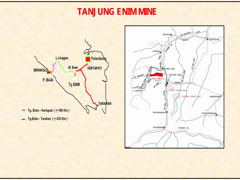
TANJUNG ENIM MINE

PT. BA Coal Reserves , per January 2006
No Coal Field Status Location Reserves Total Av. CV (cal/gr-adb)
1
2
3
4
Total PT. BA Reserves
213.68295.86419.09583.0739.32
1,551.02 63005700570057006950
a. Air Layab. MTBUc. MTBSd. West Bankoe. Bukit Kendi
Active MiningTE
172.13230.013.55285.04
1,062.11789.64401.55502.23457.8167.05
54.39325.00
4,360.50 5853615469004745492153544870504146857302537463454500
TE
a. Kungkilanb. East Kungkilanc. Bukit Munggud. Banjar Sarie. South Arahanf. Central bangkog. North Arahanh. North Suban Jerijii. South Bankoj. Bukit Bunian
k. Air Serelol. East Suban Jeriji
Cerenti
Develop-ment
Cerenti
Ombilina. Ombilin 1b. Ombilin 2c. Ombilin 3
1,340.63 4,695
2.1844.6044.07
90.45684070616918
7,343,00
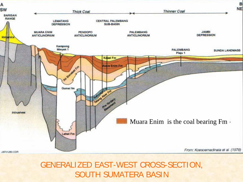
GENERALIZED EAST-WEST CROSS-SECTION, SOUTH SUMATERA BASIN
Muara Enim is the coal bearing Fm


LITHOLOGICAL FEATURES OF THE MUARA ENIM FORMATION AND ADJACENT UNITS

Andesite Intrusion
Kasai Formation
Muara Enim FormationM2 Unit Major Fault
Major Anticlinal Fault Axis
Air Benakat Formation
Major Synclinal Fault Axis
PT. Bukit Asam Concession BoundaryFigure 2. Geological map of the Tanjung Enim area (modified from Haan, 1976)
E.SUBAN JERIJI 325 Mt.
N.SUBAN JERIJI 502 Mt.
SOUTHBANKO 578 Mt.
WESTBANKO 671 Mt.
AIR LAYA 249 Mt.
BANJARSARI 285 Mt.
A. SELERO 50 Mt.
B. KENDI 45 Mt.
B. BUNIAN 20 Mt.
N. ARAHAN 230 Mt.
KUNGKILAN 146 Mt.
N. MTB331 Mt.
S. MTB422 Mt.
Muara Enim
Tanjung Enim
9.580.000
9.585.000
9.590.000
9.595.000
350.000 355.000 360.000 365.000 370.000 375.000
kilometre
N
0 1 2 3 4 5
Air Laya
Klawas
Bukit Selero
Sira Pulau Tabu Anticline
Eni
m R
iver
Eni
m R
iver
Lem
atan
g R
iver
Legend :

MUARA TIGA BESAR MINE
BANKO BARAT MINE
TOWN SITE PTBAPTBA OFFICE
TLS 3
TLS 1+2
BANKO BARATPIT 1
DUMPING AREABANKO
DUMPING AREABANKOPIT 3
STOCKPILE
MTBU
MTBS
AIR LAYA MINEBWE SYSTEM
TANJUNG ENIMMINING COMPLEX
DUMPING AREA AIR LAYA
MeasuredResources285 M tonnes
BANJARSARI COALFIELD 4.500 Ha

N
Lawai River
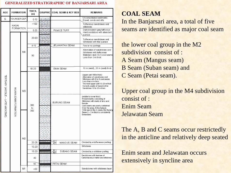
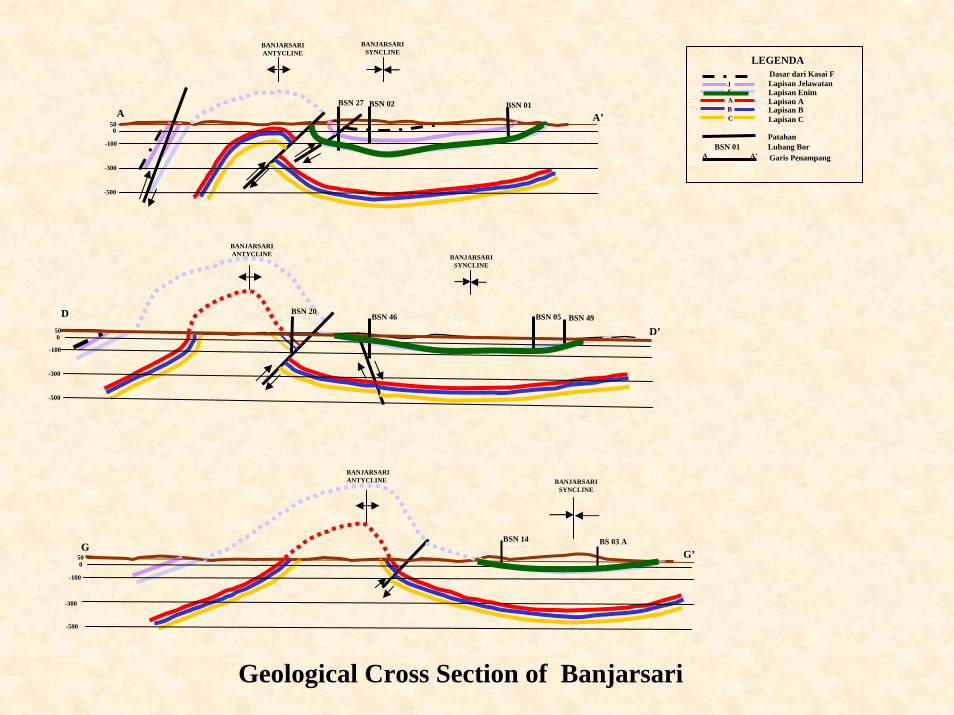
COAL SEAM In the Banjarsari area, a total of five seams are identified as major coal seam
the lower coal group in the M2 subdivision consist of :A Seam (Mangus seam)B Seam (Suban seam) and C Seam (Petai seam).
Upper coal group in the M4 subdivision consist of :Enim SeamJelawatan Seam
The A, B and C seams occur restrictedly in the anticline and relatively deep seated
Enim seam and Jelawatan occurs extensively in syncline area

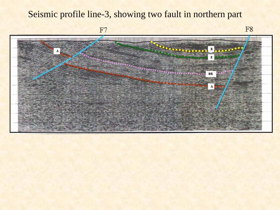
Seismic profile line-3, showing two fault in northern part
JEABC
A A’
LEGENDADasar dari Kasai FLapisan JelawatanLapisan EnimLapisan ALapisan BLapisan C
PatahanBSN 01 Lubang Bor
Garis Penampang
A0
50
-100
-300
-500
A’
BANJARSARIANTYCLINE
BANJARSARISYNCLINE
BSN 27 BSN 02 BSN 01
D
D’500
-100
-300
-500
BANJARSARIANTYCLINE BANJARSARI
SYNCLINE
BSN 20BSN 46 BSN 05 BSN 49
BANJARSARIANTYCLINE BANJARSARI
SYNCLINE
GG’50
0
-100
-300
-500
BSN 14 BS 03 A
Geological Cross Section of Banjarsari

ENIMSEAM JELAWATAN SEAM
Lawai River Lawai River
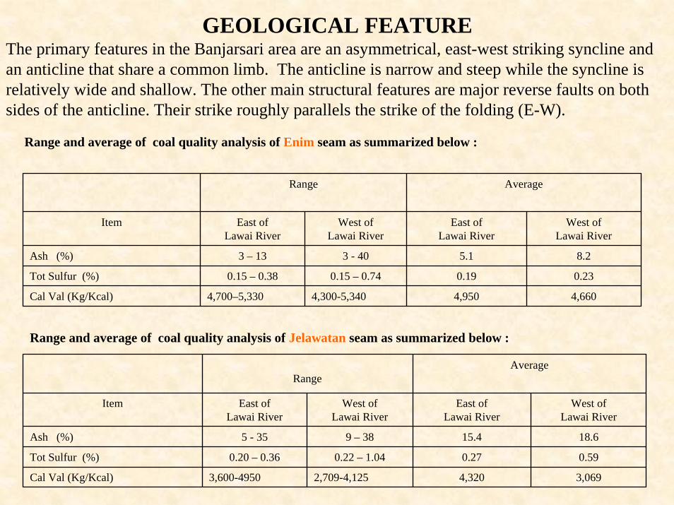
GEOLOGICAL FEATUREThe primary features in the Banjarsari area are an asymmetrical, east-west striking syncline and an anticline that share a common limb. The anticline is narrow and steep while the syncline is relatively wide and shallow. The other main structural features are major reverse faults on both sides of the anticline. Their strike roughly parallels the strike of the folding (E-W).
Range Average
Item East ofLawai River
West ofLawai River
East ofLawai River
West ofLawai River
Ash (%) 3 – 13 3 - 40 5.1 8.2
Tot Sulfur (%) 0.15 – 0.38 0.15 – 0.74 0.19 0.23
Cal Val (Kg/Kcal) 4,700–5,330 4,300-5,340 4,950 4,660
Range and average of coal quality analysis of Jelawatan seam as summarized below :
3,0694,3202,709-4,1253,600-4950Cal Val (Kg/Kcal)
0.590.270.22 – 1.040.20 – 0.36Tot Sulfur (%)
18.615.49 – 385 - 35Ash (%)
West ofLawai River
East ofLawai River
West ofLawai River
East ofLawai River
Item
AverageRange
Range and average of coal quality analysis of Enim seam as summarized below :

Moisture of E Seam of Banjarsari Coal
0
5
1 0
1 5
2 0
2 5
3 0
3 5
4 0
10 .-15 15 -2 0 2 0 -2 5 2 5 -3 0 3 0 -3 5 3 5 -4 0 4 0 -4 5 4 5 -5 0 5 0 -5 5 5 5 -6 0
( M o istu re % )
(% )
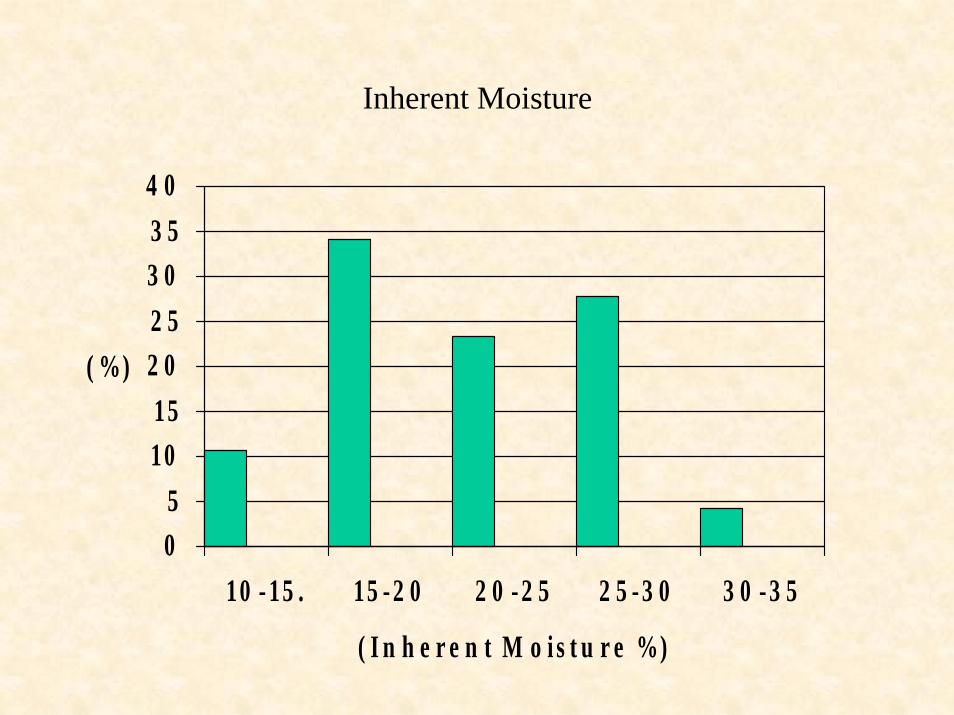
Inherent Moisture
0
5
1 0
1 5
2 0
2 5
3 0
3 5
4 0
10 -1 5. 15-2 0 2 0 -2 5 2 5-3 0 3 0 -3 5
(In h e re n t M o istu re % )
(% )

ASH COMPOSITION IN AVERAGE
NO COAL SEAM SiO2 Al2O3 Fe2O3 TiO2 CaO MgO K2O Na2O P2O5 SO3 MnO2
1 Jelawatan 50.56 23.88 7.76 2.3 7.49 2.97 2.18 2.46 4.07 2.99 2.082 Enim 33.17 22.11 12.03 0.97 15.99 2.71 0.55 1.56 3.72 3.32 0.553 A1 49.81 20.62 7.48 0.82 8.96 1.64 0.4 0.94 5.66 0.47 0.134 A2 37.82 20.76 9.21 0.67 12.42 2.91 0.32 2.85 7.92 0.81 0.225 B 49.25 23.75 4.76 0.86 5.23 2.42 0.42 2.65 6.04 0.54 0.086 C 48.39 21.32 7.16 0.7 4.69 2.59 0.49 2.39 8.93 0.41 0.06
PETROGRAPHY ANALYSIS RESULTREFLECTANCE
COAL SEAM TL DT GL V SF F SC INTR IN RE SP SB CU EKS MM (RV max) %
Jelawatan 58.6 22.1 1.1 81.8 1.8 - 1 2.2 5 1.2 0.8 0.6 0.7 3.3 9.9 0.36Enim 61.6 25.5 0.6 87.7 0.58 0.01 1.5 1.7 3.8 1.9 1.2 0.9 1.2 5.2 3.3 0.39
A 70.6 14.8 - 85.4 - - 1.4 0.2 1.6 3.4 2.2 1.8 2.8 10.2 2.8 0.4B 52.4 31.1 0.3 83.8 - - 2 2.2 4.2 1.8 2.9 1.2 3.4 9.3 2.7 0.4C 52.5 26.6 0.6 79.7 0.5 - 1.5 1.7 3.7 2.6 2.6 3.2 3.3 11.7 4.9 0.41
TL = Telovitrinite SC = Sclerotinite SB = SuberiniteDT = Detrovitrinite INTR = Inertodetrinite CU = CutiniteGL = Geolovitrinite IN = Inertinite EKS = EksiniteV = Vitrinite RE = Resinite MM = Mineral MatterSF = Semifusinite SP = Sporinite Rv max = Average of Vitrinite ReflectanceF = Fusinite
M A C E R A L (%)

Typical Lithology of Banjarsari

vitrinite in the BA coals

Maceral I PT. BA Coals

Sclerotinite of Bukit Asam Coals

Mineral matter in PT. BA Coals

Banjarsari area has a relatively good potential of coal resources. There are minimal two major coal seam called Enim seam and Jelawatan seam can be developed economically. One of the important reason the site of Banjarsari is closer to the existing mining infrastructure, and have environmentally friendly coal properties
The coal quality can be grouped in two discrete areas, the west and the east area which are divide by Lawai River. There is a gradual increase in thickness and coal quality in the area distribution from west to east.
Variation in ash and sulfur content will increase possibility to blend different type coals and resulting many type of products. Beside that the additional several discontinuous minor coal seams will give an extra coal resources in the future mining stage.
CONCLUSION
