geologic setting of the la bajada constriction and cochiti ... setting of the la bajada constriction...
TRANSCRIPT
Geologic Setting of the La Bajada Constriction and Cochiti Pueblo Area, New Mexico
By David A. Sawyer and Scott A. Minor
Chapter A ofThe Cerrillos Uplift, the La Bajada Constriction, and Hydrogeologic Framework of the Santo Domingo Basin, Rio Grande Rift, New MexicoEdited by Scott A. Minor
Professional Paper 1720–A
U.S. Department of the InteriorU.S. Geological Survey

Contents
Abstract ...........................................................................................................................................................3Introduction and Setting ...............................................................................................................................3
Context ....................................................................................................................................................3Purpose of Study ...................................................................................................................................4Geographic Setting ...............................................................................................................................4Land Use and Ownership.....................................................................................................................6Population Growth and Demands on Water .....................................................................................6Previous Geologic Mapping ................................................................................................................6
Geologic Setting of the La Bajada Constriction Area ..............................................................................9Rio Grande Rift.......................................................................................................................................9Basin Architecture and Terminology .................................................................................................9
Original Definitions of the La Bajada Constriction and Cerrillos Uplift ...............................9Geologic Definition of the La Bajada Constriction and Surrounding Basins ...................11
Cerros Del Rio Volcanic Field and Cerrillos Uplift .......................................................13Santo Domingo Valley ......................................................................................................14Saint Peters Dome Block .................................................................................................14
Stratigraphy of Pre-Rift Rocks ...................................................................................................................14Precambrian and Paleozoic Rocks ..................................................................................................15Mesozoic Sedimentary Rocks ..........................................................................................................15Pre-Rift Tertiary Rocks .......................................................................................................................17
Hydrostratigraphic Properties of Pre-Rift Sedimentary and Igneous Rocks .....................................18References Cited..........................................................................................................................................19
Figures A1. Index map of the Rio Grande rift in northern New Mexico showing principal
geologic and geographic features, cities, and towns mentioned in text ............................5 A2. Tectonic map of a segment of the middle Rio Grande rift showing the Santo
Domingo, northern Albuquerque, and Española Basins and the La Bajada constriction ....................................................................................................................................8
A3. Isostatic residual gravity model of the Santo Domingo Basin area showing gravity stations and major faults ...........................................................................................................10
A4. Digital elevation model image of the Cochiti Pueblo area showing the La Bajada constriction between bounding Cerrillos uplift and Saint Peters Dome block ............... 12
Table A1. Thicknesses of basal Cretaceous, Jurassic, Triassic, and Paleozoic stratigraphic
units ...............................................................................................................................................16
Geologic Setting of the La Bajada Constriction and Cochiti Pueblo Area, New Mexico
By David A. Sawyer and Scott A. Minor
AbstractThe geologic, geophysical, and hydrogeologic studies of
the La Bajada constriction area and adjacent Santo Domingo Basin presented in this chapter and following chapters of this report are largely an outgrowth of regional hydrogeologic investigations in the Albuquerque Basin, greater Santa Fe area, Los Alamos National Laboratory, and Native American pueblos, especially the Pueblo de Cochiti. The La Bajada con-striction area contains a complex mosaic of federal (National Forest, National Park, and Bureau of Land Management), State of New Mexico, Native American, and private lands. The scientific results summarized in this report are intended to provide critical information for the citizens of New Mexico and for the governmental officials who represent them in order to better manage the various land surface environments and groundwater resources of this complex and vital region.
The geologic, geophysical, and hydrogeologic proper-ties of the Santo Domingo Basin and La Bajada constriction are the result of tectonic and volcanic processes related to the late Tertiary and Quaternary Rio Grande rift. The La Bajada constriction is herein defined as the relatively narrow structural trough, containing >200 m of basin-fill sediments and bounded by rift-flank uplifts, that links the southern part of the Española Basin and the northeast part of the Santo Domingo Basin. The La Bajada constriction area can be subdivided into three terranes based on topographic expression, structural configuration, and dominant stratigraphy: (1) an elevated Cerros del Rio volcanic field–Cerrillos uplift eastern-border terrane; (2) the central Santo Domingo valley; and (3) an elevated Saint Peters Dome block western-border terrane. The southeastern boundary of the La Bajada constriction and the western border of the Cerrillos uplift are well defined by the La Bajada fault-zone escarpment south of the Cañada de Santa Fe, but to the north the boundary steps eastward to the geophysically expressed Tetilla fault zone buried beneath Pliocene basalts and andesites of the Cerros del Rio volcanic field. The Cerrillos uplift consists of upwarped Meso-zoic marine and continental sedimentary rocks unconformably overlain by Eocene and Oligocene sedimentary and volcanic rocks and intruded by Eocene and Oligocene stocks. The western boundary of the La Bajada constriction is sharply defined by the Pajarito fault zone and the footwall Saint Peters Dome block. To the southwest the Pajarito fault zone dies out at the surface, but an older, aligned, buried structure continues to the southwest as a
geophysically expressed basin-bounding fault. Rocks underlying the Saint Peters Dome block consist mainly of Miocene volca-nic rocks of the Jemez volcanic field. Between the Saint Peters Dome block and the Cerrillos uplift, the La Bajada constriction is filled by Miocene to Pleistocene Santa Fe Group basin-fill sedi-ments that interfinger with and are overlain by volcanic rocks of the Cerros del Rio volcanic field and early Pleistocene Bandelier Tuff erupted from nearby Valles caldera.
The stratigraphy and lithology of the pre-rift (Protero-zoic through early Miocene) basement and sedimentary rocks underlying the region and their effects on the hydrogeology of the La Bajada constriction area are summarized in this chapter. Cretaceous marine sedimentary rocks in the Cerril-los uplift form a regional groundwater barrier that retards or prevents flow from the southern Espanola Basin into the Santo Domingo Basin. Overlying Eocene and Oligocene sedimentary and volcanic rocks (the Galisteo and Espinaso Formations, respectively), which may be variably hydraulically conductive, thicken eastward away from the La Bajada constriction and Santo Domingo Basin.
Introduction and SettingContext
Studies by the U.S. Geological Survey were begun in 1996 to improve understanding of the geologic framework of the Albuquerque composite basin and adjoining areas, in order that more accurate hydrogeologic parameters could be applied to new hydrologic models. The ultimate goal of this multidis-ciplinary effort has been to better quantify estimates of future water supplies for northern New Mexico’s growing urban centers, which largely subsist on aquifers in the Rio Grande rift basins (Bartolino and Cole, 2002). From preexisting hydrologic models it became evident that hydrogeologic uncertainties were large in the Santo Domingo Basin area, immediately upgradient from the greater Albuquerque metropolitan area, and particu-larly in the northeast part of the basin. Accordingly, a priority for the new geologic and geophysical investigations was to better determine the hydrogeologic framework of the Santo Domingo Basin, especially geologic controls of underflow in the northeasternmost part of the basin known as the La Bajada constriction (defined subsequently in this chapter—see Basin
Architecture and Terminology section). In addition, because subsurface information from deep wells and geophysical logs was almost completely lacking for the Santo Domingo Basin, our hydrogeologic studies in this area depended almost entirely on new surface geologic mapping and on geophysical imaging of the subsurface, calibrated by a small amount of water-well information. The current report presents the results of the U.S. Geological Survey’s recent geologic and geophysical investiga-tions of the hydrogeologic framework of the northeast part of the Santo Domingo Basin and flanking uplands, including the La Bajada constriction area that was the focus of our study.
In this chapter we provide some background on the soci-etal issues that were most important in defining the scope and purpose of these multidisciplinary studies of the basin aquifer system in this part of the Rio Grande rift. We define the intra-basin and basin-bounding geologic features, review relevant previous investigations, and introduce and describe strati-graphic and structural features that affect the ground-water flow system. Finally, in this chapter we summarize geology and hydrostratigraphy of the older pre-rift rocks beneath and flanking the Santo Domingo and Española Basins.
Purpose of StudyThe overall purpose of this study is to improve knowl-
edge of the hydrogeology of the Rio Grande aquifer within the Santo Domingo Basin and adjoining parts of the Albuquerque and Española Basins. The Rio Grande aquifer can be viewed as that portion of the Rio Grande rift basin fill that is hydrauli-cally connected to the Rio Grande. The Rio Grande aquifer has been undergoing recharge since the last glacial maximum (22,000–19,000 years ago) and the peak of pluvial rainfall (Sanford and Plummer, 2000; Sanford and others, 2004a,b; Plummer and others, 2004a,b). Nevertheless, large portions of northern New Mexico adjoining, and locally within, the Albu-querque and Santo Domingo Basins have very old ground water (>25,000 years old), indicating that they have not recently been recharged (Sanford and others, 2000). Considerable potential exists for contamination of the Rio Grande aquifer, particularly by radionuclides released during nuclear weapons research and production at the Los Alamos National Laboratory just north of the study area. Geologic controls on fast migration pathways and travel times within the aquifer need to be better determined. Both the rate of recharge by the Rio Grande and the potential for fast migration of contaminants are functions of the hydraulic conductivity of the basin-fill sediments and faults of the Rio Grande rift. Spatial variability of hydraulic conductivity in the rift basins is largely a consequence of the tectonic and volcanic history of the rift. Describing this history and, particularly, the resulting geologic framework in the La Bajada constriction area, where ground water flows from the Española Basin into the Santo Domingo Basin, is a primary objective of this report. Better understanding of the subsurface geology affecting the ground-water resources of the region will improve hydrologic models of the age, movement, and recharge of ground water, and better models will improve the basis for managing the finite
ground-water resources of northern New Mexico. Synthesis of multidisciplinary investigations involving geologic mapping, high-resolution airborne magnetic surveys, lithologic and geo-physical logging of wells, surface-based electrical and magnetic surveys, enhanced satellite imagery, and hydrologic data will refine our understanding of the aquifer systems in the Santo Domingo Basin and the La Bajada constriction.
Geographic Setting
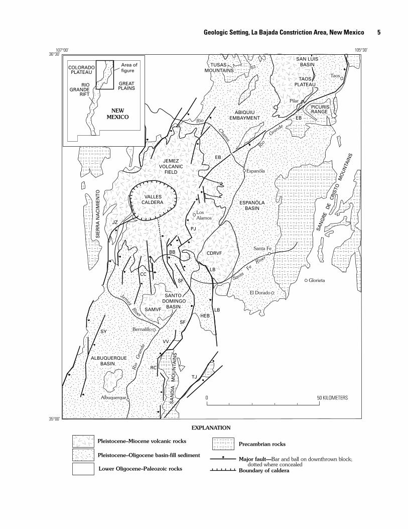
A prominent and important physiographic element of the study area is the chain of valleys and canyons occupied by the Rio Grande (Bryan and McCann, 1937) that result from geologic rift processes. The lowlands surrounding the Rio Grande between Pilar (fig. A1) on the north and its confluence with Cañada (Spanish for canyon) Ancha just south of Otowi Bridge and Buckman Mesa (La Mesita) (pl. 1) compose the Española Valley (fig. A2). Historically, this area was known as the Upper Rio Grande Valley during early Hispanic settlement that began in 1598, particularly in the areas of Española (then called Santa Cruz) and Santa Fe (fig. A1). South of Cañada Ancha the Rio Grande flows through White Rock Canyon, which separates Pajarito Plateau on the northwest from Caja del Rio Plateau on the southeast. White Rock Canyon is formed where the Rio Grande dissects the volcanic highland that separates the Española Valley from the Santo Domingo Valley (SDV, pl. 1, fig. A2). The Rio Grande exits the steep gorge of White Rock Canyon at Cochiti Pueblo and flows south through the broad lowlands of Santo Domingo Valley towards Bernalillo and Albuquerque (pl. 1). The La Bajada escarpment east of Cochiti Pueblo (pl. 1) forms the tradi-tional northeastern boundary of the Lower Rio Grande Valley and also represents part of the eastern boundary of the Santo Domingo structural basin (see discussion below). The southern end of the Santo Domingo Valley is located north of Berna-lillo where the Rio Grande lowlands become narrow between Santa Ana Mesa and the north end of the Sandia Mountains before widening again into the northern Albuquerque Basin (pl. 1, figs. A1, A2). The Cerrillos Hills, north of the Galisteo River, and the Caja del Rio Plateau form uplands separating the Santo Domingo Basin from the Española Basin to the northeast. The Santa Fe River cuts through this higher terrain in Cañada de Santa Fe before merging to the west with the Rio Grande in Santo Domingo Basin. Saint Peters Dome, north-west of Santo Domingo Basin, is a small massif of local peaks on the southeastern flank of the Jemez Mountains (pl. 1).
Figure A1 (facing page). Rio Grande rift region in northern New Mexico showing principal geologic and geographic features, cities, and towns mentioned in the text. BB, Bearhead Basin; CC, Cañada de Cochiti fault; CDRVF, Cerros del Rio volcanic field; EB, Embudo fault zone; HEB, Hagan embayment; JZ, Jemez fault; LB, La Bajada fault zone; PJ, Pajarito fault zone; RC, Rincon fault; SAMVF, Santa Ana Mesa volcanic field; SF, San Francisco fault; SY, San Ysidro fault; TJ, Tijeras fault zone; VV, Valley View fault. Modified from Smith, McIntosh, and Kuhle (2001).
� Hydrogeologic Framework, La Bajada Constriction Area, Rio Grande Rift, New Mexico
TAOSPLATEAU
Pleistocene–Miocene volcanic rocks
Pleistocene–Oligocene basin-fill sediment
Lower Oligocene–Paleozoic rocks
Precambrian rocks
Boundary of caldera
ABIQUIUEMBAYMENT
RIOGRANDE
RIFT
NEWMEXICO
ESPANÕLABASIN
Espanõla
ALBUQUERQUEBASIN
CDRVF
Albuquerque
SA
NG
RE
DE
CR
ISTO
M
OU
NTA
INS
BB
SIE
RR
A N
AC
IMIE
NT
O
35°00’
107°00’ 105°30’36°30’
RC
PilarPICURISRANGE
TUSAS MOUNTAINS
Taos
Bernalillo
LosAlamos
Glorieta
COLORADOPLATEAU
GREATPLAINS
EXPLANATION
Santa Fe
Area offigure
Major fault—Bar and ball on downthrown block;dotted where concealed
0 50 KILOMETERS
Santa
FeRive
r
Jem
ezRiver
Rio
Gra
nde
Rio
Grande
SAMVF
JEMEZVOLCANIC
FIELD
Rio
Chama
SAN LUISBASIN
El Dorado SANTODOMINGO BASIN
SA
ND
IA
MO
UN
TAIN
S
VALLESCALDERA
LB
LBHEB
SF
VV
TJ
SY
CCSF
PJJZ
EB
EB
Geologic Setting, La Bajada Constriction Area, New Mexico �

It is important to note that the La Bajada constriction is a geologic feature that is largely covered by younger plateau-forming volcanic rocks of the Cerros del Rio volcanic field (CDRVF, fig. A2). Therefore, apart from the narrowing of Santo Domingo Valley at its northern end in White Rock Canyon, the constriction has little physiographic expression.
Land Use and Ownership
Land ownership and use in the Española and Santo Domingo Valleys is a complex mosaic of Native American lands, U.S. Government lands, Spanish land grants, and other minor state and private jurisdictions. Adjoining White Rock Canyon on the west are the federal lands of Bandelier National Monument on the southern Pajarito Plateau and on the east the Caja del Rio Plateau, administered by Santa Fe National Forest (SFNF) (pl. 1). Los Alamos National Laboratory, which occupies land of the Ramon Vigil Grant on the Pajarito Plateau, is administered by the U.S. Department of Energy. National Park Service and U.S. Forest Service public lands lie between the area of Los Alamos National Laboratory and Los Alamos County, in the central Pajarito Plateau, and the Pueblo lands of the northern Santo Domingo Valley. The Pueblo lands within Santo Domingo Valley (Cochiti, Santo Domingo, San Felipe, and Santa Ana Pueblos) are located largely in Sandoval County. Most of the Caja del Rio Plateau and the southern Española Valley are in Santa Fe County. San Ildefonso, Pojoaque, and Tesuque Pueblos border the study area on the north and east. Spanish land grants within the area that are now private include the centrally located Cañada de Cochiti Grant, between Bandelier National Monument and Cochiti Pueblo, and the Mesita de Juana Lopez, Ortiz Mine, and the Tejon Grants, along the east side of Santo Domingo Valley. To the west, most of the higher Jemez Mountains are federal land within the jurisdiction of Santa Fe National Forest, including the Valles Caldera National Preserve (enacted by Congress in 2000), which occupies the land of the former Baca Grant. Tribal lands of the Zia and Jemez Pueblos occupy large parts of the southern and western Jemez Mountains on the west side of the Santo Domingo Basin. The U.S. Bureau of Land Man-agement (BLM) oversees a relatively small amount of federal land in the Santo Domingo and Española Basins—several tracts east of the Caja del Rio Plateau, west of Cochiti Pueblo, and east and south of San Felipe Pueblo. Kasha-Katuwe Tent Rocks National Monument (pl. 1) was established in January 2001 on BLM federal land west of Cochiti Pueblo.
The small Hispanic communities of Peña Blanca and Algodones and the towns of Bernalillo and Placitas are the only relatively large settlements outside of Pueblo lands in the Santo Domingo Valley (pl. 1). In the southern Española Basin east of Caja del Rio Plateau, metropolitan Santa Fe is the most rapidly growing population center in northern New Mexico.
In this report the term “Cochiti Pueblo area” informally refers to the six-quadrangle area shown on the geologic map in plate 2 (see pl. 1 for regional location) that is the focus
of this study. Public access to most of the study area and surrounding region is restricted, owing to the almost complete (>80 percent) ownership of Santo Domingo Basin lands by the sovereign Indian Pueblos of Cochiti, Santo Domingo, San Felipe, Santa Ana, Zia, and Jemez.
Population Growth and Demands on Water
The Rio Grande aquifer underlying the Rio Grande from Cochiti Dam (pl. 1) downstream to just north of Socorro (to San Acacia, about 21 km north of Socorro) is the principal source of municipal water for the rapidly growing Albuquerque and Santa Fe metropolitan areas (Kernodle, McAda, and Thorn, 1995). This critical resource is more limited in geographic area, vertical extent, and water storage capacity than previously thought (Thorn, McAda, and Kernodle, 1993; Kernodle, McAda, and Thorn, 1995). Water shortfalls in northern New Mexico could have serious consequences for the state, because approximately 900,000 people (nearly 50 percent of the popu-lation of New Mexico, according to the U.S. Census Bureau, http://factfinder.census.gov; September 2005) live in the region (Bartolino, 1999). Future growth and sustainable land man-agement depend on accurate assessment and protection of the region’s ground-water resources. In order to better understand the ground-water resources, we need a better understanding of the hydrogeology of the Santa Fe Group sedimentary deposits that fill the Rio Grande Basins and contain the principal ground-water aquifers.
Santa Fe County has grown substantially, from approxi-mately 75,000 in 1980 to more than 125,000 in 2000, and averaged about 30 percent growth in both the 1980s and 1990s (U.S. Census Bureau, http://factfinder.census.gov; September 2005). This rate of growth is the second most rapid in New Mexico, after that of the Las Cruces and Doña Ana County area, and it is similar to the rate of growth of the Rio Rancho area northwest of Albuquerque (pl. 1). Most growth in Santa Fe County has been in the City of Santa Fe and in unincorporated areas adjoining the city. Growth is also evident to the south adjoining Highway 14 toward the town of Cerrillos and in the older Hispanic land grants and villages of Cieneguilla, Cañon, and La Cienega closer to Santa Fe (pl. 1). Since 1950 Santa Fe has kept up with increased demands for water by pumping the basin-fill aquifer at the Buckman well field in Cañada Ancha (pl. 1) and by increasingly exploiting the shallow Ancha aquifer south of the city. The rapid population growth in metropolitan Santa Fe and similar growth in the Rio Rancho area north of Albuquerque will increase the demand for ground water for the foreseeable future.
Previous Geologic Mapping
Previous geologic mapping in the La Bajada constric-tion area is briefly outlined below to summarize the state of geologic knowledge at the beginning of this study. As described in a subsequent section of this chapter, early studies
� Hydrogeologic Framework, La Bajada Constriction Area, Rio Grande Rift, New Mexico

by Kirk Bryan (1938) and V.C. Kelley (1952, 1977) provided the foundation for the definition and basic geometry of the La Bajada constriction and Cerrillos uplift. Stearns (1953a,b,c) published the results of his Ph.D. dissertation under Kirk Bryan on the Galisteo area, including a 1:120,000-scale geologic map (Stearns, 1953b) of the area from Placitas to Santa Fe (pl. 1), largely east of the Santo Domingo Basin. Stearns (1953a) described the stratigraphic units and structure of this vast area, including the Espinaso Ridge, Hagan embayment, Galisteo monocline, Cerrillos Hills, and Cerros del Rio volcanic field (pl. 1, fig. A2), and he provided a sound geologic framework for subsequent work. Disbrow and Stoll (1957) studied the Cerrillos area and produced a 1:31,680-scale geologic map of the Cerrillos Hills and southernmost Cerros del Rio volcanic field. Stoll’s U.S. Geological Survey (USGS) field work and mapping (1945–46) combined with Disbrow’s graduate work at the University of New Mexico (1950–51) provided the first detailed study of Oligocene intrusive activity and related min-eralization in the Cerrillos Hills. As part of their study, Disbrow and Stoll (1957) delineated the causes and timing of local and regional deformation in the Cerrillos Hills area.
Sun and Baldwin’s (1958) study of the La Cienega area (pl. 1), which included a detailed (1:15,840-scale) geologic map, was an outgrowth of Baldwin’s regional geologic mapping from 1951 to 1954 as part of USGS water resource investigations in the Santa Fe area (Spiegel and Baldwin, 1963). Spiegel and Baldwin (1963) published a comprehensive report on the geol-ogy and water resources of the Santa Fe area that summarized field research conducted mainly in 1951–52. This work, which included four 1:24,000-scale geologic quadrangle maps east and northeast of the La Bajada constriction and Cochiti Pueblo area, is also described in this report. Geophysical surveys and interpretations were a substantial contribution of Spiegel and Baldwin’s report, which offered new structural interpretations of the Santa Fe embayment (fig. A2) and the edge of the Cerros del Rio volcanic field and improved understanding of the hydro- geology of the rift’s basin-fill sequence.
Subsequent geologic mapping of the La Bajada constric-tion area was conducted as part of regional studies of the Rio Grande rift and Jemez volcanic field. Smith, Bailey, and Ross (1970) published a 1:125,000-scale map of the volcanic geology of the Jemez Mountains. This synthesis represented more than two decades of geologic investigations in the Jemez Mountains by R.L. Smith, who during this time developed the volcanologic concepts of ash-flow tuffs, zoning, cooling units, and resurgent calderas. Roy A. Bailey integrated more than 15 years of his own field work into the Jemez geologic map when he compiled it in 1967; he included work by Clarence S. Ross dating back to the 1920s. Although the map was compiled at a small scale to allow for generalization of geologic relations, the overall framework of volcanic and sedimentary units and faults that they portray for the La Bajada constriction area has held up remarkably well. Smith, Bailey, and Ross (1970) first recognized Pleistocene volcanism (younger than 1.61 million years ago (Ma)) in the western Cerros del Rio volcanic field east of the Rio Grande. The only aspect of their mapping that
has required appreciable revision was their simplified treat-ment of the Santa Fe Group basin-fill sediments and younger surficial sedimentary deposits.
In the early 1950s Kelley (1952) identified most major geologic features within the area of the La Bajada constriction. More than two decades later Kelley (1977) published a mem-oir on the geology of the Albuquerque Basin that included a geologic map at a scale of 1:190,000. The following year he published a companion geologic map at 1:125,000-scale of the Española Basin (Kelley, 1978), which incorporated the volcanic geology of Smith, Bailey, and Ross (1970) “with very little modification.” In these two works he summarized at reconnaissance scale what was then known about Rio Grande rift structure, tectonics, basin-filling sedimentary and volcanic rocks and, in a more generalized manner, bordering pre-rift rocks. Kelley’s tectonic interpretations included defining major border and internal faults of the Santo Domingo Basin and recognizing the extent and configuration of basin-flanking uplift blocks and embayments. Kelley (1979) defined the Hagan “bench” (HB on fig. D1) as an elevated structural block in the northeast part of the Santo Domingo Basin, which he compared with the better studied Hubbell bench farther south in the Albuquerque Basin (fig. A1). Most details of the fault pattern in the Santo Domingo Basin have been modified by more recent detailed geologic mapping (described below) and differ somewhat from Kelley’s interpretations (see Dethier, 1999; Smith, McIntosh, and Kuhle, 2001; Minor and Hudson, 2006). Collectively, Smith, Bailey, and Ross (1970) and Kelley (1977, 1978) established the fundamental geologic framework of the Jemez volcanic field and the adjoining Española, Santo Domingo, and Albuquerque Basins.
Building on the foundation work of Kelley and other workers, subsequent investigators have pursued more detailed and local geologic, geochemical, and geophysical studies. Sev-eral works that encompassed parts of the area of the La Bajada constriction and included geologic maps were published in the 1990s. The geology of the Saint Peters Dome area (pl. 1) was mapped at a scale of 1:24,000 by Goff, Gardner, and Valentine (1990) to delineate the Pajarito (PJ) fault zone (figs. A2–A4) for seismic hazard evaluation and to characterize the contact relations and ages of older eruptive units of the Jemez volcanic field that are exposed in the area. Cather (1992) provided a more detailed geologic map and stratigraphic description of older sedimentary rocks (Eocene Galisteo Formation) exposed at Saint Peters Dome and interpreted them in the context of Eocene (late Laramide) tectonic deformation.
Grant (1997, 1999) reviewed the subsurface geology and hydrogeology of the Santa Fe embayment (fig. A2) for the New Mexico Office of State Engineer. These reports contain a comprehensive synthesis of published data on the geology, geophysics, and hydrology of the area from the Sangre de Cristo Mountains west to the Cerros del Rio volcanic field and emphasize the area from Galisteo River north to Tesuque Pueblo (pl. 1). He presented important new information on petroleum test wells in the Santa Fe embayment region and made inferences about the structural controls of the regional
Geologic Setting, La Bajada Constriction Area, New Mexico �
North Albuquerque and Espanola rift basins
Santo Domingo rift basin
La Bajada constriction
Pliocene basaltic volcanic fields
Axis of monoclinal ramp—Concealed; arrow toward lower limb
0 14 KILOMETERS
EXPLANATION
Major fault—Bar and ball on downthrown block;dotted where concealed
106°45’
35°15’
106°15’
35°45’
VALLESCALDERA
Area offigure A4
Area offigure E9
Area ofplate 2
NORTHERNALBUQUERQUE
BASIN
ESPAÑOLAVALLEY
HAGANEMBAYMENT
CER
RIL
LOS
U
PLIF
T
SANDIAMOUNTAINS
ZIAN
A H
OR
ST
ORTIZMOUNTAINS
SANTA FEEMBAYMENT
GalisteoCreek
SANTODOMINGO
BASIN
SAMVF
Jemez River
CDRVF
Santa Fe
River
ESPAÑOLABASIN
Rio
Gra
nde
JEMEZ VOLCANIC FIELD
JEM
EZ
MOUNTA
INS
SAINT PETERSDOMEBLOCK
JZ
PB
SA
SA
TM
EZ
RC
PL
VV
SF
HE
LB
TT
LB
PJ
PJ
SI
SF
S
D
V
VV
WZ
SY
Rio
Gra
nd
e
LA BAJADACONSTRICTION
Jemez River
� Hydrogeologic Framework, La Bajada Constriction Area, Rio Grande Rift, New Mexico

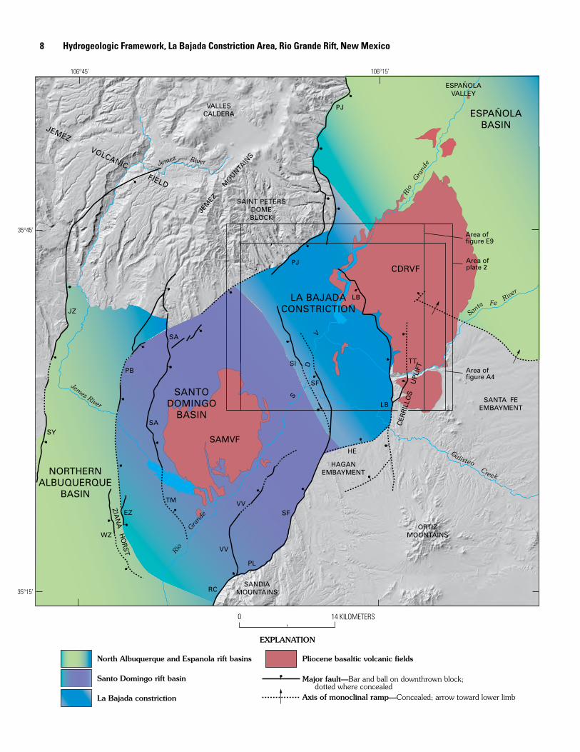
Figure A2 (facing page). Segment of the middle Rio Grande rift showing the extent, topographic expression (gray background shading), and principal structural borders of the contiguous Santo Domingo, northern Albuquerque, and Española Basins and the La Bajada constriction. La Bajada constriction overlaps northeast part of Santo Domingo Basin and southwest part of Española Basin. Areas of three other figures or plates of this report are outlined. Background topographic shading based on 30-m digital elevation model. SDV, Santo Domingo Valley. Pliocene basaltic volcanic fields: Cerros del Rio (CDRVF) and Santa Ana Mesa (SAMVF). Fault and fault zones: EZ, East Ziana; HE, Hagan Embayment; JZ, Jemez; LB, La Bajada; PB, Pico Butte; PJ, Pajarito; PL, Placitas; RC, Rincon; SA, Santa Ana; SF, San Francisco; SI, Sile; SY, San Ysidro; TM, Tamaya; TT, Tetilla; VV, Valley View; WZ, West Ziana.
hydrogeology of the basin-fill aquifer system. Grant recog-nized that intrusions in the Cerrillos Hills (pl. 1) cause large perturbations of the regional ground-water flow system. In these reports brief but important mention was made of a continuation of the Santo Domingo structural basin north beneath the Cerros del Rio volcanic field. Grant (1997, 1999) argued for substantial ground-water underflow in the Rio Grande basin-fill aquifer beneath rocks of the volcanic field from the Española Basin into the Santo Domingo Basin owing to an absence of prominent structural or stratigraphic barriers between them.
During the past 10 years, geology was mapped at 1:24,000 scale by the USGS and the University of New Mex-ico in the La Bajada constriction study area in the following 7.5′ quadrangles (fig. A4): Tetilla Peak (Sawyer and others, 2002); Santo Domingo Pueblo (Smith and Kuhle, 1998a); and Santo Domingo Pueblo SW (Smith and Kuhle, 1998b). Build-ing on this mapping, three reports have been published on the hydrogeology, structure, and tectonics of Santo Domingo Basin (Smith and Kuhle, 1998c; Smith, McIntosh, and Kuhle, 2001; Minor and Hudson, 2006) and on the Quater-nary geology of the lower White Rock Canyon area (Dethier, 1999). These results and other topical syntheses generated from recent USGS and New Mexico Bureau of Geology and Mineral Resources geologic joint investigations are reviewed and summarized in subsequent chapters of this report. Recent geologic maps of areas adjoining the study area that have been published by the New Mexico Bureau of Geology and Mineral Resources (Madrid quadrangle to the south by Maynard, Saw-yer, and Rogers, 2001; the San Felipe Pueblo NE quadrangle to the southwest by Cather, Connell, and Black, 2000; and Turquoise Hill quadrangle to the east by Koning and Hallett, 2000) provide additional surface geologic constraints on struc-tures and deposits of the region.
Geologic Setting of the La Bajada Constriction Area
Rio Grande Rift
The geologic, geophysical, and hydrogeologic proper-ties of the Santo Domingo Basin and La Bajada constriction result from processes related to evolution of the Rio Grande rift. The Rio Grande rift is a major continental rift system (fig. A1 inset) that separates the Colorado Plateau microplate on the west from the stable North American craton underlying the Great Plains to the east (Kelley, 1977; Chapin and Cather, 1994). From New Mexico northward, the Rio Grande rift con-tinues as a major tectonic feature through the San Luis Valley of Colorado and then narrows into the Upper Arkansas River valley. The rift becomes poorly defined in northern Colorado and south-central Wyoming, where it is expressed by a series of discontinuous normal faults and isolated Tertiary volcanic features. South from approximately the latitude of Socorro, New Mexico, the Rio Grande rift widens into a series of basins and ranges that merge with the eastern part of the Basin and Range province of southern Arizona, southern New Mexico, west Texas, and northern Mexico (principally in the states of Sonora and Chihuahua). In southern Colorado and northern New Mexico, the Rio Grande rift is a distinct regional physio-graphic feature that forms a chain of broad valleys (San Luis, Española, Santo Domingo, and Albuquerque Valleys) through which the Rio Grande flows southward. These valleys are underlain by, and are more or less coincident with, structural basins (San Luis, Española, Santo Domingo, and Albuquerque Basins) that compose this part of the Rio Grande rift. The Rio Grande rift basins are arranged in a right-stepping en echelon pattern from the northern New Mexico border to Socorro (Kel-ley, 1982). The landforms characterizing these basins result from the combined effects, during the last 30 million years, of extensional tectonism, intrabasinal sedimentary deposition, and volcanism associated with rifting (Chapin, 1971; Tweto, 1978, 1979; Baldridge, Bartov, and Kron, 1983; Smith, McIntosh, and Kuhle, 2001; Smith, 2004). Large mountain ranges east of the Rio Grande rift (such as the Sangre de Cristo, Sandia, and Manzano Mountains) were strongly uplifted during the rifting. The volcanic San Juan Mountains (36–26 Ma), the dominantly nonvolcanic Tusas Mountains, and the volcanic Jemez Moun-tains (12 Ma–50 thousand years ago (ka)) that form the western border of the Rio Grande rift were generally uplifted less.
Basin Architecture and Terminology
Original Definitions of the La Bajada Constriction and Cerrillos Uplift
In the two quotations below, text in brackets is added to identify to geographic localities implied by the text:
“The La Bajada constriction, which bounds the [Española] basin on the south, is formed by the La Bajada fault zone which
Geologic Setting, La Bajada Constriction Area, New Mexico �
−20 20 400
MILLIGALS
PJSC
SP
CO
25
25
Jem
ezR
iver
Jemez
River
Santa
Fe River
Galisteo CreekRioG
rand
e
Rio
Gra
nde
?
?
?
WZ
EZ
SL EH
RC
PL
EC
NR
SF
VV
TM
ZCLU
AD
BR
VV
TJ
LB
HE
TT
TT?
TT?
LB
CDRVF
SC
SFSI
CABR
CCBM
SA
MC
CM
PBSA
JZ
SAINT PETERS DOME
Inferred Oligocene intrusion
Gravity station
VALLESCALDERA
CERRILLOSHILLS
ORTIZMOUNTAINS
SANTA FEEMBAYMENT
EXPLANATION
Fault
Boundary of caldera
SANDIA MOUNTAINS
ZIA
NA
HO
RS
T CERR
ILLO
S
UPL
IFTSANTO
DOMINGOBASIN
NORTHERNALBUQUERQUE
BASIN
LA BAJADACONSTRICTION
JEMEZMOUNTAINS
ESPAÑOLABASINPJ
VV
HAGANEMBAYMENT
35°15’
35°30’
35°45’
106°30’106°45’ 106°15' 106°
Shell SantaFe Pacific 1
Trans-ocean
McKee 1
Yates LaMesa 2
Exploration well
PeltoOrtiz 1
Black OilFerrill 5
0 10 KILOMETERS
PeltoBlackshare 1
10 Hydrogeologic Framework, La Bajada Constriction Area, Rio Grande Rift, New Mexico

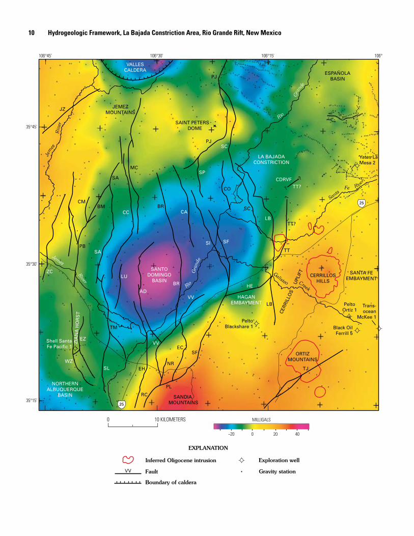
Figure A3 (facing page). Isostatic residual gravity model of the Santo Domingo Basin area showing gravity stations and major faults in the Santo Domingo Basin and adjoining areas. Locations of the Santo Domingo and Española Basins, Sandia Mountains, Cerrillos uplift, Saint Peters Dome block, and Ziana horst shown in the figure are based on the gravity model. Outlines of Oligocene monzonite intrusions inferred from aeromagnetic data (see chapter D, this volume). Fault and fault zone abbreviations: AD, Algodones; BM, Borrego Mesa; BR, Borrego; CA, Camada; CC, Cañada de Cochiti; CM, Chamisa Mesa; CO, Cochiti; EC, Escala; EH, East Heights; EZ, East Ziana; HE, Hagan Embayment; JZ, Jemez; LB, La Bajada; LU, Luce; MC, Mesita Cocida; NR, North Rincon; PB, Pico Butte; PJ, Pajarito; PL, Placitas; RC, Rincon; SA, Santa Ana; SC, Sanchez; SF, San Francisco; SI, Sile; SL, South Luce; SP, South Pajarito; TJ, Tijeras; TM, Tamaya; TT, Tetilla; VV, Valley View; WZ, West Ziana; ZC, Zia County Dump
separates the Santo Domingo basin from the Cerrillos uplift and the White Rock channel. The Cerrillos uplift consists of Mesozoic and early Tertiary sediments and middle Tertiary volcanic rocks intruded by several porphyry masses. The con-necting structure between the Española and Santo Domingo Basins is the White Rock channel. This linkage between the two basins lies between the buried northern edge of the Cerrillos uplift and a small salient [Saint Peters Dome] at the southeastern edge of the Jemez uplift.” (Kelley, 1952, p. 93)
Thus, Kelley (1952) outlined the basic geologic elements defining the boundary between the Española and Santo Domingo Basins of the Rio Grande rift (or depression, as it was known at that time). The northern boundary of the Santo Domingo Basin was identified by Kelley as the La Bajada constriction, where the Rio Grande rift narrows and then widens again into the adjoining Española Basin (fig. A2). The northwest boundary of the La Bajada constriction was defined where pre-rift rocks are exposed in the footwall of the down-to-east Pajarito fault zone at Saint Peters Dome which, in turn, becomes the western boundary of the Española Basin (fig. A2). The southeast boundary of the La Bajada constriction was recognized as the northern edge of the Cerrillos uplift, which was known to be largely hidden beneath mafic lavas of the Cerros del Rio volcanic field (CDRVF, fig. A2). Kelley’s work amplified an earlier description of the Cerrillos uplift by Kirk Bryan (1938, p. 213):
“Separating the subbasin west of Santa Fe from the Santo Domingo Valley is a prong of older rocks projecting northwest from the Ortiz Mountains. The Cerrillos Hills, composed of andesite intrusions and other crystalline rocks, form the south-ern portion of this prong. The northern portion is blanketed by Quaternary basalt, so that there is no distinction on the surface between this prong and the basalts of Santa Fe age that form the Cerros del Rio. The west side is marked by a strong north-south fault [La Bajada fault zone] which passes through Rosario siding. The east side is covered by Quaternary gravel, but doubtless detailed study will show the presence of faults.”
The locations of the features described above were first depicted by Kelley in a map displaying major tectonic features of the La Bajada constriction area (Kelley, 1952, p. 92). The term “White Rock channel” has found little further acceptance or usage, but most of the other tectonic features described and mapped by Kelley in the La Bajada constriction area have been tacitly adopted in all subsequent geologic work in the region. Kelley did not provide a more precise definition or explain the hydrogeologic significance of the La Bajada constriction, and he did not specifically address the role that the La Bajada fault zone and buried faults farther east play in controlling the distribution and continuity of the basin-fill aquifer in the subsurface.
Geologic Definition of the La Bajada Constriction and Surrounding Basins
The salient geologic features of the La Bajada constric-tion, as presently defined, and the overlapping Santo Domingo Basin are introduced in this section. Detailed descriptions of the constriction, and new geologic and geophysical observa-tions upon which they are based, are presented in subsequent chapters of this report.
We adopt the definition of the Santo Domingo Basin provided by Smith, McIntosh, and Kuhle (2001). The Santo Domingo Basin is situated between the Albuquerque Basin to the south and the Española Basin to the north (fig. A1). The large Albuquerque Basin is a composite structural feature that can be divided into several smaller subbasins, including the northern Albuquerque (or Calabacillas) Basin (fig. A2) that is adjacent to the Santo Domingo Basin (Ferguson and others, 1995; Hawley and Whitworth, 1996; Grauch, Gillespie, and Keller, 1999). The northern Albuquerque Basin is a dominantly east-tilted half graben bounded on its east side along the base of the Sandia Mountains by the large-displacement Rincon (RC) normal fault zone (fig. A2). The Española Basin is a west-tilted half graben bounded on its west side by the large-displacement Pajarito (PJ) normal fault zone. The intervening Santo Domingo Basin is an antiformal symmetric graben bounded by the east-dipping East Ziana (EZ), Pico Butte (PB), Santa Ana (SA), and Tamaya (TM) faults on the west and the west-dipping La Bajada (LB) and San Francisco (SF) faults on the east (fig. A2; chapter E, this volume) (Smith, McIntosh, and Kuhle, 2001).
Interpretation of gravity data (fig. A3) indicates a marked thickening of Santa Fe Group sediments in the Santo Domingo Basin southwest of the San Francisco fault (chapter D, this volume; Grauch, Gillespie, and Keller, 1999). On the basis of this change in basin-fill thickness, the Santo Domingo Basin can be divided into two structural subbasins. The surface trace and projection of the San Francisco fault (SF) approximates the boundary between a shallower (<2.5-km-thick basin fill) in the northeast part of the Santo Domingo Basin in the footwall block of the San Francisco fault and a deeper (2.5- to >4-km-thick basin fill) main part of the Santo Domingo Basin in the hanging-wall block of the fault (figs. A2, A3).
Geologic Setting, La Bajada Constriction Area, New Mexico 11
?
?
LAMAJADAGRABEN
ReservoirHorst
CochitiGraben
COCHITIPUEBLO
SANTODOMINGOPUEBLO
Cañada 7.5' CochitiDam 7.5'
MontosoPeak 7.5'
TetillaPeak 7.5'
SantoDomingo
Pueblo SW 7.5'
SantoDomingo
Pueblo 7.5'
COCHITI
LA BAJADACONSTRICTION
CERRILLOSUPLIFT
SAINT PETERSDOMEBLOCK
PUEBLO
SANTO DOMINGOPUEBLO
COCHITI PUEBLO
MT-17
MT-6 MT-2
Fault—Ball on downthrown side
EXPLANATION
Boundary of the La Bajada constriction Fault—Based on geophysics
Boundary of the Santo Domingo Valley
Quadrangle boundary line Universal Transverse Mercator grid
Magnetotelluric station
375 380
0 5 KILOMETERS
GalisteoCreek
395 E km UTM zone 13N385 390
San Franciscofault
Cañada de
Santa Fe
Mesita deJuana
25
3950 N km3945
39403935
3930
Elevation (m)
2250
2100
2000
1900
1800
1700
1600
MT-4
MT-8
MT-11
MT-5
MT-10
Tetilla faultzone
MT-1
MT-3
SANTO DOMINGOVALLEY
106°22’ 30”
35°30’
35°37’30”
35°45’
370
106°15’
La Bajadafault zone
Cerros del RioVolcanic Field
CerroColorado
CerroPotrillo
TetillaPeak
Sanchez fault
CochitiReservoir
CochitiDam
SantaFe
River
Rio
Gra
nde
Sile fault
Camadafault
TentRocks
NationalMonument
Peraltafault
Borregofault
SouthPajaritofault
Pajaritofaultzone
Cochitifault
12
Hydrogeologic Framew
ork, La Bajada Constriction Area, Rio Grande Rift, New
Mexico

The La Bajada constriction is the relatively narrow structural trough linking the southern part of the Española Basin and the northeastern part of the Santo Domingo Basin (fig. A2). It is bounded by rift-flank uplifts and is occupied by basin-fill sediments of the Santa Fe Group. In the present study we restrict the La Bajada constriction to those parts of the structural trough containing large (≥200 m) preserved thicknesses of basin-fill sediments, because such deposits most likely provide hydrologic connectivity for ground water flowing between the Española and Santo Domingo Basins. Large faults that form the principal structural borders of the constriction are various branches and segments of the Pajarito (PJ), La Bajada (LB), and Tetilla (TT) fault zones (fig. A2). The Pajarito fault zone, which is the western principal struc-ture bounding the present-day Española Basin, branches south of Saint Peters Dome into several splays (figs. A3, A4). Near Saint Peters Dome, one such splay of the Pajarito (herein named the Sanchez (SC) fault) bends southeastward from the southwest-striking, gravity-defined (chapters D and E, this volume), main Pajarito fault strand toward the center of the La Bajada constriction (figs. A3, A4). Splays of the La Bajada fault zone curve northwestward into the center of the constric-tion and overlap the Sanchez fault from the opposite, eastern border of the Santo Domingo Basin (figs. A3, A4). The San-chez, La Bajada, and other faults offset Pliocene-Pleistocene volcanic rocks of the Cerros del Rio and Jemez volcanic fields in the central part of the La Bajada constriction, whereas these same young volcanic rocks overlie buried, gravity-defined, basement structural highs on the flanks of the constriction.
The La Bajada constriction area can be subdivided into three terranes on the basis of topographic expression, struc-tural configuration, and dominant stratigraphy: the elevated Cerros del Rio volcanic field–Cerrillos uplift eastern border terrane; the central Santo Domingo Valley; and the elevated Saint Peters Dome block western border terrane (figs. A2, A4). Each of these terranes is described separately below.
Cerros Del Rio Volcanic Field and Cerrillos UpliftThe eastern border terrane consists primarily of two
geologic elements: the Pliocene Cerros del Rio volcanic field
(CDRVF) and the Cerrillos uplift composed of Miocene and older basement rocks (figs. A2, A4). The La Bajada fault zone bounds the west side of this eastern border terrane. The coinci-dent, west-facing, La Bajada escarpment is the physiographic boundary between the Santo Domingo Valley and the elevated Caja del Rio Plateau (pl. 1). Young (≤2.7 Ma) basalts and andesites of Cerros del Rio exposed east of the escarpment are relatively unfaulted and form a geomorphically well-expressed volcanic plateau made up of many eruptive vents and surround-ing lava-capped mesas (pl. 2; chapter C, this volume). Nearly all of the Cerros del Rio volcanic rocks in the eastern border terrane lie at elevations above 1,800 m (fig. A4), and construc-tional volcanic landforms in the central and northern Cerros del Rio rise to elevations greater than 2,200 m. The late Pliocene age (2.7–2.2 Ma) and little-deformed character of this volcanic plateau indicate that for about the last 3 m.y. the footwall block of the La Bajada fault zone has remained tectonically stable. A gentle (<2°) eastward tilt of basal basalt flows at the south end of the Cerros del Rio volcanic plateau suggest only mild uplift in the footwall of the La Bajada fault zone.
The Cerrillos uplift, which forms the southeastern border of the La Bajada constriction, is a structural high that is mostly buried beneath lava of the Cerros del Rio volcanic field (CDRVF) (figs. A2, A4). North of the Santa Fe River (Cañada de Santa Fe), where it is completely concealed, the Cerrillos uplift is largely delineated by gravity data (fig. A3; chapter D, this volume). In the region extending from Cañada de Santa Fe southward around the margins of the Mesita de Juana volcano (fig. A4), exposed pre-rift rocks of the Cerrillos uplift consist of Mesozoic sedimentary rocks unconformably overlain by Eocene Galisteo Formation and upper Eocene–Oligocene Espinaso Formation (pl. 2), all dipping moderately (11°–15°) east-northeastward. This homoclinal sequence of rocks, the Galisteo monocline (pl. 1) of Stearns (1953a), is a surface expression of rift-flank uplift in the footwall block of the southern La Bajada fault zone. The Cerrillos uplift (figs. A2, A3) has weak topographic expression other than at the Cerrillos Hills and Ortiz Mountains (pl. 1) in its central and southern parts, which are underlain by resistant upper Eocene–Oligocene intrusive rocks.
North of Cañada de Santa Fe the gravity-expressed western border of the Cerrillos uplift projects northward, away from the northwest-striking La Bajada fault zone, and merges with a buried northern projection of the Tetilla fault zone (figs. A2, A3, A4). Where exposed to the south in the La Bajada escarpment near U.S. Interstate 25 (pl. 1, 2; fig. A4), the Tetilla fault zone strikes northeastward and juxta-poses Eocene−Oligocene rocks and overlying Miocene(?) rift basin-fill sediments against Mesozoic sedimentary rocks (pl. 2). North of Cañada de Santa Fe the fault zone is buried by Pliocene Cerros del Rio basalts, and it is projected northward for several kilometers on the basis of subsurface electromag-netic evidence (chapters E and F, this volume; figs. A2, A4). On the basis of several lines of geologic and geophysical evidence, the Cerrillos uplift also continues northward on the upthrown side of the Tetilla fault zone beneath cap rock of the
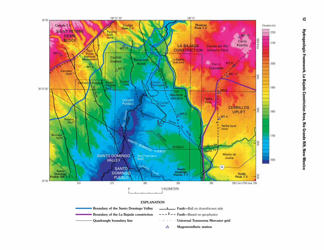
Figure A� (facing page). Cochiti Pueblo area, showing La Bajada constriction between bounding Cerrillos uplift and Saint Peters Dome block. Lowlands of the Santo Domingo Valley in the northeast part of the Santo Domingo Basin separate the western border terrane, which consists of the Saint Peters Dome block and adjacent uplands southeast of the Pajarito fault zone, from the eastern border terrane, which consists of the Cerrillos uplift and onlapping Cerros del Rio volcanic field. The northern Santo Domingo Valley, underlain by basin-fill deposits, is subdivided into the Cochiti graben, Reservoir horst, and La Majada graben; see text for descriptions. UTM, universal transverse mercator.
Geologic Setting, La Bajada Constriction Area, New Mexico 13
Cerros del Rio volcanic field. The buried north end of the Cer-rillos uplift and coincident northeast “corner” of the La Bajada constriction (that is, where it opens up into the Española Basin) (fig. A2) are delineated from subsurface geologic and geophysical interpretations presented in subsequent chapters of this report (chapters D, E, F, and G, this volume).
Santo Domingo Valley
The northeast part of the Santo Domingo Valley overlaps the southwest part of the La Bajada constriction (figs. A2, A4). This area contains a complex interfingering of rift basin-fill sedimentary deposits and volcanic rocks of the Jemez and Cerros del Rio volcanic fields that are cut by regularly spaced, mainly north-northwest-striking normal faults. The thickness of basin-fill deposits differs in different fault blocks because of the variable tectonic and growth-fault histories of individ-ual blocks. Three main structural domains identified within the Santo Domingo Valley in the Cochiti Pueblo area are, from west to east, the Cochiti graben, Reservoir horst, and La Majada graben (fig. A4). These domains are briefly described below. Fuller descriptions and interpretations of the domains are provided in subsequent chapters of this report, and their significance with respect to the hydrogeologic framework of the La Bajada constriction is addressed in chapter G (this volume).
South of Saint Peters Dome, the north-trending Cochiti graben is bounded by the east-dipping South Pajarito fault and the west-dipping Cochiti fault (fig. A4). Several addi-tional, smaller displacement north-striking faults lie within the graben (pl. 2). The Cochiti graben contains extensive exposures of the Otowi Member (unit Qbo, lower member) of the Bandelier Tuff (chapter B, this volume) that have been downdropped between the two bounding faults (pl. 2). The southeastern margin of exposed rocks of the Jemez volcanic field extends farther south within the graben than on its flanks, because the Bandelier Tuff is better preserved within the graben. Southwest of the graben, between the South Pajarito and Sile faults (fig. A4), a narrow yet stratigraphically distinct horst locally forms the boundary between the northeast part of the Santo Domingo Basin and the deeper central part of the basin to the southwest.
The centrally located Reservoir horst, which borders the east side of the Cochiti graben, is located between the Cochiti fault and the southern part of the newly identified, down-to-east Sanchez fault (chapter E, this volume; fig. A4). The southern part of the Sanchez fault is delineated on the basis of aeromagnetic and electromagnetic constraints presented in chapters D and F of this volume. Cerros del Rio basalts and interfingering Santa Fe Group ancestral Rio Grande axial river gravels are exposed within the Reservoir horst (pl. 2). The basaltic rocks and associated near-vent basaltic hydromagmatic deposits form the foundation for Cochiti Dam and underlie Cochiti Reservoir (fig. A4) (Smith and Kuhle, 1998a; Smith, McIntosh, and Kuhle, 2001).
The La Majada graben is located directly east of the Reservoir horst between the down-to-east Sanchez fault and the down-to-west La Bajada fault zone (fig. A4). Cerros del Rio basalt in this graben is downdropped at least 500 m relative to exposures in the footwall of the La Bajada fault (Smith, McIntosh, and Kuhle, 2001; chapter G, this volume). Scalloped fault splays of the La Bajada fault zone locally cut across the La Majada graben (chapter E, this volume). Santa Fe Group axial river and eastern piedmont sediments underlie most of the La Majada graben (pl. 2) (Smith, McIntosh, and Kuhle, 2001).
Saint Peters Dome Block
The northwestern border of the La Bajada constriction is formed by a northeast-striking segment of the Pajarito fault zone and its upthrown Saint Peters Dome footwall block directly to the west (figs. A2, A3). The western border terrane extends from the footwall block of the Pajarito fault zone towards the constriction axis as far east as the simplified 1,800-m-elevation contour (wide blue line, fig. A4). At Saint Peters Dome proper, just west of the La Bajada constriction, pre-rift Eocene Galisteo Formation sedimentary rocks (unit Tg, pl. 2) are exposed underneath rocks of the Jemez volcanic field. Southwest of Saint Peters Dome is a prominent topo-graphic bench where the northeast-trending main trace of the Pajarito fault offsets the 1.22-Ma cliff-forming Tshirege Member (unit Qbt, upper member) of the Bandelier Tuff and where the South Pajarito fault branches from the main trace and heads southward towards Tent Rocks National Monu-ment (pl. 2, fig. A4). Gravity data (chapter D, this volume) suggest that the northeast-striking segment of the Pajarito fault zone may continue to the southwest as a buried large-displacement fault and, thus, may form the northwest border of the main Santo Domingo structural basin (figs. A2, A3). Upper Tshirege (unit Qbt) and lower Otowi (unit Qbo) Mem-bers of the Bandelier Tuff are well preserved in the tablelands between the main northeast-striking Pajarito fault zone and the Rio Grande north of Cochiti Reservoir (pl. 2). Within and south of Peralta Canyon (pl. 1), the western border terrane is underlain by locally faulted Miocene to Pliocene Cochiti Formation (unit QTc) sedimentary deposits (pl. 2) represent-ing western piedmont fill of the Santo Domingo Basin (Smith, McIntosh, and Kuhle, 2001).
Stratigraphy of Pre-Rift RocksThe stratigraphy of Precambrian crystalline basement
rocks and overlying Paleozoic, Mesozoic, and lower Tertiary pre-rift sedimentary rocks is briefly described here to provide geologic context for the younger rift-fill deposits, volcanic rocks, and associated structures that are the main focus of this report. The reader is referred to chapters B and C of this volume for descriptions of Miocene and younger rift basin-fill sediments and volcanic rocks, respectively.
1� Hydrogeologic Framework, La Bajada Constriction Area, Rio Grande Rift, New Mexico

Precambrian and Paleozoic Rocks
Precambrian rocks are not exposed in the La Bajada con-striction nor in the flanking Saint Peters Dome and Cerrillos uplifts, so the characteristics of basement rocks underlying the area at depth are inferred from exposures in other parts of the region. South of the Cochiti Pueblo area in the Hagan embayment and Sandia Mountains, exposed basement rocks consist of Middle Proterozoic 1.4-Ga Sandia Granite (Kelley and Northrop, 1975); in the Sangre de Cristo Mountains east of the Española Basin (fig. A1) they are largely Early Proterozoic (1.7–1.6 Ga) granite and gneiss (Karlstrom and others, 1999, 2004). Basement rocks underlying the La Bajada constriction area and Española Basin probably resemble the granites and gneisses in the Sangre de Cristo Mountains and Hagan embay-ment but not the supracrustal metapelitic rocks exposed in the Picuris Range and Tusas Mountains to the north (fig. A1) (Karlstrom and others, 1999, 2004). The aeromagnetic signa-ture beneath the Española Basin closely resembles the patterns typically observed for Proterozoic granites (chapter D, this vol-ume). The controversial Yates La Mesa 2 (sec. 24, T. 17 N., R. 8 E.) drill hole (pl. 1, fig. A3) provides the only direct evidence of the nature of geologic basement beneath the Española Basin. G.A. Smith (University of New Mexico, oral commun., 2000) and S.M. Cather and R.F. Broadhead (New Mexico Bureau of Geology and Mineral Resources; oral commun., 2000) consid-ered “granite wash” at the bottom of this hole (7,534–7,710 ft depth) to represent Proterozoic granite, consistent with bore-hole geophysical log data. Alternatively, Grant (1997, 1999) interpreted the material in the bottom of the hole as arkosic sedimentary rocks of the Eocene Galisteo Formation.
No Paleozoic rocks are exposed in the La Bajada con-striction area, but Pennsylvanian and Permian beds are exposed elsewhere in north-central New Mexico (table A1) (Lucas, Rowland, and others, 1999). Pennsylvanian marine carbonate strata have been observed in the Transocean McKee 1 drill hole in the nearby Santa Fe embayment (pl. 1, fig. A3) and consist of limestone of the Madera Group and probably the underlying more clastic Sandia Formation (table A1) (Black, 1979, 1999; Myers, 1982; Broadhead, 1997). Overly-ing Permian sedimentary rocks in the drill hole include the marine San Andres Limestone and the predominantly conti-nental and clastic Glorieta Sandstone, Yeso Formation (includ-ing the distinct eolian Meseta Blanca Sandstone Member), and Abo Formation (Lucas, Rowland, and others, 1999). East of the Santa Fe embayment, Pennsylvanian, Permian, and Triassic sedimentary rocks are widely exposed in the Glorieta area and southeastern Sangre de Cristo Mountains (Baltz and Myers, 1999). Gross thickness of the Pennsylvanian-Jurassic section in the region ranges from a minimum of 1,272 m in the Shell Santa Fe Pacific 1 well (see fig. A3 for location) to a maximum of about 1,800 m in the Hagan Basin surface sec-tion (Lucas and others, 1999; Cather and others, 2002) and the Transocean McKee 1 well (table A1). Black and Hiss (1974) interpreted the Shell Santa Fe Pacific 1 stratigraphic section to have been thinned by recurrent local uplift and erosion in
Pennsylvanian, Cretaceous, and Oligocene-Miocene time. A more representative minimum Pennsylvanian-Jurassic thick-ness in this well is probably closer to 1,350–1,375 m.
Mesozoic Sedimentary Rocks
In the La Bajada constriction area, Mesozoic sedimentary rocks are exposed only in the footwall block of the La Bajada fault zone within the Galisteo monocline and in Cañada de Santa Fe (pls. 1, 2). The oldest Mesozoic rocks exposed are Upper Triassic Chinle Formation (unit dc) that crops out in the footwall of the La Bajada fault zone; it is more widely exposed immediately to the south of the area shown in plate 2 (Bachman, 1975; Lucas and Heckert, 1995; Maynard, Sawyer, and Rogers, 2001). The Chinle Formation consists of red-brown mudstone and siltstone. Bachman (1975) estimated a stratigraphic thick-ness of at least 150 m for Chinle exposed in the Galisteo mono-cline, but a more thorough examination of regional data from wells and measured sections (table A1) suggests a thickness as much as 500 m or more. The thick upper clay-rich part of the Chinle exposed in the Galisteo monocline probably correlates with the Petrified Forest Member (Lucas, Heckert, and Estep, 1999). The unconformably overlying Middle Jurassic Entrada Sandstone (unit Je, pl. 2), which is also exposed in the La Bajada footwall block in the Galisteo monocline, is characteris-tically a medium- to fine-grained, reddish-brown to yellowish-gray, quartzose sandstone. The 30–60-m-thick Entrada (table A1) is a resistant ledge former and is massive to planar and cross bedded. Where exposed in the region the unit is divisible into two parts of subequal thickness: a reddish-brown lower section and a dominantly yellowish-gray upper section (Lucas, Anderson, and Pigman, 1995).
The Todilto Formation (unit Jt, pl. 2), which overlies the Entrada, is a conspicuous ledge-forming unit consisting of a lower thin limestone member and an upper thicker gypsum member (Kirkland, Denison, and Evans, 1995; Lucas, Ander-son, and Pigman, 1995). Condon and Huffman (1988) referred to this unit in the San Juan Basin as the Todilto Limestone Member of the Wanakah Formation, but a consensus of more recent geologic mapping in New Mexico has consistently been to use the formation-rank term Todilto Formation. The lower limestone is medium gray to yellow, thinly laminated to mas-sive, and about 5 m thick. The gypsum member is white, mas-sive, and pervasively brecciated where exposed at the surface. Thickness of the Todilto is quite variable, and it commonly ranges from 20 to 70 m regionally (table A1). The Todilto crops out as leached gypsiferous residuum intermixed with clay in weathered exposures, and scattered coarse gypsum crystals (as long as 5–10 cm) commonly coat surface expo-sures. Todilto gypsum has been mined at the Rosario quarry along the La Bajada escarpment about 3 km south of the area shown in plate 2.
Stratigraphically above the Todilto is a heterogeneous ~100-m-thick set of beds (table A1) that includes a basal, red to red-brown siltstone overlain by a grayish-red, ~30-m-thick sequence of gypsiferous siltstones and sandstones that were
Geologic Setting, La Bajada Constriction Area, New Mexico 1�
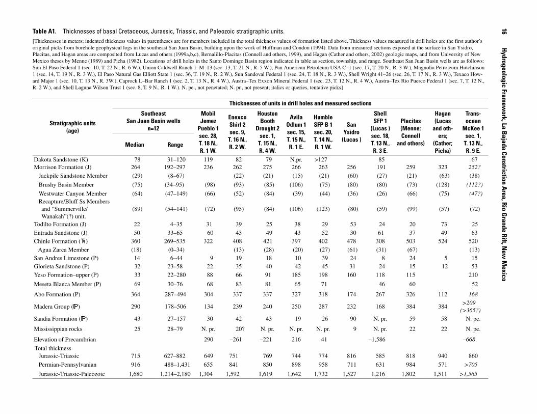
Table A1. Thicknesses of basal Cretaceous, Jurassic, Triassic, and Paleozoic stratigraphic units.[Thicknesses in meters; indented thickness values in parentheses are for members included in the total thickness values of formation listed above. Thickness values measured in drill holes are the first author’s original picks from borehole geophysical logs in the southeast San Juan Basin, building upon the work of Huffman and Condon (1994). Data from measured sections exposed at the surface in San Ysidro, Placitas, and Hagan areas are composited from Lucas and others (1999a,b,c), Bernalillo-Placitas (Connell and others, 1999), and Hagan (Cather and others, 2002) geologic maps, and from University of New Mexico theses by Menne (1989) and Picha (1982). Locations of drill holes in the Santo Domingo Basin region indicated in table as section, township, and range. Southeast San Juan Basin wells are as follows: Sun El Paso Federal 1 (sec. 10, T. 22 N., R. 6 W.), Union Caldwell Ranch 1–M–13 (sec. 13, T. 21 N., R. 5 W.), Pan American Petroleum USA C–1 (sec. 17, T. 20 N., R. 3 W.), Magnolia Petroleum Hutchinson 1 (sec. 14, T. 19 N., R. 3 W.), El Paso Natural Gas Elliott State 1 (sec. 36, T. 19 N., R. 2 W.), Sun Sandoval Federal 1 (sec. 24, T. 18 N., R. 3 W.), Shell Wright 41–26 (sec. 26, T. 17 N., R. 3 W.), Texaco How-ard Major 1 (sec. 10, T. 13 N., R. 3W.), Caprock L–Bar Ranch 1 (sec. 2, T. 13 N., R. 4 W.), Austra–Tex Exxon Mineral Federal 1 (sec. 23, T. 12 N., R. 4 W.), Austra–Tex Rio Puerco Federal 1 (sec. 7, T. 12 N., R. 2 W.), and Shell Laguna Wilson Trust 1 (sec. 8, T. 9 N., R. 1 W.). N. pe., not penetated; N. pr., not present; italics or queries, tentative picks]
Stratigraphic units (age)
Thicknesses of units in drill holes and measured sections
SoutheastSan Juan Basin wells
n=12
MobilJemez
Pueblo 1sec. 2�,T. 1� N.,R. 1 W.
EnexcoShirl 2sec. �,
T. 1� N.,R. 2 W.
Houston Booth
Drought 2sec. 1,
T. 1� N.,R. � W.
AvilaOdlum 1sec. 1�,T. 1� N.,R. 1 E.
HumbleSFP B 1sec. 20,T. 1� N.,R. 1 W.
San Ysidro
(Lucas )
ShellSFP 1
(Lucas )sec. 1�,T. 13 N.,R. 3 E.
Placitas(Menne;Connell
and others)
Hagan(Lucas
and oth-ers;
(Cather;Picha)
Trans-ocean
McKee 1sec. 1,
T. 13 N.,R. � E.
Median Range
Dakota Sandstone (K) 78 31–120 119 82 79 N.pr. >127 85 67Morrison Formation (J) 264 192–297 236 262 275 266 263 256 191 259 323 252?
Jackpile Sandstone Member (29) (8–67) (22) (21) (15) (21) (60) (27) (21) (63) (38)
Brushy Basin Member (75) (34–95) (98) (93) (85) (106) (75) (80) (80) (73) (128) (112?)
Westwater Canyon Member (64) (47–149) (66) (52) (84) (39) (44) (36) (26) (66) (75) (47?)Recapture/Bluff Ss Members and “Summerville/ Wanakah”(?) unit.
(89) (54–141) (72) (95) (84) (106) (123) (80) (59) (99) (57) (72)
Todilto Formation (J) 22 4–35 31 39 25 38 29 53 24 20 73 25
Entrada Sandstone (J) 50 33–65 60 43 49 43 52 30 61 37 49 63Chinle Formation (d) 360 269–535 322 408 421 397 402 478 308 503 524 520
Agua Zarca Member (18) (0–34) (13) (28) (20) (27) (61) (31) (67) (13)San Andres Limestone (P) 14 6–44 9 19 18 10 39 24 8 24 5 15Glorieta Sandstone (P) 32 23–58 22 35 40 42 45 31 24 15 12 53Yeso Formation–upper (P) 33 22–280 88 66 91 185 198 160 118 115 210
Meseta Blanca Member (P) 69 30–76 68 83 81 65 71 46 60 52
Abo Formation (P) 364 287–494 304 337 337 327 318 174 267 326 112 168
Madera Group (h) 290 178–506 134 239 240 250 287 232 168 384 384>209
(>365?)
Sandia Formation (h) 43 27–157 30 42 43 19 26 90 N. pr. 59 58 N. pe.
Mississippian rocks 25 28–79 N. pr. 20? N. pr. N. pr. N. pr. 9 N. pr. 22 22 N. pe.
Elevation of Precambrian 290 –261 –221 216 41 –1,586 –668
Total thicknessJurassic-Triassic 715 627–882 649 751 769 744 774 816 585 818 940 860
Permian-Pennsylvanian 916 488–1,431 655 841 850 898 958 711 631 984 571 >705
Jurassic-Triassic-Paleozoic 1,680 1,214–2,180 1,304 1,592 1,619 1,642 1,732 1,527 1,216 1,802 1,511 >1,565
1�
Hydrogeologic Framew
ork, La Bajada Constriction Area, Rio Grande Rift, New
Mexico

Mexico is complex and at present only partially resolved, particularly east of the Rio Grande rift. Our general usage is after Landis, Dane, and Cobban (1973), who subdivided the intertonguing Dakota Sandstone and Mancos Shale in west-central New Mexico into, from bottom to top, the basal Oak Canyon Member of the Dakota Sandstone, the Cubero Tongue of the Dakota Sandstone, the Clay Mesa Tongue of the Mancos Shale, the Paguate Tongue of the Dakota Sand-stone, the Whitewater Arroyo Tongue of the Mancos Shale, and the Twowells Tongue of the Dakota Sandstone. Sandstone exposed in the Galisteo monocline (pl. 1) has been mapped by Maynard, Sawyer, and Rogers (2001) and Sawyer and others (2002) as the Cubero Tongue (unit Kdc, pl. 2) of the Dakota Sandstone, and underlying shale as the Oak Canyon Member (unit Kdo).
The Mancos Shale, which overlies the Dakota Sand-stone where it is exposed in the La Bajada escarpment (pl. 2), consists of thick marine shale, calcareous shale, and sandy shale, with minor beds of limestone and bentonite. The Mancos regionally intertongues with coal-bearing continental deposits of the Crevasse Canyon Formation and the overlying Mesaverde Group; these units are not exposed in the study area but may exist nearby in the subsurface. Locally, sandy uppermost Mancos exposures are laterally equivalent to what Bachman (1975) termed Niobrara Member in the Madrid quadrangle south of the Cochiti Pueblo map area (pl. 2). Members of the Mancos Shale in the La Bajada constriction region (Sawyer and others, 2002) are subdivided in part on the basis of a proposed Mancos principal reference section (Leckie, Kirkland, and Elder, 1997) in the San Juan Basin north of Mesa Verde National Park in Colorado. These mem-bers, from the base upward, are thin shale partly equivalent to the Graneros Shale Member and the overlying Bridge Creek Limestone Member, undivided (unit Kmb, pl. 2); the Blue Hill and Fairport Members of the Carlile Shale and the overlying Juana Lopez Member, all undivided (unit Kmj); and the upper part of the Niobrara Member (unit Kmn) (Leckie, Kirkland, and Elder, 1997; Sawyer and others, 2002). These members correlate with formal stratigraphic units assigned to the Cretaceous Western Interior seaway deposits of Colorado and western New Mexico (Molenaar, 1983; Leckie, Kirkland, and Elder, 1997). Mancos Shale in the area of the Galisteo Creek watershed just south of the map area (pl. 2) is approximately 600–700 m thick (Stearns, 1953c; Bachman, 1975; Cobban, W.A., and Sawyer, D.A., unpub. data, 2005)
Pre-Rift Tertiary Rocks
The Eocene Galisteo Formation (unit Tg) is exposed on both flanks of the La Bajada constriction in the footwall block of the La Bajada fault zone and in the Saint Peters Dome area (pl. 2). In the La Bajada footwall it consists of red to brownish-yellow sandstone, red mudstone, and conglomerate. The sandstones range from well-sorted, fine-grained sandstone to more poorly sorted, coarse-grained, silty sandstone. Conglomer-ate clasts include white, gray, and black chert pebbles and gray
correlated with the Wanakah Formation by Stearns (1953a), Condon and Huffman (1988), and Condon (1989). Condon and Huffman (1988) named these beds the Beclabito Member of the Wanakah Formation. Alternatively, Lucas, Anderson, and Pigman (1995) and Lucas and Anderson (1997) have assigned this sequence of beds to the Beclabito Member of the Summerville Formation in the Hagan embayment and in extensive areas west of the Rio Grande rift. Owing to persis-tent disagreement among several workers regarding the strati-graphic relations of these various formations and members, we informally refer to this unit as “Summerville/Wanakah” (table A1; unit Jwb, pl. 2).
The Upper Jurassic Morrison Formation is widely exposed in the Galisteo Creek watershed within the Cerrillos uplift. It has commonly been divided into four members in northern New Mexico. They are, from the base upwards, the Westwater Canyon Member (unit Jmw, pl. 2), Brushy Basin Member (unit Jmb), and Jackpile Sandstone Member (unit Jmj). These subdivisions of the Morrison Formation, which have long been used in the San Juan Basin and adjoining areas (Santos, 1975), have been used locally with some modifica-tion in the Hagan embayment (Lucas, Anderson, and Pigman, 1995) and San Ysidro areas (Anderson and Lucas, 1996, 1997; Lucas, Estep, and Anderson, 1999). Lateral variability in rock types and the lack of well-recognized unconformities between members of the Morrison has led to uncertainty and disagree-ment about stratigraphic assignments within the formation (Condon and Peterson, 1986; Lucas, Anderson, and Pigman, 1995; Anderson and Lucas, 1996, 1997; Lucas and others, 1999a). USGS geologists and most other workers investigating the Gallup-Grants-Laguna uranium belt of the southern San Juan Basin and Sierra Nacimiento (Woodward, 1987) have generally used the names Recapture and Westwater Canyon Members instead of the Salt Wash Member for the lower and central part of the Morrison (Condon and Peterson, 1986; Condon and Huffman, 1994, Huffman and Condon, 1994). We generally adopt this stratigraphic usage in the La Bajada constriction area. However, because it is difficult to distinguish in the subsurface, the Recapture Member (and the intertongu-ing Bluff Sandstone in the southeast San Juan Basin (Santos, 1975)) is combined with the “Summerville/Wanakah” unit in thickness measurements shown in table A1. In this report we follow the general consensus of other workers in New Mexico on nomenclature and characteristics of the Brushy Basin and Jackpile Members of the Morrison. The braided-stream fluvial depositional environment represented by most of the Morrison contrasts with the eolian and marginal marine saline deposits of the underlying the Entrada and Todilto Formations. On the basis of surface exposures and drill-hole penetrations flanking the Rio Grande rift (table A1), the total thickness of the Mor-rison Formation in the La Bajada footwall block ranges from 191 to 323 m.
In the La Bajada constriction area, the Cretaceous Dakota Sandstone unconformably overlies the Morrison Formation in the footwall block of the La Bajada fault zone (pl. 2). Strati-graphic usage for the Dakota Sandstone in north-central New
Geologic Setting, La Bajada Constriction Area, New Mexico 1�
limestone cobbles. Galisteo Formation deposits crop out in three distinct areas on the east side of the constriction: southwest-dipping beds in the vicinity of La Cienega; northeast-dipping beds disconformably overlying the Mancos Shale in Cañada de Santa Fe midway between the villages of La Cienega and La Bajada; and in a number of variously tilted fault blocks under-lying the Pliocene Cerros del Rio basalt flows near U.S. Inter-state 25 at the base of the La Bajada escarpment (pl. 2). Galisteo sedimentary rocks exposed at these locations correspond with the upper part of the formation and are not underlain by any deposits of the Paleocene(?)–lower Eocene Diamond Tail Formation (Lucas and others, 1997; S.M. Cather, New Mexico Bureau of Mines and Mineral Resources, oral commun., 1998). It is possible, however, that the Diamond Tail is present in the subsurface of the La Bajada constriction area. The Galisteo For-mation in this part of New Mexico is interpreted to have been deposited during the late part of the Laramide orogeny (Cather, 1992), resulting in great regional variations in thickness of the formation. Although the Galisteo Formation has a maximum thickness of 1,060 m near the villages of Cerrillos and Galisteo (pl. 1) (Bachman, 1975) southeast of the La Bajada constric-tion area (fig. A2), the unit is only 340–400 m thick in the La Cienega–Cañada de Santa Fe area on the southern Caja del Rio Plateau (pl. 1, 2) (Sun and Baldwin, 1958).
In the Saint Peters Dome area, steeply west-dipping beds of the Galisteo Formation are exposed in the uplifted foot-wall block of the Pajarito (PJ) fault zone (pl. 2, figs. A2, A3) (Cather, 1992). The Galisteo there consists of tan to pink to brick red beds of well-indurated sandstone, siltstone, arkose, and conglomerate. The conglomerate contains pebbles and boulders of limestone, chert, and granitic rock derived from Precambrian and Paleozoic source terranes. The base of the Galisteo at Saint Peters Dome is not exposed, and the unit is unconformably overlain by sediments of the Santa Fe Group; the unit at the Saint Peters Dome exposure has a minimum thickness of about 200 m (Cather, 1992).
The Eocene and Oligocene Espinaso Formation (unit Te) conformably overlies Galisteo sedimentary rocks in exposures in the Cerrillos uplift area (pl. 2). Along the La Bajada escarp-ment, near its intersection with U.S. Interstate 25, the Espinaso consists mainly of clast-supported volcanic and sedimentary breccia containing andesite or latite clasts (or both), and it also includes subordinate interbedded volcaniclastic sedimentary rocks. The Espinaso Formation is described in more detail in chapter C (this volume). Eocene and Oligocene monzonite and monzonite porphyry intrusive rocks (unit Tmi) similar in age and composition to rocks of the Espinaso Formation are exposed in the Cerrillos uplift area (including the Cerrillos Hills) on the southeast flank of the La Bajada constriction (pl. 2, fig. A3). These rocks, which intrude and deform rocks of the Galisteo (unit Tg) and Espinaso (unit Te) Formations, are also discussed in more detail in chapter C (this volume).
The Cieneguilla Basanite (unit Tc, pl. 2) (Sawyer and oth-ers, 2002), which overlies intrusive rocks (unit Tmi) and rocks of the Espinaso Formation (unit Te), consists of basanite, neph-elinite, minor basalt flows, and interbedded volcaniclastic and
epiclastic sediments. The unit was mapped as the Cieneguilla Limburgite by Stearns (1953b). The Cieneguilla Basanite is further described in chapter C (this volume).
The youngest pre-rift rocks exposed in the La Bajada constriction area are a sequence of light-gray ash-rich silty sandstone and siltstone beds (unit Tab) that unconformably overlie Espinaso deposits at the west mouth of Cañada de Santa Fe near the village of La Bajada (pl. 2). These sedimen-tary rocks form prominent low cliffs and contain ash-fall beds (0.2–0.5 m thick) that are commonly admixed with detrital silt and minor arkosic sand. The lower part of this unit locally contains thin limestone beds interbedded with gray, green, and red siltstone and claystone that were interpreted by Stearns (1953b) to be lacustrine in origin. The unit is tentatively cor-related with the volcaniclastic Abiquiu Formation (Stearns, 1953b) present in the Abiquiu embayment about 70 km north of the study area (fig. A1). Stearns (1953b) also suggested possible correlation with the Zia Sand exposed in the Jemez River area about 45 km west of the Cochiti Pueblo area.
Hydrostratigraphic Properties of Pre-Rift Sedimentary and Igneous Rocks
Hydrostratigraphic properties of pre-rift rocks in the La Bajada constriction region differ greatly (Lewis and West, 1995). In general, none of the Oligocene and older sedi-mentary rocks approach the high permeability and yield of the mid-Miocene and younger poorly consolidated Santa Fe Group basin-fill deposits. Hydrologic properties of the pre-rift Tertiary rocks are transitional between those of the overlying poorly consolidated rift-basin aquifer units and underlying Cretaceous confining units. Pre-rift Tertiary strata of the Gali-steo Formation and overlying Espinaso and Abiquiu(?) Forma-tions are probably hydrologically connected with basin-aquifer units of the Santa Fe Group. Spiegel and Baldwin (1963) con-sidered the Galisteo Formation so poor a water source even for domestic and stock wells that it should be drilled only as a last resort. In the proposed La Bajada Ranch subdivision south of Cañada de Santa Fe, Peery and Pearson (1994) concluded that even if the Galisteo is not a good aquifer, it is at least consid-erably better than the other confining units in the area. In the La Cienega area (pl. 1) some domestic wells yield water from the Galisteo Formation (Spiegel and Baldwin, 1963), whereas in other wells Galisteo has such low permeability that it and subjacent Mesozoic sedimentary formations act as a single confining unit (Lewis and West, 1995). More work is needed to characterize vertical and lateral variations in permeability and hydraulic conductivity within the Galisteo and associated Diamond Tail Formations, which are as much as 1 km thick in the Galisteo Creek watershed (Abbott, Cather, and Good-win, 1995). Post-Galisteo pre-rift volcaniclastic and igneous rocks such as the Espinaso Formation, monzonites associated with the Cerrillos Hills intrusive center, and the Cieneguilla
1� Hydrogeologic Framework, La Bajada Constriction Area, Rio Grande Rift, New Mexico

Basanite may locally provide adequate supply for domestic or small stock wells owing to fracture-induced permeability (Shomaker, 1995).
The stratigraphically highest regional confining unit is generally Upper Cretaceous marine shale. In the exposed footwall block of the La Bajada fault zone, this unit is the very low permeability Mancos Shale. In the area underlain by the Cerrillos uplift, the 600–700-m-thick Mancos Shale functions as a local hydrologic “confining basement” for the Cenozoic aquifer system, and it affects the configuration of the regional ground-water flow system and the connectivity of conductive Tertiary sedimentary and volcanic rocks. Such Cretaceous marine shales have extremely low hydraulic conductivity, from 10–16 to 10–19 m/s (Bredehoeft, Neuzil, and Milly, 1983; Belitz and Bredehoft, 1988; Neuzil, 1994). Although some wells in the Cerrillos uplift area may locally intersect fractures or fractured igneous dikes in Mancos Shale that yield small amounts of water (Peery and Pearson, 1994), the shales gener-ally have very low potential as aquifers.
Subregionally, the thick Mancos Shale prevents hydro-logic connection of the overlying Rio Grande aquifer system (sediments of the Santa Fe Group and immediately subjacent Tertiary rocks) with deeper potential aquifers in Jurassic, Permian, and especially Pennsylvanian carbonate sedimen-tary rocks. Triassic Chinle Formation continental clay-rich sedimentary rocks, although thick (>300 m; Lucas, Heckert, and Estep, 1999), probably have very low transmissivity. The Chinle and Mancos confining units have a profound effect not just on water availability but also on water quality. Brackish to saline waters are typical of these formations in much of south-ern Santa Fe County (Lewis and West, 1995). Low hydraulic conductivity hydrostratigraphic units (the Mancos Shale and other underlying confining units) are present within the upper kilometer of section within the Cerrillos uplift area and prob-ably the Saint Peters Dome block. Equivalent confining units are buried 1.5–4 km beneath more permeable rift basin-fill sediments and volcanic rocks in the Santo Domingo Basin and La Bajada constriction.
In the San Juan Basin to the west, more productive aquifer sandstones exist in the middle and lower parts of the Morrison Formation and beneath the Chinle Formation in the Permian Glorieta Sandstone and San Andres Limestone. A critical condition in Santa Fe County is whether these moderately good aquifers have been exposed at the surface to late Pleis-tocene recharge, which can then travel laterally in somewhat well-connected fracture networks or in porous sandstones. Greater than 300 m of low permeability rocks of the Chinle separate these two moderately productive intervals. Wherever these rocks have been structurally uplifted and tilted, as along the margin of the Hagan embayment or possibly in the buried Cerrillos uplift, potential pathways exist for late Pleistocene recharge of the Morrison and Glorieta–San Andres aquifers.
Little is known of the aquifer properties of deeply buried carbonates of the Pennsylvanian Madera Group in the Cerrillos uplift area. On the basis of a more thorough study of correlative rocks in the Sandia and Manzano Mountains (Titus, 1980),
they may form good aquifers where recharged by Pleistocene water. This potential is particularly likely where Pennsylvanian carbonates are exposed in the foothills adjoining the Sangre de Cristo Range near eastern Santa Fe and the town of El Dorado (fig. A1). The structural configuration of the northeast-dipping northeastern flank of the Cerrillos uplift (fig. A2) is unfavorable for recharge from the Sangre de Cristo Mountains (Grauch and Bankey, 2003; discussed in more detail in subse-quent chapters of this report). Buried Precambrian granite and granitic gneiss basement rocks that presumably underlie Paleo-zoic rocks in the La Bajada constriction area generally provide poor quantities of water elsewhere in the region, suitable only for local domestic supply or stock.
References CitedAbbott, J.C., Cather, S.M., and Goodwin, L.B., 1995, Paleo-
gene synorogenic sedimentation in the Galisteo Basin related to the Tijeras-Cañoncito fault system: New Mexico Geological Society 46th field conference, Geology of the Santa Fe Region, Guidebook, p. 271–278.
Anderson, O.J., and Lucas, S.G., 1996, Stratigraphy and depo-sitional environments of middle and upper Jurassic rocks, southeastern San Juan Basin, New Mexico: New Mexico Geological Society 47th field conference, Jemez Mountains Region, Guidebook, p. 205–210.
Anderson, O.J., and Lucas, S.G., 1997, The Upper Jurassic Morrison Formation in the Four Corners region: New Mexico Geological Society 48th field conference, Mesozoic Geology and Paleontology of the Four Corners Area, Guide-book, p. 139–155.
Bachman, G.O., 1975, Geologic map of the Madrid quadran-gle, Santa Fe and Sandoval Counties: U.S. Geological Sur-vey Geologic Quadrangle Map GQ–1268, scale 1:62,500.
Baldridge, W.S., Bartov, Yuval, and Kron, Andrea, 1983, Geo-logic map of the Rio Grande rift and southeastern Colorado Plateau, New Mexico and Arizona, supplement to Riecker, R.E., ed., Rio Grande rift—Tectonics and magmatism (book and map), 2d printing, American Geophysical Union, scale 1:500,000.
Baltz, E.H., and Myers, D.A., 1999, Stratigraphic framework of upper Paleozoic rocks, southeast Sangre de Cristo Moun-tains, New Mexico, with a section on Speculations and implications for regional interpretation of Ancestral Rocky Mountain paleotectonics: New Mexico Bureau of Geology and Mineral Resources Memoir 48, 269 p.
Bartolino, J.R., 1999, Introduction: U.S. Geological Survey Middle Rio Grande Basin Study—3d Annual Work-shop: Albuquerque, New Mexico, February 24–25, 1999, Proceedings: U.S. Geological Survey Open-File Report 99–203, p. 2.
Geologic Setting, La Bajada Constriction Area, New Mexico 1�

Bartolino, J.R., and Cole, J.C., 2002, Ground-water resources of the Middle Rio Grande Basin, New Mexico: U.S. Geo-logical Survey Circular 1222, 132 p.
Belitz, K.R., and Bredehoeft, J.D., 1988, Hydrodynamics of Denver Basin—Explanation of subnormal fluid pressures: American Association of Petroleum Geologists Bulletin, v. 72, no. 11, p. 1334–1359.
Black, B.A., 1979, Structure and stratigraphy of the Hagan embayment—A new look: New Mexico Geological Soci-ety 30th field conference, Santa Fe Country, Guidebook, p. 101–105.
Black, B.A., 1999, Oil and gas exploration in the Hagan embayment of the Española Basin: New Mexico Geologi-cal Society 50th field conference, Albuquerque Geology, Guidebook, p. 441–448.
Black, B.A., and Hiss, W.L., 1974, Structure and stratigraphy in the vicinity of the Shell Oil Co. Santa Fe Pacific No. 1 test well: New Mexico Geological Society 25th field confer-ence, Ghost Ranch, Guidebook, p. 365–370.
Bredehoeft, J.D., Neuzil, C.E., and Milly, P.C.D., 1983, Regional flow in the Dakota aquifer—A study of the role of confining layers: U.S. Geological Survey Water-Supply Paper 2237, 45 p.
Broadhead, R.F., 1997, Subsurface geology and oil and gas potential of Estancia Basin, New Mexico: New Mexico Bureau of Mines and Mineral Resources Bulletin 157, 54 p.
Bryan, Kirk, 1938, Geology and ground-water conditions of the Rio Grande depression in Colorado and New Mexico: Regional Planning Report, part 6, Upper Rio Grande, p. 197–225.
Bryan, Kirk, and McCann, F.T., 1937, The Ceja del Rio Puerco—A border feature of the Basin and Range Province in New Mexico, part II, Geomorphology: Journal of Geol-ogy, v. 46, p. 1–16.
Cather, S.M., 1992, Suggested revisions to the Tertiary tec-tonic history of north-central New Mexico: New Mexico Geological Society 43d field conference, San Juan Basin IV, Guidebook, p. 109–122.
Cather, S.M., Connell, S.D., and Black, B.A., 2000, Geology of the San Felipe Pueblo NE 7.5 minute quadrangle, San-doval County, New Mexico, New Mexico Bureau of Mines and Mineral Resources Open-file Geologic Map OF–GM 37, scale 1:24,000.
Cather, S.M., Connell, S.D., Lucas, S., Picha, M.G., and Black, B.A., 2002, Geology of the Hagan 7.5 minute quadrangle, Sandoval County, New Mexico, New Mexico Bureau of Geology and Mineral Resources Open-file Geologic Map OF–GM 50, scale 1:24,000.
Chapin, C.E., 1971, The Rio Grande rift, part 1—Modifications and additions: New Mexico Geological Society 22d field conference, San Luis Basin, Guidebook, p. 191–202.
Chapin, C.E., and Cather, S.M., 1994, Tectonic setting of the axial basins of the northern and central Rio Grande rift, in Keller, G.R., and Cather, S.M., eds., Basins of the Rio Grande rift—Structure, stratigraphy, and tectonic setting: Geological Society of America Special Paper 291, p. 5–25.
Condon, S.M., 1989, Revisions of middle Jurassic nomencla-ture in the southeastern San Juan Basin, New Mexico: U.S. Geological Survey Bulletin 1808–E, 23 p.
Condon, S.M., and Huffman, A.C., Jr., 1988, Revisions in nomenclature of the middle Jurassic Wanakah Formation, northwestern New Mexico and northeastern Arizona: U.S. Geological Survey Bulletin 1633–A, p. 1–12.
Condon, S.M., and Huffman, A.C., Jr., 1994, Northwest-southeast-oriented cross sections of Jurassic through Paleo-zoic rocks, San Juan Basin and vicinity, Utah Colorado, Arizona, and New Mexico: U.S. Geological Survey Oil and Gas Chart C–142, 3 sheets.
Condon, S.M., and Peterson, Fred, 1986, Stratigraphy of middle and upper Jurassic rocks of the San Juan Basin—Historical perspectives, current ideas, and remaining problems: American Association of Petroleum Geologists Studies in Geology 22, p. 7–26.
Connell, S.D., Cather, S.M., Ilg, Bradley, Karlstrom, K.E., Menne, Barbara, Picha, Mark, Andronicos, Chris, Read, A.S., Bauer, P.W., and Johnson, P.S., 2000, Geology of the Bernalillo and Placitas 7.5 minute quadrangles, Sandoval County, New Mexico: New Mexico Bureau of Mines and Mineral Resources Open-file Geologic Map OF–GM 2 and 16, scale 1:24,000.
Dethier, D.P., 1999, Quaternary evolution of the Rio Grande near Cochiti Lake, northeast Santo Domingo Basin, New Mexico: New Mexico Geological Society 50th field confer-ence, Albuquerque Geology, Guidebook, p. 371–378.
Disbrow, A.E., and Stoll, W.C. 1957, Geology of the Cerrillos area, Santa Fe County, New Mexico: New Mexico Bureau of Mines and Mineral Resources Bulletin 48, 73 p.
Ferguson, J.F., Baldridge, W.S., Braile, L.W., Biehler, S., Gilpin, B., and Jiracek, G.R., 1995, Structure of the Española Basin, Rio Grande rift, from SAGE seismic and gravity data: New Mexico Geological Society 46th field conference, Geology of the Santa Fe Region, Guidebook, p. 105–110.
Goff, Fraser, Gardner, Jamie, and Valentine, Greg, 1990, Geo-logic map of the St. Peter’s Dome area, Jemez Mountains, New Mexico: New Mexico Bureau of Mines and Mineral Resources Geologic Map 69, scale 1:24,000.
20 Hydrogeologic Framework, La Bajada Constriction Area, Rio Grande Rift, New Mexico

Grant, P.R., 1997, Subsurface geology and related hydrologic conditions, Santa Fe embayment and contiguous areas, New Mexico: New Mexico State Engineer Office Technical Report 97–5, 53 p., 3 plates.
Grant, P.R., 1999, Subsurface geology and related hydrologic conditions, Santa Fe embayment and contiguous areas, New Mexico: New Mexico Geological Society 50th field confer-ence, Albuquerque Geology, Guidebook, p. 425–435.
Grauch, V. J. S., and Bankey, Viki, 2003, Aeromagnetic inter-pretations for understanding the hydrogeologic framework of the southern Española Basin, New Mexico: U. S. Geo-logical Survey Open-file Report 03–124, 44 p., available from http://pubs.usgs.gov/of/2003/ofr–03–124/.
Grauch, V.J.S., Gillespie, C.L., and Keller, G.R., 1999, Discus-sion of new gravity maps for the Albuquerque Basin: New Mexico Geological Society 50th field conference, Albu-querque Geology, Guidebook, p. 119–124.
Hawley, J.W., and Whitworth, T.M., eds., 1996, Hydrogeol-ogy of potential recharge areas for the basin- and valley-fill aquifer systems, and hydrogeochemical modeling of proposed artificial recharge of the upper Santa Fe aquifer, northern Albuquerque Basin: New Mexico Bureau of Mines and Mineral Resources Open-file Report 402d, 575 p., 15 plates, 7 appendices.
Huffman, A.C., Jr., and Condon, S.M., 1993, Stratigraphy, structure, and paleogeography of Pennsylvanian and Perm-ian rocks, San Juan Basin and adjacent areas, Utah, Colo-rado, Arizona, and New Mexico: U.S. Geological Survey Bulletin 1808–O, 44 p.
Huffman, A.C., Jr., and Condon, S.M., 1994, Southwest-northeast-oriented cross sections of Jurassic through Paleo-zoic rocks, San Juan Basin and vicinity, Colorado, Arizona, and New Mexico: U.S. Geological Survey Oil and Gas Chart 141, 3 sheets.
Karlstrom, K.E., Amato, J.M., Williams, M.L., Heizler, M., Shaw, C.A., Read, A.S., and Bauer, P., 2004, Proterozoic tectonic evolution of the New Mexico region—A synthe-sis, in Mack, G.H., and Giles, K.A., The Geology of New Mexico, A Geologic History, New Mexico Geological Society, p. 1–34.
Karlstrom, K.E., Cather, S.M., Kelley, S.A., Heizler, M.T., Pazzaglia, F.J., and Roy, M., 1999, Sandia Mountains and Rio Grande rift—Ancestry of structures and history of deformation: New Mexico Geological Society 50th field conference, Albuquerque Geology, Guidebook, p. 155–165.
Kelley, V.C., 1952, Tectonics of the Rio Grande depression of central New Mexico: New Mexico Geological Society 3d field conference, Rio Grande Country, Guidebook, p. 92–105.
Kelley, V.C., 1977, Geology of Albuquerque Basin, New Mexico: New Mexico Bureau of Mines and Mineral Resources Memoir 33, 60 p.
Kelley, V.C., 1978, Geology of the Española Basin, New Mexico: New Mexico Bureau of Mines and Mineral Resources Geologic Map 48, scale 1:125,000.
Kelley, V.C., 1979, Tectonics, middle Rio Grande rift, New Mexico, in Riecker, R.E., ed., Rio Grande rift—Tectonics and magmatism: American Geophysical Union, p. 57–70.
Kelley, V.C., 1982, The right-relayed Rio Grande rift, Taos to Hatch, New Mexico: New Mexico Geological Society 33d field conference, Albuquerque Country II, Guidebook, p. 147–151.
Kelley, V.C., and Northrop, S.A., 1975, Geology of the Sandia Mountains and vicinity: New Mexico Bureau of Mines and Mineral Resources Memoir 29, 136 p.
Kernodle, J.M., McAda, D.P., and Thorn, C.R., 1995, Simula-tion of ground-water flow in the Albuquerque Basin, central New Mexico, 1901–1994, with projections to 2020: U.S. Geological Survey Water-Resources Investigations Report 94–4251, 114 p.
Kirkland, D.W., Denison, R.E., and Evans, R., 1995, Middle Jurassic Todilto Formation of northern New Mexico and southwestern Colorado—Marine or non-marine: New Mexico Bureau of Mines and Mineral Resources Bulletin 147, 37 p.
Koning, D.J., and Hallett, R.B., 2000, Geology of the Turquoise Hill 7.5 minute quadrangle, Santa Fe County, New Mexico, New Mexico Bureau of Mines and Mineral Resources Open-file Geologic Map OF–GM 41, scale 1:24,000.
Landis, E.R., Dane, C.H., and Cobban, W.A., 1973, Strati-graphic terminology of the Dakota Sandstone and Mancos Shale, west-central New Mexico: U.S. Geological Survey Bulletin 1372–J, 44 p.
Leckie, R.M., Kirkland, J.I., and Elder, W.P., 1997, Stratigraphic framework and correlation of a principal reference section of the Mancos Shale (Upper Cretaceous), Mesa Verde, Colorado: New Mexico Geological Society 48th field con-ference, Mesozoic Geology and Paleontology of the Four Corners Area, Guidebook, p. 163–216.
Lewis, A.C., and West, Francis, 1995, Conceptual hydrologic systems for Santa Fe County: New Mexico Geological Soci-ety 46th field conference, Geology of the Santa Fe Region, Guidebook, p. 299–305.
Lucas, S.G., and Anderson, O.J., 1997, The Jurassic San Rafael Group, Four Corners region: New Mexico Geological Society 48th field conference, Mesozoic Geology and Paleontology of the Four Corners Area, Guidebook, p. 115–132.
Geologic Setting, La Bajada Constriction Area, New Mexico 21

Lucas, S.G., Anderson, O.J., and Pigman, C., 1995, Jurassic stratigraphy in the Hagan Basin, north-central New Mexico: New Mexico Geological Society 46th field conference, Geology of the Santa Fe Region, Guidebook, p. 247–256.
Lucas, S.G., Cather, S.M., Abbott, J.C., and Williamson, T.E., 1997, Stratigraphy and tectonic implications of Paleogene strata in the Laramide Galisteo Basin, north-central New Mexico: New Mexico Geology, v. 19, p. 89–95.
Lucas, S.G., Estep, J.W., and Anderson, O.J., 1999, Correla-tion of Jurassic strata from the Colorado Plateau to the High Plains, across the Rio Grande rift, north-central New Mexico: New Mexico Geological Society 50th field confer-ence, Albuquerque Geology, Guidebook, p. 317–326.
Lucas, S.G., and Heckert, A.B., 1995, Triassic stratigraphy around the Sandia uplift, central New Mexico: New Mexico Geological Society 46th field conference, Geology of the Santa Fe Region, Guidebook, p. 233–241.
Lucas, S.G., Heckert, A.B., and Estep, J.W., 1999, Correla-tion of Triassic strata across the Rio Grande rift, north-central New Mexico: New Mexico Geological Society 50th field conference, Albuquerque Geology, Guidebook, p. 305–310.
Lucas, S.G., Rowland, J.M., Kues, B.S., Estep, J.W., and Wilde, G.L., 1999, Uppermost Pennsylvanian and Permian stratigraphy and biostratigraphy at Placitas, New Mexico: New Mexico Geological Society 50th field conference, Albuquerque Geology, Guidebook, p. 281–292.
Maynard, S.R., Sawyer, D.A., and Rogers, J., 2001, Prelimi-nary geologic map of the Madrid 7.5 minute quadrangle: New Mexico Bureau of Mines and Geology Open-file Report DM–40, scale 1:24,000.
Menne, Barbara, 1989, Structure and stratigraphy of the north-western part of the Sandia Mountains, New Mexico: Albu-querque, University of New Mexico, M.S. thesis, 163 p.
Minor, S.A., and Hudson, M.R., 2006, Regional survey of structural properties and cementation patterns of fault zones in the northern part of the Albuquerque Basin, New Mexico—Implications for ground-water flow: U.S. Geo-logical Survey Professional Paper 1719, 28 p.
Molenaar, C.M., 1983, Major depositional cycles and regional correlations of Upper Cretaceous rocks, southern Colorado Plateau and adjacent areas, in Reynolds, M.W., and Dolly, E.D., eds., Mesozoic paleogeography of west-central United States: Society of Paleontologists and Mineralogists Rocky Mountain Section, Denver, p. 201–224.
Myers, D.A., 1982, Stratigraphic summary of Pennsylva-nian and lower Permian rocks, Manzano Mountains, New Mexico: New Mexico Geological Society 33d field confer-ence, Albuquerque Country II, Guidebook, p. 233–237.
Neuzil, C.E., 1994, How permeable are clays and shales?: Water Resources Research, v. 30, no. 2, p. 145–150.
Peery, R.L., and Pearson, J.W., 1994, Hydrogelogy and water-resource assessment, proposed La Bajada subdivision, Santa Fe County, NM: John Shomaker & Associates consultant report, 33 p. plus maps and tables.
Picha, M.G., 1982, Structure and stratigraphy of the Mont-ezuma salient, Hagan Basin area, Sandoval County, New Mexico: Albuquerque, University of New Mexico, M.S. thesis, 248 p.
Plummer, L.N., Bexfield, L.M., Anderholm, S.K., Sanford, W.E., and Busenberg, E., 2004a, Hydrochemical tracers in the Middle Rio Grande Basin, USA—1. Conceptualization of groundwater flow: Hydrogeology Journal, v. 12, no. 4, p. 359–388.
Plummer, L.N., Bexfield, L.M., Anderholm, S.K., Sanford, W.E., and Busenberg, E., 2004b, Geochemical Character-ization of ground-water flow in the Santa Fe Group aqui-fer system, Middle Rio Grande Basin, New Mexico, U.S. Geological Survey Water-Resources Investigation Report 03–4131, 395 p.
Sanford, W.E., Plummer, L.N., McAda, D.P., Bexfield, L.M., and Anderholm, S.K., 2000, Estimation of hydrologic parameters for the ground-water model of the middle Rio Grande Basin using carbon-14 and water-level data, in Cole, J.C., ed., U.S. Geological Survey Middle Rio Grande Basin Study—4th Annual Workshop, Albuquerque, New Mexico, February 15–16, 2000, Proceedings: U.S. Geological Survey Open-File Report 00–488.
Sanford, W.E., Plummer, L.N., McAda, D.P., Bexfield, L.M., and Anderholm, S.K., 2004a, Hydrochemical tracers, in the Middle Rio Grande Basin, USA—2. Calibration of a groundwater-flow model: Hydrogeology Journal, v. 12, no. 4, p. 389–407.
Sanford, W.E., Plummer, L.N., McAda, D.P., Bexfield, L.M., and Anderholm, S.K., 2004b, Use of environmental tracers to estimate parameters for a predevelopment ground-water-flow model of the Middle Rio Grande Basin, New Mexico: U.S. Geological Survey Water-Resources Investigation Report 03–4286, 102 p.
Santos, E.S., 1975, Lithology and uranium potential of Juras-sic formations in the San Ysidro–Cuba and Majors Ranch areas, northwestern New Mexico: U.S. Geological Survey Bulletin 1329, 22 p., 1:48,000-scale geologic map.
Sawyer, D.A., Shroba, R.R., Minor, S.A., and Thompson, R.A., 2002, Geologic map of the Tetilla Peak 7.5 minute quadrangle, Santa Fe and Sandoval Counties, New Mexico: U.S. Geological Survey Miscellaneous Field Studies Map MF–2352, scale 1:24,000.
22 Hydrogeologic Framework, La Bajada Constriction Area, Rio Grande Rift, New Mexico

Shomaker, J.W., 1995, Hydrogeology of the Ortiz Mountains and vicinity: New Mexico Geological Society 46th field conference, Geology of the Santa Fe Region, Guidebook, p. 313–318.
Smith, G.A., 2004, Middle to Late Cenozoic development of the Rio Grande rift and adjacent regions in northern New Mexico, in Mack, G.H., and Giles, K.A., eds., The geology of New Mexico—A geologic history: New Mexico Geologi-cal Society Special Publication 11, p. 331–358.
Smith, G.A., and Kuhle, A.J., 1998a, Geologic map of the Santo Domingo Pueblo 7.5 minute quadrangle, Sandoval County, New Mexico: New Mexico Bureau of Mines and Mineral Resources Open-file Digital Map OFDM 26, scale 1:24,000.
Smith, G.A., and Kuhle, A.J., 1998b, Geologic map of the Santo Domingo Pueblo SW 7.5 minute quadrangle, San-doval County, New Mexico: New Mexico Bureau of Mines and Mineral Resources Open-file Digital Map OF–DM–26, 1 sheet and text, scale 1:24,000.
Smith, G.A., and Kuhle, A.J., 1998c, Hydrostratigraphic implications of new geologic mapping in the Santo Domingo Basin, New Mexico: New Mexico Geology, v. 20, p. 21–27.
Smith, G.A., McIntosh, William, and Kuhle, A.J., 2001, Sedi-mentologic and geomorphic evidence for seesaw subsidence of the Santo Domingo accommodation-zone basin, Rio Grande rift, New Mexico: Geological Society of America Bulletin, v. 113, p. 561–574.
Smith, R.L., Bailey, R.A., and Ross, C.S., 1970, Geologic map of the Jemez Mountains, New Mexico: U.S. Geologi-cal Survey Miscellaneous Investigations Map I–571, scale 1:125,000.
Spiegel, Zane, and Baldwin, Brewster, 1963, Geology and water resources of the Santa Fe area: U.S. Geological Sur-vey Water-Supply Paper 1525, 258 p.
Stearns, C.E., 1953a, Early Tertiary volcanism in the Galisteo-Tonque area, north-central New Mexico: American Journal of Science, v. 251, p. 415–452.
Stearns, C.E., 1953b, Tertiary geology of the Galisteo-Tonque area, New Mexico: Geological Society of America Bulletin, v. 64, p. 459–508.
Stearns, C.E., 1953c, Upper Cretaceous, Galisteo-Tonque area, New Mexico: American Association of Petroleum Geolo-gists Bulletin, v. 37, p. 961–974.
Sun, Ming-shan, and Baldwin, Brewster, 1958, Volcanic rocks of the Cienega area, Santa Fe County, New Mexico: New Mexico Bureau of Mines and Mineral Resources Bulletin 54, 80 p. and geologic map, scale 1:15,840.
Thorn, C.R., McAda, D.P., and Kernodle, J.M., 1993, Geo-hydrologic framework and hydrologic conditions in the Albuquerque Basin, central New Mexico: U.S. Geological Survey Water-Resources Investigations Report 93–4149, 106 p., 2 plates.
Titus, F.B., Jr., 1980, Ground water in the Sandia and northern Manzano Mountains, New Mexico, New Mexico Bureau of Mines and Mineral Resources Hydrologic Report 5, 66 p.
Tweto, Ogden, 1978, Tectonic map of the Rio Grande rift system in Colorado: New Mexico Bureau of Mines and Mineral Resources Circular 163, plate 1, scale 1:1,000,000.
Tweto, Ogden, 1979, The Rio Grande rift system in Colorado, in Riecker, R.E., ed., Rio Grande rift—Tectonics and mag-matism: American Geophysical Union, p. 33–56.
Woodward, L.A., 1987, Geology and mineral resources of Sierra Nacimiento and vicinity: New Mexico Bureau of Mines and Mineral Resources Memoir 42, 85 p.
Published in the Central Region, Denver, Colo.Manuscript approved for publication February 10, 2006Graphics by authorsPhotocomposition by Mari L. Kauffmann (Contractor, ATA Services)Edited by Mary-Margaret Coates (Contractor, ATA Services)
Geologic Setting, La Bajada Constriction Area, New Mexico 23