geologic maps of the marcus and kettle … and kettle falls quadrangles, stevens and ferry counties,...
TRANSCRIPT

C\I CW') I ~ C,
a. <(
~
u C, 0 ...J 0 w C,
STATE OF WASHINGTON
DEPARTMENT OF NATURAL RESOURCES
BRIAN J. BOYLE, Commissioner of Public Lands
ART STEARNS, Supervisor
DIVISION OF GEOLOGY AND EARTH RESOURCES
RAYMOND LASMANIS, State Geologist
GEOLOGIC MAP GM-32
GEOLOGIC MAPS OF THE MARCUS AND KETTLE FALLS QUADRANGLES,
STEVENS AND FERRY COUNTIES, WASHINGTON
By
J. W. MILLS
1985
Printed in the United States of America
For sale by Department ot Natural Resources, Olympia, Washington
Price $ 5.53 .47 tax
$6.00

STATE OF WASHINGTON
DEPARTMENT OF NATURAL RESOURCES
BR IAN J. BOYLE, Commissioner of Public Lands
ART STEARNS, Supervisor
DIVISION OF GEOLOGY AND EARTH RESOURCES
RAYMOND LASMANIS, State Geologist
GEOLOGIC MAP GM-32
GEOLOGIC MAPS OF THE MARCUS AND KETTLE FALLS QUADRANGLES,
STEVENS AND FERRY COUNTIES, WASHINGTON
By
J.W. MILLS
1985
Printed in the United States of America

CONTENTS
Page
Introduction . . . . . . . . . . . . . . . . . . . . . . . . . . . . . . . . . . . . . . . . . . . . . . . . . . . . . . . . . . . . . . . . . . . . . . 1 Previous work . . . . . . . . . . . . . . . . . . . . . . . . . . . . . . . . . . . . . . . . . . . . . . . . . . . . . . . . . . . . . . . 1 Acknowledgments . . . . . . . . . . . . . . . . . . . . . . . . . . . . . . . . . . . . . . . . . . . . . . . . . . . . . . . . . . . 1
General geology - Kettle Falls quadrangle . . . . . . . . . . . . . . . . . . . . . . . . . . . . . . . . . . . . . . . . . . . . . . . 2 South half, Kettle Falls quadrangle . . . . . . . . . . . . . . . . . . . . . . . . . . . . . . . . . . . . . . . . . . . . . . 2
Monk Formation . . . . . . . . . . . . . . . . . . . . . . . . . . . . . . . . . . . . . . . . . . . . . . . . . . . . . . . 2 Addy Formation . . . . . . . . . . . . . . . . . . . . . . . . . . . . . . . . . . . . . . . . . . . . . . . . . . . . . . . 2 Maitlen Formation . . . . . . . . . . . . . . . . . . . . . . . . . . . . . . . . . . . . . . . . . . . . . . . . . . . . . . 2 Metaline Formation . . . . . . . . . . . . . . . . . . . . . . . . . . . . . . . . . . . . . . . . . . . . . . . . . . . . . 3 Ledbetter Formation . . . . . . . . . . . . . . . . . . . . . . . . . . . . . . . . . . . . . . . . . . . . . . . . . . . . 3 Limestone . . . . . . . . . . . . . . . . . . . . . . . . . . . . . . . . . . . . . . . . . . . . . . . . . . . . . . . . . . . . 3
Central part, Kettle Falls quadrangle . . . . . . . . . . . . . . . . . . . . . . . . . . . . . . . . . . . . . . . . . . . . . 3 Sanpoil Volcanics and O'Brien Creek Formation . . . . . . . . . . . . . . . . . . . . . . . . . . . . . . . 3
Lower conglomerate member . . . . . . . . . . . . . . . . . . . . . . . . . . . . . . . . . . . . . . . . . 4 Sandstone member . . . . . . . . . . . . . . . . . . . . . . . . . . . . . . . . . . . . . . . . . . . . . . . . . 4 Dacite member . . . . . . . . . . . . . . . . . . . . . . . . . . . . . . . . . . . . . . . . . . . . . . . . . . . . 4 Volcanic breccia member . . . . . . . . . . . . . . . . . . . . . . . . . . . . . . . . . . . . . . . . . . . . 4 Upper conglomerate member . . . . . . . . . . . . . . . . . . . . . . . . . . . . . . . . . . . . . . . . . 4
North part, Kettle Falls quadrangle . . . . . . . . . . . . . . . . . . . . . . . . . . . . . . . . . . . . . . . . . . . . . . 4 Greenstone and graywacke . . . . . . . . . . . . . . . . . . . . . . . . . . . . . . . . . . . . . . . . . . . . . . . . 4 Argillite and limestone . . . . . . . . . . . . . . . . . . . . . . . . . . . . . . . . . . . . . . . . . . . . . . . . . . . 5 Argillite, siltstone, and graywacke . . . . . . . . . . . . . . . . . . . . . . . . . . . . . . . . . . . . . . . . . . 5 Greenstone . . . . . . . . . . . . . . . . . . . . . . . . . . . . . . . . . . . . . . . . . . . . . . . . . . . . . . . . . . . . 5
General geology - Marcus quadrangle . . . . . . . . . . . . . . . . . . . . . . . . . . . . . . . . . . . . . . . . . . . . . . . . . . 6 Northwest and southeast corners, Marcus quadrangle. . . . . . . . . . . . . . . . . . . . . . . . . . . . . . . . . 6
Argillite and limestone . . . . . . . . . . . . . . . . . . . . . . . . . . . . . . . . . . . . . . . . . . . . . . . . . . . 6 West-central and south-central Marcus quadrangle . . . . . . . . . . . . . . . . . . . . . . . . . . . . . . . . . . . 7
Argillite, siltstone, and graywacke . . . . . . . . . . . . . . . . . . . . . . . . . . . . . . . . . . . . . . . . . . 7 Greenstone and chert . . . . . . . . . . . . . . . . . . . . . . . . . . . . . . . . . . . . . . . . . . . . . . . . . . . . 7
Southwest side, Marcus quadrangle . . . . . . . . . . . . . . . . . . . . . . . . . . . . . . . . . . . . . . . . . . . . . . 7 Gneiss, amphibolite, quartzite, and limestone and dolomite marble . . . . . . . . . . . . . . . . . 7
Northeast corner, Marcus quadrangle . . . . . . . . . . . . . . . . . . . . . . . . . . . . . . . . . . . . . . . . . . . . . 8 Limestone and argillite . . . . . . . . . . . . . . . . . . . . . . . . . . . . . . . . . . . . . . . . . . . . . . . . . . . 8 O'Brien Creek Formation . . . . . . . . . . . . . . . . . . . . . . . . . . . . . . . . . . . . . . . . . . . . . . . . . 8
Intrusive rocks . . . . . . . . . . . . . . . . . . . . . . . . . . . . . . . . . . . . . . . . . . . . . . . . . . . . . . . . . . . . . . . . . . . . 8 Quartz monzonite . . . . . . . . . . . . . . . . . . . . . . . . . . . . . . . . . . . . . . . . . . . . . . . . . . . . . . 8 Diabase. . . . . . . . . . . . . . . . . . . . . . . . . . . . . . . . . . . . . . . . . . . . . . . . . . . . . . . . . . . . . . . 9 Granite . . . . . . . . . . . . . . . . . . . . . . . . . . . . . . . . . . . . . . . . . . . . . . . . . . . . . . . . . . . . . . . 9 Rhyodacite. . . . . . . . . . . . . . . . . . . . . . . . . . . . . . . . . . . . . . . . . . . . . . . . . . . . . . . . . . . . 9
Structural geology and structural analysis - Marcus quadrangle . . . . . . . . . . . . . . . . . . . . . . . . . . . . . . . 9 Kettle Falls to Marcus area (excluding greenstone of Mission area east of Kettle Falls) . . . . . . . 9
Conclusions . . . . . . . . . . . . . . . . . . . . . . . . . . . . . . . . . . . . . . . . . . . . . . . . . . . . . . . . . . . 11 Kelly Hill area . . . . . . . . . . . . . . . . . . . . . . . . . . . . . . . . . . . . . . . . . . . . . . . . . . . . . . . . . . . . . . 11
III

CONTENTS
Structural geology and structural analysis - Kettle Falls quadrangle . . . . . . . . . . . . . . . . . . . . . . . . . . . 12 Southwest domain . . . . . . . . . . . . . . . . . . . . . . . . . . . . . . . . . . . . . . . . . . . . . . . . . . . . . . . . . . . 12 South-central domain . . . . . . . . . . . . . . . . . . . . . . . . . . . . . . . . . . . . . . . . . . . . . . . . . . . . . . . . . 13 Southeast domain.... . . . . . . . . . . . . . . . . . . . . . . . . . . . . . . . . . . . . . . . . . . . . . . . . . . . . . . . . 14
Later folds . . . . . . . . . . . . . . . . . . . . . . . . . . . . . . . . . . . . . . . . . . . . . . . . . . . . . . . . . . . . 15 Conclusions . . . . . . . . . . . . . . . . . . . . . . . . . . . . . . . . . . . . . . . . . . . . . . . . . . . . . . . . . . . . . . . . 15 Summary of fold history . . . . . . . . . . . . . . . . . . . . . . . . . . . . . . . . . . . . . . . . . . . . . . . . . . . . . . 15
References cited . . . . . . . . . . . . . . . . . . . . . . . . . . . . . . . . . . . . . . . . . . . . . . . . . . . . . . . . . . . . . . . . . . . 1 7
IV

ILLUSTRATIONS
Page
Plate 1. - Geologic map of the Kettle Falls quadrangle, Stevens and Ferry Counties, Washington .................................................. . In envelope
2. - Geologic map of the Marcus quadrangle, Stevens and Ferry Counties, Washington .................................................. . In envelope
Figure 1. - Structural analysis domains . . . . . . . . . . . . . . . . . . . . . . . . . . . . . . . . . . . . . . . . . . . . . . . 10 2. - Pingston Creek North and South domains foliation pole stereogram . . . . . . . . . . . . . . . . 10 3. - Pingston Creek South domain contoured bedding pole stereogram. . . . . . . . . . . . . . . . . . 11 4. - Pingston Creek North domain contoured bedding pole stereogram.................. 11 5. - Kelly Hill domain stereogram . . . . . . . . . . . . . . . . . . . . . . . . . . . . . . . . . . . . . . . . . . . . . . 12 6. - Southwest domain stereogram . . . . . . . . . . . . . . . . . . . . . . . . . . . . . . . . . . . . . . . . . . . . . 12 7. - Southwest domain contoured bedding pole stereogram . . . . . . . . . . . . . . . . . . . . . . . . . . 13 8. - Southwest domain stereogram . . . . . . . . . . . . . . . . . . . . . . . . . . . . . . . . . . . . . . . . . . . . . 13 9. - South-central domain contoured bedding pole stereogram for area
outside thrust sheet . . . . . . . . . . . . . . . . . . . . . . . . . . . . . . . . . . . . . . . . . . . . . . . . . . . . 14 10. - South-central domain contoured bedding pole stereogram for area
within thrust sheet . . . . . . . . . . . . . . . . . . . . . . . . . . . . . . . . . . . . . . . . . . . . . . . . . . . . . 14 11. - South-central domain (both within and outside of thrust sheet) stereogram. . . . . . . . . . . 14 12. - Southeast domain contoured bedding pole stereogram . . . . . . . . . . . . . . . . . . . . . . . . . . . 15 13. - Southeast domain stereogram . . . . . . . . . . . . . . . . . . . . . . . . . . . . . . . . . . . . . . . . . . . . . . 15 14. - Summary of fold history . . . . . . . . . . . . . . . . . . . . . . . . . . . . . . . . . . . . . . . . . . . . . . . . . 16
TABLE
Table 1. - Summary of fold history . . . . . . . . . . . . . . . . . . . . . . . . . . . . . . . . . . . . . . . . . . . . . . . . . 16
V


GEOLOGIC MAPS OF THE MARCUS AND KETTLE FALLS QUADRANGLES, STEVENS AND FERRY COUNTIES, WASHINGTON
by J. W. Mills
INTRODUCTION
The Marcus and Kettle Falls 71h minute quadrangles are in northern Stevens County, Washington, between 48° 30' and 48° 45' north latitude and 118° 00' and 118° 07'30" west longitude. Lake Roosevelt occupies the central part of the Marcus quadrangle and the western border of the Kettle Falls quadrangle. Two other important drainageways are the Kettle River, which empties into Lake Roosevelt in the southwest quarter of the Marcus quadrangle, and the Colville River, which empties into Lake Roosevelt in the west-central part of the Kettle Falls quadrangle. Except for about 11h square miles in the center of the Marcus quadrangle, the only appreciable agricultural land is an area of about 5 square miles along the course of the Colville River in the northeast quarter of the Kettle Falls quadrangle.
Geologic outcrop mapping was done on aerial photographs at a scale approximately the same as that of the published maps. The outcrops shown on the geologic maps are believed to depict at the very least 95 percent of all exposed bedrock in the area. The distribution of deposits of Pleistocene sand and silt was not mapped, although there are extensive thick deposits of well-sorted sand in secs. 4 and 10, T. 37 N., R. 38 E., southeast of Bossburg, as well as in secs. 13, 14, 23, 24, 25, and 26, T. 36 N., R. 37 E., and in secs. 19 and 30, T. 36 N., R. 38 E. Varved glacial silts are especially well exposed along the shores of Lake Roosevelt in the northwest corner of the Kettle Falls quadrangle.
Elevations in the two quadrangles range from approximately 1,300 ft along Lake Roosevelt to about 5,300 ft on Mingo Mountain near the south boundary of the Kettle Falls quadrangle. South-facing slopes are commonly grassy, with scattered Ponderosa pine trees. North-facing slopes are most often heavily forested with pine,
fir, and western larch. Some cedar is found in the denser forests along north-flowing streams in the Kettle Falls quadrangle. Deer and grouse are plentiful; bears are few. Western diamondback rattlesnakes were seen in a few places between Kettle Falls and Pingston Creek and on Kelly Hill, but they were alarmingly plentiful along the west side of Lake Roosevelt south of the mouth of the Kettle River, and in the low forested ground at the northeast end of the bridge across the mouth of the Kettle River.
PREVIOUS WORK
Prior to mapping (summers of 1962, 1963, 1964), the only available areal geologic mapping in the quadrangles was that done by Weaver (1920) and by Bowman (1950). Since the field work was completed in 1964, there have been several geologic maps and reports by other authors working in adjacent areas. These include the study of the Palmer Volcanics in the Colville River valley, both in and adjacent to the Kettle Falls quadrangle (Bradshaw, 1964). The geology of these rocks as shown on the Kettle Falls quadrangle map is taken entirely from Bradshaw's report, with his permission. Other works include those of Lyons (1967), Donnelly (1978), Wilson (1981), Duncan (1982), Brainard (1982), and Beka (1980).
ACKNOWLEDGMENTS
It is a pleasure to acknowledge the excellent geologic field assistance rendered by Herbert Bradshaw in 1962 and 1963, and by Robert Souders in 1964. Mapping of the Tertiary strata within the Colville River valley was conducted solely by Herbert Bradshaw.

GENERAL GEOLOGY - KETTLE FALLS QUADRANGLE
Metasedimentary and metavolcanic rocks ranging in age from late Precambrian to Triassic are exposed in the southern half and northernmost part of the Kettle Falls quadrangle. Sedimentary, volcaniclastic, and volcanic rocks of Eocene age are exposed in a graben trending northwest through the central part of the quadrangle.
SOUTH HALF, KETTLE FALLS QUADRANGLE
MONK FORMATION
The oldest rocks in the quadrangle are dolomite, fine-grained quartzite, greenstone, limestone, and phyllitic argillite. They are arched into a complex doubly plunging anticline or dome within the northern part of a thrust sheet and are overlain toward the south by early Cambrian Addy Quartzite. No similar rock package is to be found elsewhere in the Kettle Falls or Marcus quadrangles. Because of their uniqueness and their discordance with neighboring strata to the north, east, and west, and because they are only slightly disconformable with the Cambrian quartzite to the south, they are shown on the geologic map as confined to a thrust sheet.
The older member of this formation is a dolomite, light-gray, cream-white to lavender on fresh surfaces, weathering to tan or brown. It commonly contains up to 10 percent thin, barren, white quartz stringers and blebs. It lacks the zebra-banding and intraformational breccia that is so characteristic of much of the dolomite of the Metaline Formation (Cambrian). An overlying younger member consists of variable proportions of quartzite, greenstone, limestone, and phyllitic argillite. There is nothing particularly distinctive about these rocks except for the quartzite, which is browner on both fresh and weathered surfaces than the quartzite of the early Cambrian section (Gypsy/Addy).
The assignment of these rocks to the Monk Formation is tentative, for it is not certain how these rocks are to be correlated with others in northern Washington, Idaho, and British Columbia. The presence of greenstone this low in the regional stratigraphic section is reminiscent of the Precambrian Huckleberry Greenstone or Leola Volcanics. However, unlike the Huckleberry/ Leola, the greenstone in the Kettle Falls quad-
2
rangle is not underlain by conglomerate but by rocks very much like those described by Daly (1912), Walker (1934), Park and Cannon (1943), and Miller and Clark (1975), and mapped as Monk Formation. Although greenstone is not typically a part of the Monk Formation in Washington and Idaho, the various rock units beneath the Cambrian quartzite in the Kettle Falls map area are considered to be Precambrian and to belong to the Monk Formation.
ADDY FORMATION
Overlying the Monk Formation in the southern part of the Kettle Falls quadrangle is quartzite that is the equivalent of the Gypsy/ Addy Quartzite elsewhere in northeastern Washington. Three members are recognized - a lower quartzite-rich member of gray to purplish color, an upper quartzite member of white to pink to light-brown color, and an intervening middle member consisting mostly of phyllite of lightbrown to olive color, and up to 20 percent interbedded quartzite.
The Addy Formation is folded into symmetrical, upright folds plunging approximately 42 degrees southerly. The folds are thought to be first-stage folds because the foliation, in the few places it can be seen, parallels the axial surface of the major folds. To the east and north of the thrust plate and south of the major fault zone bounding the Colville Valley, the formation forms tightly appressed south-southwest plunging anticlines and synclines slightly overturned to the east-southeast.
MAITLEN FORMATION
The Maitlen Formation is to be found in parts of secs. 5, 6, 8, 10, 15, 16, 21, 22, and 28, T. 35 N., R. 38 E., in the central and southeast parts of the Kettle Falls quadrangle, and in SW% sec. 1, SE% sec. 2, and WI/2 and NE% sec. 11, T. 35 N., R. 37 E., in the west-central part of the quadrangle. It is underlain by the Addy Formation and overlain by the Metaline Formation. The formation is made up largely of chlorite phyllite and sericite phyllite. Interbedded with the phyllite in a few places is gray limestone, yellowwhite dolomite, and still lesser amounts of gray quartzite. In the southeastern corner of the Kettle Falls quadrangle, the Maitlen Formation

within the approximately half-mile-wide contact metamorphic aureole of intrusive granite is a quartz-mica schist and andalusite-bearing schist.
METALINE FORMATION
Conformably overlying the Maitlen Formation in the central and west-central parts of the Kettle Falls quadrangle is the Metaline Formation, consisting for the most part of gray to black, thin- to very thin-bedded limestone. At several places within the Metaline section there are thin interbeds of gray dolomite and occasionally discontinuous pods of zebra dolomite. The entire carbonate unit is considered to be the equivalent of the Metaline Limestone of middle Cambrian age, although no fossils were found to confirm this correlation.
LEDBETTER FORMATION
Rocks of the Ledbetter Formation make up a very large part of the southwest quarter of the Kettle Falls quadrangle where they lie conformably above the Metaline Formation and in thrust fault contact with the Precambrian rocks to the east. The strata occupy the core of a first stage refolded south-plunging syncline, much disjointed by northwest-trending high angle faults and by the eastern thrust fault. The formation consists of the following four members, from oldest to youngest: (1) dark-gray to black argillite, some of which is graptolite-bearing, and rarely containing interbeds of dark-gray limestone, (2) interbedded dark-gray argillite, brownish-gray siltstone, and very fine-grained and thin-bedded quartzite or metachert, (3) highly fissile gray limestone and calcareous gray argillite, and ( 4) dark-gray to black argillite with interbeds of green argillite or tuff.
LIMESTONE
In the southeastern corner of the quadrangle is a limestone, folded and disrupted by faults, underlain and overlain by phyllite belonging to the Maitlen Formation. The true stratigraphic position and hence the identity of this limestone is quite uncertain. There are three possibilities. First, and what seems least likely, is that the limestone is what has been termed the lower Cambrian Reeves Limestone in the Salmo area (Fyles and Hewlett, 1959). However, the limestone seems to be much too high in the Maitlen section to be Reeves. A second possibility, but
3
still a rather unlikely one, is that this limestone is Metaline. However, the fact that it seems to be interbedded with phyllite and quartzite and that such strata continue to make up a great deal of the adjacent part of the quadrangle to the east argue against a Metaline correlation.
A third and more likely possibility is that the limestone is one of two limestone horizons found within the Maitlen Formation but well above the Reeves Limestone in SE1h T. 39 N ., R. 38 E., and NE% T. 38 N., R. 38 E. (Moser, 1978; Phillips, 1979), several miles to the north of the Kettle Falls quadrangle.
CENTRAL PART, KETTLE FALLS QUADRANGLE
SANPOIL VOLCANICS AND O'BRIEN CREEK FORMATION
To the north of the rocks just described and separated from them by a major zone of faulting is a down-dropped block about 21h miles wide, extending west-northwest across much of the quadrangle. The fault zone is marked by intense shattering and brecciation of the quartzitic rocks and the development of abundant slickensides. Its trace is remarkably straight even though there is considerable relief along its course, indicating that the fault must have a very steep to vertical dip. Wherever slickensides were observed, they were within a few degrees of vertical.
Within the down-faulted block or graben underlying Colville Valley is a series of volcaniclastic, volcanic, and sedimentary rocks of Tertiary age. These were first mapped and described by Weaver (1920), who named them the Palmer Volcanics. More recently, detailed mapping and petrography of these rocks were reported by Bradshaw (1964), who assigned a pre-Miocene, Oligocene age to them on the basis of the presence of fossil needles of Metasequoia occidentalis Newberry. These rocks were found by Bradshaw to have a minimum thickness within the Kettle Falls quadrangle of up to 7,700 feet, thickening toward the east and southeast to at least 9,300 feet near Colville.
Most recently, these rocks have been found to be 50.2 ± 1.3 million years old; that is, Eocene, and hence are considered to be correlatives of the Sanpoil Volcanics and O'Brien Creek Formation elsewhere in northern Washington (Pearson and Obradovich, 1977). The lower conglomerate and sandstone members are probably correlative with the O'Brien Creek Formation, and the dacite,

volcanic breccia, and upper conglomerate members are probably correlative with the Sanpoil Volcanics.
The contact between the largely volcanically derived assemblage and the Permian and Triassic rocks to the north is not exposed. On the basis of the great difference in age between the rocks in the Colville Valley and the rocks to the north, and owing to the relatively narrow gap between the two rock assemblages, the contact between them is thought to be a fault, probably comparable in scale and character to the fault bounding the volcanic rocks on their south side. That is, the volcanic pile occupies a graben extending at least from Kettle Falls to Colville.
The distribution of these rocks on the geologic map of the Kettle Falls quadrangle is taken from Bradshaw's report (1964), as are the following condensed rock descriptions.
LOWER CONGLOMERATE MEMBER
Most of the conglomerate is composed of rounded clasts of quartzite, argillite, chertpebble conglomerate, graywacke, limestone, and granite, from 2 to 12 inches in diameter. These clasts, together with some smaller subangular ones, are set in a sandy matrix. Sorting is good and the thickness of the unit is of the order of 640 ft.
SANDSTONE MEMBER
The lower conglomerate member is overlain by 500 ft of volcanic sandstone, which contains fragments oftrachytic, pilotaxitic, and vitrophyric hornblende andesite, microgranular augite dacite, pumiceous hornblende, vitrophyre, and tuff. Crystals of plagioclase and hornblende are abundant; augite is locally abundant and quartz is minor.
DACITE MEMBER
Much of the dacite is fragmental. Fragmental dacite is composed of angular blocks of dacite that range from 1 ft to less than 1 mm in diameter, set in a very fine-grained igneous matrix containing hematite. According to Bradshaw (1964, p. 51), it is not known whether the dacite in the Kettle Falls quadrangle is intrusive or extrusive.
VOLCANIC BRECCIA MEMBER
This member, from 900 to 1,000 ft thick,
4
has beds that range from a few to more than 100 ft in thickness. It is nearly monolithologic, consisting of angular clasts of gray porphyritic augite dacite set in a tuffaceous matrix. Clast size ranges from less than 1 inch to as much as 6 ft in diameter.
UPPER CONGLOMERATE MEMBER
This conglomerate is much like the lower conglomerate member but the upper member is much thicker (5,000 ft), contains from 25percent to 7 5 percent volcanic rock clasts ( dacite and andesite) and interbeds of volcanic breccia, pebbly sandstone, tuffaceow; sandstone, and siltstone, and the rock is less well sorted.
NORTH PART, KETTLE FALLS QUADRANGLE
North of the graben are three quite different rock assemblages. The easternmost assemblage is composed of greenstone and quartzite or quartz. rich graywacke and is in fault contact with the two western assemblages. The older of the two western assemblages is a belt of argillite and limestone of Permian age which is overlain to the west by the third assemblage consisting of argillite, siltstone, and graywacke of probable Triassic age. Following is a description of each of these three distinctive assemblages.
GREENSTONE AND GRAYWACKE
This easternmost assemblage occupies the northeastern comer of the Kettle Falls quadrangle and extends beyond to the east for about 2 miles into the Colville quadrangle, for several miles to the north and northeast into the southeast corner of the Marcus quadrangle, and east into the Echo Valley quadrangle. Greenstone and overlying quartz-rich graywacke and fine-grained quartzite or siltite occupy a south-plunging second stage synform. The greenstone ranges from highly calcareous ( calcitic) schistose greenstone to massive and occasionally pillowed metabasalt to volcanic breccia and tuff. These altered lavas and tuffs commonly contain gray limestone pods and lenses from a few inches to a few feet thick and tens of feet long, often well bedded, but unfossiliferous. Above the greenstone in the Kettle Falls quadrangle is a distinctive quartz-rich graywacke and siltite, which contains sand-size quartz grains embedded in a very finegrained muscovite-rich matrix. Quartz grains are

strikingly dark and lustrous on fresh surfaces and the rock is well bedded.
The age of this unit is unknown as it is faultbounded both to the west and east. However, on the basis of its position it is presumed to be younger than Ordovician and older than midPermian; hence it is assigned speculatively to the Carboniferous System.
ARGILLITE AND LIMESTONE
Extending northeast then north from the vicinity of Kettle Falls and along the east side of the Marcus quadrangle is a belt of rocks, from 2,000 to 6,000 feet wide, intruded by diabase dikes, in fault contact to the west with gray argillite, and truncated on the east by a second major fault that separates these rocks from the greenstone to the east. The belt consists of a distinctive fossiliferous argillite with scattered bodies of fossiliferous limestone. Similar rocks are found in the northwest portion of the Marcus quadrangle.
Heretofore, this argillite unit was included (Weaver, 1920) in a group of rocks termed the Mission Argillite. This term was given to a northtrending belt of rocks about 6 miles wide at Kettle Falls and 11 miles wide a short ways to the north - a belt that included, from west to east, the graywacke and argillite of Triassic age (this report), argillite and limestone of Permian age (this report), greenstone, and several rock units to the east, which are now known to range in age at least from Ordovician through Devonian (Hogge, 1982; Laskowski, 1982; Yates, 1976). Clearly with the present state of knowledge, it would be quite inappropriate to continue to refer to this heterogeneous wide-ranging assemblage as the Mission Argillite. On the other hand, until the relationships of the various rock units within the formation are much better understood, it is not appropriate to assign formational status to any of the included rocks.
The fossiliferous argillite, some of which is highly siliceous and some highly calcareous, ranges from light gray to dark gray on fresh surfaces and invariably has a distinctive brown color on weathered surfaces. The grain size, including that of the ever-present finely divided iron sulfides that give rise to the brown weathering rind, ranges from 0.010 to 0.025 mm in diameter. A typical specimen of the calcareous argillite contains 66 percent calcite, 34 percent chalcedony, with minor unidentified clay minerals and iron sulfides. Bedding is exceptionally difficult to
5
recognize so that rather few bedding attitudes were recorded except for a few places where there are minor interbeds of gray siltstone or black argillite.
The argillite is rich in fossils - notably brachiopods, pelecypods, gastropods, scaphopods, crinoid stems, and plant parts. These have been described by Dixon (1958). Within the argillite belt there are at least 40 pods, lenses, and irregular bodies of limestone almost entirely lacking bedding, but highly fossiliferous. They are light gray to gray on fresh and weathered surfaces, fine to medium grained, and approximately equigranular. These limestone bodies are rich in fusulines, tetracorals, bryozoans, gastropods, and crinoid stems (Mills and Davis, 1962). On the basis of fossil studies it was concluded that the deposition of the argillite-siltstone-limestone of the argillite unit was begun in late Leonardian (Permian) time and continued into early Guadalupian (Permian) time.
ARGILLITE, SILTSTONE, AND GRAYWACKE
Along the north boundary of the Kettle Falls quadrangle, and in its northwest quarter (in the Hawks Nest area), lying to the northwest of the Permian rocks just described, is a series of Triassic argillites, siltstones, graywackes, and angular chert pebble conglomerate, part of the hinge and southeast limb of a second stage synform that plunges gently toward the northeast. These strata and the fold structures (both first and second stage) in which they are involved occupy a very much larger area in the southcentral part of the neighboring Marcus quadrangle to the north, as well as a very large part of the western half of the Marcus quadrangle. Therefore, a description and discussion of these strata are treated in the part of this report that deals with the geology of the Marcus quadrangle.
GREEN STONE
In the central part of sec. 23, T. 36 N., R. 37 E., a few small outcrops of massive greenstone are bordered by Triassic graywacke to the north and south and are separated from the rocks of Hawks Nest, described above, by a major fault. The stratigraphic position of these rocks is unknown; they may be the stratigraphic equivalent of the greenstone at the mouth of the Kettle River, Marcus quadrangle, and are so shown on the geologic maps.
GENERAL GEOLOGY - MARCUS QUADRANGLE
At least seven faults have known strike lengths of 2 to 5 miles or more. None is sufficiently well exposed to allow much to be learned about the fault picture and probably there are others concealed by overburden. What evidence is available suggests that the northsouth faults are more continuous, have more displacement, and dip at steeper angles than the northwest- and northeast-trending faults. The former have dips of 60 to 90 degrees to the east; faults of the latter two sets dip 45 degrees or more to the northeast and northwest, respectively. Most faults, possibly all, belong to the fault systems responsible for horst and graben development in Tertiary time throughout northeastern Washington.
Of the several known faults, by far the greatest change in rock type distribution has been brought about by the north-south fault along the east side of the Kettle River valley. Metamorphic rocks (gneiss, amphibolite, quartzite, and marble), of uncertain age, on the west side of this fault are in fault contact with Triassic and Permian sedimentary rocks (siltstone, graywacke, chert-pebble conglomerate, and a little limestone) and a chert/greenstone assemblage of unknown (possibly Triassic) age east of the fault. The chert/greenstone assemblage is also in fault contact with the sedimentary rocks along northwest- and northeast-trending major faults in secs. 22 and 31, T. 37 N., R. 37 E., and in sec. 6, T. 36 N., R. 38 E.
Although the actual fault was not seen, the presumption is that a major fault separates the Paleozoic rocks to the east from the Triassic rocks to the west in secs. 28, 33, and 34, T. 37 N., R. 38 E., and in secs. 3 and 10, T. 36 N., R. 38 E. This presumption based upon (a) the pinching out to the north of the Triassic argillite (~ a), (b) the high variability of bedding attitudes in strata near the fault site, (c) the abundance of narrow elongate topographic depressions, swamps, and ponds along the fault trend, and (d) the presence of a major Tertiary diabase dike along the conjectured part of the fault to the south and southwest and the rapid dying out of the dike to the northeast where it leaves the fault zone in the central part of sec. 10.
Two other major faults that juxtapose rocks of quite different assemblages are the north-south
6
fault in the northeastern corner of the map area and the northeast-trending fault in the southeastern corner. Both of these faults continue for several miles into the neighboring Echo Valley quadrangle to the east.
NORTHWEST AND SOUTHEAST CORNERS, MARCUS QUADRANGLE
ARGILLITE AND LIMESTONE
Except for the Carboniferous(?) rocks exposed in the southeast corner of the quadrangle, the oldest rocks known in the Marcus quadrangle are the Permian limestone and argillite that crop out sporadically in an arcuate belt, convex to the east, extending from the northwest corner of the quadrangle to the southeast corner, thence southwestward into the neighboring Kettle Falls quadrangle. Their lithologies and fossil content are identical to those already described (Kettle Falls quadrangle).
In the northwest corner of the Marcus quadrangle and extending into the Bossburg quadrangle to the north, the Permian limestone and argillite are overlain by Triassic limestone and argillite, with minor siltstone and graywacke. Fossiliferous limestone of Lower Triassic (Scythian) age is found in Wl/z sec. 35, and El/z sec. 33, T. 38 N., R. 37 E., and in NW%NW% sec. 2, T. 37 N., R. 37 E., of the Marcus quadrangle. The Triassic limestone and its contained fossils have been described by Kuenzi (1965, p. 365) in part, as follows:
thin-bedded limestone is approximately 30 feet thick ... the basal 15 feet of the limestone unit is a silty, friable, medium brown limestone ... and the fauna . . . is entirely molluscan and is represented by ammonoids, pelecypods, and gastropods.
Both Permian and Triassic strata are involved in a number of tightly appressed early folds, overturned to the south, the axes of which trend east-west and plunge gently to the west. Emplacement of diabase and rhyodacite bodies of Tertiary age and considerable faulting have disrupted but not entirely concealed the fold pattern.
WEST-CENTRAL AND SOUTH-CENTRAL MARCUS QUADRANGLE
ARGILLITE, SILTSTONE, AND GRA YWACKE
To the west of the arcuate belt just described and east of the Kettle and Columbia River valleys near the west side of the quadrangle is a great series of argillites, siltstones, and graywackes which are entirely enclosed within the Marcus quadrangle except for a very small projection into the Kettle Falls quadrangle. They are believed to lie stratigraphically above the Triassic limestone and to be of Triassic age.
The argillite is black to dark gray on fresh surfaces. It weathers gray in striking contrast to the brown- or tan-weathering, very fine-grained rocks of the Permian section to the east. Bedding is usually quite distinct and slaty cleavage may be pronounced, though rarely sufficiently developed so as to erase bedding (slate). Thin to very thin interbeds of siltstone or graywacke are present but probably total less than 10 percent of the argillite section.
Stratigraphically above the argillite is a thick section of siltstone and graywacke with less than 10 percent angular chert pebble conglomerate and dark-gray argillite. Outcrops of these rocks are quite extensive on Kelly Hill but, although the unit occupies a large area on the map, outcrops are scattered and relatively small to the east of Marcus and on Gold Hill in the south-central part of the quadrangle. Both siltstone and graywacke are gray to dark gray, weathering yellow to brown. Thin to medium bedding is pronounced, especially where interbedded with argillite, and excellent graded bedding is not uncommon. Typical graywacke contains subangular to angular grains (0.03-0.30 mm) of quartz, chert, calcite, phyllite, and other minerals and rocks set in a groundmass of chlorite, very fine-grained felsic material, and much red-brown iron oxide.
The argillite, siltstone, and graywacke of both Kelly Hill and Gold Hill are involved in major first stage, gently plunging, east-westtrending synclinal folds, strongly overturned to the south.
GREENSTONE AND CHERT
At the mouth of the Kettle River and also south of Marcus are good exposures of greenstone and chert which, like the Carboniferous(?) greenstone east of Kettle Falls, are fault bounded on all sides. Their relation to other rocks in the
7
Marcus quadrangle is unknown but they are not thought to be related to the Carboniferous(?) greenstones east of Kettle Falls. They are here assigned speculatively to the Triassic. Chert (actually an ultra-fine-grained quartzite) is light gray, gray, to dark gray, weathering white to gray to brown, very thin bedded, crenulated and chevron-folded. It is interbedded with greenstone; that is, with green tuff, massive and pillowed metabasalt, schistose and calcareous greenstone, and minor amounts of chlorite schist.
SOUTHWEST SIDE, MARCUS QUADRANGLE
GNEISS, AMPHIBOLITE, QUARTZITE, AND LIMESTONE AND DOLOMITE MARBLE
Extending from the west side of the Kettle River near its mouth, south to the southwest corner of the Marcus quadrangle, is an assemblage of metamorphic rocks not to be seen elsewhere in the Marcus and Kettle Falls quadrangles. They are part of a metamorphic rock sequence to the west and southwest in neighboring Boyds and Bangs Mountain quadrangles (Wilson, 1981), separated from the rest of the rocks of the Marcus quadrangle by a major north-south zone of faulting along the Kettle River valley. Bedding was not idenitified in the older metamorphic units (gneiss and amphibolite) but foliation and layering that dip gently (mostly 10° -30°) in various directions are well developed. Above the gneiss and amphibolite is well-bedded quartzite, limestone marble, and dolomite marble with equally low angle dips to bedding, but the beds are openly folded into upright symmetrical folds that plunge gently to the north-northwest or south-southeast. The style and attitude of these folds seem not to match the folds in the rest of this quadrangle. The lowermost exposed unit is a light- to medium-gray, medium-grained granodiorite gneiss. Plagioclase and quartz, in a ratio of about 2:1, make up approximately 80 percent of the rock. The remainder is orthoclase and mafic minerals. Plagioclase occurs as large clasts and as an important constituent of the matrix of the gneiss. Overlying the gneiss is an amphibolite or hornblende schist composed almost entirely of intergrown hornblende and plagioclase. The amphibolite is medium to coarse grained, with a pronounced lineation and moderately welldeveloped foliation. Above the amphibolite is a fine- to medium-grained, light-gray to lightbrown, well-bedded, and thin-bedded quartzite with conspicuous muscovite on its parting surfaces.
Topping the metamorphic rock sequence is a light-gray to gray limestone marble and a white to light-gray, fine-grained dolomite marble. For a more detailed account of the petrology and structure of these rocks the reader is referred to papers by Lyons (1967), Donnelly (1978), Rhodes and Cheney (1981), and Wilson (1981).
NORTHEAST CORNER, MARCUS QUADRANGLE
LIMESTONE AND ARGILLITE
In the northeasternmost corner of the Marcus quadrangle is a rock assemblage separated from other rocks in the quadrangle by major north-trending fault zones. In the SE1,4 sec. 33 and the SW% sec. 34, T. 38 N., R. 38 E., and the NW% and the SE% sec. 3, T. 37 N., R. 38 E., are several outcrops of limestone and argillite displaying a wide variety of bedding and foliation dips and strikes. The variety of attitudes is thought to be due largely to the fact that these outcrops occupy a block of ground that has been greatly disturbed by movement on marginal faults on its east and west sides. Intense brecciation of
the carbonate rocks in some places supports this interpretation. In the central part of the area, farthest removed from the bounding faults, the limestone is gray to dark gray, phyllitic, slightly silicified, and locally dolomitic. The associated argillite is gray to dark gray and moderately to highly phyllitic. The relationship of these rocks to others in the quadrangle is not certain. It is possible that the limestone here is the one that is well exposed in the quarries of the U.S. Gypsum Co. in SW% sec. 10 and NE% sec. 16, T. 37 N., R. 38 E. The quarried limestone is of exceptional purity (97 percent plus, CaC0
3 ), light gray to
gray, fine to medium grained, and very well bedded. In all probability the age of the limestone is Permian.
O'BRIEN CREEK FORMATION
Along the eastern boundary of the northeastern extremity of the Marcus quadrangle are a few outcrops of sandstone that are probably correlative with the Eocene O'Brien Creek Formation of Pearson and Obradovich (1977). These few outcrops are just the westerly fringe of very much more extensive occurrences in the quadrangle to the east (Yates, 1971).
INTRUSIVE ROCKS
There are four families of intrusive rocks in the Kettle Falls and Marcus quadrangles -quartz monzonite, diabase, granite, and rhyodacite.
QUARTZ MONZONITE
Intrusive rock bodies approximately quartz monzonite in composition crop out in three widely separated areas, as follows:
SE%, sec. 2, T. 35 N., R. 37 E., Kettle Falls quadrangle
NE%NE% sec. 33 and NW%NW1/t sec. 34, T. 37 N., R. 38 E., Marcus quadrangle
SEl/t sec. 7 and SW% sec. 8, T. 36 N., R. 38 E., Marcus quadrangle
The age of these intrusives is not known for certain; however, they strongly resemble the calcalkaline intrusive rocks of the Spirit pluton and the Kaniksu batholith in their mineral makeup, hence they are thought to be Late Cretaceous in age.
8
The quartz monzonite cropping out in the Kettle Falls quadrangle and in township 37 north of the Marcus quadrangle is gray to light gray in color, weathering reddish. The most abundant constituent ( 40 percent) of this fine-grained granular rock is plagioclase ( andesine-oligoclase ), ranging in grain size from 0.2 to 0. 7 mm in length. Rare phenocrysts of plagioclase are as much as 6 mm long. Accompanying the plagioclase is hornblende, orthoclase, biotite, and quartz, in order of decreasing abundance. Very minor amounts of magnetite, pyrite, and calcite are common. Orthoclase and mafic minerals are strongly sericitized and chloritized.
The intrusive in secs. 7 and 8, T. 36 N., R. 38 E., on the west side of Gold Hill, Marcus quadrangle, is a composite stock that ranges in composition from quartz monzodiorite at the margin to quartz monzonite and granodiorite or granite near its center (Ellison, 1982). The stock is a massive, holocrystalline, inequigranular intrusive. The principal rock-forming minerals are, in order of decreasing abundance, plagioclase, hornblende, augite, orthoclase, and quartz. A
hydrothermal alteration mineral suite includes sericite, biotite, chlorite, epidote, carbonate, and montmorillonite. Minor amounts of pyrite, chalcopyrite, galena, magnetite, ilmenite, hematite, and pyrrhotite are accessory minerals associated with the hydrothermally altered parts of the stock. For a complete report on the geology, mineralogy, chemistry, and structure of the stock the reader is referred to Ellison's study (1982).
DIABASE
In the southeastern corner of the Marcus quadrangle and the northern part of the Kettle Falls quadrangle there are several large bodies of intrusive diabase in the Permian argillite belt. They are readily distinguished from other intrusives by their brown-gray weathering color and coarse diabasic texture. Chemical analyses of two type specimens average 49.05 percent Si02, 17.41 percent Al2 0 3 , 9.50 percent CaO, 5.25 percent MgO, 1.58 percent K2 0, 2.67 percent Na2 0, 5.35 percent Fe2 0 3 , 6.12 percent FeO, and 2.45 percent Ti02. The diabase is presumed to be Tertiary.
GRANITE
Granite is found only in the southeast corner of the Kettle Falls quadrangle, part of an intrusive underlying adjacent parts of neighboring quadrangles to the south and east in North Basin.
The rock is a coarse-grained, holocrystalline, twomica (muscovite and biotite) granite or quartz monzonite. It is presumed to be Tertiary.
RHYODACITE
Porphyritic dike rocks with feldspar and( or) hornblende phenocrysts in a glassy or aphanitic groundmass are especially abundant on Kelly Hill in the Marcus quadrangle. X-ray fluorescence analyses for 9 specimens of these dike rocks show very little difference in their composition, the average for which is:
Percent Percent
Si02 64.60 Al20 3 17.55 Fe20 3 2.10 FeO 2.40 MgO 2.44 CaO 3.82 Na20 3.19 K20 2.78 Ti02 0.66 P205 0.07
These rocks almost certainly belong to the Sanpoil Volcanics of Eocene age, based upon the great similiarity between their chemical composition and those given by Pearson and Obradovich (1977). They differ considerably in chemical composition from the diabase intrusives in the map area, especially in their much lower content of Fe20 3 (2.10 versus 5.35 percent), FeO (2.40 versus 6.12 percent), and Ti02 (0.66 versus 2.45 percent).
STRUCTURAL GEOLOGY AND STRUCTURAL ANALYSIS - MARCUS QUADRANGLE (The structural analysis domains used in this section are shown on fig. 1)
KETTLE FALLS TO MARCUS AREA (Excluding greenstone of Mission area east of Kettle Falls)
Bending of foliation is shown on the geologic maps within a 3 by 3 mile area of which Marcus and Kettle Falls are the northwest and southwest corners. Beginning near Marcus and moving easterly, then southerly, then westerly, along the three sides of the rectangular area, the direction of dip of foliation changes from northwest to north, to northeast, to east, and finally to southeast near Kettle Falls. The foliation surfaces form a broad arch or antiform, the product of a combination of first and second stage folding, possibly modified by movement on the major northeasttrending fault in the southeast corner of the Marcus quadrangle.
9
On the foliation pole stereogram for Pingston Creek North and South domains (fig. 2) 31 poles to foliation have a wide scatter reflecting the wide variety of foliation attitudes. However, they tend to cluster in a girdle trending N. 78° W., which is interpreted as having been produced by a post-foliation (F2) folding, the axis of which ((3 2S1 ) trends N. 12° E. at inclinations from 5 to 42 degrees, averaging about 26 degrees.
It is not clear from either the geologic map or from the stereogram what the attitude of the original (Fl) foliation must have been, but the data are compatible with gently north-dipping first stage axial plane foliation related to eastwest trending, near-recumbent first generation folds, the major one here being a syncline strongly overturned to the south; later folding (F2)

-t--.-------~-------......... 48°45'
KELLY HILL
QUADRANGLE
+
CREEK SOUTH
KETTLE FALLS QUADRANGLE
z .... M
..:
z CD M
..:
z in M
...:
+----L-....l...,li-----LI'----------+-48°30'
118°07 .5' R. 37
E.
0 1 miles
R. 38 E.
2
Figure 1. - Structural analysis domains.
118°
10
N
' + ' +
' + ', -P"
' + I
T + ' + ' +
1'+.... + + ,,,, ............... + +_+',.,,.,..+ - - - - - ±. - - -+ + + + + +
+
Figure 2. - Pingston Creek North and South domains foliation
pole stereogram. Showing 31 poles to foliation ( + ), 5 second stage fold axes ( 0 ). '3
2S
0 in Pingston Creek South
domain is 35°, N. 14° E., ~2s
0 in Pingston Creek North
domain is 36°, N. 04° W., and ~2s1 in both domains is
26°, N. 12° E.
warped this along north-northeast axes. In this regard, the early structural history is much like that in the rest of the Marcus quadrangle and quite different from the early folding south of the Colville Valley in the Kettle Falls quadrangle where the earlier near-isoclinal folds trend much more nearly north-south rather than east-west.
Second generation folds have been recognized in the area south of Pingston Creek and these have axes that plunge from 26 to 52 degrees north or northeast (fig. 3). These are in accord with the beta pole to the great circle for foliation (5° to 42°, averaging 26°, N. 12° E.). The second generation folds in beds of Pingston Creek are upright and moderately appressed. Poles to bedding in this area occupy three pronounced pole girdles (fig. 3, Pingston Creek South domain), one trending N. 76° W., another N. 12° W., and a third N. 38° W. Beta corresponding to the first is inclined 35°, N. 14° E.; it occupies a similar position to the beta for foliation so that both betas correspond to F2 fold axis attitudes. Betas for the second great circle, 28°, S. 78° W., and third, 15°, N. 52° E., correspond to the dominant post-F2 attitudes of the original Fl fold axis attitudes.

N
Figure 3. - Pingston Creek South domain contoured bedding pole stereogram. Contours represent 2, 4, and 6 plus percent of 122 poles to bedding in 1 percent of stereonet area. Showing ~ 2s0 35°, N. 14° E.; ti,'S0, principal attitudes of first stage fold axes following second stage folding, 28°, S. 78° W., and 15°, N. 52° E.
Because the first stage folds were almost isoclinal, with relatively long planar limbs and sharp hinges, the first stage fold axes after F2 folding are dominantly at the positions shown ((3/S0 ) on fig. 3.
Bedding pole diagram (fig. 4) for the area north of Pingston Creek has two pronounced girdles and one less well-developed one. One girdle has a beta ((3 2 S0 ) of 36°, N. 04° W., generated by F2 folding. The other two reflect the post-F2 attitudes of the Fl fold limbs and fold axes, the dominant plunges of which are 22°, S. 75° W. and 14°, N. 35° E.
CONCLUSIONS
The fact that betas for bedding ((3 2 S0 ) and foliation ('3 2 S1 ), both north and south of Pingston Creek, all fall close together on the stereogram (fig. 2, Pingston Creek North and South) indicates that the first stage folds were tightly appressed to nearly isoclinal. Those parts of the Fl fold limbs that have been affected by F2 folding gave rise to (3/ S0 ('3 1 reoriented by F2) that ranges from 28°, S 78° W., to 15°, N. 52° E., south of Pingston Creek (fig. 3), and 14°, N. 35° E. to 22°, S. 75° W., north of Pingston Creek.
11
N
Q. 'S 8 1-'1 0
Figure 4. - Pingston Creek North domain contoured bedding pole
stereogram. Contours represent 2, 4, and 6 plus percent of
54 poles to bedding in 1 percent of stereonet area. Showing (32S0 36°, N. 04° w., (3,'S0 , principal attitudes of first stage fold axes following second stage folding, 22°, S. 75° W., and 14°, N. 35° E.
KELLY HILL AREA
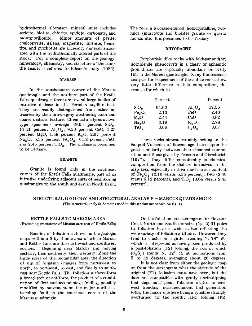
The sedimentary and volcanic rocks of the Kelly Hill area constitute about one-third of the entire Marcus quadrangle. They are bounded to the west by a major fault in the Kettle River valley, to the east and south by Lake Roosevelt, and to the north by the quadrangle map limit. These rocks have been folded at least twice and later block faulted. The earlier folding generated east-west, tightly appressed folds, strongly overturned to the south (fig. 5) and of very low plunge, giving rise to the east-west rock distribution pattern not unlike that of Gold Hill, north of Kettle Falls. Subsequently a second stage of folding developed rather open and upright folds, much like the second stage folds elsewhere in the Marcus and Kettle Falls quadrangles, plunging at low to moderate angles to the north and northeast (fig. 5). This second stage folding affected rocks at least as young as Early Triassic on Kelly Hill.
The rock distribution pattern resulting from these deformations was further disrupted and complicated by north-south block faulting, probably in post-Eocene time.
N
_J_ I
Figure 5. - Kelly Hill domain stereogram showing 2 first stage
minor fold axes ( e), 7 second stage minor fold axes ( O), 4
(31 s0 ( 0) for first stage folds ( F1), 4 (32s
0 ( (·)) for second
stage folds ( F2), and 1 (32S1 ( ·:;:· ) for second stage folds
( F2) in foliation. Sources of the data are as follows: Mouth
of Kettle River - 5 second stage minor fold axes and
42 poles to bedding in chert, which define a 131s
0 and a
(32S0, all labeled 1; South half of Kelly Hill - 42 poles to
bedding in siltstone, graywacke, and argillite, which define
a (31 S0 and (32S0 , both labeled 2; Napoleon mine - 5 poles
to bedding in argillite and limestone, which define a (32
S0
labeled 3; Northwest corner of domain - 1 second stage
fold axis labeled 4A, 13 poles to bedding in argillite, silt
stone, and graywacke, which define a ~1 s
0 and a (3
2S
0,
both labeled 4A; Northwest corn?r of domain - 2 first
stage minor fold axes and 1 second stage minor fold axis, all
labeled 4B, and all overturned folds in bedding, and 16
poles to foliation which define a (32
S1
labeled 4B; North
boundary of Marcus quadrangle - 9 poles to bedding in
limestone and phyllite, which define a (31
S0
labeled 5.
STRUCTURAL GEOLOGY AND STRUCTURAL ANALYSIS -- KETTLE FALLS QUADRANGLE
Examination of the geologic map of the Kettle Falls quadrangle (plate 1) demonstrates that the various important structural events include, from oldest to youngest, (1) at least two periods of large-scale folding, (2) high-angle faulting in a northwest direction, ( 3) high-angle faulting in a north to northeast direction, ( 4) thrust faulting, and ( 5) block (graben) faulting along the trend of the Colville River valley. The combination of these several events has produced a number of disrupted blocks, each with a rock distribution often greatly different from its neighbors. The record of the two folding periods is one that is especially difficult to decipher from examination of the map or even of the outcrops. Consequently, the field data on bedding, foliation, and minor folds, have been divided into several domains (fig. 1), discussion of which follows.
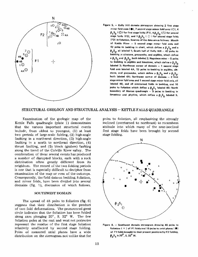
SOUTHWEST DOMAIN
The spread of 48 poles to foliation (fig. 6) suggests that their distribution is the product of two fold deformations. The pronounced great circle indicates that the foliation has been folded along axes plunging 20°, S. 32° W. The few foliation poles at the east and west net perimeter represent the residue of the first stage foliation relatively unaffected by second stage folding. Poles of measured axial planes have a wide distribution on the stereogram not unlike that for
12
poles to foliation, all emphasizing the strongly inclined ( overturned to northeast) to recumbent attitude into which many of the near-isoclinal first stage folds have been brought by second stage folding.
+
+
::·. ...
N
+ + + +
Figure 6. - Southwest domain stereogram showing 48 poles to
foliation ( + ) of F1 folds and 16 poles to axial planes ( •)
of F1 folds brought to their present positions by F2 folding.
~ 2s1 is 20°, S. 32° W.

On figure 7 there are two great circles. The northwest-southeast one indicates folds in bedding that plunge 24°, S. 41 ° W. The E-W great circle suggests folds that plunge 20°, S. 03° W. These two great circles strongly resemble those for foliation in the Southwest domain (P2 81 ; 20° S. 32° W. ), as well as those for bedding in the Southcentral domain (fig. 9). This suggests, as in the South-central domain, that early folds were almost isoclinal, upright, plunging 20°, S. 03° W., and that later (F2) folding reoriented the tightly appressed minor early folds so that their axial surfaces and most of the early fold foliation are now expressed as inclined to recumbent folds that plunge 20°, S. 32° W. (folds in foliation) and 24°, S. 41 ° W. (folds in bedding).
~·; ~25
0
\::·~2s,
N
Figure 7. - Southwest domain contoured bedding pole stereogram. Contours represent 2, 4, and 6 plus percent of 183 poles to bedding in 1 percent of stereonet area. p1s0 is 20°, S. 03° W., ~2s0 is 24°, S. 41° W.,and(i2S1 (from fig. 6) is 20°, S. 32° W.
The very similar pole patterns for folded bedding and folded foliation testify to the near parallelism of bedding and foliation prior to the younger (F2) folding; that is, the first stage folding must have been nearly isoclinal.
Figure 8 shows the wide dispersion of 10 axes of tightly appressed to isoclinal, strongly inclined to recumbent, minor first stage folds in phyllite, argillite, and limestone. This dispersion of first stage fold axes is the product of the second stage folding about the axes referred to above ('3 2 80 and p2 S1 on figs. 7 and 8).
13
N
•• Figure 8. - Southwest domain stereogram showing 10 F1 fold
axes ( e) dispersed by F2 folding, p2s
0 from figure 7, and
~2s1 from figure 6.
SOUTH-CENTRAL DOMAIN
Bedding pole and four first stage minor fold axis plots (fig. 9) for Cambrian quartzites outside of the thrust sheet indicate that folds are symmetrical, very tightly appressed, upright, plunging 12°, S. 22° W. ((3 1 8 0 ). Axial planes are calculated to have attitude N. 24° E., 70° W. These are first stage folds.
Pole diagram for bedding ( 40 measurements) (fig. 10) in thin-bedded and interbedded quartzite, dolomite, phyllite, and greenstone within the thrust sheet indicates symmetrical upright first stage folds plunging 30°, S. 34° W. Axial plane is calculated to be N. 24° E., 70° W. Fold limbs have dominant attitudes N. 23° E., 65°-70° W., and N. 44° E., 70° E.
Poles to foliation and to 4 measured axial planes (fig. 11), though limited both in number (13 foliation readings) and in location (near mouth of Colville River), indicate the presence of small second stage folds overturned to the northwest and plunging 20°, S. 48° W. (p 2 S1 ). In view of the fact that both bedding and foliation are involved in this folding, it must be younger than the first stage folds. However, the "overturned" nature of many of these folds may not reflect the presence of overturned second stage folds; rather, at least some of the "overturned" folds may be tightly appressed first stage folds brought to their present "overturned" position by second stage folding.
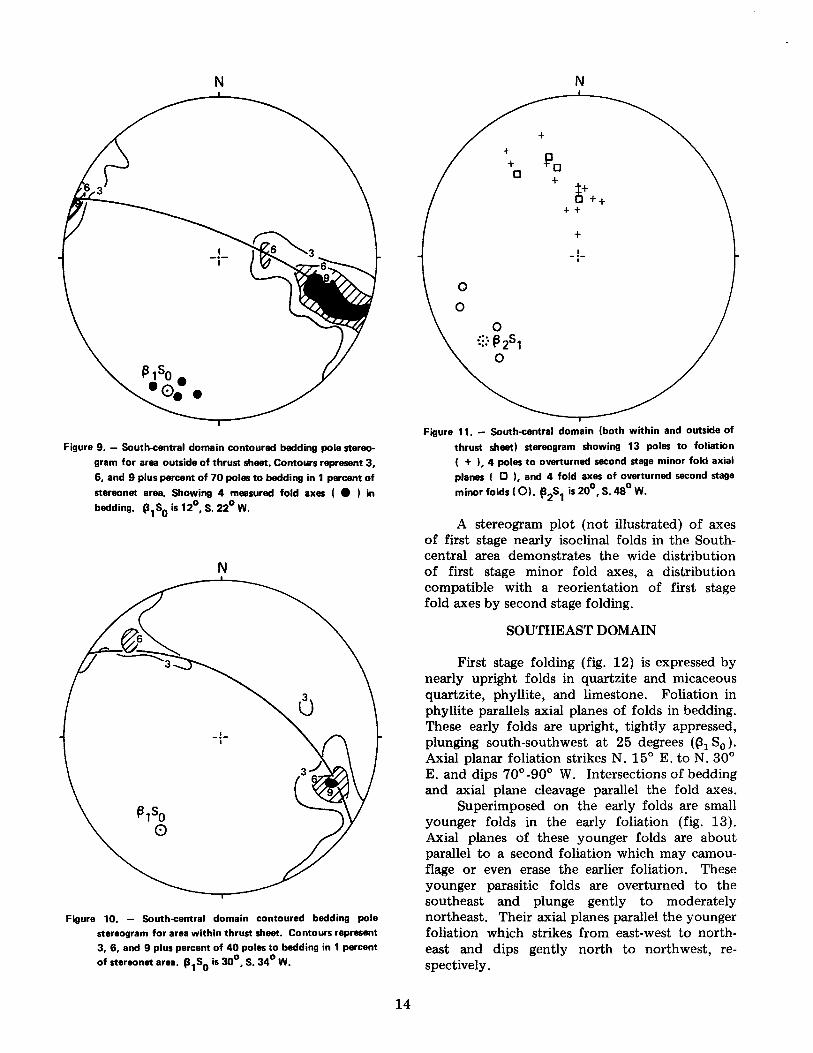
N
Figure 9. - South-central domain contoured bedding pole stereogram for area outside of thrust sheet. Contours represent 3, 6, and 9 plus percent of 70 poles to bedding in 1 percent of
stereonet area. Showing 4 measured fold axes ( e ) in bedding. '31S0 is 12°, S. 22° W.
N
Figure 10. - South-central domain contoured bedding pole stereogram for area within thrust sheet. Contours represent 3, 6, and 9 plus percent of 40 poles to bedding in 1 percent of steraonet area. (3
1S
0 is 30°, S. 34° W.
14
N
+ +
~a + a +
~+ ++ ++
+ I
-i-
0
0
0 {::· f3 251
0
Figure 11. - South-central domain (both within and outside of thrust sheet) steraogram showing 13 poles to foliation ( + ), 4 poles to overturned second stage minor fold axial planes I a ), and 4 fold axes of overturned second stage minorfolds(O). p
2s1 is20°,S.48°W.
A stereogram plot (not illustrated) of axes of first stage nearly isoclinal folds in the Southcentral area demonstrates the wide distribution of first stage minor fold axes, a distribution compatible with a reorientation of first stage fold axes by second stage folding.
SOUTHEAST DOMAIN
First stage folding (fig. 12) is expressed by nearly upright folds in quartzite and micaceous quartzite, phyllite, and limestone. Foliation in phyllite parallels axial planes of folds in bedding. These early folds are upright, tightly appressed, plunging south-southwest at 25 degrees ((31 S0 ).
Axial planar foliation strikes N. 15 ° E. to N. 30° E. and dips 70° -90° W. Intersections of bedding and axial plane cleavage parallel the fold axes.
Superimposed on the early folds are small younger folds in the early foliation (fig. 13). Axial planes of these younger folds are about parallel to a second foliation which may camouflage or even erase the earlier foliation. These younger parasitic folds are overturned to the southeast and plunge gently to moderately northeast. Their axial planes parallel the younger foliation which strikes from east-west to northeast and dips gently north to northwest, respectively.

• • • ,/ijr,,so• •• ••••
N
-1-1
Figure 12. - Southeast domain contoured bedding pole stereo.
gram. Contours represent 1 and 8 plus percent of 200 poles
to bedding in 1 percent of stereonet area. Also shown are
13 poles to first stage fold axial planes ( 8 ), and 14 meas
ured axes of upright first stage folds ( e ). C31
S0
is 25°, s. 26°W.
N
t+ ++ D +
t++.:t.+t+ b + +:..tt+-t +.ifi + + + +-fy + + + + + t+-+' + +++
+~ + o+
Figure 13. - Southeast domain stereogram showing 65 poles to foliation ( + ), 13 axes of post-F1 minor folds, overturned to the southeast ( 0 ), and 6 poles to axial planes of folds,
overturned to the southeast ( CI.
15
LATER FOLDS
A still younger fold generation has crenulations in the northwest-dipping foliation. Although found rather frequently, reliable attitudes are difficult to obtain because the folds are almost completely recumbent and they seem to vary widely in direction of plunge.
CONCLUSIONS
First and second stage folds such as are found in the northeastern corner of the Kettle Falls quadrangle are like those described earlier in the Marcus quadrangle. However, in the south half of the Kettle Falls quadrangle, first stage folds are upright, very tightly appressed, plunging from 12 to 30 degrees to south and south-southwest. Second stage folds in bedding and foliation throughout most of the south half of the Kettle Falls quadrangle are overturned toward the north and plunge about 22°, SW. In the southeast corner of the Kettle Falls quadrangle, foliation superimposed on the earlier Fl foliation is axial planar to small folds in early (Fl) foliation. These small folds plunge from 10 to 60 degrees to north-northeast. No similar fold generation has been recognized elsewhere in the quadrangle. This deformation may be due to the emplacement of the granite intrusive body alongside these rocks in the southeast corner of the quadrangle.
SUMMARY OF FOLD HISTORY
Fold history is summarized in figure 14 and table 1. Prior to the major faulting, the Paleozoic and Mesozoic (Triassic) sedimentary and volcanic rocks were subjected to two periods of major folding. Folds of the younger generation are relatively open, upright, and plunge at low angles to moderate angles to the north or north-northeast in the Marcus quadrangle (fig. 5, Kelly Hill domain; fig. 4, Pingston Creek North domain; fig. 3, Pingston Creek South domain; fig. 2, Pingston Creek North and South domains), and to the southwest (Southeast domain and Southwest domain) in the Kettle Falls quadrangle. That is, the trend of second stage fold axes is about the same throughout the two quadrangles but the amount and direction of inclination were determined to a large extent by the attitude of the strata prior to second stage folding (fig. 14).
Folds of the earlier (Fl) generation in the Marcus quadrangle are quite unlike those in the Kettle Falls quadrangle, both in style and especially in orientation. The earlier folds in the Marcus quadrangle are tightly appressed, strongly over-

Table 1. - Summary of fold history (see also fig. 14)
Plunge and trend of poles to great circles for bedding (S0) and foliation (S1)
Domain @1So ~{So l32So f32S1
Southwest 20°, S. 03°W. ---·------- 24°,S.41°W.1 20°, S. 32°W.1
South-central: - within thrust sheet 30°,S.34°W. .... -- - .. - --- - ----------- ------------ outside thrust sheet 12°.s.22°w. ----------- ----------- ------------ within and outside of thrust sheet - -- - .. - - -- -- ...................... ----------- 20°, S. 48°W.1
Southeast 25°,S. 26°W.2 ----------- ----------- -----------
Pingston Creek South - .. - - - .. - - .... - 28°, S. 78°W.2 35°, N. 14°E. -----------15°, N. 52°E.2
Pingston Creek North - - .. - .. -- - .. - - 22°, s. 75°w.2 36°, N. 04°W. .... -- - - - - ...... 14°, N. 35°E.2
26°, N.12°E. Pingston Creek North and South - .. - -- .. - - -- .. ----------- ---- -------
Kelly Hill 24°, N. 87°W.(mean)2 ----------- 25°, N. 10°E.(meanl 33°, N. 02°E.
Folds overturned to north. ~1
• pole to gr~!t _ci_rcle for first stage folding. -
~ 1' · POie to great circle for first stage folding, modified by second stage folding.
f!2
· pole to great circle for second stage folding. 2
Folds overturned to south.
N
KH KH .. (~1:-PCNS
,...; .. ,, PCN '·., .. '~ PCS
KH0
PCS,... r.-..J '--'PCN
sc, ... SC!:::: .... 0 sc. within thrust
sw..:'::·:0 SE sw···
• r-,SW 0 SC , oufside thrust
Figure 14. - Summary of fold history (see also table 1 ).
Legend 0 p
1s
0, pole to great circle for F1 folding
8 p1
1s0
, pole to great circle for F1 folding modified by F2
folding (·) p
2s
0, pole to great circle for F2 folds in bedding
-:::• '32
S1
, pole to great circle for F2 folds in F1 foliation
KH - Kelly Hill domain
PCN - Pingston Creek North domain PCS - Pingston Creek South domain PCNS - Pingston Creek North and South domains
SE - Southeast domain
thrust sheet unless otherwise indicated
SW - Southwest domain
16
turned to the south, with axes plunging gently to the west on Kelly Hill (fig. 5) and probably to the east in the area between the towns of Marcus and Kettle Falls. In some places, later cross folding deflected the first stage fold axes so as to give them plunges in a northeast direction or west-southwest direction (Pingston Creek South and Pingston Creek North domains). The aspect and plunge of these folds are in sharp contrast to the first generation folds south of the Colville River in the Kettle Falls quadrangle, where fold plunges are at low angles to the southwest (Southwest and South-central domains) more like those in the Northport quadrangle several miles to the north (Mills and Nordstrom, 1973).
The elastic and volcanic rocks of Eocene age, which occur in the northeast corner of the Marcus quadrangle, in profusion in the quadrangles to the east and northeast, and in the Colville Valley, rest unconformably on rocks of Permian age and are only lightly deformed as compared to strata of Permian and Triassic age; therefore, the principal fold deformations in the Marcus and Kettle Falls quadrangles are certainly preEocene. These same Permian and Triassic strata have been metamorphosed by the intrusive quartz monzonite in the southeast quarter of the Marcus quadrangle. Since neither the intrusive rocks nor their metamorphic aureoles appear to have been affected by folding, and since the quartz monzonite is probably Late Cretaceous in age, both first stage and second stage folding must have taken place not only in pre-Eocene, but in pre-Late Cretaceous time.
REFERENCES CITED
Beka, F. T., 1980, Upper Paleozoic metasedimentary and metavolcanic rocks and associated mineral deposits between Glasgo Lakes and Little Sheep Creek, Stevens County, Washington: Washington State University Ph. D. thesis, 172 p., map scale 1 :63,360.
Bowman, E. C., 1950, Stratigraphy and structure of the Orient area, Washington: Harvard University Ph. D. thesis, 161 p., map scale 1 :63,360.
Bradshaw, H. E., 1964, Geology of the Palmer Volcanics: University of Oregon M.S. thesis, 109 p., map scale 1:27,500.
Brainard, R. C., 1982, Geology of the Colville area, Washington, township 35 north, east half of range 38 east, west half of range 39 east: Washington State University M.S. thesis, 60 p., map scale 1:40,000.
Daly, R. A., 1912, Geology of the North American Cordillera at the forty-ninth parallel: Geological Survey of Canada Memoir 38, 3 parts, 546 p.
Dixon, J. S., 1958, Additional fossil evidence bearing upon the age of the Mission Argillite, Stevens County, Washington: State College of Washington (Honors thesis), 20 p., map scale 1:24,000.
Donnelly, B. J., 1978, Structural geology of the Nancy Creek area, east flank of the Kettle dome, Ferry County, Washington: Washington State University M.S. thesis, 251 p., map scale 1:15,000.
Duncan, G. W., 1982, Structural geology and stratigraphy of the east half of township 37 north, range 38 east, and the southeastern half of township 37 north, range 39 east, Stevens County, Washington: Washington State University M.S. thesis, 68 p., map scale 1:24,000.
Ellison, P. J., 1982, Mineralization and alteration of a composite stock in the Gold Hill area, Stevens County, Washington: Washington State University M.S. thesis, 67 p., map scale 1 :600.
Fyles, J. T.; Hewlett, C. G., 1959, Stratigraphy and structure of the Salmo lead-zinc area: British Columbia Department of Mines Bulletin 41, 162 p., map scale 1:24,000.
Hogge, C. E., 1982, Geology of the Paleozoic black shale sequence, Moberg Hill, Stevens County, Washington: Washington State University M.S. thesis, 80 p., map scale 1:36,000.
Kuenzi, W. D., 1965, Early Triassic (Scythian) ammonoids from northeastern Washington: Journal of Paleontology , v. 39, no. 3, p. 365-378.
Laskowski, E. R., 1982, Geology of the black shale belt of the Bruce Creek area, Stevens County, Washington: Washington State University M.S. thesis, 113 p., map scale 1:24,000.
Lyons, D. J., 1967, Structural geology of the Boulder Creek metamorphic terrane, Ferry County, Washington: Washington State University Ph.D. thesis, 115 p., map scale 1 :84,480.
Miller, F. K.; Clark, L. D., 1975, Geology of the Chewelah-Loon Lake area, Stevens and Spokane Counties, Washington, with a section on potassium-argon dates of the plutonic rocks, by J. C. Engels: U.S. Geological Survey Professional Paper 806, 7 4 p., 2 plates, map scale 1 :62,500.
Mills, J. W.; Davis, J. R., 1962, Permian fossils of the Kettle Falls area, Stevens County, Washington: Cushman Foundation Foraminiferal Research Contribution, v. 13, part 2, p. 41-51.
Mills, J. W.; Nordstrom, H. E., 1973, Multiple deformation of Cambrian rocks in the Kootenay Arc, near Northport, Stevens County, Washington: Northwest Science, v. 47, no. 3, p. 185-202.
17

REFERENCES CITED • Continued
Moser, K. R., 1978, Structural analysis of Cambrian rocks in the Bowen Lake area, Stevens County, Washington: Washington State University M.S. thesis, 64 p., map scale 1:6,400.
Park, C. F., Jr.; Cannon, R. S., Jr., 1943, Geology and ore deposits of the Metaline quadrangle, Washington: U.S. Geological Survey Professional Paper 202, 81 p., map scale 1:96,000.
Pearson, R. C.; Obradovich, J. D., 1977, Eocene rocks in northeast Washington - Radiometric ages and correlation: U.S. Geological Survey Bulletin 1433, 41 p., map scale 1:300,000.
Phillips, W. M., 1979, Structural geology and Cambrian stratigraphy of the Crown Creek-Bowen Lake area, Stevens County, Washington: Washington State University M.S. thesis, 82 p., map scale 1:6,000.
Rhodes, B. P.; Cheney, E. S., 1981, Low-angle faulting and the origin of Kettle dome - Metamorphic core complex in northeastern Washington: Geology, v. 9, no. 8, p. 366-369.
Walker, J. F., 1934, Geology and mineral deposits of Salmo map-area, British Columbia: Geological Survey of Canada Memoir 172, 102 p., map scale 1:63,360.
Weaver, C. E., 1920, The mineral resources of Stevens County: Washington Geological Survey Bulletin 20, 350 p., map scale 1:125,000.
Wilson, J. R., 1981, Structural development of the Kettle gneiss dome in the Boyds and Bangs Mountain quadrangles, northeastern Washington: Washington State University Ph.D. thesis, 156 p.
Yates, R. G., 1971, Geologic map of the Northport quadrangle, Washington: U.S. Geological Survey Miscellaneous Geologic Investigations Map I-603, map scale 1:31,680.
Yates, R. G., 1976, Geology of the Deep Creek area, Washington, and its regional significance: U.S. Geological Survey Open-File Report 76-537, 435 p., map scale 1:31,680.
18

'
' / We
/ KfotLI., F f
"" ~ t:l (",
"' 0 ,,. .,, "' "" -tc ~ :,..
,-. C .... ~ Qga .. "' ' "' , .... :.., ' "' "'
"" _, .,, , . • -,.. .,, ,. :,::
"" ~ C ~ e
~ "' "' "' r! Mlle '<l -35' ' 700 ' -4
;;;..
I .,
.,, ... :~Oga . .., - "'
"81 "' "'
''80
''" 35 r,
" -' ~
"' , ::, --"' (
"
Oga
l'Ol"l.1-.t.: IL M
S ,\"l"ION \I, Rt:L:1H;.,1.· HI~ .-\!ti::,
nu.•, Kl.IN II
l.{Ji
f .,. )
Oga
Oga
,; ·,
·'
Qga
/ I \-rsd
Qga
, ~, ' '·
Base map frorn IJSG S 7¥,. rn imHe Ken le Falls Ouad(anul<1, Wa,;hinatun •
GEOLOGIC MAP
0 '48' 14 MIL S
" . 3Si MILS
U!''I QRIO ANO 1%9 •MGNHIC NORTH OECl•NATIO"I AT CENT~R Of SHEET
SCALE 1:24000 } 0 !MILE Ea==="""= =~=== =========
0 - •ooo
CON TO UR INTERVAL 40 FEET DOTT ED LI N ES REPRE SENT 20-FOOT CONTOURS
DATUM IS MEAN SEA LEV EL
6000 700() FEET
DEPTH CURVES AND SOUNDINGS IN FEET-DATUM 15 NORMAL POOL ELEVATION 1289 FEET
OF THE KETTLE FALLS QUADRANGLE, STEVENS AND
BY J. W. MILLS
1985
0
' ·~
•
WASHINGTON
QUADRANGLE LOCATION
FERRY
DIVISION OF GEOLOGY AND EARTH RESOURCES RAYMOND LASMANIS, State Geologist
Cs
60
•
Oga
Tsd
a •
Cartography by Keith Ikerd
I EE!
' " "
''18
,, 0
'lb
"
"
8
N
CENOZOIC
r MESOZOIC
l
( Quaternary
l
Tartiary
r Triassic
l
r Carboniferous(?)
l
r Ordovician
PALEOZOIC l
Cambrian
r PRECAMBRIAN
l r r
CENOZOIC Tertiary
l l ( (
MESOZOIC Cretacttous l l
COUNTIES, WASHINGTON
( Pleistocene
l
Eocene
Oga
Tscu 't Tsb
Tsd •
DESCRIPTION OF MAP UNITS
Surficial Depotits
Glacial and alluvial deposits. Silt, sand, and grave!
UNCONFORMITY
Sedimentary, Metamorphic, end ExtrusiV8 Igneous Rocks Gray-shaded areas are outcrops
GEOLOGIC MAP GM 32 Plate 1 of 2
Sanpoil Volcanics (Pearson and Obradovich, 1977): Geology from Bradshaw, 1964
Tscu - Conglomerate
Tsb - Volcanic breecia
Tsd - Dacite
Sediments correlative(?) with the O'Brien Creek Formation (Pearson and Obradovich, 1977) :
Geology from Bradshaw, 1964
Tss - Sandstone
Tse! - Conglomerate
FAULT
~ Rs Rs - Siltstone, and graywacke, with minor chen-pebble conglomerate, and argillite
Fig (9 fl g - Massive green stone, inter bedded with graywacke . Age and correlation uncenain
Pa
l) £mp
®>
£au ~
,, D £am
£a l c;:J
C) pCm,
( ,,
" -d
pCml 6\)
gw - Mappable lenses of graywacke
UNCONFORMITY
Pa - Fossiliferous, highly siliceous or highly calcareous argillite
gw - Graywacke
Pl - Pods, lenses, and irregular bodies of fossiliferous limestone
Cs - Siltite and graywacke
Cg - High ly calcareous, schistose greenstone; massive, sometimes pillowed metabasalt; volcanic breccit1; and tuff. Commonly contains gray limestone pods and lenses. lnterbedded with siltite ;and graywacke unit (Cs)
FAULT
Ledbetter Formation:
014 - Blt1ck argillite and green argillite or tuff
013 - lnterbedded limestone and argillite
012 - lnterbedded argillite, siltstone, and quartzite
ss - Mappable bodies of siltstone
01 1 - Argillite with rare limestone interbeds and occasional graptolites
UNCONFORMITY
Metaline Formation:
£m - Gray to black, thin-bedded limestone
d - Gray, zebra-bt1nded dolomite
Maitlen Formation:
£mp - Phy!lite. Metamorphosed to andalusite schist near contact with granitic rocks in southeast comer of quadrangle
Is - Limestone
d - Dolomite
q - Quartzite
Addy Formation:
Cau - Quartzite and argil!aceous quartzite with up to 10 percent interbedded t1rgillite. Minor brown phyllite in uppermost part
Is - Minor gray limestone in uppermost part of £au
£am - Phyllite, phyllitic argil!ite, and siltstone. Contains up to 20 percent interbedded quartzite
£al - Quartzite. Contains up to 10 percent interbedded, thin bedded, argi!laceous auartzite
DISCONFORMITY(l)
Monk Formation:
pCmu - Greenstone
ls - Limestone
q - Quartzite
d - Dolomite
pCml - Dolomite with qut1rtz stringers and blebs. Contains qut1rtzite, greenstone, limestone, and argillite
Diabase
Granite
Quartz monzonite
lntru1iV8 Igneous Rocks Gray-shaded areas are outcrops
EXPLANATION
Contact, dashed where approximately located, dotted where concealed
6' D ____._ iJ -- - Fault, showing dip. U, upthrown side, D, downthrown side. Dashed where approximately located
Thrust fault. Sawteeth on upper plate. Dashed where approximately located
'1--+--- Anticlinal axis, showing plunge. Dashed where approximately located
'5---+--- Synclinal axis, showing plunge. Dashed where approximately located
19 • A Axis of overturned anticline, showing plunge. Dashed where approximately located
,,~,-~O~ Axis of ovenurned syncline, showing plunge. Dashed where approximately located
26 - Trend and plunge of minor fold axis
Outcrops
Strike and dip of beds
75 ,.,;.-,- Strike and dip of beds, tops known
..-Y Strike of vertical beds
R" Strike and dip of overturned beds
" .Y Strike and dip of foliation
X Strike of vertical foliation
F Fossil locality
s Schistosity due to faulting
<I <I <1 4 Fault breccia
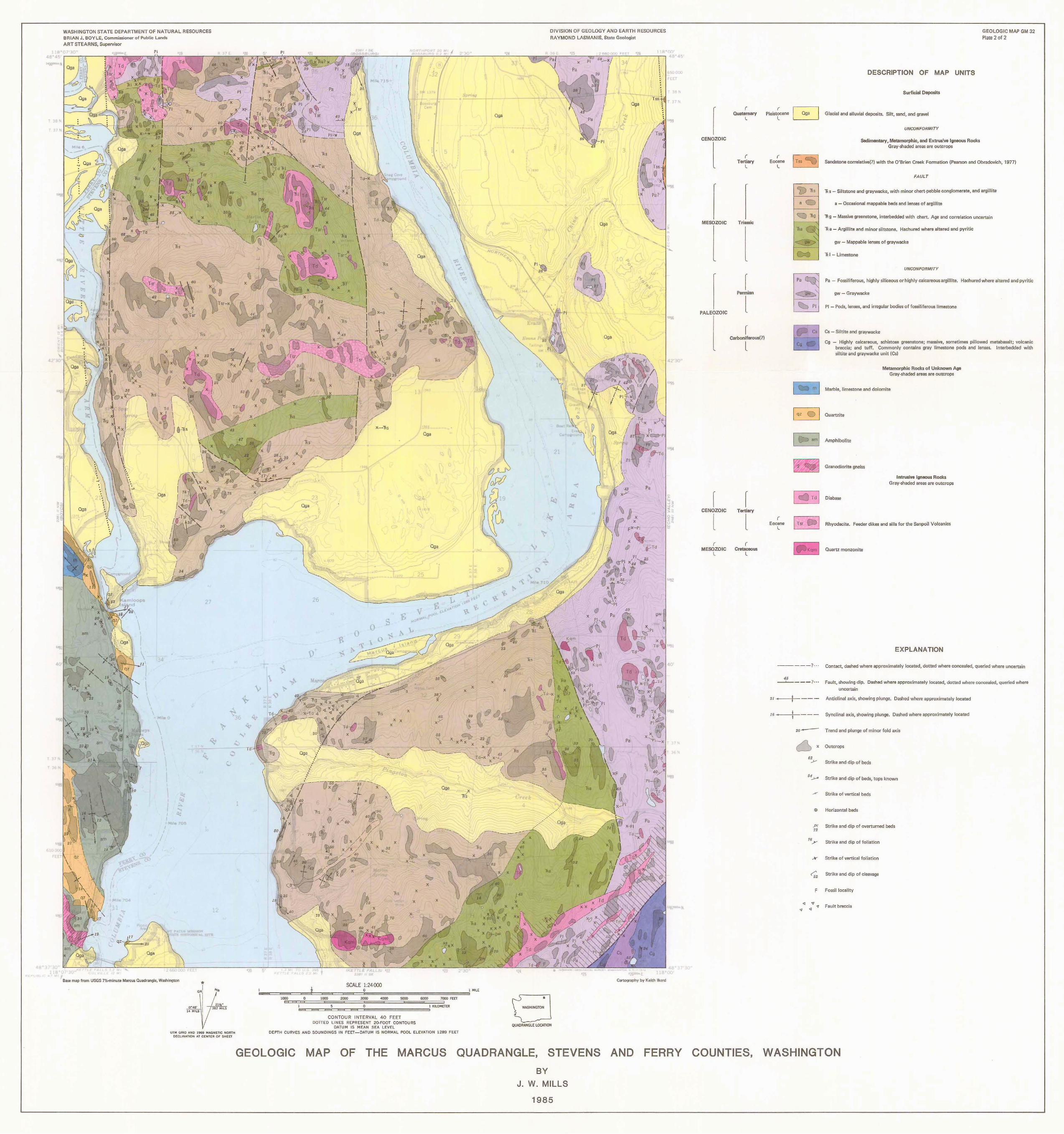
T
l(
48
""
,_ ~~ -0 ~!!!
"'' 40
'"
•
WASHINGTON STATE DEPARTMENT OF NATURAL RESOURCES BRIAN J. BOYLE, Commissionor of Public LandG ART STEARNS, Supervisor
~
1'' ..
. . I
~ '
\ \
I . .
• ' I
I• ~ .
·11 ·.
? .• Qga
I Qga \ . . • ~ -. I •' ~~
94
7
,m
H
.....
20
~
" x, ,.\,,,
Ml
~ .. X \X X X ~ q) X
am
7
M.t • 70~
Qga
,, 30
Bare map from USGS 7%-minute Marcus Quadrangle, Washington • GN /.f1,
, ... \ { ... ~ 14 MILS
UTM GRIO A!iD 19611 MAGNETIC NORTH DECLINATION AT CENTER OF SHEET
"'"'
' ,,.
Gga
0 I
(
,000
n 0 ...
..
X .X
' X
X X
5 0 I ll!LOMET£R ============ CONTOUR INTERVAL 40 FEET
DOTIED LINES REPRESENT 20-FOOT CONTOURS DATUM IS MEAN SE.4. LEVEL
• WASHINGTON
DIVISION OF GEOLOGY AND EARTH RESOURCES
AA YMOND LASMANIS, Stotc Geologist
Qg,
Qg,
; I \J
F<"
N
N
4,: 30
Pa
X
t,'\ ~ ?I
Td ~ Td X
01, Td
Td ~
Cartography by Keith Ikerd
..,,
QUADRANGLE LOCATION
DEPTH CURVES AND SOUNDINGS IN FEET-0.4.TUM 1$ NORMAL POOL ELEVATION 1289 FEET
GEOLOGIC MAP OF THE MARCUS QUADRANGLE, STEVENS AND FERRY BY
J. W. MILLS
1985
r CENOZOIC
l
MESOZOIC
PALEOZOIC
r CENOZOIC
l r
MESOZOIC l
r Quaternary
l
(
Tertiary l
Triassic
r Permian
l r
carboniferous(?)
l
r Tertiary
l r
Crataceous l
(
Pleistocene l
( Eocene
L
r Eocene
l
Pa
DESCRIPTION OF MAP UNITS
Surficial Deposits
Glacial and alluvial deposits. Silt, sand, and gravel
UNCONFORMITY
Sedimentary, Metamorphic, and Extrusive lwneous Rocks Gray-shaded areas are outcrops
GEOLOGIC MAP GM 32 Plate 2 of 2
Sandstone correlative(?) with the O'Brien Creek Formation (Pearson and Obradovich, 1977)
FAULT
Rs - Siltstone and graywacke, with minor chert-pebble conglomerate, and argillite
a - Occasional mappable beds and lenses of argillite
Rg - Massive greenstone, interbedded with chert. Age and correlation uncertain
Ra - Argillite and minor siltstone. Hachured where altered and pyritic
gw - Mappable lenses of graywacke
R I - limestone
UNCONFORMITY
Pa - Fossiliferous, highly siliceous or highly calcareous argillite. Hachured where al tered and pyritic
gw - Graywacke
Pl - Pods, lenses, and irregular bodies of fossiliferous limestone
Cs - Slltite and graywacke
Cg - Highly calcareous, schistose greenstone; massive, sometimes pillowed metabasalt; volcanic breccia; and tuff. Commonly contains gray limestone pods and lenses. lnterbedded with siltite and graywacke unit (Cs)
Metamorphic Rocks of Unknown Age Gray-shaded areas are outcrops
~ m ] Marble, limestone and dolomite
~ Quartzite
~ Amphibolite
] ~~I Granodiorite gneiss
I ~ Td I Diabase
Intrusive Igneous Rocks Grav-shaded areas are outcrops
j Tsr eJi I Ahyodacite. Feeder dikes and sills for the Sanpoil Volcanics
'flKQm I Quartz monzonite
EXPLANATION
--- --? · · Contact, dashed where approximately located, dotted where concealed, queried where uncertain
4' ----J......---- ?··· Fault, showing dip. Dashed where approximately located, dotted where concealed, queried where
uncertain
"-- -1----- Anticlinal axis, showing plunge. Dashed where approximately located
,s ---+-- -- - Synclinal axis, showing plunge. Dashed where approximately located
20-- T rend and plunge of minor fold axis
U x Outcrops
" ..J-- Strike and dip of bed5
64~ Strike and dip of beds, tops known
_... Strike of vertical beds
E& Horizontal beds
P,: Strike and dip of overturned beds
" 76
.Y Strike and dip of foliation
X Strike of vertical foliation
~ Strike and dip of cleavage
F Fossil locality
<I v v Fault breccia • •
COUNTIES, WASHINGTON