geologic map of the espanola 7 - new mexico … · geologic map of the san juan pueblo 7.5 ... this...
TRANSCRIPT
Geologic Map of the San Juan Pueblo 7.5-Minute Quadrangle, Rio Arriba and Santa Fe Counties,
New Mexico.
By
Daniel J. Koning and Kim Manley
September 2014
New Mexico Bureau of Geology and Mineral Resources Open-file Geologic Map OF-GM 70
Scale 1:24,000
This work was supported by the U.S. Geological Survey, National Cooperative Geologic
Mapping Program (STATEMAP) under USGS Cooperative Agreement and the New Mexico Bureau of Geology and Mineral Resources.
New Mexico Bureau of Geology and Mineral Resources 801 Leroy Place, Socorro, New Mexico, 87801-4796
The views and conclusions contained in this document are those of the author and should not be interpreted as necessarily representing the official policies,
either expressed or implied, of the U.S. Government or the State of New Mexico.

2
GEOLOGIC MAP OF THE SAN JUAN PUEBLO 7.5-MINUTE QUADRANGLE, RIO ARRIBA AND
SANTA FE COUNTIES, NEW MEXICO
Technical Report
BY
DANIEL J. KONING1 AND KIM MANLEY2
May, 2003
Submitted to formal review on November, 2007
New Mexico Bureau of Geology and Mineral Resources OFGM 70
Any further research on land belonging to the San Juan Pueblo needs explicit
permission from the San Juan Pueblo tribal government
1 New Mexico Bureau of Geology and Mineral Resources, New Mexico Tech, 801 Leroy Place, Socorro, NM, 87801-4796; [email protected]. 2 Retired, United States Geological Survey; 4691 Ridgeway, Los Alamos, NM 87544

3
EXECUTIVE SUMMARY
The San Juan Pueblo 7.5-minute quadrangle is underlain by basin-fill sediment of sand
and silt together with subordinate gravel and mud. These deposits were laid down in
the Española basin between 5.8 and 14.8 million years ago, buried by further deposition,
and then eroded so that they now lie exposed at the present land surface. During
burial, the deposits were compacted and cemented to various degrees. Similar deposits
that are still buried may be as much as 25-30 million years old. Included in the Santa Fe
Group, these deposits dip westward and northwestward due to associated tilting of the
Española basin half-graben. Tilting occurred during crustal extension between 30
million years ago to the present, although the rates of this extension may have
fluctuated during that time. A period of net erosion after 3.5 million years ago has
removed much of the youngest basin-fill strata (that post-dating 8 million years old),
but the pre-erosional development of the Chamita syncline (upward-facing fold) in the
northwest portion of the quadrangle did preserve these youngest strata at that location.
Around 3.5-3.7 million years ago, a basalt flow covered relatively thin gravel deposits
that were previously deposited by southwest- to -southeast-flowing rivers (i.e.,
ancestral Rio Grande and Rio Ojo Caliente). Upon cooling and hardening, this basalt
flow served as a protective cap over these gravels and underlying basin-fill deposits –
eventually allowing the formation of the present-day Black Mesa. Although net erosion
has characterized the last 3.5 million years, at least four major episodes of sedimentation
occurred during the past million years. This relatively recent sedimentation has left
relatively thick fill terrace deposits along the Rio Chama, Rio Grande, and Santa Cruz
River.
4
The 5-15 million year-old basin-fill deposits observed at the surface are mapped as the
Tesuque and Chamita Formations, which are further subdivided into several units on
the basis of composition (source area), texture, and other sedimentologic characteristics.
The units reflect five general depositional environments (approximately listed from east
to west): 1) a west- to northwest-sloping alluvial slope flanking the Sangre de Cristo
Mountains south and west of Truchas Peaks, over which flowed numerous streams
carrying abundant granitic gravel and arkosic sand; 2) a relatively high-energy, south-to
southwest-flowing river system on a sloping basin floor that was sourced in the Sangre
de Cristo Mountains north of Truchas Peaks (east of the Peñasco embayment); this river
carried abundant Paleozoic sedimentary gravel and Proterozoic quartzite gravel; 3) an
older, relatively low-energy river or stream system on a southward-sloping basin floor,
derived from the Sangre de Cristo Mountains (near the Peñasco embayment and north
of Truchas Peaks) as well as the San Luis basin, that primarily deposited silt and fine
sand; 4) a south- to southeast-flowing river or stream system on a basin floor that
transported volcanic sediment, exposed along the western quadrangle boundary; and 5)
an extensive wind-blown dune field whose size fluctuated with time, but was most
extensive 12.0-13.5 million years ago. It is important to note that an individual unit may
reflect millions of years of depositional time. Also, many of these units were deposited
at the same time, albeit in different locations within the basin, and interfinger with one
another.
Other noteworthy items are listed below:
1. We use four informal member-rank terms for the Chamita Formation
corresponding to the first four of the depositional environments listed above: the
coarse, upper unit of lithosome A, Cejita member, Vallito member, and
Hernandez member. The first two units extend across both the Tesuque

5
Formation and the Chamita Formation. These four units will be formally defined
in an upcoming N.M. Geological Society Guidebook paper.
2. Alluvial slope deposits derived from the Sangre de Cristo Mountains south and
west of Truchas Peaks (represented by lithosome A of the Pojoaque Member,
Tesuque Formation, and the coarse, upper unit of lithosome A of the Tesuque
and Chamita Formations) progressively prograded westward across the
quadrangle between 5.8 and 16 million years ago, and eventually extended
underneath what is now Black Mesa. The south-southwest-flowing river and
stream system (represented by lithosome B of the Pojoaque Member and the
Cejita Member of the Chamita and Tesuque Formations) likewise shifted to the
west during this same time interval.
3. There is a general coarsening-upward trend in both lithosome B and lithosome A
in the Tesuque Formation.
4. Various tephra intervals -- including the Pojoaque white ash zone, the main
coarse white ash zone, the Española tephra zone, and the lower and upper
Chamita tuffaceous zones -- serve as time markers and allow for correlation of
strata across the quadrangle. In addition, these tephra can be used to track the
westward progradation of lithosome A of the Tesuque Formation and Chamita
Formation across the quadrangle.
5. An important fault zone is located immediately east of the south tip of Black
Mesa and is called the Santa Clara fault zone. It consists of two to three, east-
down fault strands that likely have both a vertical and side-ways sense of
motion. Tectonic motion along and near these faults has appreciably deformed
6
overlying basalt flows. East of this fault zone, strata generally dip to the
northwest; west of this fault zone, strata dip to the southeast. Inspection of a
northwest-southeast cross-section (A-A’) indicates that 470-510 m of vertical
displacement along this fault has occurred over the last 8 m.y.; cumulative
vertical displacement values over the course of rifting may be as much as 1700 m.
This fault probably acts as the more recent master fault of the half-graben
associated with the Española basin, as noted in Baldridge et al. (1994), although
when the structure formed is still under investigation.
INTRODUCTION
The San Juan Pueblo 7.5-minute quadrangle is located in the central Española Valley
(generally called Española basin in this report), which is one of many north-south
trending basins formed by extenstion of the Rio Grande rift during the past 35 million
years. Important geographic features in this quadrangle include: 1) the confluence of
the Rio Grande and Rio Chama, 2) the southern tip of Black Mesa, 3) the first capital city
in New Mexico (Old San Juan), 4) San Juan Pueblo, and 5) the northern extent of the city
of Española. The older (Miocene and Pliocene) geologic features on this quadrangle are
important because they provide insight into the development of the Rio Grande rift,
and the younger geologic features, namely Quaternary terrace deposits, provide a
record of the erosional and sedimentational history of the basin. We present a summary
of map unit descriptions below, with brief interpretations regarding their age and
depositional environment. These descriptions are summarized from a detailed
technical geologic report (available in electronic format), and care has been taken to
keep technical jargon to a minimum. Tables 1-2 and Figures 1-2 are provided to help
with geologic terms and stratigraphic concepts used in this summary. Also, “Ma” and
7
“ka” are abbreviations for “million(s) of years ago” and “thousand(s) of years ago,”
respectively. The age ranges of terms related to geologic time divisions (e.g., Miocene,
Quaternary, Pliocene, Paleozoic) relevant in this report are illustrated in Figure 3, which
also provides a temporal correlation of the map units.
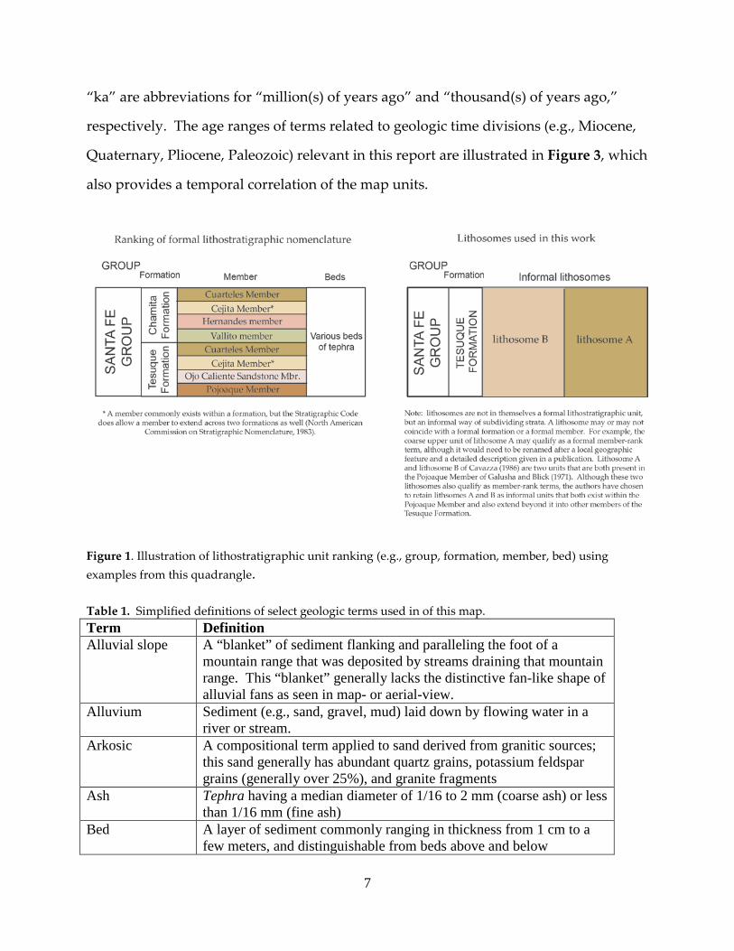
Figure 1. Illustration of lithostratigraphic unit ranking (e.g., group, formation, member, bed) using examples from this quadrangle. Table 1. Simplified definitions of select geologic terms used in of this map. Term Definition Alluvial slope A “blanket” of sediment flanking and paralleling the foot of a
mountain range that was deposited by streams draining that mountain range. This “blanket” generally lacks the distinctive fan-like shape of alluvial fans as seen in map- or aerial-view.
Alluvium Sediment (e.g., sand, gravel, mud) laid down by flowing water in a river or stream.
Arkosic A compositional term applied to sand derived from granitic sources; this sand generally has abundant quartz grains, potassium feldspar grains (generally over 25%), and granite fragments
Ash Tephra having a median diameter of 1/16 to 2 mm (coarse ash) or less than 1/16 mm (fine ash)
Bed A layer of sediment commonly ranging in thickness from 1 cm to a few meters, and distinguishable from beds above and below

8
Bioturbation Churning or mixing of sediment by living organisms (e.g., plant root growth and animal burrowing)
Channel The carved-out path of a river or stream Channel-fill Bed(s) of sediment (typically sand and gravel) that has filled a
channel on the Earth’s surface Contact The three-dimensional surface or boundary of a stratigraphic unit
(e.g., bed, member, formation) Cross-stratified Beds that initially were deposited at steep angles, either by wind or by
water Half-graben A valley created by tilting of the Earth’s surface towards a normal
fault Incision Act of down-cutting of a river or stream that forms a valley, gorge,
arroyo, gully, etc Lamination A layer of sediment less than 1 cm thick Lapilli Tephra having a median diameter of 2-64 mm Lithostratigraphic unit
A stratigraphic unit recognized solely by properties inherent in the rock or sediment (such as texture, composition, bedding style, color) and by stratigraphic position; age is not a factor
Lenticular A bed that wedges out on either end, like a cross section of a lens or a somewhat flattened oval with pointed ends
Massive A descriptive term referring to a lack of observable beds or laminations in a deposit.
Normal fault A crack or split between two blocks of earth or rock, commonly sloping at angles of 45-90 degrees from horizontal, along which the overlying block has slid downward
Overbank sediment
Fine sediment (particularly silt and clay) deposited by the settlement of suspended particles during a flood that overtops the banks of a river or stream
Phreatomagmatic Sediment consisting of tephra and other debris that fell from the air after being expelled by an explosive eruption; the eruption was caused by upward-moving magma superheating groundwater
Piedmont A sloping area of relatively low topographic relief, located just below the base of mountains or hills, that commonly serves or has served as a place of deposition
Relief The amount of vertical or elevational variation of a contact or the Earth’s surface
Strata Layered sediment commonly deposited by water- or wind-related processes
Stratigraphic section
A band-like area along which thicknesses of various strata within a lithostratigraphic unit have been measured and described
Stratigraphy Study of the space and time relations of geologic units Tephra Volcanic fragments and debris that were once air-borne because they
were explosively expelled from a volcano during a volcanic eruption Terrace deposit Sediment that was initially deposited under an active stream or river
in a valley bottom, but later is left above the flood level because that stream or river had cut a more recent, deeper canyon; the surface of
9
the deposit is commonly flat or gently sloping Terrace strath Base of a terrace deposit Type section
A stratigraphic section that constitutes a formal example of a lithostratigraphic unit; needed in the formal designation of a formation or member (see Figure 1)
Vesicular A term applied to hardened lava that has cavities created by former gas bubbles
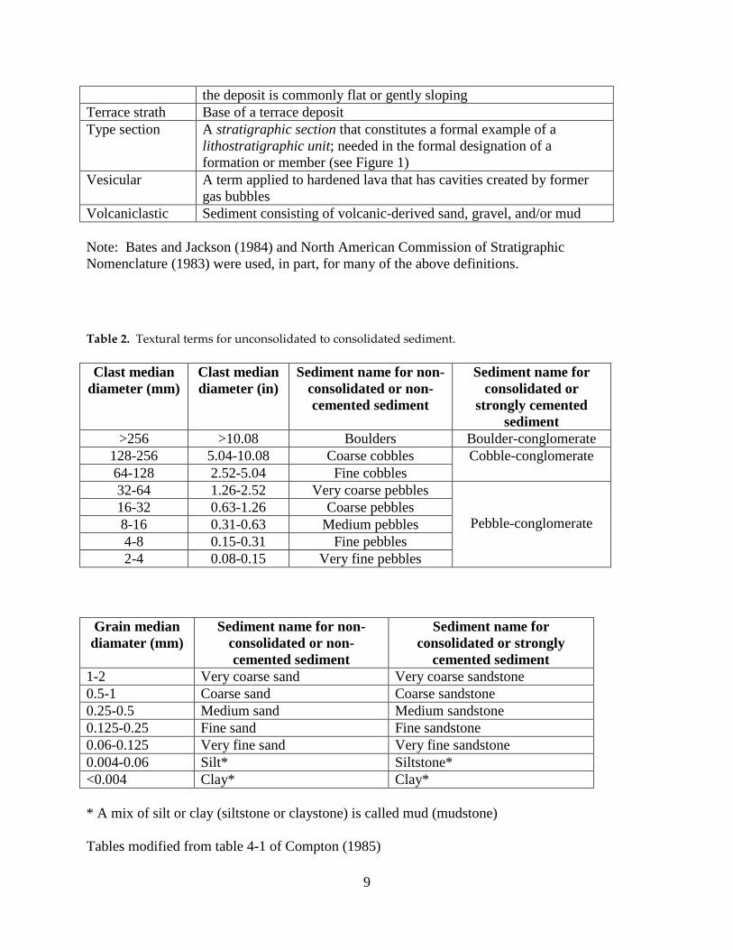
Volcaniclastic Sediment consisting of volcanic-derived sand, gravel, and/or mud Note: Bates and Jackson (1984) and North American Commission of Stratigraphic Nomenclature (1983) were used, in part, for many of the above definitions.
Table 2. Textural terms for unconsolidated to consolidated sediment. Clast median
diameter (mm) Clast median diameter (in)
Sediment name for non-consolidated or non-cemented sediment
Sediment name for consolidated or
strongly cemented sediment
>256 >10.08 Boulders Boulder-conglomerate 128-256 5.04-10.08 Coarse cobbles Cobble-conglomerate 64-128 2.52-5.04 Fine cobbles 32-64 1.26-2.52 Very coarse pebbles
Pebble-conglomerate
16-32 0.63-1.26 Coarse pebbles 8-16 0.31-0.63 Medium pebbles 4-8 0.15-0.31 Fine pebbles 2-4 0.08-0.15 Very fine pebbles
Grain median diamater (mm)
Sediment name for non-consolidated or non-cemented sediment
Sediment name for consolidated or strongly
cemented sediment 1-2 Very coarse sand Very coarse sandstone 0.5-1 Coarse sand Coarse sandstone 0.25-0.5 Medium sand Medium sandstone 0.125-0.25 Fine sand Fine sandstone 0.06-0.125 Very fine sand Very fine sandstone 0.004-0.06 Silt* Siltstone* <0.004 Clay* Clay* * A mix of silt or clay (siltstone or claystone) is called mud (mudstone) Tables modified from table 4-1 of Compton (1985)
10
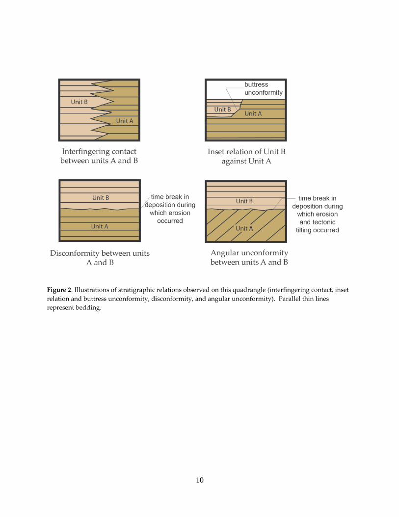
Figure 2. Illustrations of stratigraphic relations observed on this quadrangle (interfingering contact, inset relation and buttress unconformity, disconformity, and angular unconformity). Parallel thin lines represent bedding.

11
Figure 3. Correlation of map units with respect to age. Time (in millions of years), chronostratigraphic divisions (eons, periods, epochs), and North American Land Mammal “ages” (Tedford, et al., 1987) are plotted on the vertical axis.
12
DESCRIPTION OF MAP UNITS
Grain sizes follow the Udden-Wentworth scale for clastic sediments (Udden, 1914;
Wentworth, 1922) and are based on field estimates. Pebble sizes are subdivided as
shown in Compton (1985). The term “clast(s)” refers to the grain size fraction greater
than 2 mm in diameter. Clast percentages are based on counts of 100-150 clasts at a
given locality. Descriptions of bedding thickness follow Ingram (1954). Sandstone is
classified according to Pettijohn et al. (1987). Colors of sediment are based on visual
comparison of dry samples to the Munsell Soil Color Charts (Munsell Color, 1994).
Surficial units are only delineated on the map if estimated to be at least 1 m thick. Soil
horizon designations and descriptive terms follow those of the Soil Survey Staff (1992)
and Birkeland (1999). Stages of pedogenic calcium carbonate morphology follow those
of Gile et al. (1966) and Birkeland (1999).
Mapping of geologic features was accomplished using field traverses, close inspection
of numerous outcrops across the quadrangle, and aerial photographs. Terrace
correlations were made by comparison of mapped strath heights (the main
consideration), lithologic characteristics, and deposit thickness. The interpreted ages of
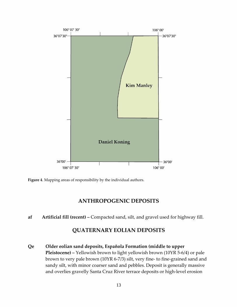
the map units are correlated in Figure 3. Two different workers mapped this
quadrangle, although it was compiled by the lead author, and the area covered by each
respective worker is shown in Figure 4. Both the Tesuque and Chamita Formations are
characterized by strata that range from weakly to well consolidated, and from non- to
strongly cemented. For the sake of consistency, we have decided to universally use the
ending of “stone” for texture-based names in the descriptions (e.g., sandstone,
mudstone).
13
Figure 4. Mapping areas of responsibility by the individual authors.
ANTHROPOGENIC DEPOSITS
af Artificial fill (recent) – Compacted sand, silt, and gravel used for highway fill.
QUATERNARY EOLIAN DEPOSITS
Qe Older eolian sand deposits, Española Formation (middle to upper Pleistocene) – Yellowish brown to light yellowish brown (10YR 5-6/4) or pale brown to very pale brown (10YR 6-7/3) silt, very fine- to fine-grained sand and sandy silt, with minor coarser sand and pebbles. Deposit is generally massive and overlies gravelly Santa Cruz River terrace deposits or high-level erosion
14
surfaces east of Española. Pebbles and coarser sand, laid down by streams, are generally located near the lower contact and probably worked upward by means of bioturbation. Wind-blown sand and silt were then deposited on top of this coarse, relatively thin sediment. Cumulic soil development is inferred, and soils locally contain Bt horizon(s) (many faint to distinct films on ped faces) overlying calcic horizons with stage II carbonate morphology. Correlates to unit Qes of Koning (2002a) and Koning (2003), and is the type locality of the Española Formation of Galusha and Blick (1971). The Española Formation is reported to contain Rancholabrean-age (approximately 10-300 ka; Tedford et al., 1987) fossils that include Canis dirus, Equus, Bison, and ?Camelops (Galusha and Blick, 1971, p. 80-81). Aside from this quadrangle, the term Española Formation has been abandoned for other quadrangles in the Española basin by the lead author because of uncertainties regarding its definition; it is unclear whether the term refers to all eolian-dominated deposits that mantle terrace deposits and lava flows here. These deposits may have a greater age range than that implied by Galusha and Blick (1971) (10-300 ka), resulting from numerous episodes of eolian deposition. Dethier and Reneau (1995, Table 3) report a 14C date of 19 ka from eolian sand (probably this unit) east of Española. Loose to weakly consolidated and 1-3 m thick.
QUATERNARY LANDSLIDE DEPOSITS Qls Undifferentiated landslide deposits (middle to upper Pleistocene) – Large
masses of Chamita Formation (primarily unit Tcc), together with talus and large blocks of Servilleta Basalt, which have slumped and slid eastward since major incision of the Rio Grande after ~3.5 Ma. This mass-wasting probably occurred at relatively slow rates, and may have taken place mostly during paleoclimates marked by increased precipitation (see discussion of landslides in White Rock Canyon by Reneau and Dethier, 1996). Basal slide planes not exposed. Landslides marked by contorted bedding, small-scale faulting, and bulbous or lobate geomorphic shapes. Weakly to moderately consolidated. Thickness unknown.
Qlsi Individual landslide (middle to upper Pleistocene) – This unit denotes a
specific landslide complex at the center part of the northern boundary of the quadrangle. It consists of translated Chamita Formation, primarily units Tcc and Tccu, and talus and blocks of Servilleta Basalt which have slowly slumped eastward since major incision of the Rio Grande after ~3.5 Ma. The landslide complex is marked by contorted bedding, small-scale faulting, and an overall

15
bulbous or lobate geomorphic shape. Basal slide planes are not exposed. Weakly to moderately consolidated. The toe of the landslide directly abuts the Rio Grande. Erosion of the toe of the landslide by the river may create destabilization and further movement. It is recommended that this particular landslide be further studied, especially since there are homes on it and a highway has been cut across its toe. Thickness unknown.
QUATERNARY ALLUVIUM
Qay Younger alluvium (Holocene) – Yellowish brown to light yellowish brown
(10YR 5-6/4) or pale brown to very pale brown (10YR 6-7/3) sand, silt, and clay, silty sand, gravelly sand, and sandy gravel that underlie modern valley floors. Beds are mostly planar to lenticular to channel-shaped, and laminated to very thinly- to thickly-bedded. Gravel is commonly clast-supported, poorly sorted, rounded to subangular, and generally consists of pebbles and cobbles. Correlates to units Qam, Qay2, Qayi, and Qay1 of Koning (2002a) and Koning et al. (2002). Sand is very fine- to very coarse-grained, subangular to subrounded, and poorly to well sorted. Texture and composition of sediment depends on source area of drainage. Weakly consolidated to loose, but silt and mud beds may be moderately consolidated. Basal contact not generally exposed, but drilling and seismic data indicate a maximum thickness of 32 m near east of Española (Johnpeer et al., 1985); these same data also indicate that this unit overlies older (Pleistocene?) sandy gravels deposited by the ancestral Rio Grande (Johnpeer et al., 1985). Near El Llano, samples from this unit were less than 3,000 14C yr BP (Johnpeer et al., 1985).
Qao Older alluvium (middle to upper Pleistocene) – Yellowish brown to light
yellowish brown (10YR 5-6/4) or pale brown to very pale brown (10YR 6-7/3) pebbly sand, sand, and sandy pebbles. Beds are generally very thin to medium and planar to lenticular; sand may be massive. Pebbles are subangular to subrounded, poorly to moderately sorted, and generally granitic with minor quartzite; gravel may include 10-30% cobbles. Sand is very fine- to very coarse-grained, subangular to subrounded, moderately to poorly sorted, and arkosic. Unit was deposited after the terrace units Qtr1 and Qtc1 were abandoned. East of the Rio Grande, unit Qtr2 is both locally cut on top of or laterally grades into this unit, and thus is similar in age to unit Qao at this location. These observations indicate that an interpreted age of 50-300 ka is reasonable for this unit over much of the quadrangle, although locally it may be somewhat older or younger. Loose to weakly consolidated, and 1-12 m thick.
16
SANTA CRUZ RIVER TERRACES
Qtsc4 Lower terrace deposit of Santa Cruz River (middle to upper Pleistocene) – Unit is of very small extent on this quadrangle, and is found in the extreme southeast corner. Description is from exposures in the Española quadrangle to the south (Koning, 2002a), where the unit is much more extensive: “light yellowish brown to light brown (7.5-10YR 6/4) finer sand and mud associated with overbank facies and varying proportions (but generally subordinate) of coarser sand and gravel associated with axial facies. Forms a thick, relatively extensive terrace deposit that is inset into the Tesuque Formation north of the Santa Cruz River. The axial facies has very thin to thick, lenticular to channel-shaped beds of sand and gravel, with the channel-fills being up to 100 cm-deep; locally there are tangential, low angle cross-laminations or cross-beds (very thin) that are generally < 20 cm-tall. Gravel consists of approximately subequal cobbles and pebbles, is clast-supported, rounded to subrounded, and poorly to moderately sorted; clast count immediately north of Quarteles (UTM coordinates: 3,983,570 N and 408605 E ± 30 m; zone 13, NAD 27) gives: 19% quartzite plus 81% granite and pegmatitic quartz; sand is medium- to very coarse-grained, subrounded to subangular, poorly sorted, and an arkose to lithic-rich arkose. These axial facies are generally preserved near the top of the deposit. Overbank facies consists of silty very fine- to fine-grained sand and mud with 10% coarse to very coarse sand and pebbles (mostly granite with subordinate quartzite); massive; weakly consolidated to loose. A soil possessing calcic horizon(s) with stage III calcium carbonate morphology is locally preserved on the top of the deposit. North of the Santa Cruz River, the basal 2-3 m of this terrace deposit is composed of a grayish, quartzite-rich gravel. Gravel consists of cobbles with subordinate pebbles and is clast-supported, rounded to subrounded, poorly sorted, and composed of subequal quartzite and granitic clasts (granitic clasts include a sheared, grayish granite not common elsewhere). Clast count of this basal gravel from a site northwest of Quarteles (UTM coordinates: 3,983,740 N and 408,280 E ± 10; zone 13, NAD 27) gives: 8% sheared, grayish granite, 46% pinkish granite and pegmatitc clasts, and 45% quartzite. Measured diameters of the nine largest clasts from this site average 51:31 cm (a:b axis), with the maximum being 60:45 cm. Strath is 27-34 m above the Santa Cruz River and 60 m above the Rio Grande. Based on its great thickness and relative height above modern stream grade, this unit correlates to terrace deposit Qtsct south of the Santa Cruz River, unit Qtwt2 or Qtwt4 west of the Rio Grande, and probably unit Qtpt1 and Qtt3 near the Pojoaque River. Its strath height above the Santa Cruz River is comparable
17
with heights of terraces whose ages have been interpreted at 70-90 ka or 120-150 ka based on 14C and amino-acid racemization dating (Dethier and McCoy, 1993; Dethier and Reneau (1995).” Deposits are loose and 1-15 m-thick.
Qtsc3 Middle terrace deposit of Santa Cruz River (middle Pleistocene) – Loose sand
and gravel up to 9 m-thick. Not described in detail on this quadrangle; from the Española quadrangle to the immediate south (Qtsc3 of Koning, 2002a) it is described as light yellowish brown to light brown (10-7.5YR 6/4) sandy gravel (color from sand) deposit occurring in thin to thick, non-distinct, lenticular to channel-shaped beds. The gravel is mostly subrounded, poorly sorted, cobbles with subordinate pebbles; clasts are mostly granite with subordinate quartzite. At a site north of Quarteles (UTM NAD 27 zone 13 coordinates: 3,984,030 N 408,840 E ± 30 m), the clast count = 70% granite, 25% quartzite, 4% amphibolite, and 1% muscovite schist. Diameter measurements of the largest nine clasts at a site northwest of Quarteles (3,983,770 N 407,710 E ± 20 m) has an average diameter of 34 : 23 cm (a : b axis) and a maximum diameter of 35 : 27 cm (a : b axis). The sand is very fine- to very coarse-grained, poorly sorted, subrounded to subangular, and arkosic to lithic-rich arkosic. Locally overlain by eolian sand up to 2 m-thick (Qe). Correlation to other terrace units on this quadrangle is difficult, but our preferred choices are Qtcg2a, Qtc1 and Qtr1. Comparison of these strath heights with heights of Rio Grande terraces dated by 14C and amino-acid racemization methods (Dethier and McCoy, 1993; Dethier and Reneau, 1995) suggests an age of 250-280 ka. 1-4 m thick.
Qtsc2 Upper terrace deposit of Santa Cruz River (lower to middle Pleistocene) –
Loose, light yellowish brown (10YR 6/4) sandy gravel; bedding is not exposed. Gravel is comprised of subequal cobbles and pebbles which are rounded to subrounded, with the exception that granitic very fine to coarse pebbles may be subangular, and is clast-supported. Immediately south of the quadrangle boundary, the largest observed clast is 30 : 20 cm (a : b axis) in a clast count of 26% quartzite clasts and 74% granitic clasts. Sand is very fine to very coarse, poorly sorted, subangular to subrounded, and arkosic. Strath is approximately 88-90 m above the Santa Cruz River. This unit may correlate with either Qtcg1 or Qtcg2a on this quadrangle. A comparison of this strath height with heights of Rio Grande terrace deposits, suggests an age of about 250-500 ka. 1-6 m thick.
Qtsc1 Uppermost terrace deposit of Santa Cruz River (lower Pleistocene) – Light
yellowish brown (10YR 6/4) sandy gravel, with minor silt locally. Bedding is very poorly exposed. Clasts are subrounded (granitic clasts may be
18
subangular), poorly sorted, and loose; the average maximum clast size = 22 : 15 cm in a clast count of 71% granite, 20% quartzite, and 9% vein quartz. Sand is very fine- to very coarse-grained, subrounded to subangular, poorly sorted, and loose. This unit may correlate with Qtcg1 on this quadrangle. The strath is 96-102 m above the Santa Cruz River; a comparison of which with heights of Rio Grande terrace deposits, suggests an age of about 350-650 ka. 2-8 m thick.
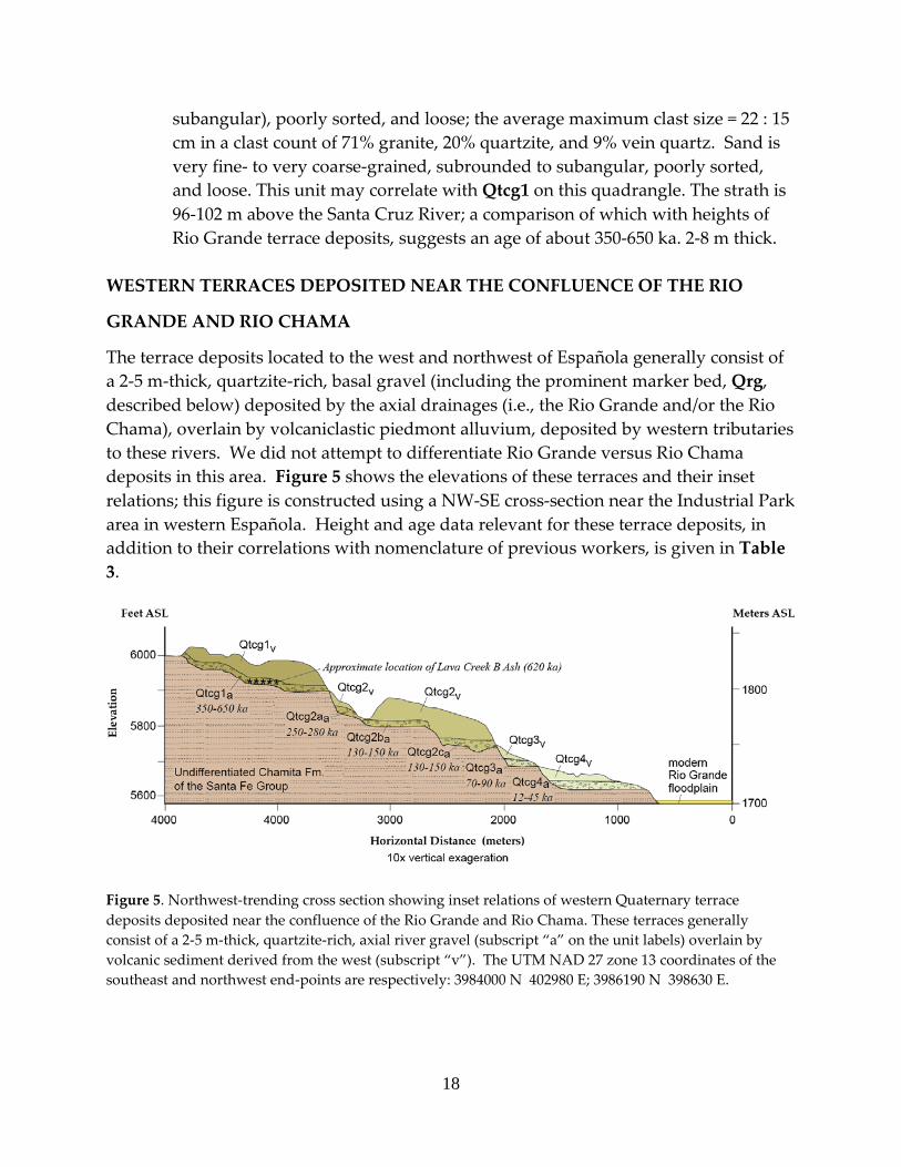
WESTERN TERRACES DEPOSITED NEAR THE CONFLUENCE OF THE RIO
GRANDE AND RIO CHAMA
The terrace deposits located to the west and northwest of Española generally consist of a 2-5 m-thick, quartzite-rich, basal gravel (including the prominent marker bed, Qrg, described below) deposited by the axial drainages (i.e., the Rio Grande and/or the Rio Chama), overlain by volcaniclastic piedmont alluvium, deposited by western tributaries to these rivers. We did not attempt to differentiate Rio Grande versus Rio Chama deposits in this area. Figure 5 shows the elevations of these terraces and their inset relations; this figure is constructed using a NW-SE cross-section near the Industrial Park area in western Española. Height and age data relevant for these terrace deposits, in addition to their correlations with nomenclature of previous workers, is given in Table 3.
Figure 5. Northwest-trending cross section showing inset relations of western Quaternary terrace deposits deposited near the confluence of the Rio Grande and Rio Chama. These terraces generally consist of a 2-5 m-thick, quartzite-rich, axial river gravel (subscript “a” on the unit labels) overlain by volcanic sediment derived from the west (subscript “v”). The UTM NAD 27 zone 13 coordinates of the southeast and northwest end-points are respectively: 3984000 N 402980 E; 3986190 N 398630 E.

19
Table 3. Summary of Quaternary terrace deposits near the confluence of the Rio Chama and Rio Grande.
Terrace map unit1
Associated geomorphic
surface2
Approximate height of strath (m) above Rio Chama or Rio
Grande3
Measured height of top of quartzite-rich,
axial gravel (m)4
Estimated age of axial river sediment, in
ka5
Qtcg4 5-12 N/d 12-45 Qtcg3 [Qtc6] Q4 27-38 38 70-90 Qtcg2c Q3 35-47 47 130-150 Qtcg2b Q3 50-64 55-64 130-150 Qtcg2a [Qtc4] Q3 67-84 70-84 250-280 Qtcg16 [Qtc3] Q2 90-126 89-120 350-650 Notes: 1 Qtcg4 is youngest and Qtcg1 is the oldest. Label in brackets is the correlative unit in the
Medanales quadrangle to the northwest. 2From Dethier et al. (1988). 3Height is estimated from the San Juan Pueblo 7.5-minute topographic map and Figure 5.
Estimated measurement error of ± 3-5 m. 4Heights are from Dethier and Reneau (1995, fig. 3); N/d = Not differentiated as a separate
terrace deposit in Dethier and Reneau (1995, fig. 3). 5Values are from age estimations and related data presented in Dethier and Reneau (1995, table
1) and Dethier and McCoy (1993). The author is of the opinion that parts of Qtcg1 may be older than 650 ka.
6The two lower straths of this unit were locally differentiated for constructing Figure 5. Note: Much previous work has been done on these terrace deposits and the Quaternary incisional history of the Rio Grande; pertinent publications include Dethier et al. (1988), Dethier and McCoy (1993), and Dethier and Reneau (1995). Qtcg4 Lowermost terrace deposit of Rio Chama-Rio Grande confluence (upper
Pleistocene) – A good exposure of this terrace deposit was not available on this quadrangle. However, in a U.S. Route 285 roadcut, 625 m south of the southern quadrangle boundary, Koning (2002a) described the sediment as a light yellowish brown to very pale brown (10YR 6/4 to 7/3) sandy gravel. The gravel is comprised of subequal pebbles and cobbles subrounded to rounded, poorly sorted, clast-supported, and includes 1-2% boulders. The clast count has 27% quartzite, 18% granitic clasts, 15% quartz, 11% intermediate to felsic volcanic clasts, 9% non-granitic intrusives, 5% basalt, 5% amphibolite and other mafic-

20
rich rocks, 2% chert, 2% meta-siltstone(?), 1% muscovite schist, 1% sandstone, and 3% unidentified. The sand is fine- to very coarse-grained, subrounded to subangular, well to moderately sorted, and rich in lithic grains. Volcaniclastic alluvium derived from local tributaries may cover the central to western part of this unit. Some lower terrace deposits within western Rio Grande tributaries appear to correlate eastward to this unit; these tributary deposits are up to 6 m thick and consists of sandy pebbles, cobbles, and boulders; gravel is poorly sorted, subrounded to rounded, and is mostly of intermediate to dacitic volcanic clasts with subordinate quartzite and more minor rhyolite, chert, quartz, granite, sandstone, basalt, and amphibolite. The strath is 5-12 m above the Rio Grande. Comparison of this strath height with heights of Rio Grande terraces dated by 14C and amino-acid racemization methods (Dethier and McCoy, 1993; Dethier and Reneau, 1995) suggests that this unit formed in Oxygen Isotope Stage 2 (approximately 12-45 ka; Table 3). Unit correlates with Qtc3 on this quadrangle, and unit Qtrg3 of Koning (2002a). Approximately 5-6 m thick.
Qtcg3 Lower terrace deposit of Rio Chama-Rio Grande confluence, overlain by
volcaniclastic alluvium from local tributary drainages (upper Pleistocene) – 3-4(?) m of quartzite-rich, axial fluvial sandy gravel overlain by younger volcaniclastic alluvium from western tributary streams; both are locally interbedded with floodplain deposits. The axial river quartzite-rich gravel is clast-supported, subrounded to rounded, poorly sorted, loose, and consists of pebbles and cobbles; bedding is poor but commonly thick where observed. Clast composition is mainly quartzite with approximately 30% intermediate to dacitic volcanic clasts, 5% hypabyssal intrusives, 5% miscellaneous sandstone, 1-3% mylonite, 3-5% leucocratic intrusive, trace-3% granite, and 1-3% basalt. Axial channel-fill sand is pale brown (10YR 6/3), fine- to very coarse-grained, subrounded to subangular, poorly to moderately sorted, lithic-rich, and loose. Overlying volcaniclastic alluvium consists of sandy gravel and gravelly sand; beds are very thin to thick, and planar to lenticular to channel-shaped; sand may be laminated; local cross-stratification is present up to 50 cm tall; gravel consists of pebbles, cobbles, and boulders in varying proportions; gravel are clast-supported, subrounded to subangular, and moderately to poorly sorted; clast composition is generally dacitic to intermediate with 5-25% rhyolite, 1-30% basalt, 1-5% quartzite, and 1-2% granite; sand is light brownish gray to pale brown (10YR 6/2-3), fine- to very coarse-grained, subrounded to subangular, moderately to poorly sorted, and rich in volcanic lithic grains.

21
Floodplain sediment is in very thin to thick, tabular beds or else massive; it is interbedded with minor thin to medium, lenticular channel-fill beds of tributary-derived pebbles; and consists of pale brown to very pale brown (10YR 6-7/3), light yellowish brown (10YR 6/4), or light brown to reddish yellow (7.5YR 6/4-6) silt and very fine-grained to medium-grained sand and silty sand, with minor coarser sand and 1-5% pebbles; sand is subrounded to subangular, moderately to well sorted, and has approximately subequal potassium feldspar to volcanic lithics. Strath is approximately 27-38 m above the Rio Grande; comparison of strath height with amino-acid ratio chronologic data for various Rio Grande terraces presented in Dethier and Reneau (1995) suggests an age range of 70-90 ka for this unit (Table 3). Unit correlates to Qtc2 and possibly Qtr2 on this quadrangle, unit Qtrg2 on the Española quadrangle (Koning, 2002a), and unit Qtsc4 on the Chimayo quadrangle (Koning, 2003). Loose to moderately consolidated. 7-20 m thick.
Qtcg2a-c Middle terrace deposit of Rio Chama-Rio Grande confluence, overlain by
volcaniclastic alluvium from local tributary drainages (middle to upper Pleistocene) – 3-5 m of quartzite-rich, axial fluvial gravel overlain by younger volcaniclastic alluvium from western tributaries; both are locally interbedded with floodplain deposits. The quartzite-rich, basal sandy gravel is clast-supported and consists of poorly sorted, subrounded to rounded pebbles, cobbles, and up to 5% boulders; either massive or thickly bedded. Clast counts at three scattered localities record: 35-45% quartzite, 7-31% intermediate to dacitic volcanic rocks, 1-2% Pilar phyllite, 1-5% Meosozoic to Paleozoic sandstone, trace to 4% meta-conglomerate, 0-14% basalt, 1% limestone, 3-5% amphibolite, 3-12% black, mafic-rich rock (possibly basalt), 11% rhyolite and felsic tuffs, 3-4% granite, 3-7% leucocratic intermediate intrusive, 1% mylonite, 3-5% quartz, and 2-11% hypabyssal, felsic to intermediate intrusives. Channel-fill sand in the quartzite-rich, axial fluvial sediment is light brownish gray to pale brown (10YR 6/2-3) to light yellowish brown (2.5Y 6/3), fine- to very coarse-grained, moderately to poorly sorted, subrounded to subangular, and rich in lithic grains. The overlying volcaniclastic alluvium is composed of sand and gravel in very thin to thick, planar to lenticular to channel-shaped (up to 1 m deep) beds, locally with minor low-angle cross-stratification. The gravel is commonly clast-supported and consists of pebbles with subordinate cobbles and boulders. Near the western quadrangle boundary there is a well-graded mix of pebbles, cobbles, and boulders; clasts are rounded to subangular, moderately to poorly sorted, and composed of intermediate to dacitic clasts with 5-15% rhyolite, trace granite, and 0.5-15% quartzite. Sand is light brownish gray to pale brown (10YR 6/2-3) or light yellowish brown (10YR 6/4), fine- to

22
very coarse-grained, subrounded to subangular, moderately to poorly sorted, and rich in volcanic lithics. Floodplain deposits are composed of silt and silty very fine- to fine-grained sand that is laminated or in thin to thick, tabular beds; 10-25% interbeds of thin to thick, lenticular, volcanic sandy pebble channel-fill deposits. On top of deposit are remnants of soils showing stage II to III carbonate morphology. Unit correlates to Qg2 on the Chili quadrangle (Dethier and Manley, 1985), Qtc1 and Qtr1 on this quadrangle, and units Qtrg1 and Qtwt2 on the Española quadrangle (Koning, 2002a). Loose and 15-23 m thick.
Subunits Qtcg2a, Qtcg2b, and Qtcg2c
Terrace deposit Qtcg2 can be subdivided into three subunits (a-c = oldest to youngest) based on different respective gross elevations of the quartzite-rich, basal sandy gravel (differentiable at the scale of 1:24000 mapping). These three different levels correspond with different ages of the quartzite-rich, basal sandy gravel (Figure 5). The overlying volcaniclastic alluvium, however, covers all three levels of the quartzite-rich, basal sandy gravel and is probably of the same general age (Figure 5). This volcaniclastic alluvium appears to have been emplaced following the deposition of the lowest level of the quartzite-rich, axial fluvial gravel, but prior to the next incisional epidsode associated with Qtcg3. On top of the volcaniclastic alluvium is generally a single geomorphic surface (surface Q3 of Dethier et al., 1988). The strath heights of terraces deposits Qtcg2c, Qtcg2b, and Qtcg2a are approximately 35-47 m, 50-64 m, and 67-84 m above the modern Rio Grande (Table 3). The estimated ages of their axial channel-fill and floodplain deposits, using gastropod amino-acid data, are 130-150 ka for Qtcg2c and Qtcg2b, and 250-280 ka for Qtcg2a (Table 3; Dethier and McCoy, 1993; Dethier and Reneau, 1995).
Qtcg1 Upper terrace deposit of Rio Chama-Rio Grande confluence, overlain by
volcaniclastic alluvium from local tributary drainages (middle Pleistocene) – 2-3 m of quartzite-rich, axial fluvial sandy gravel overlain by floodplain deposits, which in turn are overlain by younger volcaniclastic alluvium from western tributaries. The axial fluvial gravel is clast-supported and consists of poorly sorted, subrounded to rounded pebbles, cobbles, and up to 5% boulders. A clast count in Arroyo del Gaucho (UTM NAD 27 zone 13 coordinates: 3985170 N, 399925 E ± 20 m) comprises: 37% quartzite, 24% intermediate to dacitic volcanic rocks, 9% leucocratic intermediate to felsic intrusive rocks, 4% intermediate to felsic, hypabyssal intrusives, 4% basalt, 1% rhyolite, 2% quartz, 2% Paleozoic limestone, 3% chert, 1% mylonite, 2% Paleozoic to Mesozoic sandstone, 2% meta-conglomerate clasts, 3% granite, and 6% unidentified. Channel-fill sand is gray to pale brown (10YR 6/1-3),
23
subrounded to subangular, poorly to moderately sorted, and rich in lithic grains. No obvious bedding seen in the quartzite-rich sandy gravel. Floodplain deposits are very pale brown (10YR 7/3) silt to mud, with minor sand and ~3% pebbles (mostly volcanic) in up to 4 m thick, massive, with subordinate very thin to thin, tabular beds which are moderately to well consolidated. Western tributary volcaniclastic alluvium is sandy gravel to gravelly sand in very thin to medium, lenticular to planar to channel-shaped beds; sand may be planar-laminated to wavy-laminated. Channel-fill gravel is subrounded to subangular, moderately to poorly sorted, generally clast-supported, and comprised of pebbles with subordinate cobbles and sparse (up to 10%) boulders; boulders become more common up-section. Clasts are composed of intermediate to dacitic clasts with about 5-10% rhyolite and 1% quartzite (the latter is usually in the lower parts of the deposit). Sand is locally silty and very fine- to fine-grained, with subordinate medium- to very coarse-grained, and pale brown to very pale brown (10YR 6-7/3), subrounded to subangular, poorly sorted, and rich in volcanic lithic grains. Volcaniclastic sediment is weakly to moderately consolidated; 11-12 m thick. The deposit thins to the southwest against a buttress unconformity with Ojo Caliente Sandstone. Mapping of strath indicates as much as 36 m of relief; 90-126 m above the Rio Grande and Rio Chama (Table 3). Lower parts of deposit locally have the Lava Creek B ash to the west (Dethier et al., 1990). The presence of this ash, together with comparison of strath height with amino-acid ratio chronologic data for various Rio Grande terraces presented in Dethier and Reneau (1995), suggests an age range of 350-650 ka for this unit (Table 3). Unit correlates with Qg2 of Dethier and Manley (1985), and unit Qtwt1 on the Española quadrangle to the south (Koning, 2002a). As a whole, terrace deposit is loose to weakly consolidated and 4-20 m thick.
Qrg Quartzite-rich, basal sandy gravel mapped in terraces near the confluence of
the Rio Grande and Rio Chama (middle to late Pleistocene) – Sandy gravel found at the base of several terraces near the confluence of the Rio Grande and Rio Chama. Gravel is clast-supported, subrounded to rounded, poorly sorted, loose, and consists of pebbles, cobbles, and up to 5% boulders. Bedding is poor but commonly thick where observed. Gravel are composed of 25-50% quartzite, 7-30% dacitic to intermediate volcanic clasts, 1-10% rhyolite and felsic tuffs, 1-10% Mesozoic to Paleozoic sedimentary rocks (including sandstone, siltstone, limestone, meta-sandstone, and meta-conglomerate), 1-3% mylonite, 1-2% muscovite schist and Pilar phyllite, 3-15% leucocratic and hypabyssal intrusives, trace-20% granite, 1-15% bull quartz, trace to 5% amphibolite and other mafic-rich rocks, trace to 1-3% chert, and 1-15% basalt. Associated sand is
24
pale brown to light yellowish brown to very pale brown to light brownish gray to gray (10YR 6-7/3; 10YR 6/4; 10YR 6/1-3), fine- to very coarse-grained, subrounded to subangular, poorly to well sorted, rich in lithic grains, and loose. 2-5 m-thick.
TERRACES DEPOSITED NEAR THE CONFLUENCE OF THE RIO GRANDE AND
THE RIO CHAMA NEAR CHAMITA
Qtc3 Lower terrace deposit of Rio Grande Rio Chama near Chamita (upper Pleistocene) – 2.5-4 m of quartzite-rich, axial river gravel overlain by floodplain and/or piedmont deposits. Sandy gravel is clast-supported, subrounded to rounded, poorly sorted, and comprised of pebbles and cobbles with 5-10% boulders in medium to thick, tabular to lenticular beds. Clast assemblages at the mouth of Arroyo de los Peñita (UTM NAD 27 zone 13 coordinates: 3993550 N, 399720 E ± 20 m) contain: 45% quartzite, 12% intermediate to dacitic volcanic rocks, 9% felsic volcanic rocks, 9% basalt, 6% granite, 1% chert, 5% felsic intrusive rocks, 1% mylonite, 2% quartz, 2% hypabyssal felsic to intermediate intrusives, 1% meta-conglomerate, 2% limestone, and 6% Paleozoic-Mesozoic siltstone and sandstone. Clast imbrication indicates an eastward paleoflow. Sand is pale brown to light yellowish brown (10YR 6/3-4), medium- to very coarse-grained, subrounded to subangular, well sorted, and has an approximate 2/3:1/3 ratio of lithic grains to pinkish potassium feldspar grains. Floodplain sediment is a massive light yellowish brown (10YR 6/4) siltstone and very fine-grained sandstone. Both floodplain and coarser axial fluvial sediment are loose. Adjacent to Black Mesa and west of El Duende, the terrace deposit is thicker (as much as 38 m). Above the quartzite-rich, basal gravel it is generally composed of very fine- to very coarse-grained sand, subrounded, moderately sorted, with subequal potassium feldspar grains to volcanic-rich lithic grains in massive, minor thin to medium beds of medium- to very coarse-grained sand and sandy gravel (latter may be similar to the basal, quartzite-rich layer). The sandy texture and particular sand composition of the terrace sediment here is probably the result of much influx of locally derived sediment from the Ojo Caliente Sandstone (Tto) onto a floodplain or piedmont adjacent to the Rio Chama. East of Black Mesa, the unit is locally overlain by arkosic piedmont alluvium derived from drainages to the north. No significant soil observed on tread surface. Strath is approximately 6-12 m above the Rio Chama. Comparison of strath height with 14C and amino-acid ratio chronologic data for various Rio Grande terraces presented in Dethier and Reneau (1995) suggests this unit formed near the end of Oxygen Isotope Stage 2 (12-45 ka).

25
Unit correlates with Qtcg4 on this quadrangle, and unit Qtrg3 of Koning (2002a). Loose and 6-40 m thick.
Qtc2 Middle terrace deposit of Rio Chama-Rio Grande near Chamita (upper to middle(?) Pleistocene) – 4-6 m of quartzite-rich, axial river sandy gravel overlain by 1-20 m of interbedded floodplain and tributary piedmont deposits. The quartzite-rich, basal gravel consists of rounded and poorly sorted cobbles, pebbles, and 1-5% boulders with no apparent bedding. A clast count at a site west of San Juan Pueblo (UTM NAD 27 zone 13 coordinates: 39910350 N, 3992250 E, ± 20 m) contained: 37% quartzite, 24% intermediate volcanic rocks, 13% basalt, 5% felsic volcanic flow rocks, 4% mafic-rich rocks and amphibolite, 4% intermediate to felsic hypabyssal intrusives, 8% granite, 2% Paleozoic sandstone, 1% hydrothermally altered felsic intrusive, 1% mylonite, and 1% biotite gneiss. The sand near the base is fine- to very coarse-grained, subrounded, moderately to poorly sorted, and has about a 2/3:1/3 ratio of lithic grains to potassium feldspar grains. Floodplain deposits of light yellowish brown (10YR 6/4) sand consist of very fine- to fine-grained silty sand interbedded with minor (~5%) thin beds of fine- to very coarse-grained sand, sandy pebbles, and pebbly sand derived from local tributary drainages. Tributary piedmont deposits consist of silty very fine- to medium-grained sand (minor sandy silt) with subordinate beds of sandy pebbles and pebbly medium- to very coarse-grained sand. Pebble composition reflects the provenance of the drainage (commonly granitic with subordinate quartzite). The sand is subrounded to subangular, moderately to poorly sorted, and arkosic. The lower contact has up to 1 m of relief with a strath height 30-45 m above the Rio Grande. Unit correlates to Qtr2, Qtcg3, and possibly Qtcg2c on this quadrangle. The interpreted age range is 70-150 ka (based upon Dethier and Reneau 1995). Loose. Total thickness 4-26 m.
Qtc1 Upper terrace deposit of Rio Chama-Rio Grande near Chamita (middle
Pleistocene) – 4-6 m of quartite-rich, axial fluvial sandy gravel interbedded with subordinate (10-20%) floodplain deposits. Quartzite-rich gravel is clast-supported, subrounded to rounded, and poorly sorted; gravel consists of subequal cobbles and pebbles, with boulders present near base of deposit; not distinctly bedded. A clast count at the northeast corner of unit (UTM NAD 27 zone 13 coordinates 3992250 N, 402325 E, ± 20 m) contained: 30% quartzite, 29% granite, 13% quartz, 10% intermediate to felsic hypabyssal intrusives, 5% chert and other cryptocrystalline silicic rocks, 2% basalt, 2% Pilar Phyllite, 2% Paleozoic limestone, 3% Paleozoic sandstone, 2% biotite gneiss, 1% intermediate volcanic flow rock, and 1% unidentified. Floodplain deposits are

26
light yellowish brown (10YR 6/4) siltstone and very fine- to fine-grained sandstone; massive and locally has trace to 4% pebbles. The strath is 71-75 m above the Rio Grande. Unit correlates to unit Qtgc2a and possibly Qtr1 on this quadrangle, Qg2 on the Chili quadrangle (Dethier and Manley, 1985), and Qtwt2 in the Española quadrangle (Koning, 2002a). The interpreted age range is 250-280 ka (based upon Dethier and Reneau 1995). Loose. Up to 12 m thick.
RIO GRANDE TERRACE DEPOSITS ABOVE CONFLUENCE OF RIO CHAMA Qtr2 Lower terrace deposit of Rio Grande above confluence with the Rio Chama
(upper to middle Pleistocene) – Sandy gravel. Gravel is clast-supported, poorly sorted, and subrounded to rounded, and consists of pebbles with 25-40% cobbles; no distinct bedding. Unit includes interbeds of unit Qao and lateral grades into sediment of Qao. Strath is 35-49 m above the modern Rio Grande. Unit correlates to Qtc2, Qtcg2c, and possibly Qtcg3 on this quadrangle. Interpreted age range of 70-150 ka (probably 130-150 ka) (based upon Dethier and Reneau, 1995). Loose. Up to 12 m thick.
Qtr1 Upper terrace deposit of Rio Grande above confluence with the Rio Chama
(middle Pleistocene) – Sandy gravel to gravelly sand. Gravel is generally clast-supported, poorly to moderately sorted, and subrounded to rounded, and consists of subequal pebbles and cobbles. No bedding exposure. Southeast of Alcalde (UTM NAD 27 zone 13 coordinates: 3992920 N, 406430 E ± 20 m) a clast count contained: 26% quartzite, 11% quartz, 15% basalt, amphibolite and other mafic-rich rocks, 13% granite, 4% gneiss, 8% chert and other cryptocrystalline silica rocks, 11% intermediate to felsic hypabyssal intrusives, 5% intermediate to felsic volcanic flow rocks, 3% biotite schist, 2% Paleozoic sandstone, siltstone, and limestone, and 2% unidentified. Strath is 82-86 m above the modern Rio Grande. Unit correlates to Qg2 on the Chili quadrangle (Dethier and Manley, 1985), Qtcg2a and possibly Qtc1 on this quadrangle, and unit Qtwt2 on the Española quadrangle (Koning, 2002a). Interpreted age range of 250-350 ka (based upon Dethier and Reneau, 1995). Loose. 3-4 m thick.
PLEISTOCENE-PLIOCENE VOLCANIC AND SEDIMENTARY ROCKS QTse Slopewash and eolian deposits overlying down-dropped basalt flows (upper
Pliocene to Pleistocene) – Very pale brown to light yellowish brown (10YR 7/3-6/4) silt and very fine sand, with subordinate fine to coarse sand. Generally
27
massive or in vague, tabular beds; ~3% of beds are strongly cemented by calcium carbonate. Also contains very minor pebbly sand to sandy pebble beds (very thin to medium) whose pebbles consist of reworked basalt. Loose to weakly consolidated. Sediment is interpreted to be eolian fines locally reworked by slopewash processes that mixed in detritus from the Chamita Formation and Servilleta Basalt.
PLIOCENE BASALT FLOWS AND SUBJACENT FLUVIAL DEPOSITS Tgy Younger, upper gravel overlying Servilleta Basalt flows (lower to upper
Pliocene) – Thin gravel (probably less than 1 m-thick) overlain by silt and fine sand; the latter is similar to QTse in lithologic characteristics and possibly in age. The gravel is composed of pebbles and cobbles of basalt, with 1-15% very fine to very coarse pebbles similar in composition to unit Tgo. Both gravel and finer, overlying sediment is estimated to be 0.5-4.0 m thick.
Tsb Servilleta Basalt flows (Pliocene) – Dark gray, vesicular basalt that lacks mafic
phenocrysts but has abundant plagioclase laths. Vesicules are commonly in discrete zones. The unit forms an indurated, erosionally resistant, protective cap on top of Black Mesa, which has been deformed by Plio-Pleistocene tectonic activity along faults under and adjacent to the mesa. On the western margin, there is generally one flow 3-8 m thick. Locally this flow is overlain by another flow 3-6 m thick. Flows are commonly more numerous along the eastern margin than the western margin. North of this quadrangle, this unit has been dated at 3.65 ± 0.09 Ma by the 40Ar/39Ar technique near Dixon (Laughlin et al., 1993, unpublished report for Los Alamos National Laboratory), and 2.8 Ma by K-Ar methods near Lyden (Manley, 1976a). A sample of the basalt from this quadrangle (UTM NAD 27 zone 13 coordinates: 3996100 N, 400970 E) yielded an 40Ar/39Ar age of 3.32 ± 0.78 Ma.
Tgo Lower, older gravel underlying Servilleta Basalt flows (lower Pliocene) –
Sandy gravel, sand, and silty sand; sand is massive, but gravel may be in thin to thick, broadly lenticular beds. Gravel is clast-supported, rounded to subrounded, poorly sorted, and consists of pebbles and cobbles with local minor (5-10%) boulders. Clast imbrication indicates a south to southeast paleoflow direction in the gravel underlying the western margin of Black Mesa, and a southeast to southwest to west flow in gravel underlying displaced Servilleta Basalt on the eastern side of Black Mesa. Clast counts of gravel give: 65-86% quartzite, 0-8% reworked Miocene sandstone (only in western part of
28
unit), 0-8% Paleozoic sandstone and siltstone, 0-1% Paleozoic limestone, 2-10% whitish to pinkish granite, 0-7% felsic to intermediate volcanic rocks, 0-7% hypabyssal porphyritic rocks, 0-1% chert, 0-1% basalt, 0-4% vein quartz, 0-8% Pilar Phyllite, and 1-2% black, mafic-rich rock and amphibolite. At head of Arroyo del Guique southeast of Black Mesa, a clast count contains: 69% quartzite, 8% quartz, 14% granite, 1% Paleozoic limestone, 2% Paleozoic siltstone, 1% hypabyssal felsic to intermediate intrusive, 1% cryptocrystalline silicic rock, 1% un-identified, and 2% reddish intermediate volcanic rocks. Sand is pale brown to very pale brown (10YR 6-7/3), very fine- to very coarse-grained, subangular to subrounded, poorly to well sorted, and arkosic to lithic-rich. Silty sand may reflect floodplain deposition. Sediment is loose to weakly consolidated; weakly cemented by calcium carbonate, but strong cementation near the base occurs locally.
In eastern exposures, the gravel described above is overlain by up to 9 m of light brown to light yellowish brown to reddish yellow to brownish yellow (7.5-10YR 6/4-6) sediment very similar to unit Tccu. This overlying sediment consists of channel-fill deposits interbedded with medium to thick, tabular beds of silt and silty very fine to very coarse sand consist of fine- to very coarse-grained sand, pebbly sand, and sandy pebbles (clasts contain up to 5% cobbles, and composed of 20-30% quartzite and 70-80% granite); About 0.5-3% of channel-fills are strongly cemented by calcium carbonate, but most are non-cemented. Where overlain by basalt, the upper 0.1-1.5 m of the unit is commonly reddish due to thermal alteration; however, there is no evidence of a strong soil or angular unconformity at these locations. This suggests that there was not a significant temporal hiatus between deposition of this unit and that of the Servilleta Basalt. At head of Arroyo del Guique, where not overlain by basalt, a 100-110 cm-thick soil (with a calcic horizon having stage III carbonate morphology) has formed in the upper part of the deposit but locally is overlain by 2 m of sandy gravel. The unit overlies underlying strata with an angular unconformity. It is 1-5 m thick in its western extent and 6-17 m thick in its eastern extent (i.e., east of interpreted faults under Black Mesa), and represents an axial fluvial system interpreted to be derived from the Sangre de Cristo Mountains near the Peñasco embayment and the southern San Luis basin. This river may possibly have merged with an ancestral equivalent of the Rio Ojo Caliente near the southern tip of Black Mesa. Thickness contrasts of the unit across the interpreted faults under Black Mesa suggest a syntectonic control on deposition.
29
MIOCENE BASIN FILL
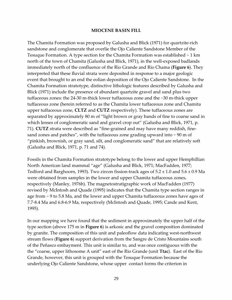
The Chamita Formation was proposed by Galusha and Blick (1971) for quartzite-rich sandstone and conglomerate that overlie the Ojo Caliente Sandstone Member of the Tesuque Formation. A type section for the Chamita Formation was established ~ 1 km north of the town of Chamita (Galusha and Blick, 1971), in the well-exposed badlands immediately north of the confluence of the Rio Grande and Rio Chama (Figure 6). They interpreted that these fluvial strata were deposited in response to a major geologic event that brought to an end the eolian deposition of the Ojo Caliente Sandstone. In the Chamita Formation stratotype, distinctive lithologic features described by Galusha and Blick (1971) include the presence of abundant quartzite gravel and sand plus two tuffaceous zones: the 24-30 m-thick lower tuffaceous zone and the ~30 m-thick upper tuffaceous zone (herein referred to as the Chamita lower tuffaceous zone and Chamita upper tuffaceous zone, CLTZ and CUTZ respectively). These tuffaceous zones are separated by approximately 80 m of “light brown or gray bands of fine to coarse sand in which lenses of conglomeratic sand and gravel crop out” (Galusha and Blick, 1971, p. 71). CUTZ strata were described as “fine-grained and may have many reddish, fine-sand zones and patches”, with the tuffaceous zone grading upward into ~ 90 m of “pinkish, brownish, or gray sand, silt, and conglomeratic sand” that are relatively soft (Galusha and Blick, 1971, p. 71 and 74). Fossils in the Chamita Formation stratotype belong to the lower and upper Hemphillian North American land mammal “age” (Galusha and Blick, 1971; MacFadden, 1977; Tedford and Barghoorn, 1993). Two zircon fission-track ages of 5.2 ± 1.0 and 5.6 ± 0.9 Ma were obtained from samples in the lower and upper Chamita tuffaceous zones, respectively (Manley, 1976b). The magnetostratigraphic work of MacFadden (1977) revised by McIntosh and Quade (1995) indicates that the Chamita type section ranges in age from ~ 9 to 5.8 Ma, and the lower and upper Chamita tuffaceous zones have ages of 7.7-8.4 Ma and 6.8-6.9 Ma, respectively (McIntosh and Quade, 1995; Cande and Kent, 1995). In our mapping we have found that the sediment in approximately the upper half of the type section (above 175 m in Figure 6) is arkosic and the gravel composition dominated by granite. The composition of this unit and paleoflow data indicating west-northwest stream flows (Figure 6) support derivation from the Sangre de Cristo Mountains south of the Peñasco embayment. This unit is similar to, and was once contiguous with the the “coarse, upper lithosome A unit” east of the Rio Grande (unit Ttac). East of the Rio Grande, however, this unit is grouped with the Tesuque Formation because the underlying Ojo Caliente Sandstone, whose upper contact forms the criterion in
30
Figure 6. Chamita Formation type section and informal member-rank subdivisions used in our map; slightly modified from Galusha and Blick (1971). Arrows denote paleocurrent data.
31
recognizing the lower contact of the Chamita Formation, does not extend more than ~ 6 km east of the river. Strata beneath this arkosic and granite-rich unit consist of floodplain fine sandstone and mudstone, with subordinate channel-fills of sandstone and conglomerate. These deposits are correlated to the Cejita Member of Manley (1976b, 1977, 1979) because of their mutual sedimentologic and lithologic similarities. The gravel is composed of clast-supported pebbles with ~10% fine cobbles; these clasts are subrounded-rounded, poorly to moderately sorted, and consist primarily of Proterozoic quartzite and Paleozoic limestone, sandstone, and siltstone (Figure 6). The Cejita Member west of the Rio Grande overlies a light yellowish brown to very pale brown unit composed of sandstone and silty sandstone, with very sparse pebbles dominated by felsic to intermediate volcanic clasts. This brown unit is informally referred to as the Vallito member, lies just above and below our relocation of the base of the original Chamita type section (Figure 6), and is interbedded with subordinate, cross-stratified, eolian sandstone intervals. Another unit, informally referred to as the Hernandez member, on this quadrangle consists of floodplain deposits of siltstone, very fine-grained sandstone, and mudstone that are interbedded with minor medium to thick channel-fills of pebbly sandstone to sandy pebble-conglomerate. The gravel of the Hernandez member is composed of felsic to intermediate volcanic clasts that were probably reworked from older formations, such as the Abiquiu Formation and Los Pinos Formation. Stratigraphic problems with the Chamita Formation east of the Rio Grande East of the Rio Grande and north of Española, strata are generally coarse and include the Cejita Member and piedmont facies of Manley (1976b, 1977, and 1979). These two units are similar to, and lithologically correlative with, the Cejita Member and coarse upper lithosome A unit found in the Chamita type section (Figure 6). Note that we will use the name “coarse, upper lithosome A unit” rather than the “piedmont facies” for granite-bearing, arkosic, coarse strata east of the Rio Grande. The lithologic similarities of these two units east of the Rio Grande with the Chamita Formation type section supports the extension of the Chamita Formation to these coarse strata east of the Rio Grande. Furthermore, fossil data in these strata at the northwest corner of the Chimayo quadrangle (i.e., the Osbernoceros Quarry) were thought to be similar to fossils in the Chamita type section (Koning, 2003; Tedford and Barghoorn, 1993). However, we have decided to restrict the Chamita Formation to west of the Rio Grande because of difficulties in mapping its lower contact east of the river. The lower part of the Cejita Member east of the Rio Grande is compositionally similar to the Dixon member and lithosome B of the Pojoaque Member, although the latter may contain more volcanic clasts (Cavazza, 1986), and the lower part of the coarse, upper Lithosome A unit
32
commonly has a similar composition to lithosome A of the underlying Pojoaque Member (Koning, 2003). Furthermore, the coarse, upper lithosome A unit basal contact is commonly gradational over 6-60 m; this gradation becomes more pronounced near the Sangre de Cristo Mountain front (Koning, 2003). Compounding the problem of mapping the lower contact is that the Ojo Caliente Sandstone, whose top by definition forms the base of the Chamita Formation, only extends ~ 6 km east of the Rio Grande. The lack of a mappable contact near the Sangre de Cristo Mountains, due in part to the absence of the Ojo Caliente Sandstone, in part to a lower contact that becomes increasingly more gradational to the east, and in part to gross lithologic similarities of strata in with underlying strata, leads us to restrict the Chamita Formation to the west side of the Rio Grande. The coarse, upper lithosome A unit and Cejita Member east of the Rio Grande are assigned to the Tesuque Formation. Because the Ojo Caliente Sandstone is relatively ubiquitous in this quadrangle west of the Rio Grande, it is not a problem to identify the basal Chamita Formation contact there. Inclusion of a member (in this case, the Cejita Member) in two different formations is allowed by the Stratigraphic Code (North American Commission on Stratigraphy, 1983, p. 858). Tccu Coarse, upper lithosome A unit (Cuarteles Member; upper Miocene) – Light
brown to reddish yellow (7.5YR 6/4-6) to pink (7.5YR 7/3-4), silty sandstone and sandy siltstone in tabular, thin to thick beds; in these beds are minor coarse- to very coarse-grained sand and locally scattered pebbles. There are subordinate channel-fill complexes of pebbly sandstone and clast-supported sandy conglomerate. These channel complexes are tabular to broadly lenticular, but internal bedding is laminated to very thin-medium, planar to lenticular. Gravel generally consists of poorly to moderately sorted, subrounded to subangular pebbles, but minor cobbles are locally present. Locally on the north limb of the Chamita syncline, channel-fills in uppermost part of unit are inset as much as 5 m into older sediment. The maximum intermediate clast diameters near the Chamita Formation stratotype average about 8 cm. Clast composition is granite with about 15-40% quartzite. Sand is mostly very fine- to medium-grained outside of the coarser channel-fill complexes and subangular to subrounded, moderately to poorly sorted, and arkosic. West-northwest paleocurrent flow data together with the granite-dominated composition of the gravel support a provenance from the Sangre de Cristo Mountains south of the Peñasco embayment.
This unit is compositionally similar to lithosome A of Cavazza (1986) in the underlying Pojoaque, Skull Ridge, and Nambé Members of the Tesuque Formation. However, the Cuarteles Member differs from these underlying members in that it has larger clasts and more abundant coarse channel-fill
33
complexes (the latter generally exceed 10-20% of the total sediment volume). Immediately east of Black Mesa near the Chamita Formation stratotype, the Cuarteles Member is locally dominated by silty fine sand and silty sand, with only 3-20% coarse channel-fills. South of the Rio Chama, this unit is light brown to pink (7.5YR 6-7/4) siltstone and very fine to fine-grained sandstone, silty sandstone, and sandy siltstone. There are 1-5% tabular, medium beds of pebbly sandstone. These channel-fill sands are moderately sorted, fine- to very coarse-grained, subangular to subrounded. Pebbles are generally granitic. The coarse to very coarse sand is arkosic, but the very fine to medium sand is a lithic arenite (lithic grains not identified). Here, this unit was deposited on the distal alluvial slope in a relatively low-energy environment. The stratigraphic and age relations of the Cuarteles Member are as follows: This member interfingers with the Cejita Member to the northwest under the southern and central parts of Black Mesa; west of the Rio Grande, it generally underlies Pliocene gravel across an angular unconformity (this Pliocene gravel is overlain by the Servilleta Basalt that caps Black Mesa), and its base is gradational with the underlying Cejita Member. At the Chamita Formation type section, the minimum age of the Cuarteles Member is ~5.8 Ma based on 40Ar/39Ar dating of tephra beds and consequent magnetostratigraphic revisions (McIntosh and Quade, 1995; we used the geomagnetic polarity time scale of Cande and Kent, 1995). In the southwestern part of the quadrangle, the lowest beds of the Cuarteles Member are found ~60-80 m stratigraphically above the coarse white ash zone (CWAZ), the bulk of which was probably deposited 12.0-12.8 Ma (see CWAZ discussion below). Thus, the Cuarteles Member has an age range of ~12.0-5.8 Ma, which is consistent with biostratigraphic fossil data from the Chamita stratotype with its Hemphillian North American Land Mammal Age of 5-9 Ma (Galusha and Blick, 1971; MacFadden, 1977; Tedford and Barghoorn, 1993). The unit attains a maximum thickness of 200-250 m east of the south tip of Black Mesa.
Tccut Coarse, upper lithosome A unit, tuffaceous (upper Miocene) – Coarse, upper lithosome A unit, as described above, mixed with pumiceous ash and interbedded with the CUTZ. Individual CUTZ beds are not differentiated here because of their abundance and because of extensive mixing of ash with detrital sediment. Estimated maximum thickness of approximately 40 m.

34
Tcc Cejita Member (upper middle to upper Miocene) – Light brown to light yellowish brown (7.5-10YR 6/4) to very pale brown (10YR 7/3-4) floodplain deposits of siltstone-claystone and fine sandstone that are interbedded with various proportions of coarser channel-fill deposits of sand and pebble-dominated gravel. On the western slopes of Black Mesa within the fine-grained sediment, the coarser channel-fill deposits make up about 10% of the deposit. These consist of tabular channel-fill complexes, with local planar- to tangential- cross-stratification. Paleoflow measurements from clast imbrication and channel-fill trends indicate a general southwest flow direction. Channel-fill gravel is clast-supported, subrounded to rounded, poorly to moderately sorted, and consists of pebbles and fine cobbles composed of 35-60% quartzite and 15-45% green-gray Paleozoic limestone, sandstone, and siltstone (with 0-15% vein quartz, 0-10% felsic to intermediate volcanic rocks, and 0-15% granite). Maximum clast sizes average about 9 cm (intermediate axis) near the Chamita stratotype, but are typically 3-6 cm south of the Rio Chama. Channel-fill sand is typically pale brown to very pale brown (10YR 6-7/3) or light gray (10YR 7/2) or pale yellow (2.5Y 7/3), fine- to very coarse-grained, subrounded to subangular, well to poorly sorted, and contains common grains of mafic, metamorphic, and Paleozoic lithics (these are generally more abundant than orange-pink potassium feldspar).
On the southern tip of Black Mesa, this unit is composed of interbedded floodplain and channel-fill deposits of sandstone, pebbly sandstone, and sandy pebble-conglomerate (~5-8% pebbly beds, some having very coarse pebbles; most of channel fill is sandstone) in tabular (for sandstone) to lenticular (for pebbly beds) beds. The channel-fill sand is light yellowish brown to very pale brown (10YR 6-7/4 and 10YR 7/3), fU to vcU, rounded to subangular, and moderately sorted. There is subordinate reddish brown to light brown floodplain claystone and clayey very fine-grained sandstone (thin to thick, tabular beds). Here, there are minor intervals of deposits correlative to the Vallito member (Tcv), and locally there is much sand that looks to be fluvially reworked from the Ojo Caliente Sandstone of the Tesuque Formation (Tto). The Cejita Member fines-upward on the southern tip of Black Mesa, so that the unit immediately beneath the basalt flows on the east side is composed of medium to thick, tabular beds of light brown (7.5YR 6/3-4) claystone and vfL-fU, subrounded to subangular, well-sorted sandstone; 15-25% medium to thick, tabular beds of mL-vcU sandstone and 1-3% pebbly sandstone (mostly very fine- to medium pebbles; no very coarse pebbles or cobbles).
35
The stratigraphic relations of the Cejita Member with other units are as follows. To the southeast it interfingers with Tccu, as observed near the Chamita stratotype. For example, the lowest beds of the CUTZ are in the Cejita Member in the central and western parts of the badlands north of Chamita, but in the Tccu in the eastern part of these badlands. On the western slopes of Black Mesa, the Cejita Member contains interbeds of the Tcv, so it probably interfingered with that unit to the west. West of the Rio Grande, however, the base of the Cejita Member gradationally overlies Tcv. Where not overlain by Tccu, its top lies beneath Pliocene gravel (unit Tg) across an angular unconformity. We interpret the age range of the Cejita Member in the Chamita Formation to be ~12.8 to 5.8 Ma. The CWAZ is found in the Cejita Member immediately northwest of Española. Considering the interpreted age range for the main part of this tephra zone (12.0-12.8 Ma), the base of the Cejita Member in the Chamita Formation is probably as old as 12.8 Ma. The CLTZ (8.0-8.5 Ma; McIntosh and Quade, 1995) is present in the Cejita Member as well (Figure 6). The Cejita Member likely is as young as ~5.8 Ma, since that is the minimum age of Tccu and the two interfinger with one another. The Chamita Formation type section and cross section indicate an approximate thickness of 150-200 m for the unit where it is exposed.
Tch Hernandez member (upper Miocene) – Light yellowish brown (10YR 6/4), pale brown to very pale brown (10YR 6-7/3) floodplain deposits of siltstone, very fine-grained sandstone, and mudstone, interbedded with about 10% medium to thick channel-fills of pebbly sandstone to sandy pebble-conglomerate. Floodplain deposits are in very thin to thick, tabular beds. Channel-fills are internally contained in very thin to thin, planar- to low-cross-stratified beds, are moderately to well consolidated, and pebbles primarily consist of felsic volcanic clasts that are clast-supported, subrounded, and poorly to moderately sorted. Channel-fill sand is light gray to light brownish gray (10YR-2.5Y 6-7/2), fine- to very coarse-grained, subrounded to subangular, moderately to poorly sorted. Sand composition is a lithic arenite with a ratio of 90% volcanic grains to 10% potassium feldspar. 10-20% of channel-fills are strongly to moderately cemented by calcium carbonate. The unit was deposited from fluvial systems derived from the north-northwest, and occurs in tongues (i.e., large-scale interbeds) within the western part of the Cejita Member, so the two units appear to interfinger. No specific age data is available for the unit on this quadrangle, but it lies stratigraphically between the CWAZ and the CLTZ,
36
suggesting an age range of 8-10 Ma. The unit’s tongues attain a maximum thickness of about 16 m.
Tcv Vallito member (upper Miocene) – Pink to very pale brown (7.5-10YR 7-8/3), very fine- to medium-grained sandstone and silty sandstone that occur in thin to very thick, tabular (minor lenticular) beds. Sand locally has minor coarse grains, is rounded to subangular (mostly subrounded), moderately to well sorted, and is arkosic or has about subequal lithic grains to potassium feldspar grains. These sandy strata are interbedded with very thin to thick, tabular beds of light yellowish brown to light brown (7.5-10YR 6/4) to very pale brown (10YR 7/3) siltstone and claystone. These fine interbeds comprise <30% of the sandy strata, and locally contain calcium carbonate nodules. Strongly cemented channel-fills of pebbly sandstone also comprise ~10% of the unit. These occur in very sparse, medium to thick, lenticular beds composed of primarily felsic to intermediate volcanic pebbles and fine- to medium-grained, subrounded, moderately sorted sand comprised of more volcanic lithics than potassium feldspar grains. North of the Rio Chama, this unit also contains minor interbeds of moderately to well consolidated, probable eolian sediment: fine- to medium-grained sandstone that is massive or in very thin to thin, planar to tangential cross-stratified beds up to 30 cm tall. The sand is fine- to medium-grained, subrounded, moderately to well sorted, and has subequal (+/- 10%) potassium feldspar compared to volcanic-rich lithics (and very minor greenish quartz grains). The unit overlies the Ojo Caliente Sandstone of the Tesuque Formation, and underlies the Cejita Member; it also interfingers eastward with the Cejita Member near the western quadrangle boundary (see cross-section A-A’). It is interpreted to primarily reflect low-energy fluvial deposition on a flat basin floor, where most of the sandy strata were probably deposited in broad channels of a fluvial braidplain(?). Also on this basin floor were minor eolian deposits of sand sheets and sand dunes. Unit lies stratigraphically below the CWAZ, and extends into the lowest part of the Chamita type section (Figure 6). Thus, it probably has an age range of 13-9 Ma.
Tcvc Interbedded Vallito and Cejita Members (upper Miocene) – See above
descriptions for the Cejita Member and the Vallito Member. These interbedded intervals are commonly several meters thick in the west-central area of the San Juan Pueblo (Ohkay Owingeh). It contains a bed of CWAZ, but lies well below the CLTZ, suggesting an estimated age is 13-10 Ma. Total thickness of approximately 170-250 m.
37
TESUQUE FORMATION The Tesuque Formation was proposed by Spiegel and Baldwin (1963) for Miocene-age basin-fill sediment, composed primarily of pinkish-tan, silty, arkosic sandstone, that was deposited in the Rio Grande rift near Santa Fe. Galusha and Blick (1971) later subdivided the Tesuque Formation into several members, the pertinent ones for this quadrangle being the Nambé, Skull Ridge, and Chama-El Rito Members in the subsurface, and the Pojoaque and Ojo Caliente Sandstone Members in both outcrop and the subsurface. An additional member-rank unit, the Cejita Member, was proposed by Manley (1976b, 1977, and 1979a). The Nambé, Skull Ridge, and Pojoaque Members lie on top of each other in pancake-layer fashion, but interfinger with the Chama-El Rito Member to the west. The Pojoaque and Chama-El Rito Members are overlain by the interfingering Ojo Caliente Sandstone and Cejita Members (Figure 8). More recently, Cavazza (1986) proposed a lithosome-based stratigraphic scheme, which we have adapted to modify both the Chamita and Tesuque Formation classifications of Galusha and Blick (1971). It subdivides the basin-fill in regards to compositional and bedding differences that are due to different source areas, sizes, and character of the streams and rivers depositing the basin-fill. In some cases, the lithosome-based stratigraphic scheme coincides with the former nomenclature, as in the case of the Cejita Member. However, the lithosome-based stratigraphic scheme differentiates units that extend across contacts between the Pojoaque, Skull Ridge, and Nambé Members. We give more weight to the lithosome-based stratigraphic scheme rather than the older Galusha and Blick (1971) scheme because the former is more easily recognizable in the field and is more relevant to ground water studies. In terms of composition and bedding characteristics, two general lithosomes of unique provenance are differentiated in the Tesuque Formation (Figure 7). Lithosome A is generally composed of medium to thick, tabular to broadly lenticular beds of silty sandstone interbedded with coarse channel-fill deposits which have westward paleoflow indicators. It was deposited on an alluvial slope (see Smith, 2000, for discussion of alluvial slopes) along the western flank of the Sangre de Cristo Mountains and derived from the granite-dominated crystalline bedrock of these mountains south of Truchas Peaks. The gravel of lithosome A is composed of granite with subordinate quartzite, and its sand is rich in pinkish potassium feldspar grains. Lithosome B consists of very thin to medium, tabular beds of siltstone, very fine- to fine-grained sandstone, mudstone, and claystone (low-energy floodplain deposits) adjoining relatively broad fluvial channel-fills composed of sandstone and conglomerate. Paleoflow indicators in these channel-fills indicate a predominately south- to southwest-flow direction. On this quadrangle, lithosome B is interpreted as being deposited on a gently-sloping basin floor, immediately west of the alluvial slope
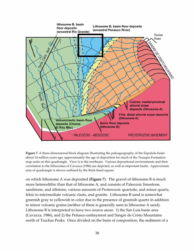
38
Figure 7. A three-dimensional block diagram illustrating the paleogeography of the Española basin about 14 million years ago, approximately the age of deposition for much of the Tesuque Formation map units on this quadrangle. View is to the northeast. Various depositional environments and their correlation to the lithosomes of Cavazza (1986) are depicted, as well as important faults. Approximate area of quadrangle is shown outlined by the thick-lined square. on which lithosome A was deposited (Figure 7). The gravel of lithosome B is much more hetereolithic than that of lithosome A, and consists of Paleozoic limestone, sandstone, and siltstone, various amounts of Proterozoic quartzite, and minor quartz, felsic to intermediate volcanic clasts, and granite. Lithosome B sand is somewhat greenish gray to yellowish in color due to the presence of greenish quartz in addition to minor volcanic grains (neither of these is generally seen in lithosome A sand). Lithosome B is interpreted to have two source areas: 1) the San Luis basin area (Cavazza, 1986), and 2) the Peñasco embayment and Sangre de Cristo Mountains north of Truchas Peaks. Once divided on the basis of composition, the sediment of a

39
particular lithosome may be further subdivided based on gross texture and other sedimentary characteristics, such as the relative abundance of channel-fills in the unit. Consequently, we have differentiated nine units in the Tesuque Formation using the lithosome-based stratigraphic approach. One unit coincides with the Ojo Caliente Sandstone Member of Galusha and Blick (1971) and another unit coincides with the Cejita Member of Manley (1976b, 1977, 1879a). A third unit, called the “coarse, upper lithosome A unit of the Tesuque Formation,” qualifies as a new member-rank term. The remaining six units lie within the Pojoaque Member. In the map unit labels for these six units, the third signifies lithosome A or lithosome B, and the fourth letter (p) represents the Pojoaque Member. The contacts between these units are gradational, unless otherwise noted below, and locally approximate. Three terms utilized in the following descriptions need to be explained. One, “extra-channel sediment” is an informal term used by the authors in alluvial slope deposits for silty-clayey sandstone and pebbly silty-clayey sandstone generally deposited in medium to thick, tabular to broadly lenticular beds. Within these beds the sediment is relatively massive and poorly sorted. Commonly, these are not observed to occupy discrete channel-fills, but locally they laterally grade into confined, coarse channel-fill deposits. Consequently, the authors envision them as representing depositional lobes that were once deposited on the alluvial slope at the mouths of discontinuous gullies (see Bull, 1997, for discussion of sedimentation found at the mouths of discontinuous, ephemeral gullied streams in the southwest United States) or as filling very broad channels. Two, channel-fill sediment generally is present as thick complexes of stacked channel-fill deposits, within which are smaller components of channel bedding; the following descriptions discriminate between these “channel complexes” and their smaller-scale “internal bedding.” Three, the term “northeast-derived lithics” denote lithic-rich sand grains containing conspicuous green quartz. This sand is grayish in color and interpreted to be derived from erosion of Paleozoic clastic strata. It is important to note that the Tesuque Formation map units on this quadrangle are lithostratigraphic units and do not correspond to geochronostratigraphic units. As such, they are almost all diachronous to some extent, and commonly climb (prograde) and become younger to the west. Age control for these units were obtained from published dates of tephra found within them in addition to fossil data. In addition, new radiometric ages from tephras have been obtained in the quadrangle (Table 4). In general, the Tesuque Formation units exposed on this quadrangle range in age from 15-8(?) Ma. Figure 8 is a schematic diagram that illustrates the stratigraphic relations of the Tesuque Formation units, and was constructed using Cross-section B-B’ on this quadrangle in addition to cross-sections on quadrangles to the east and
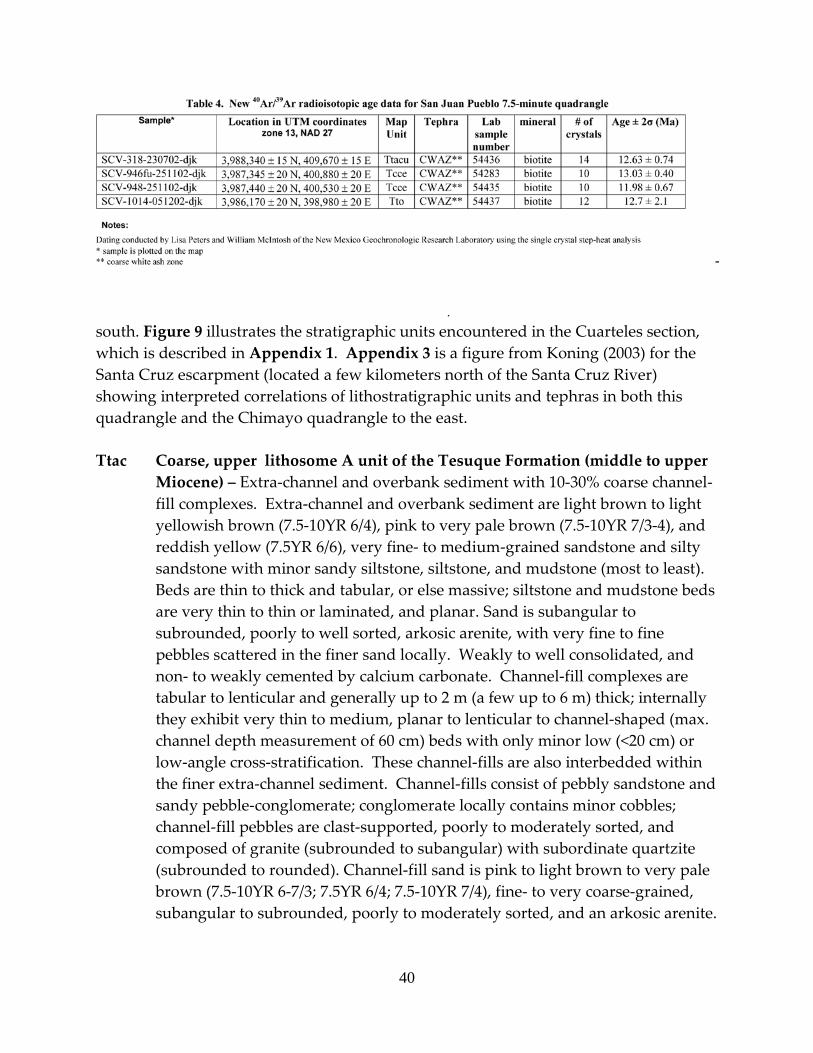
40
south. Figure 9 illustrates the stratigraphic units encountered in the Cuarteles section, which is described in Appendix 1. Appendix 3 is a figure from Koning (2003) for the Santa Cruz escarpment (located a few kilometers north of the Santa Cruz River) showing interpreted correlations of lithostratigraphic units and tephras in both this quadrangle and the Chimayo quadrangle to the east. Ttac Coarse, upper lithosome A unit of the Tesuque Formation (middle to upper
Miocene) – Extra-channel and overbank sediment with 10-30% coarse channel-fill complexes. Extra-channel and overbank sediment are light brown to light yellowish brown (7.5-10YR 6/4), pink to very pale brown (7.5-10YR 7/3-4), and reddish yellow (7.5YR 6/6), very fine- to medium-grained sandstone and silty sandstone with minor sandy siltstone, siltstone, and mudstone (most to least). Beds are thin to thick and tabular, or else massive; siltstone and mudstone beds are very thin to thin or laminated, and planar. Sand is subangular to subrounded, poorly to well sorted, arkosic arenite, with very fine to fine pebbles scattered in the finer sand locally. Weakly to well consolidated, and non- to weakly cemented by calcium carbonate. Channel-fill complexes are tabular to lenticular and generally up to 2 m (a few up to 6 m) thick; internally they exhibit very thin to medium, planar to lenticular to channel-shaped (max. channel depth measurement of 60 cm) beds with only minor low (<20 cm) or low-angle cross-stratification. These channel-fills are also interbedded within the finer extra-channel sediment. Channel-fills consist of pebbly sandstone and sandy pebble-conglomerate; conglomerate locally contains minor cobbles; channel-fill pebbles are clast-supported, poorly to moderately sorted, and composed of granite (subrounded to subangular) with subordinate quartzite (subrounded to rounded). Channel-fill sand is pink to light brown to very pale brown (7.5-10YR 6-7/3; 7.5YR 6/4; 7.5-10YR 7/4), fine- to very coarse-grained, subangular to subrounded, poorly to moderately sorted, and an arkosic arenite.
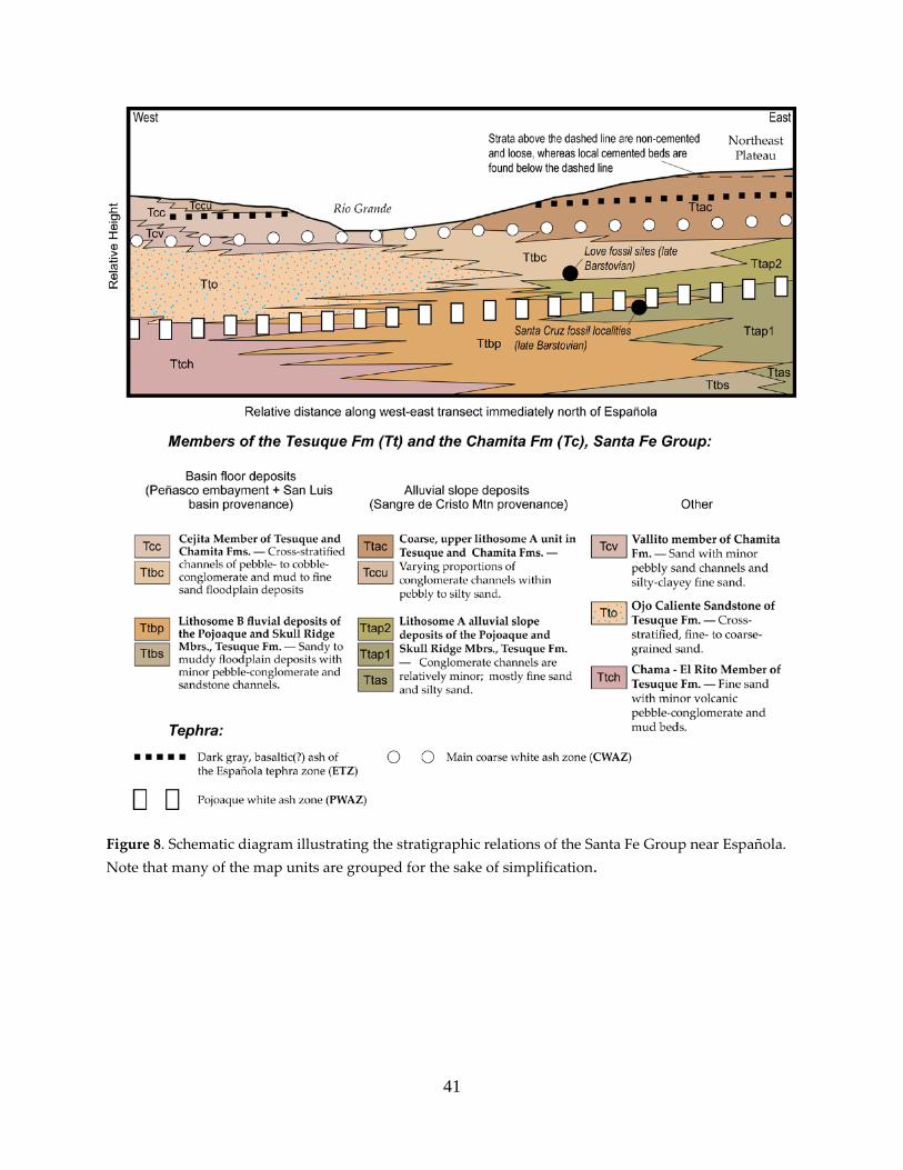
41
Figure 8. Schematic diagram illustrating the stratigraphic relations of the Santa Fe Group near Española. Note that many of the map units are grouped for the sake of simplification.

42
Figure 9. Graphic representation of the Cuarteles stratigraphic section (detailed text descriptions of this
section are given in Appendix 1 of the technical report).
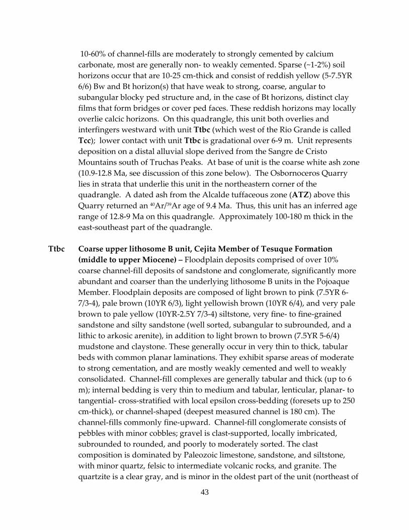
43
10-60% of channel-fills are moderately to strongly cemented by calcium carbonate, most are generally non- to weakly cemented. Sparse (~1-2%) soil horizons occur that are 10-25 cm-thick and consist of reddish yellow (5-7.5YR 6/6) Bw and Bt horizon(s) that have weak to strong, coarse, angular to subangular blocky ped structure and, in the case of Bt horizons, distinct clay films that form bridges or cover ped faces. These reddish horizons may locally overlie calcic horizons. On this quadrangle, this unit both overlies and interfingers westward with unit Ttbc (which west of the Rio Grande is called Tcc); lower contact with unit Ttbc is gradational over 6-9 m. Unit represents deposition on a distal alluvial slope derived from the Sangre de Cristo Mountains south of Truchas Peaks. At base of unit is the coarse white ash zone (10.9-12.8 Ma, see discussion of this zone below). The Osbornoceros Quarry lies in strata that underlie this unit in the northeastern corner of the quadrangle. A dated ash from the Alcalde tuffaceous zone (ATZ) above this Quarry returned an 40Ar/39Ar age of 9.4 Ma. Thus, this unit has an inferred age range of 12.8-9 Ma on this quadrangle. Approximately 100-180 m thick in the east-southeast part of the quadrangle.
Ttbc Coarse upper lithosome B unit, Cejita Member of Tesuque Formation
(middle to upper Miocene) – Floodplain deposits comprised of over 10% coarse channel-fill deposits of sandstone and conglomerate, significantly more abundant and coarser than the underlying lithosome B units in the Pojoaque Member. Floodplain deposits are composed of light brown to pink (7.5YR 6-7/3-4), pale brown (10YR 6/3), light yellowish brown (10YR 6/4), and very pale brown to pale yellow (10YR-2.5Y 7/3-4) siltstone, very fine- to fine-grained sandstone and silty sandstone (well sorted, subangular to subrounded, and a lithic to arkosic arenite), in addition to light brown to brown (7.5YR 5-6/4) mudstone and claystone. These generally occur in very thin to thick, tabular beds with common planar laminations. They exhibit sparse areas of moderate to strong cementation, and are mostly weakly cemented and well to weakly consolidated. Channel-fill complexes are generally tabular and thick (up to 6 m); internal bedding is very thin to medium and tabular, lenticular, planar- to tangential- cross-stratified with local epsilon cross-bedding (foresets up to 250 cm-thick), or channel-shaped (deepest measured channel is 180 cm). The channel-fills commonly fine-upward. Channel-fill conglomerate consists of pebbles with minor cobbles; gravel is clast-supported, locally imbricated, subrounded to rounded, and poorly to moderately sorted. The clast composition is dominated by Paleozoic limestone, sandstone, and siltstone, with minor quartz, felsic to intermediate volcanic rocks, and granite. The quartzite is a clear gray, and is minor in the oldest part of the unit (northeast of
44
El Llano) but increases up-section. It’s probably derived from Truchas Peaks area. Channel-fill sand may be in planar laminations and is pale brown to very pale brown (10YR 6-7/3) or light gray (10YR-2.5Y 7/2), fine- to very coarse-grained; subrounded to subangular, well to poorly sorted, and commonly a litharenite (with a ratio of 50-80% northeast-derived lithics to 20-50% potassium feldspar). Channel-fills are commonly non- to weakly cemented, with 10-65% moderate to strong cementation by calcium carbonate.
In the lowest part of this unit, channel-fill complexes are more abundant than floodplain deposits. Clast composition becomes progressively more granitic to the east so that granite is about subequal to other clast types near the eastern quadrangle boundary. Floodplain deposits are mostly light brown to brown (7.5YR 5-6/4) to pale brown siltstone to mudstone, and reddish yellow (7.5YR 6/6) to light yellowish brown (2.5Y 6/3) silty very fine- to fine-grained sandstone in very poorly defined, medium to thick and tabular beds. Weakly to well consolidated. The siltstone locally contains gypsum crystals up to 3 cm-long. Channel-fill complexes are commonly up to 6 m thick, and internally laminated (especially for sand) or in internal very thin to medium, tabular to channel-shaped to irregular to cross-stratified beds (foresets up to 110 cm-thick). Channel depths as great as 180 cm were observed in the lowest part of the unit. Channel-fills are composed of pebble-conglomerate and sandstone; pebbles locally include minor cobbles and are subrounded to subangular, poorly sorted, clast-supported, and locally weakly imbricated. Clast composition is variable but is dominated by Paleozoic limestone, siltstone, sandstone, and granite; quartzite, quartz, and volcanic clasts are each less than 18%. Channel-fill sandstone is pale brown (10YR 6/3) to light gray (2.5Y 7/2) to very pale brown (10YR 7/3) to light yellowish brown (10YR 6/3), fine- to very coarse-grained, subrounded to subangular, well to poorly sorted, and a litharenite to lithic arkose. While most are weakly to non-cemented and moderately to poorly consolidated, 10-30% of the channel-fills are strongly to moderately cemented by calcium carbonate. Near Arroyo Quarteles, where the unit overlies Ttap2, the basal contact of this unit is sharp and scoured (with over 1 m of scour relief) and may represent a disconformity. However, at and west of Arroyo del Llano, the basal contact is sharp and more planar, and channel-fills in the uppermost part of the underlying unit (Ttbp2) appear to progressively coarsen as one moves upwards towards the Ttbc basal contact. Unit conformably underlies Ttac across a 6-9 m-thick gradational contact.
The unit represents a large fluvial drainage that flowed south-southwest from the Peñasco Embayment, and had a source in the Sangre de Cristo Mountains
45
north of Truchas Peaks. The lower part of this unit underlies the CWAZ and has yielded fossils correlative to the late Barstovian North American Land Mammal Age (Gary Morgan, personal communication, 2004), and the upper part includes strata projecting to the Osbornoceros Quarry (9.4-10 Ma; see Koning, 2003). Considering the ages of these tephras and the fossil data, we interpret an age range of 13-9 Ma for this unit; this is consistent with fission-track age data given for the Cejita Member in Manley (1977 and 1979a). Thickness is 65-75 m.
Tto Ojo Caliente Sandstone Member of Tesuque Formation (middle Miocene) –
Very pale brown (10YR 7-8/3; 8/2), pinkish white (7.5YR 8/2), to white (7.5-10YR 8/1), very fine- to medium-grained sandstone, with minor coarse sand. Sand is subrounded to rounded, well to moderately sorted, and generally an arkosic arenite with minor volcanic lithic grains. Bedding is cross-stratified (tangential foresets mostly ~1 m tall, occasionally up to 2 m tall), planar, or massive. Beds are laminated to very thin. In exposures perpendicular to maximum foreset dip direction, very thin lenticular to broadly lenticular beds of medium to very coarse sand are locally seen, possibly representing grain-flow deposits. Foresets mostly dip to northeast, indicating a prevailing northeast paleo-wind direction (as noted in Dethier and Manley, 1985, for the adjoining Chili quadrangle). Unit includes minor beds of very thin to very thick, tabular siltstone, mudstone, and claystone. Marly siltstone is locally present. Generally weakly to moderately consolidated (but locally may be well consolidated) and non- to weakly cemented, with 1-10% moderate to strongly cemented beds that are medium to thick and commonly tabular, broadly lenticular, or cigar-shaped. This unit represents a large eolian sand dune field. It interfingers eastward with unit Ttbc, and probably interfingers with units Ttbp2 and Ttmp2 in the subsurface near Española. Tto is overlain by Tcv of the Chamita Formation in the western part of the quadrangle. The CWAZ (10.9-12.8 Ma) extends into this unit near the southwest portion of the quadrangle (UTM zone 13, NAD 27, 3986270 N, 398990 E ± 20 m). Northeast of El Llano, late Barstovian fossils were found in fluvial strata 20-25 m below an interval of Tto intercalated within the Cejita Member (David Love and Gary Morgan, personal communication, 2001-2004), but this interval may possibly be stratigraphically higher than the base of the Tto to the west. Thus, the age of the Tto on this quadrangle is interpreted to range from 13.5 to 11 Ma. Cross-sections near outcrop or well control indicate 220-350 m of thickness, but this deposit may possibly be as thick as 440 m near the northern boundary of the quadrangle (based on northward continuation of cross-section C-C’).

46
Ttap2 Upper lithosome A unit of the Pojoaque Member, informal salmon-colored unit (middle Miocene) – Overbank and extra-channel sediment with 3-15% coarse channel-fills. The former two are generally light brown to pink (7.5YR 6-7/4) to reddish yellow (7.5YR 6/6), and composed of very fine- to fine-grained, subrounded to subangular, moderately to well sorted, arkosic arenite sandstone and silty sandstone, with minor siltstone and mudstone in mostly medium to thick and tabular beds (sediment may also be massive). Channel-fills, composed of sandstone, pebbly sandstone, and pebble-conglomerate, have subangular to subrounded, poorly sorted, granitic clasts, with 1-5% quartzite, and include minor cobbles. They are clast-supported. Channel-fill sand is an arkosic arenite, very fine- to very coarse-grained (mostly medium- to very coarse-grained), subrounded to subangular, poorly sorted, and moderately to well consolidated. Channel-fills occur in thin to thick, lenticular to tabular to channel-shaped beds (latter up to 30 cm deep), and represent deposition on the distal-most alluvial slope associated with lithosome A. The unit correlates to Ttaf in the Chimayo quadrangle to the east. On this quadrangle and in the Española quadrangle to the south, this unit has been referred to as the salmon-colored unit of the Pojoaque Member because of the common reddish to pinkish hue of its strata (Galusha and Blick, 1971). It pinches out westward within unit Ttbp2, and is underlain by unit Ttbp2. One white ash preliminary correlated (based on hand sample characteristics) to the PWAZ was found just above the lower contact of this unit (UTM zone 13, NAD 27, 3985970 N, 409520E ± 20 m). This interval lies below localities where late Barstovian fossils were collected (Dave Love and Gary Morgan, personal commun., 2004). In consideration of these age data, we interpret an age range of 13.0-13.3 Ma for this unit. Maxium thickness of 30-40 m.
Ttbp2 Upper lithosome B unit of the Pojoaque Member (middle Miocene) –
Generally floodplain deposits with minor channel-fill deposits of sandstone to pebble-conglomerate. Floodplain deposits are mostly light brown (7.5YR 6/4) to brown (7.5YR 5/4) mudstone, claystone, and siltstone (latter commonly 10YR 6/3), with subordinate light brown to reddish yellow (7.5YR 6/4-6) and pink (7.5YR 7/3) very fine- to fine-grained sandstone to silty sandstone (subrounded, well sorted, and slightly more northeast-derived lithics compared to potassium feldspar). They occur in very thin to thick, tabular beds, with local planar-laminations. Within the floodplain deposits are minor channel-fills of very fine- to fine-grained sandstone that are up to 40 cm-thick. They are weakly to moderately consolidated. Channel-fill complexes are generally medium to very thick (max. up to 5 m, but generally up to 1.5 m) and tabular to lenticular, and internally in very thin to thin, planar beds or planar-laminated, with minor

47
tangential to trough cross-stratification generally less than 40 cm thick. Channel-fill pebble-conglomerate are commonly clast-supported, subrounded, poorly to moderately sorted, and locally include up to 40% cobbles; clast composition is dominated by Paleozoic limestone, sandstone, and siltstone, with 10-20%% quartzite, 5-15% quartz and chert, 1-10% granite, and 1-30% intermediate to felsic volcanic clasts. Channel-fill sandstone is pale brown (10YR 6/3), very fine- to very coarse-grained, subrounded, well to poorly sorted, and contains a ratio of 50-80% northeast-derived lithic grains to 20-50% potassium feldspar grains. Cementation of channel-fills is variable. High amounts of blackish, weathered volcanic rock (basaltic?) occur locally in either channel-fills or floodplain deposits. The unit represents a major fluvial system that flowed south-southwest across a flat basin floor. Ttbp2 overlies unit Ttmp2 on this quadrangle, lying below the CWAZ and below a fossil locality (projecting to unit 6c of Cuarteles stratigraphic section, Appendix 1) yielding late Barstovian vertebrate fauna. One white ash preliminarily correlated to the PWAZ was located just above the upper contact of this unit (UTM zone 13, NAD 27, 3985970 N, 409520E ± 20 m). Considering these age data, the age of this unit is approximately 13.2-13.6 Ma. ~30 m thick.
Ttmp2 Upper, mixed or interfingering provenance unit of the Pojoaque Member
(middle Miocene) – This extensive unit is comprised of overbank and extra-channel fine sandstone and siltstone, with minor (generally < 15%) channel-fills of sandstone and pebbly sandstone of either lithosome A, lithosome B, or a mix between the two. Overbank and extra-channel deposits are composed of light brown to pink (7.5YR 6-7/4) and very pale brown to light yellowish brown (10YR 7/3-4; 6/4) siltstone and very fine- to fine-grained sandstone; minor mudstone. Strata are in very thin to thick, tabular beds. Sand is subrounded, well sorted, generally has varying proportions of potassium feldspar to northeast-derived lithic grains, and is weakly to well consolidated. Channel-fill complexes are very broad and tabular, up to 1.5 m tall, locally fine-upward. Internal bedding is very thin to medium, planar or planar-laminated, with minor tangential cross-stratification up to 70-80 cm-thick. Channel-fills are composed of very pale brown to pale brown (10YR 6-7/3), very fine- to very coarse-grained sandstone that is subrounded to subangular, moderately to well sorted, and contains various proportions of northeast-derived lithics to potassium feldspar. They contain sparse pebbles of either lithosome A, lithosome B, or mixed provenance, and are mostly non- to weakly-cemented, with subordinate moderate to strong cementation by calcium carbonate. Local thick, tabular beds consisting of well sorted and subrounded sand may be eolian, particularly in unit 3j of the Cuarteles section (Appendix 1). Near the

48
city of Española, these tabular beds are internally cross-stratified, with generally east-facing foresets approximately 20-50 cm thick, and are interbedded with minor sand lenses containing abundant volcanic grains that are likely derived from the Abiquiu embayment or southern San Luis basin. Over most of the map area, this unit represents deposition near the transition between the basin floor (lithosome B) and distal portions of the alluvial slope (lithosome A). Mixing or interbedding of sediment from various source areas, as well as eolian sedimentation, accounts for the composition of this unit. The lithosome B fluvial system in the southeast part of this quadrangle during this time apparently lacked the necessary energy to transport much gravel. It overlies Ttmp1 and underlies Ttbp2. The lower-middle PWAZ spans most of the unit; immediately east of the eastern quadrangle border the unit contains fossils consistent with a late Barstovian North American Land Mammal “Age” (Koning, 2004; Gary Morgan of the New Mexico Museum of Natural History, personal communication, 2002). Thus, the age range for this unit is interpreted to be 13.2-14.0 Ma. Thickness of 70-75 m.
Ttap1 Lower lithosome A unit of the Pojoaque Member (middle Miocene) – Fine
overbank and extra-channel sediment with ~5% coarse channel-fill deposits. The former is light brown to reddish yellow (7.5YR 6/4-6) and light yellowish brown (10YR 6/4), silty, arkosic arenite sandstone, very fine- to fine-grained, subangular to subrounded, and well sorted. It contains minor medium sand grains, minor beds of mudstone and siltstone, and is generally massive. Weakly to moderately consolidated. The channel-fills are composed of light yellowish brown (10YR 6/4), very fine- to very coarse-grained arkosic arenite sandstone, subangular, moderately to well sorted, with local gravel near base. The gravel consists of pebbles that are subrounded to subangular, poorly sorted, and composed of granite with roughly 20% quartzite and 5-10% reworked calcium carbonate-cemented nodules of siltstone and sandstone. They occur in broadly lenticular beds up to 1 m thick, commonly fine-upwards, and their internal bedding is planar-laminated to very thin- to thin-planar bedded, with minor cross-stratification up to 10 cm-thick. About half of channel-fills are moderately to strongly cemented by calcium carbonate. They are similar in appearance to the salmon-colored unit (Ttap2), and interpreted to represent a similar depositional environment (i.e., distal lithosome A alluvial slope). The unit overlies Ttbp1, underlies Ttmp1, and appears to grade laterally westward into Ttmp1. It is interpreted to have a similar age: 14.7-13.7 Ma. Estimated thickenss: 0-15 m.
49
Ttmp1 Lower, mixed provenance unit of the Pojoaque Member (middle Miocene) – Pink (7.5YR 7/3-4) to pale brown (10YR 6/3) to light brown (7.5YR 6/3-4), very fine- to fine-grained sandstone, silty sandstone, and siltstone. The sand is well sorted, subrounded, and generally contains more potassium feldspar than northeast-derived lithic grains. It occurs in medium to thick, tabular beds and contains minor silt-rich mudstone. Well consolidated and a ledge-former. It is interpreted to have been deposited in the transition between the lithosome B basin floor and the lithosome A alluvial slope, and thus received fine sediment from the sources of both Lithosome A and B. Some or many beds may have been deposited as eolian sand sheets. It overlies Ttbp1, underlies Ttmp2, and lies ~5 m below the lowest identified bed of the PWAZ, where late Barstovian fossils have been collected in the westernmost Chimayo quadrangle (Koning, 2003; Gary Morgan of the New Mexico Museum of Natural History, personal communication, 2002). It is about 150 m above the basal Pojoaque Member contact. Thus, we interpret an age range of 14.7-13.7 Ma for this unit. 30-35 m thick.
Ttbp1 Lower lithosome B unit of the Pojoaque Member (middle Miocene) –
Fluvial floodplain deposits with 10-30% channel-fill deposits. Floodplain sediment consists of brown to strong brown (7.5YR 5/4-6) or reddish brown (5YR 5/4) mudstone to claystone, and pale brown (10YR 6/3) to light brown (7.5YR 6/3-4) to light yellowish brown (10YR 6/4), siltstone and very fine- to fine-grained sandstone. They occur in poorly defined, laminated to very thin to very thick, tabular beds, or else they’re massive, and weakly to moderately consolidated. The channel-fill deposits consist of sandstone, pebbly sandstone, and sandy pebble-conglomerate. The sand is pale brown to very pale brown (10YR 6-7/3) to light yellowish brown (10YR 6/4), commonly medium- to very coarse-grained, subrounded to subangular, moderately to poorly sorted, and has an estimated ratio of 50-70% northeast-derived lithics to 30-50% potassium feldspar. It locally has ripple marks up to 1.5 cm-thick. The gravel (including ~10% cobbles) is clast-supported, subrounded to rounded, poorly to moderately sorted, and only locally (and generally poorly) imbricated. Clasts consist of Paleozoic sandstone, siltstone, and limestone with roughly 15-25% intermediate to felsic volcanic rocks, 5-10% quartzite, 1-3% vein quartz, and 0-1% granite. These channel-fill deposits are commonly planar-laminated, with internal bedding which is very thin to thin, and horizontal-tabular to lenticular to tangential cross-stratified (foresets up to 20 cm thick), with possible local epsilon cross-bedding. They fine upward locally. Approximately10-30% are strongly to moderately cemented by calcium carbonate, while the remainder are non- to weakly cemented. The interpreted depositional environment is a

50
relatively gentle basin floor with scattered broad and meandering channels draining highlands located east of the Peñasco embayment and (in the subsurface to the west) the San Luis basin. This unit correlates to unit Ttbp1 and Ttbp2 of Koning (2002a), where Ttbp1 immediately overlies the Pojoaque – Skull Ridge Member contact of the Tesuque Formation. It underlies Ttmp1 on this quadrangle. About 1 km south-southeast of the Española High School, the PWAZ is present in the uppermost strata of this unit. Based on the age of the Pojoaque – Skull Ridge contact (see Koning, 2002a) and the occurrence of the PWAZ, this unit is interpreted to be 14.9-13.5 Ma. The estimated thickness is 115-125 m.
TEPHRAS OF TESUQUE FORMATION
Arroyo de los Peñita fine white ash (PFWwa) – White, fine ash rich in glass shards and with only trace mafic minerals; 10 cm-thick. Possibly the youngest ash currently known in the basin fill sediment. Age unknown.
Arroyo de los Peñita fine black ash (PFba) – Black, fining-upward bed of lapilli (near
base, up to 7 mm-long) to fine ash; well consolidated, relatively pure, and 10 cm-thick. Age unknown.
Chamita upper tuffaceous zone (CUTZ) – Yellowish white to white pumice that is
lapilli or coarse ash in size; mixed with various proportions of detrital sand. Commonly forms ledges in thick, well consolidated beds. Pumice is in at least five relatively continuous beds, but several other non-continuous pumice beds are present. South of Arroyo de los Borregos, medium to thick, tabular beds are hard, poorly sorted, slightly muddy, brownish, pumiceous, and phreatomagmatic(?). Age of pumice is relatively well-constrained at 6.8-6.9 Ma, and correlative to the Peralta Tuff (McIntosh and Quade, 1995).
Chamita lower tuffaceous zone (CLTZb, CLTZm, CLTZw) – The Chamita lower
tuffaceous zone occupies the interval about 85-115 m (280-375 feet) above the base of the Chamita type section (fig. 29 of Galusha and Blick, 1971). Within this ~ 30 m interval are three distinctive subintervals. The lowest (i.e., basal interval, CLTZb) consists of two thick beds (80-110 cm each) of grayish coarse ash and lapilli separated by 2.8 m of siltstone and fine sandstone. Vesicularity of some lapilli clasts suggest a basaltic composition, but an intermediate to felsic composition is also possible. Approximately 9-15 m above the lower subinterval is the middle subinterval (CLTZm), which is composed of two beds
51
spaced 3 m apart. The lower bed consists of altered, pebble-size clasts of consolidated white ash; the upper bed is composed of a 40 cm-thick bed of silt mixed with poorly sorted, angular basaltic pebbles and pebble-size consolidated white ash. The upper, whitish subinterval (CLTZw) lies 9-15 m above the middle. It is composed of a ledge-forming, 50-55 cm-thick, white bed of pumiceous coarse ash with ~ 20% black biotite and hornblende(?). 40Ar/39Ar dating of a tephra (probably the upper subinterval) and revision of the Chamita Formation magnetostratigraphy of MacFaden (1977) by McIntosh and Quade (1995) indicates an age range of 7.7-8.4 Ma for this zone.
Basal Alcalde tuffaceous zone(?) under Black Mesa (ATZ) – A thin bed of dark gray
(almost black), volcanic lithic grains that are equivalent in size to fine-medium sand. This was initially correlated with the CLTZb tephra, but the grains are darker than those of CLTZb and more like the color of the basal Alcalde tuffaceous zone in the Chimayo quadrangle to the east. There, this ash has an interpreted age range of 9-10 Ma (Koning, 2003).
Fine white pumice west of San Jose (FWPWSJ) – Composed of white pumice about
0.25 to 0.5 mm in length with less than 1% mafic minerals. 9-20 cm thick. Age is unknown.
Española tephra zone (ETZ) – Dark gray to light gray, fine to coarse basaltic ash that is
locally mixed with minor sandy detritus. South of San Jose, unit includes a basaltic phreatomagmatic bed 120 cm-thick; this bed fines-upward from lapilli at the base to coarse ash near the top; it is poorly sorted and many of the tephra clasts and grains are discolored and altered. The coarseness of the phreatomagmatic deposits strongly suggest derivation from the Lobato volcanic center located in the eastern Chili quadrangle. Based on discussion of this tephra zone in Koning (2003), this tephra zone probably lies in the age range of 10.2-12.4 Ma, with most of the ashes probably being 10.2-11.5 Ma.
Coarse white ash zone (CWAZ) – Numerous thin to medium, grayish white to white
ashes containing fragments of consolidated ash with minor pink to gray volcanic lithic grains (3-8%), quartz(?), and biotite grains (3-8%). Where they first appear in the stratigraphic section, there are as many as ten of these ash beds recognized over a stratigraphic interval of 50-75 m (called the main coarse white ash zone). Grain size of ash is fine to very coarse. Locally it is altered to a greenish bentonite. The felsic mineralogy of the CWAZ, its coarseness, and their stratigraphic abundance suggest they might be related to the Canovas Canyon Rhyolite and the dacites of the Paliza Canyon Formation in the Jemez
52
Mountains. 40Ar/39Ar ages from samples of this ash in the quadrangle are in the range of 12.0-13.0 Ma (Table 4). In regards to the maximum age constraint, no beds of the CWAZ have been observed in the well-exposed bluffs near the Pojoaque type section (fig. 21 of Galusha and Blick, 1971), which is located about 9 km south and 2 km west of the Cuarteles section. The height of the basal CWAZ above the salmon unit at the Cuarteles section is 83 m (Appendix 1). At the Pojoaque type section, a height of 83 m above the salmon unit corresponds to gravelly sediment correlated to magnetic polarity chron 5An.2n of the Magnetic Polarity time scale, which is less than 12.8 Ma (Barghoorn, 1981; Tedford and Barghoorn, 1993; Cande and Kent, 1995). In regards to the minimum age constraint, in exposures near the Buckman well field in the southern Española Basin (White Rock quadrangle), an 40Ar/39Ar age of 10.9 ± 0.2 Ma was obtained from biotite in a coarse white ash bed (W.C. McIntosh, unpublished data). Based on the above age control, we use an age range of 10.9-12.8 Ma for the CWAZ, with the majority of the tephra beds being 12.0-12.8 Ma (particularly the cluster of tephra beds observed in the southern quadrangle, which lie below the Española tephra zone). The relatively few coarse white ash beds observed near Black Mesa and north of the Rio Chama may be younger (12-10 Ma?).
Fine white ash east of San Juan Pueblo (FWAE) – Greenish white, altered, fine ash.
Lower 5-10 cm is hard, upper part is weakly consolidated. Age unknown. 25-30 cm-thick. Interbedded within unit Tto.
Pojoaque black ash southeast of El Llano (PBA) – Black ash, 0.1-1.0 mm in size, well
sorted, and locally mixed with sand of similar size. The PBA bed is up to 40 cm in thickness and located above the PWAZ. Correlates to black “basaltic lapilli” observed in the Española quadrangle to the south, which are likewise located stratigraphically above most of the PWAZ (Koning, 2002a). Considering the age of the PWAZ (see below), this ash is probably 13.0-13.5 Ma.
Pojoaque white ash zone (PWAZ) – Approximately six beds of thin to thick, tabular
fine white ashes in a 95-100 m-thick stratigraphic interval. Ash beds may be reworked and mixed with detrital sand, have a thickness of 10-100 cm, and are commonly internally planar- to wavy-laminated. These ashes are generally altered and contain very sparse to sparse glass shards and up to 7% biotite. Gray ashes locally preserved in the Pojoaque Member type section to the south (Galusha and Blick, 1971, fig. 21) are not observed in the study area. Chemical comparisons from samples in the Española quadrangle suggest that most beds in the PWAZ came from the Southern Nevada volcanic field (A. Sarna-
53
Wojcicki, written commun., 2005). Based on magnetic-polarity stratigraphy work by Barghoorn (1981) and the revised geomagnetic polarity time scale of Cande and Kent (1995), the PWAZ was probably deposited between 14.0 Ma and 13.2 Ma; this age is consistent with the early late Barstovian fossils found within and below the PWAZ. An 40Ar/39Ar age of 13.7 ± 0.18 Ma (Izett and Obradovich, 2001) was obtained from an ash bed located in the middle part of the PWAZ (Obradovich, written commun, 2004) in the Pojoaque Member type section, located ~9 km south of the study area.
.
SUBSURFACE UNITS DEPICTED ONLY IN CROSS SECTIONS Ttch Chama-El Rito Member of the Tesuque Formation (lower to middle
Miocene) – Pink to very pale brown, very fine to medium arkosic sand with sparse volcaniclastic pebble-conglomerate channel-fills and mud beds.
Ttbpsn Lithosome B of the Pojoaque, Skull Ridge, and Nambe Members of the
Tesuque Formation (lower to middle Miocene) – Sandy channel-fills interbedded with floodplain deposits composed of mudstone and fine-grained sandstone. Deposited by a river associated with lithosome B. Lithologically similar to map units Ttbp2 and Ttbp1 but spanning older strata whose up-dip correlatives include the Skull Ridge and Nambe Members of Galusha and Blick (1971).
Tap Abiquiu and Picuris Formations, undivided (lower Miocene) – Volcaniclastic
sand, with some gravel and silt, derived from felsic to intermediate volcanic centers to the north.
*u Undivided Paleozoic strata (Mississippian to Permian) – Limestone,
sandstone, siltstone, and shale; probably consists mostly of the Madera Limestone.
YXu Undivided crystalline basement rocks (Paleoproterozoic to Mesoproterozoic)
– Granite, amphibolite, gneiss, and schist as seen in outcrops east of Chimayo at the foot of the Sangre de Cristo Mountains.

54
STRUCTURE
Over much of the eastern and central portions of the quadrangle, strata generally strike northeast and dip 9 to 2 degrees to the northwest. Locally, dip and strike values are variable around faults in the northeast portion of the quadrangle. In the southwest portion of the quadrangle, strikes vary between northwest and northeast and dips are 5 to 13 degrees to the west. East of Black Mesa and north of Chamita, stratal dips indicate a westward-plunging syncline, which we have labeled the Chamita syncline. In the southern half of the quadrangle, most faults strike northwest and dip either to the northeast (mostly) or southwest. The most prominent of these faults is the Road fault (name from Galusha and Blick, 1971), which continues north from the Española quadrangle (Koning, 2002a). This normal fault is buried underneath Quaternary alluvium on this quadrangle, but is drawn based on projection from exposures to the south and prominent lineaments observed in processed aeromagnetic data (U.S. Geological Survey et al., 1999). It probably consists of several fault strands, as observed in exposures to the south (Koning, 2002a) and in seismic data near El Llano (Johnpeer et al., 1985). Two to three kilometers north of the southern quadrangle boundary, the dip sense (and displacement direction) of this fault may switch northward from down-to-the-west to down-to-the-east. The displacement on this fault zone is relatively minor (18 m according to Johnpeer et al, 1985) where it is down-to-the-west. The inference that the Road fault may switch displacement direction is based on its projection northwards to a relatively long down-to-the-east fault on the south limb of the Chamita syncline. The most important fault on the quadrangle is the Santa Clara fault, which trends northeast-southwest immediately east of the south tip of Black Mesa and has a down-to-the-east normal displacement and a possible left-lateral component of slip. Inspection of a northwest-southeast cross section (A-A’) indicates that 470-510 m of throw along this fault has occurred over the past 8 m.y. (since emplacement of the CLTZ); cumulative throw values accumulated during the entire history of the rift may be as much as 1700 m. Based on geologic observations on the Velarde quadrangle (Koning and Aby, 2003) and seismic data shown in Ferguson et al. (1995), the Velarde fault zone to the northwest of the quadrangle is interpreted to be a growth fault that was active since at least the middle Miocene (Koning and Aby, 2003). Likewise, the Santa Clara fault may also be a growth fault active since at least the middle Miocene, and that assumption was used in the construction of this cross-section. Movement along the Santa Clara fault has generally tilted the Servilleta Basalt (unit Tsb) to the east. Along the cross-section, there is 125-135 m of structural relief in unit Tsb; however, in most other places there is about 30 m of relief of unit Tsb in a NW-SE trend
55
across Black Mesa. Assuming that all of this structural relief was generated by tectonic motion along this fault, it appears that 30-135 m of throw occurred along this fault after the deposition of unit Tsb (2.8-3.7 Ma). The Chamita syncline was probably mostly formed after 7 Ma because the Chamita upper tuffaceous zone is tilted as much as 27 degrees on its northern limb. We cannot preclude the possibility that it was active earlier in the late Miocene because vertical exposure at a given locality is not sufficient to observe up-section dip changes that would document syndepositional tectonism. This syncline may have formed in response to tectonic forces related to the largely translational Embudo fault system to the north (i.e., the La Mesita and Velarde faults; Koning and Aby, 2003) and the Santa Clara fault on this quadrangle. In particular, it may be related to a step-over of fault slip from the Embudo fault system to the Santa Clara fault. Gravity data shown in Ferguson et al. (1995) indicate two gravity lows near this quadrangle. The northern one lies north of the confluence of the Rio Grande and Rio Chama, and under Black Mesa and the Rio Grande floodplain. This probably corresponds to the Velarde graben of Manley (1979b) and is bounded on the west by the Santa Clara fault (on this quadrangle) and the Black Mesa fault (to the north of this quadrangle); to the east and generally north of this quadrangle, the Velarde graben is bounded by the Velarde fault and Rio de Truchas fault (see also Koning, 2003, and Koning and Aby, 2003). The southern gravity low generally lies southwest of this quadrangle, but its northwestern margin may be associated with the relatively steep westward stratal dips and relatively abundant faulting present in the southwest corner of the quadrangle.
SEDIMENTOLOGIC TRENDS IN THE TESUQUE FORMATION
One important sedimentologic trend is the westward progradation of the alluvial slope associated with lithosome A. Around the time of the deposition of the Pojoaque white ash zone (13.2-14.0 Ma), the western extent of the alluvial slope was restricted to near the southeastern corner of the quadrangle. At the time of deposition of the lower part of the main coarse white ash zone (12.5-12.8 Ma), the western margin of the alluvial slope was still near the eastern quadrangle boundary, with the fluvial system of the Cejita Member covering much of the central portion of the quadrangle and the Ojo Caliente Sandstone located near the western quadrangle boundary. Northwest of Española, the lower part of lithosome A, alluvial slope sediment is present within the upper Española tephra zone, indicating major progradation at about 12.0-10.2 Ma. The CLTZ is located within lithosome B fluvial sediment (i.e., the Cejita Member of the
56
Chamita Formation), but the coarse, upper lithosome A unit basal contact is only 65-70 m above it; thus, it is likely that at 7.7-8.4 Ma the lithosome A alluvial slope margin extended to a few km east of the present Rio Grande. The CUTZ makes a very useful marker bed; it is all within the coarse, upper lithosome A unit near Pueblito and Guique, but in the middle of Arroyo de los Borregos the lower portions of this tephra zone are in Cejita Member fluvial sediment. Thus, at 6.8-6.9 Ma, the western margin of the Lithosome A alluvial slope was located within 1 km east of the present eastern margin of Black Mesa. After 6.8 Ma, the Lithosome A alluvial slope extended westward under the present eastern margin of Black Mesa, as seen in exposures at the head of Arroyo del Pueblito. A second important sedimentologic observation is that strata coarsen up-section. In particular, the Pojoaque Member is generally composed of sand, silt, and clay, whereas the Cejita Member and the coarse, upper lithosome A unit have more abundant gravelly channel-fill deposits. Although clast sizes in unit Ttbp2 are comparable to those in the overlying Cejita Member and the coarse, upper lithosome A unit, clast sizes in the Pojoaque Member below Ttbp2 are noticeably smaller.
SEDIMENTOLOGIC TRENDS IN THE QUATERNARY TERRACE DEPOSITS SOUTHWEST OF THE RIO GRANDE – RIO CHAMA CONFLUENCE
Mapping of the terrace deposits of units Qtcg1-4 indicates a basic sedimentologic pattern of: 1) 2-5 m of coarse, quartzite-rich, axial gravel, overlain by 2) floodplain deposits interbedded with volcaniclastic alluvium derived from western tributaries, overlain by 3) coarse volcaniclastic piedmont alluvium derived from western tributaries. Also, in some terraces (like Qtcg2) the quartzite-rich basal gravel slopes down towards the modern Rio Grande – Rio Chama. One possible explanation for this trend is as follows. The position of the Rio Grande – Rio Chama at the beginning of a terrace-formation cycle was to the southwest. The river then migrated to the northeast, downcutting as it did so and allowing volcaniclastic alluvium from the western tributaries to also prograde northeastward and form thick deposits over the quartzite-rich fluvial gravel and associated floodplain deposits. The bulk of the volcaniclastic alluvium may have been deposited within a relatively short time at the end of a terrace-formation cycle, perhaps in response to climatic changes (such as a change from a glacial to interglacial paleoclimatic regime).
57
ACKNOWLEGMENTS
We are extremely grateful to the San Juan Pueblo (Ohkay Owingeh) for allowing us access onto tribal lands. Sean Connell and Steve Cather of the New Mexico Bureau of Geology, Gary Smith of the University of New Mexico, and John Hawley of Hawley Geomatters, Inc., offered useful insight in regards to the Chamita Formation nomenclature issue. Sean Connell assisted in the construction of Figure 9. We also are thankful for all the biostratigraphic information freely shared to us by Richard Tedford of the New York Museum of Natural History. Contoured gravity data given by Sean Biehler helped in constructing Cross-section A-A’. The U.S. Geological Survey allowed us to use the PG-2 plotter lab in Denver, which greatly improved the precision of many of the contacts of this map. Work by Lisa Peters and William McIntosh provided the important age data listed in Table 4. Original digitizing of the map was done by Jennifer Whiteis of the New Mexico Bureau of Geology and Mineral Resources.
REFERENCES
Baldridge, W. S., Ferguson, J. F., Braile, L. W., Wang, B., Eckhardt, K., Evans, D., Schultz, C., Gilpin, B., Jiracek, G., and Biehler, S., 1994, The western margin of the Rio Grande Rift in northern New Mexico: An aborted boundary?: Geological Society of America Bulletin, v. 105, p. 1538-1551.
Barghoorn, S., 1981, Magnetic-polarity stratigraphy of the Miocene type Tesuque
Formation, Santa Fe Group, in the Española Valley, New Mexico: Geological Society of America Bulletin, v. 92, p. 1027-1041.
Bates, R. L., and Jackson, J. A., 1984, Dictionary of Geological Terms (prepared by the
American Geological Institute): New York, New York, Doubleday, 571 p. Birkeland, P. W., 1999, Soils and geomorphology: New York, Oxford University Press, 430
p. Bull, W. B., 1977, Discontinuous ephemeral streams: Geomorphology, v. 19, p. 227-276. Cande, S. C., and Kent, D. V., 1995, Revised calibration of the geomagnetic polarity
timescale for the Late Cretaceous and Cenozoic: Journal of Geophysical Research, v. 100, n. B4, p. 6093-6095.
58
Cavazza, W., 1986, Miocene sediment dispersal in the central Española Basin, Rio Grande rift, New Mexico, USA: Sedimentary Geology, v. 51, p. 119-135.
Compton, R. R., 1985, Geology in the field: New York, John Wiley & Sons, Inc., 398 p. Dethier, D. P., and Manley, K., 1985, Geologic map of the Chili quadrangle, Rio Arriba
County, New Mexico: United States Geological Survey, Miscellaneous Field Studies Map MF-1814, scale 1:24000.
Dethier, D. P., and McCoy, W. D., 1993, Aminostratigraphic relations and age of
Quaternary deposits, northern Española Basin, New Mexico: Quaternary Research, v. 39, p. 222-230.
Dethier, D. P., and Reneau, S. L., 1995, Quaternary History of the western Española
Basin, New Mexico: Geology of the Santa Fe Region, New Mexico Geological Society, 46th Field Conference Guidebook, p. 289-298.
Dethier, D. P., Harrington, C. D., and Aldrich, M. J., 1988, Late Cenozoic rates of erosion
in the western Española basin, New Mexico: Evidence from geologic dating of erosion surfaces: Geological Society of America Bulletin, v. 100, p. 928-937.
Dethier, D. P., Halverson, N., Marrack, L., Meagher, M., Oelkers, E., Harrington, C. D.,
Sarna-Wojcicki, A., and Meyer, C. E., 1990, Occurrence of the Lava Creek B tephra layer in the northwestern Española Basin: New Mexico Geology, v. 12, no. 4, p. 77-82.
Ferguson, J. F., Baldridge, W. S., Braile, L. W., Biehler, S., Gilpin, B., and Jiracek, G. R.,
1995, Structure of the Española Basin, Rio Grande Rift, New Mexico, from SAGE seismic and gravity data: Geology of the Santa Fe Region, New Mexico Geological Society, 46th Field Conference Guidebook, p. 105-110.
Galusha, T., and Blick, J. C., 1971, Stratigraphy of the Santa Fe Group, New Mexico:
Bulletin of the American Museum of Natural History, v. 144, 127 p. Gile, L. H., Peterson, F. F., and Grossman, R. B., 1966, Morphological and genetic
sequences of carbonate accumulation in desert soils: Soil Science, v. 101, p. 347-360. Ingram, R. L., 1954, Terminology for the thickness of stratification and parting units in
sedimentary rocks: Geological Society of America Bulletin, v. 65, p. 937-938, table 2.
59
Izett, G. A., and Obradovich, J. D., 2001, 40Ar/39Ar ages of Miocene tuffs in basin-fill deposits (Santa Fe Group, New Mexico, and Troublesome Formation, Colorado) of the Rio Grande rift system: The Mountain Geologist, v. 38, no. 2, p. 77-86.
Johnpeer, G. D., Love, D. W., Hawley, J. W., Bobrow, D. J., Hemingway, M., and
Reimers, R. F., 1985, El Llano and vicinity geotechnical study: unpulished report for the Office of Military Affairs, Santa Fe, NM.
Koning, D. J., 2002, Geologic map of the Española 7.5-minute quadrangle, Santa Fe
County, New Mexico: New Mexico Bureau of Geology and Mineral Resources, Open-file Geologic Map OF-GM-54, scale 1:24,000.
Koning, D. J., 2003, Geologic map of the Chimayo 7.5-minute quadrangle, Rio Arriba
and Santa Fe counties, New Mexico: New Mexico Bureau of Geology and Mineral Resources, Open-file Geologic Map OF-GM-71, scale 1:24,000.
Koning, D. J., & Aby, S., 2003, Geology of the Velarde 7.5-min. quadrangle, Rio Arriba
and Taos Counties, New Mexico: New Mexico Bureau of Geology and Mineral Resources, Open-file Geologic Map OF-GM-79, scale 1:24,000.
Koning, D. J., Kelley, S. A., and Kempter, K. 2005, Pliocene geologic features at the top
of southern Black Mesa, Española Basin, and a peculiar alignment of topographic knobs in Servilleta Basalt: Geology of the Chama, New Mexico Geological Society, 56th Field Conference Guidebook, p. 9-10.
Koning, D. J., Skotnicki, S., Nyman, M., Horning, R., Eppes, M., and Rogers, S., 2002,
Geology of the Cundiyo 7.5-min. quadrangle, Santa Fe County, New Mexico: New Mexico Bureau of Geology and Mineral Resources, Open-file Geologic Map OF-GM 56, scale 1:24,000.
MacFadden, B. J., 1977, Magnetic polarity stratigraphy of the Chamita Formation
stratotype (Mio-pliocene) of north-central New Mexico: American Journal of Science, v. 277, p. 769-800.
Manley, K., 1976a, K-Ar age determinations on Pliocene basalts from the Española
Basin, New Mexico: Isochron/West, n. 16, p. 29-30. Manley, K., 1976b, The Late Cenzoic History of the Española basin, New Mexico [Ph.D.
thesis]: University of Colorado, 1-171 pp.

60
Manley, K., 1977, Geologic map of the Cejita Member (new name) of the Tesuque Formation, Española Basin, New Mexico: U.S. Geoogical Survey Miscellaneous Field Studies Map MF-877, scale 1:24000.
Manley, K., 1979a, Tertiary and Quaternary stratigraphy of the Northeast Plateau, Española Basin, New Mexico: Santa Fe Country, New Mexico Geological Society Guidebook, 30th Field Conference, p. 231-236.
Manley, K., 1979b, Stratigraphy and structure of the Española Basin, Rio Grande rift,
New Mexico: in: Riecker, R. E., ed., Rio Grande rift: tectonics and magmatism, Washington, D.C., Amerian Geophysical Union, p. 71-86.
McIntosh, W. C., and Quade, J., 1995, 40Ar/39Ar geochronology of tephra layers in the
Santa Fe Group, Española Basin, New Mexico: Geology of the Santa Fe Region, New Mexico Geological Society Guidebook, 46th Field Conference, p. 279-284.
Munsell Color, 1994 edition, Munsell soil color charts: New Windsor, N.Y., Kollmorgen
Corp., Macbeth Division. North American Commission on Stratigraphic Nomenclature, 1983, The North
American Stratigraphic Code: The American Association of Petroleum Geologists Bulletin, v. 67, no. 5, p. 841-875.
Pettijohn, F. J., Potter, P. E., and Siever, R., 1987, Sand and sandstone: Springer-Verlag,
New York, 553 p. Reneau, S. L., and Dethier, D. P., 1996, Pliocene and Quaternary history of the Rio
Grande, White Rock Canyon and vicinity, New Mexico: Jemez Mountains Region, New Mexico Geological Society Guidebook, 47th Field Conference, p. 317-324.
Smith, G. A., 2000, Recognition and significance of streamflow-dominated piedmont
facies in extensional basins: Basin Research, v. 12, p. 399-411. Soil Survey Staff, 1992, Keys to Soil Taxonomy: U.S. Department of Agriculture, SMSS
Technical Monograph no. 19, 5th edition, 541 p. Spiegel, Z., and Baldwin, B., 1963, Geology and water resources of the Santa Fe area,
New Mexico: U.S. Geological Survey Water-Supply Paper 1525, 258 p.
61
Steinpress, M. G., 1980, Neogene stratigraphy and structure of the Dixon area, Española Basin, north-central New Mexico [M.S. thesis]: University of New Mexico, Albuquerque, N.M., 127 p. plus 2 plates.
Tedford, R. H., Skinner, M. F., Fields, R. W., Rensberger, J. M., Whistler, D. P., Galusha,
T., Taylor, B. E., Macdonald, J. R., and Webb, S. D., 1987, Faunal succession and biochronology of the Arikareean through Hemphillian interval (late Oligocene through earliest Pliocene epochs) in North America: in: Woodburne, M.O., ed., Cenozoic mammals of North America, geochronology and biostratigraphy: Berkeley, University of California Press, p. 153-210.
Tedford, R. H., and Barghoorn, S. F., 1993, Neogene stratigraphy and mammalian
biochronology of the Española Basin, northern New Mexico: Vertebrate paleontology in New Mexico: New Mexico Museum of Natural History and Science, Bulletin 2, p. 159-168.
Udden, J. A., 1914, The mechanical composition of clastic sediments: Bulletin of the Geological Society of America, v. 25, p. 655-744.
U.S. Geological Survey, Sander Geophysics, Ltd., and Geoterrex-Dighem, 1999, Digital
aeromagnetic data from the Sandoval-Santa Fe, Belen, and Cochiti airborne surveys, covering areas in Rio Arriba, Sandoval, Santa Fe, Socorro, and Valencia Counties, New Mexico: United States Geological Survey Open-file Report 99-404, 1 CD-ROM.
Wentworth, C. K., 1922, A scale of grade and class terms for clastic sediments: Journal of
Geology, v. 30, p. 377-392.

62
APPENDIX 1. CUARTELES STRATIGRAPHIC SECTION
This appendix presents four stratigraphic sections of the upper Santa Fe Group that were measured near Española. Colors of sediment are based on visual comparison of dry samples to the Munsell Soil Color Charts (Munsell Color, 1994). Grain sizes follow the Udden-Wentworth scale for clastic sediments (Udden, 1914; Wentworth, 1922) and are based on field estimates. Sand textures are abbreviated as in the following: very fine-lower, vfL; very fine-upper, vfU; fine-lower, fL; fine-upper, fU; medium-lower, mL; medium-upper, mU; coarse-lower, cL; coarse-upper, cU; very coarse-lower, vcL; very coarse-upper, vcU; rounded, rnd; subrounded, subrnd; subangular, subang; angular, ang. (m) and (l) are used to abbreviated “mostly” and “lesser,” respectively. Pebble sizes are subdivided as shown in Compton (1985). The term “clast(s)” refers to the grain size fraction greater than 2 mm in diameter. Clast percentages are based on counts of 100-150 clasts at a given locality, except where noted. Clast compositions may be abbreviated as follows: gr, granite; ss; sandstone; lm, limestone; Pz, Paleozoic; slst, siltstone; qtzite, quartzite. Quartzite may be further subdivided into: sil-qtzite, siliminite-bearing quartzite; cs-col or col-cs, colored coarse-grained quartzite; gray-smooth, gray-colored, smooth-textured quartzite; colored-smooth, colored, smooth-textured quartzite. Listed clast sizes are of the a and b axes (in that order). Descriptions of bedding thickness follow Ingram (1954). Sandstone is classified according to Pettijohn et al. (1987). Soil horizon designations and descriptive terms follow those of the Soil Survey Staff (1992), Birkeland et al., 1991, and Birkeland (1999). Stages of pedogenic calcium carbonate morphology follow those of Gile et al. (1966) and Birkeland (1999). Each stratigraphic section was measured upsection from unit 1 using a Jacob staff and Abney level. Numerical unit designations were established up-section for measured section, but listed in descending stratigraphic order. GPS localities for sites are in UTMs (NAD 27, zone 13), errors for the sites are 4-10 m. The locations of the stratigraphic sections are shown on the geologic map by depiction of a red line connecting labeled stake localites. Cuarteles stratigraphic section. Reference section of Tesuque Formation that encompasses the Pojoaque, Cejita, and Martinez members. Measured and described in Arroyo Quarteles north of the Santa Cruz River and Highway 76. Described by D.J. Koning, S.D. Connell and D. Love on May 29, 30, 31, June 2, 2003. UTM coordinates of base: 3984357 N, 409170 E (Zone 13, NAD 27), Chimayo 7.5-minute quadrangle, New Mexico.
Unit Description
Thickness (m) (Unit) (Total)
COARSE, UPPER UNIT OF LITHOSOME A, TESUQUE FORMATION (PROPOSED CUARTELES MEMBER):
178.6 446.6
UPPER CUARTELES SECTION (DESCRIBED IN WESTERN CHIMAYO QUADRANGLE TO THE EAST)
9c
Stake G placed on top of hill underlain by unit 9c. 3989840N, 410370E Similar to unit 9a.
2.5 446.6
9b
Pebbly sandstone to pebble-conglomerate channel complex sediment: Channel complex is composed of pebbly sandstone and pebble-conglomerate (subequal proportions); beds are laminated to v thin-thin, tangential- and trough-cross-stratified and also lenticular. Channel-shaped beds also present that are up to 60 cm deep. In conglomerate beds, pebbles are clast-supported, subang (most of granite) to subrnd (quartzite) and modly to poorly sorted. Clast count: 77% granite, 18% qtzite (16% coarse-colored, 2% siliminite-bearing), 3% quartz, 2% biotite granitic gneiss. 13x6 cm, 10x9 cm, 13x10 cm, 18x13 cm. Channel sand is mostly mL-vcU, subang, poorly sorted, and an arkose in composition. Channels are generally moderately to well cemented. Clasts are vaguely imbricated as to indicate a NW-directed paleoflow. Paleoflow data: N62°W ± 11° (50-60 cm-thick cross-stratification); S88°W ± 4° (25 cm-deep channel trend); N70°W (35 cm-tall channel margin); N58°W ± 20° (15 cm-deep channel); N68°W (25 c-tall channel margin). N33°W (20 cm-tall channel margin). Maximum calst sizes are: 13x6, 10x9, 13x10, and 18x13 cm.
1.5 444.1
9a
Sandy cobble-conglomerate channel complex: Very thin to medium, lenticular beds whose gravel is comprised of 65-75% cobbes and 25-35% pebbles; 10-15% strong to
3.5 442.6
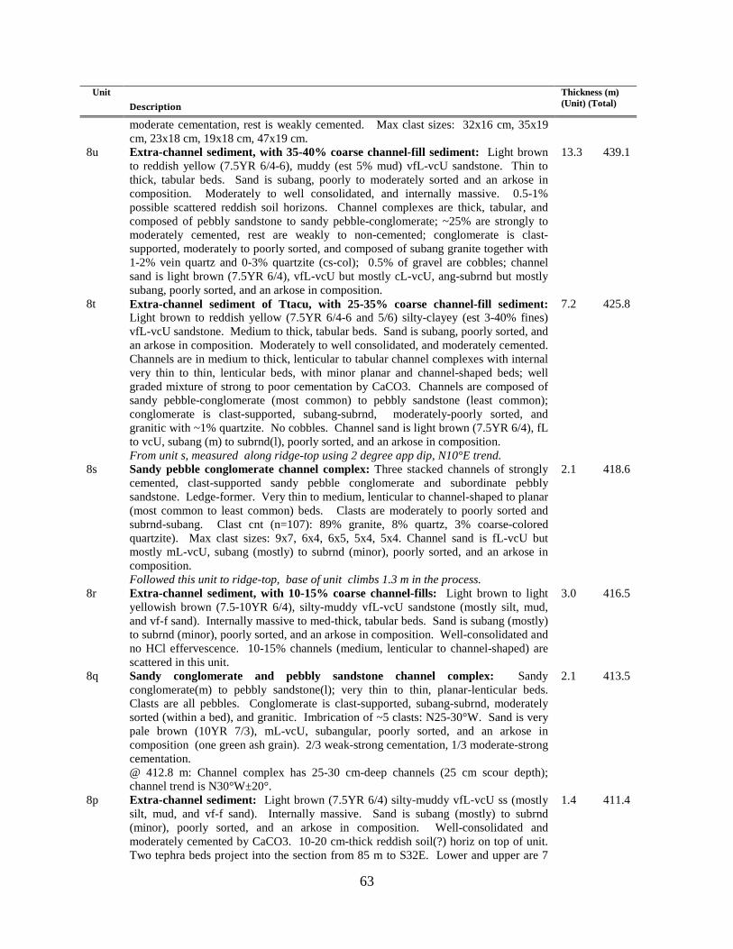
63
Unit Description
Thickness (m) (Unit) (Total)
moderate cementation, rest is weakly cemented. Max clast sizes: 32x16 cm, 35x19 cm, 23x18 cm, 19x18 cm, 47x19 cm.
8u
Extra-channel sediment, with 35-40% coarse channel-fill sediment: Light brown to reddish yellow (7.5YR 6/4-6), muddy (est 5% mud) vfL-vcU sandstone. Thin to thick, tabular beds. Sand is subang, poorly to moderately sorted and an arkose in composition. Moderately to well consolidated, and internally massive. 0.5-1% possible scattered reddish soil horizons. Channel complexes are thick, tabular, and composed of pebbly sandstone to sandy pebble-conglomerate; ~25% are strongly to moderately cemented, rest are weakly to non-cemented; conglomerate is clast-supported, moderately to poorly sorted, and composed of subang granite together with 1-2% vein quartz and 0-3% quartzite (cs-col); 0.5% of gravel are cobbles; channel sand is light brown (7.5YR 6/4), vfL-vcU but mostly cL-vcU, ang-subrnd but mostly subang, poorly sorted, and an arkose in composition.
13.3 439.1
8t
Extra-channel sediment of Ttacu, with 25-35% coarse channel-fill sediment: Light brown to reddish yellow (7.5YR 6/4-6 and 5/6) silty-clayey (est 3-40% fines) vfL-vcU sandstone. Medium to thick, tabular beds. Sand is subang, poorly sorted, and an arkose in composition. Moderately to well consolidated, and moderately cemented. Channels are in medium to thick, lenticular to tabular channel complexes with internal very thin to thin, lenticular beds, with minor planar and channel-shaped beds; well graded mixture of strong to poor cementation by CaCO3. Channels are composed of sandy pebble-conglomerate (most common) to pebbly sandstone (least common); conglomerate is clast-supported, subang-subrnd, moderately-poorly sorted, and granitic with ~1% quartzite. No cobbles. Channel sand is light brown (7.5YR 6/4), fL to vcU, subang (m) to subrnd(l), poorly sorted, and an arkose in composition. From unit s, measured along ridge-top using 2 degree app dip, N10°E trend.
7.2 425.8
8s
Sandy pebble conglomerate channel complex: Three stacked channels of strongly cemented, clast-supported sandy pebble conglomerate and subordinate pebbly sandstone. Ledge-former. Very thin to medium, lenticular to channel-shaped to planar (most common to least common) beds. Clasts are moderately to poorly sorted and subrnd-subang. Clast cnt (n=107): 89% granite, 8% quartz, 3% coarse-colored quartzite). Max clast sizes: 9x7, 6x4, 6x5, 5x4, 5x4. Channel sand is fL-vcU but mostly mL-vcU, subang (mostly) to subrnd (minor), poorly sorted, and an arkose in composition. Followed this unit to ridge-top, base of unit climbs 1.3 m in the process.
2.1 418.6
8r
Extra-channel sediment, with 10-15% coarse channel-fills: Light brown to light yellowish brown (7.5-10YR 6/4), silty-muddy vfL-vcU sandstone (mostly silt, mud, and vf-f sand). Internally massive to med-thick, tabular beds. Sand is subang (mostly) to subrnd (minor), poorly sorted, and an arkose in composition. Well-consolidated and no HCl effervescence. 10-15% channels (medium, lenticular to channel-shaped) are scattered in this unit.
3.0 416.5
8q
Sandy conglomerate and pebbly sandstone channel complex: Sandy conglomerate(m) to pebbly sandstone(l); very thin to thin, planar-lenticular beds. Clasts are all pebbles. Conglomerate is clast-supported, subang-subrnd, moderately sorted (within a bed), and granitic. Imbrication of ~5 clasts: N25-30°W. Sand is very pale brown (10YR 7/3), mL-vcU, subangular, poorly sorted, and an arkose in composition (one green ash grain). 2/3 weak-strong cementation, 1/3 moderate-strong cementation. @ 412.8 m: Channel complex has 25-30 cm-deep channels (25 cm scour depth); channel trend is N30°W±20°.
2.1 413.5
8p
Extra-channel sediment: Light brown (7.5YR 6/4) silty-muddy vfL-vcU ss (mostly silt, mud, and vf-f sand). Internally massive. Sand is subang (mostly) to subrnd (minor), poorly sorted, and an arkose in composition. Well-consolidated and moderately cemented by CaCO3. 10-20 cm-thick reddish soil(?) horiz on top of unit. Two tephra beds project into the section from 85 m to S32E. Lower and upper are 7
1.4 411.4

64
Unit Description
Thickness (m) (Unit) (Total)
and 16-17 cm thick, respectively; upper is 80 cm below unit 8q; the two are separated by 37 cm of extra-channel sediment. The black ashes are composed of gray-black ashy sand; ~1/4 : 3/4 ratio of tephra : detrital sand. Black ash is cL-vcU sand-size and probably basaltic. Top 1-2 cm of upper bed is rich in white, consolidated ash clasts and grains 0.5 - 17 mm diam – this may perhaps correlate to the Orilla pumice (10.8 Ma; Manley 1979).
8o
Strongly cemented, sandy pebble-conglomerate channel complex: Very thin to medium, lenticular (mostly) to channel-shaped (lesser in porportion, up to 10-15 cm deep) internal bedding. Gravel are clast-supported, subrnd-subang, and poorly to moderately sorted. Clast count (n-108): 93% granite, 7% quartz. Channel sand is mostly mL-vcU, subang, poorly sorted, and an arkose in composition.
1.0 410.0
8n
Channel complexes of pebbly sandstone and sandy pebble-conglomerate, interbedded with ~20% extra-channel sediment: Generally medium to thick, tabular to broadly lenticular channel complexes of pebbly sandstone and sandy pebble-conglomerate. Internal very thin to medium, planar to lenticular beds. Conglomerate is clast-supported, poorly to moderately sorted, and subang to subrund. Only 1-3% of gravel are cobbles. Gravel is granitic with ~1% quartzite. Max clast sizes from channel at 401.7 m: 9x7, 9x7, 9x6, 8x7, 9x9, 7x7 cm. About subequal strong-moderate : weak cementation. Channel sand is very pale brown (10YR 7/3), fL-vcU but mostly mL-vcU, subang (m) to subrnd (l), poorly sorted, and an arkose in composition. Extra-channel sediment is in thick, tabular beds, moderately cemented, and composed of silty (est 3-5% silt) vfL-vcU sand [subang (m) to subrnd (l), poorly sorted, and an arkose in composition]. Top of extra-channel beds commonly have 10-20 cm-thick, reddish soil horizons. @406 m: 5.4 m below 1q base is a 30 cm-thick basalt-rich sand (15-35% basaltic sand grains that are fU-mU).
8.9 409.0
8m
Ashy sandstone: Light gray to light brownish gray (10YR 6-7/2), vfL-cU arkose sandstone with 20% very dark gray volcanic lithics and mafic grains. Sand is moderately consolidated and mostly subang.
0.2 400.1
8L
Extra-channel sediment: Very pale brown (10YR 7/3), slightly silty-muddy (est 1-3%) vfL-vcU sandstone; internally massive massive. Sand is subang(m) to subrnd(l), poorly sorted, and an arkose in composition. Well-consolidated and moderately cemented by CaCO3.
1.6 399.9
8k
Pebbly sandstone-sandy pebbles channel-fill: (channelized at base, planar, thin beds at top). Channel trends: S56°W±19°, S82°W±18°, N81°W±14°, N65°W±12°, S88°W±11°.
0.6 398.3
8j
Upper bed of prominent black, coarse ash: Light gray (10YR 7/2), basalt-rich arkosic arenite sand. 1/3 basalt or int vf-f sand and mafic grains. 3-15% white pumice 0.5-8.0 mm-long. Arkosic sand is vfL-vcU, and poorly sorted. ~5% Lith A pebbles. This tabular bed is scoured into up to 50 cm by overlying unit. Stake E at 8K/8J contact; UTM coord: 3989499 N, 410257 E. 7 m to NW, stake F is at base of correlative unit 1J; UTM coord: 3989612 N, 410172 E.
0.7 397.7
8i
Fining-upward, coarse channel to finer extra-channel sediment: Lower 2/3 is pebbly sandstone; pebbles are subang (mostly) to subrnd (minor) and granitic. Sand is light yellowish brown (10YR 6/4), fL-vcU, subang-subrnd, poorly sorted, and arkosic arenite (~7% dark gray volcanic lithics). Weakly consolid and weakly cemented. Upper 1/3 is a slightly silty (est. 3-5% silt) sand. Sand is vfL-vcU, subang (mostly) to subrnd (minor), poorly sorted, and arkosic arenite; well consolidated and well-cemented. Probable 10-15 cm thick, 7.5YR 5/6 soil on top (clay-rich but no clay films).
1.8 397.0
8h
Middle bed of prominent black, coarse ash: Light brownish gray to light gray (10YR 6-7/2), basalt-rich arkosic arenite sand. Basalt is dark gray to gray and fine- to medium- grained. Arkosic sand is fL-vcU, subang (mostly) to subrnd (minor), and poorly sorted.
0.9 395.2
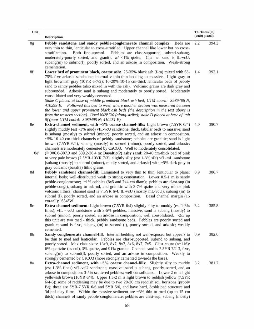
65
Unit Description
Thickness (m) (Unit) (Total)
8g Pebbly sandstone and sandy pebble-conglomerate channel complex: Beds are very thin to thin, lenticular to cross-stratified. Upper channel like lower but no cross-stratification. Both fine-upward. Pebbles are clast-supported, subrnd-subang, moderately-poorly sorted, and granitic w/ <1% qtzite. Channel sand is fL-vcU, subang(m) to subrnd(l), poorly sorted, and an arkose in composition. Weak-strong cementation.
2.2 394.3
8f
Lower bed of prominent black, coarse ash: 25-35% black ash (f-m) mixed with 65-75% f-vc arkosic sandstone; internal v thin-thin bedding to massive. Light gray to light brownish gray (10YR 6-7/2); 10-20% 10-15 cm-thick lenticular beds of pebbly sand to sandy pebbles (also mixed in with the ash). Volcanic grains are dark gray and subrounded. Arkosic sand is subang and moderately to poorly sorted. Moderately consolidated and very weakly cemented. Stake C placed at base of middle prominent black ash bed; UTM coord: 3989466 N, 410299 E. Followed this bed to west, where another section was measured between the lower and upper prominent black ash beds (the description in the text above is from the western section). Used N48°E\0 (along-strike); stake D placed at base of unit 8f (poor UTM coord: 3989495 N; 410251 E).
1.4 392.1
8e 8e’
Extra-channel sediment, with ~5% coarse channel-fills: Light brown (7.5YR 6/4) slightly muddy (est ~3% mud) vfL-vcU sandstone; thick, tabular beds to massive; sand is subang (mostly) to subrnd (minor), poorly sorted, and an arkose in composition. ~5% 10-40 cm-thick channels of pebbly sandstone; pebbles are granitic; sand is light brown (7.5YR 6/4), subang (mostly) to subrnd (minor), poorly sorted, and arkosic; channels are moderately cemented by CaCO3. Well to moderately consolidated. @ 386.8-387.3 and 389.2-38.4 m: Basaltic(?) ashy sand: 20-40 cm-thick bed of pink to very pale brown (7.5YR-10YR 7/3), slightly silty (est 1-3% silt) vfL-mL sandstone [subang (mostly) to subrnd (minor), modly sorted, and arkosic] with ~5% dark gray to gray volcanic (basalt?) lithic grains.
4.0 390.7
8d
Pebbly sandstone channel-fill: Laminated to very thin to thin, lenticular to planar internal beds; well-distributed weak to strong cementation. Lower 0.5-1 m is sandy pebble-conglomerate; ~1% cobbles (8x5 and 7x4 cm diam); pebbles are clast-sup (in pebble-congl), subang to subrnd, and granitic with 3-7% qtzite and very minor pink volcanic lithics; channel sand is 7.5YR 6/4, fL-vcU (mostly mL-vcU), subang (m) to subrnd (l), poorly sorted, and an arkose in composition. Basal channel margin (15 cm-tall): S54°W.
0.9 386.7
8c
Extra-channel sediment: Light brown (7.5YR 6/4) slightly silty to muddy (est 1-3% fines), vfL - vcU sandstone with 3-5% pebbles; massive; sand is subang (mostly) to subrnd (minor), poorly sorted, an arkose in composition; well consolidated. ~2/3 up this unit are two med - thick, pebbly sandstone beds. Pebbles are poorly sorted and granitic; sand is f-vc, subang (m) to subrnd (l), poorly sorted, and arkosic; weakly cemented.
3.2 385.8
8b
Sandy conglomerate channel-fill: Internal bedding not well-exposed but appears to be thin to med and lenticular. Pebbles are clast-supported, subrnd to subang, and poorly sorted. Max clast sizes: 13x9, 8x7, 8x7, 8x6, 8x7, 7x5. Clast count (n=116): 6% quartzite (cs-col), 3% quartz, and 91% granite. Channel sand is 7.5YR 7/2-3, f-vc, subang(m) to subrnd(l), poorly sorted, and an arkose in composition. Weakly to strongly cemented by CaCO3 (more strongly cemented towards the base).
0.9 382.6
8a Extra-channel sediment, with ~3% coarse channel-fills: Slightly silty to muddy (est 1-3% fines) vfL-vcU sandstone; massive; sand is subang, poorly sorted, and an arkose in composition; 3-5% scattered pebbles; well consolidated. Lower 2 m is light yellowish brown (10YR 6/4). Upper 1.5-2 m is light brown to reddish yellow (7.5YR 6/4-6); some of reddening may be due to two 20-30 cm reddish soil horizons (probly Bt); these are 5YR-7.5YR 6/6 and 5YR 5/6, and have hard, 3csbk ped structure and 3d-ppf clay films. Within the massive sediment are ~3% thin to med (up to 15 cm thick) channels of sandy pebble conglomerate; pebbles are clast-sup, subang (mostly)
3.2 381.7

66
Unit Description
Thickness (m) (Unit) (Total)
to subrnd (minor), poorly sorted, and granitic with 1-5% estimated quartzite; ~25% of channels are strongly cemented, rest are weakly to moderately cemented by CaCO3 (weak to moderate HCl effervescence). @379.2 m: stake B (N 3989392 N, 410359 E); above, use N42°W\ 2°NW.
Covered: 370.5-378.5 m. 8.5 378.5 Shot along-strike from stake BB using an average attitude of N48E\3NW; add 4 m
over this shot (error of +/- 1 m). Stake A placed at UTM coord: 3989307 N, 410432 E. Avg att in lower section is N48E\3NW, so used bearing of N42W\3NW. Note that cumulative thicknesses continue from the Cuarteles section on the San Juan Pueblo quadrangle to the west.
370.5
LOWER AND MIDDLE CUARTELES SECTION
@370.5 m: Stake BB placed on top of divide, still on hanging wall of fault (approx. UTM: . 3988650N 409695E
102.5 370.5
7ff
Channel pebble-conglomerate to pebbly sandstone: Subequal pebbly sandstone : pebble-conglomerate; very thin to medium, planar to lenticular beds. Conglomerate is clast-supported, poorly sorted, subrnd-rnd (qtzite) and subrnd-subang (gr). Clast count: 86% granite; 13% quartzite, 1% Pilar phyllite. Max clast sizes: 13x8, 13x8, 16x10, 13x13, 11x10 cm. Sand is 10YR 7/3, fL to vcU but mostly mL-vcU, subang-subrnd, poorly sorted, an arkose (trace felsic volc lithics). ~10% strong-moderate cementation, rest is weakly cemented to loose.
1.1 370.5
7ee
Extra-channel sediment: Reddish yellow to light brown (7.5YR 4-6/6) silty vfL-mU sand with minor cL-vcU sand; massive; est. 10% silt; sand is subang-subrnd, moderatelly sorted, and an arkose; moderately consolidated; poorly exposed. @366.0 m: Stake AA placed on top of knoll. UTM coord: 3988540N, 409700E
3.4 369.4
7dd
Two channels of pebble-conglomerate to pebbly sandstone: Lower channel fines upward from a 15 cm basal pebble-conglomerate to pebbly sandstone; weakly cemented. Clasts are granitic with 10-20% quartzite (quartzite is subrnd to rnd, granite is subrnd to subang). No distinct beds aside from 15 cm basal layer. 0.5% felsic volcanic clasts. Sand is 7.5YR 7/3, fL-vcU, subang-subrnd, poorly sorted, and an arkose. Sharp lower contact. Intervening extra-channel sediment is silty vfL-vcU (est. 15-25% silt). Upper channel is mostly a clast-supported pebble-conglomerate; beds are very thin to medium, planar to lenticular to planar-cross-stratified (up to 25 cm tall). Mostly moderately to strongly cemented by CaCO3. Max clast size: 24x14, 11x10, 10x8, 11x11, 12x9 cm. Clast count gives 24% quartzite (subrnd-rnd) and 76% granite. (subrnd-subang). Clasts are poorly sorted and clast-supported. Sand is mL to vcU, subang, poorly sorted, and an arkose.
2.5 366.0
7cc 7cc’’ 7cc’
Extra-channel sediment of Ttacu: Light brown to pink (7.5YR 6-7/4) silty vf to vc sand.; massive; I est 5-8% silt; sand is subang-subrnd, poorly sorted, and feld arenite with 2-3% felsic volc lithics and ash grains; moderately to well consolidated. @362.4-362.9 m: Basaltic ash within unit 7cc: Black basaltic ash mixed with minor detritus (~10% kspar). @359.0-359.3 m: Ashy sandstone of Ttacu: Ash is whitish, m-vc (sand-size) and mixed with vfL-mU an arkosic sandstone.
5.4 363.5
7bb
Pebbly sandstone channel sediment: Sand is mL-vcU; lower 40 cm is moderately to strongly cemented. Pebbles are scattered and consists of granite with 10-15% quartzite; no clear bedding; sand is subang-subrnd, poorly sorted, and an arkose. Sharp and scoured lower contact.
0.5 358.1
7aa
Extra-channel sediment: Reddish yellow to light brown (7.5YR 4-6/6) vfL-vcU sand with 3-5% silt-clay matrix; massive; sand has ~3% felsic volcanic grains; sand is subang-subrnd, an arkose, and poorly sorted. Moderately to well consolidated.
0.4 357.6
7z
Coarse white ash: White (10Y 7/1) altered glass and compacted white ash; 10% biotite and 3% felsic-int lithics. Somewhat greasy feel and greenish color indicates
1.1 357.2

67
Unit Description
Thickness (m) (Unit) (Total)
some alteration. Sharp lower contact; upper contact is gradational. 7y
Extra-channel sediment overlain by sandstone channel: Former is reddish yellow to light brown (7.5YR 4-6/6) and composed of silty vfL to fU sand (minor mL-vcU sand). Est 10-20% silt. Sand is subang to subrnd, modly sorted, and an arkose with 1% felsic volcanic grains; moderately to well consolidated. Channel fines-upward; lower 15 cm is strongly cemented and locally has granitic pebbles. Upper part of middle subunit is loose. Very thin to thin, planar to lenticular to cross-stratified (up to 8 cm) beds. Sand is fL-vcU, an arkose, subang-subrnd, and poorly to moderately sorted. Upper subunit is vfL-mL sand with 3-5% silt near the top; sand is moderately well sorted, subang, an arkose, and moderately consolidated. @353.5 m: Stake Z placed on north side of arroyo, one shot up from stake Y. Continue upwards at N5°W trend and 2° dip.
3.3 356.1
7x
Coarse white ash: 11 cm of loose 5Y 6/2 ash overlain by 70 cm of 10YR 7/1-2 modly consolidated, silty-clayey ash. Basal ash is mL-vcU (sand-size) and has 5-7% pink to gray lithics and 5-7% biotite; upper part is more altered (more clayey) and fL-mU gr (sand-size). @352.0 m: Stake Y placed on top of ridge and top of 7v channel. From here, shot across arroyo using N5°W\3° NW trend. Continued upwards at N5W trend and 4 degr dip.
0.8 352.8
7w
Channel pebble-conglomerate to pebbly sandstone: Beds are very thin to thin, planar to lenticular to tangential cross-stratified (latter up to 100 cm tall). 1/3:2/3 pble congl : pebbly ss; 25-35% of gravel are cobbles. Gravel is poorly sorted and clast-supported. Clast imbrication of N88W +/- 13. Max clast sizes: 24x19, 15x11, 26x4, 21x17, 19x17, 30x12. 3 clast counts give: 89-94% gr, 1% vein qtz, 6-7% colord, cs qtzite, 1% sil-qtzite. Weakly to strongly cemented. Sand is fL-vcU but mostly mL-vcU, subang-subrnd, poorly sorted, and an arkose. @345.1-345.2 m; Max clast sizes in cs channel: 6x3, 6x4, 6x3, 6x4, 3x2, 4x3, 5x5 cm
2.6 352.0
7v
Extra-channel sediment with subordinate channel sediment: Former is reddish yellow to light brown (7.5YR 4-6/6) and composed of silty vfL to mU sand; massive; poorly to moderately sorted; subang-subrnd; arkosic arenite. (up to 7% felsic volcanic grains) modly-well consolid. Channels are pbly sand to pebble-conglomerate (pebbles are moderately-poorly sorted & granitic). @343.3 m: Stake X placed on top of SCV-318 tephra. Continued upwards at N5W trend and 4 degr dip.
6.1 349.4
7u 7u’
Extra-channel sediment: Reddish yellow (7.5YR 6/6) vfL-fU sandstone; well sorted; an arkose. Vague, thin to thick, tabular beds, or else massive. 1-5% reddish, (7.5YR 5/6) clay-enriched (Bt) soil horizons. @340.5-340.8 and 343.1-343.3: Coarse white ashes: Lower is vf to m arkosic sand containing 20-25% coarse ash to lapilli-size fragments of greenish dacite(?) and purplish gray volcanic lithics. Upper is a relatively pure, pumiceous, coarse ash with 3-5% biotite; hard.
5.8 343.3
7t
Channel pebble-conglomerate to pebbly sandstone: Beds are planar-laminated to planar-cross-laminated (up to 12 cm tall). Gravel are clast-supported, subang to subrnd, modly to poorly sorted, and composed of granite with trace quartzite. Sand is ml to vcU, subang, moderately sorted, and an arkose. Max depth of channels = 20 cm. Max clast sizes: 9x5, 4x4, 6x3, 3.5x3, 5x4, 7x7, 9x5 cm.
1.0 337.5
7s
Extra-channel sediment: Light brown to reddish yellow (7.5YR 6/4-6) vfL to cU sandstone (mostly vfL to fU), locally silty.
2.1 336.5
7r
Channel pebble-conglomerate to pebbly sandstone: Beds are laminated to v thin to thin, and planar-cross-stratified up to 10 cm tall; one trough-x-stratified channel ~10 cm deep (trend of N66W). Pebbles are clast-supported, poorly to moderately sorted, and granitic. Sand is light yellowish brown (10YR 6/4), fu to vcU, subang to subrnd, and an arkose. Well-cemented. Max clast sizes: 5.5x2.5, 4.5x4, 8x3, 3x3, 5x3, 4x3, 5x3.5 cm.
0.7 334.4
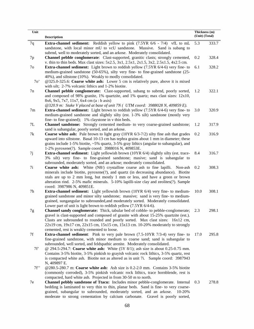
68
Unit Description
Thickness (m) (Unit) (Total)
7q
Extra-channel sediment: Reddish yellow to pink (7.5YR 6/6 - 7/4) vfL to mL sandstone, with local minor mU to vcU sandstone. Massive. Sand is subang to subrnd, well to moderately sorted, and an arkose. Moderately consolidated.
5.3 333.7
7p Channel pebble conglomerate: Clast-supported, granitic clasts; strongly cemented, v. thin to thin beds. Max clast sizes: 5x2.5, 3x1, 2.5x1, 2x1.5, 3x2, 2.5x1.5, 4x2.5 cm.
0.2 328.4
7o 7o’
Extra-channel sediment: Light brown to reddish yellow (7.5YR 6/4-6) very fine- to medium-grained sandstone (50-65%), silty very fine- to fine-grained sandstone (25-40%), and siltstone (10%). Weakly to modly consolidated. @325.0-325.6: Coarse white ash: Lower 5 cm is relatively pure, above it is mixed with silt; 2-7% volcanic lithics and 1-2% biotite.
6.1 328.2
7n
Channel pebble conglomerate: Clast-supported, subang to subrnd, poorly sorted, and composed of 98% granite, 1% quartzite, and 1% quartz; max clast sizes: 12x10, 8x6, 9x5, 7x7, 11x7, 6x4 cm (a : b axis) @320.9 m: Stake V placed at base of unit 7N ( UTM coord: 3988028 N, 409859 E).
1.2 322.1
7m
Extra-channel sediment: Light brown to reddish yellow (7.5YR 6/4-6) very fine- to medium-grained sandstone and slightly silty (est. 1-3% silt) sandstone (mostly very fine- to fine-grained); 1% claystone in v thin beds.
3.0 320.9
7L
Channel sandstone: Strongly cemented medium- to very coarse-grained sandstone; sand is subangular, poorly sorted, and an arkose.
1.2 317.9
7k
Coarse white ash: Pale brown to light gray (10YR 6/3-7/2) silty fine ash that grades upward into siltstone. Basal 10-13 cm has tephra grains about 1 mm in diameter; these grains include 1-5% biotite, ~5% quartz, 3-5% gray lithics (angular to subangular), and 1-2% pyroxene(?). Sample coord: 3988016 N, 409853E.
0.2 316.9
7j
Extra-channel sediment: Light yellowish brown (10YR 6/4) slightly silty (est. trace-3% silt) very fine- to fine-grained sandstone; masive; sand is subangular to subrounded, moderately sorted, and an arkose; moderately consolidated.
8.4 316.7
7i
Coarse white ash: White (N8/) crystalline coarse ash to fine lapilli. Non-ash minerals include biotite, pyroxene(?), and quartz (in decreasing abundance). Biotite xtals are up to 2 mm long, but mostly 1 mm or less, and have a green or brown alteration rind. 2-5% mafic minerals. 5-10% lapilli-size clay and zeolites(?). Sample coord: 3987986 N, 409851E.
0.2 308.3
7h
Extra-channel sediment: Light yellowish brown (10YR 6/4) very fine- to medium-grained sandstone and minor silty sandstone; massive; sand is very fine- to medium-grained, sungangular to subrounded,and moderately sorted. Moderately consolidated. Lower part of unit is light brown to reddish yellow (7.5YR 6/4-6).
10.0 308.1
7g
Channel sandy conglomerate: Thick, tabular bed of cobble- to pebble-conglomerate; gravel is clast-supported and composed of granite with about 15-25% quartzite (est.). Clasts are subrounded to rounded and poorly sorted. Max clast sizes: 16x12 cm, 22x19 cm, 19x17 cm, 22x15 cm, 15x15 cm, 15x13 cm. 10-20% moderately to strongly cemented, rest is weakly cemented to loose.
2.3 298.1
7f 7f’ 7f’’
Extra-channel sediment: Pink to very pale brown (7.5-10YR 7/3-4) very fine- to fine-grained sandstone, with minor medium to coarse sand; sand is subangular to subrounded, well sorted, and feldspathic arenite. Moderately consolidated. @ 294.5-294.7: Coarse white ash: White (5Y 8/1); ash size is about 0.25-0.75 mm. Contains 3-5% biotite, 3-5% pinkish to grayish volcanic rock lithics, 3-5% quartz, rest is compacted white ash. Biotite not as altered as in unit 7i. Sample coord: 3987943 N, 409897 E. @280.5-280.7 m: Coarse white ash: Ash size is 0.2-2.0 mm. Contains 3-5% biotite (commonly corroded), 3-5% pinkish volcanic rock lithics, trace hornblende, rest is compacted, hard white ash. Projected in from 30-50 m to north.
17.0 295.8
7e
Channel pebbly sandstone of Ttacu: Includes minor pebble-conglomerate. Internal bedding is laminated to very thin to thin, planar beds. Sand is fine- to very coarse-grained, subangular to subrounded, moderately sorted, and an arkose. 10-20% moderate to strong cementation by calcium carbonate. Gravel is poorly sorted,
0.3 278.8

69
Unit Description
Thickness (m) (Unit) (Total)
subang-subrnd (gr) to subrnd-rnd (qtzite), and granitic with 10-15% qtzite; ~1% of gravel are cobbles. Max clast sizes: 3.5x3, 5x3, 9x5, 12x4.5, 5x3, 5x4, 9x8 cm.
7d
Extra-channel sediment: Light yellowish brown (10YR 6/4) very fine- to fine-grained sandstone; subrounded to subangular, well to moderately sorted, and an arkose. No exposure of bedding; moderately consolidated.
4.2 278.5
7c
Pebbly sandstone channel: Fining-upward channel deposit of pebble-conglomerate (base) to pebbly sandstone. Beds are thin to thick (mostly thin to medium), lenticular to tangential cross-stratified up to 25 cm-thick. Conglomerate is clast-supported, moderately to poorly sorted, and subrnd (gr) to subrnd-rnd (qtzite). Max clast sizes: 9x9, 9x8, 7x6, 8x6, 10x5, 9x9, 9x5 cm. Clast count (n=122): 85% granite, 8% quartzite, 5% yellowish Paleozoic limestone, 2% vein quartz. Sand is very pale brown (10YR 7/3), subrnd (minor subang), moderately to poorly sorted, arnd an arkose. ~35% of channel is moderately cemented by CaCO3, rest is weakly to non-cemented.
0.3 274.3
7b
Extra-channel sediment: Pink (7.5YR 7/4) silty very fine- to fine-grained ss; sand is subrnd, well sorted, and an arkose; ~5% thin lenses of granitic vf-c pebbles and m-vc sand. Beds not exposed; moderately consolidated.
4.5 274.0
7a
Sandy pebble conglomerate channel of Ttacu: Very thin, planar internal bedding. Pebbles are clast-supported and moderately to poorly sorted. Max clast size by stake u: 6x6, 10x8, 8x7, 7x7, 6x4, 8x4, 8x6, 7x5 cm; max clast size by stake t is 12x6, 10x8, 8x4, 9x5, 6x4, 10x7, 12x7 cm (axb axis). Clast count (n=146): 85% granite, 15% quartzite. Sand is very pale brown to pink (7.5-10YR 7/3-4), fL-vcU but mostly cL-vcU, subang-subrnd, poorly sorted, and an arkose. @320.9 m: Stake T placed at base of unit 7a to west of Arroyo Quarteles; UTM coord: 3987276 N, 409710 E.@268 m: Stake U placed at base of unit 7a to east in Arroyo Quarteles: UTM coord: 3987780 N, 409969 E; above, used N30°W\5°NW
1.5 269.5
COARSE UPPER LITHOSOME B UNIT, CEJITA MEMBER OF THE
TESUQUE FORMATION (Ttbc):
70.5 268.0
6k
Floodplain sediment: Silty very fine- to fine-grained sand. Beds are tabular and very thin to thick; well consolidated; unit represents a transition from light brown to pale brown (7.5YR-10YR 6/3) sediment of the Cejita Member (with ratio of 25-35%: 75-65% NE lithics : Kspar) upwards to light brown to light yellowish brown (7.5-10YR 6/4) sediment of the Cuarteles member (with ratio of 2/3-3/4:1/3-1/4 kspar : NE lithics.) @260.5 m: Stake S placed at top of unit 6i to the east. UTM coord: 3987258 N, 409720 E. Stake R placed at top of unit 6i to the west. UTM coord: 3986986 N, 409598 E.
3.0 268.0
6j Medium-grained sand of lithosome B provenance. 4.5 265.0 6i Interbedded sandstone and conglomerate channels: Channels have thin to thick,
planar to irregular internal beds; minor low cross-stratification. Gravel is mostly subrnd pebbles with 10-20% cobbles and is dominated by Paleozoic clasts; max clast sizes: 30x18, 16x12, 18x14, 14x9, 20x10, 50x23, 20x22, 30x15 cm. Sand is pale brown (10YR 6/3), subrounded, well sorted, and composed of 65-80% : 35-20% Paleozoic-rich lithics : potassium feldspar. @ 2-2.5 m below Stake R on top of ridge: channel deposit with good clast imbrication directed S63°W (4), S65°W (1), S60°W (1), S68°W (1), S52°W(1), S34°W(3). Clast count gives: 49% Paleozoic limestone, 25% Paleozoic sandstone and siltstone, 15% quartzite, 4% granite, 1%chert, 4% quartz, 1% felsic volcanic rock. Gravel are clast supported, subrnd to rnd, poorly to moderately sorted, and consists of pebbles with 20-25% cobbles, 3-5% boulders by volume. The channel overlies sand that is moderately sorted, subrnd to subang, has 1/3 to 1/2 Kspar : 2/3 to 1/2 Paleozoic-rich lithics (~10% of lithics are volcanic grains). Color of sand is light yellowish brown to light gray
2.5 260.5

70
Unit Description
Thickness (m) (Unit) (Total)
(2.5Y 6/3 to 7/2). @ 1 m below stake S, max clast sizes: 12x11, 12x6, 9x5, 9x5, 10x10, 13x6, 9x9, 12x17, 14x13, 17x12, 15x12 cm.
6h
Sandstone channels: Laminated to very thin to thin, planar beds of of fine- to medium-grained sandstone; sand is subrnd, well sorted, and rich in lithic grains. 15-25% of channel is moderately to strongly cemented.
2.5 258.0
6g
Channel pebble-conglomerate and pebbly sandstone: Internal bedding is very thin to thin, and cross-stratified up to 100-110 cm-tall; there are also planar beds and channels up to 150 cm deep. Gravel is clast-supported, subrnd, poorly sorted, and dominated by Paleozoic clasts. Clast count gives: 37% Paleozoic limestone, 24% Paleozoic sandstone and siltstone, 26% quartzite, 5% quartz, 4% granite, 2% mylonite, 1% hypabyssal intrusives, 2% calcium carbonate cement. Sand is pale brown (10YR 6/3), fine- to very coarse-grained, subrnd, well to moderately sorted, and rich in lithics; sand may be laminated. 25-35% of channels are moderately to strongly cemented. Channel trend of 150 cm-deep channel: S43°W. @254 m: Stake Q placed within unit 6g; above, use bearing of N35°W\2°NW. UTM coord: 3986918 N, 409666 E.
5.5 255.5
6f
Sandstone channels of mixed provenance, and minor floodplain deposits: Upper 6f channels: Sand grain sizes: fU to vcU mostly mL to cU. Sand is moderate to poorly sorted, subrnd to subang, and composed of subqueal Paleozoic-rich lithics and potassium feldspar +/- 10%. 10-20% moderate to strongly cemented channel cementation, the rest is weakly to moderately cemented. Flood plain deposits: low angle x-lamination. Sand is pale brown (10YR 6/3), vfL-mL, subrnd (minor rnd), and moderately sorted. ~7/10 : 3/10 Paleozoic-rich lithics : Kspar (+/- 5%). ~5% moderate to strong cementation. Cemented beds are thin to medium and lenticular to planar. It grades upward to a light yellowish brown (10YR 6/4), fU sand to silt that is well sorted. No obvious bedding, but there is trace clay (2.5YR 5/4) planar laminations. Weak HCL effervescence. Lower 6f channels consist of channel conglomerate, pebbly sandstone and sandstone of mixed provenance; about subequal clasts associated with provenance for lithosomes A and B. Lower 6f conglomerate has 1/4-1/5 : 3/4-4/5 cobbles : pebbles and is clast-supported. Grains are poorly sorted and subrnd-rnd. Internal beds are medium to thick, and lenticular to channel shaped. Channel sand is light gray to light yellowish brown (2.5Y 7/2-6/3), fu-vcu, poorly sorted, ang-subrnd, and has subequal Kspar : Paleozoic-rich lithics. 10-20% of channel is moderately to strongly cemented by CaCO3, rest are weakly to non-cemented. Max clast sizes are 21x15, 16x10, 14x14, 20x9, 13x11, 14x12, 11x11, 25x12. Uppermost channel complex is 465-475 m long and correlates to uppermost channel in Llano sections.
15.5 250.0
6e
Floodplain sediment: Light yellowish brown (2.5Y 6/3) very fine- to fine-grained sandstone; sand is subrnd, well sorted, and has a ratio of 75-90%:10-25% Paleozoic-rich lithics : potassium feldspar. Moderately consolildated. Locally vertebrate fossil fragments are present.
1.2 234.5
6d
Channel pebbly sandstone and subordinate sandy pebble-conglomerate of mixed provenance: Channel bedding is very thin to thick and lenticular; sand may be laminated and planar. Gravel includes 1-3% cobbles. Clasts are poorly sorted, clast-supported, and subrnd to rnd; about 10-20% clasts are associated with lithosome B, otherwise gravel is granitic. Sand is pale brown (10YR 6/3), fine- to very coarse-grained, subrnd to subang, poorly sorted, and has subequal potassium feldspar : Paleozoic-rich lithic grains. ~20% of channels are strongly to moderately cemented. Max. clast sizes: 12x7, 10x9, 9x9, 9x8, 13x8 cm (axb axis). 12x8, 15x9, 9x8. @ 231.4-233.3: Clast count gives: 45% granite, 24% pz lm, 13% pz ss slst, 15% cs-col qtzite, 1% sil qtzite, 3% clr-gray qtzite. Max clast sizes: 12x7, 10x7, 11x8, 10x6, 10x6, 10x10, 9x7 cm. @225.8 m: Stake O placed at top of unit 6c to the west UTM coord: 3986882 N,
7.5 233.3
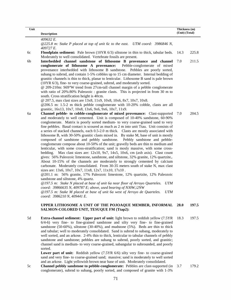
71
Unit Description
Thickness (m) (Unit) (Total)
409632 E. @225.8 m: Stake P placed at top of unit 6c to the east. UTM coord: 3986846 N, 409727 E.
6c Floodplain sediment: Pale brown (10YR 6/3) siltstone in thin to thick, tabular beds. Moderately to well consolidated. Vertebrate fossils are present.
14.3 225.8
6b
Interbedded channel sandstone of lithosome B provenance and channel conglomerate of lithosome A provenance: Pebble-conglomerate of mixed provenance interbedded with lithosome B sandstone. Pebbles are poorly sorted, subang to subrnd, and contain 1-5% cobbles up to 15 cm diameter. Internal bedding of granitic channels is thin to thick, planar to lenticular. Lithosome B sand is pale brown (10YR 6/3), fine- to very coarse-grained, subrnd, and moderately sorted. @ 209-210m: S69°W trend from 27cm-tall channel margin of a pebble conglomerate with ratio of 20%:80% Paleozoic : granite clasts. This is projected in from 30 m to south. Cross stratification height is 40cm. @ 207.5, max clast sizes are 13x8, 11x9, 10x8, 10x6, 8x7, 10x7, 10x8. @206.5 m: 1.5-2 m thick pebble conglomerate with 10-20% cobble, clasts are all granitic, 16x13, 10x7, 10x8, 13x6, 9x6, 9x6, 10x7, 11x9.
7.0 211.5
6a
Channel pebble- to cobble-conglomerate of mixed provenance: Clast-supported and moderately to well cemented. Unit is composed of 10-40% sandstone, 60-90% conglomerate. Matrix is poorly sorted medium- to very coarse-grained sand to very fine pebbles. Basal contact is scoured as much as 2 m into unit Ttau. Unit consists of a series of stacked channels, each 0.5-2.0 m thick. Clasts are mostly associated with lithosome B, with 30-50% granitic clasts mixed in. By stake M, base of unit is mostly composed of sandstone and pebbly sandstone. Pebbly sandstone and pebble-conglomerate compose about 10-50% of the unit; gravelly beds are thin to medium and lenticular, with some cross-stratification; sand is mosly massive, with some cross-bedding. Max clast sizes are: 12x10, 9x7, 14x5, 10x6, cm (axb axis). Clast count gives: 56% Paleozoic limestone, sandstone, and siltstone, 32% granite, 12% quartzite,. About 10-15% of the channels are moderately to strongly cemented by calcium carbonate. Moderately consolidated. From 30-35 meters south of stake N, max clast sizes are: 13x6, 10x7, 10x7, 11x8, 12x7, 11x10, 17x10 . @201.1 m: 56% granite, 17% Paleozoic limestone, 12% quartzite, 12% Paleozoic sandstone and siltstone, 4% quartz. @197.5 m: Stake N placed at base of unit 6a near floor of Arroyo Quarteles. UTM coord: 39866635 N, 409787 E; above, used bearing of N30W,\2NW @197.5 m: Stake M placed at base of unit 6a west of Arroyo de Quarteles. UTM coord: 3986210 N, 409441 E.
7.0 204.5
UPPER LITHOSOME A UNIT OF THE POJOAQUE MEMBER, INFORMAL
SALMON-COLORED UNIT, TESUQUE FM (Ttap2):
28.0 197.5
5d
Extra-channel sediment: Upper part of unit: light brown to reddish yellow (7.5YR 6/4-6) very fine- to fine-grained sandstone and silty very fine- to fine-grained sandstone (50-60%), siltstone (30-40%), and mudstone (5%). Beds are thin to thick and tabular; well to moderately consolidated. Sand is subrnd to subang, moderately to well sorted, and an arkose. 2-4% thin to thick, lenticular to tabular channels of pebbly sandstone and sandstone; pebbles are subang to subrnd, poorly sorted, and granitic; channel sand is medium- to very coarse-grained, subangular to subrounded, and poorly sorted. Lower part of unit: Reddish yellow (7.5YR 6/6) silty very fine- to coarse-grained sand and very fine- to coarse-grained sand; massive; sand is moderately to well sorted and an arkose. Light yellowish brown near base of unit. Moderately consolidated.
18.3 197.5
5c
Channel pebbly sandstone to pebble-conglomerate: Pebbles are clast-supported (in conglomerate), subrnd to subang, poorly sorted, and composed of granite with 1-3%
3.7 179.2
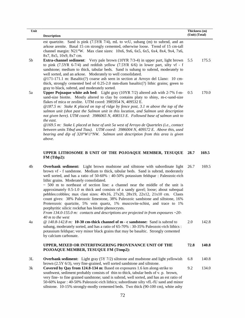
72
Unit Description
Thickness (m) (Unit) (Total)
est quartzite. Sand is pink (7.5YR 7/4), mL to vcU, subang (m) to subrnd, and an arkose arenite. Basal 15 cm strongly cemented, otherwise loose. Trend of 15 cm-tall channel margin: N21°W. Max clast sizes: 10x6, 9x6, 6x5, 6x5, 6x4, 8x4, 9x4, 7x6, 8x7, 8x5, 10x9, 8x7 cm.
5b
Extra-channel sediment: Very pale brown (10YR 7/3-4) in upper part, light brown to pink (7.5YR 6-7/4) and reddish yellow (7.5YR 6/6) in lower part, silty vf - f sandstone; medium to thick, tabular beds. Sand is subang to subrnd, moderately to well sorted, and an arkose. Moderately to well consolidated. @171-171.1 m: Basaltic(?) coarse ash seen in section at Arroyo del Llano: 10 cm-thick, strongly cemented bed of 0.25-2.0 mm-diam basaltic(?) lithic grains; green to gray to black, subrnd, and moderately sorted.
5.5 175.5
5a
Upper Pojoaque white ash bed: Light gray (10YR 7/2) altered ash with 2-7% f-m-sand-size biotite. Mostly altered to clay by contains platy to shiny, m-c-sand-size flakes of mica or zeolite. UTM coord: 3985954 N, 409532 E. @187.5 m: Stake K placed on top of ridge by fence post, 3.1 m above the top of the salmon unit (shot past the Salmon unit in this location, and Salmon unit description not given here). UTM coord: 3986065 N, 408313 E. Followed base of salmon unit to the east. @169.5 m: Stake L placed at base of unit 5a west of Arroyo de Quarteles (i.e., contact between units Ttbuf and Ttau). UTM coord: 3986004 N, 409572 E. Above this, used bearing and dip of 320°W\1°NW. Salmon unit description from this area is given above.
0.5 170.0
UPPER LITHOSOME B UNIT OF THE POJOAQUE MEMBER, TESUQUE
FM (Ttbp2):
28.7 169.5
4b Overbank sediment: Light brown mudstone and siltstone with subordinate light brown vf - f sandstone. Medium to thick, tabular beds. Sand is subrnd, moderately well sorted, and has a ratio of 50-60% : 40-50% potassium feldspar : Paleozoic-rich lithic grains. Moderately consolidated. ~ 500 m to northeast of section line: a channel near the middle of the unit is approximately 0.5-1.0 m thick and consists of a sandy gavel; loose; about subequal pebbles:cobbles; max clast sizes: 40x16, 27x20, 28x19, 22x12, 21x10 cm. Clasts count gives: 38% Paleozoic limestone, 38% Paleozoic sandstone and siltstone, 16% Proterozoic quartzite, 5% vein quartz, 1% muscovite-schist, and trace to 1% porphyritic silicic rockthat has biotite phenocrysts. From 134.0-155.0 m: contacts and descriptions are projected in from exposures ~20-40 m to the west
26.7 169.5
4a
@ 140.8-142.8 m: 10-30 cm-thick channel of m - c sandstone: Sand is subrnd to subang, moderately sorted, and has a ratio of 65-70% : 30-35% Paleozoic-rich lithics : potassium feldspar; very minor black grains that may be basaltic. Strongly cemented by calcium carbonate.
2.0 142.8
UPPER, MIXED OR INTERFINGERING PROVENANCE UNIT OF THE
POJOAQUE MEMBER, TESUQUE FM (Ttmp2):
72.8 140.8
3L Overbank sediment: Light gray (5Y 7/2) siltstone and mudstone and light yellowish brown (2.5Y 6/3), very fine-grained, well sorted sandstone and siltstone.
6.8 140.8
3k Covered by Qay from 124.8-134 m: Based on exposures 1.6 km along-strike to southwest, sediment probably consists of thin to thick, tabular beds of v. p. brown, very fine- to fine grained sandstone; sand is subrnd, well sorted, and has an est ratio of 50-60% kspar : 40-50% Paleozoic-rich lithics; subordinate silty vfL-fU sand and minor siltstone. 10-15% strongly-modly cemented beds. Two thick (90-100 cm), white ashy
9.2 134.0

73
Unit Description
Thickness (m) (Unit) (Total)
vfL-mL sandstone-siltstone to silty ash beds very likely correlate to upper part of covered interval; ashes are altered and feel soapy. @124.8 m: Between stakes I and J, followed to north a contact located between a brown mudstone (at base) and a 10YR 8/2-7/3 fine-grained sandstone [subrnd, well sorted, arkosic) on top. UTM coord. of stake J: 3985272 N, 408886 E; UTM coord. of stake I: 3985205 N, 408822 E. Above stake J, use bearing and dip of N37°W\4°NW.
3j
Eolian, extra-channel, and overbank sediment: ~40% 7.5YR 7/4 silty very fine- to fine-grained sandstone that is subrnd, well sorted, and arkosic arenite. ~25% vfL-mL sandstone; no obvious bedding; sand is subrnd, well-sorted, and arkosic (with an est ratio of 20%:80% Paleozoic-rich lithics : kspar). ~35% very thin to thick, tabular beds of mudstone. The first two deposits are either eolian or extra-channel, the third represents overbank deposit. 3-5% very thin to medium, tabular channel deposits of very fine- to fine-grained sandstone that are commonly strongly cemented by CaCO3; sand is subrounded, well sorted, has about subequal Kspar : Paleozoic-rich lithics in widely varying proportions. Moderately to weakly consolidated. @110.1: Stake H placed on top of Pleistocene terrace deposit on east rim of northern mesa.UTM coord: 3985096 N, 408924 E.
14.7 124.8
3i
Pebbly fine- to very coarse-grained sandstone channel complex (lithosome B): Planar-laminated to cross-laminated (up to 10 cm-tall and tangential); channel fines upward into a silty very fine- to fine-grained overbank(?) sand. Channel sand is pale brown (10YR 6/3), has an est ratio of 50-60% : 40-60% Paleozoic-rich lithics : Kspar, subrnd to subang, and moderately sorted. Very fine to medium, subrounded pebbles of lithosome B provenance (generally greenish Paleozoic limestone, siltstone, and sandstone, with an est 15-20% granite and ~10% quartzite); pebbles are subrnd and poorly sorted. Basal 30 cm has minor very coarse pebbles and trace cobbles (max clast size of 8x8 cm). Max clast sizes: 5X4, 5x3, 3x3, 5x4, 5x3, 5x4, 5x5 cm. About 10% of channel is strongly cemented by CaCO3. 200-300 m southwest of section line, this channel lies just above a white ash bed.
3.5 110.1
3h
Extra-channel and overbank sediment: Very pale brown to light yellowish brown (10YR 6-7/4), very fine- to fine-grained sandstone and subordinate siltstone; thin to thick, tabular beds; sand is subrnd, well-sorted, and has an est ratio of 50-60% Kspar : 40-50% Paleozoic-rich lithics. Minor light brown (7.5YR 6/4) mudstone and silty very fine- to fine-grained sandstone. If channels are present, they are sufficiently broad as to be tabular in shape; there are 3-5% very thin to thin (up to 20 cm thick) broadly lenticular channels. Moderately consolidated. Sediment may be partly eolian. @ 96.5-96.8 m: fL to cL sandstone channel of lithosome A; subrounded to subangular; est ratio of 75%:25% kspar : Paleozoic-rich lithic grains. @ 94.9-95.2 m: Fine- to very fine-grained sandstone channel of lithosome A, subrnd, well sorted, and arkosic.
15.7 106.6
3g
Extra-channel and overbank sediment: Similar to that in unit 3h but @ 88.9-90.0 m there are 20 to 30 cm-thick channels of fine-grained sandstone that is subrnd, well sorted, strongly cemented, and has an est ratio of 60-65% : 35-40% Kspar : Paleozoic-rich lithics.
2.8 90.9
3f Overbank sediment: 5YR-7.5YR 5/3 mudstone. 1.0 88.1 3e
Extra-channel and overbank sediment: Very fine- to fine-grained sandstone (2/3 of volume and 7.5YR 6/4-6 in color) plus 30-35% siltstone and mudstone (7.5YR 6/3 for mdst and sltst, some siltst is 10YR 5-6/3); thin to thick, tabular beds; sand is subrnd, well sorted, arkosic arenite, and has an est ratio of 60-65 : 35-40% Kspar : Paleozoic-rich lithics. Weakly to well consolidated.
10.5 87.1
3d
Channel sediment: fL to mL sandstone; very thin to medium, planar-bedded; sand is subrnd, well sorted, and has subequal Paleozoic-rich lithics : Kspar. Strongly cemented.
0.5 76.6

74
Unit Description
Thickness (m) (Unit) (Total)
3c Overbank sediment: 7.5YR 6/4 siltstone and very fine-grained sandstone. 1.6 76.1 3b
Pebbly sandstone channel sediment (lithosome B): Very thin to medium, planar to lenticular beds, with minor planar-cross-stratification up to 15 cm tall; sand is 10YR 6/3, fine- to very coarse-grained, subrounded, moderately to poorly sorted, and has an est. ratio of 70-75% : 25-30% NE-derived ltihics : Kspar. Pebbles are mostly calcium carbonate-indurated rip-ups of unit 2-like siltstone and very fine-grained sanstone. About half of sediment is strongly to moderately cemented by CaCO3., rest is weakly to non-cem. Max Pz clast sizes: 2x2, 3x2, 5x3, 4x2, 4x2, 3x2, 3x2 cm. @ 73 m: Projection of a thick bed of fine white ash. At SCV-215, there is 30-35 cm of relatively pure ash overlain by 60-95 cm of ash reworked with ~50% detrital sand. Lower, pure part is planar- to wavy-laminated and altered (soapy feel; 1% possible glass shards; no mafic minerals. Upper, reworked part is planar- or cross-laminated (up to 20 cm tall).
4.5 74.5
3a
Overbank sediment: Very pale brown (10YR 7/3) siltstone and very pale brown to light yellowish brown (10YR 6/4 - 7/3) vfL-fU sandstone and silty vfL-fU sandstone. Very thin to thin, laminated and planar beds. Sand is subrnd, well sorted, est ratio of 60-65% : 35-40% Paleozoic-rich lithics : Kspar. Weakly to moderately consolidated; 1-3% strong to moderate cementation. @68 m: Stakes Fand G placed on unit 3a/2c contact (northward step between the two along the contact. UTM coord of stake g: 3984979 N, 409084 E; UTM coord of stake f: 3984825 N, 409138 E. Above, used bearing and dip of N45°W\5°NW.
2.0 70.0
LOWER, MIXED PROVENANCE UNIT OF THE POJOAQUE MEMBER,
TESUQUE FM (Ttmp1):
33.0 68.0
2c
Extra-channel, overbank, and eolian(?) sediment: Medium to thick, tabular beds of vfL to fU sandstone and silty sandstone; sand similar to that in unit 2b; ledge-former; no mudstone; well consolidated. May be eolian sand sheets. Lower contact is gradational over 51.5-54.0 m. @64 m: StakesD and E placed on top of prominent, tabular, strongly cemented fine ss bed. Used this bed to step to the north. UTM coord of stake E: 3984821 N, 409158 E; UTM coord of stake D: 3984604 N, 409040 E. Above, used N60°W\4°NW.
15.5 68.0
2b
Extra-channel and overbank sediment: Medium to thick, tabular beds of siltstone, vfL to fU sandstone, silty sandstone, minor silt-rich mudstone. Sand is subrnd, well-sorted, and has an est ratio of 60-70% : 30-40% Kspar : Paleozoic-rich lithics. Well consolidated and a ledge-former. May be eolian sand sheets, in part. @41.5 m: Stakes B and Cplaced on top of prominent ledge-forming, tabular, strongly cemented very fine sandstone bed. Used this bed to step to the north. UTM coord of stake c: 3984588 N, 409076 E; UTM coord of stake b: 3984458 N, 409403 E. Above this, used bearing and dip of N60°W\4°NW.
11.3 52.5
2a
Extra-channel, overbank, and eolian(?) sediment: Medium to thick, tabular beds of siltstone, vfL to fU sandstone, and silty sandstone. Sand is subrounded, well-sorted, and has an est ratio of 70% : 30% Kspar : Paleozoic-rich ltihics. Well consolidated and a ledge-former. May possibly be eolian sand sheets.
6.2 41.2
LOWER LITHOSOME B DEPOSITS, POJOAQUE MEMBER, TESUQUE
FORMATION (Ttb1):
35.0 35.0
1g
Overbank floodplain sediment: Pale brown (10YR 6/3) siltstone and very fine- to fine-grained sandstone; very thin to thick, tabular beds, also laminated; moderately consolidated. Lower 4-5 m of unit is composed of light gray (10YR 7/2) siltstone; laminated-planar to very thinly bedded-planar; wealy to moderately consolidated.
7.5 35.0
1f
Channel sediment: Fining-upward channel deposit. ~1 m of pebbly sandstone at base: pebble clasts are subrnd to rnd, moderately sorted, and of lithosome B
2.5 27.5

75
Unit Description
Thickness (m) (Unit) (Total)
provenance; channel sand is pale brown to light yellowish brown (10YR 6/3-4), fL-vcU, subrnd, moderately sorted, and has an est ratio of 65% : 35% Paleozoic-rich lithics : Kspar; loose; exposure does not permit observation of bedding. Overlying channel sediment is generally sand with 1-2% thin, lenticular beds of pebble-conglomerate; pebbles are very fine to medium in size and of lithosome B provenance; sand is pale brown (10YR 6/3), fL - vcL, subrnd, moderately sorted, and has an est ratio of 65% : 35% Paleozoic-rich lithics : Kspar; sand is in very thin to thin to laminated, planar beds. Generally weakly consolidated.
1e
Overbank floodplain sediment: light brown to pale brown (7.5-10YR 6/3) siltstone (~35%) and very fine- to fine-grained sandstone (~25%), interbedded with ~40% brown to pale brown to light brown (7.5YR 5-6/3 and 7.5YR 6/4) mudstone. Sand is subrnd, well sorted has an est ratio of subequal Kspar : Paleozoic-rich lithic grains. Moderately to well consolidated.
13.2 25.0
1d
Channel sandstone and pebbly sandstone: Very thin to thin to laminated, planar beds of sandstone and pebbly sandstone. Sand is fine- to very coarse-grained, subrnd, moderately to well sorted, and has an est ratio of 65-70% Paleozoic-rich lithics : 30-35% Kspar. Pebbles are vf-m in size. Generally strongly cemented by CaCO3.
1.6 11.8
1c Overbank floodplain sediment: Light brown to light yellowish brown (10-7.5YR 6/4), very fine- to fine-grained sandstone, siltstone, and minor mudstone. Moderately consolidated.
3.2 10.2
1b
Overbank floodplain sediment of Ttbm: Brown (7.5YR 5/4) mudstone and siltstone; moderately consolidated.
3.3 7.0
1a Pebbly sandstone, sandy pebble-conglomerate, and sandstone channel sediment: Very thin to thin, planar to lenticular beds plus low (~20 cm tall) planar-cross-stratification; sand may be laminated; possible epsillon cross-bedding. Gravel has about 3-5% cobbles, and is clast-supported, subrnd, and poorly sorted. Clast count gives: 49% greenish Pz ss and siltstone, 15% green-gray Pz limestone, 6% brownish Paleozoic sandstone-siltstone, 19% felsic-int volcanic rocks (of which 8% are tuff), 8% quartzite, 2% quartz, 1% granite, 1% chert; max clast sizes: 7x4, 5x4, 6x3, 6x4, 11x7, 6x4, 5x5, 7x3, 7x6, 5x5, 7x3, 7x6, 5x5, 10x7 cm. Weak clast imbrication directions: S30°W, S12°W, S5°W, S0°W, S7°E, and S5°W. Channel sand is pale brown to very pale brown (10YR 6-7/3); mostly mL-vcU, subrnd to subang, moderately to poorly sorted, and has an est ratio of 55-60% : 45-40% Paleozoic-rich lithics : Kspar. Generally weakly consolidated, with weak cementation by CaCO3 (weak to moderate HCl eff); 10-20% of sediment is moderately to strongly cemented by CaCO3. Stake A at base: UTM coord of 3984357 N, 409170; above this, used bearing and dip of N60°W, 4°NW
3.7 3.7
APPENDIX 2. LLANO STRATIGRAPHIC SECTIONS
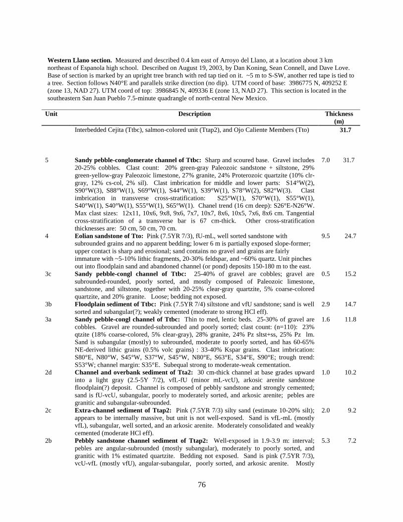
76
Western Llano section. Measured and described 0.4 km east of Arroyo del Llano, at a location about 3 km northeast of Espanola high school. Described on August 19, 2003, by Dan Koning, Sean Connell, and Dave Love. Base of section is marked by an upright tree branch with red tap tied on it. ~5 m to S-SW, another red tape is tied to a tree. Section follows N40°E and parallels strike direction (no dip). UTM coord of base: 3986775 N, 409252 E (zone 13, NAD 27). UTM coord of top: 3986845 N, 409336 E (zone 13, NAD 27). This section is located in the southeastern San Juan Pueblo 7.5-minute quadrangle of north-central New Mexico.
Unit Description Thickness (m)
Interbedded Cejita (Ttbc), salmon-colored unit (Ttap2), and Ojo Caliente Members (Tto) 31.7
5
Sandy pebble-conglomerate channel of Ttbc: Sharp and scoured base. Gravel includes 20-25% cobbles. Clast count: 20% green-gray Paleozoic sandstone + siltstone, 29% green-yellow-gray Paleozoic limestone, 27% granite, 24% Proterozoic quartzite (10% clr-gray, 12% cs-col, 2% sil). Clast imbrication for middle and lower parts: S14°W(2), S90°W(3), S88°W(1), S69°W(1), S44°W(1), S39°W(1), S78°W(2), S82°W(3). Clast imbrication in transverse cross-stratification: S25°W(1), S70°W(1), S55°W(1), S40°W(1), S40°W(1), S55°W(1), S65°W(1). Chanel trend (16 cm deep): S26°E-N26°W. Max clast sizes: 12x11, 10x6, 9x8, 9x6, 7x7, 10x7, 8x6, 10x5, 7x6, 8x6 cm. Tangential cross-stratification of a transverse bar is 67 cm-thick. Other cross-stratification thicknesses are: 50 cm, 50 cm, 70 cm.
7.0 31.7
4
Eolian sandstone of Tto: Pink (7.5YR 7/3), fU-mL, well sorted sandstone with subrounded grains and no apparent bedding; lower 6 m is partially exposed slope-former; upper contact is sharp and erosional; sand contains no gravel and grains are fairly immature with ~5-10% lithic fragments, 20-30% feldspar, and ~60% quartz. Unit pinches out into floodplain sand and abandoned channel (or pond) deposits 150-180 m to the east.
9.5 24.7
3c
Sandy pebble-congl channel of Ttbc: 25-40% of gravel are cobbles; gravel are subrounded-rounded, poorly sorted, and mostly composed of Paleozoic limestone, sandstone, and siltstone, together with 20-25% clear-gray quartzite, 5% coarse-colored quartzite, and 20% granite. Loose; bedding not exposed.
0.5 15.2
3b
Floodplain sediment of Ttbc: Pink (7.5YR 7/4) siltstone and vfU sandstone; sand is well sorted and subangular(?); weakly cemented (moderate to strong HCl eff).
2.9 14.7
3a
Sandy pebble-congl channel of Ttbc: Thin to med, lentic beds. 25-30% of gravel are cobbles. Gravel are rounded-subrounded and poorly sorted; clast count: (n=110): 23% qtzite (18% coarse-colored, 5% clear-gray), 28% granite, 24% Pz sltst+ss, 25% Pz lm. Sand is subangular (mostly) to subrounded, moderate to poorly sorted, and has 60-65% NE-derived lithic grains (0.5% volc grains) : 33-40% Kspar grains. Clast imbrication: S80°E, N80°W, S45°W, S37°W, S45°W, N80°E, S63°E, S34°E, S90°E; trough trend: S53°W; channel margin: S35°E. Subequal strong to moderate-weak cementation.
1.6 11.8
2d
Channel and overbank sediment of Tta2: 30 cm-thick channel at base grades upward into a light gray (2.5-5Y 7/2), vfL-fU (minor mL-vcU), arkosic arenite sandstone floodplain(?) deposit. Channel is composed of pebbly sandstone and strongly cemented; sand is fU-vcU, subangular, poorly to moderately sorted, and arkosic arenite; pebles are granitic and subangular-subrounded.
1.0 10.2
2c
Extra-channel sediment of Ttap2: Pink (7.5YR 7/3) silty sand (estimate 10-20% silt); appears to be internally massive, but unit is not well-exposed. Sand is vfL-mL (mostly vfL), subangular, well sorted, and an arkosic arenite. Moderately consolidated and weakly cemented (moderate HCl eff).
2.0 9.2
2b
Pebbly sandstone channel sediment of Ttap2: Well-exposed in 1.9-3.9 m: interval; pebles are angular-subrounded (mostly subangular), moderately to poorly sorted, and granitic with 1% estimated quartzite. Bedding not exposed. Sand is pink (7.5YR 7/3), vcU-vfL (mostly vfU), angular-subangular, poorly sorted, and arkosic arenite. Mostly
5.3 7.2
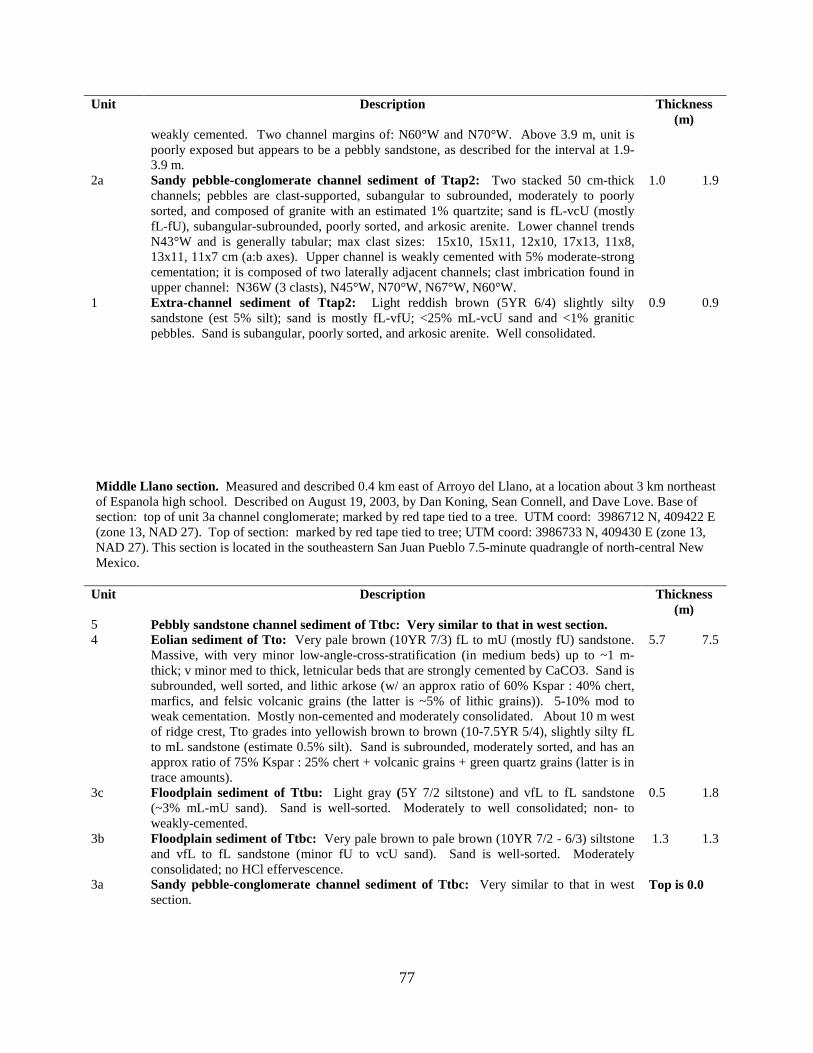
77
Unit Description Thickness (m)
weakly cemented. Two channel margins of: N60°W and N70°W. Above 3.9 m, unit is poorly exposed but appears to be a pebbly sandstone, as described for the interval at 1.9-3.9 m.
2a
Sandy pebble-conglomerate channel sediment of Ttap2: Two stacked 50 cm-thick channels; pebbles are clast-supported, subangular to subrounded, moderately to poorly sorted, and composed of granite with an estimated 1% quartzite; sand is fL-vcU (mostly fL-fU), subangular-subrounded, poorly sorted, and arkosic arenite. Lower channel trends N43°W and is generally tabular; max clast sizes: 15x10, 15x11, 12x10, 17x13, 11x8, 13x11, 11x7 cm (a:b axes). Upper channel is weakly cemented with 5% moderate-strong cementation; it is composed of two laterally adjacent channels; clast imbrication found in upper channel: N36W (3 clasts), N45°W, N70°W, N67°W, N60°W.
1.0 1.9
1 Extra-channel sediment of Ttap2: Light reddish brown (5YR 6/4) slightly silty sandstone (est 5% silt); sand is mostly fL-vfU; <25% mL-vcU sand and <1% granitic pebbles. Sand is subangular, poorly sorted, and arkosic arenite. Well consolidated.
0.9 0.9
Middle Llano section. Measured and described 0.4 km east of Arroyo del Llano, at a location about 3 km northeast of Espanola high school. Described on August 19, 2003, by Dan Koning, Sean Connell, and Dave Love. Base of section: top of unit 3a channel conglomerate; marked by red tape tied to a tree. UTM coord: 3986712 N, 409422 E (zone 13, NAD 27). Top of section: marked by red tape tied to tree; UTM coord: 3986733 N, 409430 E (zone 13, NAD 27). This section is located in the southeastern San Juan Pueblo 7.5-minute quadrangle of north-central New Mexico.
Unit Description Thickness (m)
5 Pebbly sandstone channel sediment of Ttbc: Very similar to that in west section. 4
Eolian sediment of Tto: Very pale brown (10YR 7/3) fL to mU (mostly fU) sandstone. Massive, with very minor low-angle-cross-stratification (in medium beds) up to ~1 m-thick; v minor med to thick, letnicular beds that are strongly cemented by CaCO3. Sand is subrounded, well sorted, and lithic arkose (w/ an approx ratio of 60% Kspar : 40% chert, marfics, and felsic volcanic grains (the latter is ~5% of lithic grains)). 5-10% mod to weak cementation. Mostly non-cemented and moderately consolidated. About 10 m west of ridge crest, Tto grades into yellowish brown to brown (10-7.5YR 5/4), slightly silty fL to mL sandstone (estimate 0.5% silt). Sand is subrounded, moderately sorted, and has an approx ratio of 75% Kspar : 25% chert + volcanic grains + green quartz grains (latter is in trace amounts).
5.7 7.5
3c Floodplain sediment of Ttbu: Light gray (5Y 7/2 siltstone) and vfL to fL sandstone (~3% mL-mU sand). Sand is well-sorted. Moderately to well consolidated; non- to weakly-cemented.
0.5 1.8
3b Floodplain sediment of Ttbc: Very pale brown to pale brown (10YR 7/2 - 6/3) siltstone and vfL to fL sandstone (minor fU to vcU sand). Sand is well-sorted. Moderately consolidated; no HCl effervescence.
1.3 1.3
3a Sandy pebble-conglomerate channel sediment of Ttbc: Very similar to that in west section.
Top is 0.0
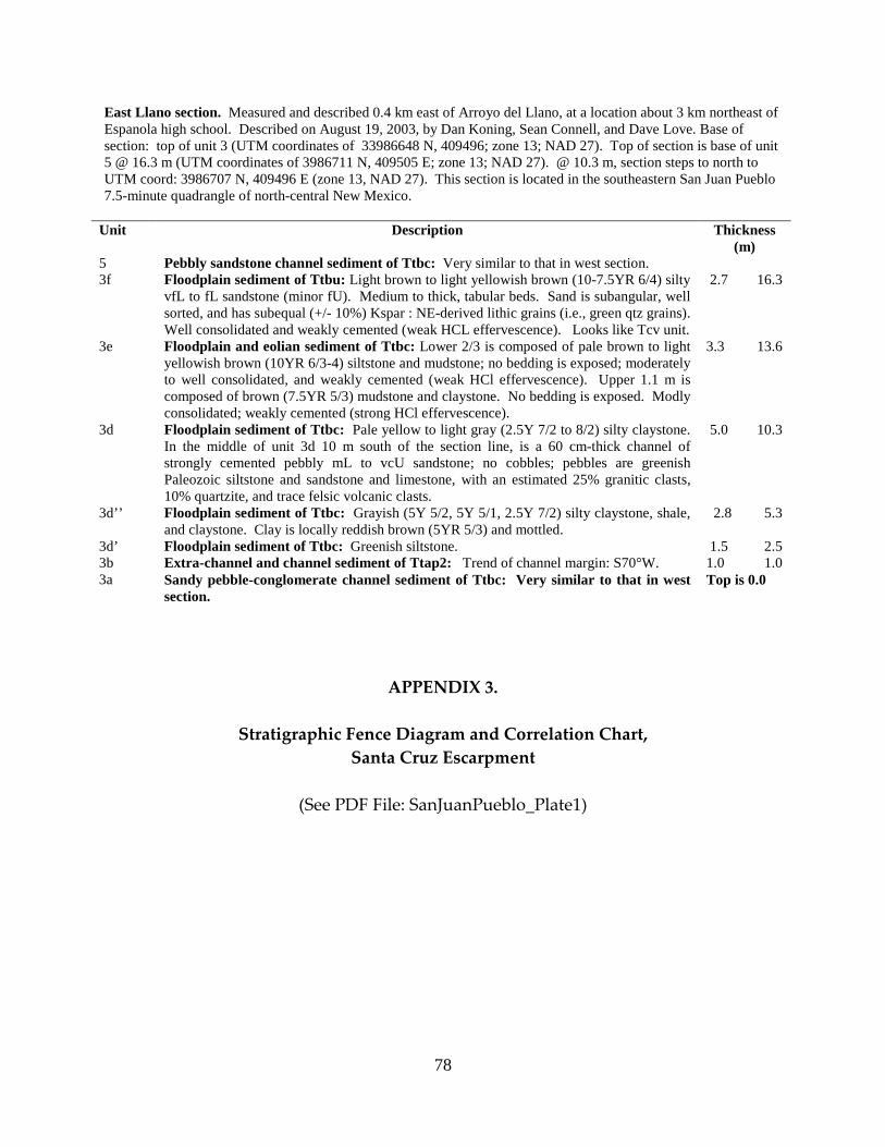
78
East Llano section. Measured and described 0.4 km east of Arroyo del Llano, at a location about 3 km northeast of Espanola high school. Described on August 19, 2003, by Dan Koning, Sean Connell, and Dave Love. Base of section: top of unit 3 (UTM coordinates of 33986648 N, 409496; zone 13; NAD 27). Top of section is base of unit 5 @ 16.3 m (UTM coordinates of 3986711 N, 409505 E; zone 13; NAD 27). @ 10.3 m, section steps to north to UTM coord: 3986707 N, 409496 E (zone 13, NAD 27). This section is located in the southeastern San Juan Pueblo 7.5-minute quadrangle of north-central New Mexico.
Unit Description Thickness (m)
5 Pebbly sandstone channel sediment of Ttbc: Very similar to that in west section. 3f
Floodplain sediment of Ttbu: Light brown to light yellowish brown (10-7.5YR 6/4) silty vfL to fL sandstone (minor fU). Medium to thick, tabular beds. Sand is subangular, well sorted, and has subequal (+/- 10%) Kspar : NE-derived lithic grains (i.e., green qtz grains). Well consolidated and weakly cemented (weak HCL effervescence). Looks like Tcv unit.
2.7 16.3
3e Floodplain and eolian sediment of Ttbc: Lower 2/3 is composed of pale brown to light yellowish brown (10YR 6/3-4) siltstone and mudstone; no bedding is exposed; moderately to well consolidated, and weakly cemented (weak HCl effervescence). Upper 1.1 m is composed of brown (7.5YR 5/3) mudstone and claystone. No bedding is exposed. Modly consolidated; weakly cemented (strong HCl effervescence).
3.3 13.6
3d Floodplain sediment of Ttbc: Pale yellow to light gray (2.5Y 7/2 to 8/2) silty claystone. In the middle of unit 3d 10 m south of the section line, is a 60 cm-thick channel of strongly cemented pebbly mL to vcU sandstone; no cobbles; pebbles are greenish Paleozoic siltstone and sandstone and limestone, with an estimated 25% granitic clasts, 10% quartzite, and trace felsic volcanic clasts.
5.0 10.3
3d’’ Floodplain sediment of Ttbc: Grayish (5Y 5/2, 5Y 5/1, 2.5Y 7/2) silty claystone, shale, and claystone. Clay is locally reddish brown (5YR 5/3) and mottled.
2.8 5.3
3d’ Floodplain sediment of Ttbc: Greenish siltstone. 1.5 2.5 3b Extra-channel and channel sediment of Ttap2: Trend of channel margin: S70°W. 1.0 1.0 3a Sandy pebble-conglomerate channel sediment of Ttbc: Very similar to that in west
section. Top is 0.0
APPENDIX 3.
Stratigraphic Fence Diagram and Correlation Chart, Santa Cruz Escarpment
(See PDF File: SanJuanPueblo_Plate1)

79
APPENDIX 4. PRELIMINARY ALCALDE #1 EXPLORATORY WELL DESCRIPTION
Dan Koning of the New Mexico Bureau of Geology and Mineral Resources
October 20-21, 2005
This document presents descriptions of cuttings from the Alcalde #1 exploratory well. This well was drilled by Rogers Drilling Company, under contract by Glorietta Geosciences. Drilling commenced October 25 and ended October 27. Discrete-zone water sampling was then performed and the hole backfilled. The well is located roughly 0.5 km east of the old church in the town of Alcalde, in the northeastern San Juan Pueblo 7.5-minute quadrangle (location plotted on geologic map). The hole was spud in Holocene alluvium derived from the hills to the east.
The following related to descriptions. Munsell colors were estimated from memory using wet cuttings. Textural
abbreviations include: very fine-lower, vfL; very fine-upper, vfU; fine-lower, fL; fine-upper, fU; medium-lower, mL; medium-upper, mU; coarse-lower, cL; coarse-upper, cU; very coarse-lower, vcL; very coarse-upper, vcU; rounded, rnd; subrounded, subrnd; subangular, subang; angular, ang. % are from visual estimation in the field. The term “similar to Ojo Caliente Sand” means that the sand is mostly of quartz, with 10-20% orange grains (orange-stained quartz + Kspar), and 8-12% lithic grains that may include gray intermediate volcanics, mafics, and reddish brown chert.
Well summary: 0-92 ft: Quaternary alluvium 92-146 ft: Cejita Member of Chamita Formation 146-920 ft: Interbedded Cejita and Vallito Members of Chamita Formation, with much fluvially reworked sand from Ojo Caliente Sandstone of Tesuque Formation. 920-1500 ft: Ojo Caliente Sandstone Member of Tesuque Formation.
Cuttings
depth (ft bgs)
Geophys-ical log depth (ft) Description
0-92 QUATERNARY ALLUVIUM
0-60 0-56 Piedmont sand (Holocene): cL-vcU arkosic sand. 60-70 56-72 Rio Grande floodplain clay (lowest Holocene to very upper Pleistocene(?): Brown. 80-100
72-92 Rio Grande coarse pebbles and cobbles (very upper Pleistocene?): >15 mm-diamater, angular gravel. Gravel includes quartzite and calcic intrusives (granodiorite, quartz diorite, or tonalite). There is minor Paleozoic sedimentary clasts and red volcanic rocks.
92-146 CEJITA MEMBER OF CHAMITA FORMATION
100-120 Sand: Light yellowish brown, mL-cU, quartz-rich, possible mafic-rich igneous grains.
@110-120: AA but with quartzite coarse sand and vf-c quartzite pebbles. Resistivity curves suggests coarse zone at 110-120 ft.
120-130
Sand: m-vc, quartz-rich sand, (Paleozoic sed detritus + quartzite sand grains) > (Kspar) grains. Suborbordinate rounded pebbles of quartzite and Paleozoic limestone. Resistivity curves suggests fine zone at 120-146 ft.
130-140
Sand: fu-vcU sand with much rounded black grains and what appears to be calcic igneous intrusives (granodiorite? or quartz diorite?). Black grains may be basalt.
80
Collectively call both “dark northerly derived grains.”
146-316 VALLITO MEMBER OF CHAMITA FORMATION
140-150
Sand: Very pale brown, mostly fU-mU. Quartz-rich, subrounded, and looks like Ojo Caliente sand but with minor dark northerly derived sand like that in 130-140 ft. Resistivity curves suggests coarse zone at 148-156 ft.
150-190
Sand: Very pale brown, fU-mU. Quartz-rich, subrounded, and looks like Ojo Caliente sand, but with very minor dark northerly derived sand like that in 130-140 ft. @170-180 ft: AA, but with only 1-3% of the dark northerly derived grains. 180-190 ft: AA, but with ~5% of the dark northerly derived grains.
190-220
Sand: Mostly fU, very pale brown, and similar to Ojo Caliente sand. Resistivity curves suggests coarse zone at 202-206 ft.
220-230 Silty sand: Sand is vfU to fU. 230-240
Sand: fU to vcU, poorly sorted sand that includes Ojo Caliente-like sand, Paleozoic sed + quartzite grains, and dark northerly derived grains.
240-260
Sand: mL-mU, subrounded, well-sorted Ojo Caliente-like sand (composed of quartz, 12-15% orange grains (orange-stained quartz + Kspar), and 15-17% dark gray lithics. Very minor (<5%) c-vc Paleozoic sed + quartzite grains and dark northerly derived lithics. @250-260: AA, but with few percent rounded chert in the sand.
260-270
Sand: mL-mU, subrounded, well-sorted Ojo Caliente-like sand (composed of quartz, 12-15% orange grains, and 15-17% dark gray lithics. Very minor (<5%) c-vc Paleozoic sed + quartzite grains. About 1/3 m-vc dark northerly derived lithics. Resistivity curves suggests fine zone at 256-264 ft.
270-280
272-286 Sand: fU-mU, subrounded, moderately sorted Ojo Caliente-like sand composed of quartz, 15-17% lithics (v. minor chert), and 12-15% orange grains; also ~20% dark northerly derived grains (m-vc). @280-290 ft: AA but with 25-35% m-vc northerly derived grains.
290-300
286-296 Sand: fU-mU, subangular to subrounded, well sorted sand similar to Ojo Caliente sand. Sand is compoased of quartz, 12-15% orange grains (Kspar + orange-stained quartz), and 12% assorted lithics.
300-320
296-316 Sand: fL-mL Ojo Caliente-like sand mixed with minor clay and about 25% m-vc, dark northerly derived grains. Poorly sorted. @310-320 ft: AA, but mostly fU-mU and about 30% dark northerly derived grains.
316-
444(?) CEJITA MEMBER OF CHAMITA FORMATION (interbedded with fluvially reworked Ojo Caliente Sand).
320-340
316-335 Sand: Very pale brown, fU-mL sand mixed with ~10% coarser grains of Paleozoic sed detritus and quartzite. The finer sand is subangular to subrounjded, well-sorted, and of quartz, 12-15% orange grains (orange-stained quartz + Kspar), and 12-15% lithics. @330-340 ft: AA but with 20-25% coarser grains of Paleozoic sed detritus and quartzite.
340-360
340-356 Gravel and pebbly sand: Very coarse sand and very fine pebble-size, angular fragments of Paleozoic limestone, Proterozoic quartzite, and minor green Paleozoic sandstone.
360-380
356- Gravel, pebbly sand, sand, and mud: Very coarse sand and very fine pebbles that are subrounded and mixed with minor fL-mL, Ojo Caliente-like sand. Very minor finer sand and mud.
380-390
-382 Sand with very minor pebbles: Sand is mostly fU-mL and similar to Ojo Caliente sand. This sand is mixed with 10-20% very fine pebbles and coarse sand of Paleozoic sed detritus and quartzite.
390-400 382-392 Mud: Mud mixed with minor very coarse sand of Paleozoic sed detritus and quartzite. 400-410 392- Sand: fU-mL, Ojo Caliente-like sand mixed with ~5% coarser sand of Paleozoic sed
81
detritus and quartzite. The former sand is of quartz, 12-15% orange grains (orange-stained quartz + Kspar), and 15-20% dark gray lithics. Well-sorted and subrounded-subangular.
410-420 Sand: fU-mL, Ojo Caliente-like sand mixed with ~10% coarser sand and very fine pebbles of Paleozoic sed detritus and quartzite. The former sand is of quartz, 12-15% orange grains (orange-stained quartz + Kspar), and 15-20% dark gray lithics. Well-sorted and subrounded-subangular.
420-430 Slightly silty sand: Sand is fL-mU and similar to Ojo Caliente sand. ~5% coarser sand and very fine pebbles of Paleozoic sed detritus and quartzite.
430-450 Sand: mL-mU sand with quartz, ~12% orange grains (orange-stained quartz + Kspar), and 15% dark lithics. Sand is subrounded (mostly) to subangular, moderately to well sorted, and has 10% coarse to very coarse sand grains + very fine pebbles of Paleozoic sed detritus and quartzite. @430-432: Resistivity curves suggest coarse zone. @442-444: Resistivity curves suggest coarse zone.
450-460 -444(?) Sand: mL-mU sand with quartz, 12-15% orange grains (orange-stained quartz + Kspar), and 12-15% dark lithics. Sand is subrounded (mostly) to subangular, moderately to well sorted, and has 5-10% coarse to very coarse sand grains + very fine pebbles of Paleozoic sed detritus and quartzite.
460-500 444(?)-
515
VALLITO MEMBER OF CHAMITA FORMATION
Sand: mL-cL, subrounded, well-sorted Ojo Caliente-like sand. @470-480 (cuttings depth): Silty sand. @444-488: Resistivity curves suggest fine zone.
500-510 492-502 Muddy sand: Brown, muddy fL-mL sand similar to Ojo Caliente sand. 510-520 Slightly muddy sand: Slightly muddy mU-cL sand similar to Ojo Caliente sand.
@502-510: Resistivity curves suggest coarse zone. 515-548 CEJITA MEMBER OF CHAMITA FORMATION
520-540 515 Mudstone: Mud is brown and mixed with very fine to coarse sand.
@ 515-548 ft: Resistivity curves suggest fine zone. 540-550 -548 Slightly muddy sand: Slightly muddy, mU-cL sand similar to Ojo Caliente sand. Sand
is subrounded and well-sorted. 550-690 548-665 VALLITO MEMBER OF CHAMITA FORMATION
550-560 548- Slightly muddy sand: Slightly muddy, mU-cL sand similar to Ojo Caliente sand. Sand
is subrounded and well-sorted. @552-558 ft: Resistivity curves suggest coarse zone.
560-580 Sand: mL-mU (mostly)-cL, subrounded (mostly) to subangular, well sorted sand similar in composition to Ojo Caliente sand.
580-610 Sand: mL-cL, well-sorted, subrounded sand. Sand is composed of quartz with 12% orange grains (orange-stained quartz + Kspar) and 10-15% lithic grains, 1-2% of the latter appear to be green Paleozoic sandstone detritus.
610-620 Sand: fU-vcL. Moderately sorted, subangular to subrounded sand composed of quartz, 15% orange grains (orange-stained quartz + Kspar), and 10% volcanic-dominated lithic grains with 1% green Paleozoic sandstone detritus.
620-630 Sand: mL-vcU, moderately sorted, subangular (mostly) to subrounded sand composed of quartz, ~15% orange grains (orange-stained quartz + Kspar), and 10% volcanic- and mafic-rich lithic grains. ~1% green Paleozoic sandstone detritus.

82
620-650 Sand with minor pebbles: mL-vcU and ~1% very fine pebbles. Grrains are subrounded to subangular, moderately sorted, and composed of quartz with 12% orange grains (orange-stained quartz + Kspar), and 10% lithic grains. Lithic grains include volcanics, mafics, and enigmatic dark grains that may include Pilar phyllite. ~1% green Paleozoic sandstone detritus.
650-670 Sand: mL-vcU, moderately sorted, subangular to subrounded sand with trace very fine pebbles. Sand is composed of quartz, 12% orange grains (orange-stained quartz + Kspar), and 10% lithic grains of dark clasts and quartzite. No green Paleozoic sandstone detritus.
670-680 Sand: vfU to mL (mostly) to vcU, subangular to subrounded, moderately sorted sand. Sand is composed of ~12% orange grains (orange-stained quartz + Kspar), ~10% dark lithics (including possible mafic-calcic igneous intrusive rocks), and at least one quartzite.
680-690 -665 Slightly silty sand: fu-vcU, slightly silty, moderately to poorly sorted, subrounded to subangular sand. Sand does not look like pure Ojo Caliente sand. Sand is composed of quartz, 12% orange grains (orange-stained quartz + Kspar), and 10% lithic grains (very dark gray unidentified lithics plus minor mafic-calcic mafic igneous intrusions, green Paleozoic sandstone detritus, and quartzite).
665-920 CEJITA MEMBER OF CHAMITA FORMATION
690-780 Sand: mU-vcU, moderately to well sorted, subrounded sand that has quartz, 12%
orange grains (orange-stained quartz + Kspar), and 15-17% lithic grains. The lithic grains are 1/3-1/4 dark lithics (basalt?) and 2/3-3/4 green-gray Paleozoic sandstone and limestone.
780-870 -835 Sand: fU-vcU, moderately to well sorted, subrounded-rounded sand that has quartz, 10-15% orange grains (orange-stained quartz + Kspar), and 12-15% lithic grains. The lithic grains are 1/3-1/4 dark lithics (basalt?) and 2/3-3/4 green-gray Paleozoic sandstone and limestone; there are also minor chert and mafic grains. The proportion of lithic grains decreases down-hole in this unit.
870-940 835-920 Sand: mU-cU, subrounded-rounded, well-sorted sand composed of quartz, 10-12% orange grains (orange-stained quartz + Kspar), and 10-15% lithics similar to those described in unit above.
920-
1500 OJO CALIENTE SANDSTONE MEMBER OF TESUQUE FORMATION
920-1500
Sand: mL-cL, subrounded to rounded, well-sorted sand very similar to Ojo Caliente sand. Sand composed of quartz, 7-10% orange grains (orange-stained quartz + Kspar), and 10-12% lithics. Lithics include chert, volcanic, mafics, and unidentified. @920-1015: Mostly mL-cL sand. @1015-1055: Mostly fU-mU sand. 1055-1500: Mostly mL-cL sand.
Notes: 1. The main criteria for distinguishing the eolianite Ojo Caliente Sandstone of Tesuque Formation from
overlying fluvially reworked sand was grain size (less than cU and greater than fL), composition of lithics (no Paleozoic detritus, no mafic-calcic igneous intrusives, no quartzite, no Pilar phyllite, no basalt; lithics in Ojo Caliente Sandstone are marked by having chert and grayish intermediate volcanic grains). On geophysical logs, there is a slight decrease in the gamma ray curve, and generally the resistivity and SP curves are relatively steady.
83
2. The Vallito and Cejita Members below 146 feet-depth are difficult to differentiate. Conceptually, the Vallito Member should be dominated by detritus from the San Luis basin and Picuris Mountains, while the Cejita Member is dominated by detritus from the Penasco embayment. Detritus from the San Luis Basin + Picuris Mountains includes green-brown Paleozoic sandstone detritus, quartzite, Pilar Phyllite, and mafic-calcic igneous intrusions. Detritus from the Penasco embayment includes green Paleozoic sandstone detritus, Paleozoic limestone, and quartzite. Relatively pure Ojo Caliente sand-like beds, both eolian and fluvially reworked, is typical throughout the Vallito Member. The lower ¾ of the Vallito Member generally lacks mudstone beds. Fluvially reworked, Ojo Caliente-like sand is only found in the westernmost part of the Cejita Member, where it is interspersed with sparse lenses of coarser sand and pebbles of Paleozoic sandstone and limestone detritus and Proterozoic quartzite. Outcrops showing the interfingering of these two units are found at the south tip of Black Mesa and south of Hernandez (Koning and Manley, 2005). Unfortunately, these outcrops are on either private property or Pueblo lands. An outcrop on State trust land of this interfingering relation is found immediately northeast of Velarde.
3. Koning and Aby (2005) restrict the use of the Chamita Formation to west of the Rio Grande inner valley.
I did not specify in paper, but I would bring the Chamita Formation to whatever is buried by the Quaternary alluvium in this valley.
COMMENTS TO USERS: The document is the author’s summary of his notes of the lithologic units encountered in the Alcalde #1 exploratory
borehole, drilled by Rogers Drilling Company in the last full week of October-2005. This document has not been
reviewed according to New Mexico Bureau of Mines and Mineral Resources standards. Revision of descriptions
and interpretations of these lithologic units is likely. The views and conclusions contained in this document are
those of the author and should not be interpreted as necessarily representing the official policies, either expressed or
implied, of the State of New Mexico, or the U.S. Government.
APPENDIX 5.
San Juan Pueblo Quadrangle Photos
(See PDF File: SanJuanPueblo_Photos)