geologic factors in the settlement of addison...

1
Geologic Factors in the Settlement of Addison County Overview Vermont at the time of settlement was a vast, rugged, wild, and expansive tract of land with relatively little competition or regulation. Indigenous groups had used the area for centuries as hunting and fishing grounds, but never as an area of consistent occupation (Dodge 1986). Small-scale endeavors to inhabit the area by Europeans began in the sixteen hundreds, but it was not until the eighteenth cen- tury that people came in any significant numbers (Mires 1993). They journeyed to this foreign terrain to carve out their own piece of the landscape, tame it, and make a life there that was better than the one they came from. Since the states to the south of Vermont had been explored and settled in earlier years, people naturally moved into Vermont from the south, slowly testing the state’s outermost edges before expanding northward into areas like Addison County. Geologic Factors The tectonic and geologic history associated with the formation of the Ver- mont region has produced a heterogeneous and widely variable landscape. Vermont has been affected by repeated glacial advances and retreats; result- ing in the formative erosion that created interspersed lowland valleys and hilly terrains, as well as the sedimentary deposition that largely defines the soil composition and bedrock exposures in the area. This area also experienced dramatic sea level change, continental rifting, continental collision, and mul- tiple episodes of thrusting (Amidon 1/11/2012). These factors, among others, have shaped and molded the landscape into what we see today. Addison County Landscape From UVM Landscape Change This image shows the dramatic changes in elevation within Addison County, from valley floor to the mountain peaks in the background. These elevation changes are greatly influential in causing localized environmental variation. Hydrology Despite being in the middle of a landlocked state, Addison County’s accessible bodies of water include Otter Creek, which is one of the state’s largest rivers, freshwater Lake Champlain on the northwestern border, several smaller lakes like Lake Dunmore in the south, and smaller brooks and creeks throughout the county. Precipitation in this area is relatively stable and ample, with an annual range of 32-50in depending on elevation (Griggs 1971). This ensures that Addison County’s many rivers are actively fed by rainfall or mountain snowmelt, and also maintains the region’s groundwater supply. One landowner is quoted as saying “In digging wells near [the Middlebury River], after penetrating the vegetable mould...you come to a bed of coarser sand, in which water, at no great depth, is invariably found” (Hall 1821). Otter Creek is one of the most influential factors in the settlement of Addison County. According to Swift, “From the head of the falls in Middlebury, to the foot of the falls in Vergennes, there is a descent of about three hundred feet, in a dis- tance of about thirteen miles, divided into six or seven falls convenient for mills” (Swift 1971). According to Fredrick Hall, these falls “may, with propriety, be re- garded as one of the leading sources of the wealth and prosperity of the town.” Saw mills, grist mills, forges, tanneries, factories, and other machinery were all built along these rivers using hydropower during the earliest period of industry in Addison County, enticing more and more people to settle this area (Swift 1971). Middlebury Falls From Swift 1971 Depicting the waterfall running through the town of Middlebury, Vermont. Like many other falls along this stretch of the river, the Middlebury Falls was recognized and capi- talized upon by settlers as a powerful source of energy. Soil Types The many variations in the landscape extend below the earth’s surface as well. John E. Griggs in his Soil Survey of Addison County breaks the county into soils from three distinct sources. The first in- cludes soils from water-deposited material in the Champlain Valley, the second encompasses the soils that originated from glacial till in the Champlain valley, and the third consists of soils in the Green Mountains and associated foothills. Soils formed in water-deposited material can be found in most of the western two-thirds of Addi- son County (General Soil Map 1970). The majority of these soils are texturally between sand and clay. The most common soil type belongs to the Vergennes-Covington association, making up thirty-six percent of the overall Addison County soils. This soil type represents some of the best agricultural land available to the county; it is clay-rich, moderately free of stony impediments, and is found on relatively flat plains and terraces (Griggs 1971). Approximately one third of Addison County, from Lake Dunmore eastward, is dominated by the Green Mountain and associated foothills soils (General Soil Map 1970). These soils are predominantly “well drained, loamy, and moderately sloping to steep.” The Lymann-Berkshire-Marlow association is the most prevalent soil type in this grouping, making up nineteen percent of the soils in the entire county (Griggs 1971). The third, and least prevalent soil category is that of soils formed in glacial till. These soils are only present in the western part of the county, interspersed within the larger areas of soils from water- deposited material (General Soil Map 1970). This grouping is found on elevated hills and ridges, is well drained, and generally contains a high volume of stones (Griggs 1971). Conclusions: Settlement of Addison County A fairly large portion of the land within Addison County would have attracted settlers because of its agricultural viability. Once cleared of trees and possibly drained, many areas could provide settlers with flat, productive land suitable for such things as “corn, hay, and pasture” (Griggs 1971) as well as “oats, barley, buck-wheat, peas, beans, and potatoes” (Hall 1821). The wide flats along the banks of the Middlebury river would also have been advantageous for settles, as they mitigate the affects of spring snowmelts or surpluses of rainfall. Proximity to water sources would have been another essential component for pioneers investigating this new land. Addison County’s numerous water sources, as well as the ease of drilling wells would have been very attractive to new settlers (Hall 1821). These waterways also provided a method of access to the land, allowing arrival by boat, as well as a mode of transportation and com- merce once communities were established (Swift 1971). Settlers originally may have favored land at higher elevations, where vegeta- tion was less dense and clearing the land less intensive (Mires 1993). However, the slope and excess stoniness of these soil types make them largely unsuitable for agriculture (General Soil Map 1970). Also, this same lack of general vegeta- tion on the tops of hills and ridges would provide less organic material, causing thinner and less productive soil (Griggs 1971). Of the thirty-six most common soil types in Addison County, interpretations of the General Soil Map of Addison County has classified thirty-three of them as having moderate to severe limita- tions for agricultural land use (General Soil Map 1970). The high clay content of many of these soils can cause them to drain poorly, making them very suscep- tible to excess rainfall (Meeks 1986). However, many lands that were unsuitable for farming because of their slope, rockiness, or soil type made very productive grazing land. Many of the glacial-till based soils are found on excessively steep terrain or lack sufficient soil depth for productive agriculture, however were likely used as cow or sheep pasture (Meeks 1986). A Boy and His Cow From UVM Landscape Change The people of the time be- lieved that the clay rich soils of Addison County produced grass that is “much more nu- tritious, than that which is grown on lighter soils.” It was even claimed that “the butchers of Brighton could distinguish, by the appear- ance and feel, the fat cattle from this part of Vermont” (Swift 1971). Map of Addison County From Beers Atlases This map shows the different towns that make up historic Addison County, along with major topo- graphical features like the Otter Creek River, which runs from Lake Champlain south through Addison county, and is one of the most important features for the emergence of industry in this part of Ver- mont. My investigation focuses on the settlement of Addison County, in central west- ern Vermont and the logistics behind why people would chose to occupy this un- known wilderness. Vermont was settled relatively late compared to other states in the area, largely because of climatic and geologic reasons. Long, intense winters indicate a short growing season and high risks associated with maintaining year- long residences. Other limiting factors include Vermont’s uneven topography, low quantity of viable agricultural land, and the densely wooded nature of the land- scape (Dodge 1986). Despite these drawbacks, there were many reasons why Ad- dison County was actively settled. The summer months are modestly warm, with adequate precipitation, and the affects of storms originating from the ocean to the east are largely mitigated by the presence of the Green Mountains (Griggs 1971). The county is also in close proximity to several bodies of water for irrigation pur- poses. All over the state farming was initially the principal form of subsistence, so choosing a place to live was synonymous with finding a place to farm, with all of these considerations to take into account. The question of how these early pio- neers chose where to establish their farmsteads appears to have been a process in- timately connected to the land. It was a decision which was to determine the liveli- hood, if not the life and death, of their family unit and would have been based heavily on the topography, hydrology, and mineralogy of the land. Works Cited Dodge, Nancy L., 1986. Settlement and cemeteries in Vermont's Northeast Kingdom : including indexed transcriptions from Gravesites in Canaan, Lemington, Bloomfield, Brunswick, and Maidstone, Vermont, and in Hereford, Quebec. Salem, Mass. : Higginson Books. General Soil Map: Addison County, Vermont. U.S. Department of Agriculture Soil Conservation Service, U.S. Forest Service, Vermont Agricultural Experiment Station, Vermont Department of Forests and Parks. 1:126,720. 1970. Griggs, John Ernest, 1971. Soil Survey, Addison County, Vermont. U.S. Soil Conservation Service; [for sale by the Supt. of Docs., U.S. Govt. Print. Off.] Hall, Frederick, 1821. A Statistical Account of the Town of Middlebury. Sewell Phelps, Boston. Images from UVM Landscape Change. http://www.uvm.edu/landscape/ Meeks, Harold A., 1986. Vermont’s Land and Resources. New England Press, Shelburne. Middlebury College Index of /SharingVTHistory/MapsAtlases. Beers_Addison_Cnty001.jpg Mires, Peter B., 1993. The Importance of Aspect to Historic Farmstead Site Location in the Green Mountains of Vermont. Society for Historical Archaeology. Vol. 27, No. 4 (1993), pp. 82-91. Swift, Samuel. History of the Town of Middlebury in the Country of Addison, Vermont: To Which Is Prefixed a Statistical and Historical Account of the County, Written at the Request of the Historical Society of Middlebury. Rutland, Vt: C.E. Tuttle Co, 1971. Print. Sarah Studwell

Upload: vohanh

Post on 23-Aug-2018

220 views

Category:

Documents


0 download

TRANSCRIPT

Geologic Factors in the Settlement of Addison CountyOverview

Vermont at the time of settlement was a vast, rugged, wild, and expansive tract of land with relatively little competition or regulation. Indigenous groups had used the area for centuries as hunting and fishing grounds, but never as an area of consistent occupation (Dodge 1986). Small-scale endeavors to inhabit the area by Europeans began in the sixteen hundreds, but it was not until the eighteenth cen-tury that people came in any significant numbers (Mires 1993). They journeyed to this foreign terrain to carve out their own piece of the landscape, tame it, and make a life there that was better than the one they came from. Since the states to the south of Vermont had been explored and settled in earlier years, people naturally moved into Vermont from the south, slowly testing the state’s outermost edges before expanding northward into areas like Addison County.

Geologic Factors The tectonic and geologic history associated with the formation of the Ver-mont region has produced a heterogeneous and widely variable landscape. Vermont has been affected by repeated glacial advances and retreats; result-ing in the formative erosion that created interspersed lowland valleys and hilly terrains, as well as the sedimentary deposition that largely defines the soil composition and bedrock exposures in the area. This area also experienced dramatic sea level change, continental rifting, continental collision, and mul-tiple episodes of thrusting (Amidon 1/11/2012). These factors, among others, have shaped and molded the landscape into what we see today.

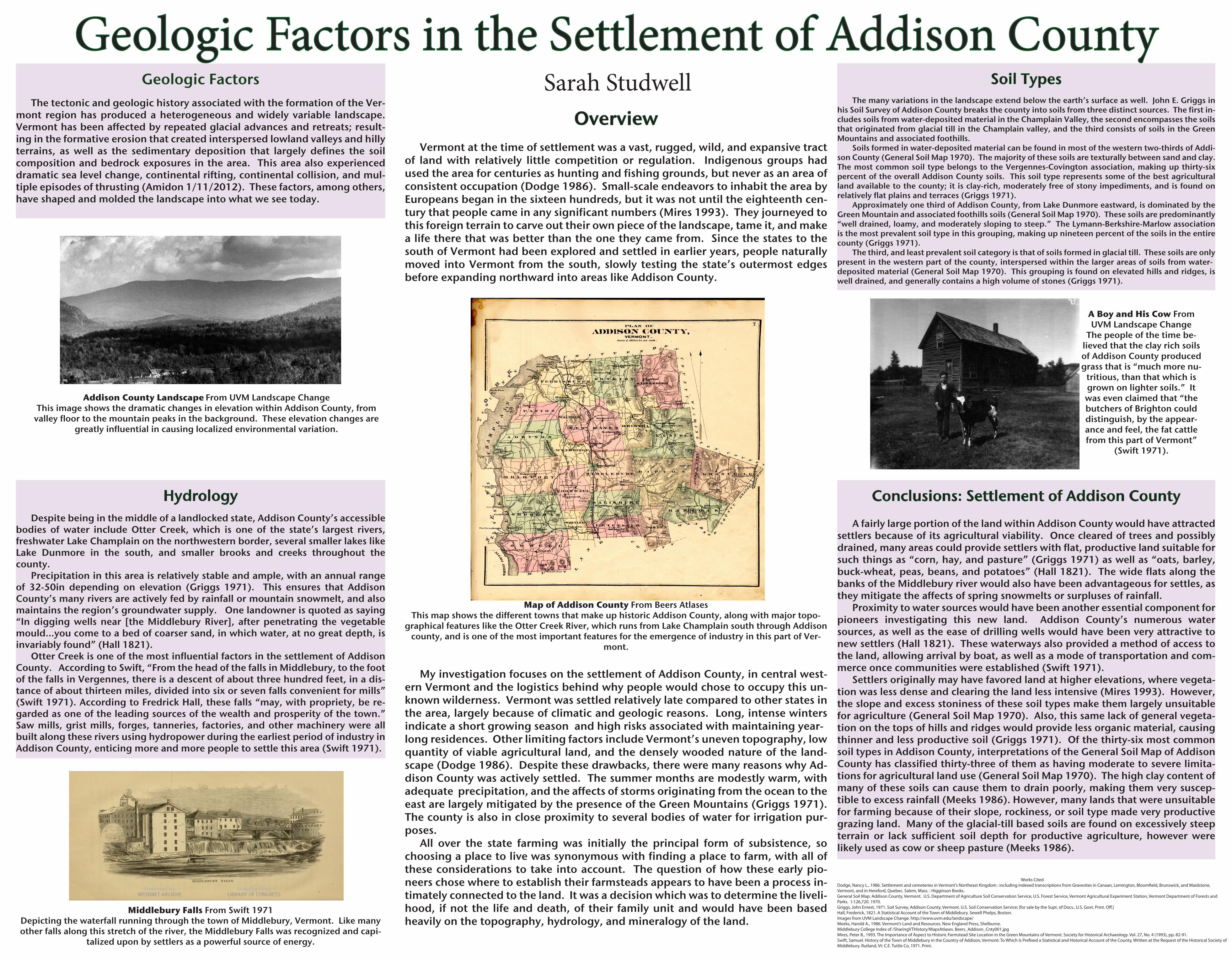
Addison County Landscape From UVM Landscape ChangeThis image shows the dramatic changes in elevation within Addison County, from

valley floor to the mountain peaks in the background. These elevation changes are greatly influential in causing localized environmental variation.

Hydrology Despite being in the middle of a landlocked state, Addison County’s accessible bodies of water include Otter Creek, which is one of the state’s largest rivers, freshwater Lake Champlain on the northwestern border, several smaller lakes like Lake Dunmore in the south, and smaller brooks and creeks throughout the county. Precipitation in this area is relatively stable and ample, with an annual range of 32-50in depending on elevation (Griggs 1971). This ensures that Addison County’s many rivers are actively fed by rainfall or mountain snowmelt, and also maintains the region’s groundwater supply. One landowner is quoted as saying “In digging wells near [the Middlebury River], after penetrating the vegetable mould...you come to a bed of coarser sand, in which water, at no great depth, is invariably found” (Hall 1821). Otter Creek is one of the most influential factors in the settlement of Addison County. According to Swift, “From the head of the falls in Middlebury, to the foot of the falls in Vergennes, there is a descent of about three hundred feet, in a dis-tance of about thirteen miles, divided into six or seven falls convenient for mills” (Swift 1971). According to Fredrick Hall, these falls “may, with propriety, be re-garded as one of the leading sources of the wealth and prosperity of the town.” Saw mills, grist mills, forges, tanneries, factories, and other machinery were all built along these rivers using hydropower during the earliest period of industry in Addison County, enticing more and more people to settle this area (Swift 1971).

Middlebury Falls From Swift 1971Depicting the waterfall running through the town of Middlebury, Vermont. Like many other falls along this stretch of the river, the Middlebury Falls was recognized and capi-

talized upon by settlers as a powerful source of energy.

Soil Types The many variations in the landscape extend below the earth’s surface as well. John E. Griggs in his Soil Survey of Addison County breaks the county into soils from three distinct sources. The first in-cludes soils from water-deposited material in the Champlain Valley, the second encompasses the soils that originated from glacial till in the Champlain valley, and the third consists of soils in the Green Mountains and associated foothills. Soils formed in water-deposited material can be found in most of the western two-thirds of Addi-son County (General Soil Map 1970). The majority of these soils are texturally between sand and clay. The most common soil type belongs to the Vergennes-Covington association, making up thirty-six percent of the overall Addison County soils. This soil type represents some of the best agricultural land available to the county; it is clay-rich, moderately free of stony impediments, and is found on relatively flat plains and terraces (Griggs 1971). Approximately one third of Addison County, from Lake Dunmore eastward, is dominated by the Green Mountain and associated foothills soils (General Soil Map 1970). These soils are predominantly “well drained, loamy, and moderately sloping to steep.” The Lymann-Berkshire-Marlow association is the most prevalent soil type in this grouping, making up nineteen percent of the soils in the entire county (Griggs 1971). The third, and least prevalent soil category is that of soils formed in glacial till. These soils are only present in the western part of the county, interspersed within the larger areas of soils from water-deposited material (General Soil Map 1970). This grouping is found on elevated hills and ridges, is well drained, and generally contains a high volume of stones (Griggs 1971).

Conclusions: Settlement of Addison County

A fairly large portion of the land within Addison County would have attracted settlers because of its agricultural viability. Once cleared of trees and possibly drained, many areas could provide settlers with flat, productive land suitable for such things as “corn, hay, and pasture” (Griggs 1971) as well as “oats, barley, buck-wheat, peas, beans, and potatoes” (Hall 1821). The wide flats along the banks of the Middlebury river would also have been advantageous for settles, as they mitigate the affects of spring snowmelts or surpluses of rainfall. Proximity to water sources would have been another essential component for pioneers investigating this new land. Addison County’s numerous water sources, as well as the ease of drilling wells would have been very attractive to new settlers (Hall 1821). These waterways also provided a method of access to the land, allowing arrival by boat, as well as a mode of transportation and com-merce once communities were established (Swift 1971). Settlers originally may have favored land at higher elevations, where vegeta-tion was less dense and clearing the land less intensive (Mires 1993). However, the slope and excess stoniness of these soil types make them largely unsuitable for agriculture (General Soil Map 1970). Also, this same lack of general vegeta-tion on the tops of hills and ridges would provide less organic material, causing thinner and less productive soil (Griggs 1971). Of the thirty-six most common soil types in Addison County, interpretations of the General Soil Map of Addison County has classified thirty-three of them as having moderate to severe limita-tions for agricultural land use (General Soil Map 1970). The high clay content of many of these soils can cause them to drain poorly, making them very suscep-tible to excess rainfall (Meeks 1986). However, many lands that were unsuitable for farming because of their slope, rockiness, or soil type made very productive grazing land. Many of the glacial-till based soils are found on excessively steep terrain or lack sufficient soil depth for productive agriculture, however were likely used as cow or sheep pasture (Meeks 1986).

A Boy and His Cow From UVM Landscape Change

The people of the time be-lieved that the clay rich soils of Addison County produced grass that is “much more nu-

tritious, than that which is grown on lighter soils.” It was even claimed that “the butchers of Brighton could distinguish, by the appear-ance and feel, the fat cattle from this part of Vermont”

(Swift 1971).

Map of Addison County From Beers AtlasesThis map shows the different towns that make up historic Addison County, along with major topo-

graphical features like the Otter Creek River, which runs from Lake Champlain south through Addison county, and is one of the most important features for the emergence of industry in this part of Ver-

mont.

My investigation focuses on the settlement of Addison County, in central west-ern Vermont and the logistics behind why people would chose to occupy this un-known wilderness. Vermont was settled relatively late compared to other states in the area, largely because of climatic and geologic reasons. Long, intense winters indicate a short growing season and high risks associated with maintaining year-long residences. Other limiting factors include Vermont’s uneven topography, low quantity of viable agricultural land, and the densely wooded nature of the land-scape (Dodge 1986). Despite these drawbacks, there were many reasons why Ad-dison County was actively settled. The summer months are modestly warm, with adequate precipitation, and the affects of storms originating from the ocean to the east are largely mitigated by the presence of the Green Mountains (Griggs 1971). The county is also in close proximity to several bodies of water for irrigation pur-poses. All over the state farming was initially the principal form of subsistence, so choosing a place to live was synonymous with finding a place to farm, with all of these considerations to take into account. The question of how these early pio-neers chose where to establish their farmsteads appears to have been a process in-timately connected to the land. It was a decision which was to determine the liveli-hood, if not the life and death, of their family unit and would have been based heavily on the topography, hydrology, and mineralogy of the land.

Works CitedDodge, Nancy L., 1986. Settlement and cemeteries in Vermont's Northeast Kingdom : including indexed transcriptions from Gravesites in Canaan, Lemington, Bloom�eld, Brunswick, and Maidstone, Vermont, and in Hereford, Quebec. Salem, Mass. : Higginson Books.General Soil Map: Addison County, Vermont. U.S. Department of Agriculture Soil Conservation Service, U.S. Forest Service, Vermont Agricultural Experiment Station, Vermont Department of Forests and Parks. 1:126,720. 1970.Griggs, John Ernest, 1971. Soil Survey, Addison County, Vermont. U.S. Soil Conservation Service; [for sale by the Supt. of Docs., U.S. Govt. Print. O�.]Hall, Frederick, 1821. A Statistical Account of the Town of Middlebury. Sewell Phelps, Boston.Images from UVM Landscape Change. http://www.uvm.edu/landscape/Meeks, Harold A., 1986. Vermont’s Land and Resources. New England Press, Shelburne.Middlebury College Index of /SharingVTHistory/MapsAtlases. Beers_Addison_Cnty001.jpgMires, Peter B., 1993. The Importance of Aspect to Historic Farmstead Site Location in the Green Mountains of Vermont. Society for Historical Archaeology. Vol. 27, No. 4 (1993), pp. 82-91.Swift, Samuel. History of the Town of Middlebury in the Country of Addison, Vermont: To Which Is Pre�xed a Statistical and Historical Account of the County, Written at the Request of the Historical Society of Middlebury. Rutland, Vt: C.E. Tuttle Co, 1971. Print.

Sarah Studwell