geography world. compass & cardinal direction compass – an instrument used to show direction....
TRANSCRIPT

GEOGRAPHY
WORLD

Compass & Cardinal direction
• Compass – an instrument used to show direction.
• The cardinal directions are North, South, East and West

Longitude
• The vertical lines are called lines of longitude. • Lines of longitude are also called meridians.• Longitude lines run North and South.• Prime Meridian is middle point

Latitude
• The horizontal lines are called lines of latitude.
• Parallel is another name for latitude lines. • Latitude lines run east and west around the
Earth.

Hemispheres
EQUATORLatitudeRuns west and east in middle of Earth
PRIME MERIDIANLongitudeRuns north and south in middle of Earth

Continents – continuous land mass
NORTH AMERICA
SOUTH AMERICA
AFRICA
AUSTRALIA
EUROPEASIA
ANTARCTICA

COUNTRIES – are part of continents
SOUTH AMERICA
ASIA

STATES – are part of countries
SOUTH AMERICA
ASIA

Capital
• The most important city or town of a country• The capital of Illinois is Springfield• The capital of the USA is Washington D.C

Counties – are part of states

Cities are part of counties

CONTINENTCOUNTRYSTATECOUNTYCITY

Oceans • Ocean: a large body of salt water. • There are 5 major oceans on Earth:1.Pacific Ocean2.Atlantic Ocean3.Indian Ocean4.Arctic Ocean5.Southern Ocean* *the newest ocean being declared an ocean in
2000

Landforms
• Landforms are natural features of the landscape, natural physical features of the earth's surface.
• for example: mountains, water, valleys, plateaus, plains, hills or glaciers.
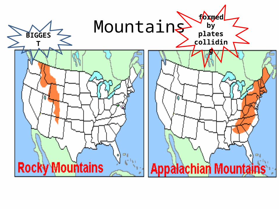
MountainsBIGGEST
formed by plates
colliding

WATER
ATLANTIC
PACIFIC
Gulf of Mexico
MISSISSIPPI RIVER

WATER
MISSISSIPPI RIVER
MISSISSIPPI RIVER

Grand Canyon, Great Lakes, & Hawaiian Islands
formed by running water
formed by glaciers
formed by volcanoes
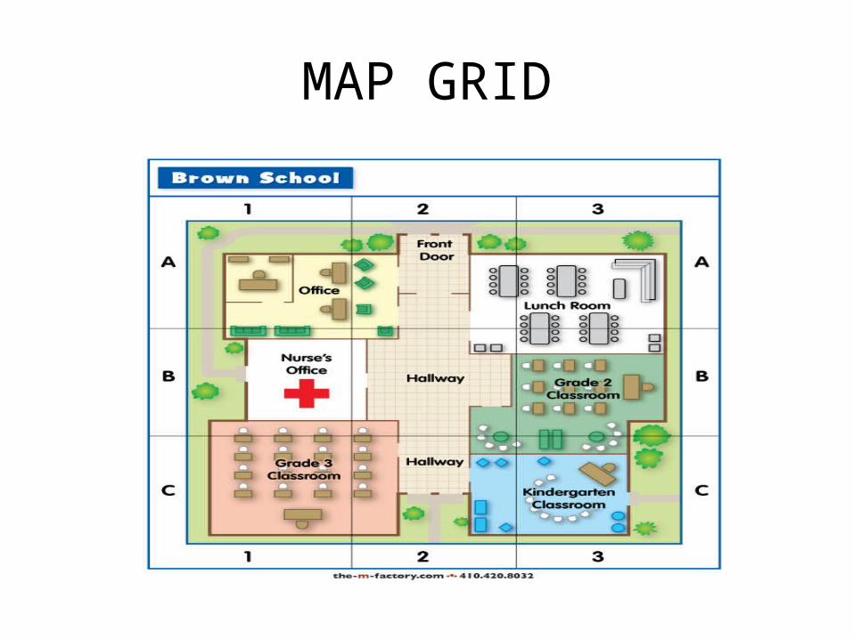
MAP GRID
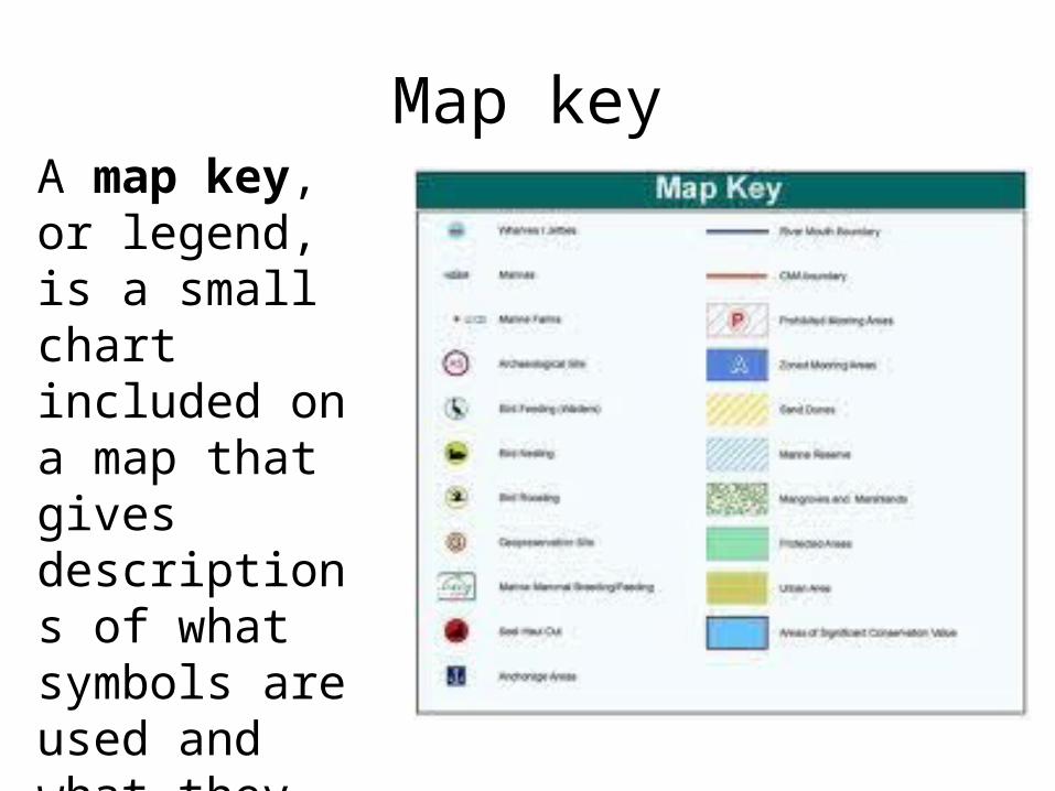
Map keyA map key, or legend, is a small chart included on a map that gives descriptions of what symbols are used and what they stand for.

Distance Scale

Political map
showsboundaries

Physical map
showslandformsand water
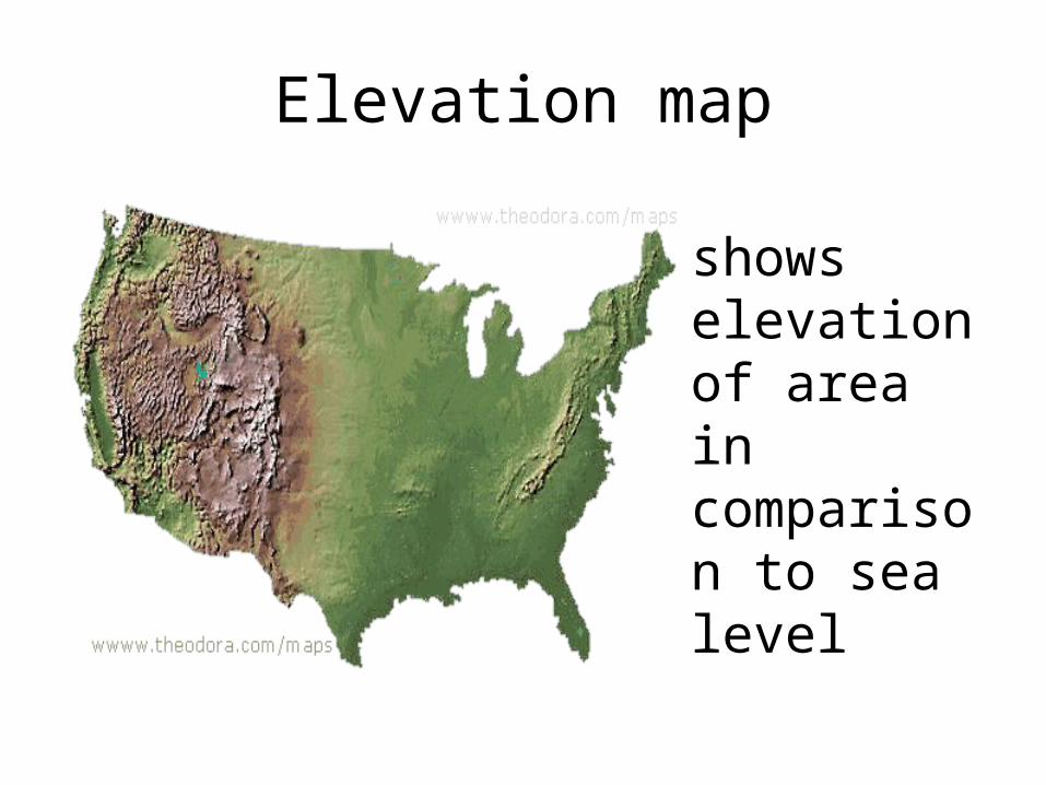
Elevation map
showselevationof area in comparison to sea level

Population map
showsareas of high and low population

Natural Resource map
showswhere resources of an area can be found

Climate map

REGIONS
DESERT
PLAINS
mountains
mou
ntai
ns
tundra
rainforest

REGIONS
CACTUS
GRASSLANDS
THICK
FORESTS
THICK
FOREST
S
PALM TREESPALM
TREES
CYPRESS TREES

HOW PEOPLE MODIFY LAND
IRRIGATION
DUST BOWL
& pesticid
es
CUTTIN
G TR
EES
CUTT
IN
G
TREE
S
LEVEES
DRAINING SWAMPS
MINING

U.S. LANGUAGESALL REGIONS MAINLY ENGLISH
Some Spanish Some French
Some Spanish

POPULATION OF REGIONS
BIG CITIES of New York, Boston, Philadelphia formed because of Atlantic coast = large populations
DIVERSITY
DIVERSITY
High Population of
African Americans
due to slavery
High Population of
Natives to reservations
High Population of
Hispanic due to
Mexican-American
War
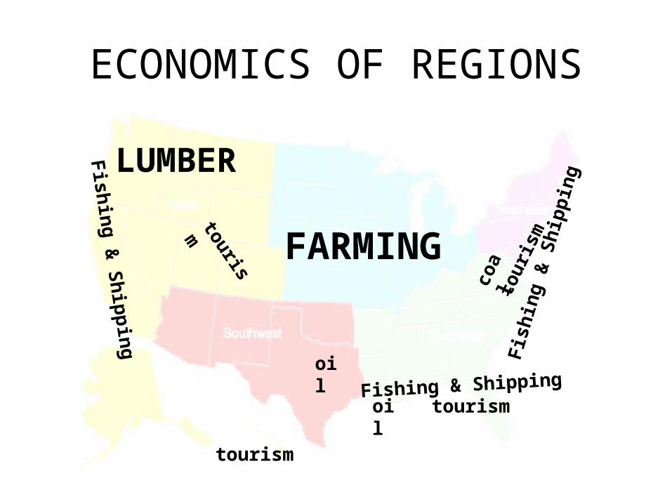
ECONOMICS OF REGIONS
Fishing & Shipping
Fish
ing
& S
hipp
ing
Fishing & Shipping
FARMING
LUMBER
tourism
tourism
tour
ism
oil
oil
tourism
coal

NATURAL DISASTERS OF REGIONS
EARTHQ
UAKES
HURRICANES& FLOODS
TORNADOES
volcanoes& tsunamis
tsunamis

Region OverviewPhysical Economic Vegetation Natural
Disasters
Northeast mountainsforestscoastline
fishingshippingtourism
thick forests some tornadoes
Southeast wetlandsgulf coast
fishingshippingoil
Cypress treesPalm trees
hurricanesfloods
Midwest plainsGreat Lakes
agriculture grasslands tornadoes
Southwest desertsGrand Canyon
oil cactus some tornadoes
Western mountainstundrarainforest
fishingshippingtourismlumber
Palm treesthick forests
earthquakestsunamis