geography the of texas wgeography deals with the present by helping to explain why people live the...
TRANSCRIPT

20
Why It MattersAs you study Unit 1, you will learn about the geography of Texas.
Geographers are interested in the places where events occur. Theyask, “Where?” Historians are interested in events as they occur in
time. Among the questions they ask is, “When?” Both geographersand historians want to know “Why?” It is, perhaps, the most important
question of all. For you to understand why events in Texas historyoccurred, you will need to understand both where events occurred
and when they occurred.
Primary Sources LibrarySee pages 684–685 for primary source readings to accompany Unit 1.
TheGeographyof Texas
Wildflowers and yucca plants thrive at the foot of Nugent Mountain in Big Bend National Park.

CHAPTER XX Chapter TitleChapter Title
“Texas is, in manyrespects, the mosteligible part of North America.”
—Mary Austin Holley (1784–1846)

&GEOGRAPHY HISTORY
Population growth has occurred among all ethnic groups. Runners competing in Austinreflect the rich diversity of Texans.
Population by county
Over 1 million
500,000 - 1 million
150,000 - 499,999
100,000 - 149,999
Less than 100,000
Railroad
Major highway
Major airport
Port
Transportation
22
Railroads, high-ways, and airlineslink the peopleand resources ofthis vast state.
1. Where do most of the people in Texas live today?
2. How do you think railroads and highways haveaffected settlement patterns in the state? How havesettlements affected railroads and highways?
L E A R N I N G f r o m G E O G R A P H Y
23
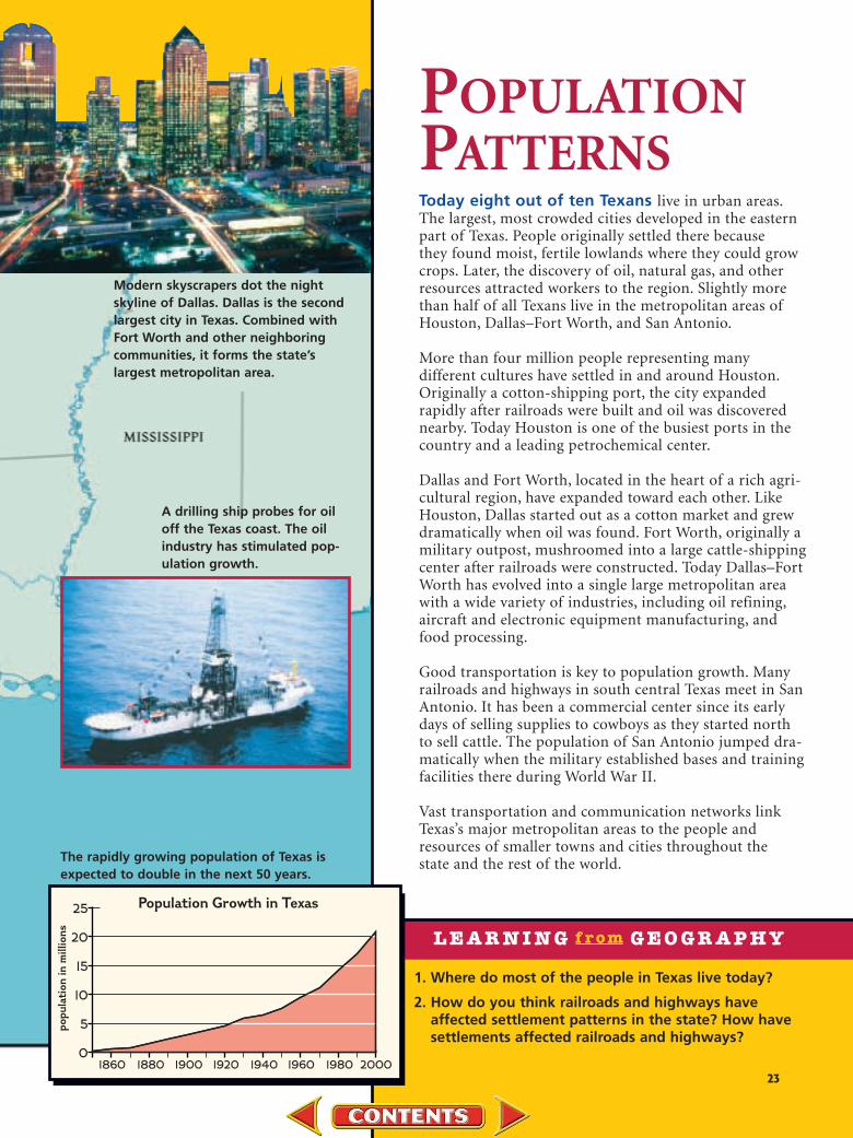
Modern skyscrapers dot the night skyline of Dallas. Dallas is the secondlargest city in Texas. Combined withFort Worth and other neighboring communities, it forms the state’slargest metropolitan area.
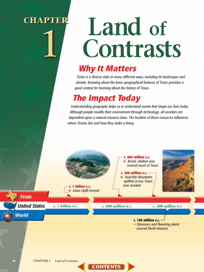
A drilling ship probes for oiloff the Texas coast. The oilindustry has stimulated pop-ulation growth.
POPULATIONPATTERNSToday eight out of ten Texans live in urban areas.The largest, most crowded cities developed in the easternpart of Texas. People originally settled there because they found moist, fertile lowlands where they could growcrops. Later, the discovery of oil, natural gas, and otherresources attracted workers to the region. Slightly morethan half of all Texans live in the metropolitan areas ofHouston, Dallas–Fort Worth, and San Antonio.
More than four million people representing many different cultures have settled in and around Houston.Originally a cotton-shipping port, the city expanded rapidly after railroads were built and oil was discoverednearby. Today Houston is one of the busiest ports in thecountry and a leading petrochemical center.
Dallas and Fort Worth, located in the heart of a rich agri-cultural region, have expanded toward each other. LikeHouston, Dallas started out as a cotton market and grewdramatically when oil was found. Fort Worth, originally amilitary outpost, mushroomed into a large cattle-shippingcenter after railroads were constructed. Today Dallas–FortWorth has evolved into a single large metropolitan areawith a wide variety of industries, including oil refining,aircraft and electronic equipment manufacturing, andfood processing.
Good transportation is key to population growth. Manyrailroads and highways in south central Texas meet in SanAntonio. It has been a commercial center since its earlydays of selling supplies to cowboys as they started north to sell cattle. The population of San Antonio jumped dra-matically when the military established bases and trainingfacilities there during World War II.
Vast transportation and communication networks linkTexas’s major metropolitan areas to the people andresources of smaller towns and cities throughout the state and the rest of the world.
1860 1880 1900 1920 1940 1960 1980 20000
5
10
15
20
25 Population Growth in Texas
po
pu
lati
on
in
millio
ns
The rapidly growing population of Texas isexpected to double in the next 50 years.
Why It MattersTexas is a diverse state in many different ways, including its landscapes and
climate. Knowing about the basic geographical features of Texas provides agood context for learning about the history of Texas.
The Impact TodayUnderstanding geography helps us to understand events that shape our lives today.
Although people modify their environment through technology, all societies aredependent upon a natural resource base. The location of those resources influences
where Texans live and how they make a living.
24 CHAPTER 1 Land of Contrasts
c. 190 million B.C.• Dinosaurs and flowering plants
covered North America
c. 1 billion B.C. c. 600 million B.C. c. 200 million B.C.
c. 600 million B.C.★ Broad, shallow seas
covered much of Texas
c. 1 billion B.C.★ Llano Uplift formed
c. 300 million B.C.★ Ouachita Mountains
uplifted across Texas; seas receded
Land ofContrasts
25CHAPTER 1 Land of Contrasts
Guadalupe Mountains National Park contains some of the mostdramatic landscape in Texas.
TEXASHISTORY
Chapter OverviewVisit the texans.glencoe.comWeb site and click onChapter 1—ChapterOverviews to previewchapter information.
c. 65 million B.C.• Rocky Mountains
began to form
c. 65 million B.C. c. 2 million B.C.
c. 2 million B.C.• Ice Age began
c. 140 million B.C.★ Seas covered Texas
again
Loca
tion
Plac
es an
d
Regio
ns
Huma
n-
Envir
onme
nt
Inter
actio
n
Mov
emen
t
Phys
ical
Syste
ms
Uses
of
Geog
raph
y
12
Fold it so the leftedge lays about inch from the
right edge.
Step 1 Fold a sheet of paper in half from sideto side.
Step 2 Turn the paper and fold it into thirds.
Step 3 Unfold and cut the top layer only alongboth folds.
Step 4 Now cut each of the three tabs in halfand label as shown.
This will makethree tabs.
Summarizing Information Study FoldableMake this foldable to help you summarize what you learn about the geography of Texas by focusing on six key words and phrases.
Reading and Writing As you read the chapter,write definitions and examples under theappropriate tabs of your foldable to learn whyTexas is called a “Land of Contrasts.”

26 CHAPTER 1 Land of Contrasts
Ouachita Trough forms
UnderstandingTexas Geography
Guide to Reading
Broad, shallow seas cover much of Texas
The Texas Almanac was published for the first time in 1857 in Galveston.It was a reference book that provided information about the climate, govern-ment, and law. It was also intended as a guide to help people moving toTexas. The Texas Almanac is still published every two years. Instead ofmerely telling about Texas, it has become part of Texas culture.
Six Geographical QuestionsDo you live in a large city, in a small town, or on a farm or ranch? What
language or languages do you speak? Is the food you eat grown nearby orbrought in from elsewhere? These questions have to do with geography.Almost every detail of your life is affected by geography. The foods youeat, the things you do for fun, the type of house you live in, and the
✦c. 600 million B.C. ✦c. 300 million B.C.
Geographical Elements ImportancePlaces/Regions
Human-EnvironmentInteraction
Movement
The first Texas Almanac
Main IdeaGeographers look at a variety oftopics as they learn about a place.
Key Termsgeography, environment, location,absolute location, relative location,place, region, human-environmentinteraction, movement, cultural dif-fusion, diameter
Reading StrategyOrganizing Information Completea chart like the one shown here byexplaining the importance of theelements below.
Read to Learn• what questions geographers ask.• about absolute and relative location.• why people need to understand the
geography of their area.
Section ThemeGeography and History Geographyexplains why people live where theydo and why certain events occurredwhere they did.
Preview of Events

clothes you wear are all influenced by whereyou live. If you live in Amarillo, for example,you need warmer winter clothes than if you livein Brownsville.
Geography deals with the present by helpingto explain why people live the way they do.Geography also helps explain the past—whycertain events occurred. Whether you are study-ing Texas or the world, the past or the present, aknowledge of geography is essential.
When you study places and events in Texas,ask yourself these six questions: (1) Where is theplace? (2) What is the place like? (3) How is theplace similar to and different from other places?(4) How do the people who live there interactwith their surroundings, or environment? (5) How are those people in that place linkedwith other people and places? (6) How doesgeography relate to the past, present, and futureof that place? These questions reflect the sixessential elements of the national standards ingeography: location, places and regions, human-environment interaction, human systems, physi-cal systems, and uses of geography.
Evaluating How is a knowledge ofgeography useful to people?
LocationLocation answers the question “Where is it?”
For example, where is Houston? Houston islocated near the eastern border of Texas, a statein the United States of America.
There are two types of location: absolute andrelative. Absolute location refers to the exactposition of a place on the earth’s surface. It is iden-tified by latitude and longitude ; (see the Geography
Handbook, pages 1–17). Absolute location can be consid-ered as a place’s “global address.” Look at themap on page 28 and identify the absolute locationfor the southernmost point in Texas.
Relative location is the position of a place inrelation to other places. Austin is located 182miles south of Dallas and 78 miles north of SanAntonio. A place may be described with manyrelative locations. When describing relative loca-tion, you may use terms like south of, located nextto, between, and in the same region.
The relative location of Texas has been one ofthe most important factors in the state’s develop-ment. On the southeastcoast, the warm waters ofthe Gulf of Mexico washTexas beaches. Today, theGulf of Mexico providesjobs to thousands ofTexans who work in thefishing, oil, tourist, andshipping industries.
Texas’s relative loca-tion places it along theborder of Mexico. Thislong border has deeply affected Texas historyand in the future may be the single most impor-tant factor in the state’s economic and socialdevelopment. According to U.S. Census figures,the Mexican American population of Texasstood at over 32 percent in 2000 and is expectedto continue growing.
Texas’s location in the south central part ofthe United States makes it attractive to manykinds of businesses. Its relatively moderate cli-mate and central location make it an ideal placefor airline and product distribution operationsserving the entire United States.
Examining How does the relativelocation of Texas affect the state’s economy?
27CHAPTER 1 Land of Contrasts
TEXASHISTORY
Student WebActivity Visit thetexans.glencoe.com Website and click onChapter 1—StudentWeb Activity to learnhow geographers use GISto study the economy.
Route 66 is a famous highway that once connected LosAngeles to Chicago. Today, only parts of it still exist. What isAdrian’s location relative to Los Angeles and Chicago?
Exploring Geography

Places and RegionsGeographers also look at places and regions.
Place refers to those features and characteristicsthat give an area its own identity or personality.Places have physical characteristics—such aslandforms, climate, plants, and animals—andhuman characteristics—such as language, reli-gion, architecture, music, politics, and way of life.
To make sense of all the complex things in theworld, geographers often group places or areasinto regions. Regions are areas that are united byone or more common characteristics. When manyplaces share similar characteristics, they form aregion. In addition to physical and human char-acteristics, regions may be defined by their busi-ness needs. For example, Mexico trades heavilywith United States border towns along the RioGrande to form an economic region.
Human-Environment Interaction
The study of geography includes looking athuman-environment interaction, or the rela-tionships linking people to their surroundingenvironment. Throughout history, people havecut forests and dammed rivers to build farmsand cities. Some of these activities have led to airand water pollution. The physical environmentaffects human activities as well. The type of soiland amount of water in a place determines ifcrops can be grown. Earthquakes and floodsalso affect human life.
Human SystemsGeographers also examine human systems,
or the way people go about shaping theworld. They look at how boundary lines aredetermined and analyze why people settle in cer-tain places and not in others. An important themein geography is the continual movement of peo-ple, ideas, and goods. People bring ideas and cul-ture from one place to another. Sometimes thoseideas are widely accepted in the new location,changing the culture. This process is calledcultural diffusion. Other aspects of movementand human systems include trade and urbaniza-tion (the growth of cities).
Physical SystemsWhy do some places have mountains and
other places have flat deserts? When studyingplaces and regions, geographers analyze howphysical systems—such as volcanoes, glaciers,and hurricanes—interact and shape the earth’ssurface. They also look at ecosystems, or commu-nities of plants and animals that are dependentupon one another and their particular surround-ings for survival.
28 CHAPTER 1 Land of Contrasts
N
S
EW200
2000 mi.
0 km
36°30'N
32°N
25°50'N
100°W 93°3'W103°W106°38'W
Gulf of Mexico
TEXAS
NEWMEXICO
OKLAHOMAARK.
LA.
CHIHUAHUACOAHUILA
NUEVOLE´ON
TAMAULIPASDURANGO
NORTH AMERICANORTHERN HEMISPHERE TEXAS
NorthPole
Equator
N
S E
W
2,0002,0000 mi.
0 km
CANADA
UNITED STATES
MEXICO
Relative location affects the politics, society, andeconomy of a place. Understanding Location How does Texas’s nearnessto Mexico affect the state’s economic development?
Absolute and Relative Locations of Texas
Small Town OppositionW e realized that this is not good for Westphalia.Many residents are concerned because the rail’sroute run[s] about 2,000 feet from a 100-year-oldCatholic church that is the town’s focal point. Manyresidents fear that the train tracks will cut off accessfrom one section [of their property] to another. Theyalso fear that noise from the train will hurt cattle.During peak hours, a trainwill pass every 15 minutesand generate about 107decibels at 25 feet.
—Dallas Morning News
A City Point-of-View Supports
High-Speed Rail System
There are countless numbers of good ideas that
have fallen by the wayside because
skeptics thought
they would never
work. The Texas
High-Speed Rail
project, the first
bullet train system for
North America, should not
become one of them. The Texas
project would connect the state’s biggest cities, pro-
vide thousands of jobs and put Texas on the map in a
dramatic way.—Editorial, Dallas Morning News
The Uses of GeographyUnderstanding geography and
knowing how to use the tools and tech-nology available to study it help pre-pare you for life in our technologicalsociety. Individuals, businesses, andgovernments depend upon geographyand maps of all kinds on a daily basis.Computer software, such as theGeographic Information System (GIS),allows us to make informed decisionsabout using our physical and humanenvironment. If, for example, a com-pany wanted to log in a forest where arare species of birds nested, they couldenter nesting and logging data into thecomputer. GIS would be used to deter-mine what areas had to be protectedand which could be cut.
Sizing Up TexasTexas is the second largest state in the
United States. Only Alaska is bigger. Ofthe other states, only California andMontana are even half as large as Texas.The state stretches 801 miles (1,289 km)from the northwest corner of the Pan-handle to the extreme southern tip nearBrownsville. It is 773 miles (1,244 km)from the easternmost bulge of the Sabine(suh•BEEN) River in Newton County tothe westernmost point near El Paso.
The total surface area of Texas is267,277 square miles (692,247 sq. km).This includes both land and water. Ifyou wanted to hike around the bound-aries of Texas, you would have to walk3,822 miles (6,150 km). That is almosttwo and one-half times the distancefrom Dallas to New York City! Texas isas large as the states of New York,Pennsylvania, Ohio, Illinois, Connecticut,Rhode Island, Massachusetts, Vermont,New Hampshire, New Jersey, andMaine combined. Even then, Texas stillhas land to spare. Texas makes up about7 percent of the total area of the United
Rural Past or Urban Future?Although this high-speed rail system plan was defeated, conflictcontinues between urban and rural interests. Read the two viewsbelow and then answer the questions.
Learning From History
1. Why are many rural residentsopposed to the rail system?
2. What are some of the specialneeds of big city populations?

30 CHAPTER 1 Land of Contrasts
Checking for Understanding1. Using Key Terms Write a short
paragraph explaining how location,place, and region are related.
2. Reviewing Facts How do youdescribe a place’s relative location?
Reviewing Themes3. Geography and History How
does the physical environmentaffect human activities?
Organizing to Learn4. Categorizing Create a web like
the one shown here and list thephysical and human characteristicsof your hometown or neighbor-hood.
Critical Thinking5. Identifying Are there examples of
cultural diffusion in your commu-nity? What are they?
Supporting GeneralizationsExplain whether you think there ismore movement of people, ideas, andgoods today than in the past. Supportyour answer with examples.
Your HomeTown
Roy Bedichek was anaturalist who wasinspired by the vast Texaslandscape. Early in hiscareer, he taught Englishin high schools inHouston and San Angelo.Later, after working atUniversity of Texas,Bedichek traveled around
the state visiting schools,often writing about histravels. At times, hewould camp out. Thisexperience got himinterested in wildlife,especially birds. In 1946,he retreated to FridayMountain Ranch inAustin, where he wrote
Adventures With a TexasNaturalist. His next twobooks, KaránkawayCountry and EducationalCompetition, were recog-nized as books of the year in Texas. Bedichekhad a gift for describingthe world around him.
Roy Bedichek 1878-–1959
HumanCharacteristics
PhysicalCharacteristics
States. The state is larger than many nations,including Ecuador, France, Italy, Spain, Germany,Poland, Kenya, Japan, and Vietnam.
Sometimes the vast distances between citiespose problems for Texans. The following exam-ples will help you understand how big Texas is.El Paso is closer to the Pacific Ocean than it isto Houston. A circle 500 miles (805 km) indiameter—with El Paso as its center—wouldinclude the capitals of three Mexican and twoAmerican states, but not Austin. Amarillo iscloser to the capitals of New Mexico, Colorado,
and Oklahoma than it is to that of Texas. Resi-dents of the village of Lajitas (lah•HEE•tahs), inthe Big Bend area, live nearly 100 miles (161km) from the nearest high school. Some stu-dents must spend 4 hours each day on a schoolbus. Understandably, people in these far-flungparts of Texas sometimes have closer businessand social ties with the people of other statesthan they do with fellow Texans.
Explaining How do long distancespose problems for some Texans?

31CHAPTER 1 Land of Contrasts
Earthquakes create Balcones Escarpment
NaturalResources
Guide to ReadingMain IdeaTexas contains a number of differentlandforms and an abundance of natu-ral resources.
Key Termsplain, barrier island, escarpment,fault, plateau, aquifer, savanna,grassland
Reading StrategyClassifying Information Complete achart like the one shown here.
Read to Learn• about major landforms and water
resources.• about natural vegetation.• about Texas’s mineral resources.
Section ThemeEconomic Factors The land’sresources affect economic activities inan area.
Gulf of Mexicobegins to develop
Preview of Events
“The northern counties of the state embrace what is usually called thewheat region of Texas . . . Eastern Texas is the great timbered region of thestate . . . The counties between the Colorado and San Antonio Rivers possessthe advantage of being better adapted to stock-raising and wool growing . . .the region extending from San Antonio to the Rio Grande is capable ofsupporting stock sufficient to supply the whole United States . . . ”
—The Texas Almanac and Emigrant’s Guide to Texas, 1869
✦c. 240 million B.C. ✦c. 65 million B.C.
Major Rivers Major Minerals
Viewing TexasImagine flying over the widest part of Texas in a straight line from the
south to the north and then from the east to the west. During these twoflights, the face of Texas would change dramatically.
Piney Woods of Texas

The southernmost point in Texas lies on amostly level plain. Plains may be gently rollingand even have low hills. The southern tip ofTexas is very near sea level where Texas meetsthe Gulf of Mexico. Running along the coast afew miles offshore is Padre Island. This long thinstrip of land covered with sand dunes is abarrier island protecting the mainland shorefrom ocean waves. Between Padre Island and themainland is Laguna Madre, a large sheltered bay.Laguna Madre is a rich fishing area.
Moving northward from the Brownsvillearea, you will see that the land slowly rises, as itbegins to gently roll. This part of Texas is cov-ered with a tough and prickly mixture ofmesquite trees, cacti, blackbrush, and otherplants that thrive in a dry, hot climate. Largeareas of South Texas are also covered withgrasses. In spring, great masses of bluebonnets,Indian blankets, Indian paintbrushes, and otherwildflowers carpet the land.
Cutting across Texas in a great curving arc isan escarpment, or long cliff. The Balcones(bal•KOH•neez) Escarpment, formed millionsof years ago by a giant earthquake, follows aweak part of the earth’s crust called a fault. Inthe distant past, the land sank east and south ofthe fault. North and west of it, the land rosemany feet, forming the escarpment.
The Balcones Escarpment marks the beginningof a region of Texas known as the “Hill Country.”This part of Texas is a plateau, or tableland, cov-ered with small trees and brush. Hills on the rimof the plateau were formed by streams cuttingand smoothing over the plateau’s limestoneedges. There are more streams and rivers in thispart of Texas than in any other. This region is alsoknown for the massive wildflower displays thatblanket its slopes in spring.
The land gradually gets flatter and higher asyou travel northwest. One abrupt changedisrupts this plains region. The Caprock
N
S
EW
200
2000 mi.
0 kmAlbers Equal-Area projection
104°W108°W
36°N
32°N
28°N
96°W 92°W100°W
Gulf of Mexico
Rio
Grande
Pecos R.
Colorado R.B
razos R.
Red R.
Sab
ine
R.
Lagu
naM
adre
An
gelinaR.
Trinity R.Guadalupe R
.Nueces R.MEXICO
OKLAHOMA
ARKANSAS
TEXAS
LA.
ALA.
MISS.
TENN.
NEWMEXICOARIZ.
LlanoEstacado
StocktonPlateau
EdwardsPlateau
PermianBasin
B a l c o n e s E s ca r p
me n
t
Capr
ock
Esca
rpm
ent
Canyon
Palo Duro
Chiso
s
Mts.
DavisMts.
Co
as
t al
P l a i n s
Hi g
hP
lain
s
PadreIsland
GuadalupeMts.
To the Spanish, the hills of theBalcones Escarpment lookedlike balconies from the plains.
The difference betweenplains and plateaus is the elevation. Plains are lowand plateaus are high.
From the plain below, ElCapitan in the Davis Mts.appears to be higher thanGuadalupe Peak, but it is not. It is a trick of perspective.
´
32 CHAPTER 1 Land of Contrasts
A physical map shows the naturalfeatures of an area, such asmountains and rivers. Analyzing What are the majorphysical landforms shown on themap?
Texas Physical Map

Escarpment slashes south to north from BigSpring to Pampa. Palo Duro and Tule Canyons,great gashes in the Caprock, hold some of themost beautiful scenery in Texas.
A trip starting at the easternmost point in thestate would also begin on a plain. Again, thelevel of the land gently rises as you travel west-ward. After crossing the Balcones Escarpmentand the hilly central region, you finally reach theplains to the west.
West Texas has landforms that do not appearin other parts of the state. Most noticeable arethe mountains. Texas has 91 mountains morethan one mile high, and all of them are in WestTexas. The highest point in the state, GuadalupePeak, rises 8,749 feet (2,667 m) above sea level and is part of the Guadalupe MountainsNational Park in Culberson County.
Contrasting What noticeabledifference in land level occurs as you travel westward?
Texas’s Water ResourcesHardly anywhere is water more precious than
in the hot, arid, and rapidly growing region ofthe Southwest United States. Texas faces manyof the concerns shared by people in this region.
Increasing demands for water are straining theecosystems of communities along rivers andnear dams. There are few new water sourcesavailable to the many businesses and homes thathave been built here in the past decades.
The Gulf of Mexico is a major water resourceof Texas. Both commercial and sports fishingboats ply its waters. Also important are themany bays found along the Texas coast. Thesebays serve as nurseries for fish, shrimp, oysters,crabs, and birds. They are also important fishingareas. Emptying into the bays, however, arerivers often polluted by wastes and chemicalsfrom cities, factories, and fields. Because of thispollution, seafood from some Texas bays issometimes declared unsafe to eat.
Rivers of TexasTexas’s river systems vary widely from region
to region. Because it receives little rainfall, SouthTexas has few rivers. The Rio Grande formsmost of Texas’s southern boundary. Between 15and 30 million years ago, forces within the earthcaused the crust to drop, forming a rift, or gash,more than 5 miles deep in places. The basins ofthe rift filled with the runoff of rain and snow toform inland seas. Earthquakes caused the seas to
100°W104°W 96°W
36°N
32°N
28°N
Canadian R.
Pecos R .Rio Gran
de
Red R.
Wichita R.
Sulp hur R.Sabine R.
Nech
e s R.
Trinity R.Littl e R.
BrazosR
.
Concho R.Colorado
R.San S aba
Llano R.Guadalupe
R.
San Antonio
R.
Frio
R
.
Nuec e s R.
Medina R.
San
JacintoR
.
MEXICO
NEW MEXICO
ARIZONAOKLA.
TEXAS
CALIF.ARK.
TENN.
MISS. ALA.
LA.
N
S
EW
200
2000 mi.
0 kmAlbers Equal-Areaprojection
Mountains and Basins
Great Plains
North Central Plains
Coastal Plains
Rivers hold only a small part ofthe earth’s fresh water but, alongwith other sources, rivers providewater for cities and for farmland.Identifying PhysicalCharacteristics What riverforms a northern border ofTexas?
Rivers of Texas

overflow, and the Rio Grande was formed. Inhopscotch fashion, the river connected basinafter basin, finally reaching the ocean about ahalf-million years ago. The beds of the ancientseas now form the fertile valleys through whichsome parts of the river runs.
The Rio Grande actually carries little watercompared to other rivers of its length. Thenearly 2,000-mile-long (3,218 km) river is one ofthe longest in the United States and the 24thlongest river in the world. Rising in the San JuanMountains of southern Colorado, it ends at theGulf of Mexico. Most of the river’s water is fromsources in Mexico.
Two major rivers are found in the TexasPanhandle. The Red River flows eastward andacts as part of the boundary between Texasand Oklahoma. The Canadian River cutsacross the Panhandle from west to east as itruns north of Amarillo.
The eastern part of the state is notable for itsmany rivers. Starting at the Sabine River, a per-son traveling west crosses the Neches, Trinity,San Jacinto, Brazos, Colorado, and Pecos Rivers.
Texas rivers are sometimes called “wrong-way” rivers because they carry water from thedry part of the state, where it is needed, to thesoutheastern part, which normally has plenty ofwater. Texas is like a giant tabletop that has beentipped from northwest to southeast. Because theland is higher in the northwest, almost all therivers in Texas run to the southeast. To keep pre-cious water from running unchecked into theGulf of Mexico and to control floods, many riversin Texas have been dammed, forming lakes.
Texas Lakes Have Many UsesTexas has about 200 major lakes. All but one
were formed when rivers were dammed. OnlyCaddo Lake in East Texas began as a naturallake. Even this lake, however, now holds watersbacked up by a dam. Surprisingly, Texas ranksthird behind Alaska and Minnesota in the sur-face area of its inland waters.
Originally built for flood control and waterconservation, Texas lakes have taken on moreroles. Most lake water is still used for irrigation,but surface waters (drawn primarily from lakes)provided about 60 percent of the needs of citiesand towns in 1997 and most of the water used inmanufacturing. For many years, lakes have sup-plied about 40 percent of Texas’s water needs.
Identifying What are the two majorrivers in the Texas Panhandle?
Aquifers Used for IrrigationNorth of the Frio River is the Balcones
Escarpment, an area famous for its many springs.Springs occur where aquifers, or undergroundwater reservoirs, meet the surface. Large springsare found at San Antonio, New Braunfels, SanMarcos, and Austin. These springs depend on theEdwards Aquifer, which gets its water from rainthat falls on the Hill Country to the north andwest. In dry years, the water level in the EdwardsAquifer drops so much that some springs stopflowing. Enormous amounts of water arepumped from the aquifer to supply the city ofSan Antonio and to irrigate farms to the west.This, combined with drought, applies great stress
34 CHAPTER 1 Land of Contrasts
Named for the Caddo Indians, Caddo Lake isnoted for its giant cypress trees. A dam was built in 1971,and the lake was designated an international wetlands regionin 1993. What is the purpose of creating dams alongrivers and lakes in Texas?
Exploring Geography
Caddo Lake★Caddo Lake★

to the Edwards Aquifer. Rainfall refills thisaquifer, however, creating a dependable source ofwater that can be used for years to come.
Another major aquifer with declining waterlevels is the Ogallala (oh•gah•LAH•lah) Aquifer.It lies under the Texas High Plains and cannot berefilled easily or quickly by rainfall. More than 5million acres (2,025,000 hectares)—an area largerthan New Jersey—are irrigated by the aquifer.Conservation programs and efforts to replenishthe aquifer have been put into effect, but thefuture of the aquifer remains a matter of concern.
Soil Is a Valuable ResourceThe rich soil of Texas is one of its most valu-
able resources. Huge areas of the state can beused for farming. Tons of cotton, watermelons,and spinach are harvested each year. Other lead-ing crops include wheat, rice, corn, soybeans,vegetables, and peanuts.
Land that is not suited for farming can still beused for ranching. The state of Texas usuallyleads the nation in the number of cattle, sheep,
and goats raised, and in the amount of wool andmohair (goat hair) clipped. Together, ranching,farming, and related businesses produce about$40 billion in income for the people of Texaseach year.
Comparing How is an aquiferdifferent from a dammed lake?
Three Vegetation RegionsIn general, Texas has three types of natural
vegetation regions: forests, savannas, and grass-lands. Three major forest regions are found inTexas, all in the eastern third of the state whererainfall is greatest. Hardwood trees, long-leafpines, and oak-hickory forests are found inabundance.
Texas forests are an important naturalresource. Timber is one of the top cash crops inTexas, usually outranked only by cotton. Thelumber, plywood, and paper industries providemore than one-fourth of the manufacturing jobsin East Texas.
35CHAPTER 1 Land of Contrasts
Water from the Edwards Aquifer comes to the surface atBarton Springs in Austin (left). Water from the OgallalaAquifer is pumped to the surface for irrigation (below).Identify some uses for aquifer water.
Exploring Geography
Ogallala AquiferOgallala AquiferAustin★Austin★

Texas also has several savanna regions. FarWest Texas is a desert shrub savanna. Only shortgrasses and small shrubs grow here, except in themountains and along streams. This region sup-ports only limited grazing of animals. Most of thecenter of Texas has savanna areas. The soil here isrocky, and the land is sometimes rugged.
The third vegetation region in Texas isgrasslands. Early settlers established farms onthe grasslands because they had to clear only afew trees before crops could be planted. Texascities today echo the patterns of the early set-tlers. The grasslands stretching from Dallas toSan Antonio and the grassy prairies aroundHouston are the most heavily settled regions.
Texas Leads in Energy ProductionThe main minerals in Texas are petroleum, nat-
ural gas, coal, sand, and gravel. Texas also pro-duces building stone, such as limestone andgranite. Gypsum is mined in many places in thestate. It is used to manufacture drywall, a materialused in construction. Texas is a leading producerof salt, mainly from mines near Grand Saline inVan Zandt County. Sand, gravel, clay, and coal aremined in East Texas.
Petroleum and natural gas are the mostimportant mineral resources. Oil or gas has beenfound in all but 23 counties. As of 2001, the valueof oil and gas produced in Texas is about $17 bil-lion annually. These resources are important to
the state and to the country. One-fourth of all theenergy produced in the entire history of theUnited States has been produced in Texas.
Examining In what ways are Texasforests an important natural resource?
36 CHAPTER 1 Land of Contrasts
Checking for Understanding1. Using Key Terms Describe a trip
through Texas using the followingwords: plain, barrier island, escarp-ment, fault, plateau, and grassland.
2. Reviewing Facts What river formsmost of the southern boundary ofthe state?
Reviewing Themes3. Economic Factors How do Texans
use land not suited for farming?
Organizing to Learn 4. Identifying Complete a chart like
the one shown below and identify amajor river found in each region.
Critical Thinking5. Describing In which natural vegeta-
tion region would you most like tolive? What would that area look like?
Understanding Geography Whyare the three major forest regions all found in the eastern third of Texas?
N
S
EW
1000 kmAlbers Equal-Areaprojection
1000 mi.
100°W104°W
32°N
28°N
96°W
36°N
Gulf ofMexico
M E X I C O
TEXAS
OKLA.
ARK.
NEWMEXICO
LA.
Region RiverPanhandle
East Texas
West Texas
South Texas
Forest
Grassland
Savanna
A region’s soil and climate influence the kinds ofnatural vegetation found there.Locating Place Where are the state’s major forests?
Natural Vegetation Regions

Why Learn This Skill?Maps can show many kinds of information, includ-
ing climate, cities, vegetation, and elevation. Theinformation on maps is often shown by various sym-bols such as numbers, colors, lines, circles, andother shapes and pictures. To understand what themap is showing, look at the map key, or legend,which explains what the symbols mean.
Also included in the legend may be two other kindsof information. First, a compass rose is often placedon maps to point out the directions north, south, east,and west. Second, a scale is included to show therelationship between distance on the map and dis-tance on the ground.
Learning the SkillTo use a map key correctly, follow these steps:• Check the compass rose to determine the direc-
tions on the map.• Check the scale of distance.• Study all the symbols in the legend and find exam-
ples of each one on the map.
Practicing the SkillStudy the map and the map key. Then answer the
following questions.
1In which direction is Austin from Dallas?
2Which city is shown in the far west part of Texas?
3How far is Brownsville from San Antonio?
4Traveling at 50 miles per hour, about how longwould it take to drive from Dallas to Brownsville?
5How many interstate highways meet at Houston?
6What is the value of the type of geographical infor-mation that you have learned in this map exercise?
Social StudiesSocial Studies
Understanding a Map Key
Understanding a Map Key Draw a simple map ofyour classroom. Create a map key that includes symbolsfor desks, doorways, and other room features. Add acompass rose showing true directions. Create a scale thatreflects true measurements of the classroom. Compareyour map to those of your classmates to see how manydifferent symbols were developed.
Glencoe’s Skillbuilder Interactive Workbook,Level 1, provides instruction and practice in keysocial studies skills.
37
N
S
EW
100
1000 mi.
0 km
Albers Equal-Areaprojection
100°W104°W
32°N
28°N
96°W
36°N
l27
l40
l20
l10l35
l10
l45l10
l35
l20
l30
l37
l44
Gulf ofMexico
El PasoOdessa
Lubbock
Amarillo
Austin
Fort Worth Dallas
Texarkana
Houston
CorpusChristi
San Antonio
Laredo
Beaumont
Brownsville
Waco
Galveston
Wichita Falls
Midland
NEWMEXICO
OKLA.
ARK.
LA.
M E X I C O
InterstateHighways
l
Major Highways in Texas

38 CHAPTER 1 Land of Contrasts
The Climateof Texas
Guide to ReadingMain IdeaTexas’s climate varies greatly fromone area of the state to the next.Elevation and nearness to the oceanaffect climate patterns.
Key Termsmiddle latitudesnorther
Reading StrategyOrganizing Information As you readthis section, complete a chart like the one shown here about the effects ofthe climate conditions listed below.
Read to Learn• how absolute location affects the
Texas climate.• how the Gulf of Mexico affects the
Texas climate.• how elevation affects climate.
Section ThemeGeography and History Texas’s dif-ferent climate regions impact wherepeople live.
Ice Age advances make Texas’sclimate cooler and wetter
Preview of Events
“. . . Texas contains, beyond any other state of the Union, the advantagesof . . . climate, a soil of unsurpassed fertility, adapted to the production ofall the most valuable staples, together with great mineral resources. This mayseem to some an extravagant assertion, but it will be readily admitted by allwho know any thing of this highly favored country.”
—The Texas Almanac and Emigrant’s Guide to Texas, 1869
Absolute Location Affects ClimateThe absolute location of Texas has important effects on its climate.
Texas lies in what are called the middle latitudes, the region aboutmidway between the equator and the North Pole. Because Texas is notvery far north of the equator, it has mild winters. Even in Amarillo, the
Climate Condition EffectCool air meets warm air
Gulf Coast breezes
Winds rise over the mountains
Early Texas farmer
✦c. 2 million B.C.
39CHAPTER 1 Land of Contrasts
temperature rises above freezing most winterdays. Because of the great north-to-south spreadof the state, however, the climate of South Texasis much warmer than that of North Texas. In theBrownsville area, for example, farmers canexpect freezing weather to occur perhaps onlyone or two days a year. South Texas is a popularwinter vacation spot for many people because ofits warm climate.
Despite its overall warmth, Texas is subject toperiods of cold weather. In fact, the Texas cli-mate has a reputation for being highly unpre-dictable. Tornadoes, hurricanes, dust storms,and northers may strike. Northers are suddenblasts of cold air that extend south from Canadaand sweep across the plains. There are nomountains or other landforms to block thesenorthers. They can drop temperatures belowfreezing, but they rarely last for more than twoor three days. A powerful norther in 1899 frozeCorpus Christi Bay so solidly that people couldwalk on it. A party of surveyors near Palo DuroCanyon in the Panhandle experienced a northerin December 1887:
“It caught us in a few minutes. With a rush ofice cold wind, a snarl like an angry beast, anawful roar, changing into a long drawn out wailwhich continued to rise and fall—the yellownorther of the plains struck and enveloped us.
The air was full of ice needles that drove intothe exposed flesh and stuck, but did not seem tomelt. The snow seemed to parallel the ground inits flight; yet the plains grass was covered by it ina few minutes and it rolled along the ground withthe wind. That wind didn’t turn aside. When it hityou it just kept [going] right on through yourbody, as though your flesh offered no obstructionto it. There wasn’t a hill between us and theNorth Pole and that wind must have come all theway—and gathering power at every jump.
We had been sweating ten minutes before.Now we pulled the wagon sheet over us huddlingunder it. But the wind and cold . . . cut andstung despite the cover.”
Texas’s absolute location affects its climate inanother way. The middle latitudes are a meetingplace of cool air moving from the north andmoist warm air moving from the Gulf of Mexico.Especially in the spring and fall, violent stormssometimes result from this mixing of cold andwarm air. Thunderstorms may bring heavy rain,lightning, and sometimes hail the size of base-balls. Tornadoes may form, causing tremendousdamage or injury when they touch ground.
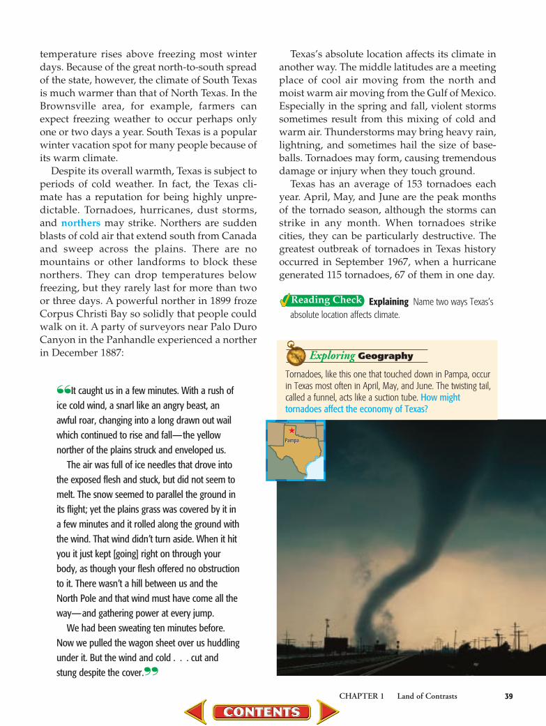
Texas has an average of 153 tornadoes eachyear. April, May, and June are the peak monthsof the tornado season, although the storms canstrike in any month. When tornadoes strikecities, they can be particularly destructive. Thegreatest outbreak of tornadoes in Texas historyoccurred in September 1967, when a hurricanegenerated 115 tornadoes, 67 of them in one day.
Explaining Name two ways Texas’sabsolute location affects climate.
Tornadoes, like this one that touched down in Pampa, occurin Texas most often in April, May, and June. The twisting tail,called a funnel, acts like a suction tube. How mighttornadoes affect the economy of Texas?
Exploring Geography
★Pampa
★Pampa

Relative Location AlsoAffects Climate
The location of Texas relative to the Gulf ofMexico has a major influence on the climate ofthe state. Most of the year, winds blow inlandfrom the south, southeast, or southwest for 200 miles (322 km) or more. These ocean breezescool the land in summer and warm it in winter.Moisture from the Gulf of Mexico is the source ofmost of the rain that falls on the state. The city ofOrange in East Texas averages about 59 inches(150 cm) of rainfall per year. Farther west, windsblow across the deserts and mountains of Mexicobefore entering Texas. This drier air brings lessrainfall. El Paso, for example, averages onlyabout 9 inches of rain per year.
The Gulf is so far from some areas of Texasthat it has little effect on climate there. WichitaFalls and other cities across the middle of thestate broil in the summer sun. Similarly, wintertemperatures in the Panhandle or in theDallas–Fort Worth area get little warming fromGulf breezes.
The location of Texas next to the Gulf ofMexico—with its hundreds of miles of coastline—has negative effects, too. Destructive stormssometimes sweep in from the Gulf and do greatdamage to the state. The hurricane of Galveston in1900 left more than 6,000 dead, and great storms
N
S
EW
Albers Equal-Area projection100
1000 mi.
0 km
100°W104°W
32°N
28°N
96°W
36°N
92°W108°W
Gulf ofMexico
El PasoOdessa
Lubbock
Amarillo
Austin
Fort Worth Dallas
Texarkana
Houston
Corpus Christi
San Antonio
Laredo
Beaumont
Brownsville
Waco
Midland
WichitaFalls
Galveston
San Angelo
Orange
OKLAHOMAARK.
NEWMEXICO
ARIZONA
TEXAS
TENN.
MISS.
LA.
M E X I C O
Precipitation that reaches theearth’s surface may be rain,snow, sleet, hail, or fog.Interpreting Data What is theaverage annual precipitationrange for Houston?
10 or Less
10.1 to 20
20.1 to 30
Average Annual Precipitation (Inches)
30.1 to 40
40.1 to 50
50.1 or More
Texas Average Annual Precipitation
This group of students experienced anorther on election day in Lubbock, Texas. How couldweather affect election results?
★Lubbock★
Lubbock
Exploring Geography
struck Corpus Christi in 1916, 1919, and 1970.Houston was struck by a hurricane in 1983.
Any part of the state can be affected by hurri-canes. In 1921 a hurricane moved from Mexicoacross south and central Texas, causing thegreatest flood in the state’s history. Duringthat storm, more than 36 inches (91 cm) of rainfell at Thrall in 18 hours—setting a record forrainfall in American history.
Elevation and Climate PatternsBesides absolute and relative location, the
Texas climate is also affected by elevation. Ingeneral, the temperature cools about 3 degreesfor each 1,000-foot (305-m) rise in elevation.Similarly, the average temperature rises as eleva-tion decreases. This fact affects the Texas climatein several ways.
If distance from the ocean were the only fac-tor determining climate, El Paso would be thewarmest city in the state. This is not the case,however. Because El Paso lies at an average ele-vation of about 3,700 feet (1,128 m), its tempera-tures are generally cooler than cities at a lowerelevation but located at about the same latitude.
The warmer temperatures at lower elevationshelp Texans in winter. Northers that chill residentsof Amarillo, at an elevation of about 3,650 feet(1,113 m), warm as they blow south. By the time a
norther reaches Austin, at an elevation ofapproximately 500 feet (152 m) above sea level,the temperature may be 20°F (11°C) warmer.
Elevation also affects rainfall. Warm air holdsmore moisture than cool air. The mountains ofWest Texas receive more rainfall than the sur-rounding desert because moisture-filled airmoving up the mountains is cooled. As the airbecomes cooler and less able to hold moisture,some of the moisture falls as rain. The DavisMountains receive up to 18 inches (46 cm) ofrain a year. The lower desert several miles awaygets only 8 to 12 inches (20 to 30 cm).
Explaining How does elevationaffect climate?
41CHAPTER 1 Land of Contrasts
Checking for Understanding1. Using Key Terms Define norther
and middle latitudes.2. Reviewing Facts On average, how
many tornadoes does Texas experi-ence each year?
Reviewing Themes3. Geography and History If you
like cool summer temperatures,where in Texas should you live?Where should you live if you likewarm winter temperatures?
Organizing to Learn4. Comparing Complete a chart like
the one shown below and write thepositive and negative effects of thestate of Texas being located nearthe Gulf of Mexico.
Critical Thinking5. Evaluating Location How does
the mild climate of South Texasfavorably affect the economy ofthat part of the state?
Analyzing Climate Texas experi-ences many types of weather. What typeof weather conditions occur in themiddle latitudes?
Positive Effects Negative Effects
Anyone who thinks Texas weather is all dry is “all wet.”The image of Texas as a parched, sunbleached waste-land persists in the popular imagination, but more ofTexas is humid than dry. The state’s three largest cities,Houston, Dallas, and San Antonio, have average rela-tive humidity percentages of 77, 70, and 70, respec-tively. Houston gets 46 inches of precipitation a year,more than Boston; Chicago; Washington, D.C.; NewYork City; or even Key West, Florida.
T E X A SF I C T I O N

Reviewing Key TermsWrite the definition of each key term. Then list a geographicalplace, or name, to which the term relates.
1. plain2. barrier island3. escarpment4. fault5. plateau6. aquifer7. savanna8. grassland
Reviewing Key Facts9. Describe the size of Texas, north to south and east to west.
10. How was the Balcones Escarpment formed?11. Identify where mountains are located in Texas. What is the
highest point in the state?12. Explain why so many Texas rivers flow in a generally
southeastern direction.13. How were most Texas lakes formed?14. What three natural vegetation regions are found in Texas?15. List the main minerals found in Texas. Of those listed,
which are the most important?16. Describe the effects of a norther.
Critical Thinking17. Locating Describe your town or community in terms of
absolute and relative location.
18. Analyzing Describe your town or community in terms ofplace. What are specific characteristics that make it aunique place?
19. Making Generalizations What are some of the ways inwhich people in your area interact with the environment?Think in terms of work or recreation.
20. Determining Cause and Effect How does Texas’s greatsize contribute to its varied climate?
21. Making Generalizations How have the rivers of Texasaffected the lives of Texans?
22. Evaluating Do you think the Ogallala Aquifer is arenewable water source? Explain your answer.
42 CHAPTER 1 Land of Contrasts
• Location • Human systems• Places and regions • Physical systems• Human-environment • Uses of geography
interaction
Main IdeaThe six elements of geography are:
Land of Contrasts
Main IdeaThe major landforms in Texas are:
• Plains • Plateaus• Escarpments • Mountains
Main IdeaTexas’s water resources include:
• Gulf of Mexico • Aquifers• Rivers and man-made lakes
Main IdeaNatural vegetation regions are:
• Forests • Grasslands• Savannas
Main IdeaImportant mineral resources
in Texas include:• Coal • Petroleum• Natural gas

Geography and History ActivityIdentify the physical features found in Texas by matching theterms below with the letters on the map. 23. plateau 25. barrier island24. mountains 26. plains
Economics and History Activity27. Cities In what part of the state of Texas are most large
cities located? How did the location affect the cities’growth?
Cooperative Learning Activity28. Creating a Model Working in groups, create a model
of an ideal community. The plans for your communityshould include a map of the area, indicating the impor-tant geographical features and where the major indus-tries and commercial areas will be developed. Then writea brief description of what your ideal community wouldbe like.
Practicing Skills29. Understanding a Map Key Draw a street map of an area
near your school or home. Include such things as high-ways, railroad tracks, bridges, or other landmarks. Be sureto add a map key. For an added challenge, create a scalethat reflects the actual distances you have mapped.
Building Technology Skills30. Using the Internet Search online to find a picture or
photograph of either Palo Duro or Tule Canyon that youcan print. Write a caption describing the physical charac-teristics of the image.
Use the graph to answer the following question.
Which of the following statements can be determinedfrom the information in this graph? A The Civil War created an enormous demand for oil.B An increase in the number of cars contributed to
higher demand for fuel.C The greatest increase in oil production occurred
between 1965 and 1970.D Oil refineries were more efficient between 1945
and 1970.
Test-Taking Tip:
Look for a statement that is supported by the graph.For example, answer A is not supported by the data.
43CHAPTER 1 Land of Contrasts
Self-Check QuizVisit the texans.glencoe.com Web site and click onChapter 1—Self-Check Quizzes to prepare for thechapter test.
TEXAS HISTORY
Source: Railroad Commission of Texas, 2000
Millions of Barrels
Year
1970
1965
1960
1955
1950
1945
0 500 1000 1500 2000 2500 3000 3500 4000
2,058
2,241
2,556
2,437
2,506
3,309
Texas Oil Production, 1945–1970
200
2000 mi.
0 km
Albers Conic Equal-Area projection
N
S
EW
104°W
36°N
32°N
28°N
96°W100°W
Gulf of Mexico
Rio
Grande
Pecos R.
Colorado R.
BrazosR
.
SabineR
.
Red R.
MEXICO
OKLAHOMAARK.
LA.
NEWMEXICO
A
B
C
D
Texas Landforms

Did you know that cotton is Texas’s number one crop? Or that one out ofevery five bales of cotton produced in the
United States is grown in Texas? The productionof cotton is vital to the state’s economy.
Texas Has What Cotton Farmers Need What you may not have thought much about
was why so much cotton is planted in Texas. Theanswer is that the geography of Texas favors thegrowth of cotton. Texas has the climate, the soil,and the labor needed to make cotton growingprofitable. Texas is so large north to south that ittakes a while for the warm temperatures neededto begin the planting season to work their wayup the state. This was very important for cottonfarmers because it meant that the farm workersneeded to pick the cotton could start in thesouthern part of the state and move northwardas the cotton plants grew ready for harvesting.
Migrant FamiliesFarmers during the 1920s through the 1950s
needed thousands of temporary workers, or“hands,” to harvest the cotton. The demand forlabor was filled by poor people who needed workto survive. By joining the Big Swing—migratingwork that took them from southern Texas to theHigh Plains—these people could earn a living.
Entire families made up the force of cottonpickers. Most were of Mexican descent, either having been born in Texas, having
lived in the United States for many years, orhaving recently arrived from their home country.They traveled to farms in their own cars, or withindividuals who drove them from farm to farmon a platform truck. In Spanish, this driver wascalled el troquero. The bed of the truck became“home” for families as they moved from farm tofarm. The troquero was responsible for findingwork for his “crew” on the route north.
The Big SwingMigrant workers began their yearly migration in
southern Texas. The weather was warm enough inthe Lower Rio Grande Valley for farmers to planttheir cotton crop in late February and early March.
Migrant Workers Provided Needed Labor
44
Mexican workers board the train for transport to U.S. farms.

By April or May, workers started the process ofthinning the young plants. During late June andcontinuing into the next few weeks, the cotton-picking season began.
From southern Texas, the migrants drove tocentral Texas. In farms surrounding San Marcos,
New Braunfels, and Lock-hart, men, women, andchildren toiled in temper-atures of more than 100degrees to make an aver-age of $1.75 per day. Bylate August, the migrantlaborers prepared tomove again, this time toWest Texas farms locatedaround San Angelo and Ballinger. In that sectionof the state, the colder climate postponed theplanting, so that the cotton did not mature untilAugust and the early fall.
The final stopping point for the cotton pickerswas the High Plains. When the crews arrivedaround September and October, the late-plantedcotton was ripe for picking. By November,many migrant families were on their way home.
Settling DownMany of the migrants, however, did not travel
back to their places of origin in Mexico or SouthTexas. They began new Spanish-speaking com-munities in towns such as Lamesa, Lubbock, andPlainview. They found jobs, married, and raisedfamilies. In this way, Mexican American culturewas transplanted to new geographical areas,where it remains today.
45
200Area projection
200
100°W105°W 95°W
SOUTH
TEXAS
PLAIN
EDWARDS PLATEAU
OKLA.
N. MEX.
MEXICO
Lower RioGrande Valley
Lubbock
Plainview
San Angelo
San Antonio
Beeville
Lamesa
Ballinger
From the 1920s to the early 1960s the route for picking cotton was knownas the Big Swing. The route took migrant workers from the warmer climatesof southern Texas to the cooler dry climates of northern Texas.
Cotton areas
Big Swing route
North Central Plains
Coastal Plains
Great Plains
Mountains and Basins
The Big Swing
1. Drawing Conclusions How does the geography ofTexas help to support migratory work?
2. Analyzing What were some benefits and drawbacksfor migrant workers during cotton-picking season?
3. Writing About Economics Write a paragraph thatdevelops one of the themes listed below. Use standardgrammar, spelling, sentence structure, and punctuation.Include information and examples from the feature asdetails to support your argument. a. People rely on a variety of jobs to earn a living.b. Family members make contributions in different
ways.c. People make sacrifices to earn a living.