geography paper 1 marking scheme section a collision …
TRANSCRIPT
GEOGRAPHY PAPER 1 MARKING SCHEME Page 1
GEOGRAPHY PAPER 1 MARKING SCHEME
SECTION A
1a) Passing star theory/Bing bang theory
Nebula cloud theory
Collision theory
Supernova theory (2x1)=2mks
b) P=60Ow
greenwich- 0o
2 p.m
Longitude difference = 60-0=60o
15=1hr
60o=60/15= 4 hrs
2 p.m-4hrs
1400-4hrs 1000hrs
10.00a.m (3mks)
2a) i) Pre-existing rocks are broken down and transported-mechanically formed sedimentary rocks.
ii) Deposition and decay of organic matter- organically formed sedimentary rocks.
iii)precipitation of mineral elements-chemically formed sedimentary rocks.
b) – They occur in layers /strata
- Some contain mineral elements/fossils
- They are non crystalline
- They have bedding planes.
(2x1)=2mks
3a) Earthquake is the sudden shaking /trembling of crystal rocks due to shock waves that originate and
operates inside the earth crust.
(2x1) 2mks
b) Natural causes of earthquakes
- Tectonic movements
- Vulcanicity
- Isostatic adjustment
- Radioactivity/Energy release in the mantle
4a) Natural vegetation is the plant cover that exists naturally in an area without interference (2mks)
b) W- Savanna grassland

GEOGRAPHY PAPER 1 MARKING SCHEME Page 2
X- Bamboo forest
Y- Heath and moorland
5a) Mass wasting is the downward movement of weathered materials under the influence of gravity
while mass movement is the downward movement of materials due to lubrication by rain water.
(2x1) 2mks
b) – Damages to property
- Loss of life
- Increase soil fertility promoting arable farming
- Formation of new features that attract tourists
- Displacement of population
6a) 31 SO+1O 2mks
b) cattle dip, Dry weather road, huts 2mks
c) Forest ,scrub and scattered trees 2mks
d) Magnetic declination
0o521 2mks
e) Health services- Health centre/dispensary
Education service- School
Administration service- DHQ District headquarters
Security – police post
Religious service- church
Any four plus the evidence 4x1= 4mks
GEOGRAPHY PAPER 1 MARKING SCHEME Page 3
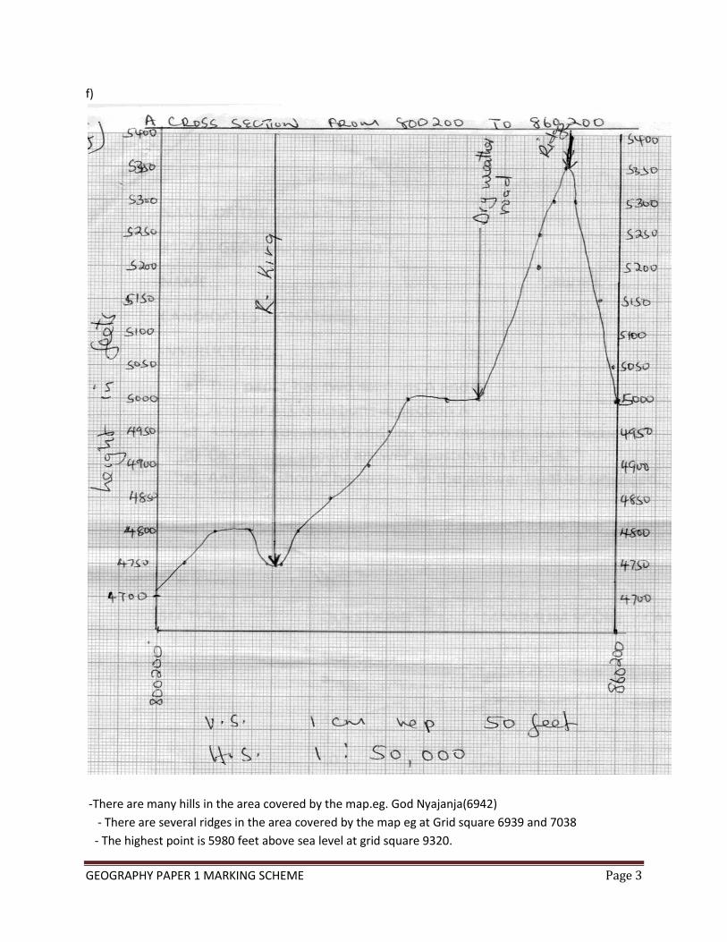
f)
-There are many hills in the area covered by the map.eg. God Nyajanja(6942)
- There are several ridges in the area covered by the map eg at Grid square 6939 and 7038
- The highest point is 5980 feet above sea level at grid square 9320.
GEOGRAPHY PAPER 1 MARKING SCHEME Page 4
- The lowest point is 3900 feet at grid square 6844.
- The eastern side of the area covered by the map is generally steep as depicted by closeness of
Contours.
- There is presence of ranges eg Kebuye range
- Presence of river valleys 6x1=6mks
7 How a river erodes its channel by
i) Hydraulic action
- Water is forced into cracks on the river banks/water hits the bank.
- Air in the cracks is compressed
- Compressed air creates pressure which widens the cracks.
- As water retreats, pressure in the cracks is released suddenly hence shattering the rock.
- The retreating water carries away the loose particles. 4mks
ii) Abrasion/corrosion
- River water carries sand gravel and boulders.
- The load is used as a tool for scouring.
- The load is hurled by the river water against the banks and dragged along the river bed.
- The load chips off the rocks on the bank and the floor.
- Eddying currents rotate rock particles in hollow and widen them into potholes. 3mks
b) Processes by which a river transports it’s load
i) Suspension
Light insoluble materials are transported downstream as mixture/materials may float on the surface
or submerged.
ii)Saltation/hydraulic lift
Materials are moved in a series of short hops and jumps. They are briefly lifted up by the force of the
moving water.
iii)Traction
Heavy materials like boulders are pushed and rolled along the river bed by the force of moving water.
They are never lifted up because they are too heavy.
iv)Solution
River water may dissolve soluble minerals from the bed and sides. The load is transported in solution
form over long distances. 6mks
c) Characteristics of flood plain
GEOGRAPHY PAPER 1 MARKING SCHEME Page 5
- Gently sloping/flat surface
- Has ox-bow lakes/meander scars
- Has deltas/distributaries
- River meanders
- Thick alluvial deposits
- Have bluffs. 3mks
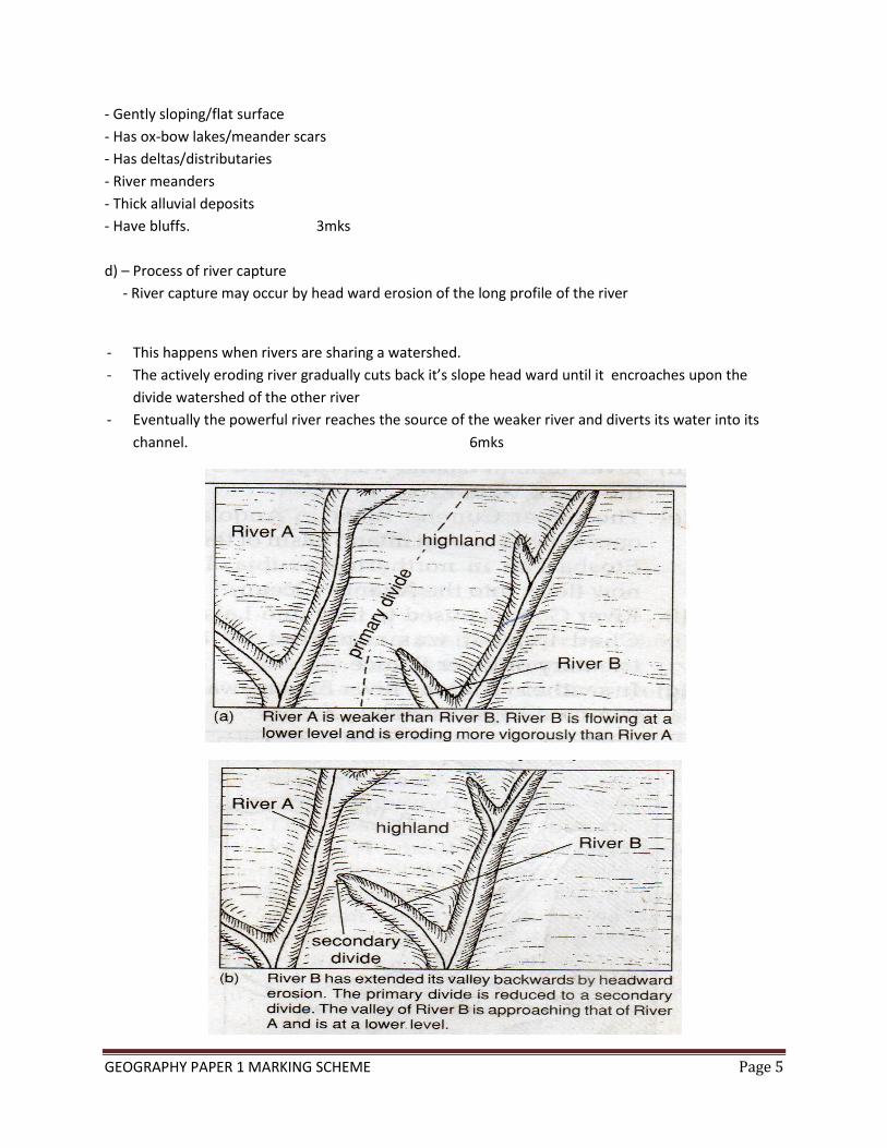
d) – Process of river capture
- River capture may occur by head ward erosion of the long profile of the river
- This happens when rivers are sharing a watershed.
- The actively eroding river gradually cuts back it’s slope head ward until it encroaches upon the
divide watershed of the other river
- Eventually the powerful river reaches the source of the weaker river and diverts its water into its
channel. 6mks

GEOGRAPHY PAPER 1 MARKING SCHEME Page 6
c) Features
- Waterfall/rapid
- potholes
- V-shaped valleys
- Plunge pools
- Interlocking spurs 3mks
8ai) Aridity refers to the state of land being deficient in moisture,leading to scanty vegetation or lack of
it while desertification is slow but steady encroachment of desert like conditions on to agriculturally
productive land.
ii)Rocky
sandy
stony
b) Formation of a rock pedestal by aid of a diagram.
- A rock made of alternating horizontal hard and soft layer of rock lies in the path of moving wind.
-The rock is acted upon by wind abrasion and weathering.
- The soft layers are worn out rapidly than the hard layers resulting in an irregular mass of rock with
protruding layers that `alternate with hollows.
- The mass of rock has a narrow base due to more wind erosion at the base.

GEOGRAPHY PAPER 1 MARKING SCHEME Page 7
This feature is called a rock pedestal
ci) Barchan
ii)K-Horns
iii)L- Eddy current
3mks
d) Wind erosion processes
Abrasion- This is the process where load carries by wind erodes by grinding, scrapping and polishing of
desert rock surface.
Deflation- This is the blowing away of any dry unconsolidated material like dust and fine sand particles
by rolling them on the ground and lifting them in the air.
Attrition- This is wearing away of wind –borne materials due to constant collision of sand particles
where they break into smaller particles.
e) Explain the significance of desert features to human activities.
i) Desert features such as rock pedestals , yardangs and sand dunes attract tourists.
ii) Loess regions have very fertile alluvial soils which are used for cultivation.
iii)Extensive and bare desert surfaces are used as testing grounds for car and jet engines.
iv)Some deflation hollows contain oases which are used as sources of water by nomadic communities.
v) The desert landscapes provides good sites for testing military weapons eg nuclear bombs.
vi) Sand dunes are barriers to transport and communications

GEOGRAPHY PAPER 1 MARKING SCHEME Page 8
9a) Intrusive volcanic features
Dykes,laccolith,Batholith & lopolith 3mks
b) (i) Volcanic plugs
- Volcanic eruption occur. The column of magma cool and solidify inside the vent of a volcanic cone.
- Solidified lava which forms the volcano is eroded over time.
- Causing the solidified column in the vent to be exposed.
- The rocks which make up the plug had cooled slowly making them harder than the surrounding lava.
- With time the plug is exposed as a resistant column or jagged stump of rocks. 4mks
Example- Peak of Mt Kenya
-Rangwe hill 1mk
- Tororo rock in Uganda (max 5)
ii) Lava plateaus
a lava plateau is formed when magma reaches the surface of the earth through a series of vents or
fissures . The lava is extremely fluid or ultra basic. The lava spreads evenly over a wide area filling all the
former valleys and covers most of the landscapes with exception of high hills. The lava cools and
solidifies. Several eruptions build successive layers of lava that form extensive level uplands known as
plateau.
Examples 1mk
Yatta plateau- Uasin Gishu plateau
Laikipia (max 5)
c) Types of volcanoes
- Active volcano 2mks
Nyiragongo,Menengai,ol donyo Lengai
- Dormant volcano
Kilimanjaro,Longonot,Suswa 2mks
- Extinct volcano
Mt Kenya,Elgon,Ngorongoro 2mks
di) Importance of route map
- Estimate the time involved.
- Location of the features
- Saving of time 3mks
Ii) Follow-up activities
- Displaying the photographs taken
- Writing a report

GEOGRAPHY PAPER 1 MARKING SCHEME Page 9
- Group/class discussion
- Further analysis on the data collected
10ai) Glaciation is the process by which moving ice erodes transports and deposits materials on the
earth surface. 2mks
Types of moraine
- Lateral moraine
- Terminal moraine
- Medial moraine
- Ground moraine/englacial moraine 3x1= 3mks
Bi) Pyramidal peaks
- Ice accumulates in several hollows on a glaciated mountain side
- The ice exerts pressure on the cracks in the hollows.
- Plucking action of the ice expands the cracked hollows allowing more ice to accumulates.
- Freeze and thaw action leads to the widening and deepening of the cracks making them to become
large basins.
- Moving ice plucks off loose rock materials from the basin. Making the basins to recede into the
mountain side through the process of headward recession.
- Steep sided, knife-edged ridges/arêtes converge at the mountain top forming a pyramidal peak
(4mks)
ii)Crag and tail
- A large block of rock stands on the path of oncoming glacier.
- The moving ice plucks off weak rock fragments from the upper side of the rock. As the ice moves
round and over the resistant rock it carries the eroded materials to the leeward side.
- The leeward side does not experience erosion but eroded materials are deposited.
- With time the moving ice smoothens the side of the oncoming ice while deposited materials
increase on the leeward side. The resistant rock is the crag while the materials deposited on the
leeward form the tail. 4mks
c) Glacial movement
- Plastic flowage
- Basal slip
- Extrusion flow
- Internal shearing
d) Ice cap mountains in East Africa.
- Mt Kenya
- Mt Ruwenzori
GEOGRAPHY PAPER 1 MARKING SCHEME Page 10
- Mt Kilimanjaro
ei)Glacial till provides fertile soils suitable for arable farming.
ii)Ice sheets in their scouring effect may expose the minerals making them easy to extract.
iii)Outwash plains comprise of sand and gravel which are used as building materials.
iv)Glacial lakes found in lowland are utilized as fishing ground and transport routes.
v)Glaciation forms features such as drumlins and eskers attracts tourists generating income.