geography of the great lakes - university of …investigation geography of the great lakes overview...
TRANSCRIPT
OHSU-El-80-014 c.2
CIRCULATlNG COPYSea Grant Depository
OEAGLS - ;=&=r&Activities
forGreatLakesSchools
GEOGRAPHY OF THE GREAT LAKES
Joyce L. Timmonsand
Rosanne Fortner, The Ohio State University
Ohio Sea Grant ProgramCharles E. Herdendorf, Program Director
Victor J . Mayer, Principal Investigator
TEACHER GUIDE
OEAGLS INVESTIGATION #14Completed July, 1980.
This instructional activity was prepared with thesupport of National Oceanic and Atmospheric AdministrationGrant Nos. 04-158-44099, 04-8-MOl-170 and NA 79AA-D-00120,and from The Ohio State University. However, any opinions,findings, conclusions, or recommendations expressed hereinare those of the authors, and do not necessarily reflectthe views of NOAA or the University.
Copyright a The Ohio State University Research Foundation, 1980.All rights reserved.
GEOGRAPHY OF THE GREAT LAKESINVESTIGATION
OVERVIEW
PREREQUISITESTUDENTBACKGROUND
MATERIALS
OBJECTIVES
In Activity A students study the geography of the GreatLakes area including positions of the lakes and the majorcities on the shores of the lakes. This is accomplishedby examining a map of the United States and by determiningdistances and directions on a map to locate cities.
Activity B considers the geography of the entireSt. Lawrence Seaway and uses the basic map skills appliedin Activity A.
In Activity C students determine perimeter and areaof the lake by using basic math skills. Distance, rateand time problems are also introduced.
In Activity D students study volume through a measurementexercise and an activity using water displacement.
Students should be able to read maps and perform basicmath operations. They should be aware of what is meant by"squaring" a number.
For each student: classroom map of the United States,metric ruler, string, pencils.
For each lab group: two plastic containers ofdifferent sizes (lake and overflow); a third containerthat can be easily measured for volume,such as a small milkcarton (See Figure 5 of the Student Guide.); graduated cylinder
When students have completed this investigation theyshould be able to:
1. Name the Great Lakes and locate them on a map.
2. Locate the major cities on the shores of the GreatLakes.
3. Tell what waterway ships use to go from the GreatLakes to the ocean.
4. Use basic math skills to determine distance, area,volume and perimeter.
5. Use water displacement as a measure of volume.
2
SUGGESTED APPROACH
ACTIVITY A
PROCEDURE
Activities A, B and C should be done by individual students.
Activity D should be done in groups of three. One studentshould read the instructions, one operate the equipment and thethird observe and report data.
Introduce the investigation by a discussion with yourstudents related to points raised in the Introduction to theStudent Guide. Additional information can be obtained fromthe reference included at the end of this guide. You shouldalso conduct a discussion after the investigation is completed.Be sure that the points included at various places in theStudent Guide are understood.
A 17 minute film entitled "The Great Lakes: North America'sInland Seas" (1971) is available from Encyclopedia BritannicaEducational Corporation, 425 North Michigan Avenue, Chicago, IL60611. The film provides an excellent introduction to the Lakesand Seaway, their history, economic importance, climate andgeneral geography. This would be an effective way to begin orend the investigation.
WHAT IS THE GEOGRAPHY OF THE GREAT LAKES AREA?
In this activity students learn the position of the GreatLakes, the major cities around the Great Lakes and some of thedistances involved in Great Lakes travel.
Map labels for Figure 1 should be as follows:
GREAT LAKES
a. Lake Erieb. Lake HuronC . Lake Superiord. Lake Michigane. Lake Ontario
MAJOR GREAT LAKES CITIES
1. Toledo2. Cleveland3. Erie4. Buffalo5. Toronto6. Chicago7. Milwaukee8. Detroit9. Duluth
Answers to be filled in other blanks:
4. Buffalo is in the state of New York.
6. Chicago is in Illinois. Its port is on Lake Michigan.
9. From Duluth to Buffalo is 1233 km by air, or about1600-1640 km by water.
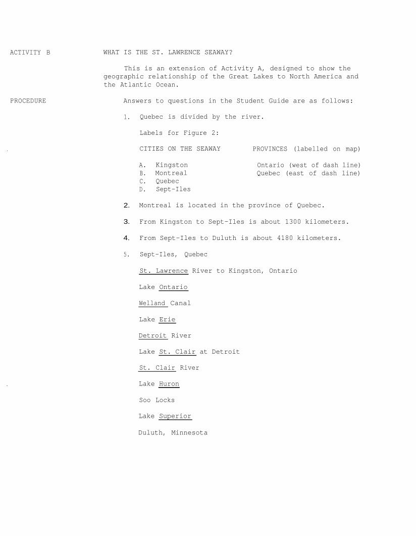
ACTIVITY B WHAT IS THE ST. LAWRENCE SEAWAY?
PROCEDURE
This is an extension of Activity A, designed to show thegeographic relationship of the Great Lakes to North America andthe Atlantic Ocean.
Answers to questions in the Student Guide are as follows:
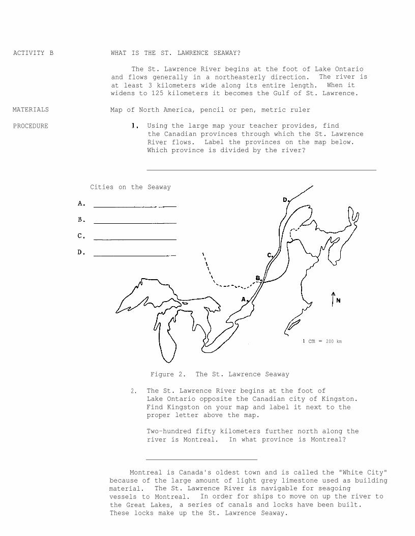
1. Quebec is divided by the river.
Labels for Figure 2:
CITIES ON THE SEAWAY PROVINCES (labelled on map)
A. Kingston Ontario (west of dash line)B. Montreal Quebec (east of dash line)C. QuebecD. Sept-Iles
2. Montreal is located in the province of Quebec.
3. From Kingston to Sept-Iles is about 1300 kilometers.
4. From Sept-Iles to Duluth is about 4180 kilometers.
5. Sept-Iles, Quebec
St. Lawrence River to Kingston, Ontario
Lake Ontario
Welland Canal
Lake Erie
Detroit River
Lake St. Clair at Detroit
St. Clair River
Lake Huron
Soo Locks
Lake Superior
Duluth, Minnesota
4
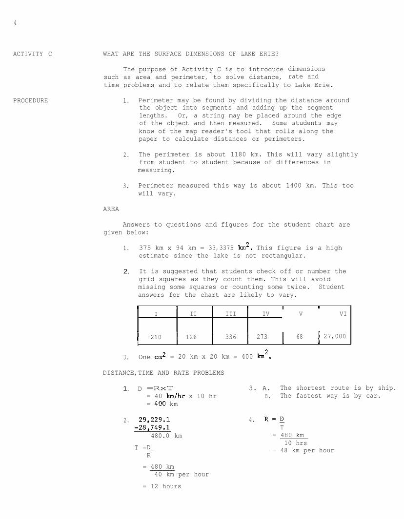
ACTIVITY C
PROCEDURE
WHAT ARE THE SURFACE DIMENSIONS OF LAKE ERIE?
The purpose of Activity C is to introduce dimensionssuch as area and perimeter, to solve distance, rate andtime problems and to relate them specifically to Lake Erie.
1. Perimeter may be found by dividing the distance aroundthe object into segments and adding up the segmentlengths. Or, a string may be placed around the edgeof the object and then measured. Some students mayknow of the map reader's tool that rolls along thepaper to calculate distances or perimeters.
2. The perimeter is about 1180 km. This will vary slightlyfrom student to student because of differences inmeasuring.
3. Perimeter measured this way is about 1400 km. This toowill vary.
AREA
Answers to questions and figures for the student chart aregiven below:
1. 375 km x 94 km = 33,3375 km'. This figure is a highestimate since the lake is not rectangular.
2. It is suggested that students check off or number thegrid squares as they count them. This will avoidmissing some squares or counting some twice. Studentanswers for the chart are likely to vary.
I I I I I I
I II III IV V VI
l 210 1261
II
I 336 I 273 I 68 I 27,000I I , I
3. One cm2 = 20 km x 20 km = 400 lon2.
DISTANCE,TIME AND RATE PROBLEMS
1. D =RxT= 40 km/hr x 10 hr= 400 km
2. 29,229.l-28,749.l
480.0 km
T =D_R
3. A. The shortest route is by ship.B. The fastest way is by car.
4. R'DT
= 480 km10 hrs
= 48 km per hour
= 480 km40 km per hour
= 12 hours
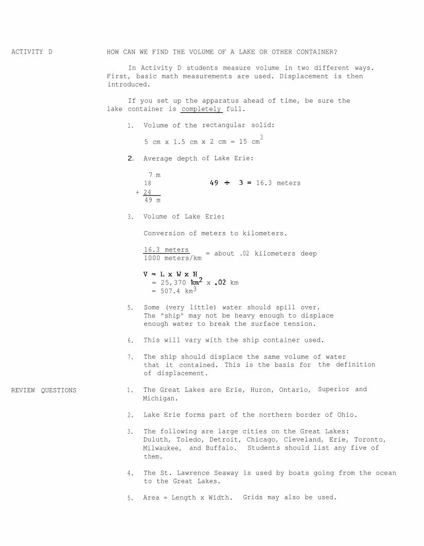
ACTIVITY D
REVIEW QUESTIONS
HOW CAN WE FIND THE VOLUME OF A LAKE OR OTHER CONTAINER?
In Activity D students measure volume in two different ways.First, basic math measurements are used. Displacement is thenintroduced.
If you set up the apparatus ahead of time, be sure thelake container is completely full.
1. Volume of the
5 cm x 1.5 cm
2. Average depth
7 m18
rectangular solid:
x 2 cm = 15 cm3
of Lake Erie:
49+ 3= 16.3 meters+ 24
49 m
3. Volume of Lake Erie:
Conversion of meters to kilometers.
16.3 meters1000 meters/km = about .02 kilometers deep
v= LxWxH= 25,370 km2 x .02 km= 507.4 km3
5. Some (very little) water should spill over.The "ship" may not be heavy enough to displaceenough water to break the surface tension.
6. This will vary with the ship container used.
7. The ship should displace the same volume of waterthat it contained. This is the basis forof displacement.
the definition
1. The Great Lakes are Erie, Huron, Ontario,Michigan.
Superior and
2. Lake Erie forms part of the northern border of Ohio.
3. The following are large cities on the Great Lakes:Duluth, Toledo, Detroit, Chicago, Cleveland, Erie, Toronto,Milwaukee, and Buffalo. Students should list any five ofthem.
4. The St. Lawrence Seaway is used by boats going from the oceanto the Great Lakes.
5. Area = Length x Width. Grids may also be used.
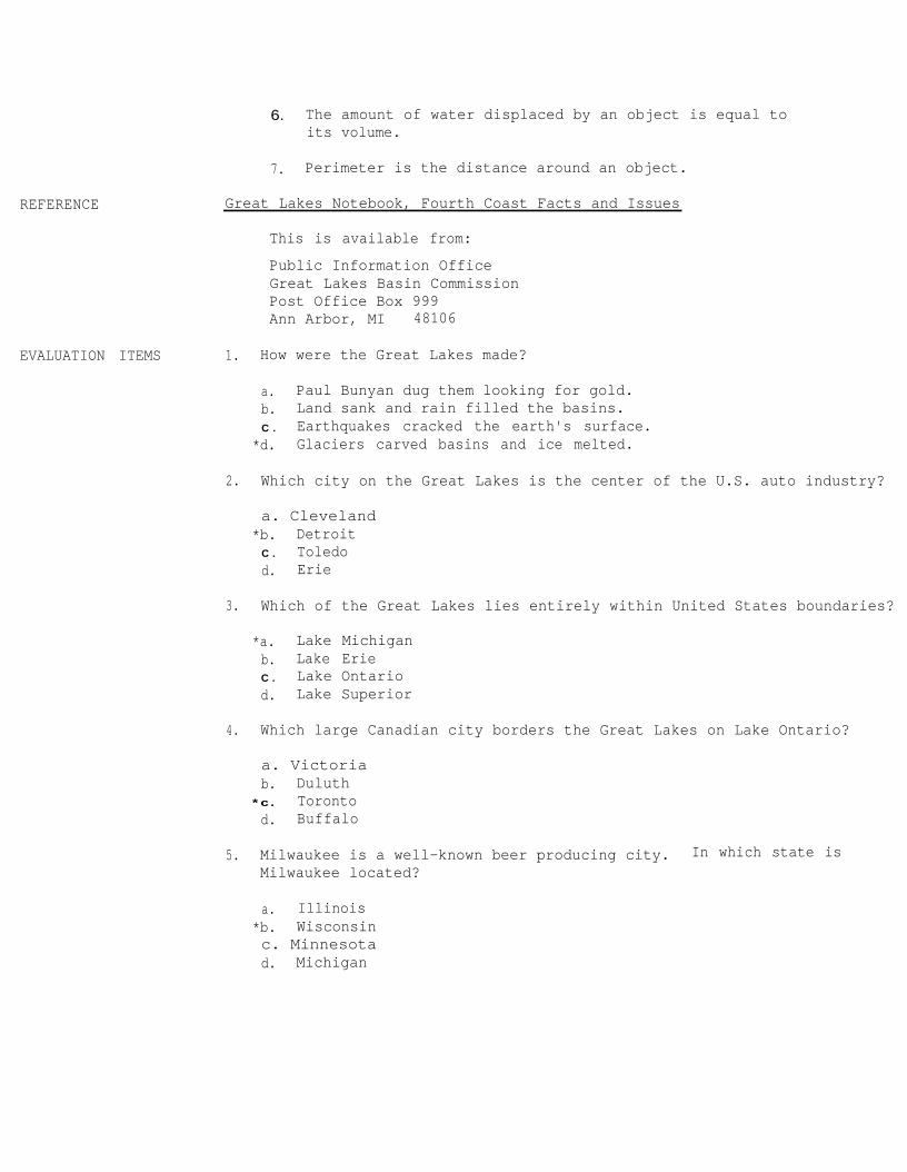
REFERENCE Great Lakes Notebook, Fourth Coast Facts and Issues
6. The amount of water displaced by an object is equal toits volume.
7. Perimeter is the distance around an object.
This is available from:
Public Information OfficeGreat Lakes Basin CommissionPost Office Box 999Ann Arbor, MI 48106
EVALUATION ITEMS 1. How were the Great Lakes made?
a. Paul Bunyan dug them looking for gold.b. Land sank and rain filled the basins.C . Earthquakes cracked the earth's surface.
*d. Glaciers carved basins and ice melted.
2. Which city on the Great Lakes is the center of the U.S. auto industry?
a. Cleveland*b. Detroit
C . Toledod. Erie
3. Which of the Great Lakes lies entirely within United States boundaries?
*a. Lake Michiganb. Lake ErieC . Lake Ontariod. Lake Superior
4. Which large Canadian city borders the Great Lakes on Lake Ontario?
a. Victoriab. Duluth
*c. Torontod. Buffalo
5. Milwaukee is a well-known beer producing city. In which state isMilwaukee located?
a. Illinois*b. Wisconsinc. Minnesotad. Michigan
7
6. Which Canadian province is divided by the St. Lawrence River?
a. New Brunswickb. Newfoundland
‘kc. Quebecd. Ontario
7. Which waterway connects the Great Lakes to the Atlantic Ocean?
a. Gulf Stream*b. St. Lawrence Seawayc. Lake Ontariod. Mississippi River
8. What is the perimeter of an object?
a. The amount of material an object can holdb. Half the distance across itc. The distance across it
*d. The distance around it
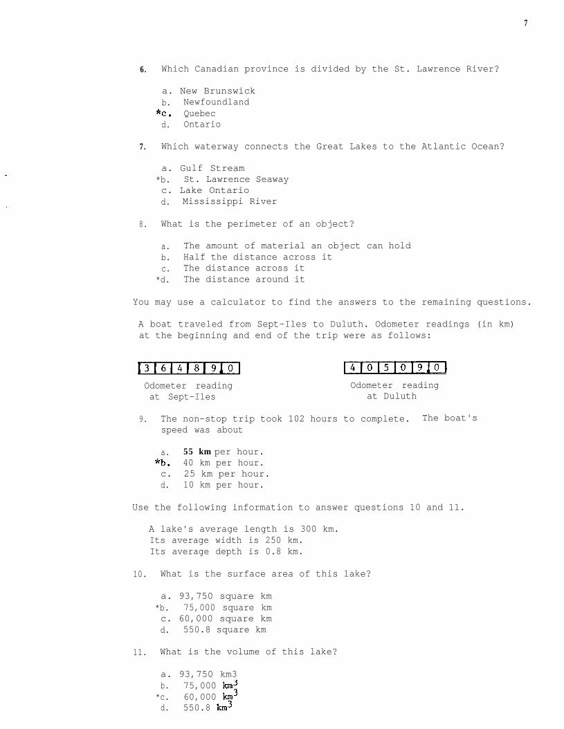
You may use a calculator to find the answers to the remaining questions.
A boat traveled from Sept-Iles to Duluth. Odometer readings (in km)at the beginning and end of the trip were as follows:
Odometer reading Odometer readingat Sept-Iles at Duluth
9. The non-stop trip took 102 hours to complete. The boat'sspeed was about
a. 55 km per hour."b. 40 km per hour.c. 25 km per hour.d. 10 km per hour.
Use the following information to answer questions 10 and 11.
A lake's average length is 300 km.Its average width is 250 km.Its average depth is 0.8 km.
10. What is the surface area of this lake?
a. 93,750 square km*b. 75,000 square kmc. 60,000 square kmd. 550.8 square km
11. What is the volume of this lake?
a. 93,750 km3b. 75,000 km3
*c. 60,000 km3d. 550.8 km3
OEAGLS - ;;ra$onActivities
forGreatLakesSchools
GEOGRAPHY OF THE GREAT LAKESby
Joyce L. Timmonsand
Rosanne Fortner, The Ohio State University
Ohio Sea Grant ProgramCharles E. Herdendorf, Program Director
Victor J. Mayer, Principal Investigator
OEAGLS Investigation # 1 4Completed May 1980
This instructional activity was prepared with thesupport of National Oceanic and Atmospheric AdministrationGrant Nos. 04-158-44099, 04-8-MOl-170 and NA 79AA-D-00120,and from The Ohio State University. However, any opinions,findings, conclusions, or recommendations expressed hereinare those of the authors, and do not necessarily reflectthe views of NOAA or the University.
Copyright a The Ohio State University Research Foundation, 1980.All rights reserved.
GEOGRAPHY OF THE GREAT LAKES
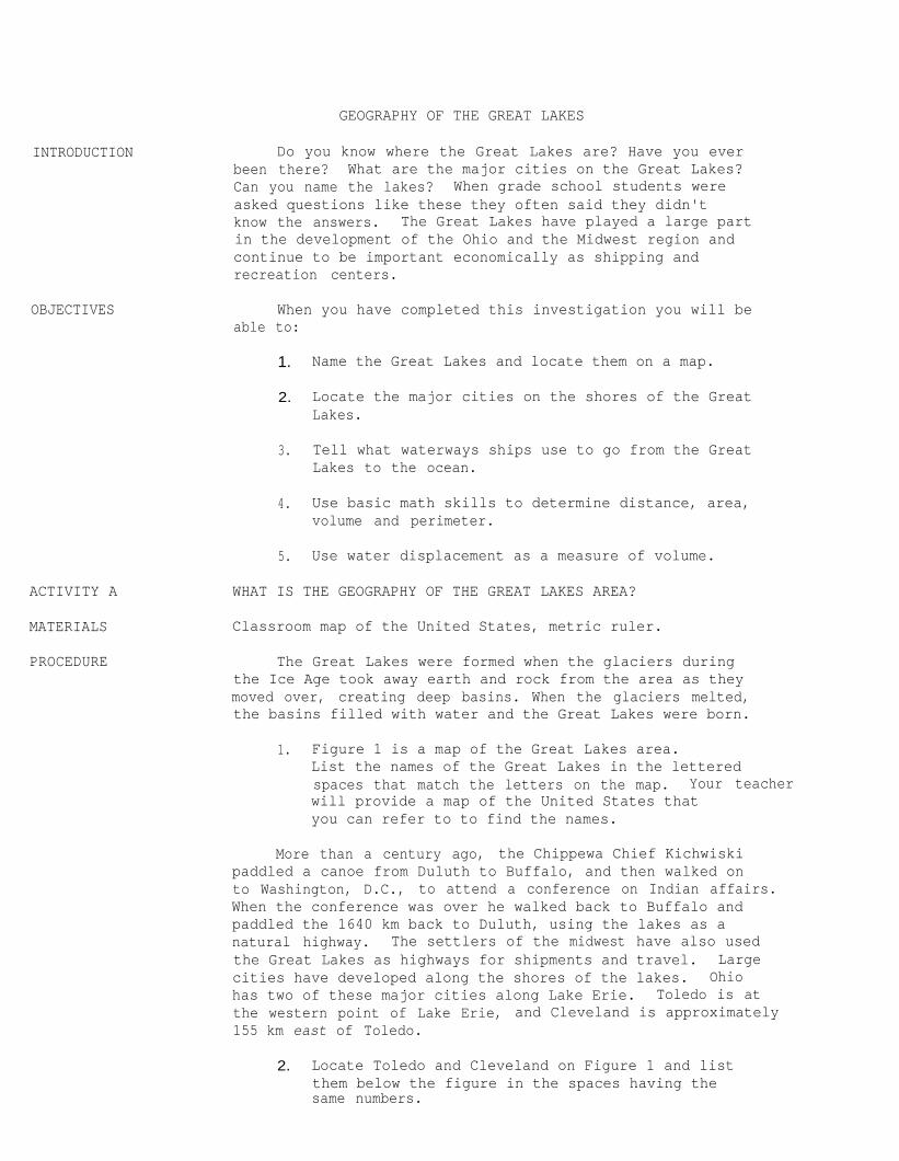
INTRODUCTION
OBJECTIVES
ACTIVITY A
MATERIALS
PROCEDURE
Do you know where the Great Lakes are? Have you everbeen there? What are the major cities on the Great Lakes?Can you name the lakes? When grade school students wereasked questions like these they often said they didn'tknow the answers. The Great Lakes have played a large partin the development of the Ohio and the Midwest region andcontinue to be important economically as shipping andrecreation centers.
When you have completed this investigation you will beable to:
1. Name the Great Lakes and locate them on a map.
2. Locate the major cities on the shores of the GreatLakes.
3. Tell what waterways ships use to go from the GreatLakes to the ocean.
4. Use basic math skills to determine distance, area,volume and perimeter.
5. Use water displacement as a measure of volume.
WHAT IS THE GEOGRAPHY OF THE GREAT LAKES AREA?
Classroom map of the United States, metric ruler.
The Great Lakes were formed when the glaciers duringthe Ice Age took away earth and rock from the area as theymoved over, creating deep basins. When the glaciers melted,the basins filled with water and the Great Lakes were born.
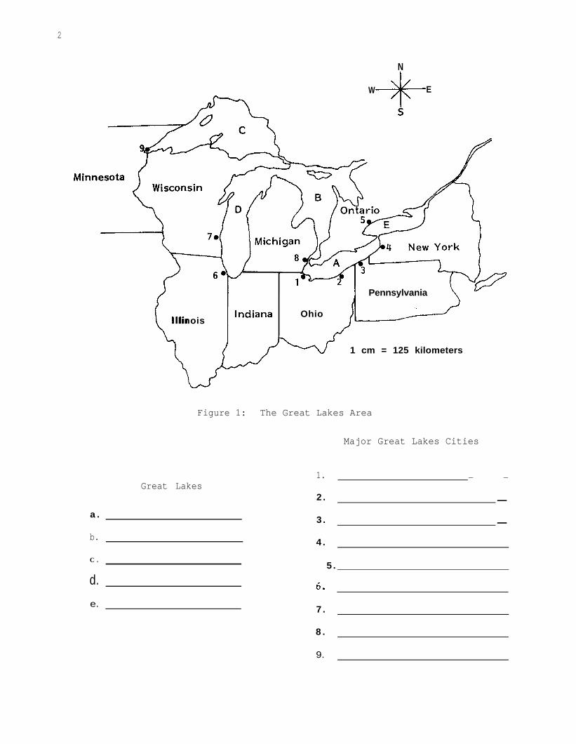
1. Figure 1 is a map of the Great Lakes area.List the names of the Great Lakes in the letteredspaces that match the letters on the map. Your teacherwill provide a map of the United States thatyou can refer to to find the names.
More than a century ago, the Chippewa Chief Kichwiskipaddled a canoe from Duluth to Buffalo, and then walked onto Washington, D.C., to attend a conference on Indian affairs.When the conference was over he walked back to Buffalo andpaddled the 1640 km back to Duluth, using the lakes as anatural highway. The settlers of the midwest have also usedthe Great Lakes as highways for shipments and travel. Largecities have developed along the shores of the lakes. Ohiohas two of these major cities along Lake Erie. Toledo is atthe western point of Lake Erie, and Cleveland is approximately155 km east of Toledo.
2. Locate Toledo and Cleveland on Figure 1 and listthem below the figure in the spaces having thesame numbers.
2
N
W-+I+-
E
(_IllinoisIndianaLf Ohio
/
1 Pennsylvania ’\
1 cm = 125 kilometers
Figure 1: The Great Lakes Area
Major Great Lakes Cities
Great Lakes
a .
b.
C .
d.
e.
1. - -
2 . -
3. -
4.
5 .
I
5.0.
7 .
8 .
9.
3. Pennsylvania has one large port on the shore ofLake Erie. This port is called Erie.
Find Erie on Figure 1 and list it in the proper spaceunder Great Lakes cities.
4. One hundred fifty-five kilometers northeast of Erie,Pennsylvania, is Buffalo. In what state is Buffalo?
Add Buffalo to your list below Figure 1.
There is one large Canadian city on Lake Ontario. It iscalled Toronto and is in the province of Ontario. CanadianProvinces are similar to states in the United States.
5. Find Toronto on Figure 1 and list it.
Ships pass between Lake Erie and Lake Ontario by wayof the Welland Canal. Water moves from one lake to anotherthrough the canal and also through the Niagara River. NiagaraFalls is located on this river.
Three hundred ninety kilometers due west of Toledo isthe second largest city in the United States, Chicago.
6. In what state is Chicago?
On which lake is the port of Chicago?
List Chicago below Figure 1.
North of Chicago on the same lake is Milwaukee, Wisconsin.Milwaukee is well known for the beer that it produces.
7. Find Milwaukee on Figure 1 and list it under Great LakesCities.
Eighty kilometers north of Toledo is Detroit, Michigan.Detroit is the center of the U.S. auto industry.
8. Detroit is not situated on one of the Great Lakes.It is on the Detroit River, which, along with theSt. Clair River and Lake St. Clair, forms a connectingwaterway between Lake Huron and Lake Erie.
List Detroit in the proper space below Figure 1.
4
Passage through Lake Huron can take a ship eitherinto Lake Michigan or Lake Superior. Ships going to LakeMichigan pass through the Straits of Mackinac. Shipsmove from Lake Huron to Lake Superior by going through theSoo Locks on the St. Mary's River.
At the extreme western tipMinnesota.
9. Using the map scale infrom Buffalo by air?
By water?
of Lake Superior is Duluth,
Figure 1, how far is Duluth
Label Duluth below Figure 1.
Duluth is near the Mesabi Range where much of our iron orecomes from. It is a major port for shipping iron ore to thesteel mills in Indiana and Ohio.
ACTIVITY B WHAT IS THE ST. LAWRENCE SEAWAY?
MATERIALS
PROCEDURE
The St. Lawrence River begins at the foot of Lake Ontarioand flows generally in a northeasterly direction. The river isat least 3 kilometers wide along its entire length. When itwidens to 125 kilometers it becomes the Gulf of St. Lawrence.
Map of North America, pencil or pen, metric ruler
Cities on the
Using the large map your teacher provides, findthe Canadian provinces through which the St. LawrenceRiver flows. Label the provinces on the map below.Which province is divided by the river?
Seaway /
1 cm = 200 km
Figure 2. The St. Lawrence Seaway
2. The St. Lawrence River begins at the foot ofLake Ontario opposite the Canadian city of Kingston.Find Kingston on your map and label it next to theproper letter above the map.
Two-hundred fifty kilometers further north along theriver is Montreal. In what province is Montreal?
Montreal is Canada's oldest town and is called the "White City"because of the large amount of light grey limestone used as buildingmaterial. The St. Lawrence River is navigable for seagoingvessels to Montreal. In order for ships to move on up the river tothe Great Lakes, a series of canals and locks have been built.These locks make up the St. Lawrence Seaway.
6
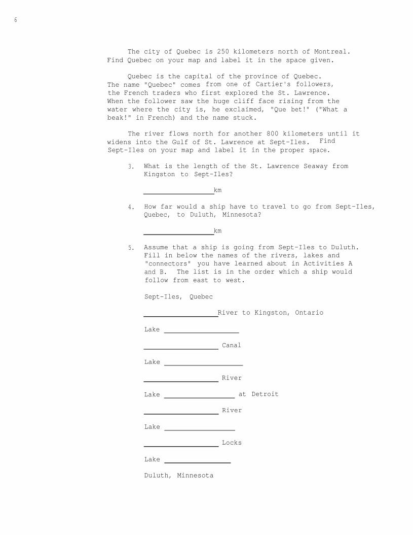
The city of Quebec is 250 kilometers north of Montreal.Find Quebec on your map and label it in the space given.
Quebec is the capital of the province of Quebec.The name "Quebec" comes from one of Cartier's followers,the French traders who first explored the St. Lawrence.When the follower saw the huge cliff face rising from thewater where the city is, he exclaimed, "Que bet!" ("What abeak!" in French) and the name stuck.
The river flows north for another 800 kilometers until itwidens into the Gulf of St. Lawrence at Sept-Iles. FindSept-Iles on your map and label it in the proper space.
3.
4.
5.
What is the length of the St. Lawrence Seaway fromKingston to Sept-Iles?
km
How far would a ship have to travel to go from Sept-Iles,Quebec, to Duluth, Minnesota?
km
Assume that a ship is going from Sept-Iles to Duluth.Fill in below the names of the rivers, lakes and"connectors" you have learned about in Activities Aand B. The list is in the order which a ship wouldfollow from east to west.
Sept-Iles, Quebec
River to Kingston, Ontario
Lake
Canal
Lake
River
Lake at Detroit
River
Lake
Locks
Lake
Duluth, Minnesota
ACTIVITY C
MATERIALS
PROCEDURE
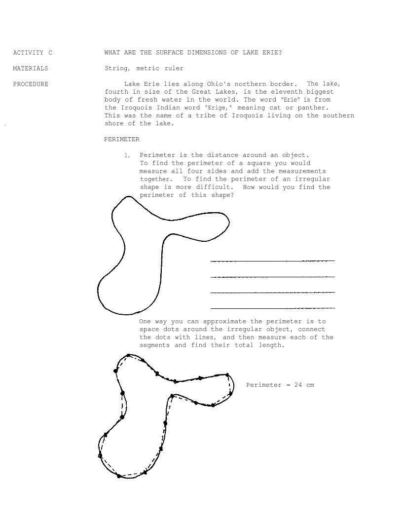
WHAT ARE THE SURFACE DIMENSIONS OF LAKE ERIE?
String, metric ruler
Lake Erie lies along Ohio's northern border. The lake,fourth in size of the Great Lakes, is the eleventh biggestbody of fresh water in the world. The word "Erie" is fromthe Iroquois Indian word "Erige," meaning cat or panther.This was the name of a tribe of Iroquois living on the southernshore of the lake.
PERIMETER
1. Perimeter is the distance around an object.To find the perimeter of a square you wouldmeasure all four sides and add the measurementstogether. To find the perimeter of an irregularshape is more difficult. How would you find theperimeter of this shape?
One way you can approximate the perimeter is tospace dots around the irregular object, connectthe dots with lines, and then measure each of thesegments and find their total length.
Perimeter = 24 cm
8
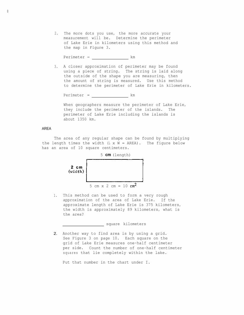
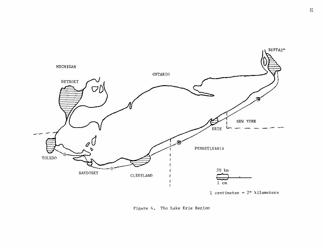
2. The more dots you use, the more accurate yourmeasurement will be. Determine the perimeterof Lake Erie in kilometers using this method andthe map in Figure 3.
Perimeter = km
3. A closer approximation of perimeter may be foundusing a piece of string. The string is laid alongthe outside of the shape you are measuring, thenthe amount of string is measured. Use this methodto determine the perimeter of Lake Erie in kilometers.
Perimeter = km
When geographers measure the perimeter of Lake Erie,they include the perimeter of the islands. Theperimeter of Lake Erie including the islands isabout 1350 km.
AREA
The area of any regular shape can be found by multiplyingthe length times the width (L x W = AREA). The figure belowhas an area of 10 square centimeters.
5 cm (length)
(:idcZ) r/
5 cm x 2 cm = 10 cm*
1. This method can be used to form a very roughapproximation of the area of Lake Erie. If theapproximate length of Lake Erie is 375 kilometers,the width is approximately 89 kilometers, what isthe area?
square kilometers
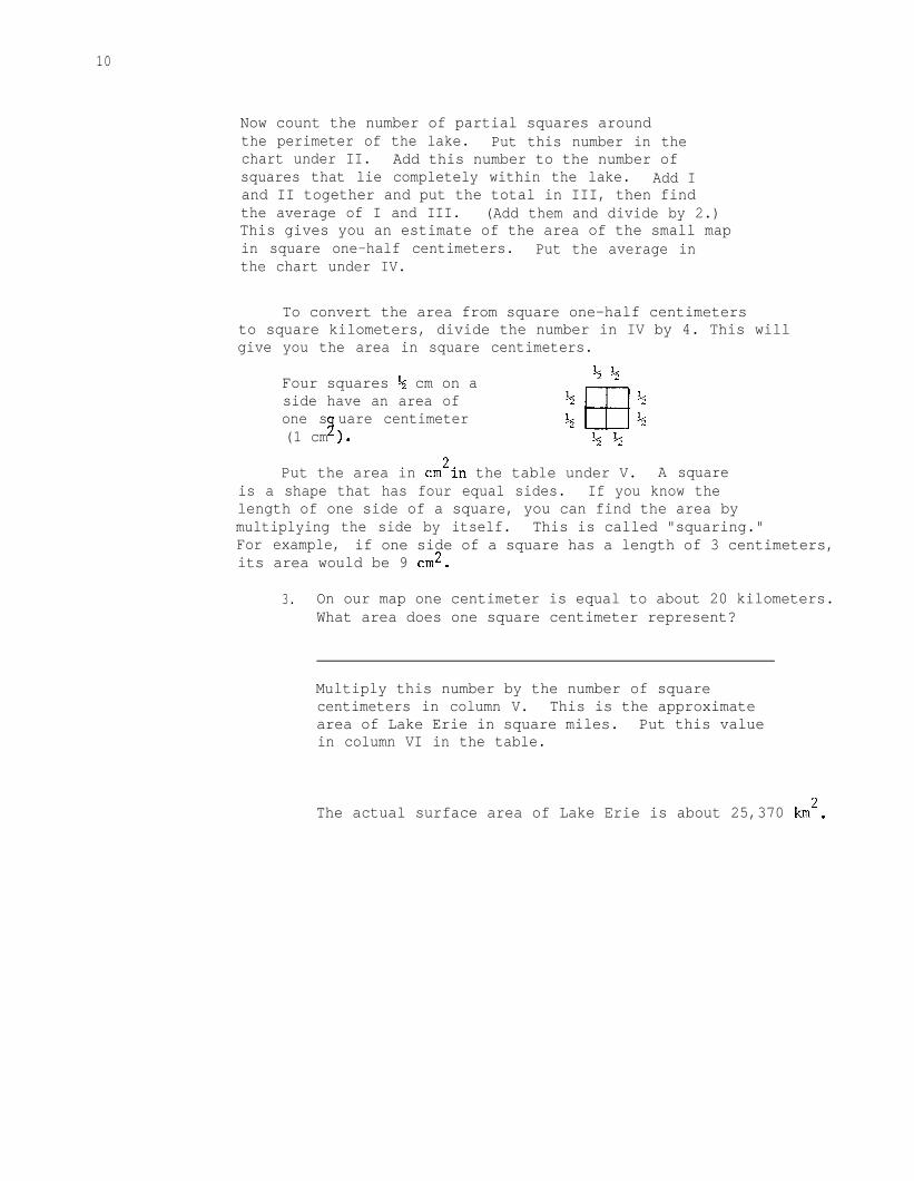
2. Another way to find area is by using a grid.See Figure 3 on page 10. Each square on thegrid of Lake Erie measures one-half centimeterper side. Count the number of one-half centimetersquares that lie completely within the lake.
Put that number in the chart under I.
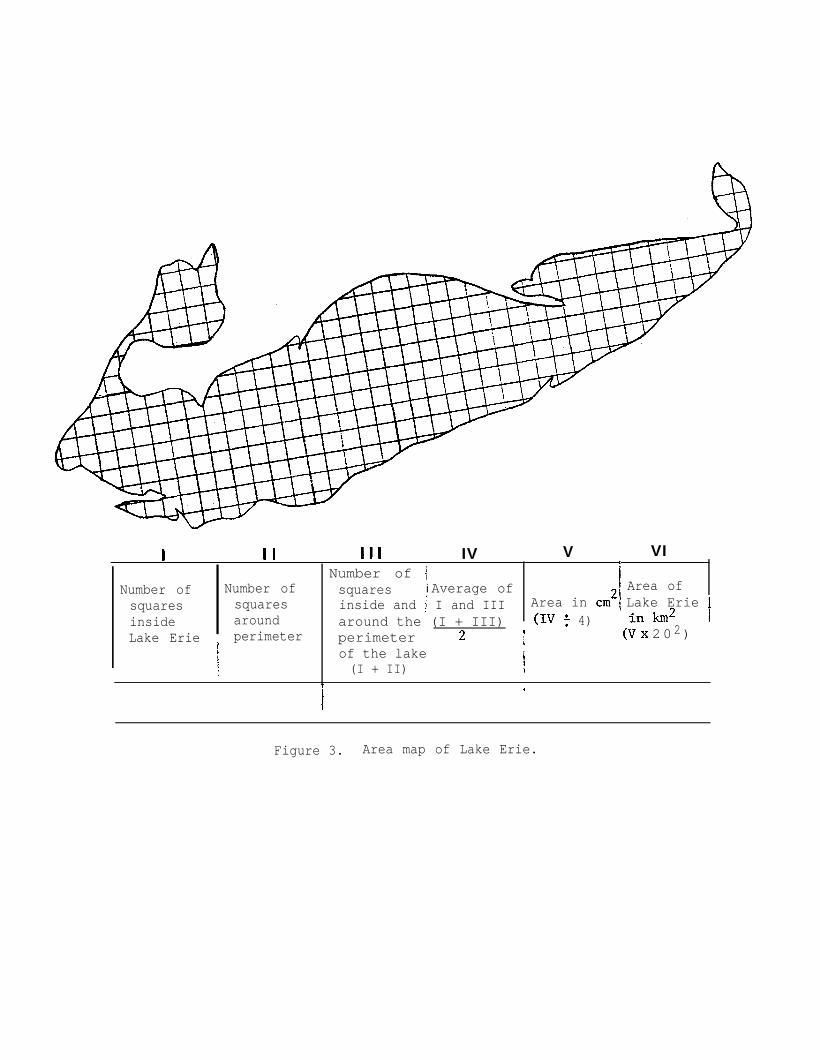
I I I Ill IV V VIINumber of 1
Number of Number of squares i Average of I Area ofsquares squares inside and i I and III Area in cm2 Lake ErieIinside around around the (I + III) (IV : 4) inkm2 ,I
Lake Erie perimeter perimeter 2 8f
i (V x 202)
\of the lake(I + II) i
7
I*
Figure 3. Area map of Lake Erie.
10
Now count the number of partial squares aroundthe perimeter of the lake. Put this number in thechart under II. Add this number to the number ofsquares that lie completely within the lake. Add Iand II together and put the total in III, then findthe average of I and III. (Add them and divide by 2.)This gives you an estimate of the area of the small mapin square one-half centimeters. Put the average inthe chart under IV.
To convert the area from square one-half centimetersto square kilometers, divide the number in IV by 4. This willgive you the area in square centimeters.
Four squares $ cm on a 4%
side have an area of &
E3
$one s uare centimeter
8 + %(1 cm ). k$
Put the area in cm2in the table under V. A squareis a shape that has four equal sides. If you know thelength of one side of a square, you can find the area bymultiplying the side by itself. This is called "squaring."For example, if one side of a square has a length of 3 centimeters,its area would be 9 cm2.
3. On our map one centimeter is equal to about 20 kilometers.What area does one square centimeter represent?
Multiply this number by the number of squarecentimeters in column V. This is the approximatearea of Lake Erie in square miles. Put this valuein column VI in the table.
The actual surface area of Lake Erie is about 25,370 km2.
11
APPLYING WHAT YOU KNOW:
DISTANCE, RATE AND TIME PROBLEMS
The Great Lakes are used to ship heavy bulky productssuch as iron ore. They are well suited for this purposebecause they are deep enough that very large ships can beused. Is travel by waterway the fastest way for people totravel?
Problems that deal with distance, time needed to gofrom place to place, and speed are called "distance, rate,and time" problems. There is a formula that can be usedto compute these values.
RATE = DISTANCETIME
DISTANCE = RATE
TIME =
x TIME (D =RT)
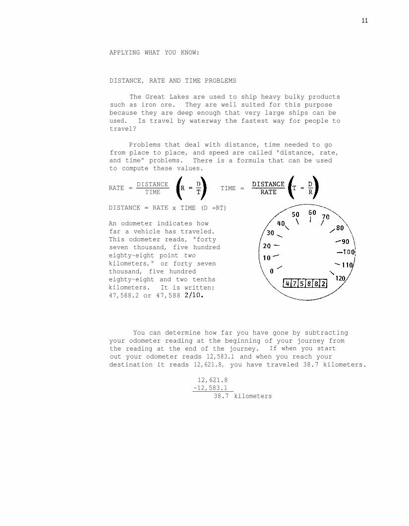
An odometer indicates howfar a vehicle has traveled.This odometer reads, "fortyseven thousand, five hundredeighty-eight point twokilometers," or forty seventhousand, five hundredeighty-eight and two tenthskilometers. It is written:47,588.2 or 47,588 2110.
You can determine how far you have gone by subtractingyour odometer reading at the beginning of your journey fromthe reading at the end of the journey. If when you startout your odometer reads 12,583.l and when you reach yourdestination it reads 12,621.8, you have traveled 38.7 kilometers.
12,621.8-12,583.l
38.7 kilometers
12
07
\\
0NII
i
13
1. A ship sets sail for Buffalo from Toledo going40km/hr. The ship reaches Buffalo 10 hourslater. How far is it from Toledo to Buffalo bywater? (Show your work.)
km
2. At the same time a man on a motor bike leaves Toledofollowing routes 2 and 90. The odometer on the man'smotor bike reads 28,749.l km when he leaves Toledo and29,229.l km when he reaches Buffalo. How far has hetraveled? (Show your work.)
km
If the man traveled at 40 km/hr, how long did he ride?
km
3. If you had a choice of going from Toledo to Buffaloby car traveling at 88 km/hr or a ship traveling at40 km/hr, which would you choose if:
A) . You wanted to get to Buffalo the shortest way?
B) . You wanted to get to Buffalo the fastest way?
4. What speed would you have to drive in order toarrive at Buffalo at the same time the ship arrives?
km/hr (Show the formula and calculations here.)
14
ACTIVITY D
MATERIALS
PROCEDURE
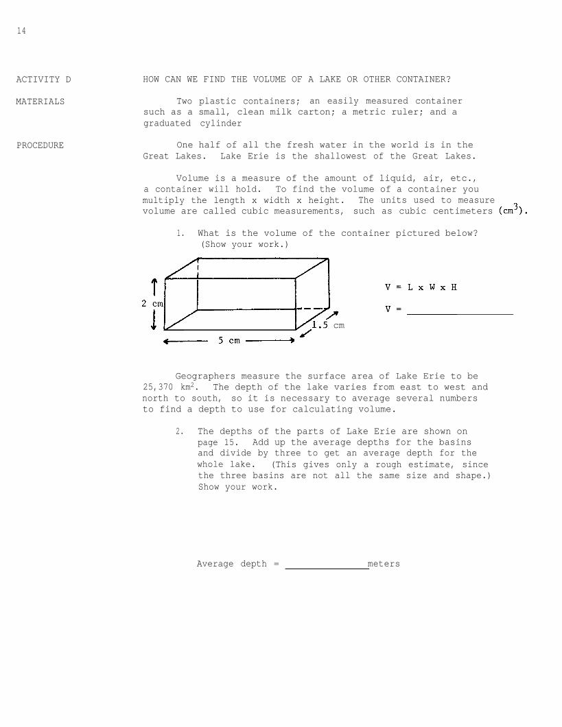
HOW CAN WE FIND THE VOLUME OF A LAKE OR OTHER CONTAINER?
Two plastic containers; an easily measured containersuch as a small, clean milk carton; a metric ruler; and agraduated cylinder
One half of all the fresh water in the world is in theGreat Lakes. Lake Erie is the shallowest of the Great Lakes.
Volume is a measure of the amount of liquid, air, etc.,a container will hold. To find the volume of a container youmultiply the length x width x height. The units used to measurevolume are called cubic measurements, such as cubic centimeters (cm3).
1. What is the volume of the container pictured below?(Show your work.)
1.3 cm5c------ 5cm-------_)
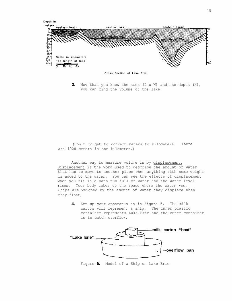
Geographers measure the surface area of Lake Erie to be25,370 km2. The depth of the lake varies from east to west andnorth to south, so it is necessary to average several numbersto find a depth to use for calculating volume.
2. The depths of the parts of Lake Erie are shown onpage 15. Add up the average depths for the basinsand divide by three to get an average depth for thewhole lake. (This gives only a rough estimate, sincethe three basins are not all the same size and shape.)Show your work.
Average depth = meters
15
Depth in
Scale in kilometersf o r length of lake
Cross Section of Lake Erie
3. Now that you know the area (L x W) and the depth (H),you can find the volume of the lake.
(Don't forget to convert meters to kilometers! Thereare 1000 meters in one kilometer.)
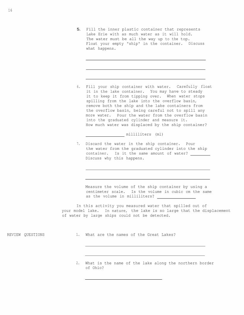
Another way to measure volume is by displacement.Displacement is the word used to describe the amount of waterthat has to move to another place when anything with some weightis added to the water. You can see the effects of displacementwhen you sit in a bath tub full of water and the water levelrises. Your body takes up the space where the water was.Ships are weighed by the amount of water they displace whenthey float,
4. Set up your apparatus as in Figure 5. The milkcarton will represent a ship. The inner plasticcontainer represents Lake Erie and the outer containeris to catch overflow.
“Lake Erie”
milk carton “boat”
overflow pan
Figure 5. Model of a Ship on Lake Erie
16
REVIEW QUESTIONS
5. Fill the inner plastic container that representsLake Erie with as much water as it will hold.The water must be all the way up to the top.Float your empty "ship" in the container. Discusswhat happens.
6. Fill your ship container with water. Carefully floatit in the lake container. You may have to steadyit to keep it from tipping over. When water stopsspilling from the lake into the overflow basin,remove both the ship and the lake containers fromthe overflow basin, being careful not to spill anymore water. Pour the water from the overflow basininto the graduated cylinder and measure it.How much water was displaced by the ship container?
milliliters (ml)
7. Discard the water in the ship container. Pourthe water from the graduated cylinder into the shipcontainer. Is it the same amount of water?Discuss why this happens.
Measure the volume of the ship container by using acentimeter scale. Is the volume in cubic cm the sameas the volume in milliliters?
In this activity you measured water that spilled out ofyour model lake. In nature, the lake is so large that the displacementof water by large ships could not be detected.
1. What are the names of the Great Lakes?
2. What is the name of the lake along the northern borderof Ohio?
17
3. What are the names of five of the large cities alongthe shores of the Great Lakes?
4. What waterway is used by ships going from the oceanto the Great Lakes?
5. How do you find the area of an object?
6. What other way besides measuring with a ruler is usedto determine volume?
7. What is the distance around an object called?