geography of fear: understanding students’ sense of place
TRANSCRIPT

Chrestomathy: Annual Review of Undergraduate Research, School of Humanities andSocial Sciences, School of Languages, Cultures, and World Affairs, College of CharlestonVolume 8 (2009): 115-146© 2009 by the College of Charleston, Charleston SC 29424, USA.All rights to be retained by the author.
115
Geography of Fear: UnderstandingStudents’ Sense of Place
Alexandra R. Modly
Introduction
As a student at the College of Charleston I began to notice thatstudents’ perception of safe or dangerous places did not correspondto available information about crime locations. While most studentswill confess a fear of crime they didn’t seem to fear the places wherecrimes were occurring. I wanted to explore this potential spatialdisconnect between the places crimes occurred and students’geographies of fear. For the purpose of this research, I have definedthe term “geography of fear” as the area or places people (in this casestudents) indicate and understand as fearful or dangerous. Most authorsattributed fear directly and solely to crime. I find this causal relationshiptroubling because authors did not take any other mediating factorsinto account. In order to gain a more holistic understanding ofindividuals’ geography of fear one must consider the many and diversefactors that can affect a person’s perception of fear or danger. Equippedwith a basic understanding of crime statistics in Charleston, I beganto realize that in some cases students’ geographies of fear were notinformed by actual occurrences of crime.
In this paper I seek to demonstrate that crime is not the only causeof fear and that students often fear unfamiliar areas characterized bythe visual presence of disorder, in the form of dilapidated propertyand people that they feel do not “belong.” For the purpose of thisresearch, fear is defined as the range of emotional and practicalresponses from pain to uneasiness caused by the sense of a perceivedthreat or danger, often concerning one’s own safety. (This definition

116 Chrestomathy: Volume 8, 2009
draws from Bannister and Fye [2001] and Rachel Pain [2001].) Fearmay vary in nature, intensity, and duration depending on the situation.I found that incorporating an understanding of the assumptions of“Broken Windows” policing strategies helped to explain students’geographies of fear. The term “Broken Windows” was coined in the1980s by James Q. Wilson and George L. Kelling. The idea is thatcrime and disorder are intrinsically related to one another. The namecomes from the analogy that if one window in a building is broken,residents should fix it as quickly as possible or else others will assumeno one cares for the building and begin to throw more stones, breakingmore windows. Orderliness, in the authors’ opinion, is a sign of aprosperous neighborhood. The absence of visual signs of orderlinesswill lead to higher crime rates. In this way visual signs of disorder andneglect are inexorably linked to higher rates of crime (Wilson andKelling 1982). The argument has been widely adopted and lavishlypraised since it was first introduced. Its ideas have seeped into thesub-consciousness of society and because of the commonsensicalnature of the assumptions that underpin the theory, it is rarelychallenged. Yet, scholarly research has demonstrated that BrokenWindows policing strategies have no real empirical support (Taylor2000; Harcourt 2004; and Harcourt and Ludwig 2006). Research hasdemonstrated, in fact, that the underlying assumptions about theintrinsic relationship between “visible disorder” and crime are untrue.Through an analysis of students’ fears which incorporates a critiqueof the near universal assumptions which inform the Broken Windowspolicing strategies, I argue that students geographies of fear areconstructed from perceptions of unfamiliarity coupled with visual signsof disorder. This relationship is problematic because students’ fearsare being based on something that does not accurately reflect the truedangers of an area. Rather, their fears reflect the problematic natureof the influence of the assumptions that inform Broken Windowsideology.
The Evolution of Geography-of-Fear Literature
The geographic study of fear reveals the spatial manifestation ofinstitutions of power which operate within a specific setting: that is,who has power, how it is expressed, its material ramifications and

Modly: Geography of Fear 117
everyday manifestations. Research on the geography of fear buildsupon itself as authors seek to expand the discipline by evaluatingpreviously held assumptions. Fear-of-crime surveys seek to understandpeoples’ fears through the lens of crime. These surveys, however,often do not take into account the identity politics that surround fear.
Fear-of-crime surveys were designed to evaluate peoples’ reactionto crime rates and crime location over a defined geographic area.Caroline Moser (2004) focuses on the costs, consequences, andproffered solutions of urban violence and insecurity. She began to seethat violence had a spatial manifestation. As a result of the spatialmanifestation of violence in the urban environment, particular socialgroups, especially the wealthy, began to separate themselvesgeographically from the urban environment through the creation ofgated communities. Her observations, while illuminating, do notattempt to explore the influential nature of subjectivity on the creationand experience of personal fears. Rather, her study aims to identifymethods of reducing insecurity (fear) by reducing violence. Moselyoverlooks many other factors that could mediate personal experienceswith crime.
Rachel Pain (2001) took this fear-of-crime discourse a step furtherby reviewing and exploring the differences in people’s experience offear through the lens of social identities Pain (2001) came to theconclusion that differences in age, gender, and race can lead todifferential experiences of fear in the same social and geographicsetting. Further, she discusses the ambiguity concerning the term fear-of-crime. She defines fear-of-crime as “the wide range of emotionaland practical responses to crime and disorder individuals andcommunities may make” (367). This definition takes into account moreaspects than simply knowledge of crime locations, yet it is still heavilydependent on crime as an agent of fear. Some more recent studiesshow an interest in examining the social, economic, and builtenvironments for evidence that fear is not solely influenced by crime.Many of these studies attribute a place-based quality to personal fears.It is in these studies that the interest in examining the influence ofmediating factors affecting perceptions and feeling of fear reallyemerges as a dominant area of interest within the geographic study offear.
118 Chrestomathy: Volume 8, 2009
According to Whitzman (2007), economic and social powerlessnessand exclusion are some factors that may cause or define fear. A closerexamination of how an individual’s experience of, understanding of,and interaction with the urban environment is mediated by variablefactors and processes is necessary in order to create a betterunderstanding of the formulation of individual fears. Along these lines,interpersonal communication and news media have been found toinfluence people’s perception of crime and fear (Smith 1984). SusanSmith found that media sources often distorted the objective pictureof crime by not portraying all crimes, in all areas, in a similar fashion.These distortions inform public opinion about crime and thereby distortpeople fears. This information was interpreted to mean that distortionsin crime reporting are the reason for distorted awareness about crimestatistics among the public. This reveals that mediating processesheavily affect participants’ perception of dangerous areas and crimestatistics. This study builds on the geographic study of fear byincorporating a framework for analysis that involves a criticalunderstanding of Broken Windows theory. The origin of this theorycan be traced back to James Q. Wilson and George L. Kelling’s article,“Broken Windows: The Police and Neighborhood Safety” (1982). Thisessay promotes the idea that crime and disorder are inextricably linked:
The citizen who fears the ill-smelling drunk, the rowdy teenager,or the importuning beggar is not merely expressing his distastefor unseemly behavior; he is also giving voice to a bit of folk-wisdom that happens to be a correct generalization – namely,that serious street crime flourishes in areas in which disorderlybehavior goes unchecked. (Wilson and Kelling 5)
The theory relies on the norm of orderliness. As Bernard Harcourtargues, order, to Wilson and Kelling, “means that the community hascontrol of the neighborhood, that it will not tolerate criminality, andthat it will enforce basic norms of civility. Order thus signifies security,safety, and control, which may help bring about behavior thatdiscourages crime” (15). Visual orderliness thus leads to a reductionin criminality and the absence of such order leads to higher rates ofcrime. While this theory seems to have great commonsensical value,

Modly: Geography of Fear 119
there is little empirical evidence to support it. As Harcourt argues,“there is no good evidence to support the broken windows theory”(7). Still, it has been adopted in most American cities as the best possiblemethod of policing and it is lauded as the most successful strategy forreducing crime (Harcourt 2004).
Steve Herbert and Elizabeth Brown (2006) critique the theory’sflawed spatial logic. Through an analysis of its underlying assumptionsthey assert that it “help[s] to legitimate the deepening of social andspatial divisions” (755). Thus social divisions between rich and poor,black and white, educated and uneducated are being transposed on tothe very geography of different places. Herbert and Brown demonstratethe ways in which the Broken Windows theory helps to reinforce andlegitimize social and spatialized exclusion, which in turn support thehyper-punitive nature of Broken Windows policies.
The Broken Windows theory was broadly adopted throughout theearly 1990s and has since become so embedded in the way peoplethink of crime and urban spaces that it is impossible to discuss fearwithout considering the influence of this theory (Herbert and Brown2006). Based on the age of participants in my study (18-28), it isreasonable to say that while they may not be familiar with the term orknow of its systematic use in police departments, the ideas of thetheory have become a part of their thinking process. In this manner Ibelieve that visible disorder has been equated with criminal activityand thus made into something to be feared. It may be that because ofthe dominance of this way of thinking, areas of higher poverty andthus less disposable income to devote to environmental (built ornatural) beautification are being associated with higher rates of crimethan are actually present. Additionally, in some areas, specificallyCharleston, race and poverty are so intertwined that fears aboutcriminality may be racialized when really the basis for these beliefs isa fear of visible signs of disorder as characterized by dilapidatedproperty and black persons in the landscape whom the observer doesnot view as legitimate users of space.
Some authors suggest that fear and crime are tenuously relatedand that there are many other factors to consider including the mentalframework through which people think about crime and fear. Accordingto Susan Smith (1984):
120 Chrestomathy: Volume 8, 2009
High levels of fear are frequently associated with environmental“incivility” – the presence of physical cues, such as abandoned,decaying buildings, or vandalism, which are suggestive to otherresidents of the activities of criminals… In sum, fear isfrequently generated quite independently of either the massmedia, or people’s direct experiences of crime.” (293)
Building on these conclusions, my research demonstrates that fearcan be more accurately attributed to individuals’ reaction to visiblesigns of disorder and not merely crime or knowledge of crime statistics.
Studying Fear
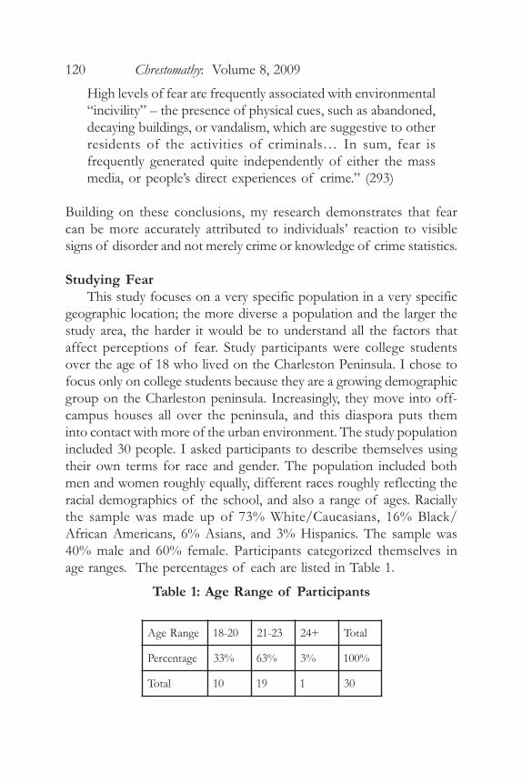
This study focuses on a very specific population in a very specificgeographic location; the more diverse a population and the larger thestudy area, the harder it would be to understand all the factors thataffect perceptions of fear. Study participants were college studentsover the age of 18 who lived on the Charleston Peninsula. I chose tofocus only on college students because they are a growing demographicgroup on the Charleston peninsula. Increasingly, they move into off-campus houses all over the peninsula, and this diaspora puts theminto contact with more of the urban environment. The study populationincluded 30 people. I asked participants to describe themselves usingtheir own terms for race and gender. The population included bothmen and women roughly equally, different races roughly reflecting theracial demographics of the school, and also a range of ages. Raciallythe sample was made up of 73% White/Caucasians, 16% Black/African Americans, 6% Asians, and 3% Hispanics. The sample was40% male and 60% female. Participants categorized themselves inage ranges. The percentages of each are listed in Table 1.
Table 1: Age Range of Participants
egnaRegA 02-81 32-12 +42 latoT
egatnecreP %33 %36 %3 %001
latoT 01 91 1 03

Modly: Geography of Fear 121
Participants also stated their year of study, the percentages of whichare listed in Table 2.
Table 2: Participants’ Year in College
The first phase of this research project involved personal interviewsand a mapping exercise. (For interview materials, see Appendices Aand B). The personal interview began with an exercise designed tohave participants highlight on a street map of the peninsula areas inwhich they often hang out, particularly like, and feel especially safe.This was followed by a similar mapping exercise in which study-participants highlighted on a map of the peninsula those places theyfeared. I discussed the maps with participants through a series ofquestions designed to elicit study-participant’s feelings toward specificareas of downtown Charleston as well as cull an understanding ofhow they use these spaces in their daily life.
From this point I moved into the second phase of the research,the self-directed photography and in-depth interviews. Self directedphotography is a data collection tool in which the researcher givescameras to participants along with directions on what to photograph(Larsen et al. 2007; Aitken and Wingate 1993; and Barnes and Duncan1992). Each participant was given one disposable camera and askedto take about 20 pictures of places which they especially liked and inwhich they felt particularly safe. I took the initiative to photographthose places and things that study-participants indicated as inspiringfear, discomfort or unease. Participants were given two weeks to returnthe cameras. I developed the film and then scheduled a time to meetwith each participant and discuss themes that emerged from the initialinterviews and both sets of pictures.
After the conversations and photo analysis were over, I comparedthe data from the interviews with other spatial data such as rates of
edarG .hserF .hpoS roinuJ roineS latoT
egatnecreP %6 %31 %02 %06 %001
latoT 2 4 6 81 03

122 Chrestomathy: Volume 8, 2009
poverty, racial demographics, and crime statistics. I did this by usingthe mapping software ArcGIS to compile three maps that depictedthe racial demographics, incidences of crime, and poverty statisticson the peninsula. I also created digital maps from the initial mapdrawing exercises and compared these with the maps I made. Thesemap comparisons help to validate my hypothesis that student fearsreflect the influence of numerous factors other than crime statistics.
Fear, Crime, Race, Poverty, and Broken Windows in Charleston
The findings reported here support the claim that fear is experiencedspatially (Sparks 2001). I also argue that the spatial manifestation offear contributes to the entrenchment and reproduction of institutionsof power which privilege one class of citizens over another. Throughoutthis project one thing became very apparent: incidences of crime bearvery little on study-participants’ construction of geographies of fear,as evidenced by the major themes that emerged from the interviewsand photography exercise. While the majority of study-participantsexpressed a fear of being victims of crime, the way they experiencedthese fears geographically often did not reflect a consideration of crimestatistics or crime locations
Rather, study-participants seemed to create their geographies offear based on an urban folklorish understanding of unfamiliar placescharacterized by visible factors in the urban landscape. Study-participants frequently used boundaries to delineate space as eithersafe or dangerous. Their understanding of unfamiliar places was veryclearly not based on any experiential knowledge of an area but ratheron second-hand stories. When discussing unfamiliar spaces, study-participants most frequently cited dilapidated property and “loitering”individuals (people with whom and whose activities they could notidentify with) as visual elements of the urban environment that inspiredfear. For some students the presence of black men simply hanging outon streets during the day was something that inspired fear. Scholarshave demonstrated before that factors such as race and location arefrequently used to attribute criminality to individuals and their activities(Ford 1992).
I argue that the assumptions about space and crime that informbroken windows policies also legitimize the fears students have. Yet

Modly: Geography of Fear 123
this legitimacy is baseless; little to no empirical evidence exists tosupport claims made by the theory. The Broken Windows fallacypersists, criminalizing visible disorder in the form of loitering, pan-handling, dilapidated buildings, and dirty sidewalks. This, and thefolklorish method of knowledge transference, enables fear of suchfactors to persist, especially in unfamiliar places.
Figure 1: Comparison of Areas with Higher Levels of Poverty
to Study-Participants’ Geography of Fear

124 Chrestomathy: Volume 8, 2009
In Charleston, the assumptions that legitimize both Broken Windowsand study-participants’ fears conceal a far more problematic issue.The creation of boundaries between safe and unsafe areas is inherentlyproblematic because of the exclusionary practices which it fosters (Ford1992). The boundaries cited by study-participants create a spatial“otherness” and, concurrently, a racial/economic “Other.” Just as in
Figure 2: Comparison of Areas of Higher Black Population to
Study-Participants’ Geography of Fear

Modly: Geography of Fear 125
the past, racial segregation isolated blacks in particular areas of a city,spatial exclusion operates to create a spatial and human “Other” whichis considered unfamiliar and therefore dangerous (Low 2001). Theconstruction of boundaries thus “legitimizes and rationalizes class-based exclusion strategies and residential segregation” (Low 45). InCharleston the location of study-participants’ boundaries and the areasthey expressed fear of are areas with higher rates of poverty and ahigher black population. A comparison of students’ areas of fear toracial demographics and poverty rates in Charleston reveals that areasstudents fear line up almost perfectly with areas of increased blackpopulations and higher rates of poverty. (See Figures 1 and 2.)
These figures demonstrate that study-participants experience theirfears of crime as fear of areas marked by the presence of dilapidatedproperty and people whom they consider to be out of the norm ofvisual orderliness. Study-participants’ geography of fear overlaps withareas of higher poverty and greater black populations. The assumptionswhich inform Broken Windows theories sanctified property as a privatecommodity to be cherished; lacking it and neglecting it have beencriminalized. Thus, in Charleston, the poor urban black has beencriminalized for the neglect of private property or the lack of privateproperty and use of public space to do the very same things wealthywhite citizens of Charleston are able to do in their own homes; i.e.hang out, have a drink, or talk with friends. Most study-participantsdid not identify with black persons doing these things on the streetbecause the use of public space for these activities is not seen aslegitimate; participants’ understanding of urban space is based on thesame assumptions about use of space (both public and private) thatinform Broken Windows strategies. This means that the manifestationof students’ fear of crime is actually a fear of unfamiliar places basedon the fear of different class- and race-based use of property andspace. This relationship and how it is reproduced needs to bedeconstructed in order for students to have a better understanding ofwhere they are actually more vulnerable to crime. It also needs to bedeconstructed in order to understand the ways in which these fearsreproduce local institutions of power and continue to concentrate andcriminalize poor blackness in the urban landscape.
Understanding Broken Windows assumptions will help to explain

126 Chrestomathy: Volume 8, 2009
further how they influence students’ conception of space, danger, andfear. Herbert and Brown (2006) identify the idea that “landscapesemit messages” as the most important underlying assumption. In theirwords, “landscapes are said to communicate signals of neighborhoodvulnerability to the criminally minded” (758). This idea relies upon asecond assumption, that “there is a relationship between communityhealth and territorial behavior.” Safe and working neighborhoods maketheir health known “through geographic activity; residents fix brokenwindows. They act as ‘place managers’ to assert informal social control”(758). The logic behind these first two assumptions also informs thethird: “the apparent social reality of a spatial division between insiderand outsider . . . crime-fearing and the crime-enacting” (758). Theseassumptions serve to legitimize police actions that seek to curb criminalactivity in largely spatial terms. The fourth assumption concerns the“overwhelming emphasis on the local scale” (758). Focus is onparticular buildings in the landscape and social behavior onneighborhood sidewalks. The theory promises benefits through locallandscape alteration. In addition to the assumptions Herbert and Brownexplore, I identified an inherent assumption about the sanctity of privateproperty within the Broken Windows theory. Together theseassumptions attribute a criminality to visual disorder and legitimizethe fears study participants project onto unfamiliar places.
Interpreting the Interviews
Employing Boundaries to Understand SpaceAs mentioned above, study participants’ areas of fear were often
constructed through the use of boundary lines. The maps drawn ofindividuals’ geographies of fear were based on the geographic limitsof their comfort zone. Study participants draw their maps of fear usingthe logic that all space beyond where they are comfortable was to befeared. As Participant 6 observed, “These are boundary lines for me.They are as far as I will go in that direction. I don’t know much aboutwhat is past them.” This participant’s lack of knowledge concerningthe space beyond his boundary line increased his fear of those places.
Boundary lines help people operate on a daily basis and are aneasy way to make decisions without having to have all of theinformation. I found that students use boundaries in order to

Modly: Geography of Fear 127
understand the entire Charleston peninsula. Boundaries createotherness through the delineation of spaces into two antitheticalcategories. This spatial otherness in turn creates a social/human“Other.” Student boundaries reflect the presence and reproductionof a racial/economic “Other.” The study-participants werepredominantly white/Caucasian. They associated safety with areasthat had low rates of poverty and had a majority white population.Participant 6 demonstrated these feelings when he explained why apicture of the Charleston Place Hotel was a place that made him feelsafe. “I think that people there will be wealthy and not doing anythingbad,” he said; “They have a good social status.” This associationdemonstrates the idea that for some, wealthy people are good peopleand therefore poor people are bad people. The social “Other” createdby boundaries coincides with visual factors in the urban landscapewhich study-participants understand to indicate criminal activity andthus fear. Authors such as Richard Ford have identified boundarycreation as a problem with respect to race. Ford (1992) argues that“the problem of race in late-twentieth-century America is the line: theline of demarcation, the boundary line, the undrawn but universallyfelt line between neighborhoods…the line that one must toe but nevercross” (Ford 118).
Boundaries tell more about an abstract perception of fearful spacethan an actual understanding of an area, its population, and the crimethat actually occurs there. Participant 19 was a member of a studentorganization, Peer Assistance Leaders (PALS) who patrolled areasaround bars and student housing at night in order to aid anyone in avulnerable situation. While discussing a picture of Spring Street, therespondent said, “It is not as nice visually which gives me the ideathat it is not as nice socially. Even for PALS we stop at Cannon Street(the street immediately south of Spring Street) and that is even pushingit at night” (Participant 19). The fact that the respondent indicates astreet as a boundary where she wouldn’t go based on its visualappearance illustrates the idea that participants based theirunderstanding of areas they considered fearful by their understandingof a conceptual boundary that exists between areas that look safe andareas that look like places to be feared. Through discussion manyparticipants revealed that in many cases they had never even gone (on

128 Chrestomathy: Volume 8, 2009
foot) within the areas they marked as fearful or feared. Rather, theirideas of what went on there, what type of people lived there, andwhat the place looked like was based on second hand information orobservations of the streets that served as their boundaries betweenthe feared and the safe places.
In some instances, a picture I took from the middle of an area aparticipant considered fearful didn’t contain any visual elements thatincreased his or her fears. In other words, the place in the picturedidn’t seem scary to participants even though they had identified thearea on their geography of fear map. When shown a picture of a wellmanicured church, one respondent indicated that it did not inspirefear. Once informed that the image was taken from Nassau Street, anarea the respondent indicated as inspiring a lot of fear, she revealedthat “It looks familiar until you hear where it is. You see a clean church.The picture doesn’t make me afraid, but the place does” (Participant13). In other instances, the picture (and its location) wasn’t evenrecognized by the study participant who claimed some form ofknowledge about the location by indicating their fear of the place.This helps to demonstrate that students’ understanding of feared areasweren’t based on knowledge of the whole areas but rather the symbolicsignificance of boundary areas.
Study-participants created their boundaries in a number of ways,often on the basis of second-hand knowledge. As Participant 16observed, “People talked about streets as boundaries even before youhad seen them. I was terrified to go to Nassau Street because of whatpeople have said about it.” This remark demonstrates how urbanfolklore can shape boundaries students have of where they feel safeand where they don’t. One participant explained how the boundaryshe indicated reflected the boundary between areas dominated bycollege students and areas where other demographics, namely poorblacks, were more represented. According to Participant 13, “my mapshows the boundaries of where college students live. I hear a streetname and it is in the ‘bad’ part of town, I am more consciously awareof my surroundings. By ‘bad’ part I mean outside of the college zone.”This spatial division was frequently cited by study participants asinfluencing their conception of areas to be feared. These twoquotations further demonstrate the fact that many study-participants
Modly: Geography of Fear 129
lack any real knowledge about what goes on in areas they consider“dangerous.” This uncertainty itself increases fear. Participant 13demonstrates this dynamic when she says, “you don’t know what goeson there [Naussau Street] and that means, in my mind, that anythingcould go on there.” Lacking real knowledge of a place beyond herboundary, this participant then based her understanding of the areaon second-hand knowledge and rumors and jumped to the conclusionthat “anything” (especially criminal activity) could go on there.Participant 1 similarly stated, “I’ve never walked there [intersectionof Crosstown and Ashley Avenue]. I only drive. I don’t recognize itwhich makes it scary which makes people not want to go there whichmakes it scary.” While such geographic “knowledge” might not reflectan on-the-ground reality of the particular areas, the fear that it producesis very real.
Spring Street marked a boundary line for many participants. Someparticipants have parents who also attended the College of Charlestonor who lived here 10 or 20 years ago. One participant’s parents toldher that it was considered dangerous to travel past Calhoun Streetwhen they lived here (Participant 13). Today students still have thisboundary mentality concerning the Charleston peninsula, but it seemsthat the boundary has shifted a couple of blocks north. As Participant1 put it, “Spring [Street] is the new Calhoun [Street]. It is the newtransitional line of where people feel safe and were they do not.” SpringStreet has an almost legendary status among college students as a placenot to travel on or go beyond. It seems local urban folklore concerningSpring Street as a boundary is constantly being passed down to newstudents entering the College. “When I came [to College of Charleston]people always said don’t go past Spring Street,” Participant 19 recalled.Spring Street emerged not only as a strong theme for many studentsduring discussion but it also emerged as a very clearly defined boundaryon the geography of fear maps.
Understanding how boundary lines are formulated and why theyare in a particular location reveals a great deal about what factorsaffect individuals’ fear. While many students attribute the location oftheir own boundary lines to fear of crime or a fear of being a victim ofviolence, the actual location of their boundary lines and the locationsof crime do not seem to correspond.

130 Chrestomathy: Volume 8, 2009
The map in Figure 3 compares students’ geographies of fear to thelocation of crime incidences.1 The crimes that are included in thismap were crimes that study-participants all said they feared being victimsof: assaults, sexual assaults, and personal robberies (mugging). Thesecrimes occurred between January and June 2006 and were reported tothe College of Charleston’s Public Safety. This office is students’
Figure 3: Comparison of Study-Participants’ Geography of
Fear and Crime Locations

Modly: Geography of Fear 131
most direct link to knowledge about crime occurrences in the downtownarea. These are the crimes that study-participants would most likelyknow about because public safety alerts all students about these crimeoccurrences via email (unlike crimes occurring beyond the campusand its immediate surroundings) and these crimes occurred near placesall students inhabit (the campus area). Notably, nearly every crimeoccurred in a place no study participant indicated as inspiring fearduring the daytime. The campus was the one place that nearly everyparticipant expressed feeling extremely safe in. Respondents frequentlytook pictures of campus buildings to depict safe places.
Participant 6 explained his feeling of safety on campus by referringto his familiarity with campus and to the area’s appearance. “It [campus]is home,” he said; “I have classes there. It is nice looking and well lit.”The disconnect between actual danger and imagined fear is a dangerousmentality for students to operate within. While study-participantsfear being a victim of crime in a certain area, the evidence providedby a map comparison of crime locations and areas of topophobiaindicate that other factors must have an influence on their fears. Thissupports the assertion that crime incidences bear little on students’geographies of fear.
The boundary mentality limits students’ knowledge of diverse areasin Charleston and may artificially make them feel safe in areas withintheir boundaries of comfort and knowledge, areas that may actuallybe dangerous. Exploring how and why fears are misplaced by study-participants will allow us to gain a better understanding of how spaceis socially constructed to be safe or dangerous, how students participatein the production or reproduction of these boundaries, and why theseideas about danger and safety persist.
Fear of the UnfamiliarScholars have argued that unfamiliarity with an area increases an
individual’s fear. Gill Valentine (2008) notes that “People areuncomfortable with the unknown and so feel anxious about encounterswith difference” (323-4). Students often admitted that their familiaritywith a particular place on the peninsula increased their feelings ofsafety within that space. Some participants expressed strong feelingsof safety within even those familiar areas where other students had

132 Chrestomathy: Volume 8, 2009
been victims of muggings or assaults in the past. Conversely, placesstudents had never even been to before, and therefore had no familiaritywith, were places greatly feared by the majority of study participants.As Participant 13 observed, “My unfamiliarity with a place increasedmy fear. It made me feel more like something could happen.” Thisrelationship between familiarity and safety and between unfamiliarityand fear is problematic in that students do not seem to take actualcrime statistics into consideration.
As a result of the high demand for affordable and student-friendlyrental housing near the College of Charleston campus, students arebeing forced to look for apartments further north on the peninsulathan they have tended to live. While students are occupying largerareas of Charleston for housing, their daily activities keep thegeographic range of their movement somewhat restricted to the centerof the peninsula, the streets and blocks in and around the College ofCharleston campus. Most daily activities included going to class,working at businesses on the lower part of the peninsula (below SpringStreet), and going to friends’ houses. Most study-participants lived onor below Spring Street. Discussion of students’ unfamiliarity with areasabove the “Spring Street boundary line” led me to believe that in mostinstances study-participants’ unfamiliarity with an area is a sureindicator that they will fear it. Related to this idea are the folklorishwarnings that are passed down from one class to the next concerningthe dangers of going beyond Spring Street. Without any experientialknowledge of the area beyond Spring Street, any stories participantshear about this region are easily assumed to be true and incorporatedinto their understanding of the space as dangerous. Participant 13indicated that Spring Street is “the first street you’re told not to gonear—it has a stigma from stories.”
One type of area in particular that many participants expressedpersonal unfamiliarity with yet also strong opinions about wasgovernment housing units. One participant specifically indicated placeswith government housing as areas she feared. “I am afraid on LoganStreet because the projects are right there,” said Participant 3. Thiswas an interesting idea to explore further through the photographyanalysis. Before students were told exactly what type of housing theywere viewing, many of them identified the short, town-house style

Modly: Geography of Fear 133
brick buildings as Charleston’s government housing. One participantwas very candid about her initial response to the picture of agovernment housing unit. She explained her fear of the area as a resultof the association of projects with the poor urban black populationand the association of poor urban black persons with crime.“Automatically I think projects,” she said; “it has a ‘don’t go there’stigma. Yet, during the day it is ok. It makes me think lower incomeAfrican-Americans. When you hear about crime that is who theperpetrators are, at least on the Campus Crime Alerts [CommunityWatch Alerts from Public Safety]” (Participant 13). As a result ofattitudes like these which automatically attribute a degree of criminalityto an unknown population based on a constructed understanding ofgovernment housing, the urban black poor become an object of fear.The idea that fear of the unfamiliar can become racialized in an urbanenvironment is not new. Ford (1992) argued that “this (most oftenirrational) fear of the unknown has been projected onto the racializedOther in the context of the ‘urban concrete jungle’” (130). Ford seesthis racialized fear as a result of the spatial demarcation between whiteand black space. Yet race is not the only factor criminalized byparticipants’ expressed fear of government housing. Poverty too,especially visible signs of poverty, are equally criminalized. Theassumption that landscapes emit messages, which undergirds BrokenWindows strategies, also explains why study-participants fear visiblesigns of poverty (Herbert and Brown 2006).
The association of familiarity with safety was also evident indiscussions with study-participants. Study-participants felt safest intheir own homes and on the college campus. Participant 1 linked herfeelings of safety on campus to familiarity with the place when sheremarked, “I have gone there [campus]. It is a familiar place to mebecause of school classes, my p.o. box is located here, etc.” Manytimes this sense of safety was attributed to the fact that participantsknew a lot of people in these places that were like them. In the picturesthey took, study-participants identified with other white individualsengaged in activities they recognized and also engaged in; shoppingKing Street, sitting in Marion Square, and going to class. Thisdemonstrates the ways in which the same assumptions that informbroken-windows theory concerning the unfamiliarity, disorderliness

134 Chrestomathy: Volume 8, 2009
and thus criminality of activities such as pan-handling, loitering, anddrinking in public, affect study-participants’ understanding of legitimatepublic activities (Wilson and Kelling 1982). Harcourt (2001), however,demonstrates the problematic nature of this understanding of publicuse of space and disorder: “The result is that these categories (thedisorderly and the law-abider) mask the repressive nature of brokenwindows policing and overshadow significant costs, including increasedcomplaints of police misconduct, racial bias in stop and frisks, andfurther stereotyping of black criminality” (Harcourt 7). Study-participants’ feelings and self-identification with familiar social andspatial factors (white middle-class people in affluent-looking areas) isevident in the following discussion of a photograph a participant tookof Marion Square as a part of the self-directed photography exercise.The picture showed the public square with predominantly (if notentirely) white people walking through it. Participant 6 stated, “Thereare always people here. I feel safer around people doing the same typesof things I do.” While the presence of public safety officers increasedfeelings of safety, the presence of cops in areas which have a higherblack population and higher rates of poverty reinforce thecriminalization of the urban black poor. Participant 29 reflected, “Ifeel safe knowing someone is there, but why is it [a cop car] there? Ifthere are always cops, then can it [the street] be safe?” Yet policepresence in and around the campus (an area with a demonstrably lowerblack population and much less poverty) does not intrinsicallycriminalize this largely white and middle-class population. Study-participants’ unfamiliarity with a certain area allowed their opinionsof such areas to be constructed from second-hand knowledge, rumors,or stories. In order to explore this particular assertion, I showedparticipants pictures of street signs from areas they indicated as fearfuland asked them to tell me the feelings the image inspired. I chose todo this exercise with streets that were deep in the middle of areas thatinspired fear for study-participants – rather than boundary regions – inorder to test my hypothesis that a lack of knowledge increases fear byrelying on second-hand (often exaggerated) information.
Discussion of the Nassau Street sign in particular was illuminatingbecause all or some part of Nassau Street was on most participants’geography of fear maps. The responses below demonstrate how the

Modly: Geography of Fear 135
street itself has become associated with fear through stories andsecondhand information that are reinforced through unfamiliarity andan unwillingness to go there.
“I mean I didn’t even know some of the street names [youwere saying]. Yet, when you hear where it is, near Nassau, youthink it is dangerous.” (Participant 13)
“There are stereotyped streets. From observations and storiesit is run down, disordered, the slums, lots of drugs, criminalactivity, and meth labs.” (Participants 6)
Even without knowledge of crimes or their geographic locations,students form opinions about the types of things that occur therefrom other sources. My research indicates that students at the Collegeof Charleston construct their fears based on a cultural understandingof the peninsula built from second-hand knowledge of particular areas.Often this knowledge strongly resembled a folklorish understandingof the “bad” parts of town that is handed down from one generationof students to the next. With respect to accurate knowledge of reportedcrime incidences, many study-participants confessed to either not reador not be affected by the Community Watch Alerts, which the Collegeof Charleston’s Public Safety sends to students to make them awareof crimes that could affect students. These alerts are the most universaland direct manner for students to become aware of crimes that occuron the peninsula. Yet, many participants noted that their fear of blackmen in the landscape was due in part to the fact that the CommunityWatch Alerts almost always described the perpetrator as black. Thisdiscrepancy is troubling, yet may be explained by the folklorish retellingof crime watch report information that focuses on race rather thanlocation. It may be easier for students to fear an unfamiliar demographicthan to have to understand a place they consider safe to be dangerous.Thus first-hand knowledge of crime statistics doesn’t seem to be thedominant source of student fears.
The Inherent Disorderliness of “People without a Purpose”Study-participants tended to express fear of unfamiliar places in

136 Chrestomathy: Volume 8, 2009
which they see people who do not seem to belong in the landscape. Inalmost every case, students referred to this as “loitering.” Thisrelationship is problematic because the term “loitering” indicates thata person’s activity is criminal. People who used this term did not seemto understand how the activities of people standing on streets duringthe day can be legitimate. This misunderstanding stems from a lack ofknowledge about how public space is used by different classes ofcitizens. Often students indicated that when they came across peopleon the street and they couldn’t easily discern their purpose or consideredthem not to have one, they felt more cautious or fearful. Thisrelationship is particularly important to deconstruct because it reflectsa bias based on class and race. It seems that only a particular range ofactivities in certain places and times had a “valid” purpose to students.That these “people without a purpose” were often black males alsoadded a racial dynamic to the situation which in many cases madeparticipants hesitant to discuss the reasons for or the rationale behindtheir fears. However, I began to unpack the fear of “people without apurpose” through the picture analysis.
In many cases study-participants considered the presence of peopleto be a factor that decreased their anxiety of a street or block – aslong, that is, as they could identify with the people. Referring to apicture of the Charleston Place Hotel, a posh hotel in the southernhalf of the peninsula, Participant 16 said, “I feel safe here because,near Charleston Place Hotel on Market Street, there are always lots ofpeople and it’s really nice looking.” Yet when study-participants sawpeople not like them socio-economically in places they considereddangerous, they registered an increase of fear. One participant explainedthat race still played a part in how she experienced fear around groupsof people in Charleston. She revealed this through our discussion of aphotograph of a couple of black men hanging out on the sidewalk inthe middle of the afternoon. Participant 19 stated, “The picture isfrom near Nassau Street, which has a bad connotation. I didn’trecognize the street name. I don’t like walking past groups of blackmen. I don’t know what they are doing. In Charleston race does stillmatter to people.” Statements such as these were not uncommon.Study-participants’ fear of “people without a purpose” seems to boildown to a lack of knowledge concerning the activities of a different

Modly: Geography of Fear 137
class of citizens and how they occupy space. Study-participants oftendescribed fearful people as “loitering,” a term that criminalizes theuse of public space.
Often the assumption was that individuals “loitering” or standingaround with friends on sidewalks didn’t have a job and could be athreat. This inability to identify with a person’s activity in a publicspace made many participants feel as if the observed people were “upto no good.” These are the very ways Harcourt (2006) sees theinfluence of Broken Windows theory on peoples’ understanding ofspace and crime. During a discussion of a picture depicting an emptySpring Street lot next to a small building that has been spray paintedto advertise for a barbershop, Participant 1 explained how sheexperienced her fear of loitering. “Usually there is a lot of ‘loitering’that is disturbing to me,” she said; “I think, ‘what are they doing?Probably waiting around to sell drugs’” (Participant 1). This fear of“people without a purpose” has a lot to do with the fact that studentsidentify the “loitering” individuals as outside of the norm of orderlinessand not a natural part of the Charleston urban landscape. Thisperspective mirrors the manner in which crimes like loitering areconsidered dangerous by Broken Windows theorists. Wilson and Kelling(1982) write that “serious street crime flourishes in areas in whichdisorderly behavior goes unchecked” (5). ”Disorderly” people areconsidered intruders, occupying a space that isn’t necessarily theirs.Yet, their activity could be understood as entirely legitimate by grantingtheir lack of private space and their right to occupy public space.Participant 7 acknowledges that his fear of “loitering” individualsreflects a fear of unknown individuals. He stated, “The CofC reports(Public Safety Crime Watch Alerts) incite a fear of people you don’tknow, especially of people out on their own. If I don’t know you, Idon’t trust you.” On the other hand, study-participants did not fearpeople like themselves (i.e., white people living in affluent areas ofCharleston).
“Dilapidated equals Dangerous”Study-participants’ fear in unfamiliar places was experienced most
directly as a fear of dilapidated property. During the preliminaryinterviews, many participants indicated that they were more afraid of

138 Chrestomathy: Volume 8, 2009
areas that looked “run-down,” “unkempt,” or “abandoned” (Participant3). Conversely, places that were (or seemed) “cleaned up,” “well kept,”“high end,” “cared for,” and “very clean – no trash or graffiti” wereplaces that participants felt safe in (Participant 1). By far this was themost prevalent and distinct theme that emerged from the interviewsand photography exercise. It reveals much about the assumptionsstudents have concerning space, people, and fear. The two mainreactions participants had to “dilapidated” places were that (1) theyembodied disorder and that (2) they reflected the inhabitants’ disrespectfor space. Both reactions in turn fueled the sense that a dilapidatedspace should be feared.
The association of dilapidated and run down property withdisrespect and disorder reflect study-participants wholesaleparticipation in the sanctification of private property. The idea thatproperty is privately owned and therefore respected and maintained isso entrenched in study-participants’ understanding of the urbanenvironment that not having it or not maintaining it is criminalizedand feared. By the same assumption, a healthy neighborhood is one inwhich inhabitants exert social control through their maintenance ofvisible disorder (Herbert and Brown 2006). Crucially, the cult ofaesthetics that the Broken Windows theory creates does not properlyreflect the true safety or dangerousness of a neighborhood. Rather, itcreates a mindset that privileges environmental beautification and thusthe disposable income required for it (Harcourt 2004). As the map ofpoverty demonstrates, the areas in which study-participants experiencetheir fear of dilapidated property are areas with higher levels of poverty,and correspondingly less disposable income with which to maintain orbeautify property. Additionally, as the area is not in a tourist district,the city has very little interest in beautifying public space.
Some study participants indicated that the reasons for their fearcentered on the idea that disorder is dangerous. Numerous respondentsmade comments to this effect in response to an image of a yard onBogard Street with signs that say “No Parking” and trash and discardedbuilding debris scattered about the yard. The part of the house that isvisible has flaking paint and tarps over parts of the siding. Particpant13 reflected, “I think that people who don’t care for yards probablywon’t care for society or people either. I am a control freak, but where

Modly: Geography of Fear 139
there is a lack of control in an area that scares me.” This responseindicates that broken windows assumptions actively influence people’sunderstanding of space. These assumptions are so embedded in theway people think of crime and urban spaces that it is impossible todiscuss fear and its spatial manifestation without considering theinfluence of this theory. Other study-participants expressed similarresponses, reinforcing the idea that order is a sign of safety and thelack of it is a sure sign an area is dangerous. Looking at a picture of amessy yard, Participant 5 remarked, “It looks overgrown and thebuilding is run-down. There is graffiti. It appears disheveled. Thatmakes me think there is no order and I believe in order.” Such responsesillustrate the manner in which students are willing to judge the relativesafety or dangerousness of an area purely by visual signs of disorder,without necessarily knowing anything about it.
Conversely, students viewed places that were clean, well groomed,and landscaped to be signs of a safe environment. In response to animage of a manicured park on the southern tip of the peninsula, anarea that is very wealthy and almost entirely white, Participant 6 said,“I feel very safe here. It [Battery Park] is very natural but cared for andgroomed. There is no trash around.” The orderliness of a street ledstudy-participants to feel safe, in some cases despite their own personalexperiences on the street. Considering a picture of the Corner of Pittand Calhoun Streets, Participant 16 observed, “I feel safe here becauseit is my friend’s house. There is a church and the school on the street.”Significantly, he went on to say, “Yet I heard of an attack happeningnear here recently and I was in a bike-taxi accident here only weeksago.” In the picture lawns are well kept, the houses are not fallingapart and it is close to the College campus. Visual appearance seemsto influence the participant’s sense of safety more so than hisknowledge of crimes that have occurred nearby.
Another common reaction to pictures of “dilapidated” houses orstreets was that the inhabitants clearly had no respect for the space orthe building. The common logic behind this idea was that such“disrespectful” people probably didn’t have any respect for otherindividuals in the area which, many participants believed, would leadinhabitants to be more apt to commit crimes or allow others to commitcrimes there. This logic recalls the thinking of Wilson and Kelling
140 Chrestomathy: Volume 8, 2009
(1982), who argue that “‘untended’ behavior also leads to thebreakdown of community controls. A stable neighborhood of familieswho care for their homes, mind each other’s children, and confidentlyfrown on unwanted intruders can change, in a few years or even a fewmonths, to an inhospitable and frightening jungle. A piece of propertyis abandoned, weeds grow up, a window is smashed” (3).
One student reflected on why trash and dirty yards inspired herfear and pointed out that the message this sent to her was that theinhabitants were disrespectful. Referencing an image taken at 77 NassauStreet which depicts a narrow alley between two houses filled withdiscarded bottles and assorted trash, Participant 1 stated, “There are alot of cobra bottles and beer cans in this alley. Inhabitants have norespect for the place because they leave their trash and if they have norespect then what does that say about it?” This was a widely heldassumption about “dilapidated” places and why they are dangerous.Participant 4 felt that unmaintained property was a sign of disrespectand took this a step further, attributing to the property owner an attitudeof social disrespect as well. “If there is a lack of maintenance andrespect of property,” he said, “I assume that the people lackmaintenance and respect for themselves and their interactions. I alsofeel that they have a distrust of outsiders, like college students.” Thisstatement demonstrates the extent to which private property ownershipis taken for granted and sanctified, to the point that “disrespect” ofproperty indicates a social disrespect as well.
Study-participants equated dilapidated places very clearly withdisrespect for property. Yet, a few went so far as to take this relationshipfurther by attributing the “dilapidated” yards and dilapidated homesto a lack of money which they then associated rather directly withhigher crime rates. Referring to a picture of a building with boardedup doors and windows and a leaning fence covered with graffiti,Participant 16 said, “The building looks run-down. There are scarysigns, ‘No Trespassing,’ ‘Beware of Dog,’ etc. It is overgrown. Thereis no money. Upkeep takes money. Where there is no money there ismore crime. That is the link I see between the picture and my fear.”While this relationship cuts out the middle-man, disrespect, it stilldemonstrates a link in peoples’ minds between visible signs of povertyand higher crime rates and thus a greater risk of victimization.

Modly: Geography of Fear 141
Conclusion
Student fear of the unfamiliar, of disorderliness and disrespect ofproperty, and of “people without a purpose” reveals a problematicrelationship between fear, race, and poverty. This relationship iscomplicated by reliance on folklorish rather than experientialknowledge. Factors as dilapidated buildings and “people without apurpose” clearly intensify study participants’ fear, despite the fact thatsuch factors may simply reflect a lack of disposable income and adifferent attitude toward public space. The correlation between areasstudents feared and areas with higher percentage of families livingbelow the poverty line and areas with higher black populations is verystrong. This association is troubling. Student fears are manifested asan unconscious fear of urban black poverty which they experience asa fear of disorder and disrespect of place. This is problematic becausepersonal and situational vulnerability have more to do with actualincidence of crime than the visual orderliness of one’s surroundings.
The persistence of the problematic relationship between studentfear, race, and poverty in Charleston will reproduce institutions ofpower which privilege one class of citizens over another and willreproduce racial and class-based prejudice as well. This fear revealsthat power is operationalized through geographies of exclusion thatproduce politics of racial and economic exclusion.
The geographic study of fear as a discipline is a large and diverse.This paper challenges some aspects of that discipline and moves thediscourse on fear-of-crime into new territory. By incorporating a newanalytical framework, the critical examination of the assumptions whichinform Broken Windows policies, this research expands the fear-of-crime discourse and seeks to explain individuals’ fears as a result ofpervasive social norms that explain space, its inhabitants, and crimein very specific ways. These findings demonstrate that crime statisticsare not the main factor that produces fear. In fact, many other factorsseem to have a greater impact on students’ understanding of “safe”and “dangerous” places. By demonstrating that there are in fact otherfactors that play a larger role in these students’ construction ofgeographies of fear, this study begins to deconstruct the relationshipbetween individuals, their fears, and the environment they inhabit inorder to better understand how the three are related. This study

142 Chrestomathy: Volume 8, 2009
demonstrates the importance of understanding how individuals actuallycreate and reproduce the geography of their fears in order to understandwhat they fear and why. While many scholars study fear of crime andits spatial manifestation, few have done in-depth studies on how thesefears are reproduced socially and on the results (if any) of such socialreproduction.
Appendix A
Sense of Place: Topophobia and Topophilia in
Downtown Charleston, SC
Participant Survey
PARTICIPANT #: DATE:
1. I am: _____ Male _____ Female2. I am: _____ 18-20 years old
_____ 21-23 years old_____ 24 or older
3. I identify as _________________ (racial/ethnic group)4. I am a: _____ freshman
_____ sophomore_____ junior_____ senior
5. I live in ____________________ (block/neighborhood)6. I have lived downtown for _______ (number of years/months)7. The thing I like most about downtown Charleston is:8. The thing I like least about downtown Charleston is:9. My favorite place in Charleston is:10. The place I like the least in Charleston is:11. The place I feel safest in Charleston is:12. The place I feel most afraid in Charleston is:
Modly: Geography of Fear 143
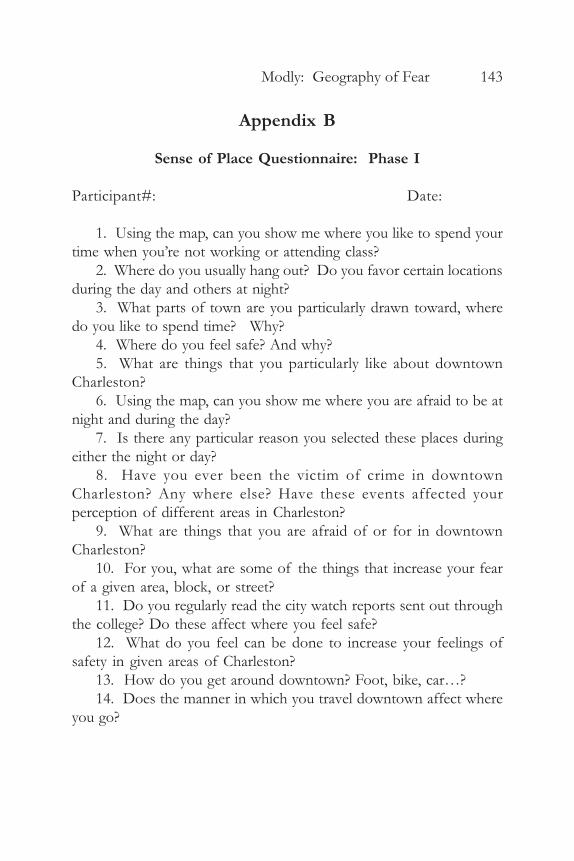
Appendix B
Sense of Place Questionnaire: Phase I
Participant#: Date:
1. Using the map, can you show me where you like to spend yourtime when you’re not working or attending class?
2. Where do you usually hang out? Do you favor certain locationsduring the day and others at night?
3. What parts of town are you particularly drawn toward, wheredo you like to spend time? Why?
4. Where do you feel safe? And why?5. What are things that you particularly like about downtown
Charleston?6. Using the map, can you show me where you are afraid to be at
night and during the day?7. Is there any particular reason you selected these places during
either the night or day?8. Have you ever been the victim of crime in downtown
Charleston? Any where else? Have these events affected yourperception of different areas in Charleston?
9. What are things that you are afraid of or for in downtownCharleston?
10. For you, what are some of the things that increase your fearof a given area, block, or street?
11. Do you regularly read the city watch reports sent out throughthe college? Do these affect where you feel safe?
12. What do you feel can be done to increase your feelings ofsafety in given areas of Charleston?
13. How do you get around downtown? Foot, bike, car…?14. Does the manner in which you travel downtown affect where
you go?
144 Chrestomathy: Volume 8, 2009
Notes
1 The maps in figures 1-3 were made by Alex Modly. Data ongeography of fear was collected and digitized by Alex Modly betweenOctober 2008 and February 2009 in accordance with all InstitutionalReview Board (IRB) protocol. Charleston street and crime locationdata were retrieved from the College of Charleston’s GIS database(S:). Data on race and poverty in Charleston are from the 2000 Census.The data were retrieved from the US Census American Factfinderwebsite (http://factfinder.census.gov). The Charleston peninsulabackground was created from a digital ortho quarter quadrangle(DOQQ file) retrieved from the South Carolina Department of NaturalResources website (www.dnr.sc.gov). The Datum used is NAD 1983.The Projection System for Poverty, Street, and Charleston outline datais Geographic. The Projection System used for geography of fear andcrime location data is SC State Plane. The maps were made on April26, 2008 at the College of Charleston.
Works Cited
Aitken, S and Wingate, J. “A Preliminary Study of the Self-DirectedPhotography of Middle-Class, Homeless, and Mobility-ImpairedChildren.” Professional Geographer 45.1 (1993): 65-72. Print.
Bannister, J. and Fye, N. “Introduction: Fear and the City.” Urban Studies38.5-6 (2001): 807-13. Print.
Barnes, T. J. and J. S. Duncan. Writing Worlds: Discourse, Text and Metaphorin the Representation of Landscape. New York: Routledge, 1992. Print.
Ford, Richard T. “Urban Space and the Color Line: The Consequenceof Demarcation and Disorientation in the Postmodern Metropolis.”Harvard Black Letter Journal 9 (1992): 118-47. Print.
Gaarder, E. and Wesely, J. “The Gendered ‘Nature’ of the UrbanOutdoors: Women Negotiating Fear of Violence.” Gender and Society18:5 (2004). 645-63. Print.
Goodey, Jo. “Boys Don’t Cry.” British Journal of Criminology 37.3 (1997):401-19. Print.
Gordon, Margaret T. and Stephanie Riger. The Female Fear: The SocialCost of Rape. Urbana: U of Illinois P, 1989. Print.
Modly: Geography of Fear 145
Harcourt, Bernard. Illusion of Order: The False Promise of Broken WindowPolicing. Cambridge, MA: Harvard UP, 2004. Print.
Harcourt, Bernard E. and Jens Ludwig.. “Broken Windows: NewEvidence from New York and a Five-City Social Experiment.”University of Chicago Law Review 73 (2006): 1-44. Print.
Herbert, Steve and Elizabeth Brown. “Conceptions of Space and Crimein the Punitive Neoliberal City.” Antipode 38.4 (2006): 755-77.Print.
Hollander, J. A. “Vulnerability and Dangerousness: The Constructionof Gender through Conversations about Violence.” Gender andSociety 15.1 (2001): 83-109. Print.
Larsen, S. et al. “Place Perception and Social Interaction on an ExurbanLandscape in Central Colorado.” The Professional Geographer 59.4(2007): 421-33. Print.
Low, Setha M. “The Edge and the Center: Gated Communities andthe Discourse of Urban Fear.” American Anthropologist 103.1 (2001):45-58. Print.
Mehta, Anna. “Embodied Discourse: On gender and Fear ofViolence.” Gender, Place, and Culture 6.11 (1999): 67-84. Print.
Moser, Caroline. “Urban Violence and Insecurity: An Introductory RoadMap.” Environment and Urbanization 16.2 (2004): 3-16. Print.
Pain, Rachel H. “Social Geographies of Women’s Fear of Crime.”Transactions of the Institute of British Geographers 22.2 (1997a): 231-44. Print.
——-. “‘Old Age’ and Ageism in Urban Research: The Case of Fearand Crime.” International Journal of Urban & Regional Research 21.1(1997b): 117-28. Print.
——-. “Place, Social Relations and the Fear of Crime: A Review.”Progress in Human Geography 24.3 (2000): 365-87. Print.
——-. “Gender, Race, and Fear in the City.” Urban Studies 38.5-6(2001): 899-913. Print.
Smith, Susan. “Crime in the News.” British Journal of Criminology,Delinquency and Deviant Social Behavior 24:3 (1984): 289-95. Print.
Sparks, Richard et al. “Fear and Everyday Urban Lives.” Urban Studies38.5 (2001): 885-98. Print.
Taylor, R. Breaking Away from Broken Windows: Baltimore Neighborhoodsand the Nationwide Fight against Crime, Grime, Fear, and Decline.

146 Chrestomathy: Volume 8, 2009
Boulder, CO: Westview, 2000. Print.Tuan, Yi-fu. 1979. “Landscapes of Fear.” New York: Pantheon Books.
Print.Valentine, Gill. “Living with Difference: Reflections on Geographies
of Encounter.” Progress in Human Geography 32.3 (2008): 323-37.Print.
Whitzman, Carolyn. “Stuck at the Front Door: Gender, Fear of Crimeand the Challenge of Creating Safer Space.” Environment andPlanning 39 (2007): 2715-32. Print.
Wilson, James Q. and George L. Kelling. “Broken Windows: The Policeand Neighborhood Safety.” The Atlantic Monthly Mar.1982: 1-10.Print.