geography in basel : the integrative approach
TRANSCRIPT

Geography in Basel - The Integrative Approach H. Leser, R. Schneider-Sliwa, P. Nagel, E. Parlow, C. Alewell 197
Geography in Basel - The Integrative Approach
Hartmut Leser, Rita Schneider-Sliwa, Peter Nagel,Eberhard Parlow, Christine Alewell, Basel
1 Introduction
The Department of Geography of the Universityof Basel views its different divisions as complemen-tary disciplines which are committed to an integratedapproach in geography. It is this philosophy whichrecently motivated the establishment of a new chairfor Environmental Geosciences and Soil Science. Atthe centre of Geography at the University of Basel liesthe relationship between humans and their environ¬ment, viewed from a physical and human geographicalperspective, and combined with biogeographical andclimatological approaches.
This article first highlights common principles of thedifferent disciplines. This will be followed by a briefpresentation of research topics - including both prac-tical projects as well as underlying methodical andtheoretical modeis. Finally, the integrated approachwill be related to current Standards of geographietheory.
2 Conceptional and methodical principles
Geography is the science of «human-space-environ-ment» and is founded on two basic theories: (1)the theory of complex (holistic) geographie per¬spectives and (2) the theory of geographie dimen-sions. The former relates to reality and its complexdomain which can be resolved only in research butnot in reality. This has consequences on researchapproaches and methodologies, as well as on theresults obtained and their impact. The latter alsoaffects methodological approaches. It does notonly categorize formally the so-called geographiedimensions (Bordsdorf 1999; Leser 1997; Leser& Schneider-Sliwa 1999; Neef 1967) but refers tothem as «tools» for specific spatial research becausethey determine the choiee of methods and therebyalso the impact of the results. That the public hasunderstood this theory, albeit rather intuitively andnot resulting from theoretical reflection, is shown bythe widely used terms «local», «regional», «zonal»and «global» dimensions and certainly adds to theviability of any environmental work - be it in thefield of man or economy, be it in the field of nature,landscape or resources.
3 Man-environment-research in society today
Urban or natural landscapes are the very starting pointof geography. Geography is concerned with the prob¬lems resulting from interactions between humans and
the environment and hence space - which is anythingbut a new idea (Barrows 1923; Neef 1969,1979; Stod-dart 1965). Examples are problems related to urban
ecology, urban economic and social geography, thelandscape, water and nutrient balance in the soil as wellas biogeographical and ecological problems related toclimate change. In dealing with current problems aris-
ing from the use of physical space, basic principles forplanning and environmental planning as well as for thesustainable use and protection of resources are beingelaborated (Fig. 1).
Over the last two decades, the International Geo¬
graphical Union (IGU) in particular stood up for inte¬
grated man-environment research, as evidenced bynumerous programmes and publications. Subject-spe-eifie problems were gradually put into a larger, inter¬
disciplinary context, as explained in «Understandingthe Earth System» (Ehlers & Krafft 2001). Evenfrom the political viewpoint of the discipline, this
approach is increasingly becoming a guiding principle,as pointed out by the Deutsche Gesellschaft für Geog¬
raphie and supported in «Geographie heute - für dieWelt von morgen» (Ehlers & Leser 2002). Intendedfor improving public relations, both the above com-municate the complexity of geographical reality. Thisis also reflected in the variety of authors representingcompletely different disciplines.
The different chapters are not only «up-to-date» interms of focusing on man-environment problems butdemonstrate that integrated, multi-diseiplinary approa¬ches - based on more complex methodologies - yieldmore credible results. This reiterates what has alreadybeen stated before: geography by its very nature is
transdiseiplinary, integrating a wide ränge of subjeetmatters (Leser 2002). Another objeetive is to demon¬
strate that geographie research is concerned with realproblems and conflicts arising from human-earth inter¬
actions. This implicates (1) a close relationship to prac¬tice and need for applied research and (2) rejeetionof the limitations of diseiplinary research. Certainly,this approach responds to the needs of society - whichare otherwise only partly appreciated by the scientificCommunity, at least not in their real complexity. Thislack of societal focus is reflected in the unimpededtrend towards diseiplinary specialization in science.

198 Geographica Helvetica Jg. 58 2003/Heft 3
Development of landscapeSpatial development
A
« Human societa
environmental rrelations
Functional structuresprocessesII
wm
mmwm vLandscape patterns Spatial. patterns:
£-'*-'¦
lJ
^22^^^^^r
Fig. 1: The realm of geographical researchDas Spektrum geographischer ForschungL'ev eMail de la recherche geographiqueDraft: H. Leser; graphics: L. Baumann
4 Human-environment research themes of theGeography Department in Basel
The research themes and projects presented in thefollowing provide evidence that the department feelscommitted to both the theoretical basis of the dis¬cipline of geography and the practical needs of thepublic. At the same time, they demonstrate the inher-ent transdiseiplinary concept of geography.
4.1 Physiogeography and landscape ecologyPhysiogeographical research is landscape ecologicalresearch (Fig. 2 and 3). This notion is founded on theo¬retical grounds and on the inherent scientific concept(holistic, integrative, in relation to landscape scales).Operating in an environment altered by man, thisresearch deals with real landscapes. Two topics arepresented here in order to elueidate the goals of this
research: «Soil erosion and element balance in land¬
scapes» and «Landscape change/landscape ecology».
4.1.1 Soil erosion and element balance in landscapesThis project represents the traditional field of BaseTsphysiogeography. It originally began with soil erosionresearch and was developed to find a suitable fieldmethod. An overview is given in the publication listof the «Research Group Soil Erosion Basel» (Geo-graphic Institute Basel, Forschungsgruppe Boden¬erosion Basel 2003). What is it about?
The abiotic geo-ecological factors, geo-relief and soil- adapted to the geo-ecosystem model - are centralissues. Soil constitutes the main subjeet of research,as it represents a significant component of the land¬scape. Emphasis is placed on physical characteris¬tics, transfer processes and resulting turnover rates.This research is carried out in the Länenbach

Geography in Basel -The Integrative Approach H. Leser, R. Schneider-Sliwa, R Nagel, E. Parlow, C. Alewell 199
W^SBSb
^ä'^MM^^äf'X
Fig. 2: Limnoecological measurements characterize theSituation in the water.Limnoökologische Messungen können die Verhältnissein einem Gewässer charakterisieren.Les rapports qui definissent une eau peuvent etre carac-terises par des mesures limnoecologiques.Photo: O. Stucki
area in the municipality of Rothenfluh (Cantonof Baselland). It focuses on phosphorus turnoverrelevant for agriculture and nutrient balances.Leser et al. (2002) gave a summary of the project(Fig. 4).Long-term research is carried out on permanentplots which aresubject to real agricultural use. Dataon element balances and erosion dynamics havebeen collected for about 20 years. They reflectchanges in land use resulting from economic, eco¬
logical as well as political reasons. Data obtainedin the field allowed for a comprehensive, compar-ative assessment of erosion modeis (Hebel 2003),revealing surprising results with respect to the valid-ity of current modeis.The project provides a framework for a variety ofindividual sub-projects, lasting from a few monthsto several years. These sub-projects are being imple¬mented in collaboration with different institutionaland private partners from the chemical industry, fed¬
eral research institutes, agricultural Colleges, agricul¬tural field stations, authorities with an environmentand soil protection mandate in municipalities as wellas individual farmers.Recent accounts of the results were presented byRüttimann (2001) on the cultivation of maize,by Böhm (2003) on soil erosion in military training
grounds, by Hebel (2003) on the comparison of ero¬
sion modeis and by Marxer (2003) on fire ecology.
4.1.2 Landscape ecology/landscape changeThis project group underwent many changes, which arereflected in the documentation of the literature (Geo¬
graphisches Institut Basel, Forschungsgruppe Land¬
schaftsanalyse und Angewandte Landschafts¬ökologie 2003). After termination of geoecologicalfield research in Spitzbergen and in the Alps, the
development of geoecological methodology was nolonger a research subject, which led to publications,such as the «Kartieranleitung Geoökologische Karte 1:
25'000» (Leser & Klink 1989), the «Bewertungsanlei¬tung des Leistungsvermögens des Landschaftshaush¬alts» (Marks, Müller, Leser & Klink 1999), andthe resulting «Landschaftsökologische Erfassungstand¬ards» (Zepp & Müller 1999). Subsequently,researchers
0,031ijiliWc oojii^i
m % ,:ifooo:fco «%;o#y M ':im«s|«P«P*soo;
|,:3|p?i»»v=5''';'%;P2!i« d '% WSMIimMiemä
iäll m^m^
iili, jiiisiii *
WillwarnWMsmm
lo^PoroofäoPlS1
liiiiSoP'p'>5ioai!BJ!fco:»a
Fig. 3: Computer aided methods and Simulation modeisdo not Substitute hands-on experience.Trotz EDV und Simulationsmodellen: «Handwerk» istim Praktikum immer noch gefragt.En depit du traitement informatique des donnees, les
ordinateurs n'ont pas detröne T«artisanat».Photo: H. Leser
200 Geographica Helvetica Jg. 58 2003/Heft 3
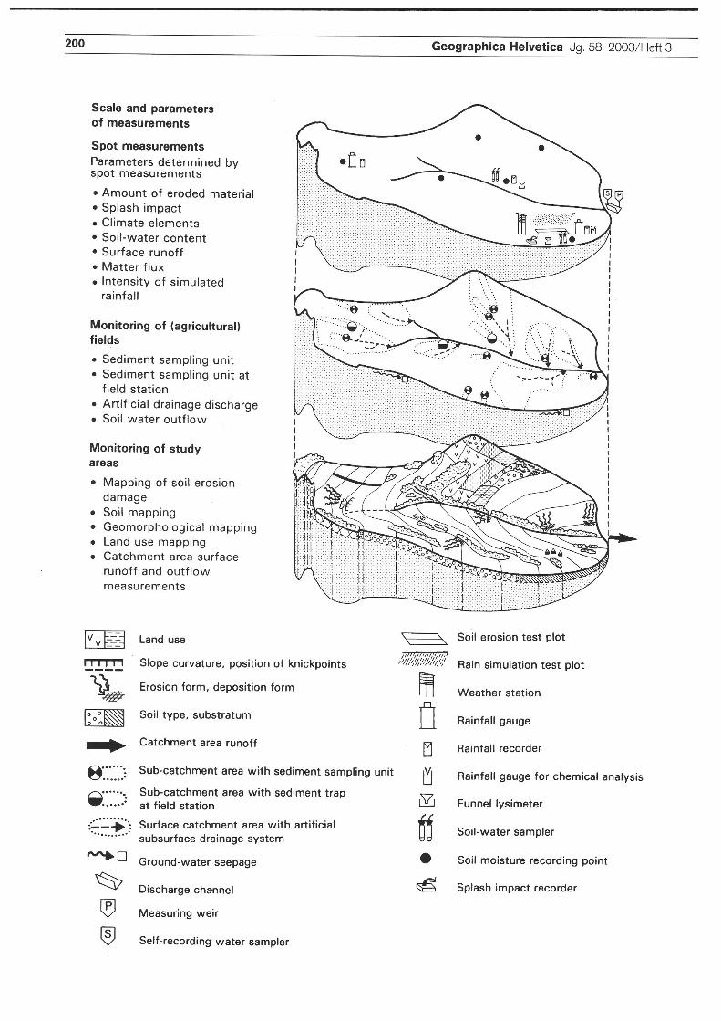
Scale and parametersof measurements
Spot measurementsParameters determined byspot measurements
Amount of eroded materialSplash impactClimate elementsSoil-water contentSurface runoffMatter fluxIntensity of simulatedrainfall
Monitoring of (agricultural)fields
Sediment sampling unitSediment sampling unit atfield StationArtificial drainage dischargeSoil water outflow
Monitoring of studyareas
Mapping of soil erosiondamageSoil mappingGeomorphological mappingLand use mappingCatchment area surfacerunoff and outflowmeasurements
3M
iio
\\o
Vv HX Land use
t_i _i_ i_«_j Slope curvature, position of knickpoints
yL^ Erosion form, deposition form
l°°°KS§j Soil type, substratum
^jl^. Catchment area runoff
Sub-catchment area with Sediment sampling unit
^//"//'
Sub-catchment area with Sediment trapat field Station
Surface catchment area with artificialsubsurface drainage System
Ground-water seepage
Discharge Channel
Measuring weir
Self-recording water sampler
00
iV,
\^ Soil erosion test plot
"<" Rain Simulation test plot
Weather Station
Rainfall gauge
Rainfall recorder
Rainfall gauge for chemical analysis
Funnel lysimeter
Soil-water sampler
Soil moisture recording point
Splash impact recorder

Geography in Basel - The Integrative Approach H. Leser, R. Schneider-Sliwa, P Nagel, E. Parlow, C. Alewell 201
participated in digital geoecological mapping projects(Huber 1995; Menz 2001), which were linked tosoil erosion modelling (Dräyer 1996). These projectsaimed at developing landscape assessment schemes,thereby introducing a second research theme.
This approach involves investigations of the changeof cultural landscapes, viewed from a human andlandscape ecological perspective (Schneider-Sliwa,Schaub & Gerold 1999). It focuses on the integra¬tive viewpoint of the real landscape, as put forwardby Ehlers (1998). Humans stand in the centre because
«nature» in the original sense (non-anthro-pogenic)hardly exists any more. Even the scientific concept ofgeography has been adapted to this approach.Issues related to the change of landscapes couldhave been integrated into the Swiss Priority Pro¬
gramme (SPP) Environment of the Swiss NationalScience Foundation. However, they did not come tothe attention of project leaders, in particular withrespect to the scale and abiotic domain of landscapesand the relationship with elements of the culturallandscapes. On the basis of the so-called Biodiver-sity Project, the issues were eventually raised by theproject «Comparison of Element Turnover in Differ-entTypes of Landscapes» (Ogermann 1999). Method-ical-methodological reflections were presented byLeser & Schaub (1995), Leser & Nagel (1998),and - from a practical viewpoint - by Leser (1997,2002b).Given that the research extended across differentdisciplines, the concept of transdisciplinarity wasanalysed as well (Leser 2002a; Potschin 2003).This research encouraged studies on landscapeprotection, directed towards the conservation ofnature, geotopes and cultural landscapes. Manyresearch projects are being conducted to thisend, partially in collaboration with the ArbeitskreisGeoökologische Raumgliederung und Leistungs¬vermögen des Landschaftshaushalts.
4.2 Human geography/urban and regionaldevelopment
Human geography research is concerned with the for¬
mation of living space by man and society and the con¬
sequences of spatial planning for man, society, the econ¬
omy and environment. These can be seen most clearly inagglomerations, which are the microcosm and research
laboratory of society. TTiey are the places where human
influences, social, ecological and economic problemsare intensified and also where city-outskirts and urban-rural relations become blurred. The Human GeographyDepartment in Basel has a threefold task in this fieldof investigation. Specifically, it aims to consolidate its
strengths in areas of application and to deliver usefulinformation for urban development policy, economic
promotion, regional development in industrialized and
developing nations, as well as decisions by firms - bymeans of regional Statistical studies, target group-ori-ented surveys of households and businesses, market and
locational analyses and field studies in areas with delaysin development (Fig. 5,6 and 7).
4.2.1 City and agglomeration - economic andsocial Systems in the city
Cities are the most important living areas where onegains experience about the world population. Distri¬bution, structure, and the dynamics of the urban popu¬lation define Services of the public administration as
well as the provision of housing, Jobs and education.
Entrepreneurial decision-making is also dependent onthe development of an agglomeration, the city and itsdistricts. This research emphasis is
dedicated towards demographic and social economic
processes and structures in cities and their surround-ing areas both in the local and regional contextof Basel and the Southern Upper Rhine regionand in metropolises worldwide. Examples for thiskind of work - in connection with different Coop¬
eration partners such as the Statistical Authority ofthe Canton of Basel-Stadt, or the research group«Lifestyle, Social Position and Urban Structures» ofthe Academy for Environmental Planning and RegionalStudies in Hanover, furthermore, Social Service Agenciesof the Canton of Basel-Stadt are: Schneider-Sliwa et al.
(1999,2001), which analyses the population and eco¬
nomic structures and processes in Basel; Egli (2001,2003), which documents homelessness in Basel; EderSandtner (2001, 2004), which reveals the new seg-regation patterns in Basel, using block data for theentire city; Sahli & Schneider-Sliwa (2004); Schnei¬
der-Sliwa 2004, which analyses the cut-off problemquarters of the African and Maghreb peoplesin Strasbourg; Kampschulte & Schneider-Sliwa(1999), which choose as its central theme the
image of Basel as a steering device of urban
development. Various market studies analyze the
Fig. 4: Multiple-step methodical concept for the determination of soil erosion and geoecological parameters: TheRiedmattbach example.Mehrstufiges methodisches Konzept für die Bestimmung von Bodenerosion und geoökologischen Parametern:Das Beispiel des Riedmattbaches.Un concept multiple de progression methodique pour la determination de Verosion du sol et des parametres geoe-
cologiques. L'exemple du Riedmattbach (la riviere du Riedmatt)Source: Prasuhn (1991)

202 Geographica Helvetica Jg. 58 2003/Heft 3
OBoio:o. oijit 11
FT
t ¦1*4
m,
#*WLJm
¦)oi¦
p,-., i
;;Fig. 5: Statistical analysis of large surveys, final discussionStatistische Auswertung von Grossbefragungen, AbschlussbesprechungExploitation statistique d'enquetes ä gründe echelle, discussion finalePhoto: R. Schneider-Sliwa
»
:|\||§ P:P,'*PO :
:ä!f
V.
9k
a
ff". f;:¦=; ;
*\-0:0'
J>
/J
:
:
1
SPlIIli oo :o ip
Fig. 6 and 7: Survey of people with special needsBefragung von besonderen BedürfnisgruppenEnquetes relatives ä des groupes aux besoins spquesPhotos: R. Schneider-Sliwa

Geography in Basel -The Integrative Approach H. Leser, R. Schneider-Sliwa, P. Nagel, E. Parlow, C. Alewell 203
applicability of research to municipalities of thetri-national region of Basel, e.g. by Kampschulte,Schneider-Sliwa & Zunzer (2002); Kampschulte& Schneider-Sliwa (2001); Schneider-Sliwa &Kampschulte (2002).As well as dedicated to international metropolisesundergoing radical change: Schneider-Sliwa (2002)with the example of the globalization and restructuringof Berlin, Brüssels, Hanoi, Ho-Chi-Minh City, HongKong, Jerusalem, Johannesburg, Moscow, St. Peters¬
burg, Sarajevo and Vienna; Breitung & Schnei¬der-Sliwa (1997) with the example of Hong Kong;Breitung (2001), who as an example of politicalchange investigates the social spatial repercussionsand regional politics in Hong Kong after 1997; Brei¬tung & Schneider-Sliwa (2000), who in the exampleof Berlin chose as the central theme the unified anddivided city; Kampschulte (2002), who illuminatedVienna's new location between East and West.
4.2.2 Regional economic development -interwoven relations across borders
Globalization, technological change and efforts towardseconomic Integration change business cycles and loca-tional advantages and intensify regional competition.This area of work investigates
structural changes of economic areas and the devel¬
opment of Jobs, population and infrastructure, espe¬
cially in the tri-national border region of Basel, theSouthern Upper Rhine region and Northwest Switzer¬
land, but also selected developing nations. The followingindividual projects are arranged here, which originatedin Cooperation with the Statistical Authorities of theCanton Basel City as well as other cantonal and cityauthorities in Basel, surrounding municipalities and ininstitutions of tri-national Cooperation. They are con¬cerned with the structure and dynamics of the economyin Northwest Switzerland in the context of globalization,e.g. by Schneider-Sliwa et al. (2001); Kampschulte& Strassmann (1999); Strassmann (2002); Strassmann,Frost & Brunner (2000).A further goal is to show the broad spectrumof regionally specific locational advantage neededfor the development of a region well adapted forthe future. Research on economic developmentacross the borders carried out market studies inwhich approximately 12 000 people were surveyedbetween 1996 and 2000. Studies included are: Kamp¬
schulte & Schneider-Sliwa (2001); Kampschulte,Schneider-Sliwa & Zunzer (2002); Schneider-Sliwa (2003a); Schneider-Sliwa & Kampschulte(2002).The projects by Eder & Sandtner (2000) andEder Sandtner & Sandtner (2002) concentratedon the development of a regional identity in thecommon economic area of the Upper Rhine. Borderregion research in other regional contexts was car¬
ried out by Kampschulte (1999a and b, 2000).
4.2.3 Urban environment and sustainablelandscape planning
Settlements and economic growth create a culturallandscape in which the balance of the ecosystem andnatural leisure areas for humans are increasingly beingdestroyed. This area of work is concerned with:
Planning, which carefully and sustainingly managesthe scarce resources of the environment in the cityand regionsDiscerning an appropriate urban environment and
development planning for target groups, the accept¬
ance of environmental protection and urban plan¬
ning measures among the population and open spaceplanning and the development of a wholesome city,which does justice to all groups in society. Two
projects are mentioned here:- In «Urban Environment in Old Age» (Schnei¬
der-Sliwa 2003c), in preparation for a planningmodel focussing on the elderly, a survey of around7000 people between 60 and 85, investigatedsenior Citizen needs and requirements for alterna¬tive living forms.
- In the project, «Road surfaces meeting therequirements of the handicapped» (Schneider-Sliwa 2003b), a study on inner city paving is
being carried out, the results of which will allowfor a paving which not only meets the require¬ments of the handicapped but is also ecologicaland aesthetical.
4.3 BiogeographyJTie Institute for the Conservation of Nature, Landscapeand Environment / Biogeography operates on the Inter¬
face between geography and biology - both in teachingand basic and applied research. Its research focus is onthe spatial analysis and evaluation of landscapes, usingorganisms as indicators. The causes for spatial patternsof biodiversity are a central theme within this research
(bioindication, biomonitoring, State and dynamics of spe¬cies distributions). Further topics include environmen¬tal risk assessment and environmental management.Theoverall goal of the applied research is to develop and
promote strategies for the sustainable development and
use of landscapes and natural resources.
4.3.1 Ecology and protection of running watersRiver engineering, land use in catchment areas andchemical pollution affect the composition and dynam¬ics of aquatic communities. Therefore, communities canbe used as indicators of the ecological State of aquaticecosystems. Our current research focuses on Springs ofthe Regio Basiliensis and aims to provide improvedscientific understanding of basic ecological processes.The objective is to develop practical strategies andassessment methods for headwater monitoring, resto-ration and management. Basic research deals with hab¬
itat specificity and colonization strategies of the fauna
204 Geographica Helvetica Jg. 58 2003/Heft 3
adapted to these island habitats. In an interdisciplinaryand transdiseiplinary approach, we classify differentspring ecosystems and their characteristic fauna andflora, assess the degree of anthropogenic disturbancesand evaluate possible restoration designs.
At the same time, techniques are being evaluated on howto exploit sources in a sustainable way for the provisionof drinking water without compromising their potentialas habitats for the flora and fauna. Experience in Baselhas shown that it is possible to create ecologically valu¬able landscapes in close proximity of urban areas by form-ing a mosaic of semi-natural floodplains and man-madeground water enrichment sites for drinking water pro¬duction. Faunal studies here provided clear evidence of afunctional similarity among semi-natural and man-madehabitats. Furthermore, studies on the purification of per-colating water and ground water transport provided basicdata for early warning Systems to detect reduetions indrinking water quality. Other research topics include thefaunistics and ecology of groundwater fauna, biomonitor-ing of water quality and appraisals of river restorations.
Selected literature: Baltes & Nagel (1997); Merschet al. (1996); Nagel (1999); Nagel & Baltes (1997):Rüetschi et al. (2001).
4.3.2 Urban ecology and the conservation of nature,landscape and environment in cultural land¬scapes
Settlements and cultural landscapes are designedaccording to the social and economic activities of man.Our research aims to identify and analyse ecologicaland spatial characteristics of these areas and to applythis knowledge in designing strategies for an environ-mentally sound and ecologically sustainable urban andrural development. The prineipal goal is to incorporateenvironmental protection objeetives into the structuraland functional design and development of urban andcultural landscapes. Questions about nature conserva¬tion in settlement areas are just as much at the centreof attention as is basic research with feral pigeons asbioindicators of environmental pollution.
Further topics in this field of research include bioindica-tion of anthropogenic, semi-natural habitats, using groundbeetles, and the analysis of ecological functions of rooftop gardens, in particular with respect to their role as Sur¬
rogate habitats and migration corridors for invertebrates.In an interdisciplinary and transdiseiplinary approach, thegreens in urban areas are assessed in regard to their differ¬ent functions, and strategies are developed for the sustain¬able preservation of their ecological functions.
Selected literature: Kaupp (1999); Lenzin et al. (2001);Luka et al. (1997); Nagel (1999, 2000); Nagel et al.(1998,2001).
4.3.3 Tropical resources management anddevelopment Cooperation
Our research emphasis is on the ecological analysisand assessment of human impacts on subtropical andtropical landscape ecosystems and - in a national andinternational co-operation context - on the develop¬ment of environmentally sound resource utilizationstrategies. Our work in this area at present focuses onvarious countries in inner tropical Africa (Fig. 8).
At the core are the development of environmentallyfriendly and sustainable methods and strategies forsafeguarding agricultural production. Our researchconcentrates especially on ecological side-effects ofclassical, traditional, and more recently, biological andgenetic control techniques against pests of crops andvectors of human and livestock diseases.
A second important research area is the development ofadapted conservation strategies. This research focuseson the fragmentation of rain forest fauna. It evaluatespossibilities to reduce fragmentation by creating net¬works of alternative habitats such as certain plantationforests. The effectiveness of different species protectionstrategies is investigated, using a ränge of different indi¬cator groups (wood-dwelling beetles, detritivorous inver¬tebrates, primates). This research combines metapopu-lation modeis and molecular genetic analysis. Anotherproject studies spatial and behavioural adaptations oflarger game (antelopes, buffaloes, elephants) to annualsavannah fires.
Selected literature: Nagel (1995); Peveling & Nagel(2001);Peveling et al. (2003a); Peveling et al. (2003b);Specht (2002); Stolz et al. (2002).
4.3.4 Zoogeography and systematicsThe spatial analysis of species distribution patterns isan instrument of biogeographical research. Phyloge-netic and systematic studies of selected animal groupsand analyses of their present and past distribution areat the core of this research. These studies not only pro-vide basic biogeographical data but contribute also tothe reconstruetion and forecast of landscape dynamicsas well as to species and landscape conservation pro¬grammes. The research groups focus on the zoogeog¬raphy and systematics of the following taxa: carabidae-paussinae (worldwide), cicadas (selected Europeantaxa) and ants (especially Neotropis). For behaviouraland ecological studies under laboratory conditions,rearing facilities have been established for some ofthese taxa. At present, molecular genetic methods arebeing used mainly to reconstruet the formation ofrelict distribution areas of carabids. The ecology ofterrestrial island biotopes is being investigated, usingthe examples of central European scree slope ecosys¬tems.

Geography in Basel -The Integrative Approach H. Leser, R. Schneider-Sliwa, P Nagel, E. Parlow, C. Alewell 205
I*P> ¦IM
P*'1 5 n
::rlTwf
f ,1
m
Fig. 8: Some staff members of the project on «Conservation of biodiversity in Lama forest, Benin» in the field in
May 2001.The research is funded by the Swiss Agency for Development and Cooperation and the Swiss National Science Foundation. It is
organized as a research partnership between the Faculty of Agricultural Sciences ofthe University Abomey-Calavi, Benin, and the
Institute for Environmental Sciences/Biogeography ofthe University of Basel.
Teammitglieder des SNF- und DEZA-unterstützten Forschungprojekts «Nachhaltige Bewahrung der Biodiversitätim Lamawald, Benin» im Gelände in Süd-Benin im Mai 2001.
Quelques representants du projet «Conservation de la biodiversite de la foret de Lama, Benin», sur le terrain en
mai2001.Photo: R. Peveling
Selected literature: De Andrade & Baroni Urbani(1999); Giulio di et al. (2003); Möseler & Molenda(1999); Mühlethaler & Nagel (2001); Nagel (1997).
4.4 Meteorology and remote sensingThe scientific formulation of questions at the Institutefor Meteorology, Climatology and Remote Sensingconcentrates on the topics of experimental micromete-orology; topoclimatological differentiation of the land¬
scape and the conversion of these results for urbanand regional planning; the use of satellite data andnumerical modeis for spatial analysis of meteorologi-cal fields, especially radiation and heat fluxes; as well as
the implementation of a numerical model for weatherforecasting, whereby short term forecasts (now-cast-ing) is prevalent (Fig. 9).
4.4.1 Experimental micrometeorologyExperimental micrometeorology investigates theexchange of water, heat and carbon dioxide on dif¬
ferent surfaces on the interface between the earth'ssurface and the atmosphere. Meteorology Basel is
represented in international projects in various cli¬
mate zones of the Earth. Naturally, the region of
Basel plays a dominant role in the research projects.However, projects in the Alps, in the Mediterraneanregion, in Northern Scandinavia, in the SpitzbergenIsland and California are also carried out. TTie formu¬lation of questions Covers a wide spectrum, rangingfrom the diffusion of harmful substances over citiesand the examination of the turbulent heat exchangesto questions on water use for agriculture in aridregions of the Mediterranean and the energetic con¬
ditions, which produce extreme instances of snow-melts (slush flows) in Polar Regions.
References: Feigen winter (2000); Vogt & Feigenwin¬
ter (2000); Bernhofer & Vogt (2000); Feigenwinteret al. (2000); Gude et al. (2000); Feigenwinter etal. (1999); Gude & Scherer (1999); Parlow (1998b);Scherer et al. (1998); Gude & Scherer (1998); Jäggi(2002); Arck & Scherer (2002); van Gorsel et al.
(2003).
4.4.2 Models for realityNumerical modeis allow for the computer-aided Simu¬
lation of the processes in the atmosphere and the
exchange processes between the Earth's surface, veg-

206 Geographica Helvetica Jg. 58 2003/Heft 3
0:
m:/¦
-ir. ¦:.
rFig. 9: Meteorological tower for urban climate studiesin the city of BaselMess- Turm für Stadtklimauntersuchungen in der BaslerInnenstadtTour meteorologiquepour analyses climatiques urbaines
ä BälePhoto: MCR Lab
etation and the atmosphere. Mesoscale modeis cal¬culate the consequences of topography and land useon the atmosphere and help to make assessments onlocal effects for weather forecasts, traffic safety andplanning. Real time modeis for the whole of Europeand high-resolution forecasts for the region of north-western Switzerland are calculated on a daily basis atthe University of Basel and published on the Inter¬net at (www.unibas.ch/geo/wetter). Local effects, suchas the Möhlin Jet, which in winter leads to the dis-solution of fog in the region of Basel, can be mod-eled and studied on the Computer. By means of thefollowing projects: REKLIP (Regio-Klimaprojekt),KABA (Klimaanalyse beider Basel) and CAMPAS(Klimaanlayse des Kantons Solothurn), many yearsof experience in the application oriented evaluationof measurement data, model calculations and satel¬lite data, especially for urban and regional planning,exists.
Selected literature: Fehrenbach et al. (2001); Fehren¬bach & Scherer (2000); Scherer et al. (1999); Fehren¬bach (1999).
4.4.3 Remote sensingRemote sensing is the measurement and Observationof the Earth's surface and the atmosphere withoutcontact (Fig. 10). It can be carried out from the groundor with the aid of airplanes and satellites and deliverssurface covering measurements on varying spatial andtemporal scales. The University of Basel participatesin various national and international remote-sensingprojects, which Stretch from the high Arctic Circleover the Alpine region to subtropical regions and areconcerned mainly with radiation and heat balances.The European Space Agency (ESA) is an importantproject partner. In combination with micrometeorol¬ogy, which works with individual measurement loca-tions, spatially differentiated Statements about heatfluxes in consideration of relief and land use effectsare possible. Urban climatology is of great importance.Satellite Systems, which are used most frequently, arethe LANDSAT-ETM and ASTER, which possess spa¬tial resolutions up to 15 m in various spectral ranges(NOAA-AVHRR and MODIS, as well as microwaveSystems such as ERS-1/2 and ENVISAT).
References: Parlow (2000a); Parlow (2000b); Schereret al. (2000); Parlow (1998a), Parlow (2003).
4.5 Environmental geosciences and soil science4.5.1 General directionsIn January 2004, a new institute for EnvironmentalGeosciences and Soil Sciences is planned to beopened. The focus of the research group will be oninterdisciplinary geoscientific research. The goal is tounderstand and to assess the context of ecosystemsin the lithosphere, pedosphere, atmosphere, hydro-sphere, biosphere and anthroposphere (Fig. 11).
Only if the function and interaction of these differentspheres is understood, can the environment be pro-tected from disturbance and human impact. Thus, theresearch group will concentrate in particular on thepedosphere, with special attention being paid to thecoupling and interaction between the cycles of ele¬ments (carbon, nitrogen, sulfate, nutrients) in semi¬natural ecosystems.
Within this area, the focus will be on changes in thecycles of elements but also on changes regarding thecoupling of these cycles due to altered climate andenvironmental conditions. It is, for example, largelyunknown how mineralization rates of sulphate andnitrogen react to a decrease in anthropogenic depo-sition with a concurrent change of climate. A changein the mineralization rates, however, generally exerts

Geography in Basel - The Integrative Approach H. Leser, R. Schneider-Sliwa, R Nagel, E. Parlow, C. Alewell 207
SS
mm ii 'wmMmmmmmmMmmiM% m
&
tt%^vIHM
35«»:*m
vmiewm SÄC1**
mim WßmWm¦pifljjliili; OSlOO«:
IIite» UlDUIBll
01PO
«1»
il -O-00*J->0. öoapiil«j?
ISlilpSR
WPl-"t*«#l llrfi
mWiliff* 50*11ililpfii
'::smsßMm ,1 likiiiiiiiiiiiiisyiiiiiiip^^:*! '
HP?' pro«»; pöj l !¦ lii* fr : NbirtÄa»««» .rWÄä ÄjüW^^lteÄwimmtMß-i/wmM m«» il t r;.ipi3iioiii»i ^¦ißtitmlamißm* tim ¦¦Silllärf ..o 0, o. ,%.::Af:~>its, '¦ *".." ,,o,hi;i*i«. ¦ o;IBip«oo, - "OooiÄiJSpioioimJL »j SOili jlfil>o Ilpiffci ¦ 11Pf o»Ö
sms *»&*< iipiiiiiisiiiiisffliiiWiiifc, ^p^^^^^^iMKi» iiiiiiiliiiiiiiiiijiiisiiii
Fig. 10: Aster satellite image of BaselAster-Satellitenbild von BaselImage satellite Aster de Bäle
great influence generally on substance balances andon phenomena such as nitrogen Saturation of ecosys¬tems, reversibility of water acidification, or the buffercapacity of the soil. An important aspect will also bethe restoration of ecosystems - especially soil reme-diation.
Selected literature: Alewell, Mitchell, Likens &Krouse (2000); Alewell, Madnerscheid, Meesen-burg & Bittersohl (2000); Alewell (2001); Alewell2002.
4.5.2 MethodsBesides general biogeochemical methods and analy¬sis, an important tool will be that used for the investi¬
gation of stable isotopes (15N, lsO,34S, 13C).The empha-sis in this area will be on field investigations, because
the transference of results from laboratory experi-ments to real situations is only possible on a limitedscale.
Regarding methodology, the Environmental Geo¬
sciences and Soil Sciences research group aims towardsinterdisciplinary Cooperation. Only by using a combi¬
nation of methods (e.g. results from biogeochemicalanalysis, stable isotope data and modelling) will it be
possible to describe the complex behaviour of ecosys¬tems as well as the complex course of events that takeplace in the soil.
Selected literature: Alewell, Mitchell, Likens &Krouse (1999); Alewell & Manderscheid (1998);Alewell, Lischeid, Hell & Manderscheid (2003);Alewell & Gehre (1999); Alewell & Novak (2001).

208 Geographica Helvetica Jg. 58 2003/Heft 3
Atmosphere
iLSÄ^ \ Biosphere
/i: :
NiHvdrospher¦ ¦P^^JL
\;
PedosphereAnthroposphere
I Lithosphere
Fig. 11: Visual representation of environmental geoscienceVisuelle Definition der UmweltgeowissenschaftenDefinition visuelle des geosciences environnementales
ReferencesAlewell, C. (2001): Predicting reversitility of acidifi-cation: The European Sulfur Story. - In: Water Air SoilPollut. 130:1271-1276.Alewell, C. (2002): Acid input into the soils by acidrain. - In: Zed Rengel (ed.): Handbook of Soil Acid-ity. - New York: Marcel Dekker Inc.Alewell, C. & M. Gehre (1999): Patterns of stable S
isotopes in a forested catchment as indicators for bio-logical S turnover. - In: Biogeochemistry 47: 319-333.Alewell, C, Lischeid, G, Hell, U. & B. Mander¬scheid (2003): High temporal resolution of ion fluxesin semi natural ecosystems - Gain of information orwaste of resources? - In: Biogeochemistry (in press).Alewell, C. & B. Manderscheid (1998): Use of objec-tive criteria for the assessment of biogeochemical eco-system modeis. - In: Ecol. Modell. 107:213-224.Alewell, C, Manderscheid, B., Meesenburg, H. &J. Bittersohl (2000): Is acidification still an ecologicalthreat? - In: Nature 407: 856-857.Alewell, C, Mitchell, M., Likens, G.E. & R.H.Krouse (1999): Sources of stream sulfate at theHubbard Brook Experimental Forest: Long-term anal¬yses using stable isotopes. - In: Biogeochemistry 44:281-299.
Alewell, C, Mitchell, M., Likens, G.E. & R.H.Krouse (2000): Assessing the origin of sulfate deposi-tion at the Hubbard Brook Experimental Forest. - In:J. Environ. Qual. 29:750-767.Alewell, C. & M. Novak (2001): Spotting zones ofdissimilatory sulfate reduction in a forested catch¬ment: The 34S-35S approach. - In: Environ. Pollut. 112:369-377.
Arck, M. & D. Scherer (2002): Problems in thedetermination of sensible heat flux over snow. - In:Geografiska Annaler, Series A, N 3-4:157-169.Baltes, B. & R Nagel (1997): Der Einfluß derGewässerversauerung auf die Rhithral-Biozönosen imnördlichen Saarland. - Tagungsbericht 1996 der Deu¬tschen Gesellschaft für Limnologie (DGL) und derdeutschen und österreichischen Sektion der SocietasInternationalis Limnologiae (SIL), Schwedt / Oder, 16.bis 20. September 1996, Band 2, Krefeld: Eigenverlagder DGL: 567-571.
Barrows, H.H. (1923): Geography as Human Ecology.- In: Annais of the Association of American Geogra¬phers 13:1-14.Bernhofer, C. & R. Vogt (2000): Energy balance clo-sure gaps - a methodical problem of eddy covariancemeasurements? - In: de Dear, R.J., Kalma, ID., Oke,

Geography in Basel - The Integrative Approach H. Leser, R. Schneider-Sliwa, R Nagel, E. Parlow, C. Alewell 209
TR. & A. Auliciems (eds): Biometeorology and urbanclimatology at the turn of the millennium. - Selected
papers from the Conference ICB-ICUC'99, WMO/TDNo. 1026:199-204.Böhm, A. (2003): Bodenerosion und Erosionsschutz¬maßnahmen auf militärischen Liegenschaften am Fall¬
beispiel US-Truppenübungsplatz Hohenfels, Deutsch¬land. - Physiogeographica, Basler Beiträge zur Physio-geographie 31.
Borsdorf, A. (1999): Geographisch denken und wis¬
senschaftlich arbeiten. Eine Einführung in die Geogra¬phie und in Studientechniken. - Perthes Geographie-Kolleg, Gotha, Stuttgart: Klett-Perthes.Breitung, W. & R. Schneider-Sliwa (1997): Hong¬kong vor neuen Herausforderungen - Eine GlobalCity im Wandel. - In: Geographische Rundschau 7-8:441-449.
Breitung, W. (2001): Hongkong und der Integra-tionsprozess. Räumliche Strukturen und planerischeKonzepte in Hongkong. - Basler Beiträge zur Geo¬
graphie 48, Wepf & CO., Basel.Breitung, W. (2002): Hongkong: Die Globalstadt Chinas.- In: Schneider-Sliwa, R.: Städte im Umbruch - Glo¬balisierung und Geographie in der Neustrukturierungvon Berlin, Brüssel, Hanoi, Ho-Chi-Minh-Stadt, Hong¬kong, Jerusalem, Johannesburg, Moskau, St. Petersburg,Sarajewo und Wien. - Berlin: Reimer Verlag.Breitung, W & R. Schneider-Sliwa (2000): Das NeueBerlin - vereinigte Stadt, gespaltene Stadt. - In: Peter¬manns Geographische Mitteilungen 144,5:6-17.Breitung W. (1999): The End of «Made in HongKong»? - Deindustrialisation and Industrial Promo¬tion Policy in Hong Kong. - In: Geographica Helvetica54,4:242-251.De Andrade, M. & C. Baroni Urbani (1999): Diver-sity and adaptation in the ant genus Cephalotes, pastand present (Hymenoptera, Formicidae). - Stuttgar¬ter Beiträge zur Naturkunde, Serie B (Geologie undPaläontologie), Nr. 271,889 pp.Dräyer, D. (1996): GIS-gestützte Bodenerosionsmo-del-lierung im Nordwestschweizer Tafeljura - Erosi-onsschadenskartierungen und Modellergebnisse. -Phy-siogeographica, Basler Beiträge zur Physiogeo-graphie 22, Basel, 1-234.Eder Sandtner, S. (2001): Städtische Sozialstruktu¬ren und residentielle Segregationsmuster. - In: Geo¬
graphica Helvetica 56,4:234-248.Eder, S. & M. Sandtner (2000): Staatsgrenzen in derTri-Rhena - Barriere oder Stimulus? - In: Regio Basi-liensis 41:15-26.Eder Sandtner, S. & M. Sandtner (2002): RegionaleIdentität über die Grenzen? Die TriRhena im Bewusst¬sein der Bevölkerung. - In: Revue Geographie de PEst 1.
Eder Sandtner, S. & R. Schneider-Sliwa (2004):Fracture sociale dans la cite de Bäle - Approchemethodologique de la segregation. - Bulletin, Asso¬ciation de Geographes Frangais (in press).
Egli, R. (2001): Obdachlosigkeit in Basel. Charakte¬ristik der betroffenen Gruppe. Ausmass und Entwick¬lung, räumliche Aspekte, Trends. In: Regio Basilien-sis 42,2:189-198.Egli, R. (2003): Les Sans domicile fixe et Taide socialeä Bäle. - Bulletin, Association de Geographes Francais,(in press).Ehlers, E. (1998): Geographie als Umweltwissen¬schaft. - In: DIE ERDE 129,4:333-349.Ehlers, E. (2000): Globale Umweltforschung undGeographie - ein «State-of-the-art»-Bericht. - In: Peter¬
manns Geographische Mitteilungen 144,2:58-65.Ehlers E. & T Krafft (eds) (2001): Understanding theEarth System. Compartments, Processes and Interac-tions. - Berlin, Heidelberg, New York: Springer Verlag:1-290.
Ehlers E. & H. Leser (Hrsg.) (2002): Geographieheute - für die Welt von morgen. - Perthes Geogra-phieKolleg, Gotha: Klett-Perthes: 1-176.
Fehrenbach, U (1999): Analyse und Bewertung lokal-und regionalklimatisch wirksamer Faktoren in derRegion Basel. - Basel: stratus 6,177 pp.Fehrenbach, U & D. Scherer (2000): Consequencesof spatial resolution transformations for land-use Clas¬
sification. - In: Casanova, J.L.: Remote Sensing in the21st Century: Economic and Environmental Applica¬tions. - Rotterdam: Balkema Publishers: 113-117.
Fehrenbach, U, Scherer, D. & E. Parlow (2001):Automated Classification of Planning Objectives forthe Consideration of Climate and Air Quality in Urbanand Regional Planning for the Example of the Regionof Basel/Switzerland. - Atmospheric Environment 35,5605-5615.
Feigenwinter, C. (2000): The Vertical Structure of Tur-bulence above an Urban Canopy. - Stratus 7, Basel,76 pp.Feigenwinter, C, Vogt, R. & E. Parlow (1999): Ver¬
tical structure of selected turbulence characteristicsabove an urban canopy. - In: Theoretical and AppliedClimatology 62:51-63.Feigenwinter, C, Vogt,R. & E. Parlow (2000): Analy¬sis of organized structures in urban turbulence. - In:de Dear, R.J., Kalma, ID., Oke, TR. & A. Auliciems(eds): Biometeorology and urban climatology at theturn of the millennium. - Selected papers from the Con¬
ference ICB-ICUC'99, WMO/TD No. 1026:565-570.Geographisches Institut Universität Basel, For¬
schungsgruppe Bodenerosion Basel (2003): Ver¬
zeichnis der Arbeiten 1974-2003 (Stand März 2003).Basel, 1-16 (mimeographed; cf. http://www.unibas.ch/geo/physiogeo/).Geographisches Institut Universität Basel, For¬
schungsgruppe Landschaftsanalyse und Ange¬wandte Landschaftsökologie (2003): Verzeichnisder Arbeiten 1974-2003 (Stand März 2003). Basel,1-15 (mimeographed; cf. http://www.unibas.ch/geo/physiogeo/).

210 Geographica Helvetica Jg. 58 2003/Heft3
Giulio, A. di,Fattorini, S., Kaupp, A., VignaTaglianti,A. & R Nagel (2003): Review of competing hypoth-eses of phylogenetic relationships of Paussinae (Cole-optera: Carabidae) based on larval characters. - Sys-tematic Entomology 28:1-31.Gude, M. & D. Scherer (1998): Snowmelt and slush-flows: hydrological and hazard implications. - In:Annais of Glaciology 26:381-384.Gude, M. & D. Scherer (1999): Atmospheric trigger-ing and geomorphic significance of fluvial events inhigh-latitude regions. - In: Zeitschrift f. Geomorpholo¬gie, NF, Suppl.-Bd. 115: 87-111.Gude, M., Jonasson, C, Dietrich, S. & D. Scherer(2000): Assessment of variability in fluvial Sedimenttransfers in Kärkevagge (N-Sweden) during the last 50
years. - In: Nordic Hydrology 31,4/5: 373-384.Hebel, B. (2003): Validierung numerischer Erosions¬modelle in Einzelhang- und Einzugsgebietsdimension.- Physiogeographica, Basler Beiträge zur Physiogeo-graphie 32, Basel.Huber, M. (1995): The Digital Geoecological Map. Con¬
cepts, GIS methods and case studies. - Physiogeographica,Basler Beiträge zur Physiogeographie 20, Basel, 1-144.
Jäggi, M. (2002): Mikrometeorologische Bestimmungdes Energiehaushaltes einer Magerwiese in kom¬plexem Gelände. - Stratus 8, Basel, 117 pp.Kampschulte, A. (1999a): Grenzen und Systeme -Vongeschlossenen zu offenen Grenzen? Eine exempla¬rische Analyse der grenzüberschreitenden Verflech¬tungen im österreichisch-ungarischen Grenzraum. -Tübinger Geographische Studien 127, Tübingen.Kampschulte, A.(1999b):TheAustro-Hungarian borderregion - opportunities for and perspectives of regionaldevelopment. - In: Knippenberg, H. & J. Markusse(eds): Nationalising and Denationalising EuropeanBorder Regions - 1800-2000: Views from Geographyand History. - Geo Journal Library 53:173-197.Kampschulte, A. (2000): Regionale Dimensionen derwirtschaftlichen und gesellschaftlichen Transformation inUngarn. - In: Fassl, H. & C. Waack (Hrsg.): Regionenim östlichen Europa - Kontinuitäten, Zäsuren und Per¬
spektiven. - Tübinger Geographische Studien 128,57-73.Kampschulte, A. (2002): Wien - Neupositionierungzwischen Ost und West. - In: Schneider-Sliwa, R.:Städte im Umbruch - Globalisierung und Geographiein der Neustrukturierung von Berlin, Brüssel, Hanoi,Ho-Chi-Minh-Stadt, Hongkong, Jerusalem, Johannes¬burg, Moskau, St. Petersburg, Sarajewo und Wien. -Berlin: Reimer Verlag.Kampschulte, A. & R. Schneider-Sliwa (1999): DasImage von Basel - Steuerungsinstrument für dieStadtentwicklung? - Basler Feldbuch 16, Basel.Kampschulte, A. & R. Schneider-Sliwa (2001): Innen¬stadt- und Kurortentwicklung Bad Säckingen. - BaslerStadt- und Regionalforschung 20,64 S.
Kampschulte, A., Schneider-Sliwa, R. & D. Zunzer(2002): Aspekte der Stadtentwicklung in Bad Säckin¬
gen: Ergebnisse nutzerorientierter Befragungen zu denThemen Jugend, Verkehr und «Lebensader Wasser». -Basler Stadt- und Regionalforschung 21, Basel.Kampschulte, A. & R. Strassmann (1999): Restruk-turierungsprozesse einer Stadt-Umland-Ökonomie -Veränderung der Wirtschaftsstruktur im Agglomerati¬onsraum Basel. - In: Geographica Helvetica 54,1:7-17.Kaupp, A. (1999): Die Käferfauna begrünter Dächer imStadtgebiet von Basel. - Regio Basiliensis 40,2:143-150.Lenzin, H, Kohl, I, Mühlethaler, R., Odiet, M.,Baumann, N. & R Nagel (2001): Verbreitung, Abun-danz und Standorte ausgewählter Neophyten in derStadt Basel (Schweiz). - Bauhinia (Zeitschrift derBasler Botanischen Gesellschaft) 15: 39-56.
Leser, H. (1997): Von der Biodiversität zur Land-schaftsdiversität. Das Ende des disziplinaren Ansat¬zes der Diversitätsproblematik. - In: Erdmann, K.-H.(Hrsg.): Internationaler Naturschutz. - Berlin, Heidel¬berg, New York: Springer Verlag: 145-175.
Leser, H. (1997): Landschaftsökologie. Ansatz, Mo¬delle, Methodik, Anwendung. - 4. Auflage, UTB 521,Stuttgart: 1-644.
Leser, H. (2002a): Geographie undTransdisziplinarität- Fachwissenschaftliche Ansätze und ihr Standortheute. - Regio Basiliensis 43,1:3-16.Leser, H. (2002b): Natur und Landschaft zwischen en¬
dogenem Wandel und anthropogenen Veränderungen.Perspektiven eines «Neuen Naturschutzes». - In: Bun¬desamt für Naturschutz (Hrsg.), bearbeitet von Karl-Heinz Erdmann & Christian Schell: Natur zwischenWandel und Veränderung. Ursache, Wirkungen, Kon¬
sequenzen. - Berlin, Heidelberg, New York: 135-158.Leser, H. & H.-J. Klink (Hrsg.) (1988): Handbuch undKartieranleitung Geoökologische Karte 1:25 000 (KAGÖK 25). - Forschungen zur deutschen Landeskunde228, Trier: 1-349.
Leser, H. & P. Nagel (1998): Landscape Diversity - a
Holistic Approach.-In: Barthloti,W. & M. Winiger (eds):Biodiversity. A Challange for Development Research andPolicy. - Berlin, Heidelberg, New York: 129-143.
Leser, H. & D. Schaub (1995): Geoecosystems andLandscape Climate -The Approach to Biodiversity onLandscape Scale. - GAIA 4:212-220.Leser, H. & R. Schneider-Sliwa (1999): Geographie- eine Einführung. - Das Geographische Seminar,Braunschweig: Westermann: 1-248.Leser H, Meier-Zielinski, S., Prasuhn, V & C. Sei-berth (2002): Soil erosion cachtment areas of North¬western Switzerland. Methodological conclusions froma 25-year research program. - In: Zeitschrift für Geo¬
morphologie, NF. 46: 35-60.Luka, H, Marggi, W & P. Nagel (1997): Agonumnigrum Dejean, 1828, neu für die Schweiz. Ein Beitragzur Gesamtverbreitung und Ökologie der Art (Coleo-ptera, Carabidae). - In: Mitteilungen der schweizeri¬schen entomologischen Gesellschaft 70,3-4:311-321.Marks, R., Müller, M.J., Leser, H. & H.-J. Klink
Geography in Basel -The Integrative Approach H. Leser, R. Schneider-Sliwa, R Nagel, E. Parlow, C. Alewell 211
(Hrsg.) (1989): Anleitung zur Bewertung des Leistungs¬vermögens des Landschaftshaushaltes (BA LVL). -Forschungen zur deutschen Landeskunde 229, Trier:1-222.
Marxer, P. (2003): Oberflächenabfluss und Bodenero¬sion auf Brandflächen des Kastanienwaldgürtels derSüdschweiz mit einer Anleitung zur Bewertung derpost-fire Erosionsanfälligkeit (BA EroKaBr). - Phy¬siogeographica, Basler Beiträge zur Physiogeographie33:1-217.Mersch, J., Beauvais, M.-N. & P. Nagel (1996): Induc-tion of micronuclei in haemocytes and gill cells ofzebra mussels, Dreissena polymorpha, exposed to clas-
togens. Mutation Research. - Genetic Toxicology Test-ing and Biomonitoring of Environmental or Occupa-tional Exposure 371:47-55.Menz, M. (2001): Die Digitale Geoökologische Risi¬kokarte. Prozessbasierte Raumgliederung am Blauen-Südhang im Nordwestschweizerischen Tafeljura. - Phy¬siogeographica, Basler Beiträge zur Physiogeographie29, Basel: 1-176.
Möseler, B.M. & R. Molenda (eds) (1999): Lebens¬raum Blockhalde. Zur Ökologie periglazialer Block¬halden im ausseralpinen Mitteleuropa. - DechenianaBeihefte, Bonn, 37:1-170.Mühlethaler, R. & R Nagel (2001): Leafhoppers(Insecta: Auchenorrhyncha) of urban habitats of Basel.- In: Zotz, G. & Ch. Körner (eds): The FunctionalImportance of Biodiversity. - Verhandlungen der Ge¬sellschaft für Ökologie 31:33.Nagel, P (1995): Environmental Monitoring Hand¬book for Tsetse Control Operations. - Weikersheim:Margraf Verlag.Nagel, P. (1997): New fossil paussids from Dominicanamber with notes on the phylogenetic systematics ofthe paussine complex (Coleoptera, Carabidae). - In:Systematic Entomology 22,4: 345-362.Nagel, P (1999): Biogeographische Raumanalyse undRaumbewertung mit Tieren. - In: Schneider-Sliwa,R., Schaub, D. & G. Gerold (Hrsg.): AngewandteLandschaftsökologie - Grundlagen und Methoden. -Berlin, Heidelberg, New York: Springer Verlag: 397-425.
Nagel, P. (2000): Welche Insekten Vielfalt wollen wir?Arten- und Naturschutzstrategien auf dem Prüfstand.- Mitteilungen der Deutschen Gesellschaft für allge¬meine und angewandte Entomologie 12:629-636.Nagel, R & B. Baltes (1997): Erstnachweis vonCapnioneura für das Saarland und den Hunsrück undBeiträge zur Habitatcharakteristik und Ökologie vonC. mitis DESPAX, 1932 (Plecoptera: Capniidae). -Lauterbornia (Zeitschrift für Faunistik und Floristikdes Süßwassers) 28:23-36.Nagel, P, Saipunkaew, W & G. Smrekar (1998):Umweltüberwachung und ökologische Raumbewer¬tung in der Stadt mit Hilfe von Organismen. - uninova, Wissenschaftsmagazin der Universität Basel 82,
September 1998:39-42.
Nagel, R, Smrekar, G. & D. Haag-Wackernagel(2001): Use of feral pigeon eggs for urban biomonitor-ing. - Fresenius Environmental Bulletin 10,1:18-25.Neef, E. (1967): Die theoretischen Grundlagen derLandschaftslehre. - Gotha, Leipzig: Haack VEB:1-152.
Neef, E. (1969): Der Stoffwechsel zwischen Gesell¬schaft und Natur als geographisches Problem. - Geo¬
graphische Rundschau 21:453-459.Neef, E. (1979): Analyse und Prognose von Nebenwir¬
kungen gesellschaftlicher Aktivitäten im Naturraum.- Berlin, Abhandlungen der Sächsischen Akademieder Wissenschaften zu Leipzig, Math.-nat. Klasse, 50,1:1-70.
Ogermann, P. (1999): Mikrowelle Aktivität, Stoff¬
umsatz und Nährstoffversorgung auf Magerrasen¬standorten unterschiedlicher Vegetationszusammen¬setzung und Produktivität. - Physiogeographica, BaslerBeiträge zur Physiogeographie 27, Basel:l-199.Parlow, E. (1998a): Analyse von Stadtklima mit Metho¬den der Fernerkundung. - Geographische Rundschau50,2:89-93.Parlow, E. (1998b): Net radiation of urban areas. - In:Gudmandsen, R (ed.): Future trends in remote sens¬
ing. - Rotterdam: Balkema Publishers: 221-226.
Parlow, E. (2000): Remotely sensed heat fluxes ofurban areas. - In: de Dear, R.J., Kalma, J.D., Oke, TR.and A. Auliciems (eds): Biometeorology and urbanclimatology at the turn of the millennium. - Selected
papers from the Conference ICB-ICUC'99, WMO/TDNo. 1026:523-528.Parlow, E. (2000): Snow runoff modeis using remotelysensed data. - In: Buchroithner, M. (ed.): Remotesensing for environmental data in Albania: a strategyfor integrated management. - NATO Science Series2, Environmental Security 72, Dordrecht: Kluwer Aca¬demic Publishers: 165-178.
Parlow, E. (2003): The Urban Heat Budget Derivedfrom Satellite Data. - In: Geographica Helvetica 58,2:99-111.Peveling, R. & P. Nagel (2001): Locust and Tsetse
Fly Control in Africa - Does Wildlife Pay the Bill forFood Security and Animal Health? - In: Johnston,John J. (ed.): Pesticides and Wildlife. - ACS Sympo¬sium Series 771, Washington, DC: American ChemicalSociety (ACS): 82-108.
Peveling, R., Nagel, R & B. Sinsin (2003a): Conser¬
vation of Lama Forest - Role of Forest Plantationsfor the Viability of Natural Forests. - Gesellschaftfür Tropenökologie, Tagungsband, 16. Jahrestagung inRostock, Tropische Biodiversität im globalen Wandel,19.-22. Februar 2003, Abstracts der Vorträge, 61 pp.Peveling, R., Tingle, C, McWilliam, A., Nagel, R,
Rasolomanana, H., Raholijaona, Rakotomianina,L., Ravoninjatovo, A., Dewhurst, C, Raveloson,A., Rafonomezana, S., Rahamefiarisoa, L.H. & G.
Gibson (2003b): Impact of locust control on harvester
212 Geographica Helvetica Jg. 58 2003/Heft 3
termites and endemic vertebrate predators in Mada-gascar. - In: Journal of Applied Ecology 40:729-741.Potschin, M. (2003): Nachhaltige Landschaftsentwick¬lung: Methodologische und methodische Ansätze. -Habilitationsschrift Philosophisch-Naturwissenschaftli¬che Fakultät Universität Basel, 1-280 (mimeo¬graphed).Prasuhn, V. (1991): Bodenerosionsformen und -pro-zesse auf tonreichen Böden des Basler Tafeljura (RaumAnwil, BL) und ihre Auswirkungen auf den Land¬schaftshaushalt. - Physiogeographica, Basler Beiträgezur Physiogeographie 16:1-372.Rüetschi, D., Wüthrich,C, Wülser, R. & R Nagel(2001): Naturnahe Grundwasseranreicherung. Reini¬gungsmechanismen in den bewaldeten Wässerstellender Langen Erlen (BS). - Zürich: gwa (Gas, Wasser,Abwasser) 81,6:393-400.Rüttimann, M. (2001): Boden-, Herbizid- und Nähr¬stoffverluste durch Abschwemmung bei konservieren¬der Bodenbearbeitung und Mulchsaat von Silomais.Vier bodenschonende Anbauverfahren im Vergleich. -Physiogeographica, Basler Beiträge zur Physiogeogra¬phie 30, Basel, 1-241.Sahli, B. & R. Schneider-Sliwa (2004): Problemessociaux dans les ZUP (Zone ä urbaniser en priorite)du Rhin Superieur: Texemple de Hautepierre ä Stras¬bourg. - Bulletin, Association de Geographes Frangais,Paris (in press).Scherer, D., Groebke, L. & E. Parlow (2000):Photogrammetrie analysis of a slush torrent in theKärkevagge, Northern Sweden. - Nordic Hydrology31,4/5:385-398.Scherer, D., Gude, M., Gempeler, M. & E. Parlow(1998): Atmospheric and hydrological boundary con¬ditions for slushflow initiation due to snowmelt. - In:Annais of Glaciology 26: 377-380.Scherer, D., Fehrenbach, U, Beha, H.-D. & E. Parlow(1999): Improved Concepts and Methods in Analysisand Evaluation of the Urban Climate for OptimizingUrban Planning Processes. - In: Atmospheric Environ¬ment 33:4185-4193.Schneider-Sliwa, R. (Hrsg.) (2002): Städte im Um¬bruch - Globalisierung und Geographie in der Neustruk-turierung von Berlin, Brüssel, Hanoi, Ho-Chi-Minh-Stadt, Hongkong, Jerusalem, Johannesburg, Moskau,St. Petersburg, Sarajewo und Wien. - Berlin: ReimerVerlag.Schneider-Sliwa, R. (Hrsg.) (2003a): TriRhena. EineRegion ohne Grenzen? Basler Stadt- und Regional¬forschung 22, Basel.Schneider-Sliwa, R. (2003b): Bedürfnisgerechte Stadt¬planung - Bodenpflasterungen in der Innenstadt vonBasel. - Basler Stadt- und Regionalforschung 24,Basel.Schneider-Sliwa, R. (2003c): Städtische Umwelt imAlter. - Nachfrage- und bedürfnisorientierte Unter¬suchungen zum Wohnumfeld und Quartiersgestaltung
für eine altersgerechte Stadtplanung und Stadtpolitik.- Basler Stadt- und Regionalforschung 25, Basel.Schneider-Sliwa, R. (Hrsg.) (2004): Fractures socialeset problematique urbaine en Suisse et en region rhe-nane meridionale. - Bulletin, Association de Geogra¬phes Francais, Paris (in press).Schneider-Sliwa, R. und A. Kampschulte (2002):Der Einkaufsstandort Bad Säckingen: Marktstudie zurMigros-Lohgerbe, Konsumentenverhalten und Ent¬wicklungen im Einzelhandel. - Basler Stadt- undRegionalforschung 23, Basel.Schneider-Sliwa, R., Kampschulte, A., Sandtner, M.,Strassmann, R. & R. Volman (2001): Wirtschaftsstruk¬tur und Wirtschaftsdynamik der Nordwestschweiz.- In: Statistisches Amt des Kantons Basel-Stadt(Hrsg.): Stadt und Region 2, Basel.Schneider-Sliwa, R., Kampschulte, A., Strassmann,R., Nommel, J.-U., Sandtner, M. & C. Waffenschmidt(1999): Bevölkerungsstruktur und Bevölkerungsdyna¬mik beider Basel. - In: Statistisches Amt des Kan¬tons Basel-Stadt (Hrsg.): Stadt und Region 1, Basel.Schneider-Sliwa, R., Schaub, D. & G. Gerold (Hrsg.)(1999): Angewandte Landschaftsökologie. Grundlagenund Methoden. Mit einer Einführung von ProfessorDr. Klaus Töpfer, Exekutivdirektor UNEP/UNCHS-HABITAT). - Berlin, Heidelberg, New York: SpringerVerlag: 1-560.
Specht, I. (2002): La foret de la Lama, Benin - SIG basesur Landsat 7. - Opuscula Biogeographica Basileensia2, Institut für Natur-, Landschafts- und Umweltschutz(NLU) - Biogeographie, Institut für Meteorologie derUniversität Basel, Faculte des Sciences Agronomiques,Universite d'Abomey-Calavi, Benin.Stoddart, D.R. (1965): Geography and the EcologicalApproach. The Ecosystem as a Geographical Principleand Method. - In: Geography 228, vol. L: 242-251.Stolz, I., Nagel, R, Lomer, C & R. Peveling (2002):Susceptibility of the Hymenopteran Parasitoids Apo-anagyrus Epidinocarsis) lopezi (Encyrtidae) andPhanerotoma sp. (Braconidae) to the Entomopatho-genic Fungus Metarhizium anisopliae var. acridum(Deuteromycotina: Hyphomycetes). - Biocontrol Sci¬
ence and Technology 12:349-360.Strassmann, R., Frost, M. & I. Brunner (2000):Veränderungen in der Branche «Dienstleistungen fürUnternehmen» in der Nordwestschweiz. Eine wirt¬schaftsgeographische Untersuchung. - In: Regio Basi¬liensis 41,1:51-58.Strassmann, R. (2002): Nordwestschweiz: Ein Grenz¬raum im Prozess der Globalisierung. - Revue Geogra¬phie de l'Est, Nancy, 42,1/2.van Gorsel, E., Christen, A., Feigenwinter, C,Parlow, E. & R. Vogt (2003): Daytime TurbulenceStatistics above a Steep Forested Slope. - Boundary-Layer Meteorology (in press).Vogt, R. & C. Feigen winter (2000): Structure of tur¬bulent exchange above a forest. - In: de Dear, R.J.,

Geography in Basel - The Integrative Approach H. Leser, R. Schneider-Sliwa, P. Nagel, E. Parlow, C. Alewell 213
Kalma,ID., Oke,TR. & A. Auliciems (eds): Biomete¬
orology and urban climatology at the turn of the mil¬lennium. - Selected papers from the Conference ICB-ICUC'99, WMO/TD No. 1026:211-216.Weniger, M. (2002): Die «Mensch-Umwelt-Beziehun¬gen» und die Geographie als «Brückenfach». - Diskus¬
sionspapier Rundgespräch Geographie II Bonn, 1-2,
(mimeographed).Zepp, H. & M.I Müller (Hrsg.) 1999: Landschaftsöko¬logische Erfassungsstandards. Ein Methodenbuch. -Forschungen zur deutschen Landeskunde 244, Flens¬
burg: 1-535.
Prof. Dr. rer.nat. Dr. h.c. Hartmut Leser, Abteilung Phy¬
siogeographie und Landschaftsökologie, Prof. Dr. phil.Rita Schneider-Sliwa, Abteilung Humangeographie/Stadt- und Regionalforschung, Geographisches Insti¬
tut, Universität Basel, Klingelbergstr. 27, CH-4056Basel.Prof. Dr. phil. Peter Nagel, Institut für Natur-,Landschafts- und Umweltschutz NLU-Biogeographie,Universität Basel, St. Johanns-Vorstadt 10, CH-4056Basel.Prof. Dr. rer. nat. Eberhard Parlow, Institut für Meteo¬
rologie, Klimatologie und Fernerkundung, UniversitätBasel, Klingelbergstr. 27,4056 Basel.
Prof. Dr. rer. nat. Christine Alewell, Institut für Umwelt-geowissenschaften und Bodenkunde, Universität Basel,Bernoullistr. 30, CH-4056 Basel.
Internet addresses
Departement Geographie :
http://www.unibas.ch/geo/
Physiogeographie und Landschaftsökologie:http://www.physiogeo.unibas.ch/
Humangeographie / Stadt- und Regionalforschunghttp://www.humgeo.unibas.ch/
Meteorology, Climatology and Remote Sensing:
http://www.unibas.ch/geo/mcr/
NLU Biogeographie:http://www.nlu.unibas.ch/
Umweltgeowissenschaften und Bodenkunde:http://www.unibas.ch/environment