geography grade 12 exam school - learn.mindset.africa · geography learner’s guide exam school...
TRANSCRIPT

exam schoolgeography
Grade 12
learn
WEB: www.mindset.co.za/learn
CALL: 0861006463
Mindset Learn And Mindset Learn Xtra: DStv Channel 319 and Toptv Channel 319
Find us on FACEBOOK & PEPTEXT: ‘learn xtra’
2012
The Department of Basic Education proudly endorses the Mindset Learn Spring School programme
Mindset Learn Xtra Exam Schoolis brought to you by

Geography Learner’s Guide Exam School 2012 www.learnxtra.co.za
Mindset Learn Xtra Exam School is brought to you by Page 1
CONTENTS
Introduction.............................................................................................. 2
Broadcast Schedules .............................................................................. 3
Preparing for Examinations ..................................................................... 5
Exam Techniques .................................................................................... 6
Exam Overview ....................................................................................... 7
Geomorphology ....................................................................................... 8
Climatology ............................................................................................ 13
People and Places (Settlement) ............................................................ 18
Mapwork ................................................................................................ 25
People and their Needs (Economic Geography) ................................... 30
Solutions to Geomorphology ................................................................. 40
Solutions to Climatology ........................................................................ 42
Solutions to People and Places (Settlement) ........................................ 46
Solutions to Mapwork ............................................................................ 50
Solutions to People and their Needs (Economic Geography) ............... 58

Geography Learner’s Guide Exam School 2012 www.learnxtra.co.za
Mindset Learn Xtra Exam School is brought to you by Page 2
INTRODUCTION
Have you heard about Mindset? Mindset Network, a South African non-profit organisation, was founded in 2002. We develop and distribute quality and contextually relevant educational resources for use in the schooling, health and vocational sectors. We distribute our materials through various technology platforms like TV broadcasts, the Internet (www.mindset.co.za/learn) and on DVDs. The materials are made available in video, print and in computer-based multimedia formats. At Mindset we are committed to innovation. In the last three years, we have successfully run a series of broadcast events leading up to and in support of the Grade 12 NSC examinations Now we are proud to announce our 2012 edition of Spring School. During Spring School we will provide revision lessons in seven subjects - Mathematics, Physical Sciences, Life Sciences, Mathematical Literacy, English 1st Additional Language, Accounting and Geography. In Exam School, we’ll also add in lessons for Economics and Business Studies. This year we’ve increased the number of topics we’ll be covering for each exam paper. In each one hour session, our expert teachers will give you study tips and work through detailed solutions to questions taken from recent previous examination papers. During Spring School we’ll also have a 1½ hour live show for each subject – that’s two live shows every day! To get the most out of these shows, we need you to participate by emailing us questions, calling in or posting on twitter, peptxt or facebook. Look out for the daily competition questions too. There are great prizes to be won! You asked us for late night study sessions and that’s what we’ve planned! If you can’t watch our Spring School during the day, we’ll repeat the day’s programmes from 10:30 pm starting with a repeat of the live show. GETTING THE MOST FROM SPRING SCHOOL This year, you’ll find the exam overviews and more tips and hints in this booklet. So make sure you read through this booklet and use it to revise. Before you watch the broadcast of a topic, read through the questions for the topic and try to answer them without looking up the solutions. If you get stuck and can’t complete the answer don’t panic. Make a note of any questions you have. When watching the session, compare the approach you took to what the teacher does. Don’t just copy the answers down but take note of the method used. If you still don’t understand post your question on Facebook – you’ll get help from all the other Mindsetters on the page. You can also send an email to [email protected] and we’ll get back to you within 48 hours. Make sure you keep this booklet. You can re-do the questions you did not get totally correct and mark your own work. Exam preparation requires motivation and discipline, so try to stay positive, even when the work appears to be difficult. Every little bit of studying, revision and exam practice will pay off. You may benefit from working with a friend or a small study group, as long as everyone is as committed as you are. If you find Mindset Learn Xtra Spring School a useful way to revise and prepare for your exams, we’ll be doing in Exam School too. We’ve included more topics so you’ll be really well prepared for each exam paper. We’ll start broadcasting Exam School from 15 October from 10:30pm. We’ve also scheduled more live broadcasts in the afternoon from two days before you are due to write the exams. So don’t miss out. See the schedules on pages 5 - 8.

Geography Learner’s Guide Exam School 2012 www.learnxtra.co.za
Mindset Learn Xtra Exam School is brought to you by Page 3
We are pleased to announce that we’ll be running special radio broadcasts on community radio stations in Limpopo, Eastern Cape and KZN. This programme is called MTN Learn. Find out more details at www.mtnlearning.co.za. You can also listen online or download radio broadcasts of previous shows. Tuning into radio will give you the chance to learn extra! Mindset believes that the 2012 Learn Xtra Spring School will help you achieve the results you want. All the best to the Class of 2012! CONTACT US We want to hear from you. So let us have your specific questions or just tell us what you think through any of the following:
LearnXtra [email protected]
@learnxtra 086 105 8262
www.learnxtra.co.za
Mindset Get the free app at pepclub.mobi
BROADCAST SCHEDULES
EXAM SCHOOL (DSTV AND TOPTV 319)
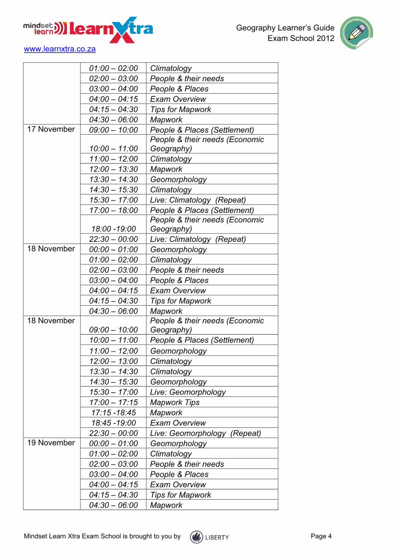
DATE TIMES TOPICS 13 November 09:00 – 10:00 Geomorphology
10:00 – 11:00 Climatology 11:00 – 12:00 People & Places (Settlement) 12:00 – 13:30 Mapwork
18:00 – 19:00 People & their needs (Economic Geography)
14 November 09:00 – 10:00 Climatology 10:00 – 11:00 Geomorphology
11:00 – 12:00 People & their needs (Economic Geography)
12:00 – 13:30 Mapwork 13:30 – 14:30 People & Places (Settlement)
14:30 – 15:30 People & their needs (Economic Geography)
15:30 – 17:00 Live: People, Places & their needs (Repeat)
17:00 – 18:00 Geomorphology 18:00 -19:00 Climatology
22:30 – 00:00 Live: People, Places & their needs (Repeat)
15 November 00:00 – 01:00 Geomorphology
Geography Learner’s Guide Exam School 2012 www.learnxtra.co.za
Mindset Learn Xtra Exam School is brought to you by Page 4
01:00 – 02:00 Climatology 02:00 – 03:00 People & their needs 03:00 – 04:00 People & Places 04:00 – 04:15 Exam Overview 04:15 – 04:30 Tips for Mapwork 04:30 – 06:00 Mapwork
17 November 09:00 – 10:00 People & Places (Settlement)
10:00 – 11:00 People & their needs (Economic Geography)
11:00 – 12:00 Climatology 12:00 – 13:30 Mapwork 13:30 – 14:30 Geomorphology 14:30 – 15:30 Climatology 15:30 – 17:00 Live: Climatology (Repeat) 17:00 – 18:00 People & Places (Settlement)
18:00 -19:00 People & their needs (Economic Geography)
22:30 – 00:00 Live: Climatology (Repeat) 18 November 00:00 – 01:00 Geomorphology
01:00 – 02:00 Climatology 02:00 – 03:00 People & their needs 03:00 – 04:00 People & Places 04:00 – 04:15 Exam Overview 04:15 – 04:30 Tips for Mapwork 04:30 – 06:00 Mapwork
18 November 09:00 – 10:00
People & their needs (Economic Geography)
10:00 – 11:00 People & Places (Settlement) 11:00 – 12:00 Geomorphology 12:00 – 13:00 Climatology 13:30 – 14:30 Climatology 14:30 – 15:30 Geomorphology 15:30 – 17:00 Live: Geomorphology 17:00 – 17:15 Mapwork Tips 17:15 -18:45 Mapwork 18:45 -19:00 Exam Overview 22:30 – 00:00 Live: Geomorphology (Repeat)
19 November 00:00 – 01:00 Geomorphology 01:00 – 02:00 Climatology 02:00 – 03:00 People & their needs 03:00 – 04:00 People & Places 04:00 – 04:15 Exam Overview 04:15 – 04:30 Tips for Mapwork 04:30 – 06:00 Mapwork
Geography Learner’s Guide Exam School 2012 www.learnxtra.co.za
Mindset Learn Xtra Exam School is brought to you by Page 5
PREPARING FOR EXAMINATIONS
1. Prepare well in advance for all your papers and subjects. You need to start your planning for success in the final examination now. You cannot guarantee success if you only study the night before an exam.
2. Write down the date of your prelim and final exam so that you can plan and structure a study time table for all your subjects.
3. Set up a study time-table according to your prelim and final Grade 12 exam time-table and stick to your study schedule. If you study a small section every day, you will feel you have achieved something and you will not be as nervous by the time you have to go and write your first paper.
4. Your study programme should be realistic. You need to spend no more than 2 hours per day on one topic. Do not try to fit too much into one session. When you cover small sections of work often, you will master them more quickly. The broadcast schedule may help you to make sure you have covered all the topics that are in the exam.
5. When studying don’t just read through your notes or textbook. You need to be active by making summary checklists or mind maps. Highlight the important facts that you need to memorise. You may need to write out definitions and formulae a few times to make sure you can remember these. Check yourself as often as you can. You may find it useful to say the definitions out aloud.
6. Practise questions from previous examination papers. Follow these steps for using previous exam papers effectively:
● Take careful note of all instructions - these do not usually change. ● Try to answer the questions without looking at your notes or the solutions. ● Time yourself. You need to make sure that you complete a question in time. To work
out the time you have, multiply the marks for a question by total time and then divide by the total number of marks. In most exams you need to work at a rate of about 1 mark per minute.
● Check your working against the memo. If you don’t understand the answer given, contact the Learn Xtra Help desk (email: [email protected]).
● If you did not get the question right, try it again after a few days.
7. Preparing for, and writing examinations is stressful. You need to try and stay healthy by making sure you maintain a healthy lifestyle. Here are some guidelines to follow:
● Eat regular small meals including breakfast. Include fruit, fresh vegetables, salad and protein in your diet.
● Drink lots of water while studying to prevent dehydration. ● Plan to exercise regularly. Do not sit for more than two hours without stretching or
talking a short walk. ● Make sure you develop good sleeping habits. Do not try to work through the night
before an exam. Plan to get at least 6 hours sleep every night.

Geography Learner’s Guide Exam School 2012 www.learnxtra.co.za
Mindset Learn Xtra Exam School is brought to you by Page 6
EXAM TECHNIQUES
1. Make sure you have the correct equipment required for each subject. You need to have at least one spare pen and pencil. It is also a good idea to put new batteries in your calculator before you start your prelims or have a spare battery in your stationery bag.
2. Make sure you get to the exam venue early - don’t be late.
3. While waiting to go into the exam venue, don’t try to cram or do last minute revision. Try not to discuss the exam with your friends. This may just make you more nervous or confused.
4. Here are some tips as to what to do when you receive your question papers: Don’t panic, because you have prepared well.
● You are always given reading time before you start writing. Use this time to take note of the instructions and to plan how you will answer the questions. You can answer questions in any order.
● Time management is crucial. You have to make sure that you answer all questions. Make notes on your question paper to plan the order for answering questions and the time you have allocated to each one.
● It is a good idea always to underline the key words of a question to make sure you answer it correctly.
● Make sure you look any diagrams and graph carefully when reading the question. Make sure you check the special answer sheet too.
● When you start answering your paper, it is important to read every question twice to make sure you understand what to do. Many marks are lost because learners misunderstand questions and then answer incorrectly.
● Look at the mark allocation to guide you in answering the question. ● When you start writing make sure you number your answers exactly as they are in the
questions. ● Make sure you use the special answer sheet to answer selected questions. ● Think carefully before you start writing. It is better to write an answer once and do it
correctly than to waste time rewriting answers. ● DO NOT use correction fluid (Tippex) because you may forget to write in the correct
answer while you are waiting for the fluid to dry. Rather scratch out a wrong answer lightly with pencil or pen and rewrite the correct answer.
● Check your work. There is usually enough time to finish exam papers and it helps to look over your answers. You might just pick up a calculation error.

Geography Learner’s Guide Exam School 2012 www.learnxtra.co.za
Mindset Learn Xtra Exam School is brought to you by Page 7
EXAM OVERVIEW
PAPER 1 (THEORY) 3HRS 300 MARKS There are two Sections each with two questions Section A Climate & Weather (Climateology) Fluvial processes (Geomorphology) Structural Landforms Section B People and places (Rural and urban settlements) People and their needs ( Economic Geography) There are four questions, two in each section. Each question is worth 100 marks shared equally between the topics. You must answer only three questions Diagrams are provided in a separate booklet PAPER 2 MAPWORK 1½ HOURS 100 MARKS You will be provided with a Topographical Map and an Orthophoto of a region on the map. There are four questions in this paper You must answer in the answer book provided. Multiple Choice questions 20 Marks Geographical Techniques and Calculations 20 Marks Application of Theory 40 Marks Geographical Information Systems (GIS) 20 Marks

Geography Learner’s Guide Exam School 2012 www.learnxtra.co.za
Mindset Learn Xtra Exam School is brought to you by Page 8
GEOMORPHOLOGY
Question 1: (Adapted from Nov 2011, P1, Question 1.2) Refer to FIGURE 1 showing the different profiles and views of a river and answer the questions that follow. Figure 1
1.1 SKETCH 1 shows a (longitudinal profile/plan view) of a river. (1 x 2) (2) 1.2 SKETCH 2 shows a (longitudinal profile/cross profile) of a river. (1 x 2) (2) 1.3 Match the demarcations in SKETCH 1 with the profiles (X, Y, Z) in SKETCH 2:
(a) A–B (1 x 2) (2) (b) C–D (1 x 2) (2) (c) E–F (1 x 2) (2)

Geography Learner’s Guide Exam School 2012 www.learnxtra.co.za
Mindset Learn Xtra Exam School is brought to you by Page 9
Question 2: (Adapted from Nov 2011, P1, Question 1.5) The impact of urbanisation on a flow hydrograph is illustrated in FIGURE 2. Figure 2:
2.1 Explain the concept flood peak/peak flow. (1 x 2) (2) 2.2 How much was the peak flow before urbanisation? (1 x 2) (2) 2.3 Describe TWO changes in the peak flow evident in the flow
hydrograph after urbanisation. (2 x 2) (4) 2.4 What role do trees play in controlling the water in river channels? (1 x 2) (2) 2.5 Name TWO negative effects that the removal of trees has on the environment.
(2 x 2) (4) 2.6 The increase in urbanisation in South Africa requires effective river management.
Write a single paragraph (approximately 12 lines) suggesting possible measures to reduce the negative effect of urbanisation on rivers. (6 x 2) (12)

Geography Learner’s Guide Exam School 2012 www.learnxtra.co.za
Mindset Learn Xtra Exam School is brought to you by Page 10
Question 3: (Adapted from Nov 2011, P1, Question 1.6) Refer to FIGURE 3 based on structural landforms. Landform B is a cuesta. Figure 3:
3.1 Identify slope C. (1 x 2) (2) 3.2 Provide evidence from the diagram for your answer to QUESTION 3.1. (1 x 2) (2) 3.3 Suggest TWO ways in which ridges, such as cuestas, are significant to humans.
(2 x 2) (4) 3.4 With reference to slope elements, answer the following questions:
(a) Identify slope element A. (1 x 2) (2) (b) Name TWO characteristics of slope element A. (2 x 2) (4)
Question 4: (Adapted from Nov 2011, P1, Question 2.6) FIGURE 4 is a photograph of a tor. Figure 4:
4.1 From what type of rock do tors originate? (1 x 2) (2) 4.2 Briefly describe what a tor looks like. (1 x 2) (2) 4.3 Describe the development of a tor. (3 x 2) (6)
Geography Learner’s Guide Exam School 2012 www.learnxtra.co.za
Mindset Learn Xtra Exam School is brought to you by Page 11
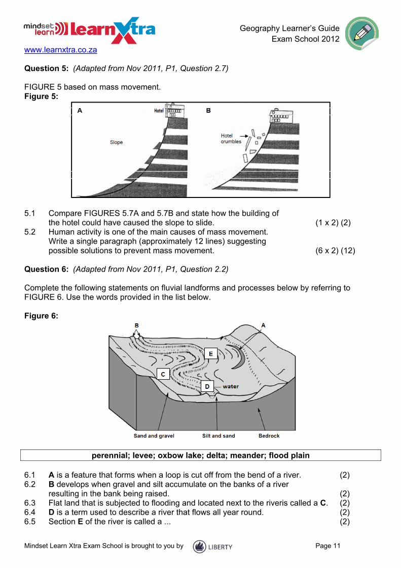
Question 5: (Adapted from Nov 2011, P1, Question 2.7) FIGURE 5 based on mass movement. Figure 5:
5.1 Compare FIGURES 5.7A and 5.7B and state how the building of
the hotel could have caused the slope to slide. (1 x 2) (2) 5.2 Human activity is one of the main causes of mass movement.
Write a single paragraph (approximately 12 lines) suggesting possible solutions to prevent mass movement. (6 x 2) (12)
Question 6: (Adapted from Nov 2011, P1, Question 2.2) Complete the following statements on fluvial landforms and processes below by referring to FIGURE 6. Use the words provided in the list below. Figure 6:
perennial; levee; oxbow lake; delta; meander; flood plain 6.1 A is a feature that forms when a loop is cut off from the bend of a river. (2) 6.2 B develops when gravel and silt accumulate on the banks of a river
resulting in the bank being raised. (2) 6.3 Flat land that is subjected to flooding and located next to the riveris called a C. (2) 6.4 D is a term used to describe a river that flows all year round. (2) 6.5 Section E of the river is called a ... (2)

Geography Learner’s Guide Exam School 2012 www.learnxtra.co.za
Mindset Learn Xtra Exam School is brought to you by Page 12
Question 7: (Adapted from Nov 2011, P1, Question 2.5) Refer to FIGURE 7 illustrating a drainage basin. Figure 7:
7.1 Define the term drainage basin. (1 x 2) (2) 7.2 Identify the drainage pattern labelled A. (1 x 2) (2) 7.3 Describe the resistance of the underlying rock structure that is
likely to be found on this landscape. (1 x 2) (2) 7.4 Describe the route that the water (precipitation) must follow to be
classified as throughflow. (1 x 2) (2) 7.5 State, with a reason, which of the following water movements,
surface run-off or groundwater flow, will take the shortest time to reach the river. (2 x 2) (4)
7.6 Assess the impact that the removal of vegetation at the source of the river will have on the following: (a) Infiltration rate (1 x 2) (2) (b) Stream discharge (Output) (1 x 2) (2)

Geography Learner’s Guide Exam School 2012 www.learnxtra.co.za
Mindset Learn Xtra Exam School is brought to you by Page 13
CLIMATOLOGY
Question 1: (Adapted from Nov 2011, P1, Question 1.1) Refer to FIGURE 1 which shows the tri-cellular model. Select a label from the sketch that best suits the statements below. Figure 1
1.1 The zone of convergence for the meeting of a warm and cold air mass. (2) 1.2 This cell is the weakest of the three cells. (2) 1.3 The formation of this cell is due to high surface temperatures. (2) 1.4 The name of the global pressure belt that results from descending
cold air at the 30° latitude. (2) 1.5 This pressure belt is associated with thunderstorms due to the
convergence of warm winds. (2)

Geography Learner’s Guide Exam School 2012 www.learnxtra.co.za
Mindset Learn Xtra Exam School is brought to you by Page 14
Question 2: (Adapted from Nov 2011, P1, Question 2.1) Refer to FIGURE 2 which shows air movement in a valley. Choose the correct word(s) from those given in brackets. Figure 2:
2.1 The valley wind labelled A is a/an (katabatic/anabatic) wind. (2) 2.2 This wind occurs during the (day/night) in valleys. (2) 2.3 It is also referred to as a/an (upslope/downslope) wind. (2) 2.4 The zone labelled B is the (thermal belt/frost pocket). (2) 2.5 The form of precipitation experienced at C is (frost/snow). (2) Question 3: (Adapted from Nov 2011, P1, Question 1.3) Refer to FIGURE 3 which captures the path and effect of tropical cyclone Yasi. Figure 3

Geography Learner’s Guide Exam School 2012 www.learnxtra.co.za
Mindset Learn Xtra Exam School is brought to you by Page 15
CYCLONE YASI STRIKES AUSTRALIA Category-five cyclone tears roofs, pubs and houses, topples trees and sends power cables crashing on to roads. The residents of Australia are assessing the damage after cyclone Yasi, the largest tropical storm to strike Australia since Europeans first settled there, created winds of 280 km/h and waves more than 9 m high. Thousands of the 400 000 people living in the path of the 500 km wide cyclone spent a sleepless night in hot and crowded emergency evacuation centres set up in primary schools and shopping centres deemed strong enough to withstand the cyclone and avoid storm surges up to 8 m high. On Mission Beach power cables crashed on to the roads and mature trees and palms were toppled by surging winds but local residents also reported an unusual half-hour in the eye of the storm. 'It's the strangest thing to go outside and see the stars and there is no wind for half an hour.' 3.1 On what date did cyclone Yasi strike the coast of Australia? (1 x 2) (2) 3.2 Name TWO conditions that would have favoured the development of Yasi. (2 x 2) (4) 3.3 What evidence from FIGURE 1.3 suggests that cyclones
are common in Australia? (1 x 2) (2) 3.4 Explain what you understand by a category-five cyclone. (2 x 2) (4) 3.5 Refer to the statement 'local residents reported an unusual half-hour
in the eye of the storm'. (a) Why do they describe the weather conditions in the eye as unusual? (2 x 2) (4) (b) Explain what causes the unusual conditions in the eye. (1 x 2) (2)
3.6 What is the local name for tropical cyclones in Australia? (1 x 2) (2) 3.7 Why do you think Australia would have an efficient emergency
programme ready to handle natural hazards? (1 x 2) (2)

Geography Learner’s Guide Exam School 2012 www.learnxtra.co.za
Mindset Learn Xtra Exam School is brought to you by Page 16
Question 4: (Adapted from Nov 2011, P1, Question 2.3) Study the synoptic weather map in FIGURE 4 and answer the questions below. Figure 4:
4.1 Name the anticyclone labelled B. (1 x 2) (2) 4.2 Give a reason why pressure systems B and C are known as anticyclones. (1 x 2) (2) 4.3 A group of students must go on a field trip to Durban on the day
presented by this synoptic weather map. What temperature will they experience on the day of their field trip? (1 x 2) (2)
4.4 Briefly describe how the front labelled D is formed. (2 x 2) (4) 4.5 Name the weather system labelled A. (1 x 2) (2) 4.6 In which general direction does the weather system A move? (1 x 2) (2) 4.7 Is weather system A likely to influence the weather conditions of
Cape Town within the next 24 hours? Explain your answer. (2 x 2) (4) 4.8 Of what importance are weather systems such as A to farming in the
Western Cape area in winter? (1 x 2) (2)

Geography Learner’s Guide Exam School 2012 www.learnxtra.co.za
Mindset Learn Xtra Exam School is brought to you by Page 17
Question 5: (Adapted from Nov 2011, P1, Question 1.4) FIGURE 5 is a cartoon that highlights issues of climate change and its effects. Figure 5:
5.1 What do you understand by the term climate change? (1 x 2) (2) 5.2 Explain how it is possible for flooding to be linked to petrol use. (2 x 2) (4) 5.3 Sustainable measures need to be taken to address the challenges
associated with flooding. Write a single paragraph (approximately 12 lines) discussing possible solutions that local municipalities can employ to reduce the effects of flooding. (6 x 2) (12)

Geography Learner’s Guide Exam School 2012 www.learnxtra.co.za
Mindset Learn Xtra Exam School is brought to you by Page 18
PEOPLE AND PLACES (SETTLEMENT)
CHECK LIST Make sure you can:
Explain how settlements are classified Discuss the complexity, size and function of settlements Compare and discuss the functions of rural and urban settlements Discuss the tensions between rural and urban settlements and strategies implemented
to deal with these
STUDY NOTES Settlement : is a place where a group of people live together and function together as a group.
Settlements can be classified as urban or rural according to their size and the kinds of activities that take place there.
Rural settlements are usually quite small; most people living there are involved in primary activities such as farming, fishing, forestry or mining. Rural settlements are, therefore, unifunction (one function) and have primary activities. It is important to know the difference between SITE and SITUATION of a settlement. SITE: actual piece of land settled on – the physical characteristics of the piece of land. Factors influencing the choice of site:
Availability of water Arable land Grazing land Building materials level ground
SITUATION: The position of the settlement in relation to the surrounding environment. Here we consider:
Transport routes The general relief (e.g. valley, mountain etc.) Aspect Soil fertility
When the site, situation, customs and traditions are combined, we find that some areas tend to be nucleated while other areas are dispersed.
Geography Learner’s Guide Exam School 2012 www.learnxtra.co.za
Mindset Learn Xtra Exam School is brought to you by Page 19
Comparison of dispersed and nucleated settlements Dispersed Nucleated Water Freely available In short supply Relief Flat ground Steeper ground Soil Unfertile Fertile Tradition Nguni settlement Tswana village Defence Peace time War and violence Climate Mild Extreme climates
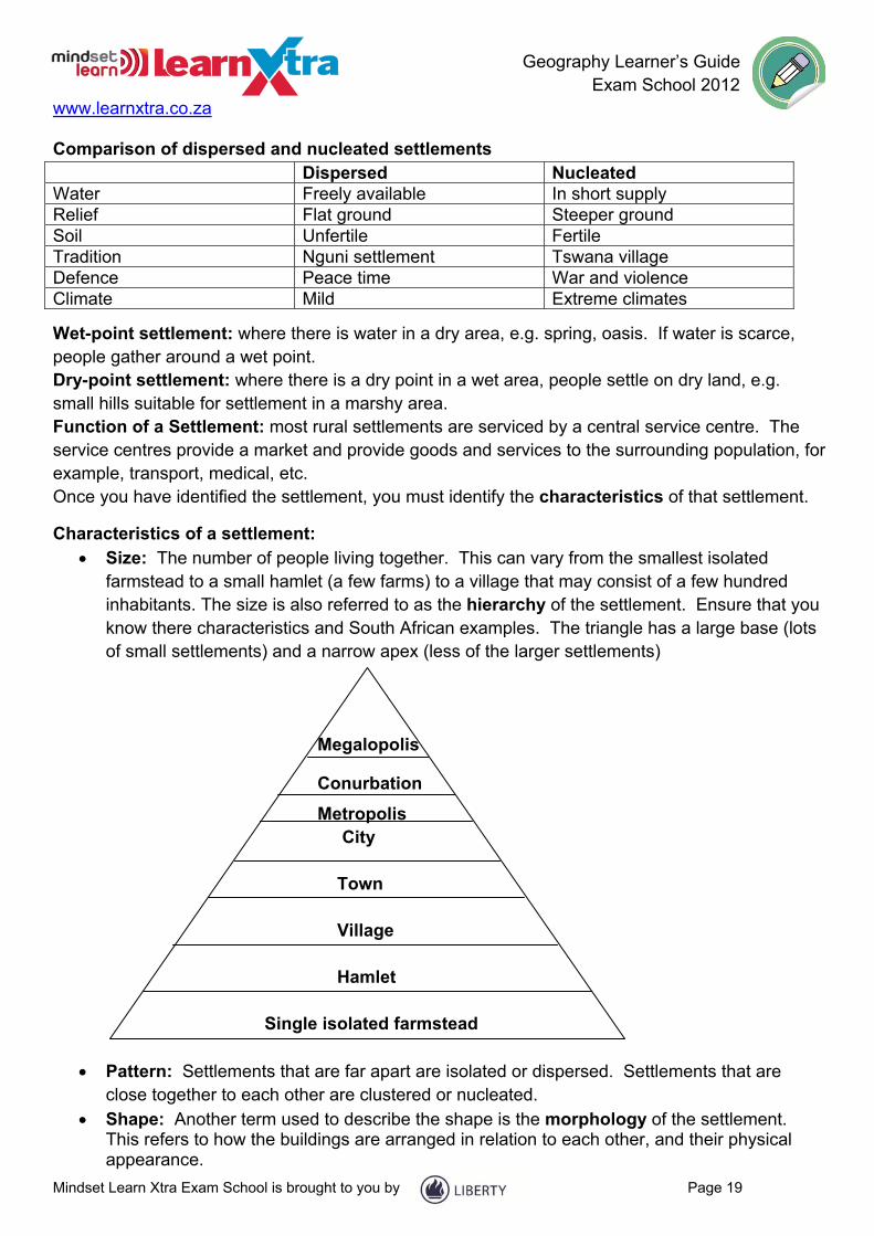
Wet-point settlement: where there is water in a dry area, e.g. spring, oasis. If water is scarce, people gather around a wet point. Dry-point settlement: where there is a dry point in a wet area, people settle on dry land, e.g. small hills suitable for settlement in a marshy area. Function of a Settlement: most rural settlements are serviced by a central service centre. The service centres provide a market and provide goods and services to the surrounding population, for example, transport, medical, etc. Once you have identified the settlement, you must identify the characteristics of that settlement.
Characteristics of a settlement: Size: The number of people living together. This can vary from the smallest isolated
farmstead to a small hamlet (a few farms) to a village that may consist of a few hundred inhabitants. The size is also referred to as the hierarchy of the settlement. Ensure that you know there characteristics and South African examples. The triangle has a large base (lots of small settlements) and a narrow apex (less of the larger settlements)
Megalopolis
Conurbation
Metropolis City Town Village Hamlet Single isolated farmstead
Pattern: Settlements that are far apart are isolated or dispersed. Settlements that are close together to each other are clustered or nucleated.
Shape: Another term used to describe the shape is the morphology of the settlement. This refers to how the buildings are arranged in relation to each other, and their physical appearance.
Geography Learner’s Guide Exam School 2012 www.learnxtra.co.za
Mindset Learn Xtra Exam School is brought to you by Page 20
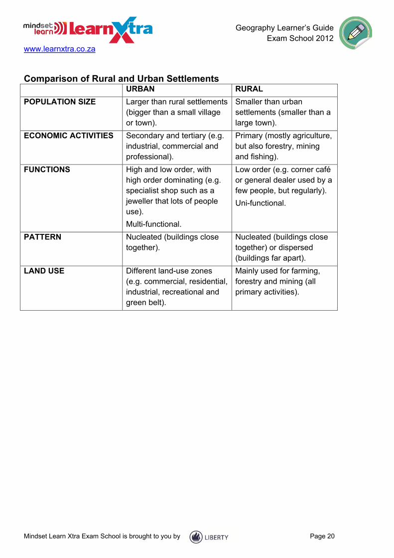
Comparison of Rural and Urban Settlements URBAN RURAL
POPULATION SIZE Larger than rural settlements (bigger than a small village or town).
Smaller than urban settlements (smaller than a large town).
ECONOMIC ACTIVITIES Secondary and tertiary (e.g. industrial, commercial and professional).
Primary (mostly agriculture, but also forestry, mining and fishing).
FUNCTIONS High and low order, with high order dominating (e.g. specialist shop such as a jeweller that lots of people use).
Multi-functional.
Low order (e.g. corner café or general dealer used by a few people, but regularly).
Uni-functional.
PATTERN Nucleated (buildings close together).
Nucleated (buildings close together) or dispersed (buildings far apart).
LAND USE Different land-use zones (e.g. commercial, residential, industrial, recreational and green belt).
Mainly used for farming, forestry and mining (all primary activities).

Geography Learner’s Guide Exam School 2012 www.learnxtra.co.za
Mindset Learn Xtra Exam School is brought to you by Page 21
Rural Development Strategies
primary HIV/AIDS education (awareness environmental sustainability education stereotyping, abstinence) (ecological conservation, sustainable eco-tourism levels of STRATEGIES TO PROMOTE employment AND INCREASE ‘
community-based development communication at grassroots level access to basic needs economic growth services high death rates (low life extreme expectancy, infant mortality) poverty STRATEGIES TO REDUCE High birth infectious diseases (HIV/ rates Aids, cholera, TB etc. Examples of International, regional and local strategies Strategy or programme Date Aims International Agenda 21 1992 Global plan of action to achieve sustainable
development through international consensus on environment and development issues (including poverty, sustainable agriculture, desertification, land degradation
Southern Africa (regional0 New Partnership of Africa’s Development (NEPAD)
2002 Framework for economic growth and sustainable development in Africa and a pledge to eradicate poverty and put Africa on a path of sustainable development
South Africa (regional, local) Integrated Sustainable Rural Development Programme
2001 Programme to improvement governance at local level and eradicate poverty through cross-sectional priority projects

Geography Learner’s Guide Exam School 2012 www.learnxtra.co.za
Mindset Learn Xtra Exam School is brought to you by Page 22
QUESTIONS: PEOPLE AND PLACES (SETTLEMENT)
Question 1: (Adapted from Nov 2011, Paper 1, Question 3.1) Study the figure below, which illustrates a number of settlements.
Adapted from Geography Foundation Tier 2009
Match the letters (A–E) on the FIGURE to the type of settlement listed below. 1.1 Linear 1.2 Dry-point site 1.3 Break-off-bulk point 1.4 Specialised town 1.5 Defensive site (10)
Geography Learner’s Guide Exam School 2012 www.learnxtra.co.za
Mindset Learn Xtra Exam School is brought to you by Page 23
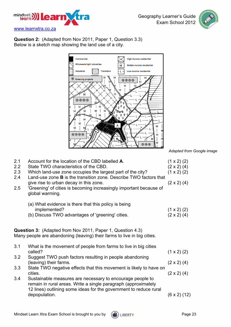
Question 2: (Adapted from Nov 2011, Paper 1, Question 3.3) Below is a sketch map showing the land use of a city.
Adapted from Google image
2.1 Account for the location of the CBD labelled A. (1 x 2) (2) 2.2 State TWO characteristics of the CBD. (2 x 2) (4) 2.3 Which land-use zone occupies the largest part of the city? (1 x 2) (2) 2.4 Land-use zone B is the transition zone. Describe TWO factors that
give rise to urban decay in this zone. (2 x 2) (4) 2.5 'Greening' of cities is becoming increasingly important because of
global warming.
(a) What evidence is there that this policy is being implemented? (1 x 2) (2)
(b) Discuss TWO advantages of 'greening' cities. (2 x 2) (4)
Question 3: (Adapted from Nov 2011, Paper 1, Question 4.3) Many people are abandoning (leaving) their farms to live in big cities. 3.1 What is the movement of people from farms to live in big cities
called? (1 x 2) (2) 3.2 Suggest TWO push factors resulting in people abandoning
(leaving) their farms. (2 x 2) (4) 3.3 State TWO negative effects that this movement is likely to have on
cities. (2 x 2) (4) 3.4 Sustainable measures are necessary to encourage people to
remain in rural areas. Write a single paragraph (approximately 12 lines) outlining some ideas for the government to reduce rural depopulation. (6 x 2) (12)
Geography Learner’s Guide Exam School 2012 www.learnxtra.co.za
Mindset Learn Xtra Exam School is brought to you by Page 24
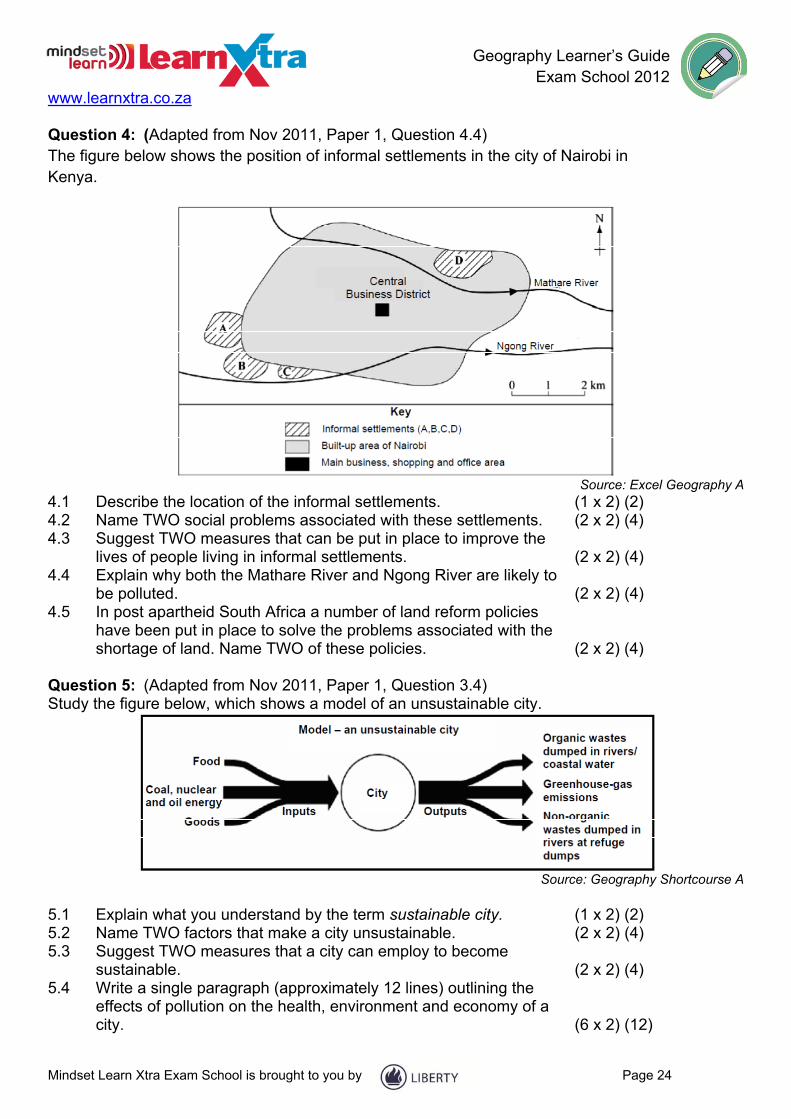
Question 4: (Adapted from Nov 2011, Paper 1, Question 4.4) The figure below shows the position of informal settlements in the city of Nairobi in Kenya.
Source: Excel Geography A
4.1 Describe the location of the informal settlements. (1 x 2) (2) 4.2 Name TWO social problems associated with these settlements. (2 x 2) (4) 4.3 Suggest TWO measures that can be put in place to improve the
lives of people living in informal settlements. (2 x 2) (4) 4.4 Explain why both the Mathare River and Ngong River are likely to
be polluted. (2 x 2) (4) 4.5 In post apartheid South Africa a number of land reform policies
have been put in place to solve the problems associated with the shortage of land. Name TWO of these policies. (2 x 2) (4)
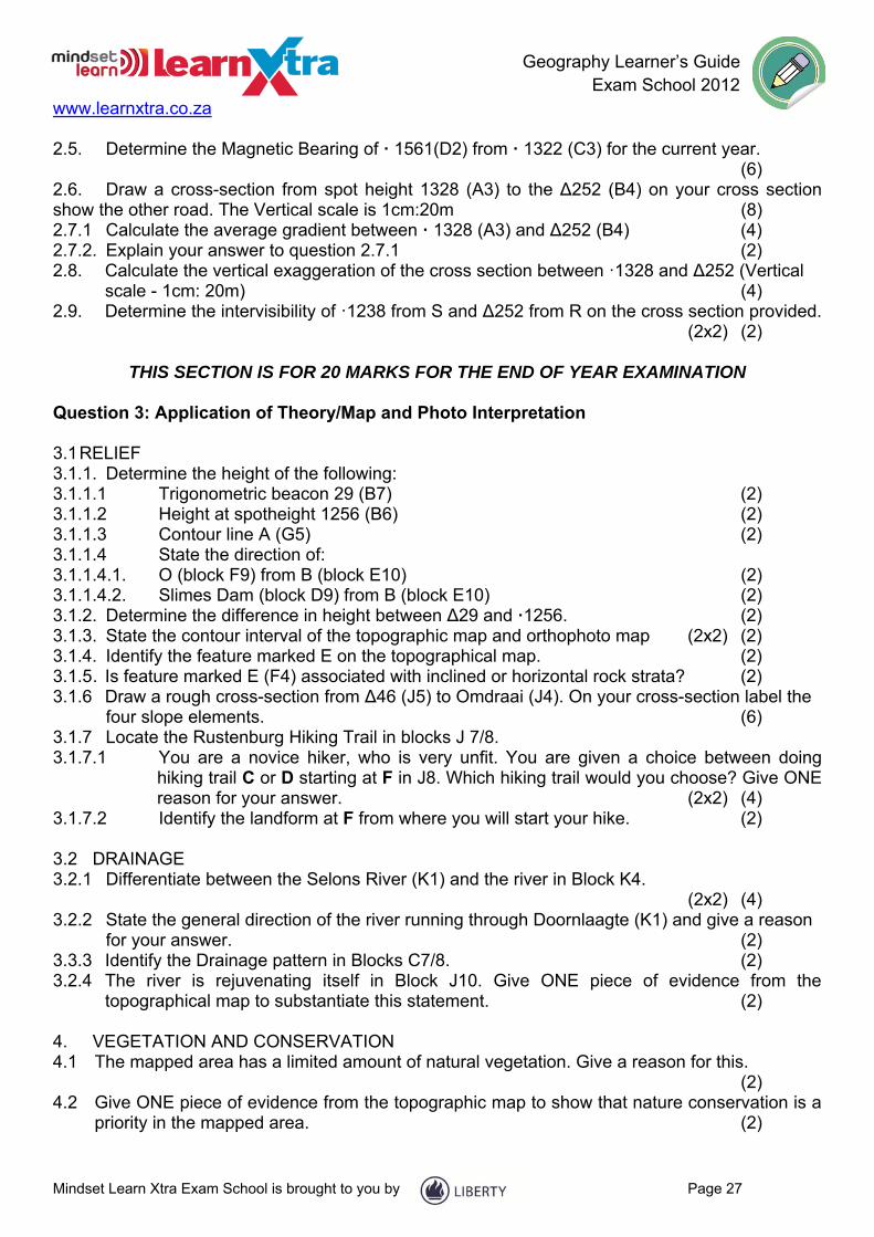
Question 5: (Adapted from Nov 2011, Paper 1, Question 3.4) Study the figure below, which shows a model of an unsustainable city.
Source: Geography Shortcourse A
5.1 Explain what you understand by the term sustainable city. (1 x 2) (2) 5.2 Name TWO factors that make a city unsustainable. (2 x 2) (4) 5.3 Suggest TWO measures that a city can employ to become
sustainable. (2 x 2) (4) 5.4 Write a single paragraph (approximately 12 lines) outlining the
effects of pollution on the health, environment and economy of a city. (6 x 2) (12)

Geography Learner’s Guide Exam School 2012 www.learnxtra.co.za
Mindset Learn Xtra Exam School is brought to you by Page 25
MAPWORK
Question 1: Multiple-Choice Questions Refer to the 1:50 000 topographical map 2527CA RUSTENBURG and the orthophoto map of the same area to answer the following questions. Various options are provided as answers for the following statements. Choose the answer and write only the letter (A - D) next to the questions number (1.1 – 1.10) in the block nest to each statement. 1.1 The scale of the orthophoto map is…
A 5 times smaller than the scale of the topographical map. B is equal to the scale of the topographical map. C 10 times smaller than the the scale of the topographical map. D 5 times larger than the topographical map.
1.2 The orthophoto map is obtained from a ...
A horizontal photograph. B low oblique photograph. C high oblique photograph. D vertical photograph.
1.3 The topographic map is drawn on a calculated grid of latitudinal and longitudinal lines. This
projection is referred to as the _______ projection. A mercator B lambert C transverse D gauss conform
1.4 Spot heights, bench-marks, trigonometrical stations and contour lines represent ______ on
the topographical map. A lines joining places of equal height. B altitude (height) above sea level. C the height of features such as mesas. D the gradient of the area.
1.5The map reference/code of the topographical map directly west of 2527CA
is ___________ A 2527DA B 2526DB C 2525CC D 2525CD
1.6 The feature marked 1 on the orthophoto map is a/an …
A sports field. B dam.

Geography Learner’s Guide Exam School 2012 www.learnxtra.co.za
Mindset Learn Xtra Exam School is brought to you by Page 26
C reservoir. D excavation.
1.7 Identify the street pattern found around 6 on the 0rthophoto map.
A gridiron B planned irregular C radial D unplanned irregular
1.8 The slope element marked A in block G5 on the topographical map is
the _________ slope. A scarp/cliff B crest/waxing C pediment D talus/debris/scree
1.9 The main primary economic activities taking place at B (block E10) on the topographical
map is _________ A forestry and crop farming. B forestry and mining. C mining and crop farming. D mining and livestock farming.
1.10 The major raw material mined around the Rustenburg area is ________
A platinum. B coal. C diamonds. D iron ore.
1.11 The coordinates/ grid reference of spotheight 1146 in block C8 is________
A 25º35.3’S 27º12.4’E B 25º35.3’E 27º12.4’S C 27º35.3’S 25º12.4’E D 27º12.4’S 25º35.3’E
THIS SECTION IS MADE UP OF TEN QUESTIONS (2 MARKS EACH = 20 MARKS) FOR THE
END OF YEAR EXAMINATION Question 2: Geographical Techniques and Calculations 2.1 Calculate the straight line distance between ∆37 (D3) and 1232 (D5), in Km. (2) 2.2. Calculate the curve / winding distance from G (F2) to H (E4), in metres. (3) 2.3. Determine the area of Block K7, in Km. (4) 2.4. How long will it take a car travelling at 50km per hour to drive from H (E4) to the N4 sign (E-
F 7) along the National Route? (4)
Geography Learner’s Guide Exam School 2012 www.learnxtra.co.za
Mindset Learn Xtra Exam School is brought to you by Page 27
2.5. Determine the Magnetic Bearing of · 1561(D2) from · 1322 (C3) for the current year. (6)
2.6. Draw a cross-section from spot height 1328 (A3) to the ∆252 (B4) on your cross section show the other road. The Vertical scale is 1cm:20m (8) 2.7.1 Calculate the average gradient between · 1328 (A3) and ∆252 (B4) (4) 2.7.2. Explain your answer to question 2.7.1 (2) 2.8. Calculate the vertical exaggeration of the cross section between ·1328 and ∆252 (Vertical
scale - 1cm: 20m) (4) 2.9. Determine the intervisibility of ·1238 from S and ∆252 from R on the cross section provided.
(2x2) (2)
THIS SECTION IS FOR 20 MARKS FOR THE END OF YEAR EXAMINATION Question 3: Application of Theory/Map and Photo Interpretation 3.1 RELIEF 3.1.1. Determine the height of the following: 3.1.1.1 Trigonometric beacon 29 (B7) (2) 3.1.1.2 Height at spotheight 1256 (B6) (2) 3.1.1.3 Contour line A (G5) (2) 3.1.1.4 State the direction of: 3.1.1.4.1. O (block F9) from B (block E10) (2) 3.1.1.4.2. Slimes Dam (block D9) from B (block E10) (2) 3.1.2. Determine the difference in height between ∆29 and ·1256. (2) 3.1.3. State the contour interval of the topographic map and orthophoto map (2x2) (2) 3.1.4. Identify the feature marked E on the topographical map. (2) 3.1.5 . Is feature marked E (F4) associated with inclined or horizontal rock strata? (2) 3.1.6 Draw a rough cross-section from ∆46 (J5) to Omdraai (J4). On your cross-section label the
four slope elements. (6) 3.1.7 Locate the Rustenburg Hiking Trail in blocks J 7/8. 3.1.7.1 You are a novice hiker, who is very unfit. You are given a choice between doing
hiking trail C or D starting at F in J8. Which hiking trail would you choose? Give ONE reason for your answer. (2x2) (4)
3.1.7.2 Identify the landform at F from where you will start your hike. (2) 3.2 DRAINAGE 3.2.1 Differentiate between the Selons River (K1) and the river in Block K4. (2x2) (4) 3.2.2 State the general direction of the river running through Doornlaagte (K1) and give a reason
for your answer. (2) 3.3.3 Identify the Drainage pattern in Blocks C7/8. (2) 3.2.4 The river is rejuvenating itself in Block J10. Give ONE piece of evidence from the
topographical map to substantiate this statement. (2) 4. VEGETATION AND CONSERVATION 4.1 The mapped area has a limited amount of natural vegetation. Give a reason for this.
(2) 4.2 Give ONE piece of evidence from the topographic map to show that nature conservation is a
priority in the mapped area. (2)

Geography Learner’s Guide Exam School 2012 www.learnxtra.co.za
Mindset Learn Xtra Exam School is brought to you by Page 28
5.INFRASTRUCTURE 5.1 Identify the street pattern at N (A5) and I (G9). (2x2) (4) 5.2 What do the street patterns tell us about the age of areas N and I (2x2) (4) 5.3 Name the main form of transport that links Rustenburg West to the other towns and state the
main purpose of this form of transport. (2x2) (4) 6. LANDUSE AND SETTLEMENT 6.1 Locate the area marked 3 on the orthophoto map 6.2 This area low income residential area. Give ONE piece of evidence from the orthophoto map
to support this statement. (2) 6.3 The local government in charge of area marked 3 is posed with many challenges pertaining
to service delivery. Mention TWO possible challenges that they could face. (2x2) (4) 6.4 Refer to group of farms in E5 and the farm Omdraai in J4. 6.4.1 Compare the group of farms in E5 and Omdraai in J4 in terms of the settlement pattern that
they assumed. (2x2) (4) 6.4.2 Give TWO pieces of evidence found on the topographical map to suggest that commercial
farming is taking place in E5. (2x2) (4) 6.5 There are no rivers flowing through E5. Give ONE measure that farmers have introduced to
obtain water in his area. (2) 6.6 Environmentalists criticize mining companies because of the damage that is caused by shaft
mining. Suggest ONE way in which mines in RUSTENBURG can rehabilitate the environment. (2)
6.7 Area R (F8) is an industrial area. 6.7.1 Is this a heavy or light industry? Give a reason for your answer. (2x2) (2) 6.7.2 Identify the following features on the orthophoto map: 7 9 12 (3x2) (6)
THIS SECTION IS FOR 40 MARKS FOR THE END OF YEAR EXAMINATION Question 4: Geographic Information Systems (GIS) Refer to the map and orthophoto of Rustenburg West and answer the questions that follow:- 4.1 Explain the following concepts: 4.1.1 Buffering (2) 4.1.2 Database (2) 4.2. Mention TWO ways in which the farmers in E5 could put GIS to use. (2x2) (4) 4.3 Spatial analysis is used in various ways in our daily life. Mention ONE way in which spatial
analysis is used in our daily lives. (2)

Geography Learner’s Guide Exam School 2012 www.learnxtra.co.za
Mindset Learn Xtra Exam School is brought to you by Page 29
4.4 Study the diagram below showing thematic layering and answer the questions that follow.
4.4.1 Explain the meaning of the term thematic layering. (2) 4.4.2 Explain TWO uses of data layering in a GIS. (2x2) (4) 4.5 A person is considering building a holiday resort in block J4. Name any TWO layers of
information, found on the topographic map, that he would consider. (2x2) (4)
THIS SECTION IS FOR 20 MARKS FOR THE END OF YEAR EXAMINATION

Geography Learner’s Guide Exam School 2012 www.learnxtra.co.za
Mindset Learn Xtra Exam School is brought to you by Page 30
PEOPLE AND THEIR NEEDS (ECONOMIC GEOGRAPHY)
CHECK LIST Make sure you can:
Explain and discuss economic activities taking place in different regions Describe and explain the role of transport in promoting trade Discuss the advantages and disadvantages of globalisation Explain the importance of water and describe strategies for managing water
STUDY NOTES PEOPLE AND THEIR NEEDS (ECONOMIC GEOGRAPHY) Economic activities
1. Economic activities are all the activities that contribute to the GDP (gross domestic product) of a country.
2. GDP measures the value of goods and services produced in a country in one year. GDP per capita is the GDP divided by the country’s population.
3. South Africa has a mixed economy – a mixture of primary, secondary, tertiary and quaternary activities
Summary of Economic Activities Economic activity
Description Examples
Primary Extracting raw material from the earth Mining, farming, fishing, forestry Secondary Manufacturing finished goods Manufacturing, building,
construction, electricity, water Tertiary Services (which become more
dominant as a country develops) Financial, professional and personal services, retail and wholesale, transport and communications
Quaternary Intellectual activity Government, culture, education, libraries, research, information technology

Geography Learner’s Guide Exam School 2012 www.learnxtra.co.za
Mindset Learn Xtra Exam School is brought to you by Page 31
Mind map of Economic Activities
Eco
nom
ic a
ctiv
ities
Classification of economic activities
Factors influencing economic activities
Defining the concepts
Contribution to GDP
Economic
Physical
Political
Social
Primary
Secondary
Tertiary
Quaternary
Perceptions of decision-making on the location of industries and other economic activities
Historic manufacturing regions
Spatial Development Initiatives (SDIs) Industrial Development Zones (IDZs)
The Pretoria Witwatersrand-Vaal complex (PWV)
Durban-Pinetown-Pietermaritzburg
South-western Cape
Port Elizabeth-Uitenhage

Geography Learner’s Guide Exam School 2012 www.learnxtra.co.za
Mindset Learn Xtra Exam School is brought to you by Page 32
OVERVIEW OF TRANSPORT Transport plays a very important role in international trade. Without container ships, railways and international flights, trade between nations would be severely reduced. 1. Air transport
- Airports Company of South Africa (ACSA) owns and operates 10 airports. - Three international airports: OR Tambo, Cape Town and Durban - OR Tambo is the largest airport and can carry 18 million passengers annually
2. Ports - No navigable rivers, 3 000km coastline - Important for containers cargo, dry docks - Durban: largest and busiest port
- Saldanha: largest natural port
3. Pipelines - Petronet operates a network of 3 000km of pipes - Large volumes of fuel are transported inland to refineries and industrial areas - New pipeline from Mozambique
4. Road transport - Approximately 500 000 km of roads in SA - Four major industrial areas, well connected - Longest network in Africa - 2 200 km – toll roads - Fast link between ports - 80% of all freight carried by road
5. Rail transport - Spoornet focuses on transport by rail - Spoornet has an annual turnover of R9 billion - Developed with discovery of minerals - Sishen-Saldanha: 861 km transports iron ore - Coal transported along Vryheid-Richards Bay line

Geography Learner’s Guide Exam School 2012 www.learnxtra.co.za
Mindset Learn Xtra Exam School is brought to you by Page 33
Concepts of Trade
Trade
When a country sells goods to other countries and buys goods it needs from other countries
Balance of payments A statement or account in which a country’s
transactions with other countries are indicated Imports Exports Goods brought into a country Goods sent out of the country
Balance of trade Payment obligations that arise when a country imports or exports goods
Year Export R-million Imports R-million
Balance R-million Gold Other exports Total
1982 8 641 10 649 19 290 20 079 -789 1983 9 929 10 779 20 708 17 545 +3 163
Positive balance Negative balance of of trade trade Exports exceed imports Imports exceed export (1983) (1982) Trade surplus Trade deficit (more money earned from exports) (more money spent on imports) Exports Imports Exports Imports Favourable balance of trade Unfavourable balance of trade How South Africa rectifies a negative Balance of Trade Increase exports Decrease exports Export more gold

Geography Learner’s Guide Exam School 2012 www.learnxtra.co.za
Mindset Learn Xtra Exam School is brought to you by Page 34
Globalisation and trade Globalisation is the process of growing exchange between countries of the world. It involves international trade and tourism, and the spread of technology and ideas. It is the ‘free’ exchange of capital (money), information, people and ideas across the world. Technological development and the growth of consumerism sped up the process, so now there is a ‘global workforce’ and companies manufacturing ‘global brands’, for example, Coca-Cola, McDonalds and Microsoft. It is made possible by:
Advances in telecommunications Faster, cheaper transport Changes in trade regulations and controls Emerging markets in developing countries (e.g. China)
Characteristics of globalisation include:
An increase in international trade A bigger role for international organisations, such as the World Trade Organisation (WTO) and the International Monetary Fund (IMF) An increase in practices such as outsourcing (the subcontracting of services or manufacture to another company) More travel and tourism More immigration The spread of local consumer goods (e.g. food products) An increase in world-wide sporting events (e.g. FIFA World Cup) The development of global telecommunications infrastructure
It leads to integration: Economic: Multinational organisations Political: NGOs, NEPAD, SADC Cultural: American (western) lifestyle (manners, fashion, practices and English as medium of communication). All this leads to tension between the rich, developed countries of the north and the poor, developing countries in Africa, South America and Asia.

Geography Learner’s Guide Exam School 2012 www.learnxtra.co.za
Mindset Learn Xtra Exam School is brought to you by Page 35
Advantages of globalisation More aid and direct investment to developing countries helps economic development More economic opportunities Cheaper products available to consumers Products are standardised and quality improves Everyone shares in the benefits of technology People gain access to goods and services from all over the
world There is a greater variety of things to buy and experience from all over the
world Benefits can trickle out from investment areas to improve the lives of many.
Foreign investment in a country can help governments raise money for healthcare, education, etc.
Disadvantages of globalisation Greater economic vulnerability between countries – if one country suffers an economic slump, many other countries will too (Thus, lack of responsibility – multinational companies in place of independent governments become responsible for decisions about where to set up factories, where to close them down, which countries to invest in and how they will treat workers. Strong competition between producers Unequal distribution of wealth Gap widens between developed and developing countries International organisations, such as the IMF and WTO apply
Western standards to non-Western countries Vulnerability – the power of multinational companies can leave governments and workers vulnerable The poor – the world’s poorest do not see much benefit from globalisation,
and some people argue it makes their position worse. Cultural loss and ‘sameness’- the presence of global brands and the
sophisticated advertising used to sell them, makes every street start to look the same – people everywhere (if they can) buy the same burgers and want to wear the same few brands of clothing

Geography Learner’s Guide Exam School 2012 www.learnxtra.co.za
Mindset Learn Xtra Exam School is brought to you by Page 36
QUESTIONS: PEOPLE AND THEIR NEEDS (ECONOMIC GEOGRAPHY)
Question 1: (Adapted from Nov 2011, Paper 1, Question 3.6) Refer to the cartoon labelled 'Tied Aid' in the figure below.
Source: GCSE Success Guide
1.1 Would you describe the relationship between the developing and
developed countries in the cartoon as free trade? Explain your answer. (2 x 2) (4)
1.2 Name TWO measures that South Africa has in place to restrict imports into our country. (2 x 2) (4)
1.3 Developing countries seek help when they have an unfavourable balance of trade. What is an unfavourable balance of trade? (1 x 2) (2)
1.4 Name TWO disadvantages of an unfavourable balance of trade. (2 x 2) (4) 1.5 A strong economic sector is key to improving an unfavourable
balance of trade. Discuss the importance of the secondary sector to South Africa's economy. (4 x 2) (8)

Geography Learner’s Guide Exam School 2012 www.learnxtra.co.za
Mindset Learn Xtra Exam School is brought to you by Page 37
Question 2: (Adapted from Nov 2011, Paper 1, Question 3.2) Choose a term from COLUMN B that matches a statement in COLUMN A.
(5 x 2) (10)
Question 3: (Adapted from Nov 2011, Paper 1, Question 3.5)
Read the adapted newspaper article titled 'Exodus of commercial growers a threat to South Africa's food security'. EXODUS OF COMMERCIAL FARMERS A THREAT TO SOUTH AFRICA'S FOOD SECURITY
Agricultural experts are warning that the farming sector in South Africa is in trouble and have appealed to the government to act to prevent commercial farmers from leaving. Currently one dairy farmer is leaving the industry every week because they are not making money. They have become high-cost producers. South Africa as a country is beginning to import more and more. The long-term effect is that food will be more expensive. The poor will suffer as they spend 40–50% of their income on food. At a time when food security is a big issue in the world it is certainly a problem that South Africa's farmers are leaving the country.
[Adapted from Sunday Times (Sipho Masondo)] 3.1 Explain the concept commercial farming. (1 x 2) (2) 3.2 Give ONE reason for South Africa becoming a high-cost producer. (1 x 2) (2) 3.3 State ONE outcome of importing more food into South Africa. (1 x 2) (2) 3.4 All the role players need to take urgent measures to improve food
security in South Africa. Write a paragraph (approximately 12 lines) explaining some measures that can be introduced to improve food
security.

Geography Learner’s Guide Exam School 2012 www.learnxtra.co.za
Mindset Learn Xtra Exam School is brought to you by Page 38
Question 4: (Adapted from Nov 2011, Paper 1, Question 4.6) Read the adapted newspaper article, titled 'Water crisis by 2020', below.
WATER CRISIS BY 2020 South Africa faces a water crisis and could start having shortages as early as 2020, experts told the South African Water and Energy Forum. Mike Muller told delegates that 'a crisis is looming … if we don't panic now and take action we will be in a crisis by 2020'. The shortages will largely be due to water demand outstripping supply and to a lesser extent by poor water quality due to infrastructure deteriorating. Other factors that will contribute include leaking pipes and the theft of water by farmers along the Vaal River. Governments and municipalities are urged to build water infrastructure immediately. It is also important that companies understand their water footprint. Companies in Europe are thinking of detailing the water footprint of every item they sell.
[Adapted from Times, 15 February 2011] 4.1 Identify TWO reasons given in the article, as to why a water crisis
is expected by the year 2020. (2 x 2) (4) 4.2 Name TWO water-transfer schemes that have been developed to
supplement the water in Gauteng. (2 x 2) (4) 4.3 Discuss TWO disadvantages associated with the construction of
dams in South Africa. (2 x 2) (4) 4.4 Suggest THREE measures that can be employed by the
government to conserve and better manage our water supply. (3 x 2) (6)

Geography Learner’s Guide Exam School 2012 www.learnxtra.co.za
Mindset Learn Xtra Exam School is brought to you by Page 39
Question 5: (Adapted from Nov 2011, Paper 1, Question 4.5) Study the table below on the percentage contribution of selected activities to the GDP of South Africa.
Source: Stats SA
5.1 What does the abbreviation GDP stand for? (1 x 2) (2) 5.2 According to the table, which economic sector makes the greatest
contribution to the GDP? (1 x 2) (2) 5.3 State why the informal sector is not represented in the table. (1 x 2) (2) 5.4 Give TWO reasons for the development of a strong informal sector
in South Africa. (2 x 2) (4) 5.5 There is a need to regulate the informal sector in the near future
although there are many challenges in this regard. Write a single paragraph (approximately 12 lines) to explain some of the challenges experienced by informal traders. (6 x 2) (12)
Geography Learner’s Guide Exam School 2012 www.learnxtra.co.za
Mindset Learn Xtra Exam School is brought to you by Page 40
SOLUTIONS TO GEOMORPHOLOGY
Question 1: (Adapted from Nov 2011, P1, Question 1.2) 1.1 Plan view (1 x 2) (2) 1.2 Cross profile (1 x 2) (2) 1.3 (a) Y (1 x 2) (2)
(b) X (1 x 2) (2) (c) Z (1 x 2) (2)
Question 2: (Adapted from Nov 2011, P1, Question 1.5) 2.1 Flood peak/peak flow - the highest level of water reached in a river
channel after it rains (2) [Concept] (1 x 2) (2)
2.2 10 000 cumecs/cubic metres per second (2) (1 x 2) (2) 2.3 Peak flow is higher (2)
Peak flow reached quicker/shorter lag time (2) (2 x 2) (4) 2.4 Trees have an extensive root system and can absorb more
water (2) Trees create an obstacle on the surface and forces water to slow down, thus encouraging it to infiltrate (2) Removal of trees leads to more run-off (2) Trees reduces run-off (2) [Any ONE of the above – Accept other reasonable answers] (1 x 2) (2)
2.5 Causes soil erosion/desertification (2) Leads to high temperature (2) Alters the ecosystem/loss of biodiversity (2) Some animals will lose their habitats (2) More carbon dioxide (2) Reduction in oxygen production (2) Impact negatively on micro climate (2) Increases mass movement (2) [Any TWO of the above – Accept other reasonable answers] (2 x 2) (4)
2.6 Implement waste management policy – no waste dumped into rivers (2) Wetland conservation (2) River-health programmes (2) Create a buffer zone to prevent development too close to rivers (2) Encourage the growth of vegetation (2) Frequent testing of water quality (2) Regulations on urban development (2) Reduce the amount of settlements built along rivers (2) Community programmes to educate people on the use of rivers (2) Employ people to clean rivers regularly (2) [Any SIX of the above. Accept other reasonable answers] (6 x 2) (12)

Geography Learner’s Guide Exam School 2012 www.learnxtra.co.za
Mindset Learn Xtra Exam School is brought to you by Page 41
Question 3: (Adapted from Nov 2011, P1, Question 1.6) 3.1 Dip slope (2) (1 x 2) (2) 3.2 It is a gentle slope/10° to 25° angle (2)
It is dipping in the same direction as the underlying structure (2) [Any ONE of the above] (1 x 2) (2)
3.3 Ridges make it difficult to construct transport networks (2) Scarp slopes cannot be used for farming as it is too steep and rocky (2) Forestry is practised on the dip slope since they do not require
fertile soil (2) Dip slopes are gentle therefore used for settlements/farming (2) Basin cuestas have artesian wells that form oil traps (2) Used in a variety of sports/recreational activities/examples (2) [Any TWO of the above] (2 x 2) (4)
Question 4: (Adapted from Nov 2011, P1, Question 2.6) 4.1 Massive igneous rock (2)
Granite (2) [Any ONE of the above] (1 x 2) (2)
4.2 A mound of core stones that appears to be stacked on top of one another (2) [Concept] (1 x 2) (2)
4.3 Vertical and horizontal joints form because of water seeping through the rock - chemical weathering (2) The rocks break down and become more rounded (2) The core stones appear as a loose pile after the eroded material has been removed (2) (3 x 2) (6)
Question 5: (Adapted from Nov 2011, P1, Question 2.7) 5.1 Slope became unstable as a result of construction (2)
The weight of the hotel overloaded the slope and caused it to slide (2) Removal of vegetation during construction (2) [Any ONE of the above] (1 x 2) (2)
5.2 Constructing concrete walls, cables, buttresses, etc. at steep road cuttings (2) Plant vegetation to prevent erosion (2) Re-grade the slopes by unloading the top (2) Provide adequate drainage so that parts of the slope do not get washed away by water (2) Remove loose rock particles that could fall down slope (2) Place concrete layers over the slope (2) Mesh wiring to contain slope movements (2) Drill metal staves into rock to stabilise (2) Proper engineering when constructing on slopes (2) Terracing of the slope (2) Avoid developing settlements on steep slopes (2) Proper environmental impact studies (2)

Geography Learner’s Guide Exam School 2012 www.learnxtra.co.za
Mindset Learn Xtra Exam School is brought to you by Page 42
[Any SIX of the above. Accept other reasonable answers] (6 x 2) (12) Question 6: (Adapted from Nov 2011, P1, Question 2.2) 6.1 Oxbow lake (2) 6.2 Levee (2) 6.3 Floodplain (2) 6.4 Perrenial (2) 6.5 Meander (2)
(5 x 2) (10) Question 7: (Adapted from Nov 2011, P1, Question 2.5) 7.1 A drainage basin is an area that is drained by a river and its
tributaries (2) [Concept] (1 x 2) (2)
7.2 Dendritic (2) (1 x 2) (2) 7.3 Rocks of uniform [concept of uniformity important] resistance to
erosion (2) (1 x 2) (2) 5.4 Water must infiltrate (2)
Flow through the soil (2) Also a correct description from the diagram (2) [Any ONE of the above] (1 x 2) (2)
7.5 Surface run-off (2) Because it flows directly to the river (2) OR With base flow (groundwater), water has to infiltrate and reach the water table before it flows into the river (2) [Any ONE reason of the above] (2 x 2) (4)
7.6 (a) Infiltration rate will be reduced as vegetation acts as an obstacle (2) (1 x 2) (2)
(b) Stream discharge will increase as more water will run off the
surface (2) (1 x 2) (2) SOLUTIONS TO CLIMATOLOGY
Question 1: (Adapted from Nov 2011, P1, Question 1.1) 1.1 Polar front 1.2 Ferrel cell 1.3 Hadley cell 1.4 Subtropical high 1.5 Equatorial low (5 x 2) (10)

Geography Learner’s Guide Exam School 2012 www.learnxtra.co.za
Mindset Learn Xtra Exam School is brought to you by Page 43
Question 2: (Adapted from Nov 2011, P1, Question 2.1) 2.1 Katabatic (2) 2.2 Night (2) 2.3 Down slope (2) 2.4 Thermal belt (2) 2.5 Frost (2)
(5 x 2) (10) Question 3: (Adapted from Nov 2011, P1, Question 1.3) 3.1 2 February (2) (1 x 2) (2) 3.2 Sea surface temperatures of 27°C and above/extremely high
temperatures (2) Unstable atmospheric conditions/rising warm moist air (2) Developed between 5° and 20° south of the equator (2) Coriolis force is required for spiraling action of air (2) Upper-air divergence (2) High rate of evaporation/sufficient moisture content (2) Release of latent heat (2) Winds that are light and variable (2) Calm conditions (2) Little friction over the ocean (2) Rapid convection (2) [Any TWO of the above] (2 x 2) (4)
3.3 The name Yasi starts with the letter Y which suggests many
cyclones prior to this (2) 25th cyclone (2) Strong buildings to withstand tropical cyclones (2) Path of the cyclone not obstructed by land masses, thus making Australia more vulnerable (2) [Any ONE of the above] (1 x 2) (2)
3.4 Category five is the most [candidates must emphasise
most/worst/strongest] destructive storm (2) Extensive damage to property (2) Extensive damage to infrastructure (2) Loss of lives (2) Damage to environment (2) Farms destroyed (2) Destructive winds/wind speed of over 200 km (2) High wave swells (2) Torrential rain (2) [Any TWO of the above. Give 2 marks for severity and 2 marks for example] (2 x 2) (4)
Geography Learner’s Guide Exam School 2012 www.learnxtra.co.za
Mindset Learn Xtra Exam School is brought to you by Page 44
3.5 (a) There was a raging storm and suddenly [candidates must emphasise the quick/abrupt/sudden change] when the eye passes over (2) It is calm (2) Clear weather /no clouds (2) No wind (2) No rain (2) [Any TWO of the above] (2 x 2) (4)
(b) Subsiding/descending/sinking air causes stable
conditions (2) (1 x 2) (2) 3.6 Willy-Willies (2) (1 x 2) (2) 3.7 It is developed/an advanced country/MEDC (2)
Have a strong economy (2) Occurs commonly there (2) [Any ONE of the above] (1 x 2) (2)
Question 4: (Adapted from Nov 2011, P1, Question 2.3) 4.1 South Indian High Pressure/Mauritius High (2) (1 x 2) (2) 4.2 They are HP systems/they are systems with the highest pressure
readings in the centre (2) They originate in a high-pressure belt (2) Consist of subsiding air (2) Anticlockwise direction in the southern hemisphere/moves in an opposite direction to a cyclone (2) [Any ONE of the above] (1 x 2) (2)
4.3 21 °C (2) (1 x 2) (2) 4.4 Warm air from the subtropics (2) meets cold air from the poles (2)
[Concept of warm and cold air meeting] (2 x 2) (4) 4.5 Mid-latitude cyclone/extra tropical cyclone/temperate cyclone/
frontal depression (2) (1 x 2) (2) 4.6 West to east/easterly (2) (1 x 2) (2) 4.7 No (2)
It will be blocked by the South Indian HP (occupies a blocking position)/high pressure ridging in (2) It is also moving well south of the country (2) Already situated east of Cape Town (2) [Any ONE reason of the above] (2 x 2) (4)

Geography Learner’s Guide Exam School 2012 www.learnxtra.co.za
Mindset Learn Xtra Exam School is brought to you by Page 45
4.8 They bring winter rainfall to Cape Town (2) Encourages farming in winter (2) Fruit such as apples/pears need cold conditions (2) Vineyards require winter rainfall (2) Dams are filled (2) Prepare for flooding (2) Crop destruction preventative measures (2) Livestock preventative measures (2) [Any ONE of the above - Accept others] (1 x 2) (2)
Question 5: (Adapted from Nov 2011, P1, Question 1.4) 5.1 Climate change refers to long term changes in global climate (2)
[Concept] (1 x 2) (2) 5.2 Cars give off a lot of carbon dioxide which lead to high
temperatures (2) More carbon dioxide provides more condensation nuclei (2) High temperatures increase the evaporation rate (2) More condensation results in higher rainfall (2) [Any TWO of the above - Accept other reasonable answers - Also influence of flooding on petrol use] (2 x 2) (4)
5.3 Building of dams (2)
Plant more trees (2) Straightening of meanders (2) Channeling of rivers (2) Building levees or artificial embankments to prevent overflow of water (2) Widening of river channels (2) Settlements should not be built below the flood line / building regulations (2) Plant vegetation in the catchment areas to encourage infiltration (2) Practice contour ploughing to control surface run-off (2) Early flood warning systems (2) Evacuation procedures (2) Protection of wetlands (2) Building of spill ways (2) Better storm drainage pipes (2) Maintenance of storm water drainage (2) Awareness campaigns (2) [Any SIX of the above. Accept other reasonable answers] (6 x 2) (12)

Geography Learner’s Guide Exam School 2012 www.learnxtra.co.za
Mindset Learn Xtra Exam School is brought to you by Page 46
SOLUTIONS TO PEOPLE AND PLACES (SETTLEMENT)
Question 1: (Adapted from Nov 2011, Paper 1, Question 3.1) 1.1 D (2) 1.2 A (2) 1.3 E (2) 1.4 C (2) 1.5 B (2)
(5 x 2) (10) Question 2: (Adapted from Nov 2011, Paper 1, Question 3.3) 2.1 Transport routes converge here/high level of accessibility (2) (1 x 2) (2) 2.2 High land value (2)
High-rise buildings (2) High rentals (2) Traffic congestion (2) Commercial heart of the city (2) High building density (2) Accessibility (2) High concentration of high order functions (2) High concentration of people (2) [Any TWO of the above] (2 x 2) (4)
2.3 Residential (2) (1 x 2) (2) 2.4 Mixed land use (2)
Overcrowding (2) Buildings are not renovated, because it is the future expansion area of the city (2) Associated with twilight activities such as drugs and prostitution (2) Attracts low income immigrants (2) Crime/social problems/examples of social problems (2) Ethnic tension (2) [Any TWO of the above] (2 x 2) (4)
2.5 (a) The presence of the park (2) Greening projects (2) [Any ONE of the above] (1 x 2) (2)

Geography Learner’s Guide Exam School 2012 www.learnxtra.co.za
Mindset Learn Xtra Exam School is brought to you by Page 47
(b) Reduces pollution (2) Lowers temperature (global warming) (2) Creates a scenic environment/aesthetic value(2) It also provides a place of peace and quiet in the city (2) Controls greenhouse gases (2) Absorbs carbon dioxide (2) Reduces soil erosion and run-off (2) Can prevent urban sprawl (2) Provides recreational areas in the cities (2) Protects wildlife (2) Increase property values (2) [Any TWO of the above] (2 x 2) (4)
Question 3: (Adapted from Nov 2011, Paper 1, Question 4.3) 3.1 Rural-urban migration (1 x 2) (2) 3.2 Lack of job opportunities (2)
Wars and cyclones (2) Natural disasters e.g. droughts/soil erosion (2) Poverty (2) Poor health services (2) Lack of clean water (2) Mechanisation on farms (2) Consolidation of farm units (2) Inequality of land ownership (2) Political instability (2) Recession in the economy, therefore less subsidy (2) Crime/farm murders (2) [Any TWO of the above – accept other reasonable answers] (2 x 2) (4)
3.3 Lack of housing leads to growth of informal settlements (2) Increase in levels of crime (2) Unskilled people cannot find jobs (2) Traffic congestion (2) Pollution increases (2) Insufficient services to cope with a large population/examples (2) Waste management becomes uncontrollable (2) Hygiene is a problem in squatter settlements (2) Values/traditions/customs break down as people get caught up in city life (2) Overcrowding (2) Rapid spread of diseases such as TB (2) Lead to informal trading (2) Street children (2) [Any TWO of the above – Accept other reasonable answers] (2 x 2) (4)
3.4 Attract commuters (2) Attract retired people (2) Create employment opportunities in rural areas (2) Provide education and training to farmers (2) Develop transport infrastructure to attract industrial and commercial activities (2)

Geography Learner’s Guide Exam School 2012 www.learnxtra.co.za
Mindset Learn Xtra Exam School is brought to you by Page 48
Organise festivals and sporting events so as to promote rural towns (2) Provide basic needs for rural people (2) Provide incentives to attract industries to rural areas (2) Improve service delivery (2) Improve working conditions and salaries (2) Improve access to capital for farmers (2) Plant drought-resistant crops – people not unemployed during droughts (2) Use scientific methods to monitor environmental conditions (2) Communal owernship of land to be changed to individual owership to improve production (2) By providing low-interest loans to potential farmers (2) By providing entertainment for the youth in rural areas (2) Land reform policies/example (2) GEAR and RDP (2) [Any SIX of the above - Accept other reasonable answers] (6 x 2) (12)
Question 4: (Adapted from Nov 2011, Paper 1, Question 4.4) 4.1 Informal settlements are located on the edges/borders/fringes of
the built-up area (2) Located close to the rivers (2) [Any ONE of the above] (1 x 2) (2)
4.2 Unemployment (2) Overcrowding (2) Child headed families (2) Spread of diseases (2) Social ills such as crime, drugs and poverty (2) Vulnerable in times of floods (2) Cannot provide help in times of emergency such as fire (2) Lack of service delivery (2) Lack of water and sanitation (2) Xenophobia (2) [Any TWO of the above – Accept other reasonable answers] (2 x 2) (4)
4.3 Providing basic services such as water (2) Providing basic services such as sewage (2) Providing basic services such as electricity (2) Build houses and relocate people to these areas (2) Improve infrastructure (2) People living in informal settlements can be encouraged to build their own houses under supervision (2) People living in informal settlements should be given new plots of land (2) Job creation/Encouraging enterprenuership (2) [Any TWO of the above – Accept other reasonable answers] (2 x 2) (4)

Geography Learner’s Guide Exam School 2012 www.learnxtra.co.za
Mindset Learn Xtra Exam School is brought to you by Page 49
4.4 Informal settlements will dump waste into the river (2) Raw sewage enters the river (2) Inhabitants will use water from rivers to wash their clothes (2) The removal of vegetation to clear space for buildings in informal settlements will result in soil erosion (2) Industrial wastes (2) [Any TWO of the above] (2 x 2) (4)
4.5 Land redistribution (2) Land restitution (2) Land tenure (2) [Any TWO of the above] (2 x 2) (4)
Question 5: (Adapted from Nov 2011, Paper 1, Question 3.4) 5.1 Sustainable city refers to a city that improves the quality of life of its
inhabitants and also considers future generations (2) A city that is well run in terms of water, policies, electricity usage, pollution, etc. (2) [Concept] (1 x 2) (2)
5.2 Air pollution/emmision of greenhouse gasses (2) Poor refuse removal (2) Uncontrolled population growth (2) Industries (2) Inorganic waste dumped as landfill (2) Pumping waste into rivers (2) [Any TWO – Accept other reasonable answers) (2 x 2) (4)
5.3 Encourage the use alternative renewable sources/examples (2) Awareness campaigns on usage of water and electricity (2) Litter control (2) Control water usage (2) Legislation for the control of pollution (2) Recycling of waste and water (2) Urban waste management (2) Using environmental friendly building material (2) Urban food / roof garden (2) [Any TWO of the above – Accept other reasonable answers] (2 x 2) (4)
5.4 EFFECTS ON HEALTH High stress levels (2) Air pollution causes problems such as asthma and cancer (2) Water borne diseases/example (2)
EFFECTS ON ENVIRONMENT Acid rain which affects the growth of plants (2) Destruction of the ecosystems (2) Increases global warming (2) Land pollution spread diseases, pests and rodents (2) Water pollution will results in growth of algae which causes aquatic ecosystems to be destroyed due to lack of oxygen (2) Pollution over the city increases temperature at night (2) Acid rain destroys building structures (2)

Geography Learner’s Guide Exam School 2012 www.learnxtra.co.za
Mindset Learn Xtra Exam School is brought to you by Page 50
EFFECTS ON ECONOMY Drop in productivity (2) Creates additional costs for economy (2) Negative effect on tourism (2) ncrease pressure on health facilities (2) Medical aid contribution rise/increase medical costs (2) [Any SIX. Candidates must refer to all parts of the question. Accept other reasonable answers.] (6 x 2) (12)
SOLUTIONS TO MAPWORK
Question 1 1.1 D 1.2 D 1.3 D 1.4 B 1.5 B 1.6 A 1.7 A 1.8 B 1.9 C 1.10 A 1.11 A Question 2 2.1 Calculate the straight line distance between ∆37 (D3) and ·1232 (D5), in Km. AD = MD x S
= 8.8cm x 50 000 cm√ = 440 000 cm (2)
Converted to =4.4 km√ Converted to = 4400m 2.2 Calculate the curve / winding distance from G (F2) to H (E4), in metres. AD = MD x S
= 7 cm x 50 000 cm√√ = 350 000 cm (3)
Converted to = 3.5 Km Converted to = 3500 m√ 2.3 Determine the area of Block K7, in Km Area = (L x S) X (B x S) = (3.7cm x 50 000cm) x (3.3cm x 50 000cm) √√ = (185000 cm) x (165000 cm) √ Convert to km = 1.85 Km x 1.65 Km = 3.1 Km²√ (4)

Geography Learner’s Guide Exam School 2012 www.learnxtra.co.za
Mindset Learn Xtra Exam School is brought to you by Page 51
(In this section your final answer must be worked out in the unit of measurement
indicated by the question) 2.4. How long will it take a car travelling at 50km per hour to drive from H (E4) to the N4 sign
(E-F 7) along the National Route? Distance = 10 cm = 5 km√
Time = distance = 5km Speed = 50Km /h√ =0.1 hrs (Multiply by 60) √ = 6 Minutes√ (4)
2.5. Determine the Magnetic Bearing of · 1561(D2) from · 1322 (C3) for the current year. True bearing = 213º √ MD for 1997 = 15 º57’ W of TN
Difference in years = 2011 - 1997 = 14 yrs√ Mean annual change = 2’ W Total change = 14 x 2'W = 28’ W √ Magnetic declination 2011 = 15º57’ W + 28’ W√ = 15º85' W = 16º25' W of True North√ Magnetic bearing = Magnetic declination + True bearing = 16º23' + 213º
= 229º23’√ (6) 2.6. Draw a cross-section from spot height 1328 (A3) to the ∆252 (B4) on your cross section
show the other road. The Vertical scale is 1cm:20m

Geography Learner’s Guide Exam School 2012 www.learnxtra.co.za
Mindset Learn Xtra Exam School is brought to you by Page 52
(8) 2.7.1. Calculate the average gradient between · 1328 (A3) and ∆252 (B4) . G = VI (VD) VI = 1381.2m-1328m=53.2 m√
HE (HD) HE=3.2 cm x 500m = 1600m√ = 53.2m ÷ 53.2 1600m ÷ 53.2√ = 1 30
= 1:30√ (4) 2.7.2. Explain your answer to question 2.7.1
This means that for every 30 metres that you travel horizontally, there will be an elevation of 1 metre. √√ (2)
2.8. Calculate the vertical exaggeration of the cross section between 1328 and ∆252 (Vertical
scale - 1cm: 20m) Vertical exaggeration (VE) = vertical scale (VS) Horizontal scale (HS) VE = __1__ VS- 1cm: 20m = 1cm: 2000m√ 2000_____ _1__ √ 50 000 = 1__ x 50 000 √ 2000 1 = 25 times √ (4)

Geography Learner’s Guide Exam School 2012 www.learnxtra.co.za
Mindset Learn Xtra Exam School is brought to you by Page 53
2.9. Determine the intervisibility of ·1238 from S and ∆252 from R on the cross section
provided.
·1238 is visible from R√√ (2) ∆252 is not visible from R√√ (2)
THIS SECTION IS FOR 20 MARKS FOR THE END OF YEAR EXAMINATION Question 3: Application of Theory/Map and Photo Interpretation
3.1 RELIEF 3.1.1. Determine the height of the following: 3.1.1.1 Trigonometric beacon 29 (B7)
1233.5m√√ (2) 3.1.1.2 Height at spotheight 1256 (B6)
1256m√√ (2) 3.1.1.3 Contour line A (G5)
1600m√√ (2) 3.1.1.4 State the direction of: 3.1.1.4.1 O (block F9) from B (block E10)
South West. √√ (2) 3.1.1.4.2 Slimes Dam (block D9) from B (block E10)
North West. √√ (2) 3.1.2. Determine the difference in height between ∆29 and ·1256.
1256m-1233.5m =22.5 m√√ (2) 3.1 .3. State the contour interval of the topographic map and orthophoto map
Topographic map – 20m√√ Orthophoto map – 5m√√ (4) 3.1.4 Identify the feature marked E on the topographical map.
Mesa√√ (2) 3.1.5. Is the feature, marked E, associated with inclined or horizontal rock strata Horizontal√√ (2) 3.1.6. Draw a rough cross-section from ∆46 (J5) to Omdraai (J4). On your cross- section label the
four slope elements.

Geography Learner’s Guide Exam School 2012 www.learnxtra.co.za
Mindset Learn Xtra Exam School is brought to you by Page 54
(Two marks for sketch and one mark each for each of the four slope elements) (6) 3.1.7 Locate the Rustenburg Hiking Trail in blocks J 7/8. 3.1.7.1 You are a novice hiker, who is very unfit. You are given a choice between doing
hiking trail C or D starting at F in J8. Which hiking trail would you choose? Give ONE reason for your answer.
D√√ D has a gentler slope than C √√ D is a shorter route than C √√ (Any ONE reason) (2x2) (4) 3.1.7.2 Identify the landform at F from where you will start your hike. Valley √√ (2)
3.2 DRAINAGE
3.2.1 Differentiate between the Selons River (K1) and the river in Block K4 Selons River is a perennial river√√ River in Block K4 is a non-perennial river√√ (2x2) (4) 3.2.2 State the general direction of f the river running through Doornlaagte (K1)
and give a reason for your answer. NNW√√ – The dam wall is on the north section of the dam√√ (2x2) (4)
3.2.3 Identify the Drainage pattern in Blocks C7/8.
Blocks C7/8 – Dendritic √√ 3.2.4 The river is rejuvenating itself in Block J10. Give ONE piece of evidence from the topographical map to substantiate this statement. There is a waterfall in this area √√ (2)
CREST
CLIFF
TALUS
PEDIMENT
Omdraai
∆46

Geography Learner’s Guide Exam School 2012 www.learnxtra.co.za
Mindset Learn Xtra Exam School is brought to you by Page 55
4. VEGETATION AND CONSERVATION 4.1 The mapped area has a limited amount of natural vegetation. Give a reason for this. Area receives limited/seasonal rainfall √√l There are many non-perennial streams and many dams.
(Any ONE) (2) 4.2 Give ONE piece of evidence from the topographic map to show that nature conservation is a priority in the mapped area. Rustenburg Nature Reserve √√ Magaliesberg Protected Natural Environment √√ (Any ONE) (2) 5. INFRASTRUCTURE 5.1 Identify the street pattern at N (A5) and I (G9). N- Irregular pattern √√ (2) I-Grid Iron pattern √√ (2) 5.2 What do the street patterns tell us about the age of areas N and I N – newer area √√ (2) I – older area √√ (2) 5.3 Name the main form of transport that links Rustenburg West to the other towns and state
the main purpose of this form of transport. The National Route/N4 √√ - is used to transport people and goods. √√ (2x2) (2) 6. LANDUSE AND SETTLEMENT 6.1 Locate the area marked 3 on the orthophoto map 6.2 This area low income residential area. Give ONE piece of evidence from the orthophoto
map to support this statement.
Houses appear small √√ Plots appear small √√ No established vegetation √√ (Any ONE – Accept other) (2)
6.3 The local government in charge of area marked 3 is posed with many challenges pertaining to service delivery. Mention TWO possible challenges that they could face.
- Building proper houses √√ - Building more houses √√ - Putting in piped water √√ - Improving electricity √√ - Providing proper sanitation √√ - Building proper roads √√

Geography Learner’s Guide Exam School 2012 www.learnxtra.co.za
Mindset Learn Xtra Exam School is brought to you by Page 56
- Providing recreation areas √√ - Reduce crime √√ (Any TWO) (2X2) (2)
6.4 Refer to group of farms in E5 and the farm Omdraai in J4. 6.4.1 Compare the group of farms in E5 and Omdraai in J4 in terms of the settlement pattern
that they assumed. Group of farms – clustered/nucleated Omdraai – isolated/dispersed 6.4.2 Give TWO pieces of evidence found on the topographical map to suggest that commercial
farming is taking place in E5. - Intensive farming √√
- Farm boundaries √√ - Farms have names √√ - Reservoirs to store water and for irrigation √√ - Near transport routes e.g. roads √√ (Any TWO) (2X2) (4)
6.5 There are no rivers flowing through E5. Give ONE measure that farmers have introduced to obtain water in his area.
Reservoirs √√ Dams √√ (Any ONE) (2) 6.6 Environmentalists criticize mining companies because of the damage that is caused by
shaft mining. Suggest ONE way in which mines in Rustenburg West can rehabilitate the environment.
- Fill the land √√ - Plant more vegetation √√ (Any ONE – Accept other) (2) 6.7 Area R (F8) is an industrial area. 6.7.1 Is this a heavy or light industry? Give a reason for your answer. Heavy industry √√
Outskirts of the CBD √√ Near bulk transport/National route/N4 √√ Flat land √√ Near low income area for labour √√ (Any ONE reason) (2X2) (4)
6.8. Identify the following features on the orthophoto map: 7 – Slimes Dam √√ 9 – Industries √√ 12 – Golf Course √√ (3X2) (6)
THIS SECTION IS FOR 40 MARKS FOR THE END OF YEAR EXAMINATION Question 4: Geographic Information Systems (Gis) Refer to the map and orthophoto of Rustenburg West and answer the questions that follow:- 4.1 Explain the following concepts: 4.1.1 Buffering

Geography Learner’s Guide Exam School 2012 www.learnxtra.co.za
Mindset Learn Xtra Exam School is brought to you by Page 57
Process of demarcating an area, around a polygon/feature √√ [Concept] (2 4.1.2 Database A collection of data organized for use in computers √√ [Concept] (2) 4.2. Mention TWO ways in which the farmers in E5 could put GIS to use. - Determine soil type √√ - Determine soil fertility √√ - Determine drainage √√ - Determine availability of underground water √√ - Determine slope of land (gradient) √√ - Early detection of crop diseases/pests √√ [Any TWO - Accept other logical answers] (2X2) (4)
4.3 Spatial analysis is used in various ways in our daily life. Mention ONE way in which spatial analysis is used in our daily lives.
- Deciding which route is the shorter when you travel to school √√ - Deciding which areas are affected by crime √√ - Deciding which route will be best to reduce traffic congestion √√ [Any ONE suitable answer] (2) 4.4 Study the diagram below showing thematic layering and answer the questions that follow.
4.4.1 Explain the meaning of the term thematic layering. Maps showing different types of information are projected onto one
another/placed on top of one another √√ [Concept] (2) 4.4.2 Explain TWO uses of data layering in a GIS.

Geography Learner’s Guide Exam School 2012 www.learnxtra.co.za
Mindset Learn Xtra Exam School is brought to you by Page 58
- Different sets of data can be compared √√ - Relationships between different sets of data can be established√√ - Analysing different sets of information √√ - Comparisons can assist with future developments √√
[Any TWO - Accept other logical answers] (2X2) (4) 4.5 A person is considering building a holiday resort in block J4. Name any TWO layers of
information, found on the topographic map, that he would consider. - Vegetation √√ - The river √√ - Conservation areas √√ - Relief √√ - Infrastructure √√ - Land-use √√ (Examples will also be accepted) [Any TWO] (2X2) (4)
THIS SECTION IS FOR 20 MARKS FOR THE END OF YEAR EXAMINATION
SOLUTIONS TO PEOPLE AND THEIR NEEDS (ECONOMIC GEOGRAPHY)
Question 1: (Adapted from Nov 2011, Paper 1, Question 3.6) 1.1 No (2)
Developed countries demands that developing countries will get assistance from them only if they will buy the tractors from them (2) (2 x 2) (4)
1.2 Taxes placed on imported goods so that they become more expensive than locally produced ones/import duties and tarrifs (2) Restrictions placed on the quantity of goods to be imported/import quotas (2) Financial assistance given to local producers to cover the production costs/subsidies (2) Anti-dumping measures (2) Border control (2) Proudly South African campaign/buying locally manufactured products (2)
[Any TWO of the above – Accept other reasonable answers] (2 x 2) (4) 1.3 Unfavourable balance of trade occurs when more goods are
imported than exported (2) [Concept] (1 x 2) (2)
1.4 Foreign capital flows out of a country (2) Standard of living decrease (2) Workers are retrenched (2) Economic growth drops (2) Debt (2) Dependence on foreign investment (2) Local industries less competitive (2) Any TWO of the above – Accept other reasonable answers] (2 x 2) (4)
1.5 Provides job opportunities (2)
More finished goods exported (2)

Geography Learner’s Guide Exam School 2012 www.learnxtra.co.za
Mindset Learn Xtra Exam School is brought to you by Page 59
Contributes to the GDP (2) Improves foreign exchange (2) Encourages foreign investments/inflow of foreign capital (2) Provides a market for raw materials (2) Leads to development of infrastructure (2) [Any FOUR of the above – accept other reasonable answers] (4 x 2) (8)
Question 2: (Adapted from Nov 2011, Paper 1, Question 3.2) 2.1 D (2) 2.2 F (2) 2.3 A (2) 2.4 C (2) 2.5 B (2)
(5 x 2) (10) Question 3: (Adapted from Nov 2011, Paper 1, Question 3.5) 3.1 Commercial farming is based on the purpose of making a profit (2)
[Concept] (1 x 2) (2) 3.2 High labour costs (2)
Costs of fertilizers (2) Import of farm machinery at a high cost (2) Frequent droughts results in farmers running at a loss (2) Workers going on strike for higher wages (2) Increasing fuel costs (2) Increasing transport costs (2) Increasing operational cost (2) [Any ONE of the above– Accept other reasonable answer] (1 x 2) (2)
3.3 Food will be more expensive (2) Poor will go hungry/food insecurity (2) Drop in economy/impacts on GDP and GNP (2) High unemployment (2) Higher rate of inflation (2) Negative or unfavourable balance of trade (2) Any ONE of the above - Accept other reasonable answers] (1 x 2) (2)
3.4 Government must provide incentives and training to farmers to help increase their profits (2) Develop small-scale irrigation schemes and improve access to water (2) Encourage consolidation of subsistence farms to increase production (2) Practice crop rotation (2) Provide training to farmers to increase output (2) Plant genetically modified crops because they are more resistant to herbicides (2) Grant low-interest loans to emerging farmers (2) Secure and manage water supplies (2) Protect soil against erosion (2) Government should monitor the distibution and access to food (2) Storage of food from surplus seasons (2) [Any SIX of the above - Accept other reasonable answers] (6 x 2) (12)

Geography Learner’s Guide Exam School 2012 www.learnxtra.co.za
Mindset Learn Xtra Exam School is brought to you by Page 60
Question 4: (Adapted from Nov 2011, Paper 1, Question 4.6) 4.1 Water demand outstripping supply (2)
Poor water quality (2) Leaking pipes (2) Theft of water by farmers (2) [Any TWO of the above] (2 x 2) (4)
4.2 Lesotho Highland Water Scheme (2) Tugela-Vaal Water Project (TUVA) (2) (2 x 2) (4)
4.3 Destroy the ecosystems (2) Silting reduces the carrying capacity of dams (2) Dams are shallow with a large surface area promoting evaporation(2) Hot, dry climate increases evaporation from dams (2) Not located in source areas with cloud cover or low evaporation rates (2) Changes in river flow characteristics (2) Relocation of settlements (2) High construction costs (2) Loss of farming/agricultural land (2) [Any TWO of the above – Accept other reasonable answers] (2 x 2) (4)
4.4 Water management strategies to supplement water supplies (2) Repair leaking pipes (2) Use indigenous plants and trees that uses little water (2) Increase the price of water (2) Impose fines for illegal water taps (2) Clear alien vegetation because they use a large amount of water (2) Reduce contamination of water from mining, landfill, industries and sewage (2) Public education on water usage (2) Recycle water (2) Protecting wetlands (2) River health programmes (2) Use rain water tanks (2) Building dams to store and regulate the flow of water (2) Developing innovative technologies (2) Cloud seeding (2) Prioritising service delivery to rural areas and informal settlements (2) Water transfer schemes e.g TUVA (2) [Any THREE of the above – accept other reasonable answers] (3 x2) (6)
Question 5: (Adapted from Nov 2011, Paper 1, Question 4.5) 5.1 Gross Domestic Product (2) (1 x 2) (2) 5.2 Tertiary sector (2) (1 x 2) (2)
Geography Learner’s Guide Exam School 2012 www.learnxtra.co.za
Mindset Learn Xtra Exam School is brought to you by Page 61
5.3 They are not registered business (2) They do not pay tax/do not contribute to the GDP (2) No formal records of income (2) [Any ONE of the above] (1 x 2) (2)
5.4 Job losses cause workers to enter the informal sector (2) Climate hazards cause unskilled workers to work in informal sector (2) Immigrants are not able to find legal employment, therefore they enter the informal sector to survive (2) Businesses give contracts to the informal sector because they are avoiding regulations related to job security (2) Tax evasion (2) Little capital to invest in business (2) No barriers to enter (2) Competition keeps prices low (2) Location convenient to customers (2) Lack of knowledge and skill required in the formal sector (2) No or low fixed costs (2) [Any TWO of the above – Accept other reasonable answers] (2 x 2) (4)
5.5 Traders considered illegal - harassment by local authorities (2) Hawkers do not have access to funding (2) Hawkers do not have access to proper trading venues/facilities (2) They are vulnerable to the weather (2) No proper access to sanitation facilities (2) Traders lack skills/knowledge required to enter formal sector (2) Traders borrow money from money lenders who charge high interest rates and they are always in debt (2) Local markets are small and high costs of transport of goods to large markets is not affordable to informal traders (2) No proper financial background/training (2) Reliance on locally available resources (2) Erratic income (2) Targeted by gangs and robbers (2) No job security and benefits for workers (2) Xenophobic attacks (2) [Any SIX of the above - Accept other reasonable answers] (6 x 2) (12)