geochemical characterization of thermal waters in the ... · geochemical characterization of...
TRANSCRIPT
Proceedings World Geothermal Congress 2010 Bali, Indonesia, 25-29 April 2010
1
Geochemical Characterization of Thermal Waters in the Calientes Geothermal Field, Tacna, South of Peru
Vicentina Cruz1, Victor Vargas1, Koji Matsuda2 1Instituto Geológico Minero y Metalúrgico - NGEMMET, Av. Canadá Nº 1470, San Borja Lima 41, Perú, Apartado 889
([email protected]), ([email protected]). 2West Japan Engineering Consultants, INC, Space cube Bldg., 2F, 7-11,1-Chome, Haruyoshi Chuo-ku, Fukuoka, Japan, 810-0003 (
Keywords: Geothermometers, geothermal waters, Calientes.
ABSTRACT
The Calientes Geothermal Field is located in the Western Cordillera of the Andes in southern of Peru, in the Tacna Region at an altitude of 4400 m.a.s.l. inside of volcanic systems with presence of several tectonic structures. In Calientes we can distinguish two volcanic chains aligned of N-S, on the extreme west of the valley there is volcanic complex Yucamane-Calientes-Yucamane Chico, whereas to the extreme east there are volcanic centers aligned to NE-SW that have presented activity possibly does more than 4 Ma. The mean lithology is andesitic lava interlayered with some porphyritic lavas and sequences of pyroclastic flows.
The Calientes Field is characterized for present a several quantity of geothermal manifestations as hot springs. In October 2007, we realized the study of thermal waters with geochemical methods for interpretation their chemical and isotopic characteristics.
The thermal waters in Calientes have discharge temperatures in the range of 50°C to 87°C, near neutral pH of 6.90 to 8.34 and conductivity between 1160 to 5920 µS/cm. The geochemical interpretation of the results by means of the use of Langelier and Pipper diagrams shows that thermal waters are classified into the alkali-chloride waters field, rich in Na and Cl ions. The Cl-SO4-HCO3 triangular diagram shows that most of the geothermal waters are close to the chloride corner, typical of geothermal deep fluids.
In binary diagram B-Cl we have noticed that waters of Calientes Field presents high concentration of B (Boron) and high relation in the proportion B/Cl, which might indicate that to deep levels the reaction of the water is producing with the sedimentary marine rocks. The δ18O vs δD diagram shows that thermal waters are product of mixing meteoric waters with magmatic fluids.
The chemical geothermometry in liquid phase allowed us to estimate the temperature to depth of the geothermal resource in Calientes Field. According the results, the temperatures values estimated have a range from 240 ºC to 280°C.
1. INTRODUCTION
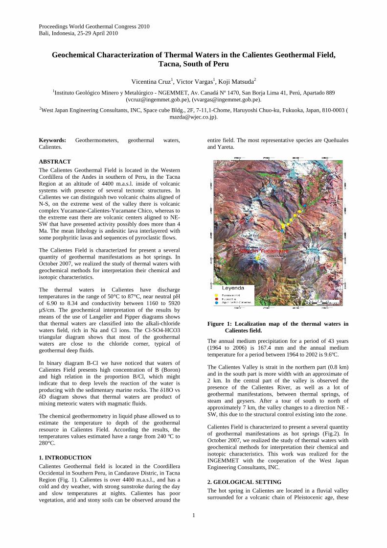
Calientes Geothermal field is located in the Coordillera Occidental in Southern Peru, in Candarave Distric, in Tacna Region (Fig. 1). Calientes is over 4400 m.a.s.l., and has a cold and dry weather, with strong sunstroke during the day and slow temperatures at nights. Calientes has poor vegetation, arid and stony soils can be observed around the
entire field. The most representative species are Queñuales and Yareta.
Figure 1: Localization map of the thermal waters in Calientes field.
The annual medium precipitation for a period of 43 years (1964 to 2006) is 167.4 mm and the annual medium temperature for a period between 1964 to 2002 is 9.6ºC.
The Calientes Valley is strait in the northern part (0.8 km) and in the south part is more width with an approximate of 2 km. In the central part of the valley is observed the presence of the Calientes River, as well as a lot of geothermal manifestations, between thermal springs, of steam and geysers. After a tour of south to north of approximately 7 km, the valley changes to a direction NE - SW, this due to the structural control existing into the zone.
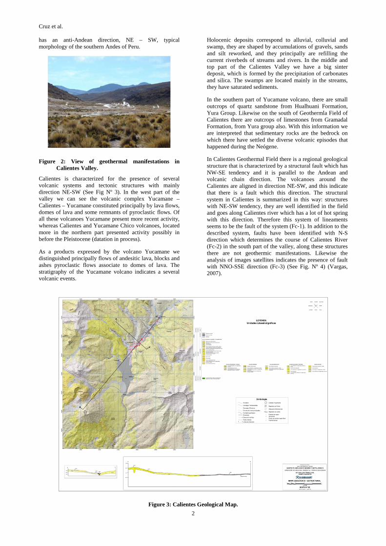
Calientes Field is characterized to present a several quantity of geothermal manifestations as hot springs (Fig.2). In October 2007, we realized the study of thermal waters with geochemical methods for interpretation their chemical and isotopic characteristics. This work was realized for the INGEMMET with the cooperation of the West Japan Engineering Consultants, INC.
2. GEOLOGICAL SETTING
The hot spring in Calientes are located in a fluvial valley surrounded for a volcanic chain of Pleistocenic age, these
Cruz et al.
2
has an anti-Andean direction, NE – SW, typical morphology of the southern Andes of Peru.
Figure 2: View of geothermal manifestations in Calientes Valley.
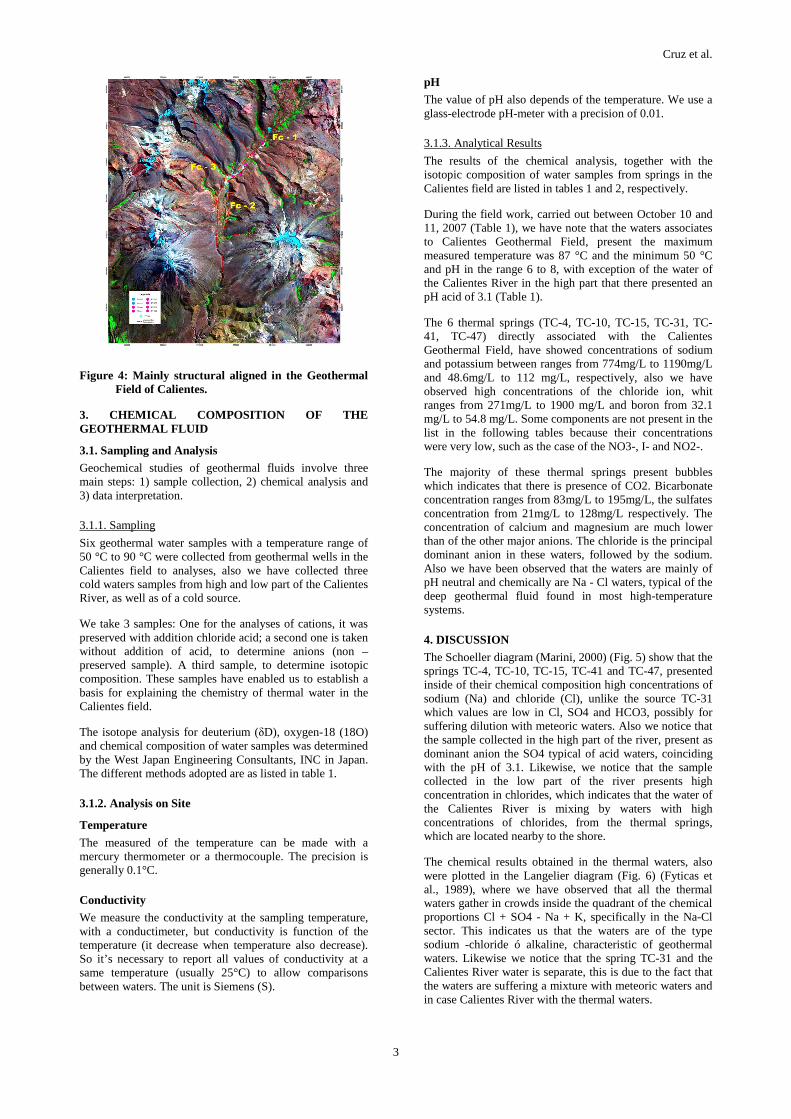
Calientes is characterized for the presence of several volcanic systems and tectonic structures with mainly direction NE-SW (See Fig Nº 3). In the west part of the valley we can see the volcanic complex Yucamane – Calientes – Yucamane constituted principally by lava flows, domes of lava and some remnants of pyroclastic flows. Of all these volcanoes Yucamane present more recent activity, whereas Calientes and Yucamane Chico volcanoes, located more in the northern part presented activity possibly in before the Pleistocene (datation in process).
As a products expressed by the volcano Yucamane we distinguished principally flows of andesitic lava, blocks and ashes pyroclastic flows associate to domes of lava. The stratigraphy of the Yucamane volcano indicates a several volcanic events.
Holocenic deposits correspond to alluvial, colluvial and swamp, they are shaped by accumulations of gravels, sands and silt reworked, and they principally are refilling the current riverbeds of streams and rivers. In the middle and top part of the Calientes Valley we have a big sinter deposit, which is formed by the precipitation of carbonates and silica. The swamps are located mainly in the streams, they have saturated sediments.
In the southern part of Yucamane volcano, there are small outcrops of quartz sandstone from Hualhuani Formation, Yura Group. Likewise on the south of Geothermla Field of Calientes there are outcrops of limestones from Gramadal Formation, from Yura group also. With this information we are interpreted that sedimentary rocks are the bedrock on which there have settled the diverse volcanic episodes that happened during the Neógene.
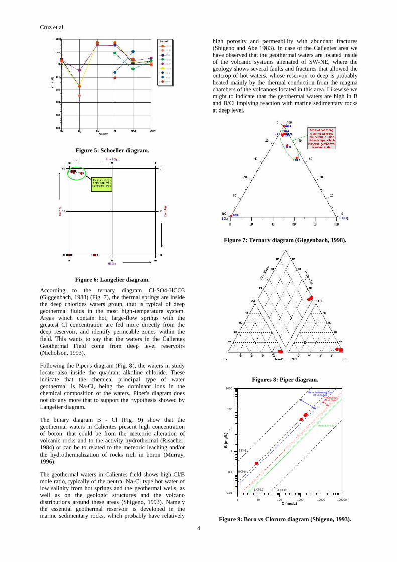
In Calientes Geothermal Field there is a regional geological structure that is characterized by a structural fault which has NW-SE tendency and it is parallel to the Andean and volcanic chain direction. The volcanoes around the Calientes are aligned in direction NE-SW, and this indicate that there is a fault which this direction. The structural system in Calientes is summarized in this way: structures with NE-SW tendency, they are well identified in the field and goes along Calientes river which has a lot of hot spring with this direction. Therefore this system of lineaments seems to be the fault of the system (Fc-1). In addition to the described system, faults have been identified with N-S direction which determines the course of Calientes River (Fc-2) in the south part of the valley, along these structures there are not geothermic manifestations. Likewise the analysis of images satellites indicates the presence of fault with NNO-SSE direction (Fc-3) (See Fig. Nº 4) (Vargas, 2007).
Figure 3: Calientes Geological Map.
Cruz et al.
3
Figure 4: Mainly structural aligned in the Geothermal Field of Calientes.
3. CHEMICAL COMPOSITION OF THE GEOTHERMAL FLUID
3.1. Sampling and Analysis
Geochemical studies of geothermal fluids involve three main steps: 1) sample collection, 2) chemical analysis and 3) data interpretation.
3.1.1. Sampling
Six geothermal water samples with a temperature range of 50 °C to 90 °C were collected from geothermal wells in the Calientes field to analyses, also we have collected three cold waters samples from high and low part of the Calientes River, as well as of a cold source.
We take 3 samples: One for the analyses of cations, it was preserved with addition chloride acid; a second one is taken without addition of acid, to determine anions (non –preserved sample). A third sample, to determine isotopic composition. These samples have enabled us to establish a basis for explaining the chemistry of thermal water in the Calientes field.
The isotope analysis for deuterium (δD), oxygen-18 (18O) and chemical composition of water samples was determined by the West Japan Engineering Consultants, INC in Japan. The different methods adopted are as listed in table 1.
3.1.2. Analysis on Site
Temperature
The measured of the temperature can be made with a mercury thermometer or a thermocouple. The precision is generally 0.1°C.
Conductivity
We measure the conductivity at the sampling temperature, with a conductimeter, but conductivity is function of the temperature (it decrease when temperature also decrease). So it’s necessary to report all values of conductivity at a same temperature (usually 25°C) to allow comparisons between waters. The unit is Siemens (S).
pH
The value of pH also depends of the temperature. We use a glass-electrode pH-meter with a precision of 0.01.
3.1.3. Analytical Results
The results of the chemical analysis, together with the isotopic composition of water samples from springs in the Calientes field are listed in tables 1 and 2, respectively.
During the field work, carried out between October 10 and 11, 2007 (Table 1), we have note that the waters associates to Calientes Geothermal Field, present the maximum measured temperature was 87 °C and the minimum 50 °C and pH in the range 6 to 8, with exception of the water of the Calientes River in the high part that there presented an pH acid of 3.1 (Table 1).
The 6 thermal springs (TC-4, TC-10, TC-15, TC-31, TC-41, TC-47) directly associated with the Calientes Geothermal Field, have showed concentrations of sodium and potassium between ranges from 774mg/L to 1190mg/L and 48.6mg/L to 112 mg/L, respectively, also we have observed high concentrations of the chloride ion, whit ranges from 271mg/L to 1900 mg/L and boron from 32.1 mg/L to 54.8 mg/L. Some components are not present in the list in the following tables because their concentrations were very low, such as the case of the NO3-, I- and NO2-.
The majority of these thermal springs present bubbles which indicates that there is presence of CO2. Bicarbonate concentration ranges from 83mg/L to 195mg/L, the sulfates concentration from 21mg/L to 128mg/L respectively. The concentration of calcium and magnesium are much lower than of the other major anions. The chloride is the principal dominant anion in these waters, followed by the sodium. Also we have been observed that the waters are mainly of pH neutral and chemically are Na - Cl waters, typical of the deep geothermal fluid found in most high-temperature systems.
4. DISCUSSION
The Schoeller diagram (Marini, 2000) (Fig. 5) show that the springs TC-4, TC-10, TC-15, TC-41 and TC-47, presented inside of their chemical composition high concentrations of sodium (Na) and chloride (Cl), unlike the source TC-31 which values are low in Cl, SO4 and HCO3, possibly for suffering dilution with meteoric waters. Also we notice that the sample collected in the high part of the river, present as dominant anion the SO4 typical of acid waters, coinciding with the pH of 3.1. Likewise, we notice that the sample collected in the low part of the river presents high concentration in chlorides, which indicates that the water of the Calientes River is mixing by waters with high concentrations of chlorides, from the thermal springs, which are located nearby to the shore.
The chemical results obtained in the thermal waters, also were plotted in the Langelier diagram (Fig. 6) (Fyticas et al., 1989), where we have observed that all the thermal waters gather in crowds inside the quadrant of the chemical proportions Cl + SO4 - Na + K, specifically in the Na-Cl sector. This indicates us that the waters are of the type sodium -chloride ó alkaline, characteristic of geothermal waters. Likewise we notice that the spring TC-31 and the Calientes River water is separate, this is due to the fact that the waters are suffering a mixture with meteoric waters and in case Calientes River with the thermal waters.
Cruz et al.
4
Figure 5: Schoeller diagram.
Figure 6: Langelier diagram.
According to the ternary diagram Cl-SO4-HCO3 (Giggenbach, 1988) (Fig. 7), the thermal springs are inside the deep chlorides waters group, that is typical of deep geothermal fluids in the most high-temperature system. Areas which contain hot, large-flow springs with the greatest Cl concentration are fed more directly from the deep reservoir, and identify permeable zones within the field. This wants to say that the waters in the Calientes Geothermal Field come from deep level reservoirs (Nicholson, 1993).
Following the Piper's diagram (Fig. 8), the waters in study locate also inside the quadrant alkaline chloride. These indicate that the chemical principal type of water geothermal is Na-Cl, being the dominant ions in the chemical composition of the waters. Piper's diagram does not do any more that to support the hypothesis showed by Langelier diagram.
The binary diagram B - Cl (Fig. 9) show that the geothermal waters in Calientes present high concentration of boron, that could be from the meteoric alteration of volcanic rocks and to the activity hydrothermal (Risacher, 1984) or can be to related to the meteoric leaching and/or the hydrothermalization of rocks rich in boron (Murray, 1996).
The geothermal waters in Calientes field shows high Cl/B mole ratio, typically of the neutral Na-Cl type hot water of low salinity from hot springs and the geothermal wells, as well as on the geologic structures and the volcano distributions around these areas (Shigeno, 1993). Namely the essential geothermal reservoir is developed in the marine sedimentary rocks, which probably have relatively
high porosity and permeability with abundant fractures (Shigeno and Abe 1983). In case of the Calientes area we have observed that the geothermal waters are located inside of the volcanic systems alienated of SW-NE, where the geology shows several faults and fractures that allowed the outcrop of hot waters, whose reservoir to deep is probably heated mainly by the thermal conduction from the magma chambers of the volcanoes located in this area. Likewise we might to indicate that the geothermal waters are high in B and B/Cl implying reaction with marine sedimentary rocks at deep level.
Figure 7: Ternary diagram (Giggenbach, 1998).
Figures 8: Piper diagram.
1 10 100 1000 10000 100000Cl(mg/L)
0.01
0.1
1
10
100
1000
B (m
g/L
)
Marine Sedimentary RocksB/Cl=0.07-1.00
Volcanic RocksB/Cl=0.02-0.07
Granite: B/Cl~0.01
B/Cl=1
B/Cl=0.1
B/Cl=0.001B/Cl=0.01
Figure 9: Boro vs Cloruro diagram (Shigeno, 1993).
Cruz et al.
5
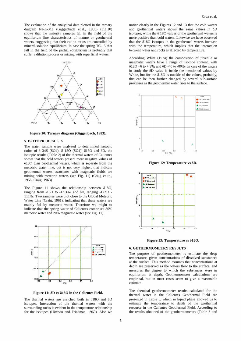
The evaluation of the analytical data plotted in the ternary diagram Na-K-Mg (Giggenbach et.al., 1983) (Fig.10) shows that the majority samples fall in the field of the equilibrium line characteristics of mature or geothermal waters, suggesting that their cation ratios are controlled by mineral-solution equilibrium. In case the spring TC-15 that fall in the field of the partial equilibrium is probably that suffer a dilution process or mixing with superficial waters.
Figure 10: Ternary diagram (Giggenbach, 1983).
5. ISOTOPIC RESULTS
The water sample were analyzed to determined isotopic ratios of δ 34S (SO4), δ 18O (SO4), δ18O and δD, the isotopic results (Table 2) of the thermal waters of Calientes shows that the cold waters present more negative values of δ18O than geothermal waters, which is separate from the meteoric water line, but is not very higher, that indicate geothermal waters associates with magmatic fluids are mixing with meteoric waters (see Fig. 11) (Craig et to., 1956; Craig, 1963).
The Figure 11 shows the relationship between δ18O, ranging from -16.1 to -13.3‰, and δD, ranging -122 a -111‰. Two samples were plot close to the Global Meteoric Water Line (Craig, 1961), indicating that these waters are mainly fed by meteoric water. Therefore we might to indicate that the spring water of Calientes comprises 80% meteoric water and 20% magmatic water (see Fig. 11).
Figure 11: δD vs δ18O in the Calientes Field.
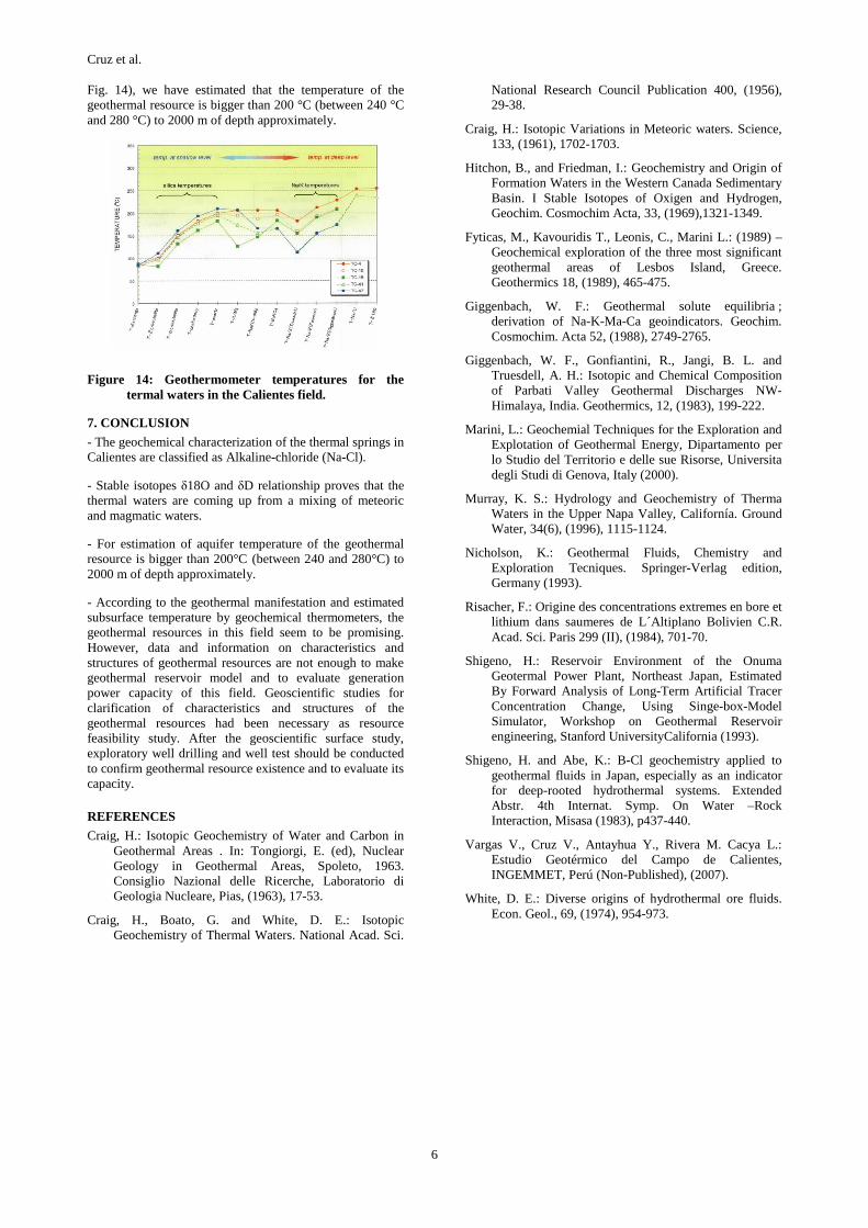
The thermal waters are enriched both in δ18O and δD isotopes. Interaction of the thermal waters with the surrounding rocks is evident in the temperature relationship for the isotopes (Hitchon and Friedman, 1969). Also we
notice clearly in the Figures 12 and 13 that the cold waters and geothermal waters shows the same values in δD isotopes, while the δ 18O values of the geothermal waters is more positive than cold waters. Likewise we have observed that the δ18O isotopes in the geothermal waters increase with the temperature, which implies that the interaction between water and rocks is affected by temperature.
According White (1974) the composition of juvenile or magmatic waters have a range of isotope content, with δ18O +6 to + 9‰ and δD -40 to -80‰, in case of the waters in study the δD value is inside the mentioned values by White, but for the δ18O is outside of the values, probably, this can be then further changed by several sub-surface processes as the geothermal water rises to the surface.
-130 -126 -122 -118 -114 -110
2H (‰)
0
18
36
54
72
90
Tem
p(°
C)
Scatter Plot
AA
CC
LegendLegend
C 7
C 3
A 2
A 1
TC-41 (Thermal water)
TC-4 (Termal water)
RIOA (Cold water)
FFNW (Cold water)
Legend
Figure 12: Temperature vs δD.
Figure 13: Temperature vs δ18O.
6. GETHERMOMETRY RESULTS
The purpose of geothermometer is estimate the deep temperature, given concentrations of dissolved substances at the surface. This method assumes that concentrations at depth are preserved as the waters flow to the surface, and measures the degree to which the substances were in equilibrium at depth. Geothermometer calculations are empirical, but in most cases seem to give a reasonable estimate.
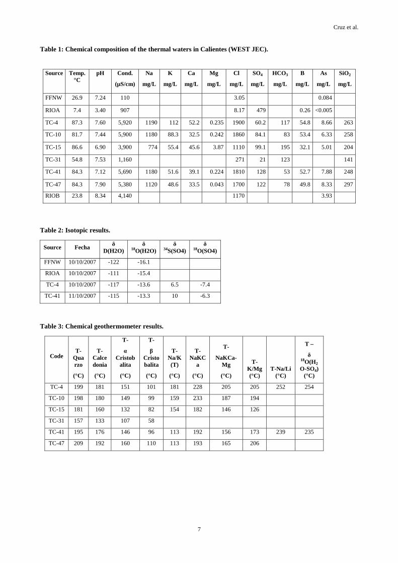
The chemical geothermometer results calculated for the thermal water in the Calientes Geothermal Field are presented in Table 3, which in liquid phase allowed us to estimate the temperature to depth of the geothermal resource in the Calientes Geothermal Field. According to the results obtained of the geothermometers (Table 3 and
Cruz et al.
6
Fig. 14), we have estimated that the temperature of the geothermal resource is bigger than 200 °C (between 240 °C and 280 °C) to 2000 m of depth approximately.
Figure 14: Geothermometer temperatures for the termal waters in the Calientes field.
7. CONCLUSION
- The geochemical characterization of the thermal springs in Calientes are classified as Alkaline-chloride (Na-Cl).
- Stable isotopes δ18O and δD relationship proves that the thermal waters are coming up from a mixing of meteoric and magmatic waters.
- For estimation of aquifer temperature of the geothermal resource is bigger than 200°C (between 240 and 280°C) to 2000 m of depth approximately.
- According to the geothermal manifestation and estimated subsurface temperature by geochemical thermometers, the geothermal resources in this field seem to be promising. However, data and information on characteristics and structures of geothermal resources are not enough to make geothermal reservoir model and to evaluate generation power capacity of this field. Geoscientific studies for clarification of characteristics and structures of the geothermal resources had been necessary as resource feasibility study. After the geoscientific surface study, exploratory well drilling and well test should be conducted to confirm geothermal resource existence and to evaluate its capacity.
REFERENCES
Craig, H.: Isotopic Geochemistry of Water and Carbon in Geothermal Areas . In: Tongiorgi, E. (ed), Nuclear Geology in Geothermal Areas, Spoleto, 1963. Consiglio Nazional delle Ricerche, Laboratorio di Geologia Nucleare, Pias, (1963), 17-53.
Craig, H., Boato, G. and White, D. E.: Isotopic Geochemistry of Thermal Waters. National Acad. Sci.
National Research Council Publication 400, (1956), 29-38.
Craig, H.: Isotopic Variations in Meteoric waters. Science, 133, (1961), 1702-1703.
Hitchon, B., and Friedman, I.: Geochemistry and Origin of Formation Waters in the Western Canada Sedimentary Basin. I Stable Isotopes of Oxigen and Hydrogen, Geochim. Cosmochim Acta, 33, (1969),1321-1349.
Fyticas, M., Kavouridis T., Leonis, C., Marini L.: (1989) – Geochemical exploration of the three most significant geothermal areas of Lesbos Island, Greece. Geothermics 18, (1989), 465-475.
Giggenbach, W. F.: Geothermal solute equilibria ; derivation of Na-K-Ma-Ca geoindicators. Geochim. Cosmochim. Acta 52, (1988), 2749-2765.
Giggenbach, W. F., Gonfiantini, R., Jangi, B. L. and Truesdell, A. H.: Isotopic and Chemical Composition of Parbati Valley Geothermal Discharges NW-Himalaya, India. Geothermics, 12, (1983), 199-222.
Marini, L.: Geochemial Techniques for the Exploration and Explotation of Geothermal Energy, Dipartamento per lo Studio del Territorio e delle sue Risorse, Universita degli Studi di Genova, Italy (2000).
Murray, K. S.: Hydrology and Geochemistry of Therma Waters in the Upper Napa Valley, Californía. Ground Water, 34(6), (1996), 1115-1124.
Nicholson, K.: Geothermal Fluids, Chemistry and Exploration Tecniques. Springer-Verlag edition, Germany (1993).
Risacher, F.: Origine des concentrations extremes en bore et lithium dans saumeres de L´Altiplano Bolivien C.R. Acad. Sci. Paris 299 (II), (1984), 701-70.
Shigeno, H.: Reservoir Environment of the Onuma Geotermal Power Plant, Northeast Japan, Estimated By Forward Analysis of Long-Term Artificial Tracer Concentration Change, Using Singe-box-Model Simulator, Workshop on Geothermal Reservoir engineering, Stanford UniversityCalifornia (1993).
Shigeno, H. and Abe, K.: B-Cl geochemistry applied to geothermal fluids in Japan, especially as an indicator for deep-rooted hydrothermal systems. Extended Abstr. 4th Internat. Symp. On Water –Rock Interaction, Misasa (1983), p437-440.
Vargas V., Cruz V., Antayhua Y., Rivera M. Cacya L.: Estudio Geotérmico del Campo de Calientes, INGEMMET, Perú (Non-Published), (2007).
White, D. E.: Diverse origins of hydrothermal ore fluids. Econ. Geol., 69, (1974), 954-973.
Cruz et al.
7
Table 1: Chemical composition of the thermal waters in Calientes (WEST JEC).
Table 2: Isotopic results.
Table 3: Chemical geothermometer results.
Source Temp. °C
pH Cond.
(µS/cm)
Na
mg/L
K
mg/L
Ca
mg/L
Mg
mg/L
Cl
mg/L
SO4
mg/L
HCO3
mg/L
B
mg/L
As
mg/L
SiO2
mg/L
FFNW 26.9 7.24 110 3.05 0.084
RIOA 7.4 3.40 907 8.17 479 0.26 <0.005
TC-4 87.3 7.60 5,920 1190 112 52.2 0.235 1900 60.2 117 54.8 8.66 263
TC-10 81.7 7.44 5,900 1180 88.3 32.5 0.242 1860 84.1 83 53.4 6.33 258
TC-15 86.6 6.90 3,900 774 55.4 45.6 3.87 1110 99.1 195 32.1 5.01 204
TC-31 54.8 7.53 1,160 271 21 123 141
TC-41 84.3 7.12 5,690 1180 51.6 39.1 0.224 1810 128 53 52.7 7.88 248
TC-47 84.3 7.90 5,380 1120 48.6 33.5 0.043 1700 122 78 49.8 8.33 297
RIOB 23.8 8.34 4,140 1170 3.93
Source Fecha δ D(H2O)
δ 18O(H2O)
δ 34S(SO4)
δ 18O(SO4)
FFNW 10/10/2007 -122 -16.1
RIOA 10/10/2007 -111 -15.4
TC-4 10/10/2007 -117 -13.6 6.5 -7.4
TC-41 11/10/2007 -115 -13.3 10 -6.3
Code T-
Quarzo
(°C)
T-Calcedonia
(°C)
T-
α Cristob
alita
(°C)
T-
β Cristobalita
(°C)
T-Na/K(T)
(°C)
T-NaKC
a
(°C)
T-
NaKCa-Mg
(°C)
T-K/Mg (°C)
T-Na/Li (°C)
T –
δ 18O(H2
O-SO4) (°C)
TC-4 199 181 151 101 181 228 205 205 252 254
TC-10 198 180 149 99 159 233 187 194
TC-15 181 160 132 82 154 182 146 126
TC-31 157 133 107 58
TC-41 195 176 146 96 113 192 156 173 239 235
TC-47 209 192 160 110 113 193 165 206