geochemical baseline mapping and lead pollution …
TRANSCRIPT

ISSN 1330-0520 original scientific paper / izvorni znanstveni radUDK 577:551.510.42.504.54(497.5/1-15)
GEOCHEMICAL BASELINE MAPPINGAND LEAD POLLUTION ASSESSMENT OF SOILS
ON THE KARST IN WESTERN CROATIA
SLOBODAN MIKO1, ZORAN PEH1, DRAGAN BUKOVEC2,ESAD PROHI]3
� @ELJKO KASTMÜLLER1
1Institute of Geology, Sachsova 2, Zagreb, HR-10000, Croatia2Croatian Natural History Museum, Demetrova 1, Zagreb, HR-10000, Croatia
3Faculty of Science, University of Zagreb, Zagreb, HR-10000, Croatia
Miko, S., Peh, Z., Bukovec, D., Prohi}, E. & Kastmüller, @.: Geochemical baseline mappingand lead pollution assessment of soils on the karst in Western Croatia. Nat. Croat., Vol. 9, No. 1.,41–59, 2000, Zagreb.
The area studied follows the sharp geomorphological boundary at which an abrupt change oc-curs from a Mediterranean to a cold continental climate. The dominant soils are brown soils devel-oped on limestone and melanosols developed on dolomite. Twenty five elements were analysed inthe fine soil sample fraction (– 63� m) by ICP-AES after total dissolution in a mixture of concen-trated acids (HF, HCl, HNO3, HClO4). The topsoil geochemical data sets of both western Croatiaand the national park were processed through R-mode factor analysis to determine the patterns ofgeochemical association among elements and to detect and identify possible anomalies of elementsthat could be associated with airborne contamination. A four-factor model accounted for 75 % ofthe total variance. The association of Pb, Zn, Cd, As and P was interpreted as associated with air-borne contamination and acid rain deposition. The factor score map of the Pb-Zn-Cd-As-P associa-tion shows high positive scores located along the climate boundary that passes through RisnjakNational Park and further to the southeast over Mt Velebit. Along this regional climate barrier, thedeposition of airborne contaminants carried by westerly winds from both regional (NE Italy) andlocal (Rijeka, oil refineries and oil- and coal-fired power plants) sources evidently occurred. Withthe aid of factor analysis it was possible clearly to identify areas influenced by airborne pollution.Total lead concentrations detected at altitudes higher than 1050 m above sea level in the nationalpark were higher than 80 ppm (maximum 139 ppm Pb) while the regional mean Pb concentrationis 43 ppm. Also a stoichiometric approach was applied to compensate for the influence of theamount of the clay fraction by modeling soil geochemical baselines on the basis of the calculationof the Pb enrichment factor (EF). As a basis for these calculations, reference soils with the pre-sumed least anthropogenic influence from the island of Mljet (78 samples) were used. In the area ofRisnjak National Park approximately 20% of the samples have an Pb EF higher than 2, which canbe considered polluted, while the whole region of Western Croatia (not including Istria) has less
Croatian Natural History Museum, Demetrova 1, Zagreb, Croatia
NAT. CROAT. VOL. 9 No 1 41¿59 ZAGREB March 31, 2000
brought to you by COREView metadata, citation and similar papers at core.ac.uk
than 3% of Pb enriched samples. All the samples from the area of Mt Velebit contain Pb within thebaseline range (EF < 2).
Key words: acid rain, soils, airborne pollution, karst, geochemical baseline, lead, enrichmentfactor, Risnjak national park, Western Croatia
Miko, S., Peh, Z., Bukovec, D., Prohi}, E. & Kastmüller, @.: Geokemijsko kartiranje i procjenaone~i{}enja olovom tala na kr{u zapadne Hrvatske. Nat. Croat., Vol. 9, No. 1., 41–59, 2000, Za-greb.
Istra`ivano podru~je pru`a se du` o{tre geomorfolo{ke granice koja oza~ava nagli prijelaz izmediteranske u hladnu kontinentalnu klimu. Dominantan tip tla ~ine sme|a tla razvijena na vap-nencu i crnice razvijene na dolomitu. Analizirano je 25 elemenata u sitnoj frakciji uzorka (– 63� m).Uzorci su nakon otapanja u smjesi koncentriranih kiselina (HF, HCl, HNO3 i HClO4) podvrgnutianalizi metodom ICP-AES. Rezultati analize tla obra|eni su R-metodom faktorske analize kako bise utvrdili oblici asocijacija me|u elementima te otkrile i protuma~ile mogu}e anomalije koje bi mo-gle potjecati od atmosferskog zaga|enja. Ukupno 75 % ukupne varijabilnosti dobivenog faktorskogmodela koncentrirano je u prva ~etiri faktora od kojih se Pb-Zn-Cd-As-P faktor mo`e povezati skiselim ki{ama i atmosferskim zaga|enjem. Faktorska karta ove asocijacije elemenata dobro de-finira klimatsku granicu koja prolazi kroz Nacionalni park »Risnjak« pru`aju}i se dalje prema juguprema Velebitu. Du` ove regionalne klimatske barijere dolazi do obaranja aerosola no{enih zapad-nim vjetrovima od regionalnih (SI Italija), ali i lokalnih (naftna industrija u Rijeci, termoelektrana uPlominu) zaga|iva~a. Pomo}u faktorske analize bilo je mogu}e jasno utvrditi podru~ja zaga|enaputem zra~nih struja. Ukupna koncentracija olova otkrivena na visinama preko 1050 m nad moremiznosi u Nacionalnom parku vi{e od 80 ppm (max = 139 ppm), dok je prosje~na regionalna koncen-tracija 43 ppm. U analizi je primijenjen i stehiometrijski pristup koji se sastoji u modeliranju osnov-nih geokemijskih nivoa pomo}u linearne regresije izme|u metala i Al s ciljem neutraliziranja utje-caja glinovite komponente, a tako|er i izra~un faktora oboga}enja (EF) za olovo. Kao osnova za teizra~une kori{tena su tla otoka Mljeta (78 uzoraka) za koja se pretpostavlja da odra`avaju najmanjiutjecaj antropogene komponente. U podru~ju Nacionalnog parka »Risnjak« pribli`no 20 % uzorakaima EF vrijednost za Pb vi{u od 2 (EF > 2), {to se mo`e smatrati kao zaga|enje, dok ~itavo podru~jezapadne Hrvatske (osim Istre) ima manje od 3 % olovom oboga}enih uzoraka. Svi uzorci s po-dru~ja Velebita imaju vrijednost EF za olovo unutar podru~ja geokemijskog {uma (EF < 2) pa semo`e smatrati da je utjecaj atmosferskog zaga|enja u tom podru~ju manje izra`en.
Klju~ne rije~i: kisele ki{e, tlo, atmosfersko zaga|enje, kr{, geokemijski {um, olovo, faktor obo-ga}enja, Nacionalni park »Risnjak«, zapadna Hrvatska
INTRODUCTION
Geochemical baseline mapping and environmental studies of carbonate terrainin Croatia in the past fifteen years (PIRC & MAKSIMOVI], 1985; PIRC et al., 1991;PROHI] et al., 1997; PROHI] et al., 1998; MIKO et al., 1999) have shown that some areaspreviously considered well preserved natural karstic landscapes have been greatlyaffected by airborne pollution.
The unique positions of Risnjak National Park and the Velebit protected area(Fig. 1), on the geomorphological boundary between the coastal Mediterranean partof Croatia and the continental hinterland have evidently caused a considerable at-mospheric fallout impact on their soil cover. The sources of this atmospheric pollu-tion are both local and regional. In a regional sense the geomorphological boundaryextends along the Dinaric mountain chain that arches along the Adriatic coast andis the first barrier to atmospheric pollutants from the whole north eastern part of It-
42 Miko, S. et al.: Geochemical baseline mapping and lead pollution assessment of soils ...

aly. During the last three decades the forests of this region have been declining(PRPI], 1987; PRPI] et al., 1991). This phenomenon is especially marked in the firand beech-fir forests while fir is the most endangered of the tree species. Studies ofsoil acidity and heavy metal humus concentrations (GLAVA^ et al., 1987; VRBEK &
Nat. Croat. Vol. 9(1), 2000 43
Fig. 1. Map of Croatia and location of the studied areas (W. Croatia open rectangle andRisnjak national park, filled box on the small map); + topsoil sampling sites (5x5 km
and 1x1 km grids).
GA[PARAC, 1992) indicate that the region of Gorski Kotar is subject to moderate airpollution. Topoclimatic analysis of Risnjak National Park (ANTONI], 1996) showspronounced exposures to west cyclone incomings and forest decline as a conse-quence of acid rain deposition. Moreover, the major Van Bebber cyclone path for thisregion, the so-called Genova cyclone, crosses the area from west to east (PAND@I],1989). According to ROBINSON (1984), this cyclone could be a major transporter ofthe air pollutants that are being deposited on the geomorphological barrier of GorskiKotar.
The vulnerability of karstic landscapes is due to the very shallow acid soil (pH4.5–6.5) developed on the carbonate rocks and its limited ability to buffer the effectsof airborne pollution.
In the past decades it has been recognized that atmophile trace metals such asAs, Hg, Pb, Zn, Cd and Cu contribute most to soil pollution as atmospheric fallout(LANTZY & MACKENZIE, 1979; FÖRSTNER, 1995; WILSON & BELL, 1996; MATSCHULLAT
& BOZAU, 1996; KUBIN & LIPPO, 1996).To assess the pollution impact on the soil cover of Risnjak National Park and the
regional climate boundary, data obtained during the geochemical baseline surveywere subjected to R-mode factor analysis within which the airborne element asso-ciation (Pb, Zn, P, As, and Cd) was singled out and the distribution of the resultingfactor scores interpreted as pollution impact. In addition, a stoichiometric approachwas applied by modeling soil geochemical baselines on the basis of the calculationof the Pb enrichment factor (HASSAN & ISMAIL, 1993; PROHI] et al., 1995; MIKO et al.,1999). As a basis for these calculations, reference soils with the presumed least an-thropogenic influence from the island of Mljet (78 samples) were used.
GEOLOGY
Western Croatia is distinguished by various features characteristic of karst land-scapes. These phenomena are most developed and most numerous in the zone of theso-called »high« Dinaric karst spreading over the elongated coastal mountains suchas Velebit. The area consists mainly of Mesozoic limestone and dolomites, occasion-ally with flysch and associated sedimentary, mostly carbonate, clastic rocks, such asbreccias and conglomerates. The oldest, Upper Paleozoic rocks i.e., sandstone, shalesand siltstones are exposed only in the hinterland (Gorski kotar and Lika).
Upper Triassic and Liassic dolomites intercalated with limestone cover almostthe entire area within the boundaries of the national park. Further to the west andnorthwest, the dolomite series of Triassic and Liassic age is progressively replacedby limestone, which prevails to the Cretaceous in an uninterrupted stratigraphic se-quence. Intensive erosion of limestone in the entire area resulted in a typical karsthydrogeology and geomorphology.
SOILS, CLIMATE AND VEGETATION
Since more than 75 % of the studied part of Western Croatia is built of Jurassicand Cretaceous limestone, the prevailing soil types are brown soils developed on
44 Miko, S. et al.: Geochemical baseline mapping and lead pollution assessment of soils ...
limestone (calcocambisols), while at lower altitudes with a Mediterranean climatevarious terra rossa type soils have developed. Occurrences of dolomites are usuallycovered by rendzinas and organic-mineral melanosols. Both organic and organic-mineral melanosols are developed on limestone and dolomites at higher altitudes.The area is covered mainly by very shallow soils developed on Mesozoic limestoneand dolomite, among which the following soil types predominate: melanosol, calco-cambisol and luvisol (MARTINOVI] et al., 1994). On silicate Permian bedrock, acidbrown soils (dystric cambisols) have developed.
The macroclimate of the karst mountainous region of Western Croatia is perhu-mid: moderately cold, with high precipitation (over 3500 mm annually), high rela-tive humidity, high and enduring snow cover and frequent frost over the entire,relatively short growing season. Spatial topoclimatic contrasts are very strong be-cause the relief is extremely rugged, due to the geological porosity and relativelyhigh precipitation. The vegetation complex belongs to the North Dinaric inlandtype, with the largest part of the area covered by beech, fir and spruce monodomi-nant forests, beech-fir mixed forests and mountain pine woods. The vegetationpattern is mosaic due to the topoclimatic contrasts (ANTONI], 1996; ANTONI] et al.,1997).
Transition to the Mediterranean macroclimatic types follows decreasing altitudetoward the west with oro-Mediterranean (moderately cold and dry with xeric beechforests), sub-Mediterranean (moderately warm and dry with sclerophyllous decidu-ous oak forests), and eu-Mediterranean (warm and dry with evergreen oak forests)macroclimates.
MATERIALS AND METHODS
The topsoil samples used in this study were collected on a 5 5 km grid for theGeneral Geochemical Map of Croatia, and the soil samples from Risnjak NationalPark on a 1 1 km grid (Fig. 1) were collected during a project which was aimed atthe characterization of soils in Croatian national parks. It should be noted that 90%of the soil samples in the national park were taken at altitudes higher than 1050 mabove sea level, and the topmost sample was taken at 1410 m above sea level. Thedetailed descriptions of initial geochemical regolith mapping protocols for carbon-ate terrains is given in detail by PIRC et al. (1991), PROHI] et al. (1997), PROHI] et al.(1998) and baseline mapping by PROHI] et al. (1995), MIKO et al. (1999) and PEH &MIKO (1999).
The topsoil samples were taken at each sampling site from 3 to 5 shallow pits(mollic horizon, from 0 to 20 cm deep) and the material of the organic layer, if pres-ent, was excluded. All samples are a composite of at least 3 sub-samples covering asurface of 10 10 m. The soil samples were air-dried and the fraction sieved to–63mwas analysed.
Sieved soil samples were analyzed after near total (hot 4 acid mixture:HClO4-HNO3-HCl-HF at 200 °C) digestion for 35 elements by inductively-coupledplasma atomic emission spectrometry (ICP-AES) in the ACME Labs in Vancouver.
Nat. Croat. Vol. 9(1), 2000 45

The accuracy and reproducibility of analysis were controlled by analysis of USGSgeological reference soil standards (GXR-2, SJS-1 and GXR-5) in the analyzed sam-ple batches. The accuracy of analysis expressed as the ratio between measured andrecommended values of elements in the standard samples was in the range 10 %and the obtained precision on replicate samples was even below 5 % for most ele-ments. From the 35 element analytical package, 11 elements are excluded since 25 %or more of their values are below detection limit. The following elements were usedin this study: Al, As, Ba, Ca, Cd, Co, Cu, Cr, Fe, K, Mg, Mn, Na, Ni, Th, V, Ti, Sc, Sr,Pb, Zn, and P.
For decades, both exploration and environmental geochemical studies frequentlyuse R-mode factor analysis as a multivariate mathematical technique to reveal theunderlying structure of a specific set of data (DAVIS, 1986). As such, it is commonlyused as a tool of data reduction, with a purpose of providing a clearer insight intothe basic relationships among variables (R-mode) or samples (Q-mode). A simplystructured factor model containing only a few heavily loaded factors is always in-dicative of the strong dependence among elements and in this case was used to de-lineate polluted areas.
Factor scores of element associations present the most straightforward way ofportraying the influence of each independent factor in every single sample, or ob-servation point. When plotted on a map they disclose the manner of some signifi-cant local or regional geochemical signatures. The factor-score maps display mostconspicuously the process dynamics responsible for the characteristic institution ofthe factor model (DILLON & GOLDSTEIN, 1984). Prior to factor analysis the probabiltydistributions were determined and the elements that showed positively skeweddistributions (Cu, Pb, Zn, As, Sr, Cd, Ca, La, Mg, Ba and P) were log-transformed.Positive skewness of distributions of some elements was not lost after logarithmictransformation (Ca, Mg, Ba, Zn, Pb).
The airborne athropogene impact of Pb on soils can be also evaluated by calculationof enrichment factor (HASSAN & ISMAIL, 1993) and was performed for this area. Theenrichment factor (EF) used in this case is the concentration ratio of Pb in eachindividual sample (Cn sample) to the conservative element (Al) in the sample (Ccons.sample)with respect to same ratio of Pb and Al in a reference material (Cn ref./Ccons.ref.)(FÖRSTNER & WITTMANN, 1981; LI, 1981):
EF = (Cn sample/Ccons.sample) / (Cn ref./Ccons.ref.)
The definition of the enrichment factor indicates that this parameter depends onthe choice of referent element and the choice of reference material.
The influence of reference element choice upon the value of the enrichment fac-tor is discussed in papers of numerous authors, but Al is the commonest in use andits correlation with the clay content in sediments and soils is well established(WINDOM et al., 1989; PROHI] et al., 1995, PROHI] et al., 1998, MIKO et al., 1999, DURN
et al., 1999). The normalisation procedure used in the evaluation of anthrophogenicPb impact utilized baseline values established on the basis of 85 (1 1 km samplinggrid) soil samples from the island of Mljet (PEH & MIKO, 1999). This island was cho-sen as the baseline reference site for geochemical baseline mapping of carbonateterrains in Croatia because of its remoteness from possible anthropogene sources
46 Miko, S. et al.: Geochemical baseline mapping and lead pollution assessment of soils ...

and a favorable soil cover and bedrock that contain the major units of both foundin Croatia. GOLCHERT et al. (1991) distinguish three categories of enrichment factors:EF 2, 2 < EF < 10 and EF 10, where an EF lower than 2 indicates a natural varia-tion of an element and those higher than 10 indicate severe pollution.
The geochemical maps were produced with the aid of SURFER mapping software.Gridding was performed by linear kriging with grid cell resolution of 2 2 km.
RESULTS AND DISCUSSION
Tab. 1. summarizes the main statistical parameters for the elements used in thisstudy for Risnjak National Park (50 samples) and Western Croatia (292 samples).
Nat. Croat. Vol. 9(1), 2000 47
Tab. 1. Summary statistics for the analyzed elements in topsoil samples of Risnjak Na-tional Park and Western Croatia.
Risnjak national park (n = 50) Western Croatia(n = 292)
Min. Max. Std. Dev. Skewness Mean MeanCu (ppm) 5 386 52 6.66 32 40Pb (ppm) 25 139 27 0.87 70 43Zn (ppm) 22 289 54 0.77 124 107Ni (ppm) 7 118 29 0.40 55 72Co (ppm) 2 25 5 –0.02 12 16Cd (ppm) 0.4 3.0 0.7 0.64 1.3 1.1As (ppm) 5 66 11 1.86 20 15Th (ppm) 2 27 4 0.57 12 13Sr (ppm) 32 102 19 –0.52 75 89V (ppm) 30 299 50 1.00 127 131Mn (ppm) 59 2545 561 1.06 779 904Cr (ppm) 18 97 18 –1.04 67 107Ba (ppm) 58 1249 179 3.48 295 269Zr (ppm) 16 123 21 0.44 63 68Sc (ppm) 3 16 3 –0.49 10 11Al (%) 1.62 8.97 1.59 –1.27 6.40 7.54Fe (%) 0.74 5.86 1.12 –0.23 3.49 4.01Ca (%) 0.08 12.10 2.24 2.93 1.65 2.64K (%) 0.25 2.42 0.40 0.10 1.25 1.26Mg (%) 0.17 7.41 1.27 3.19 1.25 1.19Na (%) 0.09 0.87 0.22 0.09 0.48 0.49Ti (%) 0.10 0.66 0.11 –0.77 0.41 0.41P (%) 0.032 0.187 0.038 1.40 0.075 0.077
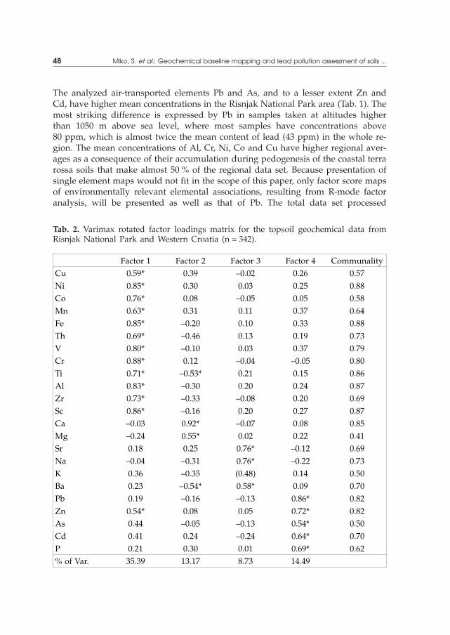
The analyzed air-transported elements Pb and As, and to a lesser extent Zn andCd, have higher mean concentrations in the Risnjak National Park area (Tab. 1). Themost striking difference is expressed by Pb in samples taken at altitudes higherthan 1050 m above sea level, where most samples have concentrations above80 ppm, which is almost twice the mean content of lead (43 ppm) in the whole re-gion. The mean concentrations of Al, Cr, Ni, Co and Cu have higher regional aver-ages as a consequence of their accumulation during pedogenesis of the coastal terrarossa soils that make almost 50 % of the regional data set. Because presentation ofsingle element maps would not fit in the scope of this paper, only factor score mapsof environmentally relevant elemental associations, resulting from R-mode factoranalysis, will be presented as well as that of Pb. The total data set processed
48 Miko, S. et al.: Geochemical baseline mapping and lead pollution assessment of soils ...
Tab. 2. Varimax rotated factor loadings matrix for the topsoil geochemical data fromRisnjak National Park and Western Croatia (n = 342).
Factor 1 Factor 2 Factor 3 Factor 4 CommunalityCu 0.59* 0.39 –0.02 0.26 0.57Ni 0.85* 0.30 0.03 0.25 0.88Co 0.76* 0.08 –0.05 0.05 0.58Mn 0.63* 0.31 0.11 0.37 0.64Fe 0.85* –0.20 0.10 0.33 0.88Th 0.69* –0.46 0.13 0.19 0.73V 0.80* –0.10 0.03 0.37 0.79Cr 0.88* 0.12 –0.04 –0.05 0.80Ti 0.71* –0.53* 0.21 0.15 0.86Al 0.83* –0.30 0.20 0.24 0.87Zr 0.73* –0.33 –0.08 0.20 0.69Sc 0.86* –0.16 0.20 0.27 0.87Ca –0.03 0.92* –0.07 0.08 0.85Mg –0.24 0.55* 0.02 0.22 0.41Sr 0.18 0.25 0.76* –0.12 0.69Na –0.04 –0.31 0.76* –0.22 0.73K 0.36 –0.35 (0.48) 0.14 0.50Ba 0.23 –0.54* 0.58* 0.09 0.70Pb 0.19 –0.16 –0.13 0.86* 0.82Zn 0.54* 0.08 0.05 0.72* 0.82As 0.44 –0.05 –0.13 0.54* 0.50Cd 0.41 0.24 –0.24 0.64* 0.70P 0.21 0.30 0.01 0.69* 0.62% of Var. 35.39 13.17 8.73 14.49
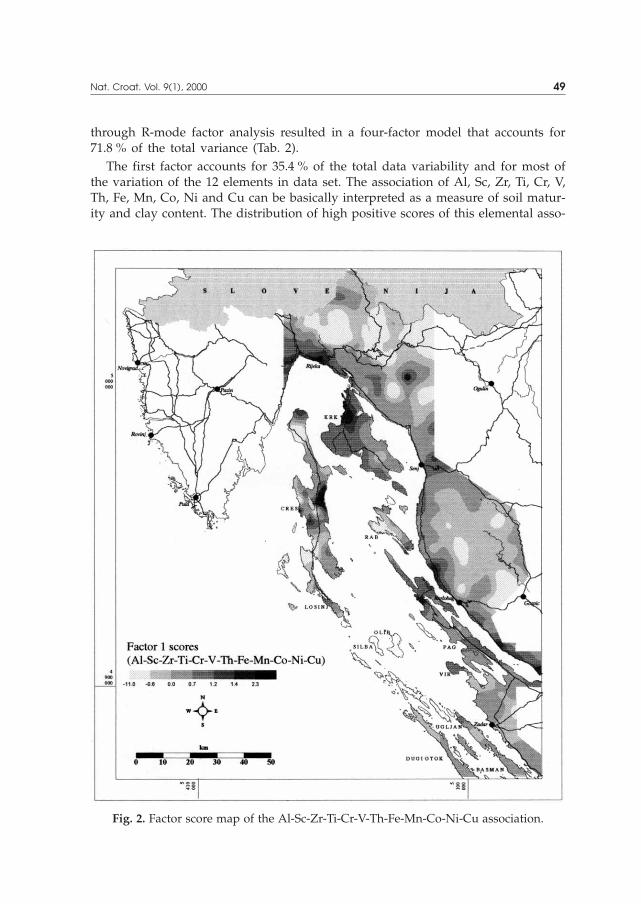
through R-mode factor analysis resulted in a four-factor model that accounts for71.8 % of the total variance (Tab. 2).
The first factor accounts for 35.4 % of the total data variability and for most ofthe variation of the 12 elements in data set. The association of Al, Sc, Zr, Ti, Cr, V,Th, Fe, Mn, Co, Ni and Cu can be basically interpreted as a measure of soil matur-ity and clay content. The distribution of high positive scores of this elemental asso-
Nat. Croat. Vol. 9(1), 2000 49
Fig. 2. Factor score map of the Al-Sc-Zr-Ti-Cr-V-Th-Fe-Mn-Co-Ni-Cu association.
ciation corresponds to the distribution of the coastal terra rossa soils. High negativescores reflect mountain soils and soils developed on clastic rocks of all stratigraphicpositions as well as soils developed on alluvial plains in karst poljes (Fig. 2). TheCa-Mg-(Ba-Th) association (factor 2) accounts for 13.2 % and is related to soils de-veloped on clastic sedimentary rocks (Eocene flysch) and soils developed on dolo-mites. The distribution of factor scores of the Sr, Na, K and Ba association (factor 3)
50 Miko, S. et al.: Geochemical baseline mapping and lead pollution assessment of soils ...
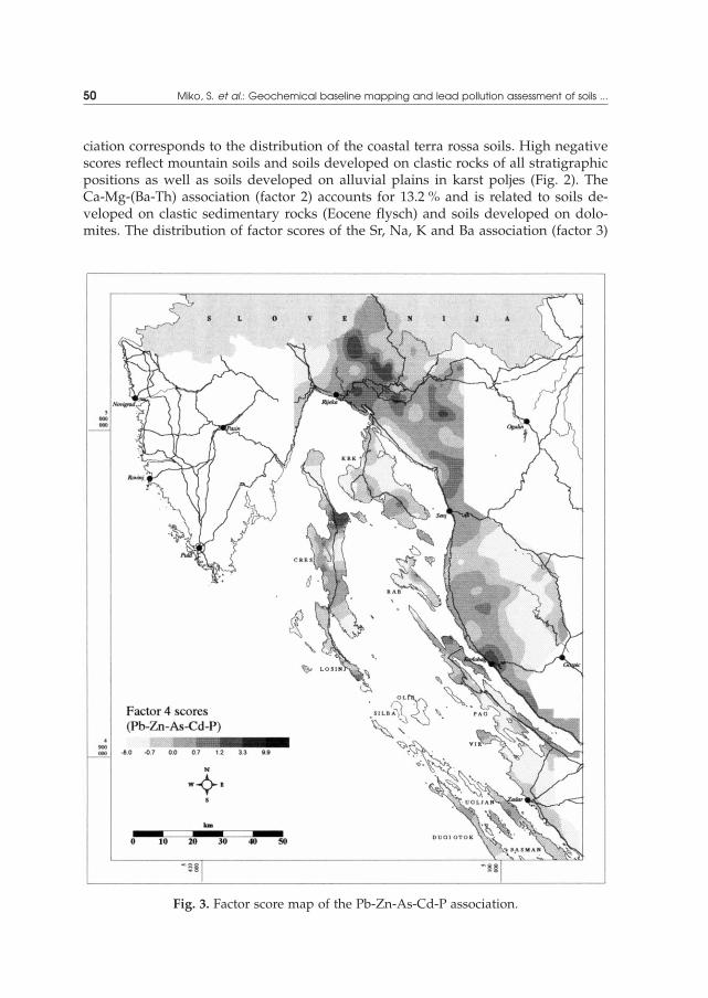
Fig. 3. Factor score map of the Pb-Zn-As-Cd-P association.

is indicative of low bedrock permeability and in general corresponds with higherpositive score values for the less permeable bedrock (Paleozoic clastic rocks and Eo-cene flysch rocks, dolomites). This factor accounts for 8.7 % of total data variability.
Factor 4 is highly loaded with the air-borne Pb-Zn-As-Cd-P association of ele-ments. This association accounts for 14.5 % of the total data variability. A geogenesource of high concentrations for this association of elements is excluded since acarbonate bedrock with low content of trace elements could not contribute consid-erably to soils through weathering processes. The soils developed on carbonaterocks can be considered to be, in a sense, transported overburden since they are de-veloped from various types of parent materials transported on carbonate terrain bydifferent mechanisms (DURN et al., 1999). The spatial distribution of factor 4 scoresshows (Fig. 3) the highest positive values in the mountain region (Risnjak NationalPark) northwest of the industrial port of Rijeka and this pattern, less pronounced,follows the climatic boundary along the coastal mountain chain of Velebit to thesoutheast. High positive values are also found in the area of the town of Karlobag,which was the only gateway for southern Dalmatia during the Croatian war from1991 to 1995. The area with high factor score values on Cres island is near a wastedisposal site with uncontrolled incineration. The distribution pattern of the Pb-Zn-As-Cd-P association of elements in topsoils on the regional scale generally shows atrend towards higher positive scores at higher altitudes of the coastal mountainarea of western Croatia. This association of elements with their pollution effectsand geographical distribution corresponds to the situation in other mountainous re-gions of central Europe, where the resulting atmospheric inputs to soil are attrib-uted to long range transport and the effect of acid deposition (e.g., FÖRSTNER, 1995;WILSON & BELL, 1996; MATSCHULLAT & BOZAU, 1996). There is no intention of usingthe data obtained to evaluate the amount of pollution that can be attributed tosources outside Western Croatia (Italy) since there is plenty of evidence that a(large) part of the pollution can be attributed to local sources. Namely, approxi-mately 50 km to the southwest of the national park there is the coal fired Plominelectric power plant which fired a local high sulfur (average 12 %) coal for morethan 20 years, as well as the oil refineries and other polluting industries in Rijeka.
The highest measured concentration of Pb within the boundaries of Risnjak Na-tional Park was 139 ppm in a brown soil at the altitude of 1390 m above sea level.The distribution of Pb in the national park and Western Croatia is presented in Fig4. The geochemistry of Istria is excluded from this discussion since it was presentedin detail in papers by PROHI] et al. (1997), ZUPAN^I^ & PIRC (1999) and MIKO et al.(1999). The distribution of lead, as stressed before, shows that the soils of thismountain region have been considerably affected by airborne pollution and the av-erage total Pb content is twice the regional average (Tab. 1.). Other elements attrib-uted to atmospheric pollution show a less pronounced increase in concentration.Concentrations of As are 25 percent higher than the regional average, Zn and Cdapproximately 15 %, and the average P content does not differ from the regionalaverage (Tab. 1.). To evaluate the relative intensity of Pb pollution in the region, theenrichment factors were calculated for each individual sample on the basis of 86reference samples from Mljet island. The results are presented in Tab. 3. and the
Nat. Croat. Vol. 9(1), 2000 51
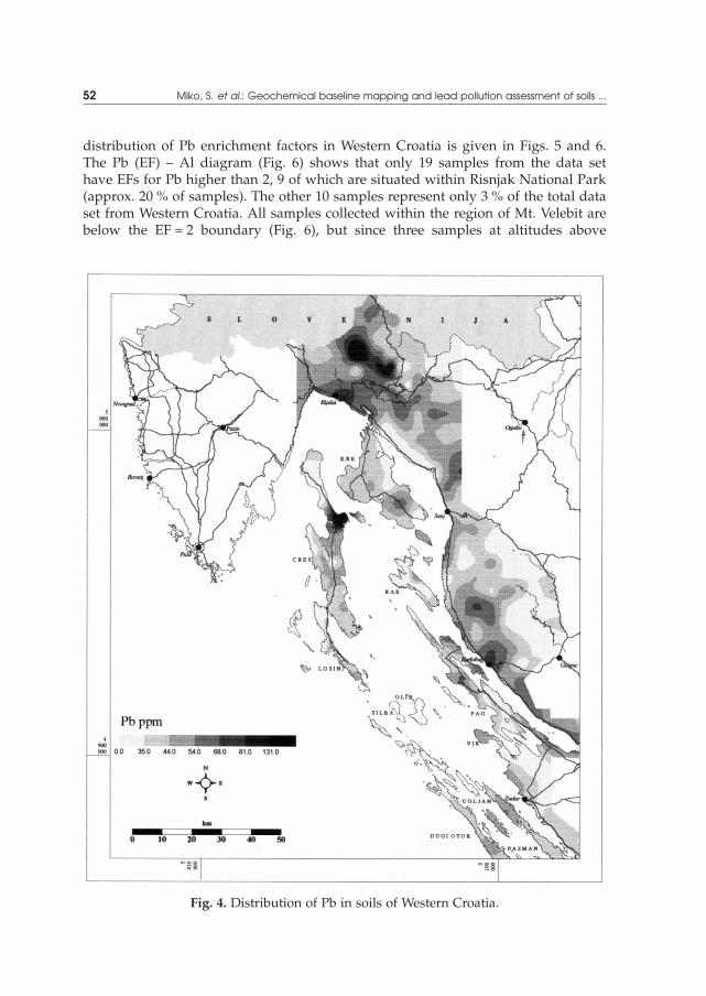
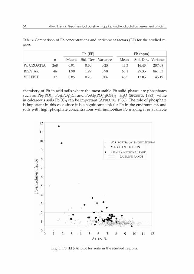
distribution of Pb enrichment factors in Western Croatia is given in Figs. 5 and 6.The Pb (EF) – Al diagram (Fig. 6) shows that only 19 samples from the data sethave EFs for Pb higher than 2, 9 of which are situated within Risnjak National Park(approx. 20 % of samples). The other 10 samples represent only 3 % of the total dataset from Western Croatia. All samples collected within the region of Mt. Velebit arebelow the EF = 2 boundary (Fig. 6), but since three samples at altitudes above
52 Miko, S. et al.: Geochemical baseline mapping and lead pollution assessment of soils ...
Fig. 4. Distribution of Pb in soils of Western Croatia.

1000 m (Fig. 5) show a slight enrichment (EF = 1.7), a possible airborne Pb contribu-tion should not be excluded. The distribution of the Pb enrichment factor also givesthe sharpest outline of Pb pollution in the Risnjak National Park area (Fig. 5).
The correlation between Pb and Zn on one side and altitude on the other is ex-pressed by moderate correlation coefficients of 0.54 and 0.42 (Tab. 4.), respectively.The observed high correlation of Pb with P (Fig. 7) is in accordance with the geo-
Nat. Croat. Vol. 9(1), 2000 53
Fig. 5. Distribution of the Pb enrichment factor.
chemistry of Pb in acid soils where the most stable Pb solid phases are phosphatessuch as Pb3(PO)4, Pb5(PO4)3Cl and PbAl3(PO4)2(OH)5 H2O (SPOSITO, 1983), whilein calcareous soils PbCO3 can be important (ADRIANO, 1986). The role of phosphateis important in this case since it is a significant sink for Pb in the environment, andsoils with high phosphate concentrations will immobilize Pb making it unavailable
54 Miko, S. et al.: Geochemical baseline mapping and lead pollution assessment of soils ...
Tab. 3. Comparison of Pb concentrations and enrichment factors (EF) for the studied re-gion.
Pb (EF) Pb (ppm)
n Means Std. Dev. Variance Means Std. Dev. Variance
W. CROATIA 268 0.91 0.50 0.25 43.3 16.43 287.08
RISNJAK 46 1.90 1.99 3.98 68.1 29.35 861.53
VELEBIT 37 0.85 0.26 0.06 46.5 12.05 145.19
Fig. 6. Pb (EF)-Al plot for soils in the studied regions.

in the soil solution (ADRIANO, 1986). The dependence of altitude and Pb topsoilconcentrations, plotted as mean values of lead concentrations at different altitudelevel ranges for the region, best illustrates this relationship (Fig. 8). The high con-centrations of Pb at lower altitudes are a consequence of pollution along the localroads that run along the coast. Acid rain fallout considerably contributes to the in-digenous soil acidity, producing carbonic acid in soil solution as a consequence of
Nat. Croat. Vol. 9(1), 2000 55
Tab. 4. Correlation coefficients for topsoil geochemical data of Risnjak National Parkand neighboring terrain (area corresponds to that presented on the geological map inFig. 1, n = 117).
Altitude Cu Pb Zn As Cd P
Altitude 1.00
Cu –0.03 1.00
Pb 0.54 0.38 1.00
Zn 0.42 0.59 0.68 1.00
As 0.15 0.43 0.48 0.51 1.00
Cd 0.12 0.60 0.71 0.72 0.50 1.00
P –0.06 0.44 0.59 0.55 0.36 0.63 1.00
Regression
95% confid.
Correlation: r = 0,69
0
20
40
60
80
100
120
140
160
0,02 0,04 0,06 0,08 0,10 0,12 0,14 0,16 0,18 0,20
Pb
pp
m(t
ot)
Fig. 7. Dependence of Pb and P in the analyzed soils.
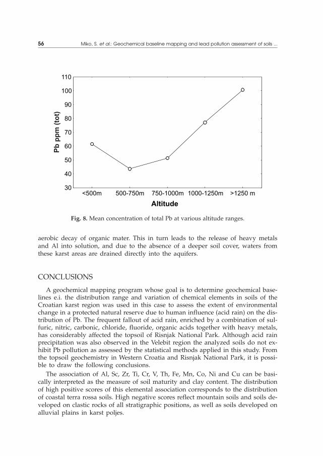
aerobic decay of organic mater. This in turn leads to the release of heavy metalsand Al into solution, and due to the absence of a deeper soil cover, waters fromthese karst areas are drained directly into the aquifers.
CONCLUSIONS
A geochemical mapping program whose goal is to determine geochemical base-lines e.i. the distribution range and variation of chemical elements in soils of theCroatian karst region was used in this case to assess the extent of environmentalchange in a protected natural reserve due to human influence (acid rain) on the dis-tribution of Pb. The frequent fallout of acid rain, enriched by a combination of sul-furic, nitric, carbonic, chloride, fluoride, organic acids together with heavy metals,has considerably affected the topsoil of Risnjak National Park. Although acid rainprecipitation was also observed in the Velebit region the analyzed soils do not ex-hibit Pb pollution as assessed by the statistical methods applied in this study. Fromthe topsoil geochemistry in Western Croatia and Risnjak National Park, it is possi-ble to draw the following conclusions.
The association of Al, Sc, Zr, Ti, Cr, V, Th, Fe, Mn, Co, Ni and Cu can be basi-cally interpreted as the measure of soil maturity and clay content. The distributionof high positive scores of this elemental association corresponds to the distributionof coastal terra rossa soils. High negative scores reflect mountain soils and soils de-veloped on clastic rocks of all stratigraphic positions, as well as soils developed onalluvial plains in karst poljes.
56 Miko, S. et al.: Geochemical baseline mapping and lead pollution assessment of soils ...
30
40
50
60
70
80
90
100
110
<500m 500-750m 750-1000m 1000-1250m >1250 m
Pb
pp
m(t
ot)
Fig. 8. Mean concentration of total Pb at various altitude ranges.
The spatial distribution pattern of the air-borne Pb-Zn-As-Cd-P association ofelements is generally controlled by the abrupt climatic boundary that occurs alongthe Western Croatian coastal mountain range. Soil pollution in higher altitudemountain regions is analogous to the acid deposition observed in Central Europe.
The effect of probably both long-range and local transport of airborne pollution onthe region of Risnjak National Park can be seen in the concentrations of Pb and As,and to a lesser extent of Cd and Zn. Total Pb concentrations detected at latitudeshigher than 1050 m above sea level in the national park were higher than 80 ppm(max. conc. 139 ppm Pb) while the regional mean Pb concentration is 43 ppm.
The calculated enrichment factors for Pb show that only 19 samples from thedata set have EFs higher than 2, 9 of which are situated within Risnjak NationalPark (approx. 20 % of samples). The other 10 samples represent only 3 % of the to-tal data set from Western Croatia. All samples collected within the region of Mt. Ve-lebit are below the EF = 2 boundary (Fig. 6) and therefore the region can be consid-ered to be subject to a smaller atmospheric pollution impact. Three samples thatshow a slight increase in Pb EF (approximately 1.7) could indicate possible airbornePb contribution in this region also.
ACKNOWLEDGMENTS
This study was funded by the Ministry of Science and Technology, Republic ofCroatia project # 01810106, »The basic geochemical map of the Republic of Croatia«.
Received November 2, 1999
REFERENCES
ADRIANO, D. C., 1986: Trace Elements in the Terrestrial Environment. Springer-Verlag, Berlin,Heidelberg, 533 pp.
ANTONI], O., 1996: Application of the spatial modelling in the Karst Bioclimatology. Cro. Met.J. 31, 95–102.
ANTONI], O., KU[AN, V. & HRA[OVEC, B., 1997: Microclimatic and topoclimatic differences be-tween the phytocoenoses in the 'Viljska ponikva' sinkhole, Mt. Risnjak, Croatia. Cro. Met.J. 32, 37–49.
DAVIS, J. C., 1986: Statistics and data analysis in geology. New York, John Wiley & Sons, 646pp.
DILLON, W. R. & GOLDSTEIN, M., 1984: Multivariate analysis: Methods and applications. NewYork, John Wiley & Sons, 575 pp.
DURN, G., OTTNER, F. & SLOVENEC, D., 1999: Mineralogical and geochemical indicators of thepolygenetic nature of terra rossa in Istria, Croatia. Geoderma, 91, 125–150.
FÖRSTNER, U., 1995: Land contamination by metals – global scope and magnitude of problem.In: ALLEN, H. E., HUANG, C. P., BAILY, G. W., BOWERS, A. R., (Eds), Metal speciation andcontamination of soil. CRC Press, 358 pp.
FÖRSTNER, U. & WITTMANN, G. T. W., 1981: Metal Pollution in the Aquatic Environment,Springer-Verlag, Berlin, Heidelberg, New York, 486 p.
Nat. Croat. Vol. 9(1), 2000 57

GLAVA^, V., KOENIES, H. & PRPI], B., 1987: Zur Imissionsbelastung der industriefernen Bu-chen- und Buchen-Tannenwälder in den Dinarischen Gebirgen Nordwest – jugoslawiens.Verhandlungen d. Ges. f. Ökologie, 15. Jahrestagung in Graz 1985, Band XV, 237–247.
GOLCHERT, B., LANDSBERGER, S. & HOPKE, P. K. 1991: Determination of heavy metals in theRock River (Illinois) through the analysis of sediments, Jour, Radioanal. Nucl. Chemistry –Art., 148, 2, 319–337.
HASSAN, F. S. M. & ISMAIL, S. S. 1993: Use of geologically biased enrichment factors (Ef) as in-dicators of natural air pollutants. J. Radioanal. Nucl. Chem., – Art., 167, 2, 237–246.
LANTZY, R. J. & MACKENZIE, F. T., 1979: Atmospheric trace metals: global cycles and assess-ment of man’s impact. Geochim. Cosmochim. Acta. 43, 511–525.
LI, Y-H., 1981: Geochemical cycles of elements and human perturbation. Geochim. Cosmo-chim. Acta, 45, 2073–2084.
KUBIN, E. & LIPPO, H., 1996: Atmospheric heavy metal deposition in Finland from 1985 to1990. Appl. Geochem. 11, 155–161.
MARTINOVI], J., VRANKOVI], A. & PERNAR, N., 1994: The soils of the national park Risnjak (inCroatian). In Extended Abstracts Book »40 Years of the national park Risnjak, 1953–1993«,Crni Lug, 131–136.
MATSCHULLAT, J. & BOZAU, E., 1996: Atmospheric element input in the Eastern Ore Mountains.Appl. Geochem. 11, 149–154.
MIKO, S., DURN, G. & PROHI], E., 1999: Evaluation of terra rossa geochemical baselines fromCroatian karst regions. J. Geochem. Explor., 66, 173–182.
PAND@I], K., 1989: Factor analysis of the local climatic fields within global stream (PhD Dis-sertation). University of Zagreb, Faculty of Natural Sciences, Croatia.
PEH, Z. & MIKO, S., 1999: The geochemical atlas of Middle and Southern Dalmatia. Open filereport (in Croatian), Institute of geology, Zagreb, 102 pp.
PIRC, S. & MAKSIMOVI], Z., 1985: Methodology for geochemical mapping in Yugoslavia. In FirstInternat. Symp. Geoch. and Health, Thornton I. ed. Northwood: Science reviews, 31–44.
PIRC, S., MCNEAL, M. J., LENAR^I^, T., PROHI], E. & SVRKOTA, R., 1991: Geochemical mappingof carbonate terrain. Bull. Inst. Mettal. Min., Applied Earth Sci. Vol. 100, B–74-B- 83.
PROHI], E., MIKO, S. & PEH, Z., 1995: Normalization and trace element contamination of soilsin a karstic polje-an example from the Sinjsko Polje, Croatia. Geol. Croatica, 48(1), 67–86.
PROHI], E., HAUSBERGER, G. & DAVIS, J. C., 1997: Geochemical patterns in soils of the karst re-gion, Croatia. J. Geochem. Explor. 60, 127–138.
PROHI], E., PEH, Z. & MIKO, S., 1998: Geochemical charecterization of karst polje – an examplefrom Sinjsko polje, Croatia. Environmental Geology 33(4), p 263–273.
PRPI], B., 1987: Decline of forest trees in Croatia with the special emphasis on the load of 'Go-rski kotar' area with the acid rain and heavy metals (in Croatian with English abstract).[umarski list ,1–2, 53–60.
PRPI], B., SELETKOVI], Z. & IVKOV, M., 1991: Forest decline in Croatia and its relation to the bi-otical and abiotical factors today and in the past (in Croatian with English abstract).[umarski list, 3–5, 107–129.
ROBINSON, E., 1984: Dispersion and fate of atmospheric pollutants. In: TRESHOW M. (ed.):Air pollution and plant life. J. Wiley, Chicester, 15–37.
SPOSITO, G., 1983: The chemical forms of trace elements in soils. In: THORTON, I., (ed): Ap-plied environmental geochemistry, Academic Press, Toronto, 123–167.
VRBEK, B. & GA[PARAC, M., 1992: New findings of heavy metals input in National park 'Ris-njak' (in Croatian with English abstract). Radovi [umarskog instituta 27(1), 65–75.
WILSON, M. J. & BELL, N., 1996: Acid deposition and heavy metal mobilization. Appl. Geo-chem. 11, 133–137.
58 Miko, S. et al.: Geochemical baseline mapping and lead pollution assessment of soils ...

WINDOM, H., SCHROPP, S., CALDER, F., RYAN, J., SMITH, R. Jr., BURNEY, L. LEWIS, F. & RAWLISON,C., 1989: Natural trace metal concentrations in estuarine and coastal marine sediments ofthe southeastern U.S., Environ. Sci. Technol., 23(3), 314–320.
ZUPAN^I^, N. & PIRC, S. 1999: Calcium distribution in soils and stream sediments in Istria(Croatia) and the Slovenian littoral. J. Geochem. Explor. 65, 205–218.
S A @ E TA K
Geokemijsko kartiranje i procjena one~i{}enja olovom talana kr{u zapadne Hrvatske
S. Miko, Z. Peh, D. Bukovec, E. Prohi} & @. Kastmüller
Istaknut polo`aj Nacionalnog parka »Risnjak« i za{ti}enog podru~ja Velebita nageomorfolo{koj granici izme|u obalnog pojasa i planinskog zale|a ima za poslje-dicu one~i{}enje povr{inskog sloja tla. Sve ~e{}a pojava kiselih ki{a oboga}enihkombinacijom anorganskih i organskih kiselina uz povi{en sadr`aj te{kih metalaprijeti ozbiljim o{te}enjem biljnog pokriva~a. Premda su kisele ki{e primije}ene i napodru~ju Velebita, analize tla provedene u okviru izrade geokemijske baze poda-taka za podru~je ~itave zemlje ne pokazuju takvo zaga|enje te{kim metalima, po-glavito olovom, kao u Nacionalnom parku »Risnjak«, {to se mo`e zaklju~iti na os-novi statisti~kih metoda kori{tenih u ovom radu.
Rezultati faktorske analize navode na zaklju~ak da se Al-Sc-Zr-Ti-Cr-V-Th-Fe-Mn-Co-Ni-Cu asocijacija elemenata (prvi faktor) mo`e protuma~iti kao mjera zre-losti tla, odnosno sadr`aja glinovite komponente. Visoke pozitivne faktorske vrijed-nosti ovog faktora koincidiraju s rasprostranjeno{}u obalnih crvenica na karbonat-noj podlozi, dok visoke negativne vrijednosti upu}uju na planinska tla koja su serazvila na klasti~nim stijenama, ali i na tla nastala na aluvijalnim naplavinamakr{kih polja.
Prostorna raspodjela atmofilne Pb-Zn-As-Cd-P asocijacije elemenata op}enito jeu izravnoj vezi s o{trom klimatskom granicom koja se pru`a grebenom priobalnogplaninskog lanca sjeverozapadne Hrvatske. Zaga|enost tla u vi{im planinskim po-dru~jima analogna je pojavi zakiseljavanja u sredi{njoj Europi. Vjerojatan utjecajudaljenog, ali i lokalnog donosa atmosferskih ~estica u podru~je Risnjaka odra`avase u povi{enim koncentracijama Pb i As, a u manjoj mjeri Cd i Zn. Maksimalne uk-upne kocentracije Pb u Nacionalnom parku, na visinama iznad 1050 m nadmorskevisine, vi{e su od 80 ppm (max = 139 ppm) dok su regionalne vrijednosti koncen-tracija Pb, prema Osnovnoj geokemijskoj karti RH, oko 43 ppm.
U podru~ju Nacionalnog parka »Risnjak« pribli`no 20 % uzoraka ima EF vrijed-nost za Pb vi{u od 2 (EF > 2), {to se mo`e smatrati kao zaga|enje, dok ~itavo po-dru~je zapadne Hrvatske (osim Istre) ima manje od 3 % olovom oboga}enih uzo-raka. Svi uzorci s podru~ja Velebita imaju vrijednost EF za olovo unutar podru~jageokemijskog {uma (EF < 2) pa se mo`e smatrati da je utjecaj atmosferskog za-ga|enja u tom podru~ju manje izra`en.
Nat. Croat. Vol. 9(1), 2000 59