geo-social tagging as a creative way to communicate
TRANSCRIPT

ISSN: 1978 - 8282
Vol.6 No.3 - Mei 2013
GEO-SOCIAL TAGGING AS A CREATIVE WAY TOCOMMUNICATE
STORIES ON GEOGRAPHIES
Elisa Bonacini1
e-mail: [email protected]
Diterima : 21 April 2012 / Disetujui : 19 April 2013
ABSTRACT
The aim of this paper is to show how the evolution of ICTs in the field of digital culturalparticipation has helped turn geo-social tagging into a new form of creation of culturalvalue through user-generated contents (UGC). In order to demonstrate the potential ofthese digital tools, we will base our study on some examples of geotagging and geo-socialblogs, in Italy and abroad. Tagging a place is giving that place a story: this means beingable to write digital stories on geographies. Tagging a place enables us to rediscover ourterritory in a new and shared way, creating forms of real social tagging and urban digitalstorytelling.
Keywords: geo-social tagging, geoblogs, real social tagging, urban digital storytelling,stories on geographies, geo-wiki, user generated content, digital culture, digital cultureparticipation, digital collective memory, cultural value.
INTRODUCTION
The exponential evolution of digital content creation has led to a real cultural revolution,where ICTs have become increasingly dominant. So much so that L. Manovich (Manovich2008, Manovich 2011) defines contemporary society as a software society, whose culturaloutput is what he calls a software culture. In this software culture there are specific culturalprocesses (creating, distributing, receiving and sharing both information and knowledge),which are mediated by dedicated digital tools, software or applications. These processes arebriefly described below based on the contribution of the author:
• software programs that allow users to create, share and make accessible culturalcontents that contain digital representations, ideas and aesthetic values (e.g., programs
251
1. Menempuh pendidikan di University of CataniaPiazza Università 16, 95124 Catania (ITALY)

ISSN: 1978 - 8282
Vol.6 No.3 - Mei 2013252
that allow users to publish documents and, as such, must be defined as media softwares,like Microsoft Word, Powerpoint, Photoshop, Illustrator, Firefox, Internet Explorer,Blogger, etc..);• software programs that provide interactive cultural experiences (from PC games toplatforms like Second Life, all of which offer three-dimensional reconstructions thatyou can “experience” in virtual life);• software programs that allow users to create and share information and knowledgeonline, for example, programs that facilitate open access participation to Wikipedia orgeotagging social platforms (adding places on Google Earth with Google My Maps,on geo-social networks such as InstaMapper, Foursquare, Google places, Facebookplaces or Gowalla, all of which provide new ways of reading and understanding ofplaces, but also on georeferenced blogs, i.e. geoblogs);• software featuring communication tools such as text, voice and/or video (e.g., e-mail,instant messaging, posts or pokes on other users’ “walls” or profiles, chat, voice/video chat...);• software programs that allow users to be part of a kind of on-line “information ecology”,forms of social bookmarking through which digital contents can rank higher in websearches based on how many people are sharing and liking it (for example, when usersclick the +1 on Google + or Like on Facebook). According to Manovich: <Theexponential explosion of the number of people who are creating and sharing mediacontent, the mind-boggling numbers of photos and videos they upload, the ease withwhich these photos and videos move between people, devices, web sites, and blogs,the wider availability of faster networks - all these factors contribute to a whole new“media ecology”> (Manovich 2008);• software built to help develop other programs able to support all these activities.
We can then agree with Bastos (2010) when she states that technology has created<an umbrella of art forms that use emergent media, platforms and digital tools. Examples are2D or 3D computer designs called digital imaging, digital photography, sculpture, digitalinstallations and virtual realities, Net Art (meaning internet art, also called web-art), performance,sound art and electronic music, digital animation and video, software, databases, interactivesystems, projections and game art>.
In this software culture, geo-social blogs (or geoblogs) and geo-social networks areamong the latest innovations to redefine the world of digital communication and culturalactivities, especially when we consider user-generated cultural content (UGC). These trendswere already discussed in a previous work (Bonacini 2011), but we will describe them infurther detail here.
Geoblogging could be described as a way to write stories on geographies, an interfacethat allows registered users to leave a comment or add an event related to a specific place(referred to as geotagging a place). These posts are displayed on a map, where they can beread by simply clicking on the location.Geoblogging is also widely used as a tool to improve land-use planning and environmentalmonitoring, as well as data dissemination and sharing through GIS technology. In fact, geoblogsare often used for Development Planning, Zoning and Urban Planning (in Italy, Sardinia’sRegional and Urban Planning is currently being tested).
Geo-social networks use geographical services such as geocoding and geotagging toillustrate the social dynamics of a city. They create new digital maps that are fluid and alwayssynchronized. These real-time living maps of the city allow for a quick, almost immediate,exchange of geo-social information (Schuch Brunet & Freire, 2010) and can be understood as<a contemporary merger between a classical digital territory map and a dynamic localized

ISSN: 1978 - 8282
Vol.6 No.3 - Mei 2013 253
flows representation producing a new kind of visual information where places, people,activities, and time are mixed together> (Aguiton, et at. 2009).
Although they work in different ways, both geoblogs and geo-social networks enablesimilar forms of geo-social tagging that help transfer the social benefits of participation,connection and interaction into the city’s geography. This creates what has been defined asGeography 2.0 or Neogeography, a form of informational geography voluntarily created byusers: <free, easy to use, and yet potentially very powerful in terms of its impact ongeographical information sciences, social sciences, and its capacity to encourage a newpartnership between professionals, lay practitioners, and the wider public> (Hudson-Smith,et al. 2009).
Another type of digital cultural activity that could be described as neogeographywould be adding places to Google Earth via the Google My Maps application. In fact, accordingto Faber (2009) the geo-social tagging revolution can be attributed to the introduction, inearly 2005, of Google My Maps, an application inside Google Maps: <the Google My Map(GMM) application allows users to add digital content (text, video, paths, shapes, photos) toa satellite-imaged map of Earth, creating a personalized and annotated mashup that can beshared online with anyone in the world>. You can choose to keep your own maps private oryou can publish or export them to Google Earth.
This process could be described as crowdsourcing1 since it brings togethergeoreferenced information and experiences from different sources by allowing <multiple usersfrom across geographical regions to collaborate on a single map, effectively allowing you toharness collective intelligence through crowd-sourcing - many voices contributing to onedataset based on their own localized knowledge and experiences> (Faber 2009).
There are many programs designed to create custom maps based both on GoogleMaps and geographical crowdsourcing: for example, GMap Creator and MapTube, bothcreated by the Centre for Advanced Spatial Analysis (CASA) at the University College London(Hudson-Smith, et al . 2009). There are also open source geographical projects, that are freeand collaborative: for example, OpenStreetMap (www.openstreetmap.org: fig. 1) and Wikimapia(http://wikimapia.org: fig. 2), a kind of geographical wiki based on Google Maps and linked toWikipedia pages.
Fig. 1. OpenStreetMap.

ISSN: 1978 - 8282
Vol.6 No.3 - Mei 2013254
Fig. 2. Wikimapia.
Stories on geographies: geotagging social, social tagging and urban real digital story telling
The geo-social blogs that are presented here work in similar ways, with some slightdifferences. They usually feature maps from Google Maps, on which users can see the postswritten and shared by other users (messages, news, commentaries, emotions, advertisinginformation), thereby creating what has been defined as real social tagging, i.e. a network oflabelled content spread all over a digital area that is actually and emotionally experienced byits citizens (hence the term “real”). This is a new form of interaction between society, geographyand technology, described by some as a form of urban digital storytelling (Levialdi Ghiron,et al. 2009) that allows people to create a digital territory, where they can store digital memories:<there is no forgetting, no memory loss in “Digital Territory”> (van Kranenburg, 2008).Along the lines of Google My Map, in November 2006 the Museum of London launched MapMy London (www.mylondonmap.com: fig. 3), a geo-website where Londoners could entertheir “memorable London moments onto a large interactive digital map” (this is the website’stag line).
Fig. 3. MyLondonMap.

ISSN: 1978 - 8282
Vol.6 No.3 - Mei 2013 255
There are a few examples of geoblogs in Italy.
Mappa Emozionale dei Luoghi della Memoria Antifascista a Torino (Emotional Mapof Anti-Fascist Memory in Turin: http://acmos.net/memoria/: fig. 4) is a geoblog set up byPerforming Media Lab during the “2006 Winter Universiade” at the Multi-site Museum ofResistance, Deportation, War, Human Rights and Freedom of the city of Turin. Although thisproject is no longer active, it was a remarkable example of the combined use of two differenttechnologies, namely QR codes and geo-social tagging, and two different communicationplatforms (internet and mobile phones). The combined use of geoblogging and matrix codesmade it easier to reach younger generations, who are used to these types of digital languagesand technologies. In this way, the Museum was able to effectively share contents related toWorld War II, the Resistance movement and the Holocaust with youths who do not have adirect connection with that period of history. A number of historical landmarks around the citywere accessible through the Museum’s website (www.museodiffusotorino.it), which featuredan interactive localization map for “places of remembrance”, developed by the official City ofTurin website, within an experimental urban geo-wiki called MappaTo (fig. 5). At the sametime, QR codes were displayed around these landmarks in order to turn the “real” visit aroundthe city into a digital experience of decoding interactive data (textual or audio-visual culturalcontents) using a smartphone. In both cases, visitors (actual or virtual) could express theirfeelings or reactions by leaving messages related to the different locations or digital contents.Messages were automatically linked to the geoblog Emotional Map of Anti-Fascist Memoryin Turin, where they could be shared with other users and visitors, thereby creating a form ofreal social tagging.
Performing Rome (www.geoblog.it/performingroma: fig. 6) and Urban Experience(www.geoblog.it: fig. 7) are two geoblogs which can be used to track events or informationabout Rome through user-generated posts (as well as multimedia contents) that are displayedon a Google Map. Users can post their written or audiovisual diaries and describe specificlocations through their subjective stories. This interaction develops a new relationshipbetween networks and physical locations, it creates new ways to look at the territory: from theground, through the actions and memories of users (rather than from above, through the eyeof the satellites).
Fig. 4. Emotional Map of Anti-Fascist Memory in Turin.

ISSN: 1978 - 8282
Vol.6 No.3 - Mei 2013256
Fig. 5. Emotional Map of Anti-Fascist Memory in Turin on MappaTo.
Fig. 6. Performing Roma.
Fig. 7. Urban Experience - Roma.

ISSN: 1978 - 8282
Vol.6 No.3 - Mei 2013 257
Percorsi Emotivi (Emotional Pathways: http://percorsi-emotivi.com/: Fig. 8) is aBologna-based geoblog, created in 2008 by a research team at the Laboratory for Urban Mapsat the Gramsci Institute Foundation Emilia-Romagna. Born from the desire to analyzequalitatively Bologna’s inhabitants’ perception of their own city, Percorsi Emotivi has becomea real “call for tales”, a digital container of impressions, feelings and emotions that peopleexperience when walking the streets of Bologna. This project is a qualitative analysis and, assuch, it has no real statistical value, but it is a great way to illustrate the many ways in whichpeople experience the city. As evidenced in Fig. 8, posts submitted by users are color-codedbased on their topic (What you remember, What we are, What we would like, What youdiscovered, What you love, What you fear, What else). The selected post in Figure 8, forexample, was written by a girl who associates this place to the memory of her first kiss.
In the section I luoghi della memoria (Memory places), Percorsi Emotivi offers thegeolocation of specific historical moments, while the section Guerra in città (War in the city)is dedicated to historical landmarks of the Second World War (Fig. 9). Finally, La Certosa is asection that highlights the most important moments of the history of the cemetery of Certosa(Fig. 10).
Fig. 8. Percorsi Emotivi - All the emotions - Bologna.

ISSN: 1978 - 8282
Vol.6 No.3 - Mei 2013258
Fig. 9. Percorsi Emotivi - War in town - Bologna.
Fig. 10. Percorsi Emotivi - Certosa cemetery - Bologna.
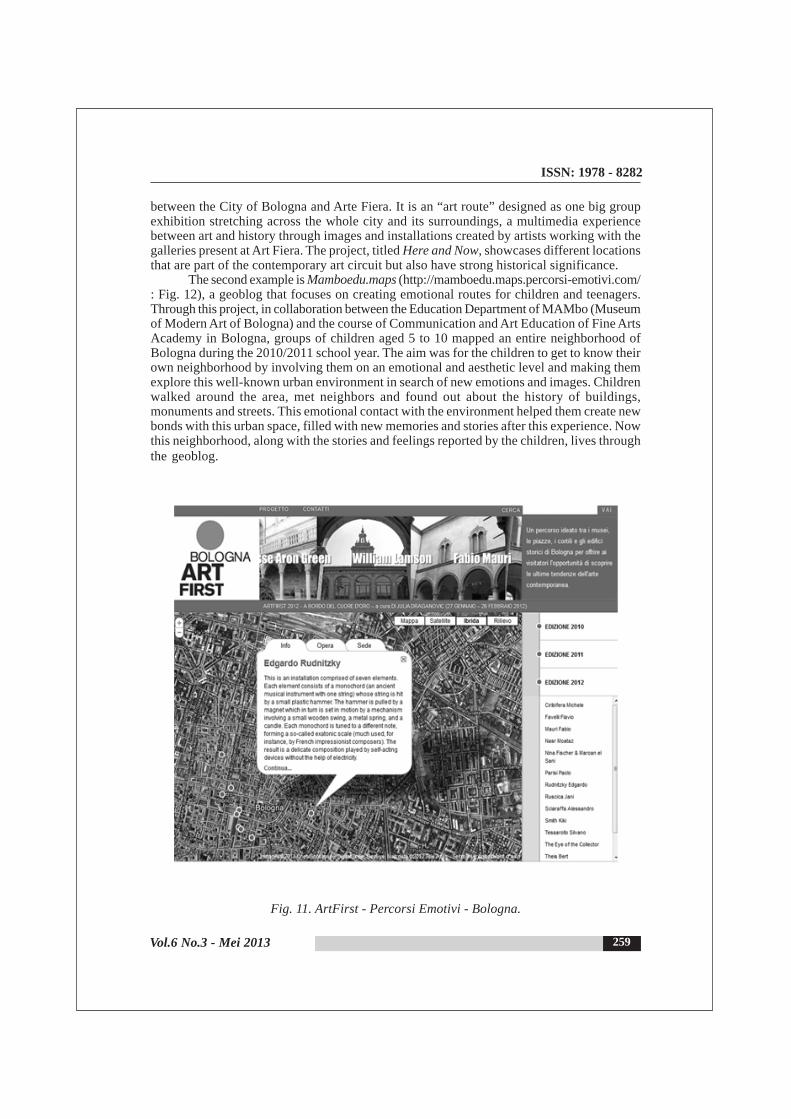
At the bottom of the Percorsi Emotivi homepage, users can find two banners that linkto Bologna’s other geoblogs. The first site is Bologna ArtFirst (http://artfirst.percorsi-emotivi.com/: Fig. 11), a project launched in 2010 (now in its third edition) in collaboration
ISSN: 1978 - 8282
Vol.6 No.3 - Mei 2013 259
between the City of Bologna and Arte Fiera. It is an “art route” designed as one big groupexhibition stretching across the whole city and its surroundings, a multimedia experiencebetween art and history through images and installations created by artists working with thegalleries present at Art Fiera. The project, titled Here and Now, showcases different locationsthat are part of the contemporary art circuit but also have strong historical significance.
The second example is Mamboedu.maps (http://mamboedu.maps.percorsi-emotivi.com/: Fig. 12), a geoblog that focuses on creating emotional routes for children and teenagers.Through this project, in collaboration between the Education Department of MAMbo (Museumof Modern Art of Bologna) and the course of Communication and Art Education of Fine ArtsAcademy in Bologna, groups of children aged 5 to 10 mapped an entire neighborhood ofBologna during the 2010/2011 school year. The aim was for the children to get to know theirown neighborhood by involving them on an emotional and aesthetic level and making themexplore this well-known urban environment in search of new emotions and images. Childrenwalked around the area, met neighbors and found out about the history of buildings,monuments and streets. This emotional contact with the environment helped them create newbonds with this urban space, filled with new memories and stories after this experience. Nowthis neighborhood, along with the stories and feelings reported by the children, lives throughthe geoblog.
Fig. 11. ArtFirst - Percorsi Emotivi - Bologna.

ISSN: 1978 - 8282
Vol.6 No.3 - Mei 2013260
Fig. 12. MAMboedu.map - Percorsi Emotivi - Bologna.
Based on the experience of the emotional geoblog created in Turin and within aneCulture project (eContent Award Italy 2007), Performing Media Lab has created a sort of “bigEuropean multi-site museum” of Fascism and Holocaust Remembrance in Europe with a geoblogentitled StoriesOnGeographies. A European participatory geoblog of memory (http://storiesongeographies.eu/: Fig. 13). The aim of this project is to preserve European socialmemory over time with the use of new technologies and it is achieved through an open accessgeoblog that distinguishes contents posted in three categories: Museums Entries,Associations Entries and Users Entries. Each item included on the map of Europe can becommented on by other users.
Fig. 13. StoriesOnGeographies.

ISSN: 1978 - 8282
Vol.6 No.3 - Mei 2013 261
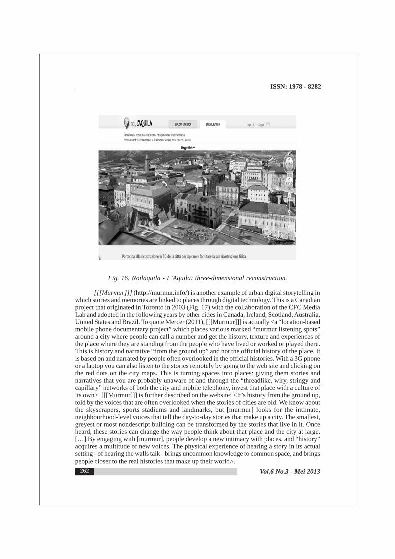
Much more complex is the project for a three-dimensional reconstruction of the historiccenter of L’Aquila, devastated after the April 2009 earthquake and never rebuilt. TitledComefacciamo (How do we do this?) the project was launched by a British architect with thehelp of Google and the use of Google SketchUp software. ComeFacciamo is connected withthe geo-website noilaquila.it (We L’Aquila: www.noilaquila.com/: Fig. 14-15), launched inJune 2011 to promote the three-dimensional virtual reconstruction of the city of L’Aquila (Fig.16) through the use of images or videos of the city, along with former residents’ memories. Themotto of the portal is “Sharing memory to rebuild the future”. Memories, video and photos areprovided and shared by users with the sole purpose of preserving, at least digitally, thememory of L’Aquila and its significant artistic and cultural heritage through a kind of urbandigital storytelling. This idea is a pilot project that Google intends to make available to allcommunities affected by natural disasters in the world (Japan, for example, is already amongthe first countries to have implemented it).
Fig. 14. Noilaquila - UGC on the map of L’Aquila.
Fig. 15. Noilaquila - Duomo’s post seen on Google Street View.
ISSN: 1978 - 8282
Vol.6 No.3 - Mei 2013262
Fig. 16. Noilaquila - L’Aquila: three-dimensional reconstruction.
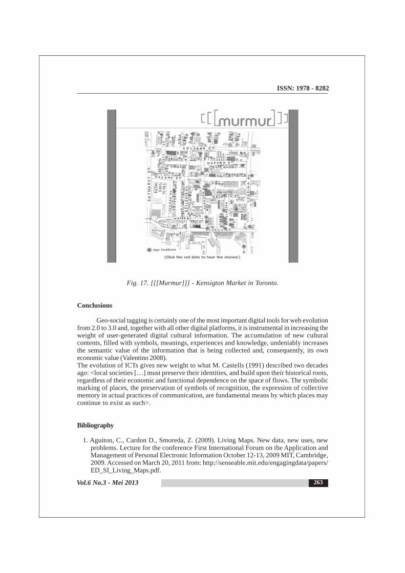
[[[Murmur]]] (http://murmur.info/) is another example of urban digital storytelling inwhich stories and memories are linked to places through digital technology. This is a Canadianproject that originated in Toronto in 2003 (Fig. 17) with the collaboration of the CFC MediaLab and adopted in the following years by other cities in Canada, Ireland, Scotland, Australia,United States and Brazil. To quote Mercer (2011), [[[Murmur]]] is actually <a “location-basedmobile phone documentary project” which places various marked “murmur listening spots”around a city where people can call a number and get the history, texture and experiences ofthe place where they are standing from the people who have lived or worked or played there.This is history and narrative “from the ground up” and not the official history of the place. Itis based on and narrated by people often overlooked in the official histories. With a 3G phoneor a laptop you can also listen to the stories remotely by going to the web site and clicking onthe red dots on the city maps. This is turning spaces into places: giving them stories andnarratives that you are probably unaware of and through the “threadlike, wiry, stringy andcapillary” networks of both the city and mobile telephony, invest that place with a culture ofits own>. [[[Murmur]]] is further described on the website: <It’s history from the ground up,told by the voices that are often overlooked when the stories of cities are old. We know aboutthe skyscrapers, sports stadiums and landmarks, but [murmur] looks for the intimate,neighbourhood-level voices that tell the day-to-day stories that make up a city. The smallest,greyest or most nondescript building can be transformed by the stories that live in it. Onceheard, these stories can change the way people think about that place and the city at large.[…] By engaging with [murmur], people develop a new intimacy with places, and “history”acquires a multitude of new voices. The physical experience of hearing a story in its actualsetting - of hearing the walls talk - brings uncommon knowledge to common space, and bringspeople closer to the real histories that make up their world>.
ISSN: 1978 - 8282
Vol.6 No.3 - Mei 2013 263
Fig. 17. [[[Murmur]]] - Kensigton Market in Toronto.
Conclusions
Geo-social tagging is certainly one of the most important digital tools for web evolutionfrom 2.0 to 3.0 and, together with all other digital platforms, it is instrumental in increasing theweight of user-generated digital cultural information. The accumulation of new culturalcontents, filled with symbols, meanings, experiences and knowledge, undeniably increasesthe semantic value of the information that is being collected and, consequently, its owneconomic value (Valentino 2008).The evolution of ICTs gives new weight to what M. Castells (1991) described two decadesago: <local societies […] must preserve their identities, and build upon their historical roots,regardless of their economic and functional dependence on the space of flows. The symbolicmarking of places, the preservation of symbols of recognition, the expression of collectivememory in actual practices of communication, are fundamental means by which places maycontinue to exist as such>.
Bibliography
1. Aguiton, C., Cardon D., Smoreda, Z. (2009). Living Maps. New data, new uses, newproblems. Lecture for the conference First International Forum on the Application andManagement of Personal Electronic Information October 12-13, 2009 MIT, Cambridge,2009. Accessed on March 20, 2011 from: http://senseable.mit.edu/engagingdata/papers/ED_SI_Living_Maps.pdf.

ISSN: 1978 - 8282
Vol.6 No.3 - Mei 2013264
2. Bastos, A. (2010). Discovering digital cultural capital in London’s events of art andtechnology: reviewing the last decade, in Seal, A., Bowen, J., Ng, K. (Eds), EVA London2010: Electronic visualisation & the arts. Proocedings of a conference held in London, 6-8 July, London. London: BCS, 1-7.
3. Bonacini, E. (2011). Nuove tecnologie per la fruizione e la valorizzazione del patrimonioculturale. Roma: Aracne Editrice.
4. Castells, M. (1991). The Informational City, Economic Restructuring and UrbanDevelopment. First paperback edition. Oxford: Basil Blackwell.
5. Faber, M. (2009). Google Maps: A Tool for the Youth Media Field. Youth Media Reporter,12 June 2009. Accessed on February 18, 2010 from: http://www.youthmediareporter.org/2009/06/google_maps_a_tool_for_the_you.html.
6. Hudson-Smith, A., Batty, M., Crooks, A., Milton, R. (2009). Mapping for the Masses.Accessing Web 2.0 Through Crowdsourcing. Social Science Computer Review, 4, 524-538.
7. Levialdi Ghiron, S., Medaglia, C. M, Perrone, A. (2009). “Art-sonomy”: Social Bookmarkingof Real Artworks via Mobile Applications with Visual Tags Source. Proceedings of the5th International Conference on Universal Access in Human-Computer Interaction. PartIII: Applications and Services, San Diego: Springer, 373-384.
8. Manovich, L. (2008). Software takes command. Unpublished edition. Accessed on July 7,2011 from: softwarestudies.com/softbook/manovich_softbook_11_20_2008.pdf.
9. Manovich, L. (2011). Cultural Software. July 2011 edition. Accessed on November 12,2011 from: http://www.manovich.net/DOCS/Manoich.Cultural_Software.2011.pdf.
10. Mercer, C. (2011). Culturelinks: cultural networks and cultural policy in the digital age, inCvjetièanin, B (Ed), Networks: The Evolving Aspects of Culture in the 21st Century, 13-15 November 2009, Zagreb (Culturelink Joint Publications Series,15). Zagreb: Institutefor International Relations, 31-44.
11. Schuch Brunet, K., Freire, J. (2010). Cultura ditigal e geolocalização: a arte ante o contextotécnico-político. Comunicação apresentada ao VI ENECULT, Encontro de EstudosMultidisciplinares em cultura, Facom UFB, 25-27 maio 2010, Salvador da Bahia. Accessedon January 19, 2011 from: http://nomada.blogs.com/home/publicaciones.html.
12. Valentino, P. M (2008). L’impatto della “seconda rivoluzione” informatica su cultura eturismo, in Galluzzi, P., Valentino, P. A (Eds), Galassia Web. La cultura nella rete. Firenze:Giunti, XLI-LXIII.
13. van Kranenburg, R. (2008). New realities, new policies?, in Uzelac, A., Cvjeti
14. anin, B (Eds), Digital Culture: The Changing Dynamics, Institute for InternationalRelations (Culturelink Joint Publications Series,12). Zagreb: Institute for InternationalRelations, 25-41.