geo l7 climatology part2 v0.1
DESCRIPTION
IAS geography lectures ny Mrunal patel and his colleagues at SPIPATRANSCRIPT

Climatology

Origin of the atmosphere on the earth
Structure of atmosphereHeat BudgetAlbedoMovement of airStability and instabilityAdiabatic lapse rateTemperature Inversion
Precipitation processes: evaporation- Humidity - condensation-clouds
Types of cloudsTypes of rainfallPressure system of the worldPlanetary wind systemVariable winds

Temperature decreases with increasing height
GHG gas absorb long wave terrestrial radiation – transparent to insolation (short wave radiation)
Heated from terrestrial radiation from earth surface
Troposphere
Structure of Atmosphere
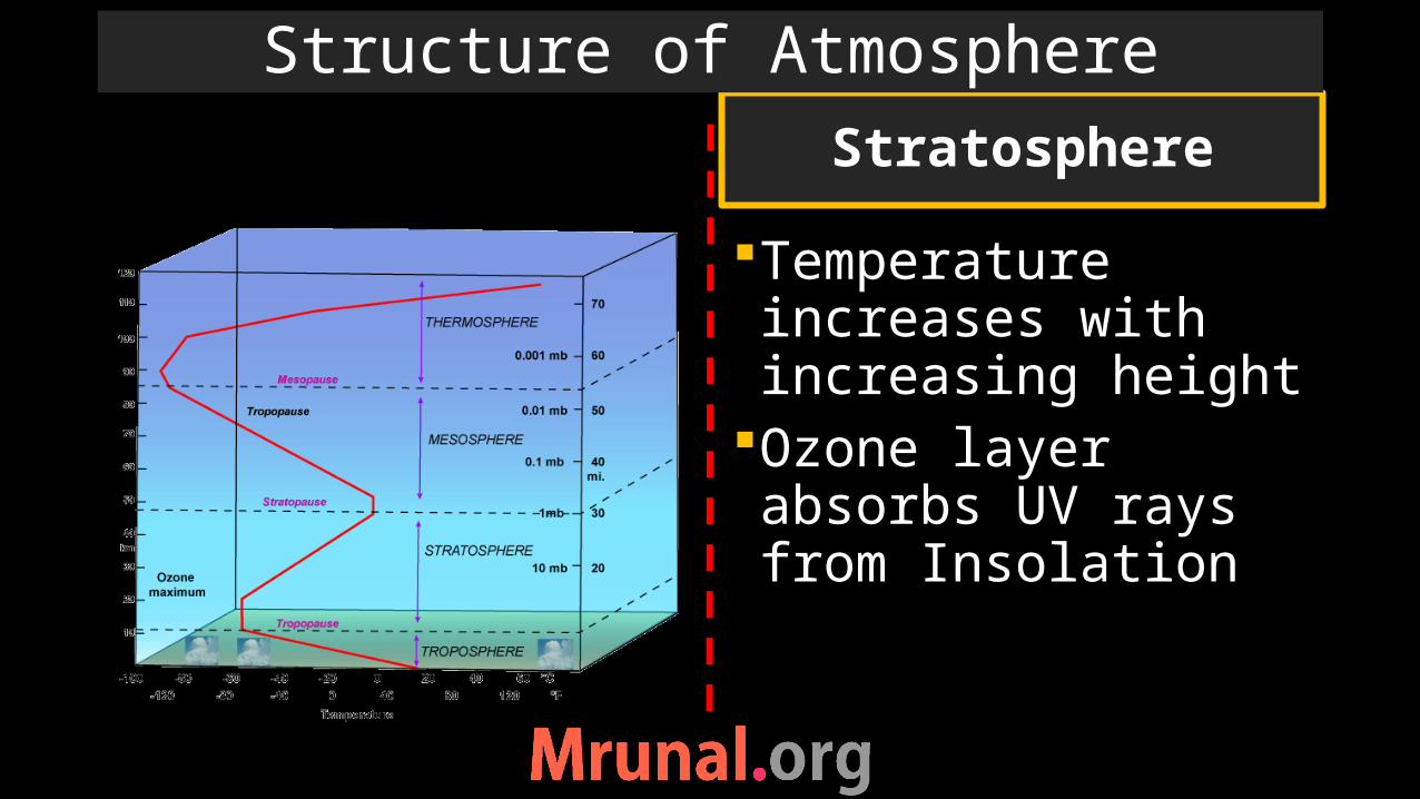
Temperature increases with increasing height
Ozone layer absorbs UV rays from Insolation
Stratosphere
Structure of Atmosphere
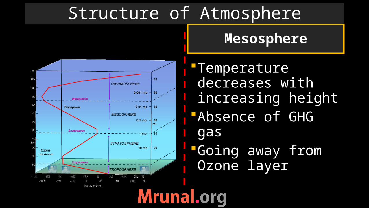
Temperature decreases with increasing height
Absence of GHG gasGoing away from Ozone layer
Mesosphere
Structure of Atmosphere
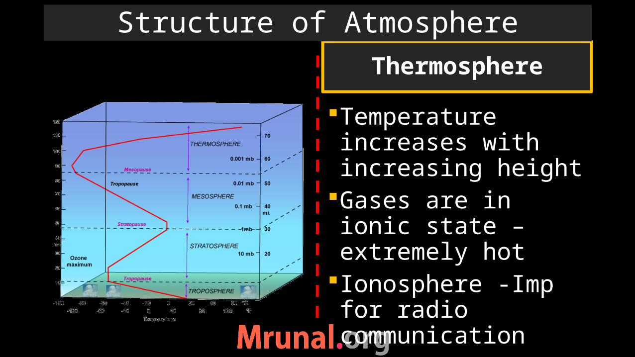
Temperature increases with increasing height
Gases are in ionic state –extremely hot
Ionosphere -Imp for radio communication
Thermosphere
Structure of Atmosphere

Movement of air Adiabatic lapse rate
Basic air movement

Temperature Inversion
Ex. Of Temp Inversion - tropopause
Temperature Inversion
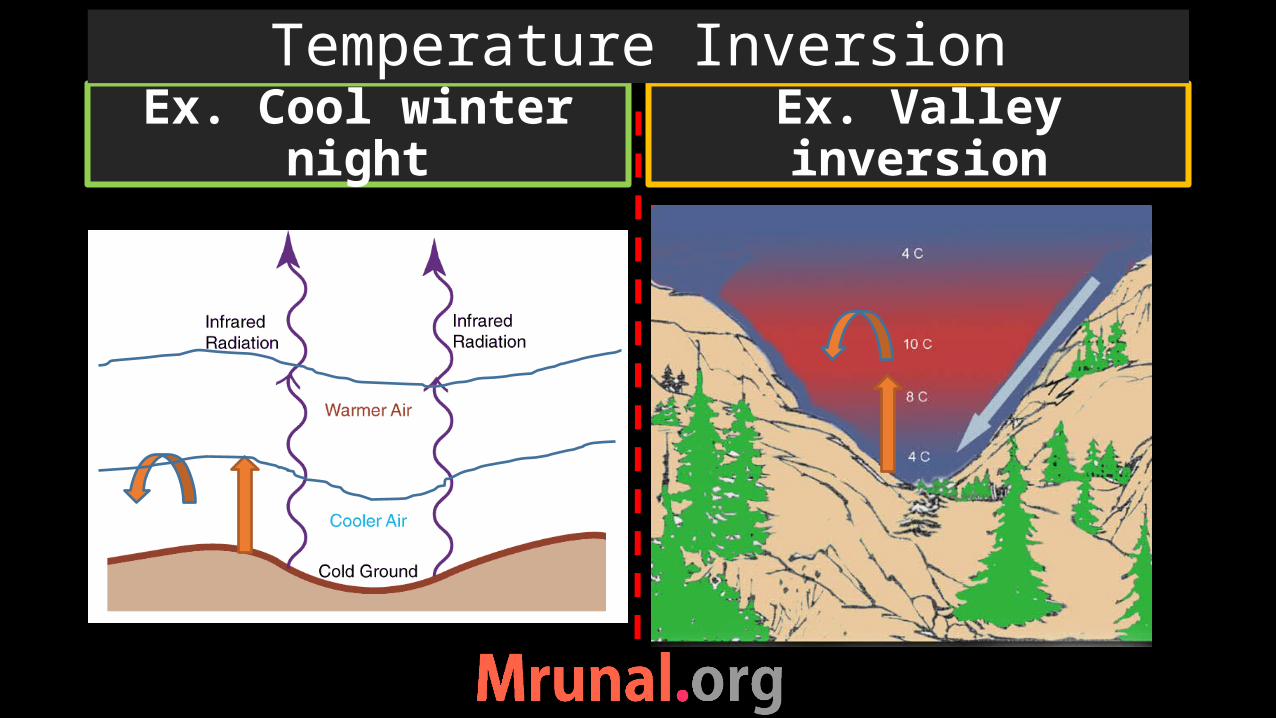
Ex. Cool winter night
Ex. Valley inversion
Temperature Inversion
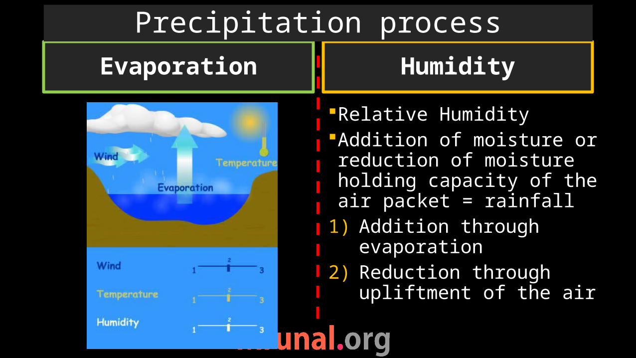
Evaporation
Relative HumidityAddition of moisture or reduction of moisture holding capacity of the air packet = rainfall
1) Addition through evaporation
2) Reduction through upliftment of the air
Humidity
Precipitation process
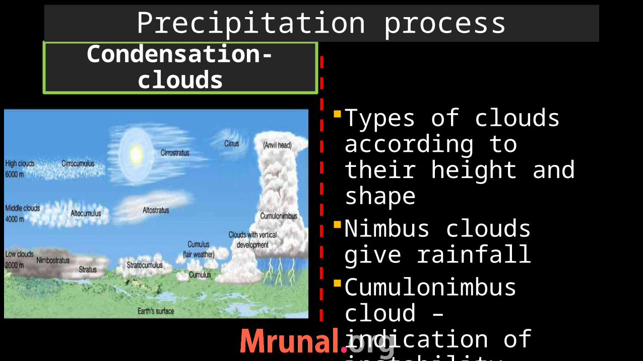
Condensation- clouds
Types of clouds according to their height and shape
Nimbus clouds give rainfall
Cumulonimbus cloud – indication of instability
Cyclonic heavy rainfall
Precipitation process

Convectional rainfall Orographic rainfall
Types of rainfall

Cyclonic rainfall Frontal rainfall
Types of rainfall

Pressure system of the world

High pressure to low pressure
Coriolis force – clockwise in northern hemi and anti-clockwise in southern hemi
Trade windsWesterliesPolar easterlies
Planetary wind system
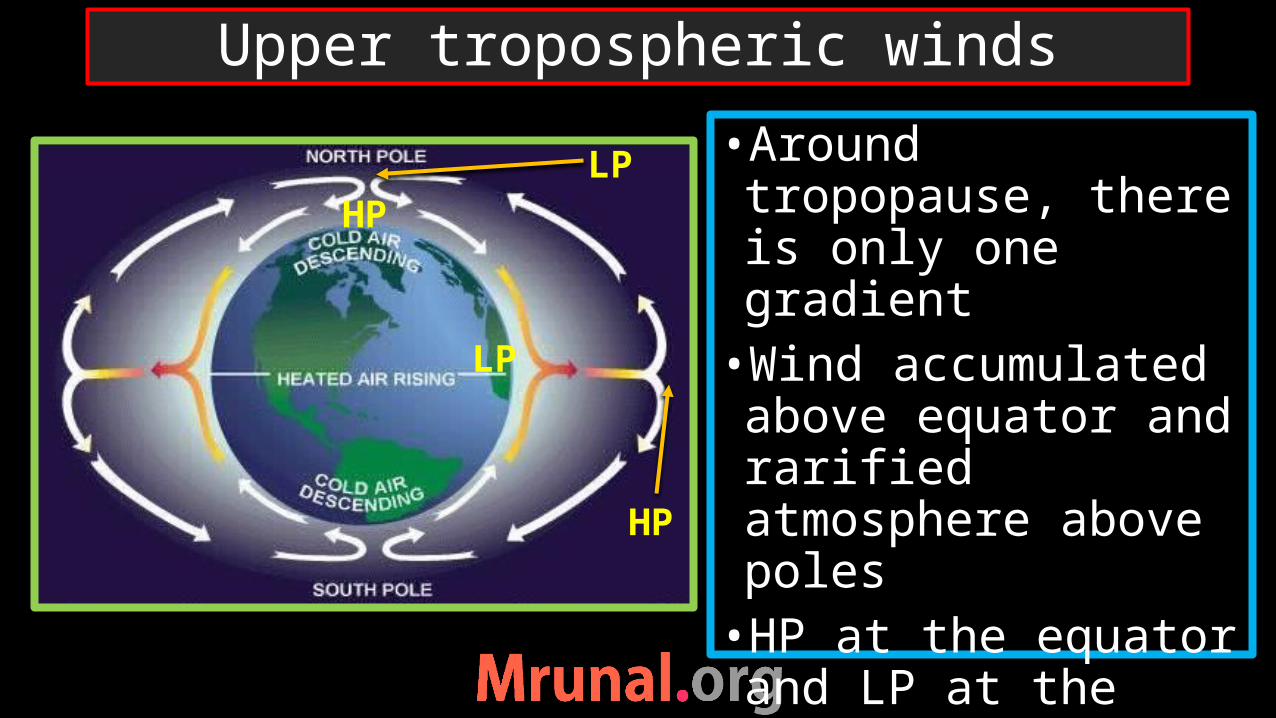
•Around tropopause, there is only one gradient•Wind accumulated above equator and rarified atmosphere above poles•HP at the equator and LP at the poles
Upper tropospheric winds
LP
HP
LP
HP

•strong coriolis force at tropopause•Because friction is less - high speed - stronger the coriolis force•So the deflection is 90 degree•Such winds called geo-strophic winds
Geo-strophic winds
Equator
Poles

•Northern hemisphere
Geostrophic deflect clockwisewest to eastIn southern Hemisphere: Anti-clockwise movementDeflect west to east
Geo-strophic winds
Poles
Poles
Equator HP
LP
LP
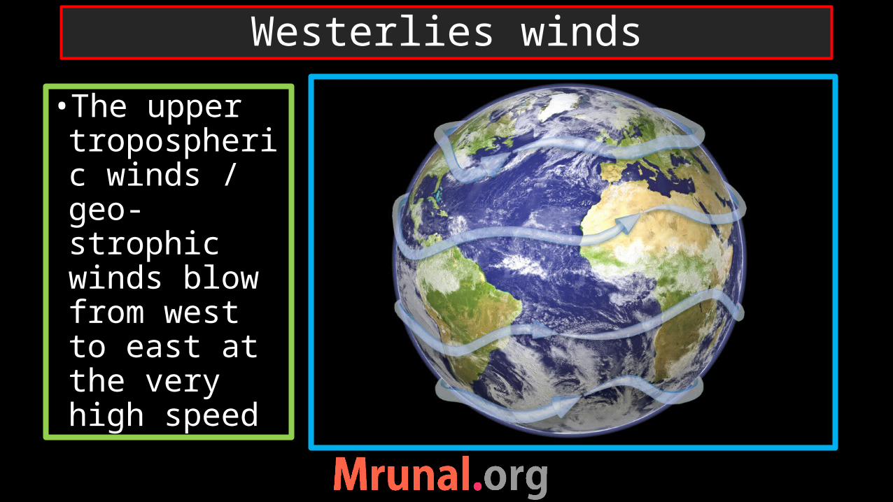
Westerlies winds
•The upper tropospheric winds / geo-strophic winds blow from west to east at the very high speed
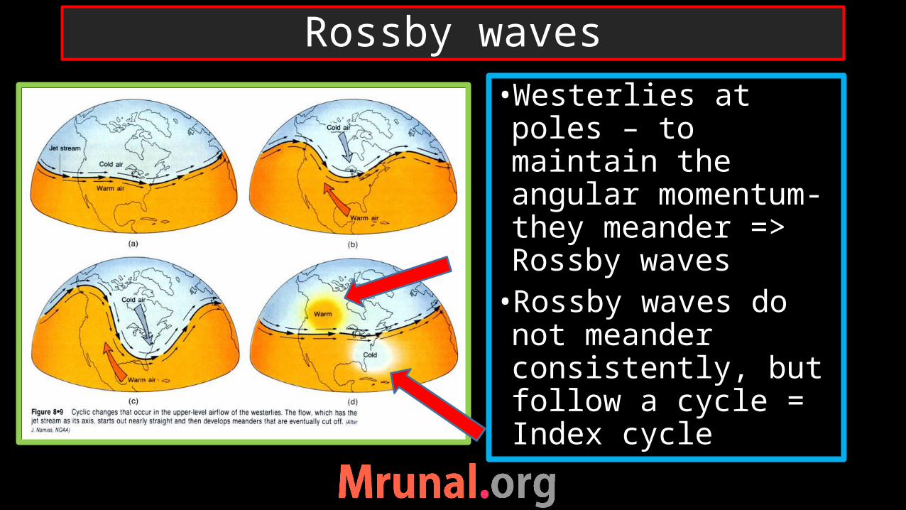
•Westerlies at poles – to maintain the angular momentum- they meander => Rossby waves•Rossby waves do not meander consistently, but follow a cycle = Index cycle
Rossby waves

• In westerlies, there are strong, narrow bands of high speed wind => Jet stream•Speed of Jet stream 300kmph
Jet streams

•There are situated at the margins of meridional cells•4 permanent Jet streams: 2 Polar Jet and 2 Sub-Tropical Westerly Jet STWJ
Jet streams location
STHP Eq. LPSPLPPolar High

Permanent jet stream
Temporary jet stream-TEJ
Jet streams
Tibet plt. LP
Mascerene High
Tropical Easterly Jet
SW Monsoon winds

Somali jet stream/ Findlater Polar-night Jet
Temporary Jet Streams
summerwinter
Polar night Jet stream
Somali Jet stream

• Jet stream embedded in westerlies (Rossby waves) at high latitude, cause pressure variability•That’s why they are called travelling depression
Jet streams
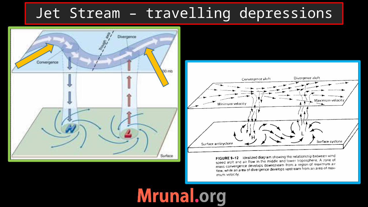
Jet Stream – travelling depressions
Weather of higher latitude is more complex than weather of equatorial or tropical regions
Because tropical and equatorial region are heat surplus region– thermal reasons play the dominant role.
But higher latitude are heat deficit region – dynamic reasons play dominant role
These include – localised + upper-tropospheric circulations (Rossby waves, Jet streams, temperate cyclones)
Weather of Mid and high latitude

Thermally induced
Because of high temperature
Ex. LP at equatorConvectional rainfall at equator
Upliftment of warm air
Ex. LP at sub-polar LP belt
Frontal rainfall
Dynamically induced
Conditions for LP

• Large extensive body of air-mass (1000sqkm)•Height upto Tropopause•At particular height, one air mass will have uniform temperature and moisture across its width•Airmasses can be differentiate according to their temperature and moisture content
Air mass
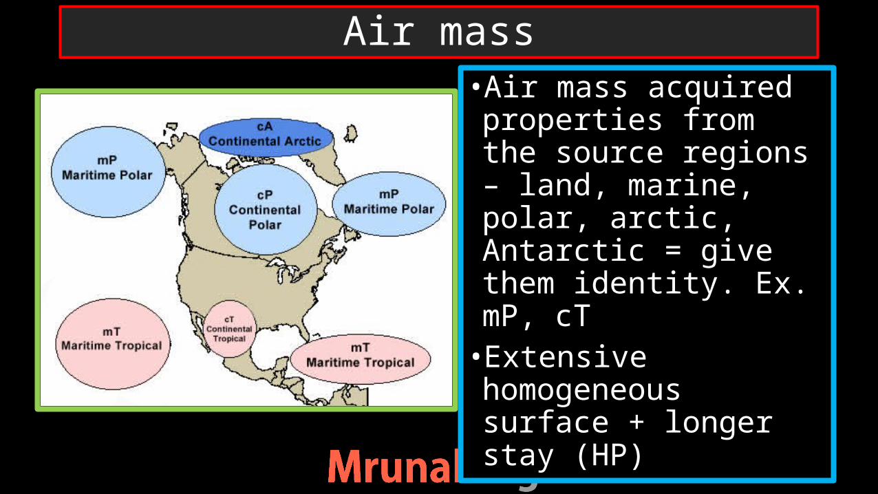
•Air mass acquired properties from the source regions – land, marine, polar, arctic, Antarctic = give them identity. Ex. mP, cT•Extensive homogeneous surface + longer stay (HP)
Air mass

•Air masses do not stay at their source regions forever, they move out. While moving they came across other air masses.
Air masses

•The relative difference between temperature and moisture decide their interaction with one another•The border/ meeting region of the two air-mass => Front
Front
Cold front
Warm front

• If cold air mass move faster than the other than it will lift the warmer one upward => cold front• the slope will be steep = there will be sudden up-liftment of the warm air = cumulonimbus clouds = cyclonic rain
Cold front
Cold air mass

• If warmer air mass is more active than cold front => warm front •slope will be gentler = there won’t be sudden up-liftment of warm air = uniform prolonged rain – drizzle
Warm front

Fronts
Cold front Warm frontCold front
Warm front
Cold air mass
warm air mass
Cool air mass
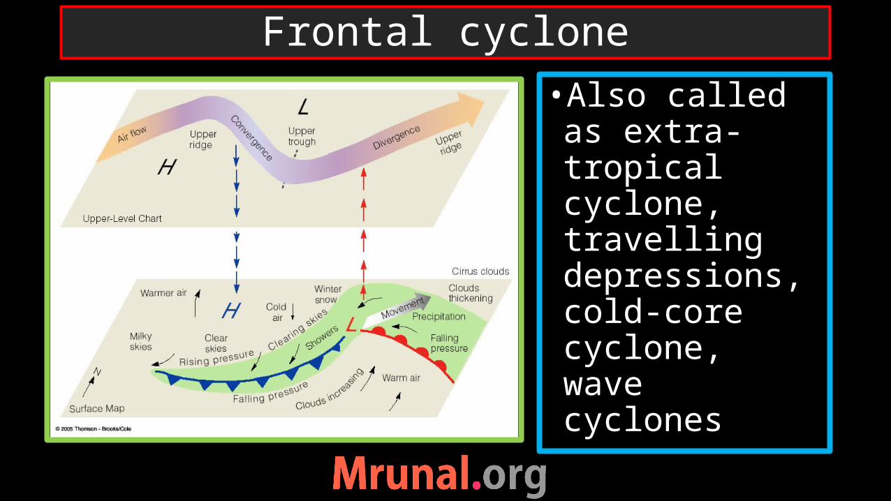
•Also called as extra-tropical cyclone, travelling depressions, cold-core cyclone, wave cyclones
Frontal cyclone

1) Intense LP system2)Air converges
towards the centre3)In Northern
hemisphere convergence – anti-clockwise
4)Closed isobars
Meaning of cyclone
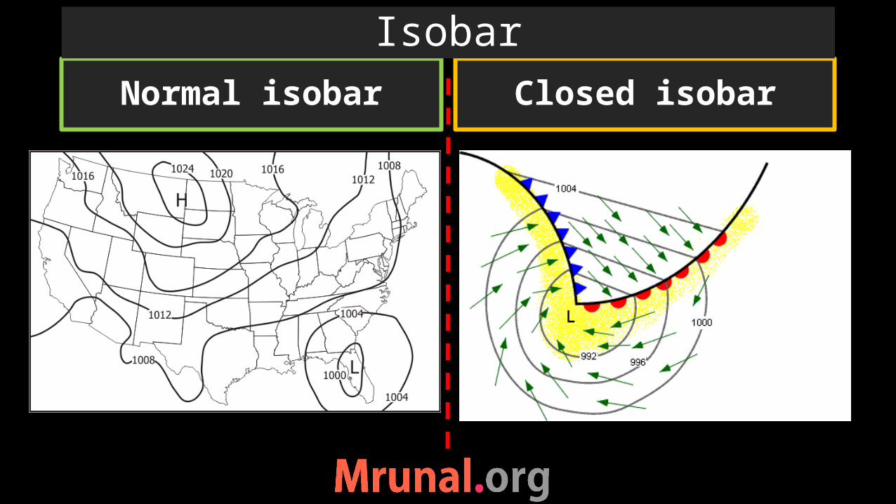
Normal isobar Closed isobar
Isobar

Thermally induced
Because of high temperature
Ex. LP at equatorConvectional rainfall at equator
Upliftment of warm air
Ex. LP at sub-polar LP belt
Frontal rainfall
Dynamically induced
Conditions for LP

•Movement of airmasses from their source region•The warm and cold air mass face each other•A front is created between them •Called Stationary front
Development of Frontal cyclone

Location of air masses Circular movement
Formative stage of frontal cyclone

•Cold air mass pushed the warm air mass•Forced upliftment of warm air mass at the cold front =LP •Two cold air mass convergence – circular due to coriolis force
Development of Frontal cyclone
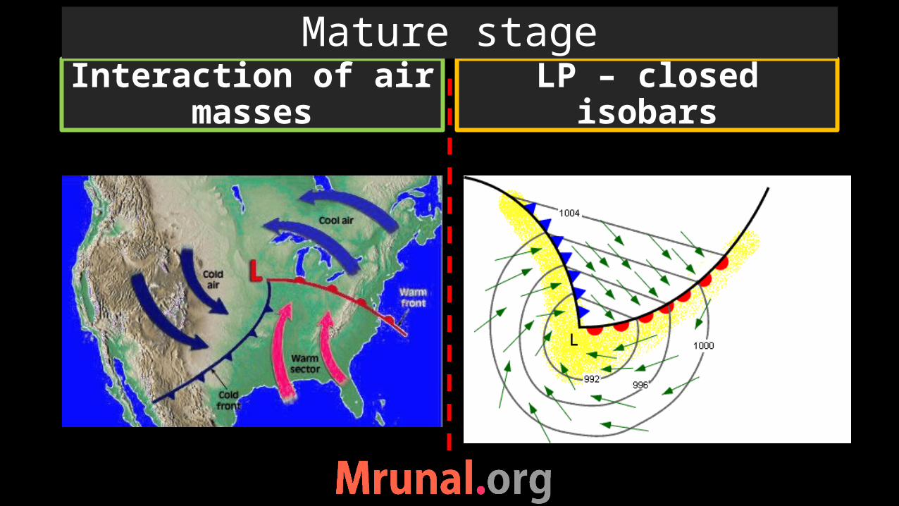
Interaction of air masses LP – closed isobars
Mature stage

• One cold air mass climb over other cold air mass–warm front is destroyed•Called occluded front•Rapid change in temperature and pressure•Unstable weather conditions
Occluded front

•Frontolysis – no great temperature difference between two cold air masses – front dissipated – LP reduced – cyclone dissipated
Dissipation of frontal cyclone

Stationary front Front
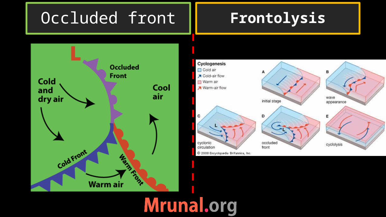
Occluded front Frontolysis

•Always west to east direction•Because influence of the Westerlies •Gradual and predictable movement
Path of the temperate cyclone

Distribution of temperate cyclonesTemperate cyclones
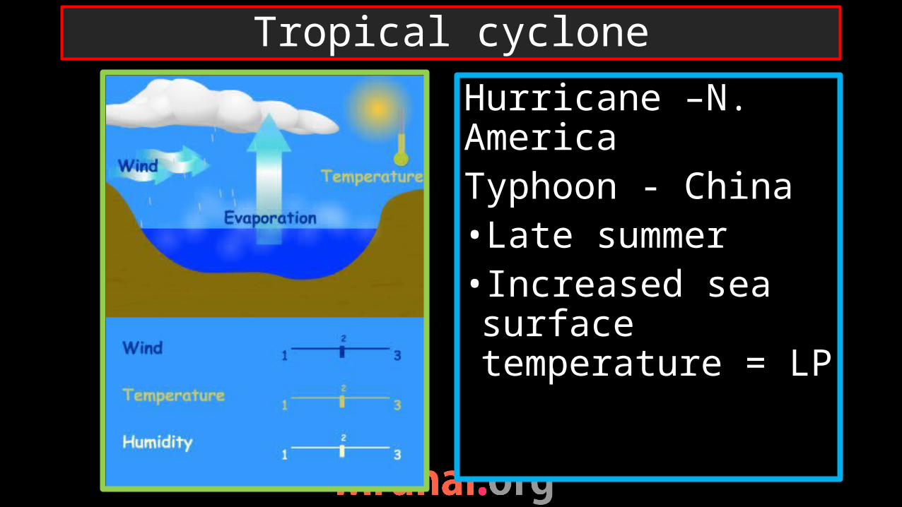
Hurricane –N. AmericaTyphoon - China•Late summer • Increased sea surface temperature = LP
Tropical cyclone

•Convergence of air around LP zone•Rising moist (wet) air => absolute instability•Cloud formation =more and more moisture – latent heat of evaporation => cumulo nimbus cloud => cyclone
Tropical cyclone
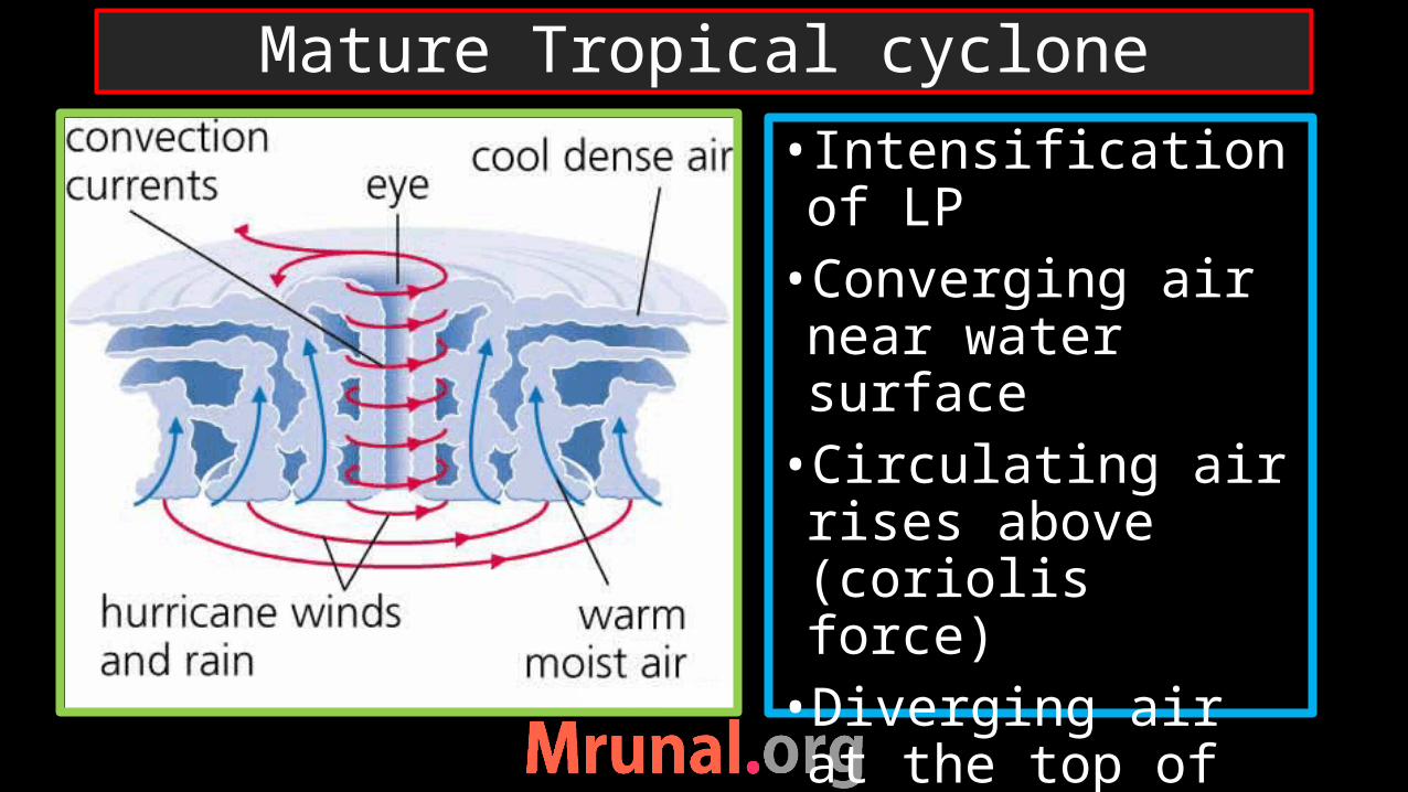
• Intensification of LP•Converging air near water surface•Circulating air rises above (coriolis force)•Diverging air at the top of cyclone
Mature Tropical cyclone
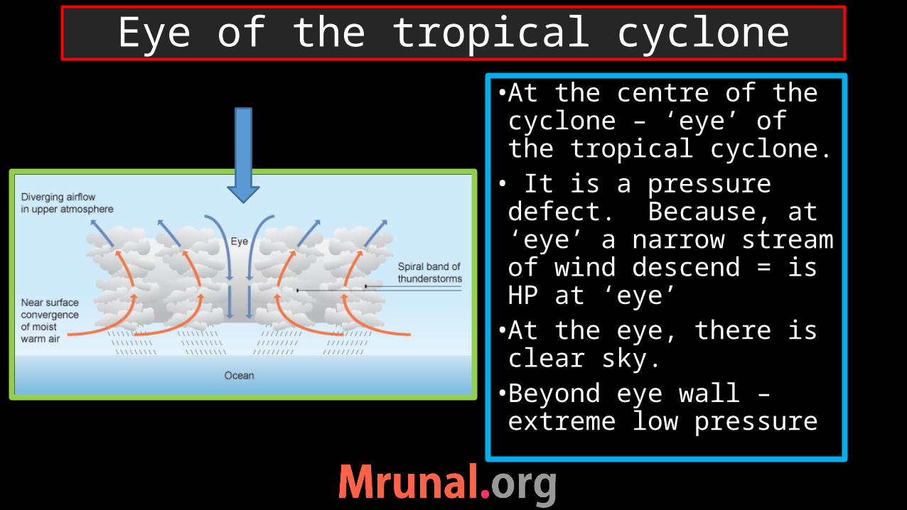
•At the centre of the cyclone – ‘eye’ of the tropical cyclone.• It is a pressure defect. Because, at ‘eye’ a narrow stream of wind descend = is HP at ‘eye’•At the eye, there is clear sky.•Beyond eye wall – extreme low pressure
Eye of the tropical cyclone
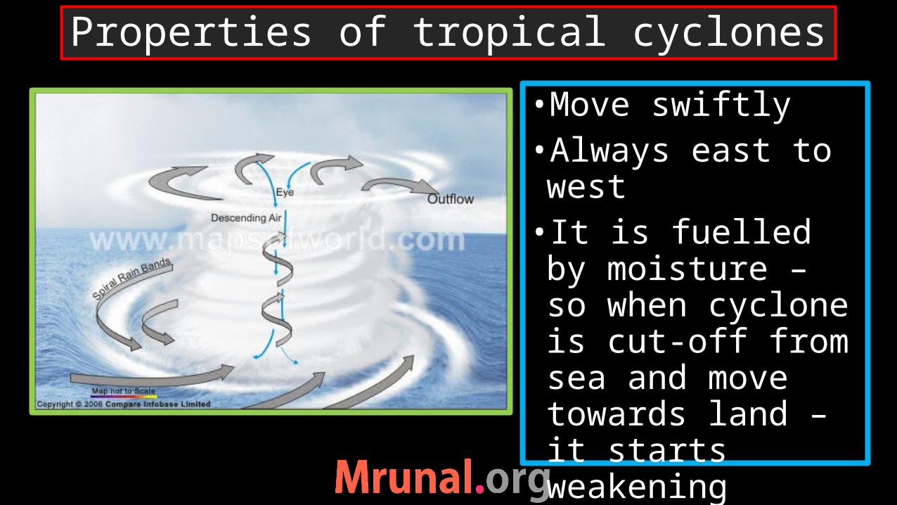
•Move swiftly•Always east to west• It is fuelled by moisture – so when cyclone is cut-off from sea and move towards land – it starts weakening
Properties of tropical cyclones
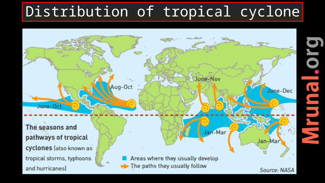
Distribution of tropical cyclone
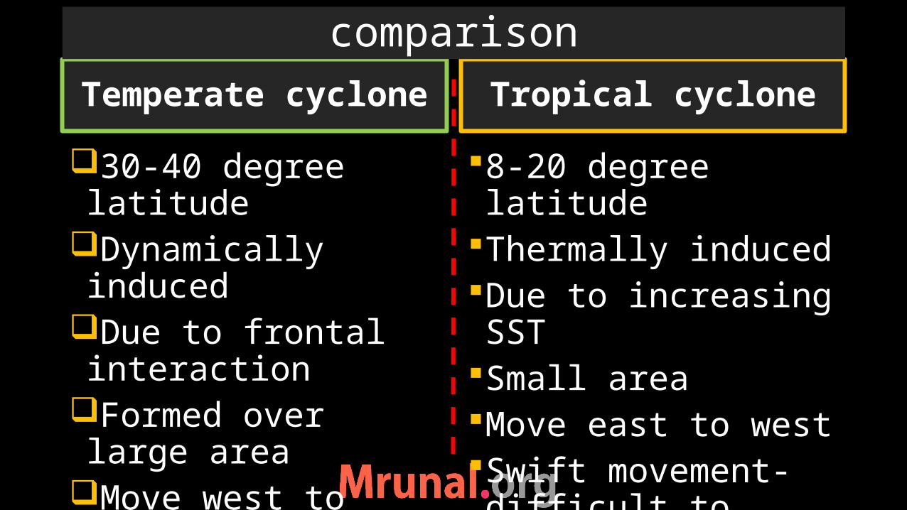
Temperate cyclone
30-40 degree latitude
Dynamically induced
Due to frontal interaction
Formed over large area
Move west to eastGradual movement – predictable
8-20 degree latitudeThermally inducedDue to increasing SST
Small areaMove east to westSwift movement- difficult to predict path
Tropical cyclone
comparison

Temperate cyclone
Wind speed 40-50 kmph
Pressure gradient 980 mb
Powerful on landAffect mainlandMore time to dissipate
Wind speed >120 kmph
Pressure gradient <880 mb
Weakens on landAffect only coastal areas
Quickly dissipate after coming on land
Tropical cyclone
comparison
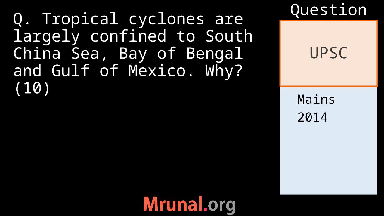
Mains2014
Q. Tropical cyclones are largely confined to South China Sea, Bay of Bengal and Gulf of Mexico. Why? (10)
UPSC
Question

1) Tropical water2) Warm ocean
currents3) Increase SST
in late summer
4) Tropical cyclone move east to west
5) Landmass on western coast
Reason for location of Tropical cyclone
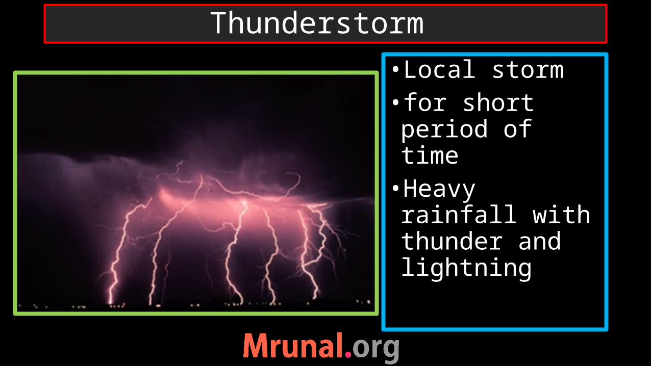
•Local storm • for short period of time•Heavy rainfall with thunder and lightning
Thunderstorm
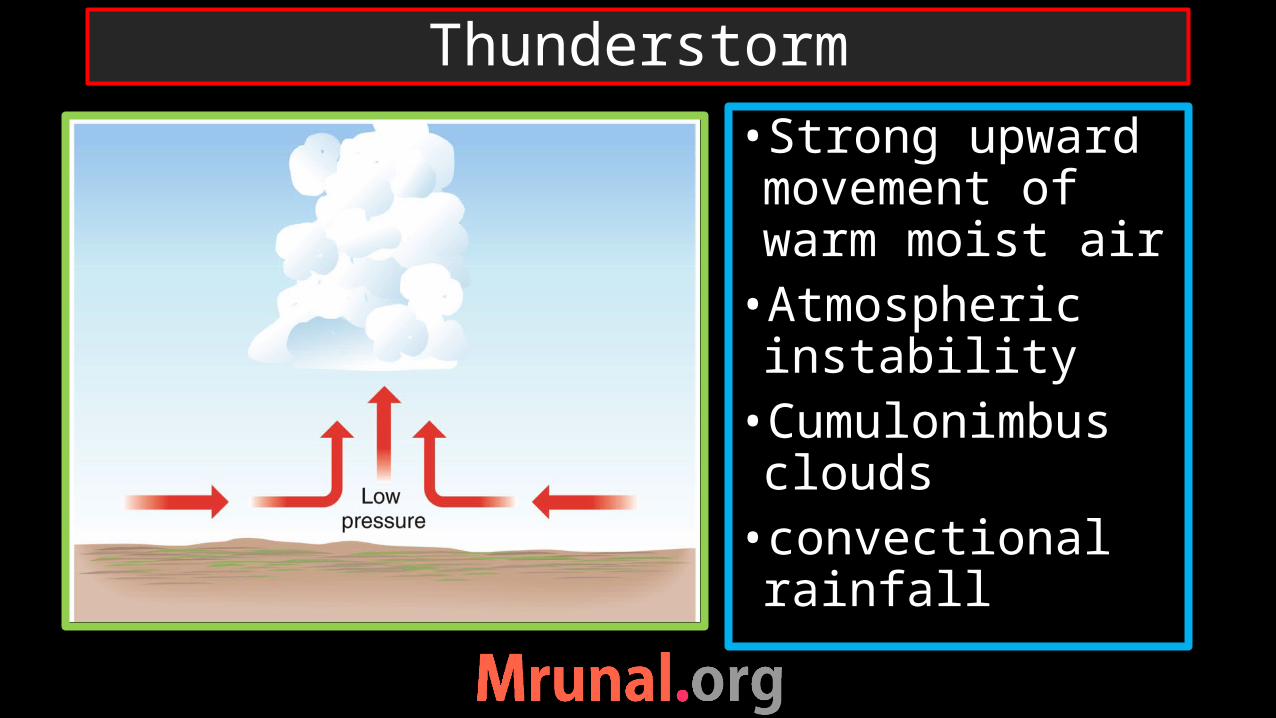
•Strong upward movement of warm moist air•Atmospheric instability•Cumulonimbus clouds•convectional rainfall
Thunderstorm

Stages of thunderstorm

1) Air motion mostly upward2) When accumulated load of water and
ice becomes excessive –downdraft starts. Descending water droplet evaporate- cool the air – increase more downdraft action
3) Downdraft spreads throughout the cell
Stages of thunderstorm

•Within thunderstorm – updrafts, downdrafts, ice and water particles•Thunder clouds produce excessive negative charge at height where temp is btwn -5 to -15 deg c•+ve charge at higher and lower altitude
lightning
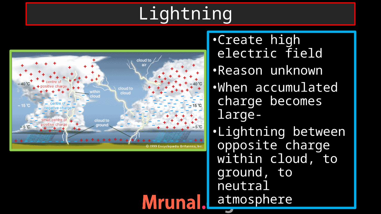
•Create high electric field•Reason unknown•When accumulated charge becomes large-•Lightning between opposite charge within cloud, to ground, to neutral atmosphere
Lightning

Types of thunderstorm
thunderstorm
Thermal
orographic
Cold front

•Localised intense heating of ground during summer afternoon•Equatorial regions•Die out if passes over water body because absence of supply of heat
Thermal thunderstorm

•Warm moist air when passes over mountain barrier•Forceful upliftment – latent heat of condensation• ‘Cloud burst’• In Cherrapunji during monsoon
Orographic thunderstorm

•Active air masses –forceful upliftment of warm moist air•Localised and short-lived
Cold front thunderstorm
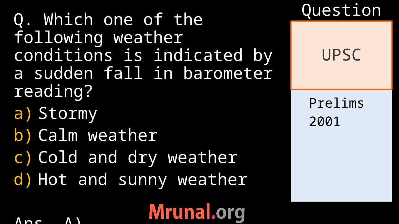
Prelims2001
Q. Which one of the following weather conditions is indicated by a sudden fall in barometer reading?a) Stormyb) Calm weatherc) Cold and dry weatherd) Hot and sunny weather
Ans. A)
UPSC
Question
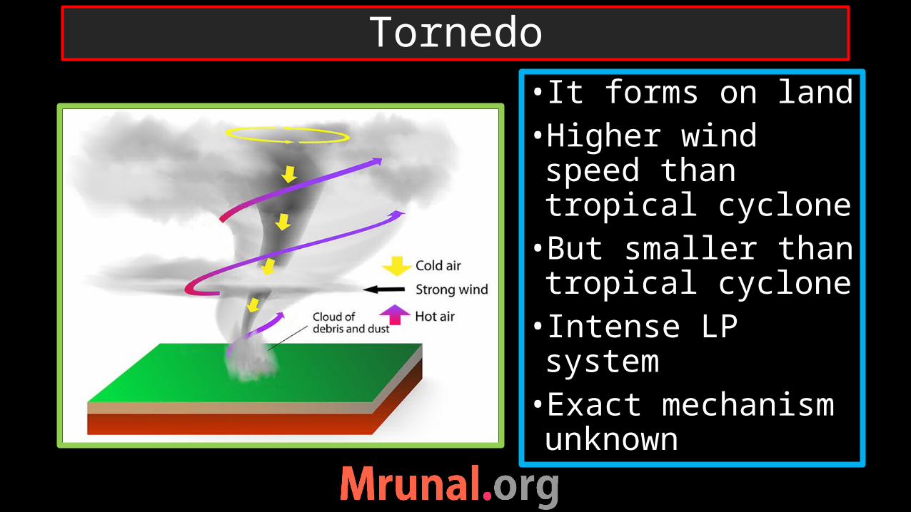
• It forms on land •Higher wind speed than tropical cyclone•But smaller than tropical cyclone• Intense LP system•Exact mechanism unknown
Tornedo
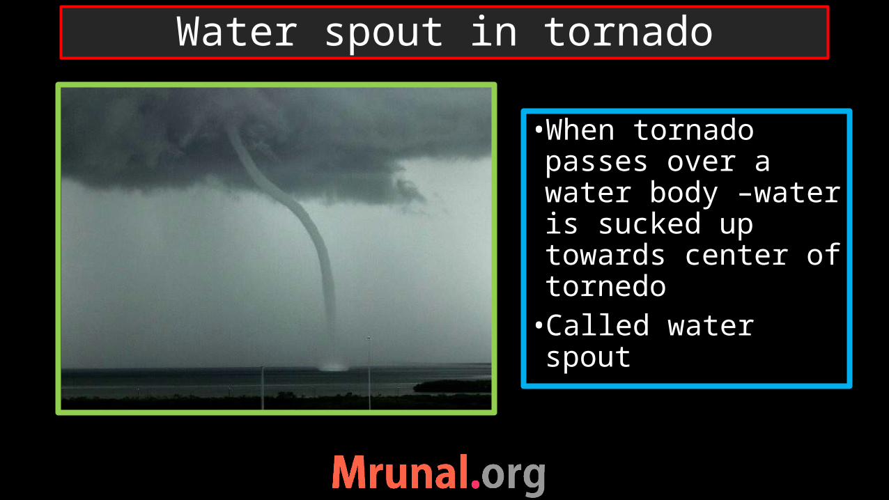
•When tornado passes over a water body –water is sucked up towards center of tornedo•Called water spout
Water spout in tornado
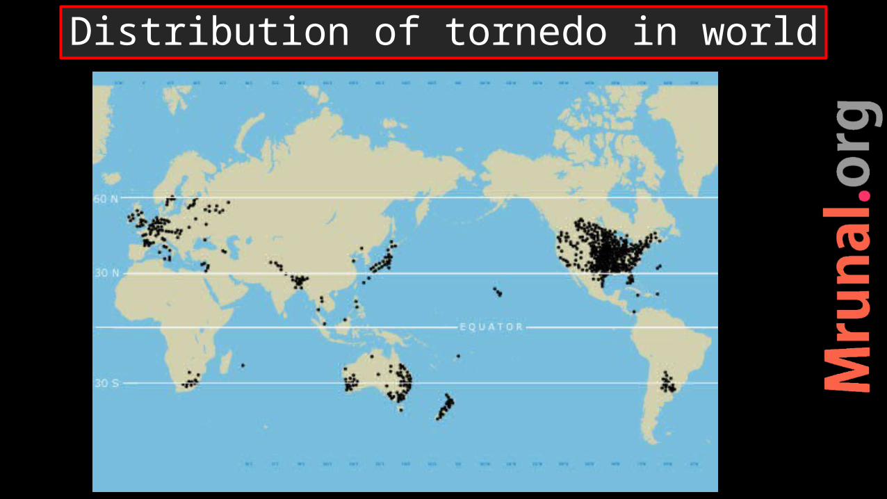
Distribution of tornedo in world

•Occur mostly in temperate regions (20 to 60 deg N,S)•Where cold polar air meets warm tropical air•USA, South-west of great plain – “tornado alley”
Distribution of tornedo in world
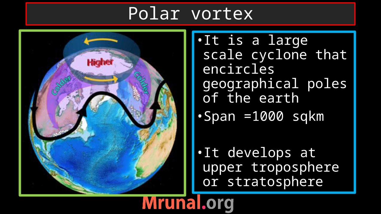
• It is a large scale cyclone that encircles geographical poles of the earth•Span =1000 sqkm
• It develops at upper troposphere or stratosphere
Polar vortex
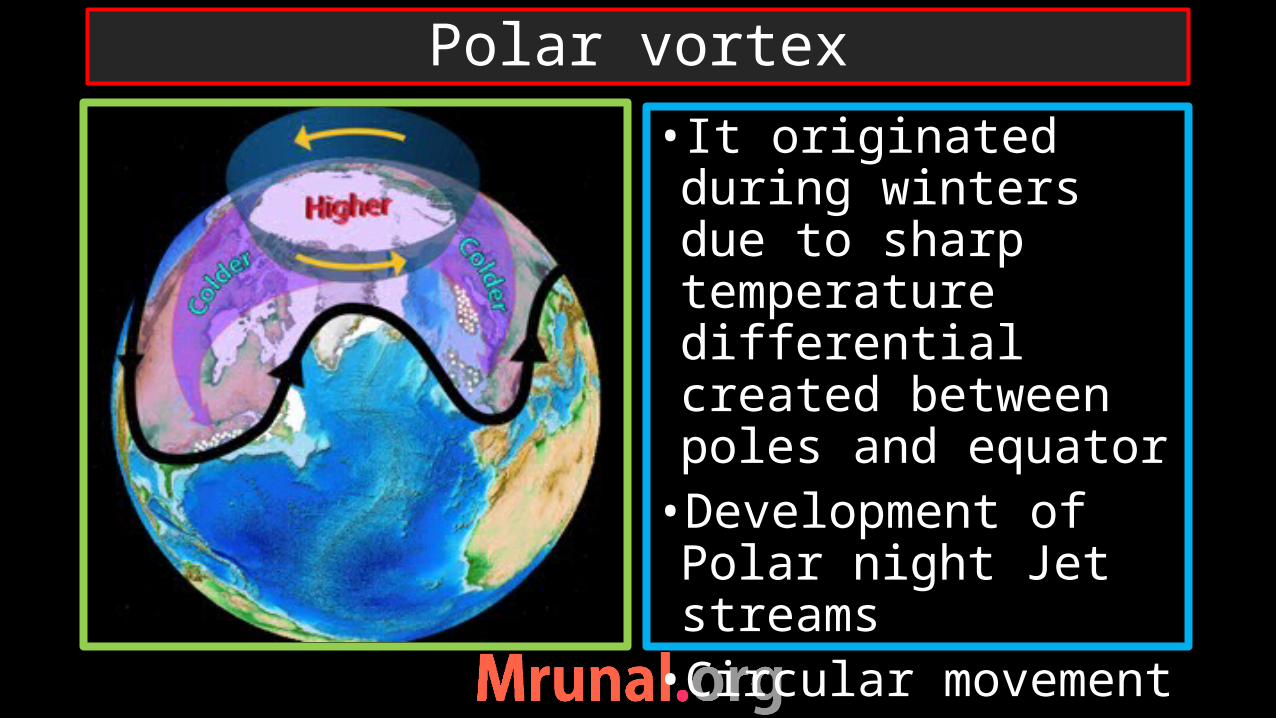
• It originated during winters due to sharp temperature differential created between poles and equator •Development of Polar night Jet streams•Circular movement
Polar vortex
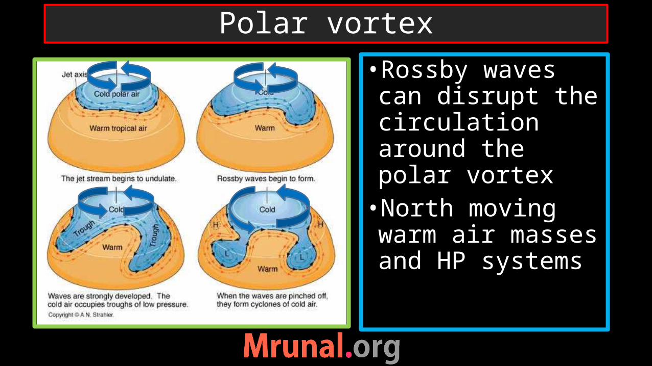
•Rossby waves can disrupt the circulation around the polar vortex•North moving warm air masses and HP systems
Polar vortex
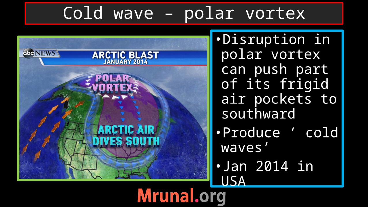
•Disruption in polar vortex can push part of its frigid air pockets to southward •Produce ‘ cold waves’• Jan 2014 in USA
Cold wave – polar vortex
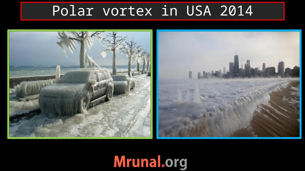
Polar vortex in USA 2014

•Nacreous cloud/mother of pearl•Polar stratospheric clouds formed in winter during polar vortex.• temperature below -80 degree – 12 -22 km height•Contains water, Nitric acid and sulphuric acid
Polar stratospheric clouds

•Nitric acid in polar stratospheric clouds reacts with CFC -create chlorine•Chlorine concentration in winter• in summer -Chlorine reacts with oxygen molecule of ozone - destruct the ozone molecule
Ozone depletion
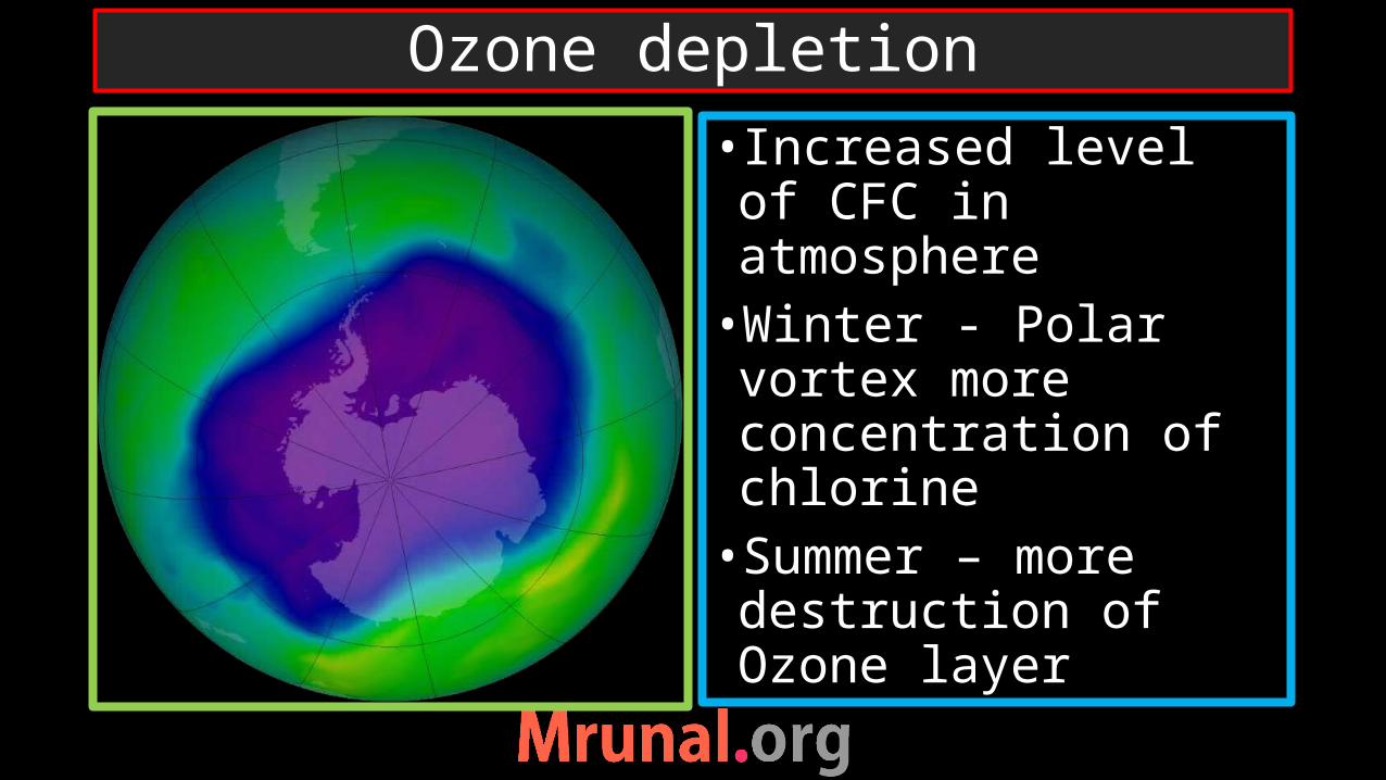
• Increased level of CFC in atmosphere•Winter - Polar vortex more concentration of chlorine •Summer – more destruction of Ozone layer
Ozone depletion
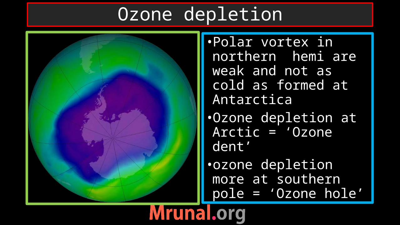
•Polar vortex in northern hemi are weak and not as cold as formed at Antarctica•Ozone depletion at Arctic = ‘Ozone dent’•ozone depletion more at southern pole = ‘Ozone hole’
Ozone depletion
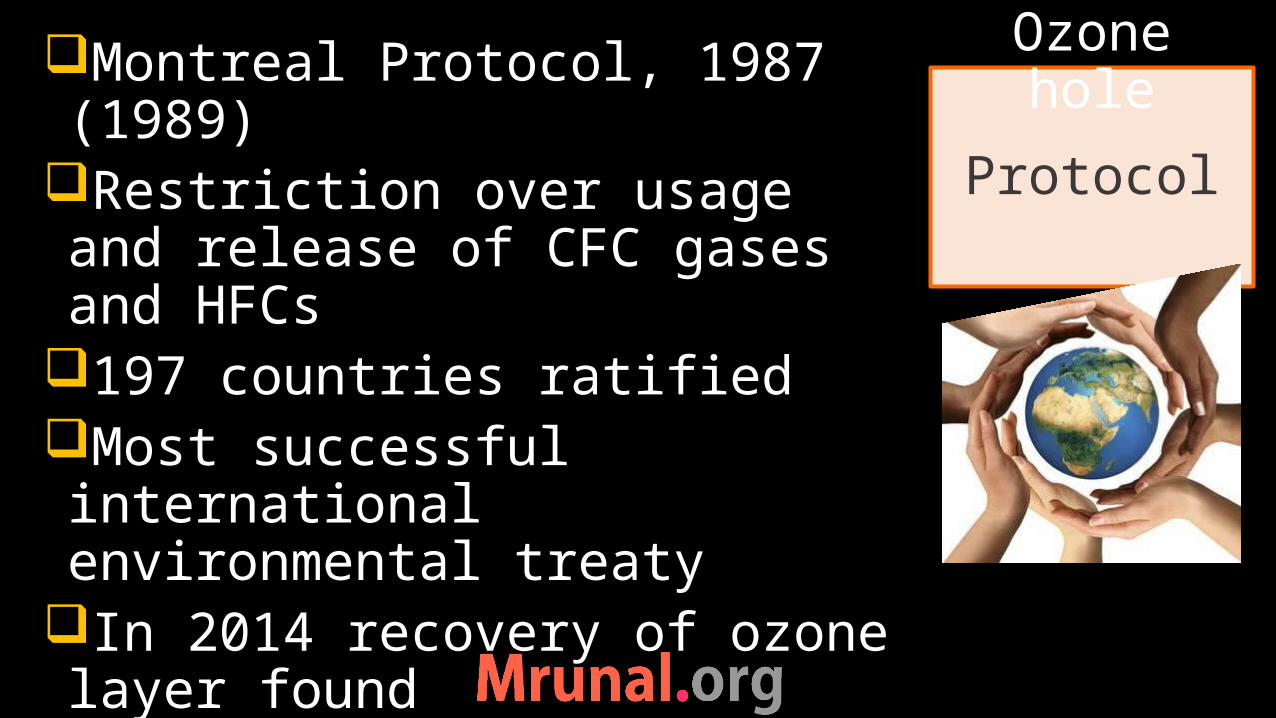
Montreal Protocol, 1987 (1989)
Restriction over usage and release of CFC gases and HFCs
197 countries ratifiedMost successful international environmental treaty
In 2014 recovery of ozone layer found
Protocol
Ozone hole

Vertical: Hadley, Ferrell Horizontal: walker
Pressure gradient cells
Ferrel cell

•There are oscillation in pressure gradient and air circulation after intervals of 2-3 years in south Pacific Ocean•Called Southern Oscillation•ENSO = EL Nino Southern Oscillation
Walkar cell at south Pacific
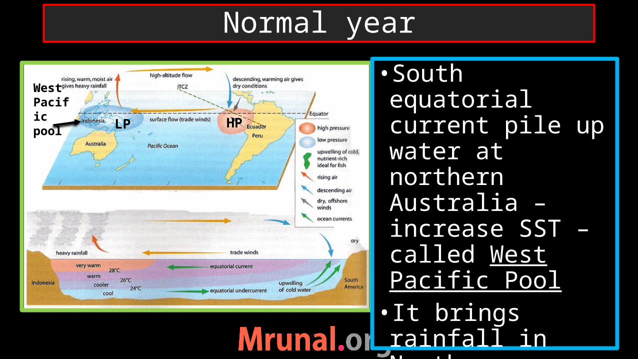
•South equatorial current pile up water at northern Australia – increase SST – called West Pacific Pool• It brings rainfall in Northern Australia
Normal year
West Pacific pool LP HP
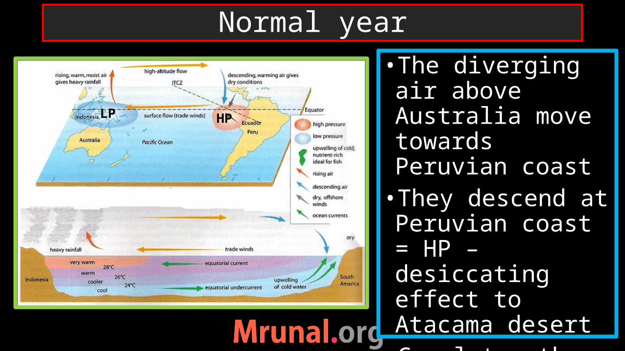
•The diverging air above Australia move towards Peruvian coast•They descend at Peruvian coast = HP – desiccating effect to Atacama desert•Completes the Walker cell
Normal year
LP HP

•As south equatorial current take water from east to west, it led water from bottom to come up and take the space•Up-welling at the Peruvian coast = rich fishing ground
Normal year
HPLP
Down-welling

•Direction of walker cell reverses•South equatorial current weakens (reason unknown)•Weak piling up of water at Northern Australia•Weakening of west Pacific Pool
El-Nino year
LP HP
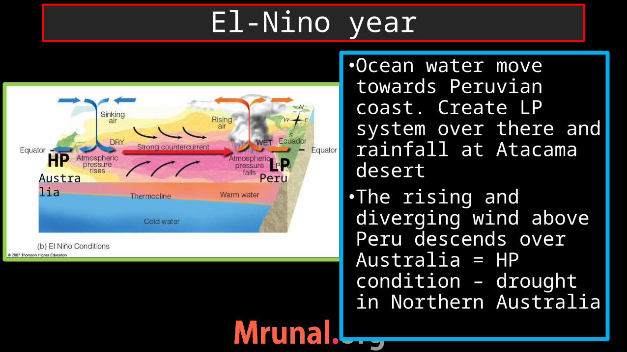
•Ocean water move towards Peruvian coast. Create LP system over there and rainfall at Atacama desert•The rising and diverging wind above Peru descends over Australia = HP condition – drought in Northern Australia
El-Nino year
LPHPAustralia Peru

•The reversal in wind direction alters submarine cycle as well•Down-welling at Peruvian coast => loss in fishing business
El-Nino year
Down-welling
Down-welling
Upwelling
Upwelling

•El-Nino bring drought condition in Indonesia as well – forest fire• It is responsible for weak monsoon in India
Implications of El-Nino
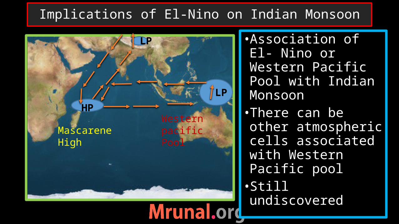
•Association of El- Nino or Western Pacific Pool with Indian Monsoon •There can be other atmospheric cells associated with Western Pacific pool•Still undiscovered
Implications of El-Nino on Indian Monsoon
Mascarene HighWestern pacific Pool
HP
LP
LP
With global warming there will be increasing number of El-Nino events
It is a global phenomenon. Though happening in limited area, it may have wider implication over the globe
Global Implications of El-Nino

• Intensification of walker cell• Strong west pacific pool•Heavy rainfall – flood condition in Northern Australia – good monsoon in India•Drought in Atacama•Very good fishing business at Peruvian coast – price crash
La-Nina

ThunderstormTornadoEL-Nino La-Ninaimplications
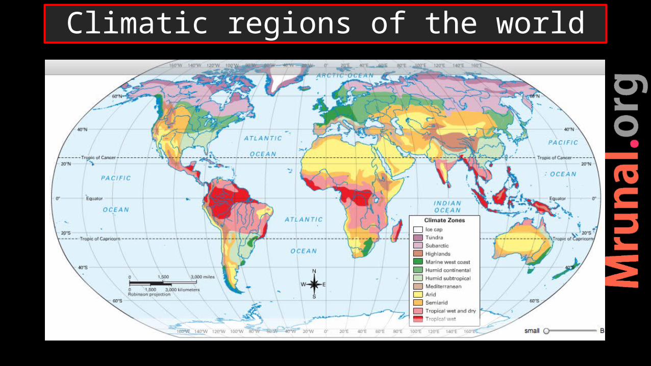
Climatic regions of the world

1) Equatorial region2) Tropical monsoon3) Savannah4) Steppe5) Hot desert6) Continental
deserts
7) Mediterranean climate8) China type9) British type10) Laurentian type11) Taiga12) Tundra
Climatic regions of the world
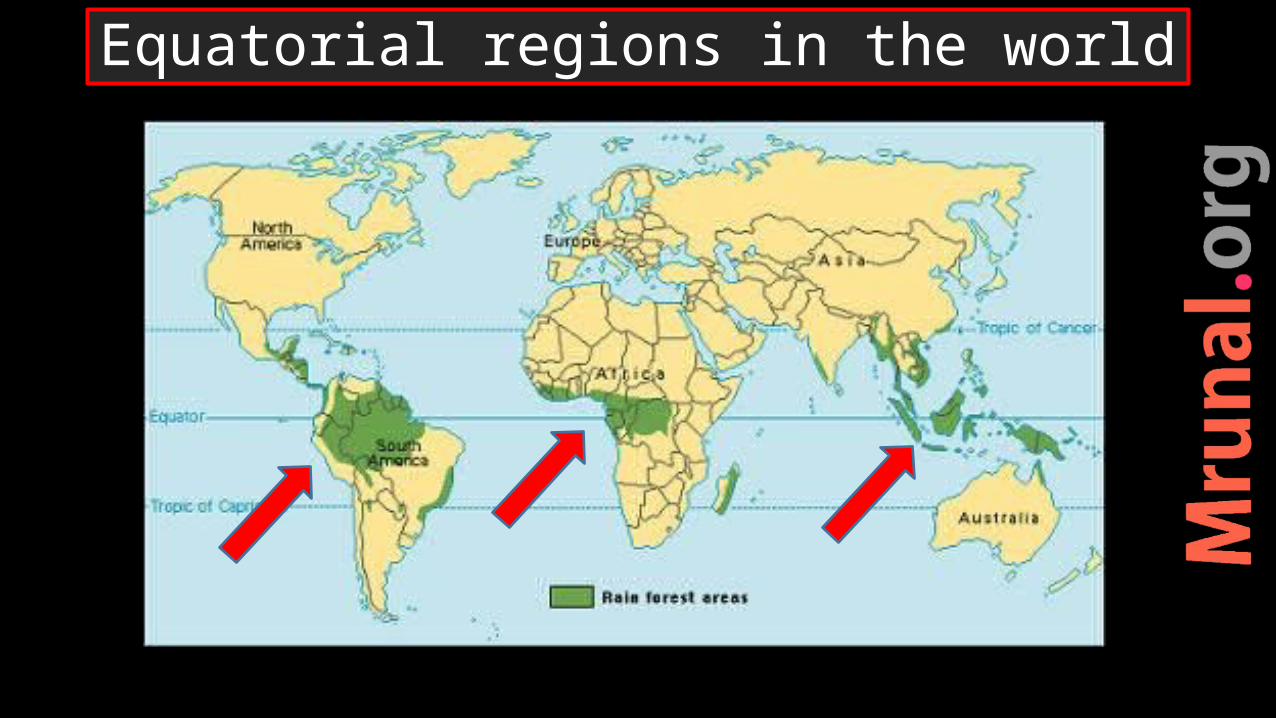
Equatorial regions in the world

•5-10 degree latitude•Same season (weather) throughout the year•Direct sunlight – heat surplus – LP condition every day – rising of moist air – advection rain every evening•Hot-wet climate
Equatorial climate

•Dense forest –rainforest –lungs of the earth•High biodiversity• Tall trees (Abony, Rosewood, mahogany, rubber) – epiphytes •But not good for lumbering – hardwood – high diversity – loading-unloading very difficult
Equatorial climate
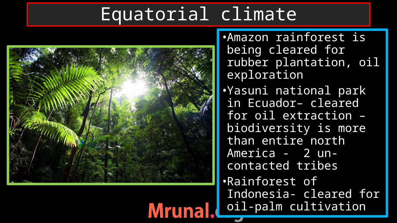
•Amazon rainforest is being cleared for rubber plantation, oil exploration • Yasuni national park in Ecuador– cleared for oil extraction – biodiversity is more than entire north America - 2 un-contacted tribes •Rainforest of Indonesia- cleared for oil-palm cultivation
Equatorial climate
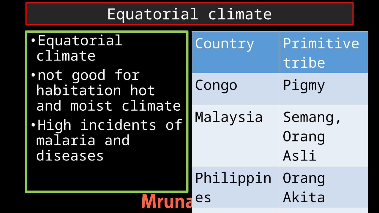
•Equatorial climate•not good for habitation hot and moist climate•High incidents of malaria and diseases
Country Primitive tribe
Congo Pigmy
Malaysia Semang, Orang Asli
Philippines Orang Akita
Borneo Dayaks
Equatorial climate
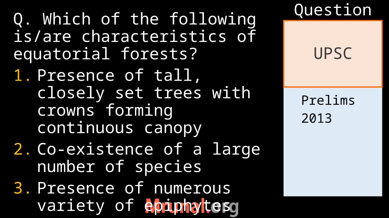
Prelims2013
Q. Which of the following is/are characteristics of equatorial forests?1. Presence of tall, closely set
trees with crowns forming continuous canopy
2. Co-existence of a large number of species
3. Presence of numerous variety of epiphytes
UPSC
Question

Prelims2013
a) 1 onlyb) 2 an 3c) 1 and 3d) 1,2 and 3
Ans.d)
UPSC
Question
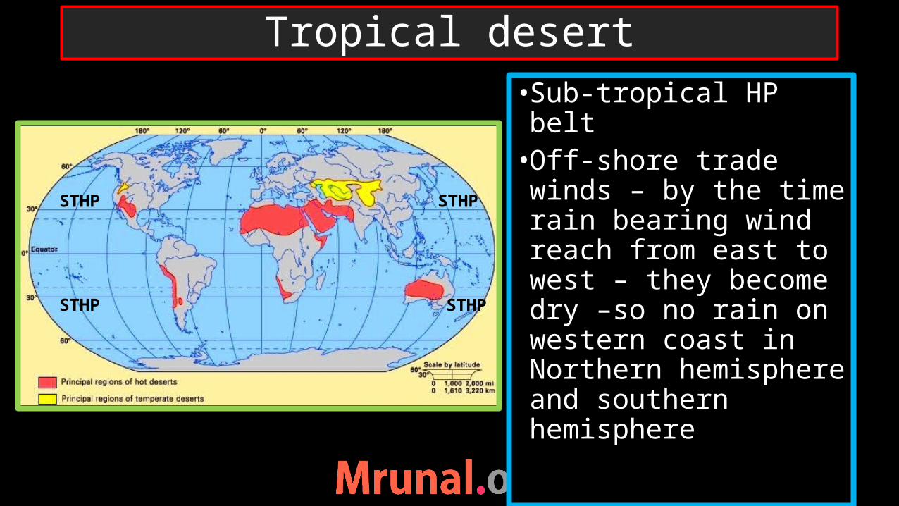
•Sub-tropical HP belt•Off-shore trade winds – by the time rain bearing wind reach from east to west – they become dry –so no rain on western coast in Northern hemisphere and southern hemisphere
Tropical desert
STHP
STHP
STHP
STHP

•desiccating effect of cold oceanic current on western coast of continents
Tropical desert

•Arid-dry climate, scanty rainfall, water deficit •Vegetation – Xerophytic • Low population – Maghreb region – high poverty• Tauregs of Sahara, Beduins of Arabia Hottentots of Kalahari desert
Tropical desert

• Interior of large land•Rainfall bearing winds cannot reach there•Leeward side of the mountain•Aridity (but no sand dunes)•High annual temp range
Continental desert

China South America
Continental deserts
TIEN SHAN
ALTUN SHAN
ANDES Range
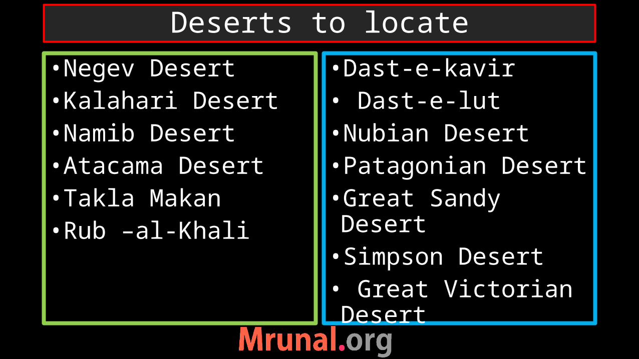
•Negev Desert•Kalahari Desert•Namib Desert•Atacama Desert•Takla Makan•Rub –al-Khali
•Dast-e-kavir• Dast-e-lut•Nubian Desert•Patagonian Desert•Great Sandy Desert•Simpson Desert• Great Victorian Desert
Deserts to locate
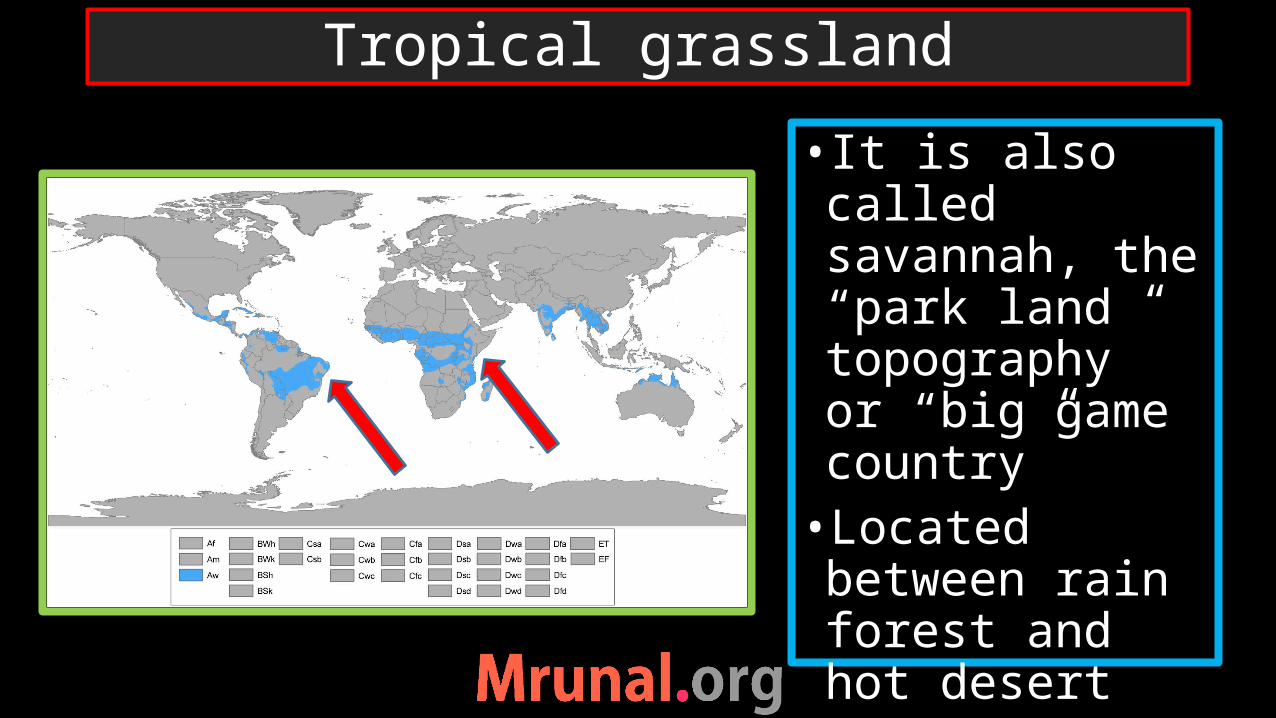
• It is also called savannah, the “park land topography” or “big game country”•Located between rain forest and hot desert
Tropical grassland
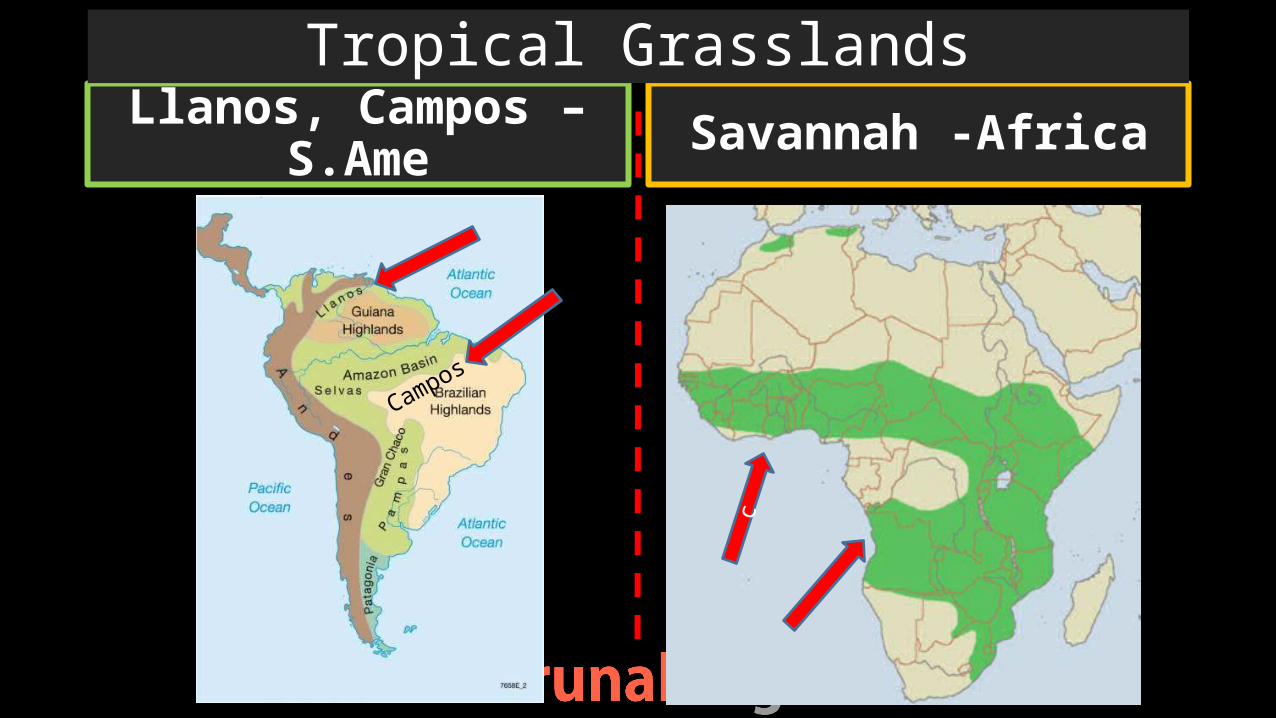
Llanos, Campos – S.Ame Savannah -Africa
Tropical Grasslands
Campos
c

•Moderate rainfall – clear dry-wet season•Tall grass ‘elephant grass’, scanty large trees, grass-fire in dry season – way of controlling trees•Large carnivorous animals
Tropical grassland

•Acacia tress with broad trunks – baoab trees and bottle trees•To store water•Grass – long roots, remain dormant in dry period•Australia – Mallee, Mulga, Spinifex grasses
Tropical grassland

•Tribes = Masai tribe (kenya) – Pastoralist •Hausa and Aibo tribes of Nigeria
Tropical Grasslands

Prelims2012
Q. Which one of the following characteristics of climate of Tropical Savannah region?a) Rainfall throughout the yearb) Rainfall in winter onlyc) An extremely short dry
seasond) A definite dry and wet
season
Ans. D)
UPSC
Question
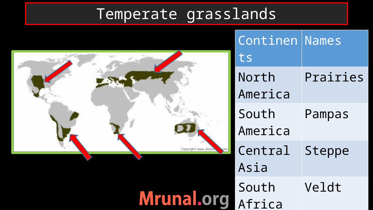
Continents Names North America
Prairies
South America
Pampas
Central Asia SteppeSouth Africa
Veldt
Australia Downs
Temperate grasslands

•Cooler and wetter than Savannah •Under westerlies•Perfect grassland – no trees •Grass is very nutritious
Temperate grasslands

•Temperate grasslands entirely converted into agriculture. •Prairies: Truck-farming – large acres of farmlands – extensive use of machinery- •High productivity per person
Truck-farming

•Wheat, cotton and Maize cultivation•USA:•Prairies: maize is fed to animals – fattening – slaughter house near great lake region
Prairies, North America
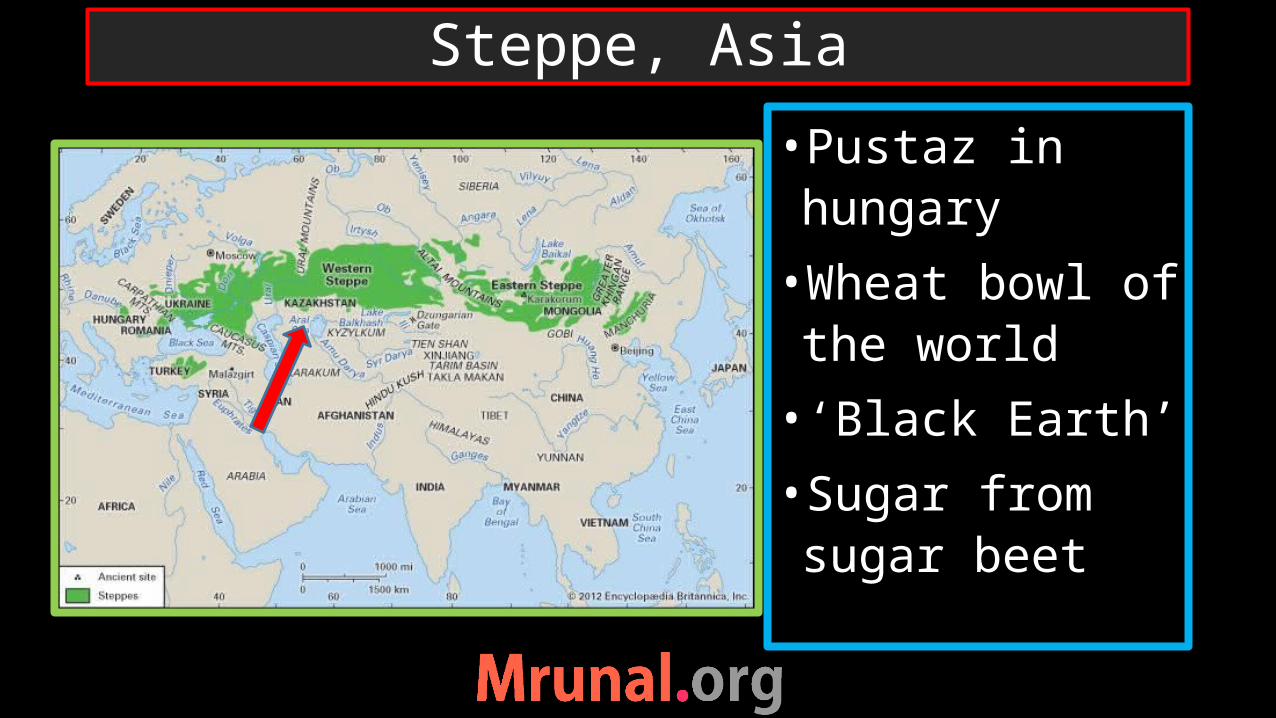
•Pustaz in hungary
•Wheat bowl of the world
• ‘Black Earth’
•Sugar from sugar beet
Steppe, Asia
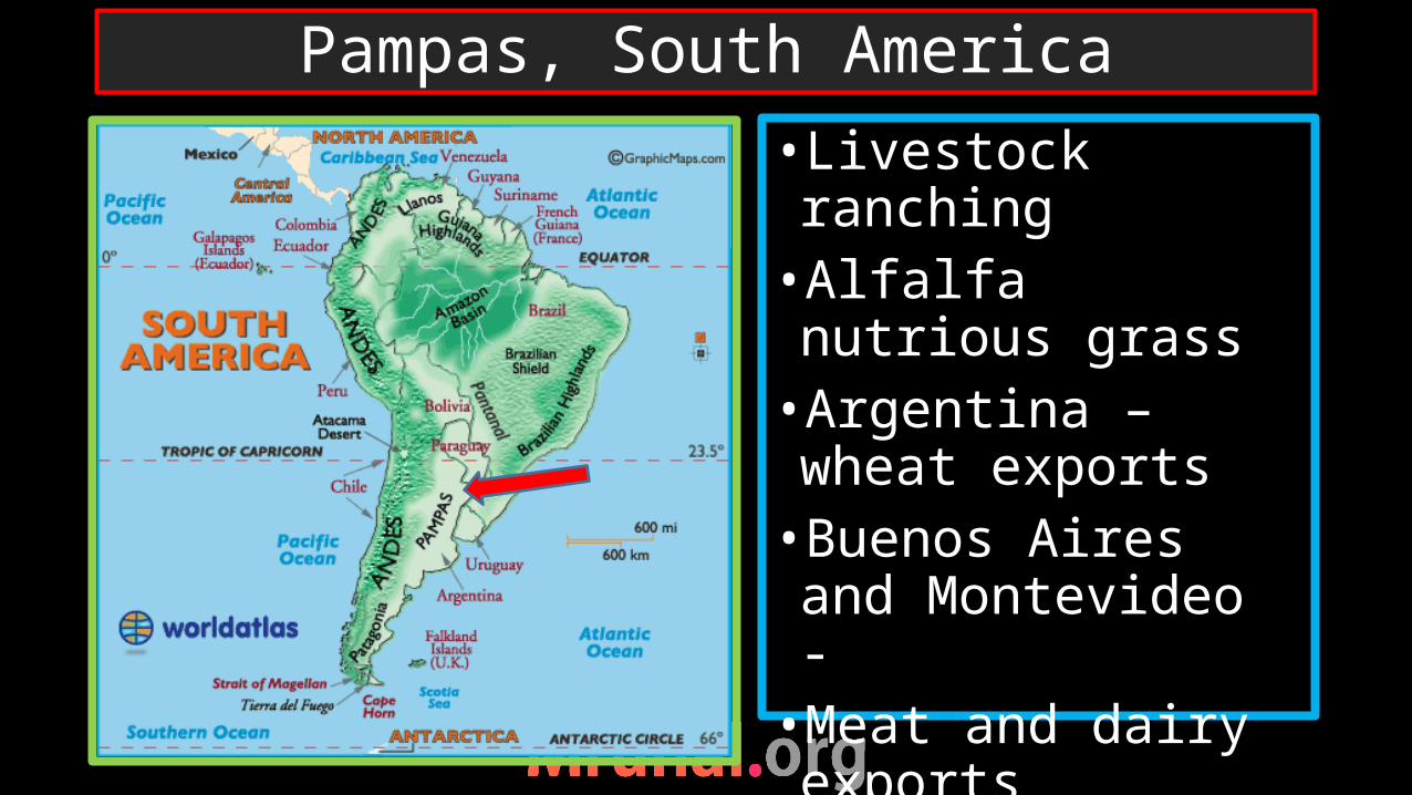
•Livestock ranching•Alfalfa nutrious grass•Argentina –wheat exports•Buenos Aires and Montevideo - •Meat and dairy exports
Pampas, South America

•Australia: sheep rearing, meat
•New Zealand:
•Canterbury plains
•Sheep rearing
Downs, Australia
DOWNS
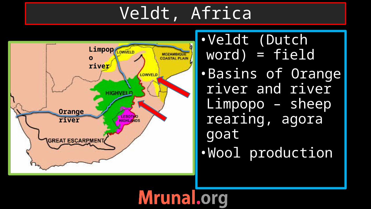
•Veldt (Dutch word) = field•Basins of Orange river and river Limpopo – sheep rearing, agora goat•Wool production
Veldt, Africa
Orange river
Limpopo river
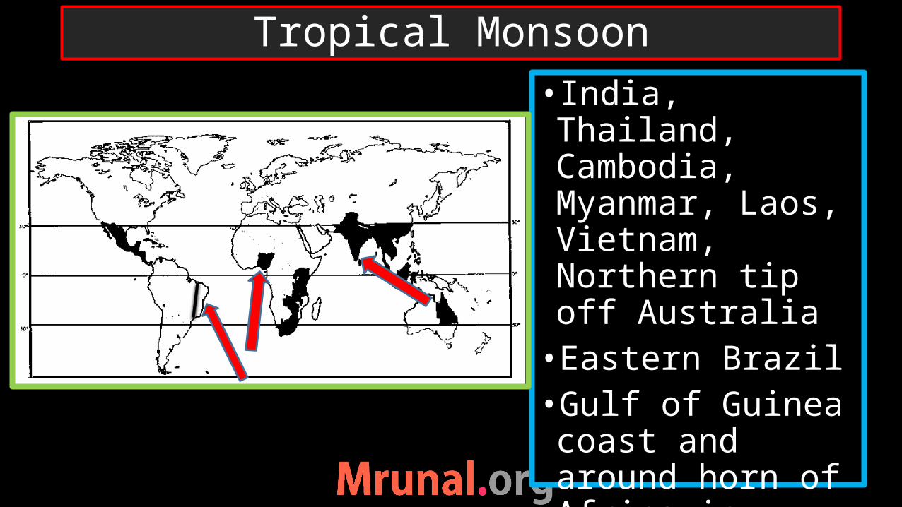
• India, Thailand, Cambodia, Myanmar, Laos, Vietnam, Northern tip off Australia•Eastern Brazil •Gulf of Guinea coast and around horn of Africa in Africa
Tropical Monsoon
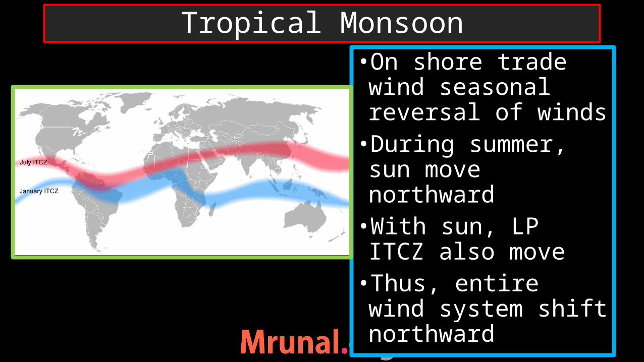
•On shore trade wind seasonal reversal of winds•During summer, sun move northward •With sun, LP ITCZ also move •Thus, entire wind system shift northward
Tropical Monsoon
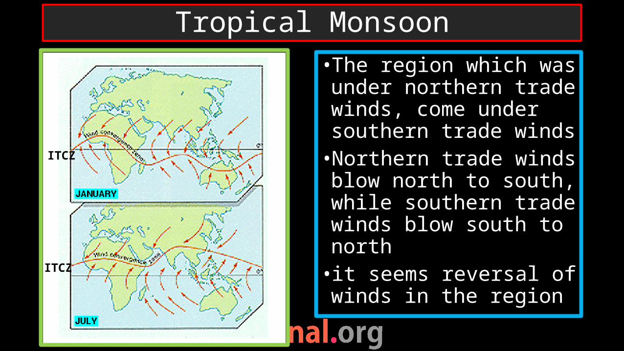
• The region which was under northern trade winds, come under southern trade winds•Northern trade winds blow north to south, while southern trade winds blow south to north• it seems reversal of winds in the region
Tropical Monsoon
ITCZ
ITCZ

•Distinct wet and dry season – rainfall in confined to 4 months – vulnerable to drought and flood•Similar to savannah but wetter than savannah
Tropical Monsoon
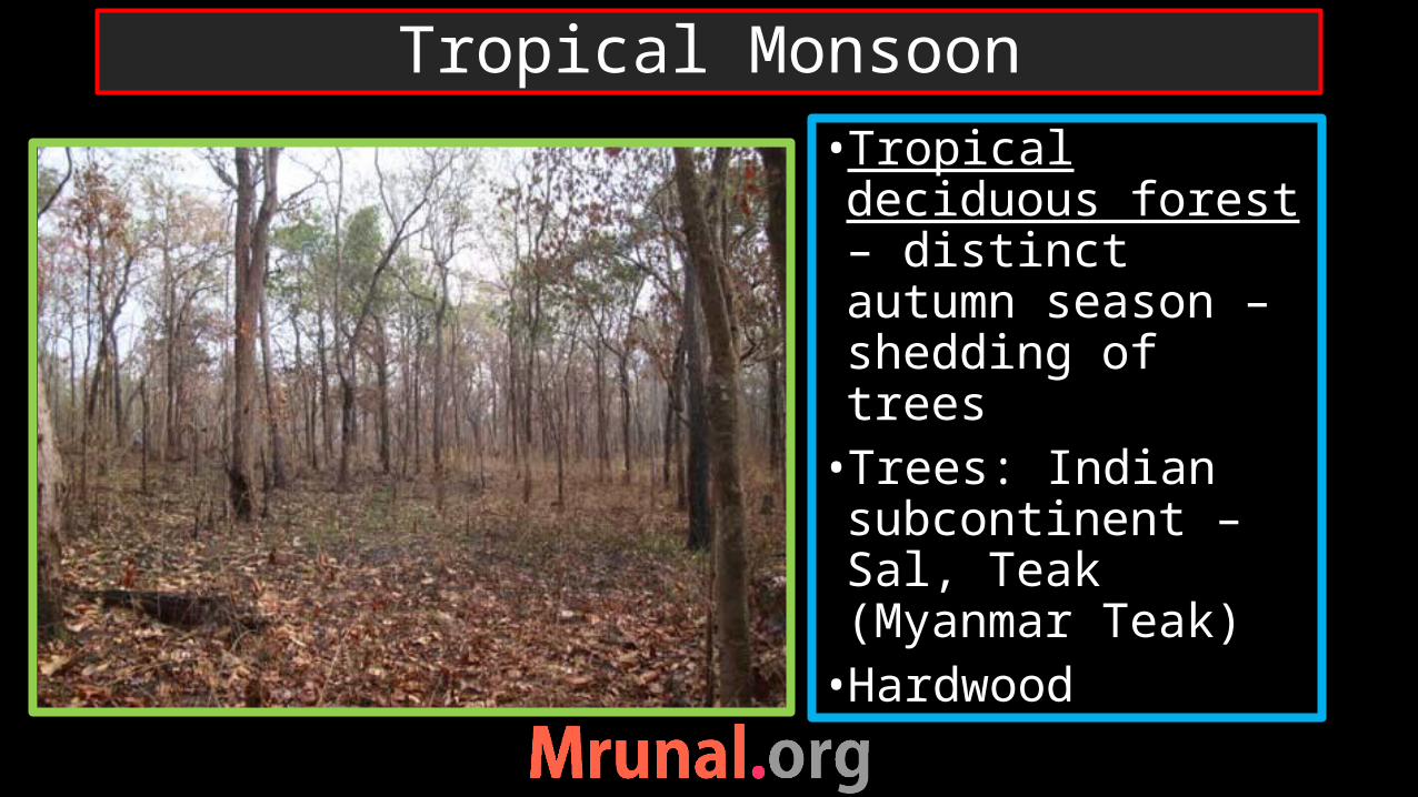
•Tropical deciduous forest – distinct autumn season – shedding of trees •Trees: Indian subcontinent – Sal, Teak (Myanmar Teak)•Hardwood
Tropical Monsoon
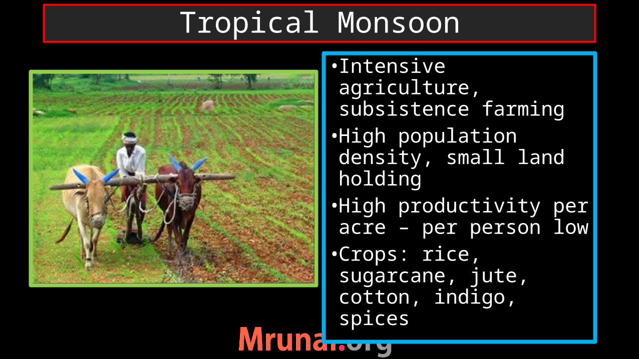
• Intensive agriculture, subsistence farming•High population density, small land holding•High productivity per acre – per person low•Crops: rice, sugarcane, jute, cotton, indigo, spices
Tropical Monsoon

• Shifting cultivation/ slash and burn cultivation/ Jhum cultivation• forests are cut, burnt and cultivated.•When soil fertility began to decline, the land is abandoned, and a new patch of forest is burnt. •By the time abandoned land regenerated for several years until the next round of cultivation.
Tropical Monsoon

against
Deforestation higher run-off of rain water in hilly areas -Water scarcity during non-rainy days
loss of biodiversity
Jhum uses natural cycle of forest regeneration (6-10 years)
Cause temporary loss of forest patches
No use chemical fertilizers or pesticides + diversified crops
favour
Jhum cultivation
the dry the cut trees are dried under the sun- burn the trees – ashes of the burnt trees (Potash) replenish the soil nutrients
The regenerating forest provides forest produce to the people
Settled agriculture- monoculture plantation of pineapple, rubber and oil palm – cause permanent loss of forest
Once monoculture adopted with chemical inputs, the same land cannot be converted into natural forest
Jhum cultivation

Country Term for shifting cultivation
Malaysia LadangMyanmar TaungyaThailand TamraiPhilippines CainginJava HumahShri Lanka ChenaAfrica Milpa
Different names of shifting cultivation

•Warm temperate western margin•Area around Mediterranean Sea•California, USA•Central Chile, South America•Southern tip of South Africa•South Australia
Mediterranean climate
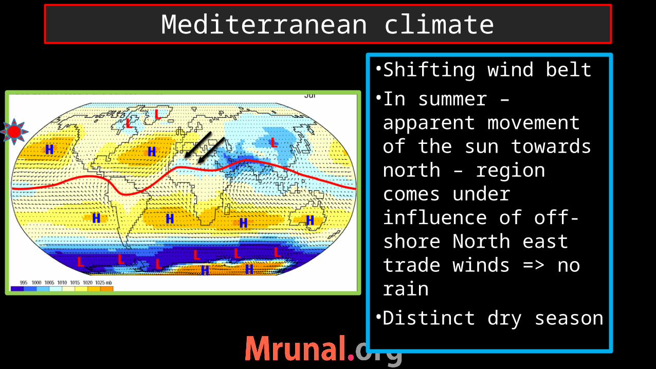
•Shifting wind belt• In summer – apparent movement of the sun towards north – region comes under influence of off-shore North east trade winds => no rain•Distinct dry season
Mediterranean climate
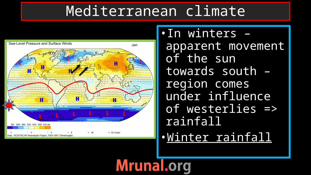
• In winters – apparent movement of the sun towards south – region comes under influence of westerlies => rainfall •Winter rainfall
Mediterranean climate
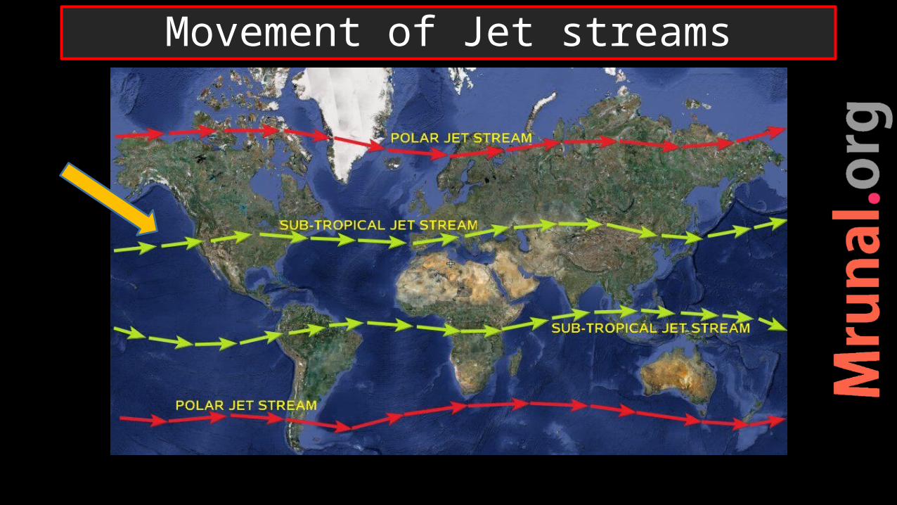
Movement of Jet streams
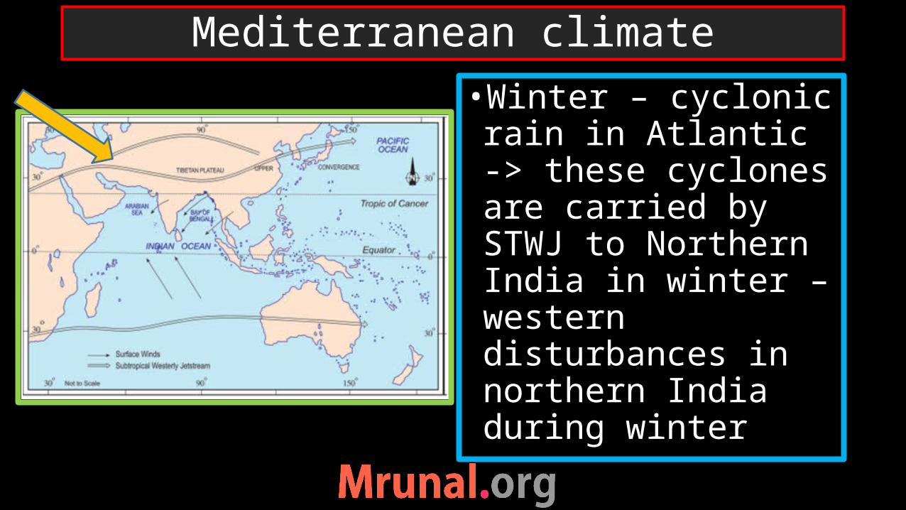
•Winter – cyclonic rain in Atlantic -> these cyclones are carried by STWJ to Northern India in winter – western disturbances in northern India during winter
Mediterranean climate

•Shrubs and bushes with scattered stunted trees•The natural grass is so wiry and bunchy – not suitable for cattle rearing => Mediterranean region net importer of dairy products
Mediterranean climate

•Trees without shed, stunted massive trunks, wide spread roots – because winter rain – growth limited to autumn and spring when moisture content is sufficient
Mediterranean vegetation
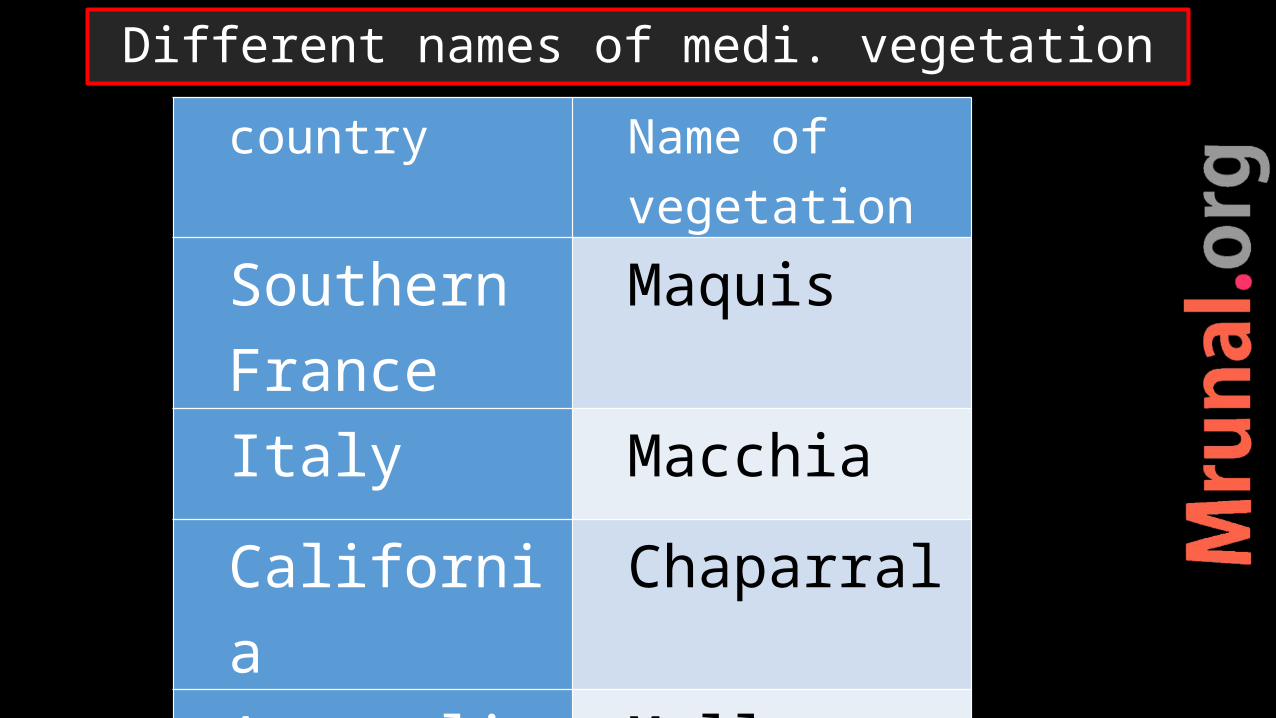
Different names of medi. vegetationcountry Name of
vegetationSouthern France
Maquis
Italy Macchia
California Chaparral
Australia Mallee scrub
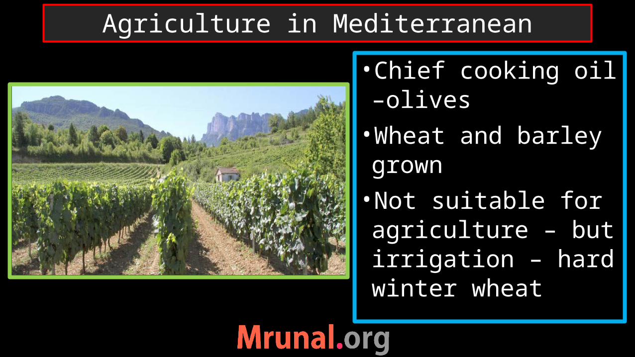
•Chief cooking oil –olives•Wheat and barley grown •Not suitable for agriculture – but irrigation – hard winter wheat
Agriculture in Mediterranean

•Citrus fruit plantation – World’s orchard lands – fruit trees – long deep root, to survive during dry summer•oranges, grapes, lemon•California – Sunkist oranges•Negev desert of Israel – Jaffa oranges•Spain – Seville oranges
Mediterranean agriculture

Country Name of wineSouthern Spain sherryPortugal Port wine Italy Chianti and
Marsala
France Champagne, Bordeaux, Burgundy
viticulture

•Viticulture:•Ebro basin in Spain• Po valley in Italy•Rhone basin in France•Sicily Island of Italy•Algeria in Africa: exports wine
Mediterranean in Europe

•California state of USA•San Francisco, Los Angeles, San Diego•Fruit plantation –oranges, grapes, Olives•California – high productivity
Mediterranean in USA
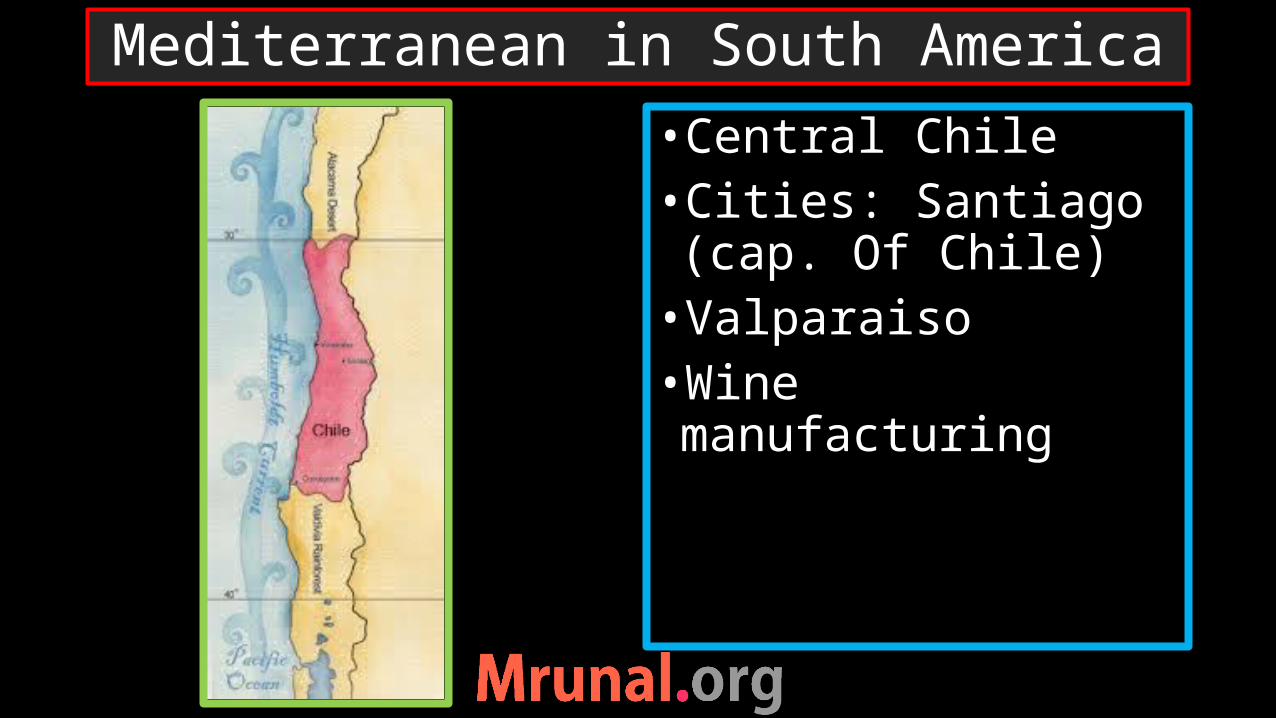
•Central Chile•Cities: Santiago (cap. Of Chile)•Valparaiso•Wine manufacturing
Mediterranean in South America

•Southern tip of Australia•Cities: Perth and Adelaide•Fruit plantation
Mediterranean in Australia
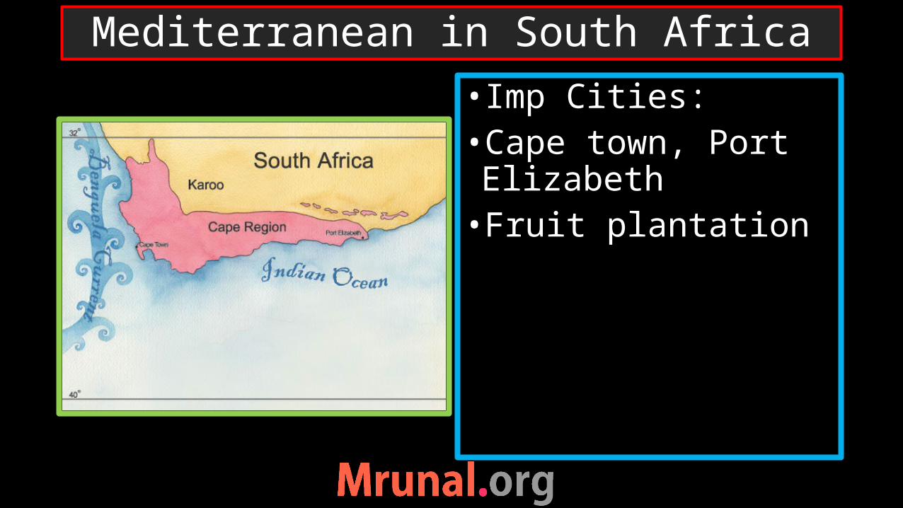
• Imp Cities:•Cape town, Port Elizabeth•Fruit plantation
Mediterranean in South Africa
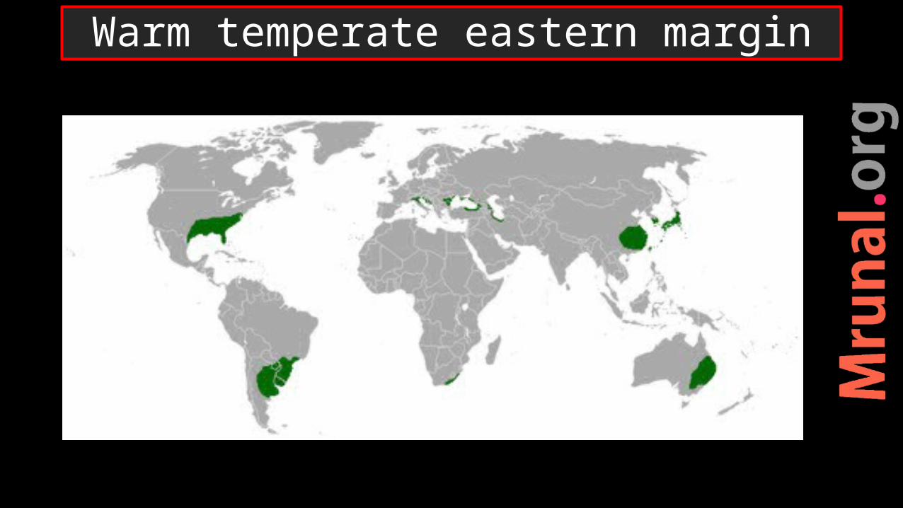
Warm temperate eastern margin

China type Gulf type Natal type
Central and north china
S E USA Natal, South Africa
Southern Japan (gulf of Mexico) Eastern Australia
Southern Brazil
Warm temperate eastern margin
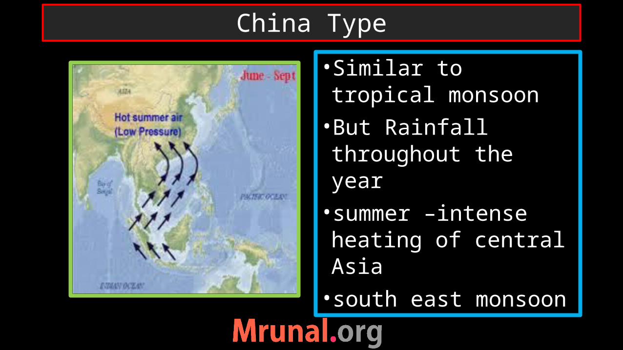
•Similar to tropical monsoon •But Rainfall throughout the year •summer –intense heating of central Asia•south east monsoon
China Type
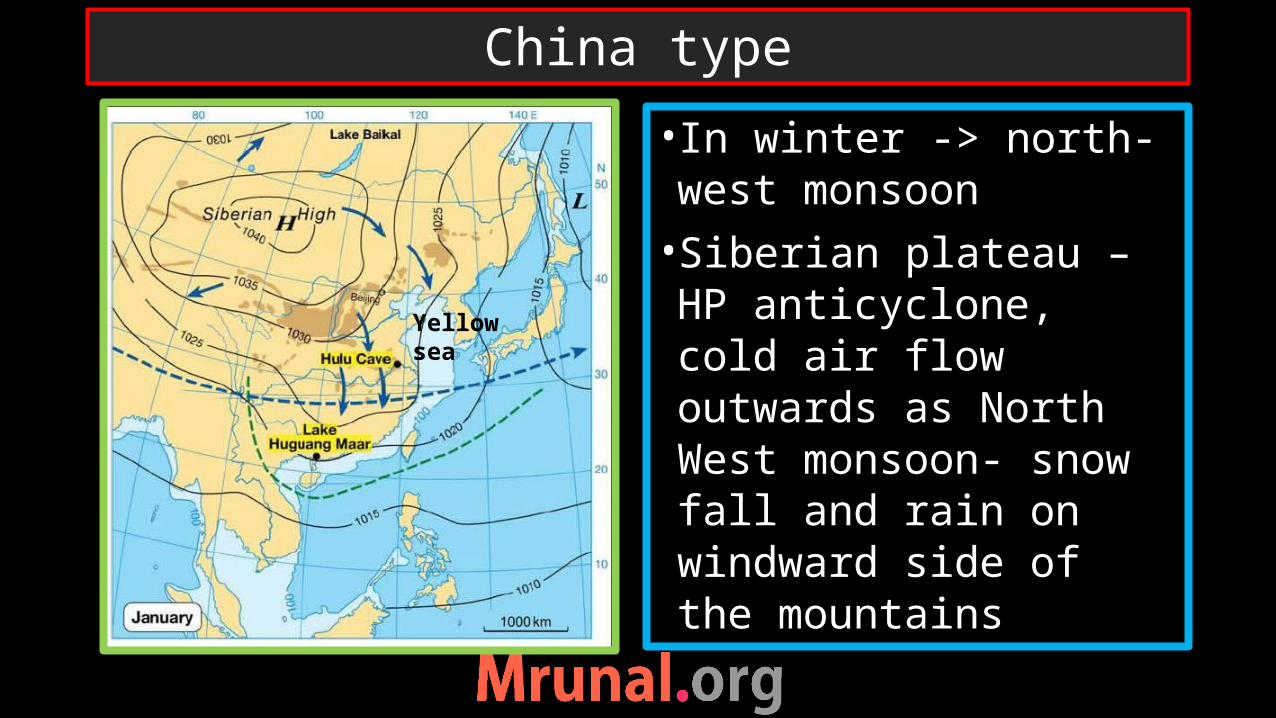
• In winter -> north-west monsoon •Siberian plateau – HP anticyclone, cold air flow outwards as North West monsoon- snow fall and rain on windward side of the mountains
China type
Yellow sea

•Rainfall is also due to local storms – typhoons (China) in late summers•More rainfall than Mediterranean climate though being on the same latitude
China Type
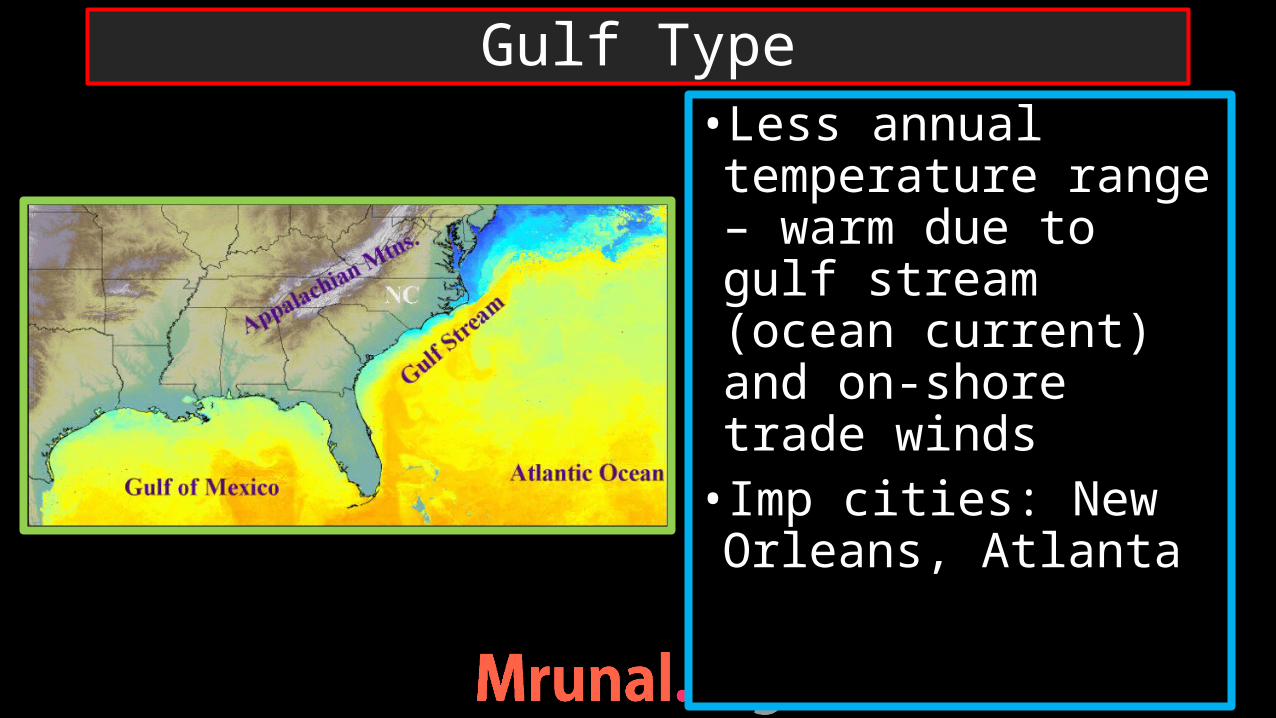
•Less annual temperature range – warm due to gulf stream (ocean current) and on-shore trade winds• Imp cities: New Orleans, Atlanta
Gulf Type

•No distinct dry season•Rainfall maximum in summer-mT unstable air mass - thunderstorms•Rainfall from hurricanes in late summer•Winter –Westerlies – frontal cyclones
Gulf type

•Narrow land, dominance of maritime climate – no monsoon effect•South east trade winds bring even distribution of rainfall throughout the year• Imp City: Durban
Natal Type
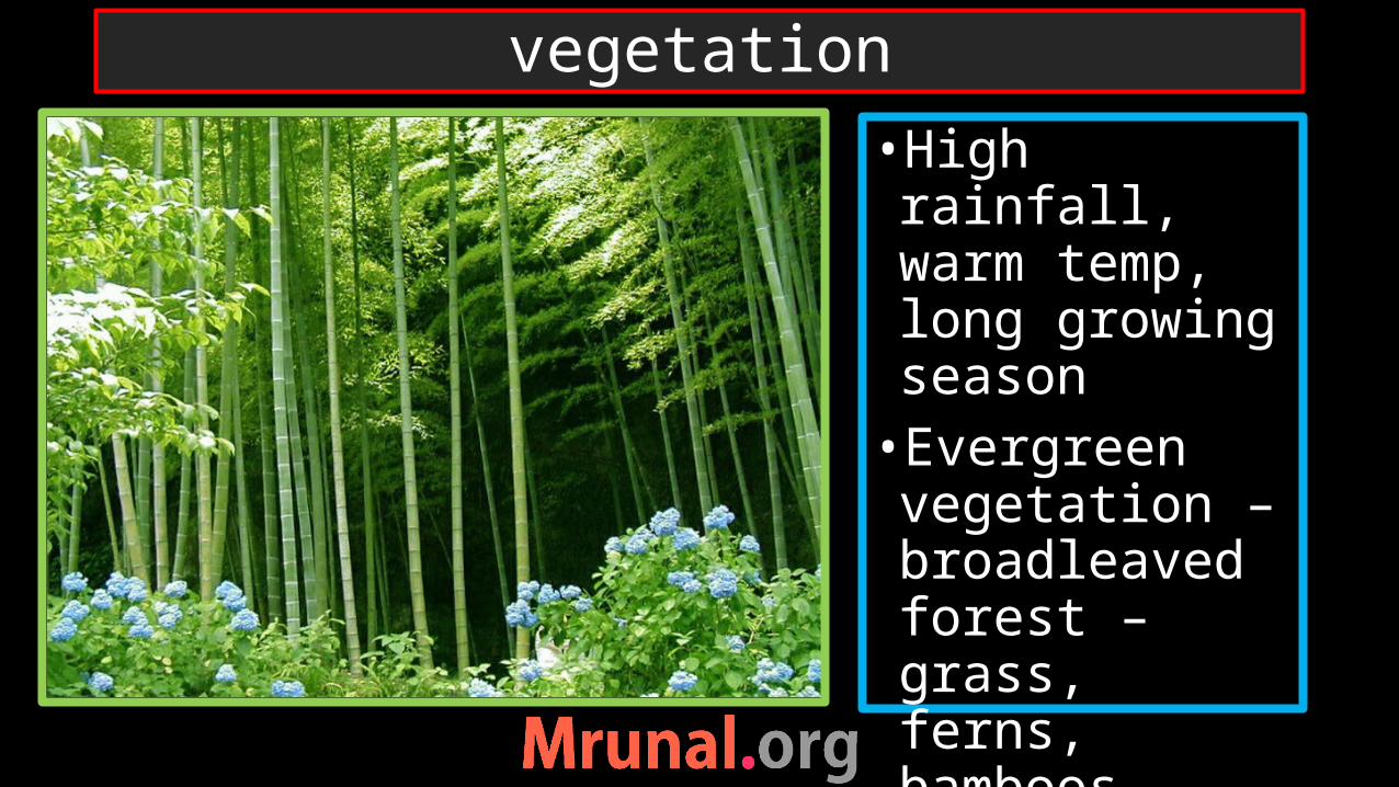
•High rainfall, warm temp, long growing season•Evergreen vegetation – broadleaved forest – grass, ferns, bamboos, palms
vegetation
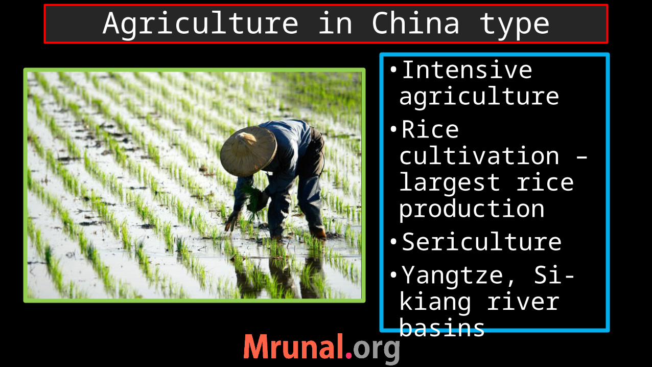
• Intensive agriculture•Rice cultivation – largest rice production•Sericulture•Yangtze, Si-kiang river basins
Agriculture in China type

•Best suited for cotton cultivation•Long growing season, frost free days, bright sunlight, high rainfall•Tobacco cultivation•Famous Virginia tobacco
Agriculture in gulf type
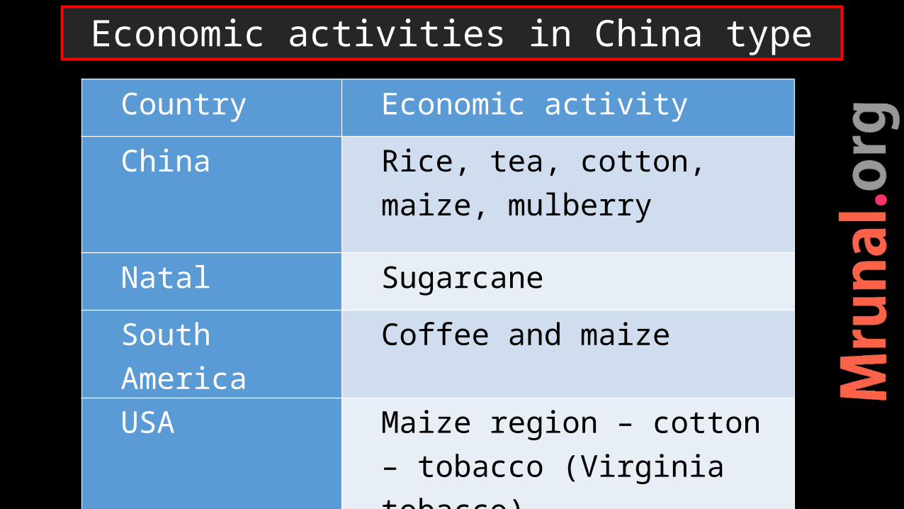
Country Economic activity
China Rice, tea, cotton, maize, mulberry
Natal Sugarcane
South America Coffee and maize
USA Maize region – cotton – tobacco (Virginia tobacco)
Economic activities in China type
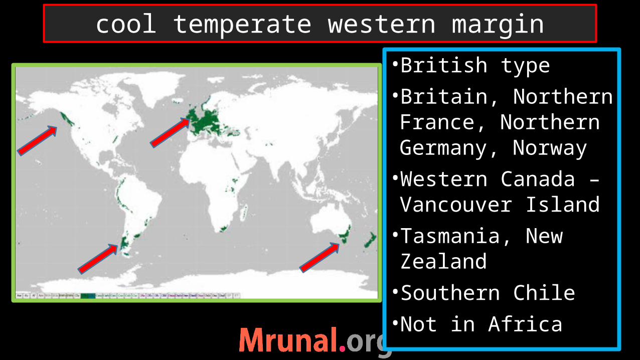
•British type•Britain, Northern France, Northern Germany, Norway•Western Canada – Vancouver Island•Tasmania, New Zealand•Southern Chile•Not in Africa
cool temperate western margin

•Best climate for human habitation•Warm current moderate climate – North Atlantic drift, Alaskan current•Moderate climate – warm summer, cool winters•Low annual temperature range
British type

•Rainfall from westerlies •western coast receive the most – rainfall decreas towards interior•Temperate cyclones – rainfall in winters
British type
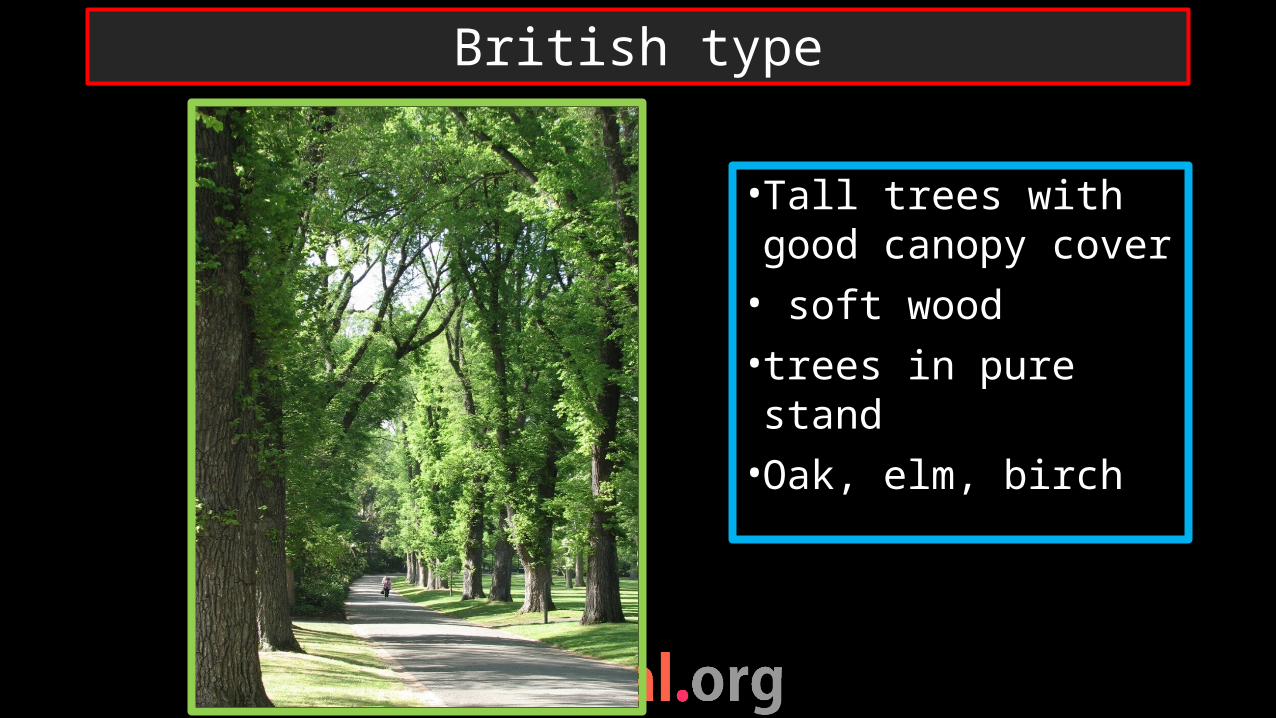
•Tall trees with good canopy cover• soft wood • trees in pure stand•Oak, elm, birch
British type

•Lumbering in Canada – Vancouver city•Systematic lumbering•Winter cutting – wood logs float in the rivers to industries•Wood furniture and paper making
British type

•Agriculture – market gardening => cultivation of fruits and vegetables •Tasmania (Aus.) – apple farming
British type
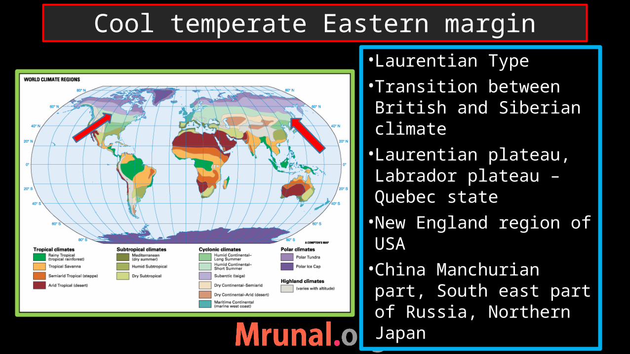
• Laurentian Type• Transition between British and Siberian climate• Laurentian plateau, Labrador plateau – Quebec state•New England region of USA•China Manchurian part, South east part of Russia, Northern Japan
Cool temperate Eastern margin

•Not in southern hemisphere- because hardly any land beyond 40 degree latitude•South America – Andes block the westerlies – oceanic influence
Laurentian type
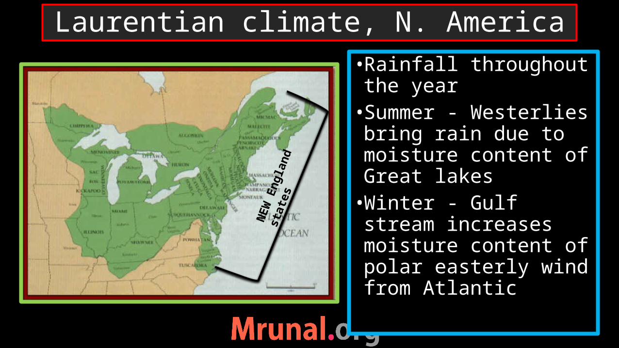
•Rainfall throughout the year•Summer - Westerlies bring rain due to moisture content of Great lakes•Winter - Gulf stream increases moisture content of polar easterly wind from Atlantic
Laurentian climate, N. America
NEW
Eng
land
st
ates

• In china – summer max•summer – intense heating of land – rainfall - wind from pacific•Winter – anti-cyclonic condition in the heart of Asia – cold wind blows out – snow fall in mountainous area
Laurentian type, China
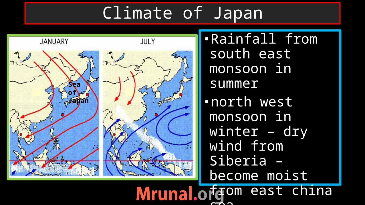
•Rainfall from south east monsoon in summer •north west monsoon in winter – dry wind from Siberia – become moist from east china sea•Maritime influence
Climate of Japan
Sea of Japan
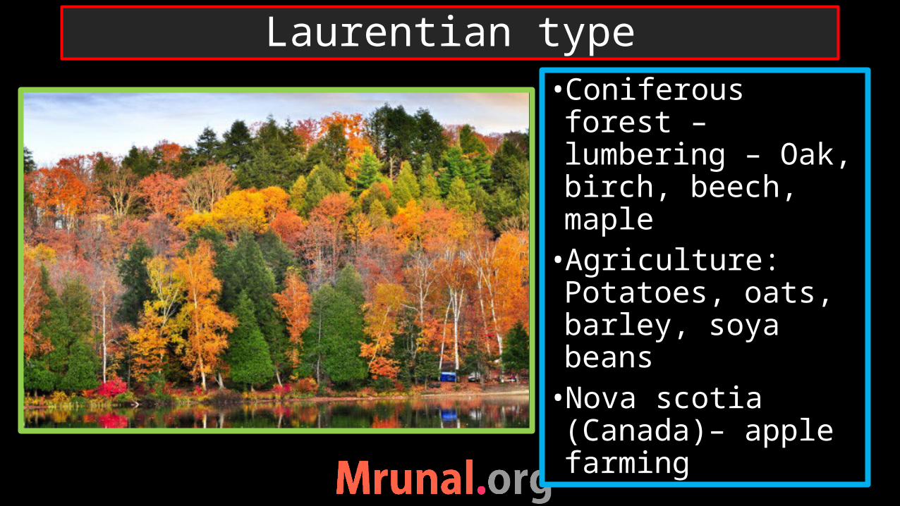
•Coniferous forest – lumbering – Oak, birch, beech, maple•Agriculture: Potatoes, oats, barley, soya beans•Nova scotia (Canada)– apple farming
Laurentian type

•Temperate regions – fish in large shoals •Cod, mackerel, tuna, salmon•Economically profitable•Mechanised sophisticated fishing•St.John’s port in Newfoundland – grand banks
Laurentian type
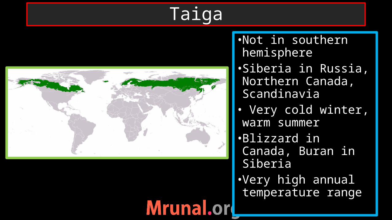
•Not in southern hemisphere•Siberia in Russia, Northern Canada, Scandinavia• Very cold winter, warm summer•Blizzard in Canada, Buran in Siberia•Very high annual temperature range
Taiga

•Rainfall throughout the year•Temperate cyclones•Evergreen pine forest, Juniper, Spruce, Birch – soft wood in pure strands•Fur bearing animals – warm blooded – muskrat, mink, silver fox
Taiga

•Arctic or polar climate•Northern Canada and Northern Russia•Periglacial climate•Freezing winter, thawing in summer•Summer short and cool•Mosses, linchens (algae and fungi) – ephemeral flowering plants
Tundra
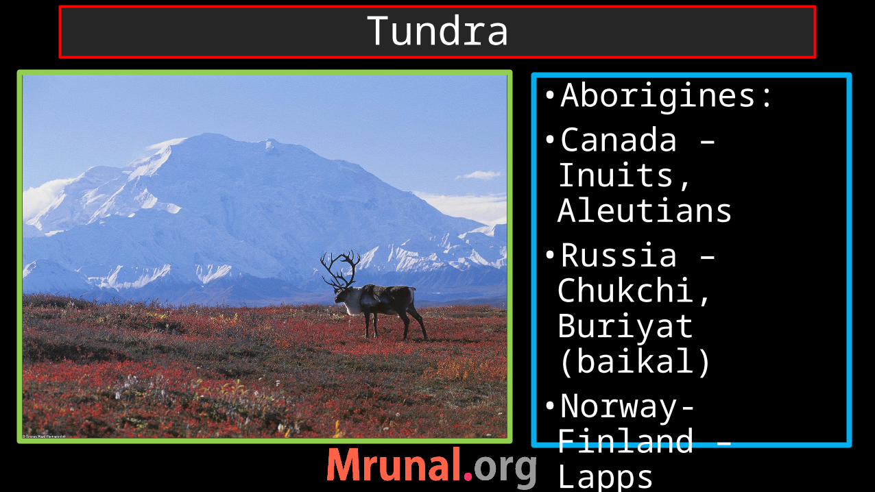
•Aborigines:•Canada – Inuits, Aleutians•Russia – Chukchi, Buriyat (baikal)•Norway- Finland – Lapps•Nomadic herders
Tundra