genesis solar energy project · biological resources technical report genesis solar energy project...
TRANSCRIPT

Biological Resources Technical Report
Genesis Solar Energy Project Riverside County, CA
Prepared By:
1940 E. Deere Avenue, Suite 200 Santa Ana, CA 92705
and
Alice E. Karl, Ph.D. P.O. Box 74006
Davis, CA 95617
Prepared For:
Genesis Solar, LLC
August 2009

Genesis Solar Energy Project Biological Resources Technical Report
ES-1 August 2009
EXECUTIVE SUMMARY Genesis Solar, LLC (Genesis Solar), is proposing to develop a 250-megawatt (MW) solar thermal power generating facility located in Riverside County, California, between the community of Desert Center and the city of Blythe on land managed by the Bureau of Land Management (BLM). The proposed Genesis Solar Energy Project (Project) would consist of two 125-MW units. Genesis Solar has applied for a 4,640-acre right-of-way (ROW) grant from the BLM for Project development; however, once constructed, the facility would occupy approximately 1,800 acres within the requested ROW, plus an approximately 90 acres for linear facilities. To determine vegetation communities, habitat, and species presence, comprehensive biological resource surveys were conducted of the entire requested ROW and linear facilities routes in spring of 2009.
The requested ROW and proposed linear facility routes were surveyed for all special-status species potentially occurring in the Project vicinity using U.S. Fish and Wildlife Service (USFWS) desert tortoise protocol survey methods (USFWS 1992). Due to the intensive nature of the desert tortoise survey methods, all special-status species were surveyed concurrently, including vegetation communities. Additional, focused surveys included burrowing owl surveys, avian point count surveys, and cactus/yucca/tree stratified sampling.
During the spring surveys, 64 wildlife species, 131 plant species, and 5 vegetation communities were observed. Although five vegetation communities occur within the survey area, only Sonoran Creosote Bush Scrub and Stabilized and Partially Stabilized Sand Dunes occur within the Project area (footprint). The main Project site (1,800 acres) is located entirely within Sonoran Creosote Bush Scrub. Portions of the linear facility routes overlap areas of Stabilized and Partially Stabilized Sand Dunes.
Special Status Species No federally or state-listed wildlife species were observed during 2009 surveys; however, sign (burrows, tracks) for the state-threatened desert tortoise (Gopherus agassizii) was found outside of the Project area. Seven California species of special concern were observed, including Mojave fringe-toed lizard (Uma scoparia), burrowing owl (Athene cunicularia), loggerhead shrike (Lanius ludovicianus), northern harrier (Circus cyaneus), short-eared owl (Asio flammeus), ferruginous hawk (Buteo regalis), and American badger (Taxidea taxus, burrow only). Tracks of the burro deer (Odocoileus hemionus eremicus; a game species) were detected within the survey area; however, no direct observations of this species were made.
Special Management Areas Five plant communities that are considered special by the BLM occur within in the Project survey area. These include Sand Dunes, Desert Chenopod Scrub, Desert Dry Wash Woodland, and Playa. Sand dunes overlap the Project area along the linear facility routes. No Chenopod Scrub, Desert Dry Wash Woodland, or Playa are located within the Project area. Although these communities exist to the northeast and east (Desert Dry Wash Woodland), south, near the dry lake bed (Chenopod Scrub), and south (Playa) of the ROW, these three communities are outside of the Project area and would not be affected by Project development.
The Project is situated within areas designated by the BLM and USFWS to manage natural resources. The plant site and portions of the linear facility routes overlap a Multi-Species Wildlife Habitat Management Area (WHMA). The southern portions of the linear facilities are within a desert tortoise Desert Wildlife Management Area (DWMA), and the southern end of the transmission line overlaps USFWS designated desert tortoise critical habitat.

Genesis Solar Energy Project Biological Resources Technical Report
i August 2009
TABLE OF CONTENTS
EXECUTIVE SUMMARY ........................................................................................................ES-1
1.0 INTRODUCTION...............................................................................................................1
2.0 PROJECT SETTING.........................................................................................................12.1 Project Location........................................................................................................12.2 Project Description ...................................................................................................22.3 ENVIRONMENTAL SETTING..................................................................................2
3.0 REGULATORY SETTING...............................................................................................113.1 Federal Laws and Regulations...............................................................................11
3.1.1 National Environmental Policy Act..............................................................113.1.2 Endangered Species Act ............................................................................113.1.3 Migratory Bird Treaty Act............................................................................113.1.4 Wild Free-Roaming Horse and Burro Act (Public Law 92-195) ..................11
3.2 State Laws and Regulations...................................................................................113.2.1 California Environmental Quality Act ..........................................................113.2.2 California Endangered Species Act............................................................123.2.3 Protection of Listed Species .......................................................................123.2.4 Protection of Non-Listed Species ...............................................................123.2.5 CEC Siting Regulations ..............................................................................13
3.3 Relevant Management Plans .................................................................................133.3.1 Northern and Eastern Colorado Desert Coordinated Management
Plan ............................................................................................................133.3.2 Desert Tortoise Recovery Plan...................................................................14
4.0 LITERATURE REVIEW AND SURVEYS........................................................................154.1 Literature Review ...................................................................................................154.2 Reconnaissance Survey.........................................................................................154.3 2009 Field Surveys.................................................................................................20
4.3.1 Vegetation Communities and Habitat Survey.............................................204.3.2 Wildlife Surveys ..........................................................................................25
5.0 SURVEY RESULTS AND DISCUSSION........................................................................295.1 General Site Characteristics...................................................................................295.2 Vegetation Community and Habitat Survey ...........................................................30
5.2.1 Special-Status Plant Species .....................................................................335.2.2 Sensitive Plant Communities......................................................................345.2.3 Cacti, Yucca, and Trees .............................................................................345.2.4 Non-Native Plants.......................................................................................37
5.3 Focused Wildlife Surveys .......................................................................................375.3.1 Desert Tortoise ...........................................................................................375.3.2 Mojave Fringe-Toed Lizard.........................................................................395.3.3 Burrowing Owl ............................................................................................405.3.4 Avian Point Count Surveys.........................................................................405.3.5 Other Special-Status Wildlife Observed .....................................................49
5.4 Potential for Other Special-Status Species to Occur..............................................495.4.1 Special-Status Wildlife and Plant Species Not Observed, but Could
Occur ..........................................................................................................49

Genesis Solar Energy Project Biological Resources Technical Report
ii August 2009
5.4.2 Special-Status Wildlife and Plant Species Not Likely to be Present...........50
6.0 ENVIRONMENTAL IMPACTS ........................................................................................506.1 Vegetation and Special Vegetation Communities ..................................................51
6.1.1 Special-Status Plant Species .....................................................................526.1.2 Cacti and Trees ..........................................................................................52
6.2 Wildlife Species ......................................................................................................536.2.1 Desert Tortoise ...........................................................................................536.2.2 Mojave Fringe-Toed Lizard.........................................................................536.2.3 Burrowing Owl ............................................................................................546.2.4 Other Special-Status Avian and Wildlife Species .......................................54
7.0 GENERAL RECOMMENDATIONS.................................................................................55
8.0 REFERENCES................................................................................................................56
LIST OF TABLES
Table 1. Aliquot Parts for the Genesis Solar Energy Project ........................................................1Table 2. Plant and Wildlife Species Observed and Potentially Occurring within the Genesis
Solar Energy Project .......................................................................................................16Table 3. Cacti, Yucca, and Trees Stratified Sampling Survey Results .......................................34Table 4. Desert Tortoise Sign Found during Spring 2009 Field Surveys....................................38Table 5. Avian Species, by Species Grouping, Observed during Spring 2009 Point Count
Surveys at the Genesis Solar Energy Project .................................................................47Table 6. Avian Species Observed by Transect during Spring 2009 Point Count Surveys at the
Genesis Solar Energy Project .........................................................................................48Table 7. Incidental Detections of Birds during Spring 2009 Point Count Surveys at the Genesis
Solar Energy Project .......................................................................................................48
LIST OF FIGURES Figure 1. Regional Location Map.............................................................................................3Figure 2. Features and Location..............................................................................................5Figure 3. Natural Community Types within the Genesis Solar Energy Project and Vicinity ....7Figure 4. Special Management Areas within Project Vicinity ..................................................9Figure 5a. CNDDB Special Status Plant Occurrences within 10 mi of the Genesis Solar
Energy Project.................................................................................................................21Figure 5b. CNDDB Special Status Wildlife Occurrences within 10 mi of the Genesis Solar
Energy Project.................................................................................................................23Figure 6. Cactus, Yucca and Tree Sampling Area ................................................................27Figure 7. Avian Point Count Locations ..................................................................................31Figure 8. Special Status Plants Observed During Field Surveys ..........................................35Figure 9. Desert Tortoise Sign Observed During Field Surveys............................................41Figure 10. Other Special Status Wildlife Species Sign Observed During Field Surveys.........43Figure 11. Burrowing Owls and Sign Observed During Field Surveys ....................................45

Genesis Solar Energy Project Biological Resources Technical Report
iii August 2009
APPENDICES Appendix A Example of Survey Data Sheet Appendix B List of Field Biologists Appendix C Representative Site Photographs Appendix D List of All Species Observed during Field Surveys Appendix E Key to Tortoise Sign Classes

Genesis Solar Energy Project Biological Resources Technical Report
1 August 2009
1.0 INTRODUCTION Genesis Solar, LLC (Genesis Solar) is proposing to develop a 250-megawatt (MW) solar thermal power generating plant in Riverside County, California (Figure 1). Genesis Solar has applied for a 4,640-acre right-of-way (ROW) grant from the Bureau of Land Management (BLM) for development of the Genesis Solar Energy Project (Project). Once constructed, the Project would permanently occupy approximately 1,800 acres within this area, plus approximately 90 acres for linear facilities. The total permanent Project footprint would be 1,890 acres (collectively referred to as the Project area).
To comply with federal, state, and local laws, natural resources must be evaluated at the Project. As part of evaluating the Project’s potential effects on species persistence and/or recovery, the presence of federally listed, state-listed, and other special plants and animals must be identified and their distribution and approximate abundance determined. To meet these objectives, comprehensive surveys for biological resources were conducted during spring 2009 of the 4,640-acre ROW and proposed linear facility routes. This document describes the methods and results of those surveys and discusses potential Project impacts.
2.0 PROJECT SETTING
2.1 Project Location The proposed Project is located approximately 25 miles west of Blythe, California, on lands managed by the BLM (Table 1, Figure 1). Surrounding features include the McCoy Mountains to the east, the Palen Mountains (including the Palen/McCoy Wilderness Area) to the north, and Ford Dry Lake to the south. Interstate 10 (I-10) is located approximately 2 miles south of the southernmost border of the ROW.
Table 1. Aliquot Parts for the Genesis Solar Energy Project
Section Aliquot Estimated Acres Township 6S, Range 19E, San Bernardino Base & Meridian
4 S ½ except wilderness 260 5 All except wilderness 550 6 SE ¼ 160 7 N ½, NE ¼ 80 8 NE ¼, N ½, NW ¼ 240 9 N ½ 320
10 All except wilderness 580 11 SW ¼ 160 13 NW ¼ except wilderness; SW ¼ 280 14 N ¾, NW ¼, N ¾, NE ¼ 240 15 N ½, NW ¼, N ½, NE ¼ 160 24 W ½, N ½ 160
Subtotal, T6S, R19E: 3,190 Township 6S, Range 18E, San Bernardino Base & Meridian
1 S ½ except wilderness 2902 S ½ except wilderness 2603 S ½ 320 4 All except wilderness 580
Subtotal, T6S, R18E: 1,450 Total ROW 4,640

Genesis Solar Energy Project Biological Resources Technical Report
2 August 2009
2.2 Project Description The Project would consist of the main plant site (solar facility), a 230-kilovolt (kV) transmission line, a natural gas pipeline, and a paved main access road (Figure 2). Within the 1,800-acre main plant site would be the solar arrays and associated Project facilities such as: a substation; an administration building; operation and maintenance facilities; and evaporation ponds. The linear facilities would originate within the plant site and, for the most part, would share the same 100-foot ROW, although each would terminate in a different location (Figure 2). Approximately 2 miles of the linear route would be within the 1,800-acre main plant site. After leaving the plant, the transmission line would be approximately 7.6 miles long, the natural gas pipeline would be 6 miles long, and the main access road would be 6.5 miles long.
2.3 ENVIRONMENTAL SETTING The Project is located in Chuckwalla Valley, immediately north of Ford Dry Lake in the Colorado region of the Sonoran Desert. This region is sparsely vegetated and characterized by broad valleys interspersed with mountain ranges and dry lakes. Summer temperatures routinely reach above 100ºF (June through September) and annual average precipitation in the Blythe, California, area is less than 4 inches. On average, August receives the most rainfall, although rainfall is also received in the winter months of December, January, and February (WRCC 2008). The Project is in the watershed of the McCoy and Palen Mountains; site drainage is by sheet flow and percolation. Topography is relatively level, with elevations between approximately 360 and 450 feet above mean sea level.
The vegetation within the Project area is characterized by two main vegetation types: Sonoran Creosote Bush Scrub and Stabilized and Partially Stabilized Sand Dunes (Holland 1986); however, small areas of Chenopod Scrub, Desert Dry Wash Woodland, and Playa (dry lake bed) are located within the survey area (but outside the Project area, Figure 3). Sonoran Creosote Bush Scrub represents the majority of the survey area, except where Stabilized and Partially Stabilized Sand Dunes are found in the eastern portion of the ROW and along the northern portions of the linear facility routes.
The Project is an undeveloped area and is currently undisturbed, although the area has been used for grazing and recreation in the past. The Project overlaps the Ford Dry Lake grazing allotment, which has been used in the past for sheep grazing, primarily. The area has not been used for grazing for over 10 years and was made unavailable for grazing in 2002 (BLM 2007). Ford Dry Lake was formerly open to the public for off-highway vehicle use, but has since been closed and current access is restricted to existing roadways. Access to the area is poor as it is limited to 4-wheel-drive roads located on the western end of the ROW.
The Project is located within the BLM’s Northern and Eastern Colorado Desert Coordinated Management (NECO) Plan area. Within the NECO Plan there are areas designated to manage natural resources including Wildlife Habitat Management Areas (WHMA), Areas of Critical Environmental Concern (ACEC), Desert Wildlife Management Areas (DWMA), and wilderness areas (Figure 4). The plant site and portions of the linear facility routes are situated within a Multi-Species WHMA. The Project is outside, but directly adjacent to the Palen/McCoy Wilderness (located to the north) and the Palen Dry Lake ACEC (located to the west). The southern portions of the linear facilities are within a desert tortoise DWMA, as well as USFWS-designated desert tortoise critical habitat (transmission line only). This document discusses potential Project impacts to biological resources as they pertain to these special management areas (Section 3.3).

Project Site
CC OO LL
OORR
AADD
OORR
II VVEE
RR
BlytheBlythe
§̈¦10
£¤95
£¤95£¤95
UV78
UV78
UV78
UV78
Midland
22nd
Lovekin
18th
78
Defrain
Seeley
28th
Intake
Hobson
6th
32nd
7th
24th
10th
Ran
nells
38th Street County Park38th Street County Park
Yuma Proving GroundYuma Proving Ground
GENESIS SOLAR ENERGY PROJECTRIVERSIDE COUNTY,
CALIFORNIA
Notes:(a) UTM Zone 11, NAD 1983 Projection. (b) Source data: ESRI, BLM
¯0 2 4 6 8
Miles
FIGURE 1REGIONAL LOCATION MAP
Printing Date: 8/5/2009 7:58 AMFile: P:\GIS\Projects\FPL\Maps\Genesis\Genesis-RegionalLocationMap.mxd
San Diego
Los AngelesRiverside
Chula Vista
Oceanside
Irvine
Yuma
Hesperia
Carlsbad
Hemet §̈¦10
§̈¦8
§̈¦10
ENLARGED AREA
LegendProject Site
Interstate
Highway
Major Road
Local Road
County Boundary
State Boundary
Lake/River
Lake Intermittent
Parks (Regional)
Military Installation
Urban Areas
Airport Area
R i v e r s i d e C o u n t y , C AR i v e r s i d e C o u n t y , C A
I m p e r i a l C o u n t y , C AI m p e r i a l C o u n t y , C A
L a P a z C o u n t y , L a P a z C o u n t y , A r i z o n aA r i z o n a
GENESIS SOLAR, LLC

!
!
!
!
!
!
!!
!
! ! !
!
! ! !
!
!
!!
!!
!!!!!!!!!!!
!!
! ! ! !
!!
!!
!!
!
! ! !!
!!
!
!
!
! ! ! ! !
!!
!!
!!
!
!!!!!!!!!!!!!!!!!!!!!!!!!!!!!!!!!!!!!!!!!!!!!!!!!!!!!!!!!!!!!!!!!!!!!!!!!
!!
!!
!!
!!
!!
!!
!!
!
!
7
4
7
63
62
99
6 4
2
7
5
5
2
8
8
9
6
3 1
9
2 1
5
1
4
35 4
7
3 1
8
8
4
9
8
4
5
9
8
30
5
31
1111
1111
24
30
31
25
2528
3027
15
31
25
22
13
19
26
12
2526
35
29
2728
13
31
18
1012
35
30
12
2627
36
17
33
32
29
34
10
36
20
36
2324
1618
23
1614
15
29
36
14
19
33
10
29
34
26
22
12
32
21
35
21
32
20
27
35
32
33
28
17
34
28
10
3433
16
21
28
28
33
33
32
29
20
17
32
29
171813
21 22
14
23 24 19
1518 1713 16
20
1416
21 22
15
23 24 19
16
2020
17
21
0
200
198
196
194
190
188
186184 182 181 180 179 178 177 175 174 173 172 171 170 169 168 167 166 165 163 162 161 159 157 156 155 154 153 152 151 150 148 147 146 145 144 142 140 139 137 136 134 133 132 131 129 127 125 124 122 120 119 118 117 115
§̈¦10
GENESIS SOLAR ENERGY PROJECTRIVERSIDE COUNTY,
CALIFORNIA
Notes:(a) UTM Zone 11, NAD 1983 Projection. (b) Source data: ESRI, BLM
¯0 0.5 1 1.5 2
Miles
FIGURE 2FEATURES AND LOCATION
Printing Date: 7/30/2009 2:09 PMFile: P:\GIS\Projects\FPL\Maps\Genesis\Genesis-Features-Location-Figure2.mxd
San Diego
Los AngelesRiverside
Irvine
Palmdale
Chula Vista
Oceanside
Yuma
VictorvilleHesperia
Carlsbad
HemetTustin
Laguna Niguel
§̈¦10
§̈¦8
ENLARGED AREA
Legend! Blythe Transmission Line Structures
Blythe Transmission Line
! ! Previously Proposed Linear Route
! ! Proposed Transmission Interconnect
Proposed Gas Line
Proposed Access
Project Site
Facility Footprint
Township and Range Lines
Section Lines
R 18 E R 19 E R 20 E
R 18 E R 19 E R 20 E
T 5
ST
6 S
T 7
S
T 5
ST
6 S
T 7
S
GENESIS SOLAR, LLC

!
!
!
!
!
!
!!
!
! !
!
! !
!
!
!
!!
!!
!!!!!!!!!
!!
!
! ! ! !
!!
!!
!
!!
! ! ! !
!!
!
! ! !!
!!
! !
!
!
!!
!!
!!
§̈¦10
Notes:(a) UTM Zone 11, NAD 1983 Projection. (b) Source data: ESRI, USDA
¯0 0.5 1 1.5 2
Miles
Last Saved: Thursday, August 06, 2009 12:24 PMP:\projects_2005\fpl\maps\Genesis_Bio\FDL_Veg_Types.mxd
Los Angeles Metro Area
San Diego Metro Area
Phoenix
§̈¦40
§̈¦8
§̈¦15Mojave NPRES
Joshua Tree NP
Death Valley NP Grand Canyon NP
A r i z o n aC a l i f o r n i a
N e v a d a
ENLARGED AREA
LegendChenopod ScrubSonoran Creosote Bush ScrubDry Desert Wash WoodlandPlaya and Sand Drifts over PlayaStabilized and Partly-Stabilized Sand DuneFacility FootprintProject SiteExtent of Surveyed AreaBlythe Energy Project Transmission Line
! ! Previously Proposed Linear Route! ! Proposed Transmission Interconnect
Proposed Gas LineProposed Access Road
Figure 3Natural Community Types within the
Genesis Solar Energy Project and Vicinity
GENESIS SOLAR ENERGY PROJECTRIVERSIDE COUNTY,
CALIFORNIA
Genesis Solar, LLCGenesis Solar, LLC

!
!
!
!
!
!!
! !
!!
!
!
!
!!
!
!!!!!!
!!
!
! ! !
!!
!
!!!!!!!!!!!!!!!!!!!!!!!!!!!!!!!!!!!!!!!!!!!!!!!!!!!!!!!!!!!!!!!!!!!!!!!!!!!!!!!!!!!!!!!!!!!!!!!
!!
!!
!!
!!
!!
!!
!!
!!
!!
!!
!!
!!
!!
!!
!!
!!
!!!!
!!
!!
!
DWMA
DWMA
DWMA
DWMA
DWMA
DWMA
Palen-Ford
Mule
Palen/McCoy Wilderness
Little Chuckwalla Mountains Wilderness
Chuckwalla Mountains Wilderness
Palen Dry Lake
Chuckwalla Valley Dune Thicket
0
99
219217
215213
211209
207205
203201
199197
191189
187184 182 180 178 176 174 172 170 168 166 164 162 160 158 156 154 152 150 148 146 144 142 140 138 136 134 132 130 128 126 124 122 120 118 116 114 112 110 108 106 104 102
§̈¦10
GENESIS SOLAR ENERGY PROJECTRIVERSIDE COUNTY,
CALIFORNIA
Notes:(a) UTM Zone 11, NAD 1983 Projection. (b) Source data: ESRI, BLM
¯0 1 2 3 4
Miles
FIGURE 4SPECIAL MANAGEMENT AREAS
WITHIN PROJECT VICINITY
Printing Date: 7/22/2009 10:33 AMFile: P:\GIS\Projects\FPL\Maps\Genesis\Genesis-WHMA.mxd
San Diego
Los AngelesRiverside
Irvine
Palmdale
Chula Vista
Oceanside
Yuma
VictorvilleHesperia
Carlsbad
HemetTustin
Laguna Niguel
§̈¦10
§̈¦8
ENLARGED AREA
LegendProposed Gas Line
! Blythe Transmission Line Structures
Blythe Transmission Line
Genesis Proposed Access
! ! Proposed Linear Route (9.6mi)
DWMA Northeren Eastern Colorado
Facility Footprint
Area of Critical Environmental Concern
Project Site
BLM Wilderness
USFWS Designated Critical Habitat
Multi Species WHMA
Bighorn Sheep MHMA
GENESIS SOLAR, LLC

Genesis Solar Energy Project Biological Resources Technical Report
11 August 2009
3.0 REGULATORY SETTING
3.1 Federal Laws and Regulations
3.1.1 National Environmental Policy ActThis act requires the analysis of the environmental effects of any federal action. In this case, the administrating agency is the BLM. The BLM follows the National Environmental Policy Act (NEPA) (40 Code of Federal Regulations [CFR] Parts 1500 – 1508), the Federal Land Policy and Management Act of 1976, and the Energy Policy Act of 2005. Additionally, BLM follows guidance in the BLM NEPA Handbook H-1790-1, which was updated in January 2008, and the BLM Land Use Planning Handbook H-17601-1, Guidance for Preparing NEPA Documents Associated with Land Use Plans and Resource Management Plans.
3.1.2 Endangered Species ActThe Endangered Species Act (ESA) of 1973 (16 United States Code [USC] 1531 et seq.; 50 CFR 17.1 et seq.) designates and provides for protection of threatened and endangered plant and animal species, and their designated critical habitat. Under Section 7 of the ESA, the BLM must consult with the USFWS regarding a proposed action that may adversely affect listed species; in this case, the desert tortoise. Formal consultation is requested via a biological assessment, followed by USFWS issuance of a biological opinion (BO) and an incidental take statement.
3.1.3 Migratory Bird Treaty ActThe Migratory Bird Treaty Act (MBTA) of 1918, as amended, prohibits “take” of migratory birds (16 USC 703-712). Under the MBTA it is unlawful to pursue, hunt, take, capture or kill; attempt to take, capture or kill; possess, offer to or sell, barter, purchase, deliver or cause to be shipped, exported, imported, transported, carried or received any migratory bird, part, nest, egg or product. All birds that are native to the United States and belong to a family, group or species covered by at least one of the four migratory bird conventions to which the United States is party are covered under the MBTA. There is currently no permitting framework (e.g., incidental take permits) that allow liability protection for developers.
3.1.4 Wild Free-Roaming Horse and Burro Act (Public Law 92-195)Wild horses and burros are protected from capture, branding, harassment, and death, and managed with the intent to achieve and preserve the natural ecological balance on public lands. The BLM is the administering agency.
3.2 State Laws and Regulations
3.2.1 California Environmental Quality ActCEQA requires review of any project that is undertaken, funded, or permitted by a state or local governmental agency. Typically, the state or local agency with overall project permitting authority takes the lead for CEQA compliance. The lead agency has the discretion to consider any non-listed species a defacto listed species by the statement that “a species not included in any listing in subsection (c) shall nevertheless be considered to be rare or endangered if the species can be shown to meet the criteria in subsection (b)” (CEQA Guidelines §15380, Subsection d). If significant project effects were identified, the lead agency would have

Genesis Solar Energy Project Biological Resources Technical Report
12 August 2009
the option of requiring mitigation for effects through changes in the project or deciding that overriding considerations make mitigation infeasible (CEQA Sec. 21002). The California Energy Commission (CEC) is the lead state agency for CEQA review for thermal generating facilities 50 MW and larger in size. Because the Genesis Solar Energy Project is proposed as a Concentrated Solar Thermal project, CEC is the lead agency by law. The CEC certification incorporates all other state permits, including those listed below.
3.2.2 California Endangered Species ActThe California Endangered Species Act of 1984 [CESA, Fish and Game Code (FGC) sections 2050 et seq.] protects California’s rare, threatened, and endangered species. The applicant must consult with California Department of Fish and Game (CDFG) regarding the possibility of “take” under CESA, similar to the federal consultation, above. When all state-listed species are also federally listed species addressed in the federal BO, CDFG can choose to find the federal BO consistent with state law (a 2080.1 Consistency Determination). Alternatively, CDFG may require a separate state “take” permit (a 2081 permit) if species listed by CESA are not covered by the federal BO and could be harmed or killed during construction or operation of a project.
3.2.3 Protection of Listed SpeciesTitle 14, California Code of Regulations, Sections 670.2 and 670.5 – Under this code, animals are designated as threatened or endangered in California. California species of special concern is a category conferred by CDFG on those species that are indicators of regional habitat changes or are considered potential future protected species. These species do not have any special legal status, but this designation is used by CDFG as a management tool for consideration when land use decisions are made.
Native Plant Protection Act (NPPA); CDFG Code Section 1900 et seq. – The NPPA includes measures to preserve, protect, and enhance rare and endangered native plant species. Definitions for “rare and endangered” are different from those contained in CESA, although CESA-listed rare and endangered species are included in the list of species protected under the NPPA.
CDFG Streambed Alteration Agreement; CDFG Code Section 1600-1616 - Waters of the state of California are also subject to the jurisdiction of the CDFG. The CDFG monitors streambed alteration to conserve, protect, and manage California’s fish, wildlife, and native plant resources. The FGC (Section 1602) requires any person, state or local governmental agency, or public utility to notify the CDFG before beginning an activity that will substantially divert, obstruct, or change the natural flow of the bed, channel, or bank (including associated riparian vegetation) of a river, stream, or lake; or use material from a streambed prior to commencement of the activity. If CDFG determines that the action could have an adverse affect on existing fish and wildlife resources, a Lake or Streambed Alteration Agreement is required.
3.2.4 Protection of Non-Listed SpeciesCDFG Code Sections 3503 and 3503.5 – These codes state that it is unlawful to take, possess, or needlessly destroy the nest or eggs of any bird, including birds of prey, or take, possess, or destroy birds of prey, except as otherwise provided by this code or any regulation made pursuant thereto.

Genesis Solar Energy Project Biological Resources Technical Report
13 August 2009
CDFG Code Sections 3511, 4700, 5050, and 5515 – These state laws classify and prohibit the take of “fully protected” birds, mammal, amphibian/reptile, and fish species in California.
CDFG Code Section 3513 – This code prohibits any take or possession of birds that are designated by the MBTA as migratory non-game birds except as allowed by federal rules and regulations promulgated pursuant to the MBTA.
CDFG Code Section 4150 – This state law makes it unlawful to take or possess any non-game mammal or parts thereof except as provided in the Fish and Game Code or in accordance with regulations adopted by the commission.
California Desert Native Plants Act – Pursuant to the California Food and Agriculture Code §§ 80001-80006, the California Desert Native Plants Act (CDNPA) allows the harvest of certain species of specific native plants under permits issued by the County Agricultural Commissioner or Sheriff. The purpose of the CDNPA is to prevent the unlawful harvesting of native desert trees and cacti, either for wood, landscaping, or other purposes. Where feasible and practicable, individual plants can be salvaged and used for the Project revegetation program or salvaged by an approved nursery, landscaper, or other group to indirectly reduce unlawful harvesting elsewhere.
3.2.5 CEC Siting RegulationsTitle 20 California Code of Regulations, Appendix B lists information that must be provided to the CEC to complete the certification process. Further, the CEC has developed protocols (CEC 2007) specific to solar projects in California. The CEC’s data adequacy requirements are based in ongoing consultation with state agencies, including CDFG.
3.3 Relevant Management Plans
3.3.1 Northern and Eastern Colorado Desert Coordinated Management PlanThe 25-million-acre California Desert Conservation Area (CDCA) was designated in 1976 by the Federal Land Policy and Management Act to allow BLM to manage the resources of the California deserts. BLM developed a management plan for the CDCA in 1980, but the plan has since been amended and subdivided into four bioregion planning areas. The BLM has completed a regional plan amendment for each bioregion, among them the NECO Plan (BLM and CDFG 2002), which encompasses 5.5 million acres in the southeastern California Desert and the entire Project area.
The NECO Plan identifies the following issues that underlie the plan’s conservation and management program:
Adopt standards and guidelines for public land health
Recover two threatened species: the desert tortoise (Gopherus agassizii) and Coachella Valley milkvetch (Astragalus lentiginosus coachellae)
Conserve approximately 60 special-status animals and plants and natural communities
Resolve management issues of wild horses and burros along the Colorado River
Designate recreational/ routes of travel
Resolve issues of the land ownership pattern
Resolve issues of resource access and regulatory burden

Genesis Solar Energy Project Biological Resources Technical Report
14 August 2009
Incorporate changes created by the 1994 California Desert Native Plants Act
In addition to a number of specific objectives and actions to meet the goals of the above issues, the NECO Plan provides for conservation and management of several special-status species, in large part through a system of broad management areas: DWMAs for desert tortoises and WHMAs for other special-status species and natural communities. In both types of management areas, habitat improvements are prescribed to enhance the species of concern. Cumulative disturbance within DWMAs is limited to one percent of the surface area and individual disturbances are compensated at 5 acres of land for every 1 acre disturbed (5:1 ratio). The Project’s entire requested ROW of 4,640 acres is located within a Multi-Species WHMA and the Project’s linear facilities overlap with portions of the same WHMA. Additionally, approximately 0.5 mile of the transmission line is within a designated desert tortoise DWMA (Figure 4).
BLM habitat categories, ranging in decreasing importance from Category I to Category III, were designed as management tools to ensure future protection and management of desert tortoise habitat and its populations. These designations were based on tortoise density, estimated local tortoise population trends, habitat quality, and other land-use conflicts. Category I habitat areas are considered essential to the maintenance of large, viable populations. Outside of desert tortoise DWMAs, all habitat previously categorized as Category I, II, or III habitat, including uncategorized habitat found to be inhabited by desert tortoises, is treated as Category III habitat for the purposes of compensation. The Project site is in uncategorized habitat not occupied by desert tortoises; however, the linear facilities overlap Category III habitat.
The NECO Plan also specifically identifies situations for which surveys must be completed for projects in the NECO planning area. Those that are relevant to the Project include the following:
In Multi-species Conservation Zones – Survey for all special-status species
Special-status Plants – Survey in all mapped ranges
Special-status Wildlife – Survey at all known locations
Bats – Identify all significant roosts within 1 mile
Prairie Falcon (Falco mexicanus) and Golden Eagle (Aquila chrysaetos) – Identify all eyries within 0.25 mile
Burrowing Owl (Athene cunicularia) – Identify presence and locations
Crissal Thrasher (Toxostoma crissale) – Identify presence
Couch’s Spadefoot (Scaphiopus couchi) – Identify all ephemeral impoundment areas
Natural and Artificial Water Sources – Identify presence within 0.25 mile
3.3.2 Desert Tortoise Recovery PlanIn June 1994, the final Desert Tortoise (Mojave Population) Recovery Plan was released (USFWS 1994a). The Recovery Plan identifies six evolutionarily significant units of the desert tortoise in the Mojave region, termed recovery units, based on differences in tortoise behavior, morphology and genetics, vegetation, and climate. Within those recovery units, suggested DWMAs act as reserves in which recovery actions are implemented. The recovery plan works in concert with critical habitat, designated for the desert tortoise in 1994 (USFWS 1994b), by prescribing management actions to aid recovery, with critical habitat providing legal protection for areas that are considered to have essential features for tortoise survival. Approximately 2.5 miles of the linear facility route falls within desert tortoise critical habitat (Figure 4).

Genesis Solar Energy Project Biological Resources Technical Report
15 August 2009
4.0 LITERATURE REVIEW AND SURVEYS
4.1 Literature Review Several species known to occur on or in the vicinity of the Project are accorded “special status” by federal and state agencies because of their recognized rarity or potential vulnerability to extinction. These species typically have a limited geographic range and/or limited habitat and are referred to collectively as “special-status” species. Prior to field surveys, a target list of special-status species that may be affected by the Project was developed (Table 2) based on the following:
Records of the California Natural Diversity Data Base (CNDDB) for special-status species that are known to occur within 10 miles of the survey area (Figures 5a, 5b)
Records from the California Native Plant Society (CNPS) for special-status plants within the survey region
Requests to and responses by the resource agencies relative to protected species in the Project area (Massar 2007, O’Rourke 2007, Goebel 2009)
Special status species identified in the NECO Plan
The Project lead biologist‘s extensive experience on desert flora and fauna in the vicinity of the Project
4.2 Reconnaissance Survey In December 2007, a biological reconnaissance survey was completed to gain a better understanding of the vegetation communities present in the Project area and to aid in determining which plant and wildlife species could occur. This survey also served as the Phase I burrowing owl habitat assessment (see Section 4.3.2.3 Burrowing Owl). Vegetation communities were loosely delineated and any special plant communities designated by NECO were mapped (Figure 3). The results of the reconnaissance survey were taken into consideration by Genesis Solar when siting Project facilities to avoid sensitive vegetation communities and habitats (sand dune and playa) as much as possible. Survey results were also used to refine search methods for focused biological surveys.
Genesis Solar Energy Project Biological Resources Technical Report
16 August 2009
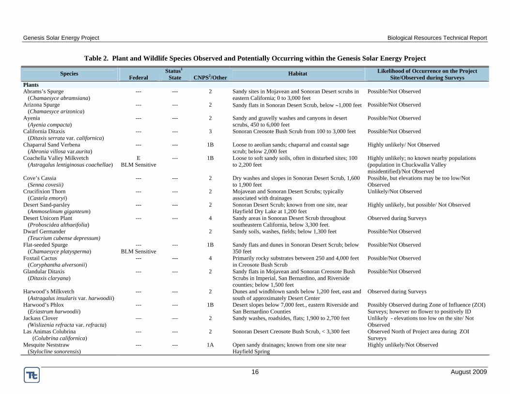
Table 2. Plant and Wildlife Species Observed and Potentially Occurring within the Genesis Solar Energy Project
Status1Species
Federal State CNPS2/OtherHabitat Likelihood of Occurrence on the Project
Site/Observed during Surveys PlantsAbrams’s Spurge
(Chamaesyce abramsiana)--- --- 2 Sandy sites in Mojavean and Sonoran Desert scrubs in
eastern California; 0 to 3,000 feet Possible/Not Observed
Arizona Spurge (Chamaesyce arizonica)
--- --- 2 Sandy flats in Sonoran Desert Scrub, below 1,000 feet Possible/Not Observed
Ayenia (Ayenia compacta)
--- --- 2 Sandy and gravelly washes and canyons in desert scrubs, 450 to 6,000 feet
Possible/Not Observed
California Ditaxis (Ditaxis serrata var. californica)
--- --- 3 Sonoran Creosote Bush Scrub from 100 to 3,000 feet Possible/Not Observed
Chaparral Sand Verbena (Abronia villosa var.aurita)
--- --- 1B Loose to aeolian sands; chaparral and coastal sage scrub; below 2,000 feet
Highly unlikely/ Not Observed
Coachella Valley Milkvetch (Astragalus lentiginosus coachellae)
EBLM Sensitive
--- 1B Loose to soft sandy soils, often in disturbed sites; 100 to 2,200 feet
Highly unlikely; no known nearby populations (population in Chuckwalla Valley misidentified)/Not Observed
Cove’s Cassia (Senna covesii)
--- --- 2 Dry washes and slopes in Sonoran Desert Scrub, 1,600 to 1,900 feet
Possible, but elevations may be too low/Not Observed
Crucifixion Thorn (Castela emoryi)
--- --- 2 Mojavean and Sonoran Desert Scrubs; typically associated with drainages
Unlikely/Not Observed
Desert Sand-parsley (Ammoselinum giganteum)
--- --- 2 Sonoran Desert Scrub; known from one site, near Hayfield Dry Lake at 1,200 feet
Highly unlikely, but possible/ Not Observed
Desert Unicorn Plant (Proboscidea althaeifolia)
--- --- 4 Sandy areas in Sonoran Desert Scrub throughout southeastern California, below 3,300 feet.
Observed during Surveys
Dwarf Germander (Teucrium cubense depressum)
2 Sandy soils, washes, fields; below 1,300 feet Possible/Not Observed
Flat-seeded Spurge (Chamaesyce platysperma)
---BLM Sensitive
--- 1B Sandy flats and dunes in Sonoran Desert Scrub; below 350 feet
Possible/Not Observed
Foxtail Cactus (Coryphantha alversonii)
--- --- 4 Primarily rocky substrates between 250 and 4,000 feet in Creosote Bush Scrub
Possible/Not Observed
Glandular Ditaxis (Ditaxis claryana)
--- --- 2 Sandy flats in Mojavean and Sonoran Creosote Bush Scrubs in Imperial, San Bernardino, and Riverside counties; below 1,500 feet
Possible/Not Observed
Harwood’s Milkvetch (Astragalus insularis var. harwoodii)
--- --- 2 Dunes and windblown sands below 1,200 feet, east and south of approximately Desert Center
Observed during Surveys
Harwood’s Phlox (Eriastrum harwoodii)
--- --- 1B Desert slopes below 7,000 feet., eastern Riverside and San Bernardino Counties
Possibly Observed during Zone of Influence (ZOI) Surveys; however no flower to positively ID
Jackass Clover (Wislizenia refracta var. refracta)
— — 2 Sandy washes, roadsides, flats; 1,900 to 2,700 feet Unlikely - elevations too low on the site/ Not Observed
Las Animas Colubrina (Colubrina californica)
--- --- 2 Sonoran Desert Creosote Bush Scrub, < 3,300 feet Observed North of Project area during ZOI Surveys
Mesquite Neststraw (Stylocline sonorensis)
--- --- 1A Open sandy drainages; known from one site near Hayfield Spring
Highly unlikely/Not Observed

Genesis Solar Energy Project Biological Resources Technical Report
17 August 2009
Status1Species
Federal State CNPS2/OtherHabitat Likelihood of Occurrence on the Project
Site/Observed during Surveys Orocopia Sage
(Saliva greatae)---
BLM Sensitive --- 1B Mojavean and Sonoran Desert Scrubs; gravelly/ rocky
bajadas, mostly near washes; below 3,000 feet Unlikely/Not observed
Pink Fairy Duster (Calliandra eriophylla)
--- --- 2 Sonoran Desert scrub; washes Possible/Not observed
Sand Evening Primrose (Camissonia arenaria)
--- --- 2 Sandy washes and rocky slopes below 1,300 feet Possible/Not observed
Slender Woolly-heads (Nemacaulis denudate var. gracilis)
--- --- 2 Dunes in coastal and Sonoran Desert scrubs, primarily in the Coachella Valley; below 1,500 feet
Possible/Not observed
Spearleaf (Matelea parvifolia)
— — 2 Rocky ledges and slopes, 1,000 to 6,000 feet, in Mojave and Sonoran Desert scrubs
Unlikely; no habitat/Not observed
Spiny Abrojo (Condalia globosa var. pubescens)
--- --- 4 Sonoran Creosote Bush Scrub; 500 to 3,300 feet Possible/Not observed
Wiggins’ Cholla (Cylindropuntia wigginsii)
--- --- 3 Sonoran Creosote Bush Scrub; 100 to 2,900 feet Possibly observed during surveys
Amphibians Couch’s Spadefoot
(Scaphiopus couchii)---
BLM Sensitive SC --- Various arid communities in extreme southeastern
California and east, south Possible/ Not observed
ReptilesColorado Desert Fringe-toed Lizard
(Uma notata)---
BLM Sensitive SC --- Restricted to aeolian sandy habitats in the Sonoran
DesertPossible hybrids with U. scoparia/ Possibly observed
Desert Rosy Boa (Charina trivirgata gracia)
---BLM Sensitive
--- --- Rocky uplands and canyons; often near stream courses Unlikely due to lack of habitat/Not observed
Mojave Fringe-toed Lizard (Uma scoparia)
---BLM Sensitive
SC --- Restricted to aeolian sandy habitats in the Mojave and northern Sonoran deserts
Observed during surveys
Desert Tortoise (Gopherus agassizii)
T T Most desert habitats below approximately 5,000 feet in elevation
Carcass, carcass fragments, burrows, and tracks only observed during surveys
BirdsAmerican Peregrine Falcon
(Falco peregrinus anatum)Delisted
BCCE
Fully Protected
Dry, open country, including arid woodlands; nests in cliffs
Possible forager on site, may nest in adjacent mountains/Not observed
Bendire’s Thrasher (Toxostoma bendirei)
BCCBLM Sensitive
SC Arid to semi-arid brushy habitats, usually with yuccas, cholla, and trees
Unlikely/Not observed
Burrowing Owl (Athene cunicularia)
BCCBLM Sensitive
SC Open, arid habitats Observed during surveys
Crissal Thrasher (Toxostoma crissale)
BCC SC Dense mesquite and willows along desert streams and washes
Highly unlikely due to lack of habitat/Not observed
Ferruginous Hawk (Buteo regalis)
BCCBLM Sensitive
- Arid, open country Observed incidentally
Golden Eagle (Aquila chrysaetos)
BCCBLM Sensitive
SCFully
Protected
Open country; nests in large trees in open areas or cliffs Possible forager on site, may nest in adjacent mountains/Not observed
Loggerhead Shrike (Lanius ludovicianus)
BCC SC Arid habitats with perches Observed during surveys
Mountain Plover (Charadrius montanus)
BCCBLM Sensitive
SC Dry upland habitats, plains, bare fields Highly unlikely, but possible winter visitor on Ford Dry Lake and adjacent shore

Genesis Solar Energy Project Biological Resources Technical Report
18 August 2009
Status1Species
Federal State CNPS2/OtherHabitat Likelihood of Occurrence on the Project
Site/Observed during Surveys Northern Harrier
(Circus cyaneus)--- SC Open habitats; nests in shrubby pen land and marshes Observed during surveys
Short-eared Owl (Asio flammeus)
--- SC Open habitats: marshes, fields; nests on ground and roosts on ground, low poles
Observed during Surveys
Yellow-breasted Chat (Icteria virens)
--- SC Dense streamside thickets, willows; brushy hillsides and canyons
Highly unlikely due to lack of habitat, but possible transient/ Not observed
MammalsAmerican Badger
(Taxidea taxus)--- SC Many habitats Observed (burrow only)
Arizona Myotis (Myotis occultus)
--- SC WBWG:M Lowlands of the Colorado River and adjacent mountain ranges, up to ponderosa pine habitat; mines, buildings, bridges, riparian woodlands, often near water
Unlikely/Not observed*
Big Free-tailed Bat (Nyctinomops macrotis)
--- SC WBWG:M Cliffs and rugged rocky habitats in arid, country, also riparian woodlands
Possible forager on site, especially near mountains/Not observed*
Burro(Equus asinus)
--- --- Protected Various habitats near water Unlikely/Not observed
Burro Deer (Odocoileus hemionus eremicus)
--- Game Species
Arboreal and densely vegetated drainages Possible
California Leaf-nosed Bat (Macrotus californicus)
--- SC WBWG:MH Lowland desert associate, found in caves, mines, tunnels and old buildings
Unlikely/Not observed*
Colorado Valley Woodrat (Neotoma albigula venusta)
--- --- Under mesquite in creosote bush scrub; southeastern California
Unlikely due to lack of habitat/Not observed
Nelson’s Bighorn Sheep (Ovis canadensis nelsoni)
---BLM Sensitive
--- In mountains and adjacent valleys in desert Scrub Possible in Palen and McCoy Mountains/Not observed
Pallid Bat (Antrozous pallidus)
---BLM Sensitive
SC WBWG:H Several desert habitats Possible/Not observed
Pocketed Free-tailed Bat (Nyctinomops femorosaccus)
--- SC WBWG:M Variety of arid areas in pinyon-juniper woodland, desert scrubs, palm oases, drainages, rocky areas
Possible in the McCoy Mountains/Not observed*
Southwestern Cave Myotis (Myotis velifer brevis)
---BLM Sensitive
SC WBWG:M Caves, mines and buildings in lower desert scrub habitats; also near streams and in woodlands, old ag fields
Unlikely /Not observed*
Spotted Bat (Euderma maculatum)
---BLM Sensitive
SC WBWG:H Arid scrub and grasslands, to coniferous forests, roosts in cliffs, Forages along waterways
Unlikely/Not observed*
Townsend’s Big-eared Bat (Corynorhinus townsendii)
---BLM Sensitive
SC WBWG:H Broad habitat associations. Roosts in caves and manmade structures; feeds in trees
Possible/Not observed*
Western Mastiff Bat (Eumops perotis californicus)
---BLM Sensitive
SC WBWG:H Cliffs, trees, tunnels, buildings in desert scrub Possible/Not observed*
Yuma Myotis (Myotis yumanensis yumanensis)
---BLM Sensitive
--- WBWG:LM Several habitat associations, but typically near open water; often roosts in manmade structures
Unlikely/Not observed*
Yuma Puma (Felis concolor browni)
--- SC Colorado River bottomlands Possible/Not observed

Genesis Solar Energy Project Biological Resources Technical Report
19 August 2009
* No bats were observed; however, focused bat surveys were not conducted 1 California Department of Fish and Game Wildlife and Habitat Data Analysis Branch, 2009, http://www.dfg.ca.gov/biogeodata/cnddb/pdfs/SPAnimals.pdf E Endangered T Threatened
BCC USFWS Bird of Conservation Concern State SC CDFG Species of Special Concern (species that appear to be vulnerable to extinction) Fully Protected Species that cannot be taken without authorization from the Fish and Game Commission BLM Sensitive Species under review, rare, with limited geographic range or habitat associations, or declining. BLM policy is to provide the same level of protection as USFWS candidate species WBWG = Western Bat Working Group (http://wbwg.org)
H – High Priority – These species should be considered the highest priority for funding, planning, and conservation actions. M – Medium Priority – These species warrant closer evaluation, more research, and conservation actions of both the species and the threats L- Low Priority – Most of the existing data support stable populations of the species and that the potential for major changes in status is unlikely
2 California Native Plant Society (CNPS). 2009. List 1A - Plants presumed extinct in California List 1B - Plants rare and endangered in California and elsewhere List 2 - Plants rare and endangered in California but more common elsewhere List 3 - Plants about which CNPS needs more information List 4 - Plants of limited distribution (Note: CNPS lists 1 and 2 require CEQA consideration.)

Genesis Solar Energy Project Biological Resources Technical Report
20 August 2009
4.3 2009 Field Surveys During March and April 2009, biologists conducted comprehensive botanical and wildlife surveys of the 4,640-acre ROW, plus zones of influence (ZOI) surveys up to 1 mile surrounding the Project area. Two proposed linear facility routes and ZOIs were also surveyed. The linear facility routes proposed at the time of surveys have since changed and will be surveyed at a later date; the formerly proposed linear route that was surveyed is shown on Figure 2. Lengths of the access road, transmission line, and gas pipeline are those of the currently proposed linear routes, portions of which have not yet been surveyed for biological resources. Collectively, the 4,640-acre ROW, linear facility routes, and ZOIs are hereafter referred to as the survey area. The following survey methods were reviewed and agreed to by the CEC, BLM, USFWS, and CDFG prior to conducting surveys. The sections below describe the field methods used during the surveys. Examples of survey data sheets are in Appendix A.
4.3.1 Vegetation Communities and Habitat SurveyIn addition to loosely delineating vegetation communities and evaluating habitat during the 2007 reconnaissance survey, vegetation communities were described and mapped during the spring 2009 biological surveys. Surveyors recorded all vegetation communities and habitats determined by the BLM to be sensitive or otherwise special, including Desert Dry Wash Woodland, Sand Dunes, Chenopod Scrub, and Playa.
4.3.1.1 Special-Status Plant SpeciesBotanical surveys were conducted on March 17 – 25 and April 6 – 13, 2009, to coincide with the growing season when optimum conditions for identification (generally blooms, fruits, and leaves) were present. Survey areas were chronologically prioritized within these survey dates to ensure that the vegetative communities that could host special-status plants were surveyed at the appropriate phenological time, when those species were available for identification. Winter rains in 2008/2009 resulted in slightly better than average germination and flowering of annual forbs, aiding in species identification. Surveys were conducted in accordance with CNPS (2001) and CDFG (2000) survey guidelines for rare plants and sensitive communities. Because of the intensity of the desert tortoise surveys (100 percent coverage at 30-foot intervals), botanical surveys were conducted concurrently with desert tortoise surveys.
Surveyors were given a pre-survey training session to become familiarized with all special plants that could occur in the area. This included visits to local reference populations of reasonably accessible species prior to commencing surveys to become familiar with the species and microhabitat preferences and to establish a search image. Reference populations were verified for the following plant species: California ditaxis (Ditaxis serrata var. californicus),desert unicorn plant (Proboscidea althaeifolia, seed pod only), foxtail cactus (Coryphantha alversonii), and Harwood’s milkvetch (Astragalus insularis var. harwoodii). A known population of dwarf germander (Teucrium cubense depressum) was sought, but no plants could be found. These visits also assisted in determining if the species had germinated and would be present at the time of surveys. Surveyors were also equipped with plant descriptions, keys to identify plants to the subspecies level, and pictures of each special status plant species with the potential to occur within the survey area. All native and non-native plant species encountered were recorded and identified to the extent necessary to determine their rarity or status using relevant publications (e.g., Baldwin et al. 2002, Gowen 2008). Vegetative communities were classified based on biotic and abiotic features.

!
!
!
!
!
!
!
!
!!
!!!!
!
! !
!!
!
dwarf germander
Abram's spurge
UV117
§̈¦10
Notes:(a) UTM Zone 11, NAD 1983 Projection.(b) Source data: ESRI, CA Dept. of Fish and Game
¯0 1 2 3 4
Miles
Last Saved: Thursday, August 06, 2009 10:20 AMP:\projects_2005\fpl\maps\Genesis_Bio\FDL_CNDDB_Records_5a.mxd
Los Angeles Metro Area
San Diego Metro Area
Phoenix
§̈¦40
§̈¦8
§̈¦15Mojave NPRES
Joshua Tree NP
Death Valley NP Grand Canyon NP
A r i z o n aC a l i f o r n i a
N e v a d a
ENLARGED AREA
Legend
CNDDB Record Common NameAbrams' spurgeCoachella Valley milk-vetchEmory's crucifixion-thornHarwood's milk-vetchLas Animas colubrinadwarf germanderglandular ditaxisjackass-cloverBlythe Energy Project Transmission Line
! ! Proposed Transmission InterconnectProposed Gas LineProposed Access RoadProject Site10 Mile Site Buffer
Figure 5a.CNDDB Special Status Plant Occurrences
within 10 mi of the Genesis Solar Energy Project
GENESIS SOLAR ENERGY PROJECTRIVERSIDE COUNTY,
CALIFORNIA
Genesis Solar, LLCGenesis Solar, LLC

!
!
!
!
!
!
!
!
!!
!!!!
!
! !
!!
!
UV117
§̈¦10
Notes:(a) UTM Zone 11, NAD 1983 Projection.(b) Source data: ESRI, CA Dept of Fish and Game
¯0 1 2 3 4
Miles
Last Saved: Thursday, August 06, 2009 10:29 AMP:\projects_2005\fpl\maps\Genesis_Bio\FDL_CNDDB_Records_5b.mxd
Los Angeles Metro Area
San Diego Metro Area
Phoenix
§̈¦40
§̈¦8
§̈¦15Mojave NPRES
Joshua Tree NP
Death Valley NP Grand Canyon NP
A r i z o n aC a l i f o r n i a
N e v a d a
ENLARGED AREA
Legend
CNDDB Record Common Namepallid batdesert tortoisecave myotisNelson's bighorn sheepCrissal thrasherCalifornia leaf-nosed batAmerican badgerBlythe Energy Project Transmission Line
! ! Proposed Transmission InterconnectProposed Access RoadProposed Gas LineProject Site10 Mile Site Buffer
Figure 5b.CNDDB Special Status Wildlife Occurrences
within 10 mi of the Genesis Solar Energy Project
GENESIS SOLAR ENERGY PROJECTRIVERSIDE COUNTY,
CALIFORNIA
Genesis Solar, LLCGenesis Solar, LLC

Genesis Solar Energy Project Biological Resources Technical Report
25 August 2009
4.3.1.2 Cacti, Yucca, and Trees Cacti, yucca, and trees protected by the CDNPA were inventoried and counted using a stratified sampling technique. The site was stratified into six areas based on habitat type (including plant communities, topography, soils, substrates, and drainage) and geographically (Figure 6). Transects within each area were surveyed to census all cacti, yucca, and trees. These transects included six 0.405-acre plots, plus the quality control plots (see Section 4.3.2.1 Desert Tortoise). Total species counts in each censused transect were then applied to the area to provide the total number of each protected species on the site as well as distribution.
4.3.1.3 Non-Native Plants Invasive plants are any non-native plant species that are injurious to the public health, agriculture, recreation, wildlife habitat, or the biodiversity of native habitats. The California Invasive Plant Council (Cal-IPC) categorizes invasive plants as high, moderate, or limited according to the severity of their ecological impact (Cal-IPC 2006). Invasive plants classified as high consist of species that have severe ecological impacts on physical processes, plant and animal communities, and vegetation structure; and have a moderate to high rate of dispersal and establishment. Those classified as moderate consist of species that have substantial and apparent (but not severe) ecological impacts, and have a moderate to high rate of dispersal and establishment; however, establishment is generally dependent upon a disturbance regime such as soil disruption or fire. Those classified as limited consist of species that are invasive, but their ecological impacts are minor on a state-wide level. Dispersal and establishment of species classified as limited are generally low to moderate. These classifications are based on cumulative state-wide trends and can vary at local scales; this means that a species classified as limited may be more invasive on a local scale than a species classified as high, depending on local conditions (Cal-IPC 2006). Therefore, all plants Cal-IPC classified invasive, even those classified as limited, can potentially impact a local ecosystem. All invasive plant species were inventoried during the biological field surveys. Concentrations of invasive species were mapped and described.
4.3.2 Wildlife SurveysComprehensive wildlife surveys were completed in March and April 2009 for most species in Table 2 or their habitat in Project-affected areas that each special-status species might inhabit.
4.3.2.1 Desert Tortoise Desert tortoise surveys were conducted in accordance with USFWS protocols (1992) and CEC guidelines (2007) by qualified field biologists (Appendix B) on March 17 – 25 and April 6 – 13, 2009. Although the timing requirement for the protocol surveys is March 25 to May 31, the USFWS Carlsbad field office permitted tortoise surveys to commence on March 16, based on data identifying that tortoises are active in the Project area in March (T. Engelhard, pers. comm. March 18, 2009).
At the time of the surveys, the Project area had not been finalized; therefore, 100 percent of the 4,640-acre requested ROW, including the proposed routes for the linear facilities, was surveyed using 30-foot-wide belt transects. A single 30-foot-wide ZOI transect was walked at 100, 300, 600 (see Section 4.3.2.3 Burrowing Owl, below), 1,200, and 2,400 feet from the ROW boundary. Additionally, a ZOI transect was surveyed at 3,960 and 5,280 feet (from the ROW boundary only) to comply with CEC data requirements (CEC 2007). Linear facility surveys assumed a 420-foot ROW width to allow for flexibility in siting project components and ZOI transects were conducted out to 2,400 feet (transect spacing was as described above). All tortoise sign (scat,

Genesis Solar Energy Project Biological Resources Technical Report
26 August 2009
burrows, tortoise, tracks, carcasses, etc.) and all sightings of common ravens, other known tortoise predators, and other site features that could assist in the analysis of tortoise population impacts were recorded and mapped using a handheld global positioning system (GPS) unit. A quality control survey was conducted at six, 37-acre plots within the ROW and one location on the linear route using 10-foot-wide belt transects. Plots were geographically separated to ensure sampling of all habitats present.
4.3.2.2 Mojave Fringe-Toed Lizard Surveys for the Mojave fringe-toed lizard (Uma scoparia) were conducted in suitable sandy habitats concurrently with desert tortoise surveys. Survey methods are identical to those outlined in Section 4.3.2.1. All fringe-toed lizards, including Colorado fringe-toed lizards (U.notata) and possible hybrids were identified to species when possible, recorded, and mapped using a handheld GPS unit.
4.3.2.3 Burrowing Owl California Burrowing Owl Consortium (CBOC) Guidelines (CBOC 1993) include three survey phases, each following the previous based on the latter’s results. To assess the presence of burrowing owl within the Project area, a Phase 1: Habitat Assessment was completed in December 2007 during the reconnaissance survey. Because burrowing owls were detected during the Phase I survey, a Phase II: Burrow Survey was conducted to locate burrows and owls in suitable burrowing owl habitat within the Project area. Subsequently, because the Project area contained burrows, Phase III: Owl Presence surveys were conducted during the breeding season (February 1 to August 31) to determine if, when, and how burrowing owls were utilizing the area. During all three phases, owl sightings and observed sign were recorded and mapped using a handheld GPS unit.
The Phase II surveys were concurrent with desert tortoise surveys on March 17 – 25 and April 6 – 13, 2009. The CBOC guidelines suggest a buffer transect (functionally equivalent to the desert tortoise ZOI transect) every 100 feet out to 500 feet from the Project boundary for the Phase II surveys. These buffer transects at 100 and 300 feet coincided with Project ZOI transects for the desert tortoise at 100 and 300 feet. Two additional buffer transects were added at 200 and 400 feet. Normally, desert tortoise surveys are conducted at 600 feet; however, to meet the burrowing owl requirement for a buffer transect at 500 feet, the desert tortoise ZOI was moved to 500 feet with permission from the CEC, BLM, USFWS, and CDFG.
Phase III surveys were conducted from 1 hour before sunrise to 2 hours after sunrise on April 11, April 13, May 29, and May 30, 2009, and from 2 hours before sunset to 1 hour after sunset on April 10, April 11, May 28, and May 29, 2009. Survey locations were chosen using the locations of owl sightings and burrow locations identified during Phase I and II surveys. The CBOC guidelines suggest that if no burrowing owls are observed during the Phase III surveys, a wintering survey should be conducted between December 1 and January 31. No burrowing owls were observed during the Phase III surveys, and therefore winter surveys will be conducted during the 2009/2010 or they will be replaced with a pre-construction clearance survey of site footprint and linear facility routes. The results of the pre-construction survey will fulfill the purpose of the Phase III winter survey and simultaneously provide data relative to then-current burrowing owl occupation of the site and necessary on-site mitigation strategies. Clearance surveys will be conducted within 30 days prior to the commencement of construction. Approval for deviation from the recommended CBOC guidelines was obtained from the CEC, BLM, USFWS, and CDFG prior to commencing surveys.

!
!
!
!
!
!
!!
!
! ! !!
! !
!
!
!
!!
!!
!!!!!!!!!!!
!!
! ! ! !
!!
!!
!
!!
! ! ! !
!!
!
! ! !!
!!
!
!
!
!
!!
!!
!!
§̈¦10
Notes:(a) UTM Zone 11, NAD 1983 Projection. (b) Source data: ESRI, USDA
¯0 0.5 1 1.5 2
Miles
Last Saved: Thursday, August 06, 2009 9:59 AMP:\projects_2005\fpl\maps\Genesis_Bio\FDL_Survey_Cells.mxd
Los Angeles Metro Area
San Diego Metro Area
Phoenix
§̈¦40
§̈¦8
§̈¦15Mojave NPRES
Joshua Tree NP
Death Valley NP Grand Canyon NP
A r i z o n aC a l i f o r n i a
N e v a d a
ENLARGED AREA
Legend
Survey Sample Area123456C TransectQC TransectBlythe Energy Project Transmission Line
! ! Previously Proposed Linear Route! ! Proposed Transmission Interconnect
Proposed Gas LineProposed Access RoadProject SiteFacility Footprint
Figure 6 Cactus, Yucca, and Tree
Sampling Area
GENESIS SOLAR ENERGY PROJECTRIVERSIDE COUNTY,
CALIFORNIA
Genesis Solar, LLCGenesis Solar, LLC

Genesis Solar Energy Project Biological Resources Technical Report
29 August 2009
4.3.2.4 Avian Point Count Surveys Avian point count surveys were conducted according to a protocol set forth by the BLM dated March 9, 2009, and revised via email on March 24, 2009 (C. Otahal, pers. comm.). Point count surveys were conducted on March 21 – 24, 27, 29, 30, and April 4 – 7 and 11 – 13, 2009. One point count transect was located in each square mile of the ROW for a total of seven transects (Figure 7). Specific transect locations were chosen based on habitat characteristics where the highest density of avian species was likely to occur. Each transect consisted of eight point count locations spaced 820 feet (250 meters) apart with a 328 feet (100 meters) survey radius. Point count surveys were conducted for each transect 1 day a week for 4 weeks between March and April. Protocol called for point counts to be conducted between 0500 and 0900; however, due to logistics and poor access to transect locations, point counts were conducted between 0730 and 0950, except for two transects, which were conducted between 1045 and 1145. Additional point count surveys to identify wintering birds will be conducted using identical methodology between November and January.
4.3.2.5 Other Special-Status Wildlife Other special-status wildlife surveys and wildlife inventories were conducted concurrent with tortoise surveys. All observations of special-status wildlife species within 1 mile of the Project boundary and within 2,400 feet of the centerline of proposed linear facilities were included when compiling and mapping survey results. All non-game mammals are protected by CDFG; therefore, kit fox (Vulpes macrotis) complexes (natal dens or burrow complexes with three or more entrances) were recorded and mapped. To inventory nocturnal rodents and the raptor/burrowing owl prey base, small-mammal trapping (100 traps per night) was conducted on April 8, 11, 12 and June 7, 8, 9, 2009, in two locations on each side of the Project area. Any artificial or temporary water catchments that could serve as breeding pools for Couch’s spadefoot toad were identified. Surrounding natural and anthropogenic features (e.g., water bodies, cliffs) that could funnel migrants or serve as major avian roosting sites; wildlife corridors; and bat roosting and hibernacula were also identified and mapped.
5.0 SURVEY RESULTS AND DISCUSSION
5.1 General Site Characteristics The survey area is characterized by sheet flow hydrology, which is particularly heavy in the western portion of the survey area where water flow off the two surrounding mountain ranges coalesces. Shallow channels (runnels), typically approximately one yard or less wide and one-to-few inches deep, form a network of ephemeral drainages across the Project that rarely flow and often fail to provide through-flow to larger drainages. Occasional, well-defined washes are present in the western portion of the survey area and along the southern portion of the surveyed linear facility route north of I-10. There are no springs, seeps, wetlands, streams, or impoundments within the Project area. Field surveys to analyze surface waters were conducted separately from biological resource surveys. Detailed survey results can be found in Delineation of Waters for the Genesis Solar Energy Project (Tetra Tech EC, Inc. 2009).
Within the survey area where Sonoran Creosote Bush Scrub occurs, soils are generally soft sandy-loams and loamy-sands, with scattered to 90 percent cover of fine gravel. Broad patches of well-developed, large-gravel desert pavement characterize the western portion of the survey area and are scattered (and less well-developed) throughout the central portion of the survey area. Where Ford Dry Lake nears the southeastern portion of the ROW and the linear facility

Genesis Solar Energy Project Biological Resources Technical Report
30 August 2009
routes (north of I-10), soils are much finer than elsewhere in the survey area. Also in this area, sand is patchily and shallowly deposited over the surface and there many small sinks.
5.2 Vegetation Community and Habitat Survey Five vegetation communities occur within the survey area; however, there are only two main vegetation communities found within the Project area: Sonoran Creosote Bush Scrub and Stabilized and Partially Stabilized Sand Dunes (see Holland 1986, Figure 3). Chenopod Scrub, Desert Dry Wash Woodland, and Playa communities were not present within the Project area (Section 5.2.2). The characteristics of the two communities found within the Project area are described in detail below. Representative photographs of each plant community can be found in Appendix C.
Sonoran Creosote Bush ScrubThe deserts of southeastern California are extensively covered by creosote bush scrub (Holland 1986), which is recognized by the dominance of creosote bush (Larrea tridentata) and the lack of trees. Creosote bush scrub communities typically consist of widely scattered shrubs, 1.5 to 10 feet tall, with bare ground between the plants. Sonoran Creosote Bush Scrub, a subset of creosote bush scrub communities, occurs mainly on well-drained secondary soils of slopes, fans, and valleys rather than on sites with thin residual spoils or areas of high soil salinity (Holland and Keil 1995). The dominant shrub species in this vegetation community are creosote bush, white bursage (Ambrosia dumosa), brittlebush (Encelia farinosa), white rhatany (Krameria grayi), and cheesebush (Ambrosia [=Hymenoclea] salsola). Growth occurs during spring and many species of ephemeral herbs may flower in late March and April if the winter rains are sufficient. Other less numerous species of annuals appear following summer thundershowers.
The shrub cover is low, approximately 10-15 percent within the surveyed area of Sonoran Creosote Bush Scrub community, and the shrub community varies due to hydrology and slope. Runnels are more densely populated by creosote bush and white bursage as well as brittlebush, cheesebush, and white rhatany; big galleta grass (Pleuraphis [=Hilaria] rigida) is patchily common in these drainages. Ironwood (Olneya tesota) and palo verde (Cercidium floridum) are scattered in the occasional well-defined washes and in the heavy sheet flow area in the western portion of the ROW. Common understory species include plantain (Plantago ovata), pebble pincushion flower (Chaenactis carphoclinia), forget-me-not (Cryptantha spp.), desert sunflower (Geraea canescens), peppergrass (Lepidium lasiocarpum), and stiff-haired lotus (Lotus strigosus) (Appendix D).
Stabilized and Partially Stabilized Sand Dunes Stabilized and Partially Stabilized Sand Dunes are areas of fine, windblown sand accumulations stabilized by shrubs, perennial grasses, and sand-adapted annual plants (Holland 1986). Desert dunes typically occur within creosote bush scrub communities where sand that has been deposited by wind or water accumulates over millennia. Sand dunes readily absorb water and can retain water below the surface. These conditions are suitable for plants that have deep root systems that are able to take advantage of the retained water.
A heterogeneous mixture of Stabilized and Partially Stabilized Sand Dunes is located in the southeastern portion of the 4,640-acre ROW along portions of the linear facility route (Figure 3). There are also sandy areas present south of I-10 that overlap with the surveyed linear route. These areas contain low dune formations of fine sand that contain widely spaced perennial shrubs. Dominant shrubs include creosote bush, white bursage, and galleta grass. Several sand-associated and other annuals are also abundant (e.g., sand verbena [Abronia villosa],

!
!
!
!
!
!
!!
!!
! !
!
! !
!
!
!
!!
!!
!
!!!!!!!!!
!!
!!
! ! ! !
!!
!!
!
!
!!
! ! ! !
!!
!
! ! !
!!
!!
! !
! !
!!
!!
!!
DDDD
DDDDD
DDD
DD DDD
DD
DD
DDDDD
DDD
DD
D DD
DD
D
DD
DD
D DDD
DDD
DDD
D
DD
D
DD
D
DD
D
DD
DD
D
D
DD
DDD
DD
DDDD
DDD DDD
DDD
D
D
DDD
DDD
D
D D
D
DDD
DDD
DD
DD
D
DD
D
DD
DDD DD
DDD
DDD
DDDD
DDDD
D DDD
D
D
DDD DD
D
D
DD
D
DD
D D
DD
DDD
DDD DD
DD
DDD
DD
DD DD
D
D
D
D
D
DD D
D
DDD
DDD
D
DDDDDDD DDD
D
DD
DDD
D
DD
DDDD DDD
DD
D
DDD
DD
DDDD DDD
DD
DDD
D
DD
DD D
D
DD
D
DDD
DD
D
DD
DDD
D
D
D DD
D
DDDD
D
D
DD
DD
DD
D
DDDD
DD
DD
DDD
DD
D
D
D
D
D
D
D
DD
D
D
DD
D
DDDD
D
DD
DD
DDDD
D
D
D
D
D
D
A
B
C
D E
F
G
7
4
7
6
3
62
99
6 4
2
7
5
5
2
8
8
9
6
3 1
9
2 1
5
1
4
35 4
7
3 1
8
8
4
9
4
9
31
1111
1111
24
31
30
25
28
30
30
27
15
31
25
22
13
19
26
12
2526
35
2728
13
31
18
1012
35
30
12
2627
36
17
33
3234
10
36
20
36
2324
1618
23
1614
15
29
36
14
19
33
10
29
34
22
12
29
32
21
35
21
32
20
35
32
33
17
34
28
10
3433
28 27
8
2526
5
29
8
16
21
5
28
17
33
33
181314
28
18 151713 16141516
32
29
16
20
17
32
29
17
T6S R19ET6S R18ET6S R20E
T7S R19E
T5S R19E
T7S R18E
T5S R18E
T7S R20E
T5S R20E
§̈¦10
Notes:(a) UTM Zone 11, NAD 1983 Projection.(b) Source data: ESRI, BLM
¯0 0.5 1 1.5 2
Miles
Last Saved: Monday, August 17, 2009 3:25 PMP:\projects_2005\fpl\maps\Genesis_Bio\FDL_Avian_Pointcount.mxd
Los Angeles Metro Area
San Diego Metro Area
Phoenix
§̈¦40
§̈¦8
§̈¦15Mojave NPRES
Joshua Tree NP
Death Valley NP Grand Canyon NP
A r i z o n aC a l i f o r n i a
N e v a d a
ENLARGED AREA
LegendD Avian Point Count Location
Blythe Energy Project Transmission Line! ! Previously Proposed Linear Route! ! Proposed Transmission Interconnect
Proposed Gas LineProposed Access RoadProject SiteSectionTownship (Meridian 27, SE)
Figure 7.Avian Point Count Locations
GENESIS SOLAR ENERGY PROJECTRIVERSIDE COUNTY,
CALIFORNIA
Genesis Solar, LLCGenesis Solar, LLC

Genesis Solar Energy Project Biological Resources Technical Report
33 August 2009
birdcage primrose [Oenothera deltoides], desert marigold [Baileya pauciradiata], and narrow-leaved forget-me-not [Cryptantha angustifolia]). Although there are no coarse particles in the substrate of the dunes, the areas between the dunes that contain more shrubs may be partially stabilized by a light gravel layer.
Shrub cover decreases from 10 to 15 percent in the Sonoran Creosote Bush Scrub communities to 2 to 5 percent in the Stabilized and Partially Stabilized Sand Dunes. The shrub cover continues to decrease closer to Ford Dry Lake (playa). Between the Stabilized and Partially Stabilized Sand Dunes and Ford Dry Lake there is a transition zone where there are intermittent sand drifts over the outer edges of the playa (Figure 3). Edges of the ROW, as well as portions of the linear facility route, overlap these areas where the sand layer is shallow and deposited over sinks (small playas).
5.2.1 Special-Status Plant Species No federally or state-threatened, endangered, or candidate plant species were identified within the Project survey area during field surveys; however, five CNPS-listed plants were found during surveys. Of the five CNPS-listed plants found, three were found within the Project area and are likely to be impacted by Project development: desert unicorn plant (75 seed pods, 1 individual), Harwood’s milkvetch (21 individuals), and Wiggins’ cholla (Cylindropuntia wigginsii, 109 individuals) (Figure 8). One Harwood’s phlox (Eriastrum harwoodii) and one Las Animas colubrina (Colubrina californica) were found approximately 1 mile west and north of the ROW boundary, respectively. Because neither of these plants were found within the Project area, it is unlikely that these two species impacted by Project development.
Two of the species found, Wiggins’ cholla and Harwood’s phlox, could not be positively identified. Wiggin’s cholla is a possible hybrid (see below), and definitive identification by physical characteristics and geographic range is unreliable. Harwood’s phlox was unable to be positively identified because it was dried and lacked flowers.
Desert Unicorn Plant This perennial herb grows on deep, alluvial sands in Sonoran Desert Scrub habitat (Reiser 1994), at elevations below 3,300 feet. It typically flowers between July and September after substantial summer rains. It has a fleshy root system that can remain dormant in dry years. Although only one plant was found during surveys, the number of seed pods found suggests that this species is present in the Project area would likely germinate when growing conditions are suitable. Habitat for this species is present along the southern end of the linear facility routes, on both sides of I-10.
Harwood’s Milkvetch This annual herb grows in dunes and windblown sand in Mojave and Sonoran Creosote Bush Scrub, at elevations of 300 to 1,200 feet (Munz and Keck 1968, Hickman 1993). It blooms from February to May. This species was found in higher concentrations along the sandy areas of the proposed linear facility route, although two specimens were found within the proposed facility footprint. Habitat for Harwood’s milkvetch exists in the sandy areas along the linear facility routes (Figure 3, Figure 8).
Wiggins’ Cholla This perennial, shrubby cactus grows on sandy soils in Sonoran Desert Scrub (Reiser 1994) at elevations below 2,900 feet. It is thought to be a hybrid of pencil cholla (Opuntia ramosissima)

Genesis Solar Energy Project Biological Resources Technical Report
34 August 2009
and silver cholla (O. echinocarpa). Although it could not be identified to species, habitat for this cholla is present throughout the Project area.
5.2.2 Sensitive Plant CommunitiesNECO sensitive plant communities that occur in the Project region include Sand Dunes, Desert Chenopod Scrub, Desert Dry Wash Woodland and Playa. Sand Dunes overlap the Project area and are discussed in Section 5.1 Vegetation and Habitat Survey, above. No Chenopod Scrub, Desert Dry Wash Woodland, or Playa is located within the Project area; however, both communities exist to the northeast and east (Desert Dry Wash Woodland), south, near the dry lake bed (Chenopod Scrub), and south (Playa) of the ROW (Figure 3). Because these 3 communities are outside of the Project area, they would not be impacted by Project development.
5.2.3 Cacti, Yucca, and TreesApproximately five percent of the study area was surveyed for cacti, yucca, and trees based on a stratified method that resulted in six sampling areas (Figure 6). Cacti and tree species were relatively uncommon within the Project survey area and there were no yucca species observed (Table 3). Zero cacti and zero trees were detected in Areas 4 and 6, resulting in an estimate of zero cacti and trees in this area (Table 3); however, this is likely an underestimation in the number that actually occurs in this area. Conversely, nine ironwood trees were found in Area 5, indicating that 69 ironwood trees occur in this area. This is likely an overestimation of the number of trees in this area. Stratified sampling is a method of sampling a population and may not always be an accurate indicator of how many cacti or trees occur. The numbers presented in Table 3 are meant to provide an estimate only.
Table 3. Cacti, Yucca, and Trees Stratified Sampling Survey Results
Survey Counts Description of Area1 Habitat Transect
Number2
Cacti3 Trees
TotalAcreageof Each
Area
EstimatedNumber of Cacti
and Trees per Area
Transect 1 {QC}
1Beavertail
Cactus 3 Wiggins'
Cholla
0Area 1 Desert pavement areas of the western ROW
Transect 2 {C} 0 1 Palo Verde
732.4 94.3
Transect 3 {QC}
3 Wiggins' Cholla
0Area 2 Open creosote bush scrub with little desert pavement, found on most of the western area of the ROW Transect 4
{QC}1 Wiggins'
Cholla0
1,165.80 64.1
Transect 5 {C} 0 0 Area 3 Heavy sheet flow area central ROWTransect 6 {QC}
0 2 Catclaw Acacia
1,068.20 55
Transect 7 {QC}
0 0 Area 4 Sparsely vegetated, soft sandy area in eastern ROW
Transect 8 {C} 0 0
1,036.20 0
Area 5 Windblown sandy areas in far eastern ROW
Transect 9 {QC}
0 9 Ironwood
278.2 68.9
Area 6 Sink habitat in southeastern ROW and transmission line route
Transect 10 {C}
0 0 201.1 0
1 Areas and transect numbers corresponds to those on Figure 6.2 QC = Quality Control Survey Plot C = Cactus/Tree Count Plot 3 Positive identification of Wiggins’ cholla (hybrid) based on external characteristics and geography was not reliable

!
!
!
!
!
!
!!
!
! !
!
! ! !!
!
!!
!!
!!!!!!!!!
!!
!
! ! ! !
!!
!!
!
!!
! ! ! !
!!
!
! ! !!
!!
! !
!
!
!!
!!
!!
&
"
"
"
"
""
"
"
""
"
$
E "EE
""
"
"
"
"
"""
"
""
"
"
""
##
#
"E"E
"
"
"
"
E"
""
"
E
E
"
E
EE
E
"
""
"
"
"
" " "
"
"
"
#
E
E
##
#
#
##
###
"
"
""
"
"
""
"
"
"
#
"
E
E
""
""""
"
"
"
"
"
E
"
"
EE
E
""
E#
""
"
§̈¦10
Notes:(a) UTM Zone 11, NAD 1983 Projection. (b) Source data: ESRI, USDA
¯0 0.5 1 1.5 2
Miles
Last Saved: Thursday, August 06, 2009 10:49 AMP:\projects_2005\fpl\maps\Genesis_Bio\FDL_RarePlant_GL.mxd
Los Angeles Metro Area
San Diego Metro Area
Phoenix
§̈¦40
§̈¦8
§̈¦15Mojave NPRES
Joshua Tree NP
Death Valley NP Grand Canyon NP
A r i z o n aC a l i f o r n i a
N e v a d a
ENLARGED AREA
Figure 8 Special Staus Plants
Observed During Field Surveys
Legend# Harwood's Milk Vetch
$ Las Animas Colubrina
" Wiggins' Cholla [Possible]
& Harwood's Phlox [Possible]
E Desert Unicorn Plant
Blythe Energy Project Transmission Line
! ! Previously Proposed Linear Route
! ! Proposed Transmission Interconnect
Proposed Gas Line
Proposed Access Road
Project Site
Solar Facility
GENESIS SOLAR ENERGY PROJECTRIVERSIDE COUNTY,
CALIFORNIA
Genesis Solar, LLCGenesis Solar, LLC

Genesis Solar Energy Project Biological Resources Technical Report
37 August 2009
5.2.4 Non-Native PlantsFour non-native species were detected during surveys, including Saharan mustard (Brassica tournefortii), tamarisk (Tamarix ramosissima), Russian thistle (Salsola tragus), and Mediterranean grass (Schismus sp.). Saharan mustard and tamarisk are classified as high by the Cal-IPC, whereas Russian thistle and Mediterranean grass are classified as limited by the Cal-IPC. Saharan mustard was widespread throughout the survey area, and contributed to a relatively large portion of the plant biomass. It was located in both Sonoran Creosote Bush Scrub, as well as Stabilized and Partially Stabilized Sand Dunes; with patches of higher concentrations occurring within runnels, along the existing two-track road on the west side of the ROW, and along the linear facility routes. Tamarisk was rare in the survey area, as only a single plant was found in the south of the Project area near the edge of the dry lake bed. Russian thistle is common within the Stabilized and Partially Stabilized Sand Dunes in the eastern portion of the survey area and along the linear facility route. Mediterranean grass was detected throughout the Project area in both vegetation communities.
5.3 Focused Wildlife Surveys No federally listed wildlife species were found during 2009 surveys; however, sign (burrows, tracks, etc.) was found for the state-threatened desert tortoise. Seven California species of special concern were observed, including Mojave fringe-toed lizard, burrowing owl, loggerhead shrike (Lanius ludovicianus), northern harrier (Circus cyaneus), short-eared owl (Asio flammeus), ferruginous hawk (Buteo regalis), and American badger (Taxidea taxus, burrow only). Tracks of the burro deer (Odocoileus hemionus eremicus), a protected game species, were found in one location south of I-10. The section below describes the detailed survey results for special-status species observed during spring 2009 surveys.
5.3.1 Desert Tortoise No live tortoises or other signs of recent tortoise presence (e.g., burrows, tracks) were found within the Project area during the 2009 field surveys; however, three burrows were found within the western half of the ROW and one set of tracks was found on the 2,400-foot ZOI (Figure 9). Of the three burrows found, two were Class 3 burrows and one was a Class 5 burrow, indicating that the burrows had not been used at the date of the survey in 2009 (see Appendix E for explanation of tortoise sign classes). No live tortoises or scat were found within the survey area.
Within the entire survey area, surveyors found two partially intact carcasses, 19 bone fragments estimated to be between 10 and 15 years old, and 50 bone fragments estimated to be 3,000 to 5,000 years old (W. Orr, pers. comm. May 15, 2009) (Table 4; Figure 9). The two partially intact carcasses, both estimated to be 4 or more years old, were located outside the western portion of the ROW. Bone fragments were generally parts of single, disarticulated bones, averaging approximately 30 millimeters (mm) in diameter. Those estimated to be between 3,000 and 5,000 years old showed evidence of permineralization, a process in which minerals are deposited into cells of organisms, usually by way of water (W. Orr, pers. comm. May 15, 2009). These fragments could be easily distinguished from the younger bone fragments found because they were heavier, more solid, and most had a slight orange/brown color as opposed to the younger fragments, which were whiter and lighter in color. For the most part, bone fragments were found singly and evenly distributed throughout the surveyed area, with the exception of a slightly higher concentration in the center of the ROW. These slightly higher concentrations are located in areas that could potentially receive increased water runoff from the Palen Mountains, and thus be attributed to distribution by surface flow.

Genesis Solar Energy Project Biological Resources Technical Report
38 August 2009
Table 4. Desert Tortoise Sign Found during Spring 2009 Field Surveys
Number on
Figure 9.
UTM Coordinates NAD 83
Easting Northing
Sign Type Number of Sign
AgeClass*
SurveyDate 2009
Comments
1 676877 3729670 Partially intact carcass
1 >4 8-Apr approximately 250 mm MCL
2 684527 3729281 Tracks 1 1 8-Apr fresh tracks; 220 mm wide; toe nail present; <48 hours old
3 682857 3728946 Carcass fragment 1 >>4 8-Apr 3,000-5,000 years old 4 674911 3728719 Carcass fragment 1 >>4 17-Mar 3,000-5,000 years old; adult 5 682695 3728687 Carcass fragment 1 >>4 19-Mar 3,000-5,000 years old; adult 6 682542 3728491 Carcass fragment 1 >>4 8-Apr 3,000-5,000 years old 7 676755 3728260 Partially intact
carcass 1 4 8-Apr outer scales still present; 170 mm
wide x 230 mm MCL 8 680962 3728232 Carcass fragment 1 >4 10-Apr 10-15 years old; not hard as other
specimens 9 682294 3728165 Carcass fragment 1 >>4 10-Apr 3,000-5,000 years old
10 680853 3728141 Carcass fragment 1 >4 10-Apr 10-15 years old; adult 11 682894 3728132 Carcass fragment 1 >>4 7-Apr 3,000-5,000 years old 12 675283 3728104 Burrow 1 5 18-Mar 330 mm wide (inactive) 13 682118 3728020 Carcass fragment 1 >>4 10-Apr 3,000-5,000 years old 14 681731 3728006 Carcass fragment 1 >>4 8-Apr 3,000-5,000 years old 15 682765 3727990 Carcass fragment 3 >>4 7-Apr 3,000-5,000 years old, all 3 bone
fragments within 10 m radius 16 682695 3727959 Carcass fragment 1 >>4 7-Apr 3,000-5,000 years old 17 684014 3727891 Carcass fragment 1 >>4 7-Apr 3,000-5,000 years old 18 682548 3727823 Carcass fragment 1 >>4 7-Apr 3,000-5,000 years old 19 675189 3727734 Burrow 1 3 18-Mar 320 mm wide 20 679460 3727687 Carcass fragment 1 >>4 11-Apr 3,000-5,000 years old; adult
plastron bone 21 684227 3727681 Carcass fragment 1 >4 6-Apr 10-15 years old; adult 22 680559 3727677 Carcass fragment 1 >>4 10-Apr 3,000-5,000 years old; male
plastron23 679924 3727671 Carcass fragment 1 >>4 11-Apr 3,000-5,000 years old; 30 mm 24 684614 3727668 Carcass fragment 1 >4 6-Apr single fragment appeared worked
over25 689136 3727659 Carcass fragment 2 >>4 8-Apr 3,000-5,000 years old; adult 26 682673 3727581 Carcass fragment 1 >>4 7-Apr 3,000 to 5,000 years old 27 682710 3727531 Carcass fragment 2 >>4 7-Apr 2 fragments within 10 m radius 28 683905 3727512 Carcass fragment 1 >>4 7-Apr 3,000-5,000 years old 29 684026 3727486 Carcass fragment 1 >>4 7-Apr 3,000-5,000 years old 30 675911 3727474 Burrow 1 3 17-Mar 290 mm wide 31 682627 3727456 Carcass fragment 1 >>4 7-Apr 3,000-5,000 years old 32 676167 3727453 Carcass fragment 1 >4 17-Mar 2 bone fragments 33 683817 3727450 Carcass fragment 1 >>4 7-Apr 3,000-5,000 years old; adult 34 680983 3727394 Carcass fragment 1 >4 19-Mar juvenile 35 683904 3727278 Carcass fragment 1 >>4 7-Apr 3,000-5,000 years old; adult 36 682673 3727176 Carcass fragment 7 >>4 7-Apr spread out over sheet flow 37 684161 3727047 Carcass fragment 1 >>4 6-Apr 3,000-5,000 years old 38 685297 3727011 Carcass fragment 1 >>4 6-Apr 3,000-5,000 years old 39 683922 3726983 Carcass fragment 2 >>4 7-Apr 3,000-5,000 years old 40 682484 3726900 Carcass fragment 1 >4 8-Apr 10-15 years old 41 686576 3726867 Carcass fragment 1 >4 24-Mar 10-15 years old 42 683743 3726842 Carcass fragment 2 >>4 7-Apr 3,000-5,000 years old; adult 43 686756 3726840 Carcass fragment 1 >>4 24-Mar 3,000-5,000 years old 44 683985 3726818 Carcass fragment 1 >>4 7-Apr 3,000-5,000 years old; adult 45 684074 3726757 Carcass fragment 2 >>4 7-Apr 3,000-5,000 years old 46 683938 3726621 Carcass fragment 1 >>4 8-Apr 3,000-5,000 years old 47 684176 3726526 Carcass fragment 1 >>4 8-Apr 3,000-5,000 years old 48 683972 3726523 Carcass fragment 2 >>4 8-Apr 3,000-5,000 years old 49 686804 3726344 Carcass fragment 1 >4 24-Mar 10-15 years old 50 687711 3726341 Carcass fragment 2 >4 23-Mar 10-15 years old

Genesis Solar Energy Project Biological Resources Technical Report
39 August 2009
Number on
Figure 9.
UTM Coordinates NAD 83
Easting Northing
Sign Type Number of Sign
AgeClass*
SurveyDate 2009
Comments
51 688739 3726057 Carcass fragment 2 >4 13-Apr 10-15 years old; immature or large juvenile
52 688096 3725874 Carcass fragment 1 >>4 23-Mar 3,000-5,000 years old 53 687014 3725810 Carcass fragment 1 >>4 24-Mar 3,000-5,000 years old; adult 54 687582 3725647 Carcass fragment 1 >4 23-Mar 10-15 years old; plastron fragment
margin piece 55 688265 3725543 Carcass fragment 1 >>4 23-Mar 3,000-5,000 years old; adult 56 686989 3725378 Carcass fragment 1 >>4 8-Apr 3,000-5,000 years old 57 687844 3725375 Carcass fragment 1 >>4 8-Apr 3,000-5,000 years old 58 685871 3725366 Carcass fragment 1 >>4 8-Apr 3,000-5,000 years old 59 685850 3725333 Carcass fragment 1 >>4 8-Apr 3,000-5,000 years old; hyoplastron 60 688665 3724308 Carcass fragment 1 >>4 13-Apr 3,000-5,000 years old 61 687980 3724235 Carcass fragment 1 >>4 13-Apr 3,000-5,000 years old; adult 62 691609 3723937 Carcass fragment 1 >4 13-Apr fragment, adult female gular 63 687988 3723823 Carcass fragment 2 >>4 13-Apr 3,000-5,000 years old; adult 64 691618 3723592 Carcass fragment 2 >4 13-Apr 10-15 years old 65 690846 3722835 Carcass fragment 1 >>4 9-Apr 3,000-5,000 years old 66 691238 3722691 Carcass fragment 1 >4 13-Apr fragment 67 690865 3722341 Carcass fragment 1 >>4 9-Apr 3,000-5,000 years old 68 693895 3721934 Carcass fragment 2 >4 14-Apr 10-15 years old; immature 69 691868 3721613 Carcass fragment 1 >>4 14-Apr 3,000-5,000 years old; adult 70 691918 3721476 Carcass fragment 2 >>4 14-Apr 3,000-5,000 years old; adult
plastron bone 71 691252 3721119 Carcass fragment 1 >>4 9-Apr 3,000 to 5,000 years old 72 693089 3720981 Carcass fragment 1 >4 14-Apr 10-15 years old 73 692160 3720942 Carcass fragment 3 >4 14-Apr 10-15 years old; immature,
plastron74 691276 3720886 Carcass fragment 1 >>4 9-Apr 3,000-5,000 years old
* Age class for carcasses refers to approximate time since death. >>4 indicate those bone fragments estimated to be between 3,000 and 5,000 years old. MCL – Mean Carapace Length
The lack of live tortoises and recent tortoise sign detected during surveys, plus the size, older condition, and distribution of the bone fragments, suggest that tortoises do not currently occupy the Project area. The lack of tortoises, scat, and active burrows indicates that the current tortoise population within the survey area is very low to zero. Although two carcasses were found during surveys, both were located on ZOI transects, outside of the ROW and Project area. It is possible that tortoise densities are higher north of the Project area, or that these carcasses were transported into the area by predators.
Quality Control Surveys The Quality Control (QC) surveys produced mixed results. During the QC surveys, surveyors located 12 desert tortoise bone fragments, whereas only one bone fragment was located during the original survey. The increased number of bone fragments found during QC surveys is most likely due to the more intensive survey methods, as well as to the surveyors becoming more familiar with the Project survey area, and thus more adept at locating the small bone fragments. However, two inactive (Class 3 and Class 5) tortoise burrows that were recorded during the original surveys were not recorded during the QC surveys. This discrepancy may be attributable to the subjective nature of classifying inactive burrows.
5.3.2 Mojave Fringe-Toed LizardThirty-nine fringe-toed lizards were found during surveys, six of which could be positively identified as Mojave fringe-toed lizard (Figure 10). Both the Mojave and Colorado fringe-toed lizards are found only in sand dunes, sand fields, hummocks, and other areas with sand

Genesis Solar Energy Project Biological Resources Technical Report
40 August 2009
deposits, between 300 and 3,000 feet in elevation. The Project is located in an area that is adjacent to known habitat for the Colorado fringe-toed lizard, also a California species of special concern (Zeiner et al. 1988-1990) Based on morphological characters seen in lizards that were caught and examined, it is possible that the Colorado fringe-toed lizard could also occur in the Project area and that the two species have hybridized.
5.3.3 Burrowing OwlThe field reconnaissance survey in December 2007 identified suitable burrowing owl habitat in the Project area; one burrowing owl was observed during that survey. During the 2009 biological field surveys two live birds were observed within the survey area, and burrowing owl sign (burrows, whitewash, feathers, and pellets) was observed at several locations throughout the survey area (Figure 11). Recent burrowing owl sign was observed at three locations within the survey area, although no active nests were found. Habitat for this species exists within the entire ROW and along all the surveyed linear facilities routes.
5.3.4 Avian Point Count SurveysDuring the avian point count surveys in spring 2009, a total of 336 birds consisting of 17 identified and one unidentified species were recorded at the 120 points (Tables 5 and 6). The most commonly detected birds were the horned lark (Eremophila alpestris, 36.1 percent of all birds observed), black-throated sparrow (Amphispiza bilineata, 24.7 percent), and cliff swallow (Hirundo pyrrhonota, 15.5 percent). Each remaining species comprised 5.4 percent or less of the total number of birds observed. One special-status species, the loggerhead shrike was observed during point count surveys. An additional 18 identified species were observed incidentally (i.e., flying outside of the 100 meter survey radius during point counts) (Table 7), including three California species of special concern: loggerhead shrike, northern harrier, and short-eared owl. Observations of each special-status bird species are summarized below.
Loggerhead Shrike Loggerhead shrike was observed throughout the survey area during spring 2009 surveys as well as during avian point count surveys. The survey area is considered loggerhead shrike habitat because of the open and relatively low shrub vegetation that also contains taller structures. The latter are used for nesting and as lookout posts to spot potential predators and prey.
Northern Harrier Northern harrier is thought to be a wintering occupant of the area; however, it was observed during spring 2009 surveys and incidentally during avian point count surveys. Suitable habitat consists of open areas dominated by herbaceous cover, including deserts, coastal dunes, pasturelands/grasslands, estuaries, and salt- and freshwater marshes; therefore, the entire survey area is considered wintering habitat for the northern harrier. The California species of special concern designation refers to breeding only.
Short-eared owl The short-eared owl is considered a winter resident in southern California; however, it was observed as an incidental during spring avian point count surveys. Suitable habitat consist of open country (typically prairie, grasslands, shrub-steppe, or agricultural lands), which is capable of supporting small mammal populations (Wiggins et al. 2006). The entire survey area is considered wintering habitat for the short-eared owl. The California species of special concern designation refers to breeding only.

!
!
!
!
!
!
!!
!
! !
!
! ! !
!
!
!!
!!
!!!!!!!!!
!!
!! ! ! !
!!
!!
!
!!
! ! ! !
!!
!
! ! !!
!!
! !
!
!
!!
!!
!!
!!
!
!
!
!
!
!
!
!
!
!
!
!
!!
!
!
!
!!
!
!
!
!
!
!
!
!
!
!
!
!
!
!
!
!!
!
!
!
!
!
!
!!
!
!
!
!
!!
!
!!
!
!
!!
!
!!
!
!
!!
!
! !
! !!!
!
§̈¦10
9876
43
2
1
74 73 7271
7069
68
67
6665
6463 6261 60
5958
57565554
53 5251
504948
47
4644 4342 4140 39 38
3534 3332 313027
26 252423 22 21201917161514 1312
10
Notes:(a) UTM Zone 11, NAD 1983 Projection. (b) Source data: ESRI, USDA
¯0 0.5 1 1.5 2
Miles
Last Saved: Thursday, August 13, 2009 9:06 AMP:\projects_2005\fpl\maps\Genesis_Bio\FDL_DTortoise.mxd
Los Angeles Metro Area
San Diego Metro Area
Phoenix
§̈¦40
§̈¦8
§̈¦15Mojave NPRES
Joshua Tree NP
Death Valley NP Grand Canyon NP
A r i z o n aC a l i f o r n i a
N e v a d a
ENLARGED AREA
Legend
(Reference Table 4)! Burrow! Carcass! Bone Fragments 10-15 years old! Bone Fragments 3,000 - 5,000 years old! Tracks
Extent of Surveyed AreaProject SiteProposed Facility FootprintBlythe Energy Project Transmission Line
! ! Previously Proposed Linear Route! ! Proposed Transmission Interconnect
Proposed Access RoadProposed Gas Line
Figure 9Desert Tortoise Sign Observed
During Field Surveys
GENESIS SOLAR ENERGY PROJECTRIVERSIDE COUNTY,
CALIFORNIA
Genesis Solar, LLCGenesis Solar, LLC

!
!
!
!
!
!
!!
!!
! !
!
! ! !
!
!
!
!!
!!
!
!!!!!!!!!
!!
!!
! ! ! !
!!
!!
!
!
!!
! ! ! !
!!
!
! ! !
!!
!!
!
!!
!
!!
!!
!!
")
")
_̂
GF
_̂
")")
")
_̂
")
GFGF_̂
GF
GF
_̂GF
")
_̂
")
_̂
")
")
")")")
")
")")
")
")
_̂")")
")")
GF")
")
")
_̂
_̂
")
")
GFGF
GF
GFGF
GFGF
GF
#*
_̂
")")")
GFGFGFGF
GF
GFGF
GFGF
GFGFGF
")")
")
")
")
")
")
")
_̂GF
GF")
")")
GF ")_̂GF
_̂
")
")
")")
")
")
")") ")")")
")
_̂
")
_̂
")
_̂
")
")
")
")")")
")")")
")
")
GFGFGF
GF
")
")
")
")
§̈¦10
Notes:(a) UTM Zone 11, NAD 1983 Projection. (b) Source data: ESRI, USDA
¯0 0.5 1 1.5 2
Miles
Last Saved: Thursday, August 06, 2009 10:55 AMP:\projects_2005\fpl\maps\Genesis_Bio\FDL_SpecStatWildSpp.mxd
Los Angeles Metro Area
San Diego Metro Area
Phoenix
§̈¦40
§̈¦8
§̈¦15Mojave NPRES
Joshua Tree NP
Death Valley NP Grand Canyon NP
A r i z o n aC a l i f o r n i a
N e v a d a
ENLARGED AREA
Legend") American Badger Burrow#* Burro Deer (Tracks)") Kit Fox Burrow Complex_̂ Loggerhead Shrike_̂ Northern Harrier_̂ Short-eared OwlGF Mojave and/or Colorado Fringe-toed Lizard
Blythe Energy Project Transmission Line! ! Previously Proposed Linear Route! ! Proposed Transmission Interconnect
Proposed Gas LineProposed Access Road
Project SiteSolar Facility
FIGURE 10 Other Special Status Wildlife Species Sign
Observed During Field Surveys
GENESIS SOLAR ENERGY PROJECTRIVERSIDE COUNTY,
CALIFORNIA
Genesis Solar, LLCGenesis Solar, LLC

!
!
!
!
!
!
!!
!!
! !
!
! !
!
!
!
!!
!!
!
!!!!!!!!!
!!
!!
! ! ! !
!!
!!
!
!
!!
! ! ! !
!!
!
! ! !!
!!
!
! !
! !
!!
!!
!!
!(
!(

Genesis Solar Energy Project Biological Resources Technical Report
47 August 2009
Table 5. Avian Species, by Species Grouping, Observed during Spring 2009 Point Count Surveys at the Genesis Solar Energy Project

Genesis Solar Energy Project Biological Resources Technical Report
48 August 2009
Table 6. Avian Species Observed by Transect during Spring 2009 Point Count Surveys at the Genesis Solar Energy Project
Table 7. Incidental Detections of Birds during Spring 2009 Point Count Surveys at the Genesis Solar Energy Project

Genesis Solar Energy Project Biological Resources Technical Report
49 August 2009
Other Special-Status Bird Species Ferruginous Hawk The ferruginous hawk, a BLM sensitive species, was observed incidentally during spring 2009 surveys (and therefore no data was collected for this observation). This bird is a winter resident of California; however, the survey area is located within the ferruginous hawk’s range and suitable wintering habitat exists within the Project area.
5.3.5 Other Special-Status Wildlife ObservedSeveral other wildlife species and their sign were found during surveys (Appendix D), two of which were special status (American badger and burro deer, described below). Over 65 kit fox burrow complexes, both active (fresh scat present) and inactive, were observed throughout the 4,640-acre ROW, but not along the southern portion of the linear facility routes (Figure 10), indicating that habitat for kit fox overlaps portions of the Project area. Nocturnal rodents inventoried by trapping included desert pocket mouse (Chaetodipus penicillatus), little pocket mouse (Perognathus longimembris), and Merriam’s kangaroo rat (Dipodomys merriami). No artificial or temporary water catchments that could serve as breeding pools for Couch’s spadefoot toad, wildlife corridors, major avian migration routes or roosting sites, or bat roosting and hibernacula were identified during surveys.
American Badger One American badger burrow was found in the western portion of the ROW (Figure 10). The badger is an uncommon resident of level, open areas in grasslands, agricultural areas, and open shrub habitats. The entire survey area is considered habitat for American badger.
Burro Deer Tracks from a burro deer, a game species, were found at the southern end of the transmission line route south of I-10 (Figure 10). Burro deer is a subspecies of mule deer found in the in the Colorado region of the Sonoran Desert near the Colorado River and within Desert Wash Woodland communities. This species is known to migrate into desert areas looking for water and forage. Suitable habitat for the burro deer does not occur in the Project area, but is present to the east, closer to the McCoy Mountains.
5.4 Potential for Other Special-Status Species to Occur
5.4.1 Special-Status Wildlife and Plant Species Not Observed, but Could OccurIn addition to the special status species observed during surveys, it is possible that the following special-status species from Table 2 could inhabit the survey area and immediately adjacent areas. Species may not have been observed during surveys because of their rarity, behavior, or season of surveys (e.g., annual plants, wintering species).
Abram’s Spurge (Chamaesyce abramsiana) Arizona Spurge (Chamaesyce arizonica) Ayenia (Ayenia compacta) California Ditaxis (Ditaxis serrata var. californica) Dwarf Germander (Teucrium cubense depressum) Flat-seeded Spurge (Chamaesyce platysperma) Glandular Ditaxis (Ditaxis claryana) Sand Evening Primrose (Camissonia arenaria) Slender Woolly-heads (Nemacaulis denudate var. gracilis) Couch’s Spadefoot (Scaphiopus couchii)
Genesis Solar Energy Project Biological Resources Technical Report
50 August 2009
American Peregrine Falcon (Falco peregrinus anatum) Golden Eagle (Aquila chrysaetos) Nelson’s Bighorn (Ovis canadensis nelsoni) (migratory) Yuma Puma (Felis concolor browni)
Habitat exists for all of these species, either for growing (e.g., the plant species), or for foraging (e.g., American peregrine falcon, golden eagle). Nelson’s bighorn sheep, burro, and Yuma puma are unlikely to use this portion of the valley as it is far from the mountains and contains no water resources.
5.4.2 Special-Status Wildlife and Plant Species Not Likely to be PresentThe remaining species in Table 2 likely do not occur within the Project survey area. These species were not observed during surveys and are not expected due to lack of preferred habitat.
Cove’s Cassia (Senna covesii) Crucifixion Thorn (Castela emoryi) Orocopia Sage (Saliva greatae) Chaparral Sand Verbena (Abronia villosa var. aurita) Desert Sand-parsely (Ammoselinum giganteum) Jackass Clover (Wislezenia refracta var. refracta) Mesquite Nestraw (Stylocline sonorensis) Spearleaf (Matelea parvifolia) Bendire’s Thrasher (Toxostoma bendirei) Crissal Thrasher (Toxostoma crissale) Mountain Plover (Charadrius montanus) Yellow-breasted Chat (Icteria virens) Desert Rosy Boa (Charina trivirgata gracia) Colorado Valley Woodrat (Neotoma albigula venusta) Arizona Myotis (Myotis occultus) Big Free-tailed Bat (Nyctinomops macrotis) California Leaf-nosed Bat (Macrotus californicus) Pallid Bat (Antrozous pallidus) Pocketed Free-tailed Bat (Nyctinomops femorosaccus) Southwestern Cave Myotis (Myotis velifer brevis) Spotted Bat (Euderma maculatum) Townsend’s Big-eared Bat (Corynorhinus townsendii) Western Mastiff Bat (Eumops perotis californicus) Yuma Myotis (Myotis yumanensis yumanensis)
6.0 ENVIRONMENTAL IMPACTS The Project consists of a solar power generating facility, a 230-kV transmission line, a natural gas pipeline, and a paved main access road, which would impact approximately 1,890 acres. The solar facility would consist of the solar arrays and associated project facilities, including a substation, an administration building, operation and maintenance facilities, and evaporation ponds. It is assumed that these project components would occupy 1,800 acres and that the entirety of this area would be permanently disturbed.
The transmission line, natural gas pipeline, and paved access road would originate at the solar facility and be co-located within the same 100-foot ROW for the majority of the linear corridor, although each terminates in a different location. After leaving the facility, the transmission line,

Genesis Solar Energy Project Biological Resources Technical Report
51 August 2009
natural gas pipeline, and access road would extend approximately 7.6 miles, 6 miles, and 6.5 miles, respectively, and occupy approximately an additional 90 acres, although not all disturbances would be permanent. The transmission line would be suspended on poles with foundations, the natural gas line would be buried, and the access road would be paved. Permanently affected areas associated with these linear features would include the 24-foot-wide access road, the transmission line pole foundations, and the transmission line spur roads.
Biological resources may be either directly or indirectly affected by a project. Direct or indirect impacts may be permanent or temporary in nature. These impact categories are defined below. It is expected that impacts to biological resources would be minimized with the implementation of protection measures determined as part of the permitting process (see Section 7).
Direct: Any alteration, disturbance or destruction of biological resources that would result from project-related activities would be considered a direct impact. Examples include vegetation clearing and loss of individual species or their habitats.
Indirect: As a result of project-related activities, biological resources may also be affected in a manner that is not direct. Examples include elevated noise and dust levels, increased human activity, decreased water quality, and the introduction of invasive plants.
Permanent: All impacts that result in the long-term or irreversible removal of biological resources are considered permanent. Examples include constructing a building, transmission line foundations, or a permanent road.
Temporary: Any impact considered to have reversible effects on biological resources can be viewed as temporary. Examples include increased vehicle traffic and noise during construction activities and habitat loss from underground pipeline installation.
6.1 Vegetation and Special Vegetation Communities There would be permanent and temporary impacts to vegetation and habitat from construction and operation of the proposed solar facility. One hundred percent of the vegetation would be permanently cleared within the 1,800-acre solar facility. The corridor for the linear facilities is assumed to be 100 feet wide, but vegetation would only be permanently cleared for the paved access road, transmission line pole foundations, and transmission line spur roads. Although some impacts are classified as temporary, natural revegetation in desert habitats is slow and should be considered a long-term temporary impact.
Direct Impacts – Construction of the Project would result in the permanent clearing of Sonoran Creosote Bush Scrub and Stabilized and Partially Stabilized Sand Dunes. These areas would be directly and permanently affected by the construction of the solar facility, paved access road, transmission line pole foundations, and transmission line spur roads. Vegetation located along the underground natural gas pipeline would be temporarily affected, as these areas would be cleared for construction, but allowed to re-vegetate afterward. Other impacts from development, especially of the linear facility route, is population fragmentation resulting in an adverse affect on pollinator activity and thus gene flow.
Indirect Impacts – Vegetation communities are likely to be temporarily affected by fugitive dust from construction activities, off-ROW human and vehicle construction traffic, and offsite run-off and sedimentation. Fugitive dust settles on plant surfaces and inhibits metabolic processes such as photosynthesis and respiration. Individual plants could be trampled by foot or vehicles that stray outside of authorized areas during construction. Run-off, sedimentation, and alteration

Genesis Solar Energy Project Biological Resources Technical Report
52 August 2009
of drainage patterns may affect plants by altering site conditions so that the location in which they are growing becomes unfavorable. It is also possible that the introduction and spread of invasive species would result in permanent impacts.
Special Vegetation CommunitiesOne NECO-designated sensitive vegetation community, Stabilized and Partially Stabilized Sand Dunes, was identified within the Project area along a portion of the linear facility route where it comes out of the main plant site (Figure 3). Direct and indirect impacts to this area are as outlined in this section above. The affected portion of the Stabilized and Partially Stabilized Sand Dune community represents a small portion of this vegetation community, which extends to the northeast beyond the Project ROW. Three additional sensitive communities, Desert Dry Wash Woodland, Chenopod Scrub, and Playa were identified outside of the Project area to the east, west, and south, respectively; however, these communities are not within the Project area and would not be affected by Project development.
6.1.1 Special-Status Plant Species Federally listed or state-listed plants were not identified within the survey area and are not considered likely to occur within the Project area; therefore, no direct or indirect impacts to listed plant species would result from Project construction or operation. Three CNPS listed plant species; Harwood’s milkvetch, Wiggin’s cholla (possible), and desert unicorn plant were identified within the Project area are would be affected by Project development. Impacts to these species would be identical to those discussed in section 6.1.
Permanent impacts to Wiggin’s cholla and Harwood’s milkvetch and their associated habitat would result from the development of the solar facility, and permanent impacts to Harwood’s milkvetch and desert unicorn plant would result from development of the linear facilities. Where Harwood’s milkvetch and desert unicorn plant overlap the underground natural gas pipeline, impacts would be direct and permanent, although these areas would be backfilled and allowed to re-vegetate after construction.
6.1.2 Cacti and TreesTwo cacti species (beavertail and Wiggins’ cholla) and three tree species (palo verde, cat-claw acacia, and ironwood) were identified within the Project area. Higher concentrations of ironwood were observed in the northern portion of the Project area. No yuccas were observed during surveys and they are unlikely to be present in the Project area and, therefore, would not be affected by project development.
Direct – Any tree or cacti overlapping the Project area would be directly and permanently affected by the removal of individuals.
Indirect – Impacts to these species would likely include those listed for vegetation in Section 6.1. Additionally, trees that are located in drainages to the south of the Project area (there are few) that require sufficient water accumulation are likely to be adversely affected by the alteration of natural drainage patterns by Project development.

Genesis Solar Energy Project Biological Resources Technical Report
53 August 2009
6.2 Wildlife Species
6.2.1 Desert TortoiseImpacts to desert tortoise within the Project area are expected to be negligible due to lack of current occupation. The creosote bush scrub found within the Project is poor desert tortoise habitat and the small sand dunes along the linear facilities route are generally not considered tortoise habitat, although tortoises may occupy the inter-dune spaces. It is possible that tortoises are present upslope to the north and east of the ROW where higher quality creosote bush scrub and ephemeral washes are present. Tortoises occupying these areas may enter or inhabit the ROW.
Direct – If present, potential impacts to desert tortoise could include injury or mortality by crushing or entombment in their burrows during construction or increased potential for vehicle strikes if tortoises are attempting to cross the main access road. Tortoises may also experience disruption of behavior during construction or operation of facilities; disturbance by noise or vibrations from the heavy equipment; or collection or vandalism by project personnel.
Indirect – Permanent habitat removal could result in indirect impacts that are considered to be negligible due to (1) poor habitat that is currently unoccupied on site and (2) lack of habitat south and southwest of the ROW. If impacts occur, they would include habitat fragmentation (i.e., restriction of movement and gene flow); loss of potential burrowing, breeding, and foraging habitat; and reduced habitat quality due to the introduction or spread of non-native plant species and compaction of soils. Increased levels of surface disturbing activities may compact the soils, as well as increase the abundance of non-native plants, which could replace native forage species and reduce the amount and diversity of forage available for tortoises. Additionally, an increase in human activities, the Project’s transmission line (as bird perch sites), and the Project’s evaporation ponds may attract predators (e.g., common raven, coyote) of the desert tortoise, resulting in increased tortoise mortality.
6.2.2 Mojave Fringe-Toed LizardThe Mojave fringe-toed lizard occupies the sandy habitats that overlap the proposed linear facility routes and would likely incur impacts as a result of Project development. It is possible that the Colorado fringe-toed lizard, also a California species of concern, occurs within the sandy areas associated with the Project. Both the Mojave and Colorado fringe-toed lizards are California species of concern and are treated the same by the resource agencies.
Direct – Permanent impacts to either of the fringe-toed lizard species would include injury or mortality from construction equipment and related traffic and habitat fragmentation as a result of the paved access road. These impacts would be elevated during construction due to increased traffic and temporary disturbance, but vehicle strikes would continue throughout the operation of the project or as long as the road was in place.
Indirect – Indirect temporary impacts to these species due to construction activities would include temporary dispersal from existing habitat to similar, adjacent habitats due to noise and vibrations. Indirect, permanent impacts could include potential avoidance of paved roads by these species resulting in further fragmentation of populations and potential reduction in home range. Additionally, an increase in human activities, the transmission line (as bird perch sites) and the Project’s evaporation ponds may attract predators (e.g., common raven, coyote) of the fringe-toed lizards, resulting in increased mortality.

Genesis Solar Energy Project Biological Resources Technical Report
54 August 2009
6.2.3 Burrowing OwlBurrowing owls are present within the Project area and vicinity and would likely be affected by Project development. No active nest were found during surveys; however, suitable habitat for this species exists throughout the Project area. Fewer burrowing owl sign was detected along the linear facility route and, therefore, impacts are expected to be less in this area.
Direct – Permanent impacts to this species include removal of foraging and breeding habitat, destruction of burrows during construction activities, and mortality due to vehicular strikes during both construction and operation activities.
Indirect – Indirect temporary impacts to these species may include temporary dispersal from existing habitat to similar adjacent habitats. Permanent impacts to the burrowing owl could result from artificially enhanced populations of native predators (e.g., kit foxes, coyotes) and introduced predators (e.g., cats, dogs) near burrowing owl colonies. Burrowing owls may also get tangled in loose fences, abandoned wire, and loose string.
6.2.4 Other Special-Status Avian and Wildlife SpeciesOther special-status wildlife species are expected to be directly and indirectly affected by Project development mainly due to the loss of 1,800 acres of habitat. However, the loss of the specific foraging habitat located in the Project area is unlikely to create a significant, permanent impact because the Project area hosts no special foraging habitat (e.g., water sources) and there is ample, identical foraging habitat immediately outside of the Project area. Impacts are expected to be elevated during construction, but would continue to a lesser extent during operation of the facility.
Direct – Permanent impacts include habitat fragmentation, loss of foraging and breeding habitat, and mortality, injury, or harassment of individuals as a result of encounters with vehicles or heavy equipment during construction and operations.
Indirect – Temporary, indirect impacts could result from disruption of natural foraging behavior by increased ambient noise levels and unnatural lighting during dawn, dusk, or nighttime construction. Indirect affects could also include poisoning by drinking from evaporation ponds and mortality due to an increase of predators (e.g., coyotes, ravens) attracted to the area by human activities.
Bird Species Direct – Impacts to bird species could include disruption of nesting activities during construction, permanent habitat loss and fragmentation, and mortality by transmission line collisions and electrocution. Wintering or migrating species that do not nest in the area (e.g., ferruginous hawk and northern harrier) would be affected by loss of foraging habitat. In addition, the accumulation of waste material in evaporation ponds can be detrimental to a variety of birds that seasonally inhabit or utilize the Project vicinity. Birds may be attracted to the evaporation ponds for resting, foraging, and nesting. Evaporation ponds can contain high levels of trace elements from geochemical origins. The trace element of most concern is selenium, as it bioaccumulates in the aquatic food chain and causes death and deformity of birds that are attracted to the pond environment.
Indirect – Temporary, indirect impacts could result from disruption of natural foraging behavior by increased ambient noise levels and unnatural lighting during dawn, dusk, or nighttime construction.

Genesis Solar Energy Project Biological Resources Technical Report
55 August 2009
BatsImpacts would be negligible since no roosting and foraging habitat exists on site. Also, foraging habitat such as agricultural fields and riparian areas are not present within the Project area and would not be affected. Nocturnal foraging near the Project would not be disturbed by daytime project construction.
7.0 GENERAL RECOMMENDATIONS The following are general recommendations for both desert tortoises and wildlife. Specific conservation and mitigation measures for the appropriate vegetation communities, special-status species, and habitat will be captured in the environmental documents that will be generated as part of the permitting requirements, such as the Application for Certification to the CEC, Biological Resources Mitigation Implementation and Management Plan (BRMIMP), and Section 7 consultation with the USFWS.
ON-SITE MITIGATION Minimization of Habitat DegradationIn general, disruption of ecological processes should be minimized. Habitat degradation should be limited to essential areas only and, where practical, previously disturbed areas (e.g., existing roads) should be used for driving, parking, and storing equipment. Surface water control facilities for storm water flow and discharge are proposed as part of the final design and best management practices will be employed to effectively manage drainage related issues.
AvoidanceIn general, avoidance of biological resources, seasonal or daytime construction, and pre-construction surveys for special-status wildlife (desert tortoise, Mojave fringe-toed lizard, burrowing owl) will minimize impacts.
Pre-Construction, Construction-, and Operations-Related Environmental Protection Prior to the start of construction, activities and contingencies-related environmental protection during Project construction and operation must be detailed in a BRMIMP. Issues addressed should include, but not be limited to, biological monitoring of construction activities, exclusionary wildlife fencing, designated working areas and equipment storage, stream protection, equipment maintenance and cleaning, fueling and accidental fuel spills, removal of all debris, hazardous waste (including evaporation pond monitoring during operations), and other construction-related materials, and worker education. The worker education program for Project personnel should include measures for desert tortoises and all special-status species, as well as general working procedures (e.g., minimization of habitat degradation, garbage control, vehicular speed limits, and authority of the biological monitors). The BRMIMP and all associated plans and programs would be approved by the resource agencies prior to Project licensing.
Designation of a Project Biologist A Project biologist should be assigned to ensure successful monitoring of construction activities and successful mitigation implementation, as well as implement the worker education program. The Project biologist would be approved by the agencies and would be responsible for approving biological monitors. The Project biologist would work with the construction foreman and Project Environmental Compliance Coordinator and would have the authority to halt construction to ensure successful mitigation. Finally, the Project biologist would be responsible for reports to the agencies.

Genesis Solar Energy Project Biological Resources Technical Report
56 August 2009
Restoration and Weed Control Project design will include efforts to decrease the risk of introduction of and spreading non-native vegetation. For all surface disturbance areas, including external to the Project due to erosion or other Project factors, a restoration and weed control program should be implemented, based on anticipated disturbance levels.
ReportingDuring construction, the Project biologist should provide progress reports to relevant agencies to describe the extent of construction, mitigation measures implemented, mitigation successes or difficulties, and suggestions. Any harassment or mortality take of listed species, with suggestions for mitigation improvement, would be documented.
Adaptive Management The monitoring results will be used to evaluate the effectiveness and practicality of the protection measures. When data show that alterations in the mitigation measures are required to adequately protect wildlife and habitats, then these should be analyzed with the relevant agencies and changes implemented, as feasible.
OFF-SITE MITIGATION Off-site mitigation may be required for certain species to offset habitat loss, especially for species that are more difficult to avoid. Off-site mitigation, if required, will mitigate for direct and indirect impacts to species from the Project. Off-site mitigation would be scientifically supportable and based upon species impacts (both Project and cumulative), on-site habitat quality and importance identified by the resource agencies, and Project location.
Impacts to sand dune habitat will require habitat compensation at a 3:1 ratio for all acres disturbed during construction and operation (BLM and CDFG 2002). Additionally, the portion of the linear facility routes that overlap the DWMA and Critical Habitat will carry a compensation ratio of 5 acres of land for every 1 acre disturbed (5:1 ratio).
8.0 REFERENCES Baldwin et al. 2002. The Jepson Desert Manual. Vascular plants of Southeastern California.
University of California Press. Berkeley, California.
BLM (Bureau of Land Management). 2007. Environmental Assessment; Converting Ford Dry Lake Allotment to a Purpose which Precludes Livestock Grazing. CA-660-06-54.
BLM and CDFG (California Department of Fish and Game). 2002. Final Environmental Impact Statement. Proposed Northern & Eastern Colorado Desert Coordinated Management Plan (NECO). Bureau of Land Management, California Desert, Riverside, CA.
Cal-IPC (California Invasive Plant Council Home). 2006. California Invasive Plant Inventory. Cal-IPC Publication 2006-02. California Invasive Plant Council: Berkeley, CA. Available: http://www.cal-ipc.org/, Accessed September 29, 2008.
CBOC (California Burrowing Owl Consortium). 1993. Burrowing owl survey protocols and mitigation guidelines. Unpub. document. 13 pp.

Genesis Solar Energy Project Biological Resources Technical Report
57 August 2009
CDFG (California Department of Fish and Game). 2000. Survey Guidelines for Assessing the Effects of Proposed Projects on Rare, Threatened, and Endangered Plants and Natural Communities.
CDFG and Habitat Data Analysis Branch, Biogeographic Data Branch. 2009. http://www.dfg.ca.gov/biogeodata/cnddb/pdfs/SPAnimals.pdf. Updated July 2009
CNPS (California Native Plant Society). 2001. CNPS Botanical Survey Guidelines. December 9, 1983, revised June 2, 2001. 3 pp.
CNPS. 2009. Electronic inventory of rare and endangered vascular plants of California.http://www.cnps.org. Accessed March 2009.
CEC (California Energy Commission). 2007. Recommended biological resources field survey guidelines for large solar projects. Draft. 31 May 2007. 3pp.
Engelhard, T. 2009. Personal Communication. Verbal communication followed by e-mail to Alice Karl. Fish and Wildlife Biologist. Carlsbad Fish and Wildlife Office. 6010 Hidden Valley Road, Suite 101. Carlsbad, CA 92011. Office 760-431-9440, ext. 202, Fax 760-431-9624, [email protected]. March 18.
Goebel, K. A. 2009. Reply to request for information on endangered and threatened species for Project Genesis, Riverside County. March 19 letter to Tricia Bernhardt, Tetra Tech EC, Inc., Denver, Colorado. Reference No. FWS-ERIV-08B0060-09SL8504. 3 pp. March 19.
Gowen, D. 2008. New taxa following a reassessment of Eriastrum sparsiflorum(Polemoniaceae). Madrono 55(1): 82-87.
Hickman, J. C. 1993. The Jepson manual: higher plants of California. Univ. of California Press, Berkeley and Los Angeles. 1400 pp.
Holland, R.F. 1986. Preliminary Descriptions of the Terrestrial Natural Communities of California. The Resources Agency. California Department of Fish and Game. 156 pp.
Holland, V. L. and D. J. Keil. 1995. California vegetation. Kendal/Hunt Publishing Company, Dubuque, IA.
Massar, M. 2007. Reply to request for information on endangered and threatened species for Project Genesis, Riverside County. October 25 letter to Dr. Penny Eckert, Tetra Tech EC, Inc., Bothell, Washington. Reference No. CACA-015562A. 5 pp.
Munz, P. A. and D. D. Keck. 1968. A California flora and supplement. University of California Press, Berkeley and Los Angeles, CA. 1905 pp.
O’Rourke, T. 2007. Reply to request for information on endangered and threatened species for Project Genesis, Riverside County. October 25 letter to Dr. Penny Eckert, Tetra Tech EC, Inc., Bothell, Washington. Reference No. FWS-ERIV-2008-B-0026/2008-SL-0035. 3 pp.
Orr, William. 2009. Personal Communication. Paleontologist. Dept of Geology. University of Oregon. Eugene, Oregon 97403-1272. [email protected]. May 15.

Genesis Solar Energy Project Biological Resources Technical Report
58 August 2009
Otahal, C. 2009. Personal Communication via email with Ray Romero, Tetra Tech, EC. Bureau of Land Management Barstow Field Office. 2601 Barstow Road, Barstow, CA 92311 Phone: (760) 252-6000. March 9 and March 24.
Reiser, C. 1994. Rare Plants of San Diego County. Sierra Club. Available at: http://sandiego.sierraclub.org/rareplants/. Last updated on 10/6/01
Tetra Tech EC, Inc. 2009 Draft Delineation of Waters Report for the Genesis Solar Energy Project. Eastern Riverside County, California. July 2009.
USFWS (U.S. Fish and Wildlife Service). 1992. Field survey protocol for any non-federal action that may occur within the range of the desert tortoise. Unpub. doc. 22 pp.
USFWS. 1994a. Desert Tortoise (Mojave population) Recovery Plan. Portland, Oregon. 73 pages plus appendices.
USFWS. 1994b. Federal Register, Department of the Interior, Fish and Wildlife Services. Rules and Regulations. Determination of Critical Habitat for the Mojave Population of the Desert Tortoise; Final Rule. 50 CFR Part 17. 59 FR 5820-5866. February 8.
WRCC (Western Regional Climate Center) Blythe, CA Airport. http://www.wrcc.dri.edu/cgi-bin/cliMAIN.pl?ca0927. Accessed July 21, 2009.
Wiggins, D. A., D. W. Holt, and S. M. Leasure. 2006. Short-eared Owl (Asio flammeus), The Birds of North America Online (A. Poole, Ed.). Ithaca: Cornell Lab of Ornithology; Available at: http://bna.birds.cornell.edu/bna/species/062
Zeiner, D.C., W.F. Laudenslayer, Jr., K.E. Mayer, and M. White, eds. 1998-1990. California’s Wildlife. Vol. I-II. California Depart. Of Fish and Game, Sacramento, California. Updated 1997 J. Vindum.

Genesis Solar Energy Project Biological Resources Technical Report
August 2009
APPENDIX A
EXAMPLES OF SURVEY DATA SHEETS


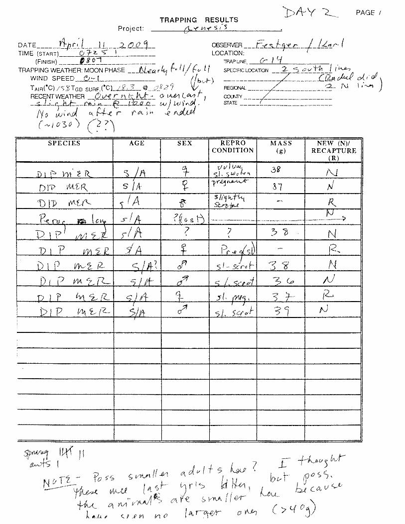

Genesis Solar Energy Project Biological Resources Technical Report
August 2009
APPENDIX B
LIST OF FIELD BIOLOGISTS
Field Biologists Alice Karl, Ph.D. *Art Schaub Bill Hasskamp Bret Blosser, Ph.D. Dave Focardi Emily Festger *Jake Mohlmann Jennifer Weidensee Kevin Walsh Lehong Chow Leslie Backus Liz (Jacqueline) Smith Mary Ann Hasskamp Michael Omana Nathan Mudry Paul Frank Peggy Wood Rachel Woodard Shawn Lindey Steve Emerson Tim Thomas Tina Poole
*Report Preparers

Genesis Solar Energy Project Biological Resources Technical Report
August 2009
APPENDIX C
REPRESENTATIVE PHOTOGRAPHS

Genesis Solar Energy Project Biological Resources Technical Report
August 2009
Sonoran Creosote Bush Scrub in North/Central Area of ROW, Facing Southeast
Sonoran Creosote Bush Scrub with Patches of Sand over Playa Proposed Linear Route, Facing East

Genesis Solar Energy Project Biological Resources Technical Report
August 2009
Sonoran Creosote Bush Scrub, Facing East from Center of ROW
Sonoran Creosote Bush Scrub Located within the Proposed Solar Facility

Genesis Solar Energy Project Biological Resources Technical Report
August 2009
Stabilized and Partially Stabilized Sand Dunes Characteristic of the Eastern ROW
Sonoran Creosote Bush Scrub North of I-10 along Linear Route, Facing East

Genesis Solar Energy Project Biological Resources Technical Report
August 2009
APPENDIX D
SPECIES OBSERVED

Genesis Solar Energy Project Biological Resources Technical Report
August 2009
Wildlife and Plant Species Observed at the Genesis Solar Energy Project during 2009 SpringSurveys
REPTILESCallisaurus draconoides zebra tail lizardCnemidophorus (=Aspidoscelis) tigris western whiptailCrotalus cerastes sidewinderDipsosaurus dorsalis desert iguanaGambelia wislizenii leopard lizardPhrynosoma platyrhinos desert horned lizardUma scoparia Mojave fringe toed lizardUrosaurus graciosus brush lizardUta stansburiana side blotched lizardMAMMALSAmmospermophilus leucurus antelope ground squirrelCanis latrans coyote (scat)Chaetodipus penicillatus Desert Pocket MouseDipodomys deserti Desert Kangaroo RatDipodomys merriami Merriam’s kangaroo ratLepus californicus black tailed hareNeotoma lepida desert woodrat (midden)Odocoileus hemionus eremicus burro deer (tracks)Perognathus longimembris little pocket mouseTaxidea taxus American badger (burrow)Spermophilus tereticaudus round tailed ground squirrelSylvilagus audubonii desert cottontailVulpes macrotis desert kit fox (digs, scat, natal dens)INSECTSPepsis sp. Tarantula HawkBIRDSAmphispiza bilineata Black throated sparrowAsio flammeus short eared owlAuriparus flaviceps verdinAthene cunicularia Burrowing owlBubo virginianus great horned owlButeo jamaicensis red tailed hawkButeo swainsoni Swainson’s hawkButeo regalis ferruginous hawkCallipepla gambelii Gambel’s quailCalypte anna Anna’s hummingbirdCalypte costae Costa’s hummingbirdCathartes aura turkey vultureChordeiles acutipennis lesser nighthawkCircus cyaneus northern harrierCorvus corax common ravenDendroica coronata yellow rumped warblerEremophila alpestris California horned larkFalco mexicanus prairie falconHirundo rustica barn swallowHirundo pyrrhonota cliff swallowLanius ludovicianus loggerhead shrikeLoxia curvirostra red crossbillMimus polyglottos northern mockingbirdMyiarchus cinerascens ash throated flycatcherPasserculus sandwichensis savannah sparrowPhainopepla nitens phainopeplaPhalaenoptilus nuttallii common poor willQuiscalus mexicanus great tailed grackleRiparia riparia bank swallowSpizella breweri Brewer’s sparrow

Genesis Solar Energy Project Biological Resources Technical Report
August 2009
Wildlife and Plant Species Observed at the Genesis Solar Energy Project during 2009 SpringSurveys
Stelgidopteryx serripennis northern rough winged swallowStreptopelia decaocto Eurasian collared doveSturnella neglecta western meadowlarkTachycineta bicolor tree swallowTachycineta thalassina violet green swallowToxostoma lecontei LeConte’s thrasherTyrannus verticalis western kingbirdVireo gilvus warbling vireoZenaida asiatica white winged doveZenaida macroura mourning doveZonotrichia albicollis white crowned sparrowPLANTS (*Non-native )Abronia villosa var. villosa sand verbenaAcacia greggii catclaw acaciaAchyronychia cooperi onyx flower, frost matAllionia incarnata windmills, trailing four o’clockAmbrosia acanthicarpa annual bursageA. dumosa white bursageA. (=Hymenoclea) salsola cheesebushAristida purpurea three awnAsclepias subulata rush milkweedAsclepias erosa desert milkweedAstragalus aridus astragalusA. insularis var. harwoodii Harwood’s milkvetchAtrichoseris platyphylla gravel ghostAtriplex polycarpa allscaleBaileya pauciradiata desert marigoldB. pleniradiata woolly marigoldBebbia juncea chuckwalla bushBouteloua aristidoides needle gramaBrandegea bigelovii desert starvine*Brassica tournefortii Saharan mustardCalandrinia ambigua desert pussypawsCalycoseris wrightii white tackstemCamissonia boothii sun cupC. boothii ssp. condensata sun cupC. boothii ssp. desertorum sun cupC. claviformis ssp. aurantiaca Raven browneyesCercidium floridum (=Parkinsonia florida) blue paloverdeChaenactis carphoclina pebble pincushionC. fremontii Fremont’s pincushionC. stevioides desert pincushionChamaesyce polycarpa spurgeChenopodium murale goosefootChorizanthe brevicornu brittle spine flowerC. corrugata spineflowerC. rigida rigid spinyherbColubrina californica Las Animas colubrinaCryptantha angustifolia narrow leaved forget me notC. barbigera bearded cryptanthaC. costata ribbed cryptanthaC. maritima white haired forget me notC. nevadensis Nevada forget me notC. pterocarya wing nut forget me notCryptantha sp. CryptanthaCylindropuntia acanthocarpa buckhorn chollaC. (=Opuntia) echinocarpa silver cholla

Genesis Solar Energy Project Biological Resources Technical Report
August 2009
Wildlife and Plant Species Observed at the Genesis Solar Energy Project during 2009 SpringSurveys
C. (=Opuntia) ramosissima pencil cactusC. (=Opuntia) wigginsii Wiggins’ chollaCynanchum utahense Utah cynanchumCuscuta cf denticulata dodderDalea mollis silk daleaD. mollissima silk daleaDatura wrightii jimsonweedDicoria canescens desert dicoriaDitaxis lanceolata narrowleaf silverbushD. neomexicana ditaxisD. serrata saw toothed ditaxisD. serrata serrata silverbushDithyrea californica spectacle podEncelia farinosa brittlebushEremalche rotundifolium desert five spotEriastrum harwoodii Harwood’s phloxEriogonum inflatum desert trumpetE. reniforme wild buckwheatE. thomasii wild buckwheatE. trichopes wild buckwheatEriogonum sp. buckwheatErodium texanum storksbillEschscholtzia glyptosperma gold poppyE. minutiflora small flowered gold poppyFagonia laevis California fagonbushFouquieria splendens ocotilloGeraea canescens desert sunflowerGilia latifolia broad leaved giliaG. stellata star giliaGuillenia (=Thelopodium) lasiophylla California mustardHesperocallis undulata desert lilyHibiscus denudatus rock hibiscusHoffmannseggia glauca pig nut, hog potatoHyptis emoryi desert lavenderKallstroemia grandiflora Arizona poppyKrameria erecta pima rhatany, purple heatherK. grayi white rhatanyLangloisia setosissima ssp. setosissima bristly langloisiaLarrea tridentata creosote bushLepidium lasiocarpum pepper grassLinanthus lemmonii Lemmon's linanthusLoeseliastrum schottii Schott giliaLotus strigosus hairy lotusLupinus arizonica Arizona lupineLupinus sp. lupineMalacothrix glabrata desert dandelionMammillaria tetrancistra fish hook cactusMarina parryi parry daleaMentzelia affinis blazing starM. albicaulis blazing starM. involucrata sand blazing starM. multiflora var. longiloba blazing starMentzelia sp. blazing starMohavea confertifolia ghost flowerMonoptilon bellioides Mojave desert starNama demissum purple matOenothera deltoides dune primrose

Genesis Solar Energy Project Biological Resources Technical Report
August 2009
Wildlife and Plant Species Observed at the Genesis Solar Energy Project during 2009 SpringSurveys
Oligomeris linifolia mignonetteOlneya tesota ironwoodPalafoxia arida (= linearis) Spanish needlePectocarya penicillata hairy leaved comb burP. recurvata arch nutted comb burPerityle emoryi Emory rock daisyPeucephyllum schottii desert firPhacelia crenulata var. crenulata cleftleaf wildheliotropeP. crenulata var.minutiflora cleftleaf wildheliotropeP. distans distant phaceliaP. neglecta alkali phaceliaP. tanacetifolia lacy phaceliaPhysalis crassifolia ground cherryPlantago ovata plantainPleuraphis (=Hilaria) rigida big galleta grassPrenanthella exigua brightwhiteProboscidea althaeifolia desert unicorn plantProsopis glandulosa honey mesquitePsathyrotes ramosissima turtlebackPsorothamnus emoryi Emory daleaP. spinosus smoke treeRafinesquia neomexicana desert chicory*Salsola tragus Russian thistle, tumbleweedSarcostemma hirtellum hairy milkweed*Schismus arabicus Mediterranean grassSenecio mohavensis Mojave ragwortSphaeralcea angustifolia fendler globe mallowStephanomeria pauciflora Wire lettuceStillingia spinulosa broad leaved stillingiaStreptanthella longirostris mustard*Tamarix ramosissima tamariskTidestromia oblongifolia Arizona honeysweetTiquilia plicata plicate coldenia

Genesis Solar Energy Project Biological Resources Technical Report
August 2009
APPENDIX E
DR. ALICE KARL’S KEY TO DESERT TORTOISE SIGN CLASSES

Genesis Solar Energy Project Biological Resources Technical Report
August 2009
KEY TO SIGN CLASSES
BURROWS
1 – DEFINITELY TORTOISE – FRESH (TRACKS, TORTOISE INSIDE, FRESHLY DISTURBED SOIL ON MOUND/RUNWAY)
2 – DEFINITELY TORTOISE – USED THIS SEASON (CLEARED OF ANNUALS, BUT NO FRESHLY DISTURBED SOIL)
3 – DEFINITELY TORTOISE – NOT USED THIS SEASON (PROBABLY HAS ANNUALS GROWING IN RUNWAY)
4 – POSSIBLY TORTOISE – IN GOOD CONDITION BUT UNSURE OF SPECIES USING BURROW
5 – DEFINITELY TORTOISE – DETERIORATED SUCH THAT IT WOULD REQUIRE SUBSTANTIAL REMODELING TO BE USABLE
6 – POSSIBLY TORTOISE – DETERIORATED
SCAT
TY1 – WET OR FRESH DARK, ODORIFEROUS
TY2 – DRIED, POSSIBLE GLAZE ON PART; UNEXPOSED SURFACES DARK BROWN; SLIGHT ODOR
TY3 – DRIED, NO GLAZE; AT LEAST PARTIALLY FADED ON EXTERIOR; VERY SLIGHT ODOR
NTY3 – DRIED, NO GLAZE; AT LEAST PARTIALLY FADED ON EXTERIOR; NO ODOR (DISTINGUISHES FROM TY3)
NTY4 – DRIED, LOOSENING, PALE OR BLEACHED
CARCASSES – GENERAL INDICATORS FOR TIME SINCE DEATH
<1 YR – UNEXPOSED SCUTES NORMAL COLOR AND SHEEN, ADHERE TIGHTLY. EXPOSED SCUTES PALING AND MAY BE LIFTING OR OFF. UNEXPOSED BONE WAXY AND SOLID.
1–2 YRS – UNEXPOSED SCUTES NORMAL COLOR WITH SLIGHT SHEEN, MOSTLY TIGHTLY ATTACHED. EXPOSED SCUTES SLIGHTLY PALE WITH NO SHEEN AND NO TO SLIGHT GROWTH RING PEELING. NO ODOR. UNEXPOSED BONE SILKY.
2–3 YRS – UNEXPOSED SCUTES PALE AND WITHOUT SHEEN BUT NO GROWTH RING PEELING. EXPOSED SCUTES PALE WITH SLIGHT PEELING, SCUTES LOOSE, OFF AND/OR TIGHT. BONE SUTURES GENERALLY TIGHT.
4 YRS – UNEXPOSED SCUTES NORMAL COLOR TO SLIGHTLY PALE, NO SHEEN, NO PEELING. EXPOSED SCUTES LOOSE, PALE, DULL, WITH MODERATE PEELING. SUTURES SEPARATING AND BONE SURFACE IS FISSURED, EDGES ARE ROUGHENED (FISSURED UNDER HAND LENS) AND CHIP FAIRLY EASILY.
>>4 YRS –` DISARTICULATED AND DISARTICULATING. BONE EDGES CHIP AND CRUMBLE EASILY. SCUTES ARE PEELING AND CURLED.