general meeting agenda - gladstone regional council june 2012... · general meeting agenda ... key...
TRANSCRIPT

GENERAL MEETING AGENDA
TO BE HELD AT THE COUNCIL CHAMBERS - CIVIC CENTRE 101 GOONDOON STREET, GLADSTONE
On 19 JUNE 2012
Commencing at 9.00am
Stuart Randle CHIEF EXECUTIVE OFFICER

GLADSTONE REGIONAL COUNCIL GENERAL MEETING -19/06/2012
-----2-----
GENERAL MEETING AGENDA TABLE OF CONTENTS
ITEM SUBJECT PAGE
G/1 MAYORAL STATEMENT ON CURRENT ISSUES......................................... 4 G/2 MESSAGES OF CONDOLENCE ................................................................... 4 G/3 CONFIRMATION OF MINUTES ..................................................................... 4
G/3.1 Confirmation of Minutes of General Meeting 5 June 2012...................... 4 G/4 Business ARISING FROM MINUTES............................................................. 5 G/5 OFFICERS' REPORTS................................................................................... 5 G/5.1 OFFICE OF THE CEO................................................................................ 5
G/5.1.1 Queensland Pest Animal Symposium................................................. 5 G/5.1.2 Strategic KPI Monthly Report for Period Ending 31 May 2012 ........... 7
G/5.2 ENGINEERING SERVICES........................................................................ 9 G/5.2.1 Flood Damage Report Update ............................................................ 9 G/5.2.2 Traffic Control Measures and Road Closure for Region's High School Proms 13 G/5.2.3 Bus Shelter Equality Within The Gladstone Region.......................... 16 G/5.2.4 Cost of Car Parking Provisions ......................................................... 20 G/5.2.5 Goondoon Street Parking.................................................................. 22
G/5.3 CORPORATE AND COMMUNITY SERVICES ........................................ 26 G/5.3.1 Pool Opening Hours.......................................................................... 26 G/5.3.2 Change of Purpose - Grant to Gladstone Kart Club.......................... 33 G/5.3.3 Future of Clinton Sports Park ............................................................ 36 G/5.3.4 Increased Lease Area To The Discovery Coast Sport & Recreation Association 41 G/5.3.5 Corporatisation of Gladstone Airport ................................................. 49
G/5.4 PLANNING AND ENVIRONMENT............................................................ 54 G/5.4.1 Development Application 508/2012 - Material Change of Use of Premises - Duplex Unit - 39 Cairncross Street, Sun Valley................................... 54 G/5.4.2 Development Application 587/2012 - Material Change of Use of Premises - Business (Offices) - 173 Goondoon Street, Gladstone ....................... 70 G/5.4.3 Development Application 543/2012 - Material Change of Use of Premises -Duplex Unit - 12 Orchard Drive Kirkwood ............................................ 89 G/5.4.4 Development Application 521/2012 - Material Change of Use of Premises - Office - 8/100 Goondoon Street, Gladstone ...................................... 102 G/5.4.5 Development Application DA/500/2012 MATERIAL CHANGE OF USE OF PREMISES FOR MULTIPLE UNIT RESIDENTIAL (31 UNITS) AT LOT 951 SP246155, BRIFFNEY STREET, KIRKWOOD................................................... 108 G/5.4.6 Development Application 41804/2007 - Preliminary Approval for Master Planned Residential Community approx. 1,312 Dwellings, Indoor Recreation, Outdoor Recreation and Sewerage Treatment Plant at Turkey Beach Road, Rodds Bay ................................................................................................ 135 G/5.4.7 Extension of GAPDL Arrangements................................................ 146 G/5.4.8 Proposed Minor Amendments to the Gladstone Plan & Calliope Planning Scheme ................................................................................................ 148 G/5.4.9 Proposed Amendment to the Gladstone Plan 2006 to remove Civic Theatre From Local Heritage List ........................................................................ 159 G/5.4.10 Commercial Activities on Council Controlled Land.......................... 167

GLADSTONE REGIONAL COUNCIL GENERAL MEETING -19/06/2012
-----3-----
G/5.4.11 Commercial beach activity permit - Hovercraft Operation Seventeen Seventy - Mr Welbeloved .................................................................................... 176
G/5.5 CHIEF FINANCIAL OFFICER................................................................. 184 G/5.5.1 Proposed road name for unnamed road reserve located off Hourigan Creek Road Raglan ............................................................................................. 184 G/5.5.2 Proposed Street names for Riverstone Rise DA495/2011.............. 189 G/5.5.3 Proposed Road Names Little Creek Estate DA/432/2012............... 193 G/5.5.4 Additional street names for Hillclose Harvey Road - Clinton........... 198 G/5.5.5 Proposed Street names for Elliots Run Calliope - 15 Mingara Cresent - DA20600/2008 .................................................................................................. 201 G/5.5.6 Financial Statements - period ended 31 May 2012......................... 204 G/5.5.7 Debtor Writeoffs .............................................................................. 207
G/6 COUNCILLOR REPORTS .......................................................................... 211 G/6.1 Councillor Report ................................................................................ 211
G/7 QUESTIONS FROM THE PUBLIC GALLERY............................................ 214 G/8 CONFIDENTIAL ITEMS.............................................................................. 214 ATTACHMENTS ..................................................................................................... 215

GLADSTONE REGIONAL COUNCIL GENERAL MEETING -19/06/2012
-----4-----
G/1 MAYORAL STATEMENT ON CURRENT ISSUES Nil. Back to Top G/2 MESSAGES OF CONDOLENCE Nil. Back to Top G/3 CONFIRMATION OF MINUTES G/3.1 CONFIRMATION OF MINUTES OF GENERAL MEETING 5
JUNE 2012 Responsible Officer: Chief Executive Officer Council Meeting Date: 19 June 2012 Purpose: Confirmation of the minutes of the General Meeting held on the 5 June 2012. Officer's Recommendation: That the minutes of the General Meeting of Council held on the 5 June 2012 be confirmed. Attachments: 1. Minutes of the General Meeting of Council 5 June 2012. Tabled Items: 1. Nil Report Prepared by: Assistant to the Chief Executive Officer General Meeting Minutes 5 June 2012 for confirmation Open Document

GLADSTONE REGIONAL COUNCIL GENERAL MEETING -19/06/2012
-----5-----
Back to Top G/4 BUSINESS ARISING FROM MINUTES Nil. Back to Top G/5 OFFICERS' REPORTS Back to Top G/5.1 OFFICE OF THE CEO G/5.1.1 QUEENSLAND PEST ANIMAL SYMPOSIUM Responsible Officer: Chief Executive Officer Council Meeting Date: 19 June 2012 Purpose: This report seeks Council authorisation for Cr. McDonald to attend the Queensland Pest Animal Symposium from the 30th July to 2 August 2012. Officer's Recommendation: That Cr. McDonald be authorised to attend the Queensland Pest Animal Symposium from the 30th July to 2 August 2012. Background: Attached is a brochure and program for the annual Queensland Pest Animal Symposium which will be held on the Sunshine Coast from the 30 July to 2 August 2012. Cr. McDonald has expressed an interest in attending. Consideration: Nil Communication and Consultation (Internal/External): Not Applicable Legal Environmental and Policy Implications: Not Applicable Financial and Resource Implications: Conference Registration fee of $795 applies for full registration. Commentary:

GLADSTONE REGIONAL COUNCIL GENERAL MEETING -19/06/2012
-----6-----
Not applicable Summary: Not applicable Attachments: 1. Queensland Pest Animal Symposium Brochure Tabled Items: 1. Nil Report Prepared by: PA to the Chief Executive Officer Queensland Pest Animal Symposium Brochure Open Document

GLADSTONE REGIONAL COUNCIL GENERAL MEETING -19/06/2012
-----7-----
Back to Top G/5.1.2 STRATEGIC KPI MONTHLY REPORT FOR PERIOD ENDING
31 MAY 2012 Responsible Officer: Chief Executive Officer Council Meeting Date: 19 June 2012 Purpose: This report provides Council with an overview of Council's operations through strategic key performance indicators (KPIs) for the month ending 31 May 2012. Officer's Recommendation: That Council receive and note the Strategic KPI Monthly Report for period ending 31 May 2012. Background: Attached is the Strategic KPI Monthly Report for Council's operations for the month ending 31 May 2012. Consideration: Nil Communication and Consultation (Internal/External): Not applicable Legal Environmental and Policy Implications: Nil Financial and Resource Implications: Nil Commentary: Nil Summary: Nil Attachments: 1. Strategic KPI Monthly Report for period ending 31 May 2012.

GLADSTONE REGIONAL COUNCIL GENERAL MEETING -19/06/2012
-----8-----
Tabled Items: 1. Nil Report Prepared by: Assistant to the Chief Executive Officer Strategic KPI Monthly Report for period ending 31 May 2012 for General Meeting 19 June 2012 Open Document
GLADSTONE REGIONAL COUNCIL GENERAL MEETING -19/06/2012
-----9-----
Back to Top G/5.2 ENGINEERING SERVICES G/5.2.1 FLOOD DAMAGE REPORT UPDATE Responsible Officer: Director Infrastructure Services Council Meeting Date: 19 June 2012 Purpose: The purpose of this report is to update Council on the progress of the NDRRA claims process. Officer's Recommendation: That 1. Council note the update report on the status of the NDRRA (January 2011 event) damage claim, and that 97% of the estimated claim value has been approved to date. Background: This is a regular monthly update report. The Contract for Stage 1 was awarded to Robert House & Associates on 17 January 2012, work commenced on 22 February 2012. The Contract for Stage 2 was awarded to VDM Construction (Eastern Operations) (VDM) on 27 April 2012. Work is scheduled to commence on 18 June 2012. Consideration: The cost to date for the claims development process is approximately $2.34 million (LGIS). Attachment 1 presents the progress of the claim process to date. Highlights include; Batch 10 has been submitted to the QRA for approval. All batches for claims are
now in. Batch 7 and 9 have been approved by the QRA. Contract 3 (the final contract) is now being advertised. The status of works is as follows: Stage 1:
o Works scheduled next two weeks (11/6 - 25/6): Blackmans Gap Road - Drainage and culvert works, pavement repairs (sealed and unsealed).

GLADSTONE REGIONAL COUNCIL GENERAL MEETING -19/06/2012
-----10-----
Lowmead Road - Drainage and culvert works, pavement repairs (sealed and unsealed).
Stage 2:
o The Contract for Stage 2, Parts A & B, was awarded to VDM Construction on 27 April 2012. Prestart meeting was held on 21 May 2012.
o Part A (Northern collector roads): Works scheduled next two weeks (11/6 - 25/6): Tablelands Rd - Drainage and culvert works, pavement repairs. Mt Alma Rd - Drainage and culvert works, pavement repairs.
o Part B (Boyne Valley): Works scheduled next two weeks (11/6 - 25/6): Mobilisation
Stage 3:
o Part C: Tender for works advertised 10 May 2012. o Tender closes: 12 June 2012 o Tender Awarded: Not applicable o Works scheduled next two weeks (11/6 - 25/6): Nil o Part D: Tender for works advertised 10 May 2012. o Tender closes: 12 June 2012 o Tender Awarded: Not applicable o Works scheduled next two weeks (11/6 - 25/6): Nil o Part E: Tender for works advertised 10 May 2012. o Tender closes: 12 June 2012 o Tender Awarded: Not applicable o Works scheduled next two weeks (11/6 - 25/6): Nil o Part F: Tender for works advertised 10 May 2012. o Tender closes: 12 June 2012 o Tender Awarded: Not applicable o Works scheduled next two weeks (11/6 - 25/6): Nil
Communication and Consultation (Internal/External): Communication to date has been predominantly internal and with Consultants. The information contained in Attachment 1 has been developed to allow for distribution to the community via Councillors, Media and GRC Web site. Schedule Map and Contract Sections and updates are provided on Council's website. Legal Environmental and Policy Implications: Nil. Financial and Resource Implications: Nil financial implications. Minor modifications to submissions to date. Ineligible claimed works to be omitted from scope for Contractors. Commentary:

GLADSTONE REGIONAL COUNCIL GENERAL MEETING -19/06/2012
-----11-----
Nil. Summary: Nil. Attachments: 1. Flood Damage Summary 5 June 2012 Tabled Items: Nil. Report Prepared by: Manager Works Services

GLADSTONE REGIONAL COUNCIL GENERAL MEETING -19/06/2012
-----12-----
GLADSTONE REGIONAL COUNCIL GENERAL MEETING -19/06/2012
-----13-----
Back to Top G/5.2.2 TRAFFIC CONTROL MEASURES AND ROAD CLOSURE
FOR REGION'S HIGH SCHOOL PROMS Responsible Officer: Director Infrastructure Services Council Meeting Date: 19 June 2012 Purpose: The purpose of this report is to allow Council to consider a proposal to provide assistance to the local High Schools in relation to traffic control arrangements for their annual Prom Night. Officer's Recommendation:
That Council assist the local high schools with their Prom night traffic arrangements by adopting the following (with no fee attached):-
Council write to each school asking it to nominate its venue for the school Prom night (letter sent in June each year), response required before 30 June each year,
Council prepare a Traffic Management Plan for the occasion for each venue, If required, Council loan the necessary equipment to the school (delivered to and
picked up from the school) to allow them to implement the Traffic Management Plan, and
The school implements the Traffic Management Plan using an accredited organisation and notifies the Queensland Police Service accordingly.
Background:
Last year (2011) there was some confusion relating to what Council required in relation to traffic control arrangements at Prom locations, leading to some rather hectic last minute arrangements. The Prom nights provide for a formally announced arrival of each school girl and boy to the event via Council’s public road network. To undertake this safely a traffic management plan is required which typically results in the road in front of the Prom venue being closed to traffic for an hour or so.
Typically;
Each school engages and accredited organisation each year to prepare a traffic management plan. Multiple plans are produced to the same location hosting different schools.
Council requires the schools to pay a fee to cover the cost associated with approving the traffic management plan and any Council works.
Council provides signs etc. on a loan basis to the SES who implement the traffic Control arrangements.
Consideration:
The following options are proposed
1. Write to the schools outlining the current arrangements and thus change nothing. Current arrangements are;

GLADSTONE REGIONAL COUNCIL GENERAL MEETING -19/06/2012
-----14-----
Council write to the school advising that it requires a Traffic Management Plan for the school’s Prom night 8 weeks in advance of the event and this is to be accompanied by the appropriate application fee (currently $200)
If specifically requested Council will loan the school the necessary signs etc to implement the Traffic Management Plan; (delivered to and picked up from the school).
The school implements the Traffic Management Plan using an accredited organisation.
2. Council assist the schools by adopting the following arrangements, with no fee
attached:-
Council write to each school asking it to nominate its venue for the school Prom night (letter sent in June each year), response required before 30 June each year,
Council prepare a Traffic Management Plan for the occasion for each venue,
If required, Council loan the necessary equipment to the school (delivered to and picked up from the school) to allow them to implement the Traffic Management Plan, and
The school implements the Traffic Management Plan using an accredited organisation and notifies the Queensland Police Service accordingly.
Communication and Consultation (Internal/External): Nil. Legal Environmental and Policy Implications:
In relation to both options;
Legal Implications are minimal over and above Council’s current traffic control liability exposure, provided accredited designers and plan implementers are used.
If no fee is charged this will effectively be a donation to each school.
Financial and Resource Implications:
Nil in relation to option one, if fees are regularly revised to cover Councils cost
Minimal in relation to option two; provided venues and schools don’t change much over time. The cost to prepare a Traffic Management Plan is likely to be about $500 per school. A budget allocation would be appropriate to record the actual cost.
Commentary: Nil. Summary: Nil. Attachments: Nil. Tabled Items:

GLADSTONE REGIONAL COUNCIL GENERAL MEETING -19/06/2012
-----15-----
Nil. Report Prepared by: Director Engineering Services

GLADSTONE REGIONAL COUNCIL GENERAL MEETING -19/06/2012
-----16-----
Back to Top G/5.2.3 BUS SHELTER EQUALITY WITHIN THE GLADSTONE
REGION Responsible Officer: Director Infrastructure Services Council Meeting Date: 19 June 2012 Purpose: The purpose of this report is to allow Council to consider adopting a bus shelter style and colour to be installed across the Gladstone region. Officer's Recommendation: That Council engage G. James Glass & Aluminium Qld Pty Ltd to supply bus shelters in accordance with B-RES-001 (and the tendered submission), and adopt a standardised colour scheme based on the blue used in Council's logo. Background: Council has been providing Bus Shelters for public usage for a number of years. There is no uniform approach to the type, shape, size and colour of these structures, see Attachment 1. Uniformity of these structures can reduce maintenance costs (ie replacement panels etc) and create a sense of identity, and create a feeling of order and planning. Council currently has 126 bus stops, of which 43 fully comply with the Commonwealth Disability Standards for Accessible Public Transport 2002, which comes under the Disability Discrimination Act 1992 (DDA). All existing urban bus stops are required to be upgraded and all new stops must meet the standards. Whilst it is not possible to upgrade all facilities at once, a schedule of works has been developed and accepted by the Department of Transport and Main Roads. Of the 83 stops that are not compliant, 45 contain bus shelters. Over the next 5 years Council is required to have 90% of its bus stops compliance with the DDA standard, and by 2022, 100% of stops and shelters are to be compliant. Council has considered this matter over the last few years however for one reason or another, the matter remains unresolved. The following lists the resolutions Council has made recently:- At the general meeting on 10 March 2009 Council resolved the following (vide resolution G09/140)
“That the matter be held over for clarification that other interest has been sought”

GLADSTONE REGIONAL COUNCIL GENERAL MEETING -19/06/2012
-----17-----
At the general meeting on 7 April 2009 Council resolved the following (vide resolution G09/203) That: 1. It is Council’s preference to achieve a bus shelter solution via a commercial
advertising off-set arrangement, resulting in no cost to Council. 2. In accordance with Section 486(1)(a) of the Local Government Act 1993, Council
has determined that Adshel Street Furniture Pty Ltd is the only supplier reasonably available to it.
3. The Chief Executive Officer be authorised to conclude negotiations with Adshel Street Furniture Pty Ltd and execute the necessary contracts”
At the general meeting on 7 July 2009 Council resolved the following (vide resolution G09/389) That Council 1. Agree to Adshel’s request to defer the commencement of negotiations towards a
bus shelter solution via a commercial advertising off-set arrangement, resulting in no cost to Council for a period of up to 12 months.
2. Advise Adshel of this decision” In summary, the previous course of action was to enter into an agreement with a company offering the supply, installation and maintenance of bus shelters, with the construction and ongoing works funded by advertising revenue. Due to economic constraints at the time, the chosen company was not able to enter into the agreement. The agreement was to be revised 12 months later, however, the company would not respond to Council's enquiries. Subsequently, Council Officers developed a 'typical' shelter style and specification, as per the discussions of briefing meeting 13 September 2011 (Attachment 2), and sought typical pricing information for a 'compliant' structure, from a number of suppliers, using the Local Buy Suppliers listings. The specifications and typical structure specified is shown in Attachment 3. Six (6) interested suppliers replied to Council with either an indicative quote or advice that they were not able to assist in this instance. Three (3) suppliers were shortlisted for further consideration. The following suppliers were ruled out:- Landmark Products advised that the supply of shelter is outside their scope of
works at this point in time, and as such have not been further assessed. Adshel did not provide an individual price. As the timeframe to install the total
number of shelters is a period of years, the use of an individual price is seen as a requirement for assessment, and accordingly the firm have not been further assessed.
Polite have not been further assessed as they do not provide Aluminium structures.
The shortlisted suppliers are as follows:-

GLADSTONE REGIONAL COUNCIL GENERAL MEETING -19/06/2012
-----18-----
Evolution Shelters – Meets most requirements but is not considered the best option due to higher cost of both supply, and supply and install.
G. James Glass & Aluminium Qld Pty Ltd – Meets all requirements and the cost is reasonable for both supply, and supply and install. (Subsequent discussions with G. James Glass & Aluminium Qld Pty Ltd representative indicate that structure can also be provided in anodised aluminium).
Metshelter – Meets most requirements but is not considered the best option due to extended delivery time frames, medium price range and a New Zealand based company.
Consideration: A summary of the submitted costs are provided in Attachment 4. G. James Glass & Aluminium Qld Pty Ltd proposes to build the shelters in accordance with Council's specifications. G. James Glass & Aluminium Qld Pty Ltd trade under the name of Gossi Park for matters relating to street furniture. The submission from G. James Glass & Aluminium Qld Pty Ltd based in Gladstone, appears to provide the best value for money to Council and is considered the preferred supplier. Gladstone Regional Council does not have any form of 'Standard' colour scheme for shelters. For consistency purposes it is suggested that Council adopt a standard colour, from the choice of the 4 colours utilised in the Council logo (Blue, Silver, Green, and Gold). Blue is considered to be more associated with the Gladstone Logo as it is the background to the various locality signs. Communication and Consultation (Internal/External): Council officers have liaised with the Senior Advisor of Passenger Transport in Mackay to ensure Council meets DDA requirements. Legal Environmental and Policy Implications: This schedule of bus shelter upgrades (Attachment 5) is considered appropriate response to mitigate any potential legal issues regarding access. As not all stops will have shelters installed, and existing stops will generally only be upgrading the existing site facilities, it is not likely that any significant issues will arise from the conversion. The replacement of existing shelters may create complaints as most landowners with shelters in close proximity to their property would prefer the shelter to be located elsewhere. Financial and Resource Implications: Council have entered into an agreement with Queensland Transport, on behalf of the state, for the installation and upgrade of Bus Stop to be compliant with the Disability Discrimination Act 1992. This agreement is the Passenger Transport Bus Stop Financial Assistance Agreement. Under this agreement, Queensland Transport will

GLADSTONE REGIONAL COUNCIL GENERAL MEETING -19/06/2012
-----19-----
pay 50% of the capital costs of works where Council's obligations under the Disability Discrimination Act 1992 are to complete works relating to 55% compliance target. Further agreements will be entered into as required to meet the 100% compliance target by 2022. Suitable budget allocations will be presented in future draft budgets for Council's consideration. Commentary: Nil Summary: Nil Attachments: 1. Image of Existing Shelters 2. Briefing Meeting Report dated 13 September 2011 3. Typical Shelter Style (Technical Drawing B-RES-001) and Shelter
Specifications as requested 4. Tendered Pricing Details and Structures 5. Schedule of Upgrades 6. Passenger Transport Financial Assistance Agreement 7. General Meeting Minutes 10 March 2009 - resolution 09/140 8. General Meeting Minutes 07 April 2009 - resolution 09/203 9. General Meeting Minutes 07 July 2009 - resolution 09/389 Tabled Items: 1. Nil Report Prepared by: Manager Technical Services Attachment 1 - Image of Existing Shelters Open Document Attachment 2 - Briefing Meeting Report dated 13 September 2011
Open Document Attachment 3 - Typical Shelter Style (Technical Drawing B-RES-001) & Shelter
Specifications as requested Open Document Attachment 4 - Tendered Pricing Details and Structures Open Document Attachment 5 - Schedule of Upgrades Open Document Attachment 6 - Passenger Transport Financial Assistance Agreement Open Document Attachment 7 - General Meeting Minutes 10 March 2009 - resolution 09/140
Open Document Attachment 8 - General Meeting Minutes 07 April 2009 - resolution 09/203
Open Document Attachment 9 - General Meeting Minutes 07 July 2009 - resolution 09/389
Open Document
GLADSTONE REGIONAL COUNCIL GENERAL MEETING -19/06/2012
-----20-----
Back to Top G/5.2.4 COST OF CAR PARKING PROVISIONS Responsible Officer: Director Infrastructure Services Council Meeting Date: 19 June 2012 Purpose: To advise Council of what the average unit rate for carpark construction within the Gladstone Region is. Officer's Recommendation: That Council note that the average unit rate for carpark construction within the Gladstone Region is:-
Multi Deck Carpark $26,200 On Ground Carpark $12,500
Background: Currently Council requires a specific level of on site carparking to be provided as part of any development. This is a requirement under the respective Planning Schemes. On occasions, the level of parking provided by the developer on site does not meet the specified levels, and the developer is conditioned to provide a payment to Council in lieu of the car park provision. The contribution is seen as a payment for Council to consolidate and construct public carparking in strategic locations. Currently this payment is $5,000 per car park. Council has recently considered the application for the Entertainment Centre and its associated carpark. This development indicated the current cost of constructing additional carpark bays is approximately $36,000 per bay, excluding foundation strengthening and overheads. Other data sourced (regional New South Wales), indicates that the construction cost is in the order of $19,000 - $23,500 per bay for a multi level carpark on Council owned land, and $4,500 - $9,000 per bay for at grade parking on Council owned land. Gold Coast City Council historically raised charges per parking space as an in-lieu contribution with the rate varying dependant upon the area involved. These charges equate to approximately $8,500 and $38,500. The price of land in Gladstone varies considerably however the following is a reasonable guide. A reasonable estimate would be say $300/m2, ie $150,000 for a 500m2 block. Thus assuming a carpark is about 20m2 ie (5.5 *2.5 plus an allowance

GLADSTONE REGIONAL COUNCIL GENERAL MEETING -19/06/2012
-----21-----
for circulation lanes etc of 30%) the cost of land component would be of the order of $6,000. For a multi deck carpark of say 5 stories the land component of a carpark would be $1,200 per carpark. Consideration: It is likely that if Council were to install any further public car parking in the Gladstone CDB, it would be constructed as multi-level parking due to land constraints. The average unit rate for carpark construction within the Gladstone Region is:-
Multi Deck Carpark $26,200 On Ground Carpark $12,500
Communication and Consultation (Internal/External): Nil Legal Environmental and Policy Implications: Nil. Council has the option to condition the provision of car parking or, via an alternative condition, require the developer to enter into an Infrastructure Agreement for Council to provide car parking. This agreement would include a cost for the work using the above rates as a guide. Financial and Resource Implications: The current charging methodology is not achieving cost recovery. Commentary: Nil. Summary: Nil Attachments: 1. Nil Tabled Items: 1. Nil Report Prepared by: Manager Technical Services
GLADSTONE REGIONAL COUNCIL GENERAL MEETING -19/06/2012
-----22-----
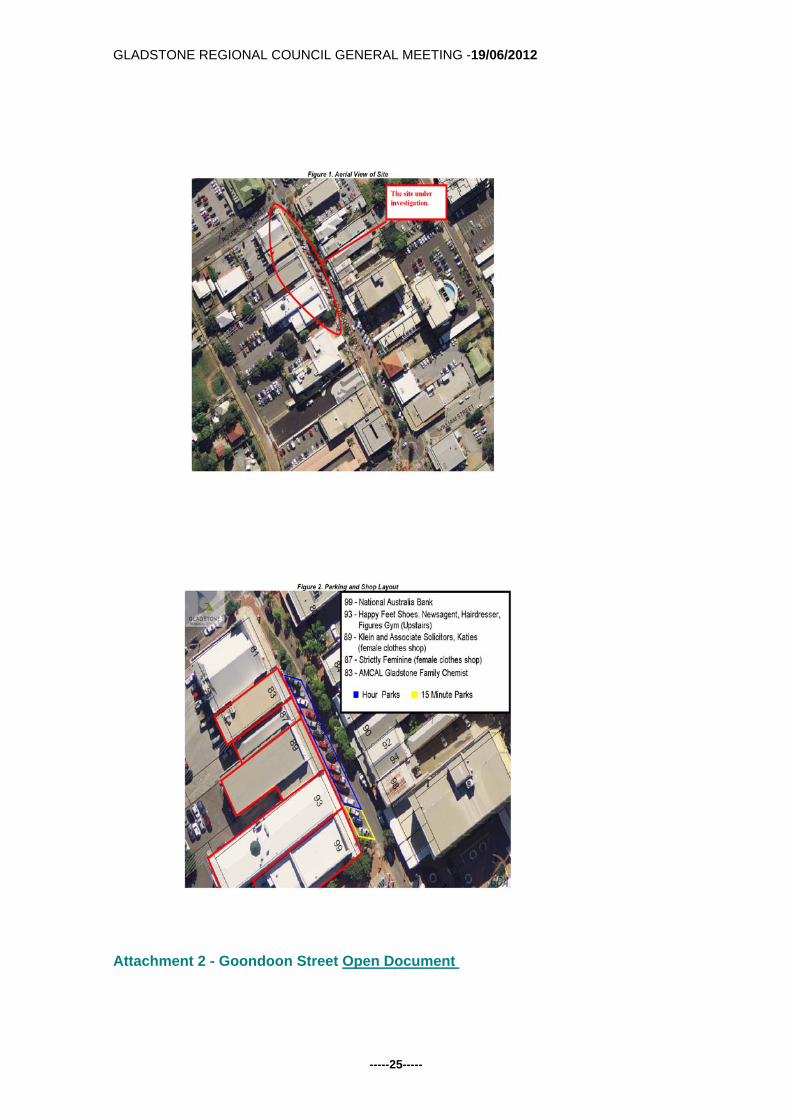
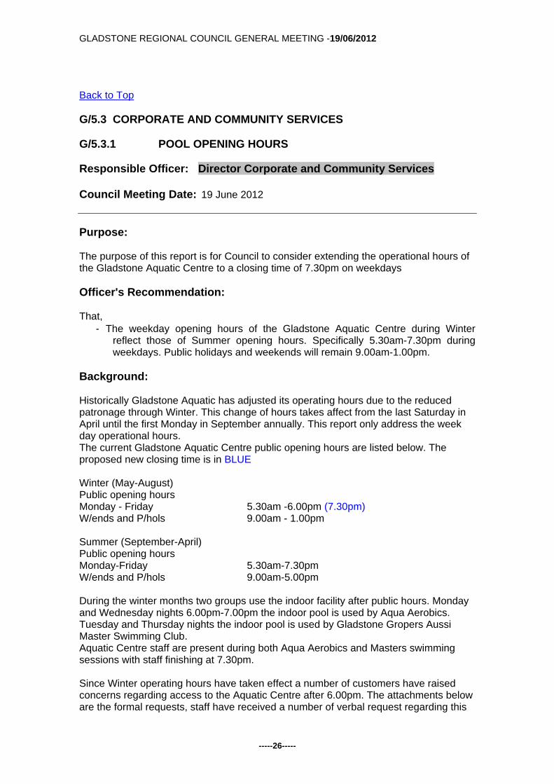
Back to Top G/5.2.5 GOONDOON STREET PARKING Responsible Officer: Director Infrastructure Services Council Meeting Date: 19 June 2012 Purpose: The purpose of this report is to allow Council to consider complaints received in relation to timed parking on Goondoon Street, between William and Roseberry Streets. Officer's Recommendation: That, in accordance with the data gathered on site, Council
1. Makes no changes to the current parking arrangements on Goondoon Street, between William and Roseberry Streets;
2. Increase the patrols in this location at peak times; and 3. Conduct a similar survey in twelve months time.
Background: Currently fifteen parks are available for public use, three (3) of which are fifteen minute parks and twelve of which are hour parks, see Attachment 1. This portion of road will be referred to as the 'site'. Council has received requests from the owners of businesses in this section of road and members of the public seeking changes to be made to the parking arrangements to increase turnover at this site. There is also parking available at the rear of all these properties, and public parking at the rear of the Council buildings. The business use in this area generally results in a mix of quick turnaround parking (short term shopping), and medium term turnaround (clothes shops). Any requirements for longer term parking than the existing 1 hour, is considered applicable to utilise the rear of block parking available. Shop fronts corresponding to the 15 minute parks include a bank, newsagent and hairdresser. Shop fronts corresponding to the hour parks include retail shops, and a chemist. Each shop has differing patronage and required parking times. A preliminary site visit was undertaken by a GRC Officer on Wednesday 11th January 2012 to determine site conditions and parking arrangements. Site visits to gather parking usage data was conducted randomly. Parking usage surveys were conducted over two hour periods at differing times during business hours. A total of five parking usage surveys were completed. Attachment 2, details gathered site data from the investigation.

GLADSTONE REGIONAL COUNCIL GENERAL MEETING -19/06/2012
-----23-----
Some of the more notable statistics from the survey are:- 50% of cars parking in the hour bays generally remain less than 15 minutes.
80% of cars parking in the hour bays stay less than thirty minutes
70% of cars parking in the 15 minute bays remain less than 15 minutes.
The 15minute parking bays experience an average parking turnover of 4.8
vehicles per hour.
The 1 hour parking bays experience an average parking turnover of 2.9 vehicles
per hour.
Increased enforcement of the short term bays is required.
Consideration: Based on the data obtained, current parking arrangements appear to meet the time frame requirements of all shop owners while maintaining a high turnover rate. The data shows that the smaller the parking limit, the greater the number of cars exceeding the parking limit. The implication of this is that more complaints are received about exceeding parking limits and shortages, and more parking offences are administered. For parking changes to be effective, time limits would need to be regularly policed and enforced, and clearly signed. Thus the preferred option is make no changes, patrol the “site” at peak times. Conduct a similar survey in twelve months time. Communication and Consultation (Internal/External): This report and Council's resolution should be mailed to all shops within the “site” and inviting the shop owners to provide feedback to assist Council improve future survey techniques. Legal Environmental and Policy Implications: Changes to parking signage must be conformant to MUTCD standards. Any parking changes would require public notice. Financial and Resource Implications: Nil, if no change is adopted and negligible implications for a repeat survey. Replacing a sign on an existing post can cost about $100. Commentary: The surveys of car parking in the section of Goondoon Street between the Council Chambers and Roseberry street, indicated that there is a consistent turnover of vehicles, generally corresponding with the applicable parking limits in place.

GLADSTONE REGIONAL COUNCIL GENERAL MEETING -19/06/2012
-----24-----
It is considered that the current parking limits in place reflect a good balance of the needs of the shopping community and retailers. Summary: Nil Attachments:
1. Images of Site 2. Goondoon Street Parking Report
Tabled Items: 1. Nil Report Prepared by: Manager Technical Services
GLADSTONE REGIONAL COUNCIL GENERAL MEETING -19/06/2012
-----25-----
Attachment 2 - Goondoon Street Open Document
GLADSTONE REGIONAL COUNCIL GENERAL MEETING -19/06/2012
-----26-----
Back to Top G/5.3 CORPORATE AND COMMUNITY SERVICES G/5.3.1 POOL OPENING HOURS Responsible Officer: Director Corporate and Community Services Council Meeting Date: 19 June 2012 Purpose: The purpose of this report is for Council to consider extending the operational hours of the Gladstone Aquatic Centre to a closing time of 7.30pm on weekdays Officer's Recommendation: That,
- The weekday opening hours of the Gladstone Aquatic Centre during Winter reflect those of Summer opening hours. Specifically 5.30am-7.30pm during weekdays. Public holidays and weekends will remain 9.00am-1.00pm.
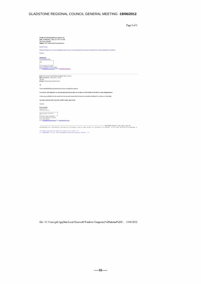
Background: Historically Gladstone Aquatic has adjusted its operating hours due to the reduced patronage through Winter. This change of hours takes affect from the last Saturday in April until the first Monday in September annually. This report only address the week day operational hours. The current Gladstone Aquatic Centre public opening hours are listed below. The proposed new closing time is in BLUE Winter (May-August) Public opening hours Monday - Friday 5.30am -6.00pm (7.30pm) W/ends and P/hols 9.00am - 1.00pm Summer (September-April) Public opening hours Monday-Friday 5.30am-7.30pm W/ends and P/hols 9.00am-5.00pm During the winter months two groups use the indoor facility after public hours. Monday and Wednesday nights 6.00pm-7.00pm the indoor pool is used by Aqua Aerobics. Tuesday and Thursday nights the indoor pool is used by Gladstone Gropers Aussi Master Swimming Club. Aquatic Centre staff are present during both Aqua Aerobics and Masters swimming sessions with staff finishing at 7.30pm. Since Winter operating hours have taken effect a number of customers have raised concerns regarding access to the Aquatic Centre after 6.00pm. The attachments below are the formal requests, staff have received a number of verbal request regarding this

GLADSTONE REGIONAL COUNCIL GENERAL MEETING -19/06/2012
-----27-----
issue. The majority of access issues are linked to the increase of construction based employees who are employed 6.00am-6.00pm and as such are unable to attend during normal operating hours. Consideration: Aqua Aerobics provider has raised no issues with allowing public access during scheduled times. Masters Swimming have raised some concerns regarding available lane space but representatives have agreed to allow some lane(s) to be available during their scheduled swim times Monday - Friday. Both user groups have agreed that the number of public lane space available will depend on balancing the demand from general public swimming and the demand from the user group. The issue of multiple demands on the same water space is not new to the Aquatic Centre and will be managed as part of normal business. Communication and Consultation (Internal/External): If Council supports the change of hours the Coordinator Healthy Communities will make arrangement with user groups for a suitable time to implement. Legal Environmental and Policy Implications: Nil Financial and Resource Implications: Operationally this would entail staff finishing at 8.00pm instead of the traditional 7.30pm. This is expected increase operational expenditure by $2,500.00 per annum. Commentary: Nil Summary: Nil Attachments: Letters of Complaint Tabled Items: 1. Nil Report Prepared by: Coordinator Healthy Communities

GLADSTONE REGIONAL COUNCIL GENERAL MEETING -19/06/2012
-----28-----

GLADSTONE REGIONAL COUNCIL GENERAL MEETING -19/06/2012
-----29-----

GLADSTONE REGIONAL COUNCIL GENERAL MEETING -19/06/2012
-----30-----
GLADSTONE REGIONAL COUNCIL GENERAL MEETING -19/06/2012
-----31-----

GLADSTONE REGIONAL COUNCIL GENERAL MEETING -19/06/2012
-----32-----

GLADSTONE REGIONAL COUNCIL GENERAL MEETING -19/06/2012
-----33-----
Back to Top G/5.3.2 CHANGE OF PURPOSE - GRANT TO GLADSTONE KART
CLUB Responsible Officer: Director Corporate and Community Services Council Meeting Date: 19 June 2012 Purpose: This report seeks approval for a Change of Purpose to a Facility Assistance Grant awarded to the Gladstone Kart Club. The request relates to the Grant the club was awarded in 2010 as a contribution towards the resealing of their track. Officer's Recommendation: That 1. A 'Change of Purpose" is approved for the Gladstone Kart Club allowing their
Facility Assistance Grant to be used towards the core testing of their track 2. The Gladstone Kart Club complete the necessary acquittal process for officers
to acquit accordingly. Background: Council has received a written request from the Gladstone Kart Club (attached) seeking reimbursement of the costs incurred the Club incurred undertaking core sampling tests of their race track. The Club believe that the testing costs are a legitimate part of the attempt to reseal their track, a project that was to be funded under the Federal Government's RLCIP program, but that ultimately did not proceed. The Club have provided copies of invoices that show $18,960 (ex GST) was spent on the testing. In 2010 the Club were awarded a $15,538 (ex GST) Facility Assistance Grant from Council to be used towards the costs of the reseal work. As the project did not proceed, Council is entitled to retrieve the grant monies from the Club. Consideration: The application to be reimbursed the cost of the track testing should not be approved as the testing and the resealing, although related, are completely separate activities. However, as an act of goodwill and show of support for the Club, officers recommend that Council permit the Club to retain the $15,538 (ex GST) Facility Assistance Grant funds they were awarded in 2010. Although this funding was originally granted towards

GLADSTONE REGIONAL COUNCIL GENERAL MEETING -19/06/2012
-----34-----
the re-seal project, it will cover most of the costs of the subsequent testing. This would result in the Club being only $3,422 (ex GST) "out of pocket". This recommendation will require a Grant 'Change of Purpose' to be granted and officers will proceed to document and acquit accordingly. Communication and Consultation (Internal/External): Phone and e-mail conversations with the President and Secretary of the Kart Club. Council Manager Community Wellbeing. Legal Environmental and Policy Implications: Change of Purpose and Grant acquittal will need to be appropriately documented. Financial and Resource Implications: The original grant to the Club was funded from the 2010/2011 Facility Assistance Grant budget. Commentary: Nil Summary: Attachments: 1. Letter from Gladstone Kart Club Inc dated 23 April 2012 Tabled Items: 1. Nil Report Prepared by: Sport & Recreation Coordinator

GLADSTONE REGIONAL COUNCIL GENERAL MEETING -19/06/2012
-----35-----

GLADSTONE REGIONAL COUNCIL GENERAL MEETING -19/06/2012
-----36-----
Back to Top G/5.3.3 FUTURE OF CLINTON SPORTS PARK Responsible Officer: Director Corporate and Community Services Council Meeting Date: 19 June 2012 Purpose: Director Corporate & Community Services reporting on outcomes of recent consultation regarding the future of Clinton Sports Park and associated proposals for Harvey Road and Palm Drive sports facilities. Officer's Recommendation: THAT: 1. Further to Council's resolution of 17 January 2012 regarding relocation of sporting
clubs from Clinton Park, Clinton Park Sports Association Inc. and other relevant stakeholders be advised that:
a. AFL and cricket will be relocated to Palm Drive as originally intended. b. In order to resolve the scheduling conflict between junior soccer and AFL,
Council now intends to ultimately accommodate junior soccer at Harvey Road as part of the new Clinton Soccer facility.
2. Copies of the latest concept plans, indicative timeline and this report be provided to
all stakeholders. 3. Officers be authorised to proceed with detailed design in consultation with relevant
sporting clubs in order to advance the plans. Background: In mid-2010, Council initiated a dialogue with the Clinton Parks Sports Association about the needs of the growing Gladstone Airport and the consideration of relocating sports clubs away from Clinton Park to accommodate such growth. A master planning exercise was committed to and ROSS Planning was engaged to facilitate a comprehensive assessment and engagement exercise over the following months. ROSS' reports and recommendations were the subject of a number of discussions with Councillors in late 2011 before the following resolutions were passed at an Ordinary Meeting on 17 January 2012. "THAT:
1. Council note the conclusions of the Gladstone Airport Master Plan 2011 that Clinton Park will be required for future road access, car parking and commercial
GLADSTONE REGIONAL COUNCIL GENERAL MEETING -19/06/2012
-----37-----
development associated with the continued growth of Gladstone Airport, with work recommended to commence within two to five years.
2. The Airport Manager be authorised to commence detailed planning and obtain
regulatory approvals as necessary for relevant Master Plan works (road access and car parking) to commence on the northern section of Clinton Park no sooner than October 2013.
3. The Clinton Park asset is transferred to Gladstone Airport once suitable
commercial arrangements have been reached between Council and the (yet-to-be-formed) Gladstone Airport Corporation.
4. Council also note the conclusions of the Master Plans developed by ROSS
Planning for both Harvey Road and Palm Drive and the options explored in these plans to accommodate the sports to be relocated from Clinton Park over time.
5. Clinton Park Sports Association be advised that:
a. Council has agreed to provide Clinton Park for use by Gladstone Airport
from October 2013, commencing with the northern section of that field to accommodate new road access and car parking etc.
b. In order to accommodate Gladstone Airport’s needs from October 2013, it is proposed to stage relocation of the respective sports from Clinton Park over a number of years:
i. Initially, Clinton Soccer be relocated to alternative premises (nominally new Harvey Road Sports Precinct) for the commencement of winter season 2014.
ii. Mudcrabs AFL and cricket be relocated to alternative premises (nominally Palm Drive Sports Complex) no later than the commencement of the summer season 2015/16.
b. Mudcrabs AFL and cricket may continue to utilise the main Clinton Park
Oval to no later than the end of winter season (October) 2015 at which time both clubs will be required to vacate the site to a venue to be determined, but most likely Palm Drive Sports Complex.
c. In so doing, both clubs should acknowledge that there is not currently any agreements for satisfactorily scheduling both junior soccer and AFL at the Palm Drive grounds.
d. Council acknowledges the verbal commitment given during a meeting at Clinton Park in July 2010 that relocated clubs will be provided with an overall package of replacement facilities at alternative locations that is as good as (or better than) those at Clinton Park. It must be recognised that the configuration of facilities at new sites can not exactly replicate those existing at Clinton Park.
e. Appropriate renewals to the Association’s lease over Clinton Park (currently expiring on 30 June 2012) will be made to reflect the arrangements outlined above.
6. Palm Drive Junior Sports Association Inc. be advised of:
a. The relocation of secondary cricket fields from Clinton Park to Palm Drive from summer season 2013/14 and the main cricket field from no later than summer season 2015/16.
GLADSTONE REGIONAL COUNCIL GENERAL MEETING -19/06/2012
-----38-----
b. The likely relocation of Mudcrabs AFL for the commencement of winter season 2016.
c. The need for the Association to commence a dialogue with all current members about achieving the most effective use of this significant sporting facility and accommodating the needs of all occupant sports into the future.
7. Football CQ be requested to assist in accommodating the relocation of
Mudcrabs AFL from Clinton Park. 8. Officers immediately commence planning and consultation for the required
works at:
a. Harvey Road to enable relocation of Clinton Soccer for the commencement of the 2014 season.
b. Palm Drive Sports Complex to accommodate cricket’s secondary oval facilities from October 2013 and AFL and cricket from the commencement of the 2015/16 summer season.
c. Any ancillary works required at other facilities and venues to accommodate the consequential changes outlined above.
9. Up to $300,000 be sought in a budget revision to enable the necessary
planning and design work to commence immediately. CARRIED The obvious conflict remaining following this decision was that both Mudcrabs AFL and junior soccer scheduled matches at Palm Drive on a Saturday. This lack of certainty for clubs led to numerous discussions and meetings between various parties over subsequent months that revisited all of the options explored by ROSS in 2011. Consideration: Following another round of consultation with clubs in recent weeks, officers are now in a position to present further recommendations to Council with a view to accommodating all sports satisfactorily and observing Council's commitment to "as good if not better overall" facilities for all. These recommendations can be summarised as: 1. Two full-size ovals only are developed at Palm Drive to be shared by AFL and
cricket, enabling scope for future additional facilities (car parking or junior fields), but also allowing for the possible development of the Port Access Road in this vicinity.
2. Clinton Soccer Club relocates and assumes primary responsibility for the new
rectangle field precinct at Harvey Road. This area includes three full-size fields (including premier facility) and two smaller fields.
3. The original plan to offer the Valleys RLFC accommodation on Harvey Rd is not
pursued. 4. Junior Soccer moves from Palm Drive to use the new Clinton football complex
fields for their Saturday morning competition.

GLADSTONE REGIONAL COUNCIL GENERAL MEETING -19/06/2012
-----39-----
It should be noted that a not dissimilar proposal to this was first considered by ROSS but discounted over concerns for additional vehicle and car parking congestion (junior soccer and junior rugby league) on Harvey Road on a Saturday morning. Careful consideration of traffic movements and car parking will need to be allowed for in detailed design phases. Some preliminary work by Brian Lister Traffic Engineer is attached to this report. A summary of consultations relevant to this proposal is attached to this report. Obviously, in accommodating this proposal, there will be some sharing of facilities required by all clubs on occasion. Whilst joint (and indeed public) use of public facilities has been a long-standing principle for most communities across Australia, officers acknowledge that achievement of this ideal is not entirely straightforward. Tenure and management agreements will need to be structured to ensure this is managed well. Alternatives Considered: As reported above and earlier, many options were considered (and respectively discounted) during the lengthy consultation process. Communication and Consultation (Internal/External): A number of face to face meetings have been held with the affected Clinton Park
sporting bodies. Phone/e-mail communication has been maintained with other stakeholder groups
including Gladstone JRL and CQ Football. Legal Environmental and Policy Implications: Environmental implications of developing a greenfield site at Harvey Road to be assessed during planning phases. Financial and Resource Implications: As reported on 17 January 2012, relocation of the Clinton Park Sporting clubs will require considerable investment in alternatives. The funds required by Council to undertake these upgrades will be acquired from the ultimate transfer of Clinton Park to Gladstone Airport Corporation. The Quantity Surveyor estimates provided in the original ROSS Plan (March 2012) are approximately $8.15M and $5.5M for Harvey Rd and Palm Drive respectively. The following need to be taken into consideration:
Palm Drive was costed on three full-size ovals, not two - a significant reduction in construction costs.
Harvey Rd new soccer field area is slightly reduced, however, an additional car park, extra lighting and an additional small amenities building will be required.
The QS report includes a large amount of interconnecting walk/cycle pathways and other small items (picnic shelters, water fountains etc) at a cost of over $800,000. These should be considered "nice to haves" and not a mandatory part of the sports facility development.
The QS report includes an amount of $2.2M for the main soccer clubhouse which is considered to be well above the commitment for "as good or better".

GLADSTONE REGIONAL COUNCIL GENERAL MEETING -19/06/2012
-----40-----
The QS report includes an amount of nearly $1.5M for design and statutory fees which can be refined.
There are considerable asset management implications for this proposal: 1. New facilities (and whole of life costs) for Harvey Road Sports Precinct. 2. Upgraded facilities at Palm Drive Sports Complex. Commentary: Nil. Summary: In summary, officers believe that the proposal outlined above and detailed in the attached concept plans provides the best possible outcome for three sporting facilities to be combined into two. It meets Council's stated commitment of providing "as good if not better" facilities for those displace Clinton clubs and also achieves far greater use of important community assets which at present are underutilised. A basic timeline is attached which articulates how the proposed facility developments and club relocations may unfold. This should be viewed as an optimistic timeframe and is dependant upon preliminary work beginning by mid- late August at the latest. Attachments:
1. Preliminary report on traffic assessment compiled by Brian Lister Planning 2. Latest Harvey Road concept plans 3. Latest Palm Drive Concept Plans 4. Summarised consultation outcomes. 5. Basic timeline
Tabled Items: 1. Nil Report Prepared by: Sport & Recreation Coordinator Attach 1 Gladstone Harvey Road Sportsfield Open Document Attach 2 Latest Harvey Road Master Plan Open Document Attach 3 Palm Drive New AFL Boyd Athletics March 2012 Open Document Attach 4 Summarise Consultation Outcomes Open Document Attach 5 Clinton Park Timeline Display Open Document

GLADSTONE REGIONAL COUNCIL GENERAL MEETING -19/06/2012
-----41-----
Back to Top G/5.3.4 INCREASED LEASE AREA TO THE DISCOVERY COAST
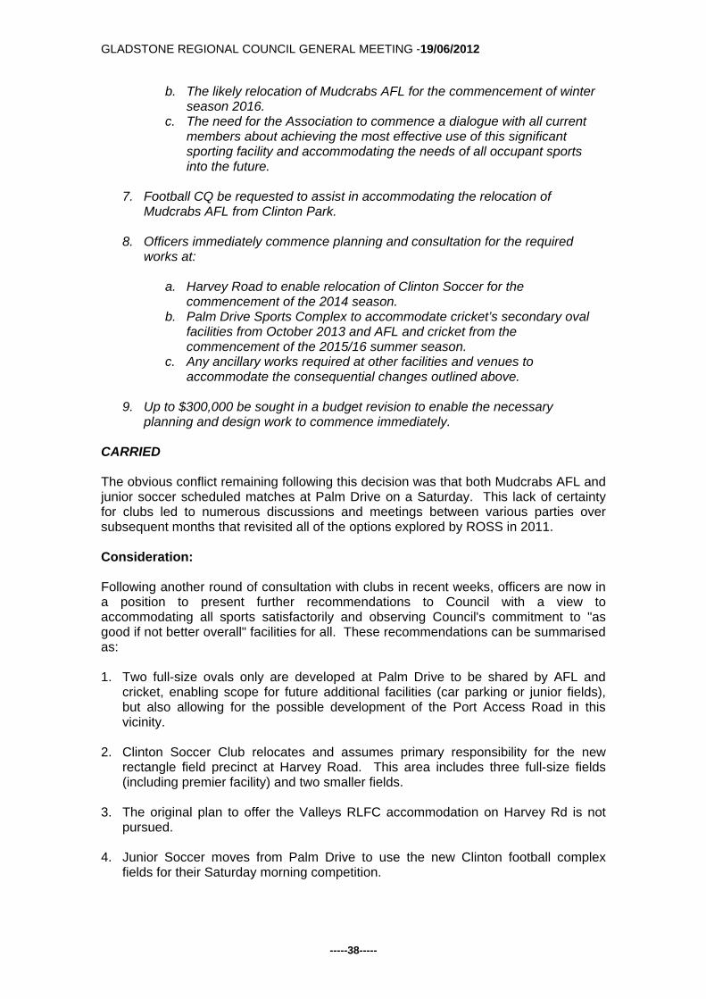
SPORT & RECREATION ASSOCIATION Responsible Officer: Director Corporate and Community Services Council Meeting Date: 19 June 2012 Purpose: This report recommends the Discovery Coast Sport & Recreation Association be granted a lease over the entire parcel of land Lot 561 RP 620954, Anderson Way, Agnes Water. Officer's Recommendation: That
1. Council approve of an application being made to the Department of Environment & Resource Management for a trustee lease to the Discovery Coast Sport & Recreation Association Inc over the entire Lot 561 RP 620954, for a term of 10 years on such other conditions as are satisfactory to the Chief Executive Officer; and
2. Council authorise the Chief Executive Officer to sign all documents (including
lease agreement) required to give affect to paragraph 1. Background: In 2009 Council entered into a 10-year lease agreement with the Discovery Coast Sport & Recreation Association (DCSRA) over part of the Reserve known as the Discovery Coast Sports Grounds. An aerial view of this property is attached. At the time (and on several occasions since) the DCSRA have expressed a desire to lease the entire parcel of land. Officers have been reluctant to pursue this further and have actively encouraged the Association to focus their efforts on the lease area they had been granted. The main reasons being that the Association was consistently struggling for membership/participation and did not have the resources to adequately maintain the area they did have. During the last 18 months the situation has improved considerably at the DCSRA. The new executive committee has a much clearer direction for the facility, has regained a lot of community support/confidence, and has achieved a number of milestones. These milestones include the introduction of social sporting competitions establishment of a Community Garden facility, and the partnership with the new Agnes Water Marlins RLFC. Officers now believe the DCSRA is now a much stronger organisation offering increased sporting activities which provide a regular income stream. The DCSRA also

GLADSTONE REGIONAL COUNCIL GENERAL MEETING -19/06/2012
-----42-----
now has far greater resources (mowers and volunteers) which enable it to fully maintain its current lease area. This is due in no small part to the involvement of the Marlins. Consideration: The new DCSRA executive has written to Council requesting to extend their lease area to the entire lot. The primary motivation for this is a partnership with the Agnes Water Little Athletics Club (AWLAC), who is keen to relocate their operation from the state school grounds. The AWLAC have bee offered the opportunity to host a state titles meeting in 2015, something which they cannot accept at their current inadequate facility. The DCSRA have provided a basic sketch depicting their view of how the Grounds may look in the future. While it is unlikely that some of these facilities will materialize in the foreseeable future, the establishment of athletics facilities does appear to be a realistic and achievable goal. Communication and Consultation (Internal/External): DCSRA Executive Committee Legal Environmental and Policy Implications: Nil Financial and Resource Implications: As Trustee Council will be required to monitor the development of the Reserve and the activities of the Lessee to ensure compliance with the lease agreement and conditions set down by the State Government. Under the terms of a Trustee Lease, the Lessee shall be responsible for regular mowing and other maintenance of the Reserve. Commentary: Nil Summary: Nil Attachments:
1. DCSRA Letter dated 04May 2012 2. Agnes Water Little Athletics letter dated 23 April 2012 3. Rough Plan Proposed sport & Recreation 4. Lease Lot561 RP620954
Tabled Items:

GLADSTONE REGIONAL COUNCIL GENERAL MEETING -19/06/2012
-----43-----
1. Nil Report Prepared by: Sport & Recreation Coordinator

GLADSTONE REGIONAL COUNCIL GENERAL MEETING -19/06/2012
-----44-----

GLADSTONE REGIONAL COUNCIL GENERAL MEETING -19/06/2012
-----45-----

GLADSTONE REGIONAL COUNCIL GENERAL MEETING -19/06/2012
-----46-----
GLADSTONE REGIONAL COUNCIL GENERAL MEETING -19/06/2012
-----47-----

GLADSTONE REGIONAL COUNCIL GENERAL MEETING -19/06/2012
-----48-----

GLADSTONE REGIONAL COUNCIL GENERAL MEETING -19/06/2012
-----49-----
Back to Top G/5.3.5 CORPORATISATION OF GLADSTONE AIRPORT Responsible Officer: Director Corporate and Community Services Council Meeting Date: 19 June 2012 Purpose: Director Corporate & Community Services reporting on concluding phases of the corporatisation process for Gladstone Airport and recommending that the new corporate entity be "brought to life" effective 1 July 2012. Officer's Recommendation: THAT: 1. Council reaffirm its decision of 20 September 2011 to corporatise the significant
business that is Gladstone Airport and restate its commitment to the principles of corporatisation as outlined at s. 51 of the Local Government (Beneficial Enterprises and Business Activities) Regulation 2010, viz:
a. Clarity of objectives b. Management autonomy and authority c. Accountability for performance d. Competitive neutrality
2. In accordance with s. 49(2) of the Regulation, Council resolve that it is satisfied that
Gladstone Airport Corporation will be ready to conduct the airport business from 1 July 2012, nothing that:
a. The Corporatisation Plan adopted by Council on 3 April 2012 has been fully
implemented. b. A board of directors has been appointed. c. Staff transition arrangements are in place. d. Share capital and shares are ready to issued. e. Suitable commercial agreements have been reached for corporate support to
be provided to the corporate entity by Council as necessary. 3. On the basis of the preceding determinations and in accordance with s. 49(1) and
49(5) of the Regulation, Council hereby establishes a corporate entity to be known as Gladstone Airport Corporation to come into existence from 1 July 2012.
4. The Chief Executive Officer be authorised to give notice of the passing of the
resolution to bring Gladstone Airport Corporation to life on 1 July 2012 by publication in the Government Gazette.
5. In accordance with s. 40 of the Regulation, Council notes that the Corporatisation
Plan expires when the shareholder approves the first Statement of Corporate Intent.

GLADSTONE REGIONAL COUNCIL GENERAL MEETING -19/06/2012
-----50-----
6. Council note that s. 35(5) of the Regulation automatically disbands the
Corporatisation Committee once the corporate entity comes into existence. Further that the external Corporatisation Committee members be thanked for their service in achieving the target date for corporatisation.
7. The report and financial modelling for Gladstone Airport developed by Queensland
Treasury Corporation be received and the following points noted:
a. No shareholder dividend (other than tax equivalents and competitive neutrality adjustments) being generated for the first three (3) years (s. 83 of the Regulation).
b. Over the forecast period of 20 years, it is estimated that the corporation will return almost $248 million to Council in dividends ($133.69 million), tax equivalents ($99.68 million) and competitive neutrality adjustments ($14.32 million).
c. Debt being reduced from about $66 million to $11 million over the forecast period.
8. The Chief Executive Officer be authorised to transact transfers of the appropriate
assets and liabilities (including appropriate working capital cash to Gladstone Airport Corporation and, as required by s. 75(1) of the Regulation, arrange for the issue of corresponding shares in the value (est. $63 million).
9. Noting its resolution of 3 April 2012 to adopt a Constitution for Gladstone Airport
Corporation, Council authorise its Chief Executive Officer to conclude negotiations with the corporate entity and execute an over-arching Memorandum of Understanding that will include both:
a. Constitution as prescribed by s. 34(2) of the Regulation. b. Social Licence to Operate.
10. Council not appoint shareholder delegates (s. 76 of the Regulation) and instead
manage the relationship with Gladstone Airport Corporation using the mechanisms prescribed in the adopted Memorandum of Understanding.
11. In relation to draft corporate documents required to be prepared pursuant to s. 94 of
the Regulation:
a. Council endorse the draft Statement of Corporate Intent 2012/13 prepared by the Corporatisation Committee and request the corporate entity review the draft and resubmit for shareholder approval as required within 30 days of coming into existence (ie. by 30 July 2012).
b. Council endorse the draft Corporate Plan 2012-15 prepared by the Corporatisation Committee and request the corporation review the draft and resubmit for shareholder approval as required within 30 days of coming into existence (ie. by 30 July 2012).
12. Council also endorse the draft Service Level Agreement for the provision of
ongoing corporate services to Gladstone Airport Corporation. 13. Gladstone Airport Corporation be advised that Council expectations around
performance reporting are captured by s. 100 of the Regulation and the Memorandum of Understanding.

GLADSTONE REGIONAL COUNCIL GENERAL MEETING -19/06/2012
-----51-----
Background: In 2010/11, Council engaged AEC Group to undertake a public benefit assessment of various competition reform options to determine if good governance outcomes would be achieved if reforms were introduced. AEC Group's report was presented to a meeting of Council on 20 September 2011 and, following deliberation, Council resolved to corporatise Gladstone Airport. Council subsequently formed a Corporatisation Committee (comprising David Spearritt as Chair and Garry Ross as Community Representative supported by Council's Chief Financial Officer and Director Corporate & Community Services) to develop and implement a Corporatisation Plan (as prescribed by the Local Government (Beneficial Enterprises and Business Activities) Regulation 2010) to achieve corporate entity status by 1 July 2012. Consideration: A copy of the Corporatisation Plan is attached showing that all necessary actions and outcomes have been achieved, specifically: The Corporatisation Plan adopted by Council on 3 April 2012 has been fully
implemented. A board of directors has been appointed. Staff transition arrangements are in place. Share capital and shares are ready to be issued. Suitable commercial agreements have been reached for corporate support to be
provided to the corporate entity by Council as necessary. The critical relationship between corporation and shareholder will be governed by a Memorandum of Understanding which includes the Constitution and Social Licence to Operate. The Corporatisation Committee recommends that Council not appoint shareholder delegates in the first instance and, rather, manage the relationship with its new corporation as a complete unit. s. 94 of the Regulation requires the corporation to present both a draft Corporate Plan and draft Statement of Corporate Intent to its shareholder (Council) within 30 days of commencement. The Corporatisation Committee considered this to be a tall order and has instead prepared drafts for handover to the board in advance. Council’s endorsement of these drafts is respectfully sought. The Corporatisation Committee has planned an induction/handover for the incoming non-executive directors on 18 June 2012 and anticipates that, following that induction, will be in a position to confirm that the Corporatisation Plan has effectively been implemented save the few remaining items highlighted, including final resolutions of Council. The governing Regulation requires Council to resolve to “bring the corporate entity to life” (s. 49) and the recommendations presented in this report are structured to give effect to the series of steps involved:
Councillors are asked to reaffirm their commitment t0o corporatisation and to the principles enshrined in the Regulation.

GLADSTONE REGIONAL COUNCIL GENERAL MEETING -19/06/2012
-----52-----
Council needs to resolve that it is satisfied that the corporate entity is ready to take over management and operation of Gladstone Airport from 1 July 2012. It is hoped that officers have presented sufficient information to Councillors throughout the process, and particularly today, that provides the level of confidence needed to proceed.
Once Council passes the resolution, a notice needs to be published in the Government Gazette nominating the effective date of 1 July 2012.
Communication and Consultation (Internal/External):
Corporatisation Committee Department of Local Government Queensland Treasury Corporation Directors Australia Pty Ltd (recruitment consultant for non-executive directors) McArthur (recruitment consultant for CEO) Airport management and staff Australian Workers’ Union and Queensland Services Union
Legal Environmental and Policy Implications: Council made a policy decision to proceed with corporatisation of Gladstone Airport on 20 September 2011. The Corporatisation Committee has worked since that time to achieve the commencement day set of 1 July 2012. The entire process has been governed by the Local Government Act 2009 and Local Government (Beneficial Enterprises and Business Activities) Regulation 2010. Financial and Resource Implications: As Councillors are aware, Queensland Treasury Corporation has undertaken forecast modelling for the new business and a copy of its report is attached. Although it is always difficult to summarise such a comprehensive piece of work, some salient points are brought to Councillors’ attention:
No shareholder dividends will be paid for the first three (3) years whilst continued capital investment is undertaken (mostly in relation to the alternative access and carparking).
However, over the forecast period of 20 years, it is estimated that the corporation will return almost $248 million to Council in dividends ($133.69 million), tax equivalents ($99.68 million) and competitive neutrality adjustments ($14.32 million).
Overall airport debt will be reduced from $66 million to $11 million. Commentary: Nil Summary: Council’s plans to corporatize Gladstone Airport have now been effectively implemented and enabling resolutions are sought to formalise and conclude the process.

GLADSTONE REGIONAL COUNCIL GENERAL MEETING -19/06/2012
-----53-----
The Corporatisation Committee is automatically disbanded once the corporate entity comes into existence (s. 35 of the Regulation) and the Corporatisation Plan becomes redundant once the first Statement of Corporate Intent is adopted. Attachments:
1. Corporatisation Plan (Version 2.4, 14 June 2012) 2. Queensland Treasury Report & Financial Modelling 3. Draft Memorandum of Understanding (including Constitution and Social Licence
to Operate) 4. Draft Statement of Corporate Intent 2012/13 5. Draft Corporate Plan 2012-15 6. Draft Service Level Agreement
Tabled Items: 1. Nil Report Prepared by: Director Corporate and Community Services Attach 1 Corporatisation Plan (Version 2.4, 14 June 2012) Open Document Attach 2 Queensland Treasury Report & Financial Modelling Open Document Attach 3 Draft Memorandum of Understanding Open Document Attach 4 Draft Statement of Corporate Intent Open Document Attach 5 Draft Corporate Plan Open Document Attach 6 Draft Service Level Agreement Open Document

GLADSTONE REGIONAL COUNCIL GENERAL MEETING -19/06/2012
-----54-----
Back to Top G/5.4 PLANNING AND ENVIRONMENT G/5.4.1 DEVELOPMENT APPLICATION 508/2012 - MATERIAL
CHANGE OF USE OF PREMISES - DUPLEX UNIT - 39 CAIRNCROSS STREET, SUN VALLEY
Responsible Officer: Chief Planner Council Meeting Date: 19 June 2012 Development Application:
Application Number: DA/508/2012
Applicant: Burns Qld Pty Ltd C/ - Fredriksen, Maclean & Associates
Owner: Burns Qld Pty Ltd
Date Of Receipt: 18 January 2012
Location: 39 Cairncross Street, Sun Valley
RPD: Lot 14 SP162261
Area: 846m²
Current Use Of Land: Vacant
Zoning: Residential
Proposal: Duplex Unit
Submissions Close Date: 28 May 2012
Number Of Submissions: 1 ‘Properly Made’ submission
Purpose: The purpose of this report is to consider DA/508/2012. Executive Summary An Impact Assessable Development Application for a Material Change of Use of Premises for a Duplex Unit was lodged with Council on 18 January 2012. The development is situated within the residential area of Sun Valley. One ‘Properly Made’ submission was received during the public notification period and is discussed in a subsequent section of this report. The proposal is considered to generally comply with the requirements of the Planning Scheme, and is therefore recommended for approval subject to reasonable and relevant conditions. Subject Site: The subject site is located at 39 Cairncross Street, Sun Valley within the Residential Zone of the Suburban Locality. The subject site has a total area of 846m², is rectangular in shape and has a frontage of 20 metres to the unformed Rifle Range Road and 20 metres to Cairncross Street. The site has a fall from Cairncross Street

GLADSTONE REGIONAL COUNCIL GENERAL MEETING -19/06/2012
-----55-----
sloping downwards towards Rifle Range Road. The site is currently vacant and development in the general vicinity consists of a range of residential housing, including single detached dwellings, duplex units and small lot housing. The following figures show the location and zoning of the subject site, an aerial of the site and current form of the site.
Figure 1 – Location and Zoning of the Subject Site
GLADSTONE REGIONAL COUNCIL GENERAL MEETING -19/06/2012
-----56-----
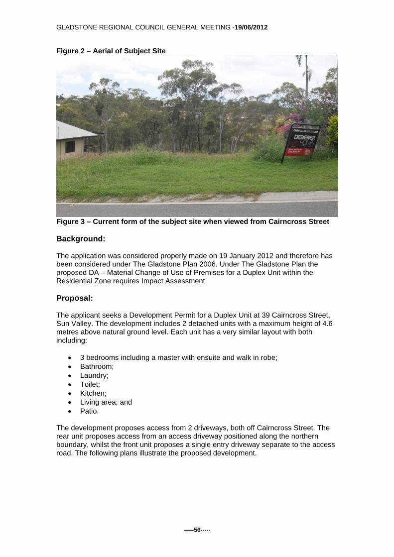
Figure 2 – Aerial of Subject Site
Figure 3 – Current form of the subject site when viewed from Cairncross Street Background: The application was considered properly made on 19 January 2012 and therefore has been considered under The Gladstone Plan 2006. Under The Gladstone Plan the proposed DA – Material Change of Use of Premises for a Duplex Unit within the Residential Zone requires Impact Assessment. Proposal: The applicant seeks a Development Permit for a Duplex Unit at 39 Cairncross Street, Sun Valley. The development includes 2 detached units with a maximum height of 4.6 metres above natural ground level. Each unit has a very similar layout with both including:
3 bedrooms including a master with ensuite and walk in robe; Bathroom; Laundry; Toilet; Kitchen; Living area; and Patio.
The development proposes access from 2 driveways, both off Cairncross Street. The rear unit proposes access from an access driveway positioned along the northern boundary, whilst the front unit proposes a single entry driveway separate to the access road. The following plans illustrate the proposed development.

GLADSTONE REGIONAL COUNCIL GENERAL MEETING -19/06/2012
-----57-----
Figure 4 – Overall Site Plan and Landscape Plan
Figure 5 – Site Plan Rear Residence
GLADSTONE REGIONAL COUNCIL GENERAL MEETING -19/06/2012
-----58-----
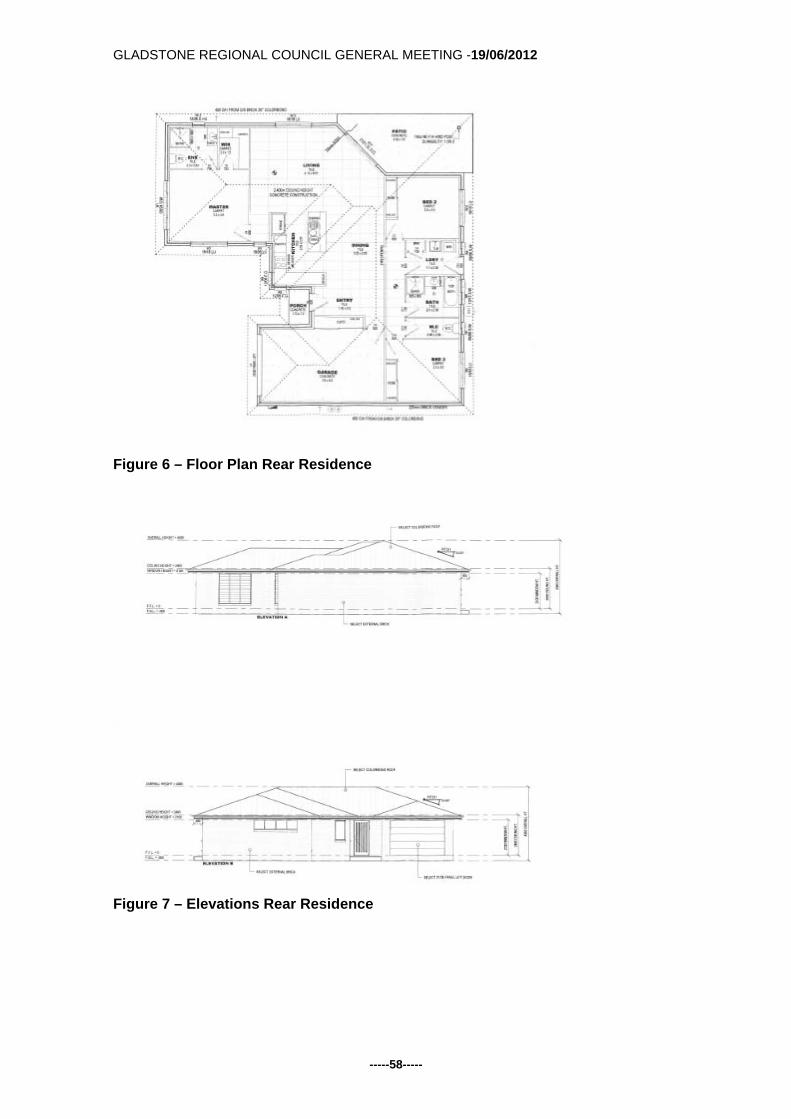
Figure 6 – Floor Plan Rear Residence
Figure 7 – Elevations Rear Residence

GLADSTONE REGIONAL COUNCIL GENERAL MEETING -19/06/2012
-----59-----
Figure 8 – Site Plan Front Residence
Figure 9 – Floor Plan Front Residence

GLADSTONE REGIONAL COUNCIL GENERAL MEETING -19/06/2012
-----60-----
Figure 10 – Elevations Front Residence Referral: The application did not trigger referral to any advice or concurrence agencies in accordance with the Sustainable Planning Act 2009. Public Notification: The application was subject to Impact Assessment and therefore Public Notification was undertaken in accordance with the Sustainable Planning Act 2009. The Public Notification component commenced on 4 May 2012 and was completed on 29 May 2012. One (1) ‘Properly Made’ submission was received during this process and is discussed further in the report. Assessment: Strategic Planning: The subject site is located within the Central Precinct of the Suburban Locality and in the Residential Zone. The primary focus for residential lots within the Suburban Locality is for the provision to be made for a wide range of affordable residential housing types on conveniently located and serviced land. Further, land within the Central Precinct is primarily residential and is to provide low density residential development in the Residential Zone. It should be noted that the subject site lies within the Urban designation of the Gladstone Strategic Framework which seeks to maximise the benefits of existing urban

GLADSTONE REGIONAL COUNCIL GENERAL MEETING -19/06/2012
-----61-----
facilities and infrastructure by maintaining and consolidating development within the existing urban areas. It is therefore considered that the proposed development is compatible, and is of a benefit to the site and surrounding locality. Submissions: The application was publically notified from 4 May 2012 to 28 May 2012, during which time 1 ‘Properly Made’ submission was received. The submission was from the Gladstone Area Water Board (GAWB) and has been attached to this report. The submission advises that a 600mm diameter pipeline is located in the Glenlyon Road reserve which adjoins the development site. The pipeline conveys water at high pressure to the Round Hill Reservoir and other industrial customers. It has been requested that no construction equipment or vehicles be allowed to traverse the pipeline without the consent of GAWB. Considering the nature of the pipeline, conditions have been recommended that will reflect the above request. Planning Scheme Requirements: The subject site is located within the Residential Zone of the Suburban Locality. In accordance with The Gladstone Plan the proposed development requires Impact Assessment against the following codes:
Suburban Locality Code; Residential Code; Environment and Infrastructure Code; and Operational Works (Earthworks) Code.
Assessment against the provisions of the relevant Codes has been undertaken, and for the most part, where applicable, the proposal is considered to comply with these requirements. The proposal is for a detached duplex unit to be developed covering 336m² of the site which equates to a site coverage of 39%, which is below the 40% permitted by the Planning Scheme. Boundary setbacks for duplex units are required to be in accordance with the Queensland Development Code (QDC) MP1.3 Siting and Design Standards for Duplexes, being 6 metres from the front boundary and 1.5 metres from the side and rear boundaries where the height of that part of the building is 4.5 metre or less. Accordingly all setbacks comply with both buildings setback from the southern side boundary 1.5 metres, the rear boundary by 1.5 metres and the northern side boundary 2.7 metres, with the exception of the front setback which is 5 metres from the front boundary. It is noted however that the encroaching part of the building into the front setback is the garage, which runs parallel to the front boundary for 3.8 metres. The rest of the front dwelling is setback 6 metres. It is further noted that the driveway into the encroaching garage will still be able to fit a visitor car without being within the road reserve. Additionally, Cairncross Street contains a number of older style dwellings. A number of these dwellings have frontages between 4.5 metres and 6 metres. As such, it is considered that the relaxation to this development would be in character with the surrounding dwellings of the area. Accordingly, a relaxation to the front setback is considered appropriate.

GLADSTONE REGIONAL COUNCIL GENERAL MEETING -19/06/2012
-----62-----
QDC MP1.3 further states that each dwelling in a duplex has a clearly defined outdoor living space that has an area of at least 16m² and no dimensions less than 4 metres. Accordingly the front residence provides an open space area of 5.8m x 5m totalling 29m² and the rear residence provides an area of 8.10m x 4.30m totalling 35m². As such both dwelling units comply with the provisions of the QDC with respect to private open space. With regard to car parking, Schedule 2 of The Gladstone Plan requires 2 car parking spaces per residential unit, with 1 space per unit, to be covered. Floor plans for the dwellings show a double lockup garage per unit as well as each proposed driveway, and as such the proposal is therefore considered to meet the car parking requirements of the Planning Scheme. The development proposes two separate driveways to access the site. The following image illustrates the proposed driveways.
Figure 11 – Proposed Access into the Site Access into the front unit is via a 4 metre wide driveway that directly accesses the unit’s garage. Access into the rear unit is via a 3 metre side access driveway that widens for access into the rear unit. Both of these driveways are located 2.5 metres away from each other. Because of the proximity of the driveways it has been recommended in the conditions that this section is sufficiently landscaped to provide a

GLADSTONE REGIONAL COUNCIL GENERAL MEETING -19/06/2012
-----63-----
screening barrier between the driveways. Further, because of the slope of the site, this access is considered appropriate and as such, it has been recommended in the conditions that the access into the site is constructed to council’s standards. The following image demonstrates the surrounding water and sewer mains in proximity to the site.
Figure 12 – Assets Plan with Water (Blue) and Sewer (Red) As the above image demonstrates the lot will be able to connect into both water and sewer reticulated services. Because of the slope of the site each proposed unit will be able to connect to water from the existing main along Cairncross Street. Further, each proposed unit will be able to connect to sewer services within the Rifle Range Road road reserve. The proposal for a Duplex Unit at 39 Cairncross Street, Sun Valley is considered to comply with the requirements and intent of the Planning Scheme as a whole, and is therefore recommended for approval subject to reasonable and relevant conditions. Officer's Recommendation: That the application for a Material Change of Use of Premises for a Duplex Unit at 39 Cairncross Street, Sun Valley be approved subject to the following conditions:
1. Development is to be carried out generally in accordance with the submitted application including the following plans:
Drawing Name Drawing No. Drawn By Dated
Site Plan (Overall) D898 02 of 14 BKD Designs 22/03/2012 Site Plan (Rear) D898 02 of 14 BKD Designs 10/11/2011 Floor Plan (Rear) D898 03 of 14 BKD Designs 10/11/2011 Elevations A & B (Rear) D898 06 of 14 BKD Designs 10/11/2011 Elevations C & D (Rear) D898 07 of 14 BKD Designs 10/11/2011 Site Plan (Front) D898 02 of 14 BKD Designs 10/11/2011 Floor Plan (Front) D898 03 of 14 BKD Designs 10/11/2011

GLADSTONE REGIONAL COUNCIL GENERAL MEETING -19/06/2012
-----64-----
Elevations A & B (Front) D898 06 of 14 BKD Designs 10/11/2011 Elevations C & D (Front) D898 07 of 14 BKD Designs 10/11/2011
except where amendments are required to satisfy the conditions of approval. 2. All alterations to services and municipal facilities necessitated by the
development shall be the responsibility of the applicant.
Operational Works
3. Where required, a Development Permit for Operational Works must be obtained from Council prior to the commencement of construction. The Development Application for Operational Works is to include the following:
a) earthworks (including retaining walls) b) roadworks (driveways, crossovers and footpaths) c) water infrastructure d) sewerage infrastructure e) stormwater management f) landscaping, environmental protection and associated works
The design and supporting calculations / documentation associated with these works must be certified by a Registered Professional Engineer of Queensland (RPEQ).
4. Operational Works shall be designed and constructed in accordance with
Council's relevant standards at the time of lodgement of an application for an Operational Works Permit and in accordance with the relevant Australian Standards and good engineering practice. Council’s current standards include:
a) Roads and Transport Standard 2005 b) Gladstone Storm Water Management Strategy 2000 – Drainage
Management Document c) Water Supply Standard 2006 d) Sewerage Design Standard 2003
5. The Operational Works drawings are to contain adequate information to
position each component of infrastructure by coordinates to GDA94 and levels to Australian Height Datum (AHD). The drawings shall also indicate the identification number, position and recorded level of the Permanent Survey Mark (PSM) from which the project’s horizontal and vertical position was derived.
6. The Operational Works are to be executed under the supervision of a RPEQ.
The applicant / developer must give to the Council, construction certificates from such supervising engineer, that the work has been constructed in accordance with the Operational Works Permit and good engineering practice, together with relevant quality assurance, operation and maintenance, and “as constructed” documentation. This includes provision of a CCTV report on all sewer mains installed as part of the development.
7. The “as constructed” drawings and associated electronic documentation are to
be certified by the supervising engineer and by a registered surveyor stating that the as constructed information shown on the “as constructed” drawings represent a complete and accurate record of the works as executed. Council

GLADSTONE REGIONAL COUNCIL GENERAL MEETING -19/06/2012
-----65-----
reserves the right to utilise for its own purposes and the sale of information provided within the “as constructed” drawings provided by the applicant / developer.
8. No Operational Works are to commence until a copy of Form 34 “Notice of
appointment of principal contractor” (Queensland Workplace Health and Safety Act 1995) is received by WH&S Qld, the Principal Contractor and by Council. Similarly, Council must be provided with evidence of any change in the appointment of a Principal Contractor throughout the course of the project.
9. Any alterations to, extension of, or upgrading of Council assets / infrastructure
or other service authority infrastructure necessitated by this development proposal (including earthworks, retaining structures, roadworks, pedestrian / bicycle pathways, stormwater drainage, water supply, sewerage, electrical and telecommunication services, reticulated gas etc.) is the responsibility of the applicant / developer.
10. All earthworks on the site must be carried out in accordance with AS 3798 and
good engineering practice. Geotechnical supervision shall be to Level 1. Building Works
11. Any security lighting shall be so designed to ensure that nuisance is not caused
to adjoining areas by the spillage of light.
12. The applicant is required to obtain a Development Permit for Building and Plumbing Works in accordance with the Sustainable Planning Act 2009. Construction is to comply with the Building Act 1975, the Building Code of Australia and the requirements of other relevant authorities.
13. Building Works application shall detail the proposed location of water tanks as
required by Part 25 of the Queensland Development Code.
14. Appropriate erosion and sedimentation control measures are to be utilised during any Building works carried out as a result of the development.
15. Provision of an 1800 mm high screen fence to all boundaries other than that
section forward of the building line which shall be no greater than 1.2 metres in height. The details of which are to be submitted with any Building Works application on the site.
16. All plant and equipment (including air conditioners, exhaust fans and the like)
are to be housed, screened and located so that these do not cause environmental nuisance or harm to the residential uses on the site and surrounding sites.
Sewer Infrastructure

GLADSTONE REGIONAL COUNCIL GENERAL MEETING -19/06/2012
-----66-----
17. A separate connection to Council’s sewerage infrastructure is to be provided for each residential unit.
18. Connections to Councils live sewerage infrastructure must be carried out by
Council’s Water and Sewerage Department. The cost of these works is to be borne by the applicant.
Water Infrastructure
19. A water service connection is to be provided from the Council water main to the front property boundary of the development. The location and size of the water service is to be determined in consultation with Council's water and Sewerage Department.
20. Individual water meters (sub-metering) shall be provided for each unit in
accordance with the Water and Other Legislation Amendment Act 2007. Sub-meters must be purchased from Council.
21. Connections to Councils live water supply infrastructure and the installation of
water meters to service the development must be carried out by Council’s Water and Sewerage Department. The cost of these works is to be borne by the applicant.
22. Any strata titling of the development will require certification from a Hydraulic
Engineer that the metering of water for the development complies with the Water and Other Legislation Amendment Act 2007.
Earthworks
23. Allotment batters and retaining walls located along the side and rear property boundaries of residential allotments are to be constructed as follows:
a. embankment slopes and retaining walls located along the rear and side
boundaries of adjoining allotments are to be constructed within the allotment located on the low side of the common boundary;
b. where it is not feasible to construct the batters / retaining structures within the adjoining property e.g. along common boundaries with existing properties and along road reserves etc., vertical retaining walls are to be constructed along the boundary.
24. Retaining walls are to comply with the following requirements:
a) The design life of retaining walls is to be at least sixty (60) years and the
design is to be in accordance with AS4678-2002. The walls are to safely withstand the impact of a 1.8m high solid fence constructed along the top of the retaining wall (generally along the property boundary). Fence loadings to include dead, live and wind loads.
b) Retaining walls must not impose loads on underground services within allotments or external to allotments, including but not limited to water, sewerage, stormwater, electrical, telecommunication or other services. In particular, retaining wall footings must not impose loads on the electrical / telecommunication service corridor which is located in the footpath (verge) adjacent to the front property boundary and must allow for the installation and maintenance of these services.
c) The design and construction of retaining walls must be certified by a

GLADSTONE REGIONAL COUNCIL GENERAL MEETING -19/06/2012
-----67-----
Registered Professional Engineer of Queensland (RPEQ) experienced in this type of work. The design certificate and the construction certificate must be location specific and must include:
- design life, design standards, allowable fence loads and any special
provisions / constraints in regards to fence type, fence footing, foundation etc. (for the information of future fence designers / constructors).
- a statement that the retaining wall structure will not impose loads on underground services, including but not limited to water, sewerage, stormwater, electrical, telecommunication or other services and that the design / construction of same allows for the installation and maintenance of these services.
25. Appropriate erosion and sediment control measures are to be utilised during
any building works carried out in association with the development. Transportation
26. Provision of a total of 4 car parking spaces is to be provided with 1 space per unit to be covered and 1 space per unit covered or uncovered. The 4 car parking spaces are to be provided through the use of 2 double lockup garages.
27. Car parking spaces and driveways shall be sealed, drained and line marked in
accordance with Part 14, Schedule 2, Division 4 of the Planning Scheme and AS2890.1.
28. The proposed access driveways are to be constructed in accordance with
Council’s Standard Drawing RT-0055. If not approved via an Operational Works application the applicant shall obtain an approval from Council under Local Law 12 - Roads for the proposed driveway.
Stormwater Infrastructure
29. The design of the Operational Works must comply with the following stormwater management (quantity) criteria:
a) Stormwater infrastructure must adequately drain the site and must cater for
stormwater flows through the site (if applicable) and discharge any runoff from the site to a “lawful point of discharge” as defined in Section 3.02 of the Queensland Urban drainage Manual – Volume 1, 2nd edition 2007. The stormwater drainage system is to be designed to cater for a 1 in 10 year ARI minor storm event and a 1 in 100 year ARI major storm event.
The stormwater management report must demonstrate there will be no worsening of stormwater runoff from the site as a result of the proposed development of the site for all design storm events up to and including a storm event with an average recurrence interval of 1 in 100 years.
The report must be certified by the responsible RPEQ in accordance with the following: “I am aware that the Gladstone Regional Council may rely upon the content and findings of this report including the recommendations, conclusions, results, calculations, plans, graphs, tables, attachments etc., for the purposes of development assessment. In my opinion, the Council can rely
GLADSTONE REGIONAL COUNCIL GENERAL MEETING -19/06/2012
-----68-----
upon the information contained within the report and there are no reservations or qualifications in respect to the information other than set out in the report itself. I confirm that the development site is above the controlling 1 in 100 year ARI flood level and that there will be no worsening of stormwater runoff from the site as a result of the proposed development of the site.”
30. The design of the Operational Works shall comply with the following stormwater management (quality) criteria: Water Sensitive Urban Design (WSUD) measures must be implemented to achieve the pollutant load reductions listed below. The proposed treatment train shall be modelled using “MUSIC” (Model for Urban Stormwater Improvement Conceptualisation) developed by the eWater cooperative research centre (eWater CRC). The water quality objectives in terms of the minimum percentage reduction in mean annual pollutant loads from the unmitigated development are as follows: Total Suspended Solids (TSS) 85% reduction Total Phosphorus (TP) 70% reduction Total Nitrogen (TN) 45% reduction Gross Pollutants (> 5mm) 90% reduction
Alternatively, the applicant may enter into an infrastructure agreement with Council generally in accordance with the following:
The applicant is to provide partial on-site treatment including the use of on-site rainwater tanks and sediment reduction measures and pay a monetary contribution to Council for Council to commence the planning, design, construction and maintenance of additional nutrient removal treatment measures external to the site.
External Works
31. Where infrastructure (access, water supply, sewerage, stormwater etc.) is required to be constructed within land owned by others (external to the development site), the applicant / developer must provide Council with evidence that the relevant property owner consents to the construction of the proposed infrastructure works within their property and to the provision of an easement (in favour of Council) over the subject infrastructure. The written evidence shall be in the form of a Deed of Agreement and must be provided to Council in conjunction with the relevant operational works application.
Landscaping
32. All Landscaping shall be in accordance with Site Plan Dwg. No. D898 02 of 14 dated 22 March 2012 prepared by BKD Designs, except where:
The space between the two driveways along the frontage of the site must be
adequately landscaped for the full distance between the driveways and for the full 3 metres from the frontage.
33. All landscaping, referred to in condition 32 above is to be maintained to an
appropriate standard at all times.

GLADSTONE REGIONAL COUNCIL GENERAL MEETING -19/06/2012
-----69-----
34. Any footpath areas disturbed by the development are to be repaired to their original condition following completion of construction activity.
Gladstone Area Water Board Pipeline
35. A 600mm diameter pipeline owned by the Gladstone Area Water Board exists within the Glenlyon Road road reserve adjoining the property. No construction equipment or vehicles are allowed to traverse or carry out works within the pipeline corridor at anytime without the consent of the Gladstone Area Water Board.
Advice to Applicant An adopted infrastructure charge notice in relation to the infrastructure charges applicable to this development has been provided separately. Attachments:
1. DA/508/2012 - Adopted Infrastructure Charges Notice 2. DA.508.2012 – Gladstone Area Water Board Submission – dated 18 May
2012
Tabled Items: 1. Nil Report Prepared by: Planning Officer DA.508.2012 - Gladstone Area Water Board Submission - dated 18 May 2012.pdf Open Document DA/508/2012 - Adopted Infrastructure Charges Notice.pdf Open Document
GLADSTONE REGIONAL COUNCIL GENERAL MEETING -19/06/2012
-----70-----
Back to Top G/5.4.2 DEVELOPMENT APPLICATION 587/2012 - MATERIAL
CHANGE OF USE OF PREMISES - BUSINESS (OFFICES) - 173 GOONDOON STREET, GLADSTONE
Responsible Officer: Chief Planner Council Meeting Date: 19 June 2012 Development Application:
Application Number: DA/587/2012
Applicant: N.I.V Pty Ltd as trustee for The Bareki Street Unit Trust C/ JFP Urban Consultants Pty Ltd
Owner: N.I.V Pty Ltd as trustee for The Bareki Street Unit Trust
Date Of Receipt: 5 April 2012
Location: 173 Goondoon Street, Gladstone
RPD: Lot 2 RP618544
Area: 941m²
Current Use Of Land: Vacant
Zoning: Commercial
Proposal: Material Change of Use of Premises for Business (Offices)
Submissions Close Date: 28 May 2012
Number Of Submissions: 1 ‘Properly Made’ Submission
Purpose: The Purpose of this report is to consider DA/587/2012. Executive Summary An Impact Assessable Development Application for a Material Change of Use of Premises for Business (Offices) was lodged with Council on 5 April 2012. The development is situated within the commercial strip along Goondoon Street, within Gladstone’s Central Business District. One ‘Properly Made’ submission was received during the notification period and is discussed further in the report. The proposal is considered to generally comply with the requirements of the Planning Scheme and is therefore recommended for approval subject to reasonable and relevant conditions. Subject Site: The subject site is located at 173 Goondoon Street within the Commercial Zone of the City Locality. The subject site has a total area of 941m² and has a 20 metre frontage to Goondoon Street. The site is currently vacant, however is currently used as an informal car park for the Riverstone Rise Sales Office located at 175 Goondoon Street.

GLADSTONE REGIONAL COUNCIL GENERAL MEETING -19/06/2012
-----71-----
Development surrounding the site is predominately retail and offices, with the lot adjoining a residential allotment to the south of the site and Star of the Sea Primary School located 50 metres to the south of the site. The following figures outline the location and zoning of the subject site as well as uses surrounding the site.
Figure 1 – Location and Zoning of the Subject Site

GLADSTONE REGIONAL COUNCIL GENERAL MEETING -19/06/2012
-----72-----
Figure 2 – Surrounding Land Uses Background: The application was considered properly made on 5 April 2012 and therefore has been considered under The Gladstone Plan 2006. Under The Gladstone Plan the proposed DA for Business (Offices) within the Commercial Zone requires Impact Assessment. Proposal: The applicant seeks a Development Permit for Offices at 173 Goondoon Street, Gladstone. The development includes the construction a single storey building consisting of two separate tenancies, one for each level. The building at its uppermost projection is 7.8 metres above natural ground level. Site access will be via a 6.4 metre driveway from Goondoon Street into a rear car park consisting of 18 car parking spaces (including a disabled car park) and bike storage. The overall development of the site proposes a site coverage of 240m² which equates to 36% site coverage. The building is built to the boundary at the front and side boundaries and 15.3 metres from the rear boundary. The following images illustrate the overall development.
Figure 3 – Site Plan & Ground Floor Plan
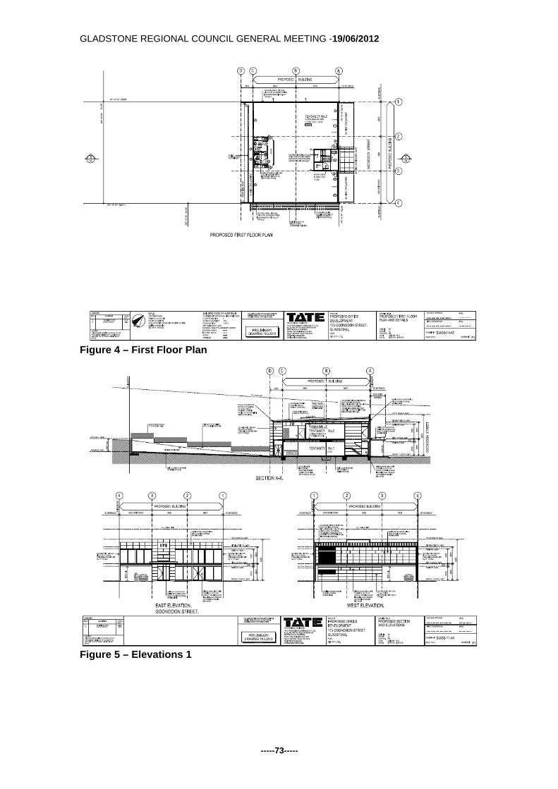
GLADSTONE REGIONAL COUNCIL GENERAL MEETING -19/06/2012
-----73-----
Figure 4 – First Floor Plan
Figure 5 – Elevations 1

GLADSTONE REGIONAL COUNCIL GENERAL MEETING -19/06/2012
-----74-----
Figure 6 – Elevations 2 Referral: The application did not trigger referral to any advice or concurrence agencies in accordance with the Sustainable Planning Act 2009. Public Notification: The application was publicly notified from 4 May 2012 to 28 May 2012, during which time one ‘Properly Made’ submission was received. The submission is discussed under a subsequent section of this report. Assessment: Strategic Planning: The subject site is located within the Valley Precinct of the City Locality and in the Commercial Zone. The primary focus for this Locality is to function as the city’s major business centre supporting and driving the growth of business in the Port, the industrial areas, and the Gladstone State Development Area and Gladstone City. Further to this, within this Precinct, where in the Commercial Zone, provide local convenience shopping and small-scale mixed business to service the inner city population. It is considered that the proposed development for offices located on commercially zoned land will further support the business centre of Gladstone City. Further, the location of the land will help service the inner city population by providing conveniently located office space. It should be noted that the subject site is included in the urban designation of the Gladstone Strategic Framework. The strategy for the urban designation is to maximise the benefits of existing urban facilities and infrastructure by maintaining and

GLADSTONE REGIONAL COUNCIL GENERAL MEETING -19/06/2012
-----75-----
consolidating development within the existing urban area. The proposed development for a Material Change of Use of Premises for Offices is considered to be consistent with the Urban Strategic Framework designation. Submissions: Public Notification commenced on 4 May 2012 and concluded on 28 May 2012, with 1 ‘properly made’ submission received. The submission raised concerns regarding the following:
The application is ‘not properly made’ in accordance with the SPA; Public Notification was not carried out in accordance with the requirements of
the SPA; and The proposed development should not be supported as it does not comply with
the provisions of The Gladstone Plan. Council is required to further respond to the submission in order to assess any issues of non-compliance. The following is an outline of the issues involved and Council’s response. The application is ‘not properly made’ in accordance with the SPA. The submitter has stated that the plans submitted with the development application do not show the location and use of buildings on all land adjoining the relevant land. Further, that this is considered ‘mandatory requirements’ under the Sustainable Planning Act 1009 Section 260(1)&(3). It is considered that this information is critical as it shows the relationship between the proposed earthworks, retaining walls and existing structures on adjoining land. In accordance with IDAS Form 5 the applicant is required to submit a plan demonstrating the location and use of buildings on land adjoining the subject site. It is noted that the applicant has demonstrated on the Site Plan, adjoining buildings to the southern boundary of the lot. The main concern the submitter has is that the adjoining properties, specifically the commercial buildings built to boundary on the adjoining side boundaries may be affected by the proposed earthworks and retaining walls relating to the subject site. Whilst it is considered mandatory information, the applicant has submitted a plan demonstrating some adjoining building locations. Further, because of nature of the proposal, being for commercial development, the majority of applications along Goondoon street are built to the boundaries as the Planning Scheme permits. As such, it was not considered necessary to identify all buildings on surrounding land. It is considered that these concerns will be addressed at Operational and Building Works stage prior to the commencement of construction which will prevent damage to adjoining properties. Public Notification was not carried out in accordance with the requirements of the SPA. The submitter has stated that the incorrect property address and real property description was stated on the public notification sign and that 175 Goondoon Street was not notified as an adjoining owner. On that basis the errors have adversely affected the awareness of the public of the existence and nature of the application..

GLADSTONE REGIONAL COUNCIL GENERAL MEETING -19/06/2012
-----76-----
Public Notification for the development began on 4 May 2012 and concluded on 28 May 2012. The information provided on the sign, newspaper and to adjoining land owners stated that the proposed office was over 173-175 Goondoon Street and Lot 1 RP 616662 and Lot 2 RP 618544. It is noted that both these addresses were used as both lots are owned by the same owner, and as such are rated together. Once this was brought to Council’s attention, the sign was amended on 22 May 2012 to read 175 Goondoon Street and Lot 2 RP618544. It is not believed that this has affected the public’s awareness of the application. Further, whilst both properties were advertised, only one submission was received. On 7 June 2012 the applicant was sent correspondence via email requesting confirmation that they would accept with public notification or if they required it to be restarted. Accordingly, on 13 June 2012 a response was received stating that they have accepted the notification and wish the application to proceed to assessment stage. It is not considered appropriate to readvertise the application. The proposed development should not be supported as it does not comply with the provisions of The Gladstone Plan. The submitter has stated that the development does not comply with the relevant Overall Outcomes and Specific Outcomes of the relevant codes. It is considered that the applicant has complied with all relevant outcomes within the Planning Scheme. Further, based on assessment within this report it is considered that the applicant has provided sufficient justification to warrant a commercial development in the commercial zone. Planning Scheme Requirements: The subject site is located within the Commercial Zone of the City Locality and the Valley Precinct. In accordance with The Gladstone Plan, the proposed development requires Impact Assessment against the following codes:
City Locality Code; Commercial Code; Environment and Infrastructure Code; and Operational Works (Earthworks) Code.
Assessment against the provisions of the relevant Codes has been undertaken, and for the most part where applicable, the proposal is considered to comply with these requirements. The development is comprised of 2 commercial tenancies on 2 separate levels of the one building. The overall development of the site proposes a total of 36% site cover which is compliant with the maximum 50% permitted by the Scheme. The Locality Code allows commercial buildings to a maximum height of 10 metres above natural ground level. The proposed building will be 7.8 metres at its highest projection, complying with the provisions of the Planning Scheme. The Commercial Code sets out requirements regarding Commercial Development abutting non-commercial uses. Specifically, commercial development abutting the Residential (Higher Density) Zone will provide the following:

GLADSTONE REGIONAL COUNCIL GENERAL MEETING -19/06/2012
-----77-----
(i) Buildings are setback the same distance as the residential buildings (as a minimum, buildings are setback 2 metres from the side and rear boundaries) except where the premises is situated in the commercial zone; and
(ii) A landscaped buffer strip 2 metres in width is provided and maintained
within the site on any boundary adjoining a residential land use area. Accordingly, as the development is for commercial development within the Commercial Zone, the setbacks proposed are consistent with the provisions for commercial development within the commercial designation. However, the applicant has only provided a 1 metre landscaped buffer at the rear of the site where the lot adjoins a Residential (Higher Density) Zone. It is noted however that this reduction in landscaping is considered appropriate as the detached dwelling abutting the rear of the property is setback 30 metres from the boundary. It is also noted that an application for Multiple Unit Residential for 16 Units was approved over the adjoining rear property of the site being 104 -106 Central Lane. If the approval is acted upon, the rear of the site will be occupied as a car park for the units, with the actual unit building been set back 21 metres from the adjoining boundary. In either situation, it is considered that the setbacks are large enough not to cause nuisance to the adjoining residential property. Further, the development proposes a 2.4 metre high retaining wall along this boundary and as such, along with appropriate landscaping within the 1 metre landscaped strip, when the subject site is viewed from the residential property it will not detract from the visual amenity. It is further noted that the applicant has proposed a black powder coated security fence along the rear boundary. This is considered inappropriate as this boundary adjoins a residential property. As such, it has been recommended as a condition that this fence be replaced with a 1.8 metre high screen fence. It has further been recommended as a condition that the trees used along the landscape strip will be no smaller than 3 metres at mature age size to further screen the development from adjoining residential uses. Specific Outcome 2 within the Building Scale and Appearance section of the Commercial Code states building setbacks are appropriate to the setting so as to enhance the streetscape and to establish an efficient functional relationship between the development and the street. Table 4-27.1 within the City Locality Code outlines the built form standard for the Valley Precinct and commercially zoned areas. As such development within the Commercial Zone is allowed to be built to boundary from the principal road frontage. Accordingly the building is built to the boundary at the front and side boundaries and has a rear setback of 15.3 metres. These setbacks are appropriate as both adjoining properties to the north and south are both built to the boundary at the front and side setbacks and have left significant rear setback boundaries. The development proposes access from Goondoon Street into the rear carpark via a two way entry/exit point. This point is located adjacent to the ground level tenancy and under the first level tenancy, as the following image demonstrates.

GLADSTONE REGIONAL COUNCIL GENERAL MEETING -19/06/2012
-----78-----
Figure 7 – Indication of Access into the Site Whilst the access breaks up the building bulk and provides a unique, architecturally aesthetically pleasing development, it is considered to be potentially unsafe by providing a blind corner at the driveway entrance/exit. As such it has been recommended as a condition that the solid section of the building on the right of the driveway be constructed using clear building materials or curves or angles are used instead of the 90 degree corner. The following image demonstrates the subject site and Council assets including water, sewer and stormwater.
Figure 8 – Council’s Assets including Water (Blue), Sewer (Red) and Stormwater (Purple) It is noted that the development will be able to connect into Council’s reticulated water and sewer in Goondoon Street and also drain stormwater into the Goondoon Street stormwater system.

GLADSTONE REGIONAL COUNCIL GENERAL MEETING -19/06/2012
-----79-----
Schedule 2 within the Planning Scheme outlines the requirements for car parking. As the use is for offices, 1 space per 30m² GFA is required. The development proposes a total of 540m² GFA which results in a requirement of 18 car parks. The application has provided a total of 18 car parks and thus complies with the requirements of the Planning Scheme. The proposal for Offices at 173 Goondoon Street, Gladstone is considered to comply with the requirements and intent of the Planning Scheme as a whole, and is therefore recommended for approval subject to reasonable and relevant conditions. Officer's Recommendation: That Development Application for a Material Change of Use of Premises for a Business (Offices) at 173 Goondoon Street, Gladstone be approved, subject to the following conditions.
1. Development is to be carried out in accordance with the submitted application including the following plans and supporting documentation except where amendments are required to satisfy the conditions of this approval.
Plan/Document Number Plan/Document Name Prepared By Dated Site & Ground Floor Layout Plan
S3555-1-A1 P1 TATE January 2012
First Floor Plan S3555-11-A2 P1 TATE January 2012 Proposed Section & Elevations
S3555-11-A4 P1 TATE January 2012
Proposed Elevations S3555-11-A5 P1 TATE January 2012 Landscape Operational Works Documentation
201209-LP01 Jp CONCEPTS
23/03/2012
except where amendments are required to satisfy the conditions of this approval, including:
The applicant is required to replace the black powder coated security fence along the rear boundary with a 1.8 metre high screen fence; and
The solid section of the building adjoining the driveway is to be constructed
using clear building materials or curves or angles instead of the 90 degree corner.
2. The applicant shall be responsible for, and bear the costs of any alterations to
existing services or utility mains brought about by approval of this development.
Operational Works
3. Where required, a Development Permit for Operational Works must be obtained from Council prior to the commencement of construction. The Development Application for Operational Works is to include the following:
earthworks (including retaining walls) roadworks (driveways, crossovers and footpaths)

GLADSTONE REGIONAL COUNCIL GENERAL MEETING -19/06/2012
-----80-----
The design and supporting calculations / documentation associated with these works must be certified by a Registered Professional Engineer of Queensland (RPEQ). 4. Operational Works shall be designed and constructed in accordance with
Council's relevant standards at the time of lodgement of an application for an Operational Works Permit and in accordance with the relevant Australian Standards and good engineering practice. Council’s current standards include:
a) Roads and Transport Standard 2005 (Joint CSC and GCC) b) Gladstone Storm Water Management Strategy 2000 – Drainage
Management Document c) Water Supply Standard 2006 (Joint CSC and GCC) d) Sewerage Design Standard 2003 (Joint CSC and GCC)
5. The operational works drawings shall contain adequate information to position each component of infrastructure by coordinates to GDA94 and levels to Australian Height Datum (AHD). The drawings shall also indicate the identification number, position and recorded level of the Permanent Survey Mark (PSM) from which the project’s horizontal and vertical position was derived.
6. The operational works are to be executed under the supervision of a RPEQ.
The applicant / developer must give to the Council, construction certificates from such supervising engineer, that the work has been constructed in accordance with the Operational Works Permit and good engineering practice, together with relevant quality assurance, operation and maintenance, and “as constructed” documentation. This includes provision of a CCTV report on all sewer mains installed as part of the development.
7. The “as constructed” drawings and associated electronic documentation are to
be certified by the supervising engineer and by a registered surveyor stating that the as constructed information shown on the “as constructed” drawings represent a complete and accurate record of the works as executed. Council reserves the right to utilise for its own purposes and the sale of information provided within the “as constructed” drawings provided by the applicant / developer.
8. No operational works are to commence until a copy of Form 34 “Notice of
appointment of principal contractor” (Queensland Workplace Health and Safety Act 1995) is received by WH&S Qld, the Principal Contractor and by Council. Similarly, Council must be provided with evidence of any change in the appointment of a Principal Contractor throughout the course of the project.
9. Any alterations to, extension of, or upgrading of Council assets / infrastructure
or other service authority infrastructure necessitated by this reconfiguration proposal (including earthworks, retaining structures, roadworks, pedestrian / bicycle pathways, stormwater drainage, water supply, sewerage, electrical and telecommunication services, reticulated gas etc.) shall be the responsibility of the applicant / developer.
10. The subject site is identified as an area located between 5 m AHD and 20 m
AHD and as such is at risk of being subject to potential Acid Sulphate Soils (ASS). If detailed engineering design for proposed excavation and filling on the site for operational works indicates that more than 100 m3 of soil will be

GLADSTONE REGIONAL COUNCIL GENERAL MEETING -19/06/2012
-----81-----
excavated from below an elevation of 5 AHD, or filling over 500 m3 of soil will occur below 5 m AHD, the applicant must submit to Council, as part of the Development Application for carrying out operational works; a detailed ASS investigation report to determine whether ASS are present in the area to be disturbed. If ASS is found: a) A report is needed to define the location, depth and existing/potential acidity
of ASS relative to the proposed disturbance. If ASS is to be disturbed by the proposed development, the applicant is also expected to provide a comprehensive ASS is to be disturbed by the proposed development, as the applicant is also expected to provide a comprehensive ASS management strategy outlining how the proposed development will achieve Outcome 1 of State Planning Policy (SPP) 2/02 to occur during assessment of the operational works application.
b) The applicant must maintain the water quality and ecological health of the receiving environment;
c) The applicant must avoid adverse effects on environmentally sensitive areas; and
d) The applicant must avoid accelerated corrosion of assets such as buildings, structures, roads and other infrastructure.
e) The applicant must treat the affected soils in an appropriate manner
One way of achieving compliance with the condition is as follows: a) Have no ASS disturbed ; or b) Have less than 100 m3 of ASS with either >0.7% peroxide oxidisable
sulphur or > 400 moles H+/tonne TPA or TAA will be disturbed.
Landscaping 11. All landscaping shall be in accordance with submitted Landscape Operational
Works Documentation Dwg. No. 201209-LP01, prepared by JW Concepts and dated 23 March 2012, except for the following amendment:
a) Landscaping along the rear boundary shall incorporate trees no smaller
than 3 metres in height.
12. All landscaping referred to in Condition 11 above is to be maintained to an appropriate standard at all times.
13. Provision of an 1800 mm high screen fence to side and rear boundaries, other
than those areas where the building is built to the boundary line, the details of which are to be submitted with any building works application on the site.
Building Works
14. A Development Permit for Building and Plumbing Works is to be obtained in accordance with the Sustainable Planning Act 2009. Construction is to comply with the Building Act 1975, the Building Code of Australia and the requirements of other relevant authorities. This includes appropriate access and facilities for the disabled and compliance with the relevant fire classification requirements in accordance with the Building Code of Australia.
GLADSTONE REGIONAL COUNCIL GENERAL MEETING -19/06/2012
-----82-----
15. All plant and equipment (including air conditioners, exhaust fans and the like) are to be housed, screened and located so that these do not cause environmental nuisance or harm to residential uses in the surrounding area.
16. Environmentally responsible erosion and sediment control measures are to be
implemented during any building works carried out in association with the development.
17. The location of the proposed buildings shall comply with Council Policy 19.7 -
Revision 1 - Building Adjacent to and Over Sewers, Stormwater and Water Assets.
18. An appropriate pedestrian all weather awning over the full width of the footpath
is to be provided over the Goondoon Street footpath for the entire length of the proposed building, the details of which are to be submitted as part of the application for Building Works.
Earthworks
19. All earthworks must be carried out in accordance with AS 3798 and good engineering practice. Geotechnical supervision shall be to Level 1. The geotechnical testing authority shall provide a report to Council, setting out the inspections, sampling and testing it has carried out, and the locations and results thereof. The geotechnical report must be certified a RPEQ experienced in this type of work.
Transportation
20. Provision of a minimum of 18 car parking spaces on site. These spaces and all
vehicle movement areas are to be constructed, drained, linemarked and maintained in accordance with Part 14 Division 4 of the Planning Scheme for the City of Gladstone and AS 2890.1.
21. All driveways are to be clearly signposted and constructed in accordance with
Council's Standard Drawing Figure D - Standard Non Residential Vehicle Crossing in accordance with the Engineering and Development Guidelines Road and Transport Standard 2005.
22. All constructed footpath areas disturbed by the development are to be
resurfaced following completion of construction activity.
23. Safe pedestrian access is to be maintained at all times to surrounding sites during the construction of the development.
24. Any manholes located on the proposed driveway are to be covered with Class
D Covers to AS 3996, and are to be maintained at finished surface levels and remain accessible at all times.
Water Infrastructure
25. A water supply connection is to be provided from Council’s reticulated water supply to the front property boundary of the allotment. The size and location of

GLADSTONE REGIONAL COUNCIL GENERAL MEETING -19/06/2012
-----83-----
the service is to be determined in consultation with Council’s Water and Sewerage Section.
Sewer Infrastructure
26. All sanitary drainage is to drain to Council’s existing sewerage infrastructure. 27. Work on Councils live sewerage infrastructure must be carried out by Council’s
Water and Sewerage Department with the cost of these works to be borne by the applicant.
Stormwater Management
28. Stormwater management works are to be generally in accordance with the Stormwater Report submitted with the application and prepared by TATE Professional Engineers and dated March 2012.
29. The design of the Operational Works must comply with the following stormwater
management (quantity) criteria:
a) Stormwater infrastructure must adequately drain the site and must cater for stormwater flows through the site (if applicable) and discharge any runoff from the site to a “lawful point of discharge” as defined in Section 3.02 of the Queensland Urban drainage Manual – Volume 1, 2nd edition 2007. The stormwater drainage system is to be designed to cater for a 1 in 10 year ARI minor storm event and a 1 in 100 year ARI major storm event. The stormwater management report must demonstrate there will
be no worsening of stormwater runoff from the site as a result of the proposed development of the site for all design storm events up to and including a storm event with an average recurrence interval of 1 in 100 years.
The report must be certified by the responsible RPEQ in accordance with the following: “I am aware that the Gladstone Regional Council may rely upon the content and findings of this report including the recommendations, conclusions, results, calculations, plans, graphs, tables, attachments etc., for the purposes of development assessment. In my opinion, the Council can rely upon the information contained within the report and there are no reservations or qualifications in respect to the information other than set out in the report itself. I confirm that the development site is above the controlling 1 in 100 year ARI flood level and that there will be no worsening of stormwater runoff from the site as a result of the proposed development of the site.”
30. The design of the Operational Works shall comply with the following stormwater management (quality) criteria: Water Sensitive Urban Design (WSUD) measures must be implemented to achieve the pollutant load reductions listed below. The proposed treatment train shall be modelled using “MUSIC” (Model for Urban Stormwater Improvement Conceptualisation) developed by the eWater cooperative research centre (eWater CRC). The water quality objectives in terms of the minimum

GLADSTONE REGIONAL COUNCIL GENERAL MEETING -19/06/2012
-----84-----
percentage reduction in mean annual pollutant loads from the unmitigated development are as follows: Total Suspended Solids (TSS) 85% reduction Total Phosphorus (TP) 70% reduction Total Nitrogen (TN) 45% reduction Gross Pollutants (> 5mm) 90% reduction
Alternatively, the applicant may enter into an infrastructure agreement with Council generally in accordance with the following:
The applicant is to provide partial on-site treatment including the use of on-site rainwater tanks and sediment reduction measures and pay a monetary contribution to Council for Council to commence the planning, design, construction and maintenance of additional nutrient removal treatment measures external to the site.
Lighting
31. All lighting at ground level and associated with illuminating ground level areas must be focused downwards and be provided with hoods, shades or other permanent devices to direct illumination downwards and not allow upward lighting to adversely affect the residential uses on this site and the adjoining the sites.
32. Any security lighting shall be so designed to ensure that nuisance is not caused
to adjoining areas by the spillage of light.
ENVIRONMENTAL SCHEDULE A - GENERAL CONDITIONS A1 In carrying out the activity, all reasonable and practical measures are to be taken
to minimise releases and the likelihood of releases of contaminants to the environment, except as otherwise provided by the conditions of this development approval.
A2 The holder of this development approval must:
(a) install and operate all works and control equipment, and (b) take all measures, perform all acts and do all things, necessary to ensure
compliance with the conditions of this development approval. A3 Notwithstanding any other condition of this development approval, this
development approval does not authorise any release of contaminants that causes or is likely to cause an environmental nuisance beyond the boundaries of the registered place.
SCHEDULE B - AIR B1 Odour and visible contaminants, including but not limited to dust, smoke, fumes
and aerosols must not be released to the environment in a manner that will or may cause environmental harm or environmental nuisance unless such release is authorised.
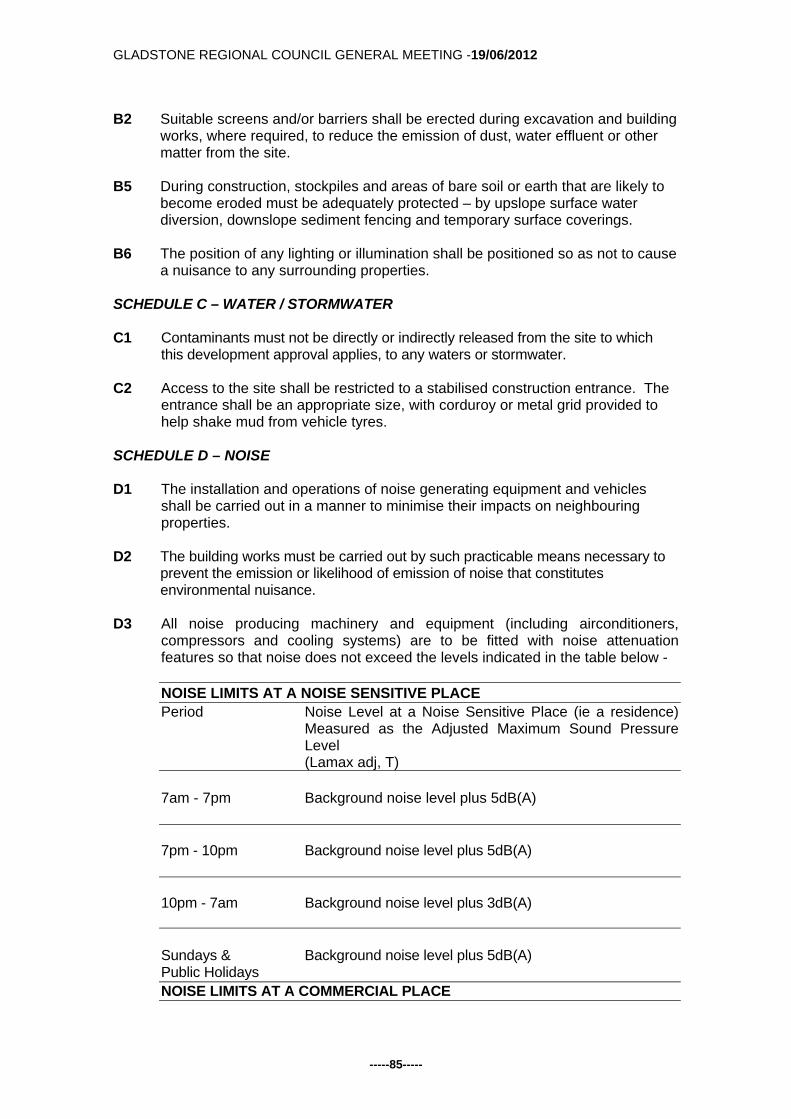
GLADSTONE REGIONAL COUNCIL GENERAL MEETING -19/06/2012
-----85-----
B2 Suitable screens and/or barriers shall be erected during excavation and building
works, where required, to reduce the emission of dust, water effluent or other matter from the site.
B5 During construction, stockpiles and areas of bare soil or earth that are likely to
become eroded must be adequately protected – by upslope surface water diversion, downslope sediment fencing and temporary surface coverings.
B6 The position of any lighting or illumination shall be positioned so as not to cause
a nuisance to any surrounding properties. SCHEDULE C – WATER / STORMWATER C1 Contaminants must not be directly or indirectly released from the site to which
this development approval applies, to any waters or stormwater. C2 Access to the site shall be restricted to a stabilised construction entrance. The
entrance shall be an appropriate size, with corduroy or metal grid provided to help shake mud from vehicle tyres.
SCHEDULE D – NOISE D1 The installation and operations of noise generating equipment and vehicles
shall be carried out in a manner to minimise their impacts on neighbouring properties.
D2 The building works must be carried out by such practicable means necessary to
prevent the emission or likelihood of emission of noise that constitutes environmental nuisance.
D3 All noise producing machinery and equipment (including airconditioners,
compressors and cooling systems) are to be fitted with noise attenuation features so that noise does not exceed the levels indicated in the table below -
NOISE LIMITS AT A NOISE SENSITIVE PLACE Period Noise Level at a Noise Sensitive Place (ie a residence)
Measured as the Adjusted Maximum Sound Pressure Level (Lamax adj, T)
7am - 7pm Background noise level plus 5dB(A) 7pm - 10pm Background noise level plus 5dB(A) 10pm - 7am Background noise level plus 3dB(A) Sundays & Background noise level plus 5dB(A) Public Holidays NOISE LIMITS AT A COMMERCIAL PLACE

GLADSTONE REGIONAL COUNCIL GENERAL MEETING -19/06/2012
-----86-----
Period Noise Level at a Commercial Place Measured as the Adjusted Maximum Sound Pressure Level (Lamax adj, T)
7am - 7pm Background noise level plus 10dB(A) 7pm - 10pm Background noise level plus 10dB(A) 10pm - 7am Background noise level plus 8dB(A) Sundays & Background noise level plus 5dB(A) Public Holidays
SCHEDULE E – WASTE MANAGEMENT E1 Where waste is a contaminant, waste must not be released to the environment
where the release will or may cause environmental harm or environmental nuisance, unless such release is authorised.
E2 The internal road construction must allow for a fully loaded refuse collection
vehicle. E3 The waste storage area is to be imperviously paved, with a hose cock and hose
fitted in close proximity to the enclosure to ensure the area can be easily and effectively cleaned.
E4 Waste is to be serviced onsite with the waste vehicle to enter and exit the site in
a forward motion. SCHEDULE F - MONITORING AND REPORTING F1 All complaints received by the holder of this development approval relating to
releases of contaminants from the activity must be recorded and kept in a log book with the following details:
(i) time, date and nature of complaint; (ii) type of communication (telephone, letter, personal etc.); (iii) name, contact address and contact telephone number of complainant
(note: if the complainant does not wish to be identified then "Not identified" is to be recorded);
(iv) response and investigation undertaken as a result of the complaint; (v) name of person responsible for investigating complaint; and (vi) action taken as a result of the complaint investigation and signature of
responsible person.
F2 As soon as practicable after becoming aware of any emergency or incident which results in the release of contaminants not in accordance, or reasonably expected to be not in accordance with the conditions of this development approval, the holder of the registration certificate to which this development approval relates, must notify the administering authority of the release by telephone or facsimile.

GLADSTONE REGIONAL COUNCIL GENERAL MEETING -19/06/2012
-----87-----
F3 The notification of emergencies or incidents as required by condition F2 must include but not be limited to the following:
(i) the operator of the activity to which this development approval relates; (ii) the location of the emergency or incident; (iii) the name and telephone number of the designated contact person; (iv) the time of the release; (v) the time the holder of the registration certificate became aware of the
release; (vi) the suspected cause of the release; (vii) the environmental harm and or environmental nuisance caused,
threatened, or suspected to be caused by the release; and (viii) actions taken to prevent further any release and mitigate any
environmental harm and/or environmental nuisance caused by the release.
F4 Not more than 14 days following the initial notification of an emergency or
incident, the holder of the development approval must provide written advice of the information supplied in accordance with condition number F3 in addition to: (i) proposed actions to prevent a recurrence of the emergency or incident; (ii) outcomes of actions taken at the time to prevent or minimise
environmental harm and or environmental nuisance; and (iii) the results of any environmental monitoring performed.
SCHEDULE G - DEFINITIONS G1 For the purposes of this development approval the following definitions apply:
(a) "L(Amax adj, T)" means the average maximum A- weighted sound pressure level, adjusted for noise character and measured over a time period of not less than 15 minutes, using Fast response
(b) "commercial place" means a place used as an office or for business or
commercial purposes.
(c) "noise sensitive place" means - a) a dwelling, mobile home or caravan park, residential marina or other
residential premises; or b) a motel, hotel or hostel; or c) a kindergarten, school, university or other educational institution; or d) a medical centre or hospital; or e) a protected area ; or f) a park or gardens.
G2 For the purposes of this development approval any term not otherwise defined
in the Environmental Protection Act 1994, and the Sustainable Planning Act 2009 and any subordinate legislation made pursuant to these Acts or in the Definitions Schedule of this development approval has the meaning conferred to that term in its common usage.
END OF CONDITIONS
Advice To Applicant

GLADSTONE REGIONAL COUNCIL GENERAL MEETING -19/06/2012
-----88-----
An Adopted Infrastructure Charges Notice in relation to the infrastructure charges applicable to this development has been provided separately. Attachments:
1. DA.587.2012 - Adopted Infrastructure Charges Notice; and 2. DA.587.2012 - Properly Made Submission, dated 23 May 2012.
Tabled Items: 1. Nil Report Prepared by: Planning Officer DA.587.2012 - Adopted Infrastructure Charges Notice.pdf Open Document DA.587.2012 - Properly Made Submission Received, dated 23 May 2012.pdf Open Document

GLADSTONE REGIONAL COUNCIL GENERAL MEETING -19/06/2012
-----89-----
Back to Top G/5.4.3 DEVELOPMENT APPLICATION 543/2012 - MATERIAL
CHANGE OF USE OF PREMISES -DUPLEX UNIT - 12 ORCHARD DRIVE KIRKWOOD
Responsible Officer: Chief Planner Council Meeting Date: 19 June 2012 Development Application:
Application Number: DA/543/2012
Applicant: Troy Tenheggeler c/- McNee North Surveys
Owner: Troy Tenheggeler
Date Of Receipt: 23 March 2012
Location: 12 Orchard Drive, Kirkwood
RPD: Lot 227 SP 247744, Parish Auckland
Area: 953m2
Current Use of Land: Vacant
Zoning: Residential
Proposal: Material Change of Use of Premises - Duplex Unit
Submissions Close Date: 28 May 2012
Number of Submissions: Nil
Purpose: The purpose of this report is to consider DA/543/2012. Executive Summary: An application for a Material Change of Use of Premises for a Duplex at 12 Orchard Drive, Kirkwood was properly made on 23 March 2012. The proposed development is Impact Assessable and was assessed against the provisions of The Gladstone Plan 2006. The applicant has proposed an alternative residential development in an establishing residential area. The subject site is situated within the Residential Zone of the Suburban Locality, under the Gladstone Plan 2006. Public Notification was required to be undertaken for a period of 15 business days and there were no submissions received for or against the proposed development during this period. The application is considered to comply with the relevant requirements of the Planning Scheme and is therefore recommended for approval subject to reasonable and relevant conditions. Subject Site:

GLADSTONE REGIONAL COUNCIL GENERAL MEETING -19/06/2012
-----90-----
The subject site is irregular in shape with an area of 953m2 to the east of Orchard Drive, forming part of a residential estate known as Emmadale Gardens. The site has a frontage of approximately 33 metres to Orchard Drive and an average length of approximately 40 metres. The subject site is currently vacant with the surrounding residential area consisting predominantly of single detached dwellings, many of which are currently under construction, and vacant land on either side of the site. The site contains a gentle sloping topography at the front and a relatively steep slope at the back of the site. The front portion of the site has a height of 41.5m AHD to the street frontage which decreases to 39m AHD from the start of a steep rear section. The site then has a sharp drop from 39m AHD to 36m AHD at the rear of the site. The site has been the subject of recent earthworks where all vegetation has been cleared and a terraced landscape has been created between adjoining lots to form a level building platform to the site. A sewer line traverses the central portion of the site and a small portion of a stormwater easement is present to the southern corner. The subject site can be fully serviced by water and sewer reticulation as part of the ongoing development of the estate. The following figures illustrate the location and surrounds of the subject site.
Figure 1 - Location and zoning of the Subject Site

GLADSTONE REGIONAL COUNCIL GENERAL MEETING -19/06/2012
-----91-----
Figure 2 - Topography and existing infrastructure Background: The subject site and lots in the surrounding area were created in late 2011 as part of Stage 7 of Emmadale Gardens Estate. The site has been vacant since it's creation but has been cleared of vegetation from bulk earthworks operations associated with the previous subdivision. The application was considered properly made on 23 March 2012 and assessed under the current Planning Scheme for Gladstone - The Gladstone Plan 2006 and the Sustainable Planning Act 2009. Proposal: The proposal is to develop the site for a single storey duplex with a total Gross Floor Area (GFA) of 312m2 yielding a site coverage of 32%. The dwellings are mirror images of each other and are detached and separated by a minimum width of 1.8 metres. Each dwelling is proposed to contain 3 bedrooms, 2 bathrooms, open kitchen, family and dining area, laundry and single lockup garage. The proposed duplex unit can be accessed via an individual crossover from the Orchard Drive frontage. An additional 2 uncovered visitor car spaces have also been provided to the frontage of the site. Each unit also contains a verandah with the surroundings separated into privately fenced yards by a 1.8m high treated pine paling screen fence which is also proposed along the side and rear boundaries. Landscaping is also proposed to the frontage of the property.

GLADSTONE REGIONAL COUNCIL GENERAL MEETING -19/06/2012
-----92-----
The building is setback 4.5 metres from the frontage, 1.504 metres from the eastern side boundary, 1.5 metres from the western side boundary and 16.92 metres from the rear boundary inclusive of the sewerage and stormwater easements. The external finish of the duplex is to be brick and rendered brick with a colorbond corrugated roof, hardwood posts, aluminium framed windows and selected ceramics tile inserts. The following plans illustrate the perspective, site plan, floor plan, elevations and landscaping for the duplex.
Figure 3 - Site Plan
Figure 4 - Elevation Plan of Unit 1

GLADSTONE REGIONAL COUNCIL GENERAL MEETING -19/06/2012
-----93-----
Figure 5 - Floor Plan of Unit 1
Figure 6 - Landscaping Plan of Proposed Duplex Referral: The proposed development was not required to be referred to any Concurrence or Advice Agency. Public Notification: Public Notification was required to be undertaken as the proposed development was Impact Assessable under the Gladstone Plan. Notification was undertaken for a period of 15 business days and commenced on 4 May 2012 and was completed on 28 May 2012. There were no submissions for or against the proposed development.

GLADSTONE REGIONAL COUNCIL GENERAL MEETING -19/06/2012
-----94-----
Assessment: Strategic Planning: The subject site is located in the Residential Zone within the Suburban Locality under The Gladstone Plan. Overall outcomes for this locality state that the provision of a wide range of affordable residential housing types on conveniently located and serviced land is provided within the Residential Zone. More specifically the site is located within the Kirkwood Road South Precinct of the Suburban Locality. The Kirkwood Road South Precinct's Overall Outcomes require development to occur in a coordinated and sustainable way, with sensitivity to the local topography and providing a higher standard design due to its proximity to Kirkwood Road. This precinct also outlines that development is predominantly for urban residential purposes, dominated by dwelling houses on single allotments and integrated closely with areas of open space. The proposed development provides an alternative housing stock that is well serviced and is conveniently located in close proximity to passive and active parkland known as Koowin Park within the estate. While the overall outcomes for the precinct nominate dwelling houses on single allotments, it does not rule out the possibility of an alternative housing type provided it meets the relevant criteria. As such the proposed development is considered to comply with the overall outcomes of the Suburban Locality and the Kirkwood Road South Precinct. It should be noted that the subject site is included in the urban designation of the Gladstone Strategic Framework. The strategy for the urban designation is to maximise the benefits of existing urban facilities and infrastructure by maintaining and consolidating development within the existing urban area. The proposed Duplex Unit is considered to be consistent with the Urban Strategic Framework designation. It is considered that the proposal meets these requirements as the development will increase the availability of affordable residential properties in the area, and although an increase in density, the duplex is considered to be consistent with the Planning Scheme requirements with regard to site area, coverage and set backs. Planning Scheme Requirements: The subject site is located within the Residential Zone of the Suburban Locality. In accordance with The Gladstone Plan the proposed development requires Impact Assessment against the following codes:
Suburban Locality Code - Kirkwood Road South Precinct; Residential Code; Environment and Infrastructure Code; and Operational Works (Earthworks) Code
In the Suburban Locality Code it is a requirement to ensure development in the Residential Zone promotes a high standard of residential living on conveniently located, serviced land in a sustainable, planned and efficient manner. The proposed development is conveniently serviced by infrastructure, roads and parklands and although Dwelling Houses are primarily to be located in the Residential Zone, this does not exclude Duplex Units. The proposed development is considered an acceptable affordable, alternative housing type, particularly given it compiles with the relevant built form provisions of the Planning Scheme.

GLADSTONE REGIONAL COUNCIL GENERAL MEETING -19/06/2012
-----95-----
The Specific Outcomes and Acceptable and Probable Solutions for the Suburban Locality Code state that the Residential Zone is to contain a mix of housing types in suitable locations within close proximity to community facilities and designated commercial centres being the Woolworths Shopping Centre on Kirkwood Road, and a small neighbourhood shopping centre to the corner of Emmadale and Skyline Drive. The proposed duplex is located within reasonable proximity to nearby commercial centres which meets the requirements of the code. The proposed development is situated on a 953m2 allotment which meets the minimum lot size requirement of 800m2. The maximum site coverage stated in the code is 40% for a duplex unit and the proposal has a site coverage of 34% (293m2). In accordance with the Residential Code, the height of a residential building is not to exceed 9 metres in height, including a ground storey or any attics or mezzanine floors measured from natural ground level (NGL) at any point. The overall height of the proposed development is 4.5 metres to the peak of the roof from NGL which complies with the code. Development of this site is required to provide a 6 metre setback from the road in accordance with Acceptable Solution A1 (a) (i) of the Queensland Development Code (QDC) requirements (Buildings and Structures). The proposed setback to the frontage is less than this requirement at 4.5 metres. The proposal is however considered to meet the requirements of the corresponding Performance Criteria P1 of the code which states:
The location of a building or structure facilitates an acceptable streetscape, appropriate for – (a) the bulk of the building or structure; and (b) the road boundary setbacks of neighbouring buildings or structures; and (c) the outlook and views of neighbouring residents; and (d) nuisance and safety to the public.
The proposed duplex is a detached structure which provides a significant degree of building articulation and features in addition to landscaping to reduce the perception of building bulk when viewed from the street. In addition similar setbacks are being considered as part of boundary relaxation applications on adjacent properties in response to the siting constraints associated with the continuation of the rear sewer easement. This is evident in the following tabulated comparative analysis of the frontage setbacks approved or currently under assessment for developments along Orchard Drive.
Address Setback Application number 10 Orchard Drive 4 metres BR/1076/2012 14 Orchard Drive 6 metres BP/212/2012 18 Orchard Drive 4 metres BR/1097/2012 20 Orchard Drive 6.140 metres BP/617/2012 22 Orchard Drive 6 metres BP/210/2012 24 Orchard Drive 4.210 metres BR/1098/2012 26 Orchard Drive 6 metres BP/178/2012 As visitor spaces are not proposed within the setback area, the need to accommodate the length of a standard vehicle within the driveway area is not required. As such the consideration of a boundary relaxation given the length of a standard car park of 5.4 metres to the garage door is not relevant in this instance.

GLADSTONE REGIONAL COUNCIL GENERAL MEETING -19/06/2012
-----96-----
On this basis the proposal is considered to provide a continuity of the streetscape which will not hinder the outlook and views of neighbouring residents onto the street for casual surveillance or create nuisance and safety to the public. As such the proposed frontage setback is considered to be appropriate in this instance and an appropriate streetscape can be achieved. Acceptable Solution A2 (a) of the QDC also states that side and rear boundary clearances for the side and rear boundaries are to be 1.5 metres where the height of the building is 4.5 metres or less. A 1.5 metre setback for the side and rear is also required to accommodate landscaping in accordance with the Residential Code. The proposed development meets the requirements with the proposed side and rear setbacks being 1.504 metres from the eastern side boundary, 1.5 metres from the western side boundary and 16.92 metres from the rear boundary with space for landscaping. No acceptable solutions are specifically nominated for the amount of landscaping or recreational space for duplex units under the Gladstone Plan. However QDC MP1.3 further states that each dwelling in a duplex has a clearly defined outdoor living space that has an area of at least 16m², no dimensions less than 4 metres with access from a living area an has a slope of not more than 1 in 10. Accordingly as noted below in Figure 7, Unit 1 provides 80.5m2 and Unit 2 provides 108.8m2 of private open space, to a portion of the rear yard of the site and verandahs of each dwelling. As such both dwelling units comply with the provisions of the QDC. These areas are to be separated for the privacy of each dwelling through a 1.8 metre high treated pine paling fence.
Figure 7 - Private open space The applicant has provided a Landscaping Plan which identifies proposed landscaping within the site. A condition requiring compliance with development over and within infrastructure easements has been recommended should the applicant propose to plant vegetation within the sewerage or stormwater easements in the future. Car parking requirements for a duplex are 2 spaces per unit, one of which must be covered. The proposed development meets these requirements with a single garage provided for each of the units and 2 uncovered visitor spaces adjacent to the garages.

GLADSTONE REGIONAL COUNCIL GENERAL MEETING -19/06/2012
-----97-----
The Environment and Infrastructure Code states that premises are to have an adequate, safe and reliable supply of water and are to connect into Council's water supply system and reticulated sewerage treatment system. The proposed development is able to connect into these systems, with the water infrastructure located along the street frontage, and the sewer infrastructure located within the central portion of the site. The code also requires stormwater drainage to be captured, treated and released to an approved point of discharge. A condition requiring the collection of all roof water and water from paved areas to be discharged to the stormwater and roof water pit to the rear of the site has been recommended. The proposed Material Change of Use of Premises for a Duplex is considered to meet the requirements of the Gladstone Plan with regard to maximising the benefits of existing urban facilities and infrastructure by maintaining and consolidating development within the existing urban area and further by providing a range of housing diversities within close proximity to services. As such, it is therefore recommended that the proposed development for a Duplex at 12 Orchard Drive, Kirkwood be approved subject to reasonable and relevant conditions. Officer's Recommendation: That the application for a Material Change of Use of Premises for a Duplex Unit at 12 Orchard Drive, Kirkwood be approved subject to the following conditions:
1. Development is to be carried out in accordance with the submitted application including the following plans:
Drawing name Drawing
Number Drawn By Date
Site Plan 78 Page 1 of 9
Tenheggeler Homes 2011
Driveway Path and Landscaping Plan
78 Page 2 of 9
Tenheggeler Homes 2011
Contour Levels 78 Page 3 of 9
Tenheggeler Homes 2011
Unit 1 - Floor Plan 78 Page 4 of 9
Tenheggeler Homes 2011
Unit1 Elevations 78 Page 5 of 9
Tenheggeler Homes 2011
Unit 1 - Slab and Plumbing
78 Page 6 of 9
Tenheggeler Homes 2011
Unit 2 - Floor Plan 78 Page 7 of 9
Tenheggeler Homes 2011
Unit2 Elevations 78 Page 8 of 9
Tenheggeler Homes 2011
Unit 2 - Slab and Plumbing
78 Page 9 of 9
Tenheggeler Homes 2011
except where amendments are required to satisfy the conditions of approval.
2. All alterations to services and municipal facilities necessitates by the development shall be the responsibility of the applicant.
Building Works

GLADSTONE REGIONAL COUNCIL GENERAL MEETING -19/06/2012
-----98-----
3. The applicant is required to obtain a Development Permit for Building and Plumbing Works in accordance with the Sustainable Planning Act 2009. Construction is to comply with the Building Act 1975, the Building Code of Australia and the requirements of other relevant authorities.
4. Appropriate erosion and sedimentation control measures are to be utilised
during any Building Works carried out as a result of the development.
5. All lighting at ground level and associated with illuminating ground level areas must be focussed downwards and be provided with hoods, shades or other permanent devices to direct illumination downwards and not allow upward lighting to adversely affect the residential uses on the site and surrounding sites.
6. Any security lighting shall be so designed to ensure that nuisance is not caused
to adjoining areas by the spillage of light.
7. Provision of a 1.8 metre high screen fence to side, and rear boundaries, other than that section forward of the building line which shall be no greater than 1.2 metres in height. The details of which are to be submitted with any Building Works application on the site.
8. All plant and equipment (including air conditioners, exhaust fans and the like)
are to be housed, screened and located so that these do not cause environmental nuisance or harm to the residential uses on the site and surrounding sites.
9. The Building Works application must detail the proposed location of water tanks
as required by Part 25 of the Queensland Development Code.
10. Environmentally responsible erosion and sediment control measures are to be implemented during any building works carried out in association with the development.
Earthworks
11. All earthworks on the site must be carried out in accordance with AS 3798 and good engineering practice. Geotechnical supervision shall be to Level 1.
12. Environmentally responsible erosion and sediment control measures are to be
implemented during any operational works or building works carried out in association with the development.
13. Allotment batters and retaining walls located along the side and rear property
boundaries of residential allotments are to be constructed as follows.
a. embankment slopes and retaining walls located along the rear and side boundaries of adjoining allotments are to be constructed within the allotment located on the low side of the common boundary;
b. where it is not feasible to construct the batters / retaining structures within the adjoining property e.g. along common boundaries with existing properties and along road reserves etc., vertical retaining walls are to be constructed along the boundary.
14. Retaining walls are to comply with the following requirements:

GLADSTONE REGIONAL COUNCIL GENERAL MEETING -19/06/2012
-----99-----
a) The design life of retaining walls is to be at least sixty (60) years and the
design is to be in accordance with AS4678-2002. The walls are to safely withstand the impact of a 1.8m high solid fence constructed along the top of the retaining wall (generally along the property boundary). Fence loadings to include dead, live and wind loads.
b) Retaining walls must not impose loads on underground services within allotments or external to allotments, including but not limited to water, sewerage, stormwater, electrical, telecommunication or other services. In particular, retaining wall footings must not impose loads on the electrical / telecommunication service corridor which is located in the footpath (verge) adjacent to the front property boundary and must allow for the installation and maintenance of these services.
c) The design and construction of retaining walls must be certified by a Registered Professional Engineer of Queensland (RPEQ) experienced in this type of work. The design certificate and the construction certificate must be location specific and must include:
- design life, design standards, allowable fence loads and any special
provisions / constraints in regards to fence type, fence footing, foundation etc. (for the information of future fence designers / constructors).
- a statement that the retaining wall structure will not impose loads on underground services, including but not limited to water, sewerage, stormwater, electrical, telecommunication or other services and that the design / construction of same allows for the installation and maintenance of these services.
15. Appropriate erosion and sediment control measures are to be utilised during
any building works carried out in association with the development. Sewerage Infrastructure
16. A separate connection to Council’s sewerage infrastructure is to be provided for each residential unit.
17. Connections to Councils live sewerage infrastructure must be carried out by
Council’s Water and Sewerage Department. The cost of these works is to be borne by the applicant.
18. A survey is to be undertaken to accurately determine the location of the
easement and sewer main. This survey must be submitted to Council to confirm the location prior to building application being submitted.
Water Infrastructure
19. A water service connection is to be provided from the Council water main to the
front property boundary of the development. The location and size of the water service is to be determined in consultation with Council’s Water and Sewerage Department.
20. Individual water meters (sub-metering) shall be provided for each unit in
accordance with the Water and Other Legislation Amendment Act 2007. Sub-meters must be purchased from Council.

GLADSTONE REGIONAL COUNCIL GENERAL MEETING -19/06/2012
-----100-----
21. Connections to Councils live water reticulation network and the installation of water meters to service the development must be carried out by Councils Water and Sewerage Department. The cost of these works is to be borne by the applicant.
22. Any strata titling of the development will require certification from a Hydraulic
Engineer that the metering of water for the development complies with the Water and Other Legislation Amendment Act 2007.
Stormwater Infrastructure
23. As part of a Building and / or Plumbing Works the applicant is to connect to the legal point of discharge being Council’s existing stormwater system at the rear of the site, or another approved location.
External Works
24. Where infrastructure (access, water supply, sewerage, stormwater etc.) is
required to be constructed within land owned by others (external to the development site), the applicant / developer must provide Council with evidence that the relevant property owner consents to the construction of the proposed infrastructure works within their property and to the provision of an easement (in favour of Council) over the subject infrastructure. The written evidence shall be in the form of a Deed of Agreement and must be provided to Council in conjunction with the relevant operational works application.
Landscaping
25. A landscape plan is to be submitted for approval prior to the issuing of a
Development Permit for Building Works. The landscaping of the site shall incorporate:
a) All areas of landscaping as referred to on approved plan 'Driveway Path
and Landscaping Plan', Drawing Number 78, Page 2 of 9 that has indicative landscaping on it.
b) The landscaping provided shall be in accordance with Council's preferred landscape plant list; and
c) All areas not covered by a building or driveway are to be incorporated into the landscaping plan.
The landscaping plan shall contain the following information: a) Outline of the buildings; b) Existing trees (height location); c) Proposed planting (quantity, species and expected mature height); d) Paths, driveways and paving (location and materials); and e) The method of planting and the proposed maintenance program.
26. All landscaping referred to in Condition 25 above is to be maintained to an
appropriate standard at all times
27. Future landscaping within the sewer easement to the rear of the site shall not cause damage to Council's existing sewerage infrastructure.
Transportation

GLADSTONE REGIONAL COUNCIL GENERAL MEETING -19/06/2012
-----101-----
28. Provision of 4 car parking spaces on site, 2 of which are to be covered. These
spaces and all vehicle movement areas are to be constructed, drained, linemarked and maintained in accordance with Part 14, Schedule 2, Division 4 of the Planning Scheme and AS2890.1.
29. The proposed access driveways are to be constructed generally in accordance
with Council’s Standard Drawing RT-0055. A Driveway Permit must be obtained from Council for this work.
30. There is to be adequate screening of all vehicle parking areas from habitable
rooms, at all times. Miscellaneous
31. Provision is to be made for an allocated waste reciprocal area/s adequate to service the development. The waste reciprocal area must comply with the following where applicable:
a. Mobile Wheelie Bins:
1. Provision of an allocated waste reciprocal area/s adequate to store the mobile wheelie-bins for all units. The standing room for the wheelie-bin is to allow for two (2) 240 litre mobile garbage bins per unit.
32. The site is to be maintained in a clean and orderly state at all times.
END OF CONDITIONS
Advice to Applicant: An adopted infrastructure charge notice in relation to the infrastructure charges applicable to this development has been provided separately. Attachments:
1. Draft Infrastructure Charge Notice. Tabled Items: 1. Nil. Report Prepared by: Planning Officer DA/543/2012 - Attachment 1 - Draft Infrastructure Charges Notice.pdf Open Document

GLADSTONE REGIONAL COUNCIL GENERAL MEETING -19/06/2012
-----102-----
Back to Top G/5.4.4 DEVELOPMENT APPLICATION 521/2012 - MATERIAL
CHANGE OF USE OF PREMISES - OFFICE - 8/100 GOONDOON STREET, GLADSTONE
Responsible Officer: Chief Planner Council Meeting Date: 19 June 2012 Development Application:
Application Number: DA/521/2012
Applicant: D & T Hamilton C/- LG Planning Services
Owner: D & T Hamilton
Date Of Receipt: 2 February 2012
Location: 8/100 Goondoon Street, Gladstone
RPD: Lot 1 BUP60138
Area: 4,227m² Total Site Area
92m² GFA
Current Use Of Land: Shop, Office, Retail, Hotel, Food Premises, Licensed Premises
Zoning: Commercial
Proposal: Material Change of Use of Premises for Office
Submissions Close Date: 31 May 2012
Number Of Submissions: Nil
Purpose: The purpose of this report is to consider DA/521/2012. Executive Summary An Impact Assessable development application for a Material Change of Use of Premises for an Office was received by Council on 2 February 2012. The application was publicly notified from 13 April 2012 until 31 May 2012, with no submissions received during this period. The proposal is considered to generally comply with the requirements of the Planning Scheme and is therefore recommended for approval subject to reasonable and relevant conditions. Subject Site: The subject site is located in Shop 8, 100 Goondoon Street, Gladstone and is zoned Commercial within The Gladstone Plan. The overall site has an area of approximately 4,227m², and is part of a mixed used complex with an actual tenancy GFA of 92m². The site slopes downwards from Goondoon Street towards Oaka Lane and has a frontage of 43 metres to Goondoon Street and 80 metres to Oaka Lane. The site contains the Rydges Hotel, Food Premises, Shops and Offices. Adjoining the site to the

GLADSTONE REGIONAL COUNCIL GENERAL MEETING -19/06/2012
-----103-----
north are shops and offices and to the south is a site that is a Queensland Heritage Place, being the former Commonwealth Bank. Across Goondoon Street to the east is the Council Chambers Civic Centre and across Oaka Lane to the west is a car park and the Rydges Motel/Hotel. The following images illustrate the location, zoning and existing condition of the subject site.
Figure 1 – Location and Zoning of Subject Site
Figure 2 – Current condition of the Subject Site

GLADSTONE REGIONAL COUNCIL GENERAL MEETING -19/06/2012
-----104-----
Background: The application was received by Council on 2 February 2012 and was therefore received after the commencement of The Gladstone Plan 2006. Under The Gladstone Plan the proposed DA – Material Change of Use of Premises for an Office within the Commercial Zone and where located below ground flood level requires Impact Assessment and appropriate public notification of the proposal. This is in accordance with the Gladstone City CBD and Waterfront Revitalisation Study dated July 2006. Section 1.8 of the report identifies key sites within the CBD including the streetscape and forecourt areas adjacent to the Gladstone City Council. These sites require strong urban design and streetscape inputs and active street frontages. Proposal: The proposed development involves converting the use of the existing Shop at tenancy 8/100 Goondoon Street from a shop to an office use. No other works or building modifications are proposed and any changes to the internal layout of the premises will be the responsibility of any future tenant. The following image illustrates the current premises on site.
Figure 3 – Site Plan

GLADSTONE REGIONAL COUNCIL GENERAL MEETING -19/06/2012
-----105-----
Referral: The application required referral to the Department of Environment and Resource Management (DERM) as an Advice Agency as the site adjoins a Queensland Heritage Place, being the former Commonwealth Bank Building. DERM did not issue an information request and on 17 April 2012 the department issued their Advice Agency Response stating that they had no recommendations relating to the application. This response has been attached to this report. Public Notification: The application was subject to Impact Assessment and therefore Public Notification was undertaken in accordance with the Sustainable Planning Act 2009. The Public Notification component commenced on 13 April and was completed on 31 May 2012, with no submissions received. The application was required by SPA to be notified for 30 business days as the site adjoins a Queensland Heritage Place. Assessment: Statutory Planning: The subject site is located in the Commercial Zone of the City Locality in the Uptown Precinct. As such, a number of Overall Outcomes are relevant to the proposed development. Specifically, the city’s commercial core is consolidated to those premises with frontage to Goondoon Street, between Lord and Bramston Street and commercial purposes or development are located in the Commercial Zone and are appropriate to the particular role and function of the relevant centre. Accordingly, the proposed development complies by being located in the commercial zone for a business use located between Lord and Bramston Street. Further, the office use is considered appropriate by adding to the diverse uses surrounding the development, particularly along Goondoon Street which consists of retail, food premises and offices. Further, The Gladstone City CBD and Waterfront Revitalisation Study discusses the uses within the CBD and Waterfront and how to achieve them. Specifically, the strategies adopted ensure that ground floor (street level) uses in the City Centre are active and would create a pedestrian focused streetscape that provided opportunities for social and business interaction. It is generally considered that even through a change in use, the subject site will still be able to achieve opportunities for active business interaction because of the location and open design of the tenancy. Planning Scheme Requirements: The Gladstone Plan contains a number of codes which are applicable to the proposed development, including:
City Locality Code; Commercial Code; and Environment and Infrastructure Code.
Assessment against the provisions of the relevant codes has been undertaken, and for the most part, where applicable the proposal complies with these requirements.

GLADSTONE REGIONAL COUNCIL GENERAL MEETING -19/06/2012
-----106-----
The maximum site coverage for commercial development is 75%. As the development proposes to occupy an already existing tenancy, of which neither the tenancy or the building take up 75% of the site, the development complies with the provisions of the Planning Scheme. The Environment and Infrastructure Code requires that vehicle parking is to be provided in accordance with Schedule 2 of the Planning Scheme. Offices are required to provide car parking at a rate of 1 space per 30m² GFA. This generates a car parking requirement of 3 spaces. This tenancy has existing use rights for a Shop which provides a credit of 5 car parking spaces located in a communal car park at the rear of the site. As such the proposed use will have an excess of 2 car parking spaces, complying with the requirements of the Planning Scheme. As the tenancy is part of a mixed use development, pedestrian access into the site will be via Goondoon Street or Oaka Lane. Vehicular access into the car park is available from Oaka Lane. As the building is already established, access driveways, car parks and crossovers are already established and comply with Council’s standards. The tenancy will utilise the industrial bins at the rear of the property for refuse collection. No setbacks apply to the application as the tenancy is already established and no building works are being proposed. It is considered that the application for an Office at 8/100 Goondoon Street, Gladstone complies with the requirements of The Gladstone Plan, and is therefore recommended for approval, subject to treasonable and relevant conditions. Officer's Recommendation: That Development Application DA/521/2012 for a Material Change of Use of Premises for an Office at 8/100 Goondoon Street, Gladstone be approved, subject to the following conditions.
1. Development is to be carried out in accordance with the submitted application in accordance with the submitted plans and material, except where amendments are required to satisfy the conditions to this approval.
2. The applicant shall be responsible for, and bear the costs of any alterations to
existing services or utility mains brought about by approval of this development. 3. Any further expansion of the office into an adjoining tenancy will require a
Material Change of Use application. Building Works
4. The applicant is required to obtain a Development Permit for Building and Plumbing Works for any internal fit outs in accordance with the Sustainable Planning Act 2009. Construction is to comply with the Building Act 1975, the Building Code of Australia and the requirements of other relevant authorities.
Lighting

GLADSTONE REGIONAL COUNCIL GENERAL MEETING -19/06/2012
-----107-----
5. Any security lighting shall be so designed to ensure that nuisance is not caused to adjoining areas by the spillage of light.
Advice to Applicant An adopted infrastructure charge notice in relation to the infrastructure charges applicable to this development has been provided separately. Attachments:
1. DA.521.2012 – Adopted Infrastructure Charge Notice 2. DA.521.2012 - DERM Advice Agency Response - dated 17 April 2012
Tabled Items: 1. Nil Report Prepared by: Planning Officer DA.521.2012 - Adopted Infrastructure Charge Notice.pdf Open Document DA.521.2012 - DERM Advice Agency Response - dated 17 April 2012.pdf Open Document

GLADSTONE REGIONAL COUNCIL GENERAL MEETING -19/06/2012
-----108-----
Back to Top G/5.4.5 DEVELOPMENT APPLICATION DA/500/2012 MATERIAL
CHANGE OF USE OF PREMISES FOR MULTIPLE UNIT RESIDENTIAL (31 UNITS) AT LOT 951 SP246155, BRIFFNEY STREET, KIRKWOOD
Responsible Officer: Chief Planner Council Meeting Date: 19 June 2012 Development Application:
Application Number: DA/500/2012
Applicant: GPDQ Pty Ltd C/- Norris Clarke & O'Brien Pty Ltd
Owner: GPDQ Pty Ltd
Date of Receipt: 3 January 2012
Location: Lot 951 SP 246155 Briffney Street, Kirkwood
RPD: Lot 951 SP 246155
Area: Lot 951 SP 246155 area - 41.51 ha
Proposed Stage 10 developable area -1.19 ha
Current Use of Land: Vacant
Zoning: Residential
Proposal: Multiple Unit Residential (31 Units)
Submissions Close Date: 20 April 2012
Number of Submissions: Nil
Purpose: The purpose of this report is to consider DA/500/2012. Executive Summary: An Impact Assessable Development Application for Multiple Unit Residential (31 Units) was lodged with Council on 3 January 2012. It is noted that there is currently an approval over this entire site for a residential subdivision of approximately 600 lots over 19 stages known as Little Creek Estate. Progress on this estate has seen stages 1, 2, 3, 4A, 8 and 5 completed. Construction of Stages 12 & 13 and external works on Kirkwood Road are well advanced. Civil works on Stages 14 and 20 are also nearing completion. The proposal itself sits within the approved Stage 10 area of the estate. No submissions were received during the public notification process. The development is considered to be consistent with the requirements of the Planning Scheme for Gladstone and as such it is considered that the application should be approved subject to the reasonable and relevant conditions contained within the officers recommendation.

GLADSTONE REGIONAL COUNCIL GENERAL MEETING -19/06/2012
-----109-----
Subject Site: A preliminary approval was issued in August 2007 for 640 residential lots and development permit for Stages 1 and 2 for the subdivision development now known as Little Creek Estate, which includes the bulk of future subdivisional development South of Kirkwood Road adjacent to the Harvey Road and Kirkwood Road intersection. Stages 1, 2, 3, 4A, 8 and 5 of the estate have been completed with dwellings already in various stages of completion throughout. The estate is currently zoned as Residential, with the exception of a powerline easement that traverses the south west corner which is zoned Major Industry and Infrastructure. The estate has undergone a series of approvals whereby a central area to the estate has been created to accommodate the proposed development. This area is known as Stage 10 of the estate which is situated within a larger lot being Lot 951 SP 246155 which additionally accommodates stages 4b, 6, 7a, 7b, 9, 11a, 11b and 19. Lot 951 SP 246155 has an area of 41.51 ha and the Stage 10 portion of this site has a developable area of 1.19 ha as illustrated below in Figure 1. Stage 19 is intended to also be subject to a future development application for multiple unit residential development.
Figure 1: Zoning of Subject Site and Surrounds Stage 10 is bounded to the south and west by the estate’s main road known as Little Creek Boulevard. This is to be a bus route with the bus stop located at the street frontage of Stage 10. The northern and eastern boundaries front onto a central linear park traversing from north to south through Little Creek Estate. In addition, the site is diagonally opposite an embellished park adjacent to Stage 4B. The site has gently undulating terrain ranging from 30 metres AHD to 28 metres AHD falling in a northerly direction towards drainage channels external to the site and towards the entrance to the site.

GLADSTONE REGIONAL COUNCIL GENERAL MEETING -19/06/2012
-----110-----
The subject site directly adjoins Kirkwood Road to the north, privately owned urban expansion allotments to the west and an estate known as Davies Estate to the east. Davies Estate has a preliminary approval for Mixed Use Development Precinct, Higher Density Residential Precinct, Urban Residential Precinct, Rural Residential Precinct, Community Title Precinct, & Open Space Precinct. The development permit for the reconfiguration of the first 4 stages of the Davies Estate has been issued. This development adjoins Emmadale Gardens further to the east. Allotments in the general area are zoned Urban Expansion with Open Space zoned allotments to the east of the subject site and Major Industry and Infrastructure zoning for the Ergon and Powerlink electricity easement. For the purpose of further assessment of development parameters throughout this report, the subject site is noted as being Stage 10 of the estate. Background: The application was considered properly made on 3 January 2012 and therefore has been considered under The Gladstone Plan 2006. Under the Gladstone Plan Multiple Unit Residential development within the Residential Zone requires Impact Assessment. The subject site which is to accommodate the development has undergone a series of development applications and approvals as outlined below. August 2007 - Preliminary Approval of an indicative 640 residential lots over 19 stages and Development Approval for Stage 1 and 2 of Little Creek Estate (DA/6696/2005). Approval has been granted for : A Development Permit for a Material Change of Use to change the development
intensity of the subject site to Residential and Park Residential purposes. A Preliminary Approval that overrides the Planning Scheme (under section 3.1.6 of
the Integrated Planning Act) for future Reconfiguring a lot applications to be subject to code assessment and not impact assessment.
A development permit for reconfiguring a lot for Stages 1 and 2 (62 lots) Applications for the civil works for Stages 1 and 2 were consequently approved, subject to conditions. The approval excluded an area of land located centrally within Little Creek Estate that was nominated as a “future commercial and / or medium density residential” area The original master plan, shown below, designated Stage 10 of the estate for commercial use, however it was not approved as such and was subject to separate approval.

GLADSTONE REGIONAL COUNCIL GENERAL MEETING -19/06/2012
-----111-----
Figure 2: Original Little Creek Master Plan December 2008 - Reconfiguring a Lot approval for Stages 3 to 5 for 88 lots being 1 lot into into 88 lots plus Balance Parcel including Stage 3 (36 residential lots), Stage 4 (37 residential lots & balance lot) and Stage 5 (15 park residential lots) (DA/10280/2008). December 2008 - Reconfiguring a lot (1 into 15 lots) - Little Creek Stage 10 (DA/10408/2008) The applicant subsequently decided to utilise the site for further residential subdivision. The application sought approval for 15 lots included in Stage 10. The following site plan illustrated the revised proposal as part of Stage 10.
Figure 3: Previous Reconfiguring a Lot Approval for Stage 10 (1 into 15 lots) August 2010 - In August 2010 Council rezoned the area of the entire estate from Urban Expansion to Residential, except for the powerline easement that traverses the south west corner which is zoned Major Industry and Infrastructure. April 2011 - Change to Existing Approval for Stage 10 for 1 into 8 lots (DA/10408/2008). The applicant subsequently decided to further revise the master plan by reducing the number of lots from 15 to 8 lots as noted in the below plan. The changes were made to better address the stormwater / drainage outcomes and adequately allow for the numerous external flows to pass through the subject site.

GLADSTONE REGIONAL COUNCIL GENERAL MEETING -19/06/2012
-----112-----
Figure 4: Amended reconfiguring a lot approval for Stage 10 (1 into 8 lots) May 2011 - Negotiated Decision Notice for Reconfiguring a lot for Stages 6 to 9 and 11 to 19 - (1 into 475 lots), (DA/10630/2008). An application was received for Reconfiguring a Lot, proposed as Stages 6 to 9 and 11 to 19 of the Estate. The approval included 475 lots plus 2 balance park lots with 25 lots being park residential lots. New lot stages 14, 15, 16 and Park Residential lots March 2012 - Material Change of Use of Premises (Small Lot Housing) and Reconfiguring a Lot (1 into 283), proposed as Stages 4B, 6, 7A, 7B, 9, 10, 11A, 11B, 17B, 18A, 18B, 18C and 19. The residential lots proposed range in size from 450m2 up to 3 hectares for park residential lots. (DA/432/2011) September 2011 - Reconfiguring a Lot Approval for 1 into 16 lots within Stage 20 (DA/379/2011) Present - Further to the above approvals the current form of the master plan for the estate is noted in Figure 5 with Stage 10 being centrally located within the estate. Stage 19 is intended to also be subject to a future development application for multiple unit residential development.

GLADSTONE REGIONAL COUNCIL GENERAL MEETING -19/06/2012
-----113-----
Figure 5: Staging plan of Little Creek Estate Proposal: The applicant seeks a Development Permit for Multiple Unit Residential on part of Lot 951 SP 246155, Kirkwood Road, Kirkwood. It is proposed to establish 31 attached dwelling units over 2 stages. The units will be developed over 11 blocks of attached units which include 6 blocks with 2 attached units, 1 block of 3 attached units and 4 blocks with 4 attached units as illustrated in below in Figures 6 and 7.
Figure 6: Detail Site and Staging Plan

GLADSTONE REGIONAL COUNCIL GENERAL MEETING -19/06/2012
-----114-----
Figure 7: Perspective drawing of the proposal from Little Creek Boulevard A total of 8 different unit designs are proposed providing significant variety within the development. The unit designs also incorporate a mix of single and double storey units with blocks 1 to 4 containing 9 double storey units being units numbers 1, 2, 3, 4, 5, 7, 10, 13 and 14 and single storey units proposed to the remaining 22 units. The proposal will yield a total of 27 x 3 bedroom units and 4 x 2 bedroom units. The proposed design of the units include a rendered finish with pitched roofs, colorbond garage doors, aluminium sliding doors and windows and balustrades to the 2 storey balconies as illustrated in Figures 8 and 9.
Figure 8: Typical floor plan, elevations and perspectives for 2 storey development (Block 1)

GLADSTONE REGIONAL COUNCIL GENERAL MEETING -19/06/2012
-----115-----
Figure 9: Typical floor plan, elevations and perspectives for single storey development (Block 7) All units are proposed to have a kitchen combined living / dining areas single or double lock up garages, laundry, 2 toilets, ensuite, bathroom, study areas, ground level patio and balconies to 2 storey units. Landscaped light courts are also proposed to several of the units to provide natural light and ventilation to internal areas. A manager's residence with office is also proposed adjacent to the Little Creek Boulevard entrance within proposed unit 1. The overall development of the site proposes a site cover of 4,089m2 (34.3%). The buildings, at their uppermost projection, range in height to a maximum height of 7.8 metres above finished ground level. The proposal has a minimum frontage setback of 3.5 metres from proposed Unit 31 to Little Creek Boulevard, 2.6 metres to the northern boundary and 3.8 metres from the outer wall projection or 1.6 metres from the patio to the eastern boundary.
The design incorporates some private recreational space for each unit in the form of landscaped ground level courtyards ranging in area from 47m2 to 210m2. Balconies of 4m2 are proposed to the 2 storey units which are directly accessible from the internal living and dining space or master bedrooms. Communal open space areas totalling 2,978m2 (25%) are also provided throughout the site. These include landscaped areas including an 854m2 swimming pool area with cabana proposed to the north eastern corner of the site. A temporary sediment basin and overland flow channel is also located adjacent to the swimming pool. Additional landscaping including a 3 metre wide garden strip is proposed along the frontage of the site. Access to the site is proposed via a 6 metre wide two way access driveway from the Little Creek Boulevard frontage with mailboxes adjacent to the entrance. The development will provide a truck turning area to the end of the driveway and a total of 57 car spaces including:

GLADSTONE REGIONAL COUNCIL GENERAL MEETING -19/06/2012
-----116-----
at least 1 covered space within a garage for each of the 31 units. In addition, 6 units being Units 1, 4, 24, 25, 26 and 27 have 2 garages resulting in a total of 37 covered spaces;
14 dedicated visitor car parking spaces are provided along the access driveway; 5 tandem spaces have been nominated as visitor spaces to the driveways of units 4
and 24 to 27; and 1 carwash bay. Referral: The application required referral to the following agencies under the Sustainable Planning Act 2009. The Department of Transport and Main Roads (DTMR) was a concurrence agency
for Development impacting on the provision of public passenger transport or railway safety and efficiency & listed in Schedules 12 or 13 of the SP Regulation 2009 and exceeding the thresholds given in the schedules; and
The Department of Environment and Resource Management (DERM) was an
advice agency with respect to the lot being situated within 100m of a Conservation Estate.
The applicant provided DTMR with a copy of the application and the Acknowledgement Notice on 17 January 2012. Council received the Concurrence agency response from the Department on 16 February 2012. DTMR requires a monetary contribution towards mitigating the impact of the proposed development on the safety and efficiency of the Dawson Highway / Penda Avenue intersection and requires that the development be carried out in accordance with the submitted proposal plans. The applicant provided DERM with a copy of the application and the Acknowledgement Notice on 17 January 2012. Council received the Advice Agency response from the Department on 31 January 2012. DERM recommended that Council should consider the potential impacts on the environment including maintaining habitat and biodiversity values, minimising any adverse impacts on ecological values, and that conservation estates be maintained conserved and enhanced. The Sustainable Planning Act 2009 requires the conditions of the concurrence agency response to be included on an approval issued over the site, and accordingly a condition requiring compliance with the Concurrence response is recommended. It is noted that DERM are an advice agency only in this instance and their response is not required to form part of any approval issued. It is considered however that the response should still be included as it recommends general conditions to ensure the potential impacts on the environment are managed. These are general only and do not specifically require the applicant to change any part of the application. Public Notification: Public notification was undertaken for a period of 30 days from 6 March 2012 until 20 April 2012. The application required notification for 30 business days as the premises contains a protected area of major interest under the Nature Conservation Act 1992. Under the Sustainable Planning Act 2009 any person other than a concurrence agency may make a submission to the assessment manager about the application. No submissions were received during the notification period.
GLADSTONE REGIONAL COUNCIL GENERAL MEETING -19/06/2012
-----117-----
Assessment: Statutory Planning: The subject site is within the Residential Zone and is included within the Kirkwood Road South Precinct of the Suburban Locality. Overall outcomes for this locality state that the provision of a wide range of affordable residential housing types on conveniently located and serviced land is provided within the Residential Zone. More specifically, the overall outcomes seek to ensure that lots located in the Kirkwood Road South Precinct are developed in a coordinated and sustainable way, dominated by dwelling houses on single allotments and integrated with areas of open space. The proposed development provides an alternative housing stock that is well serviced. The applicant has provided a high standard of design that is coordinated and sensitive to the topography of the site. While the overall outcomes for the precinct nominates dwelling houses on single allotments, it does not rule out the possibility of an alternative housing type, and as such the proposed development is considered to comply with the overall outcomes of the Suburban Locality and the Kirkwood Road South Precinct. It should be noted that the subject site is included in the urban designation of the Gladstone Strategic Framework. The strategy for the Urban designation, particularly in relation to this development is to ensure that greenfield development is in accordance with a master plan for the entire area to create an integrated development. The proposed units are considered to be consistent with the Urban Strategic Framework designation. It is considered that the proposal meets these requirements as the development will increase the availability of affordable residential properties in the area. Planning Scheme Requirements: The subject site is located within the Residential Zone of the Suburban Locality. In accordance with the Gladstone Planning Scheme the proposed development requires Impact Assessment against the following Codes:
Suburban Locality Code; Kirkwood Road South Precinct Code; Residential Code; Environment and Infrastructure Code; and Operational Works Code.
Assessment against the provisions of the relevant Codes has been undertaken, with the development proposing alternative solutions to several of the applicable Acceptable and Probable Solutions prescribed in the Planning Scheme. It should be noted that the Gladstone Plan is a performance based Planning Scheme and where a development does not comply with the Acceptable and Probable Solutions, the applicant is required to demonstrate how the development complies with the intent of the Specific Outcomes. The Residential Code sets specific standards for development for Multiple Unit Residential development. The code notes a maximum site coverage of 40% and the

GLADSTONE REGIONAL COUNCIL GENERAL MEETING -19/06/2012
-----118-----
maximum building height of 9 metres. The proposal complies with these requirements with 4,089m2 (34.3%) site coverage, and a maximum building height of 7.6 metres. No density provisions are noted within the Residential Code however the development proposes a total of 31 units over the 1.19 hectare site, resulting in a density of approximately 1 unit per 384m2. This density is less than that noted in other precincts in the Suburban Locality. For example the unit density in the Northern Precinct is 1/100m2 and the unit density in the Central Precinct is 1/250m2. At this density, the impact on the surrounding area is similar to that of a Small Lot Housing subdivision which is a consistent use in the Residential Zone. However unit development would provide better integration of services than small lot housing development. As such the proposed density is considered to be acceptable. The Residential Code also details the required setbacks for a development of this type of development. The requirement is for buildings to be setback at least half the height of the building or 3 metres from the side boundary and 6 metres from the rear boundary with an articulated built form to minimise the impact of building bulk. The setbacks proposed are as follows.
Eastern boundary - 3.8 metres from the outer wall projection or 1.6metres to the patio;
Northern boundary - 2.6 metres; Based on the shape of the site it is considered that no rear boundary exists to the
site; and The frontage setback to Unit 31 from Little Creek Boulevard - 3.5 metres. As noted above the proposed rear and side setbacks are not fully compliant with the prescribed requirements. The corresponding Specific Outcome requires that the building design maintains privacy, sunlight and breezes to adjoining properties, and that residential buildings are set back from side and rear boundaries at progressively increased distances as building height increases. Parkland is proposed to border the site to the north and east and as such the proposal does not negatively impact on the privacy, sunlight or breezes of any adjoining buildings. It is considered that the proposed setbacks to patios and balconies represent only a minor shortfall from the prescribed setbacks. The development still complies with the minimum setback of 3 metres from side boundaries, rather than half the height of the building. This approach has been applied in other multiple unit developments which are more than 2 storeys in height. As such, it is considered as the development is proposed to be setback a minimum of 3 metres from the outermost projection, the development can achieve the specific outcomes by maintaining privacy, sunlight and breezes to adjoining properties as well as future residents of the development. To further maintain privacy, a 1.8 metre high screen fence is proposed between adjoining units. The 2 storey units adjoining light courts which provide natural light and ventilation to internal areas contain no windows on the elevations facing into the light courts to restrict overlooking. It is not proposed to install roofs over these light courts. To minimise the impact of overlooking between balconies a condition requiring privacy screening between balconies of adjoining units has been recommended. Frontage setbacks are not specified within the Locality Code or the Residential Code, however the standard setback as required by the Queensland Development Code (QDC) is 6 metres for duplex and single dwelling developments This provision has been used as guide. The development falls within this setback with Unit 31 having a setback of 3.5 metres and Unit 21 having a setback of 5 metres to the Little Creek
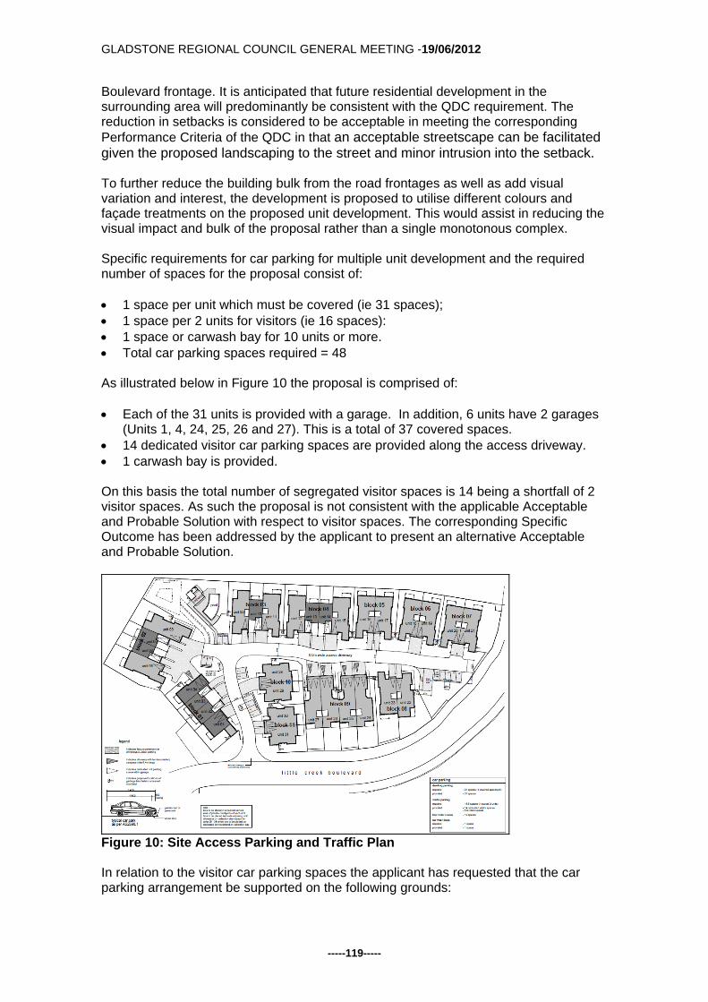
GLADSTONE REGIONAL COUNCIL GENERAL MEETING -19/06/2012
-----119-----
Boulevard frontage. It is anticipated that future residential development in the surrounding area will predominantly be consistent with the QDC requirement. The reduction in setbacks is considered to be acceptable in meeting the corresponding Performance Criteria of the QDC in that an acceptable streetscape can be facilitated given the proposed landscaping to the street and minor intrusion into the setback. To further reduce the building bulk from the road frontages as well as add visual variation and interest, the development is proposed to utilise different colours and façade treatments on the proposed unit development. This would assist in reducing the visual impact and bulk of the proposal rather than a single monotonous complex. Specific requirements for car parking for multiple unit development and the required number of spaces for the proposal consist of: 1 space per unit which must be covered (ie 31 spaces); 1 space per 2 units for visitors (ie 16 spaces): 1 space or carwash bay for 10 units or more. Total car parking spaces required = 48
As illustrated below in Figure 10 the proposal is comprised of: Each of the 31 units is provided with a garage. In addition, 6 units have 2 garages
(Units 1, 4, 24, 25, 26 and 27). This is a total of 37 covered spaces. 14 dedicated visitor car parking spaces are provided along the access driveway. 1 carwash bay is provided. On this basis the total number of segregated visitor spaces is 14 being a shortfall of 2 visitor spaces. As such the proposal is not consistent with the applicable Acceptable and Probable Solution with respect to visitor spaces. The corresponding Specific Outcome has been addressed by the applicant to present an alternative Acceptable and Probable Solution.
Figure 10: Site Access Parking and Traffic Plan
In relation to the visitor car parking spaces the applicant has requested that the car parking arrangement be supported on the following grounds:

GLADSTONE REGIONAL COUNCIL GENERAL MEETING -19/06/2012
-----120-----
As illustrated in Figure 10 a total of 5 tandem car parking spaces are nominated on the proposal plan. This yields a total of 19 visitor spaces. The total car parking spaces proposed would equate to 57 dedicated spaces. In addition, each of the driveways in front of the 31 garages (plus the 6 double garages) has the ability for tandem parking.
Whilst it is possible to provide the 2 additional car parking spaces on site, it is
considered a more desirable outcome to provide 5 additional visitor spaces as tandem parking behind the units with double garages. This avoids creating an internal driveway that is predominantly comprised of driveway (hardstand) and visitor car parks. It also takes into account that only one of the double garage spaces per unit is counted as a visitor space. It is considered reasonable that visitors to residents of the units with double garages are likely to park in front of their unit than find a segregated visitor parking space.
Overall when considering the parking available to driveway areas, the unit complex
provides well in excess of the required total number of car parking spaces (ie. a grand total of 94 on site car parking spaces compared to the required 48 car parking spaces).
Based on the above justification, the proposal is considered to maintain consistency with the corresponding Specific Outcome in that the proposal has adequate vehicle parking spaces to satisfy the anticipated requirements of the activity. The layout of the car parking results in all vehicles being able to enter and exit the site in a forward direction. The Planning Scheme requires the provision of 50m2 per unit of recreation space with half to be provided in one area as communal open space with a minimum dimension of 3 metres. This proposal for 31 units should involve the provision of 1,550m2, of which 775m2 should be communal space. Communal open space of 2,141m2 is provided including a communal pool area to the north eastern corner of the site. Private open space of 2,978m2 is provided including courtyards, patios and balconies. The resulting total area of open space is 5,119m2 (43%) with the pool area being 854m2 in area which is compliant with the landscaping requirements. Also in this instance, the private backyards assist in presenting the development more as single dwellings rather than a unit complex. Private open space provided as an extension of the living areas of the units means that the area is more likely to be used on a daily basis as part of the everyday functionality of the unit. This provision of both communal and private open space ensures that the open space requirements of the Planning Scheme have been achieved. The applicant has also indicated that landscaping will be provided to the frontage of Little Creek Boulevard as well as to the side and rear boundaries. The area of the site and the location of the units mean that the required landscaping of 3 metres to the road frontage and 1.5 metres to side boundary can be easily accommodated. As such, the landscaping is considered to be adequately designed for the purpose of the development. A landscape concept plan has been provided by the applicant and the development will be required to comply with this plan as part of a subsequent Operational Works application. Further detail on species, locations and mature tree heights will also be required to be submitted as part of the Operational Works application.

GLADSTONE REGIONAL COUNCIL GENERAL MEETING -19/06/2012
-----121-----
In regard to waste servicing, the applicant has proposed that wheelie bins be stored within the limits of each unit with collection via the communal driveway for weekly servicing. Further detailing on the waste servicing has been recommended as a condition requiring a waste management plan to be submitted. All new units are to be provided with sewer and water services connected to Councils reticulated systems in accordance with the Environment and Infrastructure Code. The applicant has previously been requested to address the impacts of increased density on Council’s Water and Sewer networks. The applicant has provided insufficient information to re-evaluate their internal water network in light of the increased density from Stages 10 and 19. The increased densities in stage 10 and 19 exceed the capacity of at least one sewerage asset. As such conditions have been included requiring that the proponent address water and sewerage issues. The applicant has provided an engineering report which address the overall estate’s approach to road layouts as well as a site based stormwater management plan to provide a design proposal and guide to the stormwater quantity and quality management measures for the entire estate. Specific details of the proposed stormwater management, connections to reticulated services and proposed roads for this stage of the development will be assessed further as part of an Operational Works application. The proposal for Multiple Unit Residential (31 Units) at Lot 951 SP 246155, Briffney Street, Kirkwood, is considered to comply with the requirements and intent of the Planning Scheme as a whole, and is therefore recommended for approval subject to reasonable and relevant conditions. Officer's Recommendation:
1. Development is to be carried out generally in accordance with the submitted application including the following plans:
Plan Name Drawing No. Drawn By Date
Site Locality and Drawing Schedule
RD11219 A100 Rev A
Raymond Design 19 December 2011
Overall Site Plan & Site Data
RD11219 A101 Rev A
Raymond Design 19 December 2011
Detail Site and Staging Plan
RD11219 A102 Rev A
Raymond Design 19 December 2011
Site Access, Parking and Traffic Plan
RD11219 A103 Rev A
Raymond Design 19 December 2011
Detail Site / Floor Plan RD11219 A104 Rev A
Raymond Design 19 December 2011
Block 01 – Plan & Elevations
RD11219 B100 Rev A
Raymond Design 24 April 2009
Block 02 – Plan & Elevations
RD11219 B101 Rev A
Raymond Design 24 April 2009
Block 03 – Plan & Elevations
RD11219 B102 Rev A
Raymond Design 24 April 2009
Block 04 – Plan & Elevations
RD11219 B103 Rev A
Raymond Design 24 April 2009

GLADSTONE REGIONAL COUNCIL GENERAL MEETING -19/06/2012
-----122-----
Block 05 – Plan & Elevations
RD11219 B104 Rev A
Raymond Design 24 April 2009
Block 06 – Plan & Elevations
RD11219 B105 Rev A
Raymond Design 24 April 2009
Block 07 – Plan & Elevations
RD11219 B106 Rev A
Raymond Design 24 April 2009
Block 08 – Plan & Elevations
RD11219 B107 Rev A
Raymond Design 24 April 2009
Block 09 – Plan & Elevations
RD11219 B108 Rev A
Raymond Design 24 April 2009
Block 10 – Plans and Elevations
RD11219
B109 Rev A
Raymond Design 24 April 2009
Block 11 – Plan & Elevations
RD11219
B110 Rev A
Raymond Design 24 April 2009
Site Elevations RD11219 C100 Rev A
Raymond Design 19 December 2011
Site Perspectives RD11219 C101 Rev A
Raymond Design 19 December 2011
Cover Page N/A Anembo Consultants
20 December 2011
Landscape Concept Stage 10
S1112707 Issue B
Anembo Consultants
20 December 2011
Planting Palette S1112707 Issue B
Anembo Consultants
20 December 2011
except where amendments are required to satisfy the conditions of this approval as follows;
As part of the building application, a plan must be submitted that
outlines the construction style and colours that will be used. Privacy screens are to be provided between the balconies of adjoining
units to prevent overlooking and loss of privacy. 2. Any strata titling of the proposed development can only provide for a total of 31
Multiple Residential Units. Referral Agency Conditions 3. Development is to comply with Department of Transport and Main Roads
Referral Agency Response (Concurrence Agency) Conditions dated 16 February 2012 (TMR12-001174) (see Attached).
4. Development is to comply with Department of Environment and Resource
(Advice Agency) Conditions dated 20 January 2012 (SPAR03750212) (see Attached).
Operational Works
5. A Development Permit for Operational Works must be obtained from Council prior to the commencement of construction. The Development Application for Operational Works is to include the following:
GLADSTONE REGIONAL COUNCIL GENERAL MEETING -19/06/2012
-----123-----
a) earthworks (including retaining walls) b) roadworks (including all works within the road reserve, e.g. driveway
access) c) water infrastructure d) sewerage infrastructure e) stormwater management (including erosion & sediment control) f) landscaping
The design and supporting calculations / documentation associated with these works must be certified by a Registered Professional Engineer of Queensland (RPEQ).
6. Operational Works shall be designed and constructed in accordance with
Council's relevant standards at the time of lodgement of an application for an Operational Works Permit and in accordance with the relevant Australian Standards and good engineering practice. Council’s current standards include:
a) Roads and Transport Standard 2005 (Joint CSC and GCC) b) Gladstone City Council Subdivision Guidelines, Rev 4, Nov 02 (Section 7) c) Water Supply Standard 2006 (Joint CSC and GCC) d) Sewerage Design Standard 2003 (Joint CSC and GCC) e) Gladstone Storm Water Management Strategy 2000 – Drainage
Management Document
7. The Operational Works drawings shall contain adequate information to position each component of infrastructure by coordinates to GDA94 and levels to Australian Height Datum (AHD). The drawings shall also indicate the identification number, position and recorded level of the Permanent Survey Mark (PSM) from which the project’s horizontal and vertical position was derived.
8. The Operational Works are to be executed under the supervision of a RPEQ.
The applicant / developer must give to the Council, construction certificates from such supervising engineer, that the work has been constructed in accordance with the Operational Works Permit and good engineering practice, together with relevant quality assurance, operation and maintenance, and “as constructed” documentation. This includes provision of a CCTV report on all sewer mains installed as part of the development.
9. The “as constructed” drawings and associated electronic documentation are to
be certified by the supervising engineer and by a registered surveyor stating that the as constructed information shown on the “as constructed” drawings represent a complete and accurate record of the works as executed. Council reserves the right to utilise for its own purposes and the sale of information provided within the “as constructed” drawings provided by the applicant / developer.
10. Where the appointment of a principal contractor is applicable under the
Queensland Workplace Health and Safety Act 1995, no operational works are to commence until a copy of Form 34 “Notice of appointment of principal contractor” is received by WH&S Qld, by the Principal Contractor and by Council. Similarly, Council must be provided with evidence of any change in the appointment of a Principal Contractor throughout the course of the project.

GLADSTONE REGIONAL COUNCIL GENERAL MEETING -19/06/2012
-----124-----
11. The lodgement of a maintenance bond at the commencement of the “on-maintenance” period, the equal of five (5) per centum of the total estimated cost of construction (minimum $ 10,000), to be held by the Council during the maintenance / performance verification period, being not less than twelve (12) months. The commencement of the ‘on maintenance’ period will not occur until all outstanding works have been completed, including the receipt of acceptable ‘as constructed’ information.
12. The applicant is responsible for and is to bear the cost of any alterations to,
extension of, or upgrading of Council assets / infrastructure or other service authorities’ infrastructure necessitated by the approval of this development (including but not limited to earthworks, retaining structures, roadworks, pedestrian / bicycle pathways, stormwater drainage, water supply, sewerage, electrical and telecommunication services, reticulated gas etc.).
13. Any alterations to, extension of, or upgrading of Council assets / infrastructure
or other service authorities’ infrastructure necessitated by this MCU proposal (including earthworks, retaining structures, roadworks, pedestrian / bicycle pathways, stormwater drainage, water supply, sewerage, electrical and telecommunication services, reticulated gas etc.) is the responsibility of the applicant / developer.
Building Works
14. The applicant / developer is required to obtain a Development Permit for Building Works in accordance with the Sustainable Planning Act 2009 to remove the existing structures from the site in accordance with the Building Act 1975. A separate application for Building Works approval is required to remove or demolish existing structures from the site, including any sealing of sewer connections until new building work commences.
15. The applicant is required to obtain a Development Permit for Building and
Plumbing Works in accordance with the Sustainable Planning Act 2009. Construction is to comply with the Building Act 1975, the Building Code or Australia and the requirements of other relevant authorities.
16. The development is to be constructed and used as a Class 1a Multiple Unit
Residential building only, not a Class 3 Accommodation Building. 17. All lighting at ground level and associated with illuminating ground level areas
must be focussed downwards and be provided with hoods, shades or other permanent devices to direct illumination downwards and not allow upward lighting to adversely affect the residential uses on the site and surrounding sites.
18. Any security lighting shall be so designed to ensure that nuisance is not
caused to adjoining areas by the spillage of light.
19. Open storage / bin storage areas are to be adequately screened so as not to detract from the visual amenity of the area. One way of achieving compliance with this condition is as follows:
a) outdoor storage areas are situated in locations not visible from the street b) a 1.8m solid screen fence is located around storage areas.

GLADSTONE REGIONAL COUNCIL GENERAL MEETING -19/06/2012
-----125-----
20. All plant and equipment (including air conditioners, exhaust fans and the like) are to be housed, screened and located so that these do not cause environmental nuisance or harm to the residential uses on the site and surrounding sites.
21. Environmentally responsible erosion and sediment control measures are to be
implemented during any building works carried out in association with the development.
22. Appropriate erosion and sedimentation control measures are to be utilised
during any Building Works carried out as a result of the development. 23. The location of the proposed buildings shall comply with Council Policy 19.7 -
Revision 1 - Building Adjacent to and Over Sewers, Stormwater and Water Assets.
24. Provision is to be made for an allocated waste reciprocal area/s adequate to
service the development. The waste reciprocal area must comply with the following where applicable:
a. Mobile Wheelie Bins
Provision of an allocated waste reciprocal area/s adequate to store the mobile wheelie-bins for all units. The standing room for the wheelie-bin is to allow for two (2) 240 litre mobile garbage bins per unit.
Landscaping
25. A landscape plan is to be submitted for approval prior to the issuing of a Development Permit for Building Works. The landscaping of the site shall incorporate:
a. All areas of landscaping as referred to on approved plan titled Landscape
Concept Stage 10, Drawing Number S1112707 Issue B, prepared by Anembo Consultants ; and
b. The landscaping provided shall be in accordance with Council's preferred landscape plant list.
The landscaping plan shall contain the following information:
a. Outline of the buildings; b. Existing trees (height location); c. Trees to be removed; d. Proposed planting (quantity, species and expected mature height); e. Paths and paving (location and materials); and f. The method of planting and the proposed maintenance program.
26. All landscaping referred to in Condition 25 above is to be maintained to an
appropriate standard at all times. 27. Nominated communal open space areas are permanently accessible to all
residents of the development and may not be allocated to any particular units or units for exclusive use and/or access.
Transportation

GLADSTONE REGIONAL COUNCIL GENERAL MEETING -19/06/2012
-----126-----
28. Provision of a constructed road access to and for the full frontage of the proposed development site to be provided in conjunction with existing approvals over the Little Creek Site. This includes pedestrian footpaths for the full frontage.
29. Provision of 57 car parking spaces on site including 37 covered spaces, 19
nominated visitor spaces and 1 carwash bay. These spaces and all vehicle movement areas are to be constructed, drained, linemarked and maintained in accordance with Part 14, Schedule 2, Division 4 of the Planning Scheme and AS2890.1. The proposed access driveways are to be constructed in accordance with Council’s Standard Drawing RT-0055.
30. Any footpath areas disturbed by the development are to be top dressed and
turfed following completion of construction activity.
31. Any manholes located on the proposed driveway are to be covered with Class D Covers to AS 3996, and are to be maintained at finished surface levels and remain accessible at all times.
32. The access points to the site are to be designed and constructed as a
roadway, with all necessary traffic control devices and intersection geometric design requirements in accordance with Council's Road and Transport Standards. All details are to be submitted with the Operational Works Application.
33. All visitor spaces are to be open and easily accessible at all times to visitors to
the premises. Visitor spaces are to be clearly designated and marked. Earthworks
34. All earthworks on the site must be carried out in accordance with AS 3798 and good engineering practice. Geotechnical supervision shall be to Level 1. The geotechnical testing authority shall provide a report to Council, setting out the inspections, sampling and testing it has carried out, and the locations and results thereof. The geotechnical report must be certified a RPEQ experienced in this type of work.
35. Appropriate erosion and sediment control measures are to be implemented
during any operational works or building works carried out in association with the development.
36. Allotment batters and retaining walls located along the side and rear property
boundaries of residential allotments are to be constructed as follows:
a) embankment slopes and retaining walls located along the rear and side boundaries of adjoining allotments are to be constructed within the allotment located on the low side of the common boundary.
b) the maximum batter slope for earth embankments is to be 1 vertical to 3 horizontal (subject to slope stability and appropriate landscaping / soil stabilisation considerations).
c) where it is not feasible to construct the batters / retaining structures within the adjoining property (eg along common boundaries with existing properties) vertical retaining walls are to be constructed adjacent to the boundary.

GLADSTONE REGIONAL COUNCIL GENERAL MEETING -19/06/2012
-----127-----
37. Retaining walls are to comply with the following requirements:
a) The design life of retaining walls shall be at least fifty (50) years and retaining walls shall be designed to safely withstand the impact of a 1.8m high solid fence constructed along the top of the retaining wall. Fence loadings to include dead, live and wind loads.
b) Retaining walls must not impose loads on underground services within allotments or external to allotments, including but not limited to water, sewerage, stormwater, electrical, telecommunication or other services. In particular, retaining wall footings must not impose loads on the electrical / telecommunication service corridor which is located in the footpath (verge) adjacent to the front property boundary and must allow for the installation and maintenance of these services.
c) The design and construction of retaining walls must be certified by a Registered Professional Engineer of Queensland (RPEQ) experienced in this type of work. The design certificate and the construction certificate must be location specific and must include:
- design life, design standards, allowable fence loads and any special
provisions / constraints in regards to fence type, fence footing, foundation etc (for the information of future fence designers / constructors).
- a statement that the retaining wall structure will not impose loads on underground services, including but not limited to water, sewerage, stormwater, electrical, telecommunication or other services and that the design / construction of same allows for the installation and maintenance of these services.
Sewerage Infrastructure
38. The sanitary drainage shall drain to a single connection point at an existing or proposed concrete maintenance hole (1050mm diameter) on the municipal sewer main.
39. The applicant / developer is to liaise with Council’s Infrastructure Planning Unit
in regards to determining the impact of this development on Council’s existing sewerage infrastructure and to develop a strategy to augment / upgrade the existing infrastructure to comply with Council’s relevant development standards.
40. The applicant / developer is to submit (for approval) a detailed sewerage
master planning report for the catchments impacted by the development prior to the issue of an operational works permit for the first (chronological) stage of the development. The master plan is to be developed in conjunction with Council's Infrastructure Planning Unit and is to show indicative sizing of pumping stations (pump sizes etc), emergency and operational storage requirements, rising mains and gravity sewer sizes etc to demonstrate compliance with Council's sewerage standards.
41. Work on Councils live sewerage infrastructure must be carried out by Council’s
Water and Sewerage Department with the cost of these works to be borne by the applicant.
Water Infrastructure

GLADSTONE REGIONAL COUNCIL GENERAL MEETING -19/06/2012
-----128-----
42. The applicant / developer is to submit (for approval) a water supply master plan
for the total development (internal and external infrastructure) prior to the issue of an operational works permit for the first (chronological) stage of the development. The master plan is to be developed in conjunction with Council’s Infrastructure Planning Unit and is to incorporate appropriate pressure zoning and network analyses demonstrating compliance with Council’s water supply standards. The updated master plan is to nominate the size of all water mains (above 150mm in diameter), together with the network analysis that justifies the nominated sizing.
43. The applicant / developer is to liaise with Council’s Infrastructure Planning Unit
in regards to determining the impact of this development on Council’s existing water supply infrastructure and to develop a strategy to augment / upgrade the existing infrastructure to comply with Council’s relevant development standards.
44. New water connections necessitated by the development are the responsibility
of the applicant / developer. Water connection applications are to be made to Council for a quotation for the necessary works.
45. Individual water meters (sub-metering) shall be provided for each unit in
accordance with the Water and Other Legislation Amendment Act 2007.
46. Any strata titling of the development will require certification from a Hydraulic Engineer that the metering of water for the development complies with the Water and Other Legislation Amendment Act 2007. Council uses Elster Smart Metering System or equivalent.
47. Connections to Councils live water reticulation network and the installation of
water meters to service the development must be carried out by Councils Water and Sewerage Department. The cost of these works is to be borne by the applicant.
48. Each dwelling unit is to be sub-metered in accordance with the requirements of
the Queensland Development Code. Sub-meters must be purchased from Council.
Stormwater Management
49. The design of the Operational Works must comply with the following stormwater management (quantity) criteria: a) Stormwater infrastructure must adequately drain the site and must cater for
stormwater flows through the site (if applicable) and discharge any runoff from the site to a “lawful point of discharge” as defined in Section 3.02 of the Queensland Urban drainage Manual – Volume 1, 2nd edition 2007. The stormwater drainage system is to be designed to cater for a 1 in 10 year ARI minor storm event and a 1 in 100 year ARI major storm event. The stormwater management report must demonstrate there will be no
worsening of stormwater runoff from the site as a result of the proposed development of the site for all design storm events up to and including a storm event with an average recurrence interval of 1 in 100 years.

GLADSTONE REGIONAL COUNCIL GENERAL MEETING -19/06/2012
-----129-----
The report must be certified by the responsible RPEQ in accordance with the following: “I am aware that the Gladstone Regional Council may rely upon the content and findings of this report including the recommendations, conclusions, results, calculations, plans, graphs, tables, attachments etc., for the purposes of development assessment. In my opinion, the Council can rely upon the information contained within the report and there are no reservations or qualifications in respect to the information other than set out in the report itself. I confirm that the development site is above the controlling 1 in 100 year ARI flood level and that there will be no worsening of stormwater runoff from the site as a result of the proposed development of the site.”
50. The design of the Operational Works shall comply with the following
stormwater management (quality) criteria: Water Sensitive Urban Design (WSUD) measures must be implemented to achieve the pollutant load reductions listed below. The proposed treatment train shall be modelled using “MUSIC” (Model for Urban Stormwater Improvement Conceptualisation) developed by the eWater cooperative research centre (eWater CRC). The water quality objectives in terms of the minimum percentage reduction in mean annual pollutant loads from the unmitigated development are as follows: Total Suspended Solids (TSS) 85% reduction Total Phosphorus (TP) 70% reduction Total Nitrogen (TN) 45% reduction Gross Pollutants (> 5mm) 90% reduction
Alternatively, the applicant may enter into an infrastructure agreement with Council generally in accordance with the following:
The applicant is to provide partial on-site treatment including the use of on-site rainwater tanks and sediment reduction measures and pay a monetary contribution to Council for Council to commence the planning, design, construction and maintenance of additional nutrient removal treatment measures external to the site.
Lighting
51. All lighting at ground level and associated with illuminating ground level areas must be focussed downwards and be provided with hoods, shades or other permanent devices to direct illumination downwards and not allow upward lighting to adversely affect the residential uses on the site and surrounding sites.
52. Any security lighting shall be so designed to ensure that nuisance is not
caused to adjoining areas by the spillage of light. Refuse Management
53. A Refuse Management Report to be submitted to Council and approved by The
Environment and Regulation Section prior to Building works. The report is to provide details including:

GLADSTONE REGIONAL COUNCIL GENERAL MEETING -19/06/2012
-----130-----
(i) bin storage areas including any applicable screening; (ii) types of bins to be used; (iii) areas for refuse collection; (iv) waste removal vehicle movements to, from, and throughout the site ;and (iv) how waste is to be collected and removed from the site.
ENVIRONMENT CONDITIONS SCHEDULE A - GENERAL CONDITIONS A1 In carrying out the activity, all reasonable and practical measures are to be taken
to minimise releases and the likelihood of releases of contaminants to the environment, except as otherwise provided by the conditions of this development approval.
A2 The holder of this development approval must:
(a) install and operate all works and control equipment, and (b) take all measures, perform all acts and do all things, necessary to ensure
compliance with the conditions of this development approval. A3 Notwithstanding any other condition of this development approval, this
development approval does not authorise any release of contaminants that causes or is likely to cause an environmental nuisance beyond the boundaries of the registered place.
END OF SCHEDULE A SCHEDULE B - AIR B1 Odour and visible contaminants, including but not limited to dust, smoke, fumes
and aerosols must not be released to the environment in a manner that will or may cause environmental harm or environmental nuisance unless such release is authorised.
B2 All lights (signage, security etc) are to be installed and positioned in a manner
that does not create a light nuisance to adjoining properties. Outdoor lights must not be angled onto adjoining properties and shall comply with the requirements of Australian Standard 4282 – Control of the obtrusive effects of outdoor lighting.
END OF SCHEDULE B SCHEDULE C – WATER / STORMWATER C1 Contaminants must not be directly or indirectly released from the site to which
this development approval applies, to any waters or stormwater. C2 Access to the site shall be restricted to a stabilised construction entrance. The
entrance shall be an appropriate size, with corduroy or metal grid provided to help shake mud from vehicle tyres.
END OF SCHEDULE C

GLADSTONE REGIONAL COUNCIL GENERAL MEETING -19/06/2012
-----131-----
SCHEDULE D – NOISE D1 The installation and operations of noise generating equipment and vehicles
shall be carried out in a manner to minimise their impacts on neighbouring properties.
D2 The building works must be carried out by such practicable means necessary to
prevent the emission or likelihood of emission of noise that constitutes environmental nuisance.
D3 All noise producing machinery and equipment (including airconditioners,
compressors and cooling systems) are to be fitted with noise attenuation features so that noise at the boundary of the site does not exceed the levels indicated in the table below -
NOISE LIMITS AT A NOISE SENSITIVE PLACE Period Noise Level at a Noise Sensitive Place (ie a residence)
Measured as the Adjusted Maximum Sound Pressure Level (Lamax adj, T)
7am - 7pm Background noise level plus 5dB(A) 7pm - 10pm Background noise level plus 5dB(A) 10pm - 7am Background noise level plus 3dB(A) Sundays & Background noise level plus 5dB(A) Public Holidays NOISE LIMITS AT A COMMERCIAL PLACE Period Noise Level at a Commercial Place Measured as the
Adjusted Maximum Sound Pressure Level (Lamax adj, T) 7am - 7pm Background noise level plus 10dB(A) 7pm - 10pm Background noise level plus 10dB(A) 10pm - 7am Background noise level plus 8dB(A) Sundays & Background noise level plus 5dB(A) Public Holidays
END OF SCHEDULE D
SCHEDULE E – WASTE MANAGEMENT

GLADSTONE REGIONAL COUNCIL GENERAL MEETING -19/06/2012
-----132-----
E1 Where waste is a contaminant, waste must not be released to the environment where the release will or may cause environmental harm or environmental nuisance, unless such release is authorised.
E2 The waste storage area/s are to be sufficient in size to house all waste
collection containers including recycling waste containers. The waste storage area/s must be suitably enclosed and imperviously paved, with a hose cock and hose fitted in close proximity to the enclosure to ensure the area can be easily and effectively cleaned.
E3 Provision is to be made for an allocated waste reciprocal area/s adequate to
store the mobile wheelie-bins for all dwellings. The standing room for the wheelie-bins is to allow for two x 240 litre mobile garbage bins per dwelling.
END OF SCHEDULE E SCHEDULE F - MONITORING AND REPORTING F1 All complaints received by the holder of this development approval relating to
releases of contaminants from the activity must be recorded and kept in a log book with the following details:
(i) time, date and nature of complaint; (ii) type of communication (telephone, letter, personal etc.); (iii) name, contact address and contact telephone number of complainant
(note: if the complainant does not wish to be identified then "Not identified" is to be recorded);
(iv) response and investigation undertaken as a result of the complaint; (v) name of person responsible for investigating complaint; and (vi) action taken as a result of the complaint investigation and signature of
responsible person.
F2 As soon as practicable after becoming aware of any emergency or incident which results in the release of contaminants not in accordance, or reasonably expected to be not in accordance with the conditions of this development approval, the holder of the registration certificate to which this development approval relates, must notify the administering authority of the release by telephone or facsimile.
F3 The notification of emergencies or incidents as required by condition F2 must
include but not be limited to the following:
(i) the operator of the activity to which this development approval relates; (ii) the location of the emergency or incident; (iii) the name and telephone number of the designated contact person; (iv) the time of the release; (v) the time the holder of the registration certificate became aware of the
release; (vi) the suspected cause of the release; (vii) the environmental harm and or environmental nuisance caused,
threatened, or suspected to be caused by the release; and

GLADSTONE REGIONAL COUNCIL GENERAL MEETING -19/06/2012
-----133-----
(viii) actions taken to prevent further any release and mitigate any environmental harm and/or environmental nuisance caused by the release.
F4 Not more than 14 days following the initial notification of an emergency or
incident, the holder of the development approval must provide written advice of the information supplied in accordance with condition number F3 in addition to: (i) proposed actions to prevent a recurrence of the emergency or incident; (ii) outcomes of actions taken at the time to prevent or minimise
environmental harm and or environmental nuisance; and (iii) the results of any environmental monitoring performed.
END OF SCHEDULE F SCHEDULE G - DEFINITIONS G1 For the purposes of this development approval the following definitions apply:
(a) "L(Amax adj, T)" means the average maximum A- weighted sound pressure level, adjusted for noise character and measured over a time period of not less than 15 minutes, using Fast response
(b) "commercial place" means a place used as an office or for business or
commercial purposes.
(c) "noise sensitive place" means - a) a dwelling, mobile home or caravan park, residential marina or other
residential premises; or b) a motel, hotel or hostel; or c) a kindergarten, school, university or other educational institution; or d) a medical centre or hospital; or e) a protected area ; or f) a park or gardens.
G2 For the purposes of this development approval any term not otherwise defined
in the Environmental Protection Act 1994, and the Sustainable Planning Act 2009 and any subordinate legislation made pursuant to these Acts or in the Definitions Schedule of this development approval has the meaning conferred to that term in its common usage.
END OF SCHEDULE G END OF CONDITIONS Advice to Applicant: An adopted infrastructure charge notice in relation to the infrastructure charges applicable to this development has been provided separately. Attachments:
1) Proposal Plans 2) Department of Transport and Main Roads response dated 16 February 2012

GLADSTONE REGIONAL COUNCIL GENERAL MEETING -19/06/2012
-----134-----
3) Department of Environment and Resource Management response dated 31 January 2012
4) Draft Adopted Infrastructure Charge Notice Tabled Items: 1. Nil Report Prepared by: Planning Officer Attachment 1 - Proposal Plans DA/500/2012.pdf Open Document Attachment 2 - Department of Transport and Main Roads response dated 16 February 2012 - DA/500/2012.pdf Open Document Attachment 3 - Department of Environment and Resource Management response dated 31 January 2012 - DA/500/2012.pdf Open Document Attachment 4 - Draft Adopted Infrastructure Charge Notice - DA/500/2012.PD Open Document

GLADSTONE REGIONAL COUNCIL GENERAL MEETING -19/06/2012
-----135-----
G/5.4.6 DEVELOPMENT APPLICATION 41804/2007 - PRELIMINARY
APPROVAL FOR MASTER PLANNED RESIDENTIAL COMMUNITY APPROX. 1,312 DWELLINGS, INDOOR RECREATION, OUTDOOR RECREATION AND SEWERAGE TREATMENT PLANT AT TURKEY BEACH ROAD, RODDS BAY
Responsible Officer: Chief Planner Council Meeting Date: 19 June 2012 Development Application:
Application Number: DA/41804/2007
Applicant: Seaview Beach Pty Ltd C:/ Randall Barrington Town Planning
Owner: Seaview Beach Pty Ltd
Date of Receipt: 5 July 2006
Location: Lot 384 Bells Road, Rodds Bay
RPD: Lot 384 FL 4055
Area: 768.9 hectares
Current Use of Land: Vacant - Grazing Land
Zoning: Rural
Proposal: Preliminary Approval for a Master Planned Residential Community Comprising Approx. 1,312 Dwellings at Different Densities, Shops (Shopping Centre), Indoor Recreation (Community Hall), Outdoor Recreation And Sewerage Treatment Plant (Managed by a Community Management Scheme) and Currency Period of 12 Years and Preliminary Approval For Reconfiguration of Lot Community Title Subdivision of Approx. 1,138 Lots (Including One Control Deed for Future Medium Density Housing and One Control Deed for Future Town Centre) and Currency Period for 12 Years
Submissions Close Date: 16 August 2007
Number of Submissions: 1 properly made submission
115 not properly made submissions
Purpose: The purpose of this report is to consider DA/41804/2007.
GLADSTONE REGIONAL COUNCIL GENERAL MEETING -19/06/2012
-----136-----
Executive Summary: An Impact Assessable Development Application for a Preliminary Approval for a Master Planned Residential Community Comprising Approx. 1,312 Dwellings At Different Densities, Shops (Shopping Centre), Indoor Recreation (Community Hall), Outdoor Recreation and Sewerage Treatment Plant (Managed By a Community Management Scheme) and Currency Period of 12 Years and Preliminary Approval for Reconfiguration of Lot Community Title Subdivision of Approx. 1,138 Lots (including One Control Deed for Future Medium Density Housing and One Control Deed for Future Town Centre) and Currency Period for 12 Years at Lot 384 Bells Road, Rodds Bay was received by the former Miriam Vale Shire Council on 5 July 2006. The development proposes what is essentially another residential community to the north west of the existing Turkey Beach Township at the end of Bells Road. It is noted that the now Department of Environment and Resource Management (DERM) have refused this application. As such, their directive to refuse the application must be adhered to by Council. The applicant had requested to extend the Decision Making Period on numerous occasions in order to negotiate this response with DERM. However after 18 months there is still no resolution to this issue, and as such it is considered appropriate to complete the IDAS process and reach a decision on the matter. Council also has the opportunity to provide additional reasons for refusal if it considers that the Development Application should be refused, or it can remain silent. It is considered that the development presents several issues in regard to the reliable servicing of the site for water and sewerage. Further to this the development has the potential to cause significant environmental impacts given the proximity to coastal management districts, mapped vegetation over the site, as well as the long term urban development direction for the Turkey Beach Township. Having considered the development against the provisions of the previous Planning Scheme for the Miriam Vale Shire which was in force at the time of lodgement, the proposal is considered to present several issues which have not been adequately addressed as part of the application. Further to this, the current Planning Scheme for Miriam Vale does not support this type of development in this location given its Rural Zoning, and the development is considered to compromise the rural nature of this site and this locality. As such, the proposal has been recommended for refusal. Subject Site: The subject site is a 769 hectare rural parcel of land to the north-west of the main Turkey Beach Township. Given the size and location of the site and the undulating topography, there is diverse vegetation across the property including open scrubland and more heavily wooded areas. The site is still fairly heavily vegetated for the most part, except for the lower lying beach front areas. Access to the site is currently gained from Bells Road to the south, however this is largely unconstructed. There are no existing structures on the subject site. The subject site is in relatively close proximity to the Hummock Hill Island proposal to the north west of the site. The Hummock Hill site currently has an application being considered by the Commonwealth Minister for the Department of Sustainability, Environment, Water, Population and Communities. This application has been on hold for sometime pending this final decision but the Minister has issued a notice of intention to refuse the application. A positive decision of the Hummock Hill application may have provided some justification for this proposal given that development shared similarities

GLADSTONE REGIONAL COUNCIL GENERAL MEETING -19/06/2012
-----137-----
in the location of a significant urban development in a non urban area and provided opportunity for infrastructure issues to be dealt with on a larger scale rather than individual projects. The image below depicts the subject site.
Figure 1: Subject Site Background: The application was considered properly made on 5 July 2006 and therefore has been considered under The Superseded Planning Scheme for Miriam Vale Shire Council which was in force at the time of lodgment. Under The Superseded Planning Scheme the proposed development application requires impact assessment. It is also relevant to consider the current Planning Scheme for Miriam Vale as the scheme came into effect in February 2009, after the application was made but before the application entered the Decision Making Stage. As there has been a significant period of time between lodgment of this application and the application reaching the decision stage, the application has gone through the amalgamation of Local Government and a reshuffle of State Government departments. The applicant, separate to the required public notification, also organised several 'open days' with the Turkey Beach community to determine potential support for the proposal. This in turn resulted in numerous submissions received in response to these 'open days', however as they were not within the Public Notification period, are considered to be not properly made. It is noted that the submissions received in regard to the development predominately support the proposal. These submissions focused on the provision that the community services the development proposed would be available to all in the area, not only residents of the proposed community management lots. The applicant has indicated that this can be accommodated as part of the development.

GLADSTONE REGIONAL COUNCIL GENERAL MEETING -19/06/2012
-----138-----
The application was suspended at the Decision Stage of the assessment process until 5 June 2012. This suspension was to allow the applicant additional time to make representation to DERM to amend their concurrence agency response dated 17 May 2010. The application was to be presented for Decision at the Council Meeting on 6 March 2012. However the applicant requested the Decision Making Period be suspended for a period of 3 months (5 June 2012) in accordance with the Integrated Planning Act 1997 the day before the matter was to be presented to Council for a decision. The applicant has made a further request on 18 May 2012 to informally suspend the Decision Making Period until 31 December 2012 to allow more time to negotiate with DERM. This request is attached to this report. The applicant also wishes to make an application to the Department of Sustainability, Environment, Water, Population & Communities (DSEWPC) under the Environmental Protection & Biodiversity Conservation Act 1999 (EPBC) to gain Federal support for the proposal. It is considered that the applicant has had sufficient time to make these representations with no changes to the original DERM response. As such it is considered that Council is to make a decision on this application in order to finalise the process. Proposal: The development application for a Preliminary Approval for a Master Planned Residential Community Comprising Approx. 1,312 Dwellings at Different Densities, Shops (Shopping Centre), Indoor Recreation (Community Hall), Outdoor Recreation and Sewerage Treatment Plant (Managed by a Community Management Scheme) and Currency Period of 12 Years and Preliminary Approval for Reconfiguration of Lot Community Title Subdivision of approx. 1,138 Lots (including One Control Deed for Future Medium Density Housing and One Control Deed for Future Town Centre) and Currency Period for 12 Years is proposed over several stages over several years.
The following image details the proposal.

GLADSTONE REGIONAL COUNCIL GENERAL MEETING -19/06/2012
-----139-----
Figure 2: Proposed Site Layout Referral: Being an application for a Preliminary Approval of this scale, the application required referral to the following referral agencies:
Department of Primary Industries and Fisheries (DPI); Ergon Energy; Telstra; Queensland Fire and Rescue (QFR); Department of Main Roads (DMR); Department of Local Government and Planning (DLGP); Queensland Transport (QT); Department of Natural Resources and Mines (DNRM); and Environmental Protection Agency (EPA).
It is noted that since this application was originally lodged and referred, various State Government Agencies have been amalgamated and renamed. Ergon Energy, Telstra, QFR and QT approved the development subject to conditions. DLGP and DPI both listed issues with the development, particularly in regard to the proximity to protected fishery areas and the availability of urban land in more suitable locations. It is noted

GLADSTONE REGIONAL COUNCIL GENERAL MEETING -19/06/2012
-----140-----
that DMR originally refused the application in July 2007, given that the applicants traffic studies were deemed inadequate for the scale of the proposal. The applicant appealed the refusal with DMR, who eventually issued conditions of approval for the development. What was the EPA has now been renamed the Department of Environment and Resource Management (DERM). DERM have refused this application as the proposal conflicts with the coastal policies from the State Coastal Management Plan and the protection and retention of coastal systems and wetlands. The applicant has requested to extend the Decision Making Period several times to negotiate this response with DERM. However after 18 months there is still no resolution to this issue and as such it is considered appropriate to complete the IDAS process and reach a decision on the matter. The applicant has the opportunity to then appeal this decision, and Council's decision, to the Planning and Environment Court to attempt to resolve the listed issues. Public Notification: The application was publically notified from 2 July 2007 to 16 August 2007. During this time 1 properly made submission was received. A number of submissions (115) were also received outside of this period as the applicant undertook several open days for residents of Turkey Beach. The submissions are discussed in further detail in a subsequent section of this report. Assessment: Submissions: A total of 115 'not properly made' submissions and 1 'properly made' submission were received in regard to this application. Out of all the submissions, 73 were in support of the development and 43 were against the proposal. The submissions of support mostly focused upon the following matters;
A majority of the site was to remain in a natural form; Seaview Beach and the Town Centre would be accessible to the general public; Upgrades to Bells Road, the Bells Road/Turkey Beach Road intersection and
the Turkey Beach Road/Bruce Highway intersection would occur; Telecommunications services would be upgraded; and Power reticulation services would be upgraded.
It is noted that the applicant has offered upgrades and services to the local community, some outside of the actual development realm as part of the advertising of the proposal. Council can only apply reasonable and relevant conditions and cannot reasonably require a development to provide some of these upgrades. As such the developer is in no way obliged or required to provide some of these services including unrestricted public access and upgrades to power and telecommunications to the existing Turkey Beach community. The submissions against the development raised the following issues;
Increased traffic; Environmental degradation from clearing;

GLADSTONE REGIONAL COUNCIL GENERAL MEETING -19/06/2012
-----141-----
Impacts on coastal systems and wetlands from development and increased numbers of visitors;
Impact on local wildlife breeding and nesting habitats; Unreliable sources of water from rainfall and bores; and Potential health and safety issues with using on site sewer treatment plant.
The application has not addressed the abovementioned concerns raised by the submissions and these concerns are also shared by Council. The following assessment further highlights these issues. The only 'properly made' submission was received from the then Minister for Local Government, Planning and Sport which raised several concerns regarding the location of significant urban development outside of the preferred settlement pattern for the region. The Minister also highlights several inconsistencies with the Wide Bay Burnett Regional Plan (2007-2026). It is noted that the previous Miriam Vale Shire was within the plan, however after amalgamation is no longer within that region. Strategic Plan: The Superseded Planning Scheme for Miriam Vale Shire 1999 identifies development of this nature within the Rural Zone as Impact Assessable development and as such requires assessment against the relevant sections of the Planning Scheme and relevant Council policies. The Strategic Plan of the Superseded Planning Scheme details the overall preferred land use structure for specific areas. Specifically within Rural areas, Objective 1 specifies that no further fragmentation of rural holdings will be supported unless there is a significant demonstrated need for such development. It is considered that a development of this scale and intensity will fragment a large rural holding with little justification provided as to the economic and community need for such a proposal. Further to this, Objective 2 details that visually and environmentally significant areas including higher areas, steep land, foreshores and wetlands shall be preserved from inappropriate development. This proposal is located on a site which not only has mapped remnant vegetation throughout but also adjoins identified wetland and coastal habitat areas. It is noted that this is also one of the key concerns highlighted within the DERM refusal. The Superseded Planning Scheme also refers to the Urban Development Strategy of the area within the Strategic Plan. Primarily the strategy refers to the future development of the previous Local Government area and ensuring that future urban development is economically, socially and environmentally sustainable in a logical and consistent pattern. Special Requirements in Relation to Development: The Strategic Plan of the Superseded Planning Scheme also refers to specific requirements for particular development types. In this instance this is predominately the Reconfiguring a Lot schedule within the Rural Zone. Most relevant to this application is the intent of the Rural Zone for development such as agriculture, forestry, grazing and animal husbandry rather than the urban purposes proposed. Further to this, the scheme specifies that:

GLADSTONE REGIONAL COUNCIL GENERAL MEETING -19/06/2012
-----142-----
'Lots having an area between 4,000m2 and 2 hectares with an average of 1 hectare and a frontage of not less than 50 metres are to be used for low density residential. Such lots will only be approved in locations in close proximity to existing towns' Whilst the development provides lots of this average size, these lots are not in close proximity to existing urban areas. Further to this, the need for such a reconfiguration has not been clearly established and presented as part of this application. It is also important to consider the changes to both the community and the economy since this application was first lodged in 2006. At the very least, the applicant must reestablish the need for such a development taking into consideration the existing scale and intensity of the locality and the current economic environment. The current rate of development within Gladstone as a result of major industrial growth is not a sufficient reason, especially given the extent of approvals already issued within the existing urban footprint. The provision of safe and reliable services for all residents of the proposed development is an essential consideration. The development proposes the use of a single sewerage treatment plant to be located and maintained on site within the community title. The provision of a water supply would be individually managed for each lot by the use of water tanks. This method of servicing for the number of lots proposed (approximately 1,300) is not considered to be adequate or reliable given the unpredictable nature of rainfall and the lack of any backup supply. Furthermore, the long term management of servicing this number of lots is unpredictable given the community title scheme proposed with no connection to Council assets. In the longer term, the system may potentially fail or require maintenance/upgrades which the body corporate cannot rectify and it may fall to Council to provide adequate service levels. Such an unproven system for the numbers proposed for both sewer and water services cannot be supported. The connection to Council infrastructure for such a development in this location is practically impossible with existing services being located some distance from the site. Further to that, these services may not have the capacity for the proposed number of lots. The nearest water service is Bororen, a limited and small water system, some 20 kilometres away and the nearest sewer service is at Tannum Sands, over 30 kilometres away. The proximity of the development to sensitive coastal areas is also a concern given the proposed development and the use of an on site private sewer treatment plant. With the construction of roads, dwellings and other impervious areas, there is the potential for increased and contaminated stormwater runoff to these coastal environments. Further to this, given the private sewer treatment plant is proposed to be managed by the body corporate and not Council, any overflow sewage has the potential to contaminate these environments. The provision and long term maintenance of the roads within the development area is also of concern. Once again if the internal roads are the responsibility of the body corporate there is the potential for the body corporate to be unable to maintain such facilities in the long term. If this is the case, it may fall to Council to rectify any issues. Further to this is the increased use of the Council owned roads in the locality. Whilst Main Roads required some upgrades to the intersection with Bruce Highway, there will be a significant impact on the Council controlled roads as a result of this development. This will result in additional maintenance and potentially require upgrades to these roads by Council.

GLADSTONE REGIONAL COUNCIL GENERAL MEETING -19/06/2012
-----143-----
Current Miriam Vale IPA Planning Scheme Whilst the development was lodged under the now Superseded Planning Scheme, it is still necessary to consider the proposal against the current Planning Scheme and its requirements. Under the current Planning Scheme the site is within the Rural Locality and the Rural Zone. A development of this type would be Impact Assessable. The Overall Outcomes for the Rural Locality specifically states that the coast is considered in its natural state outside of the existing urban areas. This development would result in the opening up of the coastline for more frequent uses and easier access which would result in likely degradation of this area. Development in the Rural Locality is to be rural in nature and support rural activities. This proposal for a large urban development would compromise the functionality of the site for rural pursuits as well as impact on the rural landscape of the locality. The Rural Zone Code also encourages the protection of rural land for rural pursuits that fit within the rural amenity of the area. Again, the proposed development for urban purposes does not comply with these overall outcomes. The Reconfiguring a Lot Code specifies the requirements for proposed new subdivisions in regard to lot sizes and design. Firstly, the minimum lot size for a rural subdivision is 200 hectares with a road frontage of 100 m. This proposal is for a mix of lots ranging from 1,100m2 to 9,450m2. Even as a rural character subdivision, the application would not comply, given the minimum lot size is 2 hectares with a road frontage of 50 metres. The proposed development is of a scale inconsistent with the urban footprint of the Turkey Beach community and the locality in general. Further to this, the development of this number of lots as a Community Title Scheme, with self managed water and sewer systems may have long term maintenance and supply issues. Primarily, the key issues relate to infrastructure servicing, access and the long term urban direction for the Turkey Beach community. Also as DERM have refused the development, Council is directed to refuse the application, but can include additional reasons for refusal. As highlighted in this report, the proposal for Preliminary Approval for a Master Planned Residential Community Comprising Approx. 1,312 Dwellings at Different Densities, Shops (Shopping Centre), Indoor Recreation (Community Hall), Outdoor Recreation and Sewerage Treatment Plant (Managed by a Community Management Scheme) and Currency Period of 12 Years and Preliminary Approval for Reconfiguration of Lot Community Title Subdivision of Approx. 1,138 Lots (Including One Control Deed for Future Medium Density Housing and One Control Deed for Future Town Centre) and Currency Period for 12 Years cannot achieve the requirements and intent of the Planning Scheme as a whole, given the scale of the development and the resultant impacts on the environment and failure to provide adequate services such as water and sewer. As such the development has been recommended for refusal, including the DERM refusal of the same. Officer's Recommendation: That the application for a Preliminary Approval for a Master Planned Residential Community Comprising Approx. 1,312 Dwellings at Different Densities, Shops (Shopping Centre), Indoor Recreation (Community Hall), Outdoor Recreation and

GLADSTONE REGIONAL COUNCIL GENERAL MEETING -19/06/2012
-----144-----
Sewerage Treatment Plant (Managed by a Community Management Scheme) and Currency Period of 12 Years and Preliminary Approval for Reconfiguration of Lot Community Title Subdivision of Approx. 1,138 Lots (Including One Control Deed for Future Medium Density Housing and One Control Deed for Future Town Centre) and Currency Period for 12 Years, be refused for the following reasons:
1. The Department of Environment and Resource Management (DERM) issued a refusal on 17 May 2010 as a Concurrence Agency. As such, Council must also refuse the application in accordance with Section 3.5.12 of the Integrated Planning Act 1997.
2. The applicant has not adequately demonstrated a community and economic
need for an urban development of this scale in this location. 3. The application has not demonstrated compliance with the Implementation
Criteria for Rural Areas - Objective 1 of the Superseded Miriam Vale Planning Scheme which discourages further fragmentation of rural holdings.
4. The application has not demonstrated compliance with the Implementation
Criteria for Rural Areas - Objective 2 of the Superseded Miriam Vale Planning Scheme which requires the protection and preservation of environmentally significant areas including the foreshore and wetland areas.
5. The application has not demonstrated how the development complies with the
overall intent of the Rural Zone within Section 2.2.2 of the Superseded Planning Scheme.
6. Stormwater management (quantity and quality) has not been fully addressed. 7. The development, if not connected to Council's reticulated sewer system,
cannot provide a sustainable effluent disposal system to adequately cater for the residents of the development without having a detrimental impact on the environment and surrounding properties. The applicant has not demonstrated that the on site facilities are feasible and environmentally responsible.
8. The development cannot be practically connected to Council's reticulated sewer
system due to the physical distance to the nearest infrastructure and that there is no future planning for a Council owned Sewerage Treatment Plant in this vicinity.
9. The development, if not connected to Council's Water supply system, cannot
provide a safe and reliable water supply for the residents of the development. 10. The development cannot be practically connected to Council's Water supply
system due to the physical distance to the nearest infrastructure and that there is no future planning for a Council owned Water Treatment Plant in this vicinity.
11. The issues raised within the submissions which do not support the development
are also concerns of Council. 12. The development does not comply with the requirements of the Reconfiguring a
Lot Code, the Rural Locality Code or the Rural Zone Code in accordance with the current Planning Scheme for Miriam Vale.

GLADSTONE REGIONAL COUNCIL GENERAL MEETING -19/06/2012
-----145-----
Attachments:
1. DA/41804/2007 DERM Refusal 2. DA/41804/2007 Submissions 3. DA/41804/2007 Applicants Request for Council to further hold the Decision
Making Period
Report Prepared by: Planning Officer DA/41804/2007 DERM Refusal Open Document DA/41804/2007 Submissions Open Document DA/41804/2007 Applicants Request for Council to further hold the Decision Making Period Open Document

GLADSTONE REGIONAL COUNCIL GENERAL MEETING -19/06/2012
-----146-----
Back to Top G/5.4.7 EXTENSION OF GAPDL ARRANGEMENTS Responsible Officer: Manager Regional Strategy Council Meeting Date: 19 June 2012 Purpose: To seek Council approval for the extension of existing contractual arrangements with Gladstone Area Promotion and Development Ltd (GAPDL). Officer's Recommendation: That 1. Council determine under Section 184 (a) of the Local Government (Finance,
Plans and Reporting) Regulation 2010 that it is satisfied that there is only one supplier (Gladstone Area Promotion and Development Ltd - GAPDL) who is reasonably available for the delivery of the services (as set out in the existing contract with GAPDL) in the next six months to Council;
2. The Chief Executive Officer be authorised to negotiate a 6-month extension to
the existing service level agreement with GAPDL on similar terms and conditions as the existing contract due to expire on 30 June 2012 to enable Council the time to fully consider its position on the matter of tourism and economic development services.
Background: The current three year contract with GAPDL for the delivery of economic development and tourism related services for the region expires as at 30 June 2012. Discussions have been underway with GAPDL on the development of contractual arrangements beyond 30 June 2012. Discussions are not expected to be finalised in time to allow new contractual arrangements to be in place by 30 June 2012. Communication and Consultation (Internal/External): Consultation with officers from GAPDL, Councillors, Director Corporate and Community Services, and Manager Regional Strategy. Legal, Environmental and Policy Implications: There are no direct policy or environmental matters affected by this decision.

GLADSTONE REGIONAL COUNCIL GENERAL MEETING -19/06/2012
-----147-----
There are legal considerations that need to be addressed with respect to the payments made under the contractual arrangements in place between Council and GAPDL. Council pays its contribution to GAPDL as a 'fee for service' as it is provided under a contract for services arrangements. The annual payment at present is $450,000 plus 'in-kind' provision of office accommodation for Visitor Information Centres on Council property. As a 'fee for service' arrangement where quantum of the fee exceeds $150,000 Council's Procurement Policy under the Local Government (Finance, Plans and Reporting) Regulation 2010 would require the calling of tenders for these services unless Council:
a) resolves under Section 184 (a) of the Local Government (Finance, Plans and Reporting) Regulation 2010 that it is satisfied that there is only 1 supplier (GAPDL) who is reasonably available for the delivery of the services; OR
b) resolves under Section 184 (b) of the Local Government (Finance, Plans and
Reporting) Regulation 2010 that, because of the specialised or confidential nature of the services that are sought, it would be impractical or disadvantageous for the local government to invite quotes or tenders.
Given the nature of the services being delivered to Council (Economic Development and Tourism related), the history of GAPDL with respect to the delivery of these services in conjunction with its membership, and the absence of comparable organisations that currently cover both aspects being sought to be delivered for the region a resolution under Section 184 (a) is recommended. Financial and Resource Implications: Budget allocations for this arrangement are in place in the current (2011/12) and proposed (2012/13) budget of Council. Attachments: 1. NIL Tabled Items: 1. NIL Report Prepared by: Manager Project Coordination
GLADSTONE REGIONAL COUNCIL GENERAL MEETING -19/06/2012
-----148-----
Back to Top G/5.4.8 PROPOSED MINOR AMENDMENTS TO THE GLADSTONE
PLAN & CALLIOPE PLANNING SCHEME Responsible Officer: Manager Regional Strategy Council Meeting Date: 19 June 2012 Purpose: The purpose of this report is to recommend that Council make a submission to the Minister for State Development Infrastructure and Planning to allow minor amendments to the Gladstone Plan and Calliope Shire Planning Scheme in conformity with development application decisions in relation to those schemes. Officer's Recommendation: That 1. Council seek the approval of the Minister of State Development Infrastructure and
Planning to follow the Minor Amendment process as contained in Statutory Guideline 01/12 "Making and amending local planning instruments" as set out in Table 1 in the report.
Background: Gladstone Regional Council, or either the former Gladstone City and Calliope Shire Councils approved a number of development applications which had the effect of overriding the planning schemes for those previous local government areas. Most of these approvals were to permit residential development on land zoned ‘Urban Expansion’ or rural residential development on land zoned ‘Rural’. These decisions were a consequence of rapid growth that occurred during the extended period of preparation of those schemes. Consideration: The Sustainable Planning Act 2009 provides that, where the Minister is satisfied that the changes reflect a current development approval, a master plan for a declared master planned area or an approval under other legislation it can be considered a minor amendment. The matters proposed to be forwarded to the Minister are - Table 1 - Mapping Amendments to the Gladstone City Planning Scheme 2006 Property Location Current
Zoning Amending Zoning
Reason for Change
Lot 92 CTN 1871 Dawson Highway, Auckland & Lot 3
Urban Expansion
Residential DA/10986/2008

GLADSTONE REGIONAL COUNCIL GENERAL MEETING -19/06/2012
-----149-----
RP869160 Boundary Road, Auckland (Oasis on Kirkwood)
Lot 901 SP235957, Kirkwood Road, Kirkwood
Urban Expansion
Commercial DA/11/2009
Lot 336 SP240768, (58 Daintree Boulevard, Gladstone) previously Lot 505 SP233796 (Vantage Estate)
Urban Expansion
Residential
DA/4480/2004
Lot 337 SP240768, (56 Daintree Boulevard, Gladstone) previously Lot 505 SP233796 (Vantage Estate)
Urban Expansion
Residential
DA/4480/2004
Lot 338 SP240768, (54 Daintree Boulevard, Gladstone) previously Lot 505 SP233796 (Vantage Estate)
Urban Expansion
Residential
DA/4480/2004
Lot 339 SP240768, (52 Daintree Boulevard, Gladstone) previously Lot 505 SP233796 (Vantage Estate)
Urban Expansion
Residential
DA/4480/2004
Lot 340 SP240768, (50 Daintree Boulevard, Gladstone) previously Lot 505 SP233796 (Vantage Estate)
Urban Expansion
Residential
DA/4480/2004
Lot 341 SP240768, (48 Daintree Boulevard, Gladstone) previously Lot 505 SP233796 (Vantage Estate)
Urban Expansion
Residential
DA/4480/2004
Lot 342 SP240768, (46 Daintree Boulevard, Gladstone) previously Lot 505 SP233796 (Vantage Estate)
Urban Expansion
Residential
DA/4480/2004
Lot 343 SP240768, (44 Daintree Boulevard, Gladstone) previously Lot 505 SP233796 (Vantage Estate)
Urban Expansion
Residential
DA/4480/2004
Lot 344 SP240768, (42 Daintree Boulevard, Gladstone) previously Lot 505 SP233796 (Vantage Estate)
Urban Expansion
Residential
DA/4480/2004
Lot 345 SP240768, (3 Broadwater Place, Gladstone) previously Lot 505 SP233796 (Vantage Estate)
Urban Expansion
Residential
DA/4480/2004
Lot 346 SP240768, (1 Palmerston Court, Gladstone) previously Lot 505 SP233796 (Vantage Estate)
Urban Expansion
Residential
DA/4480/2004
Lot 347 SP240768, (3 Palmerston Court, Gladstone) previously Lot 505 SP233796 (Vantage Estate)
Urban Expansion
Residential
DA/4480/2004
Lot 348 SP240768, (5 Palmerston Court, Gladstone)
Urban Expansion
Residential
DA/4480/2004

GLADSTONE REGIONAL COUNCIL GENERAL MEETING -19/06/2012
-----150-----
previously Lot 505 SP233796 (Vantage Estate)
Lot 349 SP240768, (7 Palmerston Court, Gladstone) previously Lot 505 SP233796 (Vantage Estate)
Urban Expansion
Residential
DA/4480/2004
Lot 350 SP240768, (9 Palmerston Court, Gladstone) previously Lot 505 SP233796 (Vantage Estate)
Urban Expansion
Residential
DA/4480/2004
Lot 351 SP240768, (11 Palmerston Court, Gladstone) previously Lot 505 SP233796 (Vantage Estate)
Urban Expansion
Residential
DA/4480/2004
Lot 352 SP240768, (10 Palmerston Court, Gladstone) previously Lot 505 SP233796 (Vantage Estate)
Urban Expansion
Residential
DA/4480/2004
Lot 353 SP240768, (8 Palmerston Court, Gladstone) previously Lot 505 SP233796 (Vantage Estate)
Urban Expansion
Residential
DA/4480/2004
Lot 354 SP240768, (6 Palmerston Court, Gladstone) previously Lot 505 SP233796 (Vantage Estate)
Urban Expansion
Residential
DA/4480/2004
Lot 355 SP240768, (4 Palmerston Court, Gladstone) previously Lot 505 SP233796 (Vantage Estate)
Urban Expansion
Residential
DA/4480/2004
Lot 356 SP240768, (2 Palmerston Court, Gladstone) previously Lot 505 SP233796 (Vantage Estate)
Urban Expansion
Residential
DA/4480/2004
Lots 327 SP240768, (9 Broadwater Place, Gladstone 336-356, previously Lot 505 SP233796 (Vantage Estate)
Urban Expansion
Residential
DA/4480/2004
Lots 326 SP240770, (1 Namadgi Terrace, Gladstone, previously Lot 505 SP240768 (Vantage Estate)
Urban Expansion
Residential
DA/4480/2004
Lots 326 SP240770, (1 Namadgi Terrace, Gladstone, previously Lot 505 SP240768 (Vantage Estate)
Urban Expansion
Residential
DA/4480/2004
Lots 326 SP240770, (1 Namadgi Terrace, Gladstone, previously Lot 505 SP240768 (Vantage Estate)
Urban Expansion
Residential
DA/4480/2004
Lots 328 SP240770, (3 Namadgi Terrace, Gladstone, previously Lot 505 SP240768 (Vantage Estate)
Urban Expansion
Residential
DA/4480/2004
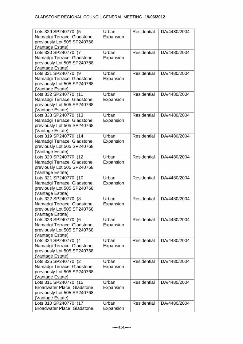
GLADSTONE REGIONAL COUNCIL GENERAL MEETING -19/06/2012
-----151-----
Lots 329 SP240770, (5 Namadgi Terrace, Gladstone, previously Lot 505 SP240768 (Vantage Estate)
Urban Expansion
Residential
DA/4480/2004
Lots 330 SP240770, (7 Namadgi Terrace, Gladstone, previously Lot 505 SP240768 (Vantage Estate)
Urban Expansion
Residential
DA/4480/2004
Lots 331 SP240770, (9 Namadgi Terrace, Gladstone, previously Lot 505 SP240768 (Vantage Estate)
Urban Expansion
Residential
DA/4480/2004
Lots 332 SP240770, (11 Namadgi Terrace, Gladstone, previously Lot 505 SP240768 (Vantage Estate)
Urban Expansion
Residential
DA/4480/2004
Lots 333 SP240770, (13 Namadgi Terrace, Gladstone, previously Lot 505 SP240768 (Vantage Estate)
Urban Expansion
Residential
DA/4480/2004
Lots 319 SP240770, (14 Namadgi Terrace, Gladstone, previously Lot 505 SP240768 (Vantage Estate)
Urban Expansion
Residential
DA/4480/2004
Lots 320 SP240770, (12 Namadgi Terrace, Gladstone, previously Lot 505 SP240768 (Vantage Estate)
Urban Expansion
Residential
DA/4480/2004
Lots 321 SP240770, (10 Namadgi Terrace, Gladstone, previously Lot 505 SP240768 (Vantage Estate)
Urban Expansion
Residential
DA/4480/2004
Lots 322 SP240770, (8 Namadgi Terrace, Gladstone, previously Lot 505 SP240768 (Vantage Estate)
Urban Expansion
Residential
DA/4480/2004
Lots 323 SP240770, (6 Namadgi Terrace, Gladstone, previously Lot 505 SP240768 (Vantage Estate)
Urban Expansion
Residential
DA/4480/2004
Lots 324 SP240770, (4 Namadgi Terrace, Gladstone, previously Lot 505 SP240768 (Vantage Estate)
Urban Expansion
Residential
DA/4480/2004
Lots 325 SP240770, (2 Namadgi Terrace, Gladstone, previously Lot 505 SP240768 (Vantage Estate)
Urban Expansion
Residential
DA/4480/2004
Lots 311 SP240770, (15 Broadwater Place, Gladstone, previously Lot 505 SP240768 (Vantage Estate)
Urban Expansion
Residential
DA/4480/2004
Lots 310 SP240770, (17 Broadwater Place, Gladstone,
Urban Expansion
Residential
DA/4480/2004
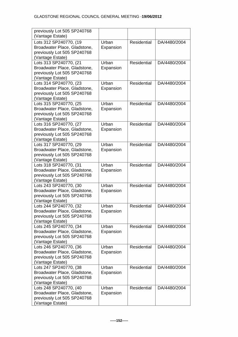
GLADSTONE REGIONAL COUNCIL GENERAL MEETING -19/06/2012
-----152-----
previously Lot 505 SP240768 (Vantage Estate)
Lots 312 SP240770, (19 Broadwater Place, Gladstone, previously Lot 505 SP240768 (Vantage Estate)
Urban Expansion
Residential
DA/4480/2004
Lots 313 SP240770, (21 Broadwater Place, Gladstone, previously Lot 505 SP240768 (Vantage Estate)
Urban Expansion
Residential
DA/4480/2004
Lots 314 SP240770, (23 Broadwater Place, Gladstone, previously Lot 505 SP240768 (Vantage Estate)
Urban Expansion
Residential
DA/4480/2004
Lots 315 SP240770, (25 Broadwater Place, Gladstone, previously Lot 505 SP240768 (Vantage Estate)
Urban Expansion
Residential
DA/4480/2004
Lots 316 SP240770, (27 Broadwater Place, Gladstone, previously Lot 505 SP240768 (Vantage Estate)
Urban Expansion
Residential
DA/4480/2004
Lots 317 SP240770, (29 Broadwater Place, Gladstone, previously Lot 505 SP240768 (Vantage Estate)
Urban Expansion
Residential
DA/4480/2004
Lots 318 SP240770, (31 Broadwater Place, Gladstone, previously Lot 505 SP240768 (Vantage Estate)
Urban Expansion
Residential
DA/4480/2004
Lots 243 SP240770, (30 Broadwater Place, Gladstone, previously Lot 505 SP240768 (Vantage Estate)
Urban Expansion
Residential
DA/4480/2004
Lots 244 SP240770, (32 Broadwater Place, Gladstone, previously Lot 505 SP240768 (Vantage Estate)
Urban Expansion
Residential
DA/4480/2004
Lots 245 SP240770, (34 Broadwater Place, Gladstone, previously Lot 505 SP240768 (Vantage Estate)
Urban Expansion
Residential
DA/4480/2004
Lots 246 SP240770, (36 Broadwater Place, Gladstone, previously Lot 505 SP240768 (Vantage Estate)
Urban Expansion
Residential
DA/4480/2004
Lots 247 SP240770, (38 Broadwater Place, Gladstone, previously Lot 505 SP240768 (Vantage Estate)
Urban Expansion
Residential
DA/4480/2004
Lots 248 SP240770, (40 Broadwater Place, Gladstone, previously Lot 505 SP240768 (Vantage Estate)
Urban Expansion
Residential
DA/4480/2004

GLADSTONE REGIONAL COUNCIL GENERAL MEETING -19/06/2012
-----153-----
Lots 249 SP240770, (42 Broadwater Place, Gladstone, previously Lot 505 SP240768 (Vantage Estate)
Urban Expansion
Residential
DA/4480/2004
Lots 250 SP240770, (44 Broadwater Place, Gladstone, previously Lot 505 SP240768 (Vantage Estate)
Urban Expansion
Residential
DA/4480/2004
Lots 251 SP240770, (46 Broadwater Place, Gladstone, previously Lot 505 SP240768 (Vantage Estate)
Urban Expansion
Residential
DA/4480/2004
Lots 252 SP240770, (48 Broadwater Place, Gladstone, previously Lot 505 SP240768 (Vantage Estate)
Urban Expansion
Residential
DA/4480/2004
Lots 253 SP240770, (50 Broadwater Place, Gladstone, previously Lot 505 SP240768 (Vantage Estate)
Urban Expansion
Residential
DA/4480/2004
Lots 254 SP240770, (52 Broadwater Place, Gladstone, previously Lot 505 SP240768 (Vantage Estate)
Urban Expansion
Residential
DA/4480/2004
Lots 255 SP240770, (54 Broadwater Place, Gladstone, previously Lot 505 SP240768 (Vantage Estate)
Urban Expansion
Residential
DA/4480/2004
Lot 357 SP240771, (19 Boonderee Place, Gladstone, previously Lot 506 SP240770
Urban Expansion
Residential
DA/4480/2004
Lot 358 SP240771, (21 Boonderee Place, Gladstone, previously Lot 506 SP240770
Urban Expansion
Residential
DA/4480/2004
Lot 359 SP240771, (23 Boonderee Place, Gladstone, previously Lot 506 SP240770
Urban Expansion
Residential
DA/4480/2004
Lot 360 SP240771, (25 Boonderee Place, Gladstone, previously Lot 506 SP240770
Urban Expansion
Residential
DA/4480/2004
Lot 361 SP240771, (27 Boonderee Place, Gladstone, previously Lot 506 SP240770
Urban Expansion
Residential
DA/4480/2004
Lot 362 SP240771, (29 Boonderee Place, Gladstone, previously Lot 506 SP240770
Urban Expansion
Residential
DA/4480/2004
Lot 363 SP240771, (31 Boonderee Place, Gladstone, previously Lot 506 SP240770
Urban Expansion
Residential
DA/4480/2004
Lot 386 SP240771, (33 Boonderee Place, Gladstone, previously Lot 506 SP240770
Urban Expansion
Residential
DA/4480/2004
Lot 364 SP240771, (35 Boonderee Place, Gladstone,
Urban Expansion
Residential
DA/4480/2004

GLADSTONE REGIONAL COUNCIL GENERAL MEETING -19/06/2012
-----154-----
previously Lot 506 SP240770
Lot 365 SP240771, (37 Boonderee Place, Gladstone, previously Lot 506 SP240770
Urban Expansion
Residential
DA/4480/2004
Lot 366 SP240771, (39 Boonderee Place, Gladstone, previously Lot 506 SP240770
Urban Expansion
Residential
DA/4480/2004
Lot 367 SP240771, (20 Boonderee Place, Gladstone, previously Lot 506 SP240770
Urban Expansion
Residential
DA/4480/2004
Lot 368 SP240771, (18 Boonderee Place, Gladstone, previously Lot 506 SP240770
Urban Expansion
Residential
DA/4480/2004
Lot 369 SP240771, (16 Boonderee Place, Gladstone, previously Lot 506 SP240770
Urban Expansion
Residential
DA/4480/2004
Lot 370 SP240771, (14 Boonderee Place, Gladstone, previously Lot 506 SP240770
Urban Expansion
Residential
DA/4480/2004
Lot 371 SP240771, (12 Boonderee Place, Gladstone, previously Lot 506 SP240770
Urban Expansion
Residential
DA/4480/2004
Lot 372 SP240771, (10 Boonderee Place, Gladstone, previously Lot 506 SP240770
Urban Expansion
Residential
DA/4480/2004
Lot 373 SP240771, (8 Boonderee Place, Gladstone, previously Lot 506 SP240770
Urban Expansion
Residential
DA/4480/2004
Lot 374 SP240771, (6 Boonderee Place, Gladstone, previously Lot 506 SP240770
Urban Expansion
Residential
DA/4480/2004
Lot 375 SP240771, (4 Boonderee Place, Gladstone, previously Lot 506 SP240770
Urban Expansion
Residential
DA/4480/2004
Lot 376 SP240771, (61 Daintree Boulevard, Gladstone, previously Lot 506 SP240770
Urban Expansion
Residential
DA/4480/2004
Lot 905 SP240771, Kirkwood (Cancelling Lot 506 SP 240770)
Urban Expansion
Open Space
DA/4480/2004
Lot 902 SP247064, Kirkwood (Cancelling Lot 507 SP240771)
Residential & Urban Expansion
Open Space
DA/4480/2004
Lot 508 SP247064, Kirkwood (Cancelling Lot 507 SP247064)
Urban Expansion
Residential DA/4480/2004
Mapping Amendments to the Calliope Shire Planning Scheme 2007 Property Location Current
Zoning Amending Zoning
Reason for Change
Lots 1 SP246162 (13 Farmer Street, Calliope)
Rural Rural Residential DA/20639/2006

GLADSTONE REGIONAL COUNCIL GENERAL MEETING -19/06/2012
-----155-----
previously Lot 5 SP190794
Lots 2 SP246162 (17 Farmer Street, Calliope) previously Lot 5 SP190794
Rural Rural Residential DA/20639/2006
Lots 3 SP246162 (2 Sweeney Court), Calliope, previously Lot 5 SP190794
Rural Rural Residential DA/20639/2006
Lots 4 SP246162 (10 Sweeney Court), Calliope, previously Lot 5 SP190794
Rural Rural Residential DA/20639/2006
Lots 5 SP246162 (14 Sweeney Court), Calliope, previously Lot 5 SP190794
Rural Rural Residential DA/20639/2006
Lots 6 SP246162 (18 Sweeney Court), Calliope, previously Lot 5 SP190794
Rural Rural Residential DA/20639/2006
Lots 7 SP246162 (22 Sweeney Court), Calliope, previously Lot 5 SP190794
Rural Rural Residential DA/20639/2006
Lots 8 SP246162 (24 Sweeney Court), Calliope, previously Lot 5 SP190794
Rural Rural Residential DA/20639/2006
Lots 9 SP246162 (25 Sweeney Court), Calliope, previously Lot 5 SP190794
Rural Rural Residential DA/20639/2006
Lots 10 SP246162 (21 Sweeney Court), Calliope, previously Lot 5 SP190794
Rural Rural Residential DA/20639/2006
Lots 11 SP246162 (17 Sweeney Court), Calliope, previously Lot 5 SP190794
Rural Rural Residential DA/20639/2006
Lots 12 SP246162 (13 Sweeney Court), Calliope, previously Lot 5 SP190794
Rural Rural Residential DA/20639/2006
Lots 13 SP246162 (9 Sweeney Court), Calliope, previously Lot 5 SP190794
Rural Rural Residential DA/20639/2006
Lot 1 SP183060, East Stowe
Rural Village DA/20600/2008
GLADSTONE REGIONAL COUNCIL GENERAL MEETING -19/06/2012
-----156-----
Communication and Consultation (Internal/External): Statutory Planning Department, to confirm the approvals had been acted upon. Legal Environmental and Policy Implications: Nil. Financial and Resource Implications: Nil. Commentary: The provisions of the Statutory Guideline require Council to resolve to make an amendment to the planning scheme, which then requires approval from the Minister for State Development Infrastructure and Planning. If the Minister agrees to adopt the changes as a minor amendment, public notification is required in the local newspaper and Government Gazette with the changes effective immediately. Summary: In summary it is recommended that Council resolve to make a submission to the Minister for State Development Infrastructure and Planning to allow a minor amendment to the Gladstone Plan and Calliope Shire Planning Scheme in conformity with the previous preliminary approvals and subsequent change in zone. This proposed action is largely "process" in nature, to ensure the current planning schemes properly reflect the commencement of uses following the take up of an approval. It ensures that the zones in the planning schemes are up to date. Attachments: Proposed Amended Zone Plan - Suburban Locality Plan Proposed Amended Zone Plan - Series 01, Sheet 21 Tabled Items: 1. Nil. Report Prepared by: Technical Officer - Planning

GLADSTONE REGIONAL COUNCIL GENERAL MEETING -19/06/2012
-----157-----

GLADSTONE REGIONAL COUNCIL GENERAL MEETING -19/06/2012
-----158-----

GLADSTONE REGIONAL COUNCIL GENERAL MEETING -19/06/2012
-----159-----
Back to Top G/5.4.9 PROPOSED AMENDMENT TO THE GLADSTONE PLAN
2006 TO REMOVE CIVIC THEATRE FROM LOCAL HERITAGE LIST
Responsible Officer: Manager Regional Strategy Council Meeting Date: 19 June 2012 Purpose: The purpose of this report is to recommend that Council make a submission to the Minister for State Development Infrastructure and Planning to allow a minor amendment to the Gladstone Plan 2006. The amendment is to remove the Civic Theatre at 165 Goondoon Street from the Local Heritage List included within the Gladstone Plan. Officer's Recommendation: That 1. Council seek the approval of the Minister of State Development Infrastructure and
Planning to follow the Minor Amendment process as contained in Statutory Guideline 01/12 "Making and amending local planning instruments" to remove 165 Goondoon Street (Lot 2 RP608130) from Schedule 3 "Local Heritage List" included within the Gladstone Plan.
Background: Council has received a request to have the property which contains the Civic Theatre removed from the Local Heritage List which is included within the Gladstone Plan. The site in question is 165 Goondoon Street. Gladstone, described as Lot 2 RP 608130. The bulk of the site is currently developed with an office area and the picture theatre both of which are accessible from Goondoon Street. The below maps highlight the location of the site and facade from Goondoon Street.

GLADSTONE REGIONAL COUNCIL GENERAL MEETING -19/06/2012
-----160-----
Figure 1 - Subject Sit
Figure 2 - Civic Theatre Consideration: The Gladstone Plan was adopted by the former Gladstone City Council on 12 December 2006 and commenced on 29 December 2006. Within the Gladstone Plan, a Local Heritage List identifies sites for the purposes of the Cultural Heritage Overlay Code, and the Code includes requirements pertaining to development of such sites. When the Gladstone Plan was being prepared it was the intent that the Local Heritage List would reflect the entries on the Queensland Heritage Register. The Civic Theatre had been on the Queensland Heritage Register since 2002. The issue of Heritage Listing of the Civic Theatre has been a long standing matter. Reviewing previous history of the site shows the Civic Theatre was nominated in 1992 and again in 1997 for registration on the Heritage Register. Subsequently, the Heritage Council considered the nomination and the property was entered as a permanent entry at a meeting of the Heritage Council on 29 April 2002. It should be noted that the Civic Theatre ceased operation in July 2001.

GLADSTONE REGIONAL COUNCIL GENERAL MEETING -19/06/2012
-----161-----
Following these actions, the owner’s lodged an appeal with the Planning & Environment Court on 4 August 2005 to remove the property from the Queensland Heritage Register. It was considered by Council that the issue of the appeal was between the owner and the Queensland Heritage Council, and as a result Council resolved not join the appeal. Council however, was given the opportunity to provide a formal response to the matter where no objection to the removal of the property from the register was given. Whilst Council originally recommended the site for inclusion on the Queensland Heritage Register, it has to be understood that it was the Queensland Heritage Council who assessed the cultural significance of the building and deemed it eligible for entry on the register. At the time the consent order confirming the removal of the Civic Theatre from the Queensland Heritage Register was issued on 17 February 2006, Council investigated deleting this site from the planning scheme but was advised that this change would require the scheme to go back in the planning scheme process for readvertising. As a consequence, the site was not removed from the draft planning scheme. To date there had been no pressing circumstances to reconsider the Civic Theatre issue since the commencement of new the scheme, until recent approaches regarding a possible redevelopment of the site. Given that the objective of the Local Heritage List in the planning scheme was to give further local recognition to places which were listed on the Queensland Heritage Register, it would appear to be inconsistent to continue to identify the Civic Theatre in the current planning scheme. Communication and Consultation (Internal/External): Chief Planner (Internal), Queensland Heritage Council (External). Legal Environmental and Policy Implications: Potential legal implications may apply, Council may be open to potential litigation from owners of the subject site should the site remain in Schedule 3. Financial and Resource Implications: Nil, based on the recommendation. Commentary: Nil. Summary: In summary, given the recent correspondence received requesting the removal of this site from the Heritage List included within the Gladstone Plan, it is considered that Council should seek approval from the Minister for State Development Infrastructure and Planning to allow a minor amendment to the Gladstone Plan 2006 to remove this site from Schedule 3 Local Heritage List. It should be noted that as background information for the new Gladstone Regional Council Planning Scheme, a “Local Heritage Study” has been commissioned. It is

GLADSTONE REGIONAL COUNCIL GENERAL MEETING -19/06/2012
-----162-----
expected that the consultants will be able to present the final draft to Council in the near future. The study has investigated places over and above those listed on the Queensland Heritage Register, and this will be a suitable opportunity to consider what approaches may be available to deal with places that may have cultural significance for the Community. If the community values these places, there will no doubt need to be incentives available to ensure these places are retained. Attachments:
1. Request from VAJ Byrne & Co to Remove the Site from the Gladstone Plan, Including Court Order & Confirmation from EPA regarding removal from Queensland Heritage List.
Tabled Items: 1. Nil. Report Prepared by: Technical Officer - Planning

GLADSTONE REGIONAL COUNCIL GENERAL MEETING -19/06/2012
-----163-----

GLADSTONE REGIONAL COUNCIL GENERAL MEETING -19/06/2012
-----164-----

GLADSTONE REGIONAL COUNCIL GENERAL MEETING -19/06/2012
-----165-----
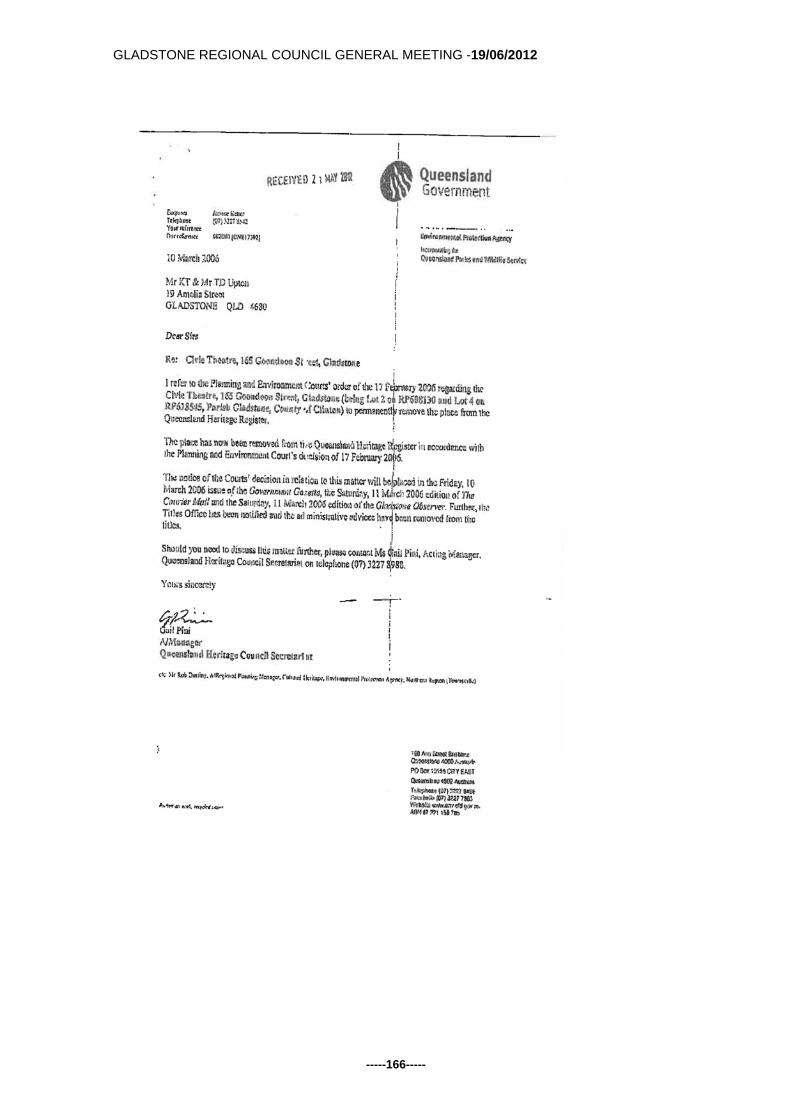
GLADSTONE REGIONAL COUNCIL GENERAL MEETING -19/06/2012
-----166-----

GLADSTONE REGIONAL COUNCIL GENERAL MEETING -19/06/2012
-----167-----
Back to Top G/5.4.10 COMMERCIAL ACTIVITIES ON COUNCIL CONTROLLED
LAND Responsible Officer: Director Planning and Environment Council Meeting Date: 19 June 2012 Purpose: The purpose of this report is to seek Councils approval to release the Draft Commercial Activities on Council Controlled Land Policy for public consultation. Officer's Recommendation: That
1. Council approve the release of Draft Commercial Activities on Council Controlled Land Policy be released for public consultation.
2. Consultation with the public be conducted through written submission and address specific clauses contained within the draft policy document.
3. Advertising of the Draft Policy be delivered through local media Public Notice, Council website and written letter to existing permit holders.
4. The Draft Policy will be available for viewing on Council website and at Customer Service outlets throughout the region and Public Libraries.
Background: Council receives submissions from Commercial Operators to conduct a wide variety of businesses upon Council Owned or Controlled land. During the assessment of each of these operations, many officers are involved with the assessment and approval process. To date this process has been undertaken by various department staffs from Planning and Environment Directorate. The need to have defined guidelines which provide for fair and equitable assessment of all commercial applications would ensure the applications are considered in a fair and reasonable manner. The Draft Commercial Activity on Council Controlled Land Policy provides guidelines for commercial application assessment. Research into other Local Governments within the state have revealed that there are many Councils requiring a policy document that ensures applications are assessed in similar ways. Caloundra Regional Council has adopted a policy for Commercial Activities and the proposed Draft Commercial Activities on Council Controlled Land Policy has been developed along similar guidelines to that one. Consideration:

GLADSTONE REGIONAL COUNCIL GENERAL MEETING -19/06/2012
-----168-----
The adoption of Policy Documents requires consultation of all impacted persons and also ensures that the general public have opportunity to make comment upon matters that may affect them in the future. Policy documents should provide guidelines for officers to conduct the business of council, but not contain elements that require review on a continuous basis or refer to specific fees and charges. Therefore it is proposed that the Policy be reviewed on a bi-annual basis. The Draft Commercial Activities on Council Controlled Land Policy has been developed to respond to applications for activities on beaches, parks and reserves within the Gladstone region. Some of the activities include surf schools, kayak hire, fitness activities under instruction, sky diving and hovercraft tours. Council provides parks and reserves for the enjoyment of its residents and visitors and ensures that these areas are available for the everyday enjoyment of the population. Commercial operations should not cause loss of access to the facilities in the council controlled areas. Communication and Consultation (Internal/External): The Draft policy will be available for review for a period of minimum 21 days. The opportunity to provide written review will ensure that all opinions are collected and then collated into a revised document which will then be presented to Council for further consideration. The Director Governance has been consulted in the initial development of this policy. The reviewed document will be forwarded to the Director Governance for alignment to adopted council procedure and presentation standards. Legal Environmental and Policy Implications: The Draft Policy has been prepared in accordance with Local Government Act 2009 requirements. Financial and Resource Implications: The Draft Policy will guide application consideration into the future, however it is a separate document to the annual Fees and Charges that are considered by Council during the budget process. Commentary: Councillors will have the opportunity to review all submissions prior to the Policy being brought to Council for formal adoption once the public consultation period has closed. Summary: Nil Attachments:

GLADSTONE REGIONAL COUNCIL GENERAL MEETING -19/06/2012
-----169-----
1. Draft Policy - Commercial Activity on Council controlled Land Tabled Items: 1. Nil Report Prepared by: Acting Director Planning and Environment

GLADSTONE REGIONAL COUNCIL GENERAL MEETING -19/06/2012
-----170-----

GLADSTONE REGIONAL COUNCIL GENERAL MEETING -19/06/2012
-----171-----

GLADSTONE REGIONAL COUNCIL GENERAL MEETING -19/06/2012
-----172-----

GLADSTONE REGIONAL COUNCIL GENERAL MEETING -19/06/2012
-----173-----

GLADSTONE REGIONAL COUNCIL GENERAL MEETING -19/06/2012
-----174-----

GLADSTONE REGIONAL COUNCIL GENERAL MEETING -19/06/2012
-----175-----

GLADSTONE REGIONAL COUNCIL GENERAL MEETING -19/06/2012
-----176-----
Back to Top G/5.4.11 COMMERCIAL BEACH ACTIVITY PERMIT - HOVERCRAFT
OPERATION SEVENTEEN SEVENTY - MR WELBELOVED Responsible Officer: Director Planning and Environment Council Meeting Date: 19 June 2012 Purpose: The purpose of this report is to allow the Council to consider an application for the commercial use of a council controlled area and to make a decision on the application Officer's Recommendation: That, in accordance with Section 9 and Section 10 of Local Law No. 1 (Administration)
2011, Council approve the application in part:
1. Approval for the operation of 1770 Hovercraft Tours to operate guided tours subject to the following conditions:
Standard Conditions
1. The activities authorised by this approval are limited to the following location, area and periods of time:
a. Location A on attachment 1; b. 1770 Marina Beach area only; c. Monday - Sunday between the hours of 9:00am - 4:00pm. d. Permit expires at 5.00pm on 30 June 2013.
2. The approval must be displayed in a prominent position so it is easily viewable by persons at the premises. Where the display of the approval is not easily viewable, it must be available to be produced for inspection on demand by an authorised person.
3. The approval holder must maintain public liability insurance to the value of $20,000,000 ($20 million) against personal injury and property damage resulting from the activities authorised by this approval.
4. The approval holder must allow an authorised person to have reasonable access to the premises during normal operating hours.
5. The approval holder must ensure that the activities authorised by the approval do not cause a nuisance or create a road safety risk.
6. The approval holder must ensure that all facilities and equipment used in the operation of the activity are, at all times, maintained— (i) in good working order and condition; and (ii) in a clean and sanitary condition.
7. The applicant must obtain and is responsible for maintaining all other necessary permits and approvals from other relevant local, state and federal agencies prior to commencement of operation.
Commercial Beach Activity

GLADSTONE REGIONAL COUNCIL GENERAL MEETING -19/06/2012
-----177-----
1. The approval holder must not — (i) conduct the activity in or on any boat ramp or car park area; (ii) place or display any sign or device advertising the activity in the area
identified in the approval otherwise than in accordance with an approval of the local government which authorises the use of the local government controlled area for that purpose;
(iii) place or secure any inflatable barrier, sign, banner or similar to any trees or vegetation;
(iv) place any secured/permanent shade structure in the area identified in the approval; and
(v) amplify, or cause to be made, any noise identifying or otherwise drawing attention to the activity, except in accordance with standards laid down under the Environmental Protection Act 1994.
2. The approval holder is responsible for the removal of all extraneous materials from the area defined in standard condition 1 and allocated to the set activity.
3. The approval holder must ensure that the operation of the activity is in accordance with information supplied in the Environmental Impact of Leisure Hovercraft including surface disturbance, environmental pollution management and noise footprint.
4. A first aid procedure must be developed and implemented for the activity that addresses at a minimum, the procedures to use in the event of injuries relating to cuts, grazes and wind blown sand.
5. The approval holder and associated employees of the commercial activity must obey any and all verbal or written directions from any authorised Council officer.
6. The approval does not grant rights of exclusive occupancy over any particular area and public access and safety to all areas is to be maintained at all times, including but not limited to boat ramps and beaches.
Additional Conditions
1. The approved activity must not commence prior to payment of annual licence fee.
2. The applicant is to advise Council Regulatory Service staff of the actual commencement date of operations.
Background: An application was received on 14 December 2011 from Mr and Mrs K. Welbeloved for the operation of Hovercraft Tours from the beach at 1770 Marina area. The proposed commercial activity involves the operation of two hovercrafts from the beach at the 1770 Marina. A total of twelve (12) tourists and two (2) coxswain/ guides will tour the adjacent Urangan Boat Harbour and northern beaches foreshores. Guests would park their vehicles at the applicants current commercial premises and be bussed to the Captain Cook Drive roadside for drop off near the beach. The guests would then proceed to gather on the beach where safety instructions and other required information will be delivered prior to embarking upon the hovercraft. The application did not address issues of noise control, road or parking access and was minimal in its information regarding the operation on the beach. Subsequent correspondence with various Council departments has resulted with clarification of details obtained at each stage of application and discussion, along with payment of the application fee to Council. The applicant did advise that they had already obtained

GLADSTONE REGIONAL COUNCIL GENERAL MEETING -19/06/2012
-----178-----
approval from Queensland Government for the operation in the waterways adjacent to Seventeen Seventy beach and estuary. A letter of refusal was sent on 28 March 2012 based upon the increased car parking at the adjacent public car park; the operation of a commercial activity off a public boat ramp; the impact of activity on the local beach and users; and the increase of commercial activities in this area impacting upon the general public enjoyment of the beach area. The applicant requested this application to be reviewed and telephone contact with Mr Welbeloved, Mrs Leisa Dowling and Ms Helen Paulsen was made on 27 April 2012. Further information was provided in support of the application, and following this discussion a concept plan of potential road redevelopment in the immediate area of the application was forwarded to Mr Welbeloved for his consideration. The applicant advised in May of his intention to continue with his application for commercial activity after he had reviewed the potential disruption to his business in the future caused by road upgrade and pathway construction. He is very demanding upon Council to approve this application as he is waiting on placing orders for the hovercraft with suppliers external to the state. Consideration: In considering this application, the following options should be reviewed: Option One Approval of Application in full as requested Option Two Approval of Application in part. Option Three Refuse the Application Option One provides for the approval of the application for the conducting of a Commercial Activity namely 1770 Hovercraft Tours to be conducted from the beach at 1770 Marina in the location indicated at A and B on the attached plan (Attachment 1) and subject to conditions of operation. The conditions are based on the details specified in Council Local Laws. Option Two provides for the approval in part of the application for conducting of a Commercial Activity namely 1770 Hovercraft Tours from the beach at 1770 Marina from the location marked as A on the attached plan only and subject to conditions of operation. The conditions are based on the details specified in Council Local Laws. Option Three provides for the refusal of the application at this time. This option would then allow the applicant to apply for a Commercial Activity Permit in accordance with future Policy currently under development, or have recourse for objection and appeal to the CEO and Council in future. Communication and Consultation (Internal/External): Extensive consultation has been had between Council officers and the applicant over the last six months. The applicants has sought the opinion of the Planning Department and have received written advice that they can conduct the activity from their existing commercial premises at 1 Grahame Colyer Drive through the use of buses from there to the marina area when escorting tourists to the boat. However, in the event of complaints received in relation to the parking of vehicles, operation of the commercial
GLADSTONE REGIONAL COUNCIL GENERAL MEETING -19/06/2012
-----179-----
hovercraft activity impacting upon residents or traffic congestion, then a Material Change of Use Application would be required. Email and telephone conversations with Regulatory Services staff regarding insurance and registration of business name have been conducted. The applicant is reluctant to apply for insurance or business name registration until Council gives its determination on the application. This can be conditioned in the response to the applicant. The Regional Habour Master, Captain Mike Lutze has approved the operation of the hovercraft activity in the Urangan Boat Harbour and adjacent environs. A map defining the areas of "no go" and the proposed route of the tours is attached for information. (Attachment 2) There are conditions associated with this approval that are required to be met by the applicant in conducting his commercial activity. The Manager Regulatory Services and the Manager Parks & Environment have held extensive discussions regarding the proposed commercial activity and have collected information regarding the proposed activity which is held in one file within the regulatory services department. Legal Environmental and Policy Implications: Council Local Law No 1 - Administration 2011 details in Schedule 2 that the commercial use of Local Government Controlled areas and roads are a prescribed activity. Section 6 (2) of the Local Law states that a person must not undertake the prescribed activity without a current approval. Financial and Resource Implications: The Adopted Fees and Charges 2012 - 2013 detail a $200 Application fee and a $100 Annual Licence fee. The applicant has paid the Application Fee, however the annual fee is applicable only if this application is approved and then an invoice would be forwarded to the applicant. Commentary: Within the 1770 Marina beach and adjacent waterways there are already a number of commercial operators conducting business from private and public premises. The LARC tours operate an amphibious watercraft from adjacent to their commercial premises in the Marina complex. They park their vessel adjacent to the building and tourist cars park along the side of Captain Cook Drive and in the adjoining public car park. 1770 Liquid Adventures conduct kayak and surf ski hire from the beach in close proximity to Location A on the attached map. They have operated from this location for a number of years. A recent application from Kitesurf 1770 for operation of a stand up paddle board hire business was considered by Council recently and was proposed for the same area. The public boat ramp serves the community of Agnes Water and Seventeen Seventy as the main all weather ramp access to the in and off shore fishing grounds. There is high boat registration statistics from this area. Boaties park their cars and trailers in the public car park across from the Marina Complex. On clear, fine weather, this area is very congested with cars, trailers and tourists all mixing together around a very busy road access to the foreshore and beach of Endeavour Park and the adjacent
GLADSTONE REGIONAL COUNCIL GENERAL MEETING -19/06/2012
-----180-----
residential and camping community of Seventeen Seventy. Engineering Services department have identified the need to expand the car park and interface areas in the immediate Marina environs and have developed a concept plan that is subject to further investigation prior to being submitted for consideration to Council. Any road works or development in the immediate area of the Marina will impact upon the commercial operators in the area. The adjacent residences will also be affected by road works and noise associated with construction activities. The local urban area on the hill overlooking the marina contains private and commercial premises. Hotel and holiday letting are located in the area overlooking the marina. Local businesses rely upon the tourists for their income and are very heavily impacted by negative or natural weather events that prevent enjoyment of the area. Council should be aware of the proposed Commercial Activity on Council Controlled Land Policy which is in development stage and will be going for public consultation in the near future. This policy will assist Council Officers determine future applications of similar nature for activities on council controlled land. Summary: The application for conducting a commercial business from Council controlled land at Seventeen Seventy Marina requires conditions for the operation which ensure that there is no adverse effects upon the environment or residents of Seventeen Seventy. Attachments:
1. Map of Proposed Operation Location on 1770 Marina Beach 2. Map of Proposed Route and Proposed Pick- up Area.
Tabled Items: 1. Nil Report Prepared by: Acting Director Planning & Environment

GLADSTONE REGIONAL COUNCIL GENERAL MEETING -19/06/2012
-----181-----

GLADSTONE REGIONAL COUNCIL GENERAL MEETING -19/06/2012
-----182-----

GLADSTONE REGIONAL COUNCIL GENERAL MEETING -19/06/2012
-----183-----

GLADSTONE REGIONAL COUNCIL GENERAL MEETING -19/06/2012
-----184-----
Back to Top G/5.5 CHIEF FINANCIAL OFFICER G/5.5.1 PROPOSED ROAD NAME FOR UNNAMED ROAD RESERVE LOCATED
OFF HOURIGAN CREEK ROAD RAGLAN Responsible Officer: Chief Financial Officer Council Meeting Date: 19 June 2012 Purpose: This report provides Council with information on a request to name an unnamed road reserve off Hourigan Creek Road, Raglan. Officer's Recommendation: That
1. Council approve Belu Lane as the name for the unnamed road reserve off Hourigan Creek Road, Raglan
2. Ben Smith be advised of the approved name 3. Engineering Services determine the appropriateness of whether this road is
to be maintained by council or not. Background: Council has received an application from Mr Ben Smith of 605 Hourigan Creek Road to name the unnamed road reserve off Hourigan Creek Road to access his other property located at Lot 202 DS55 for which he intends building on. Consideration: The proposed name provided by the applicant was checked for duplication and for similar sounding to those of existing road or place names. The name Belu is the name of the property that the unnamed road reserve adjoins and is used to access that property. Communication and Consultation (Internal/External): Mr Ben Smith - Po Box 687 Gladstone Qld 4680 Mapping & Assets Coordinator Legal Environmental and Policy Implications: Nil Financial and Resource Implications:

GLADSTONE REGIONAL COUNCIL GENERAL MEETING -19/06/2012
-----185-----
Council currently does not maintain this road. Naming of the road does not mean Council has to maintain the road. Under Councils policy Naming of Streets, Roads, Parks, Bridges & Other Places & Australian Standards all road names whether they are private or public road need to be approved by Council. Ongoing Signage Maintenance Commentary: The proposed name conforms to the “Naming of Streets, Roads, Parks, Bridges & Other Place Names” policy. No. P-3.06.01 states:
Preferred sources of names include: Indigenous names of local fauna, flora and features; Early local settlers, pioneers, explorers, and other local eminent persons; War/casualty lists; Theme based naming (eg ships, bushrangers); and Local landmarks or specific features.
Summary: Nil Attachments: 1. Correspondence from Mr Ben Smith 2. Location Map Tabled Items: 1. Nil Report Prepared by: Assets & Mapping Coordinator

GLADSTONE REGIONAL COUNCIL GENERAL MEETING -19/06/2012
-----186-----

GLADSTONE REGIONAL COUNCIL GENERAL MEETING -19/06/2012
-----187-----

GLADSTONE REGIONAL COUNCIL GENERAL MEETING -19/06/2012
-----188-----

GLADSTONE REGIONAL COUNCIL GENERAL MEETING -19/06/2012
-----189-----
Back to Top G/5.5.2 PROPOSED STREET NAMES FOR RIVERSTONE RISE
DA495/2011 Responsible Officer: Chief Financial Officer Council Meeting Date: 19 June 2012 Purpose: This report provides Council with information on a request from RPS Group to name 27 new road reserves within the Lilyvale Village, Stages 1B, 2, 3 & 4 Precint 1, and Corimba Village Stages 1A, 1C & 5 Precint 1, under development application DA495/2011 in Boyne Island/Wurdong Heights. Officer's Recommendation: That
1. Council Approve - Riverstone Rise Boulevard, Eacham Circuit, Caulder Esplanade, Lilyvale Esplanade, Jardine Crescent, Clover Crescent, Koolivoo Parade, Barambah Parade, Mipia Drive, Boondooma Court, Salt Court, Numalia Lane, Josephine Street, Gordonbrook Street, Paluma Street, Lenthall Street, Wabby Street, Buchanen Street Kurwongbah Street for Lilyvale Village and Tulipwood Circuit, Ribbon Crescent, Jacana Place, Shelduck Close, Brush Tail Court, Peper Lane, Red Ash Place and Corimba Parade for Corimba Village
2. RPS Group be advise of the approved names. Background: Council has received an application from RPS Group to name 27 new roads within the Lilyvale and Corimba Village Estates as indicated on the attached 2 plans 109058-38A & 109058-39B Consideration: The proposed names provided by the applicant where checked for duplication and for similar sounding to those of existing road or place names. The proposed names are taken from the themes of native flora species endemic to this region [being used for Corimba Village] and Australian lake names and water bodies [being used for Lilyvale Village]. Communication and Consultation (Internal/External): RPS Group Mapping & Assets Officers Legal Environmental and Policy Implications:

GLADSTONE REGIONAL COUNCIL GENERAL MEETING -19/06/2012
-----190-----
Nil Financial and Resource Implications: Nil initially as installation of appropriate signage will be carried out as part of the development. Commentary: The proposed name conforms to the “Naming of Streets, Roads, Parks, Bridges & Other Place Names” policy by using the themes. No. P-3.06.01 states:
Preferred sources of names include: Indigenous names of local fauna, flora and features; Early local settlers, pioneers, explorers, and other local eminent persons; War/casualty lists; Theme based naming (eg ships, bushrangers); and Local landmarks or specific features.
Summary: Nil Attachments: 1. Correspondence from RPS Group 2. Location Map Tabled Items: 1. Nil Report Prepared by: Assets & Mapping Coordinator
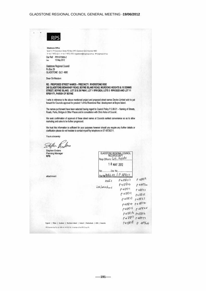
GLADSTONE REGIONAL COUNCIL GENERAL MEETING -19/06/2012
-----191-----

GLADSTONE REGIONAL COUNCIL GENERAL MEETING -19/06/2012
-----192-----

GLADSTONE REGIONAL COUNCIL GENERAL MEETING -19/06/2012
-----193-----
Back to Top G/5.5.3 PROPOSED ROAD NAMES LITTLE CREEK ESTATE
DA/432/2012 Responsible Officer: Chief Financial Officer Council Meeting Date: 19 June 2012 Purpose: This report provides Council with information on a request from Norris Clarke & O'Brien Pty Ltd to name 9 new road reserves within the Little Creek Estate Development DA/43232012 for the Balance Stages 4B, 6, 7A, 7B, 9, 11A, 11B, 17B, 18A, 18B, 18C, 10 and 19. Officer's Recommendation: That
1. Council approve, Phelps Circuit, Sirleaf Circuit, Karman Road, Sims Road, Leffett Court , Stark Place, Sargent Circuit, Rowland Street, Vane Road Norris Clarke & O'Brien be advised of the approved names.
Background: Council has received an application from Norris Clarke & O"Brien to name 9 new roads. In addition 4 new roads are extensions of previously approved roads or have been reconfigured (as indicated on the attached plan 7727SN-PRO Issue B) Consideration: The proposed names provided by the applicant where checked for duplication and for similar sounding to those of existing road or place names. The names align with the 2 themes already used in the naming of Little Creek Estate - Environmental and Nobel Peace Prize winners. Communication and Consultation (Internal/External): Norris Clarke & O'Brien Pty Ltd Mapping & Assets Officers Legal Environmental and Policy Implications: Nil Financial and Resource Implications: Nil initially as installation of appropriate signage will be carried out as part of the development
GLADSTONE REGIONAL COUNCIL GENERAL MEETING -19/06/2012
-----194-----
Commentary: The proposed name conforms to the “Naming of Streets, Roads, Parks, Bridges & Other Place Names” policy by using the theme based names. No. P-3.06.01 states:
Preferred sources of names include: Indigenous names of local fauna, flora and features; Early local settlers, pioneers, explorers, and other local eminent persons; War/casualty lists; Theme based naming (eg ships, bushrangers); and Local landmarks or specific features.
Summary: Nil Attachments: 1. Correspondence from Norris Clarke & O'Brien 2. Location Map Tabled Items: 1. Nil Report Prepared by: Assets & Mapping Coordinator

GLADSTONE REGIONAL COUNCIL GENERAL MEETING -19/06/2012
-----195-----

GLADSTONE REGIONAL COUNCIL GENERAL MEETING -19/06/2012
-----196-----

GLADSTONE REGIONAL COUNCIL GENERAL MEETING -19/06/2012
-----197-----

GLADSTONE REGIONAL COUNCIL GENERAL MEETING -19/06/2012
-----198-----
Back to Top G/5.5.4 ADDITIONAL STREET NAMES FOR HILLCLOSE HARVEY
ROAD - CLINTON Responsible Officer: Chief Financial Officer Council Meeting Date: 19 June, 2012 Purpose: This report provides Council with information on a request from Urban Land Development Authority to name 2 new road reserves within the "Hillclose" Harvey Road Development. Officer's Recommendation: That
1. Council approve Spindrift Road & Alvis Street 2. ULDA be advised of the approved names
Background: Council has received an application from ULDA to name an additional 2 roads within the Harvey Road development (indicated on the road layout plan 102361-47 REV-B) Consideration: The proposed names provided by the applicant where checked for duplication and for similar sounding to those of existing road or place names. The names align with the existing development theme and were both competitors in the Brisbane to Gladstone Yacht Race Communication and Consultation (Internal/External): Urban Land Development Authority; and Mapping & Assets Officers Legal Environmental and Policy Implications: Nil Financial and Resource Implications: Nil initially as installation of appropriate signage will be carried out as part of the development. Commentary:

GLADSTONE REGIONAL COUNCIL GENERAL MEETING -19/06/2012
-----199-----
The proposed name conforms to the “Naming of Streets, Roads, Parks, Bridges & Other Place Names” policy by continuing the existing theme of Brisbane to Gladstone Yacht Race winners or entrants. No. P-3.06.01 states: Preferred sources of names include:
Indigenous names of local fauna, flora and features; Early local settlers, pioneers, explorers, and other local eminent persons; War/casualty lists; Theme based naming (eg ships, bushrangers); and Local landmarks or specific features.
Summary: Nil Attachments: 1. Location Map from ULDA Tabled Items: 1. Nil Report Prepared by: Assets & Mapping Coordinator

GLADSTONE REGIONAL COUNCIL GENERAL MEETING -19/06/2012
-----200-----
GLADSTONE REGIONAL COUNCIL GENERAL MEETING -19/06/2012
-----201-----
Back to Top G/5.5.5 PROPOSED STREET NAMES FOR ELLIOTS RUN
CALLIOPE - 15 MINGARA CRESENT - DA20600/2008 Responsible Officer: Chief Financial Officer Council Meeting Date: 19 June 2012 Purpose: This report provides Council with information on a request from VDM Consulting to name 4 new road reserves within the Elliots Run stages 1 & 2A under development application DA20600/2008 - OPW52/2010 and OPW53/2010 Officer's Recommendation: That 1. Council Approve Lacey Close, Gilcrest Close, London Close and Rhodes Close Background: Council has received an application from VDM Consulting to name 4 new roads within Elliots Run Calliope as indicated on the attached plan C303-C. Consideration: The proposed names Lacey, Gilcrest & Rhodes are on the former Calliope Honour Roll and all 4 names where checked for duplication and for similar sounding to those of existing road or place names. Road number 16 on the map will be given a name if it doesn't connect to Woodward Avenue. If it does connect it will be given the name Woodward Avenue as a continuation of that street. Communication and Consultation (Internal/External): VDM Consulting Mapping & Assets Officers Legal Environmental and Policy Implications: Nil Financial and Resource Implications: Nil initially as installation of appropriate signage will be carried out as part of the development. Commentary:

GLADSTONE REGIONAL COUNCIL GENERAL MEETING -19/06/2012
-----202-----
The proposed names conform to the "Naming of Streets, Roads, Parks, Bridges & Other Place Names" policy by using the theme based names. Earlier approved stages of the development follow the theme of naming streets after "famous street names" from other countries; the proposed names continue this theme and also use names off the former Calliope Honour Roll as well. Summary: Nil Attachments: 1. Correspondence from VDM Consulting & Location Map Tabled Items: 1. Nil Report Prepared by: Assets & Mapping Coordinator

GLADSTONE REGIONAL COUNCIL GENERAL MEETING -19/06/2012
-----203-----

GLADSTONE REGIONAL COUNCIL GENERAL MEETING -19/06/2012
-----204-----
Back to Top G/5.5.6 FINANCIAL STATEMENTS - PERIOD ENDED 31 MAY 2012 Responsible Officer: Chief Financial Officer Council Meeting Date: 19 June 2012 Purpose: This report seeks Council adoption of the Monthly Financial Statements for the 2011/2012 year to date, for the period ended 31 May 2012, as required under Section 152 Local Government (Finance, Plans and Reporting) Regulation 2010. Officer's Recommendation: That 1. Council adopt the Monthly Financial Statements for the 2011/2012 year
to date, for the period ended 31 May 2012, as required under Section 152 Local Government (Finance, Plans and Reporting) Regulation 2010.
Background: Nil Consideration: The Revised Budget figures shown in the financial statements for the period 31 May 2012 reflect changes resulting from the continuing budget review process, with considerable adjustments processed during the month of May to reflect the 2011/12 Anticipated Position. Among these revisions is a $26.7m reduction in Capital spending, most notably in the Water & Sewerage area where spending is projected to be $9.9m below Adopted Budget levels. Delays to other Projects such as Development of the new Cell at Benaraby Landfill, Water Play Park and Philip Street Precinct have also contributed to the total reduction in Capital spending. Capital Income expectations have been reduced by $19.1m to account for delays in both Project and Headworks receipts. Reductions to Ordinary Expenses across Council in the order of $23.1m have also been processed. An anticipated increase in Ordinary Income of $5.0m, due largely to development activity, has also acted to improve the Anticipated Position at the end of this financial year. With respect to the Statement of Income and Expenses the major items of note are: Income

GLADSTONE REGIONAL COUNCIL GENERAL MEETING -19/06/2012
-----205-----
General Rate Income continues to be above revised budget; Fees & Charges continue at high levels, with income now
representing 99.46% of the revised budget, year to date; Recoverable Works, showing at $0.53m, which is partially as a result
of several income receipts for recoverable works being reported as grants and subsidies, and also attributable to lower than anticipated expenditure on recoverable works projects;
General operating revenue at $7.12m which is a level well above revised budget
Expenditure
Employee costs continue to be below budget levels due to staff losses and the ongoing negotiations of the EBA terms. These costs currently represent 84.07% of the revised budget.
Materials & Services costs are now above pro-rata levels as at the end of May, at 110.15% of Revised Budget.
The operating result for the year to date is $88.4m, ($87.7m – April), which is reflective of the continuing provision of services and program delivery during the period. With respect to the Statement of Financial Position, the Statement continues to show a strong cash balance, with an end of May result of $71.3m (compared to $83.1m - April), and an outstanding receivables figure which increased to $22.90m ($15.72 – April). Council’s Statement of Financial Position continues to demonstrate the significant capital investment made during the period within the Capital Works in Progress line item, reflecting $66.34m worth of capital expenditure incurred year to date ($56.82m – April). The opening position of the Statement of Financial Position reflects the Audited Financial Statements as at June 30 2011. The Projected Closing Balance for this Statement is based on this opening balance plus/minus the recorded movement for the year to date. Council’s Sustainability Ratios for the period continue to be in a more favourable position compared to Revised Budget, and this trend is expected to be maintained for the balance of the financial year. Comments with respect to the ratios are again incorporated within that section of the Financial Statements attached. All indicators are within budgetary expectations through to the end of May. Communication and Consultation (Internal/External): Nil Legal Environmental and Policy Implications:

GLADSTONE REGIONAL COUNCIL GENERAL MEETING -19/06/2012
-----206-----
Nil Financial and Resource Implications: Nil Commentary: Nil Summary: Nil Attachments: 1. Monthly Financial Statements for period ended 31 May 2012. 2. Monthly Financial Statement by Business Unit for period ended 31 May 2012. Tabled Items: Nil Report Prepared by: Principal Accountant Management DF06 -Attach 1 - Monthly Financial Statements - period ended 31 May 2012 Open Document DF06 - Attach 2 - Monthly Financial Statement by Business Unit Open Document

GLADSTONE REGIONAL COUNCIL GENERAL MEETING -19/06/2012
-----207-----
Back to Top G/5.5.7 DEBTOR WRITEOFFS Responsible Officer: Chief Financial Officer Council Meeting Date: 19 June 2012 Purpose: This report seeks Council approval to write off outstanding overdue debts as at 30 June 2012. Council to date has been unsuccessful in recovering specific debts, however if Council were to take further action to recover these debts, the expense incurred would be greater than the current amount recoverable. Officer's Recommendation: That 1. Council agree to writeoff specific debts which are detailed in the attached
document referenced below. Background: The accounts receivable team has exhausted all resources to recover these debts. Consideration: It has been recommended by the accounts receivable team that these debts be written off as to continue the debt recovery process of these debts would incur more cost than the amount recoverable Communication and Consultation (Internal/External): The communication with the debtor has been detailed in the attachment. Predominantly these are library debts. Legal Environmental and Policy Implications: In relation to the library debts it will be recommended that a review of the security deposits be undertaken. The four sundry debtors - it will be recommended that we continue to look for prompt payment and request purchase order numbers where practical. A review of unsecured credit is to be undertaken, with a view to requesting a credit card number or security deposit where practical. Financial and Resource Implications:

GLADSTONE REGIONAL COUNCIL GENERAL MEETING -19/06/2012
-----208-----
Where the cost of chasing payment is higher than the amount recoverable and all resources have been exhausted to recover monies outstanding, Finance agrees that it is advisable to writeoff such debts. Commentary: Nil Summary: Every possible action has been taken to recover these debts and writing off a debt is always the last option considered. Attachments: 1. Debtor proposed writeoff listing Tabled Items: 1. Nil Report Prepared by: Statutory Accountant
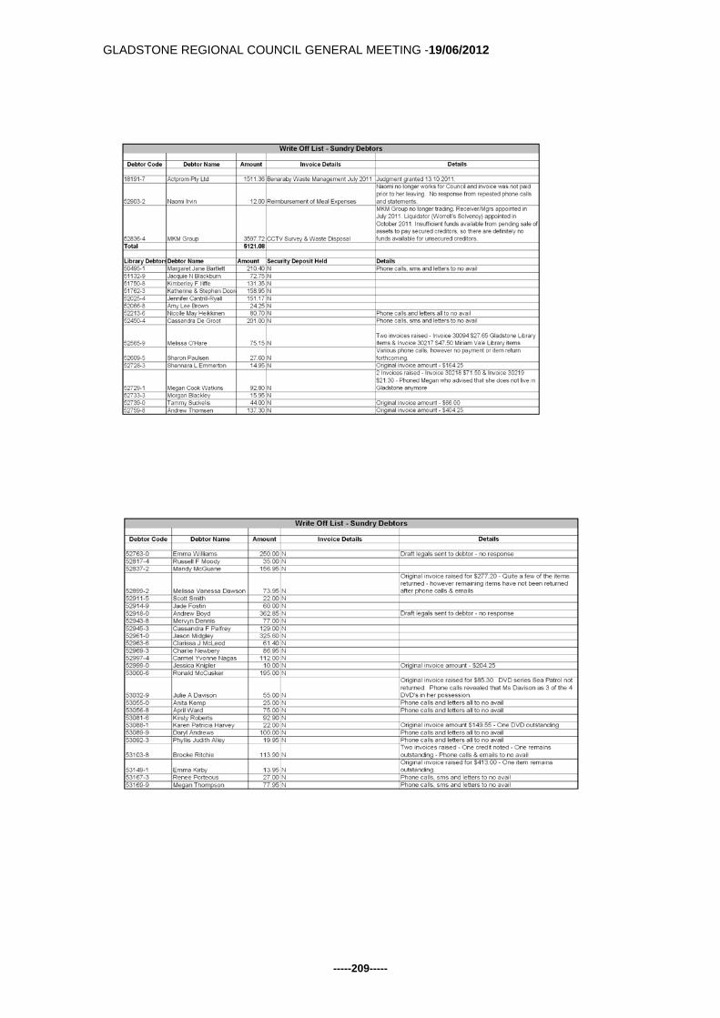
GLADSTONE REGIONAL COUNCIL GENERAL MEETING -19/06/2012
-----209-----
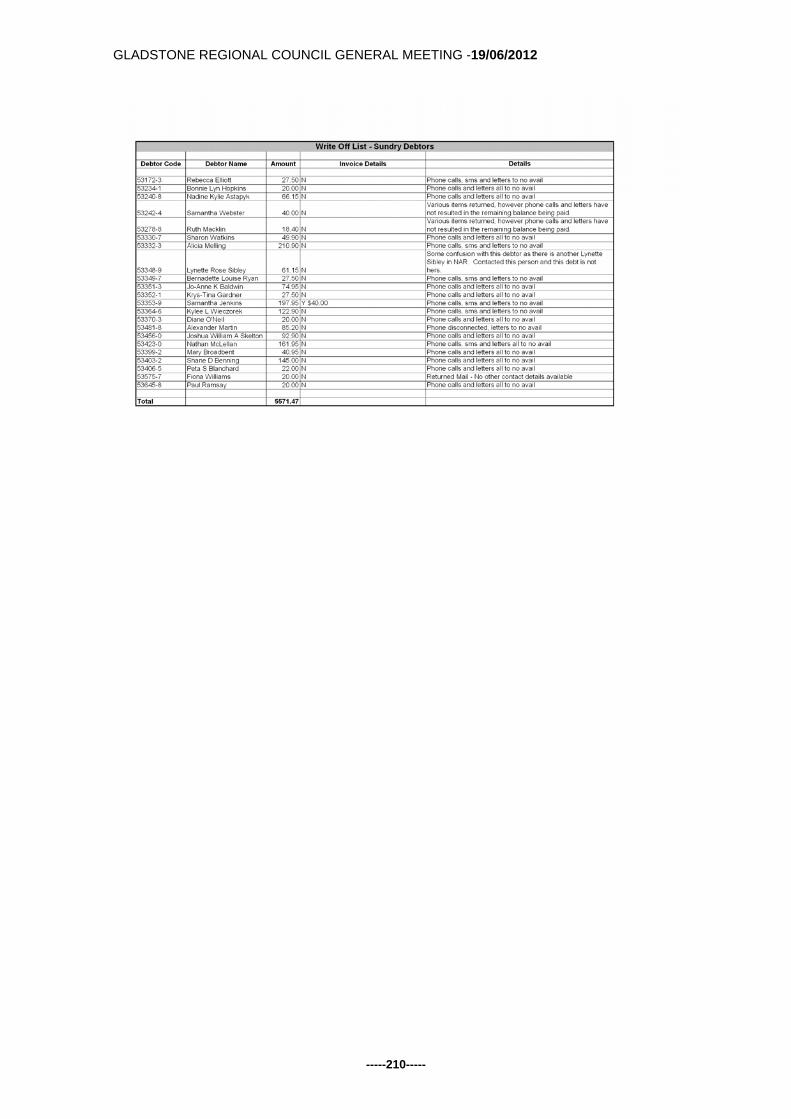
GLADSTONE REGIONAL COUNCIL GENERAL MEETING -19/06/2012
-----210-----

GLADSTONE REGIONAL COUNCIL GENERAL MEETING -19/06/2012
-----211-----
Back to Top G/6 COUNCILLOR REPORTS G/6.1 COUNCILLOR REPORT Responsible Officer: Chief Executive Officer Council Meeting Date: 19 June 2012 Purpose: The Mayor and Cr Lanzon submit the following reports for Council information and consideration. CR SELLERS Hutchinson Builders Hutchinson Builders celebrated 100 years of building across Australia with a function held in Gladstone on Thursday 7th June. Established in 1912, Hutchinson Builders is one of Australia's oldest and largest privately owned construction Companies. Hutchies opened an office in Gladstone in 2008 and have worked on Aspex Apartments, Pinnacle apartments, G80, G60 and also 11 Glenlyon Street. They are also working on the Stockpile 22 Project for the Gladstone Ports Corporation which is a $5.2 million 165 metre tunnel as part of a new coal handling facility. Order of Australia Mrs Heather Wieland of the Country Women's Association has been awarded a Member of the Order (AM) for her service to women and their families living in rural and regional Queensland through leadership roles within the County Women's Association of Australia. She is currently the Associations' National President and is representing all of the state and territory branches. Mr Ian Brusasco is to receive the Order of Australia. He was the Chairman of the Gladstone Ports Corporation for six years and will receive the Order of Australia for his distinguished service to the Queensland Community and his leadership roles with a range of public administration, sporting and charitable organisations; in particular Foodbank Queensland of which he is currently the state Chairman and he also sits on the national Board. Mr Brusasco also received an order of Australia in 1988 for his service to soccer. CR LANZON Gladstone Entertainment Centre Expansion Project After the Gladstone Ports Corporation harbour cruise Cr. Neill-Ballantine and I discussed our thoughts on the entertainment centre project.

GLADSTONE REGIONAL COUNCIL GENERAL MEETING -19/06/2012
-----212-----
Cr. Neill-Ballantine had been speaking to three people who all expressed concern that the new project would not pay for itself when completed. I have heard similar concerns. We have been assured that the new complex when completed would be a paying proposition. But I think many of us are still wondering if we are buying a pig in a poke. In Leo’s words “Are we building a hay shed when we are not sure we have the hay to put into it”. That is not to say that we disagree with the project. Now that we have made the decision to proceed we will need to be confident in going forward and take the community with us. Some things have to be done for the community benefit and none of us want to see this city become merely an industrial hub without the finer things in life. For instance, I’m a bit arty farty, but you could have knocked me over with a feather when Cr. Neill-Ballantine said he was keen to see his first ballet at the end of next month. Our thoughts were that if somehow other users of the facilities could be attracted to it without disrupting its main functions, or if other enterprises that conformed to its main use could be made interested, the bottom line wouldn’t be so red. Perhaps we could seek the help of others within the city to give input as to how that might be achieved to join the council team for a discussion. Another possibility would be to invite a representative from a similar facility either in this state or another, which is having some success in at least coming close to balancing the ledgers. If we could come up with some workable plan I’m sure it would ease the mind of both the councilors and the ratepayers Gladstone Ports Corporation The sacking of Ian Brusasco as chairman of the GPC board has revealed some interesting facts. The following is a report from Kara Irving in the Observer. She writes: 'The former chairman also pointed the finger at coal and gas companies, suggesting they were responsible for the environmental mismanagement in the region'. Mr Brusasco is quoted as saying. "If you want to see if there has been environmental mismanagement in the harbour, you should speak to the coal and gas companies." (The full story is on the Observer website) This raises some interesting questions the questions:
Is this the first time the GPC has admitted to environmental mismanagement in the harbour?
How long has it known about the environmental mismanagement? What was done about it? Has anything been done about it? What effect did it have on the harbour?

GLADSTONE REGIONAL COUNCIL GENERAL MEETING -19/06/2012
-----213-----
Did this environmental mismanagement have anything do with the fish poisoning in the harbour? Did it involve acid sulfate soils?
Or is it merely blame shifting by the GPC board? These are issues of great importance to the people of this region and as their representatives we have a duty to raise them on their behalf. Officer's Recommendation: That the Councillor report be received. Attachments: Nil Tabled Items: Nil Report Prepared by: Cr Sellers and Lanzon
GLADSTONE REGIONAL COUNCIL GENERAL MEETING -19/06/2012
-----214-----
Back to Top G/7 QUESTIONS FROM THE PUBLIC GALLERY Nil. Back to Top G/8 CONFIDENTIAL ITEMS Nil. Back to Top Double Click Here to insert the <CLOSURE>

GLADSTONE REGIONAL COUNCIL GENERAL MEETING -19/06/2012
-----215-----
ATTACHMENTS