gcpo lcc 2014 annual report semifinal -...
TRANSCRIPT

2014%Annual%Report
Photo Credits on Cover, clockwise from top center:
Caddo Lake Cypress - Thomas & Dianne Jones; Dunes at Topsail Hill Preserve State Park,
Destin, FL - Gregg Elliott, GCPO LCC; Banks of the mighty Mississippi - courtesy of John Henry
Photography; Igneous glade in the Ozarks - courtesy of Paul Nelson, Central Hardwoods Joint
Venture.
Photo Credits in body of report:Table of Contents: Wolf River, Tennessee - Gregg Elliott, GCPO LCC
p.3: Kenny Ribbeck, LDWF at SEAFWA; Steve Patrick, TWRA in Arkansas; GCPO quick start
map (Conservation Planning Atlas)
p.4: Shorebird tracks - Gregg Elliott, GCPO LCC
p.5: Draft Ozark Highlands CCS priorities map - Todd Jones-Farrand
p.6: Draft Ecological Assessment mapped datasets - Kristine Evans
p.8: GCPO LCC Steering Committee/staff field trip to Angeline & Sabine National Forests
longleaf pine, TX - Gregg Elliott, GCPO LCC
p.9: Alligator gar HSI screenshot - Yvonne Allen, GCPO LCC
Conservation Application of the Inundation Frequency Dataset: Inundation Frequency and
Alligator Gar maps - Yvonne Allen, GCPO LCC; Kimmel & Wright holding an Alligator Gar -
courtesy of USFWS
Partner Applications of the IF Dataset: Map of IF dataset application locations - Yvonne Allen,
GCPO LCC; information icon (CC license 3.0)
p. 12: Clear Gulf waters - Gregg Elliott, GCPO LCC
p. 13: Mangrove interspersed with salt marsh in Port Aransas, TX - courtesy of Dr. Mark Hester
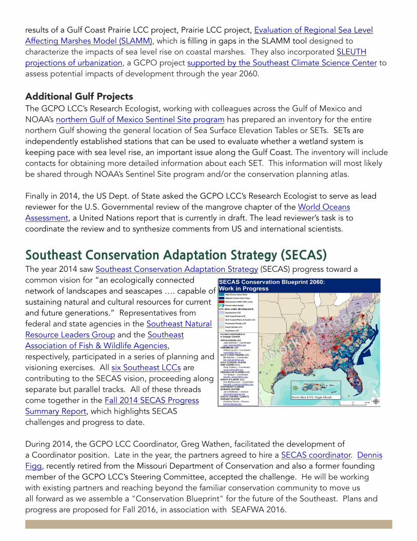
p. 14: A Work in Progress: draft SECAS conservation blueprint - Kristine Evans & Curtis Belyea,
NC State University
p. 15: National LCC Strategic Planning team at NCTC; Registration at the National Workshop
on Large Landscape Conservation - Greg Wathen
p. 18: Cover shot of “A Burning Issue: Prescribed Fire and Fire-adapted Habitats of the East
Gulf Coastal Plain”
p. 19: Northern Gulf of Mexico sea grasses - courtesy of USGS NWRC; Fiddler nation - Kathy;
20: p. 20:
p. 20: Pearl River Delta, MS - ⋏W⋏ via Wikimedia; Clapper Rail - USFWS; Map from glades
dataset - Kristine Evans, GCPO LCC
p. 21: Interior Least Tern chick - USFWS; Mallards and Black Ducks - Dendroica cerulea
All photos courtesy of Flickr Creative Commons unless otherwise noted.
Recommended citation:
GCPO LCC. 2015. Gulf Coastal Plains and Ozarks Landscape Conservation Cooperative 2014 Annual Report. 21 pages.
GCPO LCC 2014 ANNUAL REPORT 3
Table%of%Contents
From our Steering Committee Co-Chairs Page 3
Biological Planning and Conservation Design for the GCPO Region Page 5
Landscape Conservation Design - a core LCC function Page 5 Ecological Assessments: the starting point for design Page 5 Monitoring: Assessing progress on a landscape scale Page 6
Steering Committee and Partnership Advisory Council Meetings Page 7
GCPO LCC Science, Tools, and Their Application Page 9
Pullout Section - Conservation Application of a GCPO LCC Product: the Inundation Frequency Dataset Page 10
Beyond LCC Borders: Gulf Coast Conservation and the Southeast Conservation Adaptation Strategy Page 12
Gulf Coast Conservation: cross-cutting collaboration Page 12 Southeast Conservation Adaptation Strategy (SECAS) Page 14 Fitting into the Network: fitting into the larger vision Page 15
GCPO LCC Operations Page 16
Capacity Page 16 Communications/Projects Database: Highlighting and tracking accomplishments Page 17
Project Highlights and Summaries Page 19

GCPO LCC 2014 ANNUAL REPORT 3
From%our%Steering%Committee%Co-chairs
In 2014, your Gulf Coastal Plains & Ozarks Landscape Conservation Cooperative worked closely with resource agency staff from Missouri, Oklahoma, and Arkansas to develop the first iteration of a Comprehensive Conservation Strategy (CCS) for the Ozark Highlands. At our October Steering Committee meeting, the LCC leadership made the decision to adapt that CCS methodology to the entire GCPO LCC. This is the primary task that the GCPO LCC Science Coordinator will be tackling in 2015.
Speaking of staff, the year 2014 brought many changes, chief among them a changing of the guard in the Science Coordinator position. John Tirpak moved into the role of Science Coordinator for the US Fish & Wildlife Service’s Gulf Restoration Program office, a move which has heightened linkages between Gulf LCCs and the many Gulf Coast restoration efforts underway as a result of the RESTORE Act and the Deepwater Horizon oil spill. It seems that Gulf folks are inexorably drawn to all the work happening along the coast, as Jeff Gleason (formerly our Science Liaison to the USFWS Ecological Services Office in Alabama) joined the Gulf Program as Gulf Migratory Bird Coordinator, and Glenn Constant (formerly our LCC liaison to the USFWS Fisheries program and other aquatic partnerships) has reoriented his work to focus on the Gulf as well. We anticipate that new staff will once again fill these roles for the GCPO LCC beginning in early 2015.
Todd-Jones Farrand was officially offered the GCPO LCC Science Coordinator position in December 2014, after successfully serving a 60-day detail with the LCC over the summer. Todd comes to us from the Central Hardwoods Joint Venture, where he was integrally involved in the Ozark Highlands CCS process, making him ideally suited to expanding this process both geographically and with respect to partner outreach. Another change at the end of 2014 occurred as Amanda Watson, who served as Gulf Coast LCC liaison, went on maternity leave and Cynthia Edwards was brought on to fill that role. Cynthia is transitioning from her role as Gulf Coast Prairie Science Coordinator to assist first in the comple-
2014: Planning for change in a changing LCC
Kenny Ribbeck, GCPO LCC Steering Committee Chair, Wildlife Division Administrator, Louisiana
Department of Wildlife and Fisheries
Steve Patrick, GCPO LCC Steering Committee Vice Chair, Assistant Executive Director for Field Operations, Tennessee Wildlife Resources Agency
tion of the Gulf Coast Vulnerability Assessment and then in expansion of the GCPO’s CCS process.
Kristine Evans also joined the GCPO LCC in early 2014 to fill the Geomatics Coordinator position. Kristine had previously served with the US Fish and Wildlife Service National Wildlife Refuge System, Southeast Region Inventory and Monitoring Network, coordinating and integrating spatial and

GCPO LCC 2014 ANNUAL REPORT 4
Steering%Committee%Co-chairs%message%continuedrelationally-structured non-spatial data on several regional, multi-regional, and national projects, including the Mobile Acoustical Bat Monitoring project that spans 11 states and 5 physiographic regions. We are lucky to have her!
The primary task throughout much of 2014 and into 2015 for both Kristine and Yvonne Allen (the LCC’s Aquatic Habitat Analyst), is to conduct an Ecological Assessment of the GCPO region’s nine priority habitats identified in the Integrated Science Agenda. Toby Gray has been hired as Research Associate to assist Kristine with development of the Ecological Assessment, which will provide a baseline for the status of key habitats as well as important data gaps in our ability to assess them. This work will be integral as the LCC community of the Southeast moves forward with the Southeast Conservation Adaptation Strategy (SECAS) development, now officially being coordinated through the efforts of one our recent retirees, Dennis Figg from Missouri. Dennis has been hired by the USFWS to serve in a coordinator position for SECAS, ensuring progress in this action over the next two years. Additionally, Greg has been participating in regional LCC discussions on SECAS, recognizing the role of the LCCs in the development of the strategy, which will go a long way toward achieving the goals of the LCC Network Strategic Plan, completed in 2014 with the participation of the GCPO LCC.
In 2014, $914,095 in GCPO LCC project funds were granted to six projects, several of which had been a high priority but which had missed receiving funding in our FY2013 RFP (see p. X for more detailed project descriptions). Combined, these projects will contribute significantly to our knowledge and understanding of the systems and habitats throughout the GCPO region, as well as priorities for conservation.
The GCPO LCC Project Database, improved and expanded in 2014, now lists a total of 44 projects, reflecting the broad range of conservation science initiatives that we as a conservation community have undertaken. The common theme among them all, of course, is the large landscape perspective. We anticipate 2015 will be a busy year, in which we will be relying more than ever on you, our Adaptation Science Management Team, our Partnership Advisory Council, our Steering Committee, our Proposal Review Teams, our project Technical Advisory Teams, and our broader http://gcpolcc.org web community to help connect with new, regional, and local organizations who can assist us in creating and implementing a comprehensive conservation strategy for the Gulf Coastal Plains & Ozarks region. Also, please don’t forget the importance of continued communication and coordination for success in our endeavors going forward.
Best Regards,Kenny Ribbeck & Steve Patrick

GCPO LCC 2014 ANNUAL REPORT 5
�!�%��#��"!%�$(�&�"!��%��!:����"$�� ��'!�&�"! 2014 was a year of solid progress and transition for the Gulf Coastal Plains & Ozarks Landscape Conservation Cooperative. Much of the Cooperative’s attention, at both the partnership and staff levels, focused on developing the processes needed to design a conservation blueprint for the GCPO. Beginning with a multi-state team composed of LCC partners and staff focused on the Ozark Highlands, and continuing through two Steering Committee meetings, the Cooperative as a whole worked through, tested, discussed, and refined a process for designing sustainable landscapes through collaboration. While working through this partnership-driven conservation design process, staff also worked diligently to develop the methodologies required to assess the ecological integrity of the GCPO’s terrestrial and aquatic habitat systems, as defined by the GCPO LCC Integrated Science Agenda. Combined, the ecological assessments and partner-driven conservation designs will form the basis for the LCC’s conservation blueprint. Continued focus on these tasks throughout 2015 is aimed at culminating in summer 2016 with a completed version 1.0 conservation blueprint for all of the major habitat systems of the Gulf Coastal Plains & Ozarks region.
The goal of the Ozark Highlands Comprehensive Conservation Strategy (CCS) is to take an ecoregional, rather than jurisdictional, approach to designing landscapes capable of sustaining healthy plant and animal communities in the Ozark Highlands. Working collaboratively, a team composed of GCPO LCC staff, Central Hardwoods Joint Venture staff, and resource agency staff from Missouri, Oklahoma, and Arkansas developed the first iteration of a CCS. This preliminary conservation design can be used to fulfill some of the requirements for State Wildlife Action Plan (a.k.a. Comprehensive Conservation Strategy) revisions for the Ozark portion of the respective states. Further, the process provides a partner-driven framework for conservation design and delivery that is transparent, replicable and defensible (i.e. scientific). This project embodies Strategic Habitat Conservation; it also provides both a regional and a national example that demonstrates one way of developing a comprehensive strategy for an ecological unit that spans multiple states.
��"�"�������%%�%% �!&%:�&���%&�$&�!��#"�!&��"$���%��!The GCPO LCC is working to identify, build, and sustain healthy landscapes through the identification and development of Desired Ecological States for major habitat systems across our region. However, a lack of readily available, detailed information on how habitat condition varies across the GCPO region limits the Cooperative’s ability to achieve this vision.
Biological%Planning%and%Conservation%Design%for%the%GCPO%Region

GCPO LCC 2014 ANNUAL REPORT 6
Therefore, in 2014 the GCPO LCC initiated a rapid assessment of the current condition of its priority habitat systems that are outlined in the draft Integrated Science Agenda. This Ecological Assessment focuses on using existing LCC-wide data sets and remote-sensing to describe habitats to assess three basic questions:
• How much habitat is in the desired ecological state? • How much more is needed? • Where is the habitat already in the desired ecological state and where are opportunities to
manage for these conditions? • What are the key data gaps for which the LCC can support data acquisition?
Answering these questions directly addresses the second long-range goal of the LCC’s Strategic Plan: “Analyze impacts to degraded systems to identify the best opportunities and the best means of restoring ecosystems to health.”
The first version of the GCPO Ecological Assessment is scheduled to be completed in 2015.
�"!�&"$�!����%%�%%�!��#$"�$�%%�"!�����!�%��#��%����In 2014, the National Wildlife Refuge System Inventory & Monitoring (NWRS I&M) Branch completed an Inventory and Monitoring Status and Needs Assessment, which included all National Wildlife Refuges within the GCPO region. The report provides information in regard to on-going monitoring as well as inventory and monitoring information needs. It is being used by the I&M Branch to identify opportunities to coordinate and improve data collection, data management, and analysis. Although agency-specific, this report provides perspective on monitoring opportunities and needs that are relevant to the larger geography and partnership of the GCPO LCC.
GCPO Bat MonitoringIn 2014, the USFWS continued to conduct the Mobile Acoustical Bat Monitoring initiated in concert with the GCPO LCC in 2011. The project includes 41 USFWS stations throughout the GCPO LCC geography where standardized bat monitoring occurs; most stations are located on National Wildlife Refuges. Seven new stations in south Louisiana and in eastern Texas began sampling in 2014.

GCPO LCC 2014 ANNUAL REPORT 7
This unified monitoring effort provides a baseline inventory of bat species at USFWS stations, and more importantly, provides data applicable for long-term population trend assessment of common bat species within the GCPO LCC. Now in its third year, this study is providing region-wide data that will lend itself to future analysis and assessment at the landscape scale.
�&��$�!��" �&&�������$&!�$%��#���(�%"$*�"'!�������&�!�%In 2014, the GCPO LCC Steering Committee (SC) formally met twice, with an additional two meetings online. Online meetings provided updates to the SC on LCC business and provided information on matters of broad significance for the LCC community. For example, Virginia Burkett, the USGS Chief Scientist for Climate and Land Use Change gave a briefing (recorded) summarizing anticipated climate changes in the Southeast based on the Third National Climate Assessment, issued in 2014. The Partnership Advisory Council was invited to a web meeting with LCC staff September 2014 to begin discussing scientific and data gaps to be addressed in the LCC’s FY2015 projects.
Spring 2014 SC meeting at Stephen F. Austin University in TexasTheme: Designing functional landscapes for the GCPODecisions/action items:✴ Responding to an appeal from the Fish and Wildlife Service Gulf
Restoration Program office, the SC voted to have the GCPO LCC assist in development of science-based biological objectives for the Gulf Coast within the next 6 months, as it was an urgent and immediate need. Subsequent national LCC funding for this project was secured.
✴ The SC asked individual state agency members to go to their directors to indicate the LCC’s support, and to bolster state agency support, for SECAS (Southeast Conservation Adaptation Strategy) and for funding a SECAS coordinator.
✴ The SC directed GCPO LCC staff to complete the Ozark Highlands CCS design, present the results of that work in October 2014, and complete a proposal for how to move forward with the rest of the GCPO geography.
Steering Committee MembersAlabama Department of Conservation and Natural Resources
American Bird Conservancy*
Arkansas Game and Fish Commission
Auburn University*
Ducks Unlimited
Florida Fish and Wildlife Conservation Commission
Kentucky Department of Fish and Wildlife Resources
Louisiana Department of Wildlife and Fisheries
Mississippi Department of Wildlife, Fisheries, and Parks
Mississippi State University
Missouri Department of Conservation
National Bobwhite Conservation Initiative
National Oceanic and Atmospheric Administration
National Park Service
Oklahoma Department of Wildlife Conservation
Tennessee Wildlife Resources Agency
Texas Parks and Wildlife Department
The Conservation Fund*
The Nature Conservancy
US Army Corps of Engineers
U.S. Fish and Wildlife Service
US Forest Service
US Geological Survey
*non-voting member

GCPO LCC 2014 ANNUAL REPORT 8
Fall 2014, SC meeting in conjunction with SEAFWA annual meeting in Destin, FLTheme: Providing Partners a Landscape Perspective of the GCPO LCC
Decisions/Action Items:✴ The SC approved a 2-phase process for expanding the Ozark
Highlands Comprehensive Conservation Strategy process to the rest of the GCPO geography. State members of the Steering Committee generally supported the idea of committing staff (wildlife diversity coordinators) to participate in this process with the LCC. The SC supported the use of LCC funds for this purpose as well.
✴ The SC recommended both the “ingredients” and “cake” approach to the GCPO Assessment, in which both individual data layers concerning landscape endpoints as well as analyses that combine layers will be developed and shared via the Conservation Planning Atlas. The Assessment should first address information about the status of the landscape, and secondly information about the “state of the data” (quality and gaps).
✴ The SC agreed to consider funding of priority data acquisition needs in early 2015, when 2015 LCC funding decisions are made.
✴ The SC approved an LCC administrative role for a USFWS/DOI project proposal to the Gulf Restoration Council, which if approved would develop a Strategic Conservation Assessment of Gulf Coast Landscapes.
Partnership Advisory Council Members
Central Hardwoods Joint VentureEast Gulf Coastal Plain Joint Venture
Gulf Coast Joint VentureGulf of Mexico Alliance
Lower Mississippi River Conservation CommitteeLower Mississippi Valley Joint VentureSoutheast Aquatic Resources Partnership Southeast Bat Diversity Network
Southeast Partners in Amphibian & Reptile Conservation
GCPO LCC 2014 ANNUAL REPORT 9
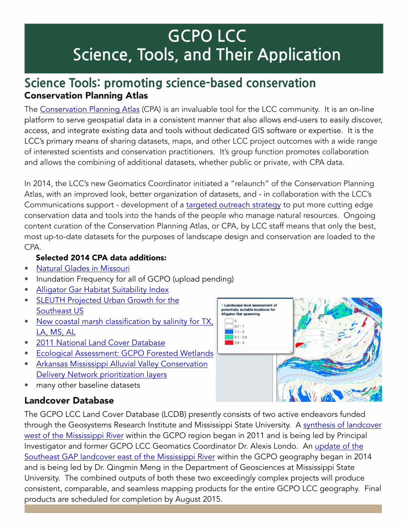
����!����""�%��#$" "&�!��%���!�����%����"!%�$(�&�"!Conservation Planning AtlasThe Conservation Planning Atlas (CPA) is an invaluable tool for the LCC community. It is an on-line platform to serve geospatial data in a consistent manner that also allows end-users to easily discover, access, and integrate existing data and tools without dedicated GIS software or expertise. It is the LCC’s primary means of sharing datasets, maps, and other LCC project outcomes with a wide range of interested scientists and conservation practitioners. It’s group function promotes collaboration and allows the combining of additional datasets, whether public or private, with CPA data.
In 2014, the LCC’s new Geomatics Coordinator initiated a “relaunch” of the Conservation Planning Atlas, with an improved look, better organization of datasets, and - in collaboration with the LCC’s Communications support - development of a targeted outreach strategy to put more cutting edge conservation data and tools into the hands of the people who manage natural resources. Ongoing content curation of the Conservation Planning Atlas, or CPA, by LCC staff means that only the best, most up-to-date datasets for the purposes of landscape design and conservation are loaded to the CPA.
Selected 2014 CPA data additions: • Natural Glades in Missouri• Inundation Frequency for all of GCPO (upload pending)• Alligator Gar Habitat Suitability Index• SLEUTH Projected Urban Growth for the
Southeast US• New coastal marsh classification by salinity for TX,
LA, MS, AL• 2011 National Land Cover Database• Ecological Assessment: GCPO Forested Wetlands• Arkansas Mississippi Alluvial Valley Conservation
Delivery Network prioritization layers• many other baseline datasets
Landcover DatabaseThe GCPO LCC Land Cover Database (LCDB) presently consists of two active endeavors funded through the Geosystems Research Institute and Mississippi State University. A synthesis of landcover west of the Mississippi River within the GCPO region began in 2011 and is being led by Principal Investigator and former GCPO LCC Geomatics Coordinator Dr. Alexis Londo. An update of the Southeast GAP landcover east of the Mississippi River within the GCPO geography began in 2014 and is being led by Dr. Qingmin Meng in the Department of Geosciences at Mississippi State University. The combined outputs of both these two exceedingly complex projects will produce consistent, comparable, and seamless mapping products for the entire GCPO LCC geography. Final products are scheduled for completion by August 2015.
GCPO%LCC%Science,%Tools,%and%Their%Application

The US Fish & Wildlife Service and many others are collaborating to improve Alligator Gar spawning habitat. The GCPO LCC combined the IF dataset with information on water temperature and vegetation type to model habitat suitability. The model identifies areas within the Lower Mississippi River with seasonally flooded habitats and low open vegetation that could be suitable for Alligator Gar spawning or reintroduction. In the ultimate test of the completed model, gar were observed spawning at a new site on the St. Catherine Creek National Wildlife Refuge in 2014, which the model had correctly predicted as potential high quality habitat.
The Gulf Coastal Plains & Ozarks Landscape Conservation Cooperative’s Inundation Frequency (IF) dataset, first developed to cover the Lower Mississippi River corridor for use in the Alligator Gar Habitat Suitability tool, has been expanded to cover the entire GCPO region. Using Landsat satellite images, it identifies locations that are subject to intermittent inundation as a result of variations in river level, precipitation and land or water management. This dataset is proving quite popular among fisheries managers working to manage and restore Alligator Gar and other wildlife populations, as it provides a comprehensive “desktop” evaluation of habitat that would be next to impossible to assess on the ground. Once identified, potential habitats can be evaluated in the field. For example, IF data can show specific floodplain areas on the landscape that are most likely to provide the right inundation conditions at the right times for various target species.
���������������������������������������� �������������� �����������������������
Habitat Model Passes the Ultimate Test
Landscape Scale Inundation Index for the GCPO LCC
Alligator Gar Model showing a portion of St. Catherine Creek NWR
USFWS fisheries biologist Kimmel and volunteer Wright holding an Alligator Gar

About the GCPO LCC, contact Greg Wathen ~ IF maps for the LMR are on the GCPO LCC Conservation Planning Atlas IF datasets (entire GCPO) pending publication, contact Yvonne Allen ~ For more on this story contact Gregg Elliott
Ducks Unlimited has developed a land protection prioritization model that uses IF data as one of several inputs to identify frequently flooded forest habitats adjacent to other protected lands in the Mississippi Alluvial Valley, with a focus on Arkansas, Mississippi and Louisiana. This model is assisting DU to proactively engage private landowners interested in perpetual protection of these important wetland habitats via donated conservation easements.
Southern Illinois University’s Watershed Science & Policy Program applied the IF information to estimate denitrification in the Atchafalaya basin and its potential to reduce the Gulf hypoxic zone. Maximizing denitrification (a natural process that reduces nitrate pollution in
water) in bottomland forest wetlands of the Mississippi River could potentially reduce the world's second largest hypoxic, or dead, zone in the northern Gulf of Mexico. The researchers used a number of published datasets, including the IF dataset, to estimate annual denitrification in the Atchafalaya River Basin, the principal river delta channel that distributes waters from the Mississippi River to the Gulf of Mexico.
The Inundation Frequency dataset is also being used within the neighboring Gulf Coast Prairie LCC (GCP LCC)
geography. (The dataset includes all bordering Landsat scenes that touch the GCPO; this includes all of the Trinity River up to Dallas.) Scientists focused on restoring and managing Alligator Gar — an important sport fish in Texas — in the lower Trinity River may receive support from the GCP LCC as well. The proposed study will not only focus on identification of spawning areas, but seek to determine whether Alligator Gar reproduced most successfully during years of greatest spawning habitat availability. Researchers are essentially trying to identify what flood characteristics and river stages result in the greatest availability of spawning habitat, and whether this translates into more Alligator Gar. Results will then be used to make management recommendations for how and where to:• increase river connectivity to floodplain
spawning areas; • re-establish connections between the
main channel and backwater areas that could become important for spawning and juvenile development (taking advantage of more frequent high flow pulses that are still below flood stage);
• provide appropriate land cover on public or private lands in the floodplain.
In addition, this information may help to answer the question, “Can floodplain inundation or reconnection with the main channel be managed to benefit multiple aquatic species, waterfowl, and riparian productivity?
Fisheries managers in Arkansas consulted with the GCPO LCC Aquatic Habitat Analyst concerning appropriate Alligator Gar reintroduction and spawning locations in the Fourche LaFave and Arkansas Rivers in the central part of the state. In addition to identifying areas in the Fourche LaFave, the IF data also indicated that other locations near the Ed Gordon/Point Remove Wildlife Management Area could be equally important to gar.
Partner Applications of the IF Dataset

GCPO LCC 2014 ANNUAL REPORT 12
�'���"�%&�"!%�$(�&�"!���$"%%��'&&�!���"����"$�&�"!�In addition to past projects, four additional GCPO LCC projects ongoing or initiated in 2014 focus on various aspects of the Gulf of Mexico coast, with GCPO LCC staff (or former staff) as principal investigators. These projects are illustrative of the many actors and partnerships at work along the US Gulf Coast. All but the Macroclimatic Drivers project described below include the participation of all four Gulf LCCs.
Establishing Explicit Biological Objectives to Guide Strategic Habitat Conservation for the Gulf CoastThe RESTORE Act (33 U.S. Code § 1321) directs 80% of Clean Water Act penalties from the Deepwater Horizon oil spill (likely to be in the billions) to Gulf of Mexico restoration. Gulf partners profess a common goal of “restoring and protecting the natural resources…and economy of the Gulf Coast region” (Gulf Coast Ecosystem Restoration Council 2013:2), yet specific and explicit objectives that quantify what it means to actually achieve this goal remain undefined.
The funds requested here will provide needed capacity to the four Gulf LCCs to effectively meet the demand from USFWS’s Gulf Program for a suite of conservation targets across the Gulf representative of broader habitat sustainability and for which explicit biological objectives have been identified – all without sacrificing work on the other important priorities of these partnerships.
The three GCPO LCC staff who transitioned in 2014 to Gulf Coast programs (the USFWS Gulf Restoration Program, Migratory Birds, and Fisheries) will continue to stay in close communication with the GCPO LCC as well as other Gulf LCCs. This linkage is strengthening the LCC’s ability to foster broad-scale partnerships and bring a landscape perspective to Gulf Coast conservation.
Incorporating Future Change into Current Conservation Planning: Evaluating Wetland Migration along the Gulf of Mexico under Alternative Sea Level Rise and Urbanization ScenariosThe Gulf Coastal Plains and Ozarks, Gulf Coast Prairie, Peninsular Florida, and South AtlanticLandscape Conservation Cooperatives are partnering with the U.S. Geological Survey to develop a decision support tool that identifies where future coastal wetlands are likely to persist and where they are likely to be lost under various scenarios of both sea level rise and future urbanization.
Beyond%LCC%Borders:%%Gulf%Coast%Conservation%and%the%
Southeast%Conservation%Adaptation%Strategy

GCPO LCC 2014 ANNUAL REPORT 13
Gulf managers and planners can use the tool to: (1) promote coastal wetland adaptation and minimize the future loss of tidal wetlands; (2) help Gulf communities make the best use of restoration funding; and (3) allow for urban growth while protecting natural defenses and important ecosystem goods and services.
Establishing a Foundation for Evaluating the Ecological Implications of Climate Change along a Gradient in Macroclimatic Drivers of Coastal Wetland EcosystemsThis project, led by scientists at the U.S. Geological Survey’s National Wetlands Research Center, examines and forecasts the effects of changes in rainfall and temperature on alternative wetland types across the Gulf of Mexico coast, with a particular focus on quantifying potential unrecognized ecological thresholds among wetland types that could result in dramatic landscape change under future climate.
The information from these studies and others is providing foundational knowledge for the Gulf Coast Vulnerability Assessment (GCVA), a broad stakeholder-driven initiative that includes NOAA as a key partner.
Gulf Coast Vulnerability Assessment: exemplifying collaboration and data integrationThe Gulf Coast Vulnerability Assessment began in 2012, with a hiatus in 2013 associated with staff changes, and was nearly completed in 2014. It is the first building block needed to achieve the longer-term goal of developing a conservation adaptation strategy for the Gulf Coast. Project partners in this project include both the Southeast Climate Science Center and the South Central Climate Science Center.
Under the able leadership of the Gulf Coast LCC Liaison, a cross-disciplinary team of scientists from a variety of organizations developed a list of 11 “umbrella” species (which represent the needs of a broader range of similar species) and 4 natural communities to assess for vulnerability to sea level rise and other stresses associated with climate change. The final vulnerability assessment report will be issued in spring 2015.
This effort exemplifies the way in which Gulf Coast LCCs, as well as other Gulf conservation and natural resource organizations, are collaborating to achieve a holistic view of the Gulf and its conservation priorities. To evaluate habitat and species vulnerability to changing conditions across the U.S. Gulf of Mexico, the GCVA science team decided to use the Standardized Index of Vulnerability and Value Assessment method, or SIVVA, and incorporate data from multiple LCC projects and a Climate Science Center-sponsored project into their SIVVA assessments. They used
GCPO LCC 2014 ANNUAL REPORT 14
results of a Gulf Coast Prairie LCC project, Prairie LCC project, Evaluation of Regional Sea Level Affecting Marshes Model (SLAMM), which is filling in gaps in the SLAMM tool designed to characterize the impacts of sea level rise on coastal marshes. They also incorporated SLEUTH projections of urbanization, a GCPO project supported by the Southeast Climate Science Center to assess potential impacts of development through the year 2060.
Additional Gulf ProjectsThe GCPO LCC’s Research Ecologist, working with colleagues across the Gulf of Mexico and NOAA’s northern Gulf of Mexico Sentinel Site program has prepared an inventory for the entire northern Gulf showing the general location of Sea Surface Elevation Tables or SETs. SETs are independently established stations that can be used to evaluate whether a wetland system is keeping pace with sea level rise, an important issue along the Gulf Coast. The inventory will include contacts for obtaining more detailed information about each SET. This information will most likely be shared through NOAA’s Sentinel Site program and/or the conservation planning atlas.
Finally in 2014, the US Dept. of State asked the GCPO LCC’s Research Ecologist to serve as lead reviewer for the U.S. Governmental review of the mangrove chapter of the World Oceans Assessment, a United Nations report that is currently in draft. The lead reviewer’s task is to coordinate the review and to synthesize comments from US and international scientists.
�"'&���%&�"!%�$(�&�"!����#&�&�"!��&$�&��*�������The year 2014 saw Southeast Conservation Adaptation Strategy (SECAS) progress toward a common vision for “an ecologically connected network of landscapes and seascapes …. capable of sustaining natural and cultural resources for current and future generations.” Representatives from federal and state agencies in the Southeast Natural Resource Leaders Group and the Southeast Association of Fish & Wildlife Agencies, respectively, participated in a series of planning and visioning exercises. All six Southeast LCCs are contributing to the SECAS vision, proceeding along separate but parallel tracks. All of these threads come together in the Fall 2014 SECAS Progress Summary Report, which highlights SECAS challenges and progress to date.
During 2014, the GCPO LCC Coordinator, Greg Wathen, facilitated the development of a Coordinator position. Late in the year, the partners agreed to hire a SECAS coordinator. Dennis Figg, recently retired from the Missouri Department of Conservation and also a former founding member of the GCPO LCC’s Steering Committee, accepted the challenge. He will be working with existing partners and reaching beyond the familiar conservation community to move us all forward as we assemble a "Conservation Blueprint" for the future of the Southeast. Plans and progress are proposed for Fall 2016, in association with SEAFWA 2016.

GCPO LCC 2014 ANNUAL REPORT 15
���� ���&)"$�����&&�!���!&"�&�����$��$�(�%�"!The LCC Network throughout North America made great progress in 2014, with the completion of a Strategic Plan, a draft Network Communications Plan and a draft Science plan. GCPO LCC Conservation Science Team and Steering Committee (SC) members contributed significantly to all three, with both the GCPO Steering Committee and staff participating in the strategic planning summit at the National Conservation Training Center. Staff also assisted in development of the Network Science Plan and the Network Communications Plan, both of which will be finalized in 2015.
National Workshop on Large Landscape ConservationThe GCPO LCC Coordinator played a pivotal role in organizing the National Workshop on Large Landscape Conservation, chairing the programs committee which resulted in 250+ presentations in 70+ concurrent sessions, and 34 posters presented over the course of 2 days -- all devoted to the topic of large landscape conservation. The NWLLC Conference presented more than three dozen plenary presentations, including Secretary of the Interior Sally Jewell presenting the keynote address. The conference lineup attracted more than 650 people from across the country, representing government, industry, and NGO’s from inside the conservation community.

GCPO LCC 2014 ANNUAL REPORT 16
�����#���&*The year 2014 brought several changes to the GCPO LCC Conservation Science Staff, chief among them a changing of the guard in the Science Coordinator position. John Tirpak moved into the role of Science Coordinator for the US Fish and Wildlife Service’s Gulf Restoration Program office, a move which has strengthened linkages between Gulf LCCs and the many Gulf Coast restoration efforts underway as a result of the RESTORE Act and the Deepwater Horizon oil spill. Likewise, two other former affiliated staff - Jeff Gleason (former Science Liaison to the USFWS Ecological Services Office in Alabama) and Glenn Constant (former LCC liaison to the USFWS Fisheries program and other aquatic partnerships) have reoriented their positions to focus on the Gulf as well. New staff are anticipated to once again fill these roles for the GCPO LCC beginning in early 2015. Todd Jones-Farrand was officially offered the GCPO LCC Science Coordinator position in December 2014, after successfully serving a 60-day detail with the LCC over the summer. Todd comes to the Cooperative from the Central Hardwoods Joint Venture, where he was integrally involved in the Ozark Highlands Comprehensive Conservation Strategy. Another change at the end of 2014 occurred as Amanda Watson, who served as Gulf Coast LCC liaison, went on maternity leave and Cynthia Edwards was brought on to fill that role. Cynthia is transitioning from her role as Gulf Coast Prairie Science Coordinator to assist in completion of the Gulf Coast Vulnerability Assessment and then in expansion of the GCPO’s CCS process.
Kristine Evans also joined the GCPO LCC in April 2014 to fill the Geomatics Coordinator position. Kristine had previously served with the US Fish and Wildlife Service National Wildlife Refuge System, Southeast Region Inventory and Monitoring Network, coordinating and integrating spatial data and relationally-structured non-spatial data on several regional, multi-regional, and national projects, including the Mobile Acoustical Bat Monitoring project that spans 11 states and 5 physiographic regions. Along with Yvonne Allen, the LCC’s Aquatic Habitat Analyst, Kristine is leading development of the GCPO Ecological Assessment. Toby Gray was also hired as Research Associate to assist in this initiative. Both Kristine and Toby are employed directly by the Geosystems Research Institute at Mississippi State University, a key GCPO LCC partner.
Dedicated & Affiliated Staff
Greg Wathen, Coordinator – Tennessee Wildlife Resources Agency
Planning & AssessmentDr. Todd Jones-Farrand, Science Coordinator – US Fish & Wildlife Service
Kristine Evans, Geomatics Coordinator - Geosystems Research Institute
Yvonne Allen, Aquatic Habitat Analyst - US Fish & Wildlife Service
Cynthia Edwards, Gulf Science Liaison - Wildlife Management Institute
Toby Gray, GIS Analyst - Geosystems Research Institute
CommunicationsK. Gregg Elliott, Communications & Outreach - K Gregg Consulting
Research & MonitoringDr. Mike Osland, Research Ecologist – US Geological Survey
Janet Ertel, NWRS Inventory & Monitoring Coordinator for the GCPO geography & Region-wide Deputy Branch Chief - US Fish & Wildlife Service
Taylor Hannah, Graduate Student - Mississippi State Univ.
GCPO%LCC%Operations

GCPO LCC 2014 ANNUAL REPORT 17
Both the GCPO LCC’s conservation design process and the Ecological Assessment will be integral as the LCC community of the Southeast moves forward with the Southeast Conservation Adaptation Strategy (SECAS). Over the course of 2014, recognition of the need for a coordinator of these efforts grew, culminating in a late-year decision to hire Dennis Figg, formerly a Steering Committee member from the Missouri Department of Conservation, as SECAS Coordinator.
" '!���&�"!%��$"���&%��&���%�����������&�!���!��&$����!�����" #��%� �!&%In 2014, the GCPO LCC moved to a monthly news format to keep pace with the LCC’s growing portfolio of projects and initiatives. Newsletter subscriptions continue to grow, though at a reduced rate compared to previous years and roughly matching the growth rate of the GCPO LCC community. In 2014, our web community increased about 7% from 977 to 1046, while overall gcpolcc dot org website traffic saw increases in the number of sessions (~8%), first time visits (i.e. new sessions, ~2%) and new users (~10%) (see Figure 1, below).
Bounce rate, pages per session, and average session duration were all down, possibly reflecting a trend away from website browsing and in keeping with the fact that spikes in visitation to the website occur in response to news campaigns, sending subscribers directly to linked news pages (see Figure 2, below). The LCC Network website also boosted viewership, referring approximately 17% of all GCPO website traffic in 2014.
Figure%1
Figure%2

GCPO LCC 2014 ANNUAL REPORT 18
The GCPO LCC news list continues to perform well against industry averages for government, nonprofits, and education (calculated by a Mailchimp survey of lists that span the gamut from 1000 subscribers to large corporations.) The GCPO LCC list comparison for campaign open rate (opening the email) and click rate (viewing more in-depth content online) is provided below:
open click
GCPO LCC 32% 12.5%
Industry average ~25% ~3.5%
In 2015, the LCC will increase outreach to people and organizations not currently members of the website.
A key aspect of LCC communications is sharing of information via the website and the GCPO LCC Projects Database. In 2014, Advanced Applications support contracted from the National Wetlands Research Center allowed the Cooperative to:• improve the look and user interface of the Database by adding functions such as search, links to
products, and social sharing;
• provide a more efficient means of data entry;• provide the ability to download project listings directly to the Network LCC Projects Catalog.
The LCC’s Database now lists a total of 44 projects, reflecting the broad range of conservation science initiatives in which the LCC is involved. The common theme among them all is, of course, the large landscape perspective.
The LCC also provided communications capacity to the East Gulf Coastal Plain Joint Venture in 2014 to complete its project promoting prescribed fire. The Strategy, entitled A Burning Issue: Prescribed Fire and Fire-adapted Habitats of the East Gulf Coastal Plain, was issued in May and has been well received.

GCPO LCC 2014 ANNUAL REPORT 19
The GCPO LCC awarded funds to support six new projects in Fiscal Year 2014. The following provides a summary of key projects begun or ongoing in 2014. To view the full complement of projects and accomplishments, consult the GCPO LCC Projects Database. Projects supported by all 22 LCCs are summarized in the LCC Network Project Catalog; GCPO LCC projects listed in the Catalog are derived and periodically updated from our Project Database.
FY2014 PROJECTS Guiding Regional Conservation Planning under Climate Change: Integrating dynamic landscape population models with structured decision makingThis project integrates dynamic landscape population viability models and structured decision making to choose among conservation scenarios that best meet desired endpoints for focal wildlife species in the Ozark Highlands region under climate change.
Occurrence and variation in submersed aquatic vegetation (SAV) along the northern Gulf of Mexico: a hierarchical approach to assess impacts of environmental change on SAV resources Submerged Aquatic Vegetation (SAV) resources provide critical foraging habitat for large concentrations of wintering waterfowl and serve as essential nursery habitat for numerous commercially and recreationally valuable fisheries. This project addresses the need to understand and manage for the continued existence of SAV in tidal marshes of the Northern Gulf Coast. This project will be beneficial to the Gulf Coast Vulnerability Assessment project, which is being supported by 4 LCCs across the Gulf Coast.
Establishing Explicit Biological Objectives to Guide Strategic Habitat Conservation for the Gulf Coast (National Landscape Conservation Cooperative Project) The newly-expanded Gulf Restoration Program is working in concert with the four Gulf Landscape Conservation Cooperatives to develop explicit population objectives for priority species identified within each of the focal areas of the
USFWS document, Vision for a Healthy Gulf of Mexico Watershed. Partnering with US Geological Survey researchers, this team will utilize the expert opinion of Gulf partners to develop Bayesian Belief Networks and enable these population objectives to be translated into habitat objectives that strategically guide on-the-ground restoration activities.
Ecological Assessments of the Gulf Coastal Plains & Ozarks geography/Landscape Conservation Design This project will support the hiring of a detail position to work with the Geomatics Coordinator to complete the
ongoing assessments of terrestrial systems and key species. This rapid ecological assessment will seek to answer the following questions: (1) How much habitat is in a desired ecological state, as defined by the Integrated Science Agenda? (2) How much more habitat is needed? (3) Where is habitat that is in the desired ecological state? (4) Where are opportunities to manage improved or high value habitat?
Project%Highlights%and%Summaries

GCPO LCC 2014 ANNUAL REPORT 20
Pearl River Basin - Subsurface habitat classifications for aquatic systems and monitoring to support understanding of species-habitat relationships and optimal habitat conditions This project will address species-habitat relationships for a priority aquatic system for the GCPO LCC: Mainstem Big Rivers. Specifically, the project will collect subsurface aquatic habitat data using side-scan sonar and high resolution bathymetry data in the Pearl River system of Louisiana. This project expands on current work ongoing in the Pearl River and will make recommendations on restoration of aquatic habitat for key species. This project directly addresses landscape conservation design and will be used to inform adaptation strategies.
Clapper Rails as Indicators of Gulf Coast Tidal Marsh This project studies the Clapper Rail (Rallus longirostris) as an indicator of Gulf Coast tidal marsh habitat change. Critical data on the Clapper Rail – annual survivorship – is lacking. It will allow development of species-habitat models to predict
how future environmental change is likely to affect this species. This project will compile existing point count data into a Breeding Marsh Bird Atlas for the northern Gulf of Mexico. Secondly, nano-tags will be employed to collect survivorship data for Clapper Rails. Those data will be crucial to developing population models for Clapper Rails. Natural resource managers can then use the models to evaluate various “what if” scenarios, exploring the impacts of climate change, pollution, and development of coastal systems, as well as the potential consequences of management activities or decisions.
HIGHLIGHTS OF KEY 2013 PROJECTS Population & habitat evaluation/projection for purposes of application to conservation planning and design
Glades Habitat Mapping: Phase II This project maps glade complexes from aerial imagery at fine-scale resolution and ground truths the classified data. Phase Ii covers the Arkansas Ozarks.
Establishing a Foundation for Evaluating the Ecological Implications of Climate Change along a Gradient in Macroclimatic Drivers of Coastal Wetland Ecosystems This project examines and forecasts the effects of changes in rainfall and temperature on alternative wetland types across the Gulf of Mexico coast, with a particular focus on quantifying potential unrecognized ecological thresholds among wetland types that could result in dramatic landscape change under future climate.
Alligator Gar Priority Tool - highlight application of tool Development of a model to identify areas within the Mississippi Alluvial Valley that are suitable for alligator gar.

GCPO LCC 2014 ANNUAL REPORT 21
Training to improve decision support as applied to conservation planning
National Conservation Training Center Toolbox Training - Training to improve Decision Support as applied to Conservation PlanningThis multi-LCC project is designed to evaluate delivery of existing courses offered through the National Conservation Training Center (NCTC) as “pilots” to enhance expertise needed within the regional context of LCC and Climate Science Center (CSC) communities. Feedback from these offsite training sessions and other strategic discussion will help identify and prioritize which tools to include in future training for staff and partners.
Monitoring to improve understanding of population and habitat evaluation/projection
Influence of Landscape and Stand-Scale Factors on Priority Wildlife Species in Open Pine Stand TypesThe objective of this study is to quantify occupancy rates for species endpoints in the open pine broadly defined habitat type.
Standardizing and Coordinating Range-wide Monitoring of the Interior Least Tern and its Habitat in a Metapopulation Context (Multi-LCC Project) The Gulf Coastal Plains and Ozarks Landscape Conservation Cooperative is partnering with the Great Plains, Plains and
Prairie Potholes, Gulf Coast Prairie, and Eastern Tallgrass Prairie and Big RiversLandscape Conservation Cooperative s as well as the US Army Corps of Engineers, US Fish and Wildlife Service, US Geological Survey and American Bird Conservancy to develop standardized range-wide monitoring protocols for both the Interior Least Tern (ILT) and its habitat, one of three requirements for delisting. Anticipated outcomes include the ability to assess population trends of the ILT and other river-dependent species, and to monitor species responses to habitat management.
Vulnerability Assessments to improve understanding of climate change impacts on species populations and habitats
Effects of Climate Change on Fall-winter Distributions of Waterfowl in the Atlantic, Mississippi, and Central Flyways of North America Applying the Weather Severity Index (WSI) that predicts how waterfowl currently responds to weather conditions annually to downscaled climate projections in the future
Incorporating Future Change into Current Conservation Planning: Evaluating Wetland Migration along the Gulf of Mexico under Alternative Sea Level Rise and Urbanization ScenariosThe Gulf Coastal Plains and Ozarks, Gulf Coast Prairie, Peninsular Florida, and South AtlanticLandscape Conservation Cooperative s are partnering to develop a decision support tool that identifies where future coastal wetlands are likely to persist and where they are likely to be lost under various scenarios of both sea level rise and future urbanization. Gulf managers and planners can use the tool to minimize the future loss of tidal wetlands; help Gulf communities make the best use of restoration funding; and allow for urban growth while protecting natural defenses.